
Alamosa City Zoning Code
ARTICLE V
- SITE DESIGN STANDARDS
DIVISION 5-4. - LIGHTING[2]
Editor's note—Ord. No. 27-2024, § 5, adopted Nov. 6, 2024, amended division 5-4 in its entirety to read as set out herein. Former division 5-4 pertained to similar subject matter and derived from Ord. No. 33-2017, § 1, adopted Dec. 6, 2017.
Sec. 21-5-101. - Purpose and application.
(a)
Generally. Review pursuant to this division is intended to ensure quality design, but, in general, not to require a density or intensity reduction. It is the policy of the city that the principles of this division be applied to the maximum extent possible without imposing restrictions that reduce the density or intensity of development that is permitted on the subject property by this UDC.
(b)
Modifications to plans. The city may require modifications to proposed site plans or subdivision plats that otherwise conform to the standards of the UDC in order to enhance the quality of the design in accordance with the qualitative principles of this division. The standards of this division shall be applied and interpreted in the context of the other applicable standards that are set out in other parts of this UDC.
(Ord. No. 33-2017, § 1, 12-6-17)
Sec. 21-5-102. - General site design principles.
(a)
Generally. Sites should be planned and developed to provide functional and desirable settings for the buildings that are to be constructed, to mitigate impacts on adjacent properties, and to enhance connectivity to other areas of the city for motor vehicles, pedestrians, and bicyclists, as provided in this section.
(b)
Compatibility. The proposed site plan or subdivision plat shall be designed in a way that:
(1)
Provides appropriate space for buffers and transitions between incompatible land uses or obvious changes in density or intensity along side or rear boundaries of the subject property;
(2)
In areas where such uses are located or planned in close proximity to each other, provides appropriate linkages between residential uses and retail, restaurant, personal service, entertainment, and office uses, providing access while protecting neighborhood integrity;
(3)
Protects downstream property and public infrastructure from flooding, erosion, or sedimentation from stormwater runoff;
(4)
Appropriately addresses natural hazards, if present;
(5)
Anticipates and provides for future connections to neighboring properties that are likely to be developed, redeveloped, or expanded with similar or supportive land uses within ten (10) years;
(6)
Minimizes interference with existing access to adjacent and nearby properties, unless new and improved access is provided by the proposed development;
(7)
Protects significant natural features or views where possible; and
(8)
Does not materially reduce the level of service of public services or utilities that are provided to surrounding development.
(c)
Future adjacent development. The proposed development shall be designed in a way that shows how future development of adjacent parcels under common ownership (if any) will relate to the subject property in terms of transportation linkages, utilities, and drainage.
(d)
Flood damage prevention. Development within a special flood hazard area is restricted as provided in Chapter 8, Flood Damage Prevention, City of Alamosa Municipal Code.
(Ord. No. 33-2017, § 1, 12-6-17)
Sec. 21-5-103. - Circulation and connectivity.
(a)
Internal circulation.
(1)
Internal circulation systems shall be interconnected.
(2)
Pedestrian routes shall be located along (or visible from) all streets, except that, where street connections are not feasible or the administrator determines that they are undesirable, off-street trails and paths may be used instead to provide pedestrian connections among buildings and land uses, and between abutting properties.
(3)
If proposed development includes more than one (1) street or more than one hundred (100) parking spaces, then the internal circulation system (e.g., new streets, sidewalks, or trails) shall be designed such that alternative travel routes are provided through the development.
(b)
Access. Access points for single-family dwelling and duplex uses shall be approved by the public works director. For multifamily, nonresidential, and vertically mixed-use development, the following access standards apply:
(1)
Access to off-street parking lots or parking structures shall be designed and constructed to facilitate the flow of traffic, provide maximum safety of traffic ingress and egress, and maximum safety for pedestrians and vehicular traffic on the site.
(2)
The number of access points shall be limited to the minimum that will allow the property to accommodate the traffic to be anticipated.
(3)
Access points shall not be more than twenty-four (24) feet in width unless the city engineer determines that a wider access is necessary (e.g., for tractor-trailers or additional access lanes) and shall be clearly and permanently marked and defined.
(4)
If there are multiple access points on the same frontage of a subject property, such access points shall be separated not less than sixty-four (64) feet, measured centerline to centerline. For every foot that the lot frontage exceeds one hundred (100) feet, the minimum required separation shall be increased by one (1) foot. The minimum spacing requirement shall not be greater than two hundred (200) feet (except where required by CDOT on a State Highway), although spacing wider than two hundred (200) feet is allowed if proposed.
(5)
In the case of a corner lot, access points shall be located not closer than thirty (30) feet to the intersecting street flowlines.
(6)
Access points shall not be located closer than fifteen (15) feet to an interior side lot line, except that a common access to two (2) adjoining properties may be provided at the shared lot line.
(c)
Cross access/external connections.
(1)
Cross-access shall be provided among nonresidential and mixed-use parcels where practicable, in order to manage curb cuts and balance the need for mobility with the need for access to lots and buildings.
(2)
Proposed development shall connect to existing and planned streets where necessary to complete planned street networks.
(3)
Paths, sidewalks, and trails shall not be routed through parking lots (except to make connections to buildings) if other practical alternatives exist. Where paths, sidewalks, or trails must be routed through parking lots, they shall be located between parking modules and protected by curbs.
(Ord. No. 33-2017, § 1, 12-6-17; Ord. No. 15-2022, § 5, 7-20-22)
Sec. 21-5-104. - On-site snow storage.
(a)
Generally. Adequate areas for snow storage shall be provided for all development that includes streets or on-site parking.
(b)
Location and configuration. Snow storage areas shall be located and configured to safely and efficiently melt snow, and to minimize and manage the impacts of pollutants from the resulting runoff, as follows:
(1)
Snow storage areas shall be located to drain away from pedestrian and vehicular use areas, and into vegetated buffer strips or other appropriate best management practices ("BMPs"), such that water quality is improved and off-site drainage impacts are mitigated.
(2)
Snow storage areas shall be configured so that stored snow does not obstruct any of the following:
a.
Sight triangles at driveways and intersections;
b.
Emergency access routes;
c.
Required parking spaces;
d.
Pedestrian routes; and
e.
Drain inlets.
(3)
To the greatest extent feasible, snow storage areas shall be located in areas with solar exposure, away from streets, sidewalks, and trails.
(Ord. No. 33-2017, § 1, 12-6-17)
Sec. 21-5-105. - Street, alley, and pedestrian way design.
(a)
Generally. Streets shall be designed in accordance with the standards of this section.
(b)
Street plans. Streets shall be located and configured to implement adopted plans of the city that show the general location and classification of new streets, and new arterial and collector streets shall align with existing streets of the same classification. The exact location and classification of new streets will be determined during the development review process.
(c)
Right-of-way dimensions.
(1)
Street, alley, and pedestrian way right-of-way widths and curves shall meet the standards of Table 21-5-105(c), Right-of-Way Specifications, unless otherwise approved by the planning commission upon a demonstration that an alternative right-of-way width will:
a.
Provide for appropriate levels of multimodal use that meets city level of service standards and provides for safe travel during all seasons;
b.
Reduce costs to the city for routine and periodic maintenance;
c.
Include appropriate connections to existing streets; and
d.
Improve the character of the area served by the street.
(2)
Principal arterial streets shall conform to state highway standards.
(3)
Minimum grade shall be determined by the city engineer.
(4)
Maximum grade through intersections shall be four (4) percent. The maximum grade shall extend a minimum of fifty (50) feet each direction from the centerline of the intersecting streets.
(5)
Pedestrian ways, not less than ten (10) feet wide, may be required to provide access to schools, playgrounds, shopping centers, open space areas, or other community facilities.
(6)
Sidewalks that are at least five (5) feet in width shall be provided along all sides of a lot that abut a public street or way. Sidewalks shall be constructed within the street right-of-way, parallel to the street, unless:
a.
A different configuration of the pedestrian circulation system is desirable in order to preserve topographical or natural features, or to provide visual interest;
b.
It is demonstrated that the alternative pedestrian circulation system will provide safe and convenient circulation; and
c.
The applicant provides for the perpetual maintenance of the alternative pedestrian circulation system through a homeowners' association, special district, or appropriate easements that allocate maintenance responsibilities.
(d)
Alleys. Paved alleys that are open at both ends shall be provided in commercial and industrial areas, unless the administrator determines that other appropriate provisions (other than an alley) are made for service access.
(e)
Fire lanes. Fire lanes shall be required where necessary to protect the subject property and adjoining properties during the period of development and when developed, and an easement to such effect shall be dedicated to the city. The easement shall be sixteen (16) feet in width, remain free of obstructions, and provide access at all times.
(f)
Integration.
(1)
Except where interruptions of the street network are necessary due to significant features such as ditches, railroads, parks, or limited access roadways, new streets shall integrate into the existing street pattern so as to:
a.
Address the new development's access and circulation needs;
b.
Provide a pattern of streets that facilitates mobility and provides a choice of routes and travel modes, in that existing and planned streets (including streets that are shown on pending applications for development approval on adjacent property) are continued in a similar alignment on the subject property and at a comparable right-of-way and pavement width, except where:
1.
There is a demonstrated need to change the street cross-section in order to improve the safety of the traveling public, or to provide on-street parking in areas where it is appropriate;
2.
The right-of-way or pavement section of the existing street is substandard; or
3.
The continuation would create incompatibility or materially concentrate through-traffic in residential neighborhoods.
(2)
When a tract is subdivided into larger than normal building lot(s) or parcel(s), such lot(s) or parcel(s) shall be so arranged as to permit the logical location and opening of future streets and appropriate resubdivision, with provision for adequate utility easements and connectors for such resubdivision.
(3)
Where the subject property is adjacent to land that is likely to be developed or redeveloped in the future, streets, bicycle paths, sidewalks, trails, and access ways in the development's proposed transportation system shall continue through to the boundary lines of the subject property to provide for the orderly subdivision and development of the adjoining land, or the transportation and access needs of the city.
(g)
Intersections. Streets shall intersect as nearly at right angles as possible.
(h)
Cul-de-sacs. Cul-de-sacs are allowed where necessary due to site constraints such as topography, site dimensions, or the presence of ditches or railroads; however, no cul-de-sac shall be longer than six hundred (600) feet from the point of connection to the street to the middle of the cul-de-sac end, and the turnaround right-of-way diameter shall be at least one hundred (100) feet. Surface drainage of the cul-de-sac shall be toward the intersecting street, or if such drainage is not possible, a drainage easement must be provided through the cul-de-sac.
(i)
Offsets. Street jogs are not allowed on arterial streets, and may be allowed on collector streets only if it is demonstrated that the physical conditions of the subject property require the offset, and the design will not compromise public safety. Streets with centerline offsets of less than one hundred fifty (150) feet will not be accepted.
(j)
Interim turnarounds. Where a street will eventually be extended beyond the boundaries of the subject property, but is temporarily dead-ended, an interim turnaround (e.g., a hammerhead or cul-de-sac with a ninety (90) foot diameter) may be required.
(k)
Half-streets. Half streets are not allowed.
(l)
Reserve strips. Reserve strips in private ownership that purport to control access to streets are prohibited. Reserve strips that are dedicated to the city are allowed.
(m)
Natural resources. New streets shall be located with appropriate regard for topography, vegetation, waterways, ditches, open spaces, and comparable resources that are environmentally sensitive, legally protected, or potential amenities.
(n)
Engineering specifications. New streets shall have such dimensions, curbs, gutters, sidewalks, and pavements as may be required by city engineering specifications promulgated by the public works director, and rights-of-way shall be sufficient to accommodate underground utility lines.
(Ord. No. 33-2017, § 1, 12-6-17; Ord. No. 12-2021, § 5, 8-18-21)
Sec. 21-5-106. - Blocks.
(a)
Generally. Block lengths and widths shall be suitable for the uses or lot sizes that are contemplated, and shall be adequate for requirements pertaining to minimum lot areas, dimensions, and setbacks.
(b)
Block length. Blocks shall be at least four hundred (400) feet and not more than one thousand three hundred twenty (1,320) feet in length unless adjacent to a railroad right-of-way, park, arterial street, natural area, ditch, or similar feature that makes street intersections impractical.
(Ord. No. 33-2017, § 1, 12-6-17)
Sec. 21-5-107. - Lots.
(a)
Size and shape. Lots shall meet all applicable zoning requirements.
(b)
Floodplains. New lots shall not be created that include portions of the floodplain unless a reasonable building envelope exists on a portion of the lot that is outside of the floodplain.
(c)
Access. All lots shall take access from a public street. Single-family detached, duplex, townhome, and multiplex lots shall take access only from local streets, or from alleys or parking courts that are connected to local streets.
(d)
Lot frontage. The minimum lot frontage shall be the least of:
(1)
The minimum lot width required by this UDC for the particular lot type;
(2)
Fifty (50) feet for lots that do not front on a cul-de-sac; or
(3)
Thirty-five (35) feet for lots that front on a cul-de-sac.
(e)
Double-frontage lots. Double-frontage lots shall be prohibited except:
(1)
Where essential to provide separation from arterial streets or state highways; or
(2)
Where lots that span an existing block are assembled for nonresidential or mixed-use development.
(Ord. No. 33-2017, § 1, 12-6-17)
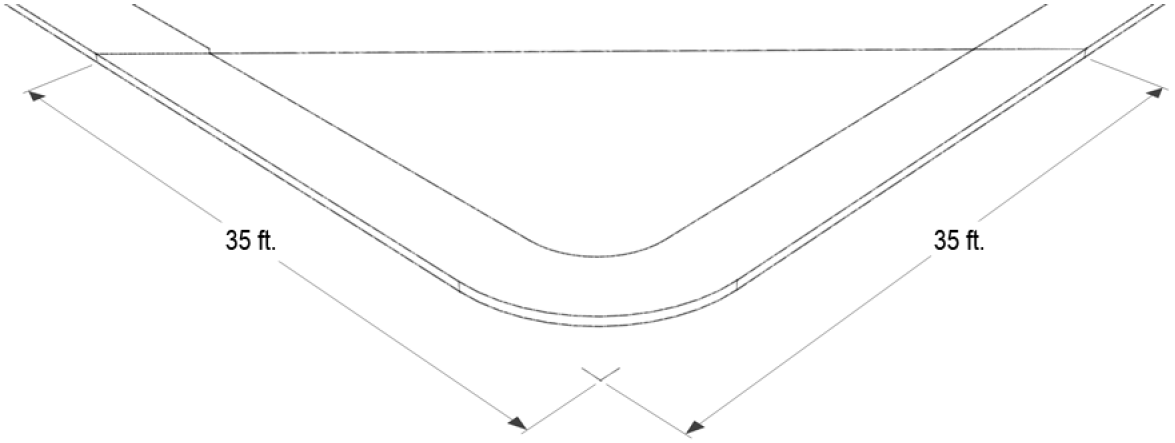
Sec. 21-5-108. - Sight triangles.
No building, fence, wall, sign, hedge, shrub, planting, tree, or other sight obstruction between two and one-half (2 ½) feet and eight (8) feet above the elevation of the crown of the street shall be located within the triangular area formed by the edge of the surface of the street or curb line and a line connecting them at points 35 feet from their point of intersection. See Figure 21-5-108, Sight Triangle.
|
Figure 21-5-108
SIGHT TRIANGLE |
|---|
 |
Sec. 21-5-201. - Purpose and application of division.
(a)
Purpose. The purpose of this division is to ensure that:
(1)
Adequate off-street motor vehicle parking is provided for uses that are approved pursuant to this UDC, in order to:
a.
Promote economic development; and
b.
Protect the character and quality of life in residential neighborhoods that may be impacted by overflow parking;
(2)
The utilization of parking resources may be optimized based on shared parking programs that allow for the utilization of a parking lot or structure by different uses that have different peak demands for parking, and based on the "internal trip capture" of areas of the city such as the MU, CBD, and CA Zones;
(3)
Appropriate parking areas and accessible routes will be provided for persons with disabilities when parking lots or structures are developed, expanded, or reconfigured;
(4)
Adequate loading areas and (where appropriate) stacking areas are provided that do not interfere with the function of adjoining streets or on-site vehicular use areas; and
(5)
Sites that are used for infill, adaptive re-use, or redevelopment have flexibility and multiple alternatives for compliance with this division, such that investments in upgrades to real property are promoted.
(b)
Application.
(1)
Number of required parking and loading spaces.
a.
Section 21-5-202 establishes the methodology for calculating the number of required parking spaces, including measurement of independent variables and application of available credits and reductions.
b.
Section 21-5-203 sets out the number of required parking spaces for each land use set out in the use tables, based on the parking district in which the use is located.
c.
Section 21-5-204 sets out the number of parking spaces that must be designed, located, and configured as accessible parking spaces to meet the requirements of the Americans with Disabilities Act.
d.
Section 21-5-205 sets out the requirements for special parking studies, which are generally used to determine parking requirements for certain land uses.
e.
Section 21-5-206 allows an allocation of on-street parking spaces within a development to the individual land uses in the development.
f.
Section 21-5-207(b), parking reduction and shared parking methodologies, allows for a substitution of a certain amount of required parking spaces with bicycle racks.
g.
Section 21-5-207(c) through (e), parking reduction and shared parking methodologies, shared parking, sets out the methodology for calculating the number of required parking spaces in locations where different types of uses create different peak parking demands on a particular parking area.
h.
Section 21-5-208, remote parking, sets out standards for the provision of parking on a property that is off-site from the subject property.
(2)
Parking, loading, and stacking design.
a.
Section 21-5-209 sets out requirements for parking lot design, including the minimum dimensions for parking spaces and drive aisles.
b.
Section 21-5-210 sets out the standards for how parking spaces must be delineated, and cross-references standards for traffic control devices.
c.
Section 21-5-211 sets out standards for the design of truck loading areas.
d.
Section 21-5-212 sets out standards for stacking lanes for drive-through uses.
(3)
Construction, operation, and maintenance. Section 21-5-213 sets out standards for the construction, operation, and maintenance of parking lots.
(c)
Relationship to certificate of occupancy.
(1)
Required parking spaces shall be improved as required and made available for use before the final inspection is completed by the building inspector.
(2)
The building inspector may grant an extension of time for completion of parking if:
a.
The parking space is not required for immediate use;
b.
The applicant executes an improvements agreement for the parking spaces and provides appropriate security in the form of a letter of credit or cash deposit equaling one hundred twenty-five (125) percent of the cost to complete the improvements as estimated by a professional engineer and approved by the building inspector; and
c.
The improvements agreement provides that in event the parking spaces are not constructed within one (1) year after the date of extension, the city may apply the security to complete the parking spaces.
(Ord. No. 33-2017, § 1, 12-6-17; Ord. No. 21-2023, § 3, 12-20-23)
Sec. 21-5-202. - Calculation of required parking spaces.
(a)
Generally.Section 21-5-203, parking tables, sets out the number of parking spaces that are required for each land use that is listed in article 2, division 2, land use. The number of parking spaces is based on one (1) or more independent variables, which are measured as provided in this section.
(b)
Independent variables. The independent variables for parking calculations are measured as follows:
(1)
Floor area. Where the independent variable is square feet ("sf."), the number of parking spaces is based on the number of square feet occupied by the use (or occupied by a component of the use that is specified in the table).
(2)
Dwelling unit. Where the independent variable is a dwelling unit ("U"), the number of parking spaces is calculated based on the number of dwelling units. In some cases, the parking requirements are based on the number of bedrooms (per "#" BRU) in each dwelling unit.
(3)
Bed. Where the independent variable is "bed," the number of parking spaces is based on the number of beds in the facility instead of the number of bedrooms or some other measure. Per-bed calculations are typically applied to uses that offer residential care or overnight accommodations with shared rooms.
(4)
Employee. The phrase "per employee" means that the number of parking spaces is based on the number of employees (full-time and part-time equivalent) on the maximum shift, that is, the work shift in which the maximum number of employees are present.
(5)
Seat/seat design capacity. If the independent variable is "seat," the number of parking spaces is based on the number of seats that are provided to guests (patrons, members, etc.). If the independent variable is "seat design capacity," the number of parking spaces is based on the maximum seating capacity of the use as established by applicable fire code.
(6)
Maximum capacity. If the independent variable is "maximum capacity," the number of parking spaces is based on the lesser of:
a.
The maximum number of people who may occupy the use pursuant to applicable fire code; or
b.
The maximum number of people who may occupy the use pursuant to other applicable regulatory or operational standards.
(7)
Others. Other independent variables are measured according to their common meanings.
(c)
Rounding. When the calculation of required parking spaces results in a fractional parking space, the result of the parking calculation shall be rounded to the nearest whole number using standard rounding techniques.
(d)
Parking reductions. Generally, the total number of required parking spaces is equal to the sum of the required parking for each use of a subject property. However, parking requirements may be reduced according to the options set forth in section 21-5-207, parking reduction and shared parking.
(Ord. No. 33-2017, § 1, 12-6-17; Ord. No. 21-2023, § 4, 12-20-23)
Sec. 21-5-203. - Parking tables.
(a)
Generally. Parking requirements for individual land uses shall be as set out in this section.
(b)
Residential and special residential parking standards. The residential and special residential land use parking standards are set out in Table 21-5-203(b), Residential and Special Residential Parking Standards.
(c)
Civic, education, and health care parking standards. The civic, education, and health care parking standards are set out in Table 21-5-203(c), Civic, Education, and Health Care Parking Standards.
(d)
General commercial and motor vehicle parking standards. The general commercial and motor vehicle parking standards are set out in Table 21-5-203(d), General Commercial and Motor Vehicle Parking Standards.
(e)
Hospitality, recreation, and entertainment parking standards. The hospitality, recreation, and entertainment parking standards are set out in Table 21-5-203(e), Hospitality, Recreation, and Entertainment Parking Standards.
(f)
Industry, transportation, storage, and disposal parking standards. The industry, transportation, storage, and disposal parking standards are set out in Table 21-5-203(f), Industry, Transportation, Storage, and Disposal Parking Standards.
(g)
Utility and communications parking standards. The utility and communications parking standards are set out in Table 21-5-203(g), Utility and Communications Parking Standards.
(h)
Agricultural parking standards. The agricultural parking standards are set out in Table 21-5-203(h), Agricultural Parking Standards.
(Ord. No. 33-2017, § 1, 12-6-17; Ord. No. 12-2018, § 7, 5-2-18; Ord. No. 21-2023, § 1, 12-20-23)
Sec. 21-5-204. - Required accessible parking spaces.
(a)
Generally. Parking spaces that are accessible to persons with disabilities ("accessible parking spaces") shall be provided as set out in this section. Such spaces shall be counted toward the total number of spaces that are provided for the purposes of compliance section 21-5-203, parking tables, after applicable reductions.
(b)
Number of required spaces. Accessible parking spaces shall be provided as set out in Table 21-5-204(b), Number of Accessible Parking Spaces, or as required by the most current revision of the ADA Standards for Accessible Design, Section 208 (as may be amended or re-titled from time to time), whichever requires more parking spaces for disabled persons.
(Ord. No. 33-2017, § 1, 12-6-17)
Sec. 21-5-205. - Special studies.
(a)
Generally.
(1)
Some of the uses that are listed in the tables set out in section 21-5-203, have nonlinear or widely varying parking demand characteristics. Accordingly, their parking requirements are listed in the tables as "special study." Required parking for these uses shall be established according to the standards of this section.
(2)
Special studies may also be submitted to support a request to reduce the number of required parking spaces to less than that set out in section 21-5-203, due to the nature of the operations or specific location of a proposed use. Such special studies shall include and support all requested reductions in parking.
(b)
Special study requirements.
(1)
A special study shall be conducted by a qualified transportation planner or traffic engineer at the applicant's expense. The administrator shall be responsible for determining whether the qualifications of any proposed transportation planner or traffic engineer are acceptable to the city for this purpose.
(2)
The special study shall provide:
a.
A peak parking analysis of at least three (3) functionally comparable uses.
b.
Documentation regarding the comparability of the referenced uses, including: name, function, location, gross floor area, parking availability, access to transportation network (including vehicular, bicycle, pedestrian, and transit), use restrictions, and other factors that could affect the parking demand.
(c)
Approval of special study.
(1)
The city may rely upon the special study or may request additional information or analysis, including, but not limited to alternative or new data points, or consideration of additional or alternative factors related to comparability or peak demand, as supported by sound engineering principles.
(2)
As a condition of approval of a special study, the city may require that land be reserved or land-banked for additional parking if there is a demonstrably high probability that:
a.
The variability of the parking study may result in a materially higher parking demand than anticipated;
b.
The use of the improvements on the subject property could change, resulting in a materially higher demand for parking.
(Ord. No. 33-2017, § 1, 12-6-17)
Sec. 21-5-206. - Credit for on-street parking.
In mixed-use developments that provide new on-street parking along internal streets, the on-street parking may be credited to particular uses. The number of parking spaces to be credited equals (Sa x P), where:
Sa = the buildable area of the subject property divided by the developed and buildable area of the mixed-use development in which it is located; and
P = the total parking that is available on-street in the mixed-use development.
(Ord. No. 33-2017, § 1, 12-6-17)
Sec. 21-5-207. - Parking reduction and shared parking methodologies.
(a)
Generally.
(1)
The number of required parking spaces may be reduced by providing bicycle racks according to the provisions of subsection (b).
(2)
In locations where a mix of uses allows for synergy with respect to the utilization of parking spaces due to differences in the timing of peak parking demand, the City may reduce the minimum required number of parking spaces according to the provisions of subsections (c) through (e).
(b)
Parking reduction for bicycle racks. Developments that provide bicycle racks are eligible for a reduction in the number of required spaces. Developments may substitute bicycle racks in lieu of one (1) parking space with parking requirements less than or equal to fifteen (15) spaces, and up to two (2) spaces for developments with parking requirements greater than fifteen (15) spaces. For the purposes of this subsection, four (4) bicycle rack spaces shall equal one (1) parking space. Bicycle racks shall be easy to recognize, attractive, and functional and shall not impede the function of the pedestrian way. To the maximum extent feasible, bicycle racks should be located within one hundred (100) feet from entry points to buildings.
(c)
Shared parking table. Shared parking allows a reduction in the total number of required parking spaces when a subject property is occupied by two (2) or more uses that generally do not have peak parking demands at the same time. When any land or building is used for two (2) or more categories of uses that are listed below, the minimum total number of required parking spaces may be determined by the following procedures:
(1)
Multiply the minimum required parking for each individual use, excluding spaces reserved for use by specified individuals or classes of individuals, by the appropriate percentage listed in Table 21-5-207(c)(1), Shared Parking Table, for each of the designated time periods.
(2)
Calculate a sum for all uses for each of the five (5) time periods (each of the columns). The minimum parking requirement is the highest of these sums, plus any reserved spaces that were excluded from the calculation in the first step. Figure 21-5-207(c)(2), Illustrative Shared Parking Credit Calculation, provides an example of how to use Table 21-5-207(c)(1), Shared Parking Table, to calculate required parking.
(d)
Special shared parking study.
(1)
In the alternative to the methodology in Table 21-5-207(c)(1), Shared Parking Table, an applicant may submit a shared parking study to demonstrate that the parking that is required to serve a certain mix of uses is less than the sum of the parking requirements for each individual use.
(2)
The special study shall be conducted by a qualified transportation planner or traffic engineer at the applicant's expense (the administrator shall be responsible for determining whether the qualifications of any proposed transportation planner or traffic engineer are acceptable to the city for this purpose), and shall:
a.
Review peak parking demand periods for the proposed uses during a 24-hour weekday and each weekend day, and shall propose a required number of parking spaces based on the combined peak hour demand for parking.
b.
Provide data on the following:
1.
The sensitivity of the proposed uses to change. For example, a center with no restaurant could have significant changes in parking if a restaurant was added.
2.
Similar mixes of uses in other areas of the region or comparable cities in other regions.
3.
Degree of variability of parking for individual uses (average, range, and standard deviation).
(3)
The city may require a reserved open area if it finds that the risk of parking needs changing over time so warrants. Once the project is occupied and well-established, if there is a surplus of parking, the Applicant may petition for additional development capacity and parking using the reserved area.
(e)
Shared parking among lots under different ownership. A shared parking reduction may be applied to uses on several properties that are under different ownership, provided that long-term maintenance of the arrangement is assured by:
(1)
An approved parking plan that provides for interconnected parking lots and a pedestrian circulation system that connects the various uses and parking areas, such that it is convenient to move among the various uses; and
(2)
Recorded access and parking easements, approved as to form by the city attorney, that provide, at a minimum, for:
a.
Cross-access among the parking areas and connections that allow for parking by any of the different uses anywhere among the parking areas;
b.
Allocation of maintenance responsibilities;
c.
A right of enforcement by the city; and
d.
A requirement for city consent in order to terminate the easements.
(Ord. No. 33-2017, § 1, 12-6-17; Ord. No. 21-2023, § 2, 12-20-23)
Sec. 21-5-208. - Remote parking.
(a)
Generally. Remote parking may be provided in lieu of on-site off street parking, pursuant to the standards of this section.
(b)
Location of remote parking.
(1)
The remote parking must be in a zone that allows surface parking as a principal use.
(2)
The distance from the nearest wall of the building to be served by remote parking and the nearest boundary of the remote parking lot shall not exceed three hundred (300) feet.
(3)
No street that is higher order than a collector shall separate the subject property from the remote parking.
(c)
Parking plan required.
(1)
All applicants that propose remote parking shall provide a parking plan that addresses the following:
a.
The location of the parking area and the distance between it and the subject property;
b.
The path of safe pedestrian travel (e.g., sidewalk, across certain streets, parking lot(s), trails) between the buildings or land uses and the remote parking facility;
c.
The total number of parking spaces that are required for the subject property;
d.
The number of proposed remote parking spaces; and
e.
Information on total parking demand served by the remote parking facility, including:
1.
The location and names of all buildings, structures, or land uses for which the parking spaces are provided;
2.
Days and hours of operation of the uses that utilize the facility;
3.
Peak days and hours of operation of such uses;
4.
Parking calculations for each use that utilizes the facility, including the measurement of the independent variable use to calculate required parking;
5.
Shared parking calculations, if used; and
6.
A loading and unloading plan for the subject property and the remote parking facility; and
f.
If required by the administrator, a study by a parking or traffic consultant to demonstrate that there is no substantial conflict (e.g., materially increased risk of vehicular-pedestrian conflict or unreasonable traffic congestion) inherent in the proposed remote parking arrangement.
(d)
Required legal documentation. An executed legal agreement, in a form acceptable to the city attorney, by and among the owners of the properties for which remote parking arrangements are proposed, shall include at a minimum the following:
(1)
The parking plan;
(2)
A legal description of the properties to be bound;
(3)
Allocation of responsibilities for permanent improvement and maintenance of off-site parking areas;
(4)
Termination only if the city consents, upon demonstration by the applicant to the city that the affected uses fully comply with minimum parking requirements in the absence of the remote parking area(s) provided for in the agreement; and
(5)
Recognition of the authority of the city to base decisions regarding development approvals for the properties that are subject to the agreement upon the remote parking provided for in the agreement, and to seek enforcement against any or all parties if the parking is not provided according to the terms of the agreement.
(e)
Recording. A copy of the approved parking plan and fully-executed legal agreement shall be recorded at the office of county clerk, and shall thereafter be binding upon the applicants, their heirs, successors, and assigns. Such recordation shall thereafter limit and control the issuance of permits and certificates and the operation of all properties that are subject to the parking plan.
(Ord. No. 33-2017, § 1, 12-6-17; Ord. No. 15-2022, § 9, 7-20-22)
Sec. 21-5-209. - Parking lot design standards.
(a)
Parking lot design.
(1)
All surface parking spaces for multifamily and nonresidential uses shall be set back ten (10) feet from the front lot line and five (5) feet from all other lot lines, except that parking lots on adjoining lots may be connected.
(2)
Parking spaces for live-work, multiplex, multifamily, and nonresidential uses shall be so located and served by a driveway that their use will require no backing movements or other maneuvering within a street right-of-way other than an alley.
(b)
Relationship to buildings.
(1)
In the MU Zone, parking lots shall be located to the rear or sides of nonresidential, multifamily, and mixed-use buildings.
(2)
The location of parking lots in relation to buildings in other zones or for certain development types may be subject to requirements set out in div. 4-8, design standards.
(c)
Standard parking space dimensions. Standard parking spaces shall have the following dimensions:
(1)
Parallel parking spaces: Eight (8) feet stall width x twenty-five (25) feet stall length.
(2)
Surface angled parking spaces (thirty (30) to ninety (90) degrees from centerline in the direction of travel): Nine (9) feet stall width x twenty (20) feet stall length.
(3)
Structured or enclosed angled parking spaces (thirty (30) to ninety (90) degrees from the centerline in the direction of travel): Nine (9) feet stall width x eighteen (18) feet stall length.
(d)
Compact parking spaces. Up to five (5) percent of required parking spaces may be "compact parking spaces." Compact parking spaces may only be provided in angled configurations. The dimensions of a compact parking space are eight (8) feet stall width x fifteen (15) feet stall length.
(e)
Accessible parking space dimensions, design, and location.
(1)
The design and location of disabled parking spaces shall be as required by the 2010 ADA Standards for Accessible Design, Section 502 (as may be amended or subsequently titled or numbered from time to time, "ADA 502"), at the time the parking space is striped;
(2)
Accessible routes to and from accessible parking spaces shall be provided as required by ADA 502, at the time the parking spaces are striped; and
(3)
Accessible routes shall be graded according to the standards of ADA 502, at the time the parking lot is developed or any time it is re-graded.
(f)
Vertical clearance. A vertical clearance of not less than eight (8) feet shall be provided over all parking spaces. Additional clearance shall be provided for larger vans, sport utility vehicles, and light trucks that require such clearance if parking demand from such vehicles is anticipated. All parking structure entrances shall include an overhead bar to alert oversized vehicles regarding vertical clearance.
(g)
Parking aisle widths. Parking aisles shall be dimensioned as shown in Table 21-5-209(g), Minimum Parking Aisle Width.
(Ord. No. 33-2017, § 1, 12-6-17)
Sec. 21-5-210. - Parking space markings, traffic control devices, and parking stops.
(a)
Generally. All parking spaces shall be marked and maintained on the pavement and any directional markings or signs shall be installed and maintained as required by the approved parking plan.
(b)
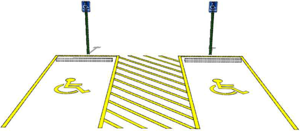
Accessible parking spaces. Each accessible parking space shall be marked with a free-standing or wall mounted sign using the standard symbol that signifies the space as designed to be accessible to persons with disabilities, along with the phrase "Accessible Parking." In addition, the standard symbol shall be painted on the pavement within the parking space. (See Figure 21-5-210(b), Illustrative Accessible Parking Spaces.) This requirement shall automatically change to conform to any amendments to the 2010 ADA Standards for Accessible Design (as may be amended, re-titled or renumbered from time to time) that are in effect at the time the parking space is striped.
|
Figure 21-5-210(b)
ILLUSTRATIVE ACCESSIBLE PARKING SPACES |
|---|
 |
(c)
Traffic control devices. All traffic control devices (signs, markings, and signals) shall conform to the Manual on Uniform Traffic Control Devices (MUTCD), latest edition.
(d)
Parking stops.
(1)
Parking stops, curbs, or bumper rails shall be installed in all parking spaces (except parallel parking spaces) at the perimeter of the parking lot and in all ADA-accessible parking spaces (except parallel parking spaces).
(2)
Parking stops or curbs shall be at least four (4) inches high and set back a minimum of four (4) feet from the sidewalk line. Bumper rails, if used, shall be set back a minimum of one (1) foot from the sidewalk line.
(3)
The city may require the installation of parking stops, curbs, or bumper rails in other locations if they are needed to prevent traffic from cutting across the parking lot outside of the drive aisles.
(Ord. No. 33-2017, § 1, 12-6-17)
Sec. 21-5-211. - Required truck loading areas.
(a)
Generally.
(1)
Buildings or structures to be built or substantially altered which receive and distribute material or merchandise by truck shall provide and maintain off-street loading berths in sufficient numbers and size to adequately handle the needs of the particular use.
(2)
If loading space has been provided in connection with an existing use or is added to an existing use, the loading space shall not be eliminated if elimination would result in less space than is required to adequately handle the needs of the particular use.
(3)
Off-street parking areas used to fulfill the requirements of this section shall not be used for loading and unloading operations except during off-peak parking periods.
(b)
CBD and MU exception. In the CBD Zone and MU Zone, over-the-curb loading from local streets or alleys is allowed in lieu of the off-street loading requirements of this section, provided that the loading occurs during off-peak hours and the areas that are used for loading are approved by the public works director.
(c)
Loading space dimensions.
(1)
Minimum width of loading bay (side to side): Twelve (12) feet.
(2)
Minimum length of loading bay (front to back):
a.
For semi-trailers: Sixty (60) feet.
b.
All other loading spaces: Twenty-five (25) feet.
(3)
Minimum vertical clearance: Fourteen (14) feet.
(d)
Use of rights-of-way. Where off-street loading areas are required, at no time shall any part of a truck or van be allowed to extend into a public right-of-way while the truck or van is being loaded or unloaded.
(e)
Maneuvering space. Adequate off-street truck maneuvering space shall be provided on-site (and not within any public street right-of-way or other public land) so that trucks can maneuver to the loading area.
(f)
Location.
(1)
Generally, all loading areas are required to be located on the same lot as the building or lot served by the loading area.
(2)
Loading areas may be shared if:
a.
The development is laid out as blocks with alleys, the size and number of loading spaces is calculated based on the development in each block, and the shared loading spaces are accessed via the alleys of the blocks they are intended to serve; or
b.
The uses that share loading areas meet all of the following criteria:
1.
The uses are adjacent;
2.
Convenient, complimentary hours are established for loading and unloading, and such hours are posted;
3.
The loading spaces are easily accessible and well-lit; and
4.
The loading areas are not located on through traffic streets, and whenever possible, are located behind one (1) of the buildings served by the loading areas.
(g)
Relationship to building.
(1)
Except in the I Zone, loading areas shall be located behind the principal building or may be located on the side of the principal building if the loading areas are screened from front and side views by wing walls or a shed structure.
(2)
In the I Zone, the location of loading areas in relation to buildings is not restricted.
(h)
Design. Off-street loading facilities shall be designed so that they do not interfere with fire exits or emergency access routes.
(Ord. No. 33-2017, § 1, 12-6-17)
Sec. 21-5-212. - Vehicle stacking requirements.
(a)
Generally. Stacking spaces are used to measure the capacity of a drive-through lane to hold cars while transactions are taking place at drive-through stations. Stacking spaces measure eight (8) feet wide by twenty (20) feet long and provide direct access to a service window. The position in front of a drive-through station (e.g., a service window, ATM, or station at a drive-through bank) is counted as a stacking space.
(b)
Requirements. Uses that include drive-through service shall provide not less than the following numbers of stacking spaces:
(1)
Financial institutions, drive-through convenience retail, or pharmacies: Three (3) stacking spaces per drive-through station.
(2)
Drive through restaurants:
a.
If two (2) service windows are provided (one (1) for payments and one (1) for pick-up):
1.
Four (4) stacking spaces to each menu board (including the position at the menu board);
2.
Four (4) stacking spaces between the menu board and the first window (including the position at the first window); and
3.
Two (2) spaces between the first window and the second window (including the position at the second window).
b.
If one (1) service window is provided (for both payments and pick up):
1.
Six (6) stacking spaces to the menu board; and
2.
Five (5) stacking spaces between the menu board and the service window.
(3)
Drive-through only uses in buildings with less than three hundred (300) square feet of gross floor area and no separate menu board (e.g., coffee stands): Three (3) stacking spaces per service window.
(4)
Dry cleaners: Two (2) stacking spaces, including the position at the window.
(5)
Vehicle Wash:
a.
Three (3) stacking spaces for each bay in a self-service vehicle wash facility;
b.
Five (5) stacking spaces for each conveyor vehicle wash facility; and
c.
If the facility provides detailing, manual drying or polishing, and/or vacuuming, sufficient area to provide those services without creating additional demand for stacking at the vehicle wash entrance.
(6)
Stacking spaces for other uses are determined by the administrator.
(c)
Design.
(1)
Stacking lanes shall be clearly marked, and shall not interfere with on-site or off-site traffic circulation.
(2)
Stacking areas shall not be located between the facade of a building and the public street upon which the building fronts unless a parking bufferyard separates the stacking area from the street.
(3)
Stacking lanes shall be designed with an adjoining eight-foot wide bypass lane.
(Ord. No. 33-2017, § 1, 12-6-17)
Sec. 21-5-213. - Construction, operation, and maintenance.
(a)
Driving and parking surface. Areas used for parking, standing, and maneuvering of vehicles shall be surfaced with asphalt or concrete or other material of comparable quality approved by the administrator, and must be maintained adequately for all-weather use.
(b)
Operation of parking lots. Required parking spaces shall be available for the parking of operable passenger automobiles of residents, customers, patrons, and employees only, and shall not be used for storage of vehicles or materials or for the parking of trucks used in conducting the business or use.
(c)
Operation of loading areas. The long-term storage of trucks and trailers in loading spaces is prohibited. Such spaces shall be available for routine use by delivery vehicles.
(Ord. No. 33-2017, § 1, 12-6-17)
Sec. 21-5-301. - Purpose and application of division.
(a)
Generally. This division includes standards for three (3) categories of landscaping:
(1)
General landscaping. General landscaping is the landscaping that is required regardless of the location of the subject property with respect to other uses.
(2)
Parking lot landscaping. Parking lot landscaping is the landscaping within and on the boundaries of surface parking lots.
(3)
Bufferyard landscaping. Bufferyard landscaping is contextual. That is, bufferyards are required (or not) based on the zoning, development type, or right-of-way type that adjoins the subject property.
(b)
Relationship to open space ratio or landscape surface ratio. The landscaping areas that are defined in this division are counted towards the open space ratio and landscape surface ratio of the subject property.
(c)
Applicability of standards; general exceptions.
(1)
Except as provided in subsection (b)(2), the standards of this division apply to all new development, redevelopment, or substantial improvements to existing sites or buildings.
(2)
The standards of this division do not apply to:
a.
Individual lots that are used for existing single-family detached or duplex dwellings.
b.
Modifications to nonresidential buildings where the redevelopment does not expand the floor area of the use by more than ten (10) percent.
(d)
Landscape calculations. No area of a subject property shall be counted more than once for the purposes of applying landscaping requirements.
(Ord. No. 33-2017, § 1, 12-6-17)
Sec. 21-5-302. - Landscape design principles.
(a)
Generally. Landscapes for nonresidential and multifamily development that involve more than one thousand (1,000) square feet of landscaped area shall be designed by a qualified landscape architect or design professional. The administrator shall develop and maintain a list of qualifications or certifications that are acceptable to the city for this purpose.
(b)
Plant spacing. Plant spacing shall allow for adequate growth of plants at maturity and for intersection visibility.
(c)
Family, genus, and species selection.
(1)
Within each category of required planting (i.e., canopy trees, understory trees, evergreens, and shrubs):
a.
Not more than thirty (30) percent shall be of any one (1) family;
b.
Not more than twenty (20) percent shall be of any one (1) genus; and
c.
Not more than ten (10) percent shall be of any one (1) species.
(2)
Native and low-water demanding plants and turf shall be used where practicable.
(3)
Native species and natural drainage ways shall be protected if practicable.
(4)
Plants shall be compatible with project soils.
(5)
Russian Olive (Elaeagnus angustifolia), Salt Cedar (Tamarix ramosissima), and plants that are identified as noxious, invasive, or prohibited by the United States or the State of Colorado shall not be planted in the city.
(d)
Irrigation and soil moisture control.
(1)
Plants with similar water requirements shall be grouped together on the same irrigation hydrozone;
(2)
High-irrigation turf and plantings shall be limited to appropriate high-use areas with high visibility and functional needs;
(3)
Soil improvements shall be incorporated where necessary for healthy plant growth; and
(4)
In permeable areas that are not covered by groundcover vegetation, mulch or rock shall be applied to help retain water in the soil and to help prevent erosion.
(Ord. No. 33-2017, § 1, 12-6-17)
Sec. 21-5-303. - Size and quality of landscape plants; tree preservation credits.
(a)
Size and quality of landscape plants. In general, plant materials that are installed according to the requirements of this division shall meet the standards that are set out in this section. However, larger sizes may be required to ensure survival or to implement a condition of approval of a limited or conditional use.
(b)
Minimum size of landscape materials. The minimum sizes of landscape materials used to satisfy the requirements of this division are set out in Table 21-5-303(b), Minimum Size of Landscape Materials.
(c)
Specification of landscape materials. All plant material shall be true to type, form, species, quality and free of injury, broken root balls, pests and diseases as well as conform to the minimum requirements described in "American Standards for Nursery Stock" (ANSI Z60.1), published by AmericanHort, as may be amended from time to time, and follow the Green Industries of Colorado ("GreenCo") Tree Planting Recommendations, as may be amended from time to time. Plant materials shall have normal, well-developed branches and vigorous root systems.
(d)
Tree preservation credits.
(1)
Existing trees that are preserved on a subject property count towards the planting requirements of this division, provided that:
a.
They are established for at least five (5) years and not prohibited by subsection 21-347(c)(5); and
b.
They are not:
1.
Overmature;
2.
Diseased;
3.
Poor in form;
4.
Leaning heavily over buildings;
5.
Too close to building foundations;
6.
Damaging sidewalks and driveways; or
7.
Impacting utilities.
(2)
Preserved trees may count as more than one (1) tree for the purposes of the landscaping requirements, as set out in Table 21-5-303(d)(2), Tree Preservation Credits.
(Ord. No. 33-2017, § 1, 12-6-17)
Sec. 21-5-304. - General landscaping.
(a)
Generally. General landscaping is required as set out in this section.
(b)
Applicability. The standards of this section apply in all zones except CBD, and except as provided in subsection 21-5-301(c)(2).
(c)
General landscape area.
(1)
The general landscape area is the permeable area of the subject property, except for the following areas:
a.
Parking lot landscape areas (see sec. 21-5-305, parking lot landscaping);
b.
Bufferyards (see Sec. 21-5-306, bufferyard landscaping);
c.
Areas within and extending up to fifteen (15) feet from plazas, play fields, or other outdoor gathering spaces or recreation areas, the use of which would be diminished by the presence of trees;
d.
Areas within designated outdoor storage areas or work areas;
e.
Areas within irrigation ditch easements, or within thirty (30) feet of the ditch bank if the easement does not have delineated boundaries;
f.
Areas used for gardens;
g.
Wetlands and waterbodies;
h.
Stormwater detention facilities;
i.
Utility and drainage easements;
j.
Wooded areas;
k.
Areas where ground-mounted solar panels (of any type) are installed, and any areas around them that must be kept clear of vegetation to avoid shading of the panels in order to optimize their use;
l.
Permeable areas that are less than eighty (80) square feet that are enclosed by any combination of buildings, structures, impermeable surfaces such as asphalt or concrete, or any of the areas described in subsection (c)(1), above; and
m.
Areas in which the soils or topography are not suitable for the establishment and growth of healthy trees.
(d)
Waiver or reduction of tree planting requirements. The administrator may waive or decrease planting requirements if the total number of trees that are required exceeds the number that can be reasonably planted on the subject property without materially increasing fire risk, compromising the health of the trees, or diminishing the use of the property.
(e)
Tree planting requirements. Trees shall be planted in all general landscaping areas at a rate of not less than one (1) tree per two thousand (2,000) square feet of general landscaping area, with fractions dropped.
(f)
Landscape design. The tree planting requirements are not spacing requirements. Trees may be planted in formal or informal arrangements. Trees that reach a mature height of more than twenty-five (25) feet shall not be planted within twenty (20) feet of an overhead utility line.
(g)
Groundcovers. Groundcovers shall be planted as necessary to stabilize soil and prevent erosion.
(Ord. No. 33-2017, § 1, 12-6-17)
Sec. 21-5-305. - Parking lot landscaping.
(a)
Generally. Parking lot landscaping is required as set out in this section.
(b)
Applicability. The standards of this section apply to surface parking lots associated with all nonresidential and multifamily uses, except parking lots that contain fewer than sixteen (16) parking spaces, and except in the CBD Zone.
(c)
Parking lot landscape areas. Landscaping is required in all of the following areas:
(1)
At the ends of parking aisles, planted in endcap islands that are not less than nine (9) feet wide and thirty-six (36) feet long (eighteen (18) feet where the parking module does not adjoin another parking module), with 10 foot curb radii on the side that faces outward from the parking aisle;
(2)
Between the endcaps of parking rows, either:
a.
Planted in interior islands that are not less than nine (9) feet wide and thirty-six (36) feet long (eighteen (18) feet where the parking module does not adjoin another parking module), with five (5) foot curb radii at both ends; or
b.
Planted in interior landscape strips that are at least five (5) feet wide that are located between parking modules, or at the edges of parking modules where parking modules do not adjoin each other.
(3)
At the corners of parking lots, planted in corner islands, which are the area defined by the extension of the outer edges of intersecting parking modules.
(d)
Spacing of parking lot landscape areas. Parking lot landscape areas shall be spaced so that no parking lot landscape area is more than one hundred (100) feet from any other parking lot landscape area, measured from curb to curb.
(e)
Planting requirements.
(1)
Each endcap island, interior island, and corner shall be planted with a minimum of one (1) canopy tree or two (2) understory trees.
(2)
Each landscape strip shall be planted with not less than one (1) canopy tree or two (2) understory trees per one hundred (100) linear feet. Formal arrangement of the trees in the landscape strip is not required.
(3)
The administrator may waive the planting requirements of this subsection, or allow the landscaping to be planted in an alternative location on the subject property (if reasonably available), for any particular landscape area or portion thereof if:
a.
The tree or trees will interfere with sight triangles that are necessary for safe ingress to or egress from the parking lot; or
b.
The landscape area is not conducive to the healthy growth of trees (e.g., due to topography, solar orientation, or soil types); or
c.
The landscape area is part of a stormwater conveyance system, and is not suitable for tree planting.
(Ord. No. 33-2017, § 1, 12-6-17)
Sec. 21-5-306. - Bufferyard landscaping.
(a)
Generally. Bufferyard landscaping is required as set out in this section, and as set out in this UDC for specific uses or situations.
(b)
Applicability. The standards of this section apply to all required bufferyards.
(c)
Bufferyard classifications. For the purposes of this UDC, there are five (5) classifications of bufferyards, as set out in Table 21-5-306(c), Bufferyard Classifications.
(d)
Parking bufferyards. Surface parking lots for multifamily and nonresidential land uses shall be buffered from adjoining streets and adjoining residential property. Unless another type of bufferyard is required along the same boundary of the subject property, the minimum bufferyard for this purpose shall be a Parking Bufferyard.
(Ord. No. 33-2017, § 1, 12-6-17)
Sec. 21-5-307. - Maintenance standards.
(a)
Generally. All landscaping elements and irrigation equipment shall be maintained in good condition. Ongoing maintenance, including the replacement of dead or unhealthy plantings, is required for areas that are landscaped pursuant to an approved landscape plan.
(b)
Restrictions within dripline or critical root zone of trees used for credit. The following restrictions apply within the larger of the dripline or the critical root zone of trees that are used for credit pursuant to section 21-5-303:
(1)
Prohibited activities. The following are not allowed:
a.
Cutting or filling;
b.
Storage of building materials or debris;
c.
Disposal of wastes;
d.
Installation of impervious paving.
(2)
Barricades required. The dripline or critical root zone shall be barricaded during construction to prevent damage to the trees and their roots by construction equipment.
(c)
Tree pruning techniques.
(1)
The following pruning techniques are prohibited on trees that are preserved or planted pursuant to an approved landscape plan:
a.
Topping (cutting large vertical branches of the tree to reduce its height).
b.
Tipping (cutting branches between nodes).
c.
Bark ripping (cutting branches so that the bark rips when the branch falls).
d.
Flush cuts (cutting the branch too close to the collar, the area where the branch connects to the tree).
e.
Stub cuts (cutting branches too far away from the collar, the area where the branch connects to the tree).
(2)
All pruning of trees within the public right-of-way or on public property shall be performed in accordance with ANSI A300, Part 1 (Pruning), as amended from time to time, and Tree Pruning Best Management Practices or Best Management Practices - Utility Pruning of Trees, as applicable (published by the International Society of Arboriculture), as either may be amended from time to time.
(Ord. No. 33-2017, § 1, 12-6-17)
Sec. 21-5-308. - Open space.
(a)
Generally. The area of land or water that is designated as open space for the purposes of satisfying the minimum open space ratio shall be physically suited for one or more of the following uses:
(1)
Any landscape area that is required by this division;
(2)
Conservation of open land in its natural state (e.g., woodlands, stream corridors, grasslands, floodplains, and the like);
(3)
Active or passive recreation (see Section 21-6-202, parks); or
(4)
Agriculture, horticulture, forestry, or fishery uses (including barns, stables, and other structures accessory or incidental to such uses, provided that such structure cover less than ten (10) percent of the site), where permitted under the appropriate zoning classification.
(b)
Location and form.
(1)
Open space shall, to the maximum extent feasible, be compact and contiguous and connected to existing or anticipated protected open space on adjacent properties.
(2)
The exact location and configuration of the land to be dedicated shall be determined by the city in consultation with the applicant, and shall take into consideration the suitability of the proposed open space sites for their stated purposes, and their proximity to other open space, parks, trails, or recreational lands.
(3)
The following areas shall be given priority in dedicating or setting aside open space:
a.
Sensitive environmental areas such as steam corridors and wetlands.
b.
Wildlife habitat.
c.
Woodlands.
d.
Parks.
e.
Recreational paths and trails.
(Ord. No. 33-2017, § 1, 12-6-17)
Sec. 21-5-401. - Purpose and intent.
(a)
The purpose of this division is to provide standards for outdoor lighting design that preserve, protect, and enhance the City's night sky while conserving energy, permitting reasonable and safe nighttime use of properties, minimizing glare and obtrusive light, and helping to protect the natural environment and wildlife from the impacts of night lighting. The intent of this division is to ensure that the use of light, particularly at night, is only prescribed when it is needed, where it is needed, and in the appropriate amount for a specific task. The standards of this division shall not be interpreted in any way to detract from public safety.
(b)
The intent of this division is to promote the five (5) principles for responsible outdoor lighting:
(1)
Useful. Use light only if it is needed. All light should have a clear purpose.
(2)
Targeted. Direct light so it falls only where it is needed by using shielded and carefully aimed light so that it points downward and does not spill beyond where it is needed.
(3)
Low level. Light should be no brighter than necessary. Use the lowest light level required and be mindful of surface conditions, as some surfaces may reflect more light upward.
(4)
Controlled. Use light only when it is needed, by using controls such as timers or motion detectors to ensure that light is available when it is needed, dimmed when possible, and turned off when not needed.
(5)
Warm-colored. Use warmer-color lights where possible and limit the amount of shorter wavelength (blue-violet) light to the least amount needed.
(Ord. No. 27-2024, § 5, 11-6-24)
Sec. 21-5-402. - Scope and applicability.
(a)
Compliance. All outdoor lighting that is replaced or newly installed after the effective date of this ordinance shall conform to the requirements established by this division. Existing lighting that remains unchanged (including ongoing standard maintenance such as bulb replacement and/or painting of existing poles and fixtures) shall be exempt from the requirements herein.
(b)
Exemptions. The following are exempt from the requirements of this division.
(1)
Lighting that is not permanently installed and of a temporary nature, such as lighting needed for construction. Such lighting shall be discontinued upon completion of the work for the day or resolution of the situation necessitating its usage.
(2)
Lighting of any type that is installed (or required to be installed) by the federal government, the State of Colorado, Alamosa County, the city, or the school district, on property owned or controlled by the governmental entity. Such lights include but are not limited to traffic control devices, temporary lights that are used in conjunction with traffic control, lights for specific security purposes as determined by the Administrator, and other lights that said entities display, require, or license to be displayed upon property that they own or control.
(3)
String, bistro, and similar lighting provided that the emission of no individual lamp exceeds fifty (50) lumens, and no installation of such lighting exceeds six thousand (6,000) lumens in aggregate. These lights must be rated at or below three thousand (3,000) Kelvins.
(4)
Low voltage landscape lighting used to illuminate pathways and landscape features in residential areas, provided the lights are installed no more than eighteen inches (18") above the adjacent ground level and have caps that direct the light downward.
(5)
Lighting that is clearly incidental, customary, and commonly associated with a holiday.
(6)
Any decorative or seasonal lighting, such as string lighting, bistro lighting, or holiday lighting on properties fronting Main Street.
(c)
Nonconforming lighting. All existing outdoor lighting that does not meet the requirements of this division and is not exempted by this division shall be brought into compliance pursuant to the standards set forth in section 21-7-404, Nonconforming Lighting.
(Ord. No. 27-2024, § 5, 11-6-24)
Sec. 21-5-403. - Prohibited outdoor lighting.
The following types of outdoor lighting sources, fixtures, and installations shall be prohibited in the City of Alamosa:
(a)
Outdoor floodlighting by floodlight projection above the horizontal plane.
(b)
Searchlights, floodlights, laser source lights, or any similar high-intensity light, except in emergencies by police, fire, or medical personnel or at their direction.
(c)
Flashing or blinking lights, or lighting with changing intensity except for seasonal holiday lighting.
(d)
Any light that could be construed as a traffic control device and which has not been authorized by a state, federal, or local government.
(e)
Mercury vapor lighting.
(Ord. No. 27-2024, § 5, 11-6-24)
Sec. 21-5-404. - Lighting information required.
All permits that involve new construction or site development, or modifications of existing buildings or sites shall include sufficient information that the proposed lighting complies with this division, and shall include illustrations, such as those contained in a manufacturer's catalog cuts, of all proposed lighting fixtures. The administrator may require information regarding the light fixture, initial lumen rating, color correlated temperature, wattage of each lamp source, and shielding mechanisms.
(Ord. No. 27-2024, § 5, 11-6-24)
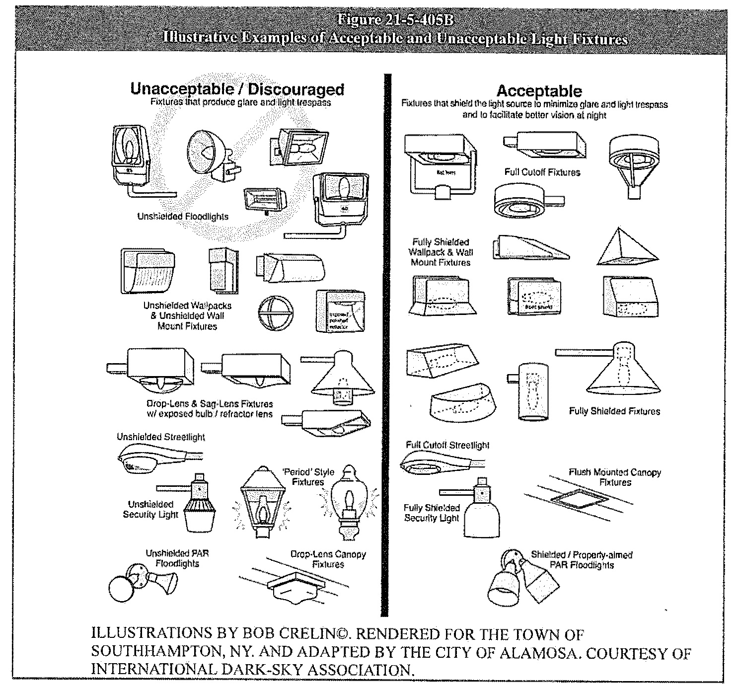
Sec. 21-5-405. - Outdoor lighting standards.
(a)
Generally. Exterior lighting in all zones, except for outdoor recreation lighting, shall conform to the requirements of this section.
(b)
Fixture types.
(1)
All outdoor lighting subject to this Code shall be fully shielded and directed toward the ground or downward, shielded by roof elements, or effectively recessed to minimize light trespass, glare, and skyglow.
(2)
Unshielded or partially shielded fixtures may be used only for special purposes such as historic preservation, provided:
a.
They are fixtures that produce no more than five hundred (500) lumens (approximately equal to a traditional 60W incandescent bulb); and
b.
Are less than three thousand (3,000) Kelvins and use adaptive controls.
(c)
Maximum freestanding fixture height. No freestanding light fixture shall be greater than twenty-five (25) feet in height for non-residential and mixed uses and fifteen (15) feet in height for residential uses, except that greater heights may be approved by the administrator if it is demonstrated that the greater height improves site lighting in a manner consistent with this division.
(d)
Maximum illumination levels.
(1)
Outdoor lighting shall be deflected, shaded, and focused away from adjacent properties, and shall not be a nuisance to such adjacent properties.
(2)
Outdoor lighting shall be designed so that any overspill of lighting onto adjacent properties shall not exceed three-tenths of a foot-candle, measured vertically, and three-tenths of a foot-candle, measured horizontally, on adjacent properties.
(e)
Canopy lighting. Canopy lighting for uses that have sheltered outside work or service areas or porte-cocheres, shall meet the standards of this Section. All lighting fixtures shall be recessed into the canopy so that they cannot be viewed from off-site from an eye height of four (4) feet.
(f)
Color temperature. Outdoor lighting fixtures shall be chosen to minimize the amount of short-wavelength light emitted into the nighttime environment, such as amber, yellow, and similar colors for lighting, and avoid bright white light wherever practically possible unless a demonstrated need for color rendition exists. In no case shall the correlated color temperature exceed three thousand (3,000) Kelvins.
(g)
Use of adaptive controls. All outdoor lighting fixtures greater than five hundred (500) initial lamp lumens shall make appropriate use of adaptive controls, including, but not limited to, timers, dimmers, and motion sensors.
(h)
Flagpole lighting. Nighttime flag illumination shall conform to the following standards:
(1)
Flagpoles shall be illuminated only from above.
(2)
Fixtures are to be mounted so that the light output points directly to the flag.
(Ord. No. 27-2024, § 5, 11-6-24)
Sec. 21-5-406. - Exterior lighting for outdoor recreation.
(a)
Generally. Ball diamonds, playing fields, driving ranges, tennis courts, and similar amusement or recreation uses have unique requirements for nighttime visibility and, generally, have limited hours of operation.
(b)
Fixture type. Light fixtures for illumination of playing courts and athletic fields shall be fully-shielded fixtures that are oriented to limit sky glow and direct lighting that is visible or measurable at the property line.
(c)
Maximum freestanding fixture height. No freestanding light fixture shall be greater than forty (40) feet in height, except that greater heights may be approved by the administrator if it is demonstrated that the greater height improves site lighting compared to fixtures that are forty (40) feet in height or less.
(d)
Maximum illumination.
(1)
Field and court lighting shall be deflected, shaded and focused away from adjacent properties and shall not be a nuisance to adjacent properties.
(2)
Field and court lighting shall be designed so that any overspill of lighting onto adjacent properties shall not exceed one-half (½) foot-candle, measured vertically, and one-half (½) foot-candle, measured horizontally, at the property line.
(3)
Buffering may be used to reduce impacts of outdoor recreation lighting in order to achieve compliance with the requirements of this subsection (d).
(4)
Lighting shall provide levels of illumination that are adjustable according to the task, allowing for illumination levels not to exceed nationally recognized Illuminated Engineering Society standards according to the appropriate class of play, as well as for lower output during other times, such as when field maintenance is being actively performed.
(e)
Curfew. Lighting shall be extinguished within one (1) hour of the end of active play. New installations of outdoor sports facility lighting shall be fitted with mechanical or electronic timers to prevent lights from being left on accidentally overnight.
(Ord. No. 27-2024, § 5, 11-6-24)
Sec. 21-5-407. - Greenhouse lighting.
If indoor lighting is used between sunset to sunrise for cultivation or agricultural purposes, whether as a principal or accessory use, it shall not be visible from outdoors. Black-out curtains or other kinds of light obstruction may be used.
(Ord. No. 27-2024, § 5, 11-6-24)
Sec. 21-5-408. - Public safety and public nuisance.
(a)
Generally. The city may require the modification or removal or limited operation of existing or new lighting fixtures if they are found to be a public hazard or public nuisance according to the criteria of this section.
(b)
Hazards. Criteria for finding illumination to be a public hazard are as follows:
(1)
Light trespass or glare which is sufficiently intense or contrasts excessively with surrounding illumination, regardless of the intensity of the surrounding illumination, in a manner to cause impairment of visual performance or to distract from or impair the safe operation of a vehicle.
(2)
Light trespass or glare that impairs a person's visual performance or ability to avoid obstacles in their path.
(c)
Nuisance. Criteria for finding illumination to be a public nuisance are as follows:
(1)
Light trespass or glare that deprives an owner or occupant of usual and reasonable use and enjoyment of their property.
(2)
A high frequency or duration of periods when light trespass or glare is sufficient to interrupt or interfere with usual and reasonable use and enjoyment of property other than the subject property.
(3)
Light trespass or glare that causes visual discomfort or impairment of visual performance in a manner that deprives the average person from the usual and reasonable enjoyment of the public streets and properties of the city.
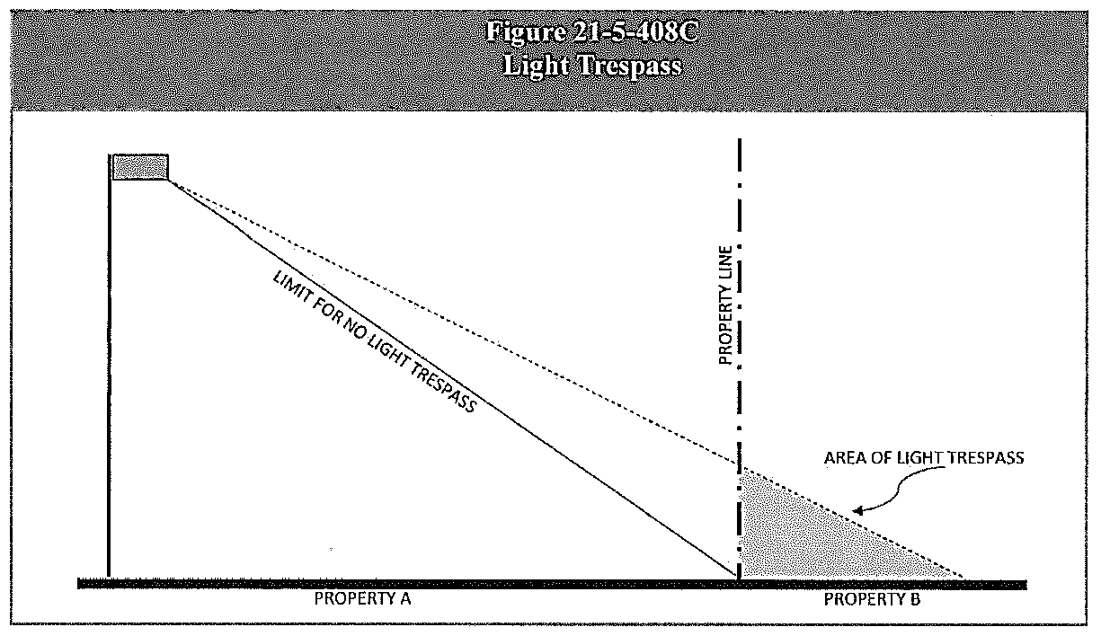
(Ord. No. 27-2024, § 5, 11-6-24)
Sec. 21-5-501. - Intent and liability
(a)
Legislative intent. The intent of this division is to enhance the quality of water in the city's drainage ways and subsequent receiving waters in order to promote the safety, public health, convenience, and general welfare of the city by:
(1)
Establishing requirements for stormwater quantity and quality control as part of new development and redevelopment to prevent impacts on the storm sewer system and receiving waters from runoff leaving new development and redevelopment within the city.
(2)
Establishing requirements for grading permits for construction activities and development to prevent soil erosion, sedimentation, and other pollutants from leaving construction sites.
(b)
Liability. Any person who undertakes or causes to be undertaken any activity which involves disturbance of the land's surface shall ensure that soil erosion, sedimentation, increased pollutant loads, and changed water flow characteristics resulting from the activity are controlled so as to minimize pollution of receiving waters. The requirements of this Division are the minimum standards, and a person's compliance with the same shall not relieve such person from the duty of enacting all measures necessary to minimize pollution of receiving waters.
(Ord. No. 33-2017, § 1, 12-6-17)
Sec. 21-5-502. - General standards for grading.
(a)
Generally. Stormwater discharges from construction activities shall not cause, nor have the reasonable potential to cause pollution, contamination, or degradation of waters of the state. Grading activities (except agriculture) that affect more than one (1) acre of land, or that affect land within one hundred fifty (150) feet of the Rio Grande, shall be conducted in accordance with an approved stormwater management plan ("SWMP") that details the best management practices ("BMPs") to be used during construction and upon completion of construction.
(b)
Best management practices (BMPs) during construction.
(1)
Construction BMPs. Construction site operators shall protect water quality and control runoff and erosion through the implementation of appropriate construction BMPs.
(2)
Timing of installation. All temporary or permanent erosion control BMPs that are intended to function during earth disturbance operations shall be installed before any construction activities take place.
(3)
Selection of BMPs. The selection, design, and installation of appropriate structural and nonstructural BMPs must be done in accordance to the latest revision of the Urban Drainage and Flood Control District's ("UDFCD") Urban Storm Drainage Criteria Manuals ("USDCM"). BMPs must be adequately designed and scaled to provide control for all potential pollutant sources associated with construction activity to prevent pollution or degradation of surface waters.
(4)
Types of construction BMPs. Construction BMPs shall include appropriate erosion control BMPs, sediment control BMPs, material management BMPs, and site management BMPs.
a.
Erosion control BMPs (e.g., mulching, erosion blankets, check dams etc.) limit the amount and rate of erosion occurring on disturbed areas.
b.
Sediment control BMPs (e.g., silt fence, inlet/outlet protection, sediment traps/basins etc.) attempt to capture the soil that has been eroded before it leaves the construction site.
c.
Material management BMPs (e.g., stockpile management, good housekeeping practices etc.) limit contact of runoff with pollutants commonly found at construction sites, such as construction materials and equipment-related fluids.
d.
Site management BMPs (e.g., construction phasing or sequencing, protection of existing vegetation, street sweeping etc.) minimize erosion and sediment transport by considering construction phasing, scheduling, and sequencing of land disturbing activities. These BMPs minimize the duration of exposure or quantity of exposed soils that are susceptible to erosion. Site management also ensures BMPs implemented at the site are properly selected, installed, inspected, maintained, and repaired to reduce erosion and sediment transport.
(5)
Management of flows. Any temporary or permanent facility designed and constructed for the conveyance of water around, through, or from the earth disturbance area shall be designed to limit the water flow to a non-erosive velocity.
(c)
Grading operations.
(1)
Any earth disturbance shall be conducted in a manner that effectively reduces accelerated soil erosion and resulting sedimentation, and does not exceed the erosion expected to occur for the subject property in its totally undeveloped state.
(2)
All earth disturbances shall be completed diligently so that the exposed area of any disturbed land shall be limited to the shortest possible period of time.
(3)
Sediment caused by accelerated soil erosion shall be removed from runoff water before it leaves the site of the disturbed area.
(4)
Construction site operators shall control waste such as, but not limited to, discarded building materials, concrete truck washout, chemicals, litter, and sanitary waste at the construction site that may cause adverse impacts to water quality.
(5)
Concrete washout water shall not be discharged to the storm sewer system, public right-of-way, or waters of the state. On-site permanent disposal of concrete washout waste is not allowed.
(6)
Off-site vehicle tracking of sediments shall be controlled and minimized.
(7)
Bulk storage structures for petroleum products and other chemicals shall have secondary containment or equivalent adequate protection so as to contain all spills and prevent any spilled material from entering surface waters.
(8)
Solids, sludges, or other pollutants removed in the course of treatment or control of wastewaters or runoff shall be properly disposed of in a manner such as to prevent any pollutant from such materials from entering surface waters.
(9)
No building material wastes or unused building materials shall be buried, dumped, or discharged at the site.
(10)
The city may require sampling and testing on a case-by-case basis in the event that there is reason to suspect that compliance with the SWMP is a problem, or to measure the effectiveness of the BMPs.
(d)
Stabilization and planting.
(1)
Exposed areas of cut and fill shall be planted with at least two (2) genera of native plants that are selected for their ability to stabilize the soil and prevent erosion.
(2)
Generally, planting shall be timed within ninety (90) days of the completion of final grading unless other construction activities are planned within ninety (90) days of that date. If final grading is completed between October 1 and March 15, planting is required by no later than June 15.
(3)
The administrator may require financial guarantees in the form of cash deposits or letters of credit to guarantee completion of the work.
(Ord. No. 33-2017, § 1, 12-6-17)
Sec. 21-5-503. - Permanent best management practices (BMPS).
(a)
Generally.
(1)
The latest revision of the Urban Drainage and Flood Control District's ("UDFCD") Urban Storm Drainage Criteria Manuals ("USDCM") shall be used to establish criteria for new development and redevelopment planning, water quality protection, and the selection and design of appropriate permanent BMPs.
(2)
Appropriate BMPs for the proposed project shall be designed and implemented according to the UDFCD-USDCM specifications and following good engineering, hydrologic, and pollution control practices.
(3)
BMPs that are not included within the latest revision to the UDFCD-USDCM may be used only with the approval of the city engineer.
(b)
Types of permanent BMPs. Permanent (post-construction) stormwater BMPs are generally divided into two (2) categories: Treatment BMPs and source control BMPs.
(1)
Treatment BMPs. Treatment BMPs include a variety of alternatives generally categorized as conveyance practices and storage practices (e.g. a grass swale, retention pond, or sand filter) that provide treatment of the stormwater runoff quantity and quality.
(2)
Source control BMPs. Source control BMPs stop or redirect pollutants before they enter the storm sewer system. A source control BMP can be a structural component of a planned site (e.g. a covered area for material storage) or a procedural BMP. Procedural BMPs involve public education, training, and development of standard operating procedures.
(c)
Location of structural BMPs.
(1)
Treatment or source control BMPs that involve structures shall be located on private property when possible.
a.
When so located, the BMP shall be owned and operated by the owner of the property on which the BMP is located.
b.
As a condition of approval of the BMP, the owner shall agree to operate and maintain the BMP to its design capacity unless and until the City relieves the property owner of that responsibility in writing.
c.
The obligation to maintain the BMP shall be memorialized on a subdivision plat, annexation plat, or in another form acceptable to the city attorney, and shall be recorded in the office of the Alamosa County Clerk and Recorder.
(2)
When the BMP must be located within the public right-of-way or within property owned by the city, the city shall own, operate, and maintain the facility.
(Ord. No. 33-2017, § 1, 12-6-17)
Sec. 21-5-504. - Design of permanent drainage systems.
(a)
Generally. Open drainage systems and underground drainage systems shall be designed according to the standards of this section.
(b)
Design objectives for open drainage systems. Site drainage using open systems shall be planned such that it:
(1)
Minimizes negative impacts on natural site features (e.g., through grading or erosion) and minimizes obstructions or alterations of natural drainageways;
(2)
Creates an amenity that is incorporated into the overall landscape plan, as follows:
a.
Detention and drainage areas with a volume of less than one thousand (1,000) cubic feet should be designed as natural landscape amenities;
b.
If feasible, detention and drainage areas with a volume of one thousand (1,000) cubic feet or more should be designed as recreational amenities; and
(3)
Appears natural in character, even if stabilized for erosion control. For example:
a.
Natural drainage ways should be incorporated into the drainage plan and the site design should feature them as amenities.
b.
Storm drains may be developed as an open landscaped feature that is lined with native grasses and indigenous plants, while also meeting technical engineering standards.
c.
The use of riprap and other devices that do not appear natural in character should be avoided in favor of treatments that appear more natural in the context of the city and the region, such as local stone, native trees and shrubs, and drought tolerant grasses.
(c)
Underground systems. When a drainage system cannot be designed as a site amenity, or the drainage system is located in the CB, CBD, or I Zone, an underground drainage system may be used instead of a surface drainage system.
(Ord. No. 33-2017, § 1, 12-6-17)