
Annapolis City Zoning Code
Division III
BASE DISTRICT REGULATIONS
21.38.010 - Purpose.
This chapter lists use and bulk regulations that apply to all zoning districts.
(Ord. O-1-04 Revised (part), 2005)
21.38.020 - Uses.
A.
Types of Uses. The following uses of land as listed in this division, are permitted in the districts indicated under the conditions specified:
1.
Permitted uses,
2.
Special exception uses,
3.
Uses subject to standards, and
4.
Accessory uses.
B.
Use of Land. No building or tract of land shall be devoted to any use other than those listed in Subsection A of this section with the exception of the following:
1.
Uses lawfully established on the date of adoption of this Zoning Code, and
2.
Uses already lawfully established on or before the date of adoption of this Zoning Code and rendered nonconforming by it. These uses are subject to Chapter 21.68.
C.
Utility Lines and Fixtures Exempted. The following uses are exempted from the provisions of this division and are permitted in any district: poles, wires, cables, conduits, vaults, laterals, pipes, mains, valves, or any other similar distributing equipment for telephone or other communication systems, electric power, gas, water and sewer lines.
Antennas and telecommunication facilities are not exempted. See regulations in Division V.
D.
Trailers. A trailer shall not be considered to be permissible as an accessory building.
E.
Tents. No tent may be erected, used or maintained for living quarters or long term storage.
(Ord. O-1-04 Revised (part), 2005)
(Ord. No. O-9-21, § I, 10-11-2021)
Editor's note—
Section III of Ord. No. O-9-21, adopted Oct. 11, 2021 provides that this ordinance
shall take effect from the date of its passage; provided, that there shall be an amnesty
period from the date of passage of this ordinance through close of business on January
10, 2022 to encourage compliance with the rental license requirements enacted by this
ordinance by allowing owners of unlicensed accessory dwelling units to participate
in this amnesty period by voluntarily entering the rental license process while continuing
to rent such unlicensed accessory dwelling unit. Any owner of an unlicensed accessory
dwelling unit who participates in this amnesty program shall be exempt from the penalties
set forth in Chapter 17.44 for the duration of the amnesty period. For the purpose
of this ordinance, the owner of an unlicensed accessory dwelling unit is participating
in the amnesty period if:
(1) A rental operating license application is filed in accordance with Chapter 17.44;
(2) The applicant makes a good faith effort, as determined by the Department, to complete
the rental license process during the amnesty period; and
(3) Information is not made known to the Department that the health, safety, or welfare
of any occupant of the unlicensed accessory dwelling unit is endangered.
21.38.030 - Bulk regulations.
A.
Bulk Regulations. Bulk regulation requirements for lots shall be as specified in the bulk regulations tables for each zoning district in this division.
B.
Minimum Lot Size and Width. No use shall be established or maintained after the date of adoption of this Zoning Code on a lot recorded after the date of adoption of this Zoning Code which is of less area or less width than prescribed in this Zoning Code for the use in the zoning district in which it is to be located.
C.
Building Conversions. No building shall be converted to conflict with, or further conflict with, the lot size requirements of the district in which the building is located.
D.
Historic District. In the historic district, height measurement and limits requirements apply in addition to those listed in the bulk regulations tables.
E.
Planned Development Required For Buildings Over Forty-Five Feet and/or Floor Area Ratio Over Two. Unless otherwise specified in the development standards for an individual zoning district, no new building or existing building which is later altered, shall have a height in excess of forty-five feet, including any tolerance allowed by the Director of the Department of Planning and Zoning pursuant to Subsection 21.30.160.C, or contribute to a floor area ratio on its zoning lot greater than two unless the building is approved as a planned development in accordance with Chapter 21.24. As used in this section, "floor area ratio" shall be calculated by dividing the total floor area of the building or buildings on any zoning lot (including the area of any above-grade off-street parking or loading facilities included in the building or buildings) by the area of the zoning lot and without regard to "net site area" or "gross development area" as those terms are used in connection with planned developments and Chapter 21.24.
F.
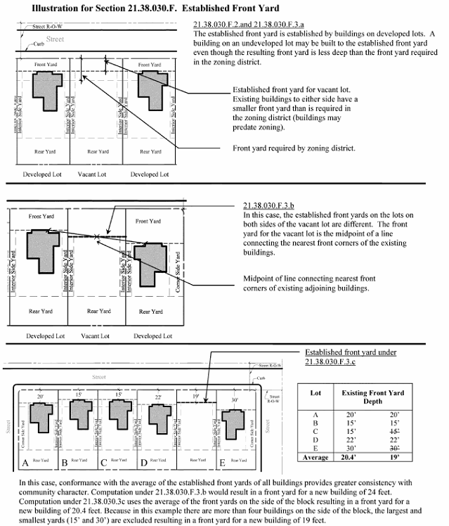
Established Front Yard. See illustration.
1.
Purpose. The purpose of the established front yard regulation is to preserve community character in specified zoning districts by ensuring that the front yards of new buildings in these districts conform to the yards that have been established by existing buildings.
2.
Regulation. The following regulation only applies when indicated on the bulk regulations table for the zoning district:
Notwithstanding the front yard requirements of the underlying zoning district, where a new building is to be built and there is an established front yard, as defined in this Zoning Code, the minimum front yard for the new building shall be the established front yard.
3.
Computation of Established Front Yard.
a.
In computing the front yard for a new building only the established front yards of the building or buildings adjoining the proposed new building need be considered, excepting, however, in cases described in Subsection (F)(3)(c) of this section.
b.
In the case where a building is to be built and the established front yards on both sides of the new building are different, the front yard of the new building shall be the mid-point of a straight line connecting the nearest front corners of the adjoining existing buildings.
c.
In cases where it can be demonstrated that conformance with the average of the established front yards of all buildings on one side of a block or street would provide greater consistency with the purpose of this section, this average yard may be used to establish the front yard for the new building. In computing the average of the established front yards, except in the case of four or fewer buildings, the largest and smallest yards shall be excluded.
G.
Accessory Buildings.
1.
Accessory Buildings Attached to Principal Buildings. Accessory buildings when attached to principal buildings shall comply with the yard requirements of the principal buildings.
2.
Percentage of Required Yard. No detached accessory building or buildings shall occupy more than fifty percent of the area of a required yard.
3.
Height. No detached accessory building or structure shall exceed the height of the principal building or structure.
4.
Separation Between Buildings. Detached accessory buildings or structures shall be located no closer than three feet to any other accessory or principal building.
5.
Reversed Corner Lots.
a.
On a reversed corner lot in a residential district, and within fifteen feet of any adjacent property to the rear in a residential district, no accessory building or portion of an accessory building located in a required rear yard shall be closer to the side lot line abutting the street than a distance equal to two-thirds of the least depth which would be required under this title for the front yard on the adjacent property to the rear.
b.
No accessory buildings shall be located within five feet of any part of a rear lot line which coincides with the side lot line or portion of the side lot line of property in a residence district.
c.
No accessory building shall be erected in or encroach upon the required side yard of a corner lot which is adjacent to the street, or upon the required side yard of a reversed corner lot which is adjacent to the street.
H.
Setback Along Roscoe Rowe Boulevard. To protect the scenic approach to Annapolis, all buildings, structures and uses established along Roscoe Rowe Boulevard shall observe a setback of not less than seventy-five feet from the right-of-way line of the boulevard.
(Ord. O-1-04 Revised (part), 2005)
(Ord. No. O-19-18, § I, 11-19-2018; Ord. No. O-44-18, § I, 6-17-2019)
21.40.010 - Regulations applicable to all residential districts.
A.
In any residential district on a lot of record, a single-family dwelling may be established or enlarged regardless of the size of the lot, provided that all other requirements of this Zoning Code are met.
B.
Accessory uses may be established on the same lot as a principal use, provided the lot meets the lot size requirements of the district, except as indicated on the bulk regulations table for the district.
C.
The yard requirements of the principal uses apply to their accessory uses and buildings unless otherwise specified on the bulk regulations tables.
D.
All accessory buildings which are attached to principal buildings (e.g., attached garages) shall comply with the yard requirements of the principal building.
E.
Interior side yards are not required along the lot lines where a dwelling unit is attached to another dwelling unit, as in the case of a townhouse involving separate ownerships of attached units.
F.
For the purpose of determining yard requirements, any floor or portion of a floor that may be occupied for dwelling purposes shall be considered a story.
G.
Floor Area Ratio and Lot Coverage.
1.
Floor area ratio limits, where required, determine the maximum floor area allowable for the building or buildings (total floor area of both principal and accessory buildings) in direct ratio to the gross area of the zoning lot.
2.
The floor area of the accessory buildings shall be included in the total allowable floor area permitted on the zoning lot, as specified for the principal uses. However, any floor area devoted to off-street parking or loading facilities is exempt from floor area ratio requirements. The lot coverage of accessory buildings shall be included in the total allowable lot coverage requirements.
H.
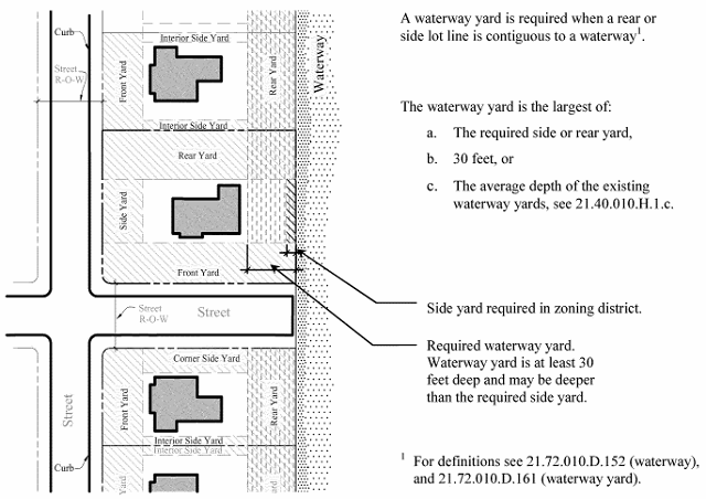
Waterway Yards. See illustration.
1.
Notwithstanding any other yard requirements set forth in this division, where any side or rear lot line is contiguous to a waterway, a waterway yard shall be provided which is the largest of:
a.
The side or rear yard required in the zoning district in which the zoning lot is located, or
b.
Thirty feet, or
c.
The depth determined by averaging the depth of existing waterway yards of all residences extending three hundred feet on either side of the subject property; except that if more than four residences are located within three hundred feet, the largest and smallest of the waterway yards shall not be used in determining the average depth. If the waterway yard as determined by this subsection would render a property unbuildable, a waterway yard shall be provided which is the larger of the yard required by Subsections (H)(1)(a) and (b) of this section.
2.
Where the requirements of this section and of Chapter 21.54 are in conflict, the more restrictive requirements shall apply.
Illustration for Section 21.40.010(H)
Waterway Yards
(Ord. O-1-04 Revised (part), 2005)
(Ord. No. O-35-20, § I, 10-12-2020)
21.40.020 - R1 Single-Family Residence district.
A.
Purpose. The R1 Single-Family Residence district provides for single-family detached dwellings at approximately six dwelling units per acre and other uses compatible with these single-family neighborhoods of the City.
B.
Uses. Uses that may be permitted in the R1 Single-Family Residence district are set forth in the table of uses for residential districts in Chapter 21.48.
C.
Development Standards. Chapter 21.50 contains the bulk regulations table for the R1 Single-Family Residence district.
D.
Contiguous Lots.
1.
Notwithstanding the provisions of Section 21.40.010(A), in the R1 District, except as described in (D)(2) of this section, a lot of record that is contiguous to one or more lots of record under single ownership or control on April 10, 2006, shall be considered part of a zoning lot, and shall not be developed or ownership transferred as an individual lot, unless the owner can demonstrate that the subject lot and each remaining lot or collection of lots in the zoning lot complies with the current base zoning regulations including lot size, lot coverage and yard setbacks except lot width.
2.
A lot of record that is contiguous to one or more lots of record under single ownership or control can be developed in accordance with Section 21.40.010(A) if the land area of the subject lot of record is not needed for the remaining contiguous lot(s) of record under single ownership or control to comply with the current base zoning regulations including lot size, lot coverage and yard setbacks.
3.
Upon application for any building permit in which the proposed improvements would have any impact on lot size, lot coverage or yard setbacks, the property owner shall submit such information as required by the Department of Planning and Zoning concerning the ownership of contiguous lots of record pursuant to compliance with this subsection.
(Ord. O-23-05 Revised § 1 (part), 2006; Ord. O-1-04 Revised (part), 2005)
(Ord. No. O-30-11 Amended, § I, 10-28-2013)
21.40.030 - R1-A Single-Family Residence district.
A.
Purpose. The R1-A Single-Family Residence district provides for single-family detached dwellings at approximately two dwelling units per acre and other uses compatible with these single-family neighborhoods of the City.
B.
Uses. Uses that may be permitted in the R1-A Single-Family Residence district are set forth in the table of uses for residential districts in Chapter 21.48.
C.
Development Standards. Chapter 21.50 contains the bulk regulations table for the R1-A Single-Family Residence district.
(Ord. O-1-04 Revised (part), 2005)
21.40.040 - R1-B Single-Family Residence district.
A.
Purpose. The R1-B Single-Family Residence district provides for single-family detached dwellings at approximately three and one-half dwelling units per acre and other uses compatible with these single-family neighborhoods of the City.
B.
Uses. Uses that may be permitted in the R1-B Single-Family Residence district are set forth in the table of uses for residential districts in Chapter 21.48.
C.
Development Standards. Chapter 21.50 contains the bulk regulations table for the R1-B Single-Family Residence district.
(Ord. O-1-04 Revised (part), 2005)
21.40.050 - R2 Single-Family Residence district.
A.
Purpose. The R2 Single-Family Residence district provides for single-family detached dwellings at up to eight dwelling units per acre and other uses compatible with these single-family neighborhoods of the City.
B.
Uses. Uses that may be permitted in the R2 Single-Family Residence district are set forth in the table of uses for residential districts in Chapter 21.48.
C.
Development Standards. Chapter 21.50 contains the bulk regulations table for the R2 Single-Family Residence district.
D.
Uses Deemed Conforming.
1.
A stadium is deemed to be conforming, pursuant to Section 21.68.030 of this Zoning Code, provided that it was legally existing on July 1, 2009, and may be altered or expanded subject to approval through the special exception process, pursuant to Chapter 21.26 of this Zoning Code.
2.
Duplex units existing on August 10, 1970, may be altered or enlarged provided that the alteration or enlargements otherwise meet the provisions of the R2 Zoning district including the setback and height limitations in accordance with single-family detached dwellings, except that the shared lot line between each half of the duplex unit must meet the provisions of the R3, General Residence district, and subject to minor site design plan review.
(Ord. O-1-04 Revised (part), 2005; Ord. No. O-35-09, § I, 5-24-2010; Ord. No. O-25-11 Amended, § I, 6-10-2013; Ord. No. O-57-22, § I, 1-23-2023)
21.40.060 - R2-NC Single-Family Residence Neighborhood Conservation district.
A.
Purpose. The purpose of the R2-NC Single-Family Residence Neighborhood Conservation district is to preserve patterns of design and development in residential neighborhoods characterized by a diversity of styles and to ensure the preservation of a diversity of land uses, together with the protection of buildings, structures or areas the destruction or alteration of which would disrupt the existing scale and architectural character of the neighborhoods. The general purposes include:
1.
Protection of the architectural massing, composition and styles as well as neighborhood scale and character;
2.
Compatibility of new construction and structural alterations with the existing scale and character of surrounding properties;
3.
Encouragement of existing types of land uses that reflect the mixture and diversity of uses that have historically existed in the community; and
4.
Preservation of streetscapes.
B.
Uses. Uses that may be permitted in the R2-NC Single-Family Residence Neighborhood Conservation district are set forth in the table of uses for residential districts in Chapter 21.48.
C.
Development Standards.
1.
Chapter 21.50 contains the bulk regulations table for the R2-NC Single-Family Residence Neighborhood Conservation district.
2.
Site Design Plan Review.
a.
Except as provided in Subsection (C)(2)(b) of this section, new construction including new buildings, enlargements to building size or bulk, or structural alterations to existing structures which have an impact upon any exterior façade of a structure or building are subject to review and approval, with emphasis placed on façades visible from the public view, by the Department of Planning and Zoning in accordance with the provisions of Chapter 21.22, Site Design Plan Review.
b.
New structures, enlargement to a structure, and structural alterations to building size or bulk of existing structures which results in the structure or building being in excess of three thousand two hundred fifty square feet of floor area are subject to public hearing, review and approval by the Planning Commission. The three thousand two hundred fifty square foot figure does not include square footage in basements that are fifty percent or more under ground, uninhabitable attic space or accessory structures. Those structures or buildings that are already in excess of three thousand two hundred fifty square feet or have site design review approval as of November 14, 2005, may be rebuilt to the same square footage as long as the design is reviewed and approved by the Planning Commission.
c.
The following guidelines shall be applied at the time of site design plan review, shall control in the event of conflict with the provisions of Chapter 21.22, and shall be applied to all uses in the R2-NC district. No design plans shall be approved by the Department of Planning and Zoning until findings consistent with the following guidelines have been made:
i.
If new buildings, structures, structural alterations or structural rehabilitations, enlargements or reductions are proposed, their design shall be compatible with the historic character and design of the area and shall promote the existing spatial and visual qualities in the R2-NC area, including height and scale of buildings, orientation, spacing, site coverage, and exterior features such as porches, roof pitch and direction and landscaping.
ii.
All structures and buildings shall observe the established, historic front setbacks and building heights pursuant to Section 21.50.050, if any, for the block on which they are proposed.
iii.
All new structures and buildings, enlargement of existing structures or buildings and all substantial rehabilitation, reduction or alteration of existing structures or buildings shall have bulk, massing and scale similar to the structures or buildings on the block face.
iv.
The proposed alterations or new construction shall preserve and enhance the vernacular streetscape of the neighborhood.
v.
Exterior structural alterations to historic and contributing structures or buildings along the street frontage shall be kept to a minimum.
vi.
Design for new construction and enlargements to all existing structures or buildings in the R2-NC district area shall conform to the guidelines for the relation of proposed structures to adjacent developments established in Section 21.62.020 and shall be compatible with the distinguishing, contributing characteristics of the majority of surrounding properties on the block face.
vii.
In cases where approval of an application is dependent upon preserving all or part of an existing structure or building, and its structural integrity is in question, the Director of Planning and Zoning shall require a structural analysis of the structure or building, by a structural engineer, to evaluate the sufficiency of the load path for a proposed alteration or demolition plan.
3.
Demolitions.
a.
The Planning and Zoning Director shall review and decide all applications for demolition of structures or buildings, pursuant to Chapter 21.14, Demolition Permits.
b.
Before the Director of Planning and Zoning may approve a request for a proposed demolition, the Director shall require a structural analysis of the structure or building, by a structural engineer, in accordance with subparagraph (c) herein, to evaluate the sufficiency of the load path for a proposed alteration or demolition plan.
c.
In addition to making written findings addressing the Review Criteria in Section 21.14.040, the Director of Planning and Zoning shall make additional written findings based on the following:
i.
Loss of the structure or building would not be adverse to the R2-NC district or the public interest by virtue of the uniqueness or contribution of the structure or building to the significance of the R2-NC district;
ii.
The proposed demolition would not have an adverse effect on the design and historic character of the structure or building and surrounding environment of the R2-NC district;
iii.
Demolition is not for the purposes of assembling properties for the construction of a large-scale structure or building, if such assemblage is determined to be incompatible with the purposes and intent of the R2-NC district;
iv.
The replacement structure or building or parts of the structure or building are designed and sited in a fashion that reflects the compatibility objectives of this chapter;
v.
A proposed demolition would not impact the stability or structural integrity of the remaining portions of the structure and appropriate measures are proposed to stabilize the building during demolition and construction.
d.
Procedures for the preparation of a structural analysis.
i.
The Department of Planning and Zoning shall prepare a scope of services for a structural analysis and solicit a cost estimate from at least two structural engineers for the preparation of the analysis.
ii.
The applicant shall remit to the Department of Planning and Zoning, upon notice from the Director, funds for the completion of the structural analysis in an amount determined by the Director to be sufficient to pay for the structural analysis.
iii.
If the cost of the structural analysis exceeds the funds that the applicant has remitted to the Department of Planning and Zoning, the Director may withhold release of the structural analysis or approval of an application until full payment is remitted.
iv.
The Department of Planning and Zoning shall facilitate the negotiation and completion of a contract between the City and the structural engineer.
v.
The applicant shall cooperate with the structural engineer contracted by the City, including providing access to the structure or building as needed to complete the structural analysis. Failure to cooperate or provide access shall be a basis for denial of the application.
vi.
The Department of Planning and Zoning shall oversee all facets of a structural analysis.
e.
For the purposes of this Chapter 21.40, demolition is defined as involving the entire removal of more than one exterior wall or the entire removal of the roof structure. These standards do not apply to demolition limited to the interior of a structure.
D.
Additional Standards. Administrative adjustment to residential off-street parking. The Planning and Zoning Director may waive the residential off-street parking requirement, pursuant to the administrative adjustment procedures set forth in Chapter 21.18, if the provision of this parking will jeopardize the purpose of the district.
E.
Uses Deemed Conforming.
1.
The following uses are deemed to be conforming, pursuant to Section 21.68.030 of this Zoning Code, provided they were legally existing on November 19, 1990:
a.
Single-family attached and detached dwellings;
b.
Two-family dwellings;
c.
Nonresidential uses, except for uses listed in Subsection (E)(2) of this section; and
d.
Multi-family dwellings of five or fewer units.
2.
Warehouse, storage and/or distribution uses and automotive service uses legally existing on November 19, 1990 are not deemed to be conforming. However, these uses may apply for a special exception, pursuant to Chapter 21.26, to become conforming, provided that such application is made while the use retains its nonconforming rights under Chapter 21.68 of this Zoning Code.
3.
Single-family attached and detached dwellings and two-family dwellings deemed conforming may be expanded for residential use if they otherwise meet the requirements of this district, including the setback and height limitations in accordance with single-family detached dwellings. In the case of any alteration, expansion, or modification to a two-family dwelling, the front setback and elements of the front façade, including any single plane, with respect to each dwelling unit shall be retained or match those of the other unit.
4.
Any increase in the building bulk of nonresidential uses that become conforming under this subsection requires special exception approval pursuant to Chapter 21.26 of this Zoning Code.
(Ord. O-15-05 Revised Amended § 1 (part), 2005: Ord. O-1-04 Revised (part), 2005)
(Ord. No. O-65-09, § I, 3-8-2010; Ord. No. O-25-11 Amended, § I, 6-10-2013; Ord. No. O-11-19, § I, 6-22-2020)
21.40.070 - R3 General Residence district.
A.
Purpose. The R3 General Residence district provides for single-family and two-family detached dwellings at up to eight dwelling units per acre and other uses compatible with these neighborhoods of the City including single-family attached and multi-family dwelling units.
B.
Uses. Uses that may be permitted in the R3 General Residence district are set forth in the table of uses for residential districts in Chapter 21.48.
C.
Development Standards. Chapter 21.50 contains the bulk regulations table for the R3 General Residence district.
(Ord. O-1-04 Revised (part), 2005)
21.40.080 - R3-NC General Residence Neighborhood Conservation district.
A.
Purpose. The R3-NC General Residence Neighborhood Conservation district is designed to ensure the preservation of buildings, structures and areas, the destruction or alteration of which would disrupt the existing scale and architectural character of the neighborhood. This purpose includes:
1.
Preserving, protecting and enhancing streetscapes, structures and areas of architectural, historic or cultural importance, although individual elements may not merit distinction;
2.
Encouraging new construction, or alterations that are compatible with the existing scale and character of surrounding properties; and
3.
Encouraging the rehabilitation and continued use of existing buildings rather than their demolition.
B.
Uses. Uses that may be permitted in the R3-NC General Residence Neighborhood Conservation district are set forth in the table of uses for residential districts in Chapter 21.48.
C.
Development Standards.
1.
Chapter 21.50 contains the bulk regulations table for the R3-NC General Residence Neighborhood Conservation district.
2.
Enlargements or substantial alterations to existing structures are subject to review by the Department of Planning and Zoning in accordance with the provisions of Chapter 21.22, Site Design Plan Review.
3.
Demolitions. The Planning and Zoning Director shall review and decide all applications for demolition of buildings or structures, pursuant to Chapter 21.14, Demolition Permits.
4.
Where development is subject to Site Design Plan Review, the following design standards shall apply in addition to the general standards set forth in Chapter 21.62.
a.
Where new buildings, structures, structural alterations or structural rehabilitations, enlargements or reductions are proposed, their design shall be compatible with the historic character and design of the area and shall promote the existing spatial and visual qualities of the area, including height and scale of buildings, orientation, spacing, site coverage, and exterior features such as porches, roof pitch and direction and landscape elements.
b.
Every reasonable effort shall be made to minimize exterior changes to existing structures, the site and their environment.
c.
Where specific design guidelines have been established and officially adopted for the R3-NC General Residence Neighborhood Conservation district or a portion thereof, any new construction, structural enlargement or reduction in floor area shall be in conformance with those guidelines.
d.
Where a site plan for a new use of a site is proposed and submitted, consideration shall be given to the benefits that the proposed development would give to the R3-NC General Residence Neighborhood Conservation district over the preservation of existing buildings or structures.
(Ord. O-1-04 Revised (part), 2005)
21.40.090 - R3-NC2 General Residence Neighborhood Conservation 2 district.
A.
Purpose. The purpose of the R3-NC2 General Residence Neighborhood Conservation 2 district is to preserve patterns of design and development in residential neighborhoods characterized by a diversity of styles and to ensure the preservation of a diversity of land uses, together with the protection of buildings, structures or areas the destruction or alteration of which would disrupt the existing scale and architectural character of the neighborhoods. The general purpose includes:
1.
Protection of the architectural massing, composition and styles as well as neighborhood scale and character;
2.
Assuring the compatibility of new construction and structural alterations with the existing scale and character of surrounding properties;
3.
Encouragement of existing types of land uses that reflect the mixture and diversity of uses that have historically existed in the community; and
4.
Preservation of streetscapes.
B.
Uses. Uses that may be permitted in the R3-NC2 General Residence Neighborhood Conservation 2 district are set forth in the table of uses for residential districts in Chapter 21.48.
C.
Development Standards.
1.
Chapter 21.50 contains the bulk regulations table for the R3-NC2 General Residence Neighborhood Conservation 2 district.
2.
Site Design Plan Review.
a.
Except as noted in Subsection (C)(2)(b) of this section, new construction including new buildings, enlargements to building size or bulk, or structural alterations to existing structures which have an impact upon the street façade are subject to review by the Department of Planning and Zoning in accordance with the provisions of Chapter 21.22, Site Design Plan Review.
b.
Site Design Plan Review is not required for new construction, enlargements or structural alterations which occur behind an existing building within the confines of a rearward extension of the side building lines, except that if such addition will impair an adequate supply of light and air to adjacent property or will impede the exterior maintenance of adjacent property side yards shall be provided pursuant to the R3-NC2 General Residence Neighborhood Conservation 2 district bulk regulations table.
3.
Demolitions. The Planning and Zoning Director shall review and decide all applications for demolition of buildings or structures pursuant to Chapter 21.14, Demolition Permits.
4.
Where development is subject to Site Design Plan Review, the following design standards shall apply in addition to the general standards set forth in Chapter 21.62.
a.
The design shall be consistent with the other structures in the R3-NC2 General Residence Neighborhood Conservation 2 district, including height and scale of buildings, orientation, spacing, site coverage, and exterior features such as porches, roof pitch and direction and landscape elements.
b.
All structures shall maintain the setbacks established in the bulk regulations table for the district, if any, for the block on which they are proposed. The design shall have bulk, massing and scale similar to the structures on the block face.
c.
In addition to the requirements of this section, the design shall conform to the design standards established in any neighborhood plan adopted by the City Council for the area in which the property is located.
d.
Exterior structural alterations along the street frontage shall be allowed only if they contribute to the preservation of the structure.
e.
Streetscape improvements, including sidewalks, curbs, planting strips, etc., shall conform to the design standards established in the neighborhood plan adopted by the City Council for the area in which the property is located.
D.
Additional Standards. Administrative Adjustment to Residential Off-Street Parking. The Planning and Zoning Director may waive the residential off-street parking requirement, pursuant to the administrative adjustment procedures set forth in Chapter 21.18, if the provision of this parking will jeopardize the purpose of the district.
E.
Uses Deemed Conforming. Single-family attached and detached dwellings and multi-family dwellings of four or fewer units lawfully existing on November 26, 2001 shall be deemed to be conforming, pursuant to Section 21.68.030 of this Zoning Code.
(Ord. O-1-04 Revised (part), 2005)
21.40.100 - R3-R General Residence Neighborhood Revitalization district.
A.
Purpose. The purpose of the R3-R General Residence Neighborhood Revitalization district is to ensure the preservation of buildings, structures and areas, the destruction or alteration of which would disrupt the existing scale and architectural character of the neighborhood. The general purpose is also intended to:
1.
Preserve, protect and enhance streetscapes and structures;
2.
Encourage new construction, or alterations which are compatible with the existing scale and character of surrounding properties; and
3.
Encourage the rehabilitation and continued use of existing buildings rather than their demolition.
B.
Uses. Uses that may be permitted in the R3-R General Residence Neighborhood Revitalization district are set forth in the table of uses for residential districts in Chapter 21.48.
C.
Development Standards.
1.
Chapter 21.50 contains the bulk regulations table for the R3-R General Residence Neighborhood Revitalization district.
2.
Site Design Plan Review.
a.
New construction including new buildings, enlargements to building size or bulk, or structural alterations to existing structures are subject to review by Department of Planning and Zoning in accordance with the provisions of Chapter 21.22, Site Design Plan Review.
b.
Where new buildings, structures or structural enlargements or reductions are proposed, the design shall be compatible with and enhance those spatial and visual qualities in the R3-R General Residence Neighborhood Revitalization district, including height and scale of buildings, orientation, spacing, site coverage and exterior features such as porches, roof pitch and direction, and landscape elements. All new structures or enlargements of existing structures shall have bulk, massing and scale similar to the majority of the structures in the R3-R General Residence Neighborhood Revitalization district.
3.
Demolitions.
a.
The Planning and Zoning Director shall review and decide all applications for demolition of buildings or structures pursuant to Chapter 21.14, Demolition Permits.
b.
In addition to the demolition application review criteria set forth in Section 21.14.040, the Planning and Zoning Director shall ensure that demolition is not for the purposes of assembling properties for the construction of a large-scale structure, if such assemblage is determined to be incompatible with the purposes and intent of the R3-R General Residence Neighborhood Revitalization district.
D.
Additional Standards. Administrative Adjustment to Residential Off-Street Parking. The Planning and Zoning Director may waive the residential off-street parking requirement, pursuant to the administrative adjustment procedures set forth in Chapter 21.18, if the provision of this parking will jeopardize the purpose of the district.
(Ord. O-1-04 Revised (part), 2005)
21.40.110 - R4 General Residence district.
A.
Purpose. The R4 General Residence district provides for single-family detached dwellings at up to nine dwelling units per acre and other uses compatible with these neighborhoods of the City including apartment hotels, and single-family attached and multi-family dwelling units.
B.
Uses. Uses that may be permitted in the R4 General Residence district are set forth in the table of uses for residential districts in Chapter 21.48.
C.
Development Standards. Chapter 21.50 contains the bulk regulations table for the R4 General Residence district.
(Ord. O-1-04 Revised (part), 2005)
21.40.120 - R4-R General Residence Neighborhood Revitalization district.
A.
Purpose. The purpose of the R4-R General Residence Neighborhood Revitalization district is to ensure the preservation of buildings, structures and areas, the destruction or alteration of which would disrupt the existing scale and architectural character of the neighborhood. The general purpose is also intended to:
1.
Preserve, protect and enhance streetscapes and structures;
2.
Encourage new construction, or alterations which are compatible with the existing scale and character of surrounding properties; and
3.
Encourage the rehabilitation and continued use of existing buildings rather than their demolition.
B.
Uses. Uses that may be permitted in the R4-R General Residence Neighborhood Revitalization district are set forth in the table of uses for residential districts in Chapter 21.48.
C.
Development Standards.
1.
Chapter 21.50 contains the bulk regulations table for the R4-R General Residence Neighborhood Revitalization district.
2.
Site Design Plan Review.
a.
New construction including new buildings, enlargements to building size or bulk, or structural alterations to existing structures are subject to review by Department of Planning and Zoning in accordance with the provisions of Chapter 21.22, Site Design Plan Review.
b.
Where new buildings, structures or structural enlargements or reductions are proposed, the design shall be compatible with and enhance those spatial and visual qualities in the R4-R General Residence Neighborhood Revitalization district, including height and scale of buildings, orientation, spacing, site coverage and exterior features such as porches, roof pitch and direction, and landscape elements. All new structures or enlargements of existing structures shall have bulk, massing and scale similar to the majority of the structures in the R4-R General Residence Neighborhood Revitalization district.
c.
Where a site plan for a new use of a site is proposed and submitted, consideration shall be given to the benefits that the proposed development would give to the R4-R General Residence Neighborhood Revitalization district.
3.
Demolitions.
a.
The Planning and Zoning Director shall review and decide all applications for demolition of buildings or structures pursuant to Chapter 21.14, Demolition Permits.
b.
In addition to the demolition application review criteria set forth in Section 21.14.040, the Planning and Zoning Director shall ensure that demolition is not for the purposes of assembling properties for the construction of a large-scale structure, if such assemblage is determined to be incompatible with the purposes and intent of the R4-R General Residence Neighborhood Revitalization district.
D.
Additional Standards. Administrative Adjustment to Residential Off-Street Parking. The Planning and Zoning Director may waive the residential off-street parking requirement, pursuant to the administrative adjustment procedures set forth in Chapter 21.18, if the provision of this parking will jeopardize the purpose of the district.
E.
Uses Deemed Conforming. The following uses are deemed to be conforming, pursuant to Section 21.68.030 of this Zoning Code.
1.
Residential dwelling units lawfully existing on September 9, 1996. These may be expanded for residential use provided that no additional dwelling units are created and if they otherwise meet the requirements of this district.
2.
Non-residential uses lawfully existing as of September 9, 1996, except that any increase in the building bulk of these uses requires special exception approval.
(Ord. O-1-04 Revised (part), 2005)
21.40.130 - C1 Conservation Residence district.
A.
Purpose. The C1 Conservation Residence district is designed to encourage the conservation of the educational, cultural and historic character of the old City.
B.
Uses. Uses that may be permitted in the C1 district are set forth in the table of uses for residential districts in Chapter 21.48.
C.
Development Standards.
1.
Chapter 21.50 contains the bulk regulations table for the C1 district.
2.
No single use of property may occupy more than two adjacent buildings.
(Ord. O-1-04 Revised (part), 2005)
21.40.140 - C1-A Special Conservation Residence district.
A.
Purpose. The C1-A Special Conservation Residence district is designed to preserve neighborhoods that have been identified as "at risk" in the Annapolis Comprehensive Plan as amended through and including amendments to the "Ward One Sector Study." At risk neighborhoods are identified as being significantly impacted by at least two of the following characteristics:
1.
A growing number of nonconforming uses,
2.
Unmaintained buildings or lots,
3.
Traffic volumes inconsistent with strictly residential land uses due to through commercial traffic, and
4.
Other adverse impact from nearby commercial uses.
Lands zoned C1-A are the focus of the intensive public efforts, including periodic monitoring of land uses, to minimize conversions from single-family to multi-family or office use, to stabilize and enhance the residential quality of life, and to encourage single-family development and conversion to single-family use.
B.
Uses. Uses that may be permitted in the C1-A district are set forth in the table of uses for residential districts in Chapter 21.48
C.
Development Standards.
1.
Chapter 21.50 contains the bulk regulations table for the C1-A district.
2.
No single use of property may occupy more than two adjacent buildings.
3.
All new construction including alterations (any change to the exterior of a structure) and enlargements (changes made to increase the bulk of a structure) to existing structures are subject to review by Department of Planning and Zoning in accordance with the provisions of Chapter 21.22, Site Design Plan Review, and Chapter 21.56, Historic District, if applicable.
D.
Additional Standards. Reserved.
E.
Uses Deemed Conforming.
1.
Multi-family dwellings lawfully existing on June 20, 1994 are deemed conforming for the purposes of condominium conversion regardless of lot area or parking requirements, pursuant to Section 21.68.030 of this Zoning Code.
2.
Single-family attached dwellings, lawfully existing on June 20, 1994, are deemed conforming and may be expanded, if they otherwise meet the requirements of this district, including the setback and height limitations in accordance with single-family detached dwellings except that for the rear yard the shared lot line between attached units will have no setback requirement, and subject to minor site design plan approval and review by the Historic Preservation Commission under Section 21.56 of this Code.
(Ord. O-1-04 Revised (part), 2005)
(Ord. No. O-1-14 Amended, § I, 5-12-2014)
21.42.010 - Regulations applicable to all commercial and industrial districts.
A.
Where a property on a street frontage between intersecting streets is zoned partially residence and partially business, the front yard requirement of the residence district shall be applied to the entire street frontage.
B.
Dispensing devices with a height of not over six feet shall be exempt from the established front yard or corner side yard requirements, but all of these dispensing devices shall be set back from the front lot line and the corner side lot line a distance of not less than fifteen feet.
(Ord. O-1-04 Revised (part), 2005)
21.42.020 - B1 Convenience Shopping district.
A.
Purpose. The B1 Convenience Shopping District is designed for the convenience shopping of persons residing in adjacent residential areas, as well as to provide for some general retail shopping needs and other compatible uses. All uses in the B1 district must be compatible with surrounding residential neighborhoods.
In the B1 district maximum limits are placed on the floor area of business establishments in order to limit the volume of vehicular and pedestrian traffic in and around convenience shopping centers to a level consistent with their function and location.
B.
Uses. Uses that may be permitted in the B1 district are set forth in the table of uses for commercial and industrial districts in Chapter 21.48.
C.
Development Standards. Chapter 21.50 contains the bulk regulations table for the B1 district.
D.
Additional Standards.
1.
Off-street parking spaces shall be located at either the side or rear of property.
2.
All business, servicing or processing in the B1 district, except for off-street parking or loading, shall be conducted within completely enclosed buildings.
3.
The parking of trucks as an accessory use, when used in the conduct of a permitted business in the B1 district, is limited to vehicles up to one and one-half tons capacity when the storage space for the vehicle is located within one hundred fifty feet of a residential district.
(Ord. O-1-04 Revised (part), 2005)
21.42.030 - B2 Community Shopping district.
A.
Purpose. The B2 Community Shopping District is designed to accommodate the needs of a large consumer population; thus, a wide range of uses is permitted for both daily and occasional shopping.
B.
Uses. Uses that may be permitted in the B2 district are set forth in the table of uses for commercial and industrial districts in Chapter 21.48.
C.
Development Standards. Chapter 21.50 contains the bulk regulations table for the B2 district.
D.
Additional Standards.
1.
All business, servicing or processing in the B2 district, except for off-street parking or loading, shall be conducted within completely enclosed buildings.
2.
The parking of trucks as an accessory use, when used in the conduct of a permitted business in the B2 district, is limited to vehicles up to one and one-half tons capacity when the storage space for the vehicle is located within one hundred fifty feet of a residential district.
(Ord. O-1-04 Revised (part), 2005)
21.42.040 - B3 General Commercial district.
A.
Purpose. The B3 General Commercial District is designed to accommodate those commercial activities which may be incompatible with the predominantly retail uses permitted in other business districts; and whose service area is not confined to any one neighborhood or community.
B.
Uses. Uses that may be permitted in the B3 district are set forth in the table of uses for commercial and industrial districts in Chapter 21.48.
C.
Development Standards. Chapter 21.50 contains the bulk regulations table for the B3 district.
D.
Additional Standards. All business, servicing or processing in the B3 district shall be conducted within completely enclosed buildings, with the following exceptions: establishments of the "drive-in" type offering goods or services directly to customers waiting in parked motor vehicles, display of merchandise for sale to the public and off-street parking and loading.
(Ord. O-1-04 Revised (part), 2005)
21.42.050 - B3-CD General Commercial Corridor Design district.
A.
Purpose. The B3-CD General Commercial Corridor Design district is designed to protect the aesthetic and visual character of lands adjacent to major business corridors by encouraging and better articulating positive commercial design guidelines along commercial corridors, protecting adjacent uses from the impacts of commercial development, and providing for the safe and efficient use of adjacent roadway corridors.
The compatible relationship of architecture along roads in the B3-CD General Commercial Corridor Design district is of critical public concern for any buildings or site improvements. The intent of the design review is not to stifle innovative architecture but to assure respect for and reduce incompatible and adverse impacts on the visual experience from the roadway.
B.
Uses. Uses that may be permitted in the B3-CD General Commercial district are set forth in the table of uses for commercial and industrial districts in Chapter 21.48.
C.
Development Standards.
1.
Chapter 21.50 contains the bulk regulations table for the B3-CD General Commercial district.
2.
Where development is subject to Site Design Plan Review, the following design standards shall apply in addition to the general standards set forth in Chapter 21.62.
a.
Sites shall be planned to accomplish a desirable transition with the streetscape and to provide for adequate planting, safe pedestrian movement, and parking areas.
b.
Parking areas shall be treated with decorative elements, building wall extensions, plantings, berms, or other innovative means so as to screen parking areas from view from public ways.
c.
Newly installed utility services and service revisions necessitated by exterior alterations shall be underground.
d.
Streetscape improvements shall be designed to be consistent with all standards in this section, and shall be reviewed for aesthetic functionality and compatibility with the prevailing character.
e.
Height.
i.
The variation between the height of a new building and the height of adjacent buildings should not vary by more than one story from any existing adjacent building within thirty feet.
ii.
A building in excess of forty-five feet should be set back fifty feet from the front line and fifty feet from the rear lot line.
D.
Additional Standards. Reserved.
(Ord. O-1-04 Revised (part), 2005)
21.42.060 - BCE Business Corridor Enhancement district.
A.
Purpose. The BCE Business Corridor Enhancement district is designed to increase commercial and certain residential opportunities and to promote and encourage mixed use while protecting the aesthetic and visual character of lands adjacent to the major business corridors by encouraging and better articulating positive commercial and certain residential design guidelines along commercial corridors, protecting adjacent uses from the impacts of commercial development, and providing for the safe and efficient use of adjacent roadway corridors.
B.
Uses.
1.
Uses that may be permitted in the BCE district are set forth in the table of uses for commercial and industrial districts in Chapter 21.48.
2.
In the BCE district any non-residential use over twenty-five thousand square feet gross floor area requires special exception approval.
C.
Development Standards.
1.
Chapter 21.50 contains the bulk regulations table for the BCE district.
2.
Design Standards. Where development is subject to Site Design Plan Review, the following design standards shall apply in addition to the general standards set forth in Chapter 21.62.
a.
The site shall be planned to accomplish a desirable transition with the streetscape and to provide for adequate planting, safe pedestrian movement, and parking areas.
b.
Parking areas shall be treated with decorative elements, building wall extensions, plantings, berms, or other innovative means so as to screen parking areas from view from public ways.
c.
Newly installed utility services and service revisions necessitated by exterior alterations shall be underground.
d.
Streetscape improvements shall be designed to be consistent with all standards in this section, and shall be reviewed for aesthetic functionality and compatibility with the prevailing character.
e.
Height. Except in the case of multi-family dwellings, the following standards apply:
i.
The variation between the height of a new building and the height of adjacent buildings should not vary by more than one story from any existing adjacent building within thirty feet.
ii.
A building in excess of forty-five feet should be set back fifty feet from the front line and fifty feet from the rear lot line.
3.
Site Access Criteria.
a.
The proposed development project shall be designed to minimize left turn movements or conflicts on the site and in the street.
b.
Driveways should be designed to achieve clear sight lines.
c.
Site access and circulation should conform whenever feasible to the following standards in this subsection. However, the Planning and Zoning Director may in his/her discretion modify the site access criteria for sites developed for uses in the BCE district based on the adjacent road configuration, the location and constraints of the specific site and the nature and density of the proposed uses and structures.
i.
Where a site or lot has frontage on two or more roads, the access to the site should be provided to the site from the lower classified road, unless there is less potential for traffic congestion and for hazards to traffic and pedestrian movement from the higher classified road.
ii.
Where necessary to safeguard against hazards to traffic and pedestrians and/or to avoid traffic congestion, provisions shall be made for turning lanes, traffic directional islands, service roads, driveways and traffic controls within the road. It is the further objective of the BCE district to minimize curb cuts and driveways by denying direct access for new lots.
iii.
Access driveways should be designed with sufficient capacity to avoid queuing of entering vehicles on any road or street.
iv.
Where topographic and other conditions are reasonably usable, provision shall be made for circulation driveway connections to adjoining lots of similar existing or potential use when such driveway connections will facilitate fire protection services or will enable the public to travel between two existing or potential uses without need to travel on a street.
v.
There should be no more than one driveway connection from any site or lot to any street, except where separate entrances and exit driveways may be necessary to safeguard against hazards and to avoid congestion. Additional driveways shall also be considered for large tracts and uses of extensive scope, if traffic flow on adjacent roads will be facilitated by the additional connections.
vi.
Each access driveway shall be located and designed so as to cause the least practical interference with the use of adjacent property and with the movement of pedestrian or vehicular traffic.
vii.
Access driveway widths shall have the following dimensions:
(A)
A minimum of twelve feet for all one-way driveways, not to exceed fifteen feet.
(B)
A minimum of twenty-four feet for all two-way driveways; not to exceed twenty-five feet.
viii.
A design objective within the BCE district is to allow no more than two driveways for each two hundred feet of street frontage on any lot. When a site is developed or redeveloped in the BCE district, excess driveways shall be eliminated or relocated when possible to achieve this objective. Circulation driveways are encouraged to minimize excess curb cuts and driveways.
D.
Additional Standards. Reserved.
E.
Uses Deemed Conforming. Uses existing on October 11, 1993 are deemed conforming for the purposes of expansion, pursuant to Section 21.68.030 of this Zoning Code. Single-family residential attached and detached dwellings and two-family dwellings may be expanded for residential use if the expansion otherwise meet the requirements of the R2 district, including the setback and height limitations in accordance with single-family detached dwellings.
(Ord. O-1-04 Revised (part), 2005)
(Ord. No. O-25-11 Amended, § I, 6-10-2013)
21.42.070 - BR Business Revitalization district.
A.
Purpose. The BR Business Revitalization district is designed to encourage the reestablishment of community oriented businesses owned and operated by members of the surrounding residential community.
B.
Uses. Uses that may be permitted in the BR district are set forth in the table of uses for commercial and industrial districts in Chapter 21.48.
C.
Development Standards.
1.
Chapter 21.50 contains the bulk regulations table for the BR district.
2.
Design Standards. Where development is subject to Site Design Plan Review, the following design standards shall apply in addition to the general standards set forth in Chapter 21.62.
a.
The height of a building as measured on the rear portion of a sloping site should not rise substantially above any residential structures adjacent to the building.
b.
The design of rear entrances to commercial buildings shall be casual, utilitarian, appropriate to its surroundings and take into account the interests of any nearby residential uses.
c.
The design of each new building and its site shall be of an urban not a suburban character.
D.
Additional Standards.
1.
Administrative Adjustment to Off-Street Parking. Pursuant to the administrative adjustment procedures set forth in Chapter 21.18, the Planning and Zoning Director may adjust the off-street parking requirements as follows upon a demonstration that reasonable alternative parking facilities are available:
a.
For development of new buildings on zoning lots of ten thousand square feet or greater a waiver of up to seventy-five percent of the off-street parking requirement may be granted.
b.
For rehabilitation or expansion of existing buildings and the development of new buildings on zoning lots less than ten thousand square feet, the off-street parking requirement may be waived completely.
2.
Loading and Unloading.
a.
Off-street loading facilities are not required in the BR district.
b.
Vehicles used for loading and unloading purposes shall park only within a designated off-street loading space at any time; or in a designated on-street loading zone, between the hours of six a.m. and eleven a.m., unless the zone is posted for other hours.
(Ord. O-1-04 Revised (part), 2005)
21.42.080 - C2 Conservation Business district.
A.
Purpose. The C2 Conservation Business district is designed to encourage the preservation of the old City by allowing a compatible mixture of business and home crafts and shops, unique to the early development of the City.
B.
Uses. Uses that may be permitted in the C2 district are set forth in the table of uses for commercial and industrial districts in Chapter 21.48.
C.
Development Standards. Chapter 21.50 contains the bulk regulations table for the C2 district.
D.
Additional Standards.
1.
All business, servicing or processing in the C2 district, except for off-street parking or loading, shall be conducted within completely enclosed buildings.
2.
Food service establishment restrictions apply in the C2 district, see Section 21.64.300.
3.
Off-street loading spaces are not required in the C2 district.
(Ord. O-1-04 Revised (part), 2005)
21.42.090 - C2A Special Conservation Business district.
A.
Purpose. The C2A Special Conservation Business district is designed to recognize and maintain existing commercial uses, while ensuring no further encroachment of these uses into adjacent residential neighborhoods. The C2A district is further designed to serve as a transitional zone by accommodating limited commercial uses of a nature that will be compatible with the character of adjoining residential properties.
B.
Uses. Uses that may be permitted in the C2A district are set forth in the table of uses for commercial and industrial districts in Chapter 21.48.
C.
Development Standards. Chapter 21.50 contains the bulk regulations table for the C2A district.
D.
Additional Standards.
1.
Food service establishment restrictions apply in the C2A district, see Section 21.64.300.
2.
Off-street loading spaces are not required in the C2A district.
(Ord. O-1-04 Revised (part), 2005)
21.42.100 - PM2 Professional Mixed Office Park district.
A.
Purpose. The PM2 Professional Mixed Office Park district is designed to encourage neighborhood commercial and/or transitional office uses, under parameters designed to maintain a low intensity and impact on surrounding properties.
B.
Uses. Uses that may be permitted in the PM2 district are set forth in the table of uses for commercial and industrial districts in Chapter 21.48.
C.
Development Standards. Chapter 21.50 contains the bulk regulations table for the PM2 district.
D.
Additional Standards. Reserved.
(Ord. O-1-04 Revised (part), 2005)
21.42.110 - I1 Industrial district.
A.
Purpose. The I1 Industrial district is designed to provide an environment suitable for industrial activities that do not create appreciable nuisances or hazards.
B.
Uses. Uses that may be permitted in the I1 district are set forth in the table of uses for commercial and industrial districts in Chapter 21.48.
C.
Development Standards. Chapter 21.50 contains the bulk regulations table for the I1 district.
D.
Additional Standards.
1.
All business, servicing or processing in the I1 district, except for off-street parking and off-street loading, shall be conducted within completely enclosed buildings.
2.
All storage, except of motor vehicles in operable condition, shall be within completely enclosed buildings or effectively screened by a solid wall or fence (including solid entrance and exit gates).
(Ord. O-1-04 Revised (part), 2005)
21.44.010 - P Professional Office district.
A.
Purpose. The Professional Office district is designed to accommodate office and institutional uses of a nature that will be compatible with the character of adjoining residential or business properties. It is not designed for retail or service activities generating customer traffic or delivery of goods.
B.
Uses. Uses that may be permitted in the P district are set forth in the table of uses for Office and Mixed Use Zoning Districts in Chapter 21.48.
C.
Development Standards. Chapter 21.50 contains the bulk regulations table for the P district.
D.
Additional Standards. On a lot of record, a single-family dwelling may be established or enlarged regardless of the size of the lot, provided that all other requirements of this Zoning Code are met.
(Ord. O-1-04 Revised (part), 2005)
21.44.020 - PM Professional Mixed Office district.
A.
Purpose. The Professional Mixed Office district is designed to serve as a transitional zone reducing commercial/office impact on adjoining residential neighborhoods.
B.
Uses. Uses that may be permitted in the PM district are set forth in the table of uses for Office and Mixed Use Zoning Districts in Chapter 21.48.
C.
Development Standards.
1.
Chapter 21.50 contains the bulk regulations table for the PM district.
2.
Design Standards. Where development is subject to Site Design Plan Review, the following design standards shall apply in addition to the general standards set forth in Chapter 21.62.
a.
Location. Structures shall be located at the front of the site.
b.
Buffer Areas. Areas designated on a site plan as buffer areas shall not be utilized for utilities, stormwater management, erosion control and signage, or grading. Buffer areas shall remain in their natural state, supplemented with additional planting.
c.
Commercial Building Façades. Each façade should be viewed as both an individual design and as a collection of relatively standard parts consistently arranged. The basic façade composition consists of the wall, the structural rhythm and the window openings. Changes to the façade of any existing building should be confined to openings within the façade.
d.
Elevated Structures. In cases where parking is provided beneath an elevated structure, the street-side portion of the building shall be available for useable office/commercial space excluding driveway and lobby areas. All exterior views of the structure shall resemble a working façade.
e.
Parking. Off-street parking spaces shall be located either underground or towards the rear of the lot behind any buildings and structures.
D.
Additional Standards. Loading and Unloading. Loading and unloading in a designated on-street loading zone may occur only between the hours of six a.m. and eleven a.m.
E.
Uses Deemed Conforming. Uses clearly established on March 9, 1987, and rendered nonconforming by the provisions of this title shall be subject to the regulations of Chapter 21.68, except that they shall be considered conforming for the purposes of expansion. In addition, nonconforming uses of a structure may continue, however, no change of that use other than to a use allowed within this district shall be permitted.
(Ord. O-16-07 § 1, 2007: Ord. O-1-04 Revised (part), 2005)
21.44.030 - MX Mixed Use district.
A.
Purpose. The Mixed Use district is designed to encourage a mixture of residential, office and retail uses within the inner West Street corridor compatible with each other and with surrounding areas.
B.
Uses. Uses that may be permitted in the MX district are set forth in the table of uses for Office and Mixed Use Zoning Districts in Chapter 21.48.
C.
Development Standards.
1.
Chapter 21.50 contains the bulk regulations table for the MX district.
2.
Notwithstanding the regulations set forth in Section 21.38.030(E), approval as a planned development is not required for a building in the MX district solely because it has a height greater than forty-five feet or an FAR in excess of two.
3.
Design Standards. Where development is subject to Site Design Plan Review, the following design standards shall apply in addition to the general standards set forth in Chapter 21.62.
a.
Character. The design of each new building and its site shall be of an urban not a suburban character.
b.
Building Location. Buildings shall be located close to the street with parking located to the rear of the zoning lot.
c.
Height. The height of a building as measured on the rear portion of a sloping site should not rise substantially above any residential structures adjacent to the building.
d.
Ground Floor of Commercial Buildings. The ground floor of a commercial building façade shall:
i.
Be differentiated from the upper floors to establish a distinct base for the building;
ii.
Be at least twelve feet in height; and
iii.
Be glazed on at least sixty percent of the façade.
e.
Rear Entrances. The design of rear entrances to commercial buildings shall be utilitarian, appropriate to the surroundings and take into account the interests of any nearby residential uses.
D.
Additional Standards.
1.
Parking Requirements for Changes of Use. Notwithstanding the requirements of 21.66.030(G), when the existing use of a building or structure is changed to a new use, parking and loading facilities are mandatory regardless of the date when the building or structure was erected.
2.
Administrative Adjustment to Off-Street Parking. Pursuant to the administrative adjustment procedures set forth in Chapter 21.18, the Planning and Zoning Director may adjust the off-street parking requirements as follows upon a demonstration that reasonable alternative parking facilities are available:
a.
For development of new buildings on zoning lots of ten thousand square feet or greater a waiver of up to seventy-five percent of the off-street parking requirement may be granted.
b.
For rehabilitation or expansion of existing buildings and the development of new buildings on zoning lots less than ten thousand square feet, the off-street parking requirement may be waived completely.
3.
Loading and Unloading. Vehicles used for loading and unloading purposes shall park only within a designated off-street loading space at any time; or in a designated on-street loading zone, between the hours of six a.m. and eleven a.m., unless the zone is posted for other hours.
4.
Demolitions. The Planning and Zoning Director shall review and decide all applications for demolition of buildings or structures pursuant to Chapter 21.14, Demolition Permits.
E.
Any building or buildings not in existence on November 28, 2005, which building or buildings are subsequently developed, shall provide retail commercial uses on the first floor of any façade abutting West Street, provided however that:
1.
If after six months of the issuance of the final use and occupancy permit pursuant to Chapter 21.12 the owner of the building is able to demonstrate an inability to lease to a retail commercial tenant after diligently pursuing such a tenant, the space may be leased to another use permitted in the MX zone.
2.
Development on parcels of six thousand five hundred square feet or less may have this requirement waived upon a demonstration that the development is for a single occupant.
3.
Retail commercial uses on the first floor are not required for parcels greater than 39,000 square-feet if the development on, or subdivision of, such parcel includes only single-family attached dwellings and common open space. Ground floor retail commercial uses are not required for town house or single-family residential dwelling units having entrances abutting West Street nor shall such use be prohibited by any applicable law, rule or regulation.
F.
The department of planning and zoning shall be responsible for approving or denying applications for demolition of buildings or structures with the MX district. A sign provided by the department of planning and zoning, indicating that demolition approval is being sought and stating the expected date of decision, shall be posted and maintained on the property in a location readily visible to the public, and shall be removed by the applicant within seven days following the decision to permit demolition to occur. In order to approve a demolition request, the department of planning and zoning must first make all of the following findings based upon evidence of record:
1.
Loss of the structure would not be adverse to the district or the public interest by virtue of the structure's uniqueness or its contribution to the significance of the district;
2.
Demolition would not have an adverse effect on the character and surrounding environment of the district;
3.
Demolition is not for the purposes of assembling properties for the construction of a large-scale structure, if such assemblage is determined to be incompatible with the purposes and intent of the MX district;
4.
The replacement structure is designed and sited in a fashion that reflects the compatibility objectives of this chapter.
G.
Notwithstanding the provisions of this ordinance, the following shall be governed by the law as it existed in the MX, Mixed-Use zoning district prior to (effective date of ordinance):
1.
A building in existence as of November 28, 2005;
2.
A project for which an application for special exception approval has been filed on or before November 28, 2005; and
3.
A proposed building or buildings for which an application for site design plan approval has been filed on or before November 28, 2005.
(Ord. O-05-06 Amended § 1 (part), 2007: Ord. O-11-05 Revised Amended § 1 (part), 2005: Ord. O-1-04 Revised (part), 2005)
(Ord. No. O-20-11, § I, 7-25-2011; Ord. No. O-19-18, § I, 11-19-2018)
21.44.040 - C2P Conservation Professional Office district.
A.
Purpose. The Conservation Professional Office district is designed to serve as a transitional zone between predominately commercial and residential districts, to buffer adjoining residential neighborhoods from commercial and other nonresidential impacts, and to properly zone certain existing, established office uses that, over time, have been shown to be compatible with adjacent residential areas. It is intended to accommodate office uses of a nature that will be compatible with the character of adjoining residential properties by allowing professional office uses that operate with minimal customer and delivery traffic.
B.
Uses. Uses that may be permitted in the C2P district are set forth in the table of uses for Office and Mixed Use Zoning Districts in Chapter 21.48.
C.
Development Standards. Chapter 21.50 contains the bulk regulations table for the C2P district.
D.
Additional Standards. Reserved.
(Ord. O-1-04 Revised (part), 2005)
21.46.010 - Regulations applicable to all waterfront districts.
Administrative Adjustment to Buffer and Planting Standards.
A.
Where the buffer and planting standards in Chapter 21.62 conflict with necessary maritime access, the Planning and Zoning Director may adjust these standards pursuant to the procedures set forth in Chapter 21.18 where it is found that:
1.
The overall amount of internal landscaping equals or exceeds seven percent of the parking area;
2.
Perimeter buffer requirements have been met; and
3.
The interior planting standards cannot physically be implemented due to the use of the area for permitted maritime uses that require access and mobility for the servicing or storage of boats.
B.
Uses Not Specifically Enumerated in the Tables of Uses for Waterfront Districts. For any waterfront maritime district, the Director of Planning and Zoning may approve as a permitted use other uses not specifically enumerated in the Tables of Uses for Waterfront Districts but determined to be similar in character and use to one or more of the uses enumerated in the Table of Uses for that district and compatible with the purposes of the district. In order to make such a determination, procedures for Administrative Interpretations in Chapter 21.16 shall be followed.
C.
Annual Reports, Compliance, and Review.
1.
Any property owner with professional office and/or non-maritime retail sales use(s) shall submit to the Director of Planning and Zoning an annual report with an update of the breakdown of the maritime and non-maritime uses on the subject property.
2.
All property owners within the WMM, WMI, WME, and WMC Districts shall provide an annual listing of maritime uses to the City of Annapolis Economic Development Manager in such form as may be promulgated from time to time by the Director of Planning and Zoning.
3.
The Director of Planning and Zoning shall submit an annual report with an update of the breakdown of maritime and non-maritime uses in the waterfront districts. This update will be included in the annual report given to the Planning Commission on the comprehensive plan. The Economic Development Manager shall provide information for the report regarding the efforts to recruit maritime businesses and the health of the maritime industry and shall also report this information to the economic matters and rules and City government committees.
4.
If a property owner in a Waterfront District is not in compliance with the allowable percentage of non-maritime uses in that Waterfront District, the Department of Planning and Zoning shall: a) notify the property owner of the non-compliance; and b) allow the property owner one hundred twenty calendar days to bring the property into compliance. If the property owner does not timely bring the property into compliance, the Department of Planning and Zoning shall revoke the occupancy permits for all non-maritime uses on that property and shall require the property owner to reapply for new occupancy permits for each of its non-maritime uses.
5.
Commencing no later than December 31, 2023, and no later than December 31 of every successive fourth year, the Planning Commission shall submit findings and recommendations to the City Council for changes to the table of uses and/or standards applicable to the Waterfront Districts in order to preserve the maritime industry as a vibrant part of Annapolis's heritage and as a contributor to the local economy.
D.
Waterfront Access Incentives. The term "GFA" means the gross floor area of buildings existing on the lot as of October 25, 2021, not including residential structures. The total percentage of professional office and retail sales of non-maritime goods allowed in WMM, WMI, or WME Zoning Districts may be increased by the following percentages if the incentive is provided, but the percentage of professional office and retail sales of non-maritime goods shall not exceed in the WMM thirty percent of total GFA of the development on the lot in existence as of October 25, 2021, and an additional twenty-five percent of total GFA, twenty percent of GFA in the WMI District, or twenty percent of GFA in the WME District. The incentives are:
Category I (maximum of five percent Total)
a.
Water taxi landing at 2.5 percent of GFA ("Waterfront Access Incentive").
b.
Public access for walking during daylight hours at 2.5 percent of GFA ("Waterfront Access Incentive").
c.
Renting to tenants that provide recreational water access at 2.5 percent of GFA.
d.
A location for the launch and recovery of paddlecraft during daylight hours for below market fee at 2.5 percent of GFA ("Waterfront Access Incentive").
e.
A location for crabbing and fishing during daylight hours at 2.5 percent of GFA ("Waterfront Access Incentive").
Category II (maximum of ten percent total)
f.
Provision of at least one hundred fifty on-site parking spaces at a reasonable fee on evenings and weekends at ten percent of GFA ("Parking Incentive").
g.
A one-time payment of two hundred fifty thousand dollars to the City for improving street end parks at five percent of GFA ("Park Donation Incentive").
h.
Community boating facility with small vessel storage and launch areas, lockers, restroom facilities and parking at ten percent of GFA ("Community Boating Facility Incentive").
A "Waterfront Access Incentive" does not require on-site parking but must be ADA-compliant as required by law, and must provide a clear pedestrian passage from the closest public roadway. The access may be subject to reasonable restrictions to address public safety concerns and shall include clear signage denoting the allowed public use and any such reasonable restrictions, as determined by the Director of Planning and Zoning.
E.
If there is an increase in non-maritime uses granted through the above incentives, a fee established by resolution of the City Council and set forth in the fees schedule shall be assessed to the property owner for the purposes of supporting the Annapolis Maritime Industry Economic Development Fund per § 6.30.010 and associated programs.
(Ord. O-1-04 Revised, 2005; Ord. No. O-25-21, § I, 10-25-2021; Ord. No. O-12-24, § I, 12-9-2024)
21.46.020 - WMC Waterfront Maritime Conservation district.
A.
Purpose. The WMC Waterfront Maritime Conservation District is intended to provide a location for maritime-related activities, including docks and slips; public access, recreational uses; and views of the waterfront in an attractive environment which supports and is harmonious with the interrelationship of the historic urban core, the waterfront and adjacent commercial and residential uses.
B.
Uses. Uses that may be permitted in the WMC District are set forth in the table of uses for Waterfront Maritime Districts in Chapter 21.48.
1.
Multiple maritime uses, restaurant and retail sales of nonmaritime-related goods may exist on the same lot at the same time provided that the maritime uses comprise a minimum of forty percent of the gross floor area on the lot.
2.
For a property located in the WMC Distict, the number of docks, slips, piers and other facilities at which boats are berthed may not be reduced with a change in use approved after July 27, 2015, except that the combination or reconfiguration of docks, slips, piers and other facilities at which boats are berthed in order to accommodate larger vessels shall not be considered as a reduction for the purposes of this subsection.
C.
Development Standards.
1.
Chapter 21.50 contains the bulk regulations table for the WMC district.
2.
In the WMC district, Chapter 21.56, Historic District, shall govern the regulation of structures within the historic district; provided, that if there are any inconsistencies between this chapter and Chapter 21.56, the more restrictive shall prevail.
3.
Where a public pedestrian walkway is provided pursuant to the bulk regulations table for the WMC district, it shall meet the minimum standards set forth in Section 21.62.020(J).
D.
Additional Standards. Reserved.
E.
Uses Deemed Conforming. Buildings or structures, located within required setbacks, lawfully existing on August 24, 1987, designed, maintained and continuously used for enumerated maritime uses are deemed conforming pursuant to Section 21.68.030 of this Zoning Code, provided that any alterations do not increase beyond existing structural supports and the alteration is designed, intended and used for one of the enumerated maritime uses.
(Ord. O-1-04 Revised (part), 2005)
(Ord. No. O-40-15 Amended, § I, 12-7-2015)
21.46.030 - WMM Waterfront Mixed Maritime district.
A.
Purpose. The WMM Waterfront Mixed Maritime district is intended to reserve areas along the water's edge for maritime uses, provide an environment for supporting maritime merchandising efforts and to encourage the preservation of existing buildings and uses. In support of specified maritime uses, the WMM district also provides for some non-maritime uses. The visual image of this area as an active maritime center is to be encouraged and maintained.
B.
Uses. Uses that may be permitted in the WMM district are set forth in the table of uses for Waterfront Maritime Districts in Chapter 21.48.
C.
Development Standards.
1.
Chapter 21.50 contains the bulk regulations table for the WMM district.
2.
One Hundred-Foot Maritime Use Setback. A one hundred-foot maritime use setback applies in the WMM district.
a.
Except as provided for in Subsection (C)(2)(b) of this section, only water-dependent structures and associated parking are permitted within the one hundred-foot maritime use setback.
b.
Non-water-dependent buildings, structures, or parking are permitted within the one hundred-foot maritime use setback only in accordance with a site plan incorporating the following criteria:
i.
Buildings and structures must be set back at least one hundred feet from the bulkhead for at least fifty percent of the lot width, and
ii.
The total gross open area contiguous to the waterfront and continuous on the site remains equal in square footage to one hundred times the lineal shoreline frontage of the zoning lot.
c.
Structures for the rack storage of boats are permitted within the one hundred-foot maritime use provided they are no taller than eight feet and do not use motorized lifts.
3.
Parking in Structures. In cases where parking is provided within or beneath a structure, all exterior views of the structure shall resemble a working façade.
D.
Uses Deemed Conforming. The following uses are deemed conforming pursuant to Section 21.68.030 of this Zoning Code:
1.
Single-family residential attached and detached dwellings and two-family dwellings, lawfully existing on August 24, 1987, may be expanded within the existing footprint, but not relocated, for residential use if the expansion otherwise meets the requirements of the R2-NC Single-Family Residence Neighborhood Conservation district, including the setback and height limitations in accordance with single-family detached dwellings. Unlawful uses occupying such residences on August 24, 1987, are not deemed to be conforming.
2.
Single-family attached and detached dwellings and two-family dwellings deemed conforming may be expanded but not relocated for residential use if they otherwise meet the requirements of this district, including the setback and height limitations in accordance with single-family detached dwellings.
3.
Buildings or structures existing as of August 24, 1987, are exempt from the requirement to provide a waterway yard. Expansion of such a building or structure is permitted only for uses allowed within the one hundred-foot maritime use setback.
4.
Buildings or structures located within the one hundred-foot maritime use setback, lawfully existing on August 24, 1987, may be continued, repaired and altered, provided that such alterations do not increase the exterior bulk of the building or structure through further encroachment on the maritime use setback area contiguous to the waterfront or through increased height.
5.
Restaurants existing prior to August 24, 1987, are permitted provided that they comply with all of the use standards for standard restaurants in the WMM district, or provided that seafood industrial, on-land boat storage, boat repair and maintenance or marine fabrication uses are maintained such that the square footage of the existing restaurant use does not exceed the square footage of the other enumerated maritime uses.
6.
Uses existing pursuant to Business Planned Development (BPD) approvals, existing prior to August 24, 1987, are permitted to continue except that once the square footage of professional office exceeds the gross floor area otherwise permitted by BPD approval, the BPD approval is rescinded. Any community benefits, specifically parking, required by the BPD must be continued and the public parking may be used to qualify for an incentive under [Section] 21.46.010.D.
(Ord. O-27-08 Amended § 1, 2009: Ord. O-1-04 Revised (part), 2005)
(Ord. No. O-25-11 Amended, § I, 6-10-2013; Ord. No. O-25-21, § I, 10-25-2021)
21.46.040 - WMI Waterfront Maritime Industrial district.
A.
Purpose. The WMI Waterfront Maritime Industrial district is intended to provide a location for land intensive maritime and accessory uses which require or clearly benefit from a waterfront location. It is the further intent of this district to support the City's maritime industry by limiting competing land uses and buffering adjacent uses from the adverse effects of permitted uses.
B.
Uses. Uses that may be permitted in the WMI district are set forth in the table of uses for Waterfront Maritime Districts in Chapter 21.48.
C.
Development Standards.
1.
Chapter 21.50 contains the bulk regulations table for the WMI district.
2.
One Hundred-Foot Maritime Use Setback. A one hundred-foot maritime use setback applies in the WMI district.
a.
Except as provided for in Subsection (C)(2)(b) of this section, only water-dependent structures and associated parking are permitted within the one hundred-foot maritime use setback.
b.
Non- non water-dependent buildings, structures, or parking are permitted within the one hundred-foot maritime use setback only in accordance with a site plan incorporating the following criteria:
i.
Buildings and structures must be set back at least one hundred feet from the bulkhead for at least fifty percent of the lot width, and
ii.
The total gross open area contiguous to the waterfront and continuous on the site remains equal in square footage to one hundred times the lineal shoreline frontage of the zoning lot.
c.
Structures for the rack storage of boats are permitted within the one hundred-foot maritime use provided they are no taller than eight feet and do not use motorized lifts.
D.
Additional Standards. Reserved.
E.
Uses Deemed Conforming. The following uses are deemed conforming pursuant to Section 21.68.030 of this Zoning Code:
1.
Single-family residential attached and detached dwellings and two-family dwellings, lawfully existing on August 24, 1987, may be expanded within the existing footprint, but not relocated, for residential use if the expansion otherwise meets the requirements of the R2 district, including the setback and height limitations in accordance with single-family detached dwellings. Unlawful uses occupying such residences as of October 25, 2021, are not deemed to be conforming.
2.
Buildings or structures located within the one hundred-foot maritime use setback, lawfully existing on August 24, 1987, which were designed and intended for seafood industrial, boat repair and maintenance or marine fabrication use, including principal buildings or structures, may be continued, repaired and altered, provided that such alterations do not increase the bulk of the building or structure through further encroachment on the maritime use setback area contiguous to the waterfront or through increased height, and the alteration is designed, intended and used for one or more of the enumerated maritime uses.
(Ord. O-1-04 Revised (part), 2005)
(Ord. No. O-25-11 Amended, § I, 6-10-2013; Ord. No. O-25-21, § I, 10-25-2021)
21.46.050 - WME Waterfront Maritime Eastport district.
A.
Purpose. The WME Waterfront Maritime Eastport district is intended to provide a location for maritime and accessory uses in conjunction with single-family residences in areas where the existing lot configuration limits the effective functioning of maritime industrial operations.
B.
Uses. Uses that may be permitted in the WME district are set forth in the table of uses for Waterfront Maritime Districts in Chapter 21.48.
C.
Development Standards.
1.
Chapter 21.50 contains the bulk regulations table for the WME district.
2.
In cases where parking is provided within or beneath a structure, all exterior views of the structure shall resemble a working façade.
D.
Additional Standards. Reserved.
E.
Uses Deemed Conforming. The following uses are deemed conforming pursuant to Section 21.68.030 of this Zoning Code:
1.
Multifamily dwellings in structures of five units or less lawfully existing on August 24, 1987 if duly licensed in accordance with City codes and with an occupancy permit.
2.
Single-family residential attached and detached dwellings and two-family dwellings, lawfully existing on August 24, 1987, may be expanded within the existing footprint, but not relocated, for residential use if the expansion otherwise meets the requirements of the R2-NC Single-Family Residence Neighborhood Conservation district, including the setback and height limitations in accordance with single-family detached dwellings; properties on Shipwright Street may be expanded for residential use if the expansion otherwise meets the requirements of the C1 Conservation Residence district, including the setback and height limitations in accordance with single-family detached dwellings. Unlawful uses occupying such residences as of October 25, 2021, are not deemed to be conforming.
3.
Buildings or structures designed and intended for seafood industrial, in-water boat storage, on-land boat storage, boat repair and maintenance or marine fabrication uses existing as of August 24, 1987 are exempt from the requirement to provide a waterway yard. Expansion of such a building or structure is permitted only for uses allowed within the one hundred-foot maritime use setback.
(Ord. O-27-08 Amended § 2, 2009: Ord. O-1-04 Revised (part), 2005)
(Ord. No. O-25-11 Amended, § I, 6-10-2013; Ord. No. O-25-21, § I, 10-25-2021)
21.47.010 - Open space district.
A.
Purpose. The purpose of the Open Space district is to provide for the preservation and enhancement of areas in the City that are designated as open space and includes areas such as floodplains, parks, and environmental preservation areas.
B.
Uses. Uses that may be permitted in the OS Open Space district are set forth in the tale of uses for an Open Space district in Chapter 21.48.
C.
Development Standards.
1.
Bulk regulations. Except as provided in Chapter 21.50 bulk regulations table for the OP Open Space district the following shall apply:
(a)
Setbacks. A use or structure other than a pier, conservation use, passive recreational use, or beach, shall be located at least fifty (50) feet from any lot line and seventy-five (75) feet from any road right-of-way.
(b)
Height limitation. The maximum height for a principal structure is forty-five (45) feet. The maximum height for an accessory structure is twenty-five (25) feet.
(Ord. No. O-26-09, § I, 11-9-2009)
21.48.010 - Table of Uses—Residential Zoning Districts.
P = Permitted Use; S = Special Exception Use; -Std = Use Subject to Standards (Chapter 21.64); A = Accessory Use; Blank = Not Permitted
A use, including a special exception use, that is not normally permissible as a permitted use or use subject to standards in a zoning district may be permitted in that district as a planned development use pursuant to Section 21.24.020.
1 Duplex units existing on August 10, 1970, may be altered or enlarged provided that the alteration or enlargements otherwise meet the provisions of the R2 zoning district, except that the shared lot line between each half of the duplex unit must meet the provisions of the R3, General Residence District, and subject to minor site design plan review.
2 Attached units existing on August 10, 1970, may be altered or enlarged provided that the alteration or enlargement otherwise meets the provisions of the C1A zoning district except that the shared lot line between attached units will have no setback requirement, and subject to minor site design plan approval and review by the Historic Preservation Commission under Section 21.56 of this Code.
3 Subject to Port Warden's approval pursuant to § 15.16.030 and § 15.16.040 of the City Code.
(Ord. O-23-05 Revised § 1 (part), 2006: Ord. O-1-04 Revised (part), 2005)
(Ord. No. O-31-14 Amended, § I, 2-9-2015; Ord. No. O-25-08 Amended, § 1, 3-9-2009; Ord. No. O-25-11 Amended, § I, 6-10-2013; Ord. No. O-25-13, § I, 9-23-2013; Ord. No. O-29-20, § I, 3-22-2021; Ord. No. O-9-21, § I, 10-11-2021; Ord. No. O-1-25, § I, 5-27-2025; Ord. No. O-9-25, § I, 7-28-2025)
Editor's note—
Section III of Ord. No. O-9-21, adopted Oct. 11, 2021 provides that this ordinance
shall take effect from the date of its passage; provided, that there shall be an amnesty
period from the date of passage of this ordinance through close of business on January
10, 2022 to encourage compliance with the rental license requirements enacted by this
ordinance by allowing owners of unlicensed accessory dwelling units to participate
in this amnesty period by voluntarily entering the rental license process while continuing
to rent such unlicensed accessory dwelling unit. Any owner of an unlicensed accessory
dwelling unit who participates in this amnesty program shall be exempt from the penalties
set forth in Chapter 17.44 for the duration of the amnesty period. For the purpose
of this ordinance, the owner of an unlicensed accessory dwelling unit is participating
in the amnesty period if:
(1) A rental operating license application is filed in accordance with Chapter 17.44;
(2) The applicant makes a good faith effort, as determined by the Department, to complete
the rental license process during the amnesty period; and
(3) Information is not made known to the Department that the health, safety, or welfare
of any occupant of the unlicensed accessory dwelling unit is endangered.
21.48.020 - Table of Uses—Commercial and Industrial Zoning Districts.
P = Permitted Use; S = Special Exception Use; -Std = Use Subject to Standards (Chapter 21.64); A = Accessory Use; Blank = Not Permitted
A use, including a special exception use, that is not normally permissible as a permitted use or use subject to standards in a zoning district may be permitted in that district as a planned development use pursuant to Section 21.24.020.
Important. The notes at the end of the table are as much a part of the law as the table itself.
Notes:
Uses in the PM2 district are subject to the following provisions as indicated in the
table:
1. This use is permitted as a principal use only in districts that do not adjoin (along non-street frontage) property zoned R1, R1A, R1B or R2.
2. This use is permitted as an incidental use in a structure that contains business, professional or governmental offices provided that gross floor area of all incidental uses does not exceed the amount of space devoted to the first floor of a multistory structure; except, that in no case shall it exceed thirty-three percent of the total gross floor area. This use is considered a neighborhood convenience use and is subject to standards given in Section 21.64.420.
(Ord. O-38-07 § 1, 2007: Ord. O-10-07 Amended § 1 (part), 2007; Ord. O-1-04 Revised (part), 2005)
(Ord. No. O-6-14, § I, 7-14-2014; Ord. No. O-30-14 Amended, § I, 4-27-2015; Ord. No. O-23-15, § I, 7-27-2015; Ord. No. O-6-17, § I, 5-22-2017; Ord. No. O-18-17 Amended, § I, 6-12-2017; Ord. No. O-18-20, § I, 9-14-2020; Ord. No. O-29-20, § I, 3-22-2021; Ord. No. O-6-22, § I, 7-25-2022; Ord. No. O-13-24, § I, 10-14-2024; Ord. No. O-6-24, § I, 12-9-2024; Ord. No. O-1-25, § I, 5-27-2025)
21.48.030 - Table of Uses—Office and Mixed Use Zoning Districts.
P = Permitted Use; S = Special Exception Use; -Std = Use Subject to Standards (Chapter 21.64); A = Accessory Use; Blank = Not Permitted
A use, including a special exception use, that is not normally permissible as a permitted use or use subject to standards in a zoning district may be permitted in that district as a planned development use pursuant to Section 21.24.020
Important. The notes at the end of the table are as much a part of the law as the table itself.
Footnotes:
2 The following apply only to the uses specified: in the MX-1 area only, in planned developments with a minimum lot size of five acres, "accessory structures" such as clock towers attached to office and/or retail structures and "theaters, indoor" shall not exceed one hundred feet in height. See the bulk regulations table in Section 21.50.260.
Table Notes:
The following regulations apply to all uses in the MX District:
1. Buildings in excess of forty-six feet, but less than fifty-five feet in height are subject to the following:
a. Either twenty-five percent of the gross floor area shall be designed for retail uses, or residential uses, or a combination of retail and residential uses, alternatively, the entire ground level front façade shall be designed for retail uses, exclusive of: (i) not more than one driveway, which shall not be greater than thirty-three feet wide, required for access to parking; (ii) space required for a lobby and space required for access to upper floor uses. Retail use along the front façade shall have a minimum height of twelve feet and a minimum depth of twenty-five feet;
b. If surface parking is located on the zoning lot, it shall be located at the rear of the zoning lot and new structures shall be located at the front of the zoning lot. If surface parking is located adjacent to single-family residential use, dense plantings shall be installed and maintained on the zoning lot to provide an effective screen; and
c. Any adverse impacts on critical lane levels of service at adjoining intersections shall be mitigated by the applicant.
2. Buildings in excess of forty-six feet, but less than sixty-five feet in height require special exception approval except as provided in note No. 1 above.
3. Uses and combinations of uses located on zoning lots of forty thousand square feet or more require special exception approval, unless such uses are approved as part of a planned development.
(Ord. O-10-07 Amended § 1 (part), 2007; Ord. O-40-06 Revised § 1 (part), 2007: Ord. O-11-05 Revised Amended § 1 (part), 2005: Ord. O-1-04 Revised (part), 2005)
(Ord. No. O-03-09, § I, 12-21-2009; Ord. No. O-31-11 Amended, § I, 2-13-2012; Ord. No. O-26-13 Amended, § I, 9-23-2013; Ord. No. O-6-14 Amended, § I, 7-14-2014; Ord. No. O-31-14 Amended, § I, 2-9-2015; Ord. No. O-23-15, § I, 7-27-2015; Ord. No. O-18-17 Amended, § I, 6-12-2017; Ord. No. O-38-17, § I, 10-23-2017; Ord. No. O-29-20, § I, 3-22-2021; Ord. No. O-8-21, § I, 7-12-2021; Ord. No. O-6-22, § I, 7-25-2022; Ord. No. O-13-24, § I, 10-14-2024; Ord. No. O-6-24, § I, 12-9-2024; Ord. No. O-1-25, § I, 5-27-2025)
21.48.040 - Table of Uses—Waterfront Maritime Zoning Districts.
P = Permitted Use; S = Special Exception Use; -Std = Use Subject to Standards (Chapter 21.64); A = Accessory Use; Blank = Not Permitted
Important. The notes at the end of the table are as much a part of the law as the table itself.
1 The standards require a listed maritime trigger to establish the use.
2 This use is permitted in buildings located within one hundred feet of the shoreline, provided that the use does not exceed twenty-five percent of the gross floor area of the lot.
3 In the WMM and WMI districts non-water-dependent buildings, structures, or parking are permitted within the one hundred-foot maritime use setback only if they meet certain bulk requirements. See Division III Chapter 21.46.
(Ord. O-1-04 Revised (part), 2005; Ord. No. O-40-15 Amended, § I, 12-7-2015; Ord. No. O-35-19 Amended, § I, 1-13-2020; Ord. No. O-29-20, § I, 3-22-2021; Ord. No. O-25-21, § I, 10-25-2021)
21.48.050 - Table of Uses—Open Space Zoning District.
P=Permitted Use; S=Special Exception Use; -Std=Use subject to standards (Chapter 21.64); A=Accessory Use
(Ord. No. O-26-09, § I, 11-9-2009)
21.50.010 - Bulk Regulations Table R1 District.
Important. The notes at the end of the table are as much a part of the law as the table itself.
Notes
1 Plus one foot for each three feet by which the building width exceeds forty feet.
2 Plus one foot for each two feet by which the building height exceeds fifteen feet.
3 Unless the entire structure is located on the rear twenty-five percent of the lot, in which case only five feet is required. See illustration at Section 21.60.100.
4 Where the front, side or rear lot line of a residential lot adjoins an accessible and usable common or public open space which is at least five acres in area and of a depth perpendicular to the lot line of not less than two hundred feet, the required area may be reduced by twenty percent.
5 The front yard for principal uses shall be the minimum specified in the table or the established front yard pursuant to Chapter 21.38.
6 Each side yard shall meet the minimum requirement set forth in the table, and the total of both side yards must equal at least twenty percent of the lot width.
7 As specified by the decision-making body or official through the zoning decision-making process set forth in Division II, Administration.
8 i. Except as provided in subsection (ii) of this note, no building shall exceed the lesser of either the maximum height in the bulk regulations table or the average height of all structures on the block face.
I. New construction behind the ridgeline (i.e., roofline) of an existing structure, or if no structure is extant, behind the average front setback of ridgelines on the block face, may maintain the height limitation in the bulk regulations table.
9 i. Within five feet of any property line except rear property lines adjacent to an alley: maximum cornice height of eight feet and maximum ridge height of 16 feet.
I. The cornice and ridge heights of an accessory structure may increase one foot for each one foot of additional setback beyond two feet up to a maximum height of two stories and/or a cornice height of sixteen feet and a ridge height of compatible design.
(Ord. O-23-05 Revised § 1 (part), 2006: Ord. O-1-04 Revised (part), 2005)
(Ord. No. O-15-14 Amended, § I, 7-14-2014; Ord. No. O-1-25, § I, 5-27-2025)
21.50.020 - Bulk Regulations Table R1-A District.
Important. The notes at the end of the table are as much a part of the law as the table itself.
Table Notes:
1 Plus one foot for each three feet by which the building width exceeds forty feet.
2 Plus one foot for each two feet by which the building height exceeds fifteen feet.
3 Unless the entire structure is located on the rear twenty-five percent of the lot, in which case only five feet is required. See illustration at Section 21.60.100.
4 Where the front, side or rear lot line of a residential lot adjoins an accessible and usable common or public open space which is at least five acres in area and of a depth perpendicular to the lot line of not less than two hundred feet, the required area may be reduced by twenty percent.
5 As specified by the decision-making body or official through the zoning decision-making process set forth in Division II, Administration.
6 As specified by the decision-making body or official through the zoning decision-making process set forth in Division II, Administration.
7 i. Within five feet of any property line except rear property lines adjacent to
an alley: maximum cornice height of eight feet and maximum ridge height of 16 feet.
ii. The cornice and ridge heights of an accessory structure may increase one foot
for each one foot of additional setback beyond two feet up to a maximum height of
two stories and/or a cornice height of 16 feet and a ridge height of compatible design.
(Ord. O-1-04 Revised, 2005; Ord. No. O-31-14 Amended, § I, 2-9-2015; Ord. No. O-15-14 Amended, § I, 7-14-2014; Ord. No. O-1-25, § I, 5-27-2025)
21.50.030 - Bulk Regulations Table R1-B District.
Important. The notes at the end of the table are as much a part of the law as the table itself.
Table Notes:
1 In addition, for waterfront lots, forty feet at mean high water line.
2 Plus one foot for each three feet by which the building width exceeds forty feet.
3 Plus one foot for each two feet by which the building height exceeds fifteen feet.
4 Unless the entire structure is located on the rear twenty-five percent of the lot, in which case only five feet is required. See illustration at Section 21.60.100.
5 Where the front, side or rear lot line of a residential lot adjoins an accessible and usable common or public open space which is at least five acres in area and of a depth perpendicular to the lot line of not less than two hundred feet, the required area may be reduced by twenty percent.
6 As specified by the decision-making body or official through the zoning decision-making process set forth in Division II, Administration.
(Ord. O-1-04 Revised, 2005; Ord. No. O-15-14 Amended, § I, 7-14-2014; Ord. No. O-1-25, § I, 5-27-2025)
21.50.040 - Bulk Regulations Table R2 District.
Important. The notes at the end of the table are as much a part of the law as the table itself.
Table Notes:
1 Where the front, side or rear lot line of a residential lot adjoins an accessible and usable common or public open space which is at least five acres in area and of a depth perpendicular to the lot line of not less than two hundred feet, the required area may be reduced by twenty percent.
2 Plus one foot for each three feet by which the building width exceeds forty feet.
3 Plus one foot for each two feet by which the building height exceeds fifteen feet.
4 Unless the entire structure is located on the rear twenty-five percent of the lot, in which case only two feet is required. See illustration at Section 21.60.100.
5 As specified by the decision-making body or official through the zoning decision-making process set forth in Division II, Administration.
6 The front yard for principal uses shall be the minimum specified in the table or the established front yard pursuant to Chapter 21.38.
7 Each side yard shall meet the minimum requirement set forth in the table, and the total of both side yards must equal at least twenty percent of the lot width.
8 i. Except as provided in subsection (ii) of this note, no building shall exceed the lesser of either the maximum height in the bulk regulations table or the average height of all structures on the block face.
ii. New construction behind the ridgeline (i.e., roofline) of an existing structure, or if no structure is extant, behind the average front setback of ridgelines on the block face, may maintain the height limitation in the bulk regulations table.
9 i. Within five feet of any property line except rear property lines adjacent to an alley: maximum cornice height of eight feet and maximum ridge height of sixteen feet.
ii. The cornice and ridge heights of an accessory structure may increase one foot for each one foot of additional setback beyond two feet up to a maximum height of two stories and/or a cornice height of sixteen feet and a ridge height of compatible design.
10 Bulk regulations shall be determined through the special exception process, pursuant to Chapter 21.26 of this Zoning Code.
(Ord. O-1-04 Revised, 2005; Ord. No. O-35-09, § I, 5-24-2010; Ord. No. O-15-14 Amended, § I, 7-14-2014; Ord. No. O-57-22, § I, 1-23-2023; Ord. No. O-1-25, § I, 5-27-2025)
21.50.050 - Bulk Regulations Table R2-NC District.
Important. The notes at the end of the table are as much a part of the law as the table itself.
Table Notes:
1 Where the front, side or rear lot line of a residential lot adjoins an accessible and usable common or public open space which is at least five acres in area and of a depth perpendicular to the lot line of not less than two hundred feet, the required area may be reduced by twenty percent. Garages are typically located at the rear of the property and, if attached, garages facing a public street shall not occupy more than one-third of the front façade and shall be setback from the front façade by five feet or more.
2 Plus one foot for each three feet by which the building width exceeds forty feet.
3 Plus one foot for each two feet by which the building height exceeds fifteen feet.
4 Unless the entire structure is located on the rear twenty-five percent of the lot, in which case only two feet is required. See illustration at Section 21.60.100.
5 As specified by the decision-making body or official through the zoning decision-making process set forth in Division II, Administration.
6 i. The front yard for principal uses shall be the lesser of the minimum specified in the table or the established front yard pursuant to Chapter 21.38.
ii. Building additions may maintain the front yard of the existing structure.
iii. If a structure is demolished for the purposes of new construction, the new structure must maintain either the front yard of the previously demolished structure or the front yard as required under subsection (i) of this note.
7 i. All lots: each side yard shall meet the minimum requirement set forth in the table.
ii. Lots fifty feet or greater in width: the total of both side yards shall equal to or greater than twenty-five percent of the lot width.
8. Rearward building additions may maintain the side yard of the existing structure, except that if such addition will impair an adequate supply of light and air to adjacent property or will impede the exterior maintenance of adjacent property, the minimum side yard set forth in the table shall be provided.
9 i. The maximum height of a building or structure is the greater of:
(A) A building height of twenty-six feet; or
(B) The average height of all structures on the block face measured to the highest point of the roof, except that the director of planning and zoning may allow a tolerance of no more than ten percent of the average height upon a finding that this tolerance is necessary to provide for adequate living space and that the tolerance will not promote incompatible design or diminish an adequate supply of light and air to adjacent properties, and that this tolerance shall not permit buildings greater in height than the maximum height allowed in the underlying zone.
ii. New construction behind the ridgeline (i.e., roofline) of an existing structure, or if no structure is extant, behind the average front setback of ridgelines on the block face, may maintain the ridgeline height subject to the following:
(A) The new construction will not impair an adequate supply of light and air to adjacent property or will impede the exterior maintenance of adjacent property;
(B) The side façades are not designed as a single plane but are articulated by means of changes in plane, increased setbacks, offsets, and a change in materials among other design solutions which lessen the potential impacts of building height;
(C) Roof and eave design are compatible with adjacent and nearby structures and, in the case of an addition, are compatible with the existing house.
10 i. Within two feet of any property line except rear property lines adjacent to an alley: maximum cornice height of eight feet and maximum ridge height of sixteen feet. The cornice height may be increased to ten feet and the ridge height to twenty feet upon findings by the Planning and Zoning Director that a) physical constraints exist or that the allowance is necessary in order to achieve compatible design, and b) the purpose of this Zoning Code will not be jeopardized.
ii. The cornice and ridge heights of an accessory structure may increase one foot for each one foot of additional setback beyond two feet up to a maximum height of two stories and/or a cornice height of sixteen feet and a ridge height of compatible design.
(Ord. O-05-06 Amended § 1 (part), 2007: Ord. O-15-05 Revised Amended § 1 (part), 2005: Ord. O-1-04 Revised (part), 2005)
(Ord. No. O-15-14 Amended, § I, 7-14-2014; Ord. No. O-1-25, § I, 5-27-2025)
21.50.060 - Bulk Regulations Table R3 District.
Important. The notes at the end of the table are as much a part of the law as the table itself.
Table Notes:
1 Where the front, side or rear lot line of a residential lot adjoins an accessible and usable common or public open space which is at least five acres in area and of a depth perpendicular to the lot line of not less than two hundred feet, the required area may be reduced by twenty percent.
2 The minimum total zoning lot area is five thousand four hundred square feet. For multi-family and single-family attached uses the maximum number of dwelling units per structure is ten.
3 Plus one foot for each three feet by which the building width exceeds forty feet.
4 Unless the building height exceeds twenty-five feet, in which case the interior side yards shall equal one-fifth the building height. Buildings fifty feet or more in overall width, as projected upon the front lot line, shall have side yards not less than ten percent of the building width or twenty percent of the building height, whichever is greater.
5 Buildings fifty feet or more in overall width, as projected upon the front lot line, shall have corner side yards not less than twenty-five percent of the building width or thirty percent of the building height, whichever is greater.
6 Plus one foot for each two feet by which the building height exceeds fifteen feet.
7 Unless the entire structure is located on the rear twenty-five percent of the lot, in which case only two feet is required. See illustration at Section 21.60.100.
8 Where the front, side or rear lot line of a residential lot adjoins an accessible and usable common or public open space which is at least five acres in area and of a depth perpendicular to the lot line of not less than two hundred feet, the floor area ratio may be increased by twenty percent.
9 The front yard for principal uses shall be the minimum specified in the table or the established front yard pursuant to Chapter 21.38.
10 Each side yard shall meet the minimum requirement set forth in the table, and the total of both side yards must equal at least twenty percent of the lot width.
11 i. Except as provided in subsection (ii) of this note, no building shall exceed the lesser of either the maximum height in the bulk regulations table or the average height of all structures on the block face.
ii. New construction behind the ridgeline (i.e., roofline) of an existing structure, or if no structure is extant, behind the average front setback of ridgelines on the block face, may maintain the height limitation in the bulk regulations table.
12 i. Within five feet of any property line except rear property lines adjacent to an alley: maximum cornice height of eight feet and maximum ridge height of sixteen feet.
ii. The cornice and ridge heights of an accessory structure may increase one foot for each one foot of additional setback beyond two feet up to a maximum height of two stories and/or a cornice height of sixteen feet and a ridge height of compatible design.
13 As specified by the decision-making body or official through the zoning decision-making process set forth in Division II, Administration.
14 If the lot is to be subdivided, a minimum lot area of three thousand six hundred square feet and a minimum lot width of thirty feet per dwelling unit shall be provided.
15 In the case of resubdivision of improved zoning lots, side yard requirements do not apply between attached buildings.
(Ord. O-1-04 Revised (part), 2005; Ord. No. O-15-14 Amended, § I, 7-14-2014; Ord. No. O-1-25, § I, 5-27-2025)
21.50.070 - Bulk Regulations Table R3-NC District.
Important. The notes at the end of the table are as much a part of the law as the table itself.
Table Notes:
1 Where the front, side or rear lot line of a residential lot adjoins an accessible and usable common or public open space which is at least five acres in area and of a depth perpendicular to the lot line of not less than two hundred feet, the required area may be reduced by twenty percent.
2 The minimum total zoning lot area is five thousand four hundred square feet. For multi-family and single-family attached uses the maximum number of dwelling units per structure is ten.
3 Plus one foot for each three feet by which the building width exceeds forty feet.
4 Unless the building height exceeds twenty-five feet, in which case the interior side yards shall equal one-fifth the building height. Buildings fifty feet or more in overall width, as projected upon the front lot line, shall have side yards not less than ten percent of the building width or twenty percent of the building height, whichever is greater.
5 Buildings fifty feet or more in overall width, as projected upon the front lot line, shall have corner side yards not less than twenty-five percent of the building width or thirty percent of the building height, whichever is greater.
6 Plus one foot for each two feet by which the building height exceeds fifteen feet.
7 Unless the entire structure is located on the rear twenty-five percent of the lot, in which case only two feet is required. See illustration at Section 21.60.100.
8 Where the front, side or rear lot line of a residential lot adjoins an accessible and usable common or public open space which is at least five acres in area and of a depth perpendicular to the lot line of not less than two hundred feet, the floor area ratio may be increased by twenty percent.
9 The front yard for principal uses shall be the minimum specified in the table or the established front yard pursuant to Chapter 21.38.
10 Each side yard shall meet the minimum requirement set forth in the table, and the total of both side yards must equal at least twenty percent of the lot width.
11 i. Except as provided in subsection (ii) of this note, no building shall exceed the lesser of either the maximum height in the bulk regulations table or the average height of all structures on the block face.
ii. New construction behind the ridgeline (i.e., roofline) of an existing structure, or if no structure is extant, behind the average front setback of ridgelines on the block face, may maintain the height limitation in the bulk regulations table.
12 i. Within five feet of any property line except rear property lines adjacent to an alley: maximum cornice height of eight feet and maximum ridge height of sixteen feet.
ii. The cornice and ridge heights of an accessory structure may increase one foot for each one foot of additional setback beyond two feet up to a maximum height of two stories and/or a cornice height of sixteen feet and a ridge height of compatible design.
13 As specified by the decision-making body or official through the zoning decision-making process set forth in Division II, Administration.
14 If the lot is to be subdivided, a minimum lot area of three thousand six hundred square feet and a minimum lot width of thirty feet per dwelling unit shall be provided.
(Ord. O-1-04 Revised (part), 2005; Ord. No. O-15-14 Amended, § I, 7-14-2014; Ord. No. O-1-25, § I, 5-27-2025)
21.50.080 - Bulk Regulations Table R3-NC 2 District.
Important. The notes at the end of the table are as much a part of the law as the table itself.
Table Notes:
1 Where the front, side or rear lot line of a residential lot adjoins an accessible and usable common or public open space which is at least five acres in area and of a depth perpendicular to the lot line of not less than two hundred feet, the required area may be reduced by twenty percent.
2 The minimum total zoning lot area is five thousand four hundred square feet. For multi-family and single-family attached uses the maximum number of dwelling units per structure is ten.
3 Plus one foot for each three feet by which the building width exceeds forty feet.
4 Unless the building height exceeds twenty-five feet, in which case the interior side yards shall equal one-fifth the building height. Buildings fifty feet or more in overall width, as projected upon the front lot line, shall have side yards not less than ten percent of the building width or twenty percent of the building height, whichever is greater.
5 Buildings fifty feet or more in overall width, as projected upon the front lot line, shall have corner side yards not less than twenty-five percent of the building width or thirty percent of the building height, whichever is greater.
6 Plus one foot for each two feet by which the building height exceeds fifteen feet.
7 Unless the entire structure is located on the rear twenty-five percent of the lot, in which case only two feet is required. See illustration at Section 21.60.100.
8 Where the front, side or rear lot line of a residential lot adjoins an accessible and usable common or public open space which is at least five acres in area and of a depth perpendicular to the lot line of not less than two hundred feet, the floor area ratio may be increased by twenty percent.
9 i. The front yard for principal uses shall be the lesser of the minimum specified in the table or the established front yard pursuant Chapter 21.38.
ii. Building additions may maintain the front yard of the existing structure.
iii. If a structure is demolished for the purposes of new construction, the new structure must maintain either the front yard of the previously demolished structure or the front yard as required under subsection (i) of this note.
10 Rearward building additions may maintain the side yard of the existing structure, except that if such addition will impair an adequate supply of light and air to adjacent property or will impede the exterior maintenance of adjacent property, the minimum side yard set forth in the table shall be provided.
11 i. Except as provided in subsection (ii) of this note, no building shall exceed the lesser of either the maximum height in the bulk regulations table or the average height of all structures on the block face.
ii. The height of an addition built behind the ridgeline of an existing structure shall not exceed the height limitation of the underlying zone.
12 Maximum cornice height of eight feet and maximum ridge height of sixteen feet. These limits are subject to adjustment in one of two ways:
i. The cornice height may be increased to ten feet and the ridge height to twenty feet upon findings by the Planning and Zoning Director that a) physical constraints exist or that the allowance is necessary in order to achieve compatible design, and b) the purpose of this Zoning Code will not be jeopardized.
ii. The cornice and ridge heights may increase one foot for each one foot of additional setback beyond two feet up to a maximum cornice height of ten feet and a maximum ridge height of twenty feet.
13 As specified by the decision-making body or official through the zoning decision-making process set forth in Division II, Administration.
14 If the lot is to be subdivided, a minimum lot area of three thousand six hundred square feet and a minimum lot width of thirty feet per dwelling unit shall be provided.
(Ord. O-1-04 Revised (part), 2005; Ord. No. O-15-14 Amended, § I, 7-14-2014; Ord. No. O-1-25, § I, 5-27-2025)
21.50.090 - Bulk Regulations Table R3-R District.
Important. The notes at the end of the table are as much a part of the law as the table itself.
Table Notes:
1 Where the front, side or rear lot line of a residential lot adjoins an accessible and usable common or public open space which is at least five acres in area and of a depth perpendicular to the lot line of not less than two hundred feet, the required area may be reduced by twenty percent.
2 The minimum total zoning lot area is five thousand four hundred square feet. For multi-family and single-family attached uses the maximum number of dwelling units per structure is ten.
3 Plus one foot for each three feet by which the building width exceeds forty feet.
4 The building height exceeds twenty-five feet, in which case the interior side yards shall equal one-fifth the building height. Buildings fifty feet or more in overall width, as projected upon the front lot line, shall have side yards not less than ten percent of the building width or twenty percent of the building height, whichever is greater.
5 Corner side yards are not required, except in the case where there is an established front yard in the remainder of the block. In such cases, the corner side yard shall be provided in accordance with the established-front-yard regulations pursuant to Chapter 21.38.
6 Plus one foot for each two feet by which the building height exceeds fifteen feet.
7 Unless the entire structure is located on the rear twenty-five percent of the lot, in which case only two feet is required. See illustration at Section 21.60.100.
8 Where the front, side or rear lot line of a residential lot adjoins an accessible and usable common or public open space which is at least five acres in area and of a depth perpendicular to the lot line of not less than two hundred feet, the floor area ratio may be increased by twenty percent.
9 i. The front yard for principal uses shall be the lesser of the minimum specified in the table or the established front yard pursuant to Chapter 21.38.
ii. Building additions may maintain the front yard of the existing structure.
iii. If a structure is demolished for the purposes of new construction, the new structure must maintain either the front yard of the previously demolished structure or the front yard as required under subsection (i) of this note.
10 Each side yard shall meet the minimum requirement set forth in the table, and the total of both side yards must equal at least twenty percent of the lot width.
11 i. Except as provided in subsections (ii) and (iii) of this note, no building shall exceed the lesser of either the maximum height in the bulk regulations table or the average height of all structures on the block face.
ii. New construction behind the ridgeline (i.e., roofline) of an existing structure, or if no structure is extant, behind the average front setback of ridgelines on the block face, may maintain the height limitation in the bulk regulations table.
iii. The Director of Planning and Zoning may grant a ten percent adjustment to the average height of all structures on the block face in subsection (i) of this note, pursuant to the procedures set forth in Chapter 21.18 of this Zoning Code. This adjustment shall not be construed to permit buildings greater in height than the maximum height allowed in the district.
12 i. Within five feet of any property line except rear property lines adjacent to an alley: maximum cornice height of eight feet and maximum ridge height of sixteen feet. The cornice height may be increased to ten feet and the ridge height to twenty feet upon findings by the Planning and Zoning Director that a) physical constraints exist or that the allowance is necessary in order to achieve compatible design, and b) the purpose of this Zoning Code will not be jeopardized.
ii. The cornice and ridge heights of an accessory structure may increase one foot for each one foot of additional setback beyond two feet up to a maximum height of two stories and/or a cornice height of sixteen feet and a ridge height of compatible design.
13 As specified by the decision-making body or official through the zoning decision-making process set forth in Division II, Administration.
14 If the lot is to be subdivided, a minimum lot area of three thousand six hundred square feet and a minimum lot width of thirty feet per dwelling unit shall be provided.
15 In the case of resubdivision of improved zoning lots, side yard requirements do not apply between attached buildings.
16 Rearward building additions may maintain the side yard of an existing structure, except that if such addition will impair an adequate supply of light and air to adjacent property or will impede the exterior maintenance of adjacent property, the minimum side yard set forth in the table shall be provided.
17 Building additions may maintain the rear yard of an existing structure except that if such addition will impair an adequate supply of light and air to adjacent property or will impede the exterior maintenance of adjacent property, the minimum rear yard set forth in the table shall be provided.
(Ord. O-1-04 Revised, 2005; Ord. No. O-15-14 Amended, § I, 7-14-2014; Ord. No. O-1-25, § I, 5-27-2025)
21.50.100 - Bulk Regulations Table R4 District.
Important. The notes at the end of the table are as much a part of the law as the table itself.
Table Notes:
1 Where the front, side or rear lot line of a residential lot adjoins an accessible and usable common or public open space which is at least five acres in area and of a depth perpendicular to the lot line of not less than two hundred feet, the required area may be reduced by twenty percent.
2 If seventy-five percent or more of the required off-street parking spaces are provided underground or within a structure, the minimum lot area shall be one thousand square feet per dwelling unit.
3 Plus one foot for each three feet by which the building width exceeds forty feet.
4 Unless the building height exceeds twenty-five feet, in which case the interior side yards shall equal one-fifth the building height. Buildings fifty feet or more in overall width, as projected upon the front lot line, shall have side yards not less than ten percent of the building width or twenty percent of the building height, whichever is greater.
5 Buildings fifty feet or more in overall width, as projected upon the front lot line, shall have corner side yards not less than twenty-five percent of the building width or thirty percent of the building height, whichever is greater.
6 If seventy-five percent or more of the required off-street parking spaces are provided underground or in a structure, the maximum allowable floor area ratio is 2.2.
7 Plus one foot for each two feet by which the building height exceeds fifteen feet.
8 Unless the entire structure is located on the rear twenty-five percent of the lot, in which case only two feet is required. See illustration at Section 21.60.100.
9 Where the front, side or rear lot line of a residential lot adjoins an accessible and usable common or public open space which is at least five acres in area and of a depth perpendicular to the lot line of not less than two hundred feet, the floor area ratio may be increased by twenty percent.
10 As specified by the decision-making body or official through the zoning decision-making process set forth in Division II, Administration.
11 If the lot is to be subdivided, a minimum lot area of two thousand four hundred square feet and a minimum lot width of thirty feet per dwelling unit shall be provided.
12 In the case of resubdivision of improved zoning lots, side yard requirements do not apply between attached buildings.
(Ord. O-1-04 Revised, 2005; Ord. No. O-15-14 Amended, § I, 7-14-2014; Ord. No. O-1-21, § I, 7-12-2021; Ord. No. O-1-25, § I, 5-27-2025)
21.50.110 - Bulk Regulations Table R4-R District.
Important. The notes at the end of the table are as much a part of the law as the table itself.
Table Notes:
1 Where the front, side or rear lot line of a residential lot adjoins an accessible and usable common or public open space which is at least five acres in area and of a depth perpendicular to the lot line of not less than two hundred feet, the required area may be reduced by twenty percent.
2 If seventy-five percent or more of the required off-street parking spaces are provided underground or within a structure, the minimum lot area shall be one thousand square feet per dwelling unit.
3 Plus one foot for each three feet by which the building width exceeds forty feet.
4 Unless the building height exceeds twenty-five feet, in which case the interior side yards shall equal one-fifth the building height. Buildings fifty feet or more in overall width, as projected upon the front lot line, shall have side yards not less than ten percent of the building width or twenty percent of the building height, whichever is greater.
5 Buildings fifty feet or more in overall width, as projected upon the front lot line, shall have corner side yards not less than twenty-five percent of the building width or thirty percent of the building height, whichever is greater.
6 If seventy-five percent or more of the required off-street parking spaces are provided underground or in a structure, the maximum allowable floor area ratio is 2.2.
7 Plus one foot for each two feet by which the building height exceeds fifteen feet.
8 Unless the entire structure is located on the rear twenty-five percent of the lot, in which case only two feet is required. See illustration at Section 21.60.100.
9 Where the front, side or rear lot line of a residential lot adjoins an accessible and usable common or public open space which is at least five acres in area and of a depth perpendicular to the lot line of not less than two hundred feet, the floor area ratio may be increased by twenty percent.
10 As specified by the decision-making body or official through the zoning decision-making process set forth in Division II, Administration.
11 If the lot is to be subdivided, a minimum lot area of two thousand four hundred square feet and a minimum lot width of thirty feet per dwelling unit shall be provided.
12 i. The front yard for principal uses shall be the lesser of the minimum specified in the table or the established front yard pursuant to Chapter 21.38.
ii. Building additions may maintain the front yard of the existing structure.
iii. If a structure is demolished for the purposes of new construction, the new structure must maintain either the front yard of the previously demolished structure or the front yard as required under subsection (i) of this note.
13 Rearward building additions may maintain the side yard of an existing structure, except that if such addition will impair an adequate supply of light and air to adjacent property or will impede the exterior maintenance of adjacent property, the minimum side yard set forth in the table shall be provided.
14 Corner side yards are not required, except in the case where there is an established front yard in the remainder of the block. In such cases, the corner side yard shall be provided in accordance with the established-front-yard regulations pursuant to Chapter 21.38.
15 Building additions may maintain the rear yard of an existing structure except that if such addition will impair an adequate supply of light and air to adjacent property or will impede the exterior maintenance of adjacent property, the minimum rear yard set forth in the table shall be provided.
16 i. Except as provided in subsections (ii) and (iii) of this note, no building shall exceed the lesser of either the maximum height in the bulk regulations table or the average height of all structures on the block face.
ii. New construction behind the ridgeline (i.e., roofline) of an existing structure, or if no structure is extant, behind the average front setback of ridgelines on the block face, may maintain the height limitation in the bulk regulations table.
iii. The Director of Planning and Zoning may grant a ten percent adjustment to the average height of all structures on the block face in subsection (i) of this note, pursuant to the procedures set forth in Chapter 21.18 of this Zoning Code. This adjustment shall not be construed to permit buildings greater in height than the maximum height allowed in the district.
17 i. Within two feet of any property line except rear property lines adjacent to an alley: maximum cornice height of eight feet and maximum ridge height of sixteen feet. The cornice height may be increased to ten feet and the ridge height to twenty feet upon findings by the Planning and Zoning Director that a) physical constraints exist or that the allowance is necessary in order to achieve compatible design, and b) the purpose of this Zoning Code will not be jeopardized.
ii. The cornice and ridge heights of an accessory structure may increase one foot for each one foot of additional setback beyond two feet up to a maximum height of two stories and/or a cornice height of sixteen feet and a ridge height of compatible design.
(Ord. O-1-04 Revised, 2005; Ord. No. O-15-14 Amended, § I, 7-14-2014; Ord. No. O-1-21, § I, 7-12-2021; Ord. No. O-1-25, § I, 5-27-2025)
21.50.120 - Bulk Regulations Table C1 District.
Important. The notes at the end of the table are as much a part of the law as the table itself.
Table Notes:
1 Front yards are not required, except in the case of an established front yard pursuant to Chapter 21.38.
2 Side yards are not required, but where a side yard is provided it shall be not less than five feet. See also Chapter 21.56 for modifications to the side yard requirements.
3 Corner side yards are not required, except in the case where there is an established front yard in the remainder of the block. In those cases, the corner side yard shall be provided in accordance with the established-front-yard regulations pursuant to Chapter 21.38.
4 In the historic district, special height measurement and limits requirements apply, see Chapter 21.56.
5 Unless the entire accessory structure is located on the rear twenty-five percent of the lot, in which case only two feet is required. See illustration at Section 21.60.100.
(Ord. O-1-04 Revised, 2005; Ord. No. O-15-14 Amended, § I, 7-14-2014; Ord. No. O-1-25, § I, 5-27-2025)
21.50.130 - Bulk Regulations Table C1-A District.
Important. The notes at the end of the table are as much a part of the law as the table itself.
Table Notes:
1 Front yards are not required, except in the case of an established front yard pursuant to Chapter 21.38.
2 Side yards are not required, but where a side yard is provided it shall be not less than five feet.
3 Corner side yards are not required, except in the case where there is an established front yard in the remainder of the block. In those cases, the corner side yard shall be provided in accordance with the established-front-yard regulations pursuant to Chapter 21.38.
4 In the historic district, special height measurement and limits requirements apply, see Chapter 21.56.
5 Unless the entire accessory structure is located on the rear twenty-five percent of the lot, in which case only two feet is required. See illustration at Section 21.60.100.
6 In the case of existing buildings, lot size and width requirements shall be determined through the special exception process, pursuant to Chapter 21.26.
(Ord. O-1-04 Revised (part), 2005)
(Ord. No. O-25-11 Amended, § I, 6-10-2013; Ord. No. O-15-14 Amended, § I, 7-14-2014)
21.50.140 - Bulk Regulations Table B1 District.
Important. The notes at the end of the table are as much a part of the law as the table itself.
Table Notes:
1 The front yard for principal uses shall be the minimum specified in the table or the established front yard pursuant to Chapter 21.38.
2 In addition to required yards, transitional yards may be required as set forth in the following table. Screening such as with a wall, fence or densely planted compact plantings may be required, as determined through the site plan design review process.
3 Per business establishment, exclusive of floor area devoted to off-street parking and loading facilities.
4 Business uses are not permitted on any floor above the ground floor, except in those buildings or structures where dwelling units are not established.
5 In addition to the area for the business establishment.
6 Dwelling units in conjunction with business establishments are not permitted below the second floor of buildings.
(Ord. O-1-04 Revised (part), 2005)
(Ord. No. O-15-14 Amended, § I, 7-14-2014)
21.50.150 - Bulk Regulations Table B2 District.
Important. The notes at the end of the table are as much a part of the law as the table itself.
Table Notes:
1 The front yard for principal uses shall be the minimum specified in the table or the established front yard pursuant to Chapter 21.38.
2 In addition to required yards, transitional yards may be required as set forth in the following table. Screening such as with a wall, fence or densely planted compact plantings may be required, as determined through the site plan design review process.
3 In addition to the area for the business establishment.
4 Dwelling units in conjunction with business establishments are not permitted below the second floor of buildings.
(Ord. O-1-04 Revised (part), 2005)
(Ord. No. O-15-14 Amended, § I, 7-14-2014)
21.50.160 - Bulk Regulations Table B3 District.
Important. The notes at the end of the table are as much a part of the law as the table itself.
Table Notes:
1 The front yard for principal uses shall be the minimum specified in the table or the established front yard pursuant to Chapter 21.38.
2 No building or structure in the B3 district shall be located within one hundred feet of either a City or County residence district boundary line, unless the building or structure is effectively screened from the residence district property by a wall, fence or densely planted compact plantings, as determined through the site plan design review process. In the event of screening, the transitional yard requirements in the following table shall apply:
(Ord. O-1-04 Revised (part), 2005)
(Ord. No. O-15-14 Amended, § I, 7-14-2014)
21.50.170 - Bulk Regulations Table B3-CD District.
Important. The notes at the end of the table are as much a part of the law as the table itself.
Table Notes:
1 The front yard for principal uses shall be the minimum specified in the table or the established front yard pursuant to Chapter 21.38.
2 Transitional yards. No building or structure in the B3-CD district shall be located within one hundred feet of either a City or County residence district boundary line, unless the building or structure is effectively screened from the residence district property by a wall, fence or densely planted compact plantings, as determined through the site design plan review process. In the event of screening, the transitional yard requirements in the following table shall apply:
Bufferyards
1. Bufferyards shall be provided as set forth in the following table:
2. Deciduous street trees shall be planted, to the extent possible, with a maximum spacing of fifteen feet.
(Ord. O-1-04 Revised (part), 2005)
(Ord. No. O-15-14 Amended, § I, 7-14-2014)
21.50.180 - Bulk Regulations Table BCE District.
Important. The notes at the end of the table are as much a part of the law as the table itself.
Table Notes:
1 The residential component of a unified development plan for a multi-family development may be developed on a parcel of a minimum of twenty thousand square feet.
2 A loft or intermediate story between a floor and a ceiling of a full story shall not be treated as a story.
Bufferyards
1. Bufferyards shall be provided as set forth in the following table:
2. Deciduous street trees shall be planted, to the extent possible, with a maximum spacing of fifteen feet.
(Ord. O-11-06 § 1, 2006: Ord. O-1-04 Revised (part), 2005)
(Ord. No. O-15-14 Amended, § I, 7-14-2014)
21.50.190 - Bulk Regulations Table BR District.
Important. The notes at the end of the table are as much a part of the law as the table itself.
Table Notes:
1 The yard and setback requirements may be modified or waived by the of Planning and Zoning Director pursuant to the procedures set forth in Chapter 21.18 of this Zoning Code.
2 The setback shall be measured to the principal elements of the front façade at its closest point to the curb.
(Ord. O-1-04 Revised (part), 2005)
(Ord. No. O-15-14 Amended, § I, 7-14-2014)
21.50.200 - Bulk Regulations Table C2 District.
Important. The notes at the end of the table are as much a part of the law as the table itself.
Table Notes:
1 Front yards are not required, except in the case of an established front yard pursuant to Chapter 21.38.
2 Corner side yards are not required, except in the case where there is an established front yard in the remainder of the block. In those cases, the corner side yard shall be provided in accordance with the established-front-yard regulations pursuant to Section Chapter 21.38.
3 In the historic district, special height measurement and limits requirements apply, see Chapter 21.56.
4 The minimum space requirements may not be reduced by a variance from the Board of Appeals.
(Ord. O-1-04 Revised (part), 2005)
(Ord. No. O-15-14 Amended, § I, 7-14-2014)
21.50.210 - Bulk Regulations Table C2A District.
Important. The notes at the end of the table are as much a part of the law as the table itself.
Table Notes:
1 Front yards are not required, except in the case of an established front yard pursuant to Chapter 21.38.
2 Corner side yards are not required, except in the case where there is an established front yard in the remainder of the block. In those cases, the corner side yard shall be provided in accordance with the established-front-yard regulations pursuant to Chapter 21.38.
3 The minimum space requirements cannot be reduced by a variance from the Board of Appeals.
(Ord. O-1-04 Revised (part), 2005)
(Ord. No. O-15-14 Amended, § I, 7-14-2014)
21.50.220 - Bulk Regulations Table PM2 District.
Important. The notes at the end of the table are as much a part of the law as the table itself.
Table Notes:
1 Separate parcels created and approved within a larger office or commercial development may be a minimum of ten thousand square feet.
2 Buildings fifty feet or more in overall width, as projected upon the front lot line, shall have corner side yards not less than twenty-five percent of the building width or thirty percent of the building height, whichever is greater.
3 Plus one foot for each three feet by which the building width exceeds forty twenty-five feet.
4 Unless the building height exceeds twenty-five feet, in which case the interior side yards shall equal one-fifth the building height. Buildings fifty feet or more in overall width, as projected upon the front lot line, shall have side yards not less than ten percent of the building width or twenty percent of the building height, whichever is greater.
5 Transitional yards between nonresidential uses and residential districts may be required as set forth in the following table. Where transitional yards are provided they replace the yard requirements in the bulk regulations table.
(Ord. O-1-04 Revised (part), 2005)
(Ord. No. O-15-14 Amended, § I, 7-14-2014; Ord. No. O-18-20, § I, 9-14-2020)
21.50.230 - Bulk Regulations Table I1 District.
Important. The notes at the end of the table are as much a part of the law as the table itself.
Table Notes:
1 Accessory buildings that are attached to principal buildings must comply with the yard requirements of the principal building.
2 In addition to required yards, transitional yards are required as set forth in the following table. Screening such as with a wall, fence or densely planted compact plantings may be required, as determined through the site design plan review process.
(Ord. O-1-04 Revised (part), 2005)
(Ord. No. O-15-14 Amended, § I, 7-14-2014)
21.50.240 - Bulk Regulations Table P District.
Important. The notes at the end of the table are as much a part of the law as the table itself.
Table Notes:
1 In the historic district, special height measurement and limits requirements apply, see Chapter 21.56.
2 The minimum total zoning lot area is five thousand four hundred square feet.
3 Plus one foot for each three feet by which the building width exceeds forty feet.
4 Unless the building height exceeds twenty-five feet, in which case the interior side yards shall equal one-fifth the building height. Buildings fifty feet or more in overall width, as projected upon the front lot line, shall have side yards not less than ten percent of the building width or twenty percent of the building height, whichever is greater.
5 Plus one foot for each two feet by which the building height exceeds fifteen feet.
6 Subject to Table Note 4, one interior side yard may be less than ten feet, provided the sum of both side yards is at least ten feet.
7 If seventy-five percent or more of the required off-street parking spaces are provided underground or in a structure, the maximum allowable floor area ratio is 3.0.
8 The front yard for principal uses shall be the minimum specified in the table or the established front yard pursuant to pursuant to Chapter 21.38.
9 As specified by the decision-making body or official through the zoning decision-making process set forth in Division II, Administration.
10 If the lot is to be subdivided, a minimum lot width of thirty feet per dwelling unit shall be provided.
(Ord. O-1-04 Revised, 2005; Ord. No. O-15-14 Amended, § I, 7-14-2014; Ord. No. O-1-25, § I, 5-27-2025)
21.50.250 - Bulk Regulations Table PM District.
Important. The notes at the end of the table are as much a part of the law as the table itself.
Table Notes:
1 If the lot is to be subdivided, a minimum lot width of twenty-five feet per dwelling unit shall be provided.
2 As specified by the decision-making body or official through the zoning decision-making process set forth in Division II, Administration.
3 Pursuant to the procedures set forth in Chapter 21.18 of this Zoning Code, the Planning and Zoning Director may permit an extension of the maximum ridgeline to forty-five feet upon findings that this would achieve a roof slope more compatible with adjacent structures and character. In no case shall the structure be more than three stories in height.
Front yard requirements
1. The required front yard is the greater of twenty feet or the average setback of all structures located on parcels on the same block which lie within three hundred feet of either side of the property. If four or more lots are available for computation, the largest and smallest setbacks may be excluded (but not one or the other).
2. Buildings fifty feet or more in width:
a. At least thirty-three percent of the building façade shall be set back thirty-five feet from the front property line or fifteen feet from the average setback line, whichever is greater.
b. When located on more than one lot of record, the building façade shall reflect the scale and massing of the property as would occur if the lots were developed individually.
3. Pursuant to the administrative adjustment procedures set forth in Chapter 21.18 of this Zoning Code, the Planning and Zoning Director may allow the front yard setback to be established by drawing a straight line between existing buildings on both sides of the new building.
Interior side yard requirements:
1. Buildings two stories or less: ten-foot side yard. Buildings over two stories: fifteen-foot side yard.
2. For buildings fifty feet or more in width:
a. Shall provide an additional one foot of side yard for each three feet the building width exceeds fifty feet, and
b. At least thirty-three percent of the side building façade shall be set back an additional ten feet from the side property line.
Corner side yard requirements:
1. The required corner side yard is the greater of:
a. Buildings two stories or less: ten feet; buildings over two stories: fifteen feet, or
b. For buildings fifty feet or more in width: a minimum twenty-five percent of the lot width.
2. For buildings fifty feet or more in width:
a. At least thirty-three percent of the corner side building façade shall be set back an additional ten feet from the corner side property line, and
b. When located on more than one lot of record, the building façade shall reflect the scale and massing of the property as would occur if the lots were developed individually.
Transitional Yard Requirements:
In addition to required yards, in the following cases transitional yards are required as set forth in the following table:
1. When a PM zoned parcel lies adjacent to a parcel which is zoned predominantly for residential use (sixty percent or more of the adjacent parcel is zoned for residential use), and
2. On parcels which are split zoned. In this case fifty percent of the transitional yard requirement may be provided within the residentially zoned portion of the parcel.
(Ord. O-1-04 Revised, 2005; Ord. No. O-15-14 Amended, § I, 7-14-2014; Ord. No. O-8-21, § I, 7-12-2021; Ord. No. O-1-25, § I, 5-27-2025)
21.50.260 - Bulk Regulations Table MX District.
Important. The notes at the end of the table are as much a part of the law as the table itself.
Table Notes:
1 This yard is a transitional yard; planting or screening such as with a wall, fence or densely planted compact plantings may be required, as determined through the site plan design review process. Notwithstanding the provisions of Section 21.60.090, no obstruction (as defined by Section 21.60.090) may be located in a required yard, other than the required planting or screening.
2 The yard and setback requirements do not apply to the adaptive reuse of an existing structure provided that:
a. Alterations to the existing structure do not cause any greater encroachment into the required yard than existed before the alterations; and
b. The floor area of the structure resulting from the alterations is no greater than twice the floor area existing before the alterations.
3. The FAR limitations do not apply to the rehabilitation of an existing structure. As used in this subsection, "rehabilitation" is limited to the remodeling, renovation, alteration or reconstruction of an interior of the existing structure without any change in the bulk of the structure and without any remodeling, renovation, alteration or reconstruction of the structure's exterior, excepting minor cosmetic repairs and routine maintenance.
4. The commercial use space shall have a minimum height of twelve feet and a minimum depth of twenty-five feet. Non-commercial uses that may be included in this façade are limited to: i) one driveway, up to thirty-three feet wide, required for access to parking; ii) space required for a lobby; and iii) space required for access to upper floor uses.
5. In the historic district, special height measurement and limits requirements apply, see Chapter 21.56.
6. The setback is measured to the principal elements of the front façade at its closest point to the curb.
7. Open space must be permanently dedicated to use in common.
8. The height of rooftop accessory structures, including, but not limited to, utility penthouses and architectural appurtenances shall not exceed twelve feet above the maximum height under this section. No accessory structures shall exceed twenty-five percent of the rooftop area on which it is affixed, except that accessory structures exceeding this height and/or area requirement may be allowed as a special exception subject to the provisions of Chapter 21.26.
9. In planned developments with a minimum lot size of five acres, "Theaters, Indoor" and "Accessory Structures" such as clock towers, attached to office and/or retail Structures shall not exceed one hundred feet in height.
(Ord. O-11-05 Revised Amended § 1 (part), 2005: Ord. O-1-04 Revised (part), 2005)
(Ord. No. O-03-09, § I, 12-21-2009)
21.50.270 - Bulk Regulations Table C2P District.
Important. The notes at the end of the table are as much a part of the law as the table itself.
Table Notes:
1 Front yards are not required, except in the case of an established front yard pursuant to Chapter 21.38.
2 Corner side yards are not required, except in the case where there is an established front yard in the remainder of the block. In those cases, the corner side yard shall be provided in accordance with the established-front-yard regulations pursuant to Chapter 21.38.
(Ord. O-1-04 Revised (part), 2005)
21.50.280 - Bulk Regulations Table WMC District.
Important. The notes at the end of the table are as much a part of the law as the table itself.
Table Notes:
1 No buildings or structures are permitted in this yard, except structures associated with the public pedestrian walkway provided in accordance with Section 21.46.020.
2 For lots with waterway frontage, unless a public pedestrian walkway is constructed, a minimum 25 percent of the lot must be unobstructed to provide views of the waterway from the street. If a walkway is constructed, a minimum 15 percent of the lot must be unobstructed. Standards for walkways are set forth in Chapter 21.62.
3 The sky exposure plane is measured from a height of 22 feet above the building line and rises over a slope of one foot of horizontal distance for every one foot of vertical distance.
4 In the historic district, special height measurement and limits requirements apply, see Chapter 21.56.
(Ord. O-1-04 Revised (part), 2005)
(Ord. No. O-31-14 Amended, § I, 2-9-2015)
21.50.290 - Bulk Regulations Table WMM District.
Important. The notes at the end of the table are as much a part of the law as the table itself.
Table Notes:
1 No buildings, structures, or parking, including accessory buildings or structures are permitted in this yard.
2 A transitional yard, minimum depth of fifteen feet, is required where a side or rear lot line adjoins a residential district or use. Effective landscaping or screening must be provided as determined through the site plan design review process.
3 The maximum FAR may be increased from 1.0 to 1.35 for a development in which no special exceptions permitted in the WMM district are located a distance of two hundred fifty feet or less from the shoreline. Once this increase is taken, no uses other than principal permitted uses shall be established at a distance less than two hundred fifty feet from the shoreline.
4 See Section 21.46.030 for the one hundred-foot maritime use setback requirements.
Additional height requirements:
Open Space Ratio Requirements:
1. For the purpose of these open space ratio requirements, open space ratio is defined as the area of open space divided by the total area of the lot where the open space is provided. Open space may include any area not covered by a structure and may include open air boat storage and parking areas. Required yards, with the exception of the rear and waterway yards, may not be used in the calculation of the open space ratio.
2. The design of the open space shall:
a. Be sensitive to the physical characteristics of the lot, adjoining lots and the requirements of the maritime industry.
b. Exhibit best management practices for water dependent facilities plan under critical areas criteria.
c. The maximum dimension of the open space provided shall open onto the waterway frontage.
d. Open space shall be maintained free from buildings and structures except for temporary structures erected for up to thirty days to pursue activities essential to on-land boat storage, boat repair and maintenance and marine fabrication uses and for temporary festivals.
e. Open space may not be separately developed.
f. Although parking may be counted as open space, every effort shall be made to entirely remove it from the one hundred-foot waterfront setback in new construction.
(Ord. O-1-04 Revised (part), 2005)
21.50.300 - Bulk Regulations Table WMI District.
Important. The notes at the end of the table are as much a part of the law as the table itself.
Table Notes:
1 No buildings, structures, or parking, including accessory buildings or structures are permitted in this yard.
2 A transitional yard, minimum depth of fifteen feet, is required where a side or rear lot line adjoins a residential district or use. Effective landscaping or screening must be provided as determined through the site plan design review process.
3 See Section 21.46.030 for the one hundred foot maritime use setback requirements.
See Chapter 21.64 for standards for dry rack storage facilities.
(Ord. O-1-04 Revised (part), 2005)
21.50.310 - Bulk Regulations Table WME District.
Important. The notes at the end of the table are as much a part of the law as the table itself.
Table Notes:
1 Residential lots lawfully existing on August 24, 1987 may be subdivided provided no additional residential building lots or units are created and the lots meet the requirements of the R4 district.
2 No buildings, structures, or parking, including accessory buildings or structures are permitted in this yard except for water-dependent structures.
3 The sky exposure plane is measured from a height of twenty-eight feet above the yard setback lines and rises over a slope of one foot of horizontal distance for every one foot of vertical distance.
(Ord. O-1-04 Revised (part), 2005)
(Ord. No. O-31-14 Amended, § I, 2-9-2015)
21.50.320 - Bulk Regulations Table OS District.
Important. The notes at the end of the table are as much a part of the law as the table itself.
1 The maximum height for an accessory structure is twenty-five feet.
(Ord. No. O-26-09, § I, 11-9-2009)