
Annapolis City Zoning Code
Division V
REGULATIONS OF GENERAL APPLICABILITY
21.60.010 - Purpose.
This chapter lists use and development standards that are supplemental to the requirements set forth in Divisions III and IV of this Zoning Code.
(Ord. O-1-04 Revised (part), 2005)
21.60.020 - Uses without buildings.
Where a lot is to be occupied for a permitted use without buildings, the side yards and front yard required for the lot shall be provided and maintained unless otherwise stipulated in this Zoning Code; except, that side yards are not required on lots used for garden purposes without buildings or structures or on lots used for public recreation areas.
(Ord. O-1-04 Revised (part), 2005)
21.60.030 - One principal building per lot.
Not more than one principal detached residential building shall be located on a zoning lot, and a principal detached residential building shall not be located on the same zoning lot with any other principal building, except in the case of the following:
A.
Special exceptions,
B.
Planned developments, and
C.
Multi-family dwellings in the BCE district, pursuant to Section 21.64.220.
(Ord. O-1-04 Revised (part), 2005)
21.60.040 - Yard and lot area maintenance and conformity.
A.
The maintenance of yards and other open space and minimum lot area legally required for a building is a continuing obligation of the owner of the building or of the property on which it is located, as long as the building is in existence.
B.
No legally required yards, other open space, or minimum lot area allocated to any building, by virtue of change of ownership or for any other reason, shall be used to satisfy yard, other open space, or minimum lot area requirements for any other building.
(Ord. O-1-04 Revised (part), 2005)
21.60.050 - Division of improved zoning lots.
No improved zoning lot shall be divided into two or more zoning lots and no portion of any improved zoning lot shall be sold, unless all improved zoning lots resulting from each division or sale conform with all the applicable bulk regulations of the zoning district in which the property is located.
(Ord. O-1-04 Revised (part), 2005)
21.60.060 - Location of required open space.
All yards and other open spaces allocated to a building or dwelling group shall be located on the same zoning lot as the building or dwelling group.
(Ord. O-1-04 Revised (part), 2005)
21.60.065 - Plantings.
A.
All plantings shall be installed and maintained in accordance with the applicable provisions of Sections 21.62.030, 21.62.040 and 21.62.050.
B.
Unless as otherwise may be required for planting mitigation or screening purposes by a condition of approval for a development application, plantings installed in the form of a boundary hedge, in-lieu-of or together with a fence or wall, shall be pruned or maintained so as not to exceed the height limits for fences and walls as outlined in Section 21.60.070.
C.
In the event that the requirements of this section conflict with those in Chapter 21.54, Critical Area Overlay, the Critical Area requirements shall prevail.
(Ord. No. O-47-11 Amended, § I, 10-28-2013)
21.60.070 - Fences and walls.
A.
Generally. Fences and walls as defined by this title may be erected, placed, maintained, altered or replaced pursuant to a permit issued in accordance with § 17.34.010, Fence and wall permit requirements.
B.
Additional Standards. The following additional standards apply:
1.
Historic District.
a.
If located within the historic district as defined in this title, all proposed new fences and walls and all proposed alterations to existing fences and walls require the review and approval of the historic preservation commission.
b.
The historic preservation commission has the authority to grant a waiver or exemption, if necessary, to comply with the Historic Preservation Commission Design Guidelines and the Secretary of the Interior's Standards for Rehabilitation.
2.
Property Lines.
a.
Fences and walls may be installed up to, but not over, the property line.
b.
It is the property owner's responsibility to ensure that the proposed fence or wall is not installed on the property of others.
c.
All property line disputes are between abutting property owners, and they shall not seek or have any remedy against the City.
3.
Buffer Areas. Within required bufferyards adjacent to public streets, to the extent practical to achieve proper screening, fences and walls shall be located towards the interior edge of the landscape buffer rather than at the edge of the public right-of-way.
4.
Sight Visibility. Except as permitted by this title, fences and walls shall not obstruct view cones or sight visibility triangles.
5.
Light and Air Obstruction. Fences and walls shall not unduly obstruct light and air from neighboring properties or public ways.
a.
Fencing Along Forests or Open Spaces.
i.
Fencing installed along areas adjacent to forests or open spaces, with no homes within 50 feet on the applicant's side must have gaps at or equal to at least 50% of the fence's surface area.
ii.
Other types of fences are allowed by special exception.
b.
Fences on Steep Slopes. Fences located on rising steep slopes greater than 15% on rear or side yard of adjoining residential property may be reduced in height, by the Director, to no less than four feet, to alleviate potential obstruction of light and air, especially when there are no homes on the applicant's side of the fence.
6.
Fence Design to Match the Surrounding Neighborhood. The overall design and materials used for fences and walls shall keep with the character and purpose for which the fence or wall is intended and be compatible with similar structures in the neighborhood.
7.
Placement of the Finished Side of the Fence.
a.
All fences and walls shall be installed with the finished side facing out so that posts and lateral supports are not on the side of the fence or wall that faces an adjacent property or public right-of-way unless such supporting members are exposed on both sides due to the specific design of the fence or wall.
b.
Where there are practical difficulties, such as the particular physical surroundings, shape, or topographical conditions of the specific property or other existing conditions where strict compliance with the standard is unreasonable, the Director of Planning and Zoning may waive this requirement.
8.
Barbed Wire. Except in connection with penal and correctional institutions and public utility and service uses, no fence or wall shall consist, in whole or in part, of barbed wire or similar materials designed or customarily utilized to inflict injury upon persons or animals.
9.
Standard Maximum Height.
a.
On properties within the R2-NC, R3-NC and R3-NC2 Residential Neighborhood Conservation Districts, if the fence or wall is located along a public street, the maximum height of the fence or wall shall not exceed four feet.
b.
On properties within the WME and WMM Maritime Districts as well as the OCD Overlay Districts, the height limits in this section shall apply only when a fence or wall is located along a lot line or public street contiguous with an adjacent property in the R2-NC District.
c.
Fences and walls shall not be considered as being located along a public street if they otherwise meet the same minimum front and corner-side yard setbacks that would be required for the principal structure on the subject property in the zoning district in which the fence or wall is located.
10.
Allowance for Additional Height.
a.
Up to two additional feet of height is allowed for decorative gates that do not exceed 25 feet in width for vehicular gates or eight feet in width for pedestrian gates.
b.
In accordance with the procedures for administrative adjustments set forth in Chapter 21.18, the Director of Planning and Zoning may permit certain fences and walls an additional height allowance of up to four feet above the standard maximum height limit established by this section.
c.
In addition to the review criteria in § 21.18.040, the Director of Planning and Zoning shall make additional written findings based on the following:
i.
The subject fence or wall will be compatible with similar structures in the neighborhood and is required to mitigate impacts from adjacent land uses, the subject property's proximity to public rights-of-way, or safety concerns.
ii.
Within the intent and purpose of this Zoning Code, the proposed additional fence or wall height, if granted, is the minimum adjustment necessary to afford relief.
11.
Temporary Fences. Notwithstanding the height limitations in this section, temporary fences and walls, incidental to construction on or development of the premises on which the temporary fences and walls are located, shall be permitted during the time construction or development is actively underway.
12.
Unconventional Fences.
a.
Lawfully existing fences and walls that do not conform to the bulk or other development or design standards for the district in which the fence or wall is located may be continued if adequately repaired and maintained as provided in Chapter 21.68, Nonconforming Uses and Structures.
b.
Nonconforming fences and walls that are structurally altered, relocated, or replaced shall comply immediately with all provisions of this Title.
(Ord. No. O-47-11 Amended, § I, 10-28-2013; Ord. No. O-19-18, § I, 11-19-2018; Ord. No. O-30-24, § I, 6-9-2025)
Editor's note— Ord. No. O-47-11 Amended, § I, adopted October 28, 2013, repealed the former § 21.60.070, and enacted a new § 21.60.070 as set out herein. The former § 21.60.070 pertained to fences, walls, and plantings and derived from Ord. O-1-04 Revised (part), 2005.
21.60.075 - Sight Visibility Triangle.
In all districts, a sight visibility triangle, as defined in Section 21.72.010, shall be provided at all intersections, including alleys and driveways, and shall be kept free of obstructions to vision between the height of two and one-half feet and twelve feet above the street. If, in the opinion of the Director of Planning and Zoning with the concurrence of the Director of Public Works, this requirement may be altered if such alteration will not result in a potential traffic hazard. Where intersections occur on roadways under the jurisdiction of the State of Maryland or Anne Arundel County, the sight visibility triangle required by the State or County may be substituted in-lieu-of the requirements above.
(Ord. No. O-47-11 Amended, § I, 10-28-2013)
21.60.080 - View cones.
A.
Where a public right-of-way or easement dedicated for public access terminates at a waterway, a view cone shall be provided. See Division VI for definition and calculation of the view cone.
B.
Fences, Walls, and Plantings in View Cones.
1.
No fences, walls, or plantings with a height greater than four feet are allowed in a view cone, except:
a.
Fences and walls (including their component parts, such as handrails and guards) that do not exceed six feet in height and are open above four feet. A fence, wall, hand-rail, or guard is considered open if its opacity is fifty percent or less. The percentage of opacity is measured by dividing the square footage of the opaque portion of the subject structure by the square footage of the entire structure, and multiplying the result by one hundred.
b.
Trees maintained with a single trunk with all branches and pendulous branches removed to a height of seven feet above the ground plane. Trees shall not be planted closer than fifteen feet apart so as not to form a visual barrier.
2.
All plantings, exclusive of trees referenced in Subsection (B)(1)(b) of this section, located in a view cone must be pruned or maintained to a height of four feet or less.
(Ord. O-1-04 Revised (part), 2005)
(Ord. No. O-47-11 Amended, § 1, 10-28-2013)
21.60.090 - Objects in required yards.
The following are not obstructions when located in the required yards:
A.
All Yards.
1.
Open terraces, porches, and decks not over four feet above the average level of the adjoining ground, but not including a permanent roof-over terrace or porch. Handrails and guardrails around terraces, porches, and decks within a view cone shall be open, pursuant to Section 21.60.080,
2.
Awnings and canopies,
3.
Steps four feet or less above grade which are necessary for access to a permitted building or for access to a zoning lot from a street or alley,
4.
Grade-level walks and driveways,
5.
Chimneys projecting two feet or less into a yard,
6.
Recreational and laundry-drying equipment,
7.
Arbors and trellises,
8.
Flagpoles, and
9.
Fences, walls and plantings, except as prohibited under Sections 21.60.075 and 21.60.080.
B.
Front Yards.
1.
One-story bay windows projecting three feet or less into a yard,
2.
Overhanging eaves and gutters projecting three feet or less into the yard,
3.
Fuel, air and water pumps in conjunction with motor vehicle service stations; provided, that they are set back at least fifteen feet from the front lot line, and
4.
Canopies in conjunction with motor vehicle service stations subject to the site design plan review requirements of Chapter 21.22.
C.
Rear Yards.
1.
Balconies,
2.
One-story bay windows projecting three feet or less into the yard, and
3.
Overhanging eaves and gutters projecting three feet or less into the yard.
D.
Side Yards.
1.
Overhanging eaves and gutters projecting eighteen inches or less into the yard, and
2.
Fuel, air and water pumps in conjunction with automobile service stations; provided, that they are set back at least fifteen feet from the side lot line.
(Ord. O-1-04 Revised (part), 2005)
(Ord. No. O-6-11, § I, 6-20-2011; Ord. No. O-47-11 Amended, § 1, 10-28-2013)
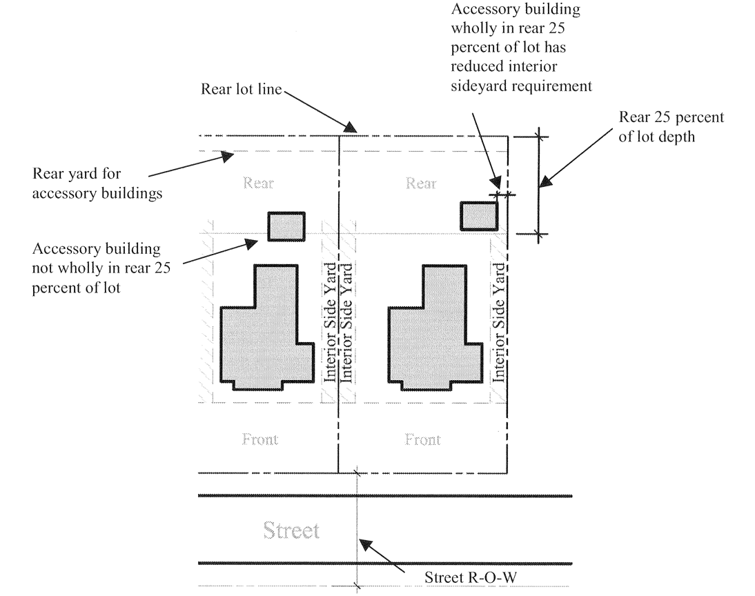
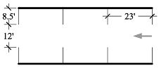
21.60.100 - Reduced side yard required for accessory uses.
See illustration.
Where specified in the bulk regulations table in Division III of this Zoning Code for a particular residential zoning district, an accessory building located on the rear twenty-five percent of a lot has a reduced interior side yard requirement.
(Ord. O-1-04 Revised (part), 2005)
21.62.010 - Applicability.
A.
The standards in this chapter shall apply to sites that are the subject of an application for site design plan approval. The standards are intended to provide a framework within which the applicant is free to exercise creativity, invention and innovation in order to meet the purpose of site design plan review as set forth in Section 21.22.010. The standards do not require or favor unduly any particular architectural style.
B.
Additional design standards may apply in specific zoning districts as set forth in Division III.
C.
Additional design standards may apply to uses that are subject to standards, as set forth in Chapter 21.64.
D.
In the event of a conflict between the standards set forth in this section and any other applicable standards, the more restrictive standard shall apply.
(Ord. O-1-04 Revised (part), 2005)
21.62.020 - General design standards.
A.
Relation of Buildings and Structures to the Surrounding Environment.
1.
Proposed structures shall be related harmoniously to themselves, to the terrain, to existing buildings and roads in the vicinity that have a visual relationship to the proposed structures, and to the historic character of the City of Annapolis. The achievement of a harmonious relationship may include the enclosure of space in conjunction with other existing buildings or other proposed buildings and the creation of focal points with respect to avenues of approach, terrain features or other buildings.
2.
Building bulk and scale shall relate to adjacent and surrounding buildings. Appropriate natural or artificial screening may be required to minimize any adverse impacts.
3.
Special consideration shall be given to the siting and design of those structures or portions thereof that may be viewed from any public street or adjacent properties.
B.
Relation of Structures to Adjacent Development. The construction of new buildings shall look appropriate and compatible as part of their surroundings. In general, new development shall be human in scale, with building façade articulation (doors, windows and surface treatment and detailing) open spaces, and access systems designed to relate to and to welcome people on foot. Buildings also must be sensitive to the character of the neighborhood in which they are located. The following standards shall apply to any development or redevelopment for a particular area:
1.
Height. Except where otherwise restricted by this Zoning Code, the variation between the height of the new building and the height of adjacent buildings shall not be so great as to substantially impair the architectural character and integrity of adjoining buildings.
2.
Width and Façade. A new or altered building shall reflect the characteristic rhythm of surrounding façades. The mass of the façade of a new building shall be divided into elements with size and proportions similar to those of adjoining and nearby structures, including where appropriate those structures across the street, and shall be consistent with the development and redevelopment goals of the area.
3.
Proportion. A new or altered building shall respect the characteristic proportion of existing façades of adjoining and nearby buildings and be consistent with the development or redevelopment goals of the area.
4.
Mass. The mass of buildings shall complement the size and proportions of the predominant features on the block on which it is located.
5.
Relationship to Street. A new or altered façade shall have a relationship to the street compatible with those of adjoining and nearby buildings.
6.
Roof Forms. The type of roof used shall be compatible with the roofs formed on adjacent and nearby buildings.
7.
Composition. The composition of a new or altered façade shall be complementary to the composition of façades of adjoining and nearby buildings.
8.
Rhythm. Rhythms which carry throughout a block shall be incorporated into a new façade.
9.
Proportion of Openings. The size and proportions of window and door openings, as well as the ratio of window area to solid wall area for the façade as a whole, shall be similar to adjoining and nearby façades in historic or preservation areas.
10.
Façade Materials. A new or altered façade shall be composed of materials that complement adjacent and nearby façades.
11.
Color. Color treatment for new or altered buildings shall complement color treatments of adjoining and nearby buildings.
12.
Corner and Through Lots. The two façades of a building situated on a corner lot or through lot shall relate to the scale of the buildings on their respective streets. Corner buildings shall complete the street form.
13.
Site Signage. Site signage shall meet the requirements and design guidelines set forth in Chapter 21.70.
(Ord. O-1-04 Revised (part), 2005)
21.62.030 - Design of open areas.
A.
Existing Features. Disturbance of existing vegetation, topography and soils shall be minimized. Efforts shall be made to preserve street trees, mature trees, trees of a diameter of four inches or above measured four feet above ground level, and trees of unique varieties. If development of the site necessitates the removal of established trees, special attention shall be given to the planting of replacements or to other landscape treatment. Any grade changes shall be in keeping with the general appearance of neighboring developed areas. All planting and maintenance shall adhere to the requirements of Chapter 14.12.
B.
Buffer Areas. All sites shall be designed appropriately to provide buffer areas to provide shade and reduce heat, noise, air pollution, and to screen adverse visual impacts. Designated buffer areas shall not be utilized for structures, utilities, storm and sanitary sewers, water lines, sediment and erosion control traps, stormwater management systems, and signage, except that access roads or required utilities may dissect a perimeter buffer or other minimal disturbance may be allowed if the integrity of the natural buffer is preserved. Buffers with existing mature trees and other vegetation shall remain in their natural state where practical and shall not be graded.
C.
Bufferyards.
1.
Bufferyards have the following purposes:
a.
Minimize potential nuisances such as dirt, litter, noise, glare, signs, and unsightly buildings or parking areas;
b.
Provide spacing to reduce adverse impacts of noise, odor, or danger of fires; and
c.
Enhance the visual character of the streetscape along street frontages for developing and redeveloping properties.
2.
Requirements for bufferyards are set forth in the zoning district bulk regulations tables, Chapter 21.50.
D.
Open Space.
1.
Areas of usable open space shall be provided on sites in order to afford visual relief. This open space area shall be planted though the surface treatment and need not be entirely living ground cover.
2.
Consideration shall be given to dedicating open space land to the City in furtherance of the goals and purposes of the Comprehensive Plan, Critical Areas Plan, and the Parks and Recreation Plan. The Annapolis Conservancy Board has been established to promote these goals and purposes, see Chapter 2.50 of the Annapolis City Code.
(Ord. O-1-04 Revised (part), 2005)
21.62.040 - Planting.
A.
Planting shall be provided within the site in order to integrate a building into the overall site design, soften the mass of the building and separate the building from the parking area. Building area planting shall be located in order to be visible from adjacent streets.
B.
Existing trees, tree stands and natural vegetation shall be integrated into the site planting plan to the maximum extent possible.
C.
Areas of lawn shall be minimized.
D.
Parking Lot Planting. See under Parking in Section 21.62.120.
(Ord. O-1-04 Revised (part), 2005)
21.62.050 - Street trees.
A.
In determining the location for the installation of street trees in the public right-of-way, consideration should be given to the location of underground utilities, the relationship of tree planting to parking, the width of the sidewalk, and other street considerations.
B.
When installed, trees shall be set back from the curb. Plantings shall be placed to the front of on-street parking spaces to not interfere with the opening or closing of car doors.
C.
Trees shall not be installed in locations which will obstruct views or otherwise produce dangerous traffic conditions.
D.
Trees shall be located at least twenty-five feet from intersections, fifteen feet from driveways and fifteen feet from hydrants.
E.
Tree plantings shall be consistent with the City of Annapolis Street Tree Master Plan, 1997.
(Ord. O-1-04 Revised (part), 2005)
21.62.060 - Scenic, historic, archaeological and landmark sites and views.
Scenic, historical, archaeological and landmark sites and features that are located on or adjacent to the proposed development shall be preserved and protected to the maximum extent as practicable through site design, building location, and parking layout. Special consideration shall be given to the impact of projects on views of the Annapolis historic district from the following points:
1.
From Eastport and the City dock; and
2.
From Truxtun Park; and
3.
From the Severn River Scenic Overlook; and
4.
From Rowe Boulevard.
(Ord. O-1-04 Revised (part), 2005)
21.62.070 - Transitional provisions for development adjoining residential districts.
Where a development adjoins a residential district, special consideration shall be given to transitional devices as landscaped pathways, increased setbacks, screening, the relationship of the height of buildings on adjoining lots, the distance between buildings on adjoining lots and plantings in transitional yards as may be required by the district regulations. Transitional devices shall be incorporated as appropriate on the lot with the higher intensity of land use, to integrate the new development with existing development on the lot with the lower intensity of land use.
(Ord. O-1-04 Revised (part), 2005)
21.62.075 - School capacity.
An applicant seeking approval of a development containing non-age restricted dwelling units shall provide to the Department of Planning and Zoning the following information:
1.
How many school-aged children are expected to live in the proposed development based on the school pupil generation factors yield per unit contained in the Anne Arundel County Educational Facilities Master Plan;
2.
Which, and to what degree, Annapolis feeder schools geographically located within the City of Annapolis; and
3.
The current and projected capacity of those impacted schools to accommodate the expected number of school aged children at present and the foreseeable future based on the Anne Arundel County Educational Facilities Master Plan.
(Ord. No. O-19-13 Amended, § 1, 10-28-2013)
21.62.080 - Surface water drainage.
A proposed development shall be designed to provide for proper surface water management through a system of controlled drainage that, wherever practicable, preserves existing natural drainage patterns and wetlands, enhances groundwater recharge areas, and that protects other properties and existing natural and artificial drainage features from the adverse effects of flooding, erosion and the depositing of silt, gravel or stone. A stormwater management plan is required to be submitted to the Director of Planning and Zoning for review and approval under Chapter 17.10 of the Annapolis City Code.
(Ord. O-1-04 Revised (part), 2005)
(Ord. No. O-12-16 Amended, § I, 5-23-2016)
21.62.090 - Traffic impacts.
A.
A development proposal generally shall minimize adverse traffic impacts on the road network serving the area.
B.
Determination of traffic impact and required mitigation shall be made through a suitable traffic impact study of the proposed use on the road network and affected intersections. The scope of the traffic impact study shall be determined by the Planning and Zoning Director.
(Ord. O-1-04 Revised (part), 2005)
21.62.100 - Driveway connections to public streets and rights-of-way.
A.
Location and Design. All entrance and exit driveways to public streets shall be located with due consideration for traffic flow and to afford maximum safety to traffic on the public streets. All entrances and exits shall be located and designed to:
1.
Conform with sight visibility triangle requirements at street intersections.
2.
Achieve maximum practicable distance from street intersections and from existing and proposed access connections from adjacent properties.
3.
Minimize left-hand turns, other turning movements, and prohibit backing movements onto a public right-of-way.
4.
Discourage the routing of commercial vehicular traffic to and through streets serving primarily residential uses.
5.
Minimize multiple access points on major collector and arterial streets. Where feasible, joint access among adjacent properties shall be provided.
B.
Width. Driveways onto public rights-of-way may not exceed twenty-five feet in width, not including curb cuts.
(Ord. O-1-04 Revised (part), 2005)
21.62.110 - Vehicular circulation.
A.
The location, width and layout of interior drives shall be appropriate for the proposed circulation.
B.
Adequate access shall be provided for police, fire, refuse and emergency vehicles.
(Ord. O-1-04 Revised (part), 2005)
21.62.120 - Parking and loading.
A.
General Design Considerations. The principles in this subsection shall govern the design of all off-street parking areas.
1.
The location and layout of accessory off-street parking and loading spaces shall provide for efficient circulation and for the safety of pedestrians and vehicles.
2.
To the maximum extent practicable, sites shall be designed to:
a.
Locate parking areas in a manner that does not detract from the design of proposed buildings and structures or from the appearance of the existing neighboring buildings, structures, and landscape elements.
b.
Minimize lot frontage of parking areas on streets and shield parking areas from public view.
c.
Avoid the location of parking areas within one hundred feet of the waterfront.
B.
Types of Facilities. Accessory parking spaces may be open or enclosed.
C.
Provisions for the Physically Handicapped. Parking for the physically handicapped shall be provided pursuant to the provisions of the Americans with Disabilities Act and the Maryland Building Code for Handicapped.
D.
Access. Access to off-street parking spaces shall meet the following requirements:
1.
Off-street parking facilities shall be designed with appropriate means of vehicular access to a street or alley in a manner which will least interfere with traffic movement.
2.
Except on lots accommodating single-family dwellings, each off-street parking space shall open directly upon an aisle or driveway at least twelve feet wide.
E.
Surface Material. Parking area surface material shall be appropriate for the use.
1.
A dustless all-weather surface material shall be used in most situations. Nontraditional surface materials, such as pervious pavers, are recommended.
2.
Subject to standards established by the Department of Public Works, gravel may be used as a surface material in residential zoning districts.
3.
The surface treatment of parking lots shall differentiate vehicular from pedestrian travelways.
F.
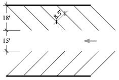
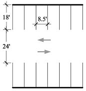
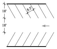
Parking Space and Aisle Dimensions.
1.
Parking spaces shall have the following minimum dimensions, exclusive of access drives or aisles, ramps, columns or office or work areas:
a.
Width: eight and one-half feet.
b.
Length: eighteen feet, or twenty-three feet in the case of parallel parking.
c.
Vertical clearance: six and one-half feet, measured at right angles to the axis of the vehicle.
2.
Minimum aisle widths are as follows, with the angle measured between the centerline of the parking space and the centerline of the aisle:
45 degree
90 degree
60 degree
Parallel
G.
Buffers and Planting.
1.
Parking lot planting shall be in accordance with Parking and Landscaping: A Manual of Landscape Standards for Parking Lots, Department of Planning and Zoning, Revised 1986.
2.
Parking lots shall have landscaped buffers in accordance with the following schedule:
3.
Parking lots containing more than fifteen parking spaces or six thousand square feet shall devote at least seven percent of the total area of the parking lot to internal planting dispersed throughout the parking lot.
4.
The Department of Planning and Zoning may require the screening of parking areas to prevent negative impacts from parking on adjacent property.
H.
Design of Loading Facilities.
1.
Size.
a.
Loading spaces shall be a minimum of twelve feet in width by fifty-five feet in length, exclusive of aisle and maneuvering space, with vertical clearance of at least fifteen feet.
b.
Through the Site Design Plan review process, loading spaces less than fifty-five feet in length may be approved based on the loading needs for the proposed use as documented by the applicant.
2.
Screening.
a.
Loading facilities shall be subject to screen plantings or other reasonable screening methods determined to be required to prevent any adverse effect on nearby property.
b.
Loading facilities that abut a residential district or an intervening alley separating a residence district from a non-residential district shall be effectively screened from the adjoining district.
(Ord. O-1-04 Revised (part), 2005)
21.62.130 - Pedestrian and bicycle circulation.
A.
Safe and convenient pedestrian and bicycle circulation, including appropriate sidewalks, shall be provided on the site and its approaches.
B.
To the maximum extent practicable, pedestrian and bicycle circulation shall be separated from motor vehicle circulation.
C.
A pedestrian and bicycle circulation plan, when required, shall be designed to minimize adverse effects of vehicular traffic upon pedestrian and bicycle routes and to enhance the integration of these physical components of the circulation system.
D.
Where bicycle parking is provided it shall be located in a clearly designated, safe and convenient location. Bicycle racks must be capable of locking the bicycle and of supporting the bicycle in an upright position.
E.
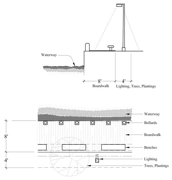
Where a public pedestrian walkway is required pursuant to the specific requirements for a zoning district, it shall be constructed in accordance with the following standard:
Requirements
Boardwalk
Benches
Luminaires
Trees
Bollards
Maintenance Plan
_____
Illustration for public pedestrian walkway
(Ord. O-1-04 Revised (part), 2005)
_____
21.62.140 - Lighting.
A.
Any lighting used to illuminate off-street parking areas shall be directed away from residential properties and public streets in such a way as not to create a nuisance.
B.
Parking lot lighting may not exceed three foot-candles measured at the lot line.
(Ord. O-1-04 Revised (part), 2005)
21.62.150 - Utility services.
If feasible, electric, telephone and other wire-served connections shall be placed underground and subject to State public utilities regulations. Any utility installations remaining aboveground shall be located in order to have a harmonious relation to neighboring properties and to the site.
(Ord. O-1-04 Revised (part), 2005)
21.62.160 - Waste disposal.
There shall be adequate provision for the disposal of all solid, liquid and gaseous wastes and for the avoidance of odors and other air pollutants that may be generated at the site. All applicable Federal, State, County and local pollution control standards shall be observed.
(Ord. O-1-04 Revised (part), 2005)
21.62.170 - Noise.
Control of all outside noise expected to be generated by the site, shall be in accordance with all applicable Federal, State and local regulations.
(Ord. O-1-04 Revised (part), 2005)
21.62.180 - Storage, loading, and service areas.
Outside storage areas, machinery service areas, truck loading areas, utility buildings and structures and similar accessory uses and structures shall be subject to setbacks, screen plantings or other reasonable screening methods determined to be required to prevent any adverse effect upon the environment or nearby property.
(Ord. O-1-04 Revised (part), 2005)
21.62.190 - Additional site design standards.
A.
In addition to the enumerated standards in Chapter 21.62, a project may also be subject to additional design standards established for a particular geographic area or for a particular use pursuant to other sections of this Zoning Code.
B.
The Planning Commission, after public hearing, may adopt additional design standards that are supplementary to, but not in conflict with, the standards specified in this chapter.
(Ord. O-1-04 Revised (part), 2005)
21.64.005 - Purpose and application of standards.
A.
This chapter lists the standards that apply to uses listed as subject to standards in the use tables Chapter 21.48 of this Zoning Code.
B.
In the case of a use requiring special exception approval, the standards for the use set forth in this chapter must be met in addition to the general standards for approving a special exception.
(Ord. O-1-04 Revised (part), 2005)
(Ord. No. O-9-21, § I, 10-11-2021)
Editor's note— Ord. No. O-9-21, § I, adopted Oct. 11, 2021, renumbered former § 21.64.010 as § 21.64.005.
21.64.010 - Accessory dwellings.
A.
A maximum of one accessory dwelling unit may be established on any one lot.
B.
An accessory dwelling unit may be established within a principal structure or within an accessory structure.
C.
Each accessory dwelling unit shall have its own separate ingress and egress.
D.
The addition of an impervious surface shall not be allowed on any lot containing an accessory dwelling unit, unless:
1.
The Department has determined that the proposed surface will be treated or managed; or
2.
The equivalent coverage of impervious surface will be removed elsewhere on the property.
E
The maximum size of any accessory dwelling unit that is not established within the existing footprint of the principal structure is eight hundred fifty square feet of livable space.
F.
A rental license for any accessory dwelling unit is required in accordance with Chapter 17.44.
G.
An accessory dwelling unit and principal structure on any one lot shall be in common ownership and the owner shall reside in either the accessory dwelling unit or the principal structure.
(Ord. No. O-9-21, § I, 10-11-2021)
Editor's note—
Section III of Ord. No. O-9-21, adopted Oct. 11, 2021 provides that this ordinance
shall take effect from the date of its passage; provided, that there shall be an amnesty
period from the date of passage of this ordinance through close of business on January
10, 2022 to encourage compliance with the rental license requirements enacted by this
ordinance by allowing owners of unlicensed accessory dwelling units to participate
in this amnesty period by voluntarily entering the rental license process while continuing
to rent such unlicensed accessory dwelling unit. Any owner of an unlicensed accessory
dwelling unit who participates in this amnesty program shall be exempt from the penalties
set forth in Chapter 17.44 for the duration of the amnesty period. For the purpose
of this ordinance, the owner of an unlicensed accessory dwelling unit is participating
in the amnesty period if:
(1) A rental operating license application is filed in accordance with Chapter 17.44;
(2) The applicant makes a good faith effort, as determined by the Department, to complete
the rental license process during the amnesty period; and
(3) Information is not made known to the Department that the health, safety, or welfare
of any occupant of the unlicensed accessory dwelling unit is endangered.
21.64.015 - Accessory uses in R1, Single-family Residence district.
Any accessory structure in the R1 district having a floor area greater than one thousand two hundred square feet or a height greater than twenty feet must be approved as a special exception.
(Ord. O-23-05 Revised § 1 (part), 2006)
21.64.020 - Adult bookstores.
Video sales may be permitted as an accessory use to the special exception.
(Ord. O-1-04 Revised (part), 2005)
21.64.025 - Alcoholic beverage uses accessory to other uses.
If the use is conducted out of doors or will include live entertainment or dancing, the area used for the activity shall be located at least one hundred feet from all residentially zoned property.
(Ord. No. O-26-09, § I, 11-9-2009)
21.64.030 - Antenna towers.
A.
Permitted by Right. Antenna towers that are permitted as a matter of right are subject to the following standards:
1.
Review. Site design plan review is required.
2.
Type. Monopole-type towers are the only towers permitted.
3.
Height. The height of the tower, including antennas, shall be no taller than necessary to meet the applicant's service needs, up to a maximum height of sixty-five feet. Elevation drawings of the tower must be submitted with the application.
4.
Need.
a.
An applicant for a tower must demonstrate need for the tower. A needs study must be submitted including:
i.
A map of area to be served and explanation of inadequate service area.
ii.
Explanation of why communications service cannot be provided by locating on existing buildings or structures.
iii.
Explanation of the proposed height of the tower.
b.
The City may require a review of the needs study by an independent consultant of its choosing, cost of the review to be borne by the applicant.
5.
Setback. Towers must be set back from all property lines a distance of one-half foot for each foot of tower height.
6.
Co-location. Towers shall be designed and made available on a commercial basis for co-location by no less than three other telecommunications service providers, unless the Planning and Zoning Director determines that co-location:
a.
Is infeasible,
b.
Will result in a tower that is taller than the minimum necessary to provide service, or
c.
Is not essential to the public interest.
B.
Special Exception.
1.
The Board of Appeals may permit a special exception for antenna towers for the following:
a.
Towers with a maximum height above sixty-five feet.
b.
Towers with a setback less than one-half foot for each foot of tower height.
2.
An application for a special exception must include information sufficient to understand the application including a thorough explanation of why the tower is needed and cannot be provided or developed under the permitted use provisions in this section.
3.
The Board may request a demonstration of visual impact such as a balloon or crane test.
4.
The Board of Appeals may require a review of the needs study by an independent consultant of its choosing, cost of the review to be borne by the applicant.
(Ord. O-1-04 Revised (part), 2005)
21.64.040 - Antennas and amateur radio stations.
A.
Antennas and amateur radio stations are permitted as accessory uses subject to the numerical limitations and standards in the table in this section.
B.
Special Exception.
1.
The Board of Appeals may permit a special exception for antennas and amateur radio stations with numerical limitations and standards different from those set forth in the table in this section.
2.
An application for a special exception must include information sufficient to understand the application including a thorough explanation of why the antenna or amateur radio station tower is needed and cannot be provided or developed under the accessory use provisions in this section.
3.
The Board of Appeals may require a review of the needs study by an independent consultant of its choosing, cost of the review to be borne by the applicant.
(Ord. O-1-04 Revised (part), 2005)
21.64.050 - Antique stores.
A.
This use may be provided only on a ground floor.
B.
New construction, expansion or substantial rehabilitation shall not provide commercial or retail uses greater than fifty percent of a structure's gross floor area.
C.
Where this use is established on lots less than five thousand four hundred square feet in size, all trash and refuse shall be stored in self-enclosed trash storage areas. Trash storage areas shall be screened in an appropriate manner using a board-on-board enclosure.
(Ord. O-1-04 Revised (part), 2005)
21.64.060 - Apartment hotels.
A.
In apartment hotels containing forty or more dwelling units the following uses are permitted: restaurants, drugstores, retail food shops, valet shops, beauty shops, barbershops, gift shops and physical health facilities (including massage, steam bath, gym).
B.
The uses in Subsection A of this section shall be accessible only through the lobby, with no advertising or display visible from outside the building.
(Ord. O-1-04 Revised (part), 2005)
21.64.070 - Arts and crafts stores.
A.
This use may be provided only on a ground floor.
B.
New construction, expansion or substantial rehabilitation shall not provide commercial or retail uses greater than fifty percent of a structure's gross floor area.
C.
Where this use is established on lots less than five thousand four hundred square feet in size, all trash and refuse shall be stored in self-enclosed trash storage areas. Trash storage areas shall be screened in an appropriate manner using a board-on-board enclosure.
(Ord. O-1-04 Revised (part), 2005)
21.64.080 - Arts and crafts studios.
A.
This use may be provided only on a ground floor.
B.
New construction, expansion or substantial rehabilitation shall not provide commercial or retail uses greater than fifty percent of a structure's gross floor area.
C.
Where this use is established on lots less than five thousand four hundred square feet in size, all trash and refuse shall be stored in self-enclosed trash storage areas. Trash storage areas shall be screened in an appropriate manner using a board-on-board enclosure.
(Ord. O-1-04 Revised (part), 2005)
21.64.090 - Bake shops.
See Food and beverage-related uses.
(Ord. O-1-04 Revised (part), 2005)
21.64.100 - Banks and financial institutions.
This use is not permitted in any part of the B1 district on or adjacent to Annapolis Street.
(Ord. O-1-04 Revised (part), 2005)
21.64.110 - Bed and breakfast homes.
A.
C1, C1A, R2-Neighborhood Conservation, R3-Neighborhood Conservation 2, and Office and Commercial Design Overlay Districts.
1.
Number and location of bed and breakfast homes:
a.
C1, C1A, R2-Neighborhood Conservation, and Office and Commercial Design Overlay districts:
i.
For each side of a block between two intersecting streets there shall be no more than two bed and breakfast homes.
ii.
No two bed and breakfast homes shall be located on adjacent properties with the exception of any bed and breakfast homes holding a valid, current license issued by the City pursuant to Chapter 17.44 as of June 20, 1994.
iii.
No bed and breakfast home shall be located in an attached dwelling with the exception of any bed and breakfast homes holding a valid, current license issued by the City pursuant to Chapter 17.44 as of June 20, 1994.
iv.
In the C1 and C1A districts, in the case of a license for a bed and breakfast home holding a valid, current license issued by the City pursuant to Chapter 17.44 as of June 20, 1994, nothing in this Zoning Code shall preclude the renewal or transfer of that license.
b.
R3-Neighborhood Conservation 2 District:
i.
There shall be no more than one bed and breakfast home for every block on any street located in the district and no two bed and breakfast homes shall be located on adjacent properties.
ii.
No bed and breakfast home shall be located in an attached or multi-family dwelling.
2.
The individual recorded owner of the property shall be the operator of the bed and breakfast and reside on the premises. No resident managers shall be allowed to operate a bed and breakfast.
3.
The number of guests shall not exceed the maximum allowed by the life safety code.
4.
There shall be only one kitchen within the entire dwelling. No cooking facilities are permitted in guest rooms.
5.
No food or beverage service may be provided for transient guests other than breakfast provided in the areas of the dwelling commonly used by the resident family for the consumption of food.
6.
Bed and breakfast homes shall not have a separate apartment within the entire dwelling or on the subject property such as a carriage house, garage, etc.
7.
Bed and breakfast homes shall have interior stairs to serve all habitable living spaces within the entire dwelling including basements and attics, except that this provision does not apply in the C1 or C1A districts to any bed and breakfast homes holding a valid, current license issued by the City pursuant to Chapter 17.44 as of June 20, 1994.
8.
The owner(s) of record of the property shall obtain a rental license from the Department of Planning and Zoning.
9.
The resident owner shall keep a current guest register including names, addresses and dates of occupancy of all guests available for inspection by the licensing agency.
10.
The use shall be subject to all applicable City Code regulations including but not limited to building, fire, and health regulations.
11.
Special provisions for the R2-Neighborhood Conservation and R3-Neighborhood Conservation 2 districts:
a.
The bed and breakfast use shall be subordinate and incidental to the principal residential use of the property and located within an existing structure.
b.
Bedroom rental units may not occupy more than sixty percent of the living space of the dwelling.
c.
The applicant for a bed and breakfast license shall post a public notice on the property indicating that a bed and breakfast license for the property is being sought. This sign shall contain such information as may be required by the Planning and Zoning Director shall be posted for a period of not less than ten days.
d.
Parking.
i.
Required off-street parking may be provided within an existing garage, driveway or parking area.
ii.
Where feasible, parking areas shall be provided at the rear or side of the property, but in no case may parking be provided in an established front yard.
iii.
When located next to a residence, parking shall be screened and maintained with dense planting or other appropriate screening to buffer the parking from abutting properties subject to the provisions of Chapter 21.62.
12.
In the R2-Neighborhood Conservation district no bed and breakfast license is required for special events including multi-day graduation events and multi-day boating events.
B.
R3-Neighborhood Conservation. This use is permitted in principal structures existing on October 10, 1988 subject to the standards in this section. A structure may be enlarged by a maximum of fifty percent of the overall floor area existing on October 10, 1988 to maintain classification as an existing structure. Enlargements in excess of fifty percent shall be considered new construction.
1.
An owner shall live on the premises,
2.
The facility shall be part of the dwelling unit and have no more than one nonresident employee,
3.
No separate kitchens shall be provided,
4.
No food or beverage service may be provided for transient guests other than breakfast provided in the areas of the dwelling commonly used by the resident family for the consumption of food,
5.
Notwithstanding the definition of bed and breakfast home in Division VI, a maximum of six guest rooms are allowed with no maximum duration-of-stay restrictions,
6.
Adequate access and egress shall be provided,
7.
Parking.
a.
Where feasible, parking areas shall be provided at the rear of the site. Parking may not be located in an established front yard.
b.
All parking areas shall be screened in accordance with the standards set forth in Chapter 21.62. When located next to single-family residential use, dense plantings to provide an effective fifty percent screen shall be installed and maintained.
(Ord. O-1-04 Revised (part), 2005)
(Ord. No. O-12-16 Amended, § I, 5-23-2016)
21.64.120 - Bed and breakfast home in a structure constructed or erected after December 14, 1998 on a vacant lot of record.
Where this use is established after the fifth anniversary of the structure's original occupancy permit, the use may be permitted as a matter of right subject to the standards for bed and breakfast homes in the R2-Neighborhood Conservation district.
(Ord. O-1-04 Revised (part), 2005)
21.64.125 - Paddlecraft vessels.
On-Land Paddlecraft Equipment Storage and Display.
1.
In the R4 district, on-land paddlecraft and associated equipment storage are permitted on paved or unpaved areas.
2.
Any structures providing on-land paddlecraft or associated equipment storage may be replaced in-kind, regardless of being located on paved or unpaved surfaces.
(Ord. No. O-9-25, § I, 7-28-2025)
21.64.130 - Candy stores including candy making.
See Food and beverage-related uses.
(Ord. O-1-04 Revised (part), 2005)
21.64.140 - Catering establishments.
See Food and beverage-related uses.
(Ord. O-1-04 Revised (part), 2005)
21.64.150 - Cigar lounges.
Cigar lounges shall:
1.
Be permitted by special exception subject to the requirements of this section.
2.
Exist only as accessory uses within tobacco shops that primarily sell premium cigars and pipe tobacco, as defined in Maryland Business Regulation Code Annotated § 16.5-101, and be operated only as an accessory to the primary operation of a tobacco shop in which a cigar lounge is located.
3.
Sell alcohol only as paired with the tobacco products sold by the tobacco shop in which a cigar lounge is located and in accordance with all other applicable requirements of the City Code.
4.
Be operated only during the hours of operation of a tobacco shop in which a cigar lounge is located and in accordance with all noise requirements of the city code.
(Ord. No. O-10-23, § I, 10-23-2023)
21.64.160 - Clubs, lodges and meeting halls, with on-premises food or beverage preparation facilities.
See Food and beverage-related uses.
(Ord. O-1-04 Revised (part), 2005)
21.64.170 - Coffee shops.
A.
Coffee shops are subject to the general standards for food and beverage-related uses.
B.
In the BCE district outdoor dining may be permitted, subject to the outdoor dining chapter, Chapter 7.35.
C.
Notwithstanding the provisions of § 21.64.300, a coffee shop shall be allowed as an accessory use to a bookstore in the C2 and C2A districts.
1.
The square footage of the coffee shop shall not exceed 25% of the floor area of the bookstore.
2.
Food sales shall be limited to pre-packaged items, prepared off-premises, with no food preparation on-site.
3.
The coffee shop shall only be open when the bookstore is open.
(Ord. O-1-04 Revised (part), 2005; Ord. No. O-16-10, § I, 7-26-2010; Ord. No. O-10-24, § I, 4-14-2025)
21.64.180 - Convenience stores.
A.
Convenience stores shall comply with the standards for food and beverage-related uses.
B.
In the B1, B2, B3, B3-CD districts, and the BCE district without a special exception, the use is limited to four thousand square feet gross floor area and two hundred square feet of area devoted to food preparation.
C.
Convenience stores shall not impact negatively the critical lane levels of service for adjoining intersections. This determination shall be made only through suitable traffic impact analysis of the proposed use on the adjoining intersections.
(Ord. O-1-04 Revised (part), 2005)
21.64.190 - Family child care.
A.
Family Child Care Homes.
1.
Family child care homes and large family child care homes shall meet requirements of Education Article § 9.5 of the Maryland Code and COMAR § 13A.15.
2.
Family child care home providers shall be residents of the principal building on the zoning lot.
B.
Zoning Requirements.
1.
No family child care home shall create noise, dust, vibrations, smells, smoke, glare, electrical interference, fire hazard, or other hazard or nuisance to any greater or more frequent extent than that usually experienced in the district on residentially used zoning lots where no family child care home exists.
(Ord. No. O-1-25, § I, 5-27-2025)
Editor's note— Ord. No. O-1-25, § I, adopted May 27, 2025, amended the Code by repealing former § 21.64.190 and adding a new § 21.64.190. Former § 21.64.190 pertained to family day cares, and derived from Ord. O-1-04, Revised of 2005.
21.64.200 - Child care center.
A.
Generally.
1.
State Requirements. Child care centers shall meet requirements of Education Article § 9.5 of the Maryland Code and COMAR § 13A.16.
2.
Additional City Requirement. Child care centers shall have safe pick-up and drop-off locations, as determined by the planning and zoning director.
B.
Educational and Religious Affiliated Child Care Centers.
1.
The use is subject to review and approval by the department of planning and zoning.
2.
A safe on-site drop-off and pick-up area shall be provided.
3.
Adequate on-site parking sufficient to accommodate the users of the facility shall be provided, with signage to reserve spaces for the day care center.
(Ord. No. O-1-25, § I, 5-27-2025)
Editor's note— Ord. No. O-1-25, § I, adopted May 27, 2025, amended the Code by repealing former § 21.64.200 and adding a new § 21.64.200. Former § 21.64.200 pertained to group day care centers, and derived from Ord. O-1-04, Revised of 2005.
21.64.210 - Reserved.
Editor's note— Ord. No. O-1-25, § I, adopted May 27, 2025, amended the Code by repealing former § 21.64.210 and adding a new § 21.64.210. Former § 21.64.210 pertained to group day care centers, in conjunction with public school facilities or with a principal religious institution, and derived from Ord. O-1-04, Revised of 2005.
21.64.220 - Delicatessens.
Delicatessens are subject to the general standards for food and beverage-related uses. The following additional standards apply:
A.
Delicatessens may not have bars, dancing, or live entertainment.
B.
The service of alcoholic beverages shall be limited to beer and wine only, served on premises with meals, or sold prepackaged for off-premises consumption.
C.
In the WMI-district, delicatessens are only permitted as an accessory use on lots without access to the bulkhead, and are limited to one thousand square feet gross floor area.
D.
In the WME-district, delicatessens are only permitted as an accessory use on lots greater than ten thousand square feet in area, and are limited to one thousand square feet gross floor area.
(Ord. O-1-04 Revised, 2005; Ord. No. O-6-24, § I, 12-9-2024)
21.64.230 - Drive-through facilities prohibited.
Drive-through facilities are prohibited in the City of Annapolis.
(Ord. O-10-07 Amended § 1 (part), 2007: Ord. O-1-04 Revised (part), 2005)
(Ord. No. O-6-24, § I, 12-9-2024)
21.64.240 - Dwellings, multi-family.
A.
BCE District.
1.
Retail and/or Office Use Required. Retail and/or office use shall be required as an integral component of a multi-family residential project and the project design shall allow for such uses on the ground floor if there is direct access and frontage along a principal arterial, minor arterial, or collector road. If there is no access and frontage along such a road, retail and/or office use is not required.
2.
Multiple Structures on a Zoning Lot. Consistent with Section 21.60.030, a multi-family residential use may contain more than one principal residential building, including a building containing a mix of residential and other BCE district uses, on a zoning lot.
3.
Parking and Loading.
a.
Structured parking may be permitted as a component of a multi-family development.
b.
Sufficient street-level parking shall be provided to accommodate commercial uses and office visitors.
c.
Parking spaces wherever reasonably possible shall be located in the rear or interior courtyard or plaza areas; if structured parking is provided then it shall be screened by buildings or landscaped wherever reasonably possible.
d.
Notwithstanding the provisions of Chapter 21.66, off-street loading facilities for a multi-family development and other BCE uses developed in conjunction therewith may be provided in the front yard of the lot.
4.
Streetscape and Planting.
a.
The streetscape shall be of an urban character with street trees, street lighting, controlled pedestrian crossings, dedicated bicycle facilities, benches and other streetscape elements.
b.
Public courts and plazas shall be open to the street or connect to pedestrian walkways. Such areas shall be well planted and shall be paved for pedestrian circulation.
c.
Pedestrian traffic through and around the use shall be separated from driveways and parking areas through the use of sidewalks, pathways, crossings and other marked pedestrian ways.
d.
Sidewalks along streets designated as major or minor arterial in the Comprehensive Plan shall be a minimum of fifteen feet wide; sidewalks along all other streets shall be a minimum of twelve feet wide.
e.
Buffer areas adjacent to public streets shall have street trees a minimum of thirty-five feet on-center and a maximum of forty-five feet on-center along with planting beds buffering pedestrians from vehicular traffic.
f.
Pedestrian features such as benches, lighting and pavers shall be designed in a consistent manner.
g.
Interior courtyards, boulevards and plaza areas shall be adequately landscaped, and include adequate sitting areas.
h.
A Planting Soils Improvement Plan shall be reviewed and approved prior to the issuance of grading permits, sufficient to provide for the long term health of all plantings and to meet the principles and recommendations for soils for urban tree plantings outlined in "Architectural Graphic Standards 10th Edition," pages 178 through 182, published by John Wiley & Sons, 1998.
5.
Lighting. An exterior lighting plan, including a fixture schedule, shall be provided, that shall insure that site lighting is designed at appropriate levels to achieve public safety without creating excessive glare or high intensity. High pressure sodium (yellow-orange) shall be prohibited for exterior use, and for the interior use in parking areas where the lighting is visible from the outside. A reduction in lighting intensity may be required after installation if a determination is made that the lighting is too bright or creates excessive glare.
6.
Building and Architecture.
a.
Buildings shall be designed with a diversity of architectural styles that enhance the visual identity and integrity of this important gateway to the City of Annapolis;
b.
Street facing façades shall provide several pedestrian access points;
c.
Buildings, rather than parking, shall be generally oriented towards adjacent public streets creating an active, urban-type frontage;
d.
Mixed-use buildings fronting on an arterial street shall provide opportunities for ground-floor retail or other commercial space with residential, hotel or office uses above;
e.
Buildings with ground-floor retail shall have all retail entrances facing the public or private streets or interior courtyards or plazas of the site;
f.
The ground floor shall be differentiated from the upper floors to establish a distinct base for the building;
g.
The exterior façades of the building shall be articulated in a human scale;
h.
The mass of large scale building shall, where possible, be divided into smaller elements or parts to minimize any negative impact on adjacent streets;
i.
Buildings shall be constructed of quality, durable materials appropriate to the vernacular architecture of Annapolis, including brick, stone, wood and/or concrete;
j.
The visibility of all parking facilities from any street or residential zoning district shall be minimized whenever possible;
k.
Visible façades of parking facilities shall be designed to be compatible with the architectural character of surrounding structures;
l.
The applicant shall explore the possibility of utilizing green roof technology, unless proven not commercially feasible, as determined by Planning and Zoning Director.
7.
Traffic Impact. A traffic impact study is required, pursuant to Section 21.62.090.
8.
Common Open Space. Permanent usable common open space equal to a minimum of ten percent of the lot area shall be identified and dedicated for passive recreational activities or limited active recreation, subject to the following requirements:
a.
The area required for parking lot landscaping or buffers shall not be included in the common open space calculation.
b.
The area of each parcel of common open space shall be of such minimum dimensions as to be functionally usable.
c.
Common open space areas shall be convenient to the dwelling units they are intended to serve.
d.
Up to fifty percent of the common open space may include community meeting rooms and indoor recreational facilities, such as club houses and exercise facilities.
e.
Any area dedicated for open space purposes shall be described in appropriate subdivision dedications, covenants and/or deed restrictions approved by the City Attorney which demonstrate that:
i.
The use of the common open space shall continue for the life of the project for the purpose specified;
ii.
Appropriate provisions shall be made for the maintenance of the common open space areas; and
iii.
Common open space areas shall not be used for a commercial enterprise admitting the public for a fee.
f.
The type of ownership of land dedicated for common open space purposes shall be selected by the owner, developer or subdivider, subject to the approval of the Planning and Zoning Director. Type of ownership may include, but is not limited to the following:
i.
The City, subject to the acceptance of the City Council;
ii.
Homeowner, condominium or cooperative associations;
iii.
Shared, undivided interest by all property owners;
iv.
The project owner.
g.
The owner of the common open space shall be responsible for its continuing upkeep and proper maintenance.
9.
Subdivision Plat.
a.
Notwithstanding any other provisions of the City Code to the contrary, a subdivision plat in accordance with the requirements of Title 20 shall be approved by the Planning Commission.
b.
Notwithstanding the provisions of Section 20.08.030, an administrative exemption to the subdivision plat shall not be allowed.
c.
In approving the subdivision plat, the Planning Commission shall determine that the design and development of the project is consistent with all applicable goals and policies of the Comprehensive Plan and any legislatively adopted sector studies or other legislatively adopted planning studies for the area in which the project is located.
d.
Modifications to Standards. In acting upon the subdivision plat, the Planning Commission shall have the authority to modify any of the foregoing standards or other BCE development standards, provided the Planning Commission shall find based on the evidence presented in each case that the proposed modification to the standard complies with all of the following criteria:
i.
The objectives underlying the standards can be met without strict adherence to them;
ii.
Because of peculiarities in the parcel of land to be developed or the facilities proposed, it would be unreasonable to require strict adherence to the standards;
iii.
The modification is in the public interest and is necessary in order to further the purposes of the BCE district; and
iv.
The modification is consistent with all applicable goals and policies of the Comprehensive Plan or other legislatively adopted planning studies for the area in which the project is located.
10.
Modifications to Approved Site Development Plan. All substantive changes or modifications to the approved site development plan shall require review and approval by the Planning Commission in accordance with the criteria for modifications to standards in previous Subsection (A)(9)(d) of this section for subdivision plat approval.
B.
C1 District.
1.
In addition to proposed new uses, the following uses require special exception approval:
a.
Any change or expansion of the bulk or any structural modifications, including extensions, enlargements or alterations which increase or decrease the floor area of a particular use, except as provided in Subsection (B)(2) below, or
b.
The expansion or extension of a special exception for part of a building or structure, the remainder of which is utilized for a use permitted in the district.
2.
The gross floor area of a dwelling unit on an individual lot of record may be expanded with administrative approval by up to twenty percent of the total floor area, provided the proposed addition complies with all other requirements of the district and provided that no previous expansion has been granted pursuant to this section.
C.
MX District.
1.
On lots of forty thousand square feet or greater, permanent usable common open space equal to ten percent of the lot area shall be identified and dedicated for passive recreational activities or limited active recreation. In the case of attached units, each unit shall have an individual rear yard which may be included in calculating the required common open space. The area required for parking lot planting or buffers shall not be included in the open space calculation.
2.
Pedestrian traffic through and around the use shall be separated from driveways and parking areas through the use of sidewalks.
3.
If surface parking is located on the zoning lot, it shall be located at the rear of the zoning lot and new structures shall be located at the front of the zoning lot.
4.
If surface parking located on the zoning lot is adjacent to single-family residential use, dense plantings shall be installed and maintained on the zoning lot to provide an effective screen.
(Ord. O-1-04 Revised (part), 2005)
(Ord. No. O-31-14 Amended, § I, 2-9-2015; Ord. No. O-6-11, § I, 6-20-2011; Ord. No. O-19-18, § I, 11-19-2018)
21.64.250 - Dwellings, multi-family containing six or fewer dwelling units.
This use is permitted in principal structures existing on October 10, 1988 subject to the standards in this section. A structure may be enlarged by a maximum of fifty percent of the overall floor area existing on October 10, 1988 to maintain classification as an existing structure. Enlargements in excess of fifty percent shall be considered new construction.
A.
Permanent usable common open space, as required, shall be identified and dedicated for passive recreational activities.
B.
All trash and refuse shall be stored in self-enclosed trash storage areas. Trash storage areas shall be screened in an appropriate manner using a board-on-board enclosure.
C.
Pedestrian traffic through and around the project shall be separated from driveways and parking areas.
D.
Parking.
1.
Where feasible, parking areas shall be provided at the rear of the site. Parking may not be located in an established front yard.
2.
Parking areas shall be screened in accordance with the standards set forth in Chapter 21.62. When located next to single-family residential use, dense plantings to provide an effective fifty percent screen shall be installed and maintained.
(Ord. O-1-04 Revised (part), 2005)
21.64.260 - Dwellings, multi-family, containing twelve or fewer units.
This use is permitted when it is provided above the first floor in conjunction with office or commercial uses and is subject to the following standards:
A.
All trash and refuse shall be stored in self-enclosed trash storage areas. Trash areas shall be screened in an appropriate manner using a board-on-board enclosure.
B.
Permanent common open space shall be provided for multifamily uses. The permanent common open space shall be used for either:
1.
Passive recreational amenities such as outdoor eating; and/or
2.
Recreational space for limited active recreational activities.
C.
Pedestrian traffic through and around the project shall be separated from driveways and parking lots through the use of sidewalks.
D.
Parking areas shall be provided at the rear of the site and structures shall be located at the front of the site.
(Ord. O-1-04 Revised (part), 2005)
21.64.270 - Dwellings, single-family attached.
A.
In the MX district this use is subject to the same standards as apply to multi-family dwellings in the MX district.
B.
In the C1 district this use is subject to the same standards as apply to multi-family dwellings in the C1 district.
(Ord. O-1-04 Revised (part), 2005)
21.64.290 - Dwellings, two-family.
In the C1 district this use is subject to the same standards as apply to multi-family dwellings in the C1 district. See Section 21.64.240(B).
(Ord. O-1-04 Revised (part), 2005)
21.64.300 - Food and beverage-related uses.
A.
Applicability. The standards in this section apply to the following uses:
1.
Bake shops,
2.
Candy stores,
3.
Catering establishments,
4.
Clubs, lodges and meeting halls, with on-premises food or beverage preparation facilities,
5.
Coffee shops,
6.
Convenience stores,
7.
Delicatessens,
8.
Fast food restaurants,
9.
Food service marts,
10.
Ice cream stores,
11.
Markets, open air,
12.
Standard restaurants, and
13.
Supermarkets.
B.
Site Plan. A site design plan for the use is required pursuant to Chapter 21.22.
C.
Noise. Noise emanating from the use shall not be of such a volume to disturb the quiet and enjoyment of property in any nearby residential zoning districts.
D.
Loitering. Loitering is not permitted around the exterior of the use.
E.
Kitchens and Food Preparation Areas. Kitchens and food preparation areas shall be designed, maintained and operated in a manner to minimize noise and odors, and to eliminate grease flows into City sewers in strict adherence to the City's Plumbing Code. An outdoor spigot shall be installed if required.
F.
Related Plans. The use shall be consistent with the City's Comprehensive Plan and any sector plans applicable to the area where the use will be located.
G.
Trash.
1.
All trash and refuse shall be stored in self-enclosed trash storage areas. These trash storage areas shall be located either within the establishment or within the structure on which the establishment is located, or shall consist of a properly screened and maintained dumpster on the property on which the establishment is located. See also Section 17.48.120.
2.
Except where trash is placed in accordance with Subsection (F)(1) of this section, trash receptacles shall not be placed outside for pick-up until one-half hour prior to the scheduled pick-up time and shall be removed within one-half hour after trash pick-up.
3.
The cleanliness of all trash storage areas and all sidewalks adjoining the establishment shall be maintained.
H.
C2 and C2A Districts. In the C2 and C2A districts, the following standards apply:
1.
No food establishment shall be allowed in a building which fronts on, or whose side yard is contiguous with, residential use on the following streets:
a.
Prince George Street;
b.
Randall, between Dock Street and King George;
c.
Cornhill Street;
d.
Fleet Street;
e.
Upper Duke of Gloucester Street from Church Circle to a point on Duke of Gloucester Street two hundred fifteen feet from the centerline of Church Circle;
f.
Newman Street;
g.
St. Mary's Street; and
h.
Maryland Avenue between Prince George and King George Streets.
2.
The provisions of Subsection (H)(1) of this section shall not apply to restaurant/food service and bars existing as of June 13, 1994.
3.
Revenues from alcohol sales shall not exceed fifty percent of total revenues. This limitation shall not apply to restaurants existing prior to June 13, 1994. All restaurants, established after June 13, 1994, shall report annually the ratio of food revenues to total revenues.
4.
[Reserved.]
5.
Expansion.
a.
All proposed expansions of restaurants are subject to the special exception process of this Zoning Code, however restaurants existing as of June 13, 1994 shall not be required to provide the report described in Subsection (H)(3) of this section for its expansion.
(Ord. O-1-04 Revised (part), 2005)
(Ord. No. O-31-14 Amended, § I, 2-9-2015; Ord. No. O-27-09, § I, 7-26-2010)
21.64.310 - Food service marts.
Food service marts are subject to the general standards for food and beverage-related uses. The following additional standards apply:
A.
Bars, dancing or live entertainment are not permitted.
B.
The service of alcoholic beverages is limited to beer and wine only and sold prepackaged for off-premises consumption, except in the WMC district where service and sale of alcoholic beverages is not allowed.
C.
The service of food items for immediate consumption, off the premises, may occur accessory to the principal use.
D.
In the WMI district, this use is only permitted as an accessory use on lots without access to the bulkhead and is limited to one thousand square feet gross floor area.
E.
In the WME, WMM and WMC districts, this use is only permitted as an accessory use on lots greater than ten thousand square feet in area, and is limited to one thousand square feet gross floor area.
(Ord. O-1-04 Revised (part), 2005)
(Ord. No. O-35-19, § I, 1-13-2020; Ord. No. O-25-21, § I, 10-25-2021)
21.64.320 - Garden supply, tool and seed stores.
All business must be conducted indoors.
(Ord. O-1-04 Revised (part), 2005)
21.64.330 - Home occupations.
A.
Area. The total floor area utilized for the occupation, including both indoor and outdoor areas, shall not exceed twenty-five percent of the total floor area of the dwelling unit.
B.
Operators. Operators of a home occupation must use the principal building on the zoning lot as their primary residence.
C.
Employees. Not more than one nonresident of the zoning lot may be employed in a home occupation.
D.
Permitted Occupations. Home occupations may include the uses listed below:
1.
Arts and crafts studios,
2.
Beauty parlors limited to one chair, this use is permitted in the R3-Revitalization and the R4-Revitalization districts only,
3.
Business and professional offices,
4.
Computer services,
5.
Dressmaking, tailoring and similar uses,
6.
Photography studios,
7.
Repair services for bicycles, cameras, clocks, computers, jewelry, or small appliances,
8.
Tutoring, including music and dance, and
9.
Other similar uses consistent with the provisions of this section.
E.
Prohibited Occupations. The following uses are not permitted as home occupations:
1.
Beauty parlors including hairdressing, except as otherwise permitted in this section,
2.
Food preparation services including catering,
3.
Furniture refinishing,
4.
Rental services,
5.
Manufacturing and processing operations other than the production of arts and crafts,
6.
Motor vehicle sales, repair or painting, and
7.
Other uses inconsistent with the provisions of this section.
F.
On Premise Sales. Home occupations shall not sell goods on the premises in the same form as that in which the goods are purchased by the operators; and only articles or services produced on the premises shall be displayed or sold.
G.
Appearance and Character. A home occupation shall not alter the residential appearance and character of the dwelling, accessory building, or zoning lot.
H.
Exterior Evidence. There shall be no exterior evidence, other than a sign, to indicate that the lot is being used for any purpose other than that of a dwelling. Exterior evidence shall include outdoor display or storage of merchandise or of service vehicles, noise, dust, vibration, glare, fumes, odors or extensive parking area.
I.
Parking. No off-street parking provided for a home occupation shall be located in a required front yard.
(Ord. O-1-04 Revised (part), 2005)
21.64.340 - Hotels with up to forty rooms, including restaurants and conference room facilities.
A.
Parking shall be provided either on the zoning lot, or off of the zoning lot, provided a valet parking drop-off station is located on the zoning lot or a combination of both.
B.
If surface parking is located on the zoning lot, it shall be located at the side and/or the rear of the zoning lot and new structures shall be located at the front of the zoning lot. If surface parking located on the zoning lot is adjacent to single-family residential use, dense plantings shall be installed and maintained to provide an effective screen on the zoning lot.
C.
Pedestrian traffic through and around the use shall be separated from driveways and parking areas through the use of sidewalks.
D.
Food service shall be subject to the standards for food and beverage-related uses.
(Ord. O-1-04 Revised (part), 2005)
21.64.350 - Ice cream stores.
A.
Ice cream stores are subject to the general standards for food and beverage-related uses.
B.
Ice cream stores are limited to two thousand square feet of gross floor area.
C.
The sale of non-ice cream food items for consumption off the premises, other than beverages, is not permitted.
(Ord. O-1-04 Revised (part), 2005)
21.64.360 - Inns.
The purpose of the inn special exception where subject to standards is to promote the preservation of large parcels of residentially zoned land by allowing appropriately located property to be developed as an inn through the special exception process. It is intended that these inns shall be located in existing structures on a parcel of land of sufficient size that the impacts of the use will be minimized. Because this section will allow the commercial use of residentially zoned property, special exception approval is subject to additional specific findings contained in this section. Development of an inn must ensure compatibility with the character of the surrounding area, in addition to other applicable standards. The following are the minimum standards which must be met before a property may be considered for a special exception as an inn.
A.
Existing Structure. The inn shall be located in a single-family detached dwelling on a lot of record, provided both exist as of January 13, 1997. No new dwelling or lot may be created for purpose of this use and no dwellings may be demolished for the purpose of this use.
B.
Road Access. The lot shall have access to a collector or arterial street without going through an established residential community or neighborhood.
C.
Signs. Signs shall be compatible with the character of the underlying zone.
D.
Site design plan review is required.
E.
All alterations and additions to the existing dwelling shall preserve the character and design of the existing dwelling.
F.
Accessory Structures. In addition to the requirements of the underlying zone, the bulk of accessory structures shall be regulated as follows:
1.
The height of accessory structures shall not exceed the height of the principal structure.
2.
Accessory structures within two feet of any property line except rear property lines adjacent to an alley shall have a cornice height not to exceed eight feet and a ridge height of sixteen feet. Where there are physical constraints or in order to achieve compatible design a two foot tolerance to the cornice height and a four foot tolerance to the ridge height may be permitted.
3.
The cornice and ridge heights of an accessory structure may increase one foot for each one foot of additional setback beyond two feet up to a maximum height of two stories and/or a cornice height of sixteen feet and a ridge height of compatible design.
G.
Parking.
1.
Parking facilities are subject to the provisions of Chapter 21.66.
2.
Parking area shall be designed so as to minimize any impact on adjacent properties.
3.
Parking is not permitted in an established front yard.
4.
Where feasible, the parking area shall be provided at the rear of the site.
5.
When located next to a single-family residential use, dense planting to provide an effective fifty percent screen shall be installed and maintained.
(Ord. O-1-04 Revised (part), 2005)
21.64.370 - Institutions for the care of the aged.
A.
The scope and type of services and facilities required will be as determined appropriate for the specific institution and subject to a determination by the authority approving the use that the amenities and services will meet needs of the residents, pursuant to the definitional requirements for this use established in Division VI.
B.
All facilities and services provided by the institution shall meet the definition of accessibility prescribed by the Americans with Disabilities Act (ADA) and all residential or living units of the facility shall meet the ADA definition of adaptability.
(Ord. O-1-04 Revised (part), 2005)
21.64.380 - Reserved.
Editor's note— Ord. No. O-6-14 Amended, § I, adopted July 14, 2014, repealed § 21.64.1380, which pertained to markets, open air. See also the Code Comparative Table and Disposition List.
21.64.390 - Maritime retail.
This use is limited to twenty-five percent of the gross floor area of development on the lot.
(Ord. O-1-04 Revised (part), 2005)
21.64.400 - Medical appliance stores.
A.
This use may be provided only on a ground floor.
B.
New construction, expansion or substantial rehabilitation shall not provide commercial or retail uses greater than fifty percent of a structure's gross floor area.
C.
Where this use is established on lots less than five thousand four hundred square feet in size, all trash and refuse shall be stored in self-enclosed trash storage areas. Trash storage areas shall be screened in an appropriate manner using a board-on-board enclosure.
(Ord. O-1-04 Revised (part), 2005)
21.64.405 - Medical cannabis dispensaries.
A.
This use may not be located within a one mile radius of any other licensed premises of a licensed dispensary of medical cannabis.
B.
As a condition of receiving a City permit, medical cannabis dispensaries must provide an automated purchasing machine (APM) that shall dispense naloxone nasal spray (Narcan™) or any other formulation of naloxone approved by the United States Food and Drug Administration as an emergency treatment for opioid overdose, with the type of APC and a location directed and specified by the City of Annapolis in consultation with the Anne Arundel County Department of Health.
(Ord. No. O-6-22, § I, 7-25-2022)
21.64.410 - Mooring slip or dock, private.
One slip per twenty-five feet of waterfront owned is permitted, but not less than one slip as in the case of a lot with less than twenty-five feet of waterfront, except as regulated by Critical Area provision 21.54.
(Ord. O-1-04 Revised (part), 2005)
21.64.420 - Neighborhood convenience shopping uses in the PM2 district.
A.
Applicability. The standards in this section apply to the following uses:
1.
Food stores,
2.
Personal care establishments,
3.
Pet grooming facility,
4.
Retail goods stores, and
5.
Specialty convenience retail goods stores.
B.
A site design plan for the use is required.
C.
Appropriate sound suppression techniques shall be employed to ensure that the level of noise emanating from within any establishment will not disturb the quiet and enjoyment of property in any nearby residential zoning districts.
D.
Loitering is not permitted around the exterior of any use.
E.
Kitchens shall be designed, maintained and operated in a manner to minimize noise and odors, as per Title 17.
F.
Within an establishment live entertainment is not allowed and any recorded music shall be limited to background variety only.
G.
Hours of deliveries shall be limited, to the extent feasible, based upon proximity of the development to residential land uses and if commercial vehicles require the use of primarily residential roadways to access the commercial development.
H.
Trash.
1.
All trash and refuse shall be stored in self-enclosed trash storage areas. These trash storage areas shall be located either within the establishment or within the structure on which the establishment is located, or shall consist of a properly screened and maintained dumpster on the property on which the establishment is located.
2.
Except where trash is placed in accordance with Subsection (H)(1) of this section, trash receptacles shall not be placed outside for pick-up until one-half hour prior to the scheduled pick-up time and shall be removed within one-half hour after trash pick-up.
3.
The cleanliness of all trash storage areas and all sidewalks adjoining the establishment shall be maintained.
(Ord. O-1-04 Revised, 2005; Ord. No. O-26-13 Amended, § I, 9-23-2013; Ord. No. O-6-24, § I, 12-9-2024)
21.64.430 - Offices, business and professional, and nonprofit, educational, cultural, or civic.
A.
P District. In the P district, this use is permitted by right on lots of five thousand four hundred square feet or more. On lots less than five thousand four hundred square feet the use may be permitted by special exception.
B.
PM District. In the PM district, when this use is established on lots less than five thousand four hundred square feet, the following standards apply:
1.
All trash and refuse shall be stored in self-enclosed trash storage areas. Trash areas shall be screened in an appropriate manner using a board-on-board enclosure.
2.
Pedestrian traffic through and around the project shall be separated from driveways and parking lots through the use of sidewalks.
3.
Parking areas shall be provided at the rear of the site and structures shall be located at the front of site.
(Ord. O-1-04 Revised (part), 2005)
(Ord. No. O-37-10 Amended, § II, 6-20-2011)
21.64.440 - Reserved.
Editor's note— Ord. No. O-25-13, § I, adopted September 23, 2013, repealed § 21.64.440, which pertained to office or studio of a professional person and derived from Ord. O-1-04 Revised (part), 2005.
21.64.450 - On-land boat storage.
Where dry rack storage facilities are provided under this use, they are subject to the following standards:
A.
Facilities may not be located in a required waterway yard;
B.
Facilities are limited in height to thirty-six feet; and
C.
Facilities must be screened from view of a public right-of-way.
(Ord. O-1-04 Revised (part), 2005)
21.64.460 - Parking garages.
A.
Underground parking garages are a permitted use.
B.
Garages up to three levels of above-grade parking are a permitted use subject to the following standards:
1.
The visibility of all parking facilities from any street or residential zoning district shall be minimized whenever possible. Visible façades of parking facilities shall be designed to be compatible with the architectural character of surrounding structures.
2.
Measures shall be taken to restore the vertical edge of the streetscape, as required by the Department of Planning and Zoning.
3.
Parking garages in excess of three levels of above-grade parking may be permitted by special exception. The standards for garages up to three levels of above-grade parking must be met in addition to the standards for approving a special exception.
(Ord. O-1-04 Revised (part), 2005)
21.64.470 - Parking lots.
A.
MX District.
1.
Temporary surface parking lots not to exceed six months duration are a permitted use.
2.
Surface parking other than permitted in Subsection (A)(1) of this section are subject to the following standards:
a.
A planting plan is required;
b.
Cars and parking lots shall be screened from view;
c.
A ten-foot wide buffer strip at all street edges of the zoning lot shall be reserved for walls or plantings, or a combination thereof in order to screen the zoning lot; and
d.
Plantings and any constructed edge shall be compatible in material, design and scale to the prevailing character of the street.
B.
PM District.
1.
A planting plan is required. In cases where parking lots abut a residential zoning district additional planting or screening may be required.
2.
All lots shall be signed in an appropriate manner to guide traffic into, around and out of the lot.
(Ord. O-1-04 Revised (part), 2005)
21.64.480 - Parking structures as accessory to permitted maritime uses on a separate zoning lot.
A.
No parking structure shall exceed twenty-eight feet in height, measured at the highest point above existing grade level.
B.
Parking structures should be minimally visible from any street, waterway or residential zoning district. Façades of parking structures must be designed to be compatible with the architectural character of surrounding structures.
C.
All structures shall be densely planted or otherwise landscaped to provide an effective fifty percent screen.
(Ord. O-1-04 Revised (part), 2005)
21.64.490 - Personal care establishments.
A.
This use may be provided only on a ground floor.
B.
New construction, expansion or substantial rehabilitation shall not provide commercial or retail uses greater than fifty percent of a structure's gross floor area.
C.
Where this use is established on lots less than five thousand four hundred square feet in size, all trash and refuse shall be stored in self-enclosed trash storage areas. Trash storage areas shall be screened in an appropriate manner using a board-on-board enclosure.
(Ord. O-1-04 Revised (part), 2005)
21.64.495 - Pet grooming facility.
A.
Animals may remain within the facility during daytime business hours in conjunction with grooming services rendered. Under no circumstances shall daily or overnight boarding of animals be permitted.
B.
The operator of a pet grooming facility shall be required to maintain a grooming parlor license issued by the Anne Arundel County Animal Control Agency in accordance with Anne Arundel County Code - Article 12, Section 4-707 as may be amended from time to time.
C.
PM2 and PM Districts. In the PM2 and PM Districts, the following standards apply:
1.
This use may be provided only on a ground floor.
2.
New construction, expansion or substantial rehabilitation shall not provide commercial or retail uses greater than fifty percent of a structure's gross floor area.
3.
Where this use is established on lots less than five thousand four hundred square feet in size, all trash and refuse shall be stored in self-enclosed trash storage areas. Trash storage areas shall be screened in an appropriate manner using a board-on-board enclosure.
(Ord. No. O-26-13 Amended, § I, 9-23-2013)
21.64.500 - Philanthropic and charitable institutions, civic nonprofit organizations, and social and fraternal organizations.
A.
This use does not include businesses sponsored by those institutions, except businesses accessory or incidental to and located in the same building as the institution proper.
B.
Art establishment. Nonprofits meeting the requirements set in Maryland Code, Alcoholic Beverages § 10-1001 (Art establishment beer and wine license) may serve beer and wine upon approval of a license by the City of Annapolis Alcoholic Beverage Control Board per Title 7 § 12.278 of the City Code.
(Ord. O-1-04 Revised (part), 2005; Ord. No. O-22-23, § I, 1-8-2024)
21.64.510 - Planned developments.
Planned developments are permitted subject to approval by the Planning Commission pursuant to regulations and procedures set forth in Chapter 21.24.
(Ord. O-1-04 Revised (part), 2005)
(Ord. No. O-31-11 Amended, § I, 2-13-2012)
21.64.520 - Professional offices.
A.
This use is permitted only in combination with one of the following:
1.
A working boatyard of at least twenty thousand square feet and a thirty-ton boat lift,
2.
Seafood processing of nine thousand square feet,
3.
On-land boat storage of at least twenty-five thousand square feet,
4.
Yacht and sailing clubs providing in-water and on-land boat storage to their members, or
5.
Fuel dock.
B.
In the WMM, WME, and WMI districts, for structures constructed after October 25, 2021, the use is not permitted in buildings or structures located within one hundred feet of the waterfront or mean high waterline.
C.
In the WMM district, this use may not exceed thirty percent of total gross floor area of development on the lot in existence on October 25, 2021, and an additional fifteen percent of total gross floor area of buildings in existence on October 25, 2021. Residential uses will not be counted toward the gross floor area of buildings for purposes of calculating the additional fifteen percent professional office square footage.
D.
In the WMI and WME districts, this use may not exceed fifteen percent of the total gross floor area of buildings in existence on October 25, 2021. Residential uses will not be counted toward the gross floor area for purposes of calculating the additional fifteen percent professional office square footage.
E.
In the WMM, WMI, and WME districts, a fee based on the square footage of non-maritime uses, established by resolution of the City Council, and set forth in the fees schedule, shall be assessed to the property owner for the purposes of supporting the Annapolis Maritime Industry Economic Development Fund per § 6.30.010 and associated programs administered by the City of Annapolis.
F.
In the WMM, WMI, and WME districts, professional office use may be expanded beyond the applicable percentage of gross floor area of the buildings on the lot if the property owner provides one or more water access incentive uses listed in [Section] 21.46.010.D to a maximum (cumulative with retail sales of non-maritime goods) as follows:
■ WMM: Maximum fifty-five percent in conjunction with triggers and water access incentives.
■ WME: Maximum twenty percent in conjunction with triggers and water access incentives.
■ WMI: Maximum twenty percent in conjunction with triggers and water access incentives.
(Ord. O-1-04 Revised (part), 2005; Ord. No. O-25-21, § I, 10-25-2021; Ord. No. O-12-24, § I, 12-9-2024)
21.64.530 - Restaurants, fast food.
Fast food restaurants are subject to the general standards for food and beverage-related uses. The following additional standards apply:
A.
Fast-food restaurants may have sit-down seating and delivery service, but may not provide dancing, live entertainment, the service of alcoholic beverages, or a bar.
B.
Outdoor dining may be permitted.
(Ord. O-1-04 Revised, 2005; Ord. No. O-6-24, § I, 12-9-2024)
21.64.540 - Restaurants, standard.
A.
General Standards for Standard Restaurants. These are standards for restaurants in all zones:
1.
Standard restaurants, as defined § 21.72.010, are subject to food- and beverage-related uses set in § 21.64.300.
2.
Except as noticed in the following zoning subsections, the following standards apply:
a.
Drive-through service is not permitted.
b.
Catering or delivery service may be permitted as an accessory use.
c.
Outdoor dining, where allowed, is subject to Chapter 7.35.
d.
Rooftop dining, where allowed, is subject to the following, unless exemptions apply as noted in subsections B through H:
i.
Alcoholic beverages shall be served only in conjunction with food service.
ii.
Hours of operation shall be limited to 10 p.m., seven days a week.
iii.
no bar, dancing or live entertainment and no speakers or public address system is permitted.
iv.
No portion of a rooftop dining area may be located any closer than 75 feet from a residential structure, measured horizontally at grade.
v.
The rooftop dining area may not exceed 25% of the floor area of the indoor restaurant area and may not have more than 25% of the number of seats in the indoor restaurant area.
vi.
Access to the Rooftop Dining area shall be through the interior of the restaurant.
vii.
Exterior access shall be allowed only as emergency access for fire and life safety purposes.
viii.
Lighting shall be directed away from adjoining properties and streets and designed to minimize glare.
ix.
All lighting shall be at or below railing level.
x.
The design of the rooftop dining area shall include noise mitigation measures that will minimize adverse impacts on adjoining properties.
B.
B1, B2, B3, B3-CD, and PM Districts.
1.
The following standards apply in B1, B2, B3, B3-CD, and PM Districts:
a.
No more than 50 seats are permitted;
b.
Alcohol is permitted with the service of food;
c.
Hours of operation are limited to midnight seven days a week;
d.
Recorded music is allowed indoors and shall be limited to background music only;
e.
In the PM district only: indoor, live, non-amplified acoustical musical entertainment.
2.
The following are allowed by special exception:
a.
More than 50 seats;
b.
Bar;
c.
Dancing;
d.
Live entertainment indoors;
e.
Hours of operation past midnight;
f.
Rooftop dining; and
g.
Outdoor dining.
C.
BCE and BR Districts.
1.
The following standards apply in BCE and BR districts:
a.
No more than 50 seats are permitted;
b.
Also permitted;
i.
bar;
ii.
dancing; and
iii.
live entertainment
2.
The following are allowed by special exception:
a.
More than 50 seats;
b.
Rooftop dining; and
c.
Outdoor dining.
D.
MX District.
1.
The following are permitted by right in the MX district:
a.
Any number of seats;
b.
Alcohol with the service of food;
c.
Accessory bars.
2.
The following are permitted by special exception:
a.
Dancing;
b.
Live entertainment
c.
Rooftop dining; and
d.
Outdoor dining.
3.
Two a.m. alcoholic beverage licenses shall not be permitted for properties within the MX-2 or MX-3 height districts, but such licenses shall be allowed for properties within the MX-1 height district.
E.
WMC, WME, WMI, and WMM - Generally.
1.
The following standards apply in WMC, WME, WMI, and WMM districts:
a.
New restaurant uses which front waterways shall provide public water access.
b.
Public water access shall be consistent with the definition provided in § 21.72.010.
2.
The following are allowed by special exception:
a.
Rooftop dining; and
b.
Outdoor dining.
F.
WMC, WME, WMI, and WMM - Additional Requirements by District.
1.
WMC Districts.
a.
The property owner shall construct and maintain a public pedestrian walkway adjacent to the water in accordance with the standards set forth in § 21.62.130, except that structures in existence as of August 24, 1987, located within the public pedestrian walkway shall comply to the extent practicable.
b.
Rooftop dining may be allowed the following exceptions:
i.
Hours of operation shall be limited to midnight seven days a week, and
ii.
No more than 75% of the number of indoor seats are allowed in the rooftop dining area; and
2.
WME Districts.
a.
This use is permitted only by special exception.
b.
This use is allowed only in combination with one of the following:
i.
A working boatyard of at least 20,000 square feet and a 30-ton boat lift, or
ii.
Seafood processing of at least 9,000 square feet.
c.
The lot for use must be at least 20,000 square feet.
d.
The use may occupy no more than 2,000 square feet of gross floor area on the lot.
3.
WMI Districts.
a.
This use is permitted only in combination with one of the following maritime triggers:
i.
A working boatyard of at least 20,000 square feet and a 30-ton boat lift,
ii.
Seafood processing of at least 9,000 square feet,
iii.
On-land boat storage of at least 25,000 square feet,
iv.
Yacht and sailing clubs providing in-water and on-land boat storage to their members, or
v.
Fuel dock.
b.
Restaurant use may occupy no more than 4,000 square feet for all dining combined.
4.
WMM Districts.
a.
This use is permitted only in combination with one of the following maritime triggers:
i.
A working boatyard of at least 20,000 square feet and a 30-ton boat lift,
ii.
Seafood processing of at least 9,000 square feet,
iii.
On-land boat storage of at least 25,000 square feet,
iv.
Yacht and sailing clubs providing in-water and on-land boat storage to their members, or
v.
Fuel dock.
b.
In structures in existence as of October 25, 2021, this use may not exceed 30% of the total gross floor area of development on the lot.
c.
Rooftop dining shall not have more than 50% the number of seats of the indoor restaurant.
(Ord. O-1-04 Revised (part), 2005; Ord. No. O-32-11 Amended, § I, 5-14-2012; Ord. No. O-31-14 Amended, § I, 2-9-2015; Ord. No. O-40-15 Amended, § I, 12-7-2015; Ord. No. O-25-21, § I, 10-25-2021; Ord. No. O-11-22, 4-10-2023; Ord. No. O-6-24, § I, 12-9-2024; Ord. No. O-10-24, § I, 4-14-2025)
21.64.550 - Retail sales of non-maritime-related goods.
A.
WMC District.
1.
In conjunction with approval of this use, the property owner shall construct and maintain a public pedestrian walkway adjacent to the water in accordance with the standards set forth in Section 21.62.130, except that structures in existence as of August 24, 1987, located within the public pedestrian walkway shall comply to the extent practicable.
B.
WMM District.
1.
This use is permitted only in combination with one of the following maritime triggers:
i.
A working boatyard of at least twenty thousand square feet and a thirty-ton boat lift;
ii.
Seafood processing of nine thousand square feet;
iii.
On-land boat storage of at least twenty-five thousand square feet;
iv.
Yacht and sailing clubs providing in-water and on-land boat storage to their members; or
v.
Fuel dock.
2.
This use may not exceed thirty percent of total gross floor area of development on the lot in existence on October 25, 2021, and an additional fifteen percent of total gross floor area of buildings in existence on October 25, 2021. Residential uses will not be counted toward the gross floor area of buildings for purposes of calculating the additional fifteen percent professional office square footage.
3.
In the WMM, WME, and WMI districts, for structures constructed after October 25, 2021, the use is not permitted in buildings or structures located within one hundred feet of the waterfront or mean high waterline.
C.
WME and WMI Districts.
1.
This use is permitted only in combination with one of the following maritime triggers:
i.
A working boatyard of at least twenty thousand square feet and a thirty-ton boat lift;
ii.
Seafood processing of nine thousand square feet;
iii.
On-land boat storage of at least twenty-five thousand square feet;
iv.
Yacht and sailing clubs providing in-water and on-land boat storage to their members; or
v.
Fuel dock.
2.
This use may not exceed fifteen percent of the total gross floor area of buildings in existence on October 25, 2021. Residential uses will not be counted toward the gross floor area for purposes of calculating the additional fifteen percent professional office square footage.
D.
Retail sales of non-maritime goods use may be expanded beyond the applicable percentage of gross floor area of the buildings on the lot if property owner provides one or more incentive uses listed at [Section] 21.46.010.D to a (cumulative with professional office) maximum fifty-five percent in the WMM Zone and twenty percent in the WMI and WME Zones.
E.
In the WMM, WMI, and WME districts, a fee based on the square footage of non-maritime uses, established by resolution of the City Council, and set forth in the fees schedule, shall be assessed to the property owner for the purposes of supporting the Annapolis Maritime Industry Economic Development Fund per § 6.30.010 and associated programs administered by the City of Annapolis.
(Ord. O-1-04 Revised, 2005; Ord. No. O-31-14 Amended, § I, 2-9-2015; Ord. No. O-40-15 Amended, § I, 12-7-2015; Ord. No. O-25-21, § I, 10-25-2021; Ord. No. O-12-24, § I, 12-9-2024)
21.64.555 - Seasonal outdoor sales.
A.
Sales are allowed only on a seasonal basis.
B.
The Department of Planning and Zoning shall determine the length of time that the seasonal use may remain open, the number of days and number of hours in a day that the seasonal use may remain open, requirements for refuse removal and deliveries for each seasonal use and any other standards required by this chapter for each seasonal use.
C.
A use permit is required and shall not be issued without the prior written consent of the owner of the property allowing use of the property for seasonal outdoor sales.
D.
No permanent structures shall be erected in conjunction with the seasonal outdoor sales. Temporary structures, portable tables, and umbrellas may be utilized for the seasonal outdoor sales.
E.
Site design review and approval under Chapter 21.62 is required. A site design review application shall include the production of a scaled site plan indicating the location of the temporary structures, recycling and refuse storage areas, and signs and the location of adjacent streets, avenues and alleys.
F.
No seasonal outdoor use shall obstruct the visibility of any motorists, or parking lot circulation or block access to a public street, avenue, or alley.
G.
Where the Department of Planning and Zoning determines that a seasonal outdoor use will result in only minimal impact on the availability of parking for other uses occupying the same property. The Director may, in his or her discretion, allow an adjustment to the existing parking requirements for that property in order to utilize those parking spaces for the seasonal outdoor use.
H.
Landscape buffers shall not be used in any manner for, or in connection with, any seasonal outdoor sales.
I.
No seasonal use shall be located within fifty feet from any residential zone.
J.
A seasonal outdoor use shall include an adequate and equal number of recycling and refuse containers, and be responsible for the maintenance and cleanliness of the site and adjacent areas. The same materials collected in the City's curbside recycling service shall be collected for seasonal outdoor sales uses.
K.
No truck-tractors or semi-trailers shall be parked or stored on, or adjacent to, the seasonal outdoor sales area.
L.
No seasonal outdoor sales shall be permitted on any zone lot where any types of chemicals, gasoline or other hazardous material are stored or sold.
M.
The Department of Planning and Zoning may impose additional conditions as deemed necessary to ensure the safe operation of a seasonal outdoor use and code compliance.
(Ord. No. O-6-14 Amended, § I, 7-14-2014)
21.64.560 - Sidewalk cafés.
Sidewalk cafés are subject to:
1.
General standards for food and beverage related uses; and
2.
Chapter 7.42 of the City Code.
(Ord. O-1-04 Revised, 2005; Ord. No. O-10-24, § I, 4-14-2025)
21.64.565 - Small cell systems.
Small cell systems are subject to the following standards, rules and guidelines as promulgated by the Department of Planning and Zoning. The standards, rules and guidelines shall include but are not limited to the following subjects:
A.
Notice of installation to abutting property owners.
B.
Approval required before installation or modification.
C.
Plans required for permit application.
D.
Consolidated applications and co-locations.
E.
Deadlines and requirements for operability and abandonment.
F.
Certification of wind load.
G.
Certification of compliance with federal standards.
H.
Copies of communications with federal agencies.
I.
Violations of this section or failure to comply with the requirements of this section or any conditions attached to a permit or certificate of use shall constitute a municipal infraction and is subject to a fine as established by resolution of the City Council. Nothing herein contained shall prevent the City of Annapolis from taking such other lawful action as is necessary to prevent or remedy any violation.
(Ord. No. O-29-20, § I, 3-22-2021)
21.64.570 - Specialty convenience retail stores.
A.
This use may be provided only on a ground floor.
B.
New construction, expansion or substantial rehabilitation shall not provide commercial or retail uses greater than fifty percent of a structure's gross floor area.
C.
Where this use is established on lots less than five thousand four hundred square feet in size, all trash and refuse shall be stored in self-enclosed trash storage areas. Trash storage areas shall be screened in an appropriate manner using a board-on-board enclosure.
(Ord. O-1-04 Revised (part), 2005)
21.64.575 - Stadium.
A.
Accessory uses shall be limited to the following:
1.
Public parking on parking lots existing on July 1, 2009.
2.
Ancillary stadium uses including sports museums.
3.
Banquet and meeting facilities existing on July 1, 2009.
4.
Special, limited duration functions.
B.
Site Design Plan Review. Where development is subject to Site Design Plan Review, the following shall apply in addition to the general standards set forth in Chapter 21.62.
1.
Where new buildings, structures, structural alterations or structural rehabilitations, enlargements or reductions are proposed, their design shall be compatible with the existing character and design of the area and shall promote the existing spatial and visual qualities of the area.
2.
Design considerations shall include the following:
a.
Height and scale of buildings,
b.
Orientation,
c.
Spacing, and
d.
Site coverage.
3.
Landscape buffers of a minimum of twenty-five feet shall be required along the perimeter of the lot.
4.
Lighting:
a.
Stadium lighting shall meet the industry standards established by the Illuminating Engineering Society of North America for outdoor sports lighting. These standards include determining pole height based upon the distances the poles are setback from pole boundaries and the amount of illumination.
b.
Lighting for parking lots and areas surrounding a stadium shall be subject to the following:
1.
The maximum height limit for lighting fixtures shall be thirty feet.
2.
All light fixtures shall be shaded or hooded and oriented to prevent light spill or glare onto abutting properties.
C.
Noise
1.
All regulations of the City of Annapolis with regard to noise shall be met.
2.
Any public address system located on the site shall be oriented so as to minimize sound intrusion onto abutting properties.
D.
Hours of operation. Night games and events shall be scheduled to conclude by ten p.m. with any post game or event activities finished and all lighting turned off by eleven p.m. The only exception to this rule is for games or events delayed by rain or other unscheduled delay.
E.
Traffic Impact. Where new activities are proposed, any activity generating in excess of one hundred peak hour trips shall prepare a traffic impact analysis and mitigate the effect of this traffic on adjoining streets.
(Ord. No. O-35-09, § I, 5-24-2010)
21.64.580 - Supermarkets.
A.
Supermarkets are subject to the general standards for food and beverage-related uses.
B.
In the BCE district, supermarkets may not exceed twenty-five thousand square feet.
C.
In the B1, B2, B3, B3-CD, and BCE districts supermarkets having more than five hundred gross square feet of floor area devoted to preparation or storage of food items to be prepared on premises for immediate consumption are special exception uses.
(Ord. O-1-04 Revised (part), 2005)
21.64.590 - Telecommunications facilities.
A.
Telecommunications facilities are permitted accessory to the following buildings and structures:
1.
With government or government-related buildings or structures in any zoning district.
2.
With non-government structures in any zoning district such as radio and television transmission towers, monopoles, light poles, water tanks, and overhead transmission line support structures.
3.
With the following types of private buildings:
a.
All buildings in non-residential zoning districts,
b.
Non-residential buildings in residential districts, and
c.
Multi-family buildings containing at least twelve multi-family units,
d.
Nonconforming non-residential buildings in residential districts may have telecommunications facilities as an accessory use provided they have received Determination of Nonconforming Use Status pursuant to Section 21.68.050.
B.
Telecommunications facilities are subject to the following standards:
1.
Review. Site design plan review is required.
2.
Location.
a.
Facilities may be roof-mounted or flush-mounted.
b.
Flush mounted antennas are subject to the following:
i.
Minimum location height: thirty feet above ground level.
ii.
No part of an antenna may extend above the building or structure against which it is mounted.
c.
Roof mounted antennas are subject to the following:
i.
Minimum building height on which the facility may be mounted:
(A)
Residential districts: thirty-five feet.
(B)
Non-residential zoning districts: thirty feet.
(C)
Government buildings in any district: twenty-five feet.
ii.
The facility must be set back from roof edge a distance equal to the total mounted height above the base.
3.
Antenna Types and Dimensions. The following types of antenna are permitted:
a.
Whip antennas up to fifteen feet in length and three inches in diameter.
b.
Panel antennas up to six feet in height and two feet in width.
c.
Dish antennas up to six feet in diameter.
4.
Design.
a.
Uses must be located to minimize to the greatest practicable extent views of the facility from the surrounding area.
b.
The Department of Planning and Zoning may require screening, camouflaging, painting, or use of stealth structures to achieve this objective.
c.
Facilities in the historic district must have a certificate of approval from the Historic Preservation Commission, see Chapter 21.56.
5.
Equipment Buildings and Cabinets. Equipment buildings and cabinets are subject to the following:
a.
Maximum floor area: two hundred square feet.
b.
Maximum height: twelve feet.
c.
Equipment buildings and cabinets are subject to the yard requirements for principal uses.
d.
Equipment buildings shall be designed to blend in with the surrounding environment with attention paid to building facing, plantings, and screening.
6.
Lighting. No lights are permitted unless required by the City or by a Federal or State agency with jurisdiction.
7.
Radiofrequency Emissions and Interference. An application for site design plan approval for a telecommunications facility shall include a statement indicating:
a.
Compliance with the Federal Communication Commission's regulations concerning human exposure to radiofrequency magnetic fields.
b.
That the facility will not interfere with any local, State, or Federal emergency response system.
8.
Removal. Any use approved under this section must be removed when it is no longer in use for a period exceeding one year.
C.
Special Exception.
1.
The Board of Appeals may permit a special exception for telecommunications facilities for the following:
a.
Equipment buildings and cabinets with floor area, height, and yards different from those set forth in Subsection (B)(5) of this section.
b.
Roof mounted facilities with a minimum building height less than those set forth in Subsection (B)(2)(c) of this section.
c.
Roof mounted facilities with a setback less than a distance equal to the total mounted height above the base.
2.
An application for a special exception must include information sufficient to understand the application including a thorough explanation of why the antenna or amateur radio stations tower is needed and cannot be provided or developed under the accessory use provisions in this section.
3.
The Board of Appeals may require a review of the needs study by an independent consultant of its choosing, cost of the review to be borne by the applicant.
(Ord. O-1-04 Revised (part), 2005)
21.64.600 - Temporary uses.
The following temporary uses are permitted in the zoning districts indicated:
A.
All Zoning Districts.
1.
Storage of building materials and equipment, and temporary buildings for construction purposes, for a period not to exceed the duration of the building permit. No yards are required provided that there shall not be undue interference with the use and enjoyment of neighboring property.
2.
Use of governmental property, including the erection of a tent or other temporary structure, for a carnival, circus or other activity.
3.
Use of non-governmental property for up to five days by a nonprofit, educational, cultural, or civic organization for a carnival, street fair, circus or similar activity including the erection of a tent or other temporary structure. The operator must obtain all permits required by law.
4.
Model homes and real estate tract offices for rental or sale of buildings in a project. A real estate office shall be removed upon the initial sales of all units in a project.
5.
Yard sales and garage sales, up to six days in a calendar year.
6.
Use of a trailer as a temporary office or shelter incidental to construction on or development of the premises on which the trailer is located during the time construction or development is actively underway.
B.
Waterfront Maritime Districts.
1.
Temporary festivals in conjunction with maritime uses up to thirty days' duration.
2.
In the WMI district, special events such as weddings are permitted for up to three consecutive days in a row.
C.
Hawker, peddler, and itinerant merchant sales as temporary uses pursuant to Chapter 7.40 of the City Code.
(Ord. O-1-04 Revised (part), 2005)
(Ord. No. O-8-16 Amended, § I, 7-25-2016; Ord. No. O-25-21, § I, 10-25-2021)
21.64.610 - Theaters, indoor.
If surface parking is located on the zoning lot, it shall be located at the rear of the zoning lot and shall be screened from adjacent uses. If surface parking located on the zoning lot is adjacent to single-family residential use, dense plantings shall be installed and maintained to provide an effective screen.
(Ord. O-1-04 Revised (part), 2005)
21.64.620 - Theaters, indoor, located in shopping centers.
Adequate parking must be provided for the theater and for other uses in the shopping center.
(Ord. O-1-04 Revised (part), 2005)
21.64.630 - Transient boater services.
A.
This use in only permitted when such services are provided in conjunction with in-water boat storage and at least one of the following other maritime uses: seafood industrial, boat repair and maintenance or marine fabrication.
B.
In no case shall such accessory services be located within the one hundred-foot maritime use setback.
C.
In the WMM and WME zones, the sum of square footage for all transient boater services may not exceed eight hundred square feet.
(Ord. O-1-04 Revised (part), 2005)
(Ord. No. O-25-21, § I, 10-25-2021)
21.64.640 - Wine bars.
A.
Wine bars are subject to the general standards for food and beverage-related uses.
B.
The following standards also apply:
1.
Any number of seats;
2.
Outdoor dining, subject to Chapter 7.35;
3.
Hours of operation are limited to 11 a.m. to midnight, Monday through Sunday.
4.
The service of alcoholic beverages shall be limited to:
a.
Beer and wine only, and
b.
Served on premises; or
c.
Sold prepackaged for off-premises consumption;
5.
Revenues from wine sales shall not be less than 66% of total alcoholic beverage revenues;
6.
All wine bars shall report annually the ratio of wine revenues to beer revenues in conjunction with the renewal of their alcoholic beverage license as required under Chapter 7.12; and
7.
Patrons shall be:
a.
Provided with individual menus; and
b.
Served their food or beverages by a restaurant employee at the same table or counter where they are consumed.
(Ord. O-39-09 § 1 (part), 2009; Ord. O-40-06 Revised § 1 (part), 2007)
(Ord. No. O-10-24, § I, 4-14-2025)
21.66.010 - Parking and loading facilities required.
A.
Facilities Required. Except as set forth below under exemptions, accessory off-street parking and loading facilities shall be provided as required by this chapter for all buildings, structures and uses of land established after the effective date of this Zoning Code.
B.
Facilities to be Maintained. Accessory off-street parking and loading facilities located on the same lot as the building or use served may not be reduced below, or if already less than, may not be further reduced below, the requirements for a similar new building or use.
C.
Use of Required Off-Street Parking Spaces. Required accessory off-street parking facilities shall be solely for the parking of passenger automobiles of patrons, occupants or employees of the use unless as otherwise permitted.
D.
Parking and Loading Facilities Plot Plan. For any application for a building permit, or for a use and occupancy certificate where no building permit is required, the Department of Planning and Zoning may require a plot plan, drawn to scale and fully dimensioned, showing any off-street parking or loading facilities to be provided in compliance with this chapter.
(Ord. O-1-04 Revised (part), 2005)
21.66.020 - Exemptions.
The following uses are exempt from the parking requirements of this chapter:
A.
Three Spaces or Less. When the Table of Off-Street Parking Requirements requires three or less spaces on a single zoning lot in any non-residential district, the parking spaces need not be provided; however, where two or more uses are located on a single zoning lot, only one of those uses is eligible for the exemption.
B.
Narrow Residential Lots. On lots of record that are thirty-three feet or less in width, which are to be improved with a single-family detached dwelling, and for which no alley has been dedicated to the rear, accessory off-street parking facilities are not required.
(Ord. O-1-04 Revised (part), 2005)
21.66.030 - Number of required parking spaces.
A.
Standards. Off-street parking spaces accessory to uses allowed in zoning districts shall be provided in accordance with the standards set forth in the Table of Off-Street Parking Requirements at the end of this chapter.
B.
Vehicles Owned by or Used in a Business. The required spaces in the Table of Off-Street Parking Requirements shall be provided in addition to any area used for parking of vehicles owned by or used in a business.
C.
Drive-In Businesses. Vehicle stacking spaces shall be provided in accordance with the standards set forth in the Table of Off-Street Parking Requirements at the end of this chapter.
D.
Spaces for Physically Handicapped. Spaces for the physically handicapped shall be provided pursuant to the provisions of the Americans with Disabilities Act and the Maryland Accessibility Code.
E.
Bicycles. Parking spaces for bicycles shall be provided. For non-residential uses the following shall be provided:
1.
One to twenty automobile spaces: one bicycle parking space.
2.
For each additional thirty automobile spaces: one additional bicycle parking space.
F.
Collective Facilities. Off-street parking facilities for separate uses may be provided collectively if the total number of spaces meets the sum of the separate requirements.
G.
Shared Parking. Parking spaces may serve more than one use provided documentation is provided to the satisfaction of the Planning and Zoning Director that:
1.
The parking facility has sufficient capacity to meet the parking requirements of all the uses requiring the parking at any one time.
2.
Only the number of parking spaces approved for shared use will be so used.
3.
All other applicable requirements of this chapter will be met.
4.
In maritime zones the Planning and Zoning Director may alternatively allow shared parking based upon the time of day, day of the week or season, rather than use.
H.
Changes of Use.
1.
Except as specified under Subsection (H)(2) of this section, when the existing use of a building or structure is changed to a new use, parking and loading facilities shall be provided as required for the new use.
2.
Unless otherwise provided for under the specific provisions for a particular zoning district in Division III, if a building or structure was erected prior to August 10, 1970, additional parking or loading facilities are mandatory only in the amount by which the requirements for the new use would exceed those for the existing use, if the latter were subject to the parking and loading provisions of this chapter.
I.
Additions and Expansions of Non-residential Property. When the intensity of use of non-residential property is increased, additional parking facilities need be provided only for the increase in intensity of use. Intensity of use means increases in measures such as gross floor area, seating capacity, addition of dwelling units, or other units of measurement specified in this Zoning Code for required parking facilities.
J.
Expansion or Alteration of Residential Buildings. When a residential building, with the exception of a single-family detached dwelling, is expanded or altered, required parking facilities shall be provided on the basis of the total required units of measurement for the entire capacity of the building.
K.
Reconstructed or Reestablished Uses. A nonconforming structure or use that has been damaged or destroyed by fire, explosion, or other causes and which is restored, repaired, or rebuilt shall provide parking or loading facilities equivalent to any maintained at the time of the damage or destruction. However, it is not necessary to restore or maintain parking or loading facilities in excess of those required by this chapter for equivalent new uses or construction.
(Ord. O-1-04 Revised (part), 2005)
(Ord. No. O-25-21, § I, 10-25-2021)
21.66.040 - Alternative parking standards.
A.
Reasonable and appropriate off-street parking requirements for structures and land uses which do not fall within the categories listed in the Table of Off-Street Parking Requirements or parking requirements which are different from the requirements listed in the Table may be determined in each case by the Department of Planning and Zoning.
B.
An applicant for a site design plan for a use not included in the Table of Off-Street Parking Requirements, or for a use for which the applicant proposes a parking standard different from the Table, shall submit a parking needs study as part of the site development application. The parking needs study shall include:
1.
An estimate of the parking needs for the use;
2.
A thorough explanation of the basis of the estimate; and
3.
The data used in calculating the estimate, including parking generation studies, previous experience with similar uses, or other information.
C.
In making its determination on the proposed parking standard the Department of Planning and Zoning shall consider all factors entering into the parking needs of each use.
(Ord. O-1-04 Revised (part), 2005)
21.66.050 - Location of parking spaces.
A.
Except for permitted off-site parking facilities, all parking spaces required by this Zoning Code shall be located on the same zoning lot as the building or use served.
B.
Parking in Yards:
1.
Except as otherwise specified in this section, off-street parking spaces may be located in any front, side or rear yard.
2.
Off-street parking spaces are not permitted in bufferyards, or in waterway yards.
C.
Enclosed buildings and carports containing off-street parking are subject to applicable yard requirements.
D.
No parking space serving a nonresidential use may be established within ten feet of a residential lot line.
E.
To the maximum extent practicable, parking areas shall not be located within one hundred feet of the waterfront in Buffer Exempt Areas.
(Ord. O-1-04 Revised (part), 2005)
21.66.060 - Off-site parking facilities.
A.
Where Permitted. Off-site parking facilities may be permitted as follows:
1.
Where listed as permissible in the Use Tables in Chapter 21.48,
2.
Where specifically listed as permissible for uses subject to standards in Chapter 21.64 of this Zoning Code,
3.
Where needed to serve an industrial use or building,
4.
For buildings or uses requiring additional parking because of alteration or enlargement, or
5.
For owners of property nonconforming as to parking who elect to provide parking and become conforming.
B.
Requirements.
1.
Covenants. The off-site facility shall be subject to recorded covenants or easements for parking, or other proof shall be provided that the continued use of the facility is guaranteed throughout the life of the land use.
2.
Location.
a.
Unless otherwise specified in this section, off-site parking facilities must be located within five hundred feet walking distance of a main entrance to the use served.
b.
Off-site facilities serving uses in the MX district must be located within eight hundred feet of the use.
c.
Off-site facilities to serve uses in the WMC district must be located within two thousand feet of the use.
d.
Off-site facilities to serve offices in the C2P and P districts must be provided within six hundred feet of the office.
e.
Off-site spaces to serve the office or studio of a professional person must be provided within six hundred feet of the office or studio.
f.
Administrative Adjustment. The Planning and Zoning Director may increase the maximum distance that required parking spaces are permitted to be located from the use served, pursuant to the administrative adjustment authority set forth in Section 21.18.030.
3.
Requirement to Maintain. Any permit issued for a use or building with parking provided through off-site spaces becomes null and void if the required off-site spaces are not maintained or if other arrangements for the provision of the required parking are not made.
(Ord. O-1-04 Revised (part), 2005)
21.66.070 - Valet parking.
A.
Location. Valet parking may only be established on parking areas that are in compliance or have been brought into compliance with the regulations of this chapter, including the design and maintenance provisions.
B.
Design and Operation.
1.
No more than one-third of the parking spaces are required to open onto an aisle or driveway.
2.
In the event that no parking attendant is available to park and unpark cars, only those parking spaces opening onto an aisle or driveway may be used.
3.
Only those parking spaces opening directly onto an aisle or driveway may be used to meet the parking requirement for any use or uses served.
4.
Valet parking spaces may not be used to meet off-site parking requirements of other uses or to expand or increase the use(s) for which the parking area serves.
(Ord. O-1-04 Revised (part), 2005)
21.66.080 - Loading facilities, where required.
Loading and unloading facilities shall be provided for all residential and non-residential developments including multi-family, residential institutional, industrial, office, restaurants and other places serving food and beverages, retail, and service establishments.
(Ord. O-1-04 Revised (part), 2005)
21.66.090 - Number of required loading spaces.
A.
The following guidelines shall be used by the Department of Planning in approving the loading and unloading needs for each use through the site design plan review process, Chapter 21.22:
1.
Developments less than twenty thousand gross square feet; dedicated on-site facilities are generally not required, unless they are needed based on the needs of the specific use.
2.
Developments twenty thousand to forty thousand gross square feet: one space.
3.
Developments forty thousand to one hundred thousand gross square feet: two spaces.
4.
Additional spaces may be required depending on the type of use and the frequency of need for loading and unloading.
B.
Space allocated to off-street loading may not be used to satisfy off-street parking requirements.
C.
Additions and Expansions to Existing Uses. When the intensity of use of a property is increased through measures such as gross floor area or addition of dwelling units, additional loading facilities are required only for the increase in intensity of use.
(Ord. O-1-04 Revised (part), 2005)
21.66.100 - Location of loading facilities.
A.
The location of loading facilities must be approved through the site design plan review process, Chapter 21.22.
B.
Loading facilities may be provided on-site, off-site in centralized loading facilities, or in on-street facilities.
C.
Centralized loading facilities may be substituted for loading facilities on individual zoning lots. Each zoning lot served should be no more than five hundred feet from the central loading area and have access to the central loading area without crossing streets.
D.
On-street loading facilities should be located within one hundred fifty feet from:
1.
The primary entrance to the building in which the use is located, or
2.
Any entrance to the building used for loading purposes.
E.
On-site loading facilities shall meet the following locational criteria:
1.
Loading facilities are not permitted in a required front yard,
2.
Loading facilities shall be located so as to not interfere with traffic movement or to impede pedestrian circulation, and
3.
Loading facilities shall be located such that no part of any vehicle extends into a street while loading or unloading.
(Ord. O-1-04 Revised (part), 2005)
21.66.110 - Design of parking and loading facilities.
Design requirements for parking and loading facilities are set forth in Chapter 21.62.
(Ord. O-1-04 Revised (part), 2005)
21.66.120 - Special parking and loading requirements applicable to certain districts or uses.
A.
Uses subject to standards may have specific requirements for parking, refer to Chapter 21.64.
B.
Special parking and loading provisions apply in certain zoning districts. These provisions are listed in Division III under the specific zoning district.
(Ord. O-1-04 Revised (part), 2005)
_____
21.66.130 - Table of off-street parking requirements.
Important—The notes at the end of the table are as much a part of the law as the table itself.
Table Notes:
1. Calculation Rules.
A. Unless stated otherwise in the table, when the standard is given in square feet the standard means the number of parking spaces per square footage of gross floor area. See definition of floor area in Division VI for areas to be included in the calculation.
B. When the number of off-street parking spaces required by the table results in a fraction, any fraction of one-half or less may be disregarded, while a fraction over one-half is counted as one parking space.
C. Parking spaces required on an employee basis shall be based on the maximum number of employees on duty or residing, or both, on the premises at any one time.
2. Drive-In Businesses. Stacking spaces, equal in number to five times the maximum capacity of a drive-in business, for automobiles awaiting entrance into the drive-in business, shall be provided.
3. Use Not Included in the Table. Alternative parking and loading standards may be proposed for uses not included in the table, pursuant to Section 21.66.040.
4. C2 and C2A Districts. Off-street parking facilities are not required in the C2 or C2A districts except that uses containing twenty thousand feet or more of floor area must provide twenty parking spaces, plus one space for each additional five hundred square feet of floor area.
5. MX District. Unless alternative parking standards are approved by the Department of Planning and Zoning pursuant to Section 21.66.040, commercial uses not specifically enumerated in the Table of Off-Street Parking Requirements shall provide one parking space for each three hundred square feet of gross floor area.
6. WMC District. Off-street parking facilities are not required in the WMC District except that (1) uses containing fifteen thousand feet or more of floor area must provide fifteen parking spaces, plus one space for each additional five hundred square feet of floor area, and (2) parking shall be provided for exterior maritime uses as set forth in Section 21.66.130.
(Ord. O-11-05 Revised Amended § 1 (part), 2005: Ord. O-1-04 Revised (part), 2005)
(Ord. No. O-23-15, § I, 7-27-2015; Ord. No. O-26-09, § I, 11-9-2009; Ord. No. O-30-14 Amended, § I, 4-21-2015; Ord. No. O-30-14 Amended, § I, 4-27-2015; Ord. No. O-40-15 Amended, § I, 12-7-2015; Ord. No. O-25-21, § I, 10-25-2021; Ord. No. O-1-25, § I, 5-27-2025)
_____
21.68.010 - Purpose.
This chapter regulates the continued existence of nonconforming principal and accessory uses and nonconforming structures.
(Ord. O-1-04 Revised (part), 2005)
21.68.020 - Authority to continue and maintain.
A.
Continuation of Nonconforming Use. A nonconforming use that lawfully occupies a structure or a land site on the effective date of this Zoning Code may be continued so long as it remains otherwise lawful, subject to the standards and limitations in this chapter.
B.
Continuation of Nonconforming Structure. A nonconforming structure that lawfully occupies a land site on the effective date of this Zoning Code that does not conform to the bulk or other development or design standards for the district in which the structure is located may be used and maintained, subject to the standards and limitations of this chapter.
C.
Continuation of Nonconforming Accessory Uses and Structures. The continued existence of nonconforming accessory uses and structures shall be subject to the provisions governing principal nonconforming uses and structures set forth in this chapter.
D.
Maintenance, Repair and Structural Safety. Normal maintenance and incidental repair may be performed on a conforming structure that contains a nonconforming use or on a nonconforming structure. Exterior or interior remodeling or improvements may be performed to a structure containing a nonconforming use, provided there is no expansion of the nonconforming use. This section shall not be construed to prevent the strengthening or restoration to a safe condition of a structure.
E.
Governmental Purchase. Any lawfully existing building, structure or use that is rendered nonconforming by governmental purchase or taking by any legal process may continue and may be used and maintained as a nonconforming use or structure, subject to the standards and limitations of this chapter.
(Ord. O-1-04 Revised (part), 2005)
21.68.030 - Deemed conforming structures and uses.
A.
As provided in Division III, which establishes regulations applicable to individual zoning districts, certain structures and uses that were lawfully in existence on the effective date of this Zoning Code shall be deemed to be conforming pursuant to the applicable district regulations. These structures and uses are listed in the "Uses deemed conforming" subsections under the individual zoning districts in Chapters 21.40, 21.42, 21.44, and 21.46.
B.
A structure or use that is deemed conforming may be altered or expanded if the alteration or expansion otherwise meets the requirements of the zoning district in which the structure or use is located.
(Ord. O-1-04 Revised (part), 2005)
21.68.040 - Nonconforming structures.
No nonconforming structure may be repaired, maintained, moved, altered or expanded, except in the manner provided in this section or unless required by law.
A.
Repair, Maintenance, Alterations, and Expansion. Any nonconforming structure may be repaired, maintained, altered, or enlarged; provided, however, that no such repair, maintenance, alteration, or expansion shall either create any new nonconformity or increase the degree of the existing nonconformity of all or any part of such structure.
B.
Moving a Nonconforming Structure.
1.
Except as provided in this subsection, a nonconforming structure shall not be moved in whole or in part for any distance whatsoever, to any other location on the same or any other lot unless the entire structure shall thereafter conform to the regulations of the zoning district in which it is located after being moved.
2.
Subject to the approval of the Board of Appeals under the procedures established in Section 21.26.030, which also apply to special exceptions, a building or structure in which a lawful nonconforming use has been established, may be reconstructed and relocated, consolidated with another structure or structures and relocated, or relocated within the lot on which the building or structure is located, provided:
a.
The bulk of the building or structure is not increased;
b.
The area of the lot occupied by the building or structure is not increased;
c.
The manner and extent of the nonconforming use is not expanded;
d.
The building or structure conforms to all applicable building codes;
e.
The location of the building or structure conforms to all setback requirements; and
f.
The building or structure conforms to all other requirements applicable under the law.
3.
For purposes of Subsection (B)(2) of this section, "reconstructed" and "reconstruction" shall mean the demolition of an entire building or structure and the construction of a substantially similar building or structure at a new location on the same lot. The terms shall also mean the repair, alteration or structural change of a building or structure in connection with the relocation of the entire building or structure to a new location on the same lot.
C.
Restoration of Damaged Nonconforming Structure.
1.
A nonconforming structure that has been damaged by fire, explosion, or other natural causes, may be restored provided that such restoration is started within one year of the date of the damage and is diligently pursued until completion.
2.
If the restoration is not started within one year of the calamity and diligently prosecuted to completion, the building or structure shall be removed and the area cleared.
(Ord. O-1-04 Revised (part), 2005)
21.68.050 - Determination of nonconforming use status.
A.
Evidence Establishing Nonconforming use Status. An applicant may request a determination by the Planning and Zoning Director that a use is a nonconforming use that lawfully occupied a structure or a site on the effective date of the Zoning Code provision that rendered the use nonconforming. In support of any request for determination of nonconforming use status, an applicant must provide evidence of the continuous status of the use without abandonment.
B.
Notice of Application for Determination of Nonconforming Use Status. Upon application for a determination by the Planning and Zoning Director that a use is a nonconforming use, notice requirements set forth in Section 21.10.020 must be followed.
(Ord. O-1-04 Revised (part), 2005)
21.68.060 - Abandonment of nonconforming use.
A.
Abandonment of Nonconforming Use. A nonconforming use of land or of a structure that is abandoned for a continuous period of one year shall be presumed to be abandoned and shall not thereafter be reestablished or resumed. Any subsequent use or occupancy of the structure or land must conform to the regulations for the district in which it is located.
B.
Rebuttal of Presumption of Abandonment. The presumption of abandonment may be rebutted upon a showing, to the satisfaction of the Planning and Zoning Director that during such period the owner of the land or structure:
1.
Has been maintaining the land and structure in accordance with all relevant Zoning Codes and did not intend to discontinue the use; or
2.
Has been actively and continuously marketing the land or structure for sale or lease with the use; or
3.
Has been engaged in other activities evidencing an intent not to abandon.
C.
Calculation of Period of Abandonment. Any period of abandonment caused by government actions, fire, or natural calamities, and without any contributing fault by the nonconforming user, shall not be considered in calculating the length of abandonment pursuant to this section.
(Ord. O-1-04 Revised (part), 2005)
21.68.070 - Expansion of nonconforming uses.
No nonconforming use may be expanded except in the manner provided in this section.
A.
Applications for Expansion.
1.
Applications for expansion of nonconforming uses shall be subject to the procedures established in Section 21.26.030 (special exceptions).
2.
Upon approval by the Board of Appeals, a nonconforming use of a structure may be expanded throughout the same structure to occupy a part of a structure that it did not occupy on the effective date of this Zoning Code.
B.
Application Requirements. All applications for expansion of nonconforming uses shall be accompanied by plans and on any forms prescribed by the Planning and Zoning Director and shall at a minimum include the following:
1.
A statement in writing by the applicant and adequate evidence showing that the expanded nonconforming use will conform to the standards set forth in this chapter.
2.
Applicants shall provide the names and addresses of all persons having a financial or vested interest in the project and in the case of firms, partnerships and corporations, the names and addresses of all principals of the firm, partnership or corporation, who have a financial or vested interest in the project for which the application is made.
C.
Review Criteria and Findings. The decision by the Board of Appeals must be based upon written findings with respect to the following:
1.
Compared with the existing nonconforming use, the expanded use will not be substantially more detrimental to the public health, safety, or general welfare.
2.
The expanded use will not be injurious to the use and enjoyment of other property in the immediate vicinity for the purposes already permitted, or substantially diminish and impair property values within the neighborhood.
3.
The expanded use will not impede the normal and orderly development and improvement of the surrounding property for uses permitted in the district.
4.
Adequate utilities, road access, drainage and necessary facilities have been or are being provided.
5.
Adequate measures have been or will be taken to minimize traffic congestion in the public streets.
D.
Expiration of Approval. No approvals of expansion of a nonconforming use shall be valid for a period longer than one year from the date of the approval, unless the building permit is obtained within that period and the expansion of the use is commenced within that period. However, the Planning and Zoning Director, upon a showing of good cause, may grant up to two successive extensions of the approval for periods not longer than six months each, provided that a written application for each extension is filed while the prior approval is still valid.
E.
Appeals. Appeals from decisions of the Board of Appeals under this section shall be made to the Circuit Court of Maryland for Anne Arundel County.
(Ord. O-1-04 Revised (part), 2005)
(Ord. No. O-31-11 Amended, § I, 2-13-2012)
21.68.080 - Change of nonconforming use.
Upon application to the Planning and Zoning Director, a nonconforming use may be changed to another nonconforming use of the same classification or lower classification based on the Planning and Zoning Director's determination of the classification of the nonconforming use pursuant to Section 21.68.080(A). Whenever any nonconforming use is changed to a lower classification of nonconforming use, such use may not be changed back to a higher classification of nonconforming use. Whenever any nonconforming use is changed to a conforming use, such use shall not later be changed to a nonconforming use, except by an action of the City Council through a zoning text amendment or a zoning map amendment, pursuant to Chapters 21.32 and 21.34.
A.
Classification of Nonconforming Uses. In deciding applications for changes of nonconforming uses, the Planning and Zoning Director will classify nonconforming uses for the purpose of determining whether expansion or change may be permitted subject to the applicable requirements of this section.
1.
Class I. Class I nonconforming uses shall include all residential uses permitted in any other zoning district.
2.
Class II. Class II nonconforming uses are those uses that, based on findings of the Planning and Zoning Director, meet all of the following:
a.
The use is not detrimental to public health, safety, or welfare;
b.
The use would not preclude or interfere with the purposes of the zoning district in which the use is located or the implementation of any applicable plans for the areas;
c.
The use is not likely to depress the value of nearby properties; and
d.
No useful purpose would be served by strict application of the provisions or requirements of this Zoning Code with which the use or structure does not conform.
3.
Class III. Class III nonconforming uses include all uses that, based on a finding of the Planning and Zoning Director, meet one of the following:
a.
The nonconforming use fails to meet the above standards for Class I or Class II uses; or
b.
The nonconforming use is a nonresidential use that is located adjacent to a lawfully established residential use; or
c.
The nonconforming use involves the storage, use, or generation of hazardous materials, processes, products or wastes or that may be detrimental to public health and safety because of the potential to create dust, glare, heat, noise, noxious gases, odor, smoke, vibration, or similar conditions that would be incompatible with surrounding land uses.
B.
Procedures for Change of Nonconforming Use.
1.
Application Procedures. All applications for change of a nonconforming use shall be filed with the Planning and Zoning Director in accordance with the requirements of Section 21.10.010 Common Procedures for Review of Applications. In the review and decision of applications, the following procedures shall apply:
a.
Staff Review. The Planning and Zoning Director, after having determined that the submission is complete, may distribute copies of the application to appropriate City departments for review.
b.
Staff Report. Any City department reviewing the application will prepare a staff report on the application and transmit the staff report to the Planning and Zoning Director prior to the required public hearing on the application.
c.
Public Hearing. The Planning and Zoning Director shall schedule and hold a public hearing on the completed application. Notice of the public hearing must be given by the applicant in accordance with the notice requirements set forth in Section 21.10.020(B) and 21.10.020(C).
d.
Action. Any staff reports received by the Planning and Zoning Director will be considered at the public hearing. Following the conclusion of the public hearing, the Planning and Zoning Director shall either: (1) approve the application, (2) approve the application subject to specific conditions; (3) postpone a decision, at the applicant's request, pending consideration of additional information to be submitted by the applicant; or (4) deny the application.
2.
Standards. The Planning and Zoning Director shall make written findings of fact and will decide an application for the change in a nonconforming use based upon each of the standards set forth below:
a.
The proposed use is consistent with the general purposes and intent of the Zoning Code.
b.
The proposed use is of the same classification or a lower classification.
c.
The proposed use is compatible with other adjacent land uses and buildings existing in the surrounding area.
d.
The proposed use promotes the safe and efficient use of land.
e.
The proposed use is consistent with the purposes of the zoning district in which the use is located and does not negatively impact the value of surrounding property.
3.
Amendments or Modifications to Approved Plans. Amendments or modifications to approved plans must be submitted to the Planning and Zoning Director. Such modifications shall be submitted in accordance with the procedures and requirements of this section. The Planning and Zoning Director may waive this requirement if the Planning and Zoning Director determines that such modification of the original plan has no significant impact upon the original proposal.
4.
Expiration of Approval. No approvals of change of a nonconforming use shall be valid for a period longer than one year from the date of the approval, unless the building permit is obtained within that period and the change of the use is commenced within that period. However, the Planning and Zoning Director, upon a showing of good cause, may grant up to two successive extensions of the approval for periods not longer than six months each, provided that a written application for each extension is filed while the prior approval is still valid.
5.
Appeal. Any appeals of a decision of the Planning and Zoning Director must be made to the Board of Appeals in conformance with the provisions of Zoning Code Chapter 21.30.
(Ord. O-1-04 Revised (part), 2005)
21.70.010 - Purpose.
The purposes of these sign regulations are to encourage the effective use of signs as a means of communication in the City; to maintain and enhance the aesthetic environment; to promote pedestrian and traffic safety; to minimize the possible adverse effects of signs on nearby public and private property; and to enable the fair and consistent enforcement of these regulations.
(Ord. O-1-04 Revised (part), 2005)
21.70.020 - Applicability.
A.
No signs may be erected unless a sign permit has been issued by the Director of Planning and Zoning pursuant to Chapter 17.60, except for signs exempted by this chapter.
B.
This section does not apply to signs used by mobile food service vendors, also known as food trucks. Sign regulations for mobile food service vendors are located in the Mobile Food Service Vendors subsection of Title 7, § 7.40.090(B).
(Ord. O-1-04 Revised (part), 2005; Ord. No. O-12-16 Amended, § I, 5-23-2016; Ord. No. O-31-24, § I, 1-27-2025)
21.70.030 - Sign permit.
A.
The Department of Planning and Zoning will review the sign permit application for consistency with the Zoning Code.
B.
Posting of Property. Except as provided below, notice must be posted on the property that is the subject of an application for a new sign in accordance with the requirements in Section 21.10.020(A).
C.
Notice of applications for sign permits shall be in accordance with the following requirements:
1.
All sign applications located in the Historic District, the Office and Commercial Design District or the Eastport Gateway Conservation Overlay Districts shall be posted for public notice.
2.
In all other districts, where the sign area applied for is less than twenty-five percent of the maximum sign area allowed for the type of sign under this chapter, posting of the sign application for public notice is not required.
3.
Posting of a sign for public notice shall not be required where a sign program has been approved in conjunction with the approval of a Site Design Plan under Section 21.70.080.
(Ord. O-22-07 Amended § 1, 2007: Ord. O-1-04 Revised (part), 2005)
(Ord. No. O-12-16 Amended, § I, 5-23-2016; Ord. No. O-19-18, § I, 11-19-2018)
21.70.040 - Prohibited signs.
The following signs are prohibited:
A.
Animated signs;
B.
Billboards;
C.
Flashing signs;
D.
Portable signs (a sign that is not permanent, affixed to a building, structure or the ground but not including sidewalk signs);
E.
Rotating signs;
F.
Rooftop signs;
G.
Signs projecting above the rooflines of buildings;
H.
Snipe signs (non-governmental signs attached to trees or poles).
(Ord. O-1-04 Revised (part), 2005)
(Ord. No. O-42-18, § I, 5-13-2019)
21.70.050 - Standards applicable to all signs.
The following standards apply to all signs whether exempt or permitted:
A.
Condition and Appearance. All signs shall be maintained in good condition and appearance.
B.
Computations of Area and Height.
1.
Area.
a.
The area of a sign face (which is also the sign area of a wall sign or other sign with only one face) shall be computed by means of the smallest square, circle, rectangle, triangle, or combination thereof that will encompass the extreme limits of the writing, representation, emblem, or other display, together with any material or color forming an integral part of the background of the display or used to differentiate the sign from the backdrop or structure against which it is placed, but not including any supporting framework, bracing, or decorative fence or wall when such fence or wall otherwise meets the zoning regulations in this title and is clearly incidental to the display itself.
b.
The sign area for a sign with more than one face shall be computed by adding together the area of all sign faces.
2.
Height. The height of a sign shall be computed as the distance from the base of the sign at normal grade to the top of the highest attached component of the sign. Normal grade shall be construed to be the lower of: (1) existing grade prior to construction or (2) the newly established grade after construction, exclusive of any filling, berming, mounding, or excavating solely for the purpose of locating the sign. In cases in which the normal grade cannot reasonably be determined, sign height shall be computed on the assumption that the elevation of the normal grade at the base of the sign is equal to the elevation of the nearest point of the crown of a public street or the grade of the land at the principal entrance to the principal structure on the zoning lot, whichever is lower.
C.
Sight Visibility.
1.
No sign shall obstruct a clear view to and from traffic along any street right-of-way, entrance or exit.
2.
A sight visibility triangle, as defined in Division VI, shall be kept free of obstructions to vision between the heights of two and one-half feet and twelve feet above the street. If, in the opinion of the Director of Planning and Zoning with the concurrence of the Director of Public Works, there are unusual circumstances, these dimensions may be altered to enhance public safety.
D.
Integrated Sign Program. An integrated sign program, as defined in Division VI, is required for all commercial office complexes, shopping centers, and multi-tenant facilities. The establishment of an integrated sign program for existing developments is strongly encouraged.
E.
Design. The design of signs is important to the character of the City of Annapolis. The following provisions are designed to give guidance to persons designing, erecting, and approving signs in the City.
1.
Guidelines for All Signs.
a.
Materials, colors and shapes of proposed signs shall be compatible with the related building(s). Size and proportions should be judged by sizes and proportions of signs on nearby properties that are compatible with the prevailing character, or the character prescribed in land use plans adopted by the City Council.
b.
Every sign shall be designed as an integral architectural element of the building and site to which it principally relates.
c.
The number of graphic elements on a sign shall be held to the minimum needed to convey the sign's major message and shall be composed in proportion to the area of the sign face.
d.
Each sign shall be compatible with signs on adjoining premises and shall not compete for attention.
e.
Signs should be constructed of quality materials. The choice of materials for signage should relate to the quality of architecture within the zoning district.
f.
Signs should provide information, character and a quality image.
2.
MX and BR Districts, Additional Guidelines.
a.
Signs generally shall be of simple design and relate to the scale and design of buildings.
b.
The size of each sign shall relate to the scale and architectural character of its façade.
c.
The placement of signs shall not cover attractive architectural details, overwhelm the façade in size, or interrupt the rhythm of upper façade windows.
d.
The choice of materials for signs shall relate to the quality of historic architecture within the MX district. The use of painted wood, glass and metal are appropriate.
3.
Historic District. Refer to Section 21.70.090 "Signs in the Historic District" for guidelines.
F.
Removal of Signs. Any sign associated with an activity on a vacated premises shall be removed from the premises, altered or resurfaced within one month from the time such activity ceases so that the sign does not display visual communication pertaining to the former activity.
G.
Sidewalk Signs. Additional standards.
1.
Sidewalk signs shall not obstruct pedestrian or vehicular traffic or visibility, or adversely affect the safety of pedestrian or vehicular traffic.
2.
Sidewalk signs shall be placed on the sidewalk immediately adjacent to a permit holder's building and allow a 40-inch minimum walkable pedestrian right-of-way. The exact location of the sign shall be determined by the Department of Public Works based on governmental accessibility and safety standards, including, but not limited to, the location and proximity of doorways; the distance between pedestrian obstacles; the location of crosswalks; and other physical features of the location that affect accessibility and safety.
3.
Sidewalk signs shall not be permanently affixed or anchored to the sidewalk or attached to structures.
4.
Sidewalk signs shall be removed from the public right-of-way from dusk to dawn and when the permit holder's business is closed.
5.
No part of a sidewalk sign shall encroach upon any part of the sidewalk frontage of any adjacent premises, alley, or other such right-of-way.
6.
The applicant shall fully ensure that the placement of a sidewalk sign shall not cause any unnecessary or unreasonable exposure to personal injury or property damage to the public.
7.
The permit holder shall fully indemnify, defend, and hold harmless the City and its agents, employees, and elected officials from and against any and all claims and damages in any way arising out of or through the acts or omissions of the permit holder in connection with the placement or use of the sidewalk sign.
8.
Before a permit is issued, the applicant shall provide an indemnity bond to ensure compliance with all applicable City laws and to cover losses and claims resulting from the placement or use of the sidewalk sign. The bond shall be in a form satisfactory to the City Attorney.
9.
An approved sign permit for a sidewalk sign may be revoked or suspended by the Director of Planning and Zoning if it is determined after the issuance of the permit that the sign is obstructing pedestrian or vehicular traffic, visibility, or safety.
(Ord. O-1-04 Revised (part), 2005)
(Ord. No. O-42-18, § I, 5-13-2019; Ord. No. O-30-19, § I, 9-23-2019; Ord. No. O-13-20, § II, 5-26-2020)
Editor's note— Section II of Ord. No. O-13-20, adopted May 26, 2020 provides that the date for submission of a sidewalk sign permit application and the sidewalk sign fee waiver shall be extended until January 1, 2021.
21.70.060 - Exempt signs.
The signs in this section are exempt from this chapter and do not require a permit provided they meet both the standards applicable to all signs in the previous section and the following standards:
A.
No sign may project beyond the property line into a public way.
B.
Illumination is Not Permitted.
1.
Nameplate and Identification Signs.
a.
A single nameplate for a dwelling unit, not exceeding one square foot in area, indicating the name or address of the occupant or a permitted occupation.
b.
On a corner lot, two nameplates for a dwelling unit, one facing each street, are permitted.
c.
Address numerals.
2.
For Sale and "To Rent" Signs.
a.
One sign per zoning lot except that on a corner zoning lot two signs, one facing each street, are permitted.
b.
Size.
i.
In commercial and industrial districts signs may be up to twelve square feet in area.
ii.
In all other districts signs may be up to nine square feet in area.
c.
No sign may be placed closer than eight feet to any other zoning lot.
d.
No sign shall project higher than twelve feet above curb level.
3.
Signs Accessory to Parking Areas.
a.
Signs designating parking area entrances or exits limited to one sign for each exit or entrance and to a maximum size of two square feet each.
b.
One sign per parking area, designating the conditions of use or identity of the parking area and limited to a maximum size of nine square feet.
c.
On a corner lot two signs, one facing each street, are permitted.
d.
No sign shall project higher than seven feet above curb level.
4.
Temporary signs as follows:
a.
Signs, banners, flags and other advertising devices may be placed on a site or building to announce the opening of a new business or a special promotion with written approval from the Director of Planning and Zoning. Such signs shall be limited to two events per year for a period of up to thirty days each event.
b.
Temporary signs up to thirty-two square feet for community or civic projects or special events for events of public interest such as carnivals, community gatherings, fairs, political events and other events of a similar nature. Temporary signs shall be displayed for a period not in excess of sixty days and shall be removed within seven days after the conclusion of the event.
c.
Construction site sign up to thirty-two square feet identifying the architect, engineer, and/or contractor.
d.
Garage or yard sale signs.
e.
Christmas tree, greens sales, and produce sales signs. One sign per street frontage up to six square feet is permitted.
5.
Window Displays. Signs erected or installed in the interior of a structure which form an integral part of a bona fide window display which is related to merchandise or services available within the structure or which are related to matters of public welfare or public interest.
6.
Public Signs.
a.
Permanent memorial signs and tablets lawfully displayed on public property or in cemeteries.
b.
Legal notices.
c.
Traffic and parking signs that bear no advertising.
(Ord. O-1-04 Revised (part), 2005)
(Ord. No. O-9-18, § I, 7-23-2018; Ord. No. O-19-18, § I, 11-19-2018)
21.70.070 - Signs in residential districts.
A.
General Standards.
1.
Illumination is permitted only by external means such as by spotlight.
2.
No sign may project beyond the property line into a public way.
B.
Permitted Signs. The following signs are permitted accessory to permitted uses subject to the standards set forth in this section and other general standards set forth in this chapter:
1.
Signs for Colleges, Religious Institutions, Schools, and Similar Institutions.
a.
One freestanding bulletin sign per lot is permitted; except, that on a corner lot, two signs, one facing each street, are permitted:
i.
Maximum area: thirty-two square feet per face.
ii.
Maximum distance from any other zoning lot: eight feet.
iii.
Maximum height: fifteen feet.
b.
One wall-mounted sign is permitted containing the official name of the institution. Maximum lettering height: thirty inches.
2.
Non-Residential Building Nameplate and Identification Signs.
a.
A single identification sign is permitted, not exceeding nine square feet and indicating only the name and address of the building.
b.
On a corner lot, two signs, one facing each street, are permitted.
c.
Maximum height fifteen feet.
3.
Subdivision or Community Identification Signs.
a.
One identification sign, not exceeding twelve square feet, giving the name of the subdivision or community may be placed at each entry point.
b.
The sign shall convey no information other than the name of the subdivision or community.
c.
Maximum height fifteen feet.
4.
Bed and Breakfast Signs. A single sign, not exceeding two square feet is permitted.
5.
Professional Office or Studio Signs.
a.
One sign per lot is permitted; except, that on a corner lot, two signs, one facing each street, are permitted.
b.
Maximum area: two square feet.
c.
Maximum height: fifteen feet.
d.
No sign may be closer than five feet to any other zoning lot.
(Ord. O-1-04 Revised (part), 2005)
21.70.080 - Signs in non-residential districts.
A.
General Standards.
1.
An integrated sign program is required for all commercial office complexes, shopping centers, and multi-tenant facilities. Individual signs shall be reviewed for conformity with the integrated sign program whether newly established or existing.
2.
Pole signs may have no more than two faces.
3.
Two-faced signs must be double faced back-to-back.
4.
Signs may not be placed along any side or rear lot line within a required bufferyard.
B.
Permitted Signs.
1.
Sign Table 1 lists the types of signs that are permitted in non-residential zoning districts.
2.
Sign Table 2 sets forth the regulations for permitted signs in non-residential zoning districts.
3.
Signs for residential uses, professional offices or studios, colleges, religious institutions, schools, and similar institutions, where these uses are permitted in non-residential zoning districts, are permitted pursuant to the regulations for these signs in residential districts.
Sign Table 1
Types of Signs Permitted in Non-Residential Zoning Districts
Sign Table 2
Regulations for Signs in Non-Residential Zoning Districts
In using the table the following regulations apply:
a.
Lots are permitted both wall-mounted and freestanding signs up to the limits set forth in the table. With the exception of the signage allowed in Table Note 1, signage in multi-tenant facilities is counted as an alternative, not in addition, to permitted wall-mounted and freestanding signs.
b.
For wall-mounted signs the maximum sign area is for the lot, with the exception of the signage allowed in Table Note 1.
c.
For all other signs the maximum sign area is the maximum area per sign face, unless stated otherwise. For example, a two-sided, freestanding, ground sign in the BCE could be thirty square feet per face or sixty square feet total.
d.
The following abbreviations are used in the table: sf = square feet; lf = linear feet; bldg = building; ″ = inches.
e.
Important. The notes at the end of the table are as much a part of the law as the table itself.
Table Notes:
1 For sign(s) located upon property at least five acres in area and zoned within the B2 District, the regulations shall be as follows:
a. Wall-mounted. Maximum sign area: (i) six sf per lf of building frontage up to a maximum of one thousand six hundred sf, (ii) No single sign may exceed three hundred forty sf in area; Number of signs allowed: No limit up to permitted sign area; Maximum Height (feet): thirty-two; Maximum sign board height: eleven and one-half feet; Maximum lettering height: six feet; Illumination permitted: Yes; Projection permitted: Yes, up to one and one-half feet into a public way.
b. Freestanding (lots with one or more businesses). Maximum sign area: (i) pole signs: twenty-four sf, (ii) ground signs: thirty sf; Number of signs allowed: one per street frontage; Maximum Height (feet): (i) pole signs: fifteen, ground signs: twelve; Minimum setback from property lines: ten feet; Minimum lot width: one hundred feet; Illumination permitted: Yes; Projection permitted: Yes, but not into a public way.
c. Multi-tenant facility identification sign. Maximum sign area: three hundred forty sf per side; Number of signs allowed: one per street frontage; Maximum Height (feet): thirty-five; Minimum setback from property lines: fifteen feet; Internal and external illumination permitted: Yes; Projection permitted: Yes, but not into a public way.
d. Anchor tenant, wall-mounted. Allowed in accordance with the regulations for wall-mounted signs in preceding subsection a.
e. Tenant sign, wall-mounted. Maximum sign area: up to forty-five sf per tenant; Number of signs allowed: one per tenant, plus one additional for a corner tenant with windows in both façades; Maximum Height (feet): thirty-two; Maximum sign board height: four feet; Maximum lettering height: three and one-half feet; Illumination permitted: Yes; Projection permitted: No.
f. Tenant sign, projecting. six
(Ord. O-18-08 Revised § 1, 2008; Ord. O-05-08 Amended § 1, 2008: O-10-07 Amended § 1 (part), 2007; Ord. O-1-04 Revised (part), 2005)
(Ord. No. O-42-18, § I, 5-13-2019; Ord. No. O-2-19, § I, 6-3-2019; Ord. No. O-54-23, § I, 9-26-2023; Ord. No. O-6-24, § I, 12-9-2024)
21.70.090 - Signs in the historic district.
In addition to the requirements of the underlying zoning district, signs in the historic district are subject to the following:
A.
A certificate of approval from the Historic Preservation Commission is required for all new signs and existing signs that are to be altered in size, shape, content or location, see Chapter 21.56.
B.
Applicants for sign permits in the historic district should refer to the Historic Preservation Commission's design guidelines for signs.
C.
No commercial sign, billboard or other advertising structure or device shall be painted on any exterior wall of a building within the historic district.
D.
Upon the inclusion of additional areas within the historic district of the City, all signs shall comply with this section within two years from the date the area is included within the historic district.
(Ord. O-1-04 Revised (part), 2005)
21.70.095 - Signs in the Eastport Gateway Conservation Overlay District.
Private or public signage shall be designed and made of materials consistent with the maritime and historic character of eastport. The size and location of signs shall reflect a pedestrian orientation and scale. Signs shall not be neon or internally lighted. Letter size can be no more that fifteen inches in height.
A.
Freestanding signage. No freestanding commercial signs, markers, monuments or the like shall be permitted above six feet.
B.
Attached signage. Signs attached to building shall be placed within the first floor area and shall not exceed fifteen feet from the ground.
(Ord. No. O-31-14 Amended, § I, 2-9-2015)
21.70.100 - Nonconforming signs.
A.
The Director of Planning and Zoning shall order the removal of any sign erected or maintained in violation of the law as it existed prior to the date of the adoption of this Zoning Code.
B.
Other signs existing at the time of the adoption of this Zoning Code and not conforming to its provisions, but which did conform to previous laws, shall be regarded as nonconforming signs which may be continued if properly repaired and maintained as provided in this chapter.
C.
Nonconforming signs which are structurally altered, relocated, or replaced shall comply immediately with all provisions of this chapter.
(Ord. O-1-04 Revised (part), 2005)
(Ord. No. O-12-16 Amended, § I, 5-23-2016)
21.70.110 - Variances.
A.
Pursuant to the authority and procedures set forth in Chapter 21.28, the Board of Appeals may grant variances to the limitations set forth in this chapter with respect to the following:
1.
An adjustment of up to twenty percent to the limitations set forth in this chapter with respect to the following dimensional criteria:
a.
Sign area,
b.
Height,
c.
Distance of permitted projection,
d.
Setback,
e.
Distance from other zoning lots,
f.
Height of lettering.
2.
An increase of one sign in addition to the maximum number of signs permitted per lot, building, or street frontage.
3.
The dimensional criteria set forth above in Subsection A of this section.
4.
The number of signs allowed per lot, building, or street frontage.
B.
In addition to the review criteria and findings set forth in Chapter 21.28 for variances, the Board of Appeals shall only approve an application if the entire signage on the lot will meet the design provisions set forth in Section 21.70.050(E).
(Ord. O-1-04 Revised (part), 2005)
21.71.010 - Purpose and general provisions.
The City Council has determined that to meet the requirements of Natural Resources Article, §§ 5-1601—5-1612, Annotated Code of Maryland, the provisions of this chapter must be enacted to protect forests and environmentally sensitive areas in the City.
(Ord. No. O-22-16 Amended, § I, 9-26-2016)
21.71.020 - Forest and tree conservation definitions.
For the purposes of this chapter only, the following terms have the meanings indicated:
"Afforestation" means:
1.
Establishment of tree cover on an area from which forest cover has been absent for a long period of time; or
2.
Planting on open areas on which there is no existing forest cover.
"Agricultural and resource areas" means undeveloped areas zoned for densities of less than or equal to one dwelling unit per five acres.
"Applicant" means a person who has lawfully submitted an application for approval of a planned development, special exception, subdivision site design plan, or project plan, or a grading or sediment control permit, or who has submitted a forest stand delineation for review, a preliminary forest conservation plan for review, or a final forest conservation plan for approval for a tract of land that, in its existing or redeveloped state, is forty thousand square feet or greater or who has received approval of a forest stand delineation or forest conservation plan.
"Approved forest management plan" means a document:
1.
Approved by the department of natural resources forester assigned to the city; and
2.
Which operates as a protective agreement for forest conservation as described in the Natural Resources Article, §§ 5-1607(e)—(f), Annotated Code of Maryland.
"Caliper" means the diameter measured as two inches above the root collar.
"Champion tree" means the largest tree of its species within the United States, the State, County, or the City, as applicable.
"COMAR" means the Maryland Code of Regulations.
"Commercial and industrial uses" means manufacturing operations, office complexes, shopping centers, and other similar uses and their associated storage areas, yarding and parking areas, more specifically described and delineated in City Code Section 21.48.020, Table of Uses.
"Commercial logging or timber harvesting operations" means the cutting and removing of tree stems from a site for commercial purposes, leaving the root mass intact.
"Contiguous forest" means a forest of twenty acres or more that connects the largest undeveloped or vegetated tracts of land within, and adjacent to, a site.
"Critical habitat area" means a critical habitat for an endangered species and its surrounding protection area. A critical habitat area shall:
1.
Be likely to contribute to the long-term survival of the species;
2.
Be likely to be occupied by the species for the foreseeable future; and
3.
Constitute habitat of the species which is considered critical under Natural Resources Article, §§ 4-2a-04 and 10-2a-06, Annotated Code of Maryland.
"Critical habitat for endangered species" means a habitat occupied by an endangered species as determined or listed under Natural Resources Article, §§ 4-2a-04 and 10-2a-04, Annotated Code of Maryland.
"DBH" or "diameter at breast height" means a tree diameter measured at four and one-half feet above the ground.
"Declaration of intent" means:
1.
A signed and notarized statement by a landowner or the landowner's agent certifying that the activity on the landowner's property:
i.
Is for certain activities exempted under the Annapolis City Code or Natural Resources Article, §§ 5-103 and 5-1601—-5-1612, Annotated Code of Maryland,
ii.
Does not circumvent the requirements of the Annapolis City Code or Natural Resources Article, §§ 5-103 and 5-1601—5-1612, Annotated Code of Maryland, and
iii.
Does not conflict with the purposes of any other declaration of intent; or
2.
The document required under COMAR 08.19.01.05 or this chapter.
"Department" means the City Department of Planning and Zoning.
"Development plan" means a drawing or drawings which delineate a planned development, special exception, subdivision, site design plan, or project plan, or a grading or sediment control permit for a tract of land that, in its existing or redeveloped state, is forty thousand square feet or greater.
Development project.
1.
"Development project" means the grading or construction activities occurring on a specific tract that is forty thousand square feet or greater.
2.
"Development project" includes redevelopment.
"Development project completion" means for the purposes of afforestation, reforestation:
1.
The release of the development bond, if required;
2.
Acceptance of the project's streets, utilities, and public services by the Department; or
3.
Designation in writing by the Department or State that a:
i.
Development project has been completed, or
ii.
Particular stage of a staged development project, including a planned unit development, has been completed.
"Environment Article" means the Environment Article of the Annotated Code of Maryland, as amended from time to time.
"Ephemeral stream" means a stream that flows only in direct response to precipitation in the immediate watershed or in response to the melting of a cover of snow or ice, and which has a channel bottom that is always above the local water table.
Forest.
1.
"Forest" means a biological community dominated by trees and other woody plants covering a land area of ten thousand square feet or greater.
2.
"Forest" includes:
i.
Areas that have at least one hundred live trees per acre with at least fifty percent of those trees having a two-inch or greater diameter at four and one-half feet above the ground and larger; and
ii.
Areas that have been cut but not cleared.
3.
"Forest" does not include orchards.
"Forest conservation" means the retention of existing forest or the creation of new forest at the levels set by the Department.
"Forest conservation and management agreement" means an agreement as stated in Tax-Property Article, § 8-211, Annotated Code of Maryland.
"Forest Conservation Technical Manual" means the City technical manual, incorporated by reference herein, used to establish standards of performance required in preparing forest stand delineations and forest conservation plans.
"Forest conservation plan" means a plan approved pursuant to sections 21.71.070, 21.71.080, 21.71.090 and 21.71.100 of this chapter.
"Forest cover" means the area of a site meeting the definition of forest.
"Forest management plan" means a plan establishing best conservation and management practices for a landowner in assessment of the resource values of forested property.
"Forest mitigation bank" means an area of land which has been intentionally afforested or reforested for the express purpose of providing credits for reforestation requirements.
"Forest mitigation bank agreement" means an agreement entered into by an individual owning a forest mitigation bank and the department or local government which commits the banker to certain procedures and requirements when creating and operating the forest mitigation bank.
"Forest mitigation bank plan" means a plan submitted for approval of a forest mitigation bank to the Department, or to a local government with an approved local program, by an individual proposing to establish a forest mitigation bank.
"Forest stand delineation" means the methodology for evaluating the existing vegetation on a site proposed for development, as provided in the Forest Conservation Technical Manual.
"Growing season" means the period of consecutive frost-free days as stated in the Current Soil Survey for this country published by the National Cooperative Soil Survey Program, 16 U.S.C. § 590(a)—(f).
"High density residential areas" means areas zoned for densities greater than one dwelling unit per acre, including both existing and planned development and their associated infrastructure, such as roads, utilities, and water and sewer service identified as all residential zones in the Annapolis City Code, Chapter 21.40.
"Historic site" or "historic structure" means any site or structure that is:
1.
Individually listed in the National Register of Historic Places (a listing maintained by the U.S. Department of the Interior) or preliminarily determined by the Secretary of the Interior as meeting the requirements for individual listings on the National Register;
2.
Certified or preliminarily determined by the Secretary of the Interior as contributing to the historical significance of a registered historic district or a district preliminarily determined by the secretary to qualify as a registered historic district;
3.
Individually listed on the Maryland Register of Historic Places; or
4.
Individually listed on the inventory of historic places maintained by the City of Annapolis whose historic preservation program has been certified by the Maryland Historic Trust or the Secretary of the Interior.
"Institutional development area" means areas zoned to allow the inclusion of schools, colleges and universities, military installations, transportation facilities, utility and sewer projects, government offices and facilities, golf courses, recreation areas, parks, and cemeteries as is applied in the Annapolis City Code.
"Intermittent stream" means a stream in which surface water is absent during a part of the year as shown on the most recent seven and one-half minute topographic quadrangle published by the United States Geologic Survey or as defined in COMAR 26.23.01.01 and confirmed by field verification.
"Landscaping plan" for purposes of this section means a plan:
1.
Drawn to scale, showing dimensions and details for reforesting an area at least thirty-five feet wide and covering two thousand five hundred square feet or greater in size;
2.
Using native or indigenous plants when appropriate; and
3.
Which is made part of an approved forest conservation plan.
"Linear project" means a project which:
1.
Is elongated with nearly parallel sides;
2.
Is used to transport a utility product or public service not otherwise contained in an application for subdivision, such as electricity, gas, water, sewer, communications, trains, and vehicles; and
3.
May traverse fee simple properties through defined boundaries, or established easement rights.
"Local agency" means each unit in the executive, legislative, or judicial branch of a county or municipal government, including an office or department.
"Lot" means a unit of land, the boundaries of which have been established by subdivision of a larger parcel, and which will not be the subject of further subdivision, as defined by Natural Resources Article, § 5-1601, Annotated Code of Maryland and this chapter, and without an approved forest stand delineation and forest conservation plan.
"Maintenance agreement" means the short-term management agreement associated with afforestation or reforestation plans required under Natural Resources Article § 5-1605, Annotated Code of Maryland and this chapter.
"Medium density residential areas" means areas zoned for densities greater than one dwelling unit per five acres and less than or equal to one dwelling unit per acre, including both existing and planned development and their associated infrastructure, such as roads, utilities, and water and sewer service.
"Minor development project" means a project:
1.
On less than five acres of land containing not more than four lots per acre; or
2.
Substantively similar as defined by the department and approved by the State.
"Mixed use development" means a single, high density development project which includes two or more types of uses, more specifically described and delineated in City Code Section 21.48.030, Table of Uses.
"Natural regeneration" means the natural establishment of trees and other vegetation with at least four hundred woody, free-to-grow seedlings per acre, which are capable of reaching a height of at least twenty feet at maturity.
"Natural resources inventory" means a compilation of natural site features including forest delineation, geological data, topography, soils series and properties, watershed data including floodplains, water resources including surface water, ground water and wetlands, wildlife habitats and connections, hydric soils, soils with K factors of .35 or greater, and slopes of fifteen percent or greater, and as further defined in the technical manual.
"Net tract areas" means:
1.
Except in agriculture and resource areas, the total area of a site, including both forested and nonforested areas, to the nearest one-tenth-acre, reduced by that area where forest clearing is restricted by another local ordinance or program;
2.
In agriculture and resource areas the part of the total tract for which land use will be changed or will no longer be used for primarily agricultural activities, reduced by that area where forest clearing is restricted by another local ordinance or program; and
3.
For a linear project:
i.
The area of a right-of-way width, new access roads, and storage; or
ii.
The limits of disturbance as shown on an application for sediment and erosion control approval or in a capital improvements program project description.
Nontidal wetlands.
1.
"Nontidal wetlands" means an area that is:
i.
Inundated or saturated by surface or groundwater at a frequency and duration sufficient to support, and under normal conditions does support, a prevalence of vegetation typically adapted for life in saturated soil conditions, commonly known as hydrophytic vegetation; and
ii.
Considered a nontidal wetland in accordance with the publication known as the "Federal Manual for Identifying and Delineating Jurisdictional Wetland," published in 1989 and as may be amended and interpreted by the U.S. Environmental Protection Agency.
2.
"Nontidal wetlands" does not include tidal wetlands regulated under Environment Article, Title 16, Annotated Code of Maryland.
"Offsite" means outside of the limits of the area encompassed by the tract or parcel of record on which the activity is proposed.
"Onsite" means within the limits of the area encompassed by the tract or parcel of record on which the activity is proposed, including an area classified as a 100-year floodplain.
"100-year flood" means a flood which has one percent chance of being equaled or exceeded in any given year.
"100-year floodplain" means an area along or adjacent to a stream of body of water, except tidal waters, that is capable of storing or conveying floodwaters during a 100-year frequency storm event, or a 100-year flood.
"Perennial stream" means a stream containing surface water throughout an average rainfall year, as shown on the most recent seven and one-half-minute topographic quadrangle published by the United States Geologic Survey, or as defined in COMAR 26.23.01.01 and confirmed by field verification.
"Person" means the Federal Government, the State, a County, Municipal Corporation, or other political subdivision of the State, or any of their units, or an individual, receiver, trustee, guardian, executor, administrator, fiduciary, or representative of any kind, or any partnership, firm, association, public or private corporation, or any of their affiliates, or any other entity.
"Planned unit development" or "planned development" for purposes of this section means a development comprised of a combination of land uses or varying intensities of the same land use in accordance with an integrated plan that provides flexibility in land use design approved by the City with at least twenty percent of the land permanently dedicated to open space in residential planned developments and at least five percent of the land permanently dedicated to open space in commercial, mixed use and other planned developments.
"Planting plan" means a labeled diagram that shows the quantities, location, size, shape, color, details and specifications of specific plants to be used in the landscape.
"Priority retention area" means:
1.
Specific areas with trees, shrubs and plants located in sensitive areas including 100-year floodplains, intermittent, perennial and ephemeral streams and their buffers, coastal bays and their buffers, non-tidal wetlands and their buffers, steep slopes and their buffers, hydric soils and critical habitats as further defined in the Forest Conservation Technical Manual;
2.
Areas containing trees, shrubs, or plants identified on the list of rare, threatened, and endangered species of the U.S. Fish and Wildlife Service or the Department;
3.
Trees that are part of a historic site or associated with a historic structure or designated by the Department as a National, State, or City Champion Tree;
4.
Areas containing one or more significant trees;
5.
Areas of contiguous forest.
"Project plan" means a construction, grading, or sediment control activity on an area of forty thousand square feet or greater by a local agency or a "site design plan" as specified in City Code Section 21.22.020.
"Public utility" means any:
1.
Facility, fixture or means of transmission operated in association with a public service company as defined in Public Utilities Article, Annotated Code of Maryland § 1-101(x);
2.
Water and sewer services as specified in Title 16 of the Annapolis City Code; or
3.
Cable television systems as defined in Local Government Article, Annotated Code of Maryland § 1-708(a).
"Reforestation" or "reforested" means:
1.
Creation of a biological community dominated by trees and other woody plants containing at least one hundred live trees per acre with at least fifty percent of those trees having the potential of attaining a two-inch or greater diameter measured at four and one-half feet above the ground, within seven years; or
2.
Establishment of a forest according to procedures set forth in the Forest Conservation Technical Manual;
3.
Landscaping of areas under an approved landscaping plan;
4.
For a linear project involving overhead transmission lines may consist of a biological community dominated by trees and woody shrubs with no minimum height or diameter criteria.
"Regulated activity" means any of the following activities, when that activity occurs on a unit of land which is forty thousand square feet or greater:
1.
Subdivision;
2.
Grading;
3.
An activity that requires a sediment control permit;
4.
Project plan; or
5.
A planned development or a special exception.
"Retention" means the deliberate holding and protection of existing trees, shrubs, or plants on the site according to established standards as provided in the Forest Conservation Technical Manual.
"Sediment control permit" means the authorization of an activity regulated under a sediment control plan as provided in Environment Article, Title 4, Annotated Code of Maryland or a grading permit as provided in Chapters 17.08 and 17.10 of the Annapolis City Code.
"Seedling" means an unbranched woody plant, less than twenty-four inches in height and having a diameter of less than one-half-inch measured at two inches above the root collar.
"Selective clearing" means the careful and planned removal of trees, shrubs, and plants using specific standards and protection measures under an approved forest conservation plan.
"Significant tree" means:
1.
A champion tree;
2.
Or a tree which is at least seventy-five percent of the diameter of the State Champion Tree;
3.
Or a tree which is of twenty-four inches DBH or more and which has been determined by the Department Director to be of notable quality and or high value because of its type, size, age, historical significance, canopy benefits, or which otherwise warrants special consideration for preservation.
"Steep slope" means a slope of fifteen percent or greater.
"Steep slope buffer" means a protective setback from the steep slope itself, required by the Anne Arundel County Soil Conservation District, that is provided to maintain the integrity of the steep slope.
"Stream buffer" means all lands lying up to one hundred feet and no less than fifty feet, measured from the top of each normal bank of a perennial or intermittent stream. The width of the buffer is to be determined by the Director to prevent activity from having a deleterious effect on the stream.
"Stream restoration project" means an activity that:
1.
Is designed to stabilize stream banks or enhance stream function or habitat located within an existing stream, waterway, or floodplain;
2.
Avoids and minimizes impacts to forests and provides for replanting onsite an equivalent number of trees to the number removed by the project;
3.
Maybe performed under a municipal separate storm sewer system permit, a watershed implementation plan growth offset, or another plan administered by the State or local government to achieve or maintain water quality standards; and
4.
Is not performed to satisfy stormwater management, wetlands mitigation, or any other regulatory requirement associated with proposed development activity.
"Subdivision" means a division of a unit of land into two or more lots of parcels for the purpose, whether immediate or future, of transfer of ownership, sale, lease, or development.
"Tax Property Article" means the Tax Property Article of the Annotated Code of Maryland as amended from time to time.
"Timber harvesting" means:
1.
A tree-cutting operation affecting one or more acres of forest or developed woodland within a one-year interval that disturbs five thousand square feet or more of forest floor;
2.
Does not include grubbing and clearing of root mass.
"Tract" means property or unit of land subject to an application for a grading or sediment control permit, subdivision approval, or project plan approval.
"Tract for a planned unit development" means the entire property subject to a planned unit development.
"Tree" means a large, branched woody plant having one or several self-supporting stems or trunks that reach a height of at least twenty feet at maturity.
"Unwarranted hardship" means the applicant has demonstrated that without a variance, the applicant would be denied reasonable and significant use of the entire parcel or lot for which the variance is requested.
Variance.
1.
"Variance" means an exemption granted to an applicant from one or more requirements of this chapter.
2.
"Variance" does not mean a zoning variance.
"Watershed" means all land lying within an area described as a sub-basin in water quality regulations adopted by the Maryland Department of the Environment under COMAR 26.08.02.08.
"Whip" means an unbranched woody plant greater than twenty-four inches in height and having a diameter of less than one inch measured at two inches above the root collar.
(Ord. No. O-22-16 Amended, § I, 9-26-2016)
21.71.030 - Application.
A.
This chapter is applicable to:
1.
A person making applications for a subdivision, project plan, grading, sediment control, planned development, special exception or site plan approval on units of land forty thousand square feet or greater;
2.
A public utility not exempt under Subsection B.5. and 6. of this section;
3.
A unit of County or Municipal Government, including public utility or public works project, making application for a subdivision, project plan, grading, or sediment control approval on areas forty thousand square feet or greater.
B.
This chapter does not apply to:
1.
Highway construction activities under Natural Resources Article, § 5-103, Annotated Code of Maryland;
2.
Areas governed by the Chesapeake Bay Critical Area Protection Law, Natural Resources Article, §§ 8-1801—-8-1817, Annotated Code of Maryland, including those areas into which critical area forest protection measures have been extended under Natural Resources Article, § 5-1602(c), Annotated Code of Maryland;
3.
Commercial logging and timber harvesting operations, including harvesting conducted subject to the forest conservation and management program under Tax-Property Article, § 8-211, Annotated Code of Maryland, that are completed:
i.
Before July 1, 1991; or
ii.
After July 1, 1991, on property which:
a.
Has not been the subject of application for a grading permit for development within five years after the logging or harvesting operation, and
b.
Is the subject of a declaration of intent as provided for in Subsection C. of this section, approved by the Department;
4.
Agricultural activities not resulting in a change in land use category, including agricultural support building and other related structures built using accepted best management practices, except that a person engaging in an agricultural activity clearing forty thousand square feet or greater of forest within a one-year period, may not receive an agricultural exemption, unless the person files a declaration of intent as provided for in Subsection C. of this section which includes:
i.
A statement that the landowner or landowner's agent will practice agriculture on that portion of the property for five years from the date of the declaration; and
ii.
A sketch of the property which shows the areas to be cleared;
5.
The cutting or clearing of public utility rights-of-way licensed under Public Utilities Article, §§ 7-207 and 7-208 or 7-205, Annotated Code of Maryland, or land for electric generating stations licensed under Public Utilities Article, §§ 7-207 and 7-208 or 7-205, Annotated Code of Maryland, if:
i.
Required certificates of public convenience and necessity have been issued in accordance with Natural Resources Article, § 5-1603(f), Annotated Code of Maryland; and
ii.
Cutting or clearing of the forest is conducted to minimize the loss of forest;
6.
Routine maintenance or emergency repairs of public utility rights-of-way licensed under Public Utilities Article, §§ 7-207 and 7-208 or 7-205, Annotated Code of Maryland;
7.
Except for a public utility subject to Subsection B.5. of this section, routine maintenance or emergency repairs of a public utility right-of-way if:
i.
The right-of-way existed before the effective date of this section; or
ii.
The right-of-way's initial construction was approved before the effective date of this section;
8.
A residential construction activity conducted on an existing single lot of record of any size at the time of application, or a linear project not otherwise exempted under this section, if the activity:
i.
Does not result in the cumulative cutting, clearing, or grading of more than twenty thousand square feet of forest;
ii.
Does not result in the cutting, clearing, or grading of a forest that is subject to the requirements of a previous forest conservation plan approved under this section; and
iii.
Is the subject of a declaration of intent filed with the department, as provided in Subsection C. of this section, stating that the lot will not be the subject of a regulated activity within five years of the cutting, clearing, or grading of forest;
9.
Strip or deep mining of coal regulated under Environment Article, Title 15, Subtitle 5 or 6, Annotated Code of Maryland;
10.
Noncoal surface mining regulated under Environment Article, Title 15, Subtitle 8, Annotated Code of Maryland;
11.
An activity required for the purpose of constructing a dwelling house intended for the use of the owner, or a child of the owner, if the activity:
i.
Does not result in cutting, clearing, or grading of more than twenty thousand square feet of forest; and
ii.
Is the subject of a declaration of intent filed with the Department, as provided for in Subsection C. of this section, which states that a transfer of ownership may result in a loss of exemption;
12.
A plan of subdivision or a grading or sediment control plan administratively approved before the effective date of this chapter and that is not subsequently overturned on appeal;
13.
A real estate transfer to provide a security, leasehold, or other legal or equitable interest, including a transfer of title of a portion of a lot or parcel, if:
i.
The transfer does not involve a change in land use, or new development or redevelopment, with associated land-disturbing activities; and
ii.
Both the grantor and grantee file a declaration of intent, as provided for in Subsection C. of this section;
14.
Maintenance or retrofitting of a stormwater management structure that may include clearing of vegetation or removal and trimming of trees, if the maintenance or retrofitting is within the original limits of disturbance for construction of the existing structure, or within any maintenance easement for access to the structure;
15.
A stream restoration project, as defined in Section 21.71.020 of this chapter, for which the applicant for a grading or sediment control permit has executed a binding maintenance agreement of at least five years with the affected property owner or owners;
16.
A special exception application that is only a change of use that does not involve new development or redevelopment with associated land-disturbing activities.
C.
Declaration of Intent.
1.
The purpose of the declaration of intent is to verify that the proposed activity is exempt under Natural Resources Article, §§ 5-103 and 5-1601—5-1612, Annotated Code of Maryland, and this chapter.
2.
A person seeking an exemption under Subsection B.3., 4., 8., 11., and 14. of this chapter shall file a declaration of intent with the Department.
3.
The declaration of intent is effective for five years.
4.
The existence of a declaration of intent does not preclude another exempted activity on the property subject to a declaration of intent, if the activity:
i.
Does not conflict with the purpose of any existing declaration of intent; and
ii.
Complies with the applicable requirements for an exempted activity.
5.
If a regulated activity on the area covered by the declaration of intent occurs within five years of the effective date of the declaration of intent:
i.
There shall be an immediate loss of exemption; or
ii.
There may be a noncompliance action taken by the Department, as appropriate, under this chapter.
6.
An applicant may apply for a regulated activity on that area of the property not covered under the declaration of intent if the requirements of this chapter are satisfied.
7.
The Department may require a person failing to file a declaration of intent or a person found in noncompliance with a declaration of intent to:
i.
Meet the retention, afforestation, and reforestation requirements established in Section 7.21.030 through Section 7.21.160 of this chapter.
ii.
Pay a noncompliance fee of ten dollars per square foot of forest cut or cleared under the declaration of intent or as set by resolution of the City Council, whichever is greater;
iii.
Be subject to other enforcement actions appropriate under Natural Resources Article, §§ 5-1601—5-1612, Annotated Code of Maryland and this chapter; or
iv.
File a declaration of intent with the Department.
8.
In its determination of appropriate enforcement action, the Department may consider whether failure to file a declaration of intent by a person required to file is a knowing violation of this chapter.
(Ord. No. O-22-16 Amended, § I, 9-26-2016; Ord. No. O-26-23, § I, 11-25-2024)
21.71.040 - Technical manual.
A.
The Department shall adopt within six months of the effective date of this chapter a Forest Conservation Technical Manual. The Department may amend the manual from time to time. Until such time as the Department adopts a Forest Conservation Technical Manual, the Department shall use the State of Maryland Forest Conservation Technical Manual. Whenever the Department adopts or amends the manual, it must provide notification and information about the manual and any changes therein to the Annapolis Environmental Commission, the City Council, and the City's Planning Commission.
B.
The Forest Conservation Technical Manual shall provide specifications consistent with this chapter including but not limited to:
1.
Any methods the Department approves to protect retained forests and trees during construction;
2.
A requirement that environmental features maps or natural resources inventory shall include topographic contours (at two-foot intervals or less if required by the Department), steep slopes and their buffers, soil classifications (including hydric properties), significant trees, trees measuring twenty-four inches or greater DBH, streams (intermittent, perennial, ephemeral), stream buffers, critical habitats, natural drainage courses, and wetlands and their buffers.
(Ord. No. O-22-16 Amended, § I, 9-26-2016)
21.71.045 - General requirements.
A.
After the effective date of this chapter, a person making applications for a subdivision, project plan, grading, sediment control, planned development, special exception or site plan approval on units of land forty thousand square feet or greater, shall:
1.
Submit to the Department a forest stand delineation and a forest conservation plan for the lot or tract on which the development is located; and
2.
Use methods the department approves, as detailed in the Forest Conservation Technical Manual, to protect retained forests and trees during construction.
B.
Notice Requirements.
Posting of Property. Upon initial application for a forest conservation act review, the following posting must be done:
1.
Notice must be posted on the property that is the subject of an application no less than five business days following an application for forest stand delineation review.
2.
Failure to post within five business days may result in the applicant's application being determined to be invalid by the department and a new application will need to be submitted before the project will be reviewed.
3.
It is the responsibility of an applicant to post any notice required under this section on the property that is the subject of an application, unless the applicant is not the property owner, in which case it is the responsibility of the property owner.
4.
The posted notice must be obtained from the Department and include language indicating that the property is under Forest Conservation Act review and where interested parties may find information about the application and a copy of the plans under review.
5.
The property must remain posted until a final administrative decision is rendered on the Forest Conservation Act application.
6.
Any sign posted on a property by an applicant must be removed by the applicant within seven days following the approval of the forest conservation plan.
(Ord. No. O-22-16 Amended, § I, 9-26-2016)
21.71.050 - Local agency application.
If a local agency or person using State funds submits an application to conduct an activity regulated by this chapter, the provisions of COMAR 08.19.04.01(D) shall apply.
(Ord. No. O-22-16 Amended, § I, 9-26-2016)
21.71.060 - Forest stand delineation.
A.
Criteria.
1.
A forest stand delineation shall be submitted to the Department as the first step of making application for the plans or permits specified in Section 21.71.045 and shall not be impacted by change in ownership of the property.
2.
The delineation shall be prepared by a licensed Forester, licensed Landscape Architect, or a qualified professional who meets the requirements stated in COMAR 08.19.06.01A.
3.
The delineation shall be used during the preliminary review process to determine the most suitable and practical areas for forest conservation and shall contain the following components:
i.
A topographic map delineating intermittent and perennial streams, and steep slopes;
ii.
A natural resources inventory;
iii.
A soils map delineating soils with structural limitations, hydric soils, or soils with a soil k value greater than 0.35 on slopes of fifteen percent or more;
iv.
Forest stand maps indicating species, location, and size of trees and showing dominant and co-dominant forest types;
v.
Location of 100-year floodplains;
vi.
The location and delineation of all tidal and non-tidal wetlands and their buffers;
vii.
Information required by the Forest Conservation Technical Manual; and
viii.
Other information the Department determines is necessary to implement this chapter, including a nontidal wetlands plan upon request.
4.
The Department shall post the forest stand delineation on its website within three business days of receipt for at least fifteen calendar days and provide directions as to how the public may send or deliver written comments, testimony, or documentation pertaining to the forest stand delineation. The website posting requirement shall apply to any amendments or revisions to the forest stand delineation. The Department shall promptly post all correspondence between the department, and the applicant. All documents shall be retained by the Department as part of the record of the application.
5.
If approved by the Department, a simplified forest stand delineation, a concept plan or plat, preliminary plat or plan, sediment control plan, or other appropriate document, verified by a site visit, if appropriate, may substitute for the forest stand delineation if:
i.
No forest cover is disturbed during a construction activity; and
ii.
Designated to be under a long term protective agreement.
6.
The Department shall consider a simplified forest stand delineation, or other substitute plan described in Subsection A.5. of this section, complete if it includes:
i.
All requirements under Subsection A.3.i., ii., iii., v., and viii. of this section;
ii.
A map showing existing forest cover as verified by field inspection; and
iii.
Other information required by this chapter.
7.
An approved forest stand delineation is valid for five years except that the Department may require submission of a revised forest stand delineation if site conditions change during the five-year period.
i.
When a new forest stand delineation is required to be completed, it shall identify and account for any forest or trees that may have been removed on the property in the past ten years, if said removal has not already been mitigated for in a current or past forest conservation plan.
8.
Time for submittal.
i.
Within thirty calendar days after receipt of the fsd, the Department shall notify the applicant in writing (by email or postal letter) whether the forest stand delineation is complete and correct. In the event a forest stand delineation is not complete and correct, the Department shall transmit to the applicant a detailed and specific listing of deficiencies.
ii.
If the Department fails to notify the applicant in writing within thirty days, the delineation shall be treated as complete and correct.
iii.
The Department may require in writing further information or provide for an additional fifteen calendar days under extenuating circumstances as determined by the Department.
9.
If the applicant submits two forest stand delineations which are not found to be complete and correct by the Department, the Department shall, at the applicant's expense, engage a licensed Forester, licensed Landscape Architect, or a qualified professional who meets the requirements stated in COMAR 08.19.06.01A to complete and submit a forest stand delineation on the applicant's behalf.
(Ord. No. O-22-16 Amended, § I, 9-26-2016; Ord. No. O-34-21, § I, 10-25-2021)
21.71.070 - Forest conservation plan.
A.
General Provisions.
1.
A preliminary forest conservation plan cannot be appealed. A final forest conservation plan is appealable as part of the appeal of a final administrative decision, Planning Commission decision or Board of Appeals decision specified in Chapter 21.08. A stay pending appeal shall be imposed during the time allowed to file an appeal, and if an appeal has been filed, for sixty days thereafter.
2.
a.
With regard to:
i.
A plan of subdivision or a grading or sediment control plan that was administratively approved; or
ii.
Planned development that has obtained final planned development approval, prior to September 26, 2016, the disposition of which remains governed by former section 17.09.025.b. of the city code;
Any person aggrieved by a decision of the Director to approve or disapprove the forest conservation plan associated with such applications shall be entitled to note an appeal, and said project shall halt work on any forest clearing until the Building Board of Appeals resolves the appeal.
b.
Any party to the proceeding before the Building Board of Appeals aggrieved of the decision of the Building Board shall be entitled to file a petition for judicial review of the decision of the Building Board in the Circuit Court for Anne Arundel County. The Department may require any forest clearing to be halted until the judicial review has been completed.
3.
The City shall use best efforts to provide weekly electronic mail updates to interested and registered users, if applicable, of newly filed or updated FCA documents and notices that are required under this chapter.
4.
In developing a forest conservation plan, the applicant shall give priority to techniques for retaining existing forest on the site. There is a rebuttable presumption that priority retention areas shall be retained. The presumption can only be rebutted under the criteria specified in Section 21.71.080.B. of this Act.
5.
If existing forest on the site subject to a forest conservation plan cannot be retained, the applicant shall demonstrate to the satisfaction of the Department:
i.
How techniques for forest retention have been exhausted;
ii.
Why the priority forests and priority areas specified in Natural Resources Article, § 5-1607(c)(1), Annotated Code of Maryland, cannot be left in an undisturbed condition:
a.
If priority forests and priority areas cannot be left undisturbed, how the sequence for afforestation or reforestation will be followed in compliance with Natural Resources Article, § 5-1607, Annotated Code of Maryland;
b.
Where on the site in priority areas afforestation or reforestation will occur in compliance with Natural Resources Article, § 5-1607, Annotated Code of Maryland; and
iii.
How the disturbance to the priority forests and priority areas specified in Natural Resources Article, § 5-1607(c)(2), Annotated Code of Maryland, qualifies for a variance.
6.
The applicant shall demonstrate to the satisfaction of the Department that the requirements for afforestation or reforestation onsite or offsite cannot be reasonably accomplished if the applicant proposes to make a payment into the forest conservation fund or to purchase credits from a forest mitigation bank.
7.
Nontidal Wetlands. A regulated activity within the net tract area that occurs wholly or partly in areas regulated as nontidal wetlands under Environment Article, Title 9, Annotated Code of Maryland, is subject to both the nontidal wetlands regulatory requirements and the requirements of this chapter, subject to the following:
i.
Any area of forest in the net tract area, including forest in nontidal wetlands that is retained, shall be counted towards forest conservation requirements under this chapter;
ii.
For the purpose of calculating reforestation mitigation under this section, a forested nontidal wetland permitted to be cut or cleared and required to be mitigated under Environment Article, Title 9, Annotated Code of Maryland, shall be shown on the forest conservation plan and subtracted on an acre-for-acre basis from the total amount of forest to be cut or cleared as part of a regulated activity;
iii.
Nontidal wetlands shall be considered to be priority areas for retention and replacement;
iv.
Forested nontidal wetland identification and delineation should be included at the earliest stage of planning to assist the applicant in avoidance and reduction of impacts to the nontidal wetlands and to avoid delay in the approval process.
8.
An approved forest conservation plan is valid for five years.
i.
When a new forest conservation plan is required to be completed, it shall identify and require mitigation for any forest or trees removed in the past ten years, if said removal has not already been mitigated for in a current or past forest conservation plan.
B.
Preliminary Forest Conservation Plan.
1.
A preliminary forest conservation plan shall be prepared by a licensed Forester, a licensed Landscape Architect, or a qualified professional who meets the requirements stated in COMAR 08.19.06.01A.
2.
The preliminary forest conservation plan shall:
i.
Be submitted with the proposed development plan;
ii.
Include the approved forest stand delineation for the site;
iii.
Include a table that lists the proposed values of the following, in square feet:
a.
Net tract area,
b.
Area of forest conservation required, and
c.
Area of forest conservation that the applicant proposes to provide, including both onsite and offsite area;
iv.
Include a clear graphic indication of the forest conservation provided on the site drawn to the same scale as the project plan scale, showing areas where retention of existing forest or afforestation or reforestation is proposed;
v.
Include an explanation of how the provisions of Subsection A. of this section have been met;
vi.
In the case of afforestation or reforestation, include a proposed afforestation or reforestation plan;
vii.
Include a proposed construction timetable showing the sequence of forest conservation procedures;
viii.
Show the proposed limits of disturbance;
ix.
Show proposed stockpile areas;
x.
Incorporate a proposed five-year maintenance agreement that shows how areas designated for afforestation or reforestation will be maintained to ensure protection and satisfactory establishment; and
xi.
Other information the Department determines is necessary to implement this chapter.
3.
The review of the preliminary forest conservation plan shall be concurrent with the review of the preliminary site plan.
4.
The Department shall post the preliminary forest conservation plan on their website for at least fifteen calendar days and provide directions as to how the public may send or deliver written comments, testimony, or documentation pertaining to the preliminary forest conservation plan.
5.
The Department shall hold a public meeting at which the Department shall describe the approval process and the applicant shall make a presentation indicating the contents of the proposed preliminary forest conservation plan and the proposed site design plan. The general public may participate in the discussion of the application. The meeting shall be recorded and the recording shall be retained until such time as the appellate period tolls and made publicly available. In the event there are significant modifications to the preliminary forest conservation plan, the Department may require an additional public meeting if it determines such a meeting would serve the public interest.
6.
During different stages of the review process, the preliminary forest conservation plan may be modified, provided the department approves of the changes. All significant modifications must be posted for public review and comment.
7.
All correspondence material to an application shall be posted on the Department website. Comments received shall be made part of the application record.
C.
Final Forest Conservation Plan.
1.
A final forest conservation plan shall be prepared by a licensed Forester, a licensed Landscape Architect, or a qualified professional who meets the requirements stated in COMAR 08.19.06.01A.
2.
A final forest conservation plan shall:
i.
Be submitted by the applicant consistent with requirements established by the Department and the law with the following:
a.
A final subdivision plan,
b.
A final project plan,
c.
An application for a grading permit, or
d.
An application for a sediment control permit;
ii.
Show proposed locations and types of protective devices to be used during construction activities to protect trees and forests designated for conservation;
iii.
In the case of afforestation or reforestation, include an afforestation or reforestation plan, with a timetable and description of needed site and soil preparation, species, size, and spacing to be used;
iv.
Incorporate justification for any proposed disturbance of priority retention areas, including reasons why such priority retention areas cannot be retained and how the applicant shall replace proposed disturbed priority retention areas through afforestation and reforestation, in compliance with the requirements of this chapter.
v.
Incorporate a binding five-year maintenance agreement specified in COMAR 08.19.05.01 that details how the areas designated for afforestation or reforestation will be maintained to ensure protection and satisfactory establishment, including:
a.
Watering, and
b.
A reinforcement planting provision if survival rates fall below required standards, as provided in the Forest Conservation Technical Manual;
vi.
Incorporate a long-term binding protective agreement as specified in COMAR 08.19.05.02 that:
a.
Provides protection for areas of forest conservation, including areas of afforestation, reforestation, and retention; and
b.
Limits uses in areas of forest conservation to those uses that are designated and consistent with forest conservation, including recreational activities and forest management practices that are used to preserve forest;
vii.
Include a statement of how the project will impact the City's tree canopy goals;
viii.
Include the substantive elements required under Subsection B.2.ii.—v., vii.—ix., and xi. of this section, as finalized elements of the forest conservation plan; and
ix.
Include other information the Department determines is necessary to implement this chapter.
3.
Time for Notification.
i.
Within forty-five calendar days after incorporation of the prospective final forest conservation plan into a complete plan or permit application associated with a regulated activity, the decision making authority for such plans shall notify the applicant in writing whether the forest conservation plan is complete and acceptable.
ii.
If the decision making authority fails to notify the applicant within forty-five calendar days, the plan shall be treated as complete and approved.
iii.
The decision making authority may require further information or extend the deadline for an additional fifteen calendar days under extenuating circumstances in its own discretion.
iv.
At the request of the applicant, the decision making authority may extend the deadline under extenuating circumstances.
v.
The Department shall post the notifications described in this section and the final forest conservation plan on their website.
4.
The Department's review of a final forest conservation plan shall be concurrent with the review of the final subdivision or project plan, grading permit application, or sediment control application associated with the project.
5.
The Department may revoke an approved forest conservation plan if it finds that:
i.
A provision of the plan has been violated;
ii.
Approval of the plan was obtained through fraud, misrepresentation, a false or misleading statement, omission of a relevant or material factor;
iii.
Changes in the development or in the condition of the site necessitate preparation of a new or amended plan; or
iv.
The project plan approval is terminated due to the applicant's inaction as specified in Title 17 of the City Code.
6.
The Department may issue a stop work order against a person who violates a provision of this chapter or a regulation, order, approved forest conservation plan, or maintenance agreement.
7.
Before revoking approval of a forest conservation plan, the Department shall notify the violator in writing and provide an opportunity for a hearing before the Department Director or designee.
8.
Upon approval of the final forest conservation plan the Department shall post the plan on the Department's website within three business days.
(Ord. No. O-22-16 Amended, § I, 9-26-2016; Ord. No. O-38-16, § I, 3-27-2017; Ord. No. O-34-21, § I, 10-25-2021; Ord. No. O-26-23, § I, 11-25-2024)
21.71.080 - Afforestation and retention.
A.
Afforestation Requirement. A person submitting an application after the effective date of this chapter for subdivision or project plan approval, a grading permit, or a sediment control permit for an area of land of forty thousand square feet or greater, shall:
1.
Conduct afforestation on the lot or parcel in accordance with the following:
i.
A tract having less than twenty percent of the net tract area in forest cover shall be afforested up to at least twenty percent of the net tract area for the following land use categories:
a.
Agriculture and resource areas, and
b.
Medium density residential areas;
ii.
A tract with less than twenty percent of its net tract area in forest cover shall be afforested up to at least twenty percent of the net tract area for the following land use categories:
a.
Institutional development areas,
b.
High density residential areas,
c.
Mixed use and planned unit development areas, and
d.
Commercial and industrial use areas;
2.
Comply with the following when cutting into forest cover that is currently below the afforestation percentages described in Subsection A.1. of this section:
i.
The required afforestation level shall be determined by the amount of forest existing before cutting or clearing begins; and
ii.
Forest cut or cleared below the required afforestation level shall be reforested or afforested at a two to one ratio and added to the amount of afforestation necessary to reach the minimum required afforestation level, as determined by the amount of forest existing before cutting or clearing began.
B.
Retention.
1.
The following trees, shrubs, plants, and specific areas are considered priority for retention and protection and shall be left in an undisturbed condition unless the applicant has demonstrated, to the satisfaction of the Department, that reasonable efforts have been made to protect them and the plan cannot reasonably be altered:
i.
Trees, shrubs, and plants located in sensitive areas including the 100-year floodplain, intermittent and perennial streams and their buffers, coastal bays and their buffers, steep slopes and their buffers, nontidal wetlands, and critical habitats.
ii.
Contiguous forest that connects the largest undeveloped or most vegetated tracts of land within and adjacent to the site.
2.
The following trees, shrubs, plants, and specific areas are considered priority for retention and protection and shall be left in an undisturbed condition unless the applicant has demonstrated, to the satisfaction of the Department, that the applicant qualifies for a variance in accordance with Section 21.71.170 of this chapter:
i.
Trees, shrubs, or plants determined to be rare, threatened, or endangered under:
a.
The Federal Endangered Species Act of 1973 in 16 U.S.C. §§ 1531—1544 and in 50 C.F.R. 17,
b.
The Maryland Nongame and Endangered Species Conservation Act, Natural Resources Article, §§ 10-2a-01—10-2a-09, Annotated Code of Maryland, and
c.
COMAR 08.03.08;
ii.
Trees that:
a.
Are part of a site designated as historic by the Maryland Historic Trust, the National Park Service, or the City of Annapolis,
b.
Are associated with a structure designated as historic by the Maryland Historic Trust, the National Park Service, or the City of Annapolis, or
c.
Have been designated by the State, County, or the Department as a National, State, County or Municipality champion tree; and
iii.
Any tree:
a.
Having a DBH of thirty inches or more, or
b.
Which has been designated as a significant tree pursuant to this chapter.
(Ord. No. O-22-16 Amended, § I, 9-26-2016; Ord. No. O-38-16, § I, 3-27-2017)
21.71.090 - Reforestation.
A.
Forest Conservation Threshold.
1.
There is a forest conservation threshold established for all land use categories, as provided in Subsection A.2. of this section. The forest conservation threshold means the percentage of the net tract area at which the reforestation requirement changes from a ratio of one acre planted for each acre removed above the threshold to a ratio of two acres planted for each acre removed below the threshold.
2.
After reasonable efforts to minimize the cutting or clearing of trees and other woody plants have been exhausted in the development of a subdivision or project plan, grading and sediment control activities, and implementation of the forest conservation plan, the forest conservation plan shall provide for reforestation, purchase of credits from a forest mitigation bank, or payment into the forest conservation fund, according to the formula set forth below and in Subsection A.3. of this section and consistent with Section 21.71.070.A. of this chapter, and the following forest conservation thresholds for the applicable land use category:
3.
Calculations.
i.
For all existing forest cover measured to the nearest one-tenth acre cleared on the net tract area above the applicable forest conservation threshold, the area of the forest removed shall be reforested at a ratio of one acre planted for each acre removed.
ii.
For all existing forest cover measured to the nearest one-tenth acre cleared on the net tract area below the applicable forest conservation threshold, the area of forest removed shall be reforested at a ratio of two acres planted for each acre removed below the threshold.
(Ord. No. O-22-16 Amended, § I, 9-26-2016; Ord. No. O-38-16, § I, 3-27-2017; Ord. No. O-27-18, § I, 11-19-2018)
Editor's note— Section II of Ord. No. O-27-18, adopted Nov. 19, 2018 states, "the Office of Environmental Policy shall assist in providing forestation opportunities on non-city-owned properties within the city." Section III of said ordinance states, "this ordinance shall not apply to any project that has an approved, preliminary or final forest conservation plan prior to the effective date of this ordinance."
21.71.100 - Priorities and time requirements for afforestation and reforestation.
A.
Sequence for Afforestation and Reforestation.
1.
After techniques for retaining existing forest on the site have been exhausted, the preferred sequence for afforestation and reforestation, as determined by the Department, is as follows:
i.
Forest creation in accordance with a forest conservation plan using one or more of the following:
a.
Transplanted or nursery stock,
b.
Whip or seedling stock, or
c.
Natural regeneration where it can be adequately shown to meet the objective of the Forest Conservation Technical Manual;
ii.
In a municipal corporation with a tree management plan and in an existing population center designated in a county master plan that has been adopted to conform with the Economic Growth, Resource Protection, and Planning Act of 1992, or in any other designated area approved by the Department, the use of:
a.
Street trees as a permissible step in the priority sequence for afforestation or reforestation and with a mature canopy coverage may be granted full credit as a mitigation technique, and
b.
Acquisition of an offsite protection easement on existing forested areas within the City boundaries not currently protected in perpetuity as a mitigation technique, in which case the afforestation or reforestation credit granted may not exceed fifty percent of the area of forest cover protected;
iii.
When all other options, both onsite and offsite, have been exhausted, landscaping as a mitigation technique conducted under an approved landscaping plan that establishes a forest of the equivalent area of the removed forest requiring mitigation, but at least thirty-five feet wide and covering at least two thousand five hundred square feet of area.
2.
A sequence other than the one described in Subsection A.1. of this article may be used for a specific project, if necessary, to achieve the objectives of the City Land Use Plan or City Land Use Policies, or to take advantage of opportunities to consolidate forest conservation efforts, as long as there is still no net loss of forest within the City limits.
3.
The following are considered a priority for afforestation and reforestation:
i.
Onsite afforestation and reforestation where the retention options have been exhausted, using methods selected in accordance with Subsection A.6. of this section, and the location being selected in accordance with this subsection.
ii.
Offsite afforestation or reforestation in the same watershed within the City boundaries or in accordance with an approved master plan where the applicant has demonstrated that no reasonable alternative onsite exists, or where:
a.
Any onsite priority areas for afforestation or reforestation have been planted in accordance with this subsection; and
b.
The applicant has justified to the Department's satisfaction that environmental benefits associated with offsite afforestation or reforestation exceed those derived from onsite planting.
4.
In the cases cited in Subsection A.3. of this section, the method shall be selected in accordance with Subsection A.6. of this section and the location shall be selected in accordance with Subsection A.3. of this section.
5.
Offsite afforestation or reforestation may include the use of forest mitigation banks within the City boundaries which have been so designated in advance by the Department.
6.
Standards for meeting afforestation or reforestation requirements shall be established using one or more of the following methods:
i.
Establish or enhance forest buffers adjacent to intermittent and perennial streams, and coastal bays and their buffers, to widths of at least fifty to one hundred feet to prevent activity causing a detrimental effect to the waterway as determined by the director;
ii.
Establish or increase existing forested corridors to connect existing forests within or adjacent to the site and, where practical, forested corridors should be a minimum of three hundred feet in width to facilitate wildlife movement;
iii.
Establish or enhance forest buffers adjacent to critical habitats where appropriate;
iv.
Establish or enhance forested areas in the 100-year floodplains;
v.
Establish plantings to stabilize slopes of twenty-five percent or greater and slopes of fifteen percent or greater with a soil K value greater than 0.35 including the slopes of ravines or other natural depressions;
vi.
Establish buffers adjacent to areas of differing land use when appropriate, or adjacent to highways or utility rights-of-way;
vii.
Establish forest areas adjacent to existing forests to increase the overall area of contiguous forest cover, when appropriate; and
viii.
Use native plant materials for afforestation or reforestation, when appropriate.
7.
A person required to conduct afforestation or reforestation under this chapter shall accomplish it within one year or two growing seasons, whichever is a greater time period, following development project completion.
(Ord. No. O-22-16 Amended, § I, 9-26-2016; Ord. No. O-38-16, § I, 3-27-2017; Ord. No. O-34-21, § I, 10-25-2021)
21.71.110 - Payment instead of afforestation and reforestation.
A.
Forest Conservation Fund.
1.
There is established a forest conservation fund.
2.
If a person subject to this chapter demonstrates to the satisfaction of the Department that requirements for afforestation or reforestation onsite or offsite cannot be reasonably accomplished, the person shall contribute money into the City forest conservation fund:
i.
For a project inside a priority funding area, as defined in Natural Resources Article, § 5-1610, Annotated Code of Maryland, at a rate per square foot of the area of required planting to be set by resolution of the City Council sufficient to provide for site identification, acquisition, preparation, ongoing maintenance costs and overhead, and
ii.
For a project outside a priority funding area, at a rate twenty percent higher than the rate established for a project inside a priority funding area.
3.
Money contributed instead of afforestation or reforestation under this chapter shall be paid prior to the issuance of a grading permit.
4.
The City shall accomplish the afforestation or reforestation for which the money is deposited within two years or three growing seasons, whichever is a greater time period, after receipt of the money.
5.
Money deposited in the City forest conservation fund:
i.
May be spent on the costs directly related to afforestation and reforestation, including site identification, acquisition, preparation, maintenance of existing forests, and achieving urban canopy goals;
ii.
Shall be deposited in a separate forest conservation fund; and
iii.
May not revert to the general fund.
6.
Sites for afforestation or reforestation using fund money:
i.
Except as provided in Subsection A.6.ii. of this section, the afforestation or reforestation requirement under this chapter shall occur in the watershed in which the project is located with priority that the requirement be met on land in the City before consideration of land outside the City.
ii.
If the afforestation or reforestation cannot be reasonably accomplished in the City or watershed in which the project is located, then the afforestation or reforestation shall occur in a watershed in Anne Arundel County.
(Ord. No. O-22-16 Amended, § I, 9-26-2016)
21.71.120 - Payment by credits from a forest mitigation bank.
A.
If a person subject to this chapter demonstrates to the satisfaction of the Department that requirements for afforestation or reforestation onsite or offsite cannot be reasonably accomplished, the person may contribute credits from a forest mitigation bank. A credit is required for each tenth of an acre of an area of required planting.
B.
The credits shall be debited from an approved forest mitigation bank within ninety calendar days after the development project completion.
(Ord. No. O-22-16 Amended, § I, 9-26-2016)
21.71.130 - Establishing forest mitigation banks.
A.
Upon approval by the Department, a person may create a forest mitigation bank from which applicants may purchase credits to meet the afforestation and reforestation requirements of this chapter.
B.
The forest mitigation bank shall:
1.
Afforest or reforest an area of land in accordance with a forest mitigation bank agreement;
2.
Be protected by an easement, deed restrictions, or covenants which require the land in the bank to remain forested in perpetuity and are enforceable by the Department and the Department of Natural Resources;
3.
Limit the use of the land in the bank to those activities which are not inconsistent with forest conservation such as recreational activities, forest management under a forest conservation and management program under Tax-Property Article, § 8-211, Annotated Code of Maryland, or activities specified in a forest management plan prepared by a licensed Forester and approved by the Department;
4.
Use native plant materials for afforestation or reforestation unless inappropriate; and
5.
Cause trees to be planted which:
i.
Establish or enhance forested buffers adjacent to intermittent and perennial streams and coastal bays to widths of at least fifty feet;
ii.
Establish or increase existing forested corridors, which, where practical, should be a minimum of three hundred feet in width to facilitate wildlife movement, to connect existing forests within or adjacent to the site;
iii.
Establish or enhance forest buffers adjacent to critical habitats where appropriate;
iv.
Establish or enhance forested areas in 100-year floodplains;
v.
Stabilize slopes of twenty-five percent or greater;
vi.
Stabilize slopes of fifteen percent or greater with a soil K value greater than 0.35 including the slopes of ravines or other natural depressions;
vii.
Establish buffers adjacent to areas of differing land use where appropriate, or adjacent to highways or utility rights-of-way; or
viii.
Establish forest areas adjacent to existing forests to increase the overall area of contiguous forest cover, when appropriate.
C.
A person proposing to create a forest mitigation bank shall submit to the Department a:
1.
Completed application on a form approved by the Department which has been signed by an authorized individual in conformance with Section 21.71.030 of this chapter;
2.
Forest mitigation bank plan which contains a:
i.
Vicinity map of the proposed mitigation bank site;
ii.
Simplified forest stand delineation which meets the criteria in Section 21.71.060.A.6 of this chapter;
iii.
Detailed afforestation or reforestation plan, which shall include a timetable and description of the site and soil preparation needed, species, size, and spacing to be utilized, prepared by a licensed Maryland Forester, a licensed Landscape Architect, or a qualified professional who meets the requirements stated in COMAR 08.19.06.01A; and
iv.
Proposed five-year maintenance agreement that:
a.
Sets forth how the areas afforested or reforested will be maintained to ensure protection and satisfactory establishment,
b.
Complies with Section 21.71.070.C.1 of this chapter, and
c.
Includes watering and reinforcement planting provisions if survival falls below required standards;
3.
Copy of the deed to the property;
4.
Survey or other legally sufficient description of the bank site for inclusion in the deeds of easement, deed restrictions, or covenants;
5.
Title report or other assurance that:
i.
The property is not encumbered by any covenants or other types of restrictions which would impair the property's use as a forest mitigation bank; and
ii.
There is legally sufficient access to the forest mitigation bank site which can be used by the Department and its assignees to inspect the forest mitigation bank; and
6.
Description of the system to be used by the person owning and operating the forest mitigation bank to identify and keep track of which portions of the bank have been debited to meet an applicant's offsite afforestation or reforestation requirements.
D.
The owner of an approved forest mitigation bank shall enter into an agreement with the Department which contains:
1.
The approved afforestation or reforestation plan;
2.
The approved system for marketing and tracking which portions of the bank have been debited; and
3.
An acknowledgement that the bank may not debit any portion of the afforested or reforested land until five years of successful growth has been achieved unless the banker has posted a bond or alternate form of security.
(Ord. No. O-22-16 Amended, § I, 9-26-2016)
21.71.140 - Recommended tree species.
A.
Tree species used for afforestation or reforestation shall be native to the City, when appropriate, and selected from a list of approved species established by the Department.
B.
The Department shall adopt a list of tree species to be used for any required afforestation or reforestation and incorporate it into the Forest Conservation Technical Manual.
(Ord. No. O-22-16 Amended, § I, 9-26-2016)
21.71.150 - Financial security for afforestation and reforestation.
A.
A person required to conduct afforestation or reforestation under this chapter shall furnish financial security in the form of a bond, an irrevocable letter of credit, or other security approved by the Department. The surety shall:
1.
Assure that the afforestation, reforestation, and the associated maintenance agreement are conducted and maintained in accordance with the approved forest conservation plan;
2.
Be in an amount equal to the estimated cost, as determined by the Department, of afforestation and reforestation; and
3.
Be in a form and of a content approved by the Department.
B.
After three growing seasons, the person required to file a bond may request reduction of the amount of the bond or other financial security by submitting a written request to the Department with a justification for reducing the bond or other financial security amount, including estimated or actual costs to ensure afforestation or reforestation requirements are met.
C.
The Department shall determine whether a lesser amount is sufficient to cover the cost of afforestation or reforestation, taking in account the following:
1.
The number of acres;
2.
The proposed method of afforestation or reforestation;
3.
The cost of planting materials or replacement materials;
4.
The cost of maintenance of the afforestation or reforestation project; and
5.
Other relevant factors.
D.
If, after five growing seasons, the plantings associated with the afforestation or reforestation meet or exceed the standards of the forest conservation technical manual, the amount of the cash bond, letter of credit, surety bond, or other security shall be returned or released.
E.
A local forest conservation program may incorporate the financial security set forth in Subsections A.—D. of this section or in COMAR 08.19.05.01B.
(Ord. No. O-22-16 Amended, § I, 9-26-2016)
21.71.160 - Standards for protecting trees from construction activities.
A.
The City shall adopt standards for the protection of trees from construction activity.
B.
Before cutting, clearing, grading, or construction begins on a site for which a forest conservation plan is required by this chapter, the applicant shall demonstrate to the Department that protective devices have been established.
(Ord. No. O-22-16 Amended, § I, 9-26-2016)
21.71.170 - Variances.
A.
An applicant may request a variance from this chapter or the requirements of Natural Resources Article, §§ 5-1601—5-1612, Annotated Code of Maryland, if the applicant demonstrates that enforcement would result in unwarranted hardship to the applicant.
B.
An applicant for a variance shall:
1.
Describe the special conditions peculiar to the property which would cause the unwarranted hardship;
2.
Describe how enforcement of these rules will deprive the applicant of rights commonly enjoyed by others in similar areas;
3.
Verify that the granting of the variance will not confer on the applicant a special privilege that would be denied to other applicants;
4.
Verify that the variance request is not based on conditions or circumstances which are the result of actions by the applicant or by any previous owner of the property;
5.
Verify that the request does not arise from a condition relating to land or building use, either permitted or nonconforming, on a neighboring property; and
6.
Verify that the granting of a variance will not adversely affect water quality.
C.
The Department shall make written findings that the applicant has met the requirements in Subsections A. and B. of this section before the Department may grant a variance.
D.
Notice of a request for a variance shall be given to the Department of Natural Resources within fifteen days of receipt of a request for a variance.
E.
There is established by this chapter the right and authority of the Department of Natural Resources to initiate or intervene in an administrative, judicial, or other original proceeding or appeal in the State concerning an approval of a variance under Natural Resources Article, §§ 5-1601—5-1612, Annotated Code of Maryland, or this chapter.
F.
Any variance must be submitted to the Planning Commission or the Zoning Board of Appeals, whichever the case may be, with the project or development plan application for final determination. If the variance is sought in connection with a site design plan application not requiring Planning Commission or Zoning Board of Appeals approval, the Department shall issue a final determination on the variance application.
G.
Variance can only be appealed as part of the final administrative decision or approval of the application.
(Ord. No. O-22-16 Amended, § I, 9-26-2016)
21.71.180 - Enforcement.
A.
Noncompliance Fees.
1.
A person found to be in noncompliance with this chapter, regulations adopted under this chapter, the forest conservation plan, or the associated five-year maintenance agreement, shall pay a minimum noncompliance fee of ten dollars per square foot of the area found to be in noncompliance with the required forest conservation. The City Council may set a greater noncompliance fee by resolution.
2.
In setting the noncompliance fee, the City Council shall consider land acquisition costs, planting costs, ongoing maintenance costs and overhead required to mitigate the noncompliance.
3.
Money collected under Subsection A.1. of this section shall be deposited in the forest conservation fund authorized by Section 21.71.130 of this chapter, and may be used by the Department for purposes related to implementing this chapter.
B.
Violation.
1.
A violation of any provision of this chapter shall constitute a municipal infraction and for each violation the person or entity in violation is subject to a fine as established by resolution of the City Council.
2.
Each day a violation continues is a separate violation for which a separate citation may be served.
C.
The Department may seek an injunction or other equitable relief requiring a person to cease violation of this chapter and take corrective action to restore or reforest an area.
D.
The local program may adopt the enforcement provisions under COMAR 08.19.06.03.
E.
The local program shall provide to the Department of Natural Resources notice of an enforcement action within fifteen days after the commencement of enforcement by the local program.
(Ord. No. O-22-16 Amended, § I, 9-26-2016)
21.71.190 - Annual report.
On or before March 1 of each year, the Department shall submit to the Department of Natural Resources a report which contains the:
A.
Number, location, and type of projects subject to the provisions of this chapter;
B.
Amount and location of acres cleared, conserved, and planted, including any areas located in the 100-year floodplain in connection with a development project;
C.
Amount of afforestation and reforestation fees and noncompliance penalties collected and expended;
D.
Costs of implementing the forest conservation program;
E.
Location and size of all forest mitigation banks approved during the past year with a description of the priority areas afforested or reforested by the bank;
F.
Number of acres debited from each forest mitigation bank since the last annual report;
G.
Forest mitigation banks inspected since the last annual report;
H.
Number, location, and types of violations and types of enforcement activities conducted; and
I.
The size and location of all conserved and planted forest areas shall be submitted in an electronic geographic information system or computer aided design format if possible. if not possible, the location shall be given by Maryland State Plane Grid Coordinates and eight-digit subwatershed.
(Ord. No. O-22-16 Amended, § I, 9-26-2016)
21.71.200 - Biennial review by the Department of Natural Resources.
The Department shall submit the necessary documentation to comply with COMAR 08.19.02.04.
(Ord. No. O-22-16 Amended, § I, 9-26-2016)