
Arlington City Zoning Code
CHAPTER 20
119 - ISLAND CROSSING SUBAREA DEVELOPMENT STANDARDS
Site Planning
Vehicular Access and Parking
Pedestrian Access, Amenities, and Open Space
Building Design
20.119.010 - Purpose and intent.
Island Crossing is an eighty-seven-acre area in northwest Arlington, well-connected to the region and the economic centers of Old Town and the Cascade industrial center, and a gateway to the Stillaguamish Valley and Snohomish County's agricultural lands. It has the potential to be a celebrated, safe, and unique gateway to Arlington and the Stillaguamish Valley and play a vital role in the region's commercial, agritourism, and outdoor recreation economies. The intent of this chapter is to implement the vision for Island Crossing as provided in the adopted Island Crossing subarea plan and ensure that redevelopment contributes to the following goals:
(1)
Support the viability of surrounding agricultural lands by managing the floodplain, allowing for farmstands, and guiding development into an agriculture-oriented business hub.
(2)
Promote a safe, well-connected, multimodal transportation system.
(3)
Celebrate the scenic landscape by:
(A)
Enhancing Island Crossing's identity as a gateway into Arlington and the Stillaguamish Valley.
(B)
Preserving, enhancing, and/or creating community-valued views of the Stillaguamish Valley, Snohomish County's agricultural lands, and the Cascade Mountains.
(4)
Leverage Island Crossing's setting and transportation access for economic prosperity through allowances for desired commercial businesses and design standards for a vibrant, human-oriented environment.
(5)
Enhance the natural environment through floodplain management, green stormwater management (e.g., raingardens, bioretention), and green building and site design.
(Ord. No. 2025-019, § 1(Exh. A), 10-20-2025)
20.119.020 - General requirements and applicability.
(a)
This chapter establishes specific regulations for development within the Island Crossing subarea consistent with the city's comprehensive plan and the Island Crossing subarea plan. Where a conflict exists between this chapter and other sections of Title 20 of this Code, the provisions of this chapter take precedence. For all other topics not specifically addressed herein, the applicable standards of AMC Title 20 shall continue to apply.
(b)
Part I Island Crossing general standards apply to the Island Crossing-1 (IC-1), Island Crossing-2 (IC-2), and Island Crossing-3 (IC-3) zones. (See Figure 1 Island Crossing Zoning Map for subdistricts boundaries)
(c)
Part II Island Crossing design standards apply to properties within IC-1 and IC-2 zones. Development within the IC-3 zone is subject to the citywide development design standards.
(d)
Extension or enlargement of nonconforming situations shall follow the regulations established under AMC Chapter 20.32.030, with the following exception:
(1)
A gas or fueling station that existed prior to the adoption of these regulations may be fully redeveloped on the same lot (no changes to lot size) if the purpose of the improvements is to construct a new building structure outside of the floodplain.
(e)
Repair, maintenance and reconstruction shall follow the regulations established under AMC Chapter 20.32.040, with the following exception:
(1)
A gas or fueling station that existed prior to the adoption of these regulations may replace, repair, or reconstruct fuel pumps, islands, and canopies following the original construction design or an updated design with a building permit.
(Ord. No. 2025-019, § 1(Exh. A), 10-20-2025)
20.119.030 - Zoning designations.
Island Crossing includes three subdistricts, IC-1, IC-2, and IC-3, each with unique regulations. These distinctions set a framework for nuanced development that can meet both community goals and regional needs.
(1)
The Island Crossing-1 (IC-1) zone is established to accommodate highway-oriented commercial activities near the I-5 and SR 530 interchange to cater to commuters, tourists, and commerce and improve the human environment and connectivity along existing and future streets.
(2)
The Island Crossing-2 (IC-2) zone is established to promote low-intensity commercial activities, including agri-commercial ventures such as farm-to-table restaurants and farm equipment stores. This zone also allows public and semi-public uses. IC-2 is intended to support a well-connected, people-friendly, vibrant community hub that enhances the local economy and recreational opportunities.
(3)
The Island Crossing-3 (IC-3) zone is established to accommodate general commercial to support the regional economy, such as car and heavy equipment sales/rentals and renewable energy facilities. It is intended to be a flexible zone following the citywide development design standards.
(4)
Zone boundaries are shown in Figure 1 Island Crossing Zoning Map.
Figure 1—Island Crossing Zoning Map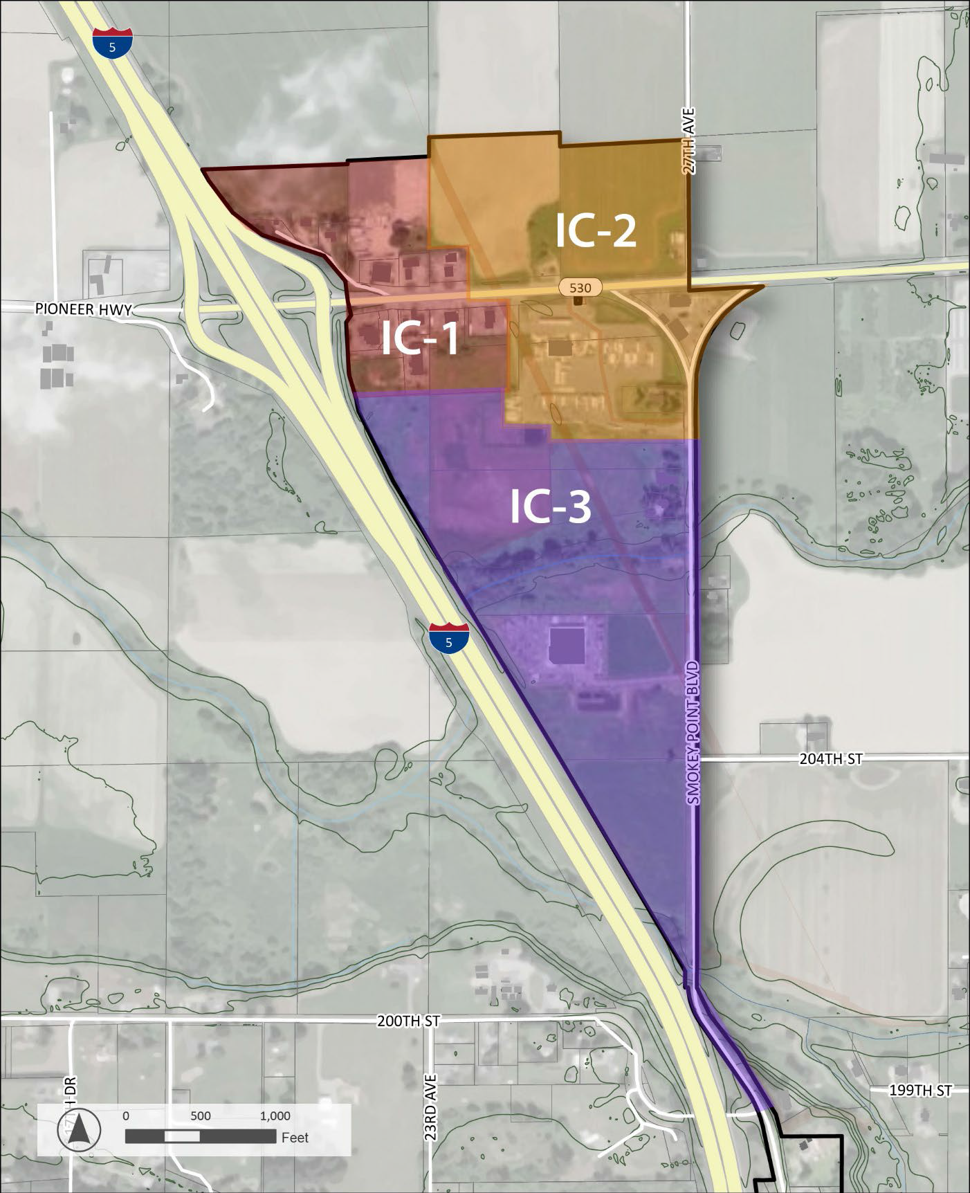
(Ord. No. 2025-019, § 1(Exh. A), 10-20-2025)
20.119.040 - Permissible uses.
(a)
The purpose of this section is to establish the uses generally permitted in each zone which are compatible with the purpose and other uses allowed within the zone. All project and/or developments are required to meet all provisions listed in AMC 20.40.020—100.
(b)
Island Crossing Table of Permissible Uses.
Footnotes of Island Crossing Table of Permissible Uses:
1 Subject to Section 20.38.080—Performance Standards and Miscellaneous Restrictions.
2 Subject to Section 20.38.070—Restrictions on Certain Use Classifications on Arlington Airport Property.
3 Subject to Chapter 20.44 Part II—Land Clearing, Grading, Filling and Excavation and Chapter 20.80 Forest Land Conversion.
4 Subject to Chapter 20.114—Alternative Energy Systems and Technologies.
5 Subject to Chapter 5.44—Parades, Athletic Events and other Special Events.
6 Only allowed within existing residential uses and subject to Section 20.44.082—Home Occupations.
7 Subject to Section 20.40.050—Accessory Uses.
8 Subject to Section 20.44.080—Administrative Conditional Use Permit for Mobile Sales and Delivery.
9 Subject to Section 20.44.034—Wireless Communications Facilities.
(Ord. No. 2025-019, § 1(Exh. A), 10-20-2025)
20.119.050 - Island Crossing density and dimensional standards.
(a)
The Island Crossing density and dimensional standards table addresses the form and intensity of development specific to individual zones. See Section 20.119.170(d) Figure 12 for lot diagram examples, illustrating setbacks requirements.
(b)
AMC Chapter 20.48 provides clarification and exceptions to the density and dimensional standards outlined in 20.119.050(g).
(c)
Building Setback Requirements. Locate development in IC-1 and IC-2, adjacent, as feasible, to the sidewalk(s). Development in IC-3 may be located in the best location on the site for the type of use proposed.
(d)
Building Height Limitation. Hotels or other similar overnight lodging within IC-2 zone shall be one hundred feet tall or less.
(e)
Island Crossing Density and Dimensional Standards Table.
Footnotes of Island Crossing Density and Dimensional Standards:
1 As used in this table, "right-of-way" means the street's ultimate right-of-way according to its classification, not existing, actual right-of-way.
2 A "0" in this column means that there is no minimum parcel size or width required. One can subdivide into as small of lots as one wants, as long as a permissible use can fit on the lot while meeting the rest of the requirements of this code (e.g., parking, landscaping, screening, setbacks, drainage, etc.).
3 Buildings may be set further from right-of-way if providing a pedestrian-oriented space between the sidewalk and the building front.
4 Exception: Buildings may locate further from an arterial when orienting to a non-arterial.
5 A "0" in this column means that there are no minimum or maximum setbacks from the right-of-way line.
6 Maximum height limit for hotels or similar overnight lodging is 100 feet.
(Ord. No. 2025-019, § 1(Exh. A), 10-20-2025)
20.119.060 - Street design standards.
New street regulations are established to enhance Island Crossing inter-site connectivity and support the development envisioned within the subarea. Required new street and through-block connections are to be built by developers as development occurs.
(1)
New streets are required:
(A)
To meet the public works design and construction standards.
(B)
To meet all sections of AMC 20.56, unless otherwise adjusted within these standards.
(2)
Authority to require dedication. If a right-of-way abutting the applicable site has inadequate width, the applicant will dedicate a portion of the subject property for the required right-of-way widening. In some instances, due to road alignment needs, more right-of way may be required from one side of a street than the other.
(3)
Provide inter-site connectivity per Figure 2 Street Network below. Specific alignments for new or extended street connections and through-block connections will be developed during the development review process for applicable sites
Note that Figure 2 Street is different than the Figure 8 Block Frontages Designation Map in AMC 20.119.120 Relationship to Street Front. The street type designations and standards regulate the design of the roadway, sidewalks, and planting strips within the right-of-way. Block-frontage designations and standards set forth in in AMC 20.119.120 regulate the development frontages, which includes the building and associated site development that occur within the property boundary.
Figure 2—Street Network.
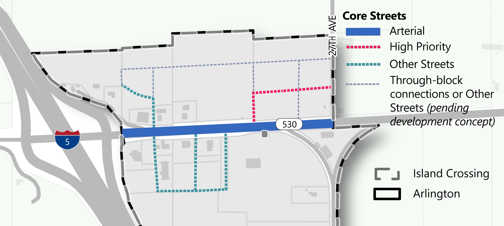
Note: The dashed lines indicate proposed street or connection conceptual locations. Applicants may propose alternate locations that meet the purpose of this section and intent of the Island Crossing subarea plan.
(4)
Maximum block length. New developments on large sites (over two acres) are to facilitate good pedestrian and vehicular circulation. Specifically, blocks are to be designed to provide publicly accessible pedestrian and/or vehicular connections at intervals no greater than indicated in AMC 20.119.060(e) by zone.
(A)
Vehicular connections shall be designed as shown in AMC 20.119.060(f).
(B)
Pedestrian or shared connections shall be designed to comply with one of the three types of through-block connections shown in AMC 20.119.060(g).
(5)
Maximum Block Face and Perimeter Length Table.
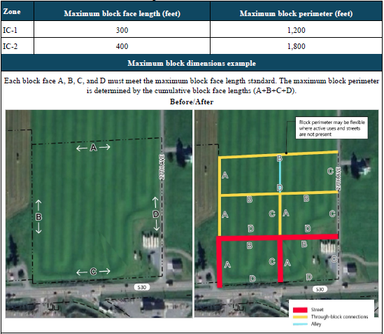
Adjustments to the dimensional standards in AMC 20.119.060(e) are allowed with director approval for up to twenty-five percent, or adjust the type and design of vehicular and/or pedestrian connection provided the design meets the subarea plan's goals and policies. For example, to compensate for larger block sizes, the quality of on-site pedestrian connections should exceed the minimum requirements.
The director may also approve a departure from the dimensional standards in AMC 20.119.060(e) where topography, right-of-way, uses that require large site/building footprints, existing construction or physical conditions, or other geographic conditions prevent compliance or impose an unusual hardship on the applicant, provided the proposed design maximizes pedestrian and vehicular connectivity on the site given the constraints.
(6)
Streetscape Classifications. Figure 2 Street Network above illustrates the configuration of three classifications for planned streets in the subarea. Subsections 1-3 below provide the regulation for each streetscape type.
Adjustments to the streetscape classifications regulation in Subsections 1-3 below and the street cross sections are allowed with director approval provided the design meets the subarea plan's goals and policies.
(A)
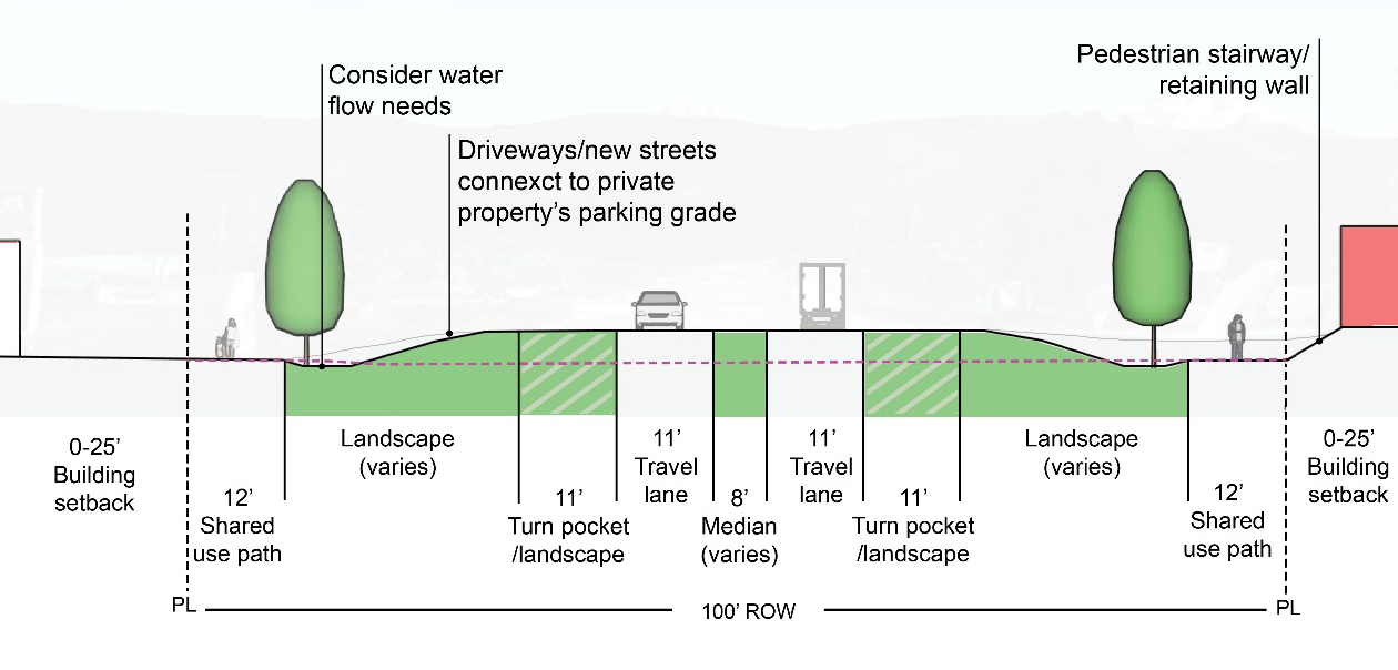
Arterial Streets. This includes SR 530, a high-traffic corridor that serves as a gateway to the subarea and into Arlington. As redevelopment occurs, it is expected to accommodate a growing number of pedestrians. Internal streets and driveways will be designed and constructed at grade with the elevated SR 530 to ensure vehicular and pedestrian accessibility. Figure 3 below illustrates the concept for SR 530 improvement. Design will be determined by public works in consultation with WSDOT to ensure compliance with applicable standards (e.g., flood and stormwater compliance). (Note, though Smokey Point Blvd is an arterial, its design is addressed through the Smokey Point Blvd improvement project outside of these design standards).
Figure 3—Cross-section options for SR 530.
(B)
High Priority Streets. High priority streets are intended to function as the subarea's primary commercial center street and are subject to AMC 20.119.150 Internal Roadways. Back-in angled parking, landscape strips, or sidewalk is acceptable in place of parallel parking, subject to approval. Figure 4 below illustrates optional streetscape cross sections.
Figure 4—Cross-section options for High Priority Streets.
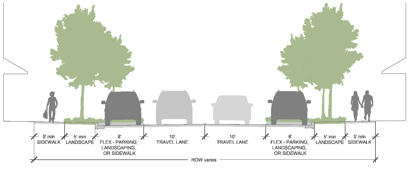
Require landscape strips to function as green stormwater infrastructure unless applicant shows stormwater is managed elsewhere more efficiently and with a cohesive site design. See AMC 20.119.120 Relationship to street front, (1) pedestrian-oriented paths for areas where wider sidewalks/landscape are required.
(C)
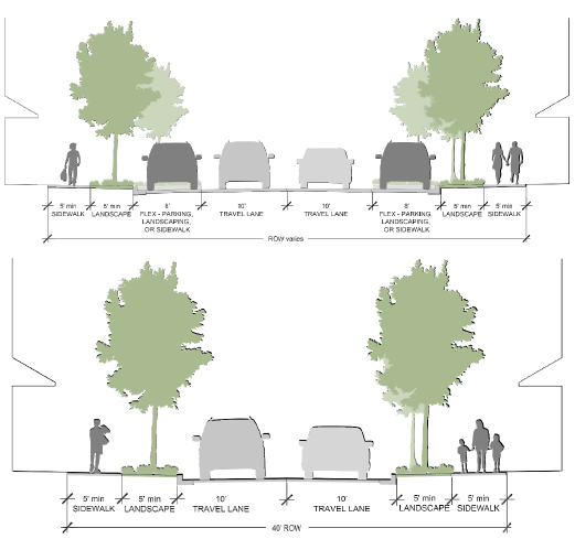
Other Streets. These streets are designed to be pedestrian-friendly corridors that support commercial and retail uses and are regulated under AMC 20.119.150 Internal roadways. Figure 5 illustrates a standard cross-section option for other streets.
Figure 5—Cross-section options for other streets.
(7)
Through-block connection types. Figure 2 street network above illustrates several "through-block connections" intended to improve pedestrian circulation, provide optional vehicular access to on-site parking, enhance site design, and break up building mass along long blocks. Specific alignments for the through-block connections will be developed during the development review process for applicable sites. These connections may take any of the forms described in the subsections below. A mix of connection types may be used for each location.
(A)
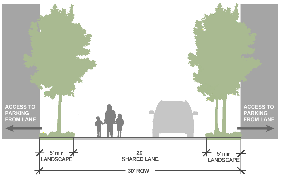
Woonerf. Woonerf is a shared lane, creating a low-speed, pedestrian-focused environment.
(i)
Thirty-foot minimum public access easement.
(ii)
Twenty-foot wide two-way travel lane featuring asphalt, concrete, unit paving, or other similar decorative and durable surface material.
(iii)
Ten-foot minimum landscape areas.
Figure 6—Cross-section of a minimum regulations for a woonerf design through-block connection.
(B)
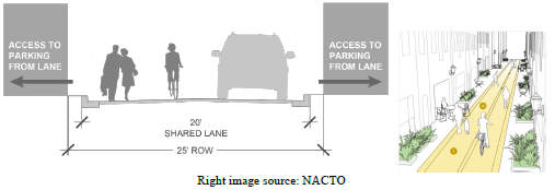
Alley. The traditional alley design option is permitted on blocks featuring storefronts.
(i)
Twenty-five-foot minimum public access easement.
(ii)
Twenty-foot wide two-way travel lane featuring asphalt, concrete, unit paving, or other similar decorative and durable surface material.
(iii)
A total of five-foot buffer should be provided for separation and clearance.
(iv)
Alleys may be closed to traffic during non-delivery hours to allow for outdoor seating or other flexible uses. Use bollards or street furniture to define shared space and minimize conflicts between users.
Figure 7—Cross-section of minimum regulations for alley design through-block connection.
(8)
Pathways. Pedestrian-only access connecting entries and public streets or parks. These pathways typically include trail or wide sidewalks with landscaping and other pedestrian-friendly features such as lighting and seating. Pathways can overlap with AMC 20.119.120(b)(1) Pedestrian-oriented paths and AMC 20.119.190 Pedestrian-oriented open spaces.
(A)
Include planting strips to improve the pedestrian environment. These may consist of continuous landscaped areas or tree pits integrated into the pavement, designed to accommodate both vegetation and pedestrian flow.
(Ord. No. 2025-019, § 1(Exh. A), 10-20-2025)
20.119.070 - Parking standards.
Applicants must comply with AMC 20.72 Parking, except minimum parking space shall contain a rectangular area at least eighteen feet long and eight feet wide (modification to 20.72.030—Parking space dimensions). Also see AMC 20.119.170 Parking layout and design.
(Ord. No. 2025-019, § 1(Exh. A), 10-20-2025)
20.119.080 - Landscaping standards.
Applicants must comply with AMC 20.76 Screening and Trees. Street trees along SR 530 are to be planted closer to the sidewalk to preserve views of the Cascade Mountain Range and provide shade for pedestrians.
(Ord. No. 2025-019, § 1(Exh. A), 10-20-2025)
20.119.090 - Flooding and compensatory storage.
Applicants must comply with AMC 20.64 Floodplain Development Regulations. Once a regional facility and fee structure are adopted, individual properties may apply to participate in the regional system and be relieved of on-site storage requirements, subject to city approval and fee payment.
(Ord. No. 2025-019, § 1(Exh. A), 10-20-2025)
20.119.100 - Interpretation.
(a)
Purpose statements are overarching objectives. For example, one of the purpose statements for the sub-section on building orientations is "to create pedestrian-friendly frontages that support a safe and active streetscape."
(b)
Standards use words such as "must," "shall," "is/are required," or "is/are prohibited" and signify required actions. Provisions that use words such as "should" or "is/are recommended" to signify voluntary measures
(c)
Departures may be allowed for specific standards. They allow alternative designs provided the director or city planner determines the resulting design and overall development meets the "purpose" of the standards and other applicable criteria. Departure opportunities are signaled by the capitalized word DEPARTURE.
(Ord. No. 2025-019, § 1(Exh. A), 10-20-2025)
20.119.110 - Island Crossing theme: Farm and agrarian design set in Stillaguamish Valley.
The Stillaguamish and Tulalip Tribes have called the Stillaguamish Valley home for millennia. More recently, pioneers began farming in the area in the late 19 th century, shaping a strong agricultural identity that remains central to the area today. Farms and agricultural operations remain the primary land use in the Stillaguamish Valley region surrounding Island Crossing.
The Island Crossing design standards supplement the city of Arlington's citywide development design standards. These guidelines establish a design framework that reflects the area's agricultural heritage, leverages transportation improvements, creates more pedestrian-oriented spaces, and encourages people-friendly, human-scaled, and high-quality development.
(1)
Purpose.
(A)
To reinforce and honor the Island Crossing agricultural heritage.
(B)
To enhance Island Crossing's role as a welcoming gateway.
(2)
Developers are encouraged to draw inspiration from the Stillaguamish Valley's agricultural history and rural context when designing buildings, public spaces, and streetscapes. The following elements help maintain Island Crossing's distinct identity:
(A)
Farm and Agrarian Theme: Designs must honor the region's setting in the Stillaguamish Valley by incorporating elements inspired by farm structures and landscapes. See AMC 20.119.200 Architectural style and Character for requirements.
(B)
Celebration and Preservation of Views: Island Crossing offers expansive views of farmland and the Cascade Mountains, which are integral to the visual identity of the area. Development is encouraged to frame, preserve, and enhance these views.
(i)
Vantage points: Orient buildings and public spaces to take advantage of views from key sightlines. Consider views from a driver/passenger viewpoint in the street and a pedestrian on a sidewalk or path. Locate and design features such as open space, plazas, and transparent facades that open up sightlines toward the mountains and valley. Key view may be:
a.
Views on SR 530 looking eastward close to I-5.
b.
New views in larger developments looking northwards towards the agricultural fields.
c.
Eastwards and northeastward views on the eastern half of the subarea to agricultural lands and mountains.
(ii)
Trees and landscape species selection: Select species for height and canopy shape to preserve, enhance, and frame key views.
(3)
Trees and landscaping: Use trees and vegetation to soften the visual appearance of paving and building edges and walls, enhance public spaces, frame key views, provide shade, and manage stormwater. (See AMC 20.119.170 Parking layout and design, 20.119.080 Landscaping standards, and 20.119.060 Street design standards).
(Ord. No. 2025-019, § 1(Exh. A), 10-20-2025)
Site Planning
The following standards supplement the citywide development design 2.2 Screening blank walls and retaining walls, 5.2 Orienting the building to the street, 10.1 Articulation and modulation, 10.2 Architectural scale, 11.3 Entries, and 14.1 Site and building design.
20.119.120 - Relationship to street front.
(a)
Purpose.
(1)
To create an active and safe pedestrian environment by encouraging development to orient towards the street.
(2)
To ensure new development integrates pedestrian friendly frontages and public spaces that promote street-level activity and walkability
(b)
Figure 8 Block frontage type designates select frontage segments as pedestrian-oriented paths (orange) and signature roads (blue) to guide site design and building orientation. These designations enhance the property's visibility, attractiveness, and interaction with its adjoining streetscape and building, creating an active pedestrian environment in key designated areas.
Note the difference between the block frontage type map and proposed street network map. Figure 8 Block frontage type shows block frontage designations and regulations apply to development frontages, which includes the building and associated site development that occurs within the property line. Figure 2 Street network sets standards for streetscape designations and regulations, regulating the design of sidewalks and planting strips within the public right-of-way.
(1)
Pedestrian-Oriented Paths. Select frontages are designated as pedestrian-oriented paths to promote human-scale development with active ground-floor uses such as storefronts or cafes that contribute to a vibrant public realm. These frontages are intended to create the feel of an "outdoor room" that encourages gathering, supports agritourism, and enhances commercial activity.
On lots larger than one acre prior to any subdivision, new development must designate at least four hundred lineal feet of block frontages as pedestrian-oriented paths, with flexibility to designate along SR 530, an internal street, the proposed park, and/or a pedestrian-oriented open space (see 20.119.190 Pedestrian-oriented open spaces). If the site is adjacent to the proposed park, at least fifteen lineal feet of the pedestrian-oriented paths must be located within sixty-eight feet of the park boundary. Cluster pedestrian-oriented path designations together for greater activation and walkability between businesses and public spaces.
On properties less than one acre, new development must integrate no less than seventy-five percent of the length of the applicable pedestrian-oriented paths illustrated in Figure 8. The alignment of pedestrian-oriented paths may be adjusted during the development review process provided the configuration meets the goals and policies of the Island Crossing subarea plan. For example, if a site includes approximately one hundred-lineal feet of a pedestrian-oriented path-designated block-frontage, the new development must integrate at least seventy-five-lineal feet of pedestrian-oriented paths block-frontage compliant development.
Figure 8 illustrates an example of pedestrian-oriented paths designations at key streets to encourage active uses, create a synergy of activity particularly at and near the proposed park, and double-sided retail (i.e., businesses on both sides of a street, open space, or path) for greater concentration of people activity and sense of enclosure. The alignment of pedestrian-oriented paths may be adjusted during the development review process provided the configuration meets the goals and policies of the Island Crossing subarea plan.
Developments may exceed the amount of pedestrian-oriented paths block-frontages illustrated in Figure 8.
Properties fronting pedestrian-oriented paths are subject to the following specific provisions:
(A)
Building Design.
(B)
20.119.130 Building orientation.
(C)
20.119.140 Blank walls.
(D)
20.119.170 Parking layout and design.
(E)
20.119.190 Pedestrian-oriented open spaces.
(F)
Sidewalk must include a minimum six feet frontage zone (i.e., widened sidewalk for cafe seating or flexible use to accommodate social gathering and greater volumes of pedestrian traffic), six feet pedestrian clear zone (i.e., no signs, street furniture, or mobile device parking to allow for multiple people to pass each other, including people in wheelchairs), and six feet landscape/furniture zone.
(2)
Signature Roads. This designation encourages attractive development edges abutting SR 530, leveraging Island Crossing's setting and transportation access for economic prosperity and reinforcing a lively gateway to Arlington and the Stillaguamish Valley. Development along signature roads can help create welcoming focal points that draw foot traffic and activate the streetscape. Properties fronting signature roads must adhere to:
(A)
Building Design.
(B)
20.119.140 Blank walls.
(C)
20.119.160 Vehicular entrances and driveways.
(D)
20.119.170 Parking layout and design.
(E)
20.119.190 Pedestrian-oriented open spaces.
(F)
Farm Stands. Applicants are encouraged to demonstrate how temporary farm stands could be safely accommodated along SR 530 and relate to permanent buildings on private property.
Figure 8—Block Frontage Type.
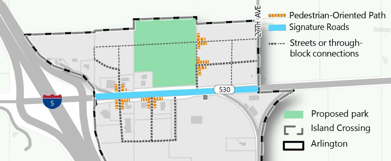
Note: The dashed lines indicate proposed streets or connections. Locations are conceptual and applicants may propose alternate locations that meet the purpose of this section and intent of the Island Crossing subarea plan.
(Ord. No. 2025-019, § 1(Exh. A), 10-20-2025)
20.119.130 - Building orientation.
(a)
Purpose.
(1)
To create pedestrian-friendly frontages that support a safe and active streetscape.
(2)
To enhance Island Crossing's visual identity and perceived scale of buildings through thoughtful design.
(b)
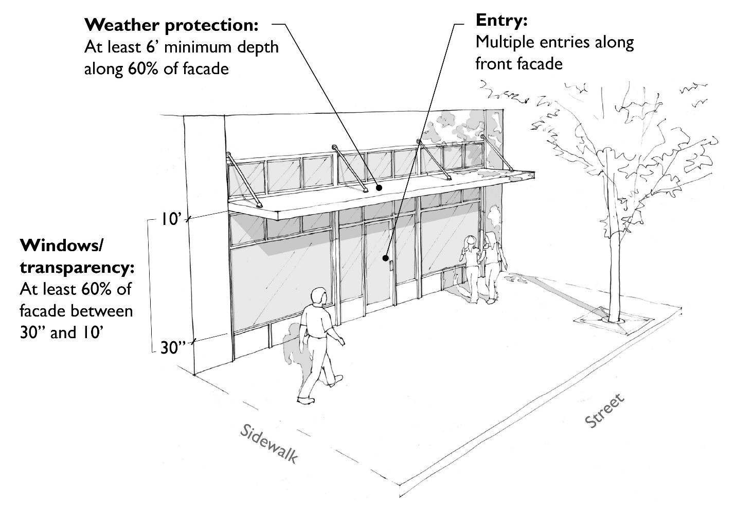
All new buildings on "pedestrian-oriented paths" must feature pedestrian-friendly façades (see Figure 9), including the following elements:
(1)
Weather protection at least six feet deep on average along at least sixty percent of the façades.
(2)
Building façades and primary entries shall be oriented toward the high priority street bordering the lot. For corner buildings, primary entrances for ground-level uses may face either street or street corner.
(3)
Transparent window area along at least sixty percent of the ground floor façade between thirty inches and ten feet above the sidewalk level.
DEPARTURE: Instead of windows, agritourism and light industrial uses may provide garage doors, open air stalls, or other feature(s) that allow for safe visual and/or auditory experience of interior operations (provided the use meets noise requirements in AMC 20.44.210).
Figure 9—Pedestrian-Oriented Façade Requirements.
(c)
Building Modulations. All buildings located on "pedestrian-oriented paths" or "signature roads" with facades longer than one hundred feet measured horizontally along the street front must include at least three of the following features to break up the massing of the building and add visual interest at intervals of no more than forty feet:
(1)
Providing building modulation of at least twelve inches in depth if tied to a change in roofline or a chance in building material, siding style, and/or color.
(2)
Repeating distinctive window patterns at intervals less than the articulation interval.
(3)
Providing a covered entry or separate weather protection feature for each articulation interval.
(4)
Change of roofline, including a change in the height of a cornice by at least two feet or integration of a pitched roof form that is at least twenty feet wide with a minimum slope of 5:12.
(5)
Changing materials or siding style.
(6)
Providing lighting fixtures, trellis, tree, or other landscape feature within each interval.
(7)
Alternative methods that meet the purpose of the standards.
(Ord. No. 2025-019, § 1(Exh. A), 10-20-2025)
20.119.140 - Blank walls.
(a)
Purpose
(1)
To reduce the impacts of blank walls located adjacent to the street or public space.
(2)
To support a more inviting pedestrian environment and contributes to a vibrant public realm.
(b)
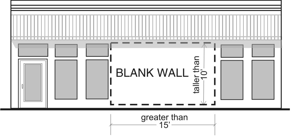
"Blank wall" means a ground floor wall or portion of a ground floor wall over ten feet in height and a horizontal length greater than fifteen feet and does not include a transparent window or door.
Figure 10—Blank Wall Requirements.
(c)
Untreated blank walls adjacent to a public street, new internal street (public or private), publicly accessible outdoor space, common outdoor space, or pedestrian pathway are prohibited. Methods to treat blank walls can include:
(1)
Display windows at least sixteen inches of depth to allow for changeable displays. Tack-on display cases (see Figure 11 below) do not qualify as a blank wall treatment.
(2)
Landscape planting bed at least five feet deep or a raised planter bed at least two feet high and three feet deep in front of the wall with planting materials that are sufficient to obscure or screen at least sixty percent of the wall's surface within three years.
(3)
Installing a vertical trellis in front of the wall with climbing vines or plant materials.
(4)
Installing a mural as approved by the director. Commercial advertisements are not permitted on such murals.
(5)
Special building detailing that adds visual interest at a pedestrian scale. Such detailing must use a variety of surfaces; monotonous designs will not meet the purpose of the regulations.
For large visible blank walls, a variety of treatments shall be required to meet the purpose of the regulations.
Figure 11—Blank Wall Treatment Examples.
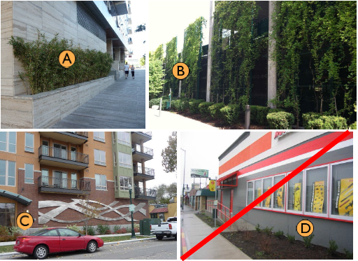
Buildings A-C feature acceptable treatments including a combination of high quality materials and landscaping (A), landscaping and trellis (B), decorative lighting/sculptural element (C), and decorative artwork. The display cases in Building D don't meet the sixteen inches depth requirement, nor do they meet the purpose of the regulations.
(Ord. No. 2025-019, § 1(Exh. A), 10-20-2025)
Vehicular Access and Parking
The following standards supplement the citywide development design standards 2.4 Screening parking lots, 2.6 Parking garage and driveways, 3.2 Parking lots, and 7.2 Siting parking areas.
20.119.150 - Internal roadways.
(a)
Purpose: To support a connected, convenient street and path network that enhances access, reduces traffic conflicts, and encourages walkable developments.
(b)
All newly created, widened, or improved streets must be constructed in accordance with the street standards set forth in AMC 20.119.060 Street design standards.
(c)
If on-street parking is provided and stormwater is treated elsewhere, then the planting strip may be in the form of tree pits within the pavement and accommodate adequate root barrier based on the City of Arlington Tree List.
(d)
Sidewalks must meet requirements in AMC 20.119.060 Street design standards and AMC 20.119.120 (b)(1) Pedestrian-oriented paths to accommodate expected pedestrian volumes.
(e)
Include traffic calming measures such as small traffic circles, raised crosswalks and curb extensions (sidewalk bulbs), chicanes, curves, or shared people/vehicular/bicycle streets (i.e., woonerfs) at least every three hundred feet to reduce vehicle speed and increase safety.
(f)
Provide the opportunities for future connections to adjacent parcels by providing road stub-outs, easements, or other methods to ensure convenient vehicular network.
(g)
The director may require modification of proposed vehicle access points and internal circulation to minimize traffic conflicts.
(Ord. No. 2025-019, § 1(Exh. A), 10-20-2025)
20.119.160 - Vehicular entrances and driveways.
(a)
Purpose. To minimize negative impacts of vehicular access on the streetscape and pedestrian environment.
(b)
Properties adjacent to signature roads are encouraged, where feasible, to locate driveways where they can be shared with adjacent properties in accordance with SR 530 improvements and/or internal streets.
(Ord. No. 2025-019, § 1(Exh. A), 10-20-2025)
20.119.170 - Parking layout and design.
(a)
Purpose.
(1)
To minimize negative impacts of parking lots on the streetscape and pedestrian environment.
(2)
To promote shared parking between compatible uses.
(b)
Development must comply with parking and general design requirements set forth in AMC Chapter 20.72 Parking.
(c)
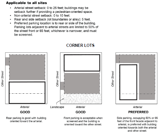
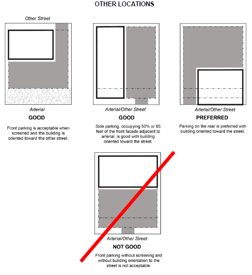
Where unavoidable, any parking lots located adjacent to a street is limited to fifty percent of the street front or sixty-five feet, whichever is narrower, except when necessary to allow the building to orient toward a pedestrian-oriented path or high priority street or path.
(d)
On signature roads (SR 530), surface parking areas shall be screened from street level views per citywide design standards 2.4 Screening parking lots.
(e)
Provide landscaping within parking lots per citywide design standards 3.2 Parking lots.
(f)
Provide pedestrian pathways through parking lots connecting businesses on the same development site per AMC 20.119.180 Internal pedestrian network.
(g)
Bicycle Parking. The minimum number of short-term and long-term bicycle parking spaces required is outlined in Subsection 20.119.170 (g)(6). When bicycle parking ratios are expressed as a number of spaces per square feet, they shall be calculated using net floor area. The resulting number of required off-street bicycle parking spaces must be rounded to the nearest whole number. If the calculation results in less than one space, at least one bicycle parking space is required.
DEPARTURE: The director may reduce bicycle parking facilities required in 20.119.170 (g)(6) when it is demonstrated that bicycle activity will not occur at that location.
(1)
Short-term bicycle parking spaces consist of outdoor bike racks. Designs should allow either a bicycle frame or wheels to be locked to a structure attached to the pavement or building. Short term bicycle parking spaces may be located in the following areas:
(A)
Indoors or outdoors on the development site.
(B)
On a public sidewalk or street outside the development, within one hundred feet of the building entrance.
(2)
Short-term bicycle spaces on a public sidewalk or street serving multiple businesses or properties may be consolidated on a public sidewalk or street, where practical.
(3)
Long-term bicycle parking spaces include the following types:
(A)
Racks in an indoor, lockable bike room.
(B)
Racks in a covered, lockable bike enclosure.
(C)
Bike lockers.
(4)
Indoor long-term bicycle storage must be located on the ground-floor or on a floor with elevator access.
(5)
All bicycle parking and storage shall be located in safe, visible areas that do not impede pedestrian or vehicle traffic flow, and shall be well lit for nighttime use.
(6)
Bicycle Parking Spaces Required.
(h)
For development facing a pedestrian-oriented path, parking must be located to the side or rear of buildings. Along other streets, parking location is more flexible, provided it complies with the requirements of this section. Figure 12 Lot Layout and Acceptable Parking Locations Examples illustrates required setbacks (see AMC 20.119.050(e)) and acceptable parking locations.
Figure 12—Lot Layout and Acceptable Parking Locations Examples.
(i)
Site Located on Intersections. Avoid locating parking lots adjacent to intersections except when necessary to allow the building to orient toward a pedestrian-oriented path or higher priority street or path. Install substantial landscaping (at least four hundred square feet of area adjacent to the street corner) utilizing a combination of decorative ground cover, shrubs, and/or trees. Install a trellis or other similar architectural element that incorporates landscaping or public art. Designs that reference the agrarian, river, Stillaguamish Tribe, or other Stillaguamish Valley context or history are encouraged.
(j)
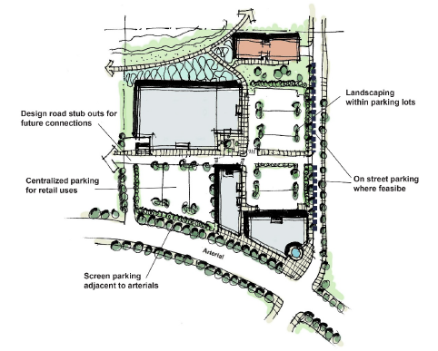
All Sites, Where Applicable. Applicants of multiple building commercial developments shall demonstrate how they've organized parking in a manner that provides for shared parking between uses on the site.
Figure 13—Illustrating Desirable Vehicular Access and Parking Lot Configuration for a Large Retail Site Development.
(Ord. No. 2025-019, § 1(Exh. A), 10-20-2025)
Pedestrian Access, Amenities, and Open Space
20.119.180 - Internal pedestrian network.
(a)
Purpose.
(1)
To improve pedestrian environment by making it easier and comfortable to walk throughout Island Crossing.
(2)
To promote connectivity between uses and properties where desirable.
(3)
To enhance quality of new developments.
(b)
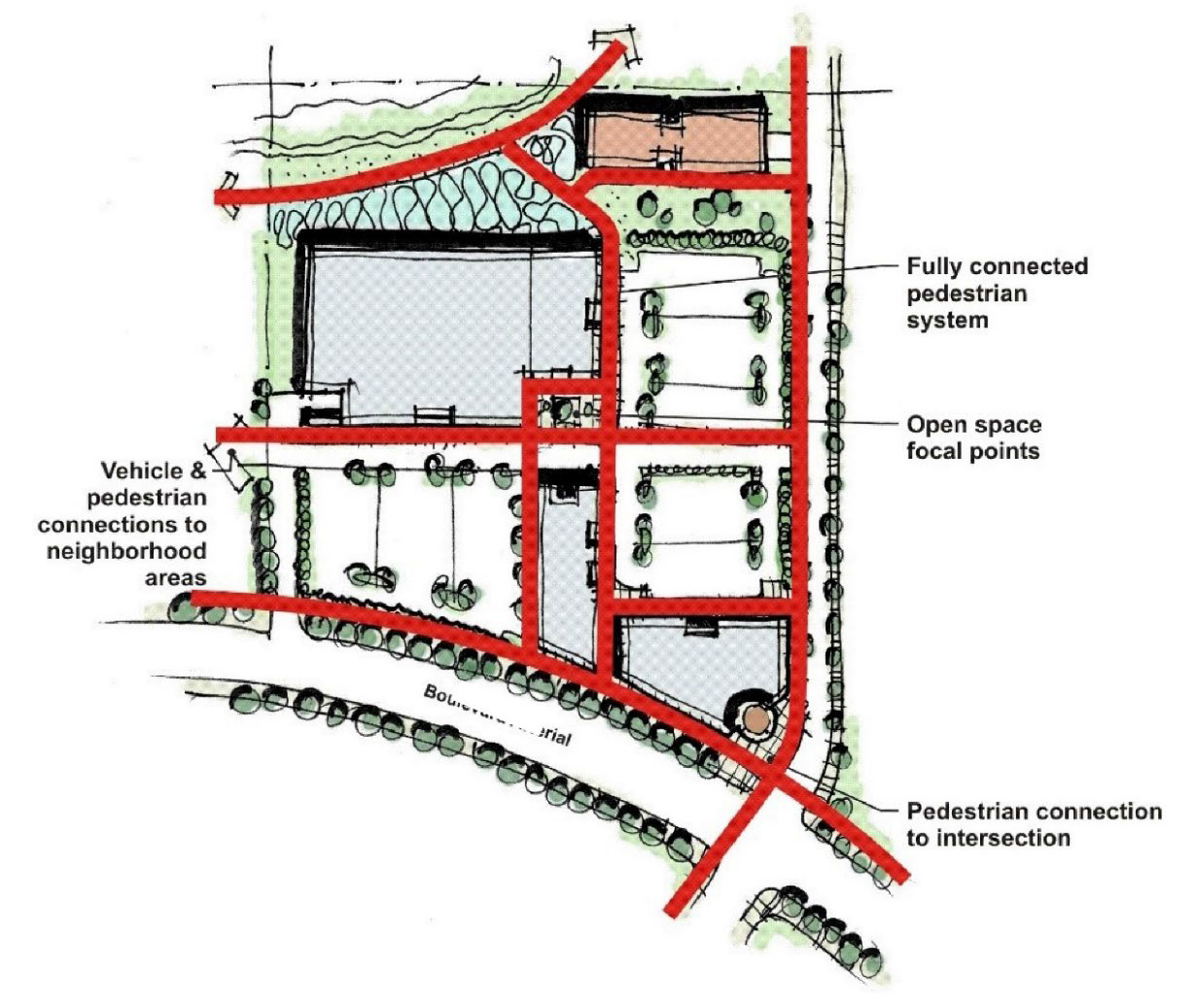
Developments should include an integrated pedestrian circulation system that connects buildings, open spaces, and parking areas with the adjacent street sidewalk network.
(c)
Sites with Multiple Buildings. Provide pedestrian paths or walkways that connect all commercial building entries on the same development site. Routes shall minimize walking distances to the extent practical.
(d)
New developments must provide direct pedestrian access to adjacent properties unless the director determines it is undesirable or infeasible due to a safety (e.g., industrial operations) or physical (e.g., topography) constraint.
(e)
New developments shall provide for the opportunity for future pedestrian connections to adjacent properties through the use of pathway stub-outs, building configuration, and parking area layout. Remodels of existing facilities are encouraged to provide these opportunities, where feasible.
(f)
Pedestrian Pathways Through Parking Lots. Include a five-foot paved walkway or sidewalk to provide safe pedestrian access through parking lots greater than one hundred fifty feet long (measured either parallel or perpendicular to the street front). Install pathways for every three parking aisles or at least every two hundred feet (whichever is more restrictive). Use contrasting paving materials to visually and physically separate pedestrian routes from parking spaces and vehicle travel lanes.
(1)
All sites, where applicable: Crosswalks are required when a walkway crosses a paved area accessible to vehicles.
(2)
All sites, where applicable: Applicants shall continue the sidewalk pattern and material across driveways.
Figure 14—Example Site Plan with Internal and External Pedestrian Connections.
(Ord. No. 2025-019, § 1(Exh. A), 10-20-2025)
20.119.190 - Pedestrian-oriented open spaces.
(a)
Purpose.
(1)
To provide a variety of pedestrian-oriented areas to attract shoppers to commercial areas and enrich the pedestrian environment.
(2)
To create gathering space for the community
(3)
To create inviting space that encourage pedestrian activity.
(b)
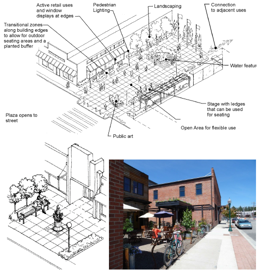
New development on "signature roads" and "pedestrian-oriented paths" with a total site area greater than one acre must provide "pedestrian-oriented open space" equal to at least one percent of the ground floor building footprint plus one percent of the site area. The open space may be in the form of plaza, outdoor eating, display, play area or other open space feature that serves both as a visual amenity and a place for human activity. Portions of sidewalks that are wider than required under 20.20.119.060 Street design standards may be counted toward this requirement. In addition, if the development relates to and activates an adjacent public park, the area of activation counts toward this open space requirement.
(c)
Definition and requirements of pedestrian-oriented open spaces.
(1)
To qualify as a pedestrian-oriented space, an area is required to include the following:
(A)
Pedestrian access (including ADA compliant access) to the abutting structures from the street, private drive, or a non-vehicular courtyard.
(B)
Pedestrian-scaled lighting (no more than fourteen feet in height) at a level averaging at least two foot candles throughout the space. Lighting may be on-site or building-mounted lighting.
(C)
At least three feet of seating area (bench, ledge, etc.) or one individual seat per sixty square feet of plaza area or open space.
(D)
Position such spaces in areas with significant pedestrian traffic to provide interest and security - such as adjacent to a building entry.
(E)
Landscaping components that add seasonal interest to the space, such as planting beds and potted plants.
(2)
Three or more of the following elements are required in a pedestrian-oriented open space:
(A)
Pedestrian amenities such as a water feature, drinking fountain, and/or distinctive paving or artwork.
(B)
Decorative elements such as windmills, weather vanes, water towers, or other similar details associated with historic regional agricultural structures.
(C)
Provide pedestrian-oriented building facades on some or all buildings facing the space.
(D)
Consideration of views, sun angle at noon, and wind patterns in the design of the space.
(E)
Transitional zones along building edges to allow for outdoor eating areas and a planted buffer.
(F)
Movable seating.
(3)
The following features are prohibited within pedestrian-oriented open space:
(A)
Asphalt or gravel pavement.
(B)
Adjacent unscreened parking lots.
(C)
Adjacent chain link fences.
(D)
Adjacent blank walls.
(E)
Adjacent dumpsters or service areas.
(d)
Building corners present valuable opportunities for pedestrian-oriented open spaces due to their high visibility and accessibility from multiple streets. These locations naturally draw foot traffic, making them ideal for active public areas such as plazas, seating nodes, or landscaped gathering spaces. Refer to AMC 20.119.210 Building corners for specific architectural corner treatments.
(e)
Allow for small temporary structures, stands, and food trucks, especially on corners, for small businesses such as flower shops and produce stands to create a more active street.
Figure 15—Example of Pedestrian-Oriented Space.
(Ord. No. 2025-019, § 1(Exh. A), 10-20-2025)
Building Design
The following standards supplement the citywide development design 5.1 Creating streetscape compatibility, 5.2 Orienting the building to the street, 11.1 Human scale, 11.3 Entries, 12.1 Appropriate materials, and 14.1 Site and building design.
20.119.200 - Architectural style and character.
(a)
Purpose.
(1)
To promote the integration of design forms, themes, and/or details associated with historic regional agricultural heritage.
(2)
To reinforce Island Crossing gateway character through visually distinctive design.
(b)
Integrate regional farm and agrarian-inspired design themes and/or elements into the facades of all new buildings and major remodels facing "signature roads" and "pedestrian-oriented paths". At least three of the following elements must be incorporated in the design:
(1)
Barn-like roof form including gambrel or simple gable roof featuring overhanging eaves (minimum of twenty-four inches for non-residential buildings), decorative braces, and brackets.
(2)
Horizontal siding, board and batten, metal siding (excluding flat metal panels), brick, masonry, wood, or combination. This includes exposed wood structure components.
(3)
Symmetrical window fenestration pattern with vertical (min 2:1) or square window shape.
(4)
Other enhancements (each item integrated counts as one "element"): Decorative shutters, proportional dormers, exposed rafter tails, geometric patterns, windmills, cupola, weather vanes, water towers, or other similar details associated with historic regional agricultural structures.
DEPARTURE. The integration of only two elements will be considered provided the design composition meets the purpose of the standards and is approved by director.
(c)
Commercial developments with multiple buildings must employ a variety of colors, building materials, and architectural treatments to reduce monotony and reinforce the city's sense of scale and independent rural character.
Figure 16—Examples of Building Form and Materials That Reference Regional Agricultural Structures.
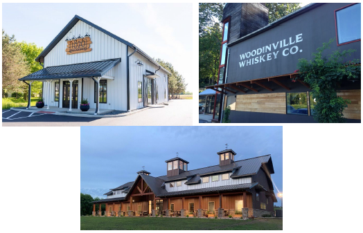
Upper left (Hickory Circle)= Gabled roof, metal siding, shed awning, gooseneck lamps, neutral color scheme with contrasting trim, reflects historic agricultural style. Upper right (Woodinville Whiskey Co.) = Bright contrasting trim, varying materials, creative use of windows, awning. Bottom (Art in Motion, MN) = Cupolas, metal siding, varying roofline, strong reference to historic agricultural style.
(Ord. No. 2025-019, § 1(Exh. A), 10-20-2025)
20.119.210 - Building corners.
Building corners, located at street intersections particularly along signature road, are highly visible and naturally attract foot traffic. Thoughtful design of building corners can create public focal points for gathering on non-arterials and temporary or seasonal commercial activities such as food stands and produce stands (primarily along SR 530) that enhance the Island Crossing farm and agrarian theme. Pairing these locations with AMC 20.119.190 Pedestrian-oriented open spaces standards enhances their role as active, welcoming spaces that contribute to a vibrant public realm.
(1)
Purpose.
(A)
To enhance the pedestrian environment.
(B)
To encourage creativity in the design of building facades to add visual interest.
(2)
All new buildings located at intersections in "signature roads" and "pedestrian-oriented paths" shall employ three or more of the following design elements or treatments to architecturally accentuate building corners facing the intersection:
(A)
A corner entrance to courtyard, building lobby, atrium, or pedestrian pathway.
(B)
A significant corner bay window or turret.
(C)
Roof deck or balconies on upper stories.
(D)
Building core setback "notch" or curved facade surfaces.
(E)
Sculpture or artwork, either bas-relief, figurative, or distinctive use of materials as part of the building.
(F)
Change of materials.
(G)
Corner windows.
(H)
Special lighting.
(I)
Significant feature such as a windmill and water towers.
(J)
Special treatment of the pedestrian weather protection canopy at the corner of the building.
(K)
Other similar treatment or element approved by the director.
Figure 17—Example of Building Corner Treatment.
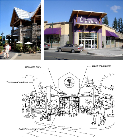
Top Left (St. Honore Bakery, Lake Oswego, OR) = Timber framed gable, upper deck balconies, and stone materials, reflect agricultural style. Top Right (University Book Store, Mill Creek, WA) = Bright contrasting trim, varying materials, and wooden awning showcase a modern interpretation of agricultural style. Bottom = Building corner with highlighted entries and pedestrian-oriented space.
(Ord. No. 2025-019, § 1(Exh. A), 10-20-2025)
20.119.220 - Building material.
(a)
Purpose
(1)
To encourage high quality building materials that enhance the character and identity of Island Crossing
(2)
To discourage materials and design treatments that create a false sense of historicism in new development.
(b)
Applicants should use high quality durable materials. This is most important for the base of buildings, particularly for commercial buildings where the façade is sited close to sidewalks. Stone, brick, or tile masonry, architectural concrete, or other similar highly durable materials are expected to be used for at least the bottom two feet of the first-floor façade (excluding window and door areas).
(c)
All buildings. Treatment of building materials that creates a false sense of historicism in new buildings is strongly discouraged. For example, buildings following the farm and agrarian architectural theme (see AMC 20.119.200 Architectural style and character) may be inspired by farm architecture, but should not design a barn replica used for a non-agricultural purpose.
(Ord. No. 2025-019, § 1(Exh. A), 10-20-2025)

