| A | |
| Abutting |
The condition of two (2) parcels of land having a common property line or boundary,
including cases where two (2) or more parcels of land adjoin at a corner, but not
including cases where parcels of land are separated by a street or alley.
|
| Access |
The right or ability of pedestrians and vehicles to enter and leave a lot or development.
|
| Access Easement |
An easement which grants the right to cross land.
|
| Accessory Building |
A detached building, the use of which is incidental to that of the principal building
and which is located on the same lot as the principal building.
|
| Accessory Dwelling Unit |
A secondary dwelling unit established in conjunction with and clearly subordinate
to a principal dwelling unit, whether part of the same structure as the principal
dwelling unit, or as a detached structure on the same lot.
|
| Accessory Structure |
A detached subordinate or incidental structure, the use of which is incidental to
the principal structure and which is located on the same lot as the principal structure.
|
|
As used in the flood damage prevention standards, a structure located on the same
parcel of property as the principal structure and the use of which is incidental to
the use of the principal structure. Garages, carports and storage sheds are common
urban accessory structures. Pole barns, hay sheds and the like qualify as accessory
structures on farms, and may or may not be located on the same parcel as the farm
dwelling or shop building.
|
| Accessory Use |
A use that is incidental, appropriate, and subordinate to the principal use of land
or buildings and located on the same lot.
|
| Active Recreation Area |
Uses or structures intended for specific active recreational uses such as athletic
fields, playgrounds, swimming pools, courts, tracks walking trails, paths, porches,
and other similar uses typically located in open space areas or parks and served by
parking facilities, spectator areas, restroom facilities, and exterior lighting, where
appropriate.
|
| Ad Hominem |
A statement or argument that relies on personal attacks rather than reason or substance.
|
| Addition |
See "Expansion."
|
|
As used in the flood damage prevention standards, an extension or increase in the
floor area or height of a building or structure.
|
| Adjacent |
Having a common boundary.
|
| Administrative Decision |
Decisions made in the implementation, administration, or enforcement of development
regulations that involve the determination of facts and the application of objective
standards set forth in G.S. 160D or the UDO. These are sometimes referred to as ministerial
decisions or administrative determinations.
|
| Administrative Hearing |
A proceeding to gather facts needed to make an administrative decision.
|
| Adopted Policy Guidance |
The combined future land-use policy guidance provided by the adopted CAMA Land Use
Plan, area plans prepared for specific parts of the Town, and system plans related
to the Town's infrastructure systems.
|
| Affected Party |
Owners of land adjoining the land subject to an application and any other person who
could suffer an adverse effect to a property interest from a proposed development.
|
| Aggrieved Party |
A person, with a legally recognized interest (i.e., fee simple ownership) and standing
to appeal, that is injuriously affected by a decision from any decision-making body
of the Town, including any officer or agent of the Town.
|
| Alley |
A roadway set aside primarily for vehicular service access to the back or side of
lands otherwise abutting a street or open space.
|
| Alteration |
Any change or expansion in the size, configuration, or location of a structure; or
any change or expansion in the use of a structure or lot, from a previously approved
or legally existing size, configuration, location, or use.
|
| Amendment |
A minor change, addition, or deletion to a legal statutory document.
|
| Antenna |
Communications equipment that transmits, receives, or transmits and receives electromagnetic
radio signals used in the provision of all types of wireless communications services.
|
| Appeal |
A request for review of an administrative official's or decision-making body's interpretation
or decision made under this UDO.
|
| Applicant |
A person who has submitted a development application for review under applicable provisions
of this Ordinance.
|
| Application |
The completed form or forms and all accompanying documents, exhibits, and fees required
of an applicant by the appropriate Town department or board as part of the development
review processes.
|
| Area of Environmental Concern |
Areas of natural importance including estuarine and ocean areas, areas where public
water supplies originate, marshes, wetlands, and other natural and cultural resource
areas identified by the Coastal Resources Commission as areas that could be damaged
by uncontrolled development.
|
| Area of Shallow Flooding |
A designated AO or VO zone on the Town's Flood Insurance Rate Map (FIRM) with base
flood depths from one (1) to three (3) feet, where a clearly defined channel does
not exist, where the path of flooding is unpredictable and indeterminate, and where
velocity flow may be evident.
|
| Area of Special Flood Hazard |
The land in the floodplain within a community subject to a one (1) percent or greater
chance of being flooded in any given year.
|
| Articulation |
The presence or projections, recesses, or other architectural features along a building
façade.
|
| As-Built Plans |
A set of engineering or site drawings that delineate the specific permitted development
as actually constructed.
|
| Assessed Value |
The monetary price that a parcel of land, portion of land, improvement on land, or
other commodity assigned by property appraiser's office for the purposes of taxation.
|
| Authorized Agent |
A person with express written consent to act upon another's behalf.
|
| Awning |
A plastic, canvas, or metal porch or shade supported by a frame and often foldable
that is placed over a storefront, doorway, or window.
|
| B | |
| Base Flood |
The flood having a one (1) percent chance of being equaled or exceeded in any given
year.
|
| Base Flood Elevation |
A determination of the water surface elevations of the base flood as published in
the flood insurance study.
|
| Base Zoning District |
A zoning district designation applied to an individual lot.
|
| Basement |
The lowest level or story which has its flood subgrade on all sides.
|
| Bedroom |
A room designated as a sleeping or bedroom on the plans and permit application.
|
| Belfry |
An enclosed structure used for housing bells for ringing, typically as part of a religious
institution. A belfry can be attached to or separate from the main building.
|
| Berm |
An elongated earthen mound typically designed or constructed on a site to separate,
screen, or buffer adjacent uses or site features.
|
| Best Management Practice |
A structural or non-structural management-based practice used singularly or in combination
to reduce nonpoint source inputs to receiving waters in order to achieve water quality
protection goals.
|
| Bicycle Lane |
A travel way, paved or otherwise, devoted for use by bicycles.
|
| Billboard |
An off-premises sign owned by a person, corporation or other entity that engages in
the business of selling the advertising space on the sign.
|
| Bio-Retention Cell or Device |
A stormwater infiltration device consisting of an excavated basin that is refilled
with engineered soil and mulch that allows stormwater run-off to collect and percolate
through the engineered soil where it is treated prior to infiltrating into the surrounding
undisturbed soil. Also known as a rain garden or bio-cell.
|
| Block |
The land lying within an area bounded on all sides by streets.
|
| Board of Adjustment |
A decision-making body responsible for hearing quasi-judicial cases in Atlantic Beach,
NC.
|
| Boat Lift |
A mechanical device used to raise or lower boats to the surface of the water. A boat
lift may also be used for temporary storage of a boat.
|
| Boat Ramp |
See "Boat Slip."
|
| Boat Slip |
A sloping ramp extending out into the water to serve as a place of launching, landing,
or repairing a boat.
|
| Breakaway Wall |
A wall that is not part of the structural support of the building and is intended
through its design and construction to collapse under specific lateral loading forces
without causing damage to the elevated portion of the building or the supporting foundation
system. A breakaway wall with loading resistance of more than twenty (20) pounds per
square foot is accompanied by a professional engineer or architect's certificate indicating
its ability to perform as required.
|
| Buffer |
An area of natural or planted vegetation adjoining or surrounding a use and unoccupied
in its entirety by any building, structure, paving or portion of such use, for the
purposes of screening and softening the effects of the use.
|
| Buffer, Perimeter |
Vegetative material and structures (i.e., walls, fences) that are used to separate
uses from each other as required by this Ordinance, including but not limited to the
Type A Opaque, Type B Semi-Opaque, and Type C intermittent.
|
| Buffer, Streetyard |
Vegetative material and structures (i.e., walls, fences) that are used to visually
separate uses from streets abutting the lot.
|
| Building |
A structure having a roof supported by walls or columns constructed or used for residence,
business, industry, or other public or private purposes.
|
| Building Façade |
See "Façade."
|
| Building Inspector |
The professional staff member responsible for inspecting new construction and issuing
building permits, certificates of occupancy, and land disturbance permits.
|
| Building Mass |
The visual form of a building that includes the exterior walls, projections, recesses,
roof features, and any attachments.
|
| Building Permit |
An official administrative authorization issued by the Town prior to beginning construction
consistent with the provisions of G.S. 160D-1110.
|
| Bulb-Out |
Areas designated for use by pedestrians that project outward into streets for the
purpose of reducing the distance necessary for crossing lanes of traffic.
|
| Bulkhead or Seawall |
Any manmade structure erected for the purpose of preventing earth, soil or sand from
along the banks of a canal, waterway or boat basin from washing or otherwise eroding
into the waters of the canal, waterway or boat basin, or which structure prevents
the water of the canal, waterway or boat basin from eroding or washing away the bank
or shoreline of the property.
|
| By Right |
Land uses that are permitted in a zoning district without requiring special use permit
review.
|
| C | |
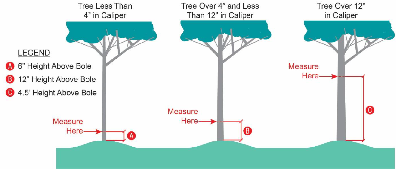
| Caliper |
Measurement for determining the size of trees at time of planting. Caliper is the
quantity in inches of the diameter of trees measured at six (6) inches above the ground.
|
| CAMA |
North Carolina's Coastal Area Management Act. This act, along with the Dredge and
Fill Law and the federal Coastal Zone Management Act, is managed through North Carolina
Department of Environmental Quality's (NCDEQ's) Division of Coastal Management (DCM).
|
| Canopy |
A permanent structure other than an awning made of cloth, metal, or other material
attached or unattached to a building for the purpose of providing shelter to patrons
or automobiles, or as a decorative feature. A canopy is not a completely enclosed
structure.
|
| Canopy Tree |
A species of tree which normally grows to a mature height of forty (40) feet or more
with a minimum mature crown width of thirty (30) feet.
|
| Casualty Damage |
The damage to or loss of a nonconforming structure or use that is sudden, unexpected,
and unusual. Typically associated with fire, severe weather, or Act of God.
|
| Certiorari |
A situation where an appellant may file an appeal of a decision directly to a higher
court of law.
|
| Change of Use |
The change in the use of a structure or land. Change of use includes a change from
one use type to another use type.
|
| Channel |
A natural water-carrying trough cut vertically into low areas of the land surface
by erosive action of concentrated flowing water or a ditch or canal excavated for
the flow of water.
|
| Charter |
As defined in G.S. 160A-1(2).
|
| City |
As defined in G.S. 160A-1(2).
|
| Clear Cut |
To cut all the trees in a stand of timber.
|
| Chemical Storage Facility |
A building, portion of a building, or exterior area adjacent to a building used for
the storage of any chemical or chemically reactive products.
|
| Coastal A Zone (CAZ) |
An area within a special flood hazard area, landward of a V zone or landward of an
open coast without mapped V zones. In a Coastal A Zone, the principal source of flooding
must be astronomical tides, storm surges, seiches, or tsunamis, not riverine flooding.
During the base flood conditions, the potential for wave heights shall be greater
than or equal to 1.5 feet. Coastal A Zones are not normally designated on FIRMs. (see
Limit of Moderate Wave Action (LiMWA).
|
| Coastal High Hazard Area |
A special flood hazard area extending from offshore to the inland limit of a primary
frontal dune along an open coast and any other area subject to high velocity wave
action from storms or seismic sources. The area is designated on a FIRM, or other
adopted flood map as determined in Article 3, Section B of this ordinance, as Zone
VE.
|
| Collocation |
The placement or installation of wireless facilities on existing structures, including
electrical transmission towers, water towers, buildings, and other structures capable
of structurally supporting the attachment of wireless facilities in compliance with
the wireless telecommunications sites and towers standards in this Ordinance.
|
| Commercial Vehicle |
A truck or other self-propelled vehicle of any type (along with a trailer or towed
appurtenance) used or maintained primarily to transport material or to aid in the
operation of a commercial establishment or business.
|
| Common Area |
All areas, including private streets, conveyed to an owners' association in a townhouse
development, residential development, or owned on a proportional undivided basis in
a condominium.
|
| Common Open Space |
Land and/or water areas within the site designated for a particular development, not
individually owned or dedicated for public use, which is designed and intended for
the common use or enjoyment of the residents of the development, but not including
any lands occupied by streets, street rights-of-way or off-street parking.
|
| Common Review Procedures |
Actions undertaken by Town staff or requirements of applicants that are uniformly
applied to all types of development applications reviewed and decided under this UDO.
|
| Community Character |
The sum or combined effect of the attributes and assets that make the Town unique
and that establish Atlantic Beach's "sense of place". Attributes include the resident
population, local institutions, visual characteristics, natural features, and shared
history.
|
| Comprehensive plan |
A comprehensive plan that has been officially adopted by the governing board pursuant
to G.S. 160D-501. For the Town of Atlantic Beach, this is the CAMA Land Use Plan.
|
| Condition (of approval) |
A limitation or stipulation on the range of allowable uses, density, intensity, configuration,
or operational parameters of new development or redevelopment. A condition may be
proposed by an applicant, a staff member, or a decision-making body that must be accepted
by an applicant to become binding.
|
| Condominium |
Development comprised of a lot or parcel of land, along with certain parts of a building
used by all the occupants that is under common ownership, combined with individual
units in the building owned in fee simple by individuals.
|
| Condotel |
An accommodations establishment where individual rooms are owned by different individuals
while at the same time being available for rent or sublet for short durations to other
individuals. The establishment may or may not include a registration desk, room cleaning
services, and other amenities typically associated with a hotel.
|
| Construction |
The erection of any building or structure or any preparations (including land-disturbing
activities) for the same.
|
| Construction Plans |
Drawing and specifications prepared by a qualified person showing buildings, structures,
utilities, infrastructures, and site configuration aspects associated with development.
|
| Contiguous |
See "Abutting."
|
| Continuance |
The adjournment or postponement of review or decision on an application to specified
future date.
|
| Contract Purchaser |
A person who has entered into a contract with another party to purchase real property,
but who has not yet settled on the purchase.
|
| Control Corner |
A recognized corner of a lot or piece of real property that is permanently marked
with a monument or marker for the purpose of determining distances, bearing, or metes
and bounds descriptions of the lot or real property.
|
| Cornice |
Any horizontal member, structural or nonstructural, of any building, projecting outward
from the exterior walls at the roof line, including eaves and other roof overhang.
|
| Corporate Limits |
The legal name that refers to the boundaries of a municipal corporation.
|
| County |
Carteret County, North Carolina.
|
| Covenant |
A binding written agreement between two (2) or more private parties regarding the
use, occupancy, or configuration of development.
|
| Critical Root Zone |
An area on and below the ground corresponding to the dripline that contains the primary
mass of tree roots.
|
| Cross Access |
Vehicular access provided between the vehicular use areas of two (2) or more development
sites or parcels of land intended to allow travel between the sites without the use
of a public or private street.
|
| Cupola |
A domelike structure on top of a roof or dome, often used as a lookout or to admit
light and air.
|
| Curb |
A constructed element used to stabilize paving, gutter, planting areas, or sidewalks.
|
| D | |
| Deciduous |
Trees, shrubs, or grasses that shed their leaves every year.
|
| Deck |
A structure, without a roof, directly adjacent to a principal building which has an
average elevation above finished grade.
|
| Dedication |
The act of giving, donating, or dedicating land or infrastructure improvements to
a unit of government for their operation and maintenance.
|
| Deed Restriction |
A written private agreement that restricts the use, occupancy, or configuration placed
upon the title of real estate often by the developer.
|
| Deferral |
A postponement of consideration of an application or request to a future date that
may or may not be specified.
|
| Designated Redeveloper |
Any individual or party that has been designated as a redeveloper and has purchased
real property from the Town pursuant to the provisions of G.S. 160D-1312.
|
| Determination |
A written, final, and binding order, requirement, or determination regarding an administrative
decision.
|
| Developer |
A person, including a governmental agency or redevelopment authority, who undertakes
any development and who is the landowner of the property to be developed or who has
been authorized by the landowner to undertake development on that property.
|
| Development |
Any of the following:
a. The construction, erection, alteration, enlargement, renovation, substantial repair,
movement to another site, or demolition of any structure.
b. The excavation, grading, filling, clearing, or alteration of land.
c. The subdivision of land as defined in G.S. 160D-802.
d. The initiation or substantial change in the use of land or the intensity of use
of land.
This definition does not alter the scope of regulatory authority granted by G.S. 160D.
|
|
As used in the flood damage prevention standards, any man-made change to improved
or unimproved real estate, including, but not limited to, buildings or other structures,
mining, dredging, filling, grading, paving, excavation or drilling operations, or
storage of equipment or materials.
|
| Development Approval |
An administrative or quasi-judicial approval made pursuant to G.S. 160D that is written
and that is required prior to commencing development or undertaking a specific activity,
project, or development proposal. Development approvals include, but are not limited
to, zoning permits, site plan approvals, special use permits, and variances. The term
also includes all other regulatory approvals required by regulations adopted pursuant
to G.S. 160D, including plat approvals, permits issued, development agreements entered
into, and building permits issued.
|
| Development Regulation |
A unified development ordinance, zoning regulation, subdivision regulation, erosion
and sedimentation control regulation, floodplain or flood damage prevention regulation,
mountain ridge protection regulation, stormwater control regulation, wireless telecommunication
facility regulation, historic preservation or landmark regulation, housing code, State
Building Code enforcement, or any other regulation adopted pursuant to this Chapter,
or a local act or charter that regulates land use or development.
|
| Diameter at Breast Height |
The diameter of a tree, measured four and one-half (4½) feet above the ground.
|
| Digital Flood Insurance Rate Map (DFIRM) |
Means the digital official map of a community, issued by the Federal Emergency Management
Agency (FEMA), on which both the Special Flood Hazard Areas and the risk premium zones
applicable to the community are delineated.
|
| Disposal |
Means, as defined in NCGS 130A-290(a)(6), the discharge, deposit, injection, dumping,
spilling, leaking, or placing of any solid waste into or on any land or water so that
the solid waste or any constituent part of the solid waste may enter the environment
or be emitted into the air or discharged into any waters, including groundwaters.
|
| Dock |
A structure, typically comprised of wood, that extends alongshore or outwards from
the shore into a body of water that allows access to the water or to moored boats
or watercraft.
|
| Drainage Easement |
An easement which grants the right to maintain, relocate, or, utilize land within
the easement for the improvement of drainage and stormwater flow.
|
| Dripline |
A vertical line extending from the outermost portion of a tree's canopy to the ground.
|
| Drive Through |
A facility designed to enable a person to transact business while remaining in a motor
vehicle.
|
| Driveway |
A private roadway providing ingress and egress from a street to a lot or site for
off-street travel.
|
| Dwelling |
Any building, structure, manufactured home, or mobile home, or part thereof, used
and occupied for human habitation or intended to be so used, and includes any outhouses
and appurtenances belonging thereto or usually enjoyed therewith.
|
| Dwelling Unit |
A single unit providing complete, independent living facilities for one or more persons,
including permanent provisions for living, sleeping, eating, cooking, and sanitation.
|
| E | |
| Easement |
The right to use or temporarily occupy the real property of another owner for a specifically
identified purpose. An easement is a recognized interest in real property, but legal
title to the underlying land is retained by the owner granting the easement.
|
| Eave |
The projecting lower edges of a roof that overhangs the wall of a building.
|
| Egress |
An exit from a building or site.
|
| Elevated Building |
A non-basement building built, to have the top of the elevated floor, above the ground
by means of pilings, columns (posts and piers), shear walls parallel to the flow of
water, and adequately anchored so as not to impair the structural integrity of the
building during a flood up to the magnitude of the base flood.
|
|
In the case of Zones A1-A30, AE, A, A99, AO, AH, B, C, and X, Elevated Building also
includes a building elevated by means of fill or solid foundation perimeter walls
with openings sufficient to facilitate the unimpeded movement of flood waters.
|
| Elevation Certificate |
A written certificate of the elevation of a building or structure located in a special
flood hazard area used to determine the proper flood insurance premium rate for the
building.
|
| Encroachment |
The advance or infringement of uses, fill, excavation, buildings, permanent structures
or development into a floodplain, which may impede or alter the flow capacity of a
floodplain.
|
| Erosion |
The wearing away, washing away of the land surface as the result of the action of
wind, water, gravity or combination thereof, so as to result in the soil, earth, or
sand being deposited in the canal or waterway.
|
| Evergreen |
A woody plant with one (1) or more stems that does not lose the majority of its leaves
during winter or dormancy.
|
| Ex parte Communication |
Any communication between a member of a decision-making body and a person involved
in a development application that is made without the presence or knowledge of the
other members of the same decision-making body.
|
| Existing building/existing structure |
Any building and/or structure for which the "start of construction" commenced before
the initial Flood Insurance Rate Map (FIRM) for the community, dated March 15, 1977.
|
| Existing Manufactured Home Park/Manufactured Home Subdivision |
Means a manufactured home park or subdivision for which the construction of facilities
for servicing the lots on which the manufactured homes are to be affixed (including,
at a minimum, the installation of utilities, the construction of streets, and either
final site grading or the pouring of concrete pads) is completed before the effective
date of the floodplain management regulations adopted by a community, dated July 16,
2003.
|
| Expansion |
An increase in the floor area of an existing structure or building, or the increase
of area of a use.
|
| F | |
| Façade |
The entire exterior wall of a building facing a lot line measured from the grade to
the eave or highest point of a flat or mansard roof. Facades may be on the front,
side, or rear elevation of the building.
|
| Family |
One (1) or more persons occupying a dwelling unit and living as a single household.
|
| Fee |
An amount charged in accordance with the regularly adopted fee schedule of the Town.
|
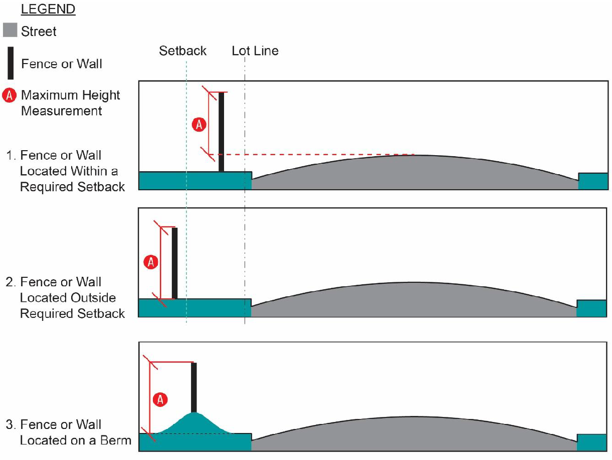
| Fence (or Wall) |
A physical barrier or enclosure consisting of wood, stone, brick, block, wire, metal,
or similar material used as a boundary or means of protection or confinement, but
not including a hedge or vegetation.
|
| Fenestration |
The arrangement of windows and doors on a building's façade.
|
| Fill |
The act of depositing soil, sand, stone, or other inert debris customarily used for
supplementing or augmenting land. The term "fill" also applies to the deposit soil,
sand, stone, or other deposited material.
|
| Final Plat |
A plan or drawing recorded in the office of the register of deeds that identifies
the metes and bounds as well as all applicable conditions applied to a lot or group
of lots that have been subdivided.
|
| Fine |
A sum of money imposed on a violator as punishment for violation of law.
|
| Fire Lane |
A lane or designated area in a parking lot or on a street that is reserved for firefighting
equipment or staging of people during a fire and is not intended for the parking of
vehicles or storage.
|
| Flag |
A piece of cloth or similar material, typically oblong or square, attachable by one
(1) edge to a pole or rope and used as the symbol, emblem, or decoration.
|
| Flood Boundary and Floodway Map (FBFM) |
An official map of a community, issued by the Federal Emergency Management Agency,
on which the special flood hazard areas and the floodways are delineated. This official
map is a supplement to and shall be used in conjunction with the Flood Insurance Rate
Map (FIRM).
|
| Flood Hazard Boundary Map (FHBM) |
An official map of the Town, issued by the Federal Emergency Management Agency, where
the boundaries of the areas of special flood hazard have been defined as Zone A.
|
| Flood Insurance |
The insurance coverage provided under the National Flood Insurance Program.
|
| Flood Insurance Rate Map (FIRM) |
An official map of a community, on which the Federal Emergency Management Agency has
delineated both the areas of special flood hazard and the risk premium zones applicable
to the community.
|
| Flood Insurance Study (FIS) |
The official report provided by the Federal Emergency Management Agency. The report
contains flood profiles, as well as the Flood Boundary Floodway Map and the water
surface elevation of the base flood.
|
| Flood or Flooding |
A general and temporary condition of partial or complete inundation of normally dry
land areas from:
|
|
(1) The overflow of inland or tidal waters; and
|
|
(2) The unusual and rapid accumulation of runoff of surface waters from any source.
|
| Flood Zone |
A geographical area shown on a flood hazard boundary map or flood insurance rate map
that reflects the severity or type of flooding in the area.
|
| Floodplain |
Any land area susceptible to being inundated by water from the base flood.
|
| Floodplain Administrator |
The professional staff member responsible for inspecting stormwater management practices,
floodplain development permits, and elevation certificates.
|
| Floodplain Management |
The operation of an overall program of corrective and preventative measures for reducing
flood damage and preserving and enhancing, where possible, natural resources in the
floodplain, including but not limited to emergency preparedness plans, flood control
works, floodplain management regulations, and open space plans.
|
| Floodplain Regulations |
This Ordinance, building codes, health regulations, special purpose ordinances, and
other applications of police power which control development in floodprone areas.
This term describes federal, state, or local regulations in any combination thereof,
which provide standards for preventing and reducing flood loss and damage.
|
| Floodproofing |
Any combination of structural and nonstructural additions, changes, or adjustments
to structures, which reduce or eliminate risk of flood damage to real estate or improved
real property, water and sanitation facilities, or structures with their contents.
|
| Floodway |
The channel of a river or other watercourse and the adjacent land areas that must
be reserved in order to discharge the base flood without cumulatively increasing the
water surface elevation more than one (1) foot.
|
| Floor |
The top surface of an enclosed area in a building, including the basement, for example,
the top of slab in concrete slab construction or top of wood flooring in wood frame
construction. The term does not include the floor of a garage used solely for parking
vehicles.
|
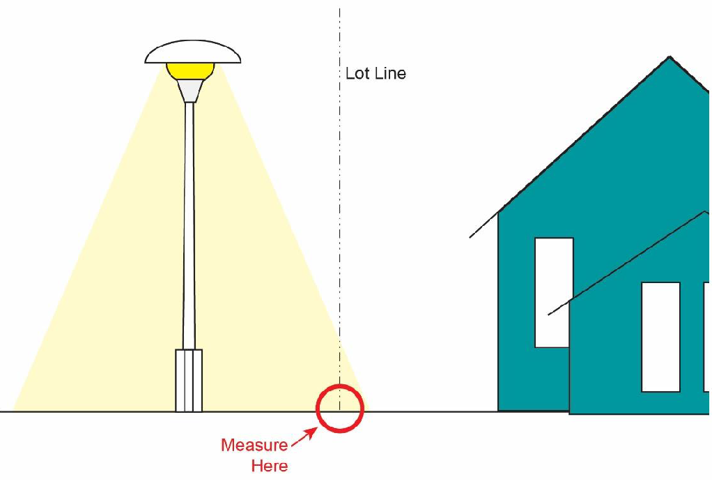
| Footcandle |
A unit of measure of the intensity of light falling on a surface. It is often defined
as the amount of illumination the inside surface of a one-foot-radius sphere would
be receiving if there were a uniform point source of one (1) candela in the exact
center of the sphere. One (1) footcandle is equal to one (1) lumen per square foot.
|
| Freeboard |
The additional amount of height added to the base flood elevation (BFE) to account
for uncertainties in the determination of flood elevations. The BFE plus the freeboard
establishes the Regulatory Flood Protection Elevation.
|
| Frontage |
A strip or extent of land abutting and extending along a street.
|
| Frontal Dune |
The first mound of sand located landward of the ocean beach that has stable and natural
vegetation present.
|
| Functionally-Dependent Facility |
A facility or structure that cannot be used for its intended purpose unless it is
located within or in close proximity to water, limited to a docking or port facility
necessary for the loading and unloading of cargo or passengers, ship building, or
ship repair. The term does not include long-term storage, manufacture, sales, or services
facilities.
|
| G | |
| Gabion |
A container crafted of wire or cage filled with rock, broken concrete or similar material
used in the construction of a retaining wall or bulkhead.
|
| General Assembly |
The General Assembly for the State of North Carolina. Also referred to as the Legislature.
|
| General Statutes |
A statute is a written law passed the General Assembly that sets forth general propositions
of law that courts apply to specific situations.
|
| Glare |
The effect produced within the visual field by a high intensity or insufficiently
shielded light source that is significantly brighter than the level to which the eyes
are adapted, causing annoyance, discomfort, or loss of visual performance or visibility
of objects.
|
| Glazing |
The portion of an exterior building surface occupied by glass or windows.
|
| Good Cause |
Legally adequate or substantial grounds or reason to take a certain action based upon
the circumstances of each individual case.
|
| Governing Board |
The Town Council of Atlantic Beach.
|
| Grading |
Excavating, filling (including hydraulic fill) or stockpiling of earth material, or
any combination thereof, including the land in its excavated or filled condition.
|
| Ground Cover |
Low growing plants such as grasses, ivy, creeping bushes and similar decorative plantings
as well as mulch, pine straw, or other similar materials used to cover the ground
within required landscaping areas.
|
| Ground-Based Mechanical Equipment |
Utility or other equipment of a mechanical nature that is mounted on or below grade
on the site it serves.
|
| H | |
| Hardship |
Special or specified circumstances that place an unreasonable or disproportionate
burden on one (1) applicant or landowner over another.
|
| Hazardous Waste Management Facility |
As defined in NCGS 130A, Article 9, a facility for the collection, storage, processing,
treatment, recycling, recovery, or disposal of hazardous waste.
|
| Highest Adjacent Grade (HAG) |
The highest natural elevation of the ground surface, prior to construction, immediately
next to the proposed walls of the structure.
|
| Historic Structure |
Any structure that is:
(a) Listed individually in the National Register of Historic Places (a listing maintained
by the US Department of Interior) or preliminarily determined by the Secretary of
Interior as meeting the requirements for individual listing on the National Register;
(b) Certified or preliminarily determined by the Secretary of Interior as contributing
to the historical significance of a registered historic district or a district preliminarily
determined by the Secretary to qualify as a registered historic district;
(c) Individually listed on a local inventory of historic landmarks in communities
with a "Certified Local Government (CLG) Program"; or
(d) Certified as contributing to the historical significance of a historic district
designated by a community with a "Certified Local Government (CLG) Program."
Certified Local Government (CLG) Programs are approved by the US Department of the
Interior in cooperation with the North Carolina Department of Cultural Resources through
the State Historic Preservation Officer as having met the requirements of the National
Historic Preservation Act of 1966 as amended in 1980.
|
| Home Day Care |
A residential dwelling unit used for the purposes of providing part-time temporary
care to children or adults who reside elsewhere.
|
| Home Occupation |
Any activity carried out for gain by a resident in their principal residence.
|
| Homeowner's Association |
An official organization of home and/or property owners in a subdivision, neighborhood,
or community unit responsible for managing common resources and enforcing covenants.
|
| I | |
| Impervious Cover or Surface |
Any structure, material or ground cover consisting of, but not limited to, asphalt,
concrete, stone, brick, terrazzo, roofing, ceramic tile or any other natural or manmade
material that prevents the absorption of surface water into the soil.
|
| Improvement |
The construction of buildings and the establishment of basic services and amenities
associated with development, including, but not limited to streets and sidewalks,
parking areas, water and sewer systems, drainage system, property markers and monuments,
recreation facilities (i.e., lakes, swimming pools, tennis courts, golf courses, club
houses, cabanas, marinas, docks and the like) and other similar construction or establishment.
|
| Indigenous |
Plant or landscaping material that originates or occurs naturally in the same area
as the Town.
|
| Infill |
The process of developing vacant or under-used parcels within existing developed areas
that are already largely developed.
|
| Ingress |
Access or entry to a building or site.
|
| In-Lieu Fee |
Monetary compensation offered by a landowner or applicant as an alternative to provision
of some other required site or development feature.
|
| Interpretation |
A determination, made in writing, by the UDO Administrator regarding the proper application
of provisions in the UDO, the boundaries on the Official Zoning Map, or a prior-approved
condition of approval.
|
| J | |
| Joint Public Hearing |
A lawfully noticed and conducted public hearing regarding a development application
conducted by the Town Council and the Planning Board.
|
| Just Cause |
Legitimate cause; legal or lawful ground for action.
|
| K | |
| L | |
| Land Disturbance |
Any movement of earth or substrate, manually or mechanically, including but not limited
to any modification of existing grade by dredging, demolition, excavation or fill,
grading, scraping, vegetation removal, landscaping, coring, well drilling, pile driving,
undergrounding utility lines, trenching, bulldozing, sheeting, shoring and excavation
for laying or removing foundations, pilings or other purposes.
|
| Landowner |
The holder of the title in fee simple. Absent evidence to the contrary, a local government
may rely on the county tax records to determine who is a landowner. The landowner
may authorize a person holding a valid option, lease, or contract to purchase to act
as his or her agent or representative for the purpose of making applications for development
approvals.
|
| Landscaping |
The improvement of a lot, parcel or tract of land with grass, shrubs, trees, and or
ground cover.
|
| Large Maturing Tree |
See "Tree, Canopy."
|
| Legislative Decision |
The adoption, amendment, or repeal of a regulation under G.S. 160D or an applicable
local act. The term also includes the decision to approve, amend, or rescind a development
agreement consistent with the provisions of G.S. 160D, Article 10.
|
| Legislative Public Hearing |
A hearing to solicit public comment on a proposed legislative decision.
|
| Levee |
A manmade structure, usually an earthen embankment, designed and constructed in accordance
with sound engineering practices to contain, control or divert the flow of water so
as to provide protection from temporary flooding.
|
| Light Trespass |
Unwanted light that shines from one (1) lot to another.
|
| Limit of Moderate Wave Action (LiMWA) |
Limit of Moderate Wave Action (LiMWA)" means the boundary line given by FEMA on coastal
map studies marking the extents of Coastal A Zones (CAZ).
|
| Loading Area or Space |
Space logically and conveniently located for bulk pickups and deliveries, scaled to
delivery vehicles, and not considered as part of the minimum required off-street surface
parking.
|
| Lot |
A legally described piece of contiguous land that has been or may be developed as
a unit. This term is synonymous with "parcel."
|
| Lot of Record |
A lot which is part of a subdivision, a plat of which has been recorded with the Carteret
County Register of Deeds prior to the adoption of this Ordinance, or a lot described
by metes and bounds, the description of which has been recorded prior to the adoption
of this Ordinance.
|
| Lowest Adjacent Grade (LAG) |
The lowest elevation of the ground, sidewalk or patio slab immediately next to the
building, or deck support, after completion of the building.
|
| Lowest Floor |
The subfloor, top of slab, or grade of the lowest enclosed area, including the basement.
An unfinished or flood resistant enclosure, usable solely for parking of vehicles,
building access or storage in an area other than a basement area is not considered
a building's lowest floor, provided that the enclosure is not built so as to render
the structure in violation of the applicable non-elevation design requirements of
this Ordinance.
|
| Lumen |
A unit of measurement of the quantity of light that falls on an area of one (1) square
foot, every point of which is one (1) foot from the source of one (1) candela. A light
source of one (1) candela emits a total of 12.57 lumens. For the purpose of this Ordinance,
the lumen output value shall be the initial lumen output ratings of a lamp.
|
| M | |
| Map Repository |
The location of the official flood hazard data to be applied for floodplain management.
It is a central location in which flood data is stored and managed; in North Carolina,
FEMA has recognized that the application of digital flood hazard data products carry
the same authority as hard copy products. Therefore, the NCEM's Floodplain Mapping
Program websites house current and historical flood hazard data. For effective flood
hazard data, the NC FRIS website (https://fris.nc.gov/fris/Home.aspx?ST=NC) is the map repository, and for historical flood hazard data the FEMA Map Service
Center website (https://msc.fema.gov/portal/home) is the map repository.
|
| Market Value |
The building value, not including the land value and that of any accessory structures
or other improvements on the lot. Market value may be established by independent certified
appraisal, replacement cost depreciated for age of building and quality of construction
(actual cash value), or adjusted tax assessed values.
|
| Master Development Plan |
A regularly-updated plan provided annually to the Town that depicts the development
anticipated by Designated Redeveloper for the land in the CIR district they control.
|
| Marginal Access Street |
See "Street, Marginal Access."
|
| Maximum Extent Practicable |
No feasible or practical alternative exists, as determined by the City, and all possible
efforts to comply with the standards or regulation to minimize potential harmful or
adverse impacts have been undertaken by an applicant. Economic considerations may
be taken into account but shall not be the overriding factor determining "maximum
extent practicable."
|
| Mean Sea Level |
The average height of the sea for all stages of the tide. It is used as a reference
for establishing various elevations within the floodplain. For purposes of this Ordinance,
the term is synonymous with "National Geodetic Vertical Datum (NGVD)."
|
| Minimum Housing Code |
Article 6 of Chapter 6 of the Town's Code of Ordinances titled "Minimum Housing Standards."
|
| Mixed-Use Development |
A tract of land or structure developed for two (2) or more different uses, such as,
but not limited to, residential, office, retail, institutional, public, or entertainment.
Such uses are functionally integrated and share vehicular use areas, ingress/egress,
and pedestrian access.
|
| Modular Home |
A dwelling unit or building constructed in accordance with the standards set forth
in the North Carolina Building Code and constructed of components substantially assembled
in a manufacturing plant and transported to the building site for final assembly on
a permanent foundation. A modular home may consist of two (2) or more sections transported
to the site in a manner similar to a manufactured home (except that the modular unit
meets the North Carolina State Building Code), or a series of panels or room sections
transported on a truck and erected or joined together on the site.
|
| Monument |
For the purposes of the subdivision regulations, a permanent marker, typically inserted
into the ground, showing the location of a lot line, lot corner, or other demarcation
associated with a lot or right-of-way.
|
| Motor Home |
See "Recreational Vehicle."
|
| Motor Vehicle |
A vehicle required by the North Carolina Department of Motor Vehicles to be registered
under North Carolina State Law.
|
| Multi-Family Development |
A tract of land under single, individual, corporate, firm partnership, or association
ownership, or under common control evidenced by duly recorded contracts or agreements;
planned and developed as an integral unit in a single development operation or in
a definitively programmed series of development operations. The development shall
consist of at least three (3) or more dwelling units sharing one (1) or more common
walls with a coordinated design of building(s), organization of service areas, and
common open space.
|
| Multi-Phased Development |
A development containing 25 acres or more which is vested pursuant to G.S. 160D-108(f).
|
| N | |
| Natural State |
The undisturbed condition of the land before any modification, alteration, or other
artificial changes caused by human activity.
|
| Neighborhood Meeting |
A meeting conducted by an applicant on a proposed development before an application
for the development permit or approval is submitted or upon request by the Town Council.
|
| New Construction |
As used in the flood damage prevention standards, structures for which the start of
construction commenced on or after the effective date of the flood damage prevention
standards and includes any subsequent improvements to such structures.
|
| Nonconforming Lot |
A lot of record that that was lawful at the date on which it was established, but
does not conform to the current dimensional requirements of the zoning district in
which it is located.
|
| Nonconforming Sign |
Any sign that was lawfully established, but does not meet the standards of this Ordinance.
|
| Nonconforming Structure |
A structure that was lawful at the date on which it was established, but does not
conform to current dimensional, elevation, location, or other requirements of this
Ordinance.
|
| Nonconforming Use |
A use which was lawful at the date on which it was established, but is now not a permitted
use of that parcel or structure under this Ordinance.
|
| Nonconformity |
Any land use, development, structure, or site, including any lot of record, that was
legally established, but that is not presently in full compliance with the provisions
of this Ordinance.
|
| Non-Encroachment Area |
The channel of a river or other watercourse and the adjacent land areas that must
be reserved in order to discharge the base flood without cumulatively increasing the
water surface elevation more than one (1) foot as designated in the flood insurance
study report.
|
| Notice of Public Hearing |
The formal legal notification of a public hearing on a proposed development application.
A "published notice" is one (1) required to be printed in a newspaper of general circulation.
A "mailed notice" is one (1) delivered to specified individuals by US Mail. A "posted
notice" is a sign posted on or near the property subject to the application.
|
| Notice of Violation |
A notice indicating a violation of this Ordinance not associated with a fine.
|
| O | |
| Oath |
The term "oath" shall be construed to include an affirmation in all cases in which,
by law, an affirmation may be substituted for an oath, and in like cases the terms
"swear" and "sworn" shall be equivalent to the terms "affirm" and "affirmed."
|
| Occupancy |
The act, state, or condition of holding, possessing, residing, or otherwise using
a premises, lot, site, building, or dwelling.
|
| Ocean Hazard Area |
Ocean hazard areas include beaches, frontal dunes, inlet lands, and other areas in
which geologic, vegetative and soil conditions indicate a substantial possibility
of excessive erosion or flood damage. Ocean hazard areas are generally divided into
two (2) zones or areas: The ocean erodible area and the high hazard flood area.
|
| Official Zoning Map |
The Official Zoning Map upon which the boundaries of various zoning districts are
drawn and which is an integral part of this Ordinance.
|
| Off-site Parking |
An off-street parking area provided on a different lot than the use it is intended
to serve.
|
| Off-Street Parking |
An area that is designated for the parking or temporary storage of one (1) motor vehicle
located outside of a dedicated street right-of-way, vehicular travel way, or parking
aisle.
|
| On-center Planting |
Placement of landscape material in a regularly-spaced pattern of equal distance between
plants.
|
| On-street Parking |
An area that is designated for the parking of one (1) motor vehicle located within
a public or private street right-of-way.
|
| Opaque |
The inability to see across or through a landscaping buffer or similar visual screen.
|
| Open Space |
Areas of land free from buildings, structures, or encumbrances, as well as lands with
buildings or structures devoted to active or passive recreational purposes.
|
| Ordinance |
A legislative enactment of the Town of Atlantic Beach, North Carolina.
|
| Outdoor Display |
The keeping of any goods, merchandise, or vehicles, in an unroofed area for marketing
or sales purposes.
|
| Outdoor Storage |
The keeping of any goods, junk, material or merchandise in an unroofed area, in the
same place for a period of time exceeding twenty-four (24) hours, but excluding temporary
construction and related activities.
|
| Outparcel |
A lot located within a multi-tenant development (e.g., a shopping center) which may
or may not have access from a public road abutting the development. The lot is treated
as part of the larger development with respect to applicable yard and dimensional
requirements.
|
| Owner |
One who has legal title or right to something. An owner shall include any part owner
or joint owner.
|
| Owner's Association |
See "Homeowner's Association."
|
| P | |
| Parapet |
A building façade that rises above the roof level, typically obscuring a gable or
flat roof as well as any roof-mounted equipment.
|
| Parcel |
See "Lot."
|
| Parking Lot |
An area or plat of land used for the storage or parking of vehicles.
|
| Parking Space |
A vehicular storage space plus the necessary access space.
|
| Parking Space, Accessible |
A space designated for the parking or temporary storage of one (1) motor vehicle in
addition to the space necessary for the ingress and egress from the vehicle by a disabled
person and any equipment needed for that purpose.
|
| Passive Recreation Area |
Open space areas designated for passive recreation uses including walking trails,
pathways, gazebos, picnic areas, fountains, plazas, and similar areas. Such areas
may also include undisturbed natural vegetation.
|
| Peddler |
See Section 9-91 of the Atlantic Beach Town Code of Ordinances.
|
| Pedestrian Accessway, Walkway, or Pathway |
See "Pedestrian Connection."
|
| Pedestrian Connection |
Interconnected paved walkway that provides a pedestrian passage through blocks running
from street to street, vehicular use areas, or other locations.
|
| Penalty |
Punishment for violation of a law or rule.
|
| Performance Guarantee |
Cash or other guarantee provided by an applicant in-lieu of completion of public infrastructure
or installation of required private site features prior to issuance of a building
permit or other development approval.
|
| Pergola |
An accessory structure consisting of parallel colonnades supporting an open roof of
girders and cross rafters.
|
| Perimeter Buffer |
A specified land area, located parallel to and within the outer perimeter of a lot
or parcel and extending to the lot or parcel boundary line, together with the planting
and landscaping required on the land. A buffer may also contain, or be required to
contain, a barrier such as a berm, fence or wall, or combination thereof, where such
additional screening is necessary to achieve the desired level of buffering between
various land use activities.
|
| Person |
An individual, partnership, firm, association, joint venture, public or private corporation,
trust, estate, commission, board, public or private institution, utility, cooperative,
interstate body, the State of North Carolina and its agencies and political subdivisions,
or other legal entity.
|
| Personal Property |
All forms of property, except real property.
|
| Pier |
A platform, supported on pillars, piles, or girders that extends outwards from the
shore into a body of water for the purposes of allowing access to the water or to
moored boats or watercraft. Piers may include exterior lighting, and facilities for
fishing, seating, recreation, or storage.
|
| Pitched Roof |
A roof that is configured at an angle to the ground.
|
| Planning Board |
Any board or commission established pursuant to G.S. 160D-301.
|
| Plant Material |
See "Landscaping."
|
| Planting Season |
The dormant time of the year for trees beginning with leaf drop and ending with bud
break; generally late fall to early spring.
|
| Plat |
A surveyed map or plan for a parcel of land which is to be, or has been, subdivided.
|
| Plaza |
An open space at the intersection of important streets or adjacent to important structures,
set aside for civic purposes and commercial activity, which may include parking, consisting
of durable pavement, and formal landscaping or tree plantings.
|
| Porch |
A covered projection (can be glazed or screened) from the main wall of a building,
with a separate roof, that is not used for livable space.
|
| Post-FIRM |
Construction or other development which started on or after the effective date of
the initial flood insurance rate map for the area, March 15, 1977.
|
| Pre-application Conference |
A meeting or conference conducted by a potential applicant for a permit or development
approval and the Technical Review Committee for the purposes of discussing a potential
application or Town rules regarding development.
|
| Pre-FIRM |
Construction or other development which started before the effective date of the initial
flood insurance rate map for the area, March 15, 1977.
|
| Preliminary Plat |
A drawing or plan showing the proposed organization of lot boundaries, streets, public
infrastructure, open space, and other site configuration features associated with
a proposed development including two (2) or more lots.
|
| Primary Entrance |
The place of ingress and egress to a building, parcel, or development used most frequently
by the public.
|
| Primary Frontal Dune |
A continuous or nearly continuous mound or ridge of sand with relatively steep seaward
and landward slopes immediately landward and adjacent to the beach and subject to
erosion and over-topping from high tides and waves during major coastal storms. The
inland limit of the primary frontal dune occurs at the point where there is a distinct
change from a relatively steep slope to a relatively mild slope.
|
| Primary Structure |
See "Principal Structure."
|
| Principal Structure or Building |
A structure in which is conducted the principal use(s) of the lot on which it is located.
|
| Principal Use |
A primary or predominate use of a lot or parcel.
|
| Private Street |
A vehicular travelway not dedicated or offered for dedication as a public street but
resembling a cul-de-sac or a local street by carrying traffic from a series of driveways
to the public street system.
|
| Property |
All real property subject to land-use regulation by a local government. The term includes
any improvements or structures customarily regarded as a part of real property. All
property, for the purposes of zoning administration, shall be identified by the tax
parcel number assigned through the Carteret County Tax Department.
|
| Property Owner |
See "Landowner."
|
| Property Owner's Association |
See "Homeowner's Association."
|
| Public Infrastructure |
Infrastructure or facilities (such as water lines, streets, storm drainage, sidewalks,
trails, etc.) owned by the public and intended for use by the public.
|
| Public Street |
A dedicated public right-of-way in which the roadway has been accepted or constructed
to public standards for vehicular traffic, but not an alley.
|
| Q | |
| Quasi-Judicial Decision |
A decision involving the finding of facts regarding a specific application of a development
regulation and that requires the exercise of discretion when applying the standards
of the regulation. The term includes, but is not limited to, decisions involving variances,
special use permits, and appeals of administrative determinations.
|
| Quasi-Judicial Public Hearing |
A hearing to gather competent, material, and substantial evidence in order to make
findings for a quasi-judicial decision required by a development regulation adopted
under G.S. 160D. Also referred to as an evidentiary hearing.
|
| Quorum |
The minimum number of board or commission members that must be present in order to
conduct official business or take official action.
|
| R | |
| Real Property |
All land, structures, firmly attached and integrated equipment (such as light fixtures
or a well pump), anything growing on the land, and all "interests" in the property
which may be the right to future ownership (remainder), right to occupy for a period
of time (tenancy or life estate) the right to drill for oil, the right to get the
property back (a reversion) if it is no longer used for its current purpose, use of
airspace, or an easement across another's property.
|
| Recreational Vehicle |
A wheeled vehicular portable structure, built on a chassis, designed to be used as
a temporary dwelling for travel and/or recreational purposes, having a body width
not exceeding ten (10) feet. A recreational vehicle may be self-propelled.
|
As used in flood damage prevention standards, a vehicle, which is:
(a) Built on a single chassis
(b) 400 square feet or less when measured at the largest horizontal projection;
(c) Designed to be self-propelled or permanently towable by a light duty truck;
(d) Designed primarily not for use as a permanent dwelling, but as temporary living
quarters for recreational, camping, travel, or seasonal use, and
(e) Is fully licensed and ready for highway use.
|
| Recombination |
Revision of existing lot lines so as to relocate a lot's boundaries or consolidate
all or a portion of two (2) or more different lots.
|
| Re-cross Examination |
As used in quasi-judicial public hearings, re-cross examination is the resumption
of cross-examination by the original cross-examiner in order to respond to matters
that may have arisen during the re-examination of a witness.
|
| Redevelopment |
Installation of any improvements, new construction, or reconstruction on a lot or
site that has pre-existing uses.
|
| Re-direct Examination |
As used in quasi-judicial public hearings, redirect examination is the process by
which the party who offered a witness has a chance to explain or otherwise qualify
any damaging or accusing testimony brought out by the opponent during cross-examination.
Redirect examination may question only those areas brought out on cross-examination.
|
| Reference Feature |
The receding edge of a bluff or eroding frontal dune or, if this type of feature is
not present, the normal high water line or the seaward line of permanent vegetation
if the high water line cannot be identified.
|
| Reference Level |
The portion of a structure or other development that must be compared to the regulatory
flood protection elevation to determine regulatory compliance of such building. Within
special flood hazard areas designated as zones A1-A30, AE, A, A99, AO, or AH, the
reference level is the top of the lowest floor. Within special flood hazard areas
designated as zones VE or V1-V30, the reference level is the bottom of the lowest
horizontal structural member.
|
| Register of Deeds |
A public officer designated by Carteret County to register documents, mainly related
to real estate. The register of deeds verifies mortgage ownership and property ownership,
such as houses and land, in official record books.
|
| Regulatory Flood Protection Elevation |
The elevation to which all structures and other development located within the special
flood hazard areas must be elevated or floodproofed if non-residential. In Special
Flood Hazard Areas where Base Flood Elevations (BFE) have been determined, this elevation
shall be the BFE plus one (1) foot freeboard. In Special Flood Hazard Areas where
no BFE has been established, this elevation shall be at least one (1) foot above the
highest adjacent grade.
|
| Remedy |
The manner in which a right or law is enforced or satisfied by the Town or a court
when a violation of the UDO or related law has occurred.
|
| Repetitive Loss |
Flood-related damages sustained by a structure on two (2) separate occasions during
any ten-year period for which the cost of repairs at the time of each such flood event,
on the average, equals or exceeds twenty-five (25) percent of the market value of
the structure before the damage occurred.
|
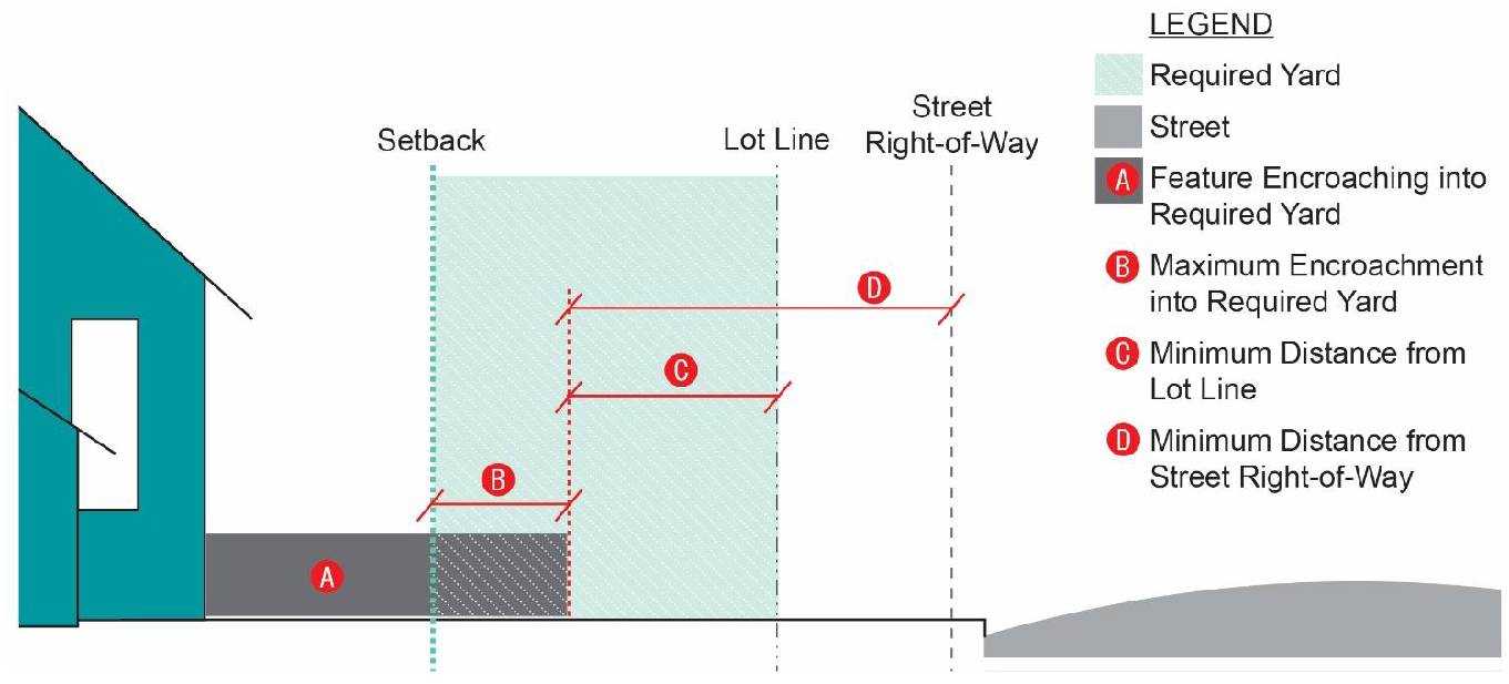
| Required Yard |
The land area located between a lot line and the boundary of a required setback.
|
| Reserve Fund |
A bank account containing reserve funds for the purpose of maintaining commonly-held
land, infrastructure, or facilities.
|
| Resolution |
The official written expression of the opinion or the will of the Town Council.
|
| Retaining Wall |
A structure, either masonry, metal, or treated wood, designed to prevent the lateral
displacement of soil, rock, fill, or other similar material.
|
| Right-of-Way |
For the purposes of determining obstructions in the right-of-way, a right-of-way is
any street, or that area adjacent to any street, that is owned, dedicated to, and
accepted by the Town.
|
| Roof Line |
The top edge of the roof or the top of the parapet, whichever forms the top line of
the building silhouette.
|
| Roof-Mounted Equipment |
Equipment, appurtenances, utilities, infrastructure, or similar objects mounted on
or near the roof of a building.
|
| Routine Maintenance |
Small-scale, ongoing activities (usually requiring only minimal skills or training)
associated with regular (daily, weekly, monthly, etc.) and general upkeep of a building,
equipment, machine, plant, or system to mitigate the negative impacts of normal wear
and tear.
|
| S | |
| Sag Vertical Curves |
A curve in a roadway that is located on a descending grade.
|
| Salvage Yard |
Any non-residential property used for the storage, collection, and/or recycling of
any type of equipment, and including but not limited to vehicles, appliances, and
related machinery.
|
| Sand Dune |
Mounds or hills primarily made up of sand that may or may not have naturally occurring
vegetation growing upon them and that generally and visibly exceed the average elevation
of the surrounding landscape. For the purposes of this Ordinance, the term may not
refer to one (1) or more sand dunes that are topologically integrated by a topographical
feature forming a "dune ridge system" that is clearly distinct from the surrounding
landscape.
|
| Screening |
Fences, walls, vegetation, building features, or other constructed devices intended
to shield a site feature from view.
|
| Sediment |
Solid particulate matter, both mineral and organic, that is transported by water,
air, gravity, or ice from its site of origin.
|
| Service Area |
The portion of a building or development site devoted to operations, upkeep, maintenance,
or typical function, but not including the range of activities that comprise the primary
or principal use of the site.
|
| Shared Parking |
The joint use of off-street parking facilities by two (2) or more uses whether located
on the same or different lot as the parking facilities.
|
| Shielding |
The portion of a light fixture constructed and installed in such a manner that all
light emitted by it, either directly from the lamp (bulb) or a diffusing element,
or indirectly by reflection or refraction from any part of the fixture, is projected
below the horizontal plane of the fixture.
|
| Shoreline |
The location where the mean high-water mark meets the land or bulkhead along any canal,
waterway, or boat basin.
|
| Shrub |
A woody plant, smaller than a tree, consisting of several small stems emerging from
the ground, or small branches near the ground. Shrubs may be deciduous or evergreen.
|
| Sidewalk |
A paved area public right-of-way running parallel to the street for the purposes of
pedestrian travel and to facilitate pedestrian access to adjacent streets and land.
|
| Sight Distance Triangle |
The triangular area formed by a diagonal line connecting two (2) points located at
designated locations on intersecting right-of-way lines or a right-of-way line and
the curb or a driveway.
|
| Sign |
An object, device, display, or structure, or part thereof, which is used to advertise,
identify, display, direct, or attract attention to an object, person, institution,
organization, business, product, service, event, or location by any means, including
but not limited to words, letters, pennants, banners, emblems, trademarks, trade names,
insignias, numerals, figures, design, symbols, fixtures, colors, illumination, or
projected images or any other attention directing device.
|
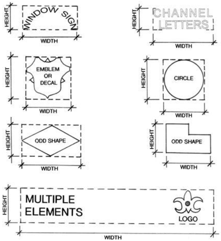
| Sign Face Area |
The portion of sign that contains the message being conveyed.
|
| Sign, Awning |
A sign placed on a canvas or metal awning affixed to a building.
|
| Sign, Banner |
A strip of cloth, paper, plastic, or metal bearing a message and intended to be affixed
to a building wall or strung between vertical projections.
|
| Sign, Fence Wrap |
A temporary sign affixed to fencing surrounding an active construction site.
|
| Sign, Flag |
See "Flag."
|
| Sign, Flashing |
A sign that uses an intermittent scrolled or flashing light or message to attract
attention, or is otherwise designed or constructed to have intermittent, flashing
or scrolled light emitted from it.
|
| Sign, Freestanding |
Any sign permanently attached to the ground and not attached to any building which
is located on a single parcel occupying an entire structure or building.
|
| Sign, Government |
Any temporary or permanent sign erected and maintained for any government purposes.
|
| Sign, Illuminated or Lighted |
A sign either internally or externally illuminated.
|
| Sign, Incidental |
A small sign affixed to a wall, post, or similar mounting device intended to provide
directional or location information to a viewer on or passing by a site.
|
| Sign, Monument |
Any sign permanently attached to the ground and not attached to any building or pole.
|
| Sign, Obsolete |
Nonconforming signs or parts of signs which pertain to a use that no longer exists,
or that has been discontinued for one hundred eighty (180) days or more.
|
| Sign, Political |
Any sign that advocates for political action.
|
| Sign, Portable |
A reusable and removable sign, which by its construction or nature, may be or is intended
to be freely moved from on location to another. A portable sign is not permanently
affixed to the ground, structure, or building.
|
| Sign, Projecting |
Any sign, other than a wall, awning, canopy or marquee sign, which is affixed to a
building and is supported only by the wall on which the sign is mounted.
|
| Sign, Safety |
A sign intended to provide basic safety or directional information for the site where
its located, including signage related to: private parking, unofficial traffic signs
indicating on-site directions, entrances, exits, or traffic hazards, signs pertaining
to above or below ground utilities, equipment, or potentially hazardous conditions,
or signs warning the public against trespassing, against danger from animals, or other
dangerous conditions.
|
| Sign, Vehicle or Mobile |
A permanent or temporary sign affixed to, painted or drawn on, or placed or mounted
in or upon any parked vehicle, parked trailer, or other parked towable device which
is displayed in public view.
|
| Sign, Wall |
Any sign which is placed against a building or other structure, which is attached
to the exterior front, rear, or side wall of such building or structure and which
does not project above the highest part of the structure. A sign or mural painted
on the surface of a structure shall be considered a wall sign.
|
| Sign, Window |
Any sign appearing in, on, or through a window of a structure and visible from outside.
The term window sign shall not be used to define a window display.
|
| Significant Erosion |
Any erosion which shall result in the loss of six (6) inches or more of the shoreline
per year into the waterway.
|
| Site Features |
Structures or elements (not including principal or accessory structures) required
or authorized to accompany a development, such as off-street parking, landscaping,
exterior lighting, or signage.
|
| Site Plan |
A scaled drawing and supporting text showing the relationship between lot lines and
the existing or proposed uses, buildings, or structures on the lot. The site plan
may include site-specific details such as building areas, building height and floor
area, setbacks from lot lines and street rights-of-way, intensities, densities, utility
lines and locations, parking, access points, roads and stormwater control facilities
that are depicted to show compliance with all legally required development regulations
that are applicable to the project and the site plan review.
|
| Small Multi-Family Project |
A structure containing dwelling units with or without party walls for two (2), three
(3), or four (4) families and the land on which the structure is located.
|
| Solid Waste Disposal Facility |
Any facility involved in the disposal of solid waste, as defined in NCGS 130A-290(a)(35).
|
| Solid Waste Disposal Site |
As defined in NCGS 130A-290(a)(36), any place at which solid wastes are disposed of
by incineration, sanitary landfill, or any other method.
|
| Special Event |
An activity which is infrequent in occurrence and limited in duration, such as arts
and craft shows, athletic events, community festivals, carnivals, fairs, circuses,
concerts, conventions, exhibitions, trade shows, outdoor religious events, and other
similar activities.
|
| Special Flood Hazard Area |
The land area anticipated to be covered by the floodwaters associated with the base
flood event.
|
| Specific Review Procedures |
The rules and requirements associated with the review of a particular type of development
application reviewed and decided under this UDO.
|
| Spire |
A tapering, conical or pyramidal structure on top of a building, typically a religious
building.
|
| Stacking Space or Lane |
A portion of the vehicular use area on a site that is dedicated to the temporary storage
or "standing" of vehicles engaged in drive-through use of the site or development.
|
| Start of Construction |
For other than new construction or substantial improvements under the Coastal Barrier
Resources Act, the same being PL. 97-348, USC 3501 et seq., includes substantial improvement,
and means the date the building permit was issued, provided the actual start of construction,
repair, reconstruction, rehabilitation, addition, or improvement was within one hundred
eighty (180) days of the permit date.
|
|
The actual start means the first placement of permanent construction of a structure,
including a manufactured home, on a site, such as the pouring of slabs or footings,
installation of piles, construction of columns or any work beyond the stage of excavation
or the placement of a manufactured home on a foundation. Permanent construction does
not include land preparation, such as clearing, grading, and filling; nor does it
include the installation of streets and/or walkways; nor does it include excavation
for a basement, footings, piers or foundations, or the erection of temporary forms;
nor does it include the installation on the property of accessory buildings, such
as garages or sheds not occupied as dwelling units or not part of the main structure.
|
|
For a substantial improvement, the actual start of construction means the first alteration
of any wall, ceiling, floor or other structural part of the building, whether or not
that alteration affects the external dimensions of the building.
|
| State Building Code |
A series of ordinances enacted by the General Assembly and State Building Code Council
that establish the minimum requirements that must be met in the construction and maintenance
of buildings and structures.
|
| Stealth Wireless Telecommunications Facility |
A wireless facility that is integrated as an architectural feature of an existing
structure or any new wireless support structure designed to camouflage or conceal
the presence of antennae or towers so the purpose of the facility or support structure
is not readily apparent to a casual observer.
|
| Street Right-of-Way |
An area of land occupied or intended to be occupied by a public street or areas claimed
by a municipality or the state for the purposes, or actually used for the purposes.
|
| Street Tree |
A canopy tree planted or existing within or along either side of a street right-of-way.
|
| Street, Collector |
A street similar to a minor thoroughfare in composition but that carries less through
traffic.
|
| Street, Cul-de-Sac |
A street with a single common point of ingress and egress and with a turnaround at
its end.
|
| Street, Frontage |
A local street or road that is parallel to a full or partial access controlled facility
and functions to provide access to adjacent land.
|
| Street, Local |
A street serving primarily as a direct access to abutting land and higher classification
streets. Local streets offer the lowest level of mobility and through traffic is usually
deliberately discouraged.
|
| Street, Major Thoroughfare |
Interstate, other freeway and expressway links, and major streets that provide for
the expeditious movement of volumes of traffic within and through urban areas.
|
| Street, Marginal Access |
A residential or non-residential street that is parallel and adjacent to a major thoroughfare
that provides access to lots that face the thoroughfare.
|
| Street, Minor Thoroughfare |
Streets that receive traffic from collector and local access streets and carry it
to the major thoroughfare system. Minor thoroughfares may be used to supplement the
major thoroughfare system by facilitating a minor through traffic movement, and may
also serve abutting property.
|
| Street, Thoroughfare |
See "Street, Major Thoroughfare."
|
| Structure |
Any material constructed, erected or placed in or upon the ground, including buildings.
|
|
For floodplain management purposes, a walled and roofed building, a manufactured home,
including a gas or liquid storage tank, or other manmade facilities or infrastructures
that are principally above ground.
|
| Subdivider |
A person who subdivides land.
|
| Subdivision |
The division of land for the purpose of sale or development as specified in G.S. 160D-802.
|
|
The following are not included within this definition and are not subject to any subdivision
regulations in this Ordinance:
|
|
(1) The combination or recombination of portions of previously subdivided and recorded
lots where the total number of lots is not increased and the resultant lots are equal
to or exceed the standards of the local government as shown in its subdivision regulations.
|
|
(2) The division of land into parcels greater than ten (10) acres if no street right-of-way
dedication is involved.
|
|
(3) The public acquisition by purchase of strips of land for the widening or opening
of streets or for public transportation system corridors.
|
|
(4) The division of a tract in single ownership whose entire area is no greater than
two (2) acres into not more than three (3) lots, where no street right-of-way dedication
is involved and where the resultant lots are equal to or exceed the standards of the
local government, as shown in its subdivision regulations.
|
|
(5) The division of a tract into parcels in accordance with the terms of a probated
will or in accordance with intestate succession under Chapter 29 of the General Statutes.
|
| Subordinate |
A staff member designated to fulfill the function of the UDO Administrator, Building
Inspector, or Floodplain Administrator, as appropriate.
|
| Substantial Change |
A significant or substantive change in conditions or circumstances.
|
| Substantial Damage |
Damage of any origin sustained by a structure during any one-year period whereby the
cost of restoring the structure to it's before damaged condition would equal or exceed
50 percent of the market value of the structure before the damage occurred.
|
| Substantial Improvement |
Any repair, reconstruction, rehabilitation, addition or other improvement of a structure,
taking place during any one-year period, the cost of which equals or exceeds fifty
(50) percent of the market value of the structure before the start of construction
of the improvement. This term includes structures which have incurred substantial
damage, regardless of the actual repair work performed. The term does not, however,
include either: Any project of improvement of a structure to correct existing violations
of state or local health, sanitary or safety code specifications which have been identified
by the local code enforcement official and which are the minimum necessary to assure
safe living conditions; or any alteration of a historic structure, provided that the
alteration will not preclude the structure's continued designation as a historic structure
and the alteration is approved by variance issued pursuant to Section 18.6.3.C.5 Variance
Procedures.
|
| Superior Court |
The Superior Court for Carteret County, North Carolina.
|
| T | |
| Technical Review Committee |
A group of Town staff members and others associated with development review in the
County who reviews and/or decides applications for certain types of development.
|
| Temporary health Care Structure |
A transportable residential structure, providing an environment facilitating a caregiver's
provision of care for a mentally or physically impaired person on the same lot as
a single-family detached dwelling.
|
| Temporary Use Permit |
A permit authorizing the operation of a temporary use or structure.
|
| Tenant |
A person who alone or jointly or severally with others occupies a building under a
lease or holds a legal tenancy.
|
| Text Amendment |
An amendment to the language of this Ordinance.
|
| Town |
The Town of Atlantic Beach, North Carolina.
|
| Town Attorney |
The Town official responsible for advising the Town Manager, Town Council, and Town
staff on legal matters.
|
| Town Clerk |
The Town official responsible for maintaining official Town records.
|
| Town Council |
The duly elected and sworn members of the Town Council of Atlantic Beach, North Carolina.
|
| Town Manager |
The Town executive responsible for the day-to-day operation of the Town of Atlantic
Beach, North Carolina.
|
| Tree Pit |
A location surrounded on two (2) or three (3) sides by a paved sidewalk that is intended
for the planting of a street tree and any associated vegetation.
|
| U | |
| UDO Administrator |
The Town official responsible for interpretation and enforcement of the UDO text and
the Official Zoning Map as well as serving as the Chair of the Technical Review Committee.
|
| Understory Tree |
A species of tree which normally grows to a mature height of fifteen (15) to thirty-five
(35) feet.
|
| Use |
The purpose for which land or structures thereon is designed, arranged or intended
to be occupied or used, or for which it is occupied, maintained, rented, or leased.
|
| Utility Easement |
An easement which grants the right to install and maintain utilities including, but
not limited to, water lines, sewer lines, storm sewer lines, electrical power lines,
telephone lines, natural gas lines, and community antenna television systems.
|
| V | |
| Vegetation, Native |
Any indigenous tree, shrub, ground cover or other plant adapted to the soil, climatic,
and hydrographic conditions occurring on the site.
|
| Vertical Mixed-Use |
A two (2) or more story development that includes residential and non-residential
development. It is typical for vertically-oriented mixed-use development to include
residential development on the upper floors and nonresidential development on the
ground or street level.
|
| Vested Right |
A development right that cannot be changed or altered by changes in regulation.
|
| Violation |
A breach, infringement, or transgression of a law or requirement in this Ordinance
or a permit or development approval.
|
|
As used in flood damage prevention standards, the failure of a structure or other
development to be fully compliant with the community's floodplain management regulations.
A structure or other development without the elevation certificate, other certifications,
or other evidence of compliance required in Sections 18.6.3.C Administration and 18.6.3.D
Provisions for Flood Hazard Reduction is presumed to be in violation until such time
as that documentation is provided.
|
| Visually Permeable |
A condition where a person may see through a building material, fence, or screening
device. A material does not need to be transparent to be visually permeable, but it
may not be opaque.
|
| W | |
| Wall |
See "Fence (or Wall)."
|
| Wall pack |
An exterior lighting device that is flush-mounted on a vertical wall surface.
|
| Wall, Building |
The entire surface area, including windows and doors, of an exterior wall of a building.
|
| Water Surface Elevation (WSE) |
The height, in relation to mean sea level, of floods of various magnitudes and frequencies
in the floodplains of coastal or riverine areas.
|
| Water Tank |
A structure used for the storage of water, whether potable or otherwise. A water tank
is not a water tower.
|
| Waterway |
Any navigable body of water or canal or basin located within the corporate limits
of the Town or the extraterritorial jurisdiction of the Town.
|
| Wetlands |
Those areas that are inundated or saturated by an accumulation of surface or ground
water at a frequency and duration sufficient to support, and that under normal conditions
do support, a prevalence of vegetation typically adapted for life in saturated soil
conditions.
|
| X | |
| Y | |
| Yard |
An open space on the same lot with a building, unoccupied and unobstructed from the
ground upward, except by trees or shrubbery or as otherwise provided herein.
|
| Z | |
| Zoning Compliance Certificate |
A permit issued by the Town conferring the right to undertake and complete the development
or the use of property.
|
| Zoning Map, Official |
See "Official Zoning Map."
|