
Atlantic Beach City Zoning Code
ARTICLE 18
3. - ZONING DISTRICTS
18.3.1. - General Provisions.
A.
Types of Zoning Districts. Land within the Town is generally classified by this Ordinance to be in one (1) of a number of general (or "base") zoning districts which are established in this Article and on the Official Zoning Map.
B.
Compliance with District Standards. Land in the Town shall not be developed except in accordance with the zoning district regulations of this Article and all other regulations of this Ordinance, including but not limited to: Article 18-4: Use Standards, Article 18-5: Development Standards, Article 18-6: Environment, and Article 18-7: Subdivisions.
C.
Generally Applicable Dimensional Standards. In addition to the dimensional standards in each zoning district, the following bulk and dimensional standards shall apply to all development in Town.
1.
Reduction Prohibited. Except where otherwise authorized by this Ordinance:
a.
No lot shall be reduced in area below the minimum requirements for the district where located except as allowed by this Ordinance.
b.
Lots created after October 23, 2017 shall meet the minimum lot dimensional requirements for the district where located.
2.
Buildings per Lot.
a.
Only one (1) principal building per lot shall be allowed unless otherwise authorized by this Ordinance.
b.
No more than one (1) principal building devoted to a residential use shall be allowed on a lot except as part of a multi-family development.
c.
Two (2) or more principal structures devoted to a non-residential use may be located on a lot, provided that access to each structure is directly available from a public street. If access to each structure from a public street is not available, a twenty-foot access easement shall be recorded and maintained from a public street to each structure for use by service or emergency vehicles.
3.
Required Yards.
a.
The land area between a lot line and the boundary of a setback is considered as a required yard.
b.
The location of front, side, or rear yards on irregularly-shaped lots shall be determined by the UDO Administrator. Wherever possible, the UDO Administrator shall interpret these boundaries in ways that minimize nonconformities.
c.
Except where otherwise provided in Section 18.10.2.E, Setback Encroachments, required yards shall not be subject to encroachment by a building, structure, or outdoor use area.
d.
In no instance shall a required yard for one (1) lot be used to meet the yard requirements for another lot.
4.
Flag Lots.
a.
Flag lots are prohibited except in cases where the lots would serve to provide lot access to a body of water or similar recreational facility.
b.
In no case shall the majority of lots within a subdivision consist of flag lots.
c.
All flag lots shall have a minimum road frontage of twenty-five (25) feet.
d.
The length of the strip in the lot shall not exceed fifty (50) feet and shall not be used to determine lot width or required setback lines.
D.
Official Zoning Map.
1.
General.
a.
The Official Zoning Map designates the location and boundaries of the various zoning districts established in this Ordinance. The Official Zoning Map shall be maintained in the Town of Atlantic Beach's Boardroom and is available for public inspection during normal business hours.
b.
The Official Zoning Map shall bear the Town Seal and the attestation by the Town Clerk.
c.
The Official Zoning Map shall be the final authority as to the status of the current zoning district classification of land in the Town's planning jurisdiction, and shall only be amended in accordance with Section 18.2.4.Y, Zoning Map Amendment.
d.
The UDO Administrator shall maintain digital or printed copies of superseded versions of the Official Zoning Map for historical reference.
2.
Incorporated by Reference.
a.
The Official Zoning Map is incorporated herein by reference and made part of this Ordinance.
b.
The Flood Insurance Rate Maps (FIRM) prepared by the State and the associated Flood Insurance Study (FIS) are incorporated herein by reference and made part of this Ordinance.
3.
Replacement. When the Official Zoning Map is replaced, the prior zoning map shall be preserved together with records pertaining to its adoption or amendment, unless the prior zoning map has been lost or destroyed.
4.
Interpretation of Official Map Boundaries. The UDO Administrator shall be responsible for determination of boundaries on the Official Zoning Map in accordance with the standards in Section 18.2.4.K, Interpretation, and the following standards:
a.
Boundaries shown as approximately following a utility line or a street, alley, or other public access way shall be interpreted as following the centerline of the right-of-way or easement for the utility line or access way.
b.
If a street, alley, or utility easement forming the boundary between two (2) separate zoning districts is abandoned or removed from dedication, the zoning district boundaries shall be construed as following the centerline of the abandoned or vacated roadbed or utility easement.
c.
Boundaries shown as approximately following a lot line shall be interpreted as following the lot line as it existed when the boundary was established. If a subsequent minor adjustment (such as from settlement of a boundary dispute or overlap) results in the lot line moving ten (10) feet or less, the zoning boundary shall be interpreted as moving with the lot line.
d.
Boundaries shown as approximately following the centerline of a stream, shoreline, canal, lake, or other waterbody shall be interpreted as following the centerline of the waterbody as it actually exists, and as moving with that centerline to the extent the waterbody moves as a result of natural processes (flooding, erosion, sedimentation, etc.).
e.
Boundaries shown parallel to or as extensions of features indicated in this subsection shall be interpreted as such.
f.
If the specific location of a depicted boundary cannot be determined from application of the above standards, it shall be determined by using the Official Zoning Map's scale to determine the boundary's distance from other features shown on the map. In the case of flood hazard boundaries, the FIRM maps shall be used for scaling.
g.
Where the actual location of existing physical or natural features vary from that shown on the Official Zoning Map, or in other circumstances are not covered by this subsection, the UDO Administrator shall have the authority to determine the district boundaries (see Section 18.2.4.K, Interpretation).
h.
Wherever a single lot is located within two (2) or more different zoning districts, each portion of the lot shall be subject to all the regulations applicable to the zoning district where it is located.
5.
Changes to Official Zoning Map. Changes made in zoning district boundaries on the Official Zoning Map shall be considered an amendment to this Ordinance and are made in accordance with Section 18.2.4.Y, Zoning Map Amendment. Changes shall be entered on the Official Zoning Map by the Town Clerk promptly after the amendment is approved by the Town Council. Entries include the date of amendment approval.
18.3.2. - Zoning Districts Established.
Table 18.3.2, Zoning Districts Established, sets out the zoning districts established by this Ordinance. Zoning districts are grouped into Residential, Mixed Use, and Commercial districts.
A.
Classification of Zoning Districts. Land shall be classified or reclassified into a zoning district only in accordance with the procedures and requirements set forth in Section 18.2.4.Y, Zoning Map Amendment.
B.
Organization of Zoning District Regulations.
1.
Sections 18.3.3 through 18.3.5 set out the general purposes of each group of zoning districts and contain subsections that set out the specific purpose, density, and dimensional standards for each individual zoning district.
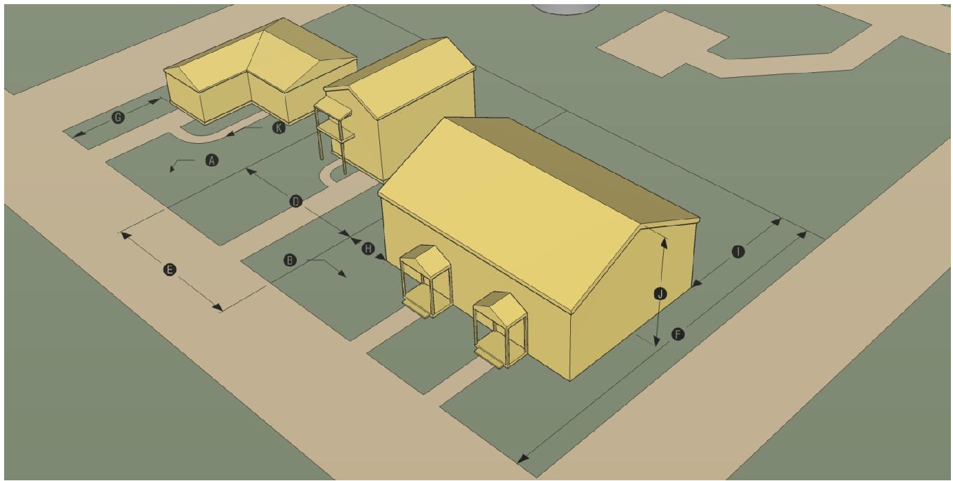
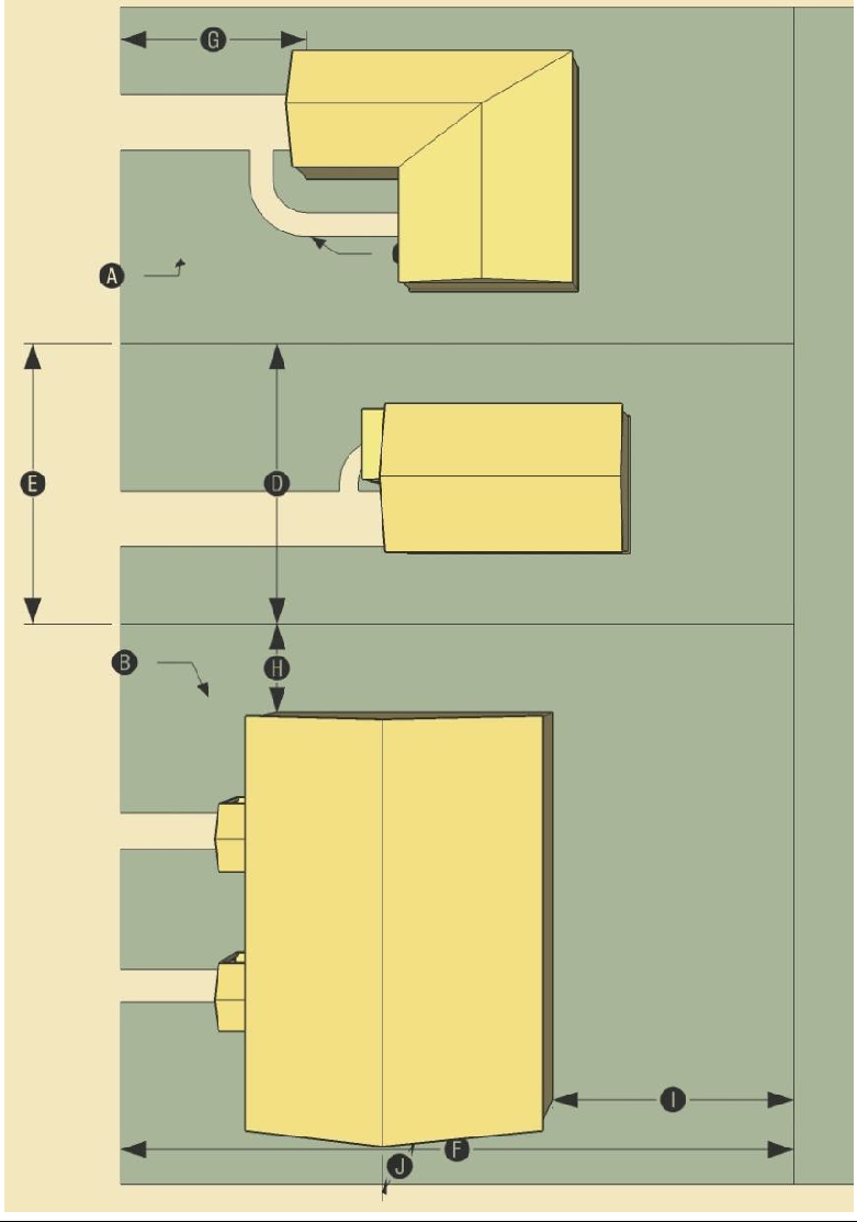
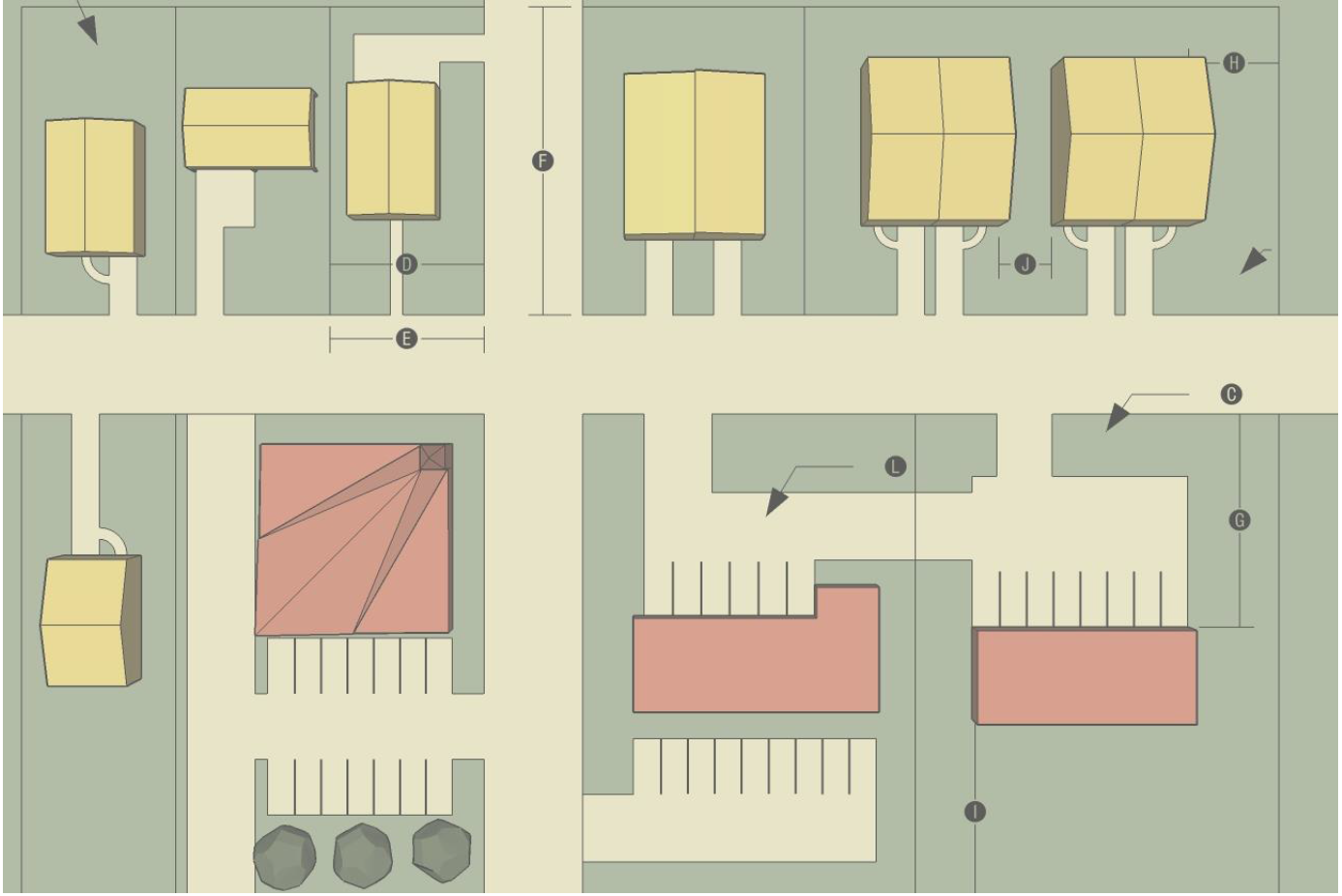
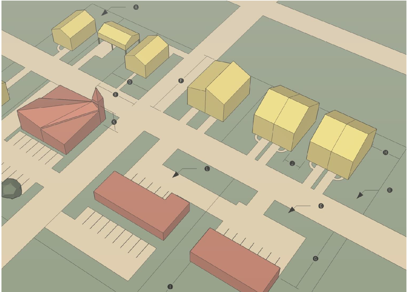
2.
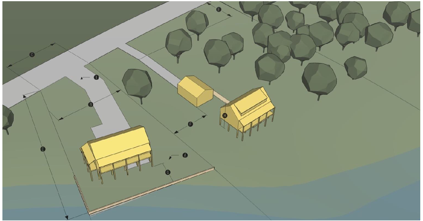
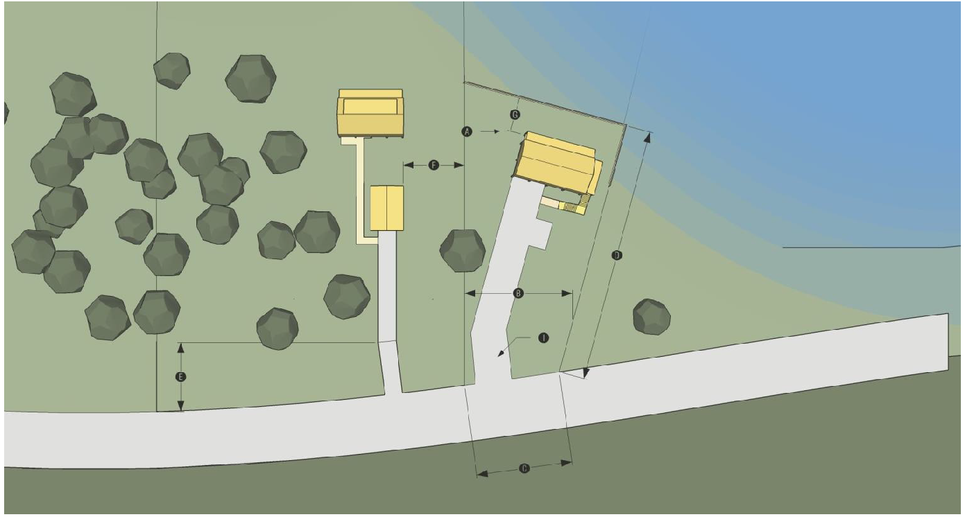
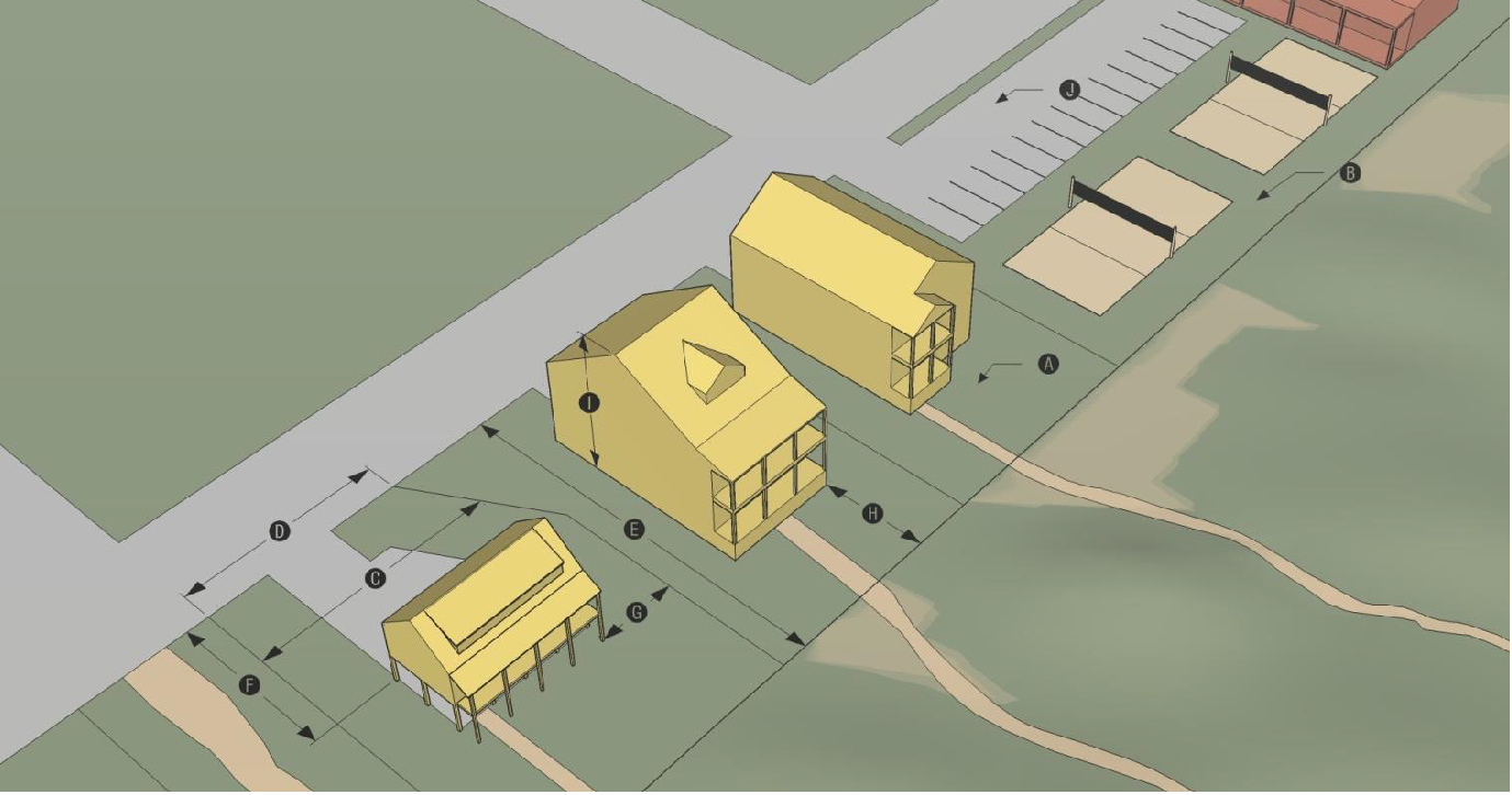
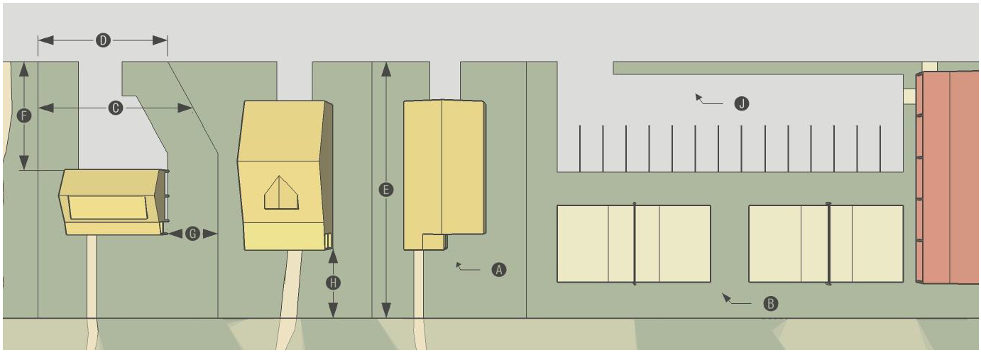
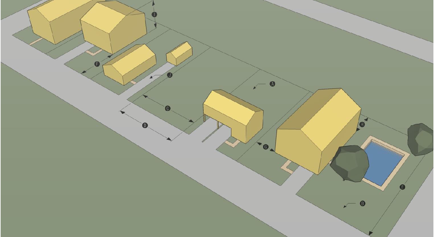
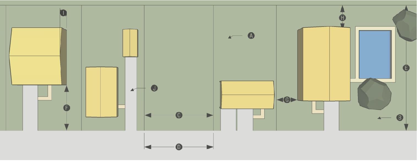
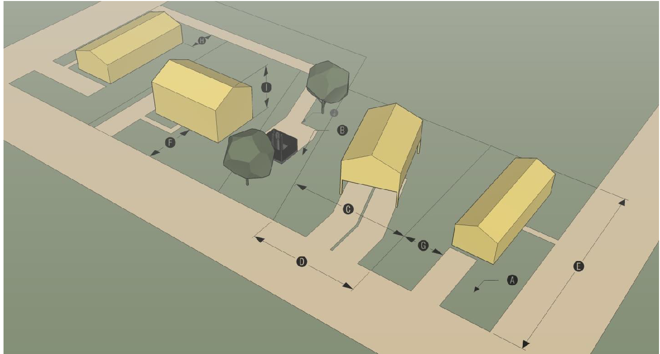
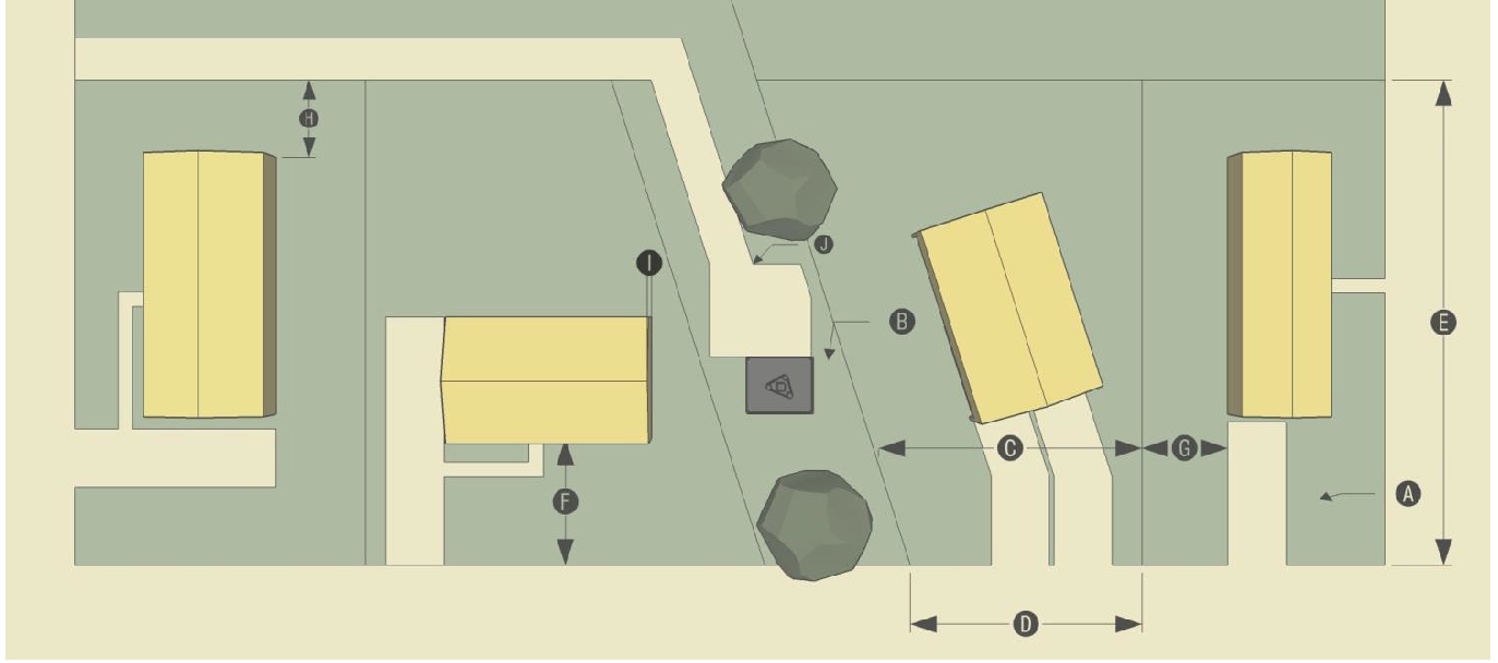
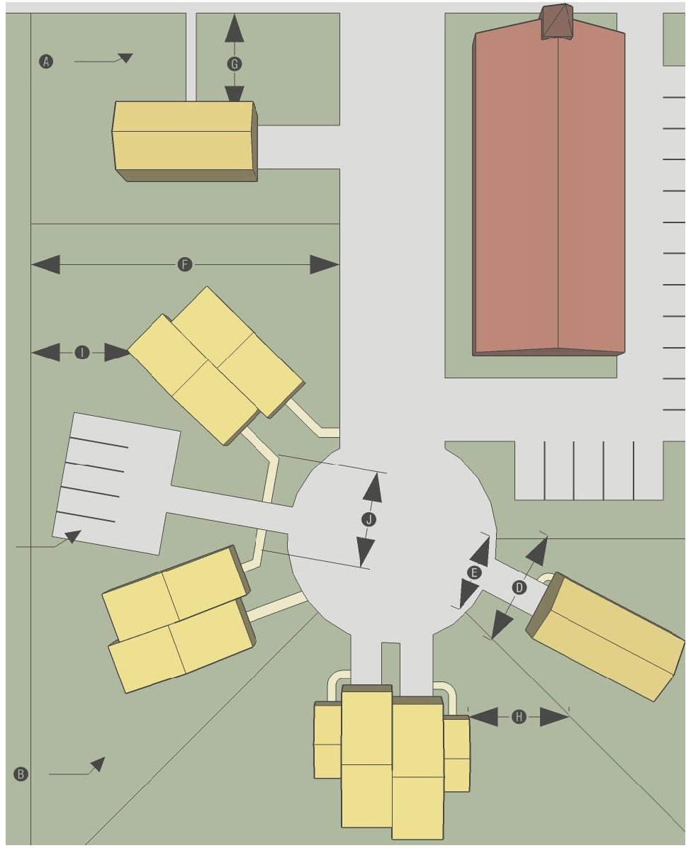
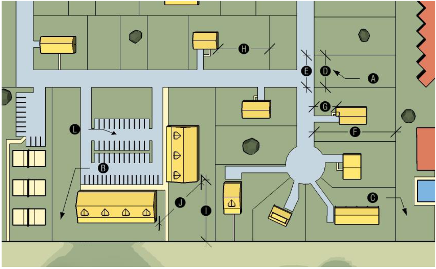
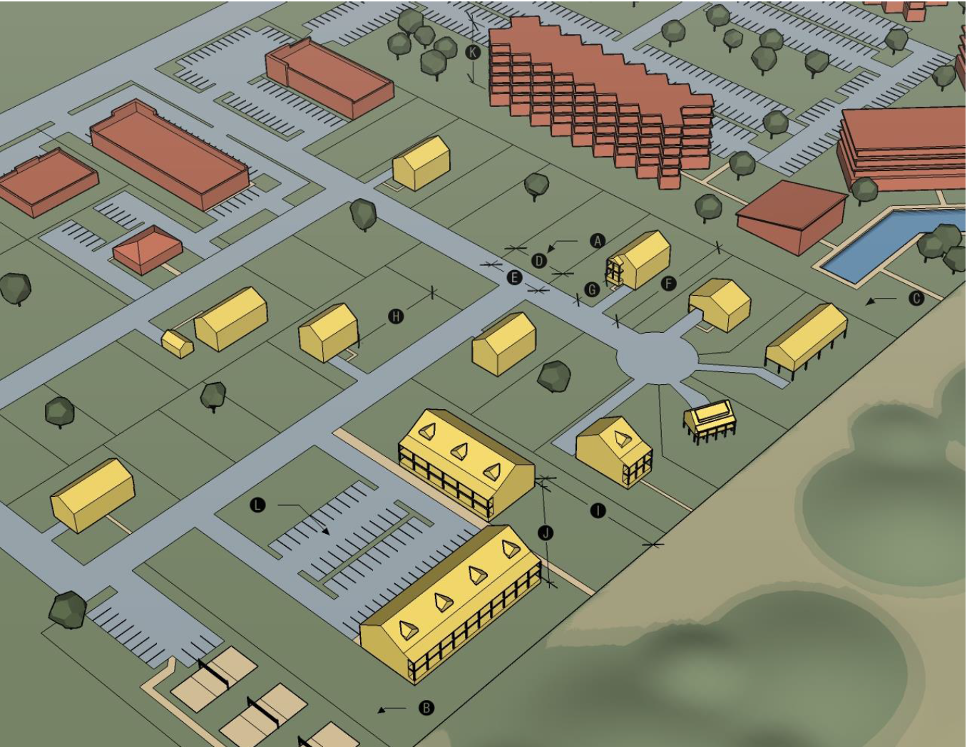
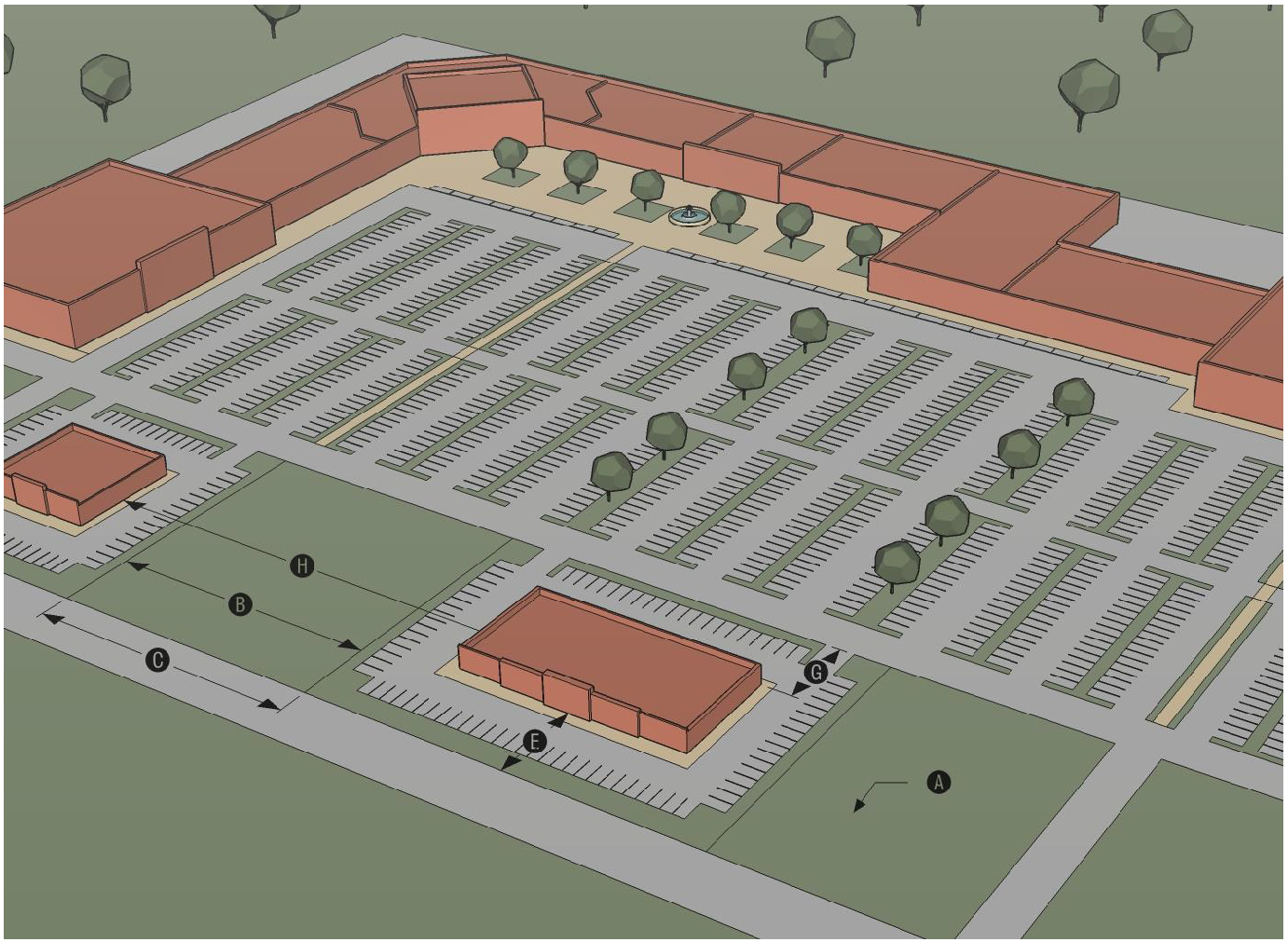
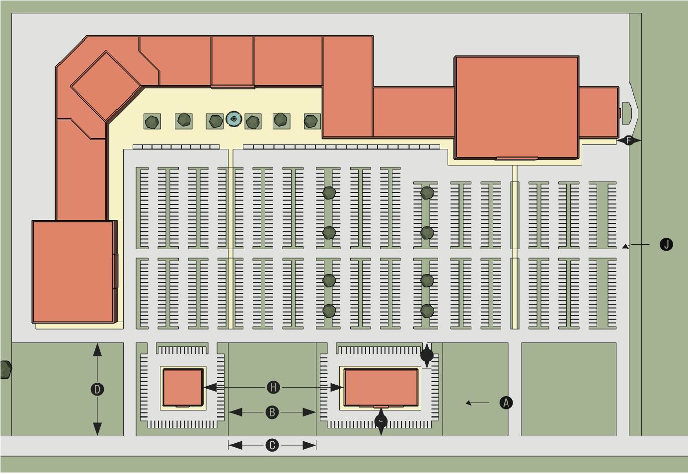
Each district includes a summary table of dimensional standards that include letters in black circles. The black circles in the dimensional standards table correspond to the black circles depicted in the district graphics.
3.
The building form, lot pattern, and development examples diagrams are for illustrative purposes only. In cases where an image conflicts with the text, the text of this Ordinance shall control.
4.
The range of allowable uses for each general zoning district is identified in Table 18.4.1.G, Principal Use Table.
5.
Some districts include district-specific standards that apply to all lands in the particular zoning district classification.
18.3.3. - Residential Zoning Districts
A.
General Purpose and Intent. The residential zoning districts established in this section are intended to provide a healthy and safe environment in which to live and recreate. More specifically, they are intended to:
1.
Provide appropriately located lands for residential development that are consistent with the Town's adopted policy guidance;
2.
Ensure adequate light, air, privacy, recreation, and open space areas for each dwelling;
3.
Provide for residential housing choice, affordability, and diversity with varying housing densities, types, and designs, including accessory dwelling units, where appropriate;
4.
Provide for safe and efficient vehicular access and circulation and pedestrian- and bicyclist-friendly neighborhoods;
5.
Provide for orderly growth and development within the Town;
6.
Provide for public services and facilities needed to serve residential areas while protecting residential areas from incompatible nonresidential development; and
7.
Create neighborhoods and preserve existing community character while accommodating new development and redevelopment consistent with the Town's goals and objectives.
B.
Residential Single-Family Conservation (RSC).
| Residential Single-Family Conservation (RSC) | 1. Purpose | ||
| The RSC district is established to accommodate one (1) single-family detached dwelling per lot in a manner that protects sensitive environmental features like existing trees, coastal habitat, and wetlands. Alteration of the existing topography, including deposition of fill, is limited. Individual single-family detached dwellings and complimentary accessory uses may be established in the RSC district following approval of a major site plan. Development in the RSC district shall take place only in accordance with the standards in this table and other relevant standards of this Ordinance. | |||
| 2. Dimensional Standards | |||
| Ref# | Standard | Requirement [1] | Notes |
| Minimum Lot Area - Per Single-Family Unit (acres) | 1 |
[1] Portions of lots within or abutting AEC or Ocean Hazard areas shall be subject
to applicable CAMA setbacks.
[2] Developments subject to a State stormwater permit are exempted from these standards. | |
| Maximum Residential Density (units/acre) | 1 | ||
| Minimum Lot Width (feet) | 60 | ||
| Minimum Street Frontage (linear feet) | 25 | ||
| Minimum Lot Depth (feet) | 100 | ||
| Minimum Street Setback (feet) | 50 | ||
| Minimum Side Setback (feet) | 20 | ||
| Minimum Rear Setback (feet) | 20 | ||
| Maximum Height (feet) | 45 | ||
| Maximum Impervious Surface Coverage % of lot area) [2] | 10 | ||
| 3. Dimensional Illustration | |||
 | |||
| 4. Typical Lotting Pattern | |||
 | |||
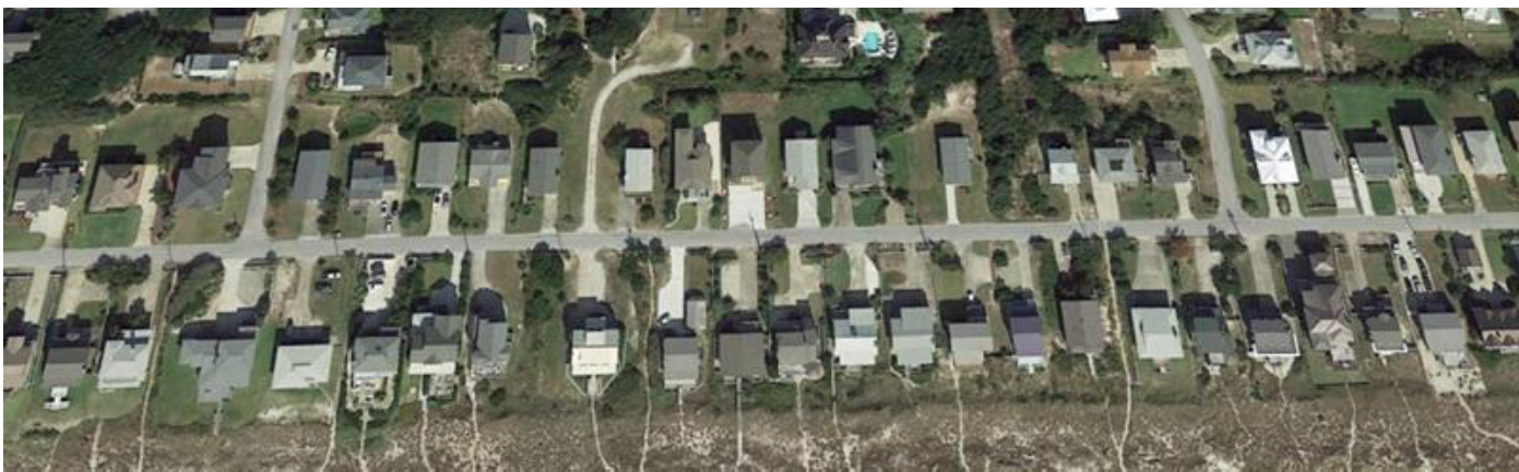
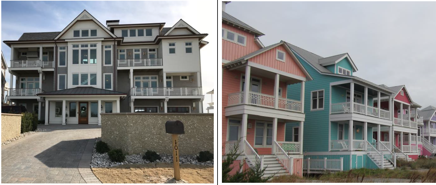
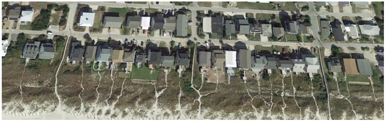
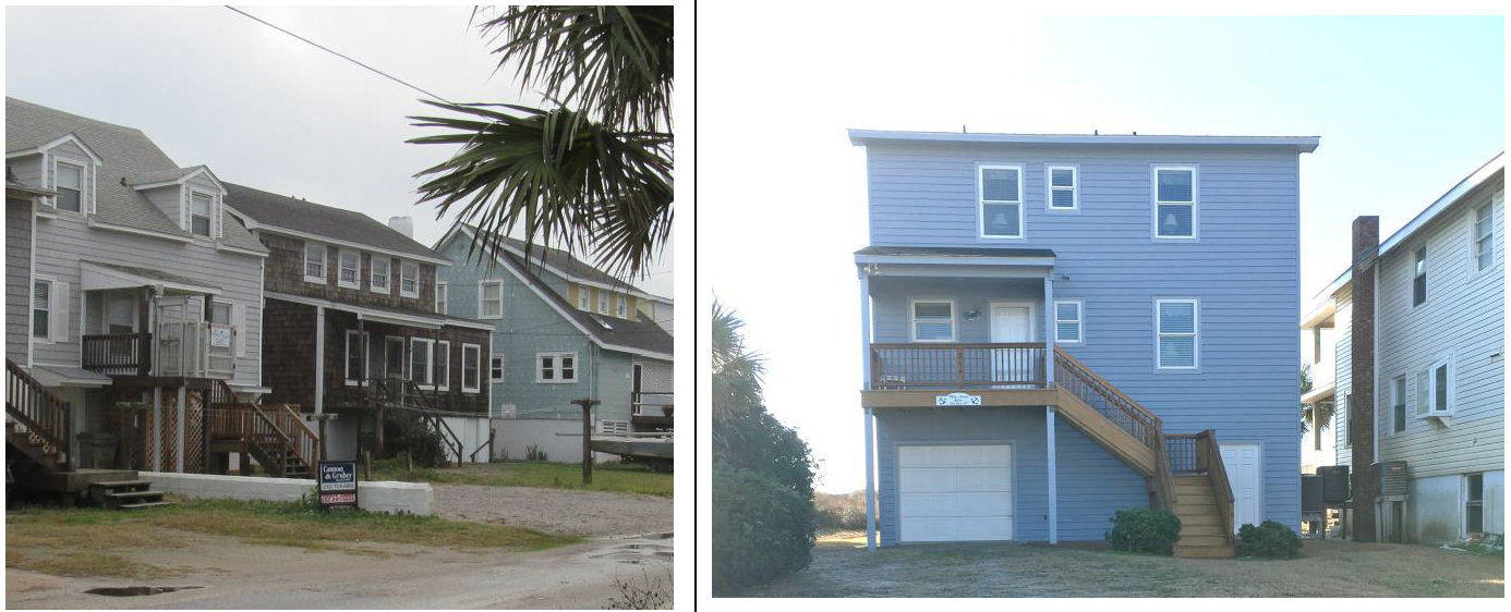
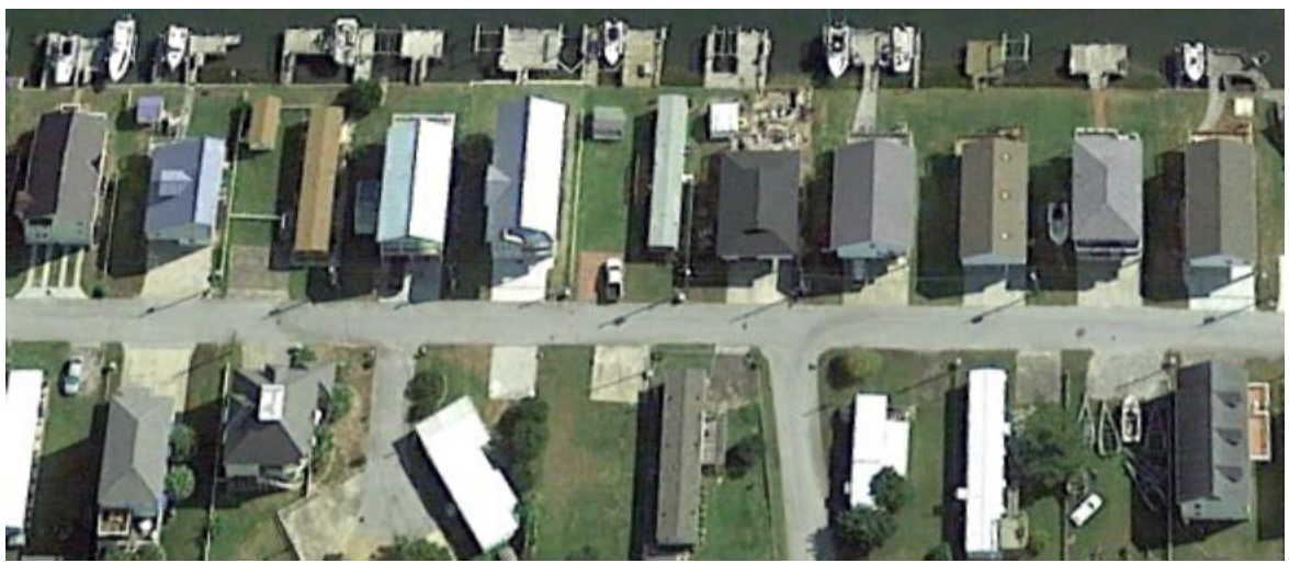
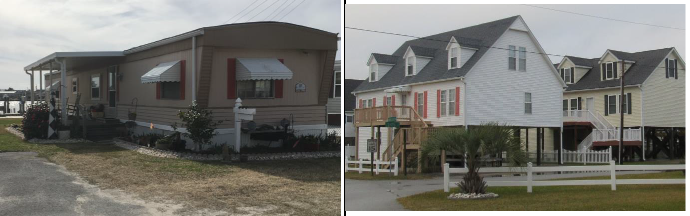
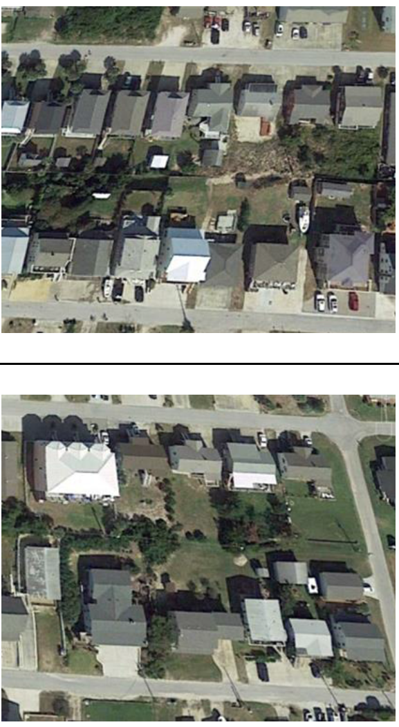
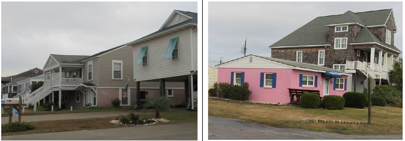
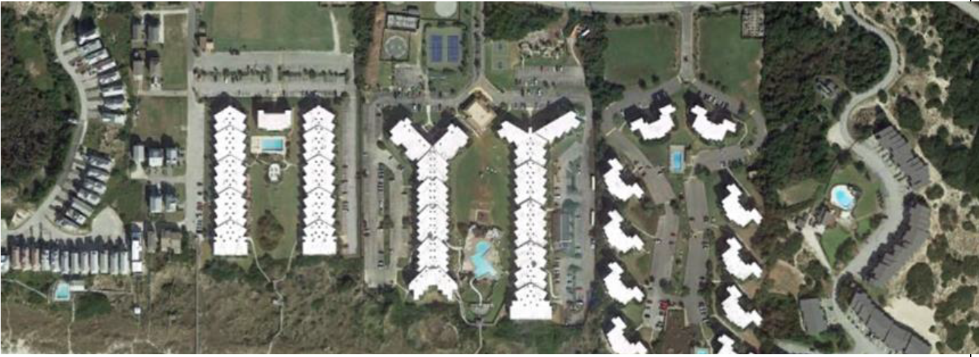
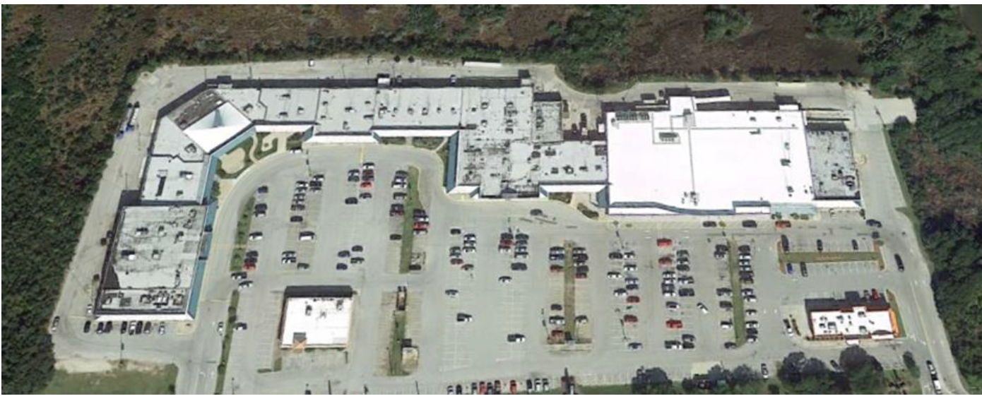
| 5. Aerial Photo | 6. Typical Forms of Development | ||
 |  | ||
| 7. District Specific Standards | |||
| a. Establishment of a principal use shall require approval of a major site plan in accordance with Section 18.2.4.P, Site Plan (Major/Minor). | |||
| b. Existing trees of three (3) inches in caliper or larger shall be retained during construction, to the maximum extent practicable. | |||
| c. No grading of the site shall take place, except as necessary for foundations and permanent vehicular access. | |||
| d. No deposition of fill shall take place except as necessary to accommodate an on-site wastewater system in accordance with Carteret County requirements. | |||
| e. Stormwater management systems and plans shall be designed to retain and infiltrate the first four (4) inches of stormwater runoff underground in accordance with Section 18.6.1.B.1.b. | |||
C.
Residential Single-Family Wide Yard (RSW).
| Residential Single-Family Wide Yard (RSW) | 1. Purpose | ||
| The RSW district is established to accommodate single-family detached dwellings at densities around seven (7) units an acre, along with parks, open space, and customary accessory uses. District regulations discourage any use that interferes with the development of single-family detached dwellings or that is detrimental to the residential nature of the district. Development in the RSW district shall take place only in accordance with the standards in this table and other relevant standards of this Ordinance. | |||
| 2. Dimensional Standards | |||
| Ref # | Standard | Require. [1] | Notes |
| Minimum Lot Area - Per Single-Family Unit (square feet) | 6,000 |
[1] Portions of lots within or abutting AEC or Ocean Hazard areas shall be subject
to applicable CAMA setbacks.
[2] Sub-Zone C includes lots within the RSW zoning district on the south side of West Atlantic Boulevard and Ocean Ridge Drive; and lots on the south side West Fort Macon Road to the west of Ocean Ridge Drive. Sub-Zone B includes lots within the RSW zoning district on Club Colony Drive, Sea Dreams Drive, and Sandpiper Court; and lots on East Fort Macon Road east of Henderson Boulevard. Sub-Zone A includes all other lots within the RSW zoning district not specifically listed as included in Sub-Zone C or Sub-Zone B. [3] Corner lots may reduce the rear setback to seven (7) feet. [4] Developments subject to a State stormwater permit are exempted from these standards. | |
| Maximum Residential Density (units/acre) | 7 | ||
| Minimum Lot Area - All Other Uses (square feet) | 12,000 | ||
| Minimum Lot Width (feet) | 60 | ||
| Minimum Lot Frontage (linear feet) | 25 | ||
| Minimum Lot Depth (feet) | 100 | ||
| Minimum Street Setback (feet) within Sub-Zone A | [2] 15 | ||
| Minimum Street Setback (feet) within Sub-Zone B | [2] 20 | ||
| Minimum Street Setback (feet) within Sub-Zone C | [2] 30 | ||
| Minimum Side Setback (feet) | 7 | ||
| Minimum Rear Setback (feet) | 20 [3] | ||
| Maximum Height (feet) | 45 | ||
| Maximum Impervious Surface Coverage (% of lot area) [4] | 40 | ||
| 3. Dimensional Illustration | |||
 | |||
| 4. Typical Lotting Pattern | |||
 | |||
| 5. Aerial Photo | |||
 | |||
| 6. Typical Forms of Development | |||
 | |||
D.
Residential Single-Family Narrow Yard (RSN).
| Residential Single-Family Narrow Yard (RSN) | 1. Purpose | ||
| The RSN district is established to accommodate single-family detached dwellings at densities of eight (8) units an acre, along with parks, open space, and customary accessory uses. District regulations discourage any use that interferes with the development of single-family detached dwellings or that is detrimental to the residential nature of the district. Development in the RSN district shall take place only in accordance with the standards in this table and other relevant standards of this Ordinance. | |||
| 2. Dimensional Standards | |||
| Ref # | Standard | Require. [1] | Notes |
| Minimum Lot Area - Per Single-Family Unit (square feet) | 5,000 |
[1] Portions of lots within or abutting AEC or Ocean Hazard areas shall be subject
to applicable CAMA setbacks.
[2] Corner lots may reduce the rear setback to five (5) feet. [3] Developments subject to a State stormwater permit are exempted from these standards. | |
| Maximum Residential Density (units/acre) | 8 | ||
| Minimum Lot Area - All Other Uses (square feet) | 10,000 | ||
| Minimum Lot Width (feet) | 50 | ||
| Minimum Street Frontage (linear feet) | 25 | ||
| Minimum Lot Depth (feet) | 100 | ||
| Minimum Street Setback (feet) | 15 | ||
| Minimum Side Setback (feet) | 5 | ||
| Minimum Rear Setback (feet) | 20 [2] | ||
| Maximum Height (feet) | 45 | ||
| Maximum Impervious Surface Coverage (% of lot area) [3] | 40 | ||
| 3. Dimensional Illustration | |||
 | |||
| 4. Typical Lotting Pattern | |||
 | |||
| 5. Aerial Photo | |||
 | |||
| 6. Typical Forms of Development | |||
 | |||
E.
Residential Single-Family Manufactured (RSM).
| Residential Single-family Manufactured (RSM) | 1. Purpose | ||
| The RSM district is established to accommodate single-family detached dwellings (including individual manufactured homes on their own lots) at densities of eight (8) units an acre, along with parks, open space, minor utilities, and customary accessory uses. District regulations discourage any use that interferes with the development of single-family detached dwellings or that is detrimental to the residential nature of the district. Development in the RSM district shall take place only in accordance with the standards in this table and other relevant standards of this Ordinance. | |||
| 2. Dimensional Standards | |||
| Ref # | Standard | Require. [1] | Notes |
| Minimum Lot Area - Per Single-Family Unit (square feet) | 5,000 |
[1] Portions of lots within or abutting AEC or Ocean Hazard areas shall be subject
to applicable CAMA setbacks.
[2] Corner lots may reduce the rear setback to seven (7) feet. [3] Developments subject to a State stormwater permit are exempted from these standards. | |
| Maximum Residential Density (units/acre) | 8 | ||
| Minimum Lot Area - All Other Uses (square feet) | 10,000 | ||
| Minimum Lot Width (feet) | 50 | ||
| Minimum Lot Frontage (linear feet) | 25 | ||
| Minimum Lot Depth (feet) | 100 | ||
| Minimum Street Setback (feet) | 15 | ||
| Minimum Side Setback (feet) | 7 | ||
| Minimum Rear Setback (feet) | 20 [2] | ||
| Maximum Height (feet) | 45 | ||
| Maximum Impervious Surface Coverage (% of lot area) [3] | 40 | ||
| 3. Dimensional Illustration | |||
 | |||
| 4. Typical Lotting Pattern | |||
 | |||
| 5. Aerial Photo | |||
 | |||
| 6. Typical Forms of Development | |||
 | |||
F.
Residential Single-Family and Duplex (RSD).
| Residential Single-Family & Duplex (RSD) | 1. Purpose | ||
| The RSD district is established to accommodate a mix of single-family detached and duplex dwellings, along with parks, open space, minor utilities, and customary accessory uses. District regulations discourage any use that interferes with the development of single-family detached dwellings or that is detrimental to the residential nature of the district. Development in the RSD district shall take place only in accordance with the standards in this table and other relevant standards of this Ordinance. | |||
| 2. Dimensional Standards | |||
| Ref # | Standard | Require. [1] | Notes |
| Minimum Lot Area - Per Single-Family Unit (square feet) | 5,000 |
[1] Portions of lots within or abutting AEC or Ocean Hazard areas shall be subject
to applicable CAMA setbacks.
[2] In cases where a duplex is on two (2) separate lots, the frontage standard applies to the entire development. [3] Developments subject to a State stormwater permit are exempted from these standards. [4] Corner lots may reduce the rear setback to five (5) feet. | |
| Maximum Residential Density - Single-Family (units/acre) | 8 | ||
| Minimum Lot Area - Per Duplex Building (square feet) | 7,200 | ||
| Maximum Residential Density - Duplex (individual units/acre) | 12 | ||
| Minimum Lot Area - All Other Uses (square feet) | 10,000 | ||
| Minimum Lot Width (feet) | 50 | ||
| Minimum Lot Frontage (linear feet) | 25 [2] | ||
| Minimum Lot Depth (feet) | 100 | ||
| Minimum Street Setback (feet) | 10 | ||
| Minimum Side Setback (feet) | 5 | ||
| Minimum Rear Setback (feet) | 10 | ||
| Maximum Height (feet) | 45 | ||
| Maximum Impervious Surface Coverage (% of lot area) [3] | 40 | ||
| 3. Dimensional Illustration | |||
 | |||
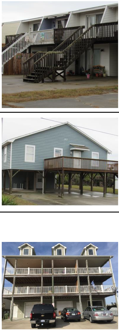
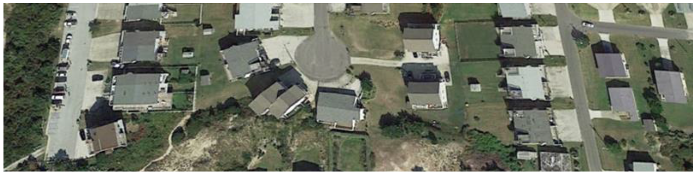
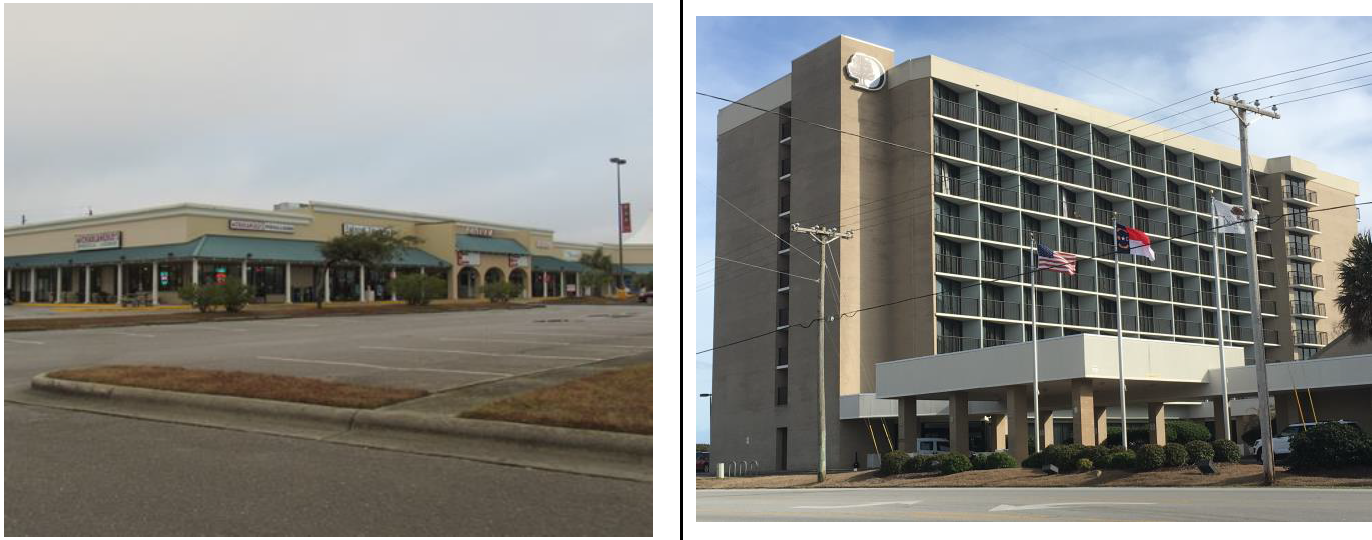
| 4. Typical Lotting Pattern | 5. Aerial Photo | ||
 |  | ||
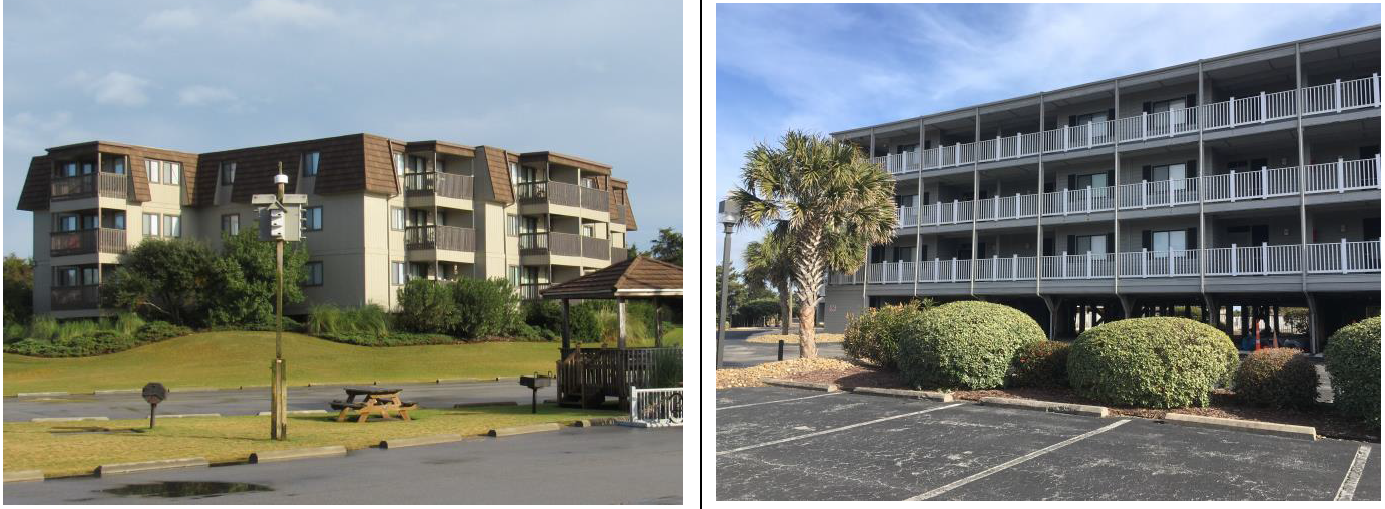
| 6. Typical Forms of Development | |||
 | |||
G.
Residential Multi-Family (RMF).
| Residential Multi-Family (RMF) | 1. Purpose | ||
| The RMF district is established to accommodate a wide range of residential uses, including single-family detached, duplex, multi-family, along with parks, open space, institutions, minor utilities, and minor visitor accommodations uses. Development in the RMF district shall take place only in accordance with the standards in this table and other relevant standards of this Ordinance. | |||
| 2. Dimensional Standards | 3. Dimensional Illustration | ||
| Ref # | Standard | Req. [1] | 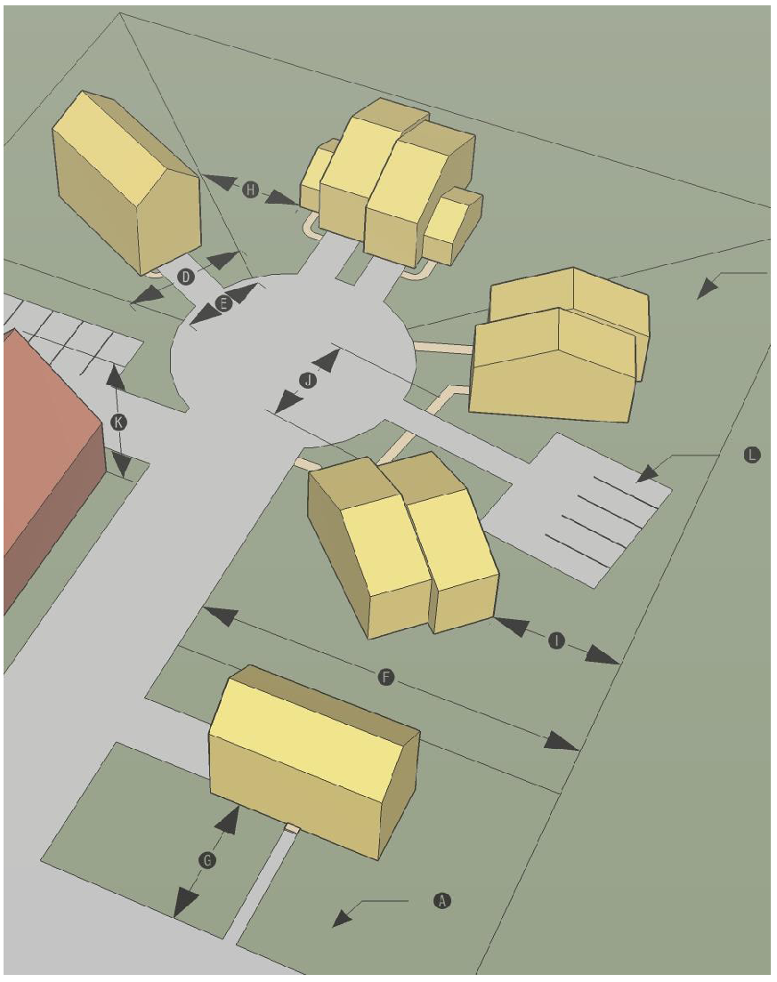 |
| Min. Lot Area - Per Single-Family Unit (sf) | 5,000 | ||
| Max. Residential Density - Single-Family (units/acre) | 8 | ||
| Min. Lot Area Per Unit - Duplex (sf) | 3,600 | ||
| Max. Residential Density - Duplex (individual units/acre) | 12 | ||
| Minimum Lot Area - All Other Uses (sf) | 10,000 | ||
| Minimum Lot Width (ft) | 50 | ||
| Min. Street Frontage (linear ft) | 25 [2] | ||
| Minimum Lot Depth (ft) | 100 | ||
| Min. Street Setback (ft) | 10 | ||
| Min. Side Setback (ft) | 5 | ||
| Min. Rear Setback (ft) | 10 [3] | ||
| Min. Spacing Between Buildings in same development (ft) | 15 | ||
| Maximum Height (ft) | 45 | ||
| Maximum Impervious Surface Coverage (% of lot area) | 40 [4] | ||
| Notes | |||
| [1] Portions of lots within or abutting AEC or Ocean Hazard areas shall be subject to applicable CAMA setbacks. | |||
| [2] In cases where a single multi-family structure is on two (2) or more separate lots, the frontage standard applies to the entire development. | |||
| [3] Corner lots with single-family detached and duplex dwellings may reduce the rear setback to five (5) feet. | |||
| [4] Developments subject to a State stormwater permit are exempted from these standards. | |||
| 4. Typical Lotting Illustration | 5. Typical Development Illustrations | ||
 |  | ||
| 6. Aerial Photo | |||
 | |||
(Ord. No. 19-01-03, 1-28-2019; Ord. No. 19-03-02, 3-25-2019; Ord. No. 20-01-01, 1-27-2020; Ord. No. 22-11-01, 11-21-22)
18.3.4. - Mixed Use Districts.
A.
General Purpose and Intent. The mixed use districts established in this section are intended to provide areas for development that serve permanent residents, seasonal residents, and tourists with a variety of residential building types and non-residential uses that support a compact, pedestrian-oriented, mixed-use environment. More specifically, they are intended to:
1.
Foster the establishment of residential, employment, shopping, and recreation uses in close proximity to one another in order to allow residents and visitors to meet some of their daily needs without use of an automobile;
2.
Promote functioning neighborhoods with a wide variety of residential housing types to accommodate residents of different income levels;
3.
Accommodate use mixing within single-buildings, on lots with multiple buildings, and in adjacent developments; and
4.
Support development densities and configurations that encourage an efficient and effective circulation system for vehicles, bicycles, and pedestrians.
B.
Mixed Use Neighborhood (MUN).
| Mixed Use Neighborhood (MUN) | 1. Purpose | |
| The MUN district is established to accommodate a blend of mixed uses at a neighborhood scale. The district accommodates most forms of residential development, numerous institutional uses, and a wide range of commercial uses. Development is configured to facilitate safe and efficient circulation by automobile, bicycle, and on foot. Development in the MUN district shall take place only in accordance with the standards in this table and other relevant standards of this Ordinance. | ||
| 2. Dimensional Standards | ||
| Ref# | Standard | Requirement [1] |
| Minimum Lot Area - Per Single-Family Unit (square feet) | 5,000 | |
| Maximum Residential Density - Single-Family Development (units/acre) | 8 | |
| Minimum Lot Area - All Other Uses (square feet) | 10,000 | |
| Minimum Lot Width (feet) | 50 | |
| Minimum Street Frontage (linear feet) | 25 | |
| Minimum Lot Depth (feet) | 100 | |
| Minimum Street Setback (feet) | 10 | |
| Minimum Side Setback (feet) | 5 | |
| Minimum Rear Setback (feet) | 10 [3] | |
| Minimum Spacing Between Buildings in the same Development (feet) | 15 | |
| Maximum Height (feet) | 45 | |
| Maximum Impervious Surface Coverage (% of lot area) [2] | 40 | |
| [1] Portions of lots within or abutting AEC or Ocean Hazard areas shall be subject to applicable CAMA setbacks. | ||
| [2] Developments subject to a State stormwater permit are exempted from these standards. | ||
| [3] Corner lots with single-family and duplex development may reduce the rear setback to five (5) feet. | ||
| 3. Typical Lotting Pattern | ||
 | ||
| 4. Aerial Photo | ||
 | ||
| 5. Dimensional Illustration | ||
 | ||
| 6. Typical Forms of Development | ||
 | ||
C.
Mixed Use High Intensity (MHI).
| Mixed Use High Intensity (MHI) | 1. Purpose | |
| The MHI district is established to provide areas, which, due to their location, natural features and access, have an extremely high potential for both permanent and tourist types of residential development. Commercial uses are permitted and shall be oriented to tourist related activities which reflect a family atmosphere. Development in the MHI district shall take place only in accordance with the standards in this table and other relevant standards of this Ordinance. | ||
| 2. Dimensional Standards | ||
| Ref # | Standard | Requirement [1] |
| Minimum Lot Area - Per Single-Family Unit (square feet) | 5,000 | |
| Maximum Residential Density - Single-Family Development (units/acre) | 8 | |
| Minimum Lot Area - Per Multi-Family Unit (in developments with four or less units) (square feet) | 3,600 | |
| Maximum Residential Density - Multi-Family Development (in developments with four or less units) (units/acre) | 12 | |
| Minimum Lot Area - Per Multi-Family Unit (in developments with five or more units) (square feet) | 2,000 | |
| Maximum Residential Density - Multi-Family Development (in developments with five or more units) | 21 | |
| Minimum Lot Area - All Other Uses (square feet) | 10,000 | |
| Minimum Lot Width (feet) | 50 | |
| Minimum Street Frontage (linear feet) | 25 [2] | |
| Minimum Lot Depth (feet) | 100 | |
| Minimum Street Setback (feet) | 25 [3] | |
| Minimum Side Setback (feet) | 10 [4] [8] | |
| Minimum Rear Setback (feet) | 20 [3] [5] [8] | |
| Minimum Spacing Between Buildings in the same Development (feet) | 15 | |
| Maximum Height (feet) | 55 [6] | |
| Maximum Impervious Surface Coverage (% of lot area) [7] | 40 | |
| [1] Portions of lots within or abutting AEC or Ocean Hazard areas shall be subject to applicable CAMA setbacks. | ||
| [2] In cases where a multi-family development is on two (2) or more separate lots, the frontage standard applies to the entire development. | ||
| [3] Single-family and duplex dwellings shall have ten-foot street and rear setbacks. | ||
| [4] Single-family and duplex dwellings shall have a five-foot side setback. | ||
| [5] Corner lots shall have a rear setback of ten (10) feet. Single-family detached and duplex dwellings on corner lots shall have a rear setback of five (5) feet. | ||
| [6] Single-family and duplex dwellings shall have a maximum height of 45 feet. | ||
| [7] Developments subject to a State stormwater permit are exempted from these standards. | ||
| [8] Minimum setbacks shall be doubled for multi-family and townhouse development on a lot abutting a residential zoning district. | ||
| 3. Typical Lotting Pattern | ||
 | ||
| 4. Aerial Photo | ||
 | ||
| 5. Dimensional Illustration | ||
 | ||
| 6. Typical Development Illustrations | ||
 | ||
(Ord. No. 19-03-03, 3-25-2019; Ord. No. 19-08-02, 8-26-2019; Ord. No. 20-01-01, 1-27-2020; Ord. No. 22-11-01, 11-21-22)
18.3.5. - Commercial Districts.
A.
General Purpose and Intent. The commercial zoning districts are established for the general purpose of ensuring there are lands in the Town that provide a wide range of office, retail, service, and related uses to meet household and business needs. More specifically they are intended to:
1.
Provide appropriately located lands for the full range of business uses needed by the Town's residents, businesses, and workers, consistent with the Town's adopted policy guidance;
2.
Establish the "Circle" area as the core of the Town's civic, retail, office, institutional, commercial, and entertainment areas;
3.
Strengthen the Town's economic base and provide employment opportunities close to home for residents of the Town and surrounding communities;
4.
Create suitable environments for various types of business uses, and protect them from the adverse effects of incompatible uses;
5.
Accommodate vertical mixed-use buildings with retail, service, office, institutional, and other uses on the ground floor and residential units above the nonresidential space;
6.
Encourage development that exhibits the physical design characteristics of pedestrian-oriented, storefront-style shopping streets;
7.
Promote the health and well-being of residents by encouraging physical activity, interconnectivity through pedestrian facilities, and greater social interaction; and
8.
Minimize the impact of business development on residential districts and uses and sensitive natural environments.
B.
Commercial Circle (CIR).
| Commercial Circle (CIR) | 1. Purpose | |
| The CIR district is established to preserve and protect the traditional core of the Town as the primary civic, business, and cultural destination for visitors and residents. Vertically integrated mixed uses with retail and other street-activating uses on the ground floor of buildings with residential and office uses on the upper floors are appropriate in the CIR district. Building height and use intensity should be highest at the core of the district and gradually decline toward the district edges for greater compatibility with surrounding lands. The district is intended to function as a "park once" environment where residents and customers use central parking facilities and walk among the uses. Development in the CIR district shall take place only in accordance with the standards in this table and other relevant standards of this Ordinance. | ||
| 2. Dimensional Standards | ||
| Ref # | Standard | Requirement [1] |
| Minimum Lot Area - Uses Served by Public or Private Sanitary Sewer | None | |
| Minimum Lot Area - Uses Not Served by Public or Private Sanitary Sewer | [2] | |
| Maximum Gross Residential Density (units per acre) | 50 [3] [4] | |
| Maximum FAR | [5] | |
| Minimum Area per Residential Unit (square feet) | 600 | |
| Minimum Street Setback from Major Roadways (feet) [6] | 0 | |
| Maximum Street Setback from Major Roadways (feet) [6] | 15 | |
| Minimum Street Setback for all Other Roadways (feet) | 10 | |
| Maximum Street Setback for all Other Roadways (feet) | 25 | |
| Minimum Setback from CIR District Boundary [7] (feet) | 10 [8] | |
| Minimum Side Setback (feet) | 0 [9] | |
| Minimum Rear Setback (feet) | 0 [10] | |
| Maximum Height (feet) | [11] | |
| Maximum Impervious Surface Coverage (% of lot area) | 40 [12] | |
| [1] Portions of lots within or abutting AEC or Ocean Hazard areas shall be subject to applicable CAMA setbacks. | ||
| [2] As required by Carteret County Health Department for an on-site septic system. | ||
| [3] Development shall not exceed the maximum allowable FAR, even if additional residential density is available. | ||
| [4] Maximum density may be increased up to fifty-five (55) units/acre based on inclusion of nonresidential floor area. | ||
| [5] See Section 18.3.5.B.a, FAR Requirements in the CIR District. | ||
| [6] Major roadways include the portions of Fort Macon Road, Atlantic Boulevard, East Drive, and West Drive located within the CIR district boundary. | ||
| [7] When the district boundary follows a street the street setback standards shall apply. | ||
| [8] District setbacks may be reduced to five (5) feet for single-family detached development. | ||
| [9] In cases where the lot abuts an unbuilt public right-of-way, an alleyway, a bike path, or a public walkway, the minimum side setback shall be five (5) feet. | ||
| [10] Nonresidential development on a lot abutting an unbuilt public right-of-way, an alleyway, a bike path, or a public walkway, shall maintain a minimum side setback of five (5) feet. | ||
| [11] See Section 18.3.5.B.7.c, Height Requirements in the CIR District. | ||
| [12] Lots that include stormwater management devices prepared in accordance with a stormwater management master plan meeting the Town's minimum requirements or that are subject to a State stormwater permit have no impervious surface coverage limitations. | ||
| 3. Dimensional Illustration | ||
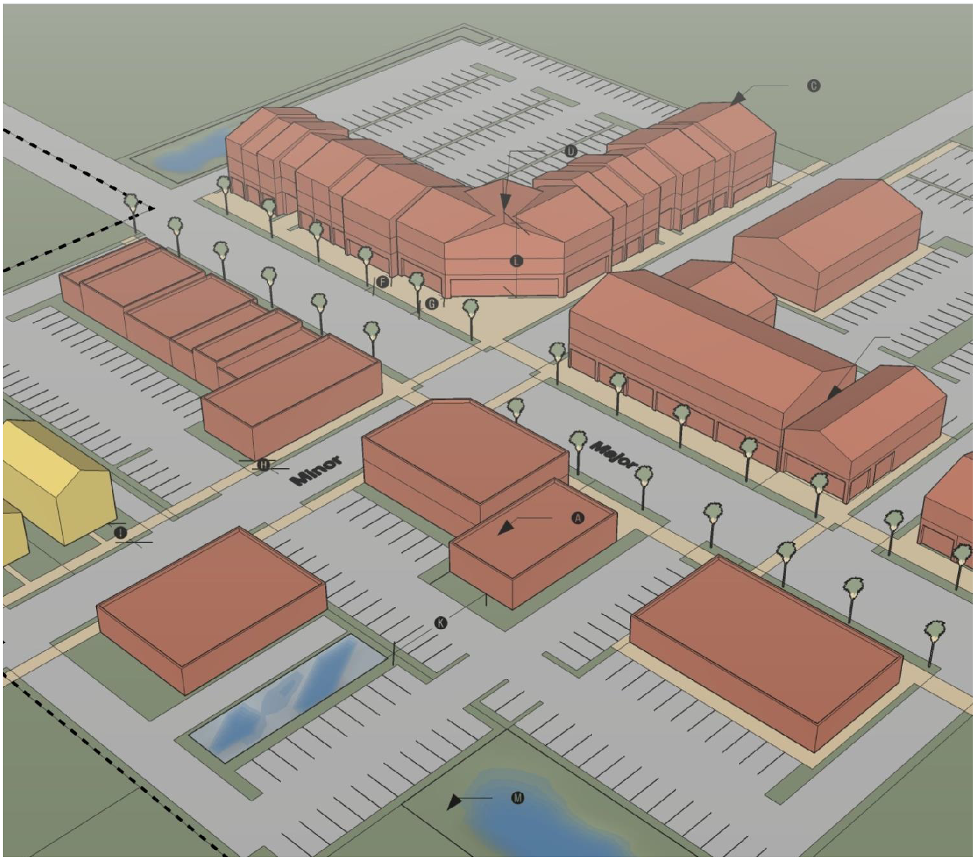 | ||
| 4. Typical Lotting Pattern | ||
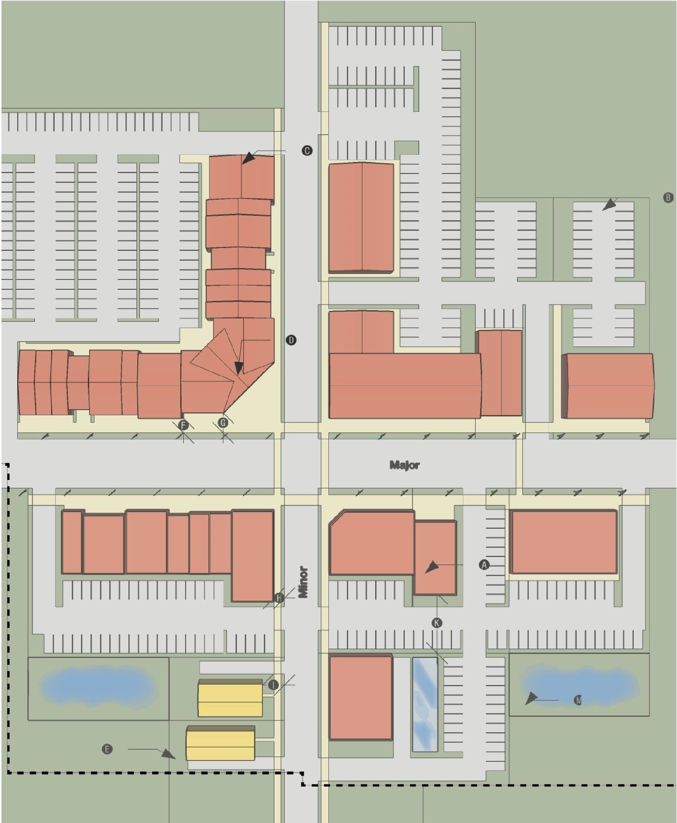 | ||
| 5. Aerial Photo | ||
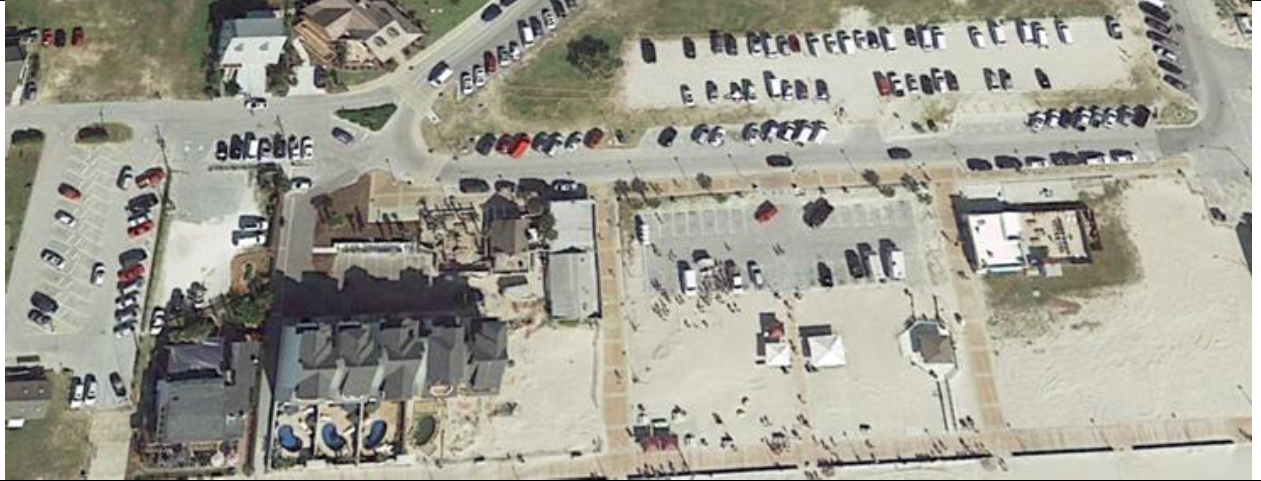 | ||
| 6. Typical Forms of Development | ||
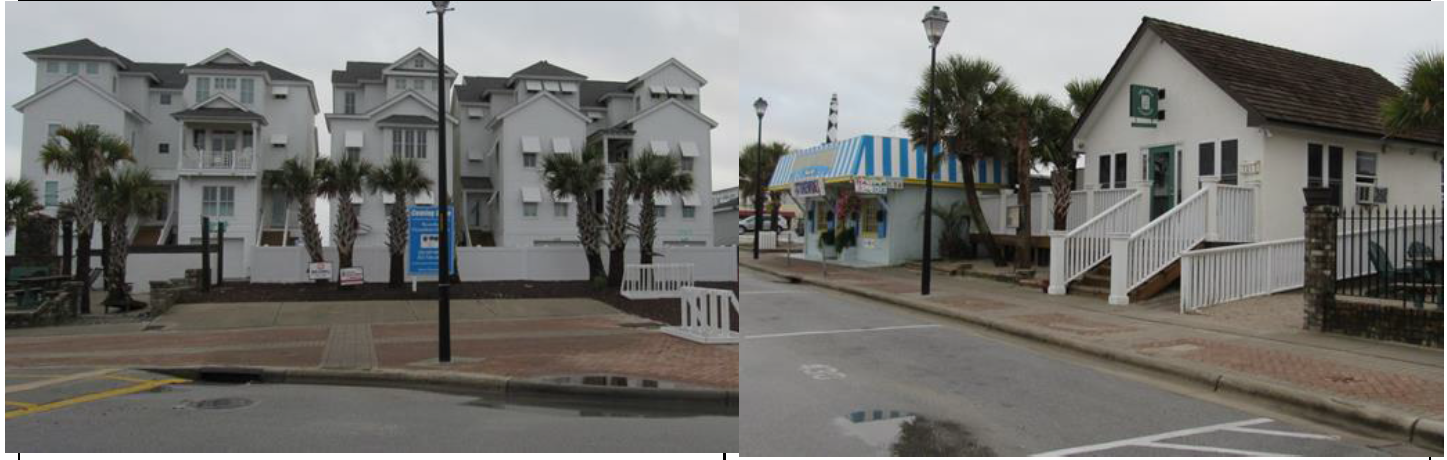 | ||
7.
District-Specific Standards.
a.
FAR Requirements in the CIR District. Development in the CIR District shall be subject to the following floor area ratio (FAR) standards.
i.
Generally.
a)
The maximum allowable amount of floor area per lot is determined by multiplying the lot's square footage by the floor area multiplier corresponding to the number of building stories in Section 18.3.5.B.a.ii, Floor Area Multiplier.
b)
The maximum amount of floor area is then divided by the number of building stories to determine the approximate amount of floor area per building story.
c)
To ensure floor area within a multi-story building is equitably distributed, no single story of a building shall have a floor area that exceeds the floor area of the smallest story by more than one hundred twenty-five (125) percent.
d)
The portions of building area that are or are not counted as floor area as described in Section 18.10.2.F, Gross Floor Area.
ii.
Floor Area Multiplier. The following standards set out the floor area multiplier for use in determining the maximum allowable floor area for buildings in the CIR district.
a)
One (1) story: 0.4
b)
Two (2) stories: 0.6
c)
Three (3) stories: 0.8
d)
Four (4) stories: 1.0
e)
Five (5) stories: 1.2
f)
Six (6) stories: 1.4
g)
Seven (7) stories: 1.6
h)
Eight (8) stories: 1.8
i)
Nine (9) or more stories: 2.0
iii.
FAR Determination for Multiple Lots. Where an application for development contains multiple lots, density/FAR may be calculated on the total amount of acreage and available maximum building height provided:
a)
All lots used for density increases must be fully contained within the CIR District;
b)
All developments utilizing increased density allocations or parcels from which allocations have been previously allotted shall be identified on a Town-approved on a Master Development Plan;
c)
All lots transferring density and/or receiving density increases must be owned completely under the same ownership. Under no circumstances shall density be transferred from one (1) landowner to another;
d)
The cumulative density of the development cannot exceed that allowable under the prescribed criteria for single lots;
e)
Vacant lots or acreage from within the CIR district used for maximum density increases on another site in the CIR district shall remain in perpetual open space and shall clearly reference on the development plan:
i)
The generating parcel;
ii)
The maximum possible development amounts from the generating parcel;
iii)
Any previously allocated amounts;
iv)
The total amount being allocated;
v)
The total remaining possible development allocations;
vi)
A reference to the parcel receiving the allocation;
vii)
The parcel receiving the allocation;
viii)
The maximum density allowed for the receiving parcel (before allocations);
ix)
Total amount of development on receiving parcel after allocations; and
x)
A reference to the parcel from which the increases were allocated.
f)
Developed or partially developed lots or acreage allocating density increases to other sites shall clearly note on the development plan:
i)
The generating parcel;
ii)
The maximum possible development amounts from the generating parcel;
iii)
The amount of existing or proposed development;
iv)
Any previously allocated amounts;
v)
The total amount being allocated;
vi)
The total remaining possible development and/or allocations;
vii)
A reference to the parcel receiving the allocation;
viii)
The parcel receiving the allocation;
ix)
The maximum density allowed for the receiving parcel (before allocations);
x)
Total amount of development on receiving parcel, after allocations; and
xi)
A reference to the parcel from which the increases were allocated.
b.
Density Bonuses in the CIR District. To encourage a mixture of residential and non-residential uses, residential densities may be increased by 0.75 for each one thousand (1,000) square feet of gross floor area dedicated to non-residential use; provided, however, that the total density of the development does not exceed fifty-five (55) units per acre. In determining possible additional units allowed, fractional numbers less than 0.75 (<.75) shall be rounded down while fractions greater than 0.75 (>.75) shall be rounded up to the nearest whole number.
EXAMPLE: 10,890 sf building (2 levels/5,444 sf used non-residential) 5,444 ÷ 1,000 = 5.44 × .75 = 4.08 or 4 additional dwelling units.
c.
Height Requirements in the CIR District. The maximum height for buildings in the CIR district shall be in accordance with Section 18.10.2.H, Height, and the following:
i.
Sub-Area Zone A. The maximum building height is one hundred fifty-five (155) feet.
ii.
Sub-Area Zone A-1. The maximum building height is one hundred eighty-five (185) feet.
iii.
Sub-Area Zone B. The maximum building height is fifty-five (55) feet.
iv.
Sub-Area Zone C. The maximum building height is forty-five (45) feet.
d.
Building Orientation and Entry in the CIR District. Buildings within the CIR district shall comply with the following building orientation and entry standards:
i.
General Requirements.
a)
Building facades shall be generally parallel or perpendicular to the street in order to form a continuous street wall.
b)
Buildings shall include an entrance facing the public street they front. Entries on side streets are encouraged, but not required.
c)
All principal building entryways shall incorporate an entryway transition (e.g., an arcade, canopy, archway, patio, building wall projection or recess, etc.) between the building façade at the street it faces.
d)
Improved pedestrian access shall be provided to all public entryways that are not adjacent to a sidewalk or pedestrian way.
ii.
Entryways for Buildings Fronting Fort Macon Road, Atlantic Boulevard, East Drive, and West Drive. Buildings fronting Fort Macon Road, Atlantic Boulevard, East Drive, and West Drive shall be configured so that at least seventy-five (75) percent of one (1) level is occupied by non-residential uses. Access to the required non-residential use(s) shall be provided at ground level and shall be handicapped accessible.
iii.
Entryways for Residential Uses.
a)
Where a residential entryway is located on a sidewalk or pedestrian way level, it shall be designed to clearly differentiate it from other commercial entrances in one (1) or more of the following ways:
i)
A recessed entryway with a minimum depth of thirty-six (36) inches;
ii)
An elevation of the entryway via steps or ramp to a height of at least fourteen (14) inches above the sidewalk or walkway grade; or
iii)
Other techniques, as approved by the UDO Administrator.
b)
In no instance shall the inclusion of steps, landings, or similar features reduce the adjacent public sidewalk or walkway width to less than six (6) feet.
e.
Building Articulation in the CIR District.
i.
Generally. Building facades subject to these standards shall be configured to emphasize visual interest for the pedestrian through inclusion of one (1) or more of the following elements:
a)
Modulation of the building façade, or projections or recesses from the primary building wall plane of a depth of at least three (3) feet;
b)
Inclusion of building elements that break up the building façade such as balconies, porches, canopies, towers, entry areas, or building wings;
c)
Inclusion of building focal points such as distinctive entry features; or
d)
Changes to building materials in logical locations and having logical expanses.
ii.
Building Facades Fronting Fort Macon Road, Atlantic Boulevard, East Drive, and West Drive. Buildings facades facing these streets shall include building articulation features across the first three (3) stories.
iii.
Buildings Facades Fronting Other Streets. Building facades fronting streets in the CIR district other than Fort Macon Road, Atlantic Boulevard, East Drive, and West Drive shall include building articulation features across the first one and one-half (1½) stories.
iv.
Building Facades Facing Alleys or Unopened Rights-of-Way. Building facades facing alleys or unopened rights-of-way are exempted from providing building articulation features.
f.
Building Fenestration in the CIR District.
i.
At least fifty (50) percent of the ground-floor level of the front façade of a building shall be configured to include windows, doors, or other visually permeable openings.
ii.
At least twenty-five (25) percent of the ground floor level of a side or rear building façade facing a street, alley, unopened right-of-way, boardwalk, greenway, walking/bicycle trail, sidewalk, other public travelway, or dedicated public open space shall be configured to include windows, doors, or other visually permeable openings.
iii.
Expanses of solid wall shall not exceed twenty (20) feet in length.
iv.
These standards shall not apply to building facades that do not front a street, alley, unopened right-of-way, boardwalk, greenway, walking/bicycle trail, sidewalk, other public travelway, or dedicated public open space.
g.
Landscaping and Screening Standards in the CIR District.
i.
Generally.
a)
For developments in the CIR district, the landscaping requirements provided in Section 18.5.4, Landscaping, shall be exempt; however, the perimeter buffer requirements of Section 18.5.4, Landscaping, shall apply. Plant materials utilized in meeting the requirements set forth in this section may be chosen from the recommended species list maintained in the Planning Department and/or the Public Works Department. This list encourages the use of plant materials which are indigenous to this region and which should be reasonably available from local nurseries. Plant materials which are not on the list may also be used provided such plants are recommended in writing by a licensed landscape architect and following approval by the UDO Administrator.
b)
All plantings shall be maintained in order to provide their intended purpose. Dead or dying plants required by this section shall be replaced, upon notification, in accordance to the planting requirements of this section.
ii.
On-Site Landscaping Standards.
a)
The landscape standards set forth in this section require landscaping between dissimilar land uses, along public rights-of-way, and in and around parking lots, in order to:
i)
Encourage the preservation of existing trees and vegetation and replenish removed vegetation.
ii)
Improve the visual quality of the Town and minimize the potential impacts of development such as noise, dust, and glare of lights.
iii)
Provide a transition between dissimilar land uses to protect abutting properties from potential negative impacts of neighboring development and to preserve the character and value of a property and provide a sense of privacy.
iv)
Require the maintenance of landscaping installed to ensure that the landscaping continues to thrive and meet these stated objectives.
b)
New development within the CIR district shall bring the entire site into full compliance with the requirements of this section. Major repair or reconstruction on a property in an amount equal to fifty (50) percent or greater of the tax value of the building, must bring the entire site into full compliance with the requirements of this section. This shall include the removal of asphalt or similar paving material from existing parking lots or other areas without landscape materials, but shall not require the removal or relocation of the principal structure. In instances where landscaping cannot be provided due to principal structure location, a fee in-lieu equal to one hundred fifty (150) percent of the estimated cost for plantings that would be required may be paid to the Town for planting and maintenance of landscaping in other areas of the CIR.
c)
Expansions or additions must generally meet the landscaping requirements only in the area around the addition that is parallel to any edge of the expansion area and extending to the property line or street pavement edge. However, where the cost of an expansion or addition is equal to fifty (50) percent or more of the tax value of the property, the entire site must be brought into full compliance.
d)
Landscaping Alternatives. Alternative landscaping plans may be used where unreasonable or impractical situations would result from application of the landscaping requirements. Such situations may result from natural land formations, dunes, topography or other physical conditions, or from lot configuration, utility easements or unusual site conditions not pertaining to existing or proposed construction. The UDO Administrator may approve an alternate plan which proposes different plant materials or plans, provided that the quality, effectiveness, durability, and performance are equivalent to that required by this section. Decisions of the staff regarding alternate methods of compliance may be appealed to the BOA.
e)
Existing Vegetation.
i)
Existing preserved trees may be credited towards compliance with the landscaping requirements of this section at the rate of:
01.
2"—6" caliper tree = 1 tree;
02.
7"—12" caliper tree = 2 trees;
03.
13"—18" caliper tree = 3 trees;
04.
19"—24" caliper tree = 4 trees; and
05.
25"+ caliper tree = 5 trees.
ii)
In order to receive credit, preserved vegetation must be in good health and condition. Trees designated for preservation must be indicated on the landscape and grading plans and be protected (with barriers) during grading and construction. If a preserved tree dies within twenty-four (24) months of completion of the project, it must be replaced with the total number of trees which were credited to the existing tree.
f)
Street Plantings.
i)
Landscaping plans for new developments and redevelopment exceeding the fifty (50) percent criteria shall incorporate street plantings and planting strips into their design. Planting strips a minimum of five (5) feet in width shall be placed between the sidewalk and the traveled way except where the planning staff determines that this is not possible due to road layout, existing conditions, or topography. All planting strips must be covered with living material, including ground cover and/or shrubs so that no soil is exposed. Mulched areas directly around required trees may be allowed provided the mulched area is maintained in a manner that prevents open soil exposure.
ii)
Where street trees are required, such trees shall be planted in a planting strip or in tree pits located along the street/sidewalk. Tree pits must be five (5) feet by five (5) feet minimum and are acceptable as a planting strip/street yard. Unless between the sidewalk and the street, no street tree shall be planted farther than eight (8) feet from the edge of the traveled way to count as a street tree.
iii)
Street trees shall be required at the rate of one (1) large maturing tree for every forty (40) linear feet of property abutting a street; however, no street tree shall be spaced more than fifty (50) feet apart (on center measurement). Where a Town-approved existing tree pattern exists on a street, the placement of new trees shall be compatible with the established pattern/species.
iv)
Street trees must (unless otherwise approved by staff) maintain the same species, spacing, and distance from the street along the development.
iii.
Screening of Dumpsters, Loading Docks, and Utility Structures. All dumpsters, loading docks, or utility structures visible from a public street or adjacent property line shall be screened unless already screened by an intervening perimeter buffer. Screening may be created through the use of a continuous hedge of evergreen and/or densely twigged deciduous shrubs or by a fence or wall. All fences or walls used for screening shall be decorative in style with the finished face outward. Each fence or wall shall be a minimum of ninety (90) percent opaque and designed to meet the requirements of the North Carolina State Building Codes, including but not limited to wind resistance codes for the area.
iv.
Compliance and Maintenance.
a)
Landscaping must be installed prior to the issuance of a final certificate of occupancy. If the season or weather conditions prohibit planting, the developer may provide a bond, an irrevocable letter of credit, or other performance guarantee in an amount equal to one hundred twenty-five (125) percent of the cost of installing the required landscaping to guarantee the completion of the required planting. The performance guarantee shall be canceled and/or returned upon completion of the required landscaping.
b)
The owner of the property where required landscaping is planted shall be responsible for the maintenance and protection of all plant and screening materials. Failure to maintain or replace dead, damaged, or diseased material or to repair a broken fence or wall shall constitute a violation of this Ordinance.
h.
Access and Connectivity Standards in the CIR District.
i.
Sidewalks.
a)
General Standards.
i)
Sidewalks shall be required within the CIR district for all new development, and any redevelopment of a parcel where total renovation costs equal to or exceed fifty (50) percent of the most recent tax appraisal of the building.
ii)
Sidewalks, pedestrian pathways, and other required or proposed pedestrian amenities shall be reflected on all subdivision plats and site plans.
iii)
Sidewalks within the CIR district shall be a minimum of six (6) feet in width.
iv)
Sidewalks located along Fort Macon Road, Atlantic Boulevard, East Drive, and West Drive shall be a minimum of eight (8) feet in width. In places with high pedestrian volumes, sidewalks should be designed to meet the anticipated pedestrian/traffic volume.
v)
Where an existing sidewalk abuts an area where a new sidewalk is to be developed, the new sidewalk shall be the same width as the existing sidewalk or meet the standards listed above, whichever standard width is greater. The UDO Administrator may allow the narrower sidewalk provided it is consistent with the development in the area and meets the intended access requirements of this section.
vi)
Sidewalks shall be constructed of concrete or other approved materials (such as pavers) and built to the specifications of the Town.
vii)
Alternative provisions for pedestrian movement meeting the intent of this section may be used where unreasonable or impractical situations would result from application of these requirements. Such situations may result from significant street trees, impending road widening, topography, utility easements, lot configuration, or other unusual site conditions.
viii)
The UDO Administrator, in consultation with the Public Works Department, may approve an alternate plan that proposes different pedestrian amenities provided that the intent of this section is fulfilled.
ix)
Decisions of the staff regarding alternate methods of compliance may be appealed to the BOA.
b)
Easements in Lieu of Sidewalks.
i)
In lieu of providing a sidewalk, a permanent easement for the construction of a sidewalk/pedestrian pathway may be provided to the Town and recorded with the Register of Deeds of Carteret County prior to the issuance of a certificate of occupancy on the development.
ii)
Easements located along Fort Macon Road, Atlantic Boulevard, East Drive, and West Drive shall be a minimum of twenty (20) feet in width.
iii)
Easements along all other streets shall be a minimum of eleven (11) feet in width.
iv)
In all instances the possible acceptance and location of easements shall be approved by the Town.
ii.
Pedestrian Street Crossing Areas.
a)
Streets should be designed so that pedestrian crossing locations are as short as possible so the needs of the pedestrian balance with the needs of vehicular traffic.
b)
Mid-block crossings, bulb-outs, raised crosswalks, and similar crossing techniques should be commonly used to accommodate pedestrians when appropriate for traffic conditions and site-specific situations.
iii.
Connection to Public Spaces.
a)
Where lots back up to greenways, public open space areas, or to the public beach, pedestrian access shall be provided at an average of one (1) every four hundred (400) feet; however, in no instance shall a span exceed greater than six hundred (600) feet.
b)
Required public accessways must be a minimum of eight (8) feet in width.
c)
Improvement of accessways is encouraged, but not required.
d)
Labeling or signing of required accessways is mandatory.
iv.
Driveway Access.
a)
A minimum separation between driveways of fifty (50) feet is required in the CIR district.
b)
A minimum separation between driveways and intersecting streets of fifty (50) feet is required in the CIR District.
c)
One-way driveways shall be a minimum of twelve (12) feet and a maximum of eighteen (18) feet in width.
d)
Two-way driveways shall be a minimum of eighteen (18) feet and a maximum of twenty-five (25) feet in width.
e)
Wherever feasible, the establishment of joint use driveways servicing two (2) abutting properties shall be required.
i.
Off-Street Parking Standards in the CIR District. The purpose of this section is to ensure that adequate and well designed parking is provided for mixed use development in the CIR district. Unless specifically referenced, all parking within the CIR shall follow the standards in this section.
i.
General Requirements.
a)
Parking spaces shall be provided at a ratio of one (1) space per each three hundred (300) square feet of gross floor area for commercial or office space and one and one-half (1½) spaces per residential dwelling unit or hotel room.
b)
Square footage for outdoor, open air, or amusement facilities (miniature golf and other similar uses) shall be one (1) space per each three hundred (300) square feet of land area amount being utilized by the individual uses.
c)
Amphitheaters, playgrounds, tot lots or similar courtyard facilities designed as part of public open space shall be exempt from parking requirements.
d)
Parking requirements within the CIR district may be furnished by on-site facilities, off-site facilities, or a combination of both. Public parking facilities serving multiple tenants or uses are recommended and encouraged in addition to the creation of single-use, private parking lots.
ii.
On-site Facilities. On-site facilities consist of parking spaces on the same parcel as the use (residence, business, or otherwise) for which the parking is required. On-site facilities may be reserved for the private use of such residences, businesses or other establishments.
iii.
Off-site Facilities.
a)
If the parking space requirements of this section cannot be provided on-site, or are desired to be located elsewhere, such spaces may be provided in an off-site facility anywhere within the CIR district.
b)
The off-site facilities described in this section may also be located anywhere in the COR district. However, no off-site facilities may be reserved for private use by any one (1) or a combination of the residences, businesses, or other establishments for which the parking is required.
c)
All off-site facilities shall be held open as public, general-use facilities.
d)
All off-site facilities will be available to all visitors of the area in addition to serving the specific use in the CIR district for which the spaces were installed.
e)
Spaces within a pre-existing general use facility shall not be used to meet the parking requirements for new construction unless it can be shown that the number of spaces within the facility exceeds the total number of spaces required for the structures and uses it was originally designed for.
iv.
Paid Parking. The provisions of this section shall not preclude the use or establishment of pay facilities or valet parking as long as the intent of open, general parking is maintained.
v.
Provisions for Shared Parking.
a)
Certain development and businesses may be permitted to make joint use of a maximum of fifty (50) percent of the required parking spaces provided the peak hours of attendance of one (1) use are different than the peak hours of attendance of the second use. If uses that are utilizing shared parking change to where the hours of peak operation are the same, the total number of parking spaces for each use shall be installed to meet the standards set forth in this section.
b)
The Town may review and grant requests for special approval for parking in situations where a principle use has an accessory use on the same site and where it is logical that many of the patrons of the secondary use will simultaneously be patrons of the principle use. Examples of such uses may include, but are not limited to, a hotel with a restaurant, a hotel with a spa, a health club with a salon or other such compatible uses.
c)
Requests for shared parking under this section shall be submitted in connection with an applicant's site plan and is subject to Town approval.
vi.
Parking Lot Design.
a)
The location and dimensions of all parking facilities shall be provided as part of the major site plan required for development in the CIR district and shall be shown on the Development Master Plan.
b)
All off-street parking lots including exits, entrances, drives, and parking areas shall be separated from walkways, sidewalks, and streets by curbing or other suitable protective device to prevent vehicles from encroaching into these areas.
c)
Parking lots shall provide vehicular connections to adjacent parking lots except in cases of substantial topographic differences between sites. Parking lots providing vehicular connections to adjacent parking lots may reduce the minimum number of required parking spaces by ten (10) percent.
d)
Parking lots shall comply with the requirements in Section 18.5.3, Off-Street Parking and Loading.
e)
Parking lots with more than four (4) spaces shall comply with the standards in Section 18.3.5.B.i.vi, Parking Lot Design.
vii.
Parking Space Dimensions. Each parking space shall comply with the minimum dimensions in Section 18.3.5.B.i.vii, Parking Space Dimensions.
viii.
Handicap Parking Requirements. Handicap parking spaces are required for all uses, except residential uses with less than three (3) units, and shall meet the criteria in Section 18.3.5.B.i.viii, Handicap Parking Requirements.
j.
Open Space Standards in the CIR District.
i.
General Standards.
a)
Except for public sites, open space shall only be used in its natural state or for limited recreational related uses.
b)
No structure shall be erected with open space areas for maintenance or non-recreational purposes.
c)
The combination of open space and public sites provided shall be a minimum of 15 percent of the gross acreage of the tract of land, and shall not include streets, parking, or required landscaping.
d)
Required percentages from one (1) developable lot, under the same ownership, may be transferred to another parcel area within the CIR district, provided that the entire amount of open space requirements shall be met.
e)
Lakes, ponds, fountains, or similar areas covered or designed to be inundated by water shall be counted at a one-half (½) to one (1) ratio and in no instance shall such area be considered to serve as more than one-half (½) of the required open space.
ii.
Maintenance and Ownership. Maintenance and ownership of open space, public sites, and recreational areas in the CIR district shall be as specified on the site plan at and accompanying documents, and shall consist of one (1) of the following:
a)
Homeowners Association. If a homeowner's association is to assume ownership of the open space, then it shall bear all responsibility for maintenance of the land and all structures thereon. All landowners in the proposed development shall be members of the homeowner's association. Location of open areas shall be approved in accordance the larger development approval. There shall be restrictive covenants recorded which prohibit use of the subject land for any purpose but open space use or limited public recreation. Covenants shall run with the land and be in full force for a minimum of at least fifty (50) years. These covenants shall become part of the deed to each lot or parcel within the development. Such covenants shall be approved by the Town and recorded with the Carteret County Register of Deeds before the first building permit in the project is issued.
b)
Ownership by Other Public or Private Entity. Ownership of the open space may be by another public or private entity. In this event, all land to be owned and maintained by the subject entity shall be noted on the site plan and accompanying documents and must be approved for recordation by the Town prior to the issuance of any building permits. Such entity shall be responsible for all maintenance of the open space, and shall make the use and enjoyment of the open space available to all residents and visitors of the Town. Additionally, restrictive covenants as in subsection (a) above shall be filed prohibiting the use of the subject land for any purpose but recreation and open space use.
c)
Dedication to the Town. The open space may be dedicated to the Town as a public site but only upon the concurrence of the Town Council. If the dedication is accepted, the public site shall be maintained by the Town as open space, except that Town may designate portions of public sites for use other than as open space, provided the remaining amount of property maintained as open space is not less than fifty (50) percent of the amount of property which would have been reserved pursuant to the original development plans.
k.
Outdoor Storage in the CIR District. Outdoor storage as an accessory or principal use is prohibited in the CIR district.
l.
CIR District Master Plan.
i.
At least once every twelve (12) months, a Designated Redeveloper shall submit to the UDO Administrator a CIR district master plan showing the Designated Redeveloper's currently proposed plans for the parcels it controls in the CIR district. An updated master plan shall be submitted along with any major site plan required for development in the district.
ii.
The master plan shall be at a scale of one hundred (100) feet to one (1) inch or larger and will be drawn on one (1) of the following sheet sizes: Fourteen (14) inches by twenty-one (21) inches, twenty-one (21) inches by thirty-six (36) inches, twenty-four (24) inches by thirty-six (36) inches, or thirty-six (36) inches by forty-two (42) inches. The master plan shall show the following:
a)
The current location of every on-site parking facility and off-site parking facility and the number of spaces included in each facility. The location of any off-site facilities may change over time as the CIR is developed, provided that the total number of spaces required is continually provided;
b)
The location of any open space from which density increases will be derived pursuant;
c)
The currently proposed location of any street plantings;
d)
The currently proposed location of any sidewalks, pedestrian street crossing areas or any connections to public spaces;
e)
The location of any existing or currently proposed streets and rights-of-way; and
f)
Currently proposed parcel boundaries.
C.
Commercial Periphery (CPY).
| Commercial Periphery (CPY) | 1. Purpose | |
| The CPY district is established to accommodate a diverse range of high and medium intensity retail, service, and office uses in a coordinated fashion that provides goods and services to both year-round residents and tourists. Upper story residential is permitted but other forms of single-family or multi-family development are prohibited. Development in the CPY district shall take place only in accordance with the standards in this table and other relevant standards of this Ordinance. | ||
| 2. Dimensional Standards | ||
| Ref # | Standard | Requirement [1] |
| Minimum Lot Area | None | |
| Maximum Residential Density (units/acre) | 8 | |
| Minimum Lot Width (feet) | 100 | |
| Minimum Street Frontage (linear feet) | 25 | |
| Minimum Lot Depth (feet) | 100 | |
| Minimum Street Setback (feet) | 20 | |
| Minimum Side Setback (feet) | 10 [2] | |
| Minimum Rear Setback (feet) | 25 [2] [3] | |
| Minimum Spacing Between Buildings in the Same Development (feet) | 15 | |
| Maximum Height (feet) | 55 | |
| Maximum Impervious Surface Coverage (% of lot area) [4] | 75 | |
| [1] Portions of lots within or abutting AEC or Ocean Hazard areas shall be subject to applicable CAMA setbacks. | ||
| [2] Minimum setbacks shall be doubled for multi-family and townhouse development on a lot abutting a residential zoning district. | ||
| [3] On corner lots, the minimum rear setback shall be ten (10) feet. | ||
| [4] Developments subject to a State stormwater permit are exempted from these standards. | ||
| 3. Dimensional Illustration | ||
 | ||
| 4. Aerial Photo | ||
 | ||
| 5. Typical Lotting Pattern | ||
 | ||
| 6. Typical Forms of Development | ||
 | ||
D.
Commercial Corridor (COR).
| Commercial Corridor (COR) | 1. Purpose | |||
| The COR district is established to accommodate a diverse range of commercial uses serving both residents and tourists. Land zoned COR is generally located at street intersections and along major roadway corridors, including the causeway from the mainland. Development in the COR district shall take place only in accordance with the standards in this table and other relevant standards of this Ordinance. | ||||
| 2. Dimensional Standards | ||||
| Ref # | Standard | Requirement [1] | ||
| COR-1 | COR-2 | COR-3 | ||
| Minimum Lot Area - Per Single-Family Unit (square feet) | None | |||
| Maximum Residential Density - Single-Family (units/acre) | None | |||
| Minimum Lot Area - Per Multi-Family Unit | None | |||
| Maximum Residential Density - Multi-Family (units/acre) | None | |||
| Minimum Lot Area - All Other Uses (square feet) | None | |||
| Minimum Street Frontage (linear feet) | 16 [2] | |||
| Minimum Street Setback (feet) |
16
Minimum 6 ft. sidewalk and 6 ft. planting zone |
None
Minimum 6 ft. sidewalk and 6 ft. planting zone |
None
Minimum 10 ft. sidewalk and 5 ft. planting zone | |
| Minimum Side Setback (feet) | 10 | |||
| Minimum Side Setback, 50 ft. wide lot | 5 | |||
| Minimum Rear Setback (feet) [1] |
10 from adjoining property
10 from adjoining alley 20 from adjoining shared drive | |||
| Minimum Spacing Between Buildings in the same Development (feet) | 10 | |||
| Maximum Height (feet) | 45 | 60 | 60 | |
| Maximum Impervious Surface Coverage (% of lot area) [3] | 75 | |||
| Maximum Number of Stories | 4 | |||
| Maximum 1 st Occupiable Floor Height (feet) | 12 | 16 | 16 | |
| Building Entrances | Minimum 20% transparency for at-grade story and 30% for occupiable stories above | 50% ground-floor transparency | 75% ground-floor transparency | |
| [1] Portions of lots within or abutting AEC areas shall be subject to applicable CAMA setbacks. | ||||
| [2] In cases where a multi-family development is on two (2) or more separate lots, the frontage standard applies to the entire development. | ||||
| [3] Developments subject to a State stormwater permit are exempted from these standards. | ||||
3.
District-Specific Standards.
a.
Indoor Operation. With the exception of marinas, or outdoor seating and outdoor activity areas associated with a restaurant or bar, sidewalk markets, sales and equipment rentals, all activities taking place within the COR district shall be conducted completely within an enclosed building. Outdoor display of products shall meet the requirements of Section 18.4.8., Accessory Uses and Structures.
Outdoor storage of inventory is permitted on the side and rear of the principal building. Vehicles used in conjunction with businesses on site must be parked in the side or rear.
b.
Entrances.
i.
Buildings shall maintain a primary entrance door facing a sidewalk. Entrances at building corners may be used to satisfy this requirement.
ii.
Entrances may serve a single establishment or be shared among multiple establishments.
c.
Frontage Types.
i.
Sidewalk sales and markets are allowable but must be held in accordance with Section 18.4.8., Accessory Uses and Structures.
d.
Fences and Walls.
i.
Chain link fencing is not permitted.
ii.
Fence and wall height shall be in accordance with Table 18.5.7.D: Maximum Fence and Wall Height.
iii.
Enclosures (fences and walls) over six (6) feet in height must preserve at least the top two (2) feet fifty (50) percent open.
e.
Sidewalks. Sidewalks are required for all new construction and redevelopment projects, and shall be:
i.
A minimum of six (6) feet in width unless otherwise specified;
ii.
Constructed of concrete or pavers, or other approved materials and built to the specifications of the Town.
iii.
Located between the building frontage and required landscaping along the street, interior to the property line;
iv.
Supplemented with an improved pedestrian way from the sidewalk to the entry of all buildings; and
v.
Provide an uninterrupted connection to adjoining sidewalks.
f.
Exterior Materials. For non-residential and multi-family construction:
i.
Vinyl, prefabricated metal siding and EFIS (synthetic stucco) shall not be used.
ii.
Preferred siding materials include Hardi/cement board, cedar (or other appropriate wood for coastal environments) and traditional stucco.
iii.
Asphalt shingles are prohibited. Standing seam metal roofing (white or silver), cedar shake or commercial flat roofing materials are appropriate.
g.
Exterior Lighting.
i.
Pedestrian scaled lighting is required except where otherwise stated.
h.
Signage.
i.
Pedestrian scaled signage is required except where otherwise stated.
ii.
One (1) monument or multi-tenant sign is permitted per site within COR-2 districts.
iii.
No temporary signage is allowed unless otherwise exempted (political signs). Examples of temporary signs include flags, banners, sandwich board or stick-in-the-ground signs.
iv.
All signage within the COR district shall comply with the standards in Section 18.5.10, Signage.
i.
Off-Street Parking Standards in the COR District. The purpose of this section is to ensure that adequate and well-designed parking is provided for development in the COR district. Unless specifically referenced, all parking within the COR shall follow the standards in this section.
i.
An applicant may, through the Major Site Plan review process, submit an engineered parking study including trip generation data to support a reduced number of on-site parking spaces for consideration.
ii.
General Requirements.
a)
Compact car and golf cart parking may account for up to fifteen (15) percent of the off-street parking requirement.
b)
Bicycle and scooter parking may account for up to fifteen (15) percent of the off-street parking requirement.
c)
Parking requirements within the COR district may be furnished by on-site facilities, off-site facilities, or a combination of both. Public parking facilities serving multiple tenants or uses are recommended and encouraged in addition to the creation of single-use, private parking lots.
a.
On-street parking may account for up to twenty-five (25) percent of the parking requirement.
b.
Parking located within the State of North Carolina right-of-way may require an encroachment agreement with the North Carolina Department of Transportation (NC DOT).
d)
On-site Facilities.
a.
On-site facilities consist of parking spaces on the same parcel as the use (residence, business, or otherwise) for which parking is required.
b.
On-site facilities may be reserved for the private use of such residences, businesses or other establishments.
e)
Off-site Facilities.
a.
If the parking space requirements of this section cannot be provided on-site, or are desired to be located elsewhere, such spaces may be provided in an off-site facility anywhere within the COR district.
b.
The off-site facilities described in this section may be located anywhere in the COR district. However, no off-site facilities may be reserved for private use by anyone or a combination of the residences, businesses, or other establishments for which the parking is required.
c.
All off-site facilities shall be held open as public, general-use facilities.
d.
All off-site facilities will be available to all visitors of the area in addition to serving the specific use in the COR district for which the spaces were installed.
e.
Spaces within a pre-existing general use facility shall not be used to meet the parking requirements for new construction unless it can be shown that the number of spaces within the facility exceeds the total number of spaces required for the structures and uses it was originally designed for.
f)
Parking Allocation.
a.
Residential parking must be located on site.
b.
Non-residential parking must be located within five hundred (500) feet of the site.
g)
Paid Parking. The provisions of this section shall not preclude the use or establishment of pay facilities or valet parking as long as the intent of open, general parking is maintained.
h)
Provisions for Shared Parking.
a.
Certain developments and businesses may be permitted to make joint use of a maximum of fifty (50) percent of the required parking spaces provided the peak hours of attendance of one (1) use are different from the peak hours of attendance of the second use. If uses that are utilizing shared parking change to where the hours of peak operation are the same, the total number of parking spaces for each use shall be installed to meet the standards set forth in this section.
b.
Up to thirty (30) percent of required, unreserved spaces shall be shared in projects with more than one (1) use category on-site or for projects utilizing off-site parking where the off-site parking is shared with a use category that does not have a conflicting peak utilization period.
c.
The Town may review and grant requests for special approval for parking in situations where a principal use has an accessory use on the same site and where it is logical that many of the patrons of the secondary use will simultaneously be patrons of the principal use. Examples of such uses may include, but are not limited to, a hotel with a restaurant, a hotel with a spa, a health club with a salon or other such compatible uses.
d.
Requests for shared parking under this section shall be submitted in connection with an applicant's major site plan and are subject to Town approval.
j.
Parking Lot Design.
i.
The location and dimensions of all parking facilities shall be provided as part of the major site plan required for development in the COR district.
ii.
All off-street parking lots including exits, entrances, drives, and parking areas shall be separated from walkways, sidewalks, and streets by curbing or other suitable protective device to prevent vehicles from encroaching into these areas.
iii.
Parking lots shall provide vehicular connections to adjacent parking lots except in cases of substantial topographic differences between sites. Parking lots providing vehicular connections to adjacent parking lots may reduce the minimum number of required parking spaces by ten (10) percent.
iv.
Parking lots shall comply with the standards in Section 18.5.3.D, Parking Lot Design.
v.
Each parking space shall comply with the minimum dimensions in Section 18.5.3.D.5, Dimensional Standards for Parking Spaces.
vi.
Handicap parking spaces are required for all uses, except single-family detached dwellings, and shall meet the criteria in Section 18.5.3.D.7, Handicapped Accessibility.
k.
Use Requirements. In the COR-2 and COR-3 districts, residential uses are allowed on upper floors only. The following table specifies the type and placement of uses within the Commercial Corridor zone.
(Ord. No. 18-08-01, 8-27-2018; Ord. No. 23-12-01, 12-18-2023)