
Avondale Estates City Zoning Code
ARTICLE 1
- INTRODUCTORY PROVISIONS
Sec. 21-1.1.1. - Title.
These regulations shall be known and may be cited as the "Avondale Estates Zoning Ordinance," "zoning ordinance," "zoning code," "Code," or "ordinance."
Sec. 21-1.1.2. - Authority.
The zoning ordinance is enacted pursuant to the authority conferred by Article 9, Section II, Paragraph IV of the Constitution of the State of Georgia, 1983, the Charter of the City, and O.C.G.A. § 36-66-1 et seq., "the zoning procedures law," and other federal, state and local authority applicable hereto.
Sec. 21-1.1.3. - Applicability.
A.
The provisions of this zoning ordinance shall apply throughout the City of Avondale Estates.
B.
The regulations of this ordinance shall apply to all buildings, structures, land, and uses within the city.
C.
In interpreting and applying the provisions of this zoning ordinance, they shall be considered as the minimum requirements for the promotion of the public safety, health, morals, and general welfare.
D.
All buildings and structures erected, all uses of land, water, buildings, or structures established, all structural alterations or relocations of existing buildings, all enlargements of, additions to, changes in and relocations of existing uses, and all land development are subject to all regulations of this ordinance:
1.
Development activity. Any person proposing to rezone property, secure permits, undertake land disturbance activities, construct, demolish, expand, or modify a structure or a building for occupancy, develop or subdivide land within incorporated areas of Avondale Estates, Georgia, or undertake any other development permission or activity shall comply with all regulations set forth in this zoning ordinance and, where required, shall make application to the City of Avondale Estates City Planning and Community Development Department and pay a fee pursuant to the established fee schedule.
2.
Use. No building, structure, premises or land shall be used or occupied and no building or part thereof shall be erected, remodeled, extended, enlarged, constructed, or altered in a manner except in conformity with the regulations herein specified for the district in which it is or is to be located.
Sec. 21-1.1.4. - Effective date.
The provisions of this zoning ordinance become effective on and compliance with its provisions becomes mandatory beginning July 14, 2021, unless otherwise expressly stated in a specific provision of the zoning ordinance.
Sec. 21-1.1.5. - Purpose.
The various zoning districts created by this ordinance and the various articles of this ordinance are adopted for the following purposes, among others:
A.
To prevent overcrowding of public facilities;
B.
To achieve such timing, density, and distribution of land development and use as will attenuate overloading systems for providing drainage, sanitation, police protection and other public services;
C.
To achieve such density, distribution, and design of land development and use as will protect and preserve the design capacity of streets and roads within the city and minimize traffic congestion and traffic hazards;
D.
To encourage such distribution of population, land development and use as will facilitate the efficient and adequate provision of public services and facilities;
E.
To achieve such density, design, and distribution of housing as will protect and enhance residential property values;
F.
To promote the health, safety, morals, convenience, order, prosperity and welfare of the present and future inhabitants of the city;
G.
To preserve the city's natural beauty and encourage architecturally pleasing development; and
H.
To improve the quality of life through protection of the city's total environment, including, but not limited to, the prevention of air, water, and noise pollution.
Sec. 21-1.1.6. - Transitional provisions.
In interpreting and applying this ordinance, the requirements contained herein are declared to be minimum requirements necessary to carry out the purposes of the ordinance. Except as herein provided, this ordinance shall not be deemed to interfere with, abrogate, annul, or otherwise affect in any manner whatsoever easements, covenants, or other agreements between parties; however, only to the extent that such easements, covenants or other agreements between parties were deemed to be legal under a previous ordinance.
Whenever the provisions of this ordinance impose greater restrictions upon the use of land or buildings or upon the height of buildings or require a larger percentage of a lot to remain unoccupied than the provisions of other ordinances, rules, regulations, conditions of any easements, covenants or other agreements between parties, the provisions of this Ordinance shall govern as provided below:
A.
This is the City of Avondale Estates Zoning Ordinance, and all other conflicting ordinances and resolutions are hereby repealed; provided that, nothing herein shall be construed as repealing or modifying the conditions of operation or conditions of site development accompanying those zoning approvals or use permits issued under previous zoning ordinances or resolutions. However, modification or repeal of these past conditions or approvals may be accomplished as provided by this ordinance.
B.
All variances and exceptions heretofore granted by the board of mayor and commissioners shall remain in full force and effect, and all terms, conditions and obligations imposed by the board of mayor and commissioners shall remain in effect and be binding. Prior ordinances shall remain in effect insofar as required for the initiation of any proceedings against these violations and for the prosecution of any violations heretofore commenced.
C.
Any development or building activity for which a valid and complete application for a land disturbance permit or building permit has been received prior to the adoption of this zoning ordinance may, at the developer's option, proceed to completion, and building permits, occupational tax certificates, and business licenses may be issued as though this zoning ordinance had not been adopted, provided that the land disturbance permit or building permit is issued within 180 calendar days of the date of adoption. Any future change in use of the property or any structure thereon shall conform with the most recent version of this zoning ordinance and shall be subject to division 8.3 - nonconformities.
D.
Any development or building activity for which a land disturbance permit or building permit has been issued prior to the adoption of this zoning ordinance may, at the developer's option, proceed to completion, and building permits may be issued as though the zoning ordinance had not been adopted.
E.
Any permitted use proposed within a valid and complete building permit application received prior to the adoption of this zoning ordinance shall be considered vested, provided that the building permit is or can be issued within 180 days of the date the application is received. Future changes in occupancy shall conform with the most recent version of this zoning ordinance and shall be subject to division 8.3 - nonconformities.
F.
The adoption of this zoning ordinance shall not be construed to affect the validity of any building permit lawfully issued prior to the adoption of this zoning ordinance, so long as:
1.
Such permit has not by its own terms expired prior to such effective date;
2.
Actual building construction is commenced prior to the expiration of such permit;
3.
Actual building construction is carried on pursuant to said permit and limited to and in strict accordance with said permit; and
4.
No extensions of said permit shall be authorized following the effective date of this zoning ordinance.
Sec. 21-1.1.7. - Conflicting provisions.
A.
In their interpretation and application, the provisions of this zoning ordinance shall be held to be minimum requirements, adopted for the promotion of the public health, safety, morals, or general welfare. Whenever the provisions of any other ordinance or statute require more restrictive standards than those of this zoning ordinance, the provisions of such standards shall govern, unless provided otherwise.
B.
Whenever the provisions of this zoning ordinance impose standards that are more restrictive than are required in or under any other statute, ordinance or resolution, these standards shall prevail, unless otherwise specified in this zoning ordinance.
C.
When a condition of approval is more restrictive than the zoning ordinance, the condition of approval shall prevail. When a requirement of the zoning ordinance is more restrictive than a previously established condition of approval, the requirements of the zoning ordinance shall prevail.
D.
Nothing herein shall repeal the conditions of use, operation, or site development accompanying zoning approval(s), variances or permits issued under previous ordinances or resolutions. All variances, exceptions, modifications, and waivers heretofore granted by the board of appeals or board of mayor and commissioners shall remain in full force and effect, and all terms, conditions and obligations heretofore imposed by the decision-making bodies shall remain in effect, unless modification or repeal of such past conditions of approval is accomplished as authorized and provided by the zoning ordinance.
E.
State or federal regulations. If the provisions of this zoning ordinance are inconsistent with those of the state or federal government, the more restrictive provision governs, to the extent allowed by law. The more restrictive provision is the one that imposes more stringent controls.
F.
Private agreements and covenants.
1.
This zoning ordinance is not intended to interfere with, abrogate, or annul any easement, covenant, deed restriction, or other agreement between private parties. If the provisions of this zoning ordinance impose a greater restriction than imposed by a private agreement or covenant, the provisions of this zoning ordinance control.
2.
Private restrictive covenants to which the city is not a party are not regulated by or enforced by the city.
Sec. 21-1.1.8. - Enforcement.
The provisions of this chapter shall be administered and enforced by the city manager, who is given the authority to perform these functions. The city manager's duties shall include receiving applications, inspecting premises, issuing building permits and certificates of occupancy for uses and structures that meet the requirements of this chapter, and other duties that are authorized by the BOMC. Duties may be delegated as outlined in section 21-9.1.8 - delegation of authority.
Sec. 21-1.1.9. - Severability.
Should any section or provision of this ordinance be declared by the courts to be unconstitutional or invalid, such decision shall not affect the validity of the ordinance as a whole, or any part thereof other than the part so declared unconstitutional or invalid. The board of mayor and commissioners hereby declares that it would have adopted the remaining parts of the ordinance if it had known that such part or parts thereof would be declared or adjudged invalid or unconstitutional.
Sec. 21-1.2.1. - Establishment.
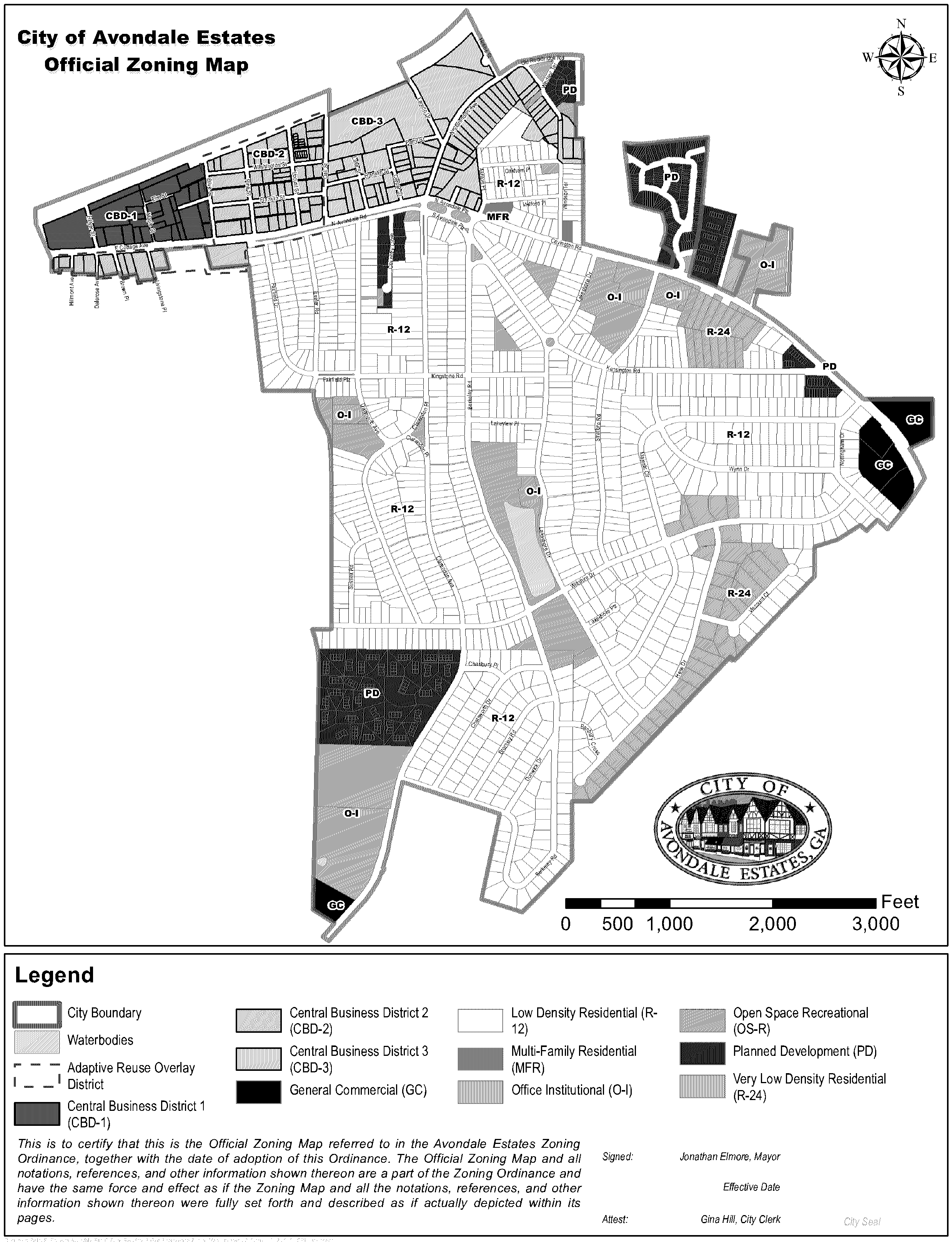
For the purposes of this Code, the location and boundaries of the zoning districts established by this zoning ordinance are depicted on the City of Avondale Estates's Official Zoning Map and is adopted and incorporated into this zoning ordinance. In general, standards and provisions for districts are designed to create walkable environments, reflective of the desired character in the city's comprehensive plan, downtown master plan, Avondale Estates Street Grid Plan, Avondale Estates Downtown Study, and any other policy documents adopted by the board of mayor and commissioners.
Sec. 21-1.2.2. - Official zoning map.
A.
District map. The city is hereby divided into zoning districts, as shown on the official zoning map, which, together with all explanatory matter thereon, is hereby adopted by reference and declared a part of this zoning ordinance.
B.
District boundaries.
1.
The district boundaries as shown on the official zoning map are generally intended to follow streets, alleys, lot lines or natural boundaries such as bodies of water. Where districts are designated on said map are bounded by such street, alley, lot line or natural boundary, the centerline of the street, alley or natural boundary or the actual lot line shall be the boundary of the district unless a specific boundary is otherwise indicated of the official zoning map. In all other cases, the district boundary line shall be determined by use of the scale on the official zoning map.
2.
When the boundary line of a district divides a lot or tract held in single ownership at the time of the adoption of the zoning ordinance from which this chapter is derived, the district boundary line may be allowed to extend a distance of not more than 50 feet into the least restricted district encompassed within the boundary of the lot or tract held in single ownership at the request of the owner of the tract.
C.
Copies of the official zoning maps and historical records.
1.
The location and boundaries of the zoning districts established by this zoning map are depicted on and maintained in geographic information system (GIS) format.
2.
The latest adopted version of the official zoning map shall be available for inspection in the offices of the City of Avondale Estates regular business hours of the city. The city manager may authorize printed copies of the official zoning map to be produced, but only the original on file shall be evidence as to the zoning district boundaries and the zoning of any lot or tract of land in the city.
3.
The city manager shall maintain digital and/or printed copies of each superseded version of the official zoning map after its amendment for historical reference.
(Ord. No. O-21-3, § 1(Att.), 7-28-2021)
Sec. 21-1.2.3. - Maintenance and updates.
A.
The city manager is responsible for directing revisions to the official zoning map to reflect its amendment as soon as practicable after the effective date of zoning map amendments. This is not intended to require the zoning map to be updated after each amendment.
B.
Revisions and amendments.
1.
Revisions and amendments to the district boundaries or other information portrayed on the official zoning map, accomplished in accordance with the provisions of this ordinance and following adoption of the amendment by the board of mayor and commissioners of the City of Avondale Estates, shall be made on the official zoning map.
2.
The official zoning map and any subsequent revisions shall be identified by the signature of the mayor, attested by the city clerk, dated with the effective date of the ordinance, and bearing the seal of the city under the following words:
"This is to certify that this is the official zoning map referred to in the Avondale Estates Zoning Ordinance, together with the date of adoption of this ordinance. The official zoning map and all notations, references, and other information shown thereon are a part of the zoning ordinance and have the same force and effect as if the zoning map and all the notations, references, and other information shown thereon were fully set forth and described as if actually depicted within its pages."
3.
No change shall be made on the official zoning map, except in conformity with the procedures set forth in this ordinance. Any unauthorized change of whatever kind by any person or persons shall be considered a violation of this ordinance and shall be punishable as provided by law.
C.
Replacement of official zoning map.
1.
In the event that the official zoning map becomes damaged, destroyed, lost or difficult to interpret because of the nature or number of changes and additions, the board of mayor and commissioners may, by ordinance, adopt a new official zoning map which shall supersede the official zoning map and shall be identified by the signature of the mayor, attested by the city clerk, dated with the effective date of the ordinance, and bearing the seal of the city under the following words:
"This is to certify that this Official Zoning Map supersedes and replaces the Official Zoning Map adopted the date of [insert date of adoption] as part of the Avondale Estates Zoning Ordinance."
2.
The new official zoning map may correct drafting or other errors or omissions in the prior official zoning map, but no such correction shall have the effect of amending the boundaries of official zoning map.
3.
Unless the previous official zoning map has been lost or destroyed, the previous map or any significant remaining parts thereof, shall be preserved, together with all available records pertaining to its adoption or amendment, either in electronic or hard copy format.
D.
Annexation. Any land subsequently annexed to the city shall, at the time of annexation, be classified into a zoning category compatible with adjacent zoning and land uses, and sound planning principles in accordance with the procedures in section 21-1.2.4 - division of city into districts and applicable state law.
Sec. 21-1.2.4. - Division of city into districts.
For the purposes of this zoning ordinance, the city is divided into base, special, and overlay zoning districts designated as follows:
Sec. 21-1.2.5. - Map interpretations.
A.
The city manager is the final authority in determining the current zoning status of land, buildings, and structures in the city.
B.
Where uncertainty exists with respect to the location of any zoning district boundaries as shown on the official zoning map, the following rules apply:
1.
Where possible, a rezoning file shall be used for delineating zoning boundaries. Such records shall have precedence over information otherwise contained on maps.
2.
Where a zoning district boundary line is shown as approximately following a corporate limits line, a land lot line, a lot line or the centerline of a street, a county road, a state highway, an interstate highway, or a railroad right-of-way or such lines extended, then such lines shall be construed to be the zoning district boundary lines.
3.
Where a zoning district boundary line divides a lot, each portion shall be governed by the zoning district that each portion is classified.
4.
Where areas appear to be unclassified on the zoning map, classification cannot be established by the above rules, and there is no other evidence of its existing or past classification, such areas must be considered to be classified R-24 until action is taken by the board of mayor and commissioners to amend the zoning map.
C.
Where uncertainties continue to exist or further interpretation is required beyond that presented in the above subsections, the question shall be presented to the board of mayor and commissioners to enact a clarifying ordinance.
Sec. 21-1.2.6. - Split-zoned lots.
A.
The zoning map shall not be amended to classify a single parcel of land into two (2) or more base zoning districts. This provision does not apply to overlay zoning districts.
B.
If an existing parcel of land is split into two (2) or more zoning districts, each such portion of the split-zoned parcel may be used only for purposes allowed within the zoning district that each such portion is classified. No principal or accessory use of land, building or structures, and no use or building or structure authorized by permit, or conditional use permit, is allowed unless the use, building or structure is expressly authorized or permitted within the subject zoning district.
Sec. 21-1.2.7. - Relationship to comprehensive plan and future development map.
The City of Avondale Estates Comprehensive Plan, consisting of the future development map and related policies, is hereby established as the official policy of the city concerning future land uses and shall serve as a guide regarding the appropriate manner in which property shall be zoned in the city. The most recent version of the comprehensive plan, as adopted by the board of mayor and commissioners, shall identify zoning districts that are appropriate within each of the city's character areas as delineated on the future development map. No rezoning of property in the city shall be done in a manner inconsistent with the future development map and related policies of the comprehensive plan. If the board of mayor and commissioners considers a zoning map amendment request that does not concur with the policies of the comprehensive plan or future development map, approval of a comprehensive plan amendment is required before an approval can be rendered on the zoning map amendment in accordance with division 7.5 - amendments and conditional uses.