
Avondale Estates City Zoning Code
ARTICLE 3
- SPECIAL PURPOSE DISTRICTS
Sec. 21-3.1.1. - Districts.
In order to regulate, restrict, and segregate the use of land, buildings and structures; to regulate and restrict the height and bulk of buildings and the area of yards and other open spaces surrounding buildings; to regulate and restrict intensity, geography, and design of mixed-use development to implement the intent of this ordinance, the incorporated area of the City of Avondale Estates, DeKalb County, Georgia, is hereby divided into the following special purpose and mixed-use zoning districts:
Sec. 21-3.1.2. - General purpose.
As with overlay zoning districts, special purpose zoning districts are tools for dealing with unique neighborhoods or settings, or accomplishing special planning, architecture, zoning goals. Unlike overlay districts, however, special districts are base zoning classifications; they do not "over-lay" other base zoning districts. The purpose specific for each district is contained within the text of each enabled district. When this zoning ordinance refers to "mixed-use districts," it is referring to zoning districts: CBD categorized in this division.
Sec. 21-3.2.1. - Purpose.
The central business district has been created to further the following public purposes:
A.
Plan compatibility. To guide new development and redevelopment as defined by the City of Avondale Estates Comprehensive Plan and Downtown Development Plan and as amended.
B.
Achieve excellence and creativity in design. Each new development should express excellence in design, use high-quality materials and construction methods, and incorporate characteristics that make it unique to Avondale Estates.
C.
Draw on local design traditions. Existing buildings, such as the Tudor Village, share similar features, materials and forms that reflect the city's design traditions and should inspire new work without copying earlier styles.
D.
Regulate a walkable, beautiful and accessible public realm. Regulate walkable blocks, and promote slow moving traffic, pedestrian, and bike accessibility in a well landscaped environment.
E.
Create an identifiable public realm. Avoid a series of independent private destinations/campuses by standardizing the public streets, sidewalks, and landscaping materials and street furniture by corridor.
F.
Encourage engaging open spaces. Encourage public and private yards, plazas, promenades, courtyards, and other amenities directly facing the public streets.
G.
Support shared street concepts. Walkers, bikers, and drivers share a narrow and landscaped road where right-of-way is very limited.
H.
Mitigate visual impacts of parking. Select appropriate locations or use landscaping and other screening to hide or mitigate the visual impacts of parking lots and decks.
I.
Encourage sustainable development. New and retrofitted buildings should address energy, waste, and water conservation and accommodate all modes of transportation.
J.
Promote vibrant streets with active ground floors. Orient storefronts to face the street, design main entrances to open onto the street, and increase windows and doors along the ground floor.
K.
Regulate height by location. Support transit-oriented development with greater height on blocks adjacent to the MARTA station and on the backside of the rail lines (up to five (5) stories) with lower heights graduating to two (2) or three (3) stories closer to the Tudor Village and along College Avenue/North Avondale Road.
L.
Require multiple entrances with direct connections to the public sidewalk. Design buildings to include multiple entrances with porches, stoops and doors directly connected to the public sidewalk.
M.
Vary massing. Change the heights of different parts of a building and create offsets in wall planes to express individual building modules.
N.
Vary articulation of the building. Vary wall surfaces, change materials, and use different fenestration patterns, or other design variations.
O.
Concentrate retail storefronts in select locations to promote economic stability. Identify street or street sections that require storefronts for retail and restaurants (and those that don't).
P.
Enable and encourage a mix of uses. Allow for a mix of uses throughout the downtown to include a variety of housing types that serve people at all stages of life, retail, restaurants, and offices.
Sec. 21-3.2.2. - Applicability.
A.
The regulations within this section apply to all buildings, structures, and land within the central business district, as illustrated on the regulating plan and on the city's zoning map.
B.
Conflicts with other provisions or requirements. All development authorized by these standards shall conform to all other requirements of the Avondale Estates Zoning Ordinance, except as specifically stated to the contrary in these standards. When a conflict exists between these standards and the other requirements of the ordinance, these standards shall prevail.
Sec. 21-3.2.3. - Regulating plan.
A.
Sub-areas. References in this zoning ordinance to "central business districts" or "CBD sub-areas," or "sub-areas" are references to these districts. Sub-areas are used to determine appropriate façade types, use requirements, and certain site and building development standards specific to each sub-area.
B.
Sub-area boundaries. Each central business district sub-area is designated in figure 21-3.2.3.
Figure 21-3.2.3 - Regulating Plan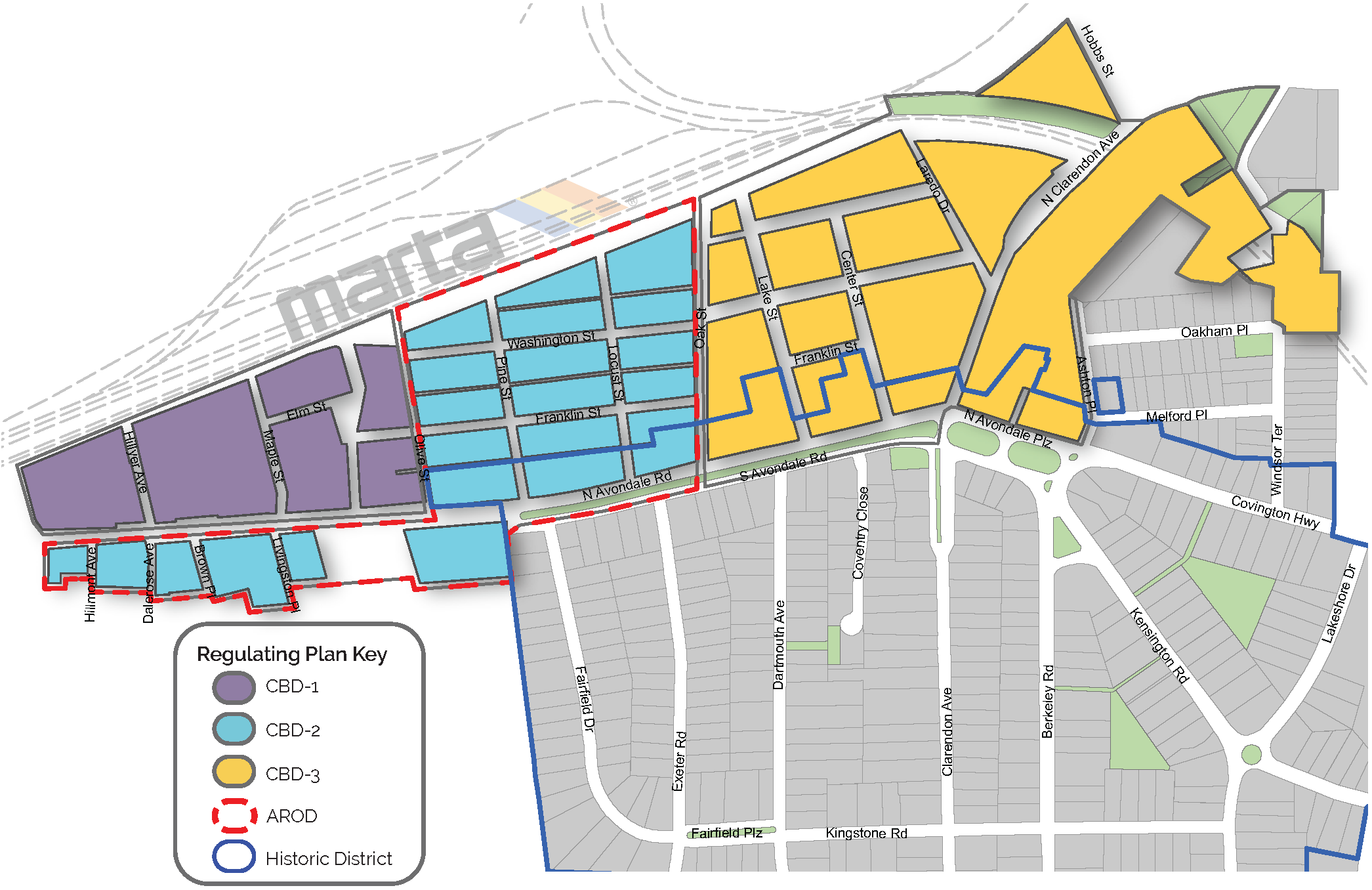
Sec. 21-3.2.4. - Central business district-1 (CBD-1).
The CBD-1 sub-area is intended to accommodate the most intensive scale of development, still respecting the maximum grid dimensions and small-town, walkable feel of the overall district. Within a 1,500-foot walkshed of the MARTA heavy rail station, the CBD-1 sub-area is intended to provide housing and commercial uses that support the remainder of the district and encourage transit ridership. Building heights up to five (5) stories are permitted in this district, with required building articulation to break up the massing and transitional height planes to step down the intensity in key locations, such as adjacent to residential uses.
Sec. 21-3.2.5. - Central business district-2 (CBD-2).
The CBD-2 sub-area is intended to develop at a less intensive scale than other sub-areas of the district. A maximum of three (3) stories in height is permitted in this sub-area, and more selective applications of retail and restaurant are required. Walk-up residential and other active ground floor uses and required to ensure the district remains at walkable, human-scale. The CBD-2 sub-area is intended to respect the history and character of the rail arts district character area by accommodating adaptive reuse of existing structures and land uses supportive of the arts.
Sec. 21-3.2.6. - Central business district-3 (CBD-3).
The CBD-3 sub area is intended to support existing historic buildings, including the Tudor Village, provide low- story development along North Avondale Road and adjacent to the new city park, with building stepbacks away from existing single-family development and park/open space. Ground story retail is encouraged to be concentrated in this sub-area to capitalize on the local business success already present in Downtown Avondale Estates to promote a distinct, walkable shopping area.
Sec. 21-3.2.7. - Street typology map.
Street type locations for new and existing streets in the central business district are designated in figure 21-3.2.7.
Figure 21-3.2.7 Street Typology Map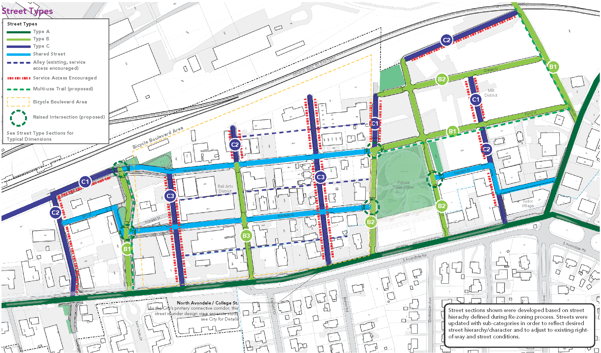
Sec. 21-3.2.8. - Streets and blocks.
A.
Applicability.
1.
The City of Avondale Estates desires a pedestrian-friendly central business district that has adequate transportation infrastructure for residents, visitors, and businesses. The city finds that its existing street grid is inadequate, in terms of pedestrian and vehicular infrastructure, to support the density of development that may be desired. Therefore, in order to ensure that new development does not exceed the capacity of transportation infrastructure, the city hereby offers a bonus program that provides development incentives to those developers that voluntarily provide improvement and dedication of transportation infrastructure identified in this section.
2.
Improvements required of every new development and redevelopment meeting the thresholds established by section 21-8.3.9:
a.
Block breaks and improvements per section 21-3.2.8.B - block requirements.
b.
Landscaping, sidewalks, and other pedestrian amenities per section 21-3.2.8.E - streetscapes.
c.
General standards to be met per section 21-3.2.8.F - conditions of improvements.
3.
Voluntary improvements required only if the developer desires to take advantage of the development bonuses set out in table 21-3.2.8.A - development bonuses:
a.
Public road improvements per section 21-3.2.8.C - streets.
b.
Design standards for streets per section 21-3.2.8.D - general standards for streets.
c.
Permitted ability to span rights-of way per section 21-3.2.8.G - air rights.
4.
Regardless, where inadequate infrastructure and lack of internal street network exists to sustain and support the maximum block size, implementation of the street grid is required.
B.
Block requirements.
1.
Maximum. The maximum block perimeter for the CBD is one thousand six hundred (1,600) feet. The required block length is a maximum of four hundred (400) feet or consistent with the adopted Downtown Avondale Estates Street Grid Plan. Exemptions or departures from these standards pertain to certain blocks based on the street grid plan.
2.
Divisions. Block faces shall be divided by either multi-use paths or streets defined and referenced herein. Multi-use paths shall provide a minimum of ten (10) feet paved width with a two (2)-foot shoulder on each side of the path for the purpose of providing a small separation from the path and any permanent structures.
3.
Measurement. Block perimeter shall be measured from the centerline of the existing or proposed facility (street or multi-use path) used to divide the block face.
4.
Waiver. The city manager may grant a tier 1 waiver to increase the block perimeter/length by up to twenty (20) percent when steep slopes, waterways, flood zones, railroads, stream buffers, greenways, open space, or easements would make the block requirements infeasible.
C.
Streets.
1.
Street regulations apply to new and existing streets per figure 21-3.2.7 - street typology map. The intent of the following regulations is to form an interconnected network of streets to support multiple modes of transportation, including walking, biking, transit use, and driving.
2.
Street type requirements. All Street Type requirements as required by the street typology map and central business district regulations shall be in conformance with these regulations.
a.
Streetscape improvements and other pedestrian improvements shall be provided along all street frontages within the boundaries of the CBD as illustrated on the street typology map and in accordance with division 6.10 - sidewalk, street, and other construction standards.
b.
Improvements shall comply with the most recently adopted version of the Downtown Avondale Estates Street Grid Plan, including all dimensional and material specifications for new and existing roads.
c.
Installation shall meet the requirements in section 21-3.2.8.F - conditions of constructed improvements.
3.
Street types. The following descriptions, illustrations, and streetscape requirements in table 21-3.2.8.E - streetscape dimensions describe the street types permitted in the CBD.
a.
Type A. Type A streets are intended to establish a series of comfortably scaled streets with continuous building frontage and a limited number of drives interrupting the sidewalk. Type A streets support a robust pedestrian realm by prioritizing bicyclists and pedestrians for a more balanced transportation route and support local retailers and business owners by encouraging a vibrant and activated public realm.
b.
Type B. Type B streets are intended to serve, similarly to type A streets, as primary pedestrian corridors with minimal curb cuts, but they are less critical based on their proximity to the retail district; therefore, they can tolerate curb cuts and other minor service needs if no other options are available. Typical cross-sections are illustrated in figure 21-3.2.8.B.4.b. - type B typicals.
Figure 21-3.2.8.B.4.b. Type B Typicals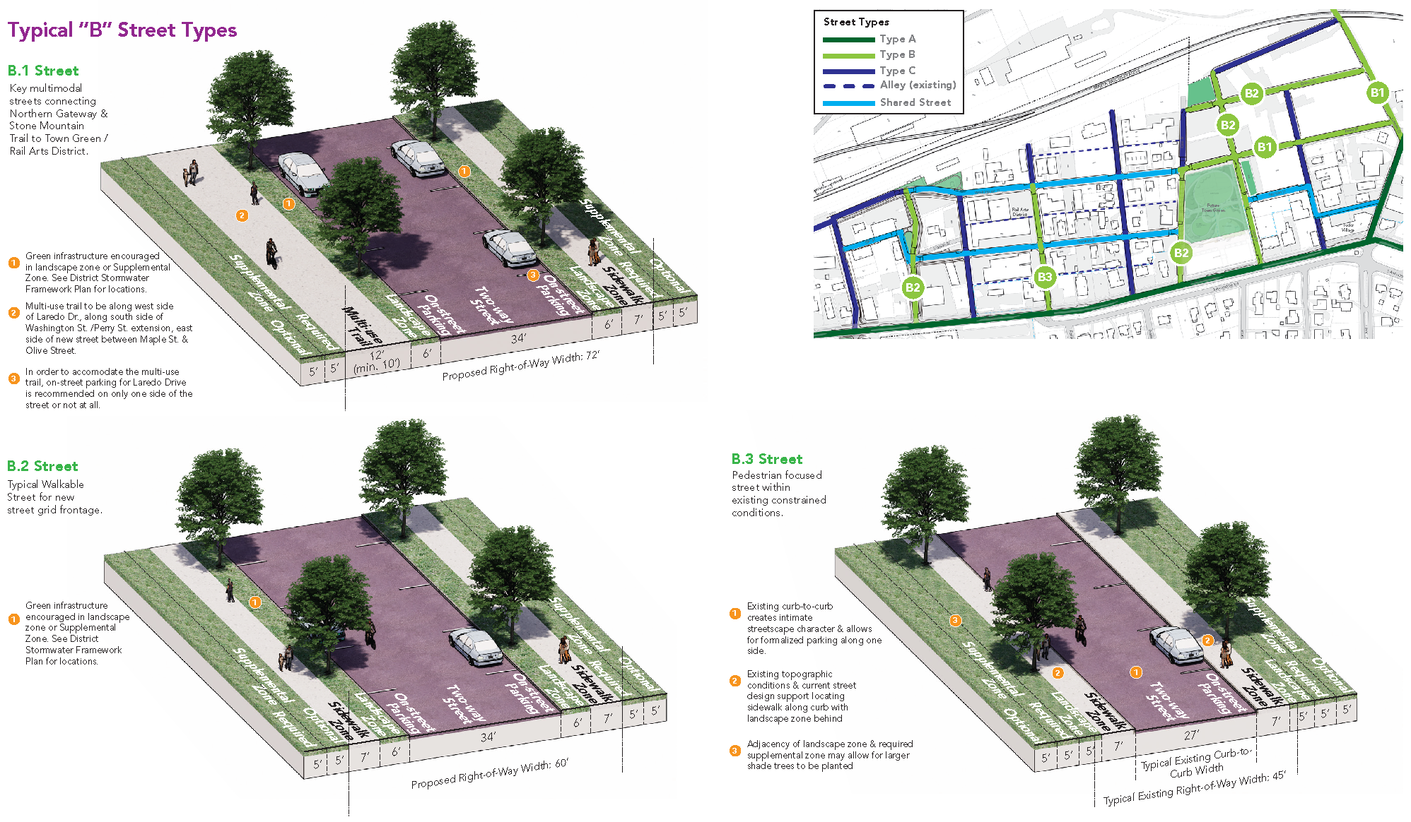
c.
Type C. Type C streets are intended to establish a designated street for parking lot and structure access, while still providing a safe and comfortable pedestrian realm. Typical cross-sections are illustrated in figure 21-3.2.8.B.4.c. - type C typicals.
Figure 21-3.2.8.B.4.c. Type C Typicals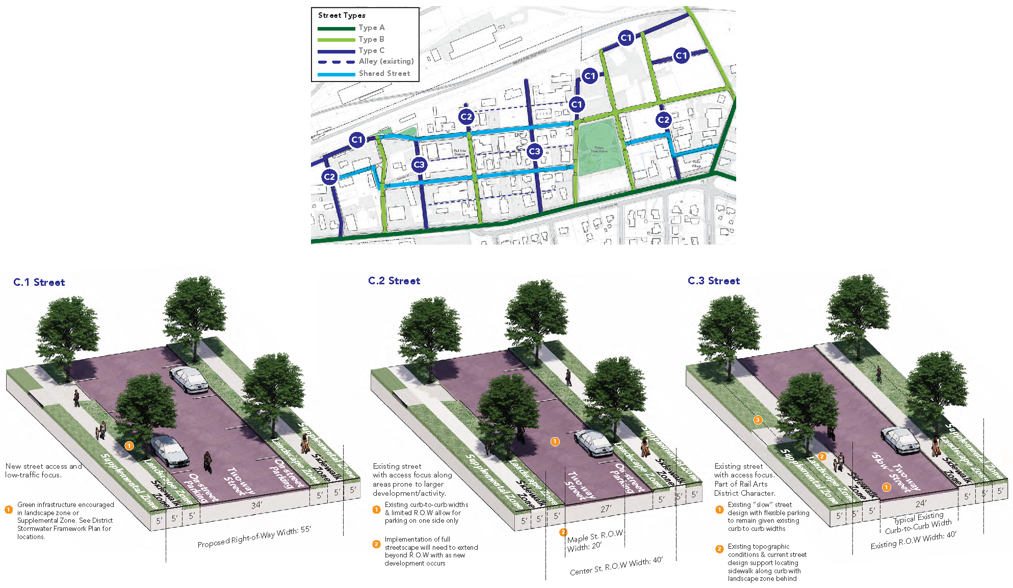
d.
Type D. Type D streets are shared streets. Type D streets are intended to work closely within the existing right-of-way to support the possibility of incremental redevelopment of a walkable warehouse district. There is no formal separation between modes of transportation; therefore, these streets are very low speed and marked by special details and materials like enhanced landscaping and paver systems. Typical cross-sections are illustrated in figure 21-3.2.8.B.4.d. - type D typicals.
Figure 21-3.2.8.B.4.d. - Type D Typicals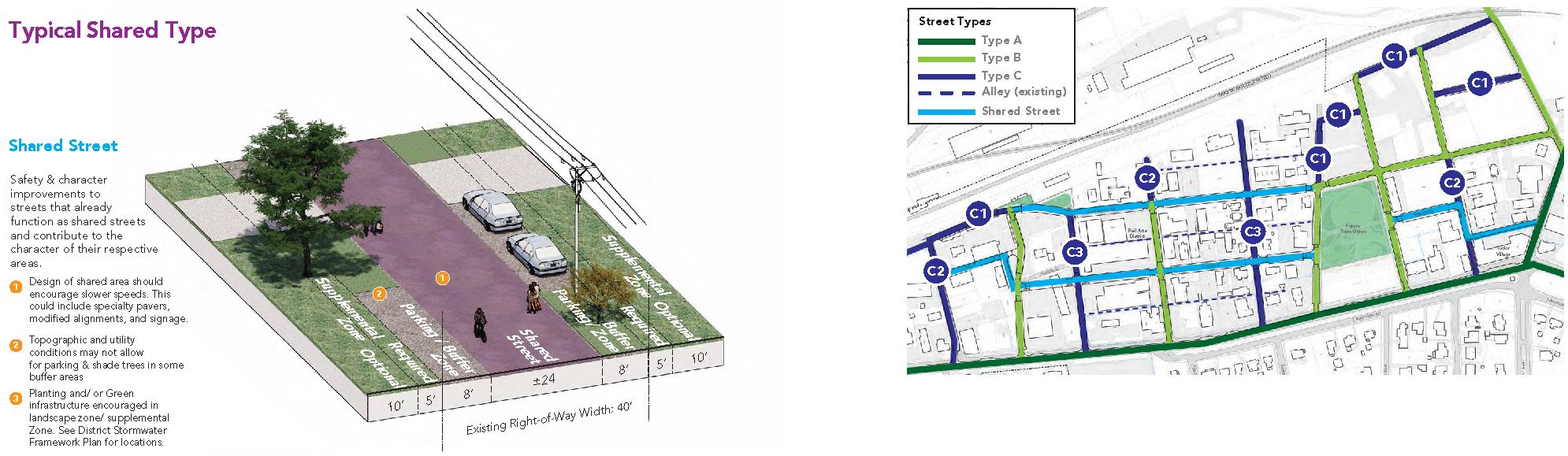
e.
Type E. Type E streets are also considered alleys. Type E streets are intended to provide access and service to adjacent parcels. When possible, they shall provide sole vehicular access to those lots. Where existing alleys are encroached, they shall be re-established as a function of any redevelopment activity exceeding the seventy (70) percent threshold in table 21-8.3.9 - redevelopment improvements, or for any full site development.
D.
General standards for streets.
1.
Public and private streets shall comply with the minimum construction standards for public streets found in appendix B - subdivision regulations, division 6.10 - sidewalk, street, and other construction standards, and other applicable sections of the City Code.
2.
All new streets shall connect at least two (2) streets or provide a temporary street stub that will allow for a future connection between at least two (2) streets. This provision is not intended to require connections to streets that are located entirely outside the boundaries of the CBD. No permanent cul-de-sac or other permanent dead end street design is permitted.
3.
Curbing.
a.
The maximum allowed curb radius at any intersection or curb is twenty (20) feet.
b.
Granite curbing is required. The curbing for such street improvement, extension, or reconstruction shall be granite curbing of a similar size and type as the granite curbing used on such existing street or the closest existing street containing granite curbing.
4.
Access.
a.
No curb cuts are allowed on type A streets if the subject lot has access to another street type. Lots with access solely to type A streets are allowed a maximum of one (1) curb cut.
b.
Lots with access to type B or C streets are allowed a maximum of one (1) curb cut on either such street.
c.
Curb cuts may not exceed twenty-four (24) feet in width.
d.
Access driveways shall be perpendicular to the abutting street.
e.
Gates and security arms are prohibited on public and private streets that require public access.
f.
On lots with more than one (1) street frontage, access and off-street parking shall not be located in front of the primary building on the street with the higher classification based on the following order from highest to lowest: North Avondale Road, North Clarendon Avenue, Washington Street, Oak Street, Center Street, Lake Street, Laredo Drive, Parry Street, Green Street, Hilyer Avenue, Olive Street, Locust Street, Pine Street, Maple Street, Elm Street, and Potter Avenue.
g.
Driveways, except for a driveway to reach the side yard or rear yard or an on-site parking facility, are not permitted between the sidewalk and a building, and shall be perpendicular to any adjacent street.
5.
External agency reviews.
a.
Should the DeKalb County Fire Marshal's requirements and those set forth herein conflict, the fire marshal's requirements shall govern without the need for additional relief from the Code.
b.
The following provisions apply to lots that abut a right-of-way controlled by the Georgia Department of Transportation (GDOT):
i.
Should any of the requirements herein conflict, the GDOT requirements shall govern without the need for additional relief from the Code.
ii.
An approved permit for proposed access or improvements is required from GDOT and shall be incorporated into the construction drawings for the project before the issuance of a land disturbance permit.
E.
Streetscape. In general, streetscapes shall consist of a landscape zone, sidewalk zone, and in some cases, a supplemental zone, dependent on table 21-3.2.8.E - streetscape dimensions.
1.
Location. Streetscape improvements, multi-use trails, and other pedestrian facilities shall be provided along all street frontages in accordance with this division.
2.
Landscape zones. The landscape zone starts at the back of the curb and extends inward (toward the lot) for the minimum distance and no more than the maximum distance indicated in table 21-3.2.8.E - streetscape dimensions. This area is generally intended to accommodate trees, plants, lights, and similar landscape elements.
a.
Required street trees are identified by corridor in the Downtown Avondale Estates Street Grid Plan.
b.
Street trees shall be planted in all landscape zones spaced on center as follows, based on the type of tree planted:
i.
Understory trees: Thirty (30) feet on-center;
ii.
Overstory trees: Sixty (60) feet on-center.
c.
Street trees shall have a minimum planting area of five (5) feet by five (5) feet. Tree planting areas shall provide porous drainage systems that allow for drainage of the planting area.
d.
Streetlights shall be located within the landscape zone and spaced a distance consistent with the Downtown Avondale Estates Street Grid Plan.
e.
Landscape zones shall be planted with grass, ground cover, or flowering plants.
3.
Sidewalk zones. The sidewalk zone starts at the inner edge of the landscape zone and extends inward (toward the lot) for the minimum distance and no more than the maximum distance indicated in table 21-3.2.8.E - streetscape dimensions. This area is intended exclusively to accommodate unimpeded pedestrian movement.
a.
Sidewalk zones shall be paved in concrete and kept clear and unobstructed for the safe and convenient use of pedestrians. There shall be a minimum ten (10) feet vertical clearance maintained on all sidewalk zones.
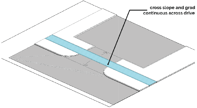
Figure 21-3.2.8.D - Paving Materials Across Driveways
b.
Paving materials shall be continued across any intervening driveway at the same prevailing grade and cross slope as on the adjacent pedestrian zone area.
c.
When newly constructed sidewalks abut adjacent sidewalks, the newly constructed sidewalk shall provide safe facilitation of pedestrian traffic flow to those adjacent sidewalks. If the adjacent sidewalk is deficient with respect to the standards of the ordinance, the subject sidewalk shall figure 21-3.2.8.D - paving materials across driveways taper to match the width of the adjacent sidewalks.
d.
If no adjacent sidewalk exists, the new sidewalk shall terminate at the property line at the required width at the grade and location of the adjacent sidewalk zone. The sidewalk on the subject property shall be graded to facilitate a future direct connection to the sidewalk (e.g.: it shall not terminate at a retaining wall).
e.
Any development that disturbs existing sidewalks on an adjacent property shall replace disturbed areas to their pre-disturbance state and condition.
f.
Safe and convenient pedestrian pathways shall be provided from sidewalks along streets to each publicly accessible building entrance, including pedestrian access routes to parking decks, through parking lots, and between adjacent buildings within the same development. All such pathways shall be paved, with a minimum width of four (4) feet, or the width required by the underlying zoning district or ADA accessibility criteria, whichever width is greater.
4.
Supplemental zones. The supplemental zone starts at the inner edge of the pedestrian zone and extends inward (toward the lot) for the minimum distance and no more than the maximum distance indicated in table 21-3.2.8.E - streetscape dimensions. This area is intended to accommodate active uses along the street frontage with amenities such as widened sidewalk zones, outdoor seating, and landscaping.
a.
The supplemental zone shall be located on private property.
b.
Benches, trash receptacles, and bike racks shall be placed within the supplemental zone. Other amenities are permitted, such as seat walls, provided they meet the intent and dimensional requirements of the supplemental zone.
i.
Such features shall be provided at a ratio of not less than one (1) bench, one (1) trash and one (1) recycling receptacle, and one (1) bike rack per three hundred (300) feet of street frontage, or portion thereof.
ii.
Bike racks provided to meet this requirement may be counted towards satisfying short-term bicycle parking requirements of table 21-6.2.3 - parking requirements.
iii.
Where a supplemental zone is not required or does not exist, these amenities shall be located in the landscape zone.
c.
The supplemental zone shall be no more than twenty-four (24) inches higher than the adjacent sidewalk, unless existing topographical conditions render this requirement unreasonable, per approval of the city manager through the permit review process.
d.
Provided the other provisions of this section are met, other activation of the supplemental zone is permitted and encouraged, to include outdoor dining, public art installations, landscaping and planter boxes, and retail sales.
5.
Insufficient right-of-way width. On existing streets with insufficient right-of-way width to accommodate the required landscape and sidewalk zone elements, the right-of-way needed to accommodate the required streetscape elements shall be dedicated to the city prior to the issuance of any certificate of occupancy.
F.
Conditions of improvements.
1.
Construction obligations. All improvements shall be constructed and dedicated to the city by the developer.
2.
Partial improvements. Where the subject property is adjacent to the location of a new street shown on the street grid plan but said planned new street is partially on private property not owned by the developer or a related entity, the developer may comply with the bonus requirements for new street build-out by making only the planned improvements shown on the subject property by the street grid plan. Streets may be constructed as one-way until the full planned street is built out.
3.
Omit from lot calculations. Any new or reconstructed streets constructed as a function of this section shall not count against maximum lot coverage and shall not be included in the lot size for calculating open space dimensions, tree density requirements, or any other standard determined using the area of the lot. In these cases, the area of the road can be completely omitted from the lot area calculation (i.e.: the area taken up by the road is not used in the coverage area, nor in the total lot area).
4.
Timing. All improvements shall be installed prior to the final certificate of occupancy, project close-out, or prior to approval of a final plat.
G.
Air rights.
1.
Where bonus criteria are met for a project, the city will grant air rights to permit occupiable bridge structures that span streets by connecting portions of buildings across rights-of-way, for the purpose of providing circulation.
2.
A maximum of one (1) bridge is permitted per block.
3.
Bridges are only permitted on structures that exceed three (3) stories in height and must be installed at least thirty (30) feet above the right-of-way.
Sec. 21-3.2.9. - Façade types.
A.
Façade type development standards. Table 21-3.2.9 - façade types outlines site standards, heights, and façade requirements based on each façade type. Section 21-3.2.10 - building design standards provides additional standards applying to all façade types.
B.
Façade types. The following descriptions and illustrations define the allowable façade types required for all exterior façades in the CBD.
1.
Attached house. The attached house is a building façade typically made up of several single-family, multi-story units, usually referred to as townhouses, each with its own external entrance. Units are not vertically mixed-use but can accommodate live-work units.
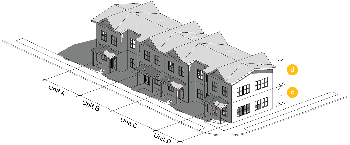
Figure 21-3.2.9.B.1 - Attached House Façade Type - Sloped Roof
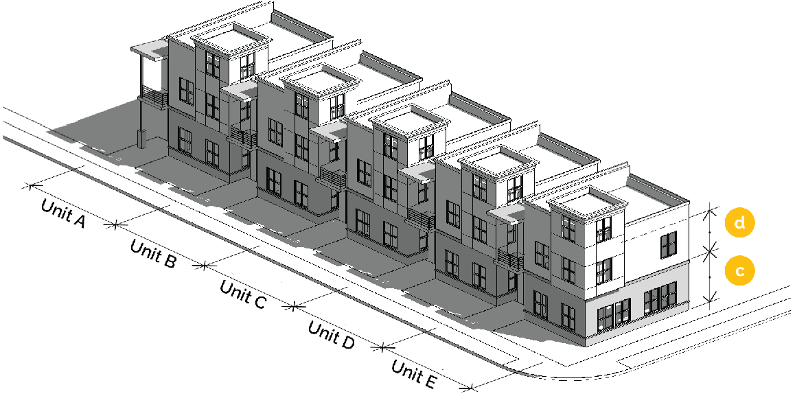
Figure 21-3.2.9.B.2 - Attached House Façade Type - Flat Roof
| Table 21-3.2.9 - Façade Types | Reference | |||||
|---|---|---|---|---|---|---|
| Attached House | General | Walk-Up | Shopfront | |||
| Site Standards | ||||||
| Min. Street Setback | Refer to Supplemental Zone Requirements | Table 21-3.2.8 Street Type Dimensions | ||||
| Max. Street Setback | Refer to Supplemental Zone Requirements | |||||
| Min. Side & Rear Setbacks |
-
|
-
|
-
| - | ||
| Uses | ||||||
| Ground Floor Uses | All CBD uses | Commercial uses in CBD | All CBD uses | Commercial uses in CBD | Uses permitted in CBD per Use Table 21-5.2.4. | |
| Uses on other floors | Residential uses in CBD | All CBD uses | All CBD uses | |||
| Parking Garage use | Prohibited directly adjacent to Type A streets and City open spaces and parks, unless liner buildings are pro- vided. Design requirements in accordance with Table 21-6.2.5 Design Standards for Parking Garages. | Section 21-6.2.5, 21-6.3.4 | ||||
| Height | ||||||
|
Ground Story Elevation (min./
max. above sidewalk) | 0 to 4.5 feet | 0 to 4.5 feet | 0 to 4.5 feet | 0 to 4.5 feet | Sub-Area Tables: Section 21-3.2.4, 21-3.2.5, 21-3.2.6 | |
| Min. Building Height | 18 feet | 18 feet | 18 feet | 18 feet | ||
| Min. Height per Story | ||||||
| Ground Story | 9 feet | 14 feet | 10 feet | 14 feet | ||
| Upper Stories | 10 feet | 10 feet | ||||
| Façades | ||||||
| Min. Fenestration on Type A and B Streets | Table 21-3.2.8 Street Type Dimensions; 21-3.2.10.G - Window Systems; 21-3.2.9.B - Shopfront Design Standards | |||||
| Ground Story | 25% | CBD-1 60% CBD-2/ CBD-3 40% | 25% | CBD-1 75% CBD-2/ CBD-3 50% | ||
| Upper Stories | 25% | CBD-1 45% CBD-2/ CBD-3 35% | ||||
| Min. Fenestration on All Other Street Types | ||||||
| Ground Story | 20% | 25% | 25% | 40% | ||
| Upper Story | 25% | |||||
| Required Type A and B Street Building Entrances | 1 per unit (regardless of street type) |
1 per 150' of
front façade |
1 per 75' of
front façade |
1 per 75' of
front façade | Figure 21-3.2.7 - Street Typology Map | |
| Façade Divisions | 1 per 50 feet |
1 per 100
feet | 1 per 75 feet | 1 per 50 feet | Section 21-3.2.10.D - Building Design Standards | |
| Roof Division | 1 per 200 feet | 1 per 200 feet | 1 per 200 feet | 1 per 200 feet | Section 21-3.2.10.D - Building Design Standards | |
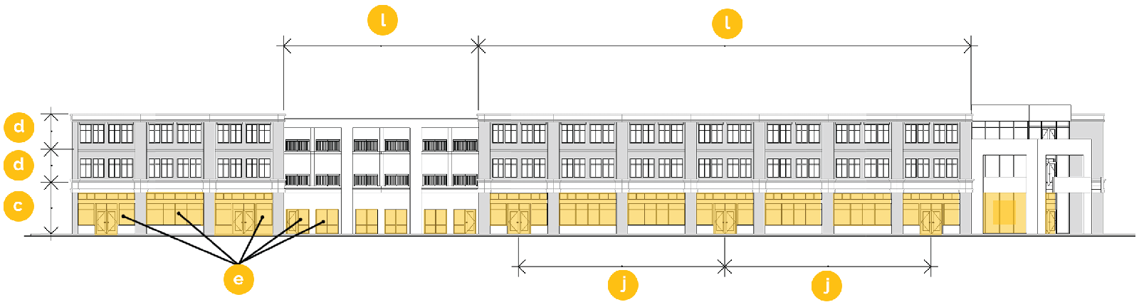
Figure 21-3.2.9.A.1 Façade Type Development Standards
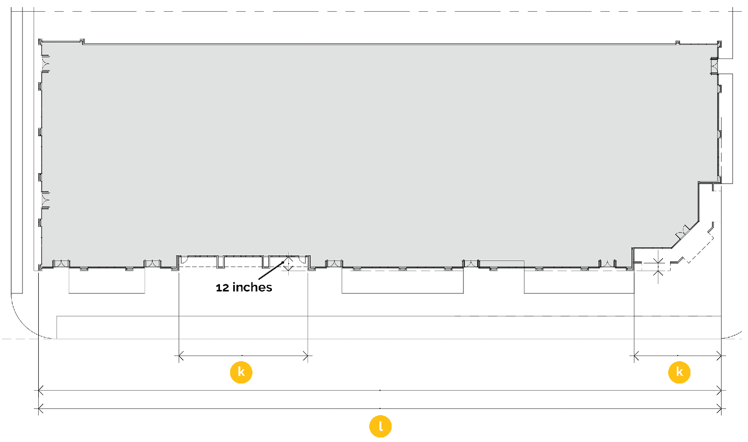
Figure 21-3.2.9.A.2 Façade Type Development Standards
2.
General. A general façade is intended to be sited close to the sidewalk but may also allow for open spaces and landscaping between the building and public realm. The building is structured to allow single or multi-story development that typically accommodates non-residential uses, such as hotel or office uses on all stories, or multi-family residential uses. The general façade type may accommodate limited amounts of accessory retail and service uses on the ground floor.
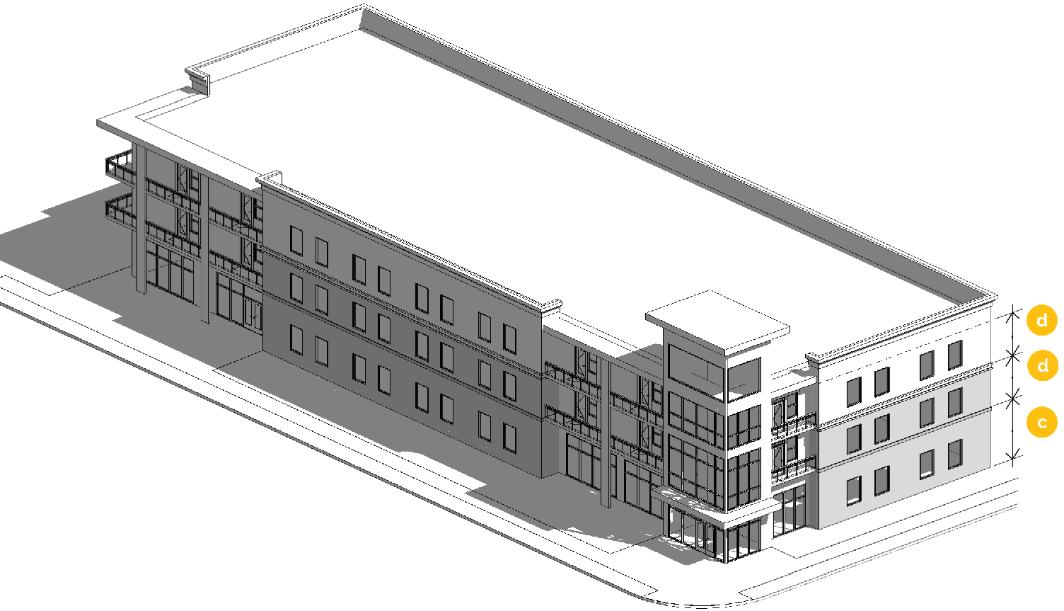
Figure 21-3.2.9.B.3 General Façade Type
3.
Walk-up. Walk-up façades typically house multi-family uses with ground floor units that have entrances facing a sidewalk or public street. Additionally, the design requirements for walk-up façades establish tenant spaces supportive of retail and other service uses in mixed use environments.
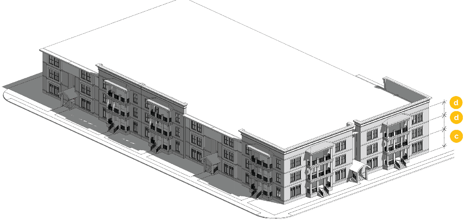
Figure 21-3.2.9.B.4 Walk-Up Façade Type
4.
Shopfront. The shopfront façade is intended for use as a mixed-use building located close to the sidewalk. The most distinctive element of this façade type is the ground floor façade with large amounts of storefront glass, regularly spaced entrances, and intricate architectural elements present in existing historic storefronts, typically for retail and service uses.
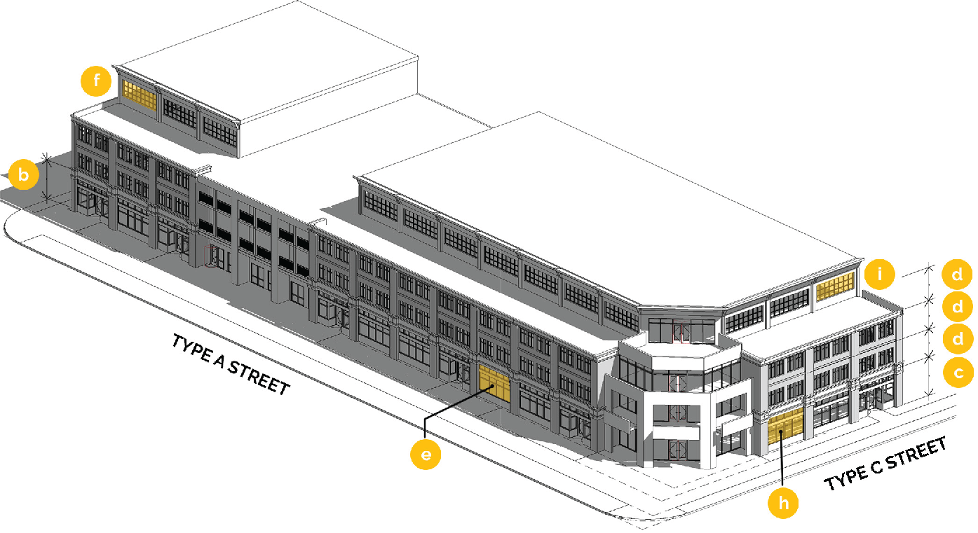
Figure 21-3.2.9.B.5 Shopfront Façade Type
C.
Shopfront Design standards.
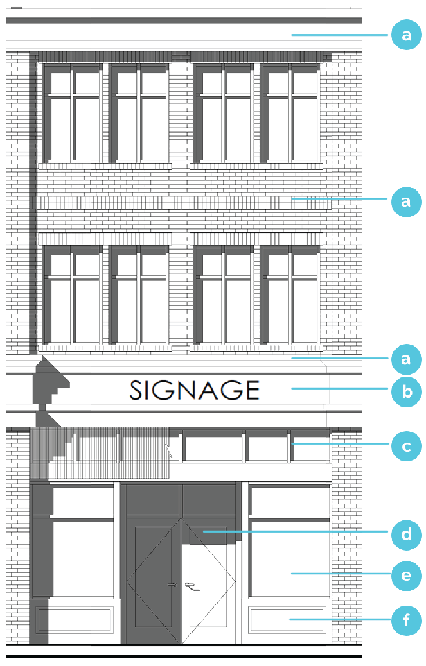
Figure 21-3.2.9.C Shopfront Design Standards
1.
The ground story of all shopfront façades in CBD-2 and CBD-3 shall contain the following elements as illustrated in figure 21-3.2.9.C:
a.
Cornice/articulated floor line. The cornice visually separates one (1) floor from the adjacent floor(s). The cornice can be articulated with a change of color, pattern, or material.
b.
Sign board. A sign board shall be an area between the cornice and window system where a wall sign is placed. The sign board shall be a minimum of two (2) feet in height and shall extend the width of each architectural bay.
c.
Transom. Transoms are horizontally articulated windows located below the sign board. The window system shall extend the full width of the architectural bay or tenant space but may be separated by mullions and muntins consistent with the design aesthetic. Grilles are prohibited.
d.
Recessed entry. Recessed entries are important to the retail experience to protect the users from inclement weather, increase the amount of space in which to display merchandise, and to ease the transition of users to and from the public realm. Entryways shall be recessed from the plane of the shopfront façade a minimum of three (3) feet.
e.
Display window. Display windows provide frames for retail users to display merchandise and contribute to the active and vibrant character along the historic street front. Display windows shall not be separated with mullions, muntins, or grilles.
f.
Bulkhead. Bulkheads shall be a minimum of eighteen (18) inches in height and shall extend the full length of the architectural bay or tenant space.
g.
Grilles, other faux features, and metal shopfront window systems shall be prohibited.
h.
Fenestration. Fenestration proportions shall comply with table 21-3.2.9 - façade types and section 21-3.2.10G - window systems.
Sec. 21-3.2.10. - Building design standards.
A.
Intent. These criteria are intended to address a building's appearance and integration into the central business district. The criteria are intended to elicit high quality materials, enhanced pedestrian experience, an appropriate scale, and a development pattern that effectively implements the city's planning and visioning documents.
B.
Applicability. The building design regulations of this section apply to all buildings in the CBD, unless otherwise expressly stated.
1.
Applicable façades. The building design standards apply to all façades visible from the street, facing streets, facing main parking lots, and adjacent to or visible from required open spaces, unless otherwise noted.
C.
Exterior finish materials.
1.
Applicable to all sub-areas:
a.
Primary building materials shall be used on at least seventy (70) percent of any building façade,
b.
Secondary building materials may be used on up to thirty (30) percent of any exterior building façade, calculated on the basis of each individual façade.
c.
Building materials, other than those expressly identified in this Section, may be used on up to ten (10) percent of any exterior building façade, provided they have not been prohibited by this section.
d.
Material proportion calculations shall not include building foundations, window systems, and doors. Proportions are calculated on the basis of each individual façade.
e.
Materials shall continue around the corner of the building onto façades not visible from the public street a minimum depth of one (1) architectural bay.
f.
Prohibited materials. Synthetic stucco, concrete masonry units (CMU), and vinyl are not permitted as exterior finish materials.
g.
Building façades shall be constructed of no more than three (3) primary materials and/or colors. Additional materials may be used as secondary, trim, or accent materials.
h.
Awnings. Plastic and vinyl awnings are prohibited. Materials repurposed into textiles for use on an awning is permitted.
2.
Exterior wall finish materials differ by sub-area district as follows:
a.
CBD-1 materials.
i.
Primary: Metal panels and siding; exposed, stained, or painted concrete; exposed wood; and ceramic panels; brick, including full-depth and half-depth masonry brick; and stone.
ii.
Secondary: EIFS; glass block; phenolic resin panels, metal mesh; brick, including full-depth and half-depth masonry brick.
b.
CBD-2 materials.
i.
Primary: Brick, including full-depth and half-depth masonry brick; stone, including unpainted natural stone, unpainted cast stone having the appearance of natural stone; and unpainted terracotta.
ii.
Secondary: Metal panels and siding; wood, including natural wood or cement-based artificial wood siding.
c.
CBD-3 materials.
i.
Primary: Brick, including full-depth and half-depth masonry brick; stone, including unpainted natural stone, unpainted cast stone having the appearance of natural stone; and unpainted terracotta.
ii.
Secondary: Wood, including natural wood or cement-based artificial wood siding; shingles, including wood or cement-based shakes and shingles; or stucco.
D.
Building articulation.
1.
In order to avoid large expanses of flat (one-dimensional) exterior walls along sidewalks, building façades over fifty (50) feet in length along a street, including abutting attached houses, shall incorporate wall projections or recesses a minimum of twelve (12) inches in depth. The combined length of such recesses and projections shall constitute at least twenty (20) percent of the total façade length along the public street.
2.
One (1) of the following to divide the façade into vertical divisions at increments no greater than the maximum width dimensions shown for a façade type, as measured along the base of the façade. Required division frequency is identified on table 21-3.2.9 - façade types.
a.
A change of façade material and window system from grade to roof; or
b.
Change of building height of at least one (1) story; or
c.
A change in façade composition and/or architectural style from grade to roof; or
d.
An open space or pedestrian passage with a minimum width of ten (10) feet and a minimum depth of thirty (30) feet. For blocks greater than four hundred (400) feet long, as permitted in section 21-3.2.8.B - block requirements, this provision is required to satisfy the building massing requirements of this section.
e.
Similar means intended to convey the impression of separate buildings.
f.
Change in color alone, window system alone, or setback alone, may not be used to satisfy this requirement.
3.
Building roof lines along street-facing façades shall change at least once every two hundred (200) feet of façade length. This change shall occur for a minimum length of twenty (20) feet and be accomplished through at least one (1) of the following:
a.
A change of roof parapet wall height and material;
b.
A change of roof cornice design;
c.
A change in the number of stories;
d.
A change in roof-shape.
E.
Blank walls. Blank wall area applies to ground and upper story façades visible from a street (not including an alley) or open space.
1.
There shall be no more than twenty (20) feet of blank wall area.
2.
Blank wall area can be broken up or interrupted to meet these provisions with any one (1) of the following interventions:
a.
Fenestration; or
b.
Substantial material change. Paint color alone does not constitute a material change; or
c.
Façade articulation greater than twelve (12) inches in depth; or
d.
Patterns and designs articulated with building materials.
e.
Vertical green walls, made of landscaped material specified for vertical, climbing growth.
f.
Signage and murals as permitted in chapter 5 - sign regulations.
3.
Blank wall area is measured in linear feet applied in both vertical and horizontal directions. See figure 21-3.2.9.E - blank wall area.
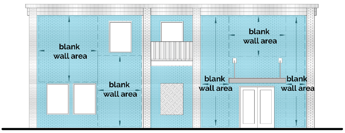
Figure 21-3.2.9.E - Blank Wall Area
F.
Residential balconies.
1.
Where balconies are incorporated into building design, they shall be integral to the façade.
2.
Balconies on stepped-back stories may be independently secured, extending from the façade as a cantilever.
3.
Juliet balconies are prohibited.
G.
Window Systems.
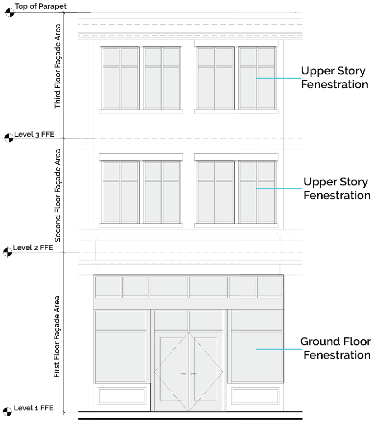
Figure 21-3.2.9.G - Fenestration Calculations
1.
Fenestration is the minimum percentage of window and door glass that must cover a façade, pursuant to table 21-3.2.9 - façade types. It is calculated based façade area and by floor. The façade area used to determine fenestration is measured from the top of the finished door to the top of the finished floor above or top of a roof parapet.
2.
Fenestration requirements apply to façades that abut a public or private street (not including an alley), or a required open space.
3.
Glass used to satisfy fenestration requirements shall be unpainted, shall have a transparency (visible light transmission) higher than seventy (70) percent and shall have an external reflectance of less than fifteen (15) percent. Transparency and external light reflectance shall be established using the manufacturer's specifications.
4.
Window frames, sashes, mullions, and similar features that are integral to the window system count towards fenestration requirements. Opaque doors and windows do not.
5.
No shades, blinds, or other coverings are permitted on the ground floor fenestration of any non-residential building.
6.
Grilles, inoperable shutters, and other faux window treatments are prohibited.
7.
Window systems shall be recessed from the façade of the building a minimum of three (3) inches. This reveal shall be accomplished through the design of the window casing reveals and frames.
H.
Pedestrian access. The pedestrian access regulations of section 21-6.2.13 - pedestrian access and circulation apply.
Sec. 21-3.2.11. - Uses.
A.
General. The use regulations of article 5 - uses apply to the CBD.
B.
Façade type. Each use shall be located within a permitted façade type (refer to section 21-3.2.9 - façade types), unless otherwise specified.
Sec. 21-3.2.12. - Generally applicable regulations.
The sections cited herein shall apply, unless otherwise expressly stated in this division.
A.
Parking. The parking and access regulations of division 6.2 - parking and access apply.
B.
Open space. The open space regulations of section 21-6.3.5 - open space apply.
C.
Buffers. The buffer from sensitive use regulations of division 6.4 - transitional buffers apply.
D.
Fences and walls. The fence and wall regulations of division 6.5 - fences and walls apply.
E.
Outdoor lighting. The lighting regulations of division 6.7 - outdoor lighting apply.
F.
Transitional height plane. All CBD-zoned lots that abut R-zoned lots, city open spaces or parks, or the CBD-2 sub-area are subject to the transitional height plane requirements of this section. Adjacent uses under this section are referred to as "sensitive."
1.
When adjacent to sensitive uses, the maximum height of all buildings or structures in the CBD shall be forty-five (45) feet or three (3) stories, whichever is less, for a horizontal distance of twenty-five (25) feet from the property line in toward the subject lot. At the point twenty-five (25) feet into the property, the height of the building can increase at a forty-five (45) degree angle up to a maximum height of seventy (70) feet or five (5) stories, whichever is less, depending on the maximum height of the sub-area.
2.
No building or portion of building may protrude above the transitional height plane.
3.
When a subject lot is occupied solely by detached and/or attached houses, the subject lot is exempt from the transitional height requirements of this section.
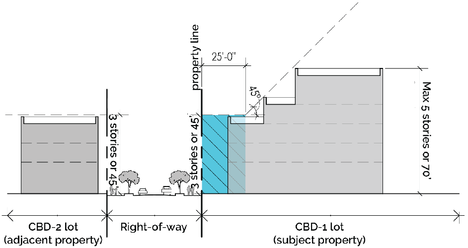
Figure 21-3.2.12.F Transitional Height Plane
Sec. 21-3.3.1. - Purpose.
A.
The PUD district is intended to permit the planning and development of parcels of land that are suitable in location and character for the uses proposed as unified and integrated developments in accordance with detailed development plans. These plans may supersede the regulations included the zoning ordinance where indicated by said development plans. The PUD district is intended to provide a means of accomplishing the following specific objectives:
1.
To provide for development concepts not otherwise allowed within non-PUD zoning districts;
2.
To provide flexibility, unity, and diversity in land planning and development, resulting in convenient and harmonious groupings of uses, structures, and common facilities;
3.
To accommodate varied design and layout of housing and other buildings;
4.
To allow appropriate relationships of open spaces to intended uses and structures;
5.
To encourage innovations in quality residential, commercial, and industrial development so that the growing demands of the population may be met by greater variety in type, design, and layout of buildings and by the conservation and more efficient use of open space;
6.
To lessen the burden of traffic on streets and highways; and
7.
To provide a procedure that can relate the type, design, and layout of residential, commercial, and industrial development to the particular site, thereby encouraging preservation of the site's natural characteristics.
Sec. 21-3.3.2. - Applicability and minimum standards.
A.
A PUD may be requested on any property or properties within the city that not zoned R-12 or R-24 that meet the minimum standards set out herein. Rezoning to PUD must be accomplished in accordance with the amendment procedures of division 7.5 - amendments and conditional uses to establish the boundaries and regulations of the PUD.
B.
No PUD district may be established without the approval of overall development standards (ODS) and an overall development plan (ODP) per section 21-3.3.3 - application of regulations by the board of mayor and commissioners, in accordance with division 7.5 - amendments and conditional uses.
C.
PUD districts shall have a minimum contiguous area of two (2) acres.
D.
PUDs shall provide a mix of a minimum of two (2) individual uses from two (2) different use sub-categories, as defined in table 21-3.3.2 - use sub-categories.
E.
PUDs shall achieve a minimum of ten (10) points from a minimum of three (3) different parent "categories" identified in table 21-6.8.3 - resiliency measures and values. Categories include: tree canopy, energy, water, transportation, public health, arts, and alternate.
F.
The boundaries of each PUD shall be in conformance with the adopted comprehensive plan, the approved overall development standards (ODS), and overall development plan (ODP) developed through the PUD enabling process.
G.
Where applicable, PUDs shall comply with the most recently adopted version of the Downtown Avondale Estates Street Grid Plan, including all dimensional and material specifications for new and existing roads, unless an acceptable alternative alignment, configuration, or other specification is approved through the process.
H.
Any development standards not expressly defined or omitted by the ODS and/or ODP shall be regulated by the zoning ordinance and appendix B - subdivision regulations.
Sec. 21-3.3.3. - Application of regulations.
A.
Overall development standards (ODS). Development of the PUD is governed by the ODS that designate the standards of zoning and development for the property. These standards replace the development standards in the zoning ordinance and development regulations and should include, at a minimum, the following:
1.
Permitted and prohibited uses;
2.
Maximum lot coverage;
3.
Maximum building coverage;
4.
Minimum open space;
5.
Minimum and maximum building heights;
6.
Minimum lot size;
7.
Required yard setbacks;
8.
Maximum block length;
9.
Parking requirements;
10.
Environmental buffers and limitations;
11.
Design standards; and
12.
Building massing.
B.
Overall development plan (ODP). Development of the PUD is also governed by the ODP, which includes a series of plans and design-related documents regulating the development of the property. At a minimum, the ODP shall include the following:
1.
Analysis of existing conditions. An analysis of existing site conditions, including a boundary survey and topographic map of the site that shall include information on all existing manmade and natural features, utilities, all streams and easements, and features to be retained, moved or altered. The existing shape and dimensions of the existing lot to be built upon including the size, measurement, and location of any existing buildings or structures on the lot shall be included.
2.
Overall master plan. A master plan outlining all proposed regulations and calculations which shall include, but not be limited to, information on all proposed improvements including proposed building footprints, entrances, densities, parking ratios, open space, height, sidewalks, yards, under and over-head utilities, internal circulation and parking, landscaping, grading, lighting, drainage, amenities, and similar details and their respective measurements.
3.
Phasing plan. Should a PUD be expected to require five (5) years or longer to complete, a phasing plan shall be provided by the applicant that indicates the timeframe for construction and development of different aspects of the PUD.
4.
Regulating plan. A regulating plan shall be provided with street types and open space for all property within the PUD boundary. The regulating plan shall be keyed to a set of standards developed based on location. This plan should consider how all modes of transportation will be accommodated, including pedestrians, bicycles, cars, transit, rideshare, etc. Detailed cross- sections shall also be included in this plan or as an attachment to this plan.
5.
Streetscape and hardscape manual. A streetscape and hardscape manual shall be created that includes specifications for the following: sidewalk zones, landscape zones, and supplemental zones, including details regarding lighting fixtures, on-street parking, street furniture, landscape materials and other amenities. A streetscape map shall accompany this manual that identifies appropriate streetscape and hardscape designs for all streets, plazas, open space, locations for public art etc. within the plan.
6.
Architectural pattern book. An architectural pattern book demonstrating approved building materials, features, exterior finishes, windows, doors, colors, and other items affecting exterior appearance, such as signs, mechanical systems, fencing, etc. The pattern book shall include renderings of proposed buildings.
C.
To the extent that the approved ODS and ODP for a PUD contradict the development regulations and this zoning ordinance or the city's development regulations, the approved ODS and ODP for the PUD district governs.
D.
Due to the mixed-use nature of PUD proposals, design shall be determined based upon the context and guidance of the comprehensive plan and any specific character area plan (e.g.: downtown master plan) in which the PUD is located, as applicable.
E.
Applications shall include any additional information deemed necessary by the city planning and community development department to determine compliance with ordinance standards.
Sec. 21-3.4.1. - Purpose.
The open space and recreation district is designed for the preservation of neighborhood parks and recreational facilities. Properties located in the OS-R district are publicly owned or are deed restricted to ensure that the properties remain dedicated to City of Avondale Estates.