
Avondale Estates City Zoning Code
ARTICLE 9
- TERMINOLOGY AND MEASUREMENTS
Sec. 21-9.1.1. - Meanings and intent.
The language of the zoning ordinance shall be read literally. Regulations are no more or less strict than stated. Words and terms expressly defined in this zoning ordinance have the specific meanings assigned, unless the context clearly indicates another meaning.
Sec. 21-9.1.2. - Tenses and usage.
A.
Words used in the singular include the plural. The reverse is also true.
B.
Words used in the present tense include the future tense. The reverse is also true.
C.
The words "must," "will," "shall" and "may not" are mandatory.
D.
The word "may" is permissive, and "should" is advisory, not mandatory or required.
E.
When used with numbers, "up to x," "not more than x" and "a maximum of x" all include "x."
F.
The word "lot" includes the word "plot."
G.
The word "used" is deemed to also include "designed, intended, or arranged to be used."
H.
The word "erected" is deemed to also include "constructed," "reconstructed," "altered," "placed," "relocated" or "removed."
I.
The terms "land use" and "use of land" are deemed to also include "building use" and "use of building."
J.
The term "adjacent" shall mean to be separated by common property lines, lot lines, or a street or alley; abutting, adjoining, contiguous, or touching.
K.
The term "planning, architecture, zoning board," (PAZB) shall mean the Avondale Estates Planning, Architecture, Zoning Board.
L.
The terms "city commission," or "board of mayor and commissioners" refers to the legally constituted and elected governing body of the City of Avondale Estates.
M.
The term "subdivision regulations" shall mean appendix B of the Code of Ordinances Subdivision Regulations of the City of Avondale Estates, 1989, as amended.
N.
The term "downtown master plan" shall mean the 2014 Downtown Master Plan adopted and amended by the board of mayor and commissioners.
O.
The term "comprehensive plan" shall mean the current comprehensive plan adopted by the board of mayor and commissioners.
Sec. 21-9.1.3. - Conjunctions.
Unless the context otherwise clearly indicates, conjunctions have the following meanings:
A.
"And" indicates that all connected items or provisions apply; and
B.
"Or" indicates that the connected items or provisions may apply singularly or in combination.
Sec. 21-9.1.3. - Computation of time.
A.
References to "days" are to calendar days unless otherwise expressly stated. References to "business days" are references to regular city government working days, excluding Saturdays, Sundays, and holidays observed by the city.
B.
The time in which an act is to be completed is computed by excluding the first day and including the last day. If the last day is a Saturday, Sunday, or holiday observed by the city, that day is excluded.
C.
A day concludes at the close of business of city hall, and any materials received after that time will be considered to have been received the following day.
Sec. 21-9.1.4. - Headings and illustrations.
Headings and illustrations are provided for convenience and reference only and do not define or limit the scope of any provision of this zoning ordinance. In case of any difference of meaning or implication between the text of this zoning ordinance and any heading, drawing, table, figure, or illustration, the text governs.
Sec. 21-9.1.5. - References to other regulations.
All references in this zoning ordinance to other city, state or federal regulations are for informational purposes only, and do not constitute a complete list of such regulations. These references do not imply any responsibility by the city for enforcement of state or federal regulations.
Sec. 21-9.1.6. - Current versions and citations.
All references to other city, state or federal regulations in this zoning ordinance refer to the most current version and citation for those regulations, unless otherwise expressly indicated.
Sec. 21-9.1.7. - Lists and examples.
Lists of items or examples that use "including," "such as" or similar terms are intended to provide examples only. They are not to be construed as exhaustive lists of all possibilities.
Sec. 21-9.1.8. - Delegation of authority.
Whenever a provision appears requiring the head of a department or another officer or employee of the city to perform an act or duty, that department head, officer or employee is authorized to delegate the assigned responsibility to other individuals over whom they have authority. This includes the identification of the city manager or other position throughout the chapter.
Sec. 21-9.1.9. - Public officials and agencies.
All employees, public officials, bodies, and agencies to which references are made are those of the City of Avondale Estates unless otherwise expressly stated.
Sec. 21-9.1.10. - Method for calculating minimum motor vehicle parking.
Unless otherwise expressly stated in this zoning ordinance, off-street motor vehicle parking spaces shall be provided in accordance with the minimum ratios established in section 21-6.2.3 - parking requirements.
A.
Floor area. Parking requirements based on floor area shall be calculated on the basis of gross floor area, minus parking and loading areas and areas of a building occupied exclusively by mechanical equipment, utilities, and service areas that are not intended for human occupancy (e.g., dumpsters and recycling bins).
B.
Multiple uses. Lots containing more than one (1) use or tenant may provide parking in an amount equal to the total aggregate maximum number of spaces for each use or tenant on the lot in accordance with section 21-6.2.3 - parking requirements.
C.
Calculations. In calculating the maximum number of parking spaces for uses subject to a parking ratio of "x" spaces per one thousand (1,000) square feet, first divide the floor area of the subject use by one thousand (1,000) and then multiply the result by "x." If, for example, a maximum parking ratio of two and one-half (2.5) spaces per one thousand (1,000) square feet is applied to a use occupying one thousand five hundred (1,500) square feet of floor area, the maximum parking requirement for that use is calculated as follows: (1.500 sq. ft. ÷ 1,000) × 2.5 = 3.75, which is rounded up to 4 spaces.
D.
Occupancy-based standards. For the purpose of computing parking maximums based on staff, students, members, residents or occupants, calculations shall be based on the average number of persons working on any single shift, the average enrollment or membership or the area's code-rated capacity, whichever is applicable.
E.
Establishment of other ratios. Upon receiving a development or permit application for a use not specifically listed, the city manager is authorized to apply the off-street parking ratio specified for the listed use that the city manager deems most similar to the proposed use or establish a parking requirement for the proposed use in accordance with section 21-5.2.6 - determination of use categories and sub-categories. The city manager is authorized to establish required parking ratios for unlisted uses and in those instances where authority to establish the parking requirement is expressly provided established on the basis of:
1.
A similar use/parking determination (as described in section 21-5.2.6 - determination of use categories and sub-categories).
2.
On parking data provided by the applicant. Parking data and studies provided by applicants shall include estimates of parking demand based on reliable data collected from comparable local uses or on external data from credible research organizations, such as the Urban Land Institute (ULI) and the Institute of Transportation Engineers (ITE). Comparability will be determined by density, scale, bulk, area, type of activity and location. Such parking studies shall document the source of all data used to develop proposed requirements.
3.
Other information available to the city manager.
Sec. 21-9.2.1. - Terms defined.
Except as defined herein, all other words used in this zoning ordinance shall be defined in accordance with the American Planning Association (APA) A Planners Dictionary, published April 1, 2004, as interpreted by the city manager. For terms not found in A Planners Dictionary, words used shall be defined in accordance with Merriam-Webster's Collegiate Dictionary, 11 th Edition, as interpreted by the city manager.
Accessory structure: Any structure of secondary importance or function on a site. Generally, the primary use of the site is not carried on in an accessory structure. These may be detached or attached from the primary structure. Examples: car ports, car garages, decks, fences, trellises, barns, swimming pools, gazebos, TV antenna structures. Mobile examples include truck campers.
Accessory use: A use or activity which is a subordinate part and clearly incidental to the primary use of a site. Accessory uses generally operate out of the same building as the primary use.
Alley: A right-of-way that provides vehicle access to the side or rear of a lot or to a shared parking area. Generally, alleys provide secondary vehicle access; however, where access from a street is not allowed or not possible, the alley may provide primary vehicle access.
Applicant: An owner of land or legally appointed owner(s) representative, such as a developer, engineer or architect, who proposes to subdivide, develop, or otherwise alter or change the use of such land.
Arcade: A succession of arches or openings, supported by columns or piers, or a covered walk enclosed by a line of such arches on one or both sides. Exterior arcades provide shelter for pedestrians.
Architectural bay: The space between windows, posts, columns, or buttresses along the length of a building; or a recess in a wall.
Avenue: A thoroughfare designed for high vehicular capacity at low to moderate speed, acting as a connector between short distances; and usually equipped with a landscaped median.
Balcony: An external extension of an upper floor of a building, enclosed up to a height of about three (3) feet by a solid or pierced screen, or by balusters or railings. Balconies serve to enlarge the living space and range of activities possible in a dwelling without a garden or lawn.
Bicycle rack: A permanent apparatus, such as a row of paired metal prongs, or other configuration designed to support the front wheels of bicycles so that they can be left unattended.
Bicycle route: A thoroughfare shared by bicycles and automobiles moving at low speeds.
Bicycle trail: A bicycle path running independently of a vehicular thoroughfare.
Bioswales: A shallow channel made of grass, rocks, or other types of vegetation with gently sloped sides designed to slow and capture water by efficiently spreading it horizontally across the landscape, facilitating water infiltration into the soil. Bioswales improve water quality and can be used as alternative to storm sewers, or to convey waters to sewers or surface waters.
Blank wall area: A portion of the exterior façade of the building that does not include: windows or doors; columns, pilasters or other articulation greater than twelve (12) inches in depth; or a substantial material change (paint color is not considered a substantial change).
Block: Property, which may consist of contiguous lots, that are bounded by streets, rights-of-way, or improved open spaces, but not alleys.
Boats: A vessel or craft designed or constructed for use on the water, usually moved by sail, oars, paddles, or motorized power.
Boat trailer: A portable structure designed or constructed for the purpose of transporting a boat or boats upon the highways or city streets and which may be used as a storage platform for said boat or boats when not in use.
Brick: A masonry building or paving material made from clay molded into blocks and baked that is laid individually in rows and held in place with mortar.
Buffer: The portion of a lot reserved as a landscaped area and used to separate different zoning districts or different uses of property, to protect the health of water resources such as rivers or streams, and/or to abate the impacts of public rights-of-way.
Buildable lot: Any platted lot, parcel, or tract of land that is a lot of record and of sufficient area and adequate configuration to comply with the building setbacks, floor area, and lot size requirements of the zoning district in which it is located and otherwise complies with all development standards contained in this ordinance.
Building: Any roofed structure enclosed and isolated by exterior walls, constructed or used for a residence, business, industry, or other public or private purpose or accessory thereto, including, but not limited to, tents, trailers, mobile homes, and similar structures whether stationary or movable.
Building, alteration: Any change in the supporting members of a building (such as bearing walls, columns, or girders): any addition or reduction to a building, any change in use; or any relocation of a building from one location or position to another.
Building coverage: The total percentage of a lot that is permitted for any allowable building, structure, or use excluding open space elements, driveways, surface parking lots, sidewalks, street furniture, supplemental zones, buffers, or fences.
Building height: For single family attached and detached dwellings, building height measures the vertical distance from the front door threshold elevation to the highest point of the roof. For all other dwelling types and structures, building height measures the vertical distance from the average grade of the curb adjacent the lot to the highest point of the highest roof beams or ridgeline.
Building official: The building official of the City of Avondale Estates established pursuant to chapter 5 of the Code of Ordinances, City of Avondale Estates, Georgia or any person or entity designated to perform a particular function of the building official.
Building, principal: The building in which the principal use of the lot is conducted.
Building, setback: The distance, at street level, between a right-of-way line or front, side, or rear lot line (as determined appropriate by zoning district) to the closest point of the principal building or structure on site, except for those projections allowed in required yards.
Building site: A parcel of land or lot occupied or intended to be occupied by a building or structure.
Bulkhead: The lower panels or platform on which traditional display windows rest, often made of wood, brick, or tile. May also be referred to as kickplates.
Bus: Motor vehicles designed or used to transport ten (10) or more unrelated passengers in exchange for compensation, and that may or may not display commercial identification.
By-right: Characterizing a proposal or component of a proposal that complies with the Code and is permitted and processed administratively, without public hearing.
Central business district: That area of land as defined by the board of mayor and commissioners and designated as such on the official zoning map of the City of Avondale Estates, Georgia.
Certificate of appropriateness: A document evidencing approval of an application by the Avondale Estates Historic Preservation Commission (HPC) pursuant to the standards adopted by the HPC.
City: The City of Avondale Estates, Georgia.
Clear zone: The area within the central business district located immediately contiguous to the street furniture and tree-planting zone intended for the unobstructed flow of pedestrians.
Companion animal: Animals that are commonly kept by persons as a pet or for companionship. Companion animals have the following characteristics: have a special and close relationship with humans; are partially or totally dependent on people; commonly live inside a residence in proximity with humans; form bonds with people; and interact with their human companions. Dogs and cats are common companion animals
Comprehensive plan: A formal document adopted by the board of mayor and commissioners, amended from time to time and used as a guide to the future operation and development of the city. The comprehensive plan is prepared in compliance with standards promulgated by the Georgia Department of Community Affairs, and establishes significant public policies contained in stated goals, objectives, and strategies found in the plan. The future land use map is adopted as an essential land use tool of the plan and serves as reference in administering the zoning ordinance.
Conditional use: A use that may not be appropriate generally or without restriction throughout a zoning district but which, if controlled as to number, area, location, or relationship to the neighborhood, would not be injurious to the public health, safety, welfare, morals, order, comfort, convenience, appearance, or general welfare. Such uses may be permitted only when approved pursuant to division 7.5 - amendments and conditional uses of this ordinance.
Construction: Any earth disturbing site preparation including, but not limited to, demolition, mining, dredging, drilling, filling, clearing, grubbing, grading, paving, impervious cover installation sufficient to significantly change the quantity or direction of water/run-off flows across the property, or vertical assembly of any structure. See Development.
Cornice: Projecting moldings that sit on brackets located on the roofline of some buildings. Used to protect the structure's wall by directing rainwater away from the building, although its traditional function is also decorative.
Curb: The edge of the vehicular pavement that may be raised or flush to a swale. It usually incorporates the drainage system.
Development: A man-made physical change to a structure or site. Includes changes made to buildings, other structures, parking and loading areas, landscaping, and improved open spaces such as parks or plazas. Includes construction activities but not normal maintenance or repair. See Normal maintenance and repair.
Display window: Large plate glass windows at the street level of a façade and used to display merchandise. A key feature of traditional storefronts of the late 19 th and early to mid-20 th centuries.
District: Geographic areas established for the purpose of assigning the specific provisions of this ordinance to specific properties. Such districts are designated by the use of symbols and/or colors on the official zoning map. Regulations controlling land use in the various districts are set forth in the zoning ordinance.
Driveway: A vehicular lane within a lot, often leading to a garage or other parking area.
Easement: A grant by a property owner for use by another, and for a specified purpose, of any designated part of his or her property.
Electric vehicle (EV): An automotive-type vehicle for on-road use, such as passenger automobiles, buses, trucks, vans, neighborhood electric vehicles, electric motorcycles, and the like, powered by an electric motor that draws current from a rechargeable storage battery, fuel cell, photovoltaic array, or other source of electric current which is charged by being plugged into an electrical source.
Electric vehicle supply equipment (EVSE): The conductors, including the ungrounded, grounded, and equipment grounding conductors, and the electric vehicle connectors, attachment plugs, and all other fittings, devices, power outlets, or apparatus installed specifically for the purpose of transferring energy between the premises wiring and the electric vehicle.
Electric vehicle supply equipment (EVSE) infrastructure: The equipment, as defined by the National Electrical Code, which is provided to support future electric vehicle charging. This shall include, but not be limited to: the design load placed on electrical panels and service equipment to support the additional electrical demand, the panel capacity to support additional feeder / branch circuits, the installation of raceways, both underground and surface mounted, to support the electrical vehicle supply equipment.
Plug-in hybrid electric vehicle (PHEV): An automotive-type vehicle for on-road use, such as passenger automobiles, buses, trucks, vans, neighborhood electric vehicles, electric motorcycles, and the like, powered by an electric motor that draws current from a rechargeable storage battery, fuel cell, photovoltaic array, or other source of electric current which is charged by being plugged into an electrical source, and having a second source of motive power such as gasoline or diesel.
Elevation drawings: A graphic illustration, drawn to scale, of any building proposed as part of any development or improvement. An elevation drawing must indicate architectural style and exterior finish materials of each face or view of each building.
Encroach: To break the plane of a vertical or horizontal regulatory limit with a structural element, so that it extends into a setback, into the public frontage, or above a height limit.
Encroachment: Any structural element that breaks the plane of a vertical or horizontal regulatory limit, extending into a setback, into the public frontage, or above a height limit.
EV chargers (DC fast, level 1, level 2):
1.
For level 1 and level 2, electronics on board the car transform regular household power consisting of alternating current into the direct current form used by batteries.
a.
A level 1 station simply means to plug into a regular household outlet which on average offers one hundred twenty (120) volts and 1.4 kilowatts, resulting in a range of four (4) miles per hour of charge.
b.
A level 2 station requires use of a special box holds up to two hundred forty (240) volts and up to 7.6 kilowatts, increasing range to twenty-five (25) miles per hour of charge.
2.
DC fast chargers covert AC power into DC power inside a freestanding station before releasing to the vehicle, bypassing the electronics on board the car, thus allowing for direct battery recharge. Their use requires more power than available at a normal home, so these stations most commonly installed at public or commercial locations. DC fast chargers offer a 40-mile range per 10-minutes of charge.
Exterior finish materials: Materials which form part of or are situated on the outermost, weather bearing façades of a building or structure.
Façade: The exterior wall of a building that fronts or is visible from a street or open space.
Family: One (1) or more persons related by blood, marriage, domestic partnership, legal adoption or guardianship, who live together in one (1) dwelling unit, provided that such family shall contain no more than four (4) individuals not related by one (1) of the means above.
Fence: A structure designed to provide separation and security, constructed of materials including chain link, wire, metal, artistic wrought iron, masonry, or other similar building material.
Fenestration: An opening in the surface of a structure of building, primarily achieved through the use of glass.
Finished floor area: The total square footage of enclosed space within the exterior walls of a building. Finished floor area calculations should not include the square footage of basements whose floor sits lower than eight (8) feet above the adjacent grade of the exterior wall; or, (2) attic spaces having a ceiling to floor height of less than eight feet; or, (3) any spaces intended for the parking of vehicles.
Floor area ratio (FAR): Calculated by dividing the total floor area of all buildings on a lot by total area of the lot on which the buildings are located.
Frontage: The full length of a lot measured along an adjacent public right-of-way. See Lot line, front.
Frontage line: A lot line bordering a street or right-of-way. Façades facing frontage lines define the public realm and are therefore more regulated than the elevations facing other lot lines.
Green roof: A roof system in which a vegetated area includes grass, trees, shrubs, flowers, and similar plant materials.
Grilles (fake muntins): A group of fake muntins which does not actually separate anything but creates a decorative pattern that simulates traditional muntins.
Gross acre: An acre of land including the public improvements as defined in appendix B of the Code of Ordinances Subdivisions Regulations of the City of Avondale Estates, 1989, as amended.
Ground story: The floor with a primary pedestrian access at or nearest to finished street grade.
Health department: The Health Department of DeKalb County, Georgia.
High efficiency appliances: Must meet or exceed EnergyStar ratings and may comply with super-efficient appliance initiative (SEHA).
Horizontal façade divisions: The use of a horizontally oriented expression line or form to divide portions of the façade into horizontal divisions at locations designated. Elements may include a cornice, belt course, molding, string courses, or other continuous horizontal ornamentation a minimum of 1.5 inches in depth.
Impervious surface: Any surface which impedes the natural filtration of water into soil. Mainly consists of artificial structures such as pavements (roads, sidewalks, driveways, and parking lots) that are covered by water resistant materials such as asphalt, concrete, brick, stone, or roof tops. Highly compacted soils, decks, swimming pools, and fountains are also considered impervious surfaces.
Improvements: Sidewalks, streets, utilities, or other facilities installed, or required to be installed, by a developer.
Landscape plan: A graphic illustration of any landscape elements proposed as part of any development or improvement which depicts how said landscape elements comply with all applicable requirements of this ordinance.
Livestock: Domestic animals and fowl customarily kept on a farm for food, commodity, or labor purposes including, but not limited to horses, mules, donkeys, cows, pigs, sheep, goats, ducks, chickens, geese, and turkeys.
Loading space, off-street: Paved space logically and conveniently situated for pick-up and delivery of goods and materials located off public rights-of-way, scaled to delivery vehicles expected to be used and accessible to such vehicles at all times.
Lot: A portion of a subdivision or any other parcel of land intended as a unit for the legal transfer of ownership or for development or both, which fronts on a public right-of-way and has access to a public street or is part of an approved planned unit development. In determining the area and dimensions of a lot, no part of the right-of-way of a road or pedestrian walkway may be included.
Lot area: Lot area is a measure of the total ground- level surface area contained within the property lines of a lot.
Lot, corner: A lot abutting two (2) or more streets at their intersection.
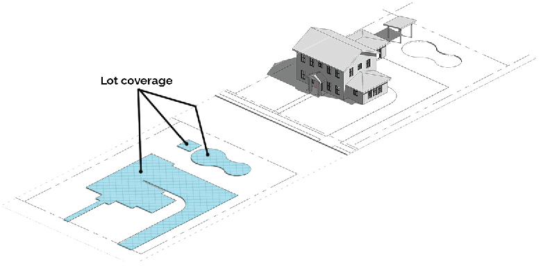
Figure 21-9.2.1.A Lot Coverage
Lot coverage: Lot coverage is measured as the area or percentage of a lot that is covered by buildings, structures, swimming pools, streets, sidewalks, patios, decks, driveways, parking areas and other impervious surfaces, often expressed as impervious surface ratio (ISR). Trail improvements that are part of a board of mayor and commissioners-approved plan are not counted as part of a site's impervious surface area for purposes of site development-related calculations and regulations. Lot coverage is used synonymously with impervious coverage.
Lot, flag: A lot that sits behind lots which face directly onto a street with access provided to the bulk of the lot by means of a narrow corridor, whether providing the minimum amount of street frontage and width or not.

Figure 21-9.2.1.B Through Lot
Lot, through: A lot which has frontage on more than one (1) street, provided that no corner lot shall qualify as a double frontage lot unless said corner lot has frontage on three (3) or more streets.
Lot frontage: Lot frontage is measured along the front property line adjacent to the street. On a corner lot the side of the lot having the least amount of street frontage is the front property line. For purposes of measuring lot frontage on corner lots with a radius return, the measurement must be taken from the point of intersection of an imaginary extension of the street property lines. For lots with other irregular geometric shapes, lot frontage is measured along an imaginary line located at the building line or the required street setback line, whichever is closer to the street.
Lot, interior: A lot having frontage on only one (1) street.
Lot line, front: The front lot line of an interior lot is the line separating the lot from the public right-of-way. The front lot line of a corner lot shall be shorter lot boundary along a public right-of-way.
Lot line, rear: The boundary opposite and more or less parallel for the front lot line.
Lot line, side: Any lot boundary line that is not a front or rear lot line.
Lot of record: An individual lot or a lot that is part of a subdivision approved by the City of Avondale Estates, a plat or the deed of which has been legally recorded in the office of the Clerk of the Superior Court of Dekalb County. No lot of record may be created after the effective date of this ordinance unless it is approved through the City of Avondale Estates subdivision process.

Figure 21-9.2.1.C Frontage and width - cul du sac
Lot width: Lot width is measured as the distance between the side lot lines, measured along a line drawn parallel to the front lot line at a distance from the front lot line equal to the minimum street yard setback. For lots with curvilinear frontage and setback lines (e.g.: cul-de-sac lots), the width shall be measured as a straight line through the points that intersect the side lot lines at a distance from the front lot line equal to the minimum street yard setback.
Motor home/motorized home: Every portable vehicle that is designed, used, or maintained primarily as a mobile dwelling, office, or commercial space and constructed as an integral part of a self-propelled vehicle.
Muntin: A dividing bar between panes of glass.
Natural grade: The unaltered, natural elevation of the ground, usually at a construction site.
Neighborhood: A geographically defined area comprised of all single-family dwellings (detached or attached) located outside of the Avondale Estates Historic District.
Nonconforming structure: Any structure lawfully situated at the time of adoption of this ordinance or amendments thereto, that does not conform to the regulations of this ordinance at the effective date of this ordinance or as the result of subsequent amendments to this ordinance.
Nonconforming Use: Any use lawfully established at the time of adoption of this ordinance or amendments thereto that does not conform to the regulations of this ordinance at the effective date of this ordinance or as the result of subsequent amendments to this ordinance. The term "permitted use" or its equivalent shall not bee deemed to include any nonconforming use.
Normal maintenance and repair: Actions taken to mend or stabilize a damaged or deteriorated component of a structure or site, using same or similar code-code complaint materials, as needed to prevent further disrepair or to bring a property into closer compliance with current zoning regulations. Examples include repainting a painted surface a solid color, re-roofing a damaged roof, or resurfacing paved areas. Does not include construction or redevelopment projects.
Open space: That portion of a lot, not including required yards, established pursuant to the requirements of this chapter as open space, which is open and unobstructed from ground level to the sky, with the exception of natural foliage or accessory recreational facilities or walkways, which is accessible to all persons occupying a building on the lot.
Owner: Any person, group of persons, firm or firms, corporation or corporations or any other legal entity having legal title to or sufficient proprietary interests in land sought to be subdivided, developed or otherwise used under the provisions of this ordinance.
Parapet: A parapet is a low wall projecting from the edge of a platform, terrace, or roof.
Parking space: A paved area within a parking lot, other than on a single-family dwelling lot, expressly provided for purposes of parking a motor vehicle.
Parking structure/parking deck: A multi-level structure providing one (1) or more stories of parking above or below the finished grade of the street.
Pedestrian walkway: A right-of-way within a block dedicated to a public use, intended primarily for pedestrians and from which motor propelled vehicles are excluded.
Pilaster: A flat surface that protrudes beyond the wall into which it is built and designed to give the appearance of a supporting column. Pilasters often appear on the sides of a door frame or widow opening on the façade of a building and are sometimes paired with weight bearing columns or pillars set directly in front of them. Commonly used for decoration, pilasters can also be used to thicken a wall to accommodate a structural load.
Planned center, office, commercial or industrial: A grouping of rental stores, service establishments, offices, industries, or other businesses offering goods or services to the public for compensation. Planned office, commercial, or industrial centers are held in common or condominium ownership.
Planned unit development (PUD): A method of using land under unified control. Planned developments are planned and developed as a whole in a single development operation or programmed development phases, including streets, utilities, building lots, and open space identified on a site plan. Such plan also indicates all structures and their relationship to each other and to adjacent uses and improvements.
Planning, architecture, zoning board (PAZB): The appointed Planning, Architecture, Zoning Board of the City of Avondale Estates, Georgia established to make recommendations to staff and the board of mayor and commissioners on decisions like tier 2 waivers and amendments.
Principal entrance: The main point of access for pedestrians into a building, usually located on a primary street.
Public area: Any space made accessible to the public through an easement, right-of-way, or consent issued from the property owner(s) or property owner(s)' legal representative.
Public notice: The posting of a sign in a conspicuous place on the frontage of the property in question, so that the posted sign that is clearly visible and legible from the street, as required by this ordinance. Public notice shall also mean publication of such notice in a newspaper of local circulation and letters mailed to adjoining property owners.
Rear alley: A vehicular way located to the rear of lots providing access to service areas, parking, and outbuildings containing utility easements. Rear alleys should be paved from building face to building face.
Recessed entry: An entry that is not flush with the façade plane, but instead set closer towards the interior space of a building.
Recreational vehicle: A boat, boat trailer, motor home, travel trailer, camping trailer, truck camper, pick up coach, as defined in this Section, used or designed for temporary portable housing or occupancy, which may be provided with sleeping accommodation.
Redevelopment: Projects which increase gross floor area by fifty (50) percent or more, or projects where the cost of remodeling is greater than the assessed value of the existing site improvements as shown on the applicable county assessment and taxation records for the current year.
Renovation: Any improvements or alterations made to property or structures that are beyond what is ordinarily needed for necessary maintenance and safety considerations.
Retaining wall: A structure constructed and erected between lands of different elevations to protect structures and/or to prevent erosion.
Right-of-way: Land occupied or intended to be occupied by a street, sidewalk, crosswalk, pedestrian walkway, bike path, planting strip, railroad, electric transmission line, oil or gas pipeline, water main, sanitary or storm sewer main, landscaped buffer or other special use.
Screening: A buffer established and maintained for the purpose of providing acoustical, visual, or general nuisance protection or abatement. Frequently used to separate of incompatible land uses.
Seating: Furnishing that is designed for sitting and which may have added features for comfort, such as a back, arm rests, or head supports.
Seat wall: A masonry wall twelve (12) to eighteen (18) inches from grade on at least one (1) side designed for sitting.

Figure 21-9.2.1.D Setbacks
Setback: A line, at street level, delineating the minimum allowable distance between a property line or public right-of-way line of an abutting street and a structure on a lot.
Short-term bicycle parking: A device to which bicycles may be securely attached and left unattended for less than two (2) hours. Also called bike racks or bike stands, these devices may be free standing or attached to a stationary object such as building or sidewalk.
Sidewalk level: Any floor of a building within the central business district having a finished floor elevation within five (5) feet of the elevation of the adjacent sidewalk.
Sign board: Area on front façade in central business district dedicated to wall signage.
Solar reflectance: A material's ability to reflect the sun's solar energy back into the atmosphere.
Solar reflectance index (SRI): SRI is a measure of the solar reflectance and emissivity of materials that can be used as an indicator of how hot they are likely to become when solar radiation falls on their surface. The lower the SRI, the hotter the material is likely to become in the sunshine.
Soldier course: A course of bricks laid on their ends so that only their long sides are visible.
Spite strip: A piece of land used to separate a street or road rights-of-way from adjoining property to preclude access to such rights-of-way.
Square: An open space type designed for unstructured recreation and civic purposes, spatially defined by building frontages or public rights-of-way and consisting of paths, lawns, patios, and trees, formally disposed.
Stoop: A frontage wherein the façade is aligned close to the frontage line with the first story elevated from the sidewalk for privacy; with an exterior stair and landing at the entrance.
Story: That portion of a building included between the surface of any floor and the surface of the next floor above, or if there is no floor above, the space between the floor and the ceiling above. Excludes basement(s) having a height of less than eight (8) feet above the adjacent grade.
Street: A dedicated, accepted, and opened public right-of-way paved for vehicular traffic that affords the principal means of access to abutting properties. The following are definitions intended to distinguish between different categories of streets:
1.
Principal arterials: Streets and highways that serve major activity centers and emphasize traffic service rather than access to abutting land. Principal arterials include all limited access freeways, expressways, parkways, or roads and carry a high proportion of total area travel on a minimum of mileage.
2.
Minor arterials: Streets that interconnect with the principal arterial system and provide service to trips of moderate length with emphasis on both traffic service and land access. Minor arterials provide intra-community continuity but should not enter identifiable neighborhoods.
3.
Collector streets: Streets that distribute trips from arterial streets to their ultimate origin or destination. Collector streets provide a greater level of property access than arterial streets, and may enter or traverse identifiable neighborhoods, and rarely serve significant volumes of through traffic.
4.
Local streets: Streets compromising all facilities not classified as arterials or collectors. Local streets provide property access with service to through traffic being activity discouraged.
Street, right-of-way line: The limit of publicly owned land or easement encompassing a street.
Structure: Anything arranged, built, installed, or erected in an ordered way. Structures have a permanent location on the ground or are attached to something having a permanent location on the ground. Examples include, but are not limited to, tennis courts, fences, walls, and swimming pools.
Subdivision: Any division or re-division of a lot, tract, or parcel of land or recombination of previously platted lots, regardless of prospective use, including all division or recombination of land involving the dedication, change, or abandonment of a street, site, easement, or other right-of-way for any public use or for sale or improvement. The term, "subdivision," shall also mean the act of subdividing. However, where appropriate to the context, the term "subdivision" shall also mean the aggregate of all parcels held by one (1) owner or combination of owners and designated to be developed or sold as parcels related to each other or interdependent through the use of streets, easements, or other rights-of-way.
Supplemental zone: The area within the central business district between the street fronting building and the sidewalk.
Travel trailer: A recreational vehicle built on a chassis and designed to be hitched to and drawn by a passenger automobile. Used as temporary dwelling for travel, recreational, and/or vacation uses. Travel trailers, when equipped for the road, have a body width not exceeding twelve (12) feet and a body length not exceeding sixty (60) feet.
Transom: A window, glass pane, or decorative wood block above a door, whether rectangular or arched, but still in the door frame.
Truck camper: A demountable recreational vehicle that is loaded and unloaded from the bed of a full size or mid-size pick-up truck. The common feature is the ability to demount the camper from the truck. Used as a temporary dwelling, office, or commercial space during travel. Can be a pop-up or hard-side walls.
Utility trailer: A type of recreational vehicle designed or constructed as to permit the hauling of various items normally towed by a personal vehicle.
Vertical façade divisions: The use of a vertically oriented expression line or form to divide the façade into vertical divisions at increments, as measured along the base of a façade. Elements may include a column, pilaster or other continuous vertical ornamentation a minimum of 1.5 inch in depth.
Waiver: Where, because of conditions peculiar to the site, strict adherence to the provisions of the ordinance would cause an undesired outcome, an alternate solution may be reviewed for a site or building feature that would still meet the spirit of the ordinance. There are two (2) tiers for this process.
Wall: A solid retaining or security barrier constructed of materials including brick, stone, concrete, concrete block, ceramic tile, or other aggregate materials.
Yard: A required space on the same lot with a principal building, open, unoccupied and unobstructed by buildings or structures from ground to sky except where encroachments or accessory buildings and other structures are expressly permitted, provided a traffic safety hazard is not created. Yard is not considered open space but is classified open area.
Yard, front: A yard situated between the front building line and the front lot line extending the full width of the lot.
Yard, rear: A yard situated between the rear building line and the rear lot line and extending the full width of the lot.
Yard, side: A yard situated between a side building line and the side lot line and extending from the front yard to the rear yard.
Zero-lot-line: A building or structure built such that common party walls located on the property lot line divide separate lots and building units. Zero lot line development my also encompass a single building erected on the property line.