Black Mountain City Zoning Code
CHAPTER 4
- ZONING REGULATIONS
4.1.1 - Purpose and authority.
These zoning regulations are adopted to provide guidelines for the development of land in Black Mountain, pursuant to the authority granted in N.C.G.S. § 160D-702, consistent with the General Statutes of the State of North Carolina, the Town of Black Mountain Code of Ordinances, and the Comprehensive Plan to address the following public purposes:
1.
To provide adequate light and air;
2.
To prevent the overcrowding of land;
3.
To avoid undue concentration of population;
4.
To lessen congestion in the streets;
5.
To secure safety from fire, panic, and dangers;
6.
To facilitate the efficient and adequate provision of transportation, water, sewerage, schools, parks, and other public requirements; and
7.
To promote the health, safety, morals, or the general welfare of the community.
SECTION 4.7 - ZONING REGULATIONS BY DISTRICT
See Section 4.7.15 for the permitted use table.
See Section 4.7.16 for the district dimensions standards table.
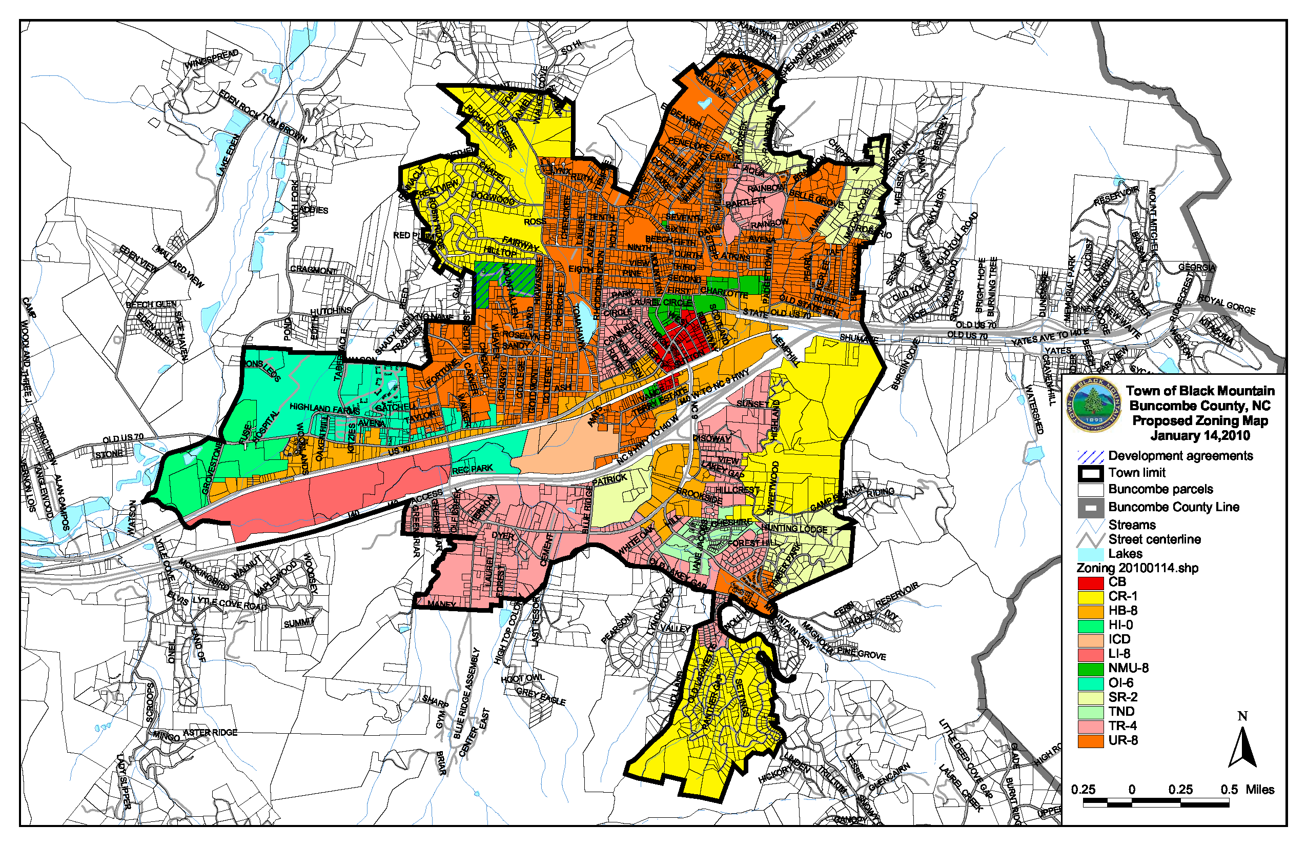
4.2.1 - Designation of zoning map.
The map entitled Town of Black Mountain Zoning Map as adopted by the Town of Black Mountain Town Council and certified by the town clerk establishes the official zoning and overlay districts. This map will be maintained and posted at the Town of Black Mountain Planning and Development Department. Digital and paper copy versions of this map shall also be made available through the planning and development department for reference.
4.2.2 - Interpretation of the zoning map.
A.
Unless otherwise specified, zoning district boundaries run with property lines or the centerline of streets, alleys or other rights-of-way.
B.
Boundaries indicated as following railroad lines run along a line midway between the tracks.
C.
Boundaries indicated as approximately following the centerline of streams, rivers, channels or lakes follow the centerline of the waterway.
D.
Where a zoning district boundary divides a land parcel under a single ownership into two districts, the requirements of the less restrictive zone shall be applied to the entire parcel and the zoning district boundary adjusted accordingly, provided that the zoning district boundary adjustment is a distance of less than 100 feet, otherwise, an application for rezoning must be filed pursuant to the process set forth in Chapter 1 of this Land Use Code.
E.
The zoning administrator shall have the authority to interpret the district boundaries. Appeals of the zoning administrator's interpretation may be made to the board of adjustment.
4.2.3 - Changes to official zoning district map.
Changes made to zoning district boundaries or other matters portrayed on the official zoning district map shall be made in accordance with the provisions section 1.5 of this Code. Changes shall be entered on the official zoning district map promptly after the amendment has been approved by the town council.
4.2.4 - Town of Black Mountain Zoning Map.
This map and its boundaries shall be incorporated and made part of these regulations.
4.3.1 - Conformance required.
A.
No building or land shall be used or occupied and no building or structure or part thereof shall be erected, moved or structurally altered except in conformity with the town zoning regulations.
B.
No building or zoning permit shall be issued on new lots created by the subdivision of land unless:
1.
The subdivision is exempt from the subdivision regulations;
2.
The subdivision is a major subdivision and a preliminary plat has been approved; or
3.
The final plat for the subdivision has been recorded with the Register of Deeds for Buncombe County.
C.
Special uses are permitted upon compliance with the additional conditions imposed and as specified by the board of adjustment.
D.
Unless otherwise specified by the regulations governing the district within which a project (new development or redevelopment) is located, all development must adhere to all development regulations, including but not limited to flood hazard prevention (see LUC chapter 2), stormwater (see LUC Chapter 8), lighting (see Town of Black Mountain Ordinances Chapter 20, Article VII), signage (see LUC chapter 9), parking (see LUC chapter 10), pedestrian planning and other requirements (see LUC chapter 4).
E.
Amusements, solicitors, peddlers and itinerant merchants shall be allowed as provided in Chapter 9 of the Town of Black Mountain Code of Ordinances. Nothing in this chapter shall be construed or interpreted to preempt or supersede the town's adopted business regulations.
4.3.2 - Minimum regulations.
Regulations set forth in this chapter shall be minimum regulations. If the district requirements set forth in this section differ with the requirements of any other lawfully adopted rules, regulations or ordinances, the more restrictive or higher standard shall govern.
4.3.3 - Zoning permits.
A.
Zoning administrator. It is the intention of this chapter that all questions arising in connection with compliance with, and enforcement of, zoning regulations shall be the responsibility of the zoning administrator and that such questions shall be presented to the board of adjustment only on appeal from the decision of the zoning administrator.
B.
Zoning permit required. No building, sign or other structure (except as otherwise provided in these regulations) shall be erected, moved, extended or enlarged or structurally altered, nor shall the use conducted within the structure change, nor shall any excavation or filling of any lot for the construction of any structure be commenced, nor substantial clearing, grading, or excavation be commenced, nor shall any change in the use of a property be commenced until a zoning permit is issued or the zoning administrator reviews and approves the issuance of permits required for such work. No zoning, building or grading permit shall be issued without first obtaining the approval of the zoning administrator who shall certify that the development described on the application complies with all existing zoning regulations.
C.
Zoning permit not required. A zoning permit is not required, notwithstanding any other provisions of this ordinance, for the following:
1.
Street construction or repair;
2.
Electric power, telephone, telegraph, cable television, gas, water, and sewer lines, wires or pipes, or supporting poles or structures, located within a public right-of-way;
3.
Temporary activities undertaken by local, state or federal governmental agencies related to emergencies, such as the provision of shelter during storms, floods or other civic needs, the use of modular or mobile homes or trailers for emergency management administration, and storm or flood clean-up and repair;
4.
Mailboxes, birdhouses, flag poles, pump covers, and doghouses;
5.
Signage that meets the exemption requirements of the sign regulations;
6.
Interior alterations and renovations which do not alter the footprint or height of an otherwise conforming use and/or structure.
D.
Expiration of permits. Any zoning permit issued in accordance with this chapter shall expire six months after the date of issuance if the work authorized by the permit has not been commenced. If after commencement the work is discontinued for a period of 12 months, the permit shall immediately expire. No work authorized by any permit that has expired shall thereafter be performed until a new permit has been secured. If the permit recipient has proceeded with due diligence and in good faith and conditions have not changed substantially so as to warrant a new application, the zoning administrator may grant extensions for periods up to six months. All such extensions may be granted without resort to the formal processes and fees required for a new permit.
4.4.1 - Lot size and lot reductions.
A.
All subdivision of property created after the effective date of this chapter must conform to the lot requirements of the district in which it is located.
B.
In areas not served by a public or community sewer system, the minimum lot area shall be that necessary for safe on-site waste disposal system as determined by the county health department, but in no case, shall the lot be smaller than the required area for the zoning district in which it is located.
C.
Subdivisions for the purpose of land conservation or for the dedication of open space which are exempt from the subdivision regulations in Chapter 3 of this LUC are exempt from the requirements of this chapter.
4.4.2 - Lot access.
A.
No building, structure or use of land for other than conservation purposes shall be established on a lot which does not have access to a public street directly or by means of an easement. Access shall meet the requirements as indicated in the Town of Black Mountain Standards and Details Manual and connect any lot that does not abut a street with the nearest reasonable accessible street to said lot. The strip shall be under the same ownership as the lot to which it provides access, or shall be an easement of record and appurtenant to the lot for which it provides access.
B.
Up to three lots may share access by means of a shared right-of-way so long as each lot has off-street parking for two cars, which parking shall not be located within the right-of-way of the private drive. In cases where four or more lots share access through a common right-of-way, the right-of-way shall be considered and designed as a named roadway and meet the requirements of the Town of Black Mountain Standards and Details Manual.
1.
In a conservation subdivision, rights-of-way that cannot meet the road standards for a subdivision without compromising performance goals of the conservation subdivision requirements (see 7.5.4) and which access more than three lots must meet the approval of the public works director and fire marshal for the purpose of waste collection, snow removal and maintenance, and emergency vehicle access.
2.
In a development undertaken pursuant to a special use permit, the design of any shared parking and loading areas that also serve to access more than three residential units must be approved by the fire marshal.
C.
Lots which include or are adjacent to perennial or intermittent surface waters as indicated on the most recent version of the 1:24,000 scale quadrangle topographic maps prepared by the USGS are subject to a 30-foot setback from the top of the bank of that surface water in accordance with phase II stormwater regulations. (see section 8.2.10)
4.4.3 - Setbacks, corner lots and double frontage lots.
A.
Yard and setback requirements shall be met unless variance is granted by the board of adjustment.
B.
Minimum setbacks shall be measured horizontally from the origin of the setback as the right-of-way, or property boundary, to the nearest portion of the building or structure.
C.
If the property line extends into a roadway or highway, then the setback line shall be measured from the edge of the roadway or back of the curb when computing setback requirements.
D.
Wherever right-of-way has not been established, setback shall be measured from the outer edge of the existing drainage ditch running parallel and adjacent to the road, or four feet off the edge of pavement where no ditch exists, or from the edge of the traveled area on an unpaved road.
E.
Public rights-of-way or easements for streets and roads shall not be considered a part of a lot or open space, or as front, side, or rear yard for the purpose of meeting yard requirements. Driveways, parking areas, loading zones, sidewalks, or greenways may encroach or be included within a yard setback without affecting the setback requirements (see also 4.4.7).
F.
In developed areas where more than three structures already exist, the setback may be determined by the average setback on already built upon lots located wholly or in part within the same block and zoning district and fronting the same street. In such cases, the setback on such a lot may be less than the required setback but not less than the average of the existing setbacks on the developed lots. However, in no case shall setbacks be less than 15 feet, except in the CB, central business district, where the minimum setback is 12 feet.
G.
No building or structure shall be placed within a roadway or highway right-of-way, except as otherwise provided in these regulations.
H.
Any structure on a corner lot shall comply with the minimum setback (front yard) requirements of the street which it faces, and shall comply with 50 percent of the minimum front yard setback requirements, if applicable, on any other street which the corner lot abuts. In case of doubt as to which street a structure faces, or if a structure is built so as not to face any street, the zoning administrator shall determine which setback, side yard and rear yard requirements apply.
I.
For lots having frontage on two or more streets, but not located on a corner, the minimum front yard shall be provided on each street in accordance with the applicable district(s).
J.
Allowable encroachments into required setbacks. The following may encroach upon required setbacks as set forth below unless specifically prohibited elsewhere in this chapter.
1.
Sills, cornices, and similar ornamental features projecting from the principal building may encroach up to 18 inches into any required setback.
2.
Bay windows, balconies, and similar features projecting from the principal building may encroach up to three feet into any required setback.
3.
Decks, steps, uncovered porches, patios, and terraces may encroach into a required side or rear setback, but no closer than six feet to the side or rear property line.
4.
Fences and walls.
5.
If a handicapped accessibility or life safety feature cannot meet this requirement due to the location of an existing structure or other impeding site feature on a residential lot, the setback requirement shall be waived to the extent necessary to accommodate the accessibility or life safety feature.
4.4.4 - Steep hillside setback allowance for residential lots.
A.
On residential lots where the first 45 feet from the edge of the pavement exceeds 30 percent slope, front yard setbacks are adjusted as follows:
1.
In CR-1 and SR-2, minimum front setback requirement is 25 feet.
2.
In TR-4 and UR-8, minimum front setback requirement is 15 feet.
4.4.5 - Location of buildings on irregularly shaped lots.
Locations of front, side and rear setback lines on irregularly shaped lots shall be determined by the zoning administrator in writing. Such determinations shall be based on the spirit and intent of the district regulations to achieve appropriate spacing and location of building(s) on individual lots. Appeals of such determinations shall be made to the board of adjustment following the procedures set out in section 1.7.2.
4.4.6 - Visibility at intersections.
A.
Uses located at a street intersection shall not have a dumpster or service area within 15 feet of the corner at the edge of pavement or the back of curb, whichever is closer.
B.
Except for intersections within the central business district (CB), the sight triangle described below in paragraph C. shall be maintained on each corner of property at the intersection of two streets, a street and an alley, a street and a railroad, and also at the point where driveways, private drives, or entrances to common parking areas intersect with a public or private street right-of-way. The sight triangle is a triangular area connecting the intersection of the right-of-way lines and the end points of the sight distance for the intersecting streets as set forth in the latest edition of the NCDOT subdivision roads minimum construction standards.
C.
The following are the distances used to establish a sight triangle as measured from an intersecting right-of-way:
| Right-of-way width | Distance (feet) | 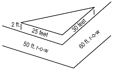 |
| <50′ | 20′ | |
| 50′ | 25′ | |
| 60′ | 30′ | |
| 70′ | 35′ | |
| 80′ | 40′ | |
| 90′ | 45′ | |
| 100′ (or greater) | 50′ |
D.
A sight triangle shall contain no fence, structure, earth bank, hedge, planting, wall or other obstruction between a height greater than two feet above the grade of the crown of the adjacent road as established by the zoning administrator. The following are exempted from this provision:
1.
Public utility poles and fire hydrants.
2.
Trees trimmed (to the trunk) to a height at least nine feet above the level of the intersection.
3.
Other plant species of open growth habit that are not planted in the form of a hedge and which are so planted and trimmed as to leave in all seasons a clear and unobstructed cross-view.
4.
A supporting member or appurtenance to a permanent building or sign lawfully existing on the effective date of this ordinance.
5.
Official warning signs or signals or other appurtenances required for traffic control.
6.
Signs which conform to the sign regulations with supports that do not encroach on the clear-vision area.
E.
The administrator (or his/her designee) may waive this provision where the natural contour of the ground is such that there can be no cross visibility at the intersection.
4.5.1 - Location of building lines.
Locations of front, side and rear building lines as oriented on a lot shall be determined by the zoning administrator. Such determinations shall be based on the intent of the town and district regulations to achieve appropriate spacing and location of buildings within parcels.
4.5.2 - Height regulations.
A.
No structure shall be erected or altered so as to exceed the height regulations of the district in which it is located.
B.
Height shall be measured as the average vertical distance from the highest adjacent grade at the base of a structure at the corners of the structure, or from the grade of the centerline of the nearest adjacent public roadway, whichever is higher, to the highest point of the coping of a flat roof, to the deck line of a mansard roof, or to the mean height level between the eaves and ridge of a gable, hip or gambrel roof.
C.
Where buildings are located on slopes, the average height will be calculated for each side of the building at its corners and at no side of the building should the maximum height from the adjacent grade be more than ten feet greater than the allowable building height for the district.
D.
Chimneys shall not be included in the measurement of building height.
E.
Steeples or towers associated with places of worship or government facilities, and water towers required for fire safety and water supply are exempt from these requirements.
F.
Free-standing communications towers constructed pursuant to a special use permit are exempt from building height requirements of this section.
G.
This section does not apply to amateur radio antennas affected and controlled by FCC regulations codified in Chapter 47, Section 97, of the Code of Federal Regulations.
H.
Maximum building height for free-standing mechanical equipment appurtenant to the use, including chimneys, storage containers, tanks, water towers or chillers shall not exceed the maximum height of the district in which the use is located.
I.
Mechanical equipment located on the roof shall not count towards the building height requirement and shall be screened to the greatest extent possible from the edge of the roadway of adjacent public roadways, with the exception of Interstate 40. Structural screening immediately adjacent and surrounding roof-top mechanical equipment is allowed in addition to or instead of a parapet for the purpose of visual screening and protection. Such structural screening for mechanical equipment shall not be at a height not to exceed the highest member of the mechanical equipment itself.
J.
Parapets may be used in all districts and shall not count toward the building height requirements, as long as they do not add more than ten percent of footage to the overall building height above the maximum height for the district. Parapets may be used to meet the screening requirement for rooftop mechanical equipment. For example:
4.5.3 - Principal buildings and structures per lot.
A.
Every structure erected, moved or structurally altered shall be located on a single lot and in no case shall there be more than one principal building and its customary accessory buildings on the lot unless:
1.
As part of an approved industrial operation within either of the industrial districts (LI-8 or HI-0); or
2.
As part of an approved special use permit; or
3.
As part of a pre-existing nonconforming use; or
4.
As a secondary dwelling.
B.
Duplexes within a single lot will be treated as a single primary structure for the purposes of compliance with zoning district lot size and setback unless regulated by the minimum lot size and density table for steep slope lots. For separate units within a zero-lot line structure such as those for some types of townhomes or attached houses, the individual units will be considered the primary structure for each lot.
4.5.4 - Accessory structures.
A.
In no case shall an accessory structure be located closer than five feet to the nearest property line.
B.
For land used for agriculture or as a bona fide farm that is greater than one acre, there is no limit to the number of accessory structures allowed, provided that such structures shall be incidental to the agricultural use and shall not cover more than 30 percent of the total lot area.
C.
In industrial districts, there is no limit to the number of accessory structures provided that such structures are incidental to the industrial use.
D.
In commercial districts, unless otherwise provided in a special use permit, no more than two accessory structures shall be permitted per lot.
E.
In residential and mixed-use districts, no more than two accessory structures shall be permitted per lot, provided that any such structure shall meet the following requirements:
1.
Accessory structures shall not be more than two stories.
2.
For lots adjacent to town or state roadways, accessory structures shall be located only in the side or rear yards.
3.
For lots not adjacent to town or state roadways, accessory structures may be located in what is determined as the front yard by the zoning administrator. The accessory structure may be located no further forward than the primary structure furthest from the road of any adjacent properties never to be less than the existing setback requirements.
4.
Accessory buildings shall not cover more than 30 percent of the required side or rear yards. Accessory structures may require screening at the direction of the zoning administrator if the accessory structure may be considered a nuisance under the town's nuisance regulations or if it is being used for commercial purposes while abutting a residential use or district.
4.5.5 - Use and location of dumpsters.
Dumpsters are allowed in all districts in accordance with the following standards:
A.
All dumpsters must be maintained in good working condition and their exterior shall be kept clean, free of debris, accumulations or effluent.
B.
No dumpster shall contain hazardous material unless it is designed to contain such material or is lined, and that such containment is approved by the environmental protection agency.
C.
Dumpsters which contain oil and grease shall not leak.
D.
Dumpsters must be screened from the public right-of-way and from abutting residential property boundaries. Screening shall be with an opaque wall or fence that is at least one foot higher than the dumpster itself. Vegetative buffers of evergreen of sufficient height and density to meet the opaque screening requirement and which are a minimum of ten feet in width, may be permitted in lieu of a structural screen upon approval of the zoning administrator.
E.
Reserved
F.
Screening provided to meet town requirements must be maintained in good condition and on a continuous basis.
G.
Reserved.
4.5.6 - General screening and buffering requirements.
A.
Where a lot upon which a commercial or industrial use is occurring abuts a lot upon which a residential or mixed-use is occurring there shall be an opaque wall or fence of at least four feet in height along the property line. A vegetative buffer of at least ten feet in width and six feet in height and of sufficient density may be permitted in lieu of a structural screen upon approval of the zoning administrator.
B.
Where a commercial or industrial use within a mixed-use district abuts a residential district, there shall be an opaque wall or fence of at least four feet in height along the property line. A vegetative buffer of at least ten feet in width and six feet in height and of sufficient density may be permitted in lieu of a structural screen upon approval of the zoning administrator.
4.6.1 - Base zoning districts established.
A.
Base zoning districts are created to provide comprehensive land use regulations throughout Black Mountain. There are 12 base zoning districts that provide for a variety of uses appropriate to the character of the areas in which they are located. The Town of Black Mountain is hereby divided into the base zoning districts as reflected on the zoning map adopted pursuant to section 4.2.1 of this chapter.
B.
The following zoning districts are established:
1.
Conservation residential district (CR-1)
2.
Suburban residential district (SR-2)
3.
Town residential district (TR-4)
4.
Urban residential district (UR-8)
5.
Office and institutional district (OI-6)
6.
Neighborhood mixed use district (UR-8)
7.
Central business district (CB)
8.
Highway business district (HB-8)
9.
Light industrial district (LI-8)
10.
Heavy industrial district (HI-0)
11.
Traditional neighborhood development (TND)
12.
Institutional campus district (ICD)
4.6.2 - Conditional zoning districts established.
A.
Conditional zoning districts are established to provide flexibility in the development of property while ensuring that proposed development is compatible with neighboring uses. Conditional districts allow for uses or development of land not otherwise permitted in the underlying base district. Conditionally zoned property may be subject to additional conditions, standards and regulations to ensure that the development and use of the property are compatible with the surrounding uses and consistent with the comprehensive plan and other plans adopted by the town. Conditional zoning should not be used to relieve hardships that could be resolved by issuance of a variance.
B.
Conditional zoning districts. the following conditional zoning districts are established:
1.
Conservation residential conditional zoning district (CR-1 CZ)
2.
Suburban residential conditional zoning district (SR-2 CZ)
3.
Town residential conditional zoning district (TR-4 CZ)
4.
Urban residential conditional zoning district (UR-8 CZ)
5.
Office and institutional conditional zoning district (OI-6 CZ)
6.
Neighborhood mixed use conditional zoning district (NMU-8 CZ)
7.
Central business conditional zoning district (CB CZ)
8.
Highway business conditional zoning district (HB-8 CZ)
9.
Light industrial conditional zoning district (LI-8 CZ)
10.
Heavy industrial conditional zoning district (HI-0 CZ)
11.
Traditional neighborhood development conditional zoning district (TND-CZ)
12.
Institutional campus district conditional zoning district (ICD-CZ)
C.
General requirements. The following provisions shall apply in the administration of conditional zoning.
1.
No property shall be zoned as a conditional district except upon application of the owner or a duly authorized representative of the owner, pursuant to the procedure set out in section 1.5.5.
2.
A conditional district shall consist of land that will be planned and developed as a single development or as an approved series of development phases. The owner or owners of the property shall be legally capable of ensuring that development of the property will comply with all documents, plans, standards, and conditions approved by the town.
3.
All standards and requirements of the corresponding general use zoning district shall be met, except to the extent that the conditions imposed by the conditional zoning may be more or less restrictive than the development standards.
4.
Only those uses permitted in the underlying zoning district, whether by right or specially, shall be permitted in the conditional zoning district. Uses not otherwise permitted within the underlying zoning district shall not be permitted within the conditional district.
5.
No variance or special use permit may be issued for developments on property subject to a conditional zoning ordinance.
D.
Conditions.
1.
Site-specific standards and conditions may be imposed within a conditional district, provided such standards or conditions are approved by the town council and consented to by the petitioner in writing.
2.
Standards and conditions may be proposed by the petitioner, by town staff, by recommendation of the planning board, or by the town council.
3.
Standards and conditions imposed shall be limited to those that address the conformance of the development and use of the site to town ordinances and plans, or the impacts reasonably expected to be generated by the development or use of the site.
(Ord. No. O-21-07, 8-9-2021; Ord. No. O-23-15, 9-29-2023)
4.6.3 - Overlay districts established.
Additionally overlay districts are created to further regulate land use, dimensional requirements, and site design in significant or sensitive areas of town.
1.
Wellhead protection overlay
2.
Flood damage prevention overlay
3.
Historic overlays (historic district and historic conservation district)
4.
Fire district overlay
5.
Pedestrian master plan overlay
6.
U.S. 70 corridor overlay
4.6.4 - Other requirements.
A.
In addition to zoning district regulations see the following sections for other requirements:
1.
See chapter 3 for subdivision requirements.
2.
See chapter 5 for additional use standards for certain uses.
3.
See chapter 7 for special uses.
4.
See chapter 8 for land development and environmental regulations.
5.
See chapter 9 for sign regulations.
6.
See chapter 10 for parking requirements.
7.
See chapter 11 for infrastructure resources, contacts and requirements.
4.7.1 - Conservation residential district (CR-1).
4.7.1.1 Purpose and intent. The conservation residential district is established to protect areas in which the principal use of the land is residential or agricultural and where steep slopes or other environmental features make it more suitable for large lot development, conservation development and the preservation of open space.
4.7.2 - Suburban residential district (SR-2).
4.7.2.1 Purpose and intent. The suburban residential district is established to protect areas in which the principal use of the land is single-family residential and where less dense development is preferred for the protection of slopes or environmentally sensitive areas, traditional single-family neighborhoods and the preservation of open space.
4.7.3 - Town residential district (TR-4).
4.7.3.1 Purpose and intent. The town residential district is established to allow for a variety of housing types while maintaining an overall residential character with medium density. Any use which, because of its characteristics would interfere with the residential nature of the area is excluded.
4.7.4 - Urban residential district (UR-8).
4.7.4.1 Purpose and intent. The mixed residential district is established to provide a variety of housing types, promote density in the more urbanized and developable areas or town, and structure the orderly development of residential neighborhoods.
4.7.5 - Office and institutional district (OI-6).
4.7.5.1 Purpose and intent. The office and institutional district is established to provide transition between residential and commercial districts; to accommodate a mixture of residential, office, and institutional uses in conditions of good health and safety; to accommodate planned developments that are institutional in nature and which may have multiple buildings and uses within one property; and to protect property values of residential, institutional and professional uses within the district in a way that is mutually beneficial.
4.7.6 - Neighborhood mixed use district (NMU-8).
4.7.6.1 Purpose and intent. The neighborhood mixed use district is established to serve the needs of the surrounding residential neighborhoods by providing compatible goods and services without negatively impacting the residential nature of the adjacent neighborhoods. It is also intended to establish areas for low-intensity business centers which are accessible to pedestrians from the surrounding residential neighborhoods.
4.7.6.2 Supplementary district requirements (NMU-8). New construction within this district shall retain the characteristics of a residential neighborhood and shall not include metal buildings or cinder block buildings as the primary structure on a lot. Newly constructed structures, unless part of a special use permit or an accessory structure, shall have a pitched roof and other characteristics of single-family homes within the adjacent residential neighborhoods.
4.7.7 - Central business district (CB).
4.7.7.1 Purpose and intent. The central business district includes the area traditionally known as "downtown" and includes the "downtown historic district". This district is established to maintain the village-like community that preserves architectural heritage and small-town character of Black Mountain. It is intended to promote a safe, convenient, and attractive environment for pedestrians; promotes business in buildings of a size and scale appropriate to a small town; encourage locally-owned businesses, entrepreneurs, and artists; provide a wide range of shopping, dining, working, and cultural attractions with storefronts that interact with the sidewalk; promote the beautification of the public rights-of-way; and encourage residential development that blends with the commercial character of the district and enhances the variety of housing options provided in the town.
4.7.7.2 Supplementary district requirements (CB).
A. Primary entrances to buildings must connect to sidewalks.
B. Sidewalks may be used for displays or temporary signs as permitted by chapter 9 of this LUC as long as four feet (4′ or 48″), as measured from the back of the curb toward the building, is maintained as free and clear passage for pedestrians and wheelchairs.
C. As part of new construction, sidewalks are required adjacent to state and town roadways and must be a minimum of six feet wide. Sidewalks intended for shared use with outdoor seating or retail displays must be a minimum of 12 feet wide.
(Ord. No. O-25-24, 9-8-2025)
4.7.8 - Highway business district (HB-8).
4.7.8.1 Purpose and intent. The highway business district provides orderly growth along the town's major thoroughfares; promotes access management and traffic safety for all modes of transportation, encourages the redevelopment of existing commercial sites; creates economic opportunities ; promotes a safe, convenient and attractive environment for pedestrians to access good and services; creates gateways and entrances into the town along central corridors; and encourages residential development that blends with the commercial character of the district and enhances the variety of housing options provided in the town. Because of the objectives and characteristics of this district, it is located contiguous to major streets or within proximity to primary commercial districts.
4.7.8.2 Supplementary district requirements (HB-8).
A. Primary entrances to buildings must connect to sidewalks.
B. As part of new construction, sidewalks are required adjacent to state and town roadways and must be a minimum of five feet wide with a minimum two-foot planted strip between the sidewalk and the roadway.
C. For areas along U.S. 70, additional development requirements may apply. See Section 4.7.7.
4.7.9 - Light industrial district (LI-8).
4.7.9.1 Purpose and intent. The light industrial district includes areas in which the principal use of the land is for light manufacturing, materials processing, warehousing, and retail operations incidental thereto. The district promotes moderate-sized, clean industries which provide jobs and career opportunities within the community; permits uses that are conducted so that noise, odor, dust and glare of each operation is completely confined within an enclosed building, insofar as is practical; encourages entrepreneurship and small business development; allows limited residential uses which do not conflict with the ability of industrial enterprises to conduct their businesses within the district area; and allows community facilities and convenience trade establishments which provide needed services to industrial development.
4.7.9.3[2] Supplementary district requirements (LI-8).
A. Documentation of permits required. Applications for a zoning permit for industrial, fabrication or manufacturing uses must include documentation of applicable state and federal permits, including documentation of regulatory compliance for handling and storage of hazardous materials, use of ammonia or other chemicals for heating, cooling or other mechanical operations as appropriate, and the type and maximum amount of any hazardous materials that will be stored on site at any given time.
B. Applications for zoning permits must include copies of NCDOT driveway permit applications for concurrence review. Traffic management and access shall be designed to maximize safety and to channel truck traffic onto major state roads with as little secondary or town road exposure as possible. A traffic impact analysis may be required in accordance with the town driveway permit requirements when accessing town roads.
C. Operations on site, including free-standing mechanical equipment, chimneys, storage containers or tanks, water towers or chillers cannot cause excessive noise, vibration, smoke, odors, electrical or radio interference.
4.7.10 - Heavy industrial district (HI-0).
4.7.10.1 Purpose and Intent. The heavy industrial district is intended to provide areas in which the principal use of the land is for general manufacturing, materials processing, warehousing or outdoor storage of materials, and retail operations incidental thereto; to promote clean industries which provide jobs and career opportunities within the community; permit uses that are conducted so that noise, odor, dust and glare of each operation impacts only other industrial uses; encourage entrepreneurship and business development; and to restrict residential uses which conflict with the ability of industrial enterprises to conduct their businesses within the district area; and to allow community facilities and convenience trade and fleet establishments which provide needed services to industrial development.
4.7.10.2 Supplementary district requirements (HI-0).
A. Documentation of permits required. Industrial, fabrication or manufacturing uses must provide documentation of applicable state and federal permits to the town, including documentation of regulatory compliance for handling and storage of hazardous materials, use of ammonia or other chemicals for heating, cooling or other mechanical operations as appropriate, and the type and maximum amount of any hazardous materials that will be stored on site at any given time.
C. Applications for zoning permits must include copies of NCDOT driveway permit applications for concurrence review. Traffic management and access shall be designed to maximize safety and to channel truck traffic onto major state roads with as little secondary or town road exposure as possible. A traffic impact analysis may be required in accordance with the town driveway permit requirements when accessing town roads.
4.7.11 - TND traditional neighborhood development (master planned).
4.7.11.1 Purpose and Intent. The purpose of this district is to allow for the development of fully integrated, mixed-use pedestrian oriented neighborhoods. The intent is to minimize traffic congestion, suburban sprawl, infrastructure costs, and environmental degradation. The provisions of this district are based on urban design and development conventions which were widely used in the United States from colonial times until the 1940's and were based on the following principles:
A. All neighborhoods have identifiable centers and edges.
B. The center of the neighborhood is easily accessed by non-vehicular means from lots on the edges (i.e. approximately one-quarter-mile from center to edge, or a five-minute walk).
C. Uses and housing types are mixed and in close proximity to one another.
D. Street networks are interconnected and blocks are small.
E. Civic buildings are given prominent sites throughout the neighborhood.
4.7.11.2 Master plan required.
A. A master plan in compliance with TND design standards and the general provisions of the subdivision regulations shall be provided with any application to reclassify a property to TND zoning. A rezoning request for TND zoning is contingent upon the approval of a master plan; if a master plan is not approved for the property, then it reverts to its previous zoning classification(s). No use or development of any property located in a TND district shall be permitted until a master plan, showing the proposed uses and development of the property, has been approved by the town council, upon a recommendation made by the planning board. Once the master plan has been approved, the developer must follow the processes and regulations set forth in the Town of Black Mountain's Subdivision Regulations to proceed with development of the property.
B. All submissions for approval shall include an agreement and approval by the associated TND master association governing the overall development. Specifically each new phase will have appropriate design standards and restrictions agreed upon and submitted to the appropriate county authority in the form of a supplemental master declaration. These additional design standards and restrictions shall be approved and filed prior to the commencement of any construction associated with that phase. The final plat submission and approval shall follow the same guidelines as the above preliminary plan.
C. The master plan shall be certified by a registered architect, registered landscape architect or certified planner.
D. If a developer proposes to construct the subdivision in phases, then the master plan shall be prepared for the entire property, and shall show the proposed phases of development. Each phase of development shall be preceded by the submission and approval of a preliminary plat for that phase, followed by the submission and approval of a final plat. In addition the master plan shall include:
1. An outline of any additional regulatory intentions or design guidelines,
2. Show intended phasing of development, and
3. Include any other information, e.g., conceptual building prototypes, which may be required to evaluate the interior pedestrian environment and conditions at project edges.
E. Approval process:
1. The owner or developer shall submit ten copies of the master plan to the zoning administrator for consideration by the planning board at least ten working days prior to the next scheduled meeting of the planning board.
2. The zoning administrator shall submit to the planning board at its next meeting any master plan that is in compliance with the design standards specified herein.
3. A filing fee shall be paid. Any master plan re-submitted within one year for substantially the same property shall not pay an additional filing fee. (0-99-09, adopted 6-14-99)
4. The planning board shall review a master plan submission or re-submission for no more than 180 days from the first meeting it is presented, in order to make a recommendation to the town council. Failure to make a recommendation accordingly shall cause the master plan to be forwarded to the town council without a recommendation. The applicant may withdraw a master plan by a written request to the zoning administrator. A withdrawn master plan may be re-submitted to the planning board for further reconsideration at a later time.
5. Before approving a master plan and subsequent rezoning, the town council shall first hold a public hearing. Staff shall place notification of the public hearing in a newspaper of general circulation within the Town of Black Mountain once a week for two successive calendar weeks. The notice shall be published the first time not less than ten days nor more than 25 days before the date scheduled for the hearing. In computing such period, the day of publication is not to be included but the day of the hearing shall be included. Meeting notice shall include the time and place of hearing.
(a) Staff shall prominently post a notice of the public hearing on the site of the proposed master plan and rezoning or on an adjacent public street or highway right-of-way. Staff shall provide notice by first class mail to all property owners within 200 feet of the property boundary of the proposed master plan and rezoning and the date of the public hearing. Notice shall also be posted to the town website indicating the date and time of the hearing.
6. Master plans not approved by the town council and subsequently revised shall be re-submitted through the approval process.
7. Approved master plans shall not be revised without re-submission through the approval process. However, minor amendments at the site plan level for specific land uses or developments may be approved by the zoning administrator, provided:
• Building floor areas are not changed by more than 20 percent;
• Building or structure heights are not increased by more than 20 percent;
• Parking areas or spaces are not diminished by more than 20 percent;
• Relocated buildings or uses maintain the same general building relationships, landscaping and utility standards; and
• The amendment preserves compliance with any specific requirements of the TND district and the town's general guidelines;
• Appropriate HOA (master association) has reviewed and approved all revisions and submittals for a new phase commencement. This approval shall be in the form of a supplemental master declaration which is agreed to and approved by the master association.
8. Once a master plan has been approved, the project may proceed through the major subdivision and permitting processes outlined in the subdivision regulations of chapter 3, with the master plan being considered as a preliminary plat.
4.7.11.3 Development Parameters.
A. No minimum development size; however 40 acres is the recommended minimum size.
B. No maximum development size; however 200 acres is the recommended maximum size.
C. Maximum permitted densities and total number of dwelling units shall be established during the master plan review process.
D. Buffer requirements shall be established during the master plan review process. Property located on the perimeter of the TND district shall have setbacks and buffers that are consistent with the setbacks and buffers of the adjoining zoning district, including provisions for accessory buildings, but shall be a minimum of 15 feet.
4.7.11.4 Uses.
A. Permitted uses shall be based on the general category of use that has been established for a lot or group of lots in the TND master plan. The general land use categories are listed below with particular uses allowed and suggested amounts for each, expressed as a percentage of the total gross area of the neighborhood.
* Residential uses are not permitted on the ground floors of shop front buildings.
** Business uses shall be grouped together as follows: office and retail may be grouped with shop front buildings to form town centers. All other business uses shall be grouped together outside town and neighborhood center.
***Mobile retail vendors shall allow up to six vendors per parcel and there is a limit of ten mobile retail vendors allowed in the district.
B. Special uses:
1. Cemeteries, mausoleums or columbaria.
2. Churches.
3. Electric power and public utility stations or substations and public utility transmission lines.
4. Fairgrounds.
5. Drive-thru restaurants.
6. Automotive services.
7. Community living facilities.
8. Laboratories.
9. Outdoor theaters.
10. Public or non-residential swimming pools.
11. Schools—Public or private.
12. Stalls or merchandise stands for outdoor sale of goods at street front.
13. Veterinarian offices.
C. Prohibited uses:
1. Any commercial use which encourages patrons to remain in their automobiles while receiving goods or services, except service stations.
2. Carting, moving, or hauling terminal or yard.
3. Chemical manufacturing, storage or distribution as a primary use.
4. Enameling, painting or plating, except artist's studios.
5. Kennels.
6. Landfills.
7. Manufacturing, storage or disposal of hazardous waste materials.
8. Mobile homes.
9. Outdoor advertising or billboard as a principle use.
10. Parking lot as principal use.
11. Prisons, detention centers, or half-way houses.
12. Sand, gravel, or other mineral extraction.
13. Scrap yards.
14. Any use which produces the following adverse impacts; noise at a level greater than typical street or traffic noise, offensive vibration, emission of noxious solids, liquids, or gases.
*Large-scale, single-use facilities (e.g., conference centers, theaters, athletic facilities) shall generally occur above or behind smaller scale street front space.
4.7.11.5 Design standards.
A. Neighborhood form.
1. Dwellings at the edge of the neighborhood shall be roughly a five-minute walk to the center of the neighborhood.
2. A great variety of housing types and price ranges shall exist in the neighborhood, with the highest density of housing located towards the center of the neighborhood.
3. Within a neighborhood the following land uses shall be arranged to serve the needs of the residents in a convenient walking environment: open space/recreational areas, civic buildings, low and high density residential, retail/commercial, business/workplace, and parking.
4. The area of the TND shall be divided into blocks, streets, lots and open space.
5. Similar land uses shall generally enfront across each street. Dissimilar land uses shall generally abut at rear lot lines. Corner lots which front on streets of dissimilar use shall generally observe the setback established on each fronting street.
6. Along existing streets, new buildings shall be compatible with the general spacing of structures, building mass and scale, and street frontage relationships of existing buildings.
7. The appearance of the neighborhood should blend in with existing neighborhoods and feature the use of natural materials in construction.
B. Lots and buildings:
1. All lots shall share a frontage line with a street or public space; lots fronting on a public space shall have access to a rear alley.
2. Consistent build-to lines shall be established along all streets and public space frontages.
3. All buildings, except accessory structures, shall have their main entrance opening on a street or public space.
4. No structure shall exceed 35 feet in height.
C. Inclusion of affordable housing:
1. Ten percent of all units created, whether for rental or purchase, must meet the affordable housing thresholds established by Buncombe County Community Development. Affordable units must blend into the overall development and not be aesthetically distinguishable from the other units, but may be of a higher density or smaller scale than other units within the development. For example, by making one of the buildings into a duplex, or by building a smaller sized unit of similar style, a developer can decrease their per unit cost and maintain the architectural integrity of their design.
2. Instead of constructing affordable units, developers may opt to convey an undeveloped lot or lots within the development for construction by a town approved affordable housing agency to meet the ten-percent requirement as long as the lot(s) conveyed can accommodate an equal or greater number of units to ten percent of the overall development.
3. A developer may also pay a fee-in-lieu of development or conveyance of a lot of equal value to ten percent of the overall estimated construction cost of the built-out master plan to the Town of Black Mountain for the purpose of creating new and affordable housing opportunities.
D. Streets, alleys and pathways:
1. Public streets shall provide access to all lots. Designs shall permit comfortable use of the street by motorists, pedestrians and bicyclists. Pavement widths, design speeds, and number of motor travel lanes should be minimized to enhance safety for motorists and non-motorists alike. The specific design of any given street must consider the building types which front on the street and the relationship of the street to the overall town street network. All roads shall be in compliance with the requirements as indicated in the Town of Black Mountain Standards and Detail Manual.
2. Streets and alleys shall, wherever practical, terminate at other streets within the neighborhood and connect to existing and projected streets outside the development. Cul-de-sac and dead-end streets are discouraged and should only occur where absolutely necessary due to natural conditions.
3. No block face should have a length greater than 500 feet without dedicated alley or pathway providing through access.
4. To prevent the build-up of vehicular speed, disperse traffic flow, and create a sense of visual enclosure, long uninterrupted segments of straight streets should be avoided.
5. A continuous network of rear alleys is recommended for all lots in a TND.
6. Utilities shall be underground and shall run along alleys wherever possible.
7. Streets shall be organized according to a hierarchy based on function, size, capacity and design speed. Streets and rights-of-ways are therefore expected to differ in dimension. The proposed hierarchy of streets shall be indicated on the submitted master plan and each street type shall be separately detailed in the master plan.
8. Every street, except alleys, shall have a sidewalk on at least one side that is at least five feet wide. In shop front areas, sidewalks shall be at least ten feet wide.
E. Parking:
1. On-street parking should be provided on all streets. Occasional on-street parking can be accommodated without additional pavement width. For streets which serve workplace and storefront buildings, on-street parking is required and should be marked as such. On-street parking should be parallel to street unless the street lends itself to other parking layouts.
2. Parking lots shall generally be located at the rear or at the side of buildings and shall be screened from public rights-of-way and adjoining properties by land forms or evergreen vegetation so as to provide a barrier that will be at least three feet high and provide a 75 percent visual barrier within two years.
3. To the extent practicable, adjacent parking lots shall be interconnected.
4. Small and strategically placed parking areas are recommended.
5. Parking areas shall be paved as required in chapter 10 and all parking areas and traffic lanes shall be clearly marked.
6. The number, width and location of curb cuts shall be such as to minimize traffic hazards, inconvenience and congestion.
7. Off-street parking and loading requirements as outlined in the town's parking regulations may be used as guidance.
8. The developer shall demonstrate the provision of adequate parking and off-street loading areas for different areas of the development, based on the uses allowed and the density of development.
9. In addition to landscaping provided for screening above, trees should be planted around the perimeter and interior of parking lots to provide shade.
F. Landscaping:
1. Trees shall be planted within rights-of-way parallel to the street along all streets except alleys.
2. Tree spacing shall be determined by species type. Large maturing trees shall be planted a minimum of 40 feet and a maximum of 50 feet on center. Small and medium maturing trees shall be planted a minimum of ten feet and a maximum of 30 feet on center.
3. Large maturing trees shall generally be planted along residential streets and along the street frontages and perimeter areas of parks, squares, greenbelts and civic structures.
4. Small maturing trees shall generally be planted along non-residential streets, interior portions of parks, squares, greenbelts and civic lots. Storefronts shall not be obstructed by the planting pattern.
5. The natural features of the landscape shall be incorporated into the landscaping plan.
6. All plantings shall be with native or appropriate species (refer to list in appendix).
G. Requirements concerning sidewalks and greenways:
1. Sidewalks or greenway easements shall be provided in locations shown on the adopted comprehensive pedestrian master plan or shall connect to pedestrian facilities shown on the comprehensive pedestrian master plan. A fee-in-lieu of construction or dedication of easement may be provided to the town at an equivalent cost to construction upon approval of the town planning board.
2. Existing sidewalks at the time of development or re-development must be improved, repaired, or replaced as necessary in order to be compliant with town and ADA regulations as part of new projects.
(Ord. No. O-24-14, 9-9-2024; Ord. No. O-24-16, 12-9-2024; Ord. No. O-25-01, 1-13-2025)
4.7.12 - ICD institutional campus development (master planned).
4.7.12.1 Purpose and Intent. This district is intended to allow for the continued and future use, expansion, and new development of academic, religious, government, and similar type uses where such campus or facilities qualify for location. The purpose of this district is to maintain the overall design integrity of the campus or facility setting while minimizing any adverse impacts on the neighboring areas.
4.7.12.2 Uses.
A. Permitted uses. The following uses include all accompanying facilities and accessory uses associated with their development that do not significantly impact the existing infrastructure (i.e., street capacity, water and sewer capacity, police or fire protection, or other service related town functions as described in the master plan).
1. Academic institutions. This will include, but is not limited to, primary, secondary, college, or specialized education organizations including technical schools.
2. Art galleries and museums.
3. Assembly facilities, including totally enclosed meeting rooms, chapels, sanctuaries, and auditoriums, but not including sports stadiums or coliseums. Facilities are not to exceed size required to seat two times the student or institutional enrollment.
4. Campus services. These may include a bookstore or retail store generally intended for, but not limited to the sale of school or institution related books and supplies; CD's, videos, gifts, greeting cards, flowers, candy, packaged snacks, soft drinks, toys, items with school logos, shirts, jackets, caps, sporting equipment, and small electronic equipment (i.e., clocks, radios, and stereos). Other such uses under this general definition could include a cafeteria, coffee shop, snack bar, laundry, etc., as long as they are located in such a manner and sign is such as to emphasize that they are for the prime benefit of users and employees and not the general public, although they may be open to the public. Such facility shall be limited to 500 square feet or no more than five percent of the total campus or institutional building area, which ever is greater. Note: Any facility listed which will be over 500 square feet shall become a special use.
5. Classrooms, laboratories, observatories, and other associated facilities.
6. Conference facilities. A facility developed for use in conjunction with other support facilities including but not limited to, bookstores, cafes or other allowed uses.
7. Golf courses or driving ranges. These shall be developed primarily for internal use by school or institutional membership.
8. Government facilities. Areas, buildings, and other support services required for use by federal, state, and local governments. (NOTE: Federal and state facilities will dictate their own use, and therefore, compliance with these regulations would be voluntary.)
9. Libraries.
10. Parks. This shall include, but is not limited to, non-enclosed athletic fields and associated seating.
11. Recreational facilities. This shall include a health club or spa facilities. Such facilities could include, but would not be limited to, organizations or associations such as the YMCA or YWCA.
12. Religious institutions and places of worship. These shall include facilities built for religious or academic study as well as other associated religious activities.
13. Residential: For use by user or staff population only.
• Dormitories.
• Duplexes, triplexes, quadraplexes.
• Single-family residences.
• Single-family residences with an accessory apartment.
14. Teller machines.
15. Wellness facilities. Facilities including, but not limited to, areas, buildings, and support facilities used for limited immediate care (infirmaries), long term residential care, or long term nursing care facilities. This may include a health care provider's office serving campus users only.
B. Special uses.
1. Campus services. As described under permitted uses, but over 500 square feet in area.
2. Enclosed gymnasiums. Such facilities shall be limited to enclosed buildings because of concerns for lights and noise.
3. Parking decks.
4. Recreational facilities. Those facilities not otherwise listed, such as swimming pools, playgrounds, bowling alleys, miniature golf, tennis courts, recreation center, etc. All uses shall be of a scale suitable for the internal needs of the institution or school and its population only.
5. Residential. Multi-family housing for user and staff use only with no more than four units per building.
6. Stadiums, coliseums, amphitheaters. Architectural plans shall show lighting, seating, and acoustics. Such facilities shall accommodate no more than twice the enrollment of the institution or school.
7. Temporary housing. This will include guest houses and conference centers when owned or operated by the primary institution for the convenience of visitors.
4.7.12.3 General requirements.
A. Minimum institutional development size: Two acres
B. Minimum institutional development width: 200 feet
C. Maximum density allowed for multiple-family dwellings: Ten units per acre
D. For calculating units per acre, lines shall be drawn and shown on a site plan indicating the acreage used for the housing development, including residential buildings, accessory buildings, yards, drives, parking, playgrounds, picnic and park areas designated for the residents, and other adjacent open space for the use only of the residents and their guests.
Minimum Building Separation by type (in feet):
E. Minimum required depth of front, side, and rear yard shall depend on the type of building but in no case shall there be less than a 30-foot separation.
F. In order to develop within this district, the following minimum criteria must be met:
1. A master plan shall be required (the master plan process is out lined in part E).
2. The total campus or facility land area will be two or more contiguous acres whether in one parcel or not.
3. The land area of an existing campus may be expanded by the addition of contiguous property, and/or properties having at least one boundary within 100 feet of the original core campus property.
G. Buffering. All campus or institutional uses shall be screened from adjacent residential, vacant, or commercial properties within 100 feet, so as to shield these properties from lights and noise, by the use of landscaping, natural vegetation, landscaped berm, topography, fence, or wall. The only such uses allowed within this 100-foot buffer area are:
1. Single-family dwellings.
2. Single-family dwellings with accessory apartments.
3. Duplex, triplexes and quadraplexes (two-, three-, and four-family) dwellings.
4. Parks (except spectator seating, which shall not encroach into the 100-foot buffer).
Trash containers, outdoor storage areas, loading areas, facility vehicle yards, and similar equipment yards shall be required to be screened from other interior uses as provided by landscaping, natural vegetation, landscaped berm, topography, fence or wall. Such buffering shall be a minimum of six feet in height and completely opaque. Vegetative buffering, if used in part or whole as the buffering of choice, shall be at least four feet at time of planting and grow to the required six-foot height within a three-year period. All plantings shall be maintained in a manner that will provide an opaque buffer.
H. Existing structures. When a property is rezoned to institutional campus development (ICD), existing structures on the property shall not be subject to the buffering or sign requirements of this chapter. Expansion of or changes to existing structures shall conform to all provisions of the ICD, except where impractical due to safety considerations or the Americans with Disabilities Act. When an existing structure is located within a buffer area, any changes to the structure shall be made so as to minimize the impact on the side(s) of the structure nearest to the property line.
I. Parking. All parking required by the uses in this district shall be provided on-site and in sufficient number not to require on-street parking off-campus, adjacent to campus, or encroachment on adjacent property. Parking shall be classified in the following manner:
1. Minimum required parking. Land reserved to meet parking demands for an institution, school, or other facility operations on a regular basis (daily operations, etc.). Minimum requirements shall be one space for each three students and three-quarters (0.75) space for each employee. These areas shall be shown on the master plan and may be paved or not at the option of the institution, school, or other facility for which such parking is being developed. These areas shall be shown with the type of surface treatment to be used on such land (gravel, brick dust, paved, etc.) which is subject to approval by the town staff.
2. Maximum required parking. Land reserved to meet parking demands for an institution, school, or other facility operations on a non-regular basis. These areas shall be shown on the master plan as areas which will be used to meet these requirements for parking (example: graduations, ball games). These maximum requirements are as follows: one space for each two students, and one space for each full time employee. These areas shall be noted on the master plan but may remain in a natural or undisturbed state.
J. Rooftop equipment. All rooftop equipment shall be enclosed in building materials that match the structure or are visually compatible with the structure.
K. Street design standard. All campuses or institutions shall have two points of connection to a town maintained street. If the street accessing the campus or institution shall be private, the street shall meet the requirements as indicated in the Town of Black Mountain Standards and Details Manual. However, such streets may, at the discretion of the planning staff in consultation with public works staff, be allowed to remain unpaved with use of an approved surface treatment (gravel or other).
L. Requirements concerning sidewalks and greenways.
1. Sidewalks or greenway easements shall be provided in locations shown on the adopted comprehensive pedestrian master plan. A fee-in-lieu of construction or dedication of easement may be provided to the town at an equivalent cost to construction upon approval of the town council.
2. Existing sidewalks at the time of development or re-development must be improved, repaired, or replaced as necessary in order to be compliant with town and ADA regulations as part of new projects.
4.7.12.4 Plan review procedure and required steps.
A. Meeting with planning, and development staff. Developer shall be required to meet with planning, and development staff for technical review prior to submitting a concept plan of the proposed development. The purpose of this meeting will be to acquaint the developer with the entire planning and developmental process for an ICD development.
B. Submittal of concept plan. A concept plan outlining the general elements of the overall development, including, but not limited to, building footprints, street layout (with roadway widths), natural areas, floodway areas, floodplain areas, and proposed recreation areas.
C. Submittal of master plan. The master plan shall be submitted no less than 30 days after the submittal of the concept plan. This time frame shall also be at least 30 days before the next regularly scheduled planning board meeting. The application for rezoning and rezoning fee should be submitted at this time. Such a plan shall be developed by a professional architect or civil engineer licensed to practice in the State of North Carolina. The applicant shall submit 12 complete copies of the master plan. To ensure clarity of the master plan presentation, utilities, landscaping, topography, and other specific categories of information may be required to be presented on separate layers, if, and as determined necessary, by the town staff. The master plan may be submitted and approved in separate phases in order to facilitate the long term development of the overall campus.
D. Planning board considers rezoning request and the master plan. The planning board shall consider rezoning request and the master plan for the institutional campus development district at the next regularly scheduled planning board or a special called meeting. A recommendation is made by the planning board to the town council.
E. Rezoning request and master plan review by town council. Recommendation for rezoning is submitted to town council and, if approved, the town council can then review the master plan.
F. Before approving a master plan and subsequent rezoning, the town council shall first hold a public hearing. Staff shall place notification of the public hearing in a newspaper of general circulation within the Town of Black Mountain once a week for two successive calendar weeks. The notice shall be published the first time not less than ten days nor more than 25 days before the date scheduled for the hearing. In computing such period, the day of publication is not to be included but the day of the hearing shall be included. Meeting notice shall include the time and place of hearing.
(a) Staff shall prominently post a notice of the public hearing on the site of the proposed master plan and rezoning or on an adjacent public street or highway right-of-way. Staff shall provide notice by first class mail to all property owners within 200 feet of the property boundary of the proposed master plan and rezoning and the date of the public hearing. Notice shall also be posted to the town website indicating the date and time of the hearing.
G. Changes to the master plan. If the project represents a substantial change from the approved master plan, a new master plan must be submitted for planning board and the town council approval. A "substantial change" means a change that, in the opinion of the planning, and development staff, substantially affects existing traffic circulation, drainage, relationship of buildings to each other, landscaping, buffering, or outdoor lighting; or significantly impacts existing infrastructure or town services (i.e., street capacity, water and sewer capacity, police or fire protection, or other service related town functions) or any change that may result in impact on neighboring properties and residents. Such changes shall include, but are not limited to:
1. Addition or relocation of a building;
2. Addition or relocation of a parking lot for over ten vehicles;
3. Addition or relocation of parking or outdoor storage for service vehicles or equipment;
4. Addition or relocation of any other major development (i.e., ball fields, tennis courts, golf courses, amphitheaters, or any other facility to be used by numerous people at one time);
5. Relocation of a public street or private street connecting with the public street system.
Any changes to areas such as small picnic areas, playgrounds, walking trails, gardens, patios, terraces, courtyards, walkways, and parking areas for ten or fewer vehicles, which do not constitute a "substantial change" may be approved by the planning director or his/her designee.
H. The town council may deny the master plan, approve the master plan, or approve the master plan with conditions. The conditions upon the installation and operation of the proposed use(s) shall address the accumulated potential impact of the proposed use, including lighting, glare, noise, etc. in order that the use shall:
1. Not interfere with the use of the other properties or alter the existing character of the immediate vicinity;
2. Provide potential pedestrian or vehicular traffic that could be generated by the use(s) with adequate and safe connections to adjoining streets and pedestrian paths; and
3. Provide adequate parking and access controls to the benefit of the property itself and the adjoining properties.
4.7.12.5 Supplementary district regulations.
A. All permitted uses and special uses in this district are subject to approval of installation and materials by the public works director as designated, of curbs, gutters, storm drainage structures, sidewalks, entrances and exits, street paving, water and sewer facilities, and garbage collection procedures.
B. Awning and canopy signs, marquee and time and temperature signs are not permitted.
C. Banners, flags and pennants may only be used temporarily for special events and with the approval of the town zoning administrator. A plan showing diagrams of each type of banner, flag, or pennant and their method of installation must be submitted to the planning department for approval at least 30 days prior to the special event making use of these banners, flags, or pennants. The total amount of display time during which such banner, flag, or pennant shall be allowed to be used shall be a total of 30 days. The installation cannot be initiated until appropriate approval is received and not more than one week prior to the event. Banners, flags, or pennants must not obstruct any fire escape, window, or door, or be placed in such a manner so as to interfere with any openings required for ventilation, nor offer hindrance to fire department equipment or personnel. Banners, flags, or pennants may be placed in or along the right-of-way of public streets immediately adjacent to the campus, providing a letter of permission from the proper utility company and/or property owner, holding the town harmless, is submitted if the banner, flag, or pennant is to be attached to any utility pole or to any tree or other object located on private property. Nothing in these requirements shall be construed to imply any restriction or prohibition on the appropriate display of any official flag of the United States, the State of North Carolina or any other government entity.
1. Manner of installation must be based on the established safety standards.
2. The banners, etc., must be made of fire-retardant material or treated to be fire retardant.
3. Maximum. The size of any banner, flag, etc. shall be 32 square feet.
4. Minimum. For safety reasons, a required seven-foot clearance above the sidewalk, if overhanging any sidewalk.
5. Minimum. For safety reasons, a required ten-foot clearance above the sidewalk, if above any street, driveway, alley, or any other vehicular travel way. More clearance may be required if the street involved warrants it.
D. Building identification (I. D.) signs may be building or ground-mounted. They must be a maximum of seven feet above the ground with a maximum surface area of 24 square feet. Only one sign per building is allowed for identification purposes.
E. Campus entrance signs shall be a maximum of seven feet above ground with a maximum surface area of 32 square feet. Only one sign per entrance to the campus at a public street, and at a major walkway considered to be the main entrance shall be allowed.
4.7.13 - Uses.
4.7.13.1 Generally.
A. Uses, for purposes of this chapter, are divided into three types: principal uses, accessory uses, and temporary uses.
B. Uses, whether principal or accessory, are permitted by right, permitted with additional requirements, permitted upon issuance of a special use permit, or prohibited in each zoning district as listed in the permitted use table found in Section 4.6.15. Uses in the table are grouped into categories based on common function, product or physical characteristics. Use categories provide a systematic basis for assigning principal uses to appropriate zoning districts.
C. Special use permits are required for certain uses to ensure the goals of the comprehensive plan or other adopted plans are considered and to minimize negative impacts on neighboring properties. Special use permits are issued by the board of adjustment which shall hear and consider requests in accordance with guidelines set forth in Chapter 7 of this code.
4.7.13.2 Uses not specifically listed. A use that is defined in Chapter 1 of this Land Use Code, but not listed in the permitted uses table, is prohibited. A proposed use that is not defined in Chapter 1 and not listed in the permitted uses table shall be allowed or prohibited in the same manner as that use appearing in the permitted uses table which is most similar to the proposed use based upon the type and amount of activity, the likely impact on surrounding property, and the conditions of the site upon which the use will take place, as determined by the zoning administrator. The zoning permit issued for the proposed use shall state the proposed use, the next most similar use as determined by the zoning administrator, and the reasons for so categorizing the proposed use.
4.7.13.3 Temporary uses.
A. Purpose. This section is intended to permit certain temporary uses of property while ensuring public safety, health and welfare.
B. Requirements. for storage units or "PODS".
This section applies to temporary, self-contained storage units, not including trailers for office use or temporary shelter, which are intended to be picked up and moved to various locations on demand.
The maximum time a temporary storage until shall be placed on a parcel is 120 days.
PODS shall be placed so as not to interfere with traffic or as to create a traffic hazard.
C. Requirements for outdoor religious meetings.
1. Religious meetings in a tent or other temporary structure shall not exceed a period of 60 days, unless approved by the zoning administrator related to on-going construction.
D. Requirements for open lot sales.
1. Temporary open lot retail sales shall be permitted in all industrial or commercial districts only.
2. Such use shall not exceed a 60-day period.
4.7.14 - Table of uses by zoning district.
Table of Uses for Zoning Districts
(Ord. No. O-21-20, 1-10-2022; Ord. No. O-22-07, 9-12-2022; Ord. No. O-24-14, 9-9-2024; Ord. No. O-25-01, 1-13-2025; Ord. No. O-25-24, 9-8-2025)
4.7.15 - Dimensional requirements by zoning district.
Dimensional Requirements by Zoning District
4.7.16 - Campus master plan notes and conditions.
4.7.16.1 Plan notes.
A.
To assist Montreat College's ("College") nationally recognized cybersecurity training program, the North Carolina General Assembly appropriated $30 million for the design and construction of a Cybersecurity Facility on the college's campus. As a consequence of the general assembly's appropriation, the college engaged in an extensive master planning process to provide guidance as to where on its Black Mountain Campus ("Campus") the cybersecurity facility would be best located, along with guidance to establish and maintain overall design integrity on the campus while maximizing positive impacts on neighboring areas and minimizing possible adverse impacts.
B.
In Section 1.2.3 of the Land Use Code of the Town of Black Mountain ("town"), the town defines a master plan as "a comprehensive, long-range plan guiding the development of a tract of land or subdivision." The hereinafter defined master plan satisfies the town's definition of master plan as a long-range plan guiding development of the campus. The master plan depicts uses and improvements envisioned by the college at the campus arising from the college's master planning process which included an extensive review of its Montreat Campus and the campus, both the advantages and opportunities of each campus as well as their specific constraints. The town participated in the college's master planning process.
C.
The guiding principles of the college's master plan are to (1) reinforce revenue sustainability, (2) protect and maintain facilities, (3) strengthen academic offerings, (4) enhance a vibrant student culture and (5) connection of the two campuses. It is foreseeable during the development of the campus that many changes in higher education, technology, transportation, and skills needed for the 21 st century will occur.
D.
These plan notes provide background and context relevant to understanding the master plan design. The plan notes are not rezoning conditions. The rezoning conditions for the campus are stated below.
4.7.16.2 Rezoning conditions.
1.
The master plan dated _______ and entitled "MONTREAT COLLEGE: BLACK MOUNTAIN CAMPUS, Montreat, NC" ("master plan") shows the property on which the campus will be developed and the campus shall be developed and used in accordance with the master plan, including the conditions identified as rezoning conditions ("rezoning conditions") as part of the Conditional Rezoning Ordinance No. O-23-22 (text) and Z-O-23-23 (map). As required by Section 1.5.5B.3, the master plan provides a full list of the proposed uses consistent in character with the Institutional Campus District in effect on August 28, 2023 (the "ICD"). All uses described on the master plan shall be generally permitted and allowed on the campus as a matter of right in the locations shown on the master plan. The campus will be developed in phases and completion of one phase is not necessary for the beginning of any development and construction of another phase except the cybersecurity facility (identified as one of the "academic buildings, number 1, on the master plan) shall be the building first constructed of the new buildings shown on the master plan. Phases and phase lines may be adjusted by the college as needed. Development of the campus will be approved through town land development approvals of subdivision plats or zoning site plans. The campus may be subdivided, or lots recombined in compliance with the Town's Land Use Code in effect on August 28, 2023, but lots on the campus shall be exempt from any internal separation or other dimensional standards when adjacent to existing lot lines within the campus.
2.
Except as shown on the master plan or identified in the rezoning conditions, the standards of ICD shall remain in effect unless one or more different standards are consented to by the college in writing signed by the college. Should any unambiguous and irreconcilable conflict between the master plan and ICD arise, the master plan shall control. Should any unambiguous and irreconcilable conflict between the master plan and the rezoning conditions arise, the rezoning conditions shall control.
3.
Any proposed change to the master plan shall be governed by section 4.7.12.4G of the ICD in effect on August 28, 2023, which is entitled, "Changes to the master plan". Section 4.7.12.4G shall be interpreted to mean that any change which (1) substantially affects existing traffic circulation, drainage, relationship of buildings to each other, landscaping, buffering or outdoor lighting or (2) significantly impacts existing infrastructure or town services (i.e., street capacity, water and sewer capacity, police and fire protection, or other service related town functions) or any change that may result in an adverse impact on neighboring properties and residents (collectively (1) and (2) above are "substantial change") requires the college to submit a new master plan to the town for approval. However, notwithstanding section 4.7.12.4G items 1-5, the following will not be considered a substantial change triggering an amendment to the master plan and conditional zoning: (A) any change of location of the buildings or relocation of a building, all of which are the buildings shown on the master plan of no more than 200 feet as depicted on the master plan; or (B) addition or relocation of accessory structures, parking lots or areas, addition or relocation of parking or outdoor storage for service vehicles or equipment, relocation of any major recreation development (i.e., ball fields, tennis courts), relocation of a private street connecting with the public street system are minor modifications that may be approved by town staff administratively. Notwithstanding the above and subject to existing conditions and structures, the layout of internal streets shown on the master plan, and bicycle and pedestrian access, stormwater management and signage approved by the town, no relocation shall violate or negatively impact the 100' institutional zoning buffer or other buffer requirements identified in paragraph 16 below or the access standards in paragraph 4 below.
4.
The college shall develop and maintain a principal and secondary access to and from the campus as depicted on the master plan. As shown on the master plan, the primary access to the campus will be from Blue Ridge Road. The Blue Ridge Road entrance will be traffic-ready and opened to College traffic prior to the issuance of a building permit for vertical construction of the cybersecurity facility, which building shall be the first one constructed of the new buildings shown on the master plan. For all construction-related work on the campus, vehicles will always use Blue Ridge Road for construction traffic or construction vehicles and equipment. The college will provide in its construction contracts that contractors will only use the primary access private street from Blue Ridge Road for access to the campus. Upon completion of the primary access road as noted above, the secondary access points from Vance Avenue and Terry Estates Drive (both being public streets) shown on the master plan will be limited to secondary access for official college vehicles (maintenance vehicles and student shuttles of no more than 15 passenger seats) driven by licensed and approved drivers for college purposes only, and emergency fire and police. All secondary access points will either be gated or have knockdown barricades that are installed within the buffer identified in rezoning condition 16 near the property line of the campus prior to issuance of the building permit for vertical construction of the cybersecurity facility. Additionally, the college will install and maintain restrictive signage within the buffer identified in rezoning condition 16 near the property line of the campus denoting the limits of vehicular use on Vance Avenue and Terry Estates Drive. Bicycle and pedestrian facilities shall be included at the time the residence halls are constructed and the facilities shall not be required to follow the path of new private streets.
5.
In order to achieve the benefit of locating the primary access to the campus as being from Blue Ridge Road, the master plan shows the primary private access street along the narrow western neck of the campus where there is minimal separation between the existing active railroad corridor and the Swannanoa River. If necessary, the private access street may be located within the town regulated stream buffer or stormwater management area. Generally, campus private streets will be paved at a minimum width of 20 feet. On-street parking is not contemplated within the master plan but if it is added, it will meet all town requirements in effect on August 28, 2023. Notwithstanding, all streets, parking lots or other access ways on the campus shall meet fire code requirements of state law in effect on August 28, 2023, and the Town Code of Ordinances in effect on August 28, 2023, unless agreed to in writing signed by the college. Access Point 9 from U.S. Highway 70 as shown on the master plan may be developed by the college in its sole discretion.
6.
The location, size, and type of stormwater management systems depicted on the master plan are subject to review and approval as part of review of applications for permits as provided by Section 2.1.4 of the Town's Land Use Code in effect on August 28, 2023. Adjustments may be necessary to accommodate actual stormwater treatment requirements, natural site discharge points and private streets of the campus; provided, however, the college shall comply with the town's post-construction stormwater ordinance in effect on August 28, 2023.
7.
Streams, wetlands, open spaces and trails and regional greenways are provided on the master plan based on preliminary information available to the college when it submitted the master plan to the town. The actual location of streams, wetlands, the Tomahawk Branch Loop Trail, the existing pedestrian and non-motorized bicycle greenway and other open spaces will be shown on applications prepared by the college for permits issued pursuant to Section 2.1.4. of the Town's Land Use Code in effect on August 28, 2023. The greenways depicted on the master plan shall be open to the public from the daylight hours of dawn to dusk once completed with appropriate security, such as gates and protective features, to protect the campus during the hours after dusk and before dawn.
8.
The intention is to preserve and renovate the Manor House, subject to renovation, maintenance, and operating costs, the availability of financial resources, and future ownership. The Manor House, originally known as "intheoaks" and also known as "In the Oaks," is a 24,400 square foot, 67 room English Tudor styled mansion built in the 1920s containing a large formal hall, large kitchen, gymnasium, guest bedrooms, meeting areas and a classroom. In addition to established prior uses, the Manor House may be used for all uses set forth in Section 4.7.12.2A. and all of the special uses set forth in Section 4.7.12.2B of the Town's Land Use Code in effect on August 28, 2023, as a matter of right except as parking decks, stadium or coliseum, which shall be special uses. Nothing herein shall waive or modify the college's right to any lawfully existing uses or nonconforming uses of the Manor House.
9.
Open space may include passive and active features such as parks, pedestrian and bike trails, regional trails, amenitized stormwater facilities (internal or external to the facility), existing streams and buffer yards, landscape areas, greens, plazas, sidewalk areas where seating is available, greenhouses, orchards, community gardens, tree save areas, and similar areas, including without limitation the existing pedestrian and non-motorized bicycle greenway along the southern border of the campus and the new Tomahawk Branch Loop Trail. Open space for the overall campus is cumulative and will be calculated by the college and provided to the town for each permit application submitted to the town for review and approval under Section 2.1.4 of the Town's Land Use Code in effect on August 28, 2023.
10.
Principal buildings should be placed to present a front or side facade to all public and private streets when feasible. All buildings adjacent to public or private streets shall face upon the street with an entrance and have architectural features such as, but not limited to, windows, banding, medallions, or design features or materials that will be provided to avoid a sterile, unarticulated blank treatment of such walls. Solid waste containers (at the cost of the college) shall be located to the rear or side of such buildings and appropriately screened from streets.
11.
Building and other site elements will be located and arranged to promote pedestrian scale, enhance the streetscape realm, and provide walkability within the campus for students, faculty, and staff. To this end, resident halls (maximum of 4) on the campus shall not exceed four stories at a maximum height of 65 feet, and the gymnasium building and the two academic buildings, one of which is the cybersecurity facility shall not exceed 55 feet maximum height. All other buildings depicted on the master plan shall not exceed the height regulations of the ICD. Height measurements are to be performed in accordance with Section 4.5.2 [of] the Town's Land Use Code in effect on August 28, 2023, with any rooftop mechanical equipment to be screened from ground level view.
12.
Signage, as allowed by the Town's Land Use Code in effect on August 28, 2023, may be provided.
13.
All exterior wall and pole lighting in vehicular and loading areas will be semi cut-off or full cut-off type lighting fixtures pedestrian-scale, lower, decorative lighting and should be installed along sidewalks and at building entryways.
14.
The primary vehicular access from Blue Ridge Road should be enhanced with elements such as ornamental landscaping, low-level decorative walls, monument-type signs, and decorative paving to emphasize site access locations.
15.
The 2- acre parcel at the northwestern corner of the campus adjacent to Blue Ridge Road and existing light industrial uses may be developed and used for any use which is accessory (customary, incidental and subordinate) to the college, or any of the uses permitted in the ICD in effect on August 28, 2023, district. By way of illustration (and not limitation) this parcel may be developed and be used as a welcome center or other facility for the benefit of the college and convenient for students, parents of students, faculty, and other college employees. The use will be customary, accessory and subordinate to the college or the campus when it furthers the college's mission or enhances the live, work, learn, play function of the campus. The use shall not be required to exclude members of the general public.
16.
Subject to existing conditions and structures and the layout of internal private streets as shown on the master plan, where the campus adjoins existing residential development, the buffer shown on the master plan shall be maintained of a minimum of 100 feet and include screening by existing or enhanced landscaping, natural vegetation, landscaped berm, topography, fence or wall. Bicycle and pedestrian access, stormwater management, and signage, all as approved by the town, may be located within the buffer.
17.
Except as provided on the master plan or these rezoning conditions, the college shall comply with all other applicable ordinances or regulations within the Town's Code of Ordinances, including Appendix A Land Use Code, that are in effect as of August 28, 2023, unless otherwise agreed to by the town and college or as otherwise provided in N.C.G.S. § 160D-108(c) or (d). This includes, but is not limited to, the town's storm water ordinance regulations, the Town's Flood Damage Prevention Ordinance and the Town's Fire Code.
18.
Recognizing the master plan is a long-range plan guiding and controlling development of the campus, the town and college may in the future negotiate and agree on a development agreement in accordance with the requirements of the North Carolina General Statutes. In the event the town approves a development agreement with the college, the college will have a vested right to complete the Campus for the period specified in the development agreement. Should the parties not enter into a development agreement, the master plan including the rezoning conditions is a site-specific vesting plan and multi-phase development of at least 25 acres under Section 1.9.1 of the Town's Land Use Code in effect on August 28, 2023. Pursuant to section 1.9.1F, the master plan vests a right to complete the campus pursuant to the town's ordinances in effect on August 28, 2023 for no less than five years from approval of the master plan by the town or no less than seven years from the date the site plan for the initial phase of the development is approved by the planning board, whichever is longer (the "vesting period") and the college, if necessary, may seek extension of development permits or approvals as provided under section 1.9.1H. Provided, however, nothing herein shall restrict or limit vesting protections afforded incomplete developments or nonconforming uses in N.C.G.S. § 160D-108 or under common law. The vesting rights provided by the Town's Land Use Code in effect on August 28, 2023, are in addition to common law vesting, statutory vesting and permit choice statutes adopted by the North Carolina General Assembly, including without limitation Article 10 of Chapter 160D of the North Carolina General Statutes authorizing formation of development agreements. To the extent vesting rights provided by the Town's Land Use Code, in effect on August 28, 2023, are different than vesting and permit choice rights under North Carolina law, the law that provides the longer vesting right shall apply.
(Ord. No. O-23-22, (Att. App. A), 5-13-2024)
4.8.1 - Wellhead protection overlay.
4.8.1.1 Purpose and intent. The wellhead protection overlay district promotes the health, safety and general welfare of the community by ensuring an adequate quality and quantity of drinking water for the residents, institutions and businesses of the Town of Black Mountain; preserves and protects the public, municipal water supply for the Town of Black Mountain; conserves the natural resources of the town; and prevents temporary and permanent contamination of the environment.
4.8.1.2 Scope. The wellhead protection overlay district consists of aquifers or recharge areas which are delineated on a map entitled "Wellhead Protection Districts, Town of Black Mountain," dated 8-9-99, as the same may be amended from time to time. This map is hereby made a part of the town zoning regulations and is on file in the office of the zoning administrator.
4.8.1.3 District boundary disputes.
A. If the location of the district boundary in relation to a particular parcel is in doubt, resolution of boundary disputes shall be through a special permit application to the board of adjustment. Any application for a special permit for this purpose shall be accompanied by adequate documentation.
B. The burden of proof shall be upon the owner(s) of the land in question to show where the bounds should properly be located. At the request of the owner(s), the town may engage a professional engineer (civil or sanitary), hydrologist, geologist, or soil scientist to determine more accurately the boundaries of the district with respect to individual parcels of land, and may charge the owner for all or part of the cost of the investigation.
4.8.1.6 Use regulations.
A. Permitted uses. The permitted uses, bulk and yard requirements within the wellhead protection overlay shall be those of the underlying zoning district, except as modified in subsection B.
B. Special use permit required. The following uses and structures which pose known groundwater contamination threats are permitted only upon issuance of a special use permit pursuant to the requirements of section 7.12:
1. Use or production of hazardous substances in industrial, processing, manufacturing or commercial operations;
2. Any waste treatment or disposal activity requiring a permit under any of the following state regulations:
a. 15A NCAC 1E, Oil Refining Facility Permits;
b. 15A NCAC 2H.0100, Point Source Discharges to Surface Waters;
c. 15A NCAC 2H.0202, Waste Not Discharged to Surface Waters, including waste lagoons, spray and infiltration systems, and the land application and subsurface disposal of wastes, but excluding sewer system extension lines.
d. 15A NCAC 5B, Mining: Mineral Resources;
e. 15A NCAC 5D, Oil and Gas Conservation;
f. 15A NCAC 13A, Hazardous Waste Management Permits;
g. 15A NCAC 13B, Solid Waste Management Permits, primarily landfills;
3. Animal feed lots;
4. Automobile junkyards;
5. Battery recycling and reprocessing;
6. Earth removal, consisting of the removal of soil, loam, sand, gravel, or any other earth material to within six feet of historical high groundwater as determined from monitoring wells and historical water table fluctuation data compiled by the U.S. Geological Survey, except for excavations for building foundations, roads, or utility works;
7. Impervious surfaces covering more than 15 percent of the lot;
8. Industrial and commercial uses which discharge processed wastewater on-site;
9. Manufacturing and production of paving, roofing, and other construction materials, using asphalt- and petroleum-based coating and preserving materials;
10. Primary and secondary metal industries that manufacture, produce, smelt, or refine ferrous and non-ferrous metals;
11. Retail gas stations and truck stops;
12. Septic tanks, unless used only for domestic waste and pumped out at least once every five years and are 1,200 gallons or less in size;
13. Storage of animal manure unless covered or contained in accordance with the specifications of the United States Natural Resources Conservation Service;
14. Storage or application of restricted use pesticides;
15. Wood-preserving operations using formulations of Chrome-Copper-Arsenate (CCC), penthachlorophenol (PENTA), creosote and related chemicals;
16. Underground storage tanks, unless equipped with secondary containment structures.
C. Use list not exhaustive. The uses prohibited pursuant to subsection B. represent commonly occurring uses that pose known risks of contamination to groundwater. If a proposed use is known to pose similar risks of groundwater contamination.
D. Changing technology. The uses prohibited by this district are prohibited based upon the combined pollution experience of many individual uses, and the technology generally employed by that class of uses, that causes the uses as a class to be groundwater pollution risks. As the technology of identified uses classes changes to non-risk materials or methods, upon petition from such a use, and after conferring with expert geological and other opinion, it is the intention to delete uses from the prohibited list, or allow them conditionally, those which demonstrate convincingly that they no longer pose a pollution hazard.
E. Limited exemptions. The following activities or uses are exempt from the provisions of this section:
1. The transportation of any hazardous substance through a wellhead protection overlay district, provided the transporting vehicle is in transit;
2. The use of any hazardous substance solely as fuel in a vehicle fuel tank or as lubricant in a vehicle;
3. Retail sales establishments that store and handle hazardous substances for resale in their original unopened containers.
4. Office supplies that are used solely for the operation of on-site administrative offices, provided such supplies are prepackaged in a form ready for use.
5. Hazardous substances which are packaged for personal or household use and present in the same form and concentration as packaged for use by the general public. The aggregate inventory of such substances shall not exceed 100 gallons or 800 pounds at any time.
F. Requirements for existing prohibited uses. All uses and structures specifically prohibited in subsection 4.1.7.6.B. may continue beyond the effective date of this ordinance only if, within 90 days after the effective date of this ordinance, the mayor and town council approve an operating and monitoring plan for each prohibited use or structure.
4.8.1.7 Plan submission and approval.
A. Site plan requirements. The following materials or information shall be provided on the site plan when it is submitted to the zoning administrator for review:
1. The location of public water supply wells within 1,000 feet of the site.
2. The location of adjacent (within 200 feet of a property line) private drinking water supply wells.
3. A complete list of the types and volumes of all hazardous substances (including fuels) used, stored, processed, handled or disposed, other than those volumes and types associated with normal household use.
4. Description of types of wastes generated and method of disposal including: solid wastes, hazardous wastes, sewage and non-sewage wastewater discharges.
5. Provisions for management of stormwater runoff.
B. Operating and monitoring plan requirements. At a minimum, an operating and monitoring plan (or "plan") shall contain the following elements, for approval by the town council:
1. General information.
2. Name, title and address of owner of the land on which the prohibited use or structure is located.
3. Name, title and address of the operator, authorized agent or other responsible person if different from the owner of the land.
4. Name of the business.
5. Address of the prohibited use or structure.
6. Type of facility, operation or site.
7. Size of the prohibited use or structure, including, where applicable, lot acreage, square footage of any buildings, number of employees, etc.
8. Operating or performance standards.
9. The plan must specify under what standards the prohibited operation, facility or site will be operated or performed. These standards must ensure that all possible efforts are made to reduce the likelihood of contamination of the groundwater supply.
10. If any state or federally promulgated environmental protection standards exist for a particular site, industry, business, facility or operation, then the plan must specify what those standards are, and how they will be implemented.
11. If no state or federally promulgated standards exist, or in addition to such standards, the plan must indicate what the most current best management practices (BMP) are for that particular site, industry, business, facility or operation and how those best management practices will be implemented.
12. Monitoring provisions.
13. If state or federal laws, rules or regulations require groundwater monitoring by a particular site, industry, business, facility or operation then the plan must specify what those requirements are and how they will be implemented.
14. If no state or federal laws, rules or regulations require groundwater monitoring by a particular site, industry, business, facility, or operation, then the plan must specify by whom, by what method, where and how frequently the groundwater under the property will be monitored.
15. Reporting schedule.
16. The owner/operator of any prohibited use or structure shall submit a report to the zoning administrator annually summarizing the monitoring results for the year, including any contamination that may have occurred and the remedies that were undertaken to protect the groundwater.
17. No annual report is required for septic tanks or impervious surfaces located within wellhead protection overlay districts. These uses will be allowed to continue indefinitely, although no future expansion will be allowed, provided that the other requirements of this section are met.
18. Performance bond. The owner/operator of any prohibited use or structure is required to engage an accredited performance bondsman to ensure complete compliance with the terms of the approved operation, monitoring and amortization plan. The plan must specify the name and address of the bondsman, as well as the amount of the insurance obtained.
19. Other requirements. Additional requirements may be imposed if further protection of the town's groundwater supply to the public well system is warranted, including groundwater monitoring beyond the amortization period specified in the plan. Factors which shall be considered include but are not limited to the toxicity of the substance, the amount of the substance, proximity of the condition to the well, soil conditions, topography and other factors pointing to the degree of risk posed to the public water supply.
C. Approval process for operating and monitoring plans.
1. Plan submission. The owner or developer shall submit ten copies of the operating and monitoring plan to the public works director for consideration by the town council.
2. Plan review. The public works director shall review the operating and monitoring plan and prepare a recommendation for the town council, based on the plan's compliance to the regulations specified in this ordinance and the potential threat to the town's public water supply. The recommendation shall be made within 30 calendar days of the plan's submission date.
3. Before approving an operating and monitoring plan, the town council shall first hold a public hearing. Staff shall place notification of the public hearing in a newspaper of general circulation within the Town of Black Mountain once a week for two successive calendar weeks. The notice shall be published the first time not less than ten days nor more than 25 days before the date fixed for the hearing. In computing such period, the day of publication is not to be included but the day of the hearing shall be included. Meeting notice shall include the time and place of hearing.
(a) Staff shall prominently post a notice of the public hearing on the site of the proposed area or on an adjacent public street or highway right-of-way. Staff shall provide notice by first class mail to all property owners within 200 feet of the property boundary of the proposed area and the date of the public hearing. Notice shall also be posted to the town website indicating the date and time of the hearing.
4.8.2 - Flood damage prevention overlay (flood insurance rate maps).
This overlay district is established to prevent hazards within the floodplain as designated on the flood insurance rate maps (FIRM) as the same may be amended from time to time, which are hereby adopted by reference and incorporated herein. Regulations for this district are found in chapter 2.3 of this LUC.
4.8.3 - Historic district and historic district overlay.
4.8.3.1 Purpose and intent. The historical heritage of our town is one of our most valued and important assets. The preservation of historic districts and landmarks stabilize and increase property values in their areas and strengthen the overall economy of the town. The purpose of establishing local historic districts and landmarks is to encourage the restoration, preservation, and rehabilitation of historically, architecturally, and archaeologically significant areas, structures, buildings, sites, objects and their surroundings, and to review new construction design to ensure compatibility with the character of the district and to safeguard against any potentially adverse influences which may cause the decline, decay, or total destruction of these important assets. In addition, the preservation of the historic districts and landmarks provides for the education, pleasure and enrichment of the residents of Black Mountain and the state as a whole.
4.8.3.3 Designation of historic districts. All locally designated Historic Districts and Historic Landmarks shall be a part of the Historic Overlay District. The town council may adopt, amend, reject or repeal ordinances designating historic districts when adoption or amendment is pursuant to the following procedure:
A. An investigation and report describing the historical, architectural, or archaeological significance of the buildings, structures, features, sites or surroundings included in any such proposed district, and the description of the boundaries of such district has been prepared; and
B. The North Carolina Department of Cultural Resources, acting through the state historic preservation officer or his or her designee, shall make an analysis of and recommendations concerning such report and description of proposed boundaries Failure of the department to submit its written analysis and recommendations to the town council within 30 calendar days after a written request for such analysis has been received by the department of cultural resources shall relieve the town of any responsibility for awaiting such analysis, and the town council may at any time thereafter take any necessary action to adopt or amend its zoning ordinance.
C. Historic districts shall consist of areas, which are deemed to be of special significance in terms of their history, prehistory, architecture and/or culture, and to possess integrity of design, setting, materials, feeling, and association. The area, buildings, structures, sites, or objects shall be significant elements of cultural, social, economic, political, or architectural history of the town or of the archaeological history or prehistory of the town. The preservation of such a district will provide for the education, pleasure and enhancement of the quality of life of all residents of the town.
D. The town council shall designate the boundaries of an historic district in accordance with the procedures set forth in the Town Code of Ordinances, amendments of the Black Mountain Zoning Ordinance and N.C.G.S. §§ 160D-601 and 160D-944.
E. Following the town council designation and approval an historic district, the area so designated shall be labeled "HD" on the official zoning map.
4.8.3.4 Certificates of appropriateness required.
A. No exterior portion of any building or structure in the historic district (including masonry, walls, fences, light fixtures, steps and pavement, or other appurtenant features) nor above-ground utility structure nor any type of outdoor advertising sign shall be erected, altered, restored, moved or demolished until after an application for a certificate of appropriateness as to exterior features has been submitted to and approved by the historic preservation commission. Such a certificate is required to be issued by the commission prior to the issuance of a building permit or other permit granted for the purpose of constructing, altering, moving or demolishing structures, which certificate may be issued subject to reasonable conditions necessary to carry out the purpose and intent for which this district is established. A certificate of appropriateness shall be required whether or not a building or other permit is required.
B. Application for and consideration of certificates of appropriateness shall be made pursuant to the requirements of section 1.8 of this Land Use Code.
C. For purposes of the application for and issuance of a certificate of appropriateness, "exterior features" shall include the architectural style, general design and general arrangement of the exterior of a building or other structure, including the kind and texture of the building material, the size and scale of the building and the type and style of all windows, doors, light fixtures, signs and other appurtenant fixtures. Exterior features may also include historic signs, color and significant landscape, archaeological and natural features of the area. In the case of outdoor advertising signs, exterior features shall be construed to mean the style, material, size and location of all such signs.
D. Jurisdiction of the commission over interior spaces is limited to specific interior features of architectural, artistic, or historical significance in publicly owned landmarks and of privately owned historic landmarks for which consent for interior review has been given by the owner.
E. The State of North Carolina (including its agencies, political subdivisions and instrumentalities), the Town of Black Mountain and all public utility companies shall be required to obtain a certificate of appropriateness prior to initiating any changes in the character of street paving, sidewalks, utility installations, lighting, walls, fences, structures and buildings on property, easements or streets owned or franchised by the State of North Carolina, the Town of Black Mountain or public utility companies or for construction, alteration, moving or demolition within the historic district; provided, however, that no certificate of appropriateness shall be required for ordinary maintenance or repair, including the following:
1. Underground utilities, except where archaeological finds or sites are uncovered;
2. Extension or upgrading of service to customers for equipment such as meters, valves and cleanouts;
3. Changes in type or amount of mechanical equipment such as interfaces, transformers or traffic-control devices on existing overhead lines, poles or ground-mounted installations;
4. Deletion or replacement of poles of standard material and height, not to exceed 37 feet;
5. Addition or deletion of fire hydrants;
6. Routine replacement of street signs;
7. Any upgrading of facilities to comply with National Electrical Safety Code (NESC) requirements;
8. Addition of equipment on existing lines or poles;
9. Replacement of existing overhead lines, poles or ground-mounted installation.
4.8.3.5 Land use, interior arrangement, maintenance, emergency repairs not considered.
A. Regulations governing the historic district overlay shall not be construed to prevent a property owner from making any lawful use of his or her property.
B. The ordinary maintenance or repair of any exterior architectural feature of a landmark, or in the historic district (HD) which does not involve a change in design, material, or outer appearance thereof, shall not be prevented by the requirements pertaining to the designated landmark or historic district.
C. Nothing in this article shall be construed to prevent (a) the maintenance or (b) in the event of an emergency, the immediate restoration of any existing above-ground utility structure without approval by the commission or the ordinary repair of streets, sidewalks, pavement markings, street signs, or traffic signs.
D. The construction, reconstruction, alteration, restoration, moving or demolition of any exterior architectural features, which the town building inspector or similar official shall certify is required for public safety because of an unsafe or dangerous condition, shall not be prevented by the requirements pertaining to the landmark, or the historic district.
4.8.5 - Fire district overlay.
4.8.5.1 Statutory authorization and enactment. In accordance with the requirements of N.C.G.S. § 160D-1128(B), the Town of Black Mountain hereby establishes a primary fire district.
A. Primary fire district defined. The primary fire district shall be as defined within the legal description set forth herein below. In addition, a map of the affected property, based upon the aforementioned legal description, is available for inspection in the office of the Town Clerk in the Black Mountain Town Hall and in the Black Mountain Planning and Development Department.
B. For the purposes of this section, the primary fire district shall be described as follows. Primary fire district. Beginning at the intersection of the centerlines of East State Street and Richardson Boulevard; thence running southeasterly along the centerline of Richardson Boulevard to a point where it intersects with the centerline of Sutton Avenue; thence southwesterly along the centerline of Sutton Avenue to the intersection of the centerlines of Sutton Avenue and N.C. Highway 9; continuing southwesterly along the centerline of Sutton Avenue to where it becomes the centerline of South Dougherty Street; thence northwesterly along the centerline of South Dougherty Street to its intersection with the centerline of West State Street; thence northeasterly along the centerline of West State Street to its intersection with the centerline of Church Street; thence northwesterly along the centerline of Church Street to a point in the centerline of Church Street at the location where it would intersect with the extended southern boundary line of property being identified with Parcel ID# 061936020000000 and described in Deed Book 5703 at Page 1047 in the Office of the Register of Deeds for Buncombe County, thence northeasterly to the northeastern corner of said property; thence westerly with the northern boundary of said property and the southern boundary of property identified with Parcel ID# 061936039000000 and described in Deed Book 5665 at Page 1604 (a ½ undivided interest) and in Deed Book 5670 at Page 1426 (a ½ undivided interest) in the Office of the Register of Deeds for Buncombe County; thence northwesterly with the western boundaries boundary of said property and the property identified with Parcel ID# 061936033900000 described in Deed Book 5597 at Page 777 in the Officer of the Register of Deeds for Buncombe County to the northwest corner of the last identified property; thence northeasterly with the northern boundary of said property to the centerline of Montreat Road; thence southeasterly along the centerline of Montreat Road to a point where it intersects with the centerline of East State Street; thence northeasterly along the centerline of East State Street to its intersection with the centerline of Richardson Boulevard, being the point and place of beginning.
4.8.5.2 Purpose and intent. This primary fire district overlay is established to provide standards for the construction, alteration, and repair of buildings and structures located within, erected within, or moved within or into the primary fire district from another location. The construction and maintenance requirements set forth herein are consistent with North Carolina General Statutes; the latest North Carolina Edition of the International Building Code, as currently enforced within the State of North Carolina and the Town of Black Mountain; and, professionally recognized practices designed to produce a reasonable level of life safety and property protection from fire hazards in premises that are located, or capable of being located, within close proximity to one another.
4.8.5.3 Definitions. For the purpose of this section, the following definitions shall apply unless the context clearly indicates or requires a different meaning.
Additional required protection features. Fire suppression equipment that is installed in a structure that is designed to lessen the exposure to potential fire damage. Such equipment shall include, but shall not be limited to, automatic fire protection systems and automatic alarm systems, or other properly engineered and approved features that provide increased levels of protection equal to or exceeding automatic fire protection.
Heavy timber construction. A type of construction in which the exterior walls are made of noncombustible materials and the interior structural building elements are of solid or laminated wood. To be considered to be heavy timber construction, supporting wood columns and roof framing shall not be less than six inches in width and eight inches in depth while floor framing members shall not be less than six inches in width and ten inches in depth.
Increased fire hazard. An increase in the volume of combustible material contained in the erected, repaired, altered, or moved structure that is not otherwise offset by the installation of additional required protection features; or, changes in the building features that allow increased communication of fire from one building to another (such as increasing the number of openings in exterior walls).
Reasonable routine maintenance. Replacement of existing portions of the structure with like materials so as to avoid deterioration, or further deterioration, of the structure.
Repair or alteration. Repairs or alterations to a building that exceed reasonable routine maintenance; that exceed 50 percent of the current value of the building; or, that change the exterior finish, exterior configuration, number of openings in exterior walls, or the footprint of the building. This does not include emergency repairs needed to secure the building from water, storms, or unauthorized access. For the purposes of this definition the current value of the structure shall be interpreted to be the assessed tax value of the structure as listed by the Buncombe County Tax Office or, as determined by a certified appraisal, before the improvement is started. If the structure has been damaged and is being repaired, the value of the structure shall be interpreted to mean the value before the damage or destruction occurred.
Wood or frame structure. A type of construction whose primary structural elements are formed by a system of repetitive wood framing members. For the purposes of this ordinance wood or frame structures shall not include heavy timber, metal frame, or masonry construction where the exterior walls are composed of noncombustible materials that support the roof load. Noncombustible veneer facades attached to exterior walls are not considered to be noncombustible exterior walls.
4.8.5.4 Permit required. No activity regulated by the provisions of this section shall commence until such time as a permit is issued by the building inspector.
4.8.5.5 Primary fire district regulations.
A. Enforcement of building and fire codes. All buildings and structures erected, repaired, altered, or moved within or into the primary fire district shall comply with the provisions of the North Carolina edition of the most current International Building and Fire Code, as currently enforced within the State of North Carolina and duly adopted and enforced within the Town of Black Mountain.
B. Wood or frame structures allowed. In accordance with G.S. 160D-1128(C), no wood or frame building or structure may be erected, repaired or altered, or moved into or within the limits of the primary fire district except in accordance with the procedure set forth below.
1. The proposed construction activity will not contribute to an increased fire hazard.
2. Permit approval process. Upon receipt of the required application, the building inspector shall circulate a copy of all application materials to the fire marshal for review and comment.
3. Following receipt of written comments from the fire marshal, the building inspector shall approve or deny said application. If the application is approved, it shall be transmitted to the town council for review. If the building inspector denies the issuance of a permit, the reasons for such denial shall be set forth in writing, a copy of which shall be transmitted to the applicant.
4. If the town council approves the application, it shall be then forwarded to the office of the insurance commissioner for the State of North Carolina for review. If the town council denies the issuance of a permit, the council shall instruct the town clerk to prepare, for the signature of the mayor, an order specifying the reasons for the denial. A copy of the order of denial shall be forwarded to the applicant. Upon notification of denial, the applicant may appeal the decision of the town council in accordance with the regulations set forth below.
5. Once both the building inspector and the town council have approved the application locally, said application is forwarded to the North Carolina Commissioner of Insurance (or designee) for review.
C. Appeals procedure. Appeals from any adverse decision made on the part of either the building inspector or the town council with regard to the enforcement of the primary fire district regulations may be taken to the commissioner of insurance (or designee). Said appeal may be made by filing a written notice concurrently with the office of the commissioner of insurance for the State of North Carolina and with the Town of Black Mountain Building Inspector within a period of ten days following the issuance of any order, decision, or determination.
(Ord. No. O-23-16, 9-29-2023)
4.8.6 - Pedestrian master plan overlay.
4.8.6.1 Purpose and intent. The pedestrian master plan overlay district is established to: fulfill the comprehensive plan goal of making Black Mountain "one of the most walkable communities in the region;" implement the adopted pedestrian master plan; provide safe and convenient pedestrian and wheelchair access throughout town and in particular to connect residential areas with commercial and employment areas; promote inter-modal transportation and support transit; and maintain the small-town feel and traditional character of the town.
4.8.6.2 Establishment of the overlay. This overlay district is established with adoption and any subsequent updates of the town's pedestrian master plan map.
4.8.6.3 Regulations.
A. Sidewalks are required for all development projects which fall in the following categories:
1. Construction of new commercial, office, institutional, and mixed-use structures that abut existing or proposed public roadways;
2. Renovation or expansion of any existing commercial, office, or institutional structure that abuts a public roadway where the renovation or expansion results in an increase of more than 50 percent of the value of the structure;
3. All new residential major subdivisions of ten or more single-family homes;
4. All new multi-family residential subdivisions of ten units or more;
5. All new development pursuant to a special use permit;
6. All new streets, improved streets or extension of streets required by the town subdivision ordinances, or special use permit.
7. As a requirement of the district in which the project is located.
B. Wherever a property abuts a proposed greenway alignment, the development plan for that property must allocate right-of-way for future construction, or may utilize greenway construction to meet pedestrian access requirements or to offset fees required in lieu of sidewalk construction (see paragraph C. below). Allocated right-of-way for the purpose of greenways may be used to fulfill open space requirements for major subdivisions and special use permits (see also chapters 3, 5, and 7).
C. Notwithstanding the conditions of a special use permit, a developer may choose to request a waiver for construction of sidewalk and pay a fee in lieu of actual construction as long as the following conditions are met:
1. The applicable project area, including the street frontage, is not identified as a needed pedestrian linkage within the pedestrian plan or other adopted transportation or corridor plan, including but not limited to the transportation improvement program (TIP), or greenway master plan, or are granted approval for a waiver by the town council.
2. To grant a waiver for sidewalk construction, the town council must find that:
a. Such facilities are not in harmony with surrounding uses; or
b. That a sidewalk in that location is unfeasible due to special circumstances, including but not limited to impending, road widening or improvements, significant street trees, or severe roadside conditions or slope which would prohibit sidewalk construction.
3. The developer must provide a recorded easement, if necessary, for the future development of the sidewalk or greenway in accordance with the adopted master plan. The developer wherever practical shall grade for the future development of a sidewalk.
4. Fees shall be based on the construction cost for a five-foot concrete sidewalk surface for the linear footage of property adjacent to the public roadway.
D. All sidewalks shall be constructed in accordance with the standards of the Town of Black Mountain and shall be reviewed by the public works director.
4.8.6.4 Use of fees collected in lieu of construction. All fees collected by the town pursuant to these provisions shall be accounted for separately from other monies, and shall be expended only for the construction or rehabilitation of sidewalks or other pedestrian improvements in the same general area as the development is located as determined by the town council at the time of the request.
4.8.7 - US70 corridor overlay.
4.8.7.1 Purpose and intent. US Highway 70 serves as the primary entrance, or "gateway," and thoroughfare through town. The US70 corridor overlay preserves and encourages the beautification of this corridor to promote economic development and investment along the US70 corridor; promote automobile, bicycle and pedestrian safety along the US70 corridor; implement selected recommendations from the US70 corridor study; promote inter-modal transportation and support transit; and maintain the small-town feel and traditional character of the town.
4.8.7.2 Establishment of the overlay. This overlay district is established over properties and uses immediately adjacent to the US70 corridor through the jurisdiction of Black Mountain, with the exception of the central business district and the industrial districts (HI-0 and LI-8). Unless explicitly stated otherwise within the regulations of the overlay, all other regulations of the underlying zoning district shall apply.
4.8.7.3 Regulations.
A. Building orientation, form and setback in relation to US70.
1. Buildings adjoining the US70 right-of-way shall be no more than 50 feet from the curb and gutter of US70 as a maximum setback unless part of a special use permit.
2. Buildings adjoining the US70 right-of-way shall be designed so that the building is oriented to the roadway. Buildings must have a minimum of one primary entrance opening directly toward the street and connect to the public sidewalk either directly or by a walkway or other facility such as an arcade, patio, or stairs and ramp that accommodates pedestrians and wheelchairs.
3. Doors, glazed openings or windows, and porches are considered openings on the facade of a building. All ground level exterior walls directly facing US70, intersections, and/or other public streets shall have a minimum of 50% openings the length of the wall.
4. Buildings shall avoid long, monotonous, uninterrupted walls or roof planes longer than 100 feet on their facades that are visible from the US70 thoroughfare. Building wall offsets, such as changes in materials, use of projections or awnings, recesses, and changes in floor level, shall be used in order to add architectural interest and variety and relieve the visual effect of a single, long wall.
5. Changes to the roofline (such as a staggered parapet or other articulation on the roofline facing the street) shall be provided every 100 feet to meet this requirement and to lend architectural interest and variety to the massing of a building and to relieve the effect of a single, long roof. Structural signage of similar material to the building and attached to the building may be used to meet this requirement.
6. Unless as part of a special use permit, parking areas shall be in the side or rear of the primary structure on the lot to the greatest extent practicable. The exemption to this requirement is handicapped parking spaces or parking areas providing less than 20 spaces which may be located in the front buildings.
7. All site plans shall design landscaping along the front of the building or parking lot adjacent to the right- of-way and in accordance with the town's landscaping regulations.
B. Access management and property ingress and egress.
1. All sites shall be developed in accordance with "access management" principles. Access management is the implementation of design practices intended to address organized and controlled traffic movement to minimize traffic conflict, provide efficient traffic flow, and to provide a more pedestrian-friendly development pattern. Access management should address the location and design of public street and driveway connections to the primary roadway, as well as promote site design that minimizes the total number of connections needed throughout the corridor.
2. In order to minimize traffic conflicts at intersections, property ingress/egress shall be a minimum of 100 feet from intersections of US70 and public roads. If the property frontage is situated in such a way or is not long enough to accommodate this requirement, then the driveway shall be as far from the intersection as possible.
3. Along US70, parcels may have a maximum of one curbcut for two-way traffic or two curbcuts for one-way traffic onto the US70 corridor. Curbcuts shall be a maximum of 25 feet for a two-way driveway, or 30 feet if driveway is to be used for truck traffic of more than two axels, or a maximum of 20 feet for one-way driveways.
One-way driveways shall be separated by a curbed median or planted area of minimum ten feet in width and include pavement markings with directional arrows to indicate traffic direction. Signage may be placed within this median as long as it does not interfere with the line of sight of motorists or the NCDOT right-of-way.
4. Adjacent properties with parking lots greater than 15 spaces shall be connected and share driveways and establish joint-access agreements. Joint parking can be utilized to meet minimum parking requirements of the town. Adjacent parking lots of greater than 15 spaces are required to have interior connections to allow traffic flow within parking areas.
5. Service entrances and alleys may be developed in addition to other driveways. Shared use and joint access to service entrances and alley ways is encouraged among multiple businesses and developments. Such alleys shall be located in the rear of buildings and should connect to side roads wherever possible.
6. Where possible, driveways on corner lots should utilize side streets to funnel traffic toward three and four-way intersections that may be governed by stoplights.
7. In addition to other pedestrian requirements provided in the pedestrian overlay, sidewalks are required along US70 the length of property frontage and must be a minimum of five feet in width with a minimum two-foot buffer between the sidewalk and the back of curb.
8. All curb-cuts and driveways shall include pedestrian markings of zebra stripes, textured asphalt stamping, or brick pavers or other material that visually designate the pedestrian thoroughfare and connects to the sidewalk.
C. Loading and storage areas.
1. All loading and storage areas shall be located to the side and/or rear of all principle structures, except single-family or duplex residential structures, fronting the highway corridor. For corner lots, the side of the lot facing the more major thoroughfare shall be considered the front yard for the purpose of this requirement.
2. All dumpsters shall be screened from any adjacent roadways and shall be located in the side or rear of buildings and comply with screening requirements (see section 4.4.6).
3. Mechanical equipment, utility meters, storage areas, trash enclosures, transformers, generators or other utility hardware attached to or on the building or ground shall be screened from the US70 roadway with materials similar to the structure, or be located so as not to be visible from public view from US70.
D. Signage.
1. All free-standing signage as allowed in the town's sign regulations, must be of monument style and incorporate some non-metal materials such as wood, brick or stone into the structure. Such signs may be lit through the use of external or internal sources only in accordance with the town lighting regulations (see chapter 9) and shall not exceed 12 feet in height.
E. Parking areas and requirement reduction incentives for tree preservation and bicycles.
1. When parking lots abut the sidewalk adjacent to US70, a planted buffer area of average of six-feet-wide, and a minimum of three-feet-wide is required to separate the sidewalk from the parking lot. The buffer shall contain continuous landscaping of shrubbery and/or flower beds, or plantings. Where a parking lot abuts the sidewalk along US70 for a length of more than 200 linear feet, then a break in the landscaping and a pedestrian connection to the parking area is required.
2. Town parking requirements may be decreased according to one or more of the following criteria within the overlay district:
a. Two to four parking spaces may be waived in exchange for the preservation of one established tree of 24 inches diameter or greater within a parking lot, up to 20 spaces in exchange for established trees per acre. The "Tree Protection Zone" is a minimum area equal to the area of a circle having a radius in feet equal to the tree diameter in inches (24-inch diameter of tree would require a 24-foot radius area). A tree protection zone must be incorporated into the site plan and preserved throughout construction. This area may serve more than one tree as long as the protection zone is adequately designated and maintained. These protected areas for larger trees can count toward the landscaping and parking lot island requirement of the town.
b. A developer may choose the option of replacing one automobile space with four bicycle parking spaces, (or two spaces for eight bicycle parking spots, or three for 12) up to a maximum of 16 bicycle parking spaces in place of four automobile spaces.
c. A developer may share parking through a joint-use agreement with another business or entity or group of businesses/entities. The number of spaces required for that business shall be determined by zoning administrator based on a negotiated joint-use agreement among businesses and the projected combined parking needs of the businesses involved.