
Black Mountain City Zoning Code
CHAPTER 7
- SPECIAL USE PERMITS
SECTION 7.11 - SPECIAL USE: MULTI-FAMILY RESIDENTIAL
A.
Where two or more multi-family residential buildings are constructed under single ownership, whether simultaneously or at different times, the entire parcel of land occupied by such multi-family residential buildings shall be considered one lot and parking spaces and usable open space will continue to be available in the same proportions to all occupants of the buildings on the lot.
B.
Minimum horizontal distance between any buildings or between any building and any lot line (other than a street right-of-way), shall be 25 feet.
C.
Solid waste storage facilities shall be provided either in the form of a screened and accessible bulk container or individual containers for each dwelling unit. When used, individual containers shall be screened, uniform in appearance, marked with the number of the dwelling unit they serve, and provided with locking lids.
D.
Structure(s) must meet all general requirements for the district except that the board of adjustment may require a lesser or greater front setback to harmonize with surrounding structures.
E.
Landscaping consisting of grass, trees and ornamental shrubs shall occupy no less than five percent of the total lot area. The landscaping shall be done in addition to any required screening or buffer. The location and type of landscaping shall be shown on the site plan.
F.
The architectural style, surface treatment and placement on the lot of the proposed structure shall be done in a way that is in harmony and in character with the surrounding properties and the neighborhood as a whole.
G.
The plan shall provide for internal pedestrian circulation and connections to public rights-of-way, existing sidewalks, transit stops or greenways consistent with town construction specifications.
H.
A clearly defined entrance to the parking area shall be provided of no more than 24 feet in width. Direct access to individual parking spaces from public rights-of-way shall not be allowed.
Parking shall be provided at a minimum rate of two spaces per dwelling unit. No grade within the parking area or access lanes shall exceed 14 percent.
SECTION 7.12 - SPECIAL USE: WIRELESS COMMUNICATION TOWERS
A.
All new wireless communication facilities shall be engineered, designed, and constructed to be capable of sharing the facility with other providers, to collocate with other existing wireless communication facilities and to accommodate the future collocation of other wireless communication facilities.
B.
These regulations do not apply to amateur radio antennas affected and controlled by FCC regulations codified in Chapter 47, Section 97, of the Code of Federal Regulations.
C.
In additional to the general SUP application requirements, the following shall apply:
1.
No person, firm or corporation shall install or construct any wireless communication facility unless and until a tower antenna use application (TAA) has been issued pursuant to the communication tower requirements of these regulations.
2.
A permit shall not be issued until the applicant proposing a new wireless communications facility shall demonstrate that it has made reasonable good faith attempt to locate its wireless communication facility onto an existing structure. Competitive conflict and financial burden alone are not deemed to be adequate reasons against collocation.
3.
All applicants for wireless communications facilities are required to submit a statement with the application agreeing to allow and reasonably market collocation opportunities to other wireless communications facility users and to design facilities to allow for additional attachments. The statement shall include the applicant's policy regarding collocation of other providers and the methodology to be used by the applicant in determining reasonable rates to be charged other providers. The collocation agreement shall be considered a condition of issuance.
4.
Construction of all wireless communication facilities shall comply with the requirements of the N.C. Building Codes and permitting process in addition to the requirements of these regulations.
5.
Attached wireless communication facilities shall not add more than 20 feet to the height of the existing building or structure to which it is attached. Antenna attachments to existing communication towers shall not increase the height of the tower above the maximum permitted height of that tower. In no instance shall a new tower exceeding 20 feet in height be allowed on a building.
6.
Height for wireless communication facilities with support structures shall be reviewed on a case- by-case basis as part of the special use permit process. The height of the proposed facility should consider ground elevations, topographical and other site development criteria within these regulations.
7.
Attached wireless communications facilities shall meet the setback provisions of the underlying zoning district in which they are located. An attached wireless communication facility antenna array may extend up to 30 inches horizontally beyond the edge of the attachment structure so long as the antenna array does not encroach upon an adjoining parcel. Wireless communications facilities and towers with support structures shall fall within the setback requirements in their entirety.
8.
Wireless communications facilities with support structures shall be enclosed by an opaque fence (excluding slatted chain link) not less than six feet in height. Security features may be incorporated into the buffer and landscaping requirements for the site. Nothing herein shall prevent fencing that is necessary to meet requirements of state or federal agencies.
9.
Existing mature tree growth and natural land formed on the site shall be preserved to the extent feasible; however, that vegetation that cause interference with the antennas or inhibits access to the equipment facility may be trimmed or removed.
10.
Grading for the new wireless communication facility shall be minimized and limited only to the area necessary for the new facility.
11.
Wireless communications facilities shall be designed to be compatible with the existing structures and surroundings to the extent feasible, including placement in a location which is consistent with proper functioning of the wireless communications facility and the use of compatible or neutral colors, or camouflage technology.
12.
Wireless communications facilities shall not be artificially illuminated, directly or indirectly, except for:
a.
Security and safety lighting of equipment buildings if such lighting is appropriately down shielded to keep light within the boundaries of the site;
b.
Such illumination of the wireless communications facility as may be required by the FAA or other applicable authority installed in a manner to minimize impacts on adjacent residents; and
c.
Unless otherwise required by the FAA or other applicable authority, the required light shall be red and type of lens used to reduce ground lighting when the site is within 100 feet of a residential dwelling.
13.
Wireless communications facilities shall not display any signage, logos, decals, symbols, or any messages of a commercial or noncommercial nature, except for a small message containing provider identification and emergency telephone numbers and such other information as may be required by local, state, or federal regulations governing wireless communications facilities.
14.
Wireless communications facilities must provide documentation that the proposed facility will meet all current applicable FCC and Electronics Industries Association and Telecommunications Industries Association (EIA/TIA) standards.
15.
Sound prohibited. No unusual sound emissions such as alarms, bells, buzzers, or the like are permitted.
16.
All utility lines for wireless communications facilities shall be installed underground to the wireless communications facility.
17.
Access to the tower site must be graded and stoned in a manner that will allow access by police and fire/rescue units.
7.1.1 - Purpose.
This land use code provides for certain uses to be located by right in districts where the uses are compatible with the purpose of the district and with other uses located in the district. This land use code also provides for certain uses to be located in districts only by complying with additional development standards to insure that same compatibility. This section provides additional requirements for certain uses that are in keeping with the intent and purposes of the district, but which may have substantial impacts on the surrounding area and should therefore only be allowed after a review of the specific proposal.
To ensure that these uses are compatible with surrounding development and in keeping with the purposes of the district in which they are proposed to be placed, they may be established only after issuance of a special use permit as required by this section.
7.2.1 - Pre-application technical review.
The applicant shall schedule a pre-application meeting with the subdivision administrator. The applicant shall bring a sketch plan of the proposed development to the meeting that meets the requirements set forth in section 1.4.6.
7.2.2 - Application requirements.
A.
All applications for a special use permit must be accompanied by a site plan (drawn to scale) that includes all of the following information as applicable:
1.
A boundary survey showing the total acreage, zoning classification(s), date, and north arrow (with the north arrow oriented up, i.e., to the top of the map);
2.
All existing easements, reservations and rights-of-way and all setbacks required for the zoning district;
3.
Proposed location of all structures, their approximate square area and general exterior dimensions;
4.
Proposed use of all land and structures;
5.
Traffic, parking, and circulation plan, showing proposed locate and arrangement of parking spaces and ingress and egress to adjacent streets;
6.
Proposed screening, including walls, fences, or planting areas, as well as treatment of any existing natural features;
7.
The name of the development, if applicable, and the name, address, and phone number of the owner;
8.
Approximate total acreage of the proposed development;
9.
Tentative street and lot arrangement, including designations of driveways, parking lots, open space, greenways, and stormwater management areas;
10.
Topography at five-foot intervals and the location of existing drainages or swales;
11.
A vicinity map showing the location of the development in relation to neighboring tracts, subdivisions, roads, or nearby buildings and their zoning and uses;
12.
Location of flood hazard areas from FIRM map;
13.
Location of existing or proposed utilities;
14.
Proposed signs and their locations;
15.
Proposed phasing, if any, and approximate completion time of the project.
B.
Whenever an application for a special use permit involves the subdivision of land, the following agencies or individuals shall be given an opportunity to make recommendations concerning the proposed development plan before consideration by the board of adjustment:
1.
The district highway engineer as to the any proposed state streets, state highways, and related drainage systems;
2.
The county health director, public works director, MSD representative, and representatives of any other local public utility, as appropriate, as to proposed water or sewerage systems;
3.
The fire marshal; and
4.
The stormwater and floodplain administrator(s)
7.2.3 - Hearing required.
The board of adjustment shall hold a quasi-judicial hearing to consider the special use permit application and shall, by majority vote, either approve, approve with modifications, or deny the permit application.
7.2.4 - Notice of hearing.
Notice of the hearing before the board of adjustment shall be provided as follows:
A.
Staff shall prominently post a notice of the hearing on the site that is the subject of the hearing or on an adjacent street or highway right-of-way within the same period specified for mailed notices of the hearing. When multiple parcels are included, a posting on each individual parcel is not required but notices shall be placed in strategically visible locations so as to provide reasonable notice to interested persons.
B.
Staff shall place notification of the evidentiary hearing in a newspaper of general circulation within the Town of Black Mountain once a week for two successive calendar weeks. The notice shall be published the first time not less than ten days nor more than 25 days before the date scheduled for the hearing. In computing such period, the day of publication is not to be included but the day of the hearing shall be included. Meeting notice shall include time and place of hearing.
C.
Staff shall mail notice of the hearing to the applicant; to the owner of the property that is the subject of the hearing if the owner did not initiate the hearing; to the owners of all parcels within 200 feet of the parcel of land that is subject of the hearing; and to any other persons entitled to receive notice as provided by the development regulations. In the absence of evidence to the contrary, notice will be mailed to the owner reflected in the county tax listing at the address where county tax notices are sent. The notice must be deposited in the mail at least ten days but not more than 25 days prior to the date scheduled for the hearing.
D.
Staff shall place a notice of the hearing on the town's website.
7.2.5 - Materials provided.
Staff shall transmit to the board, in written or electronic form, all applications, reports, and written materials relevant to the application. Such materials may be distributed prior to the hearing if, at the same time they are distributed to the board, a copy is also provided to the applicant and to the landowner if that person is not the applicant. The administrative materials shall become a part of the hearing record.
Objection to inclusion or exclusion of administrative materials may be made before or during the hearing. Rulings on unresolved objections shall be made by the board at the hearing.
7.2.6 - Hearing procedure.
A.
The applicant has the burden of producing competent material and substantial evidence tending to establish the existence of the facts and conditions which this ordinance requires for the issuance of the special use permit.
B.
The applicant, the Town of Black Mountain, and any person who would have standing to appeal the issuance or denial of the special use permit shall have the right to participate as a party at the hearing. Other witnesses may present competent, material, and substantial evidence that is not repetitive as allowed by the board. Objections shall be ruled upon by the board chair and the chair's ruling may be appealed to the full board.
C.
In considering an application for a special use permit, the board of adjustment will consider and may attach reasonable and appropriate conditions to the location, nature, and extent of the proposed use or uses, structures and other improvements, and the relation of such uses, structures, or improvements to surrounding property. Any such conditions may relate to parking areas and driveways, pedestrian and vehicular circulation systems, screening and buffer areas, the timing of development, and other matters the board of adjustment may find appropriate or that the applicant may propose.
7.2.7 - Standards.
A.
No special use permit shall be issued or amended unless the board of adjustment shall find that:
1.
The special use will not be detrimental to or endanger the public health, safety, or general welfare.
2.
The special use will not be injurious to the use and enjoyment of other property in the immediate vicinity.
3.
The special use will not substantially diminish or impair property values within the immediate vicinity.
4.
The special use will not impede the normal and orderly development and improvement of surrounding property for uses permitted in the district.
5.
The exterior architectural appeal and functional plan of any proposed structure will not be so at variance with the exterior architectural appeal and character of the neighborhood or district in which the use will be located.
6.
Adequate utilities, access roads, drainage and/or other necessary facilities have been, are being, or will be provided.
7.
Adequate measures have been or will be taken to provide ingress and egress designed to minimize traffic congestion in the public streets.
8.
If the special use involves the subdivision of land, it conforms to all applicable regulations of Chapter 3 of this Land Use Code.
9.
The special use, in all other respects, conforms to the applicable regulations of the district in which it is located, except as such regulations have, in each instance been modified by the board of adjustment in approving the issuance of the special use permit.
7.2.8 - Effect of approval.
A special use permit, once approved, attaches to and runs with the land and no subsequent development or use of the property may be undertaken except in conformity with the permit and all plans, specifications, and conditions.
7.2.9 - Reapplication for a special use permit.
If an application for a special use permit is denied by the board of adjustment, a reapplication for that special use on that property may not be filed, unless, upon request of the property owner, the board of adjustment determines that there have been sufficient changes in conditions or circumstances bearing on the proposed project to warrant a reapplication.
7.2.10 - Modification of an approved special use permit.
A.
The owner of property that is subject to an approved special use permit may apply for a modification of the special use permit by following the same procedure as if applying for a new special use permit. Applications for a modification must include a new site plan that identifies the proposed changes. Evidence presented at the hearing on the proposed modification will be limited to the effect of the proposal on the original special use permit, any plans or conditions that were a part of the original special use permit, and the standards and requirements of the ordinance under which the original special use permit approved.
B.
Changes to the plans and conditions of development that were the basis of the approval of the special use permit require board of adjustment approval; provided, however, that certain minor changes may be approved by the zoning administrator without board of adjustment approval, if:
1.
Building floor areas are not changed by more than 20 percent;
2.
Building or structure heights are not increased by more than 20 percent;
3.
Density is not increased;
4.
Relocated buildings, roads or uses maintain the same general relationships, landscaping, road, and utility standards; and
5.
The amendment preserves compliance with any specific requirement of this chapter and the zoning district requirements at the time of the amendment request.
If the zoning administrator determines that a proposal is not a minor change, the application for changes shall be forwarded to the board of adjustment for consideration.
7.2.11 - Revocation or termination.
A special use permit may be revoked as provided in Section 1.10.8. After revocation, the special use must cease, and use or development of the property must comply with the standards of the district where the property is located.
7.3.1 - Purpose.
Adult establishments, because of their nature, are recognized as having characteristics which may be out of character with and detrimental to the general health, welfare, and safety of nearby residential districts and certain other uses. The town council determines that regulation of these uses is necessary to ensure that these adverse effects do not contribute to the blighting or downgrading of nearby residential districts and to protect the integrity of those districts.
7.3.2 - Requirements.
A.
No printed material, slide, video, photograph, written text, live show, or other visual presentation format shall be visible from outside the establishment.
B.
No live or recorded voices, music, or sounds shall be heard from outside the establishment.
C.
There shall not be more than one adult business use (either the same use or another use) located on the same property, building, or structure.
D.
No adult establishment may have sleeping quarters.
[7.4.1 - Special use: Junkyards.]
A.
In addition to general SUP application requirements, a site plan must show the distance from the nearest edge of the right-of-way of any interstate or primary highway, or a North Carolina route.
B.
Requirements:
1.
The proposed site shall be not less than one nor more than five acres;
2.
The proposed site shall not be located nearer than 30 feet to any residence nor within one-half mile of another junkyard, measured from the boundary of the junkyard as shown in the approved site plan to the nearest residential structure.
3.
Screening of a minimum eight-foot-high fence and evergreen barrier shall be required along any boundary abutting a residential lot or residentially zoned lot or public right-of-way.
7.5.1 - Purpose.
The purpose of a conservation subdivision is to provide flexibility in subdivision design in order to protect the natural landscape, mountain ecology, and view-shed of the Town of Black Mountain.
7.5.2 - Applicability.
This subdivision option may be applied in any subdivision and in any zoning district in which conservation subdivisions are permitted, which the original tract or total of assembled tracts is one acre or more.
7.5.3 - Density, lot sizes, and setbacks.
A.
Conservation subdivision plans meeting the requirements of this chapter shall be allowed twice the density permitted per acre under the density table for steep slopes in the erosion prevention and slope protection ordinance (applicable to lots of 25 percent slope or greater) and shall be exempt from the minimum lot size. Under no circumstances however shall the gross density of a conservation subdivision exceed the density for the district in which it is located or as allowed by the inclusionary housing allowance.
B.
Yard setbacks are not required within the development but must be maintained on the perimeter of the project boundary.
C.
Building sites, including accessory buildings, must be established based on the site capacity analysis which identifies the areas for construction with the most stability and the least amount of land disturbance, while preserving environmentally sensitive areas.
D.
Lot sizes may vary from the minimum lot size of the district in which the subdivision is located so long as the overall density of the district is maintained and any reduction in the area of individual lots is provided in a minimum of equal area dedicated as common open space as part of the master plan. This allowance shall apply to single-family and zero-lot-line construction.
E.
Within and adjoining established residential districts, a ten-foot setback from the side and rear property lines must be preserved.
7.5.4 - Performance goals.
A conservation subdivision plan is a "performance-based" development plan that is flexible in its requirements as long as the following goals are achieved:
A.
Environmentally sensitive areas are left undisturbed, including:
1.
Any slope greater than 45 degrees, exceeding a 1:1 slope or 100 percent slope.
2.
Wetlands, bogs and natural drainages.
3.
Perennial and intermittent streams with a 30-foot protective buffer on both sides.
4.
Significant landscape features. Significant landscape features may include rock outcroppings, trees with diameter at breast height (DBH) of two feet or more, or other landscape characteristics which are unique to the site, rare in the area, or which are visually or biologically unusual.
B.
Stormwater run-off is managed in such a way as to conform to the natural hydrology of the site and resulting in run-off that is equal to or less than the pre-development conditions. Low impact development ("LID") is the preferred stormwater design strategy that seeks to maintain or replicate the pre-development hydrology of a site by using design techniques to create a functionally equivalent hydrologic landscape. The strategy seeks to maintain the functions of storage, infiltration, and groundwater recharge, as well as the volume and frequency of discharges by the use of integrated and distributed micro-scale stormwater retention and detention areas, reduction of impervious surfaces, and the lengthening of flow paths and runoff time.
C.
Colluvial soils are avoided.
D.
No more than 33 percent of total land area is disturbed in the development process,
E.
Buildings, driveways and roads are located in the most stable areas for construction and along contours that require the least amount of land disturbance and cut-and-fill.
F.
Native plants existing on the site pre-development are minimally disturbed and native plants occurring naturally on the site are also incorporated into post-construction landscaping.
G.
When adjoining or located within established residential districts, a ten-foot setback from the side and rear property lines must be preserved.
H.
A site analysis which indicates how the master plan addresses the six goals above and documents the pre-development and post-development stormwater run-off conditions.
7.5.5 - General design requirements.
In addition the requirements for a master plan required by this chapter, the following design requirements shall be conservation developments:
A.
An LID analysis of the natural hydrology and how the stormwater management plan is consistent with that hydrology. This analysis should include calculations for run-off based on the amount of impervious surface proposed, and how the run-off will be managed on-site.
B.
The disturbed area does not exceed 33 percent of the total tract area, and the location and footprint of buildings and roads are located in such a way as to minimize impact for the particular site.
C.
The plan meets or exceeds the overall density requirements of the district in which it is located.
D.
Buildings may not be more than 35 feet in height from the highest adjacent grade. A building may not exceed 45 feet in height on any one side.
E.
The subdivision development, including roads and buildings, shall be designed to meet the standards of the town's insurance rating as determined by the town's fire marshal.
F.
All roads must follow pre-disturbance land contours in order to minimize cut and fill to the greatest extent possible. Designs with bifurcated, one-way, or variable travel widths may be included within the plan if periodic turnouts, one-way loops, bifurcations, or other designs are applied that allow for staging and passing of public vehicles.
G.
Dead-end streets or culs-de-sac are allowed as long as turn-around areas are provided and meet the requirements as indicated in the Town of Black Mountain Standards and Details Manual.
H.
All rights-of-way must be established to allow for adequate drainage of road surface run-off as indicated in the Town of Black Mountain Standards and Details Manual.
I.
Predominant native species located on the site are identified and lawns and grassed areas are minimized in favor of maintaining or replacing native vegetation existing on the site pre-development.
J.
Stormwater, ridge top, and conservation easements or maintenance areas are established and designated.
K.
Pedestrian facility requirements may be met with hiking trails and/or reduced or waived at the discretion of the board of adjustment if the inclusion of these facilities would negatively impact the land or site hydrology. Greenway or other trails may be used to meet open space requirements.
L.
Areas identified for potential well head locations, or if necessary, for required drainage fields, are included in the master plan.
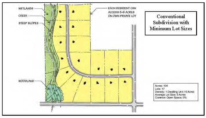
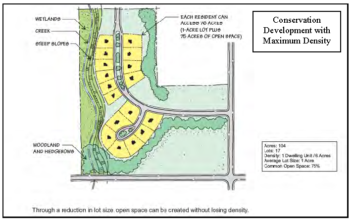
FIG. 7.1 CONSERVATION DEVELOPMENT EXAMPLE*
7.6.1 - Purpose.
The purposes of this type of development and these accompanying guidelines are to:
1.
Provide a housing type that responds to changing household sizes and ages (e.g., retirees, small families, single person households);
2.
Provide opportunities for ownership of small, detached dwelling units;
3.
Encourage creation of more usable open space for residents of the development through flexibility in density and lot standards;
4.
Preserve a housing type of small, free-standing cabins and cottages, a housing style that has historically existed in Black Mountain since its development as a retreat and vacation destination and to provide guidelines to ensure compatibility with surrounding land uses; and
5.
To accommodate and encourage new types of housing options such as "Katrina Cottages," and free-standing structures of small footprint that are generally more affordable, energy efficient and sensitive to the land.
7.6.2 - Applicability.
A cottage is a small, detached dwelling unit, not greater than 1,100 square feet in total floor area that may be developed at a density greater than the underlying zone. More than two cottages may occupy a single lot and may be owned separately. A cottage development may be developed in any zoning district except for HI-0.
7.6.3 - Density.
Cottage housing developments shall contain a minimum of two free-standing structures located in a cluster to encourage a sense of community among the residents.
7.6.4 - General design requirements.
In addition to the general SUP application requirements, the following guidelines shall be met:
A.
Setbacks for all structures from the adjacent property lines along the perimeter of the site shall comply with all setback requirements of the district in which the development is located.
B.
The minimum distance between structures, including accessory buildings, shall be ten feet, and must have off-set windows and all fire safety codes related to building proximity and fire rated walls shall be met.
C.
The maximum built-upon area, including parking, driveways and buildings, shall be equal to or less than 66 percent of the total land area for the lot.
D.
Maximum height for cottages shall be 35 feet and the maximum height for accessory structures shall be 18 feet. All parts of the cottage roof above 18 feet shall be pitched.
E.
Cottages must have a stoop or front porch that shall have a roofed porch at least 80 square feet in size with a minimum dimension of eight feet on any side.
F.
A pitched roof design is required for all parking structures.
G.
Cottages must not exceed 1,100 square feet of enclosed, habitable space. Cottage areas that do not count toward the total floor area calculation are:
1.
Unheated storage space located under the main floor of the cottage.
2.
Architectural projections such as bay windows, fireplaces or utility closets not greater than 18 inches in depth or six feet in width.
3.
Attached roofed porches.
4.
Detached garages or carports.
5.
Spaces with a ceiling height of six feet or less measured to the exterior walls, such as in a second floor area under the slope of the roof.
H.
Accessory buildings and detached or attached garages or carports shall not exceed 200 square feet in size, shall match the architecture of the cottages in style and material, and shall not be used for residential purposes.
I.
Parking spaces may be spread out through the development connected to each cottage, clustered in a shared parking lot or some combination thereof at a minimum ratio of two spaces per unit; clustered parking for more than six vehicles must be screened from public streets and adjacent residential uses by landscaping or architectural screening.
J.
Driveways, parking areas, and any common open space, parks, or stormwater management facilities, shall be considered common areas and must be maintained by a homeowners' association.
K.
The total square foot area of a cottage dwelling unit may not be increased. A note shall be placed on the title to the property for the purpose of notifying future property owners that any increase in the total square footage of a cottage is prohibited for the life of the cottage or duration of cottage regulations.
L.
Common area shall be outside of wet stormwater ponds, wetlands, streams, lakes, and sensitive areas and maintained. Private open space shall provide a private area around the individual dwellings to enable diversity in landscape design. Requirements:
1.
Common open space shall be a minimum of 400 square feet per cottage, abut at least 50 percent of the cottages in a cottage housing development, and have cottages abutting on at least two sides.
2.
Private open space shall be a minimum of 300 square feet of private, contiguous, usable space adjacent to each dwelling unit, for the exclusive use of the cottage resident. It shall be oriented toward the common open space as much as possible or in the rear or side yard areas with no dimension less than ten feet.
M.
An existing detached or attached single-family dwelling that is incorporated into a cottage housing development as a residence and is nonconforming with respect to the standards of this section shall be permitted to remain on a site used for a cottage housing development. However, the extent of the non-compliance may not be increased unless the proposed change is determined by the zoning administrator to be consistent in character, scale and design with the cottage housing development. If the existing dwelling meets the requirements of this section with regard to size and is able to conform to other site standards, it may be counted as a cottage in the density calculation for the site. If the existing dwelling does not meet the size limitation for a cottage, then it shall count as one standard size dwelling.
7.7.1 - Special use: Manufactured home parks (MHP).
A.
Manufactured home parks may include singlewide and doublewide manufactured housing and other types of residential structures.
B.
The location of three or more manufactured homes or park models on a single parcel of land, or the location of three or more manufactured homes or park models on multiple, contiguous parcels under the same ownership, shall constitute a manufactured home park.
C.
Manufactured home parks must meet the following requirements:
1.
Must have a minimum lot area of one acre.
2.
Must have a minimum front, side and rear yard, or perimeter setback, of 30 feet between the property boundary and the nearest structure.
3.
Must have an evergreen or fenced screen along the property boundary separating the park and adjacent uses except where the property abuts a public park or right-of-way, such as a road, greenway, or other designated public space, or where it abuts a stream or other surface water.
4.
Must provide a minimum of 20 feet between structures. Driveways, parking areas, and open decks and patios may be provided within this space.
5.
All structures attached to a manufactured home or other residential structure, including storage buildings, carports, and covered decks or porches, shall be considered part of a manufactured home for purposes of determining separation requirements.
6.
Must provide vehicle access that will accommodate emergency vehicle to all units within the park. Internal road system must be paved according to the standards and details manual.
7.
Parking shall be provided at a minimum of two parking spaces for each home. In addition one or more common parking areas shall be provided in the park primarily to provide for parking spaces for visitors' automobiles or additional resident parking needs at a ratio of one parking space for every six homes. Each parking space shall have a minimum width of nine feet and a minimum length of 18 feet and shall, at a minimum, be constructed using four inches of crushed stone of a well-compacted sub-base.
8.
Five percent of the lot must be dedicated open space, not to include, and in addition to, the lot yard requirements. Designation of easements to the town for parks and greenways according to the town's pedestrian plan, greenway master plan or recreation and parks plan can qualify for the dedicated open space requirement.
9.
Detached accessory structures must be at least five feet from any manufactured home and must be less than 150 square feet in dimension.
10.
Facilities for waste collection must be provided. Common waste collection facilities such as dumpsters must be screened or individual containers provided in accordance with town specifications.
11.
Covered space, including a community building, shall be permitted in the recreation area as long as it does not occupy more than half of the total set aside recreation area. If a swimming pool is provided, it shall be separated from other uses by a fence having a gate which is capable of remaining closed and being locked.
12.
Water mains properly connected with the municipal water supply system or with an alternate supply approved by the Department of Environmental Health Services shall be constructed in such a manner as to serve all spaces adequately, for both domestic use and fire protection, on the plan.
13.
Sanitary sewer:
a.
When the manufactured home park is located within the service area of a public sewerage system, sanitary sewer shall be installed in such a manner as to adequately serve all lots with connection to the public system.
b.
Where lots cannot be economically connected with a sewerage system they must contain adequate area for the installation of approved septic tank and disposal fields and must be approved in writing by the Buncombe County Department of Environmental Health.
c.
Whenever an extension of a water and sewer line is necessary, the developer shall be responsible for the cost of labor, materials, and appurtenances to install the water or sewer extensions in accordance with the specifications of the town (for water systems) or the Metropolitan Sewerage District (for sewer systems). The developer shall be responsible for the operation and maintenance of the water system for at least one year following the acceptance of the system by the town. The town will not accept or maintain any water system which does not contain a pressure of 30 P.S.I. based upon the existing main tank level.
14.
Skirting and underpinning shall be required on manufactured homes before a certificate of occupancy can be issued. The skirting and underpinning shall be constructed of materials that meet all existing requirements for manufactured homes as set forth in the N. C. Building Code. All materials must be approved by the building inspector prior to installation.
7.8.1 - Purpose.
Planned unit developments (PUDs) are planned residential, commercial, or mixed-use communities that encourage high-quality design, innovative arrangements of buildings and open space throughout the project site by allowing for flexibility in lot configuration and design. Units within a PUD may be leased or sold separately. A residential PUD may be an apartment complex, a condominium complex, or a town-home development. The requirements of this section are intended to:
1.
Facilitate more affordable housing by providing possibilities for savings in infrastructure, installation costs, and energy costs through clustering of dwellings;
2.
Retain natural features and encourage developments that will be compatible with environmentally sensitive areas;
3.
Encourage pedestrian circulation within and adjacent to the PUD;
4.
Encourage mixed-use development;
5.
Encourage quality design and management of open space.
6.
Establish criteria and guidelines for housing developments consisting of one or more principal structures or buildings and accessory structures or buildings to be constructed on a lot or plot not subdivided into the customary streets and lots, but in which dwelling units, are owned individually, and the structure, common areas and facilities are owned by all the owners on a proportional, undivided basis or by an established homeowners' association;
7.
Establish additional criteria for developments consisting of one or more principal structures or buildings and accessory structures or buildings to be constructed on a lot or plot to be subdivided at the same time or in phases for the purpose of commercial or industrial uses and which may not meet the customary street and lot layouts.
8.
Provide for a cohesive approach to multi-family development that is sensitive to the surrounding properties and which protects the health, safety and welfare of its residents and neighbors.
7.8.2 - Density.
PUDs with residential units shall contain a minimum of four dwelling units per acre and no PUD shall have greater than eight units per acre. The site shall be configured to allow for shared common areas, buildings, or parking.
7.8.3 - Uses.
Proposed uses shall be generally compatible with the uses allowed in the underlying zoning district.
7.8.4 - Dimensional requirements.
A.
Lot size, buffer, and yard regulations for the zoning district in which the proposed PUD is to be located must be met on the perimeter of the project.
B.
The maximum building height of any structure in the PUD shall not exceed the building height requirement of the district in which it is located.
7.8.5 - PUD design.
7.8.5.1 Architectural features.
A. The architectural style, surface treatment and placement on the lot of the proposed structures shall be in harmony and in character with the surrounding properties and the neighborhood as a whole.
B. Proposed structures shall, at a minimum, comport with the following requirements:
1. Buildings shall front the street or a parking lot, which shall have access to existing or planned pedestrian facilities or greenways as reflected in the pedestrian transportation plan or greenway master plan;
2. Buildings shall be designed to the topography and contours of the property to minimize impact for the site;
3. Fenestration, porches, stoops, or other architectural articulations are encouraged in order to visually break up the wall.
4. Roof design, including pitch and/or parapet shall be compatible with the surrounding neighborhood.
5. Building facades that front a street must extend parallel to that street.
7.8.5.2 Access and streets.
A. Points of ingress and egress shall be located to maximize safety and minimize traffic hazards, inconvenience and congestion and may require additional traffic control devices if recommended in a traffic impact analysis.
B. Streets and parking areas must be designed to the requirements in the standards and details manual.
C. Streets and alleys shall, wherever practical, terminate at other streets within the neighborhood and connect to existing and projected streets outside the development. Culs-de-sac and dead-end streets should only occur where absolutely necessary due to natural conditions.
D. Designs shall permit comfortable use of the street by motorists, pedestrians, and bicyclists. Pavement widths, design speeds and the number of motor travel lanes should be minimized to enhance safety for motorists and non-motorists alike. The specific design of any given street must consider the relationship of the street to the overall project and town street network.
E. If the street or road serving the proposed development does not meet the town street standards or the recommendations of the traffic impact analysis, the developer shall make the necessary improvements to the street or road, or shall make a payment to the town to cover the cost of such improvements. The town may waive this requirement for street or road improvements if the town determines that the improvement will cause more community disruption than justified by the increased traffic from the proposed development.
F. Traffic and truck egress/ingress must be designed so as to minimize traffic hazards on public streets. All requirements for traffic safety improvements as identified in a traffic impact study or as recommended by staff as part of technical review shall be met. The proposed pattern of internal circulation and parking areas shall be provided.
G. The plan shall provide for internal pedestrian circulation with sidewalks or greenway trails. Sidewalks shall form a logical, safe and convenient system for pedestrian access to all dwelling units, appropriate project facilities and connections to off-site pedestrian destinations such as sidewalks, greenways, or bus-stops external to the development. PUDs adjacent to transit routes must provide a pedestrian connection to, and a provision for, a public bus stop.
H. In addition to internal pedestrian consideration, the plan shall allow for the provision that the developer will provide the town with a minimum eight-foot sidewalk right-of-way along any adjoining or abutting town dedicated street.
7.8.5.3 Parking.
A. Parking shall be provided based on the uses that make up the PUD, using the parking requirements specified in chapter 10 of the land use code.
B. Hedges, garden walls, or fences of a minimum three feet in height, or a planted area of ten feet in width shall be required along any street frontage adjacent to parking areas.
C. An evergreen or fenced screen shall be established in the rear yard of residential uses where the property abuts a commercial or industrial zone as determined within the site as a whole, but not including areas that abut on a town or state road.
D. The space within the required yard may be used as maneuvering space for vehicles and as driveways providing ingress or egress to the parking area.
E. Truck parking and delivery areas must be in the side or rear of buildings and otherwise hidden or screened from the primary, exterior thoroughfare.
7.8.5.4 Landscaping and open space.
A. The landscaping requirements in chapter 8 shall be met.
B. Each planned unit development shall dedicate a minimum of 15-percent open, permeable space in addition to perimeter yard setbacks as required in the district. For PUDS containing residential units, the open space designation shall be established for the purpose of passive or active recreational purposes. Covered space, including a community building, gazebo, or picnic shelter shall be permitted in the recreation area as long as it does not occupy more than half of the total recreation area. Land dedicated as public greenway may count toward the open space requirements.
C. Vegetative screening or a combination of garden walls, or fences must be installed and maintained along the perimeter of a commercial development where it abuts a residential zone. If the property adjoins a residential district, then a fence, hedge or other natural planting of comparable opacity shall be provided along the side or rear lines where the property adjoins said residential district. Such fence, wall or hedge shall be at least six feet in height measured from the ground along the common line of the adjoining lot in the residential district. Hedges or comparable natural evergreen plantings shall be planted at an initial height of at least three feet. Barriers shall be in place before beginning construction on any structure.
7.8.5.5 Utilities and services.
A. Stormwater management facilities shall be provided, as approved by the town and in accordance with the town stormwater regulations.
B. A plan for the collection, removal, and disposal of waste and recyclable materials shall be provided. Solid waste storage facilities shall be provided either in the form of screened and accessible bulk, shared containers or in individual containers for each dwelling unit. When used, individual containers shall be provided with locking lids. Shared dumpster or trash and recycling areas shall be located at the rear of buildings or shall be otherwise screened or located away from the perimeter of the PUD.
C. Heating and cooling units or other mechanical equipment shall be located at the rear of buildings or shall be otherwise screened or located away from the perimeter of the PUD to minimize noise and visual impact of mechanical equipment.
7.9.1 - Purpose.
To encourage economic development and redevelopment of industrial areas in a cohesive and safe fashion that attracts investment and growth, while encouraging entrepreneurship.
7.9.2 - Density.
No density requirements apply.
7.9.3 - Requirements.
In addition to the general SUP application requirements, the following guidelines shall be met unless the industrial park involves the redevelopment of an existing commercial, industrial, or manufacturing site or "Brownfield" where pre-existing conditions may require a variance from these requirements:
A.
Industrial park developments must maintain the required setbacks for the district at their perimeter boundary. Driveways or parking may encroach into the setback, however a ten-foot landscaped or grassed buffer must be maintained along public roadways at all times. Sidewalks or greenways may be included in this ten-foot-wide area as indicated on the pedestrian master plan.
B.
Sites are required to finish all grades and sites with grass and other approved landscaping and landscaping is approved as part of the site plan review and a condition of a final occupancy permit. Landscaped areas may contribute to the stormwater management plan in accordance with the town's phase II stormwater ordinance as applicable.
C.
All parking must be improved with hard surface materials and incorporate stormwater management that retains and treats a 24-hour, one-year storm unless otherwise approved under the town's phase II stormwater ordinance requirements.
D.
Lots must be designed to maximize access and safety. Adjacent developments shall share access points to the public roadway and parking wherever practicable and shall be designed so as to take advantage of existing traffic lights.
E.
All sites are required to provide screening for outdoor storage areas and dumpsters which are visible from the public roadway. Outdoor storage must be identified on the industrial park plan and the screening to be used shall be specified. Screening requirements may be met with a minimum of a six-foot opaque fence or wall, or with a ten-foot buffer of evergreen trees which shall meet or exceed six feet in height within one year of the certificate of occupancy being granted.
F.
Loading docks are required to be placed in side or rear yards or within the interior of the property. No loading docks shall face the street unless screened by other parts of the building, screening and landscaping.
G.
Out-buildings or future expansion areas shall be designated on the plan with building envelopes. Provided that construction takes place within the approved building envelope, construction may proceed upon issuance of a building permit. Otherwise, expansion or amendment to the original plan shall require approval of the board of adjustment as an amendment to the SUP.
H.
A building permit and certificate of occupancy is required whenever a unit of the park changes ownership, tenancy, or use, to ensure that all building and fire safety codes are met.
I.
All other requirements of the zoning district in which the development is located shall be met, including stormwater management and lighting requirements of the town.
7.10.1 - Purpose.
The purpose of this planning option is to encourage mixed uses within single structures or a cohesive series of structures in the central business district (CB) that provide a wide range of shopping, dining, working, cultural attractions, and living spaces that promote activity downtown during both the day and evening hours. These provisions are also intended to preserve the architectural heritage of the downtown area by limiting the mass and scale of buildings relative to existing structures within the downtown.
7.10.2 - Applicability.
All new construction or renovation within the CB district that creates more than three commercial and/or residential units.
7.10.3 - Density.
There are no density limitations within the CB district.
7.10.4 - Requirements.
In addition to the general SUP application requirements, the following shall be required:
A.
Buildings shall address thoroughfares with doorways and windows that front the sidewalk.
B.
New construction shall conform to the historic district guidelines in their design and a certificate of appropriateness from the historic preservation commission shall be issued prior to application for a special use permit.
C.
Off-street parking must be provided for residential units at a minimum ratio of one space per unit. Parking may be provided or contracted in a lot or lots separate from the lot that holds the building. Parking may also be incorporated as part of the structure. Parking areas shared with businesses, the town or other entities may count toward this requirement with documentation of a shared parking agreement.
D.
Buildings that include a level of parking within the structure that is at street level or higher shall incorporate a facade that screens parking structure at or above street level so as to integrate the building with the architecture of adjacent or proximate buildings.
E.
Buildings shall be designed to enhance the pedestrian environment with improvements or expansions to sidewalks and crosswalks, the inclusion of outdoor seating areas, benches or other pedestrian amenities. Sidewalks shall be a minimum of eight feet in width.
F.
Minimum setbacks shall be ten feet in width from the back of curb to the edge of building or the average setback of existing built upon lots on the same street frontage of the block., whichever is greater. Maximum setbacks shall not be more than ten additional feet from the determined minimum setback unless approved by the board of adjustment.
G.
A stormwater management plan shall be incorporated into the building design so that gutter systems and parking lot drainage may be handled by the municipal storm sewer system. Connections or improvements to the municipal storm sewer system to accommodate the development must be approved by the town's public works director and stormwater administrator.
H.
The building mass from street to highest point of building shall be broken up to provide a transition from the height and scale of existing adjacent buildings, or from the nearest, existing building considered to be a contributing property of the historic district.
I.
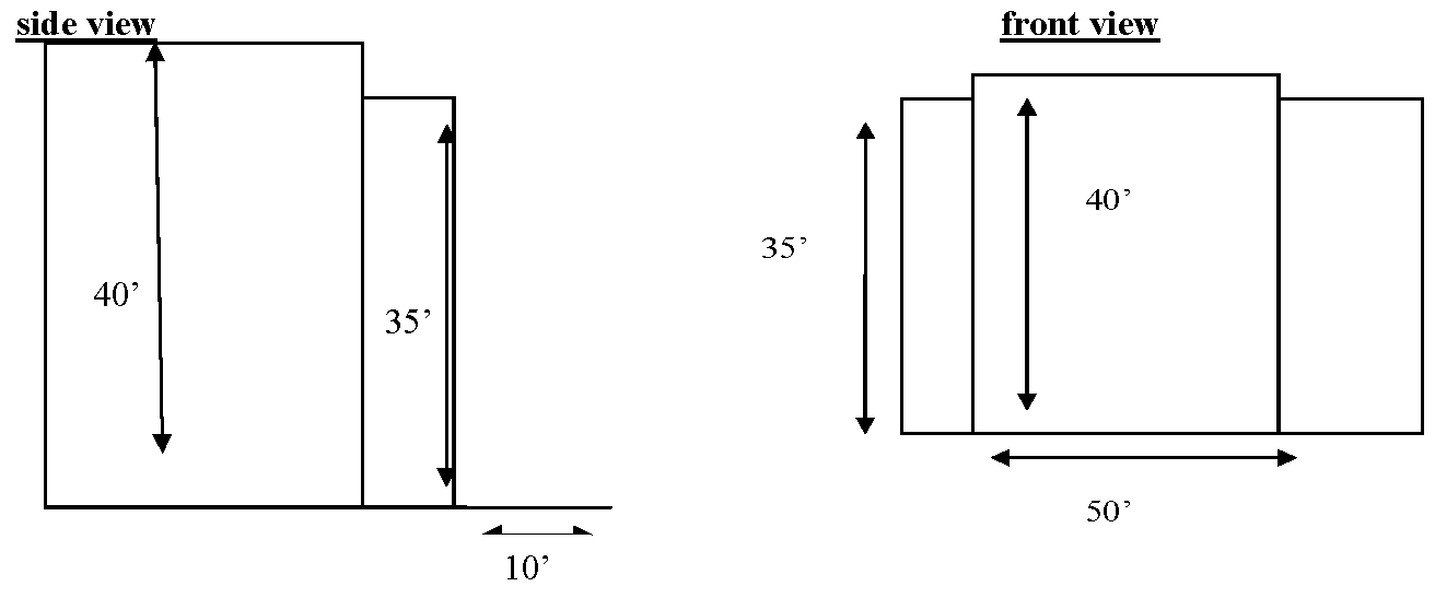
Top floors of buildings exceeding 35 feet in height and which are greater than 50 feet in length, must be stepped back or varied in height along the vertical plane of the building in order that there is never more than a 40-foot building height longer than 50 linear feet without a break or variation in the roof line.
Use of transitional height as part of new construction.
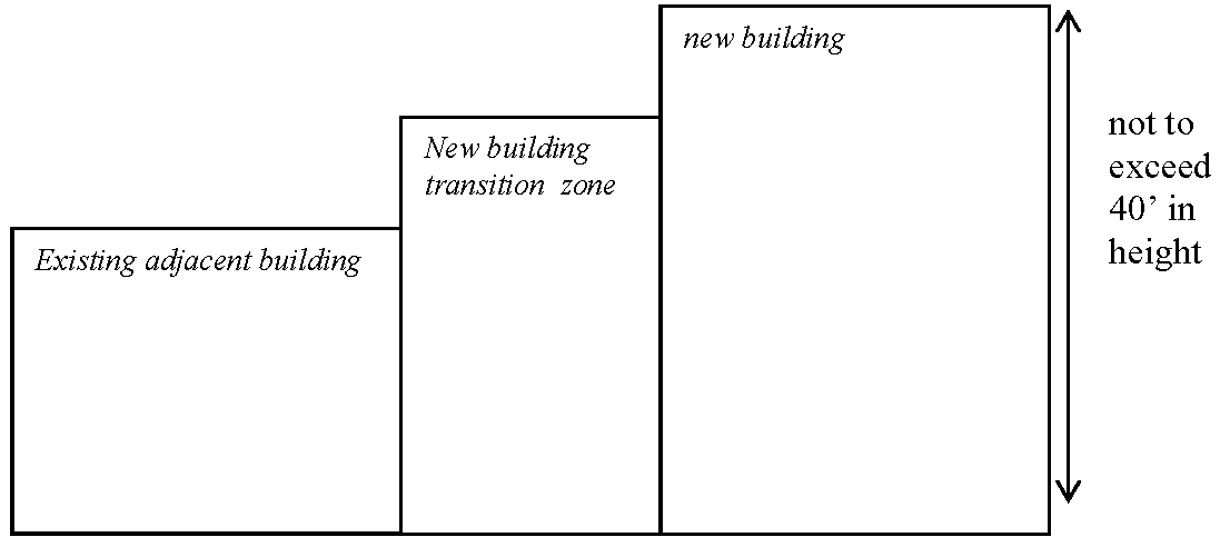
Vary or recede the top edge of building face when it exceeds height greater than 35 feet and length greater than 50 feet.
7.13.1 - Application and purpose.
A.
All campgrounds, regardless of whether the campsites are offered for sale, developed as rental sites, or let on assignment, are subject to the additional requirements contained herein.
B.
The purpose of these regulations is to ensure that campgrounds and campground related facilities are developed in a safe and orderly fashion which supports the goals of the comprehensive plan and minimizes the impact on surrounding properties.
7.13.2 - Definitions.
Dependent recreational vehicle (RV). A recreational vehicle which is dependent upon a service building for toilet and lavatory facilities.
Independent recreational vehicle (RV). A recreational vehicle which can operate independently of connections to sewer, water and electric systems. It may contain water flushed toilet, lavatory, shower and kitchen sink, all of which are connected to water storage, greywater storage, and sewage holding tanks located within the RV.
Tent campground. A campground designed for use of tents by persons in vehicles. This shall not include the camping of persons in vehicles not designed for camping purposes. Such campgrounds are dependent upon a service building for toilet and lavatory facilities.
Walk-in campground. A camping area designed exclusively for those persons which walk, bicycle, or use some other non-motorized means of access. Such areas shall contain only service roads for maintenance of campground facilities and shall not be used for parking associated with camping. (This shall be a tent use area only.) Such campgrounds are dependent upon a service building for toilet and lavatory facilities.
7.13.3 - Campground standards for all campgrounds.
The following standards shall apply to all campgrounds containing two or more campsites or lots, including sites for tents, accommodations for backpackers and recreational vehicles (RVs).
A.
All plans shall be submitted to the planning board for review. The planning board may review all developments in two phases. A preliminary development plan shall be required and shall be received at least 14 days before the next planning board meeting. When this preliminary development plan is approved or approved with conditions, construction of the campground may begin. When the construction is complete, the planning board may request a review approval of final or as-built plan of the campsite. This review shall be mandatory if the preliminary development plan was approved with conditions, or if the final or as-built plan has had significant changes since the submittal of the preliminary development plan. After all approvals have been completed, a certificate of compliance shall be issued.
B.
All proposed campgrounds shall be a minimum of three acres in size.
C.
Certificate of compliance required. Any proposed campground shall not be allowed to open until such campground has met all planning and building requirements of this ordinance for the Town of Black Mountain and the State of North Carolina.
D.
Water-sewer line extensions. All proposed and required water sources and sanitary facilities serving campgrounds shall conform to the requirements of the Town of Black Mountain and/or the Metropolitan Sewer District. Any applicant shall further be responsible for development and submittal of all water and sewer plans necessary for submittal to above-mentioned agencies for approval as extensions to systems operated by these agencies.
E.
Other permanent structures. Permanent structures other than camp platforms and recreational support and sanitary facilities shall be prohibited unless the developer or owner can prove to the planning board the necessity or desirability for such a structure. Structures commonly considered to fall under the three above categories could include a gatehouse, office, laundry area, video/amusement area, common area shelters, or picnic table shelters for campsites. Camping cabins shall be an allowed in an established campground at the discretion of the planning board and by approval of the building inspector.
F.
Building types. Conventional, industrialized (modular) and manufactured houses are prohibited on all campsites. Such structures shall only be allowed for the purpose of housing the owner or caretaker of the campground or as used for camping cabins in the campground.
G.
Storage of RVs. Storage of all types of recreational vehicles within campgrounds shall be limited to no more than one stored RV per ten RV sites. Such storage area shall be buffered and screened, preferably by vegetation, from the campground or outside areas.
H.
Number of days permitted to camp. Continuous camping shall be restricted to a period of no more than 180 consecutive days within a one-year period. Tent camping shall be limited to a period of 30 consecutive days within 60-day period.
I.
Access to water for all campsites/RV utility islands. Each campground shall have access to a source of potable water approved by the applicable health authority and building codes. It is preferable to provide one water outlet per non-RV camping unit; however a minimum of one outlet for every two non-RV units shall be provided with two hose bibs equipped with vacuum breakers. As an alternative to on-site water outlets for non-RV camping sites, a centralized location of potable water not more than 200 feet from any non-RV site could also be used as an alternative. Each site intended for use as a RV camping site shall have access to water within the RV's utility island. All water outlets, sanitary sewer line taps, and electrical outlets for RVs shall be located on an approved RV utility island. All water taps or outlets serving all campsites shall be of a type compatible with garden hose connections. All water facilities serving campsites of any type shall be required to have backflow prevention devices as required by the Black Mountain Department of Public Works.
J.
Campfires shall be contained and controlled. Stoves or grills are recommended for all campsites. Fire rings shall be required at those locations where fires are permitted. Facilities provided for above activities shall either be provided at campsites or restricted to designated locations. No fire shall be allowed within ten feet of a bottled gas container or other combustible source of fuel, and no open fire shall be left unattended. No fires outside of structures intended for the containment and control of fires shall be permitted.
K.
Refuse disposal. All campgrounds shall provide fly-proof, watertight, containers for the disposal of refuse. These containers shall also be constructed and located such that they are not subject to rodent infestation or dog and bear invasion. Containers shall be provided in sufficient number and capacity to properly store all refuse. Refuse for camping areas shall be collected at least once a day.
L.
Overflow parking area. All campsites shall be limited to a total of one non-RV parking space. An additional area for parking of such vehicles shall be provided equal to one parking place for every ten campsites. Such parking area can be surfaced with gravel. At no time shall parking be permitted on access roads to the campground.
M.
Insect control. Owners of such parks shall be responsible for adequate insect control in the camping area such as the periodic spraying for mosquitoes.
N.
Cut-off, overnight lighting for all bathhouses and centralized water sources shall be required. Reflectors denoting paths to above mentioned structures are recommended. Other minimal lighting should be installed as needed for the safety and comfort of campground residents.
7.13.4 - Campsites for accommodation of independent RVs.
A.
RVs shall not be permitted to hook up to electricity or water for occupation on individual lots unless as part of an approved campground or ICD, or O-I master plan.
B.
Density of sites. To prevent intensive site use, and to maintain an aesthetic camping atmosphere, density shall not exceed 15 sites per acre.
C.
RV parking sites material/slope. Each recreational vehicle site with individual parking shall contain at least five inches of crushed gravel leveled to not more than three percent slope.
D.
RV utility islands. Each RV site shall contain, within the utility island, hookups to water, sewer, and electrical service. Utility islands shall be located to the left center of the RV and at the discretion of the campground owner/developer based on the topography of the land.
E.
RV utility islands water/sewer plumbing requirements. Campgrounds with access to a sewage system shall provide that each campsite contain a sewer connection with suitable fittings to permit a watertight junction with the RV outlet. Each sewer connection shall be constructed so that it can be closed, and when not in use shall be capped to prevent escape of odors. All water taps or outlets serving RV campsites shall be of a type compatible with garden hose connections. Sewer and water piping and installation shall be constructed as specified in the North Carolina Building Code.
F.
Electrical outlets. Each RV site shall have access to electrical power. Configuration of power supply needed shall be the decision of the campground owner. However, a recommended one in ten RV sites should have access to 50 amp service. All electrical outlets shall be located in a properly constructed utility island.
G.
Parking dimensions RV sites. Parking dimensions may vary from single auto trailer attached vehicle back-in of 10 × 60 feet to side-by-side arrangements of trailer and auto of 29 feet long and 30 feet wide. Various combinations may be used to accommodate the recreational vehicle and one additional parking place, but dimensions to accommodate trailer width with extended outside awning shall be at least 14 feet. Parking spurs shall be located so that trailer doors face away from interior roads and into the site. Parking for all recreational vehicles and any additional vehicle shall be of a minimum five-inch gravel base.
H.
RV campsite spacing. RV parking sites shall be at least 20 feet apart (this 20-foot area will include any yard, cooking areas, dining areas, and utility island for next RV site), edge-to-edge, and the center of all camping units should be at least ten feet from the edge of the campground road.
I.
Other RV site requirements. Each RV site should have a picnic table or grill within the campsite area. There shall be a total area for both uses, including general yard area, of not less than 400 square feet with a width of not less than 20 feet.
J.
RV dump station. A sanitary dump station built to the requirements of the local health department shall be provided at the entrance to the campground or other location convenient to all campsites. The dump station shall be located so that the left rear of vehicles will slope slightly toward the dump station when connected for emptying.
7.13.5 - Sanitary facilities for accommodation of dependent RVs and tent campsites.
A.
All campgrounds for the accommodation of dependent RVs and tents shall provide sanitary facilities connected to a sewerage system. Whenever possible, these facilities shall be connected to a public sewerage system.
B.
Toilets, lavatories, and bathing facilities shall be provided as required by the North Carolina State Building Code.
C.
Toilet facilities shall be plainly marked, separate for each sex, lighted at night, and shall be located no farther than 200 feet from any camp pad.
D.
Toilet facilities may be located in a central building or in two or more buildings according to the size of the campground and location of the campsites in relation to the facilities.
E.
Adequate provisions shall be made for the disposal of dishwater according to the size of the campground. A suggested ratio is one disposal unit per ten campsites.
7.13.6 - Campsites for tents.
Construction of tent pads is not required for pup tents or other small shelters used by backpackers. Provisions for walk-in campgrounds are contained below.
A.
Each tent site should contain a minimum space of 30 × 30 feet. Density shall not exceed ten sites per acre. Tent sites with individual parking arrangements shall contain one automobile parking space at least 20 feet × 10 feet.
B.
Each site should contain a reinforced, fairly level tent pad. The pads shall be approximately 16 × 16 feet to provide maximum flexibility of use, but shall not contain less than an area of 12 × 12 feet. The tent pad shall be a minimum of six inches high and constructed of gravel, crushed aggregate, or equivalent material that will allow run-off from precipitation to flow through the pad. Pads constructed of tamped earth, asphalt or other impervious materials are prohibited. Tent pads in excess of ten percent slope should be leveled. A three-percent slope is preferable.
C.
Provisions for sanitary facilities are the same as for dependent RVs set out hereinabove.
7.13.7 - Walk-in campgrounds.
A.
Camping is prohibited in areas where a source of potable water and access to sanitary facilities is not provided.
B.
Walk-in campgrounds shall have access to potable water within 75 feet of all sleeping areas. In locations where a water supply system is not possible, potable water may be supplied by an approved well with a hand pump or by water from pickup stations.
C.
All walk-in campgrounds shall have access to the use of a toilet facility to be located within 300 feet of each camping space.
7.13.8 - Campsites for mixed uses.
Campgrounds may be developed to provide more than one type of camping site in the same area. When uses are mixed, the highest or most strict standards shall apply to development of the entire campground with the exception of walk-in camping areas in a campground designed for mixed uses. In such a development, walk-in camping shall be separated from other types of campsites so that campfire smoke or noise will not constitute a nuisance to other campers.
7.13.9 - Campground design.
The ideal design for campgrounds is one which will be compatible with the natural features and topography of the tract undergoing development; and one which provides safe, healthful and convenient camping facilities for campground users with minimum land disturbance.
A.
A complete master plan of any new, expanded or altered park shall be submitted to the Town of Black Mountain for approval before construction.
B.
Density shall not exceed 15 sites per acre.
C.
Campgrounds shall be developed to minimize noise, campfire smoke, or trespassing so as not to create a nuisance to abutting properties.
D.
Sanitary and bathing facilities shall be provided per the state building code. Sanitary dump stations built to the requirements of the local health department shall be provided at the entrance to the campground or other location convenient to all campsites. The dump station shall be located so that the left rear of vehicles will slope slightly toward the dump station when connected for emptying.
E.
All campsites shall be limited to a total of one non-RV parking space per site or RV parking space. An additional area for parking of such vehicles shall be provided equal to one parking place for every ten campsites in a common location or spread throughout the campground.