
Bladen County Unincorporated
City Zoning Code
City Zoning Code
ARTICLE 15
SUBDIVISION REGULATIONS
15.1 - TITLE
This chapter shall be known and may be cited as the subdivision regulations of the county and may be referred to as the subdivision regulations.
15.2 - PURPOSE AND APPLICABILITY
(a)
The purpose of this chapter is to establish procedures and standards for the development and subdivision of land within the territorial jurisdiction of the county. It is further designed to provide for:
(1)
The orderly growth and development of the county;
(2)
The coordination of transportation networks and utilities within proposed subdivisions with existing or planned streets and highways within proposed subdivisions with existing or planned street and highways and with other public facilities;
(3)
The dedication or reservation of recreation areas serving residents of the immediate neighborhood within the subdivision and of right-of-way or easements for street and utility purposes; and
(4)
The distribution of population and traffic in such a manner that will mitigate hazards, avoid congestion and overcrowding, and will create conditions that substantially promote the public health, safety and the general welfare.
State Law reference— G.S. 160D-804
(b)
This chapter is designed to further facilitate adequate provision of water, sewerage, parks, schools and playgrounds, and also to facilitate the further re-subdivision of larger tracts into smaller parcels of land.
(c)
For the purpose of this Ordinance, subdivision regulations shall be applicable to all divisions of a tract or parcel of land into two or more lots, building sites, or other divisions when any one or more of those divisions is created for the purpose of sale or building development, whether immediate or future, and shall include all divisions of land involving the dedication of a new street or a change in existing streets; but the following shall not be included within this definition nor be subject to the regulations authorized by this Article:
(1)
The combination or recombination of portions of previously subdivided and recorded lots where the total number of lots is not increased and the resultant lots are equal to or exceed the standards of the local government as shown in its subdivision regulations.
(2)
The division of land into parcels greater than 10 acres where no street right-of-way dedication is involved.
(3)
The public acquisition by purchase of strips of land for the widening or opening of streets or for public transportation system corridors.
(4)
The division of a tract in single ownership whose entire area is no greater than 2 acres into not more than three lots, where no street right-of-way dedication is involved and where the resultant lots are equal to or exceed the standards of the local government, as shown in its subdivision regulations.
(5)
The division of a tract into parcels in accordance with the terms of a probated will or in accordance with intestate succession under G.S. chapter 29.
State Law reference— G.S. 160D-802
15.3 - AUTHORITY AND JURISDICTION
This Article is hereby adopted under the authority and provisions of the G.S. chapter 160D, article 8. The regulations contained herein shall govern each and every subdivision within the Bladen County's planning jurisdiction.
State Law reference— G.S. 160D-801 and 160D-802
15.4 - PREREQUISITE TO PLAT RECORDATION
After the effective date of the ordinance from which this chapter is derived, each individual subdivision plat of land within the county's jurisdiction shall be approved by the county Planning Board.
The register of deeds shall not file or record a plat of a subdivision of land located within the territorial jurisdiction of the county that has not been approved in accordance with these provisions, nor shall the clerk of superior court order or direct the recording of a plat if the recording would be in conflict with this section.
15.5 - THOROUGHFARE PLANS
Where a proposed subdivision includes any part of a thoroughfare which has been designated as such upon the officially adopted thoroughfare plan of the county, such thoroughfare shall be platted by the subdivider in the location shown on the plan and at the width specified in this Article.
15.6 - ADEQUATE PUBLIC FACILITIES
To ensure public health, safety, and welfare, the county Planning Board shall review each proposed subdivision to determine if public facilities are adequate to serve the development.
(a)
The public facilities include, but are not limited to, schools, fire and rescue, law enforcement, and other county facilities. Applicable state standards and guidelines shall be followed for determining whether facilities are adequate. Facilities must be in place within two years of preliminary approval to be considered adequate.
(b)
The Planning Board may grant partial approval of developments based on limited adequacy.
15.7 - ZONING AND OTHER PLANS
Similarly, proposed subdivisions must comply in all respects with the requirements of the zoning ordinance, appendix A to this Code, if in effect in the area to be subdivided, and other officially adopted plans.
15.8 - FEES
(a)
Reasonable fees sufficient to cover the costs of administration, inspection, publication of notice and similar matters may be charged to applicants for subdivision review and approvals, variances, and other administrative relief. The amount of the fees charged shall be as set forth in the County's budget or as established by resolution of the Board of Commissioners filed in the Office of the County Clerk. Fees shall be paid upon submission of a signed application.
(b)
A local government shall provide notice to interested parties of the imposition of or increase in fees or charges applicable solely to the construction of development subject to this Article at least seven days prior to the first meeting where the imposition of or increase in the fees or charges is on the agenda for consideration. The local government shall employ at least two of the following means of communication in order to provide the notice required by this section:
(1)
Notice of the meeting in a prominent location on a Web site managed or maintained by the local government.
(2)
Notice of the meeting in a prominent physical location, including, but not limited to, any government building, library, or courthouse within the planning and development regulation jurisdiction of the local government.
(3)
Notice of the meeting by electronic mail or other reasonable means to a list of interested parties that is created by the local government for the purpose of notification as required by this section.
(c)
During the consideration of the imposition of or increase in fees or charges as provided in subsection (a) of this section, the governing board of the local government shall permit a period of public comment.
(d)
This section shall not apply if the imposition of or increase in fees or charges is contained in a budget filed in accordance with the requirements of G.S. 159-12.
State Law reference— G.S. 160D-805
15.11 - DEFINITIONS
The following words, terms and phrases, when used in this Ordinance, shall have the meanings ascribed to them in this section, except where the context clearly indicates a different meaning:
Access Easement. An easement that grants the right to cross property.
Accessory Structure. A detached subordinate building, the use of which is incidental to that of the principal building and located on the same lot therewith.
Alley. A roadway that affords only a secondary means of access to abutting property.
Block. The land lying within an area bounded on all sides by streets.
Board of Commissioners. The Board of Commissioners of Bladen County, North Carolina.
Buffer. An area of natural or planted vegetation through which stormwater runoff flows in a diffuse manner so that the runoff does not become channelized and that provides for infiltration of the runoff and filtering of pollutants. The buffer is measured landward from normal pool elevation of impounded structures and from the bank of each side of streams and rivers.
Buffer Yard. A strip of land which is established to separate one type of land use from another type of land use and which contains natural or planted vegetation, berms, walks, or fences.
Building. Any structure that encloses a space used for sheltering any occupancy. Each portion of a building separated from other portions by a fire wall shall be considered a separate building.
Building Line. The line, established by the county, beyond which the building shall not extend, except as provided for in the Zoning Ordinance.
Collector Street. A street whose principal function is to carry traffic between cul-de-sac, local, and sub collector streets, and streets of higher classification, but that may also provide direct access to abutting properties. SR 1515 is the collector street located in the county.
Common Area(s). All areas, including private streets, conveyed to an owners' association within a development, or owned on a proportional undivided basis in a condominium development.
Condominium. Portions of real estate which are designated for separate ownership, and the remainder of which is designated for common ownership solely by the owners of those portions. Real estate is not a condominium unless the undivided interests in the common elements are vested in the unit owners.
Corner Lot. A lot abutting 2 or more streets at their intersection.
County. Refers to Bladen County, North Carolina.
Cul-de-Sac Street. A short local street having one end open to traffic and the other end permanently terminated by a vehicular turnaround.
Day. Any reference to days shall mean calendar days unless otherwise specified. A duration of days shall include the first and last days on which an activity is conducted, and all days in between, unless otherwise specified by State law.
Dedication. A gift, by the owner, or a right to use of land for a specified purpose or purposes. Because a transfer of property rights is entailed, dedication must be made by written instrument, and is completed with an acceptance.
Developer. A person engaging in development (See Subdivider).
Development. Any man-made change to improved or unimproved real estate, including, but not limited to, buildings or other structures, mining, dredging, filling, grading, paving, excavation, or drilling operations or storage of equipment or materials. This definition shall also include the subdivision of land.
Development, Density of. The density of development shall be determined using a gross acreage system. The total area of the tract, including areas to be used for new streets, rights-of-way, drives, parking, structures, recreation areas, dedicated areas, and required setbacks, shall be used for density calculations.
Double Frontage Lot. A continuous (through) lot which is accessible from both streets upon which it fronts. See Through Lot.
Drainage Easement. An easement that grants the right of water drainage to pass in open channels or enclosed structures.
Drainageway. Any natural or man-made channel that carries surface runoff from precipitation.
Dwelling Unit. One or more rooms designed, occupied or intended for occupancy as separate living quarters, with cooking, sleeping and sanitary facilities provided therein. Units in dormitories, hotels, motels, shelters for the homeless, or other structures designed for transient residents are not dwelling units.
Easement. A grant of one or more of the property rights by the property owner to, or for use by, the public, a corporation, or other entities.
Existing Lot. See Lot of Record.
Family. One or more persons occupying a dwelling unit and living as a single household.
Fence. A physical barrier or enclosure consisting of wood, stone, brick, block, wire, metal or similar material, used as a boundary or means of protection or confinement, but not including a hedge or other vegetation.
Flag Lot. A lot that is composed of a narrow "flagpole" strip extending from the street and a much wider "flag" section lying immediately behind a lot or lots having the required street frontage for a conventional lot. In the case of a flag lot, the lot line at the end of the flag pole lying generally parallel to the street to which the flagpole connects shall be considered to be the front line for setback purposes.
Grade. The slope of a road, street, or other public way specified in percentage terms. The degree of inclination of a slope.
Interior Lot. A lot other than a corner lot with only one frontage on a street.
Local Street. A street whose primary function is to provide access to abutting properties.
Lot. A portion of a subdivision or any other parcel of land intended as a unit for transfer of ownership, or for development or both. The word "lot" includes "plot," "parcel," or "tract."
Lot of Record. A lot, plot, parcel, or tract recorded in the Office of the Bladen County Register of Deeds in conformance with the ordinance(s) in effect at the time of recordation. Also, a lot that is part of a subdivision, a plat of which has been recorded in the Office of the Bladen County Register of Deeds prior to the original adoption of this Ordinance, or a lot described by metes and bounds, the description of which has been so recorded prior to the original adoption of this Ordinance.
Major Subdivision. All subdivisions not classified as minor subdivisions, including, but not limited to, subdivisions of 5 or more lots, or any size subdivision requiring any new public and/or or private street, extension of the local government facilities, or the creation of any public improvements.
Minor Subdivision. A division of a tract of land where:
(a)
All lots front on an existing public street, and/or no more than one lot is created that is served by an exclusive access easement;
(b)
Public water and/or sanitary sewerage systems, other than laterals to serve individual lots, are not to be extended; and
(c)
The installation of drainage improvements that would require easements through one or more lots to serve other lots are not necessary.
(d)
No new public or private street or roads, or right-of-way dedication, no easements, no utility extension, where the entire tract to be subdivided is five acres or less in size, and where four or fewer lots result after the subdivision is completed.
The minor subdivision procedure may not be used a second time within three years on any property less than 1,500 feet from the original property boundaries by anyone who owned, had an option on, or any legal interest in the original subdivision at the time the subdivision received preliminary of final plat approval.
Official Maps or Plans. Any maps or plans officially adopted by the Board of Commissioners as a guide to the development of the County.
Open Space. An area (land and/or water) generally lacking in manmade structures and reserved for enjoyment in its unaltered state.
Owner. A holder of any legal or equitable estate in the premises, whether alone or jointly with others, and whether in possession or not.
Pedestrian Way. A right-of-way or easement dedicated to public use to facilitate pedestrian access to adjacent streets and properties.
Person. Any individual, partnership, firm, association, joint venture, public or private corporation, trust, estate, commission, board, or public or private institution, utility, cooperative, interstate body or other legal entity.
Plan. Any documented and approved program of recommended action, policy, intention, etc., which sets forth goals and objectives along with criteria, standards and implementing procedures necessary for effectively guiding and controlling decisions relative to facilitating development and growth management. The plan is sometimes referred to as the land development plan or land use plan.
Planned Unit Development. A permitted use designed to provide for developments incorporating a single type or a variety of residential and related uses which are planned and developed as a unit. Such development may consist of individual lots or common building sites. Common land must be an element of the plan related to effecting the long-term value of the entire development.
Plat. A surveyed map or plan of a parcel of land that is to be, or has been, subdivided.
Principal Structure. A structure(s) in which is conducted the principal use(s) of the lot on which it is located.
Private Drive. A vehicular travel way not dedicated or offered for dedication as a public street, providing access to parking lot(s) for 2 or more principal buildings in a group housing development
Private Driveway. A roadway serving 2 or fewer lots, building sites or other divisions of land and not intended to be public ingress or egress.
Private Sewer. A system that provides for collection and/or treatment of wastewater from a development, or property, and that is not maintained with public funds.
Private Street. A vehicular travel-way or private way not dedicated or offered for dedication as a public street, but resembling a cul-de-sac or a local street by carrying traffic from a series of driveways to the public street system.
Private Water. A system that provides for the supply and/or distribution of potable water for use by a development, project, or owner, and that is not maintained by a governmental organization or utility district.
Public Sewer. A system that provides for the collection and treatment of sanitary sewage from more than one property, and is owned and operated by a governmental organization or sanitary district.
Public Street. A dedicated public right-of-way for vehicular traffic which:
(a)
Has been accepted by the county or the North Carolina Department of Transportation for maintenance; or
(b)
Is not yet accepted but in which the roadway design and construction have been approved under public standards for vehicular traffic and is to be offered for acceptance by the County or North Carolina Department of Transportation for maintenance.
Public Water. A system that provides distribution of potable water for more than one property and is owned and operated by a governmental organization or utility district.
Recreation Area or Park. An area of land or combination of land and water resources that is developed for active and/or passive recreation pursuits with various manmade features that accommodate such activities.
Reservation. An obligation shown on a plat to keep property free from development and available for public acquisition for a stated period of time. It is not a dedication nor a conveyance.
Retaining Wall. A structure, either masonry, metal, or treated wood, designed to prevent the lateral displacement of soil, rock, fill or other similar material.
Reverse Frontage Lot. A through lot that is not accessible from one of the parallel or non-intersecting streets upon which it fronts.
Setback. The minimum required horizontal distance between a structure or activity and the property line or the street right-of-way line.
Single-Family Detached Dwelling. A separate, detached building designed for and occupied exclusively by one family.
Single-Tier Lot. A lot which backs upon a limited access highway, a railroad, a physical barrier, or another type of land use and to which access from the rear is usually prohibited.
Sight Distance Easement. An easement that grants to the County and/or North Carolina Department of Transportation the right to maintain unobstructed view across property located at a street intersection.
Storm Drainage Facilities. The system of inlets, conduits, channels, ditches, and appurtenances that serve to collect and convey stormwater through, and from, a given drainage area.
Stormwater Runoff. The direct runoff of water resulting from precipitation in any form.
Street Right-of-Way. A strip of land occupied or intended to be occupied by a travel way for vehicles and also available, with the consent of the appropriate governmental agency or owners' association (for private streets), for installation and maintenance of sidewalks, traffic control devices, traffic signs, street name signs, historical marker signs, water lines, sanitary sewer lines, storm sewer lines, gas lines, power lines, and communication lines.
Structure. Anything constructed, erected, or placed on the land, at grade or below grade. It includes, but is not limited to, buildings, signs, load bearing walls, docks, columns, pools and parking areas.
Sub-collector Street. A street whose principal function is to provide access to abutting properties, but that is also designed to be used or is used to connect local streets with collector or higher classification streets.
Subdivider. Any person who subdivides or develops any land deemed to be a subdivision (See Developer).
Subdivision. All divisions of a tract or parcel of land into 2 or more lots, building sites, or other divisions when any one or more of those divisions are created for the purpose of sale or building development (whether immediate or future), and includes all divisions of land involving the dedication of a new street or a change in existing streets; however, the following shall not be included within this definition nor be subject to the regulations authorized by this Ordinance:
(a)
The combination or recombination of portions of previously subdivided and recorded lots where the total number of lots is not increased and the resultant lots are equal to or exceed the standards of the County, as shown in its subdivision regulations.
(b)
The division of land into parcels greater than 10 acres where no street right-of-way dedication is involved.
(c)
The public acquisition by purchase of strips of land for the widening or opening of streets or for public transportation corridors.
(d)
The division of a tract in single ownership whose entire area is no greater than 2 acres into not more than 3 lots, where no street right-of- way dedication is involved and where the resultant lots are equal to or exceed the standards of the County, as shown in its subdivision regulations.
Subdivision Administrator. The officer appointed by the Board of Commissioners to administer these regulations and to assist administratively other boards and commissions. The title of said officer shall be "Subdivision Administrator" for the purposes of this Ordinance.
Thoroughfare Plan. A plan adopted by the Board of Commissioners for the development of existing and proposed major streets that will adequately serve the future needs of an area in an efficient and cost effective manner.
Through Lot. A lot abutting two streets that do not intersect at the corner of the lot.
Townhouse Lot. A parcel of land intended as a unit for transfer of ownership, and lying underneath, or underneath and around, a townhouse, patio home, or unit in a nonresidential group development.
Tract. All continuous land and bodies of water in one ownership, or contiguous land and bodies of water in diverse ownership, being developed as a unit, although not necessarily all at one time.
Use(s), Principal. The primary purpose or function that a lot or structure serves or is proposed to serve.
Utility Easement. An easement that grants to the County or other utility provider the right to install and thereafter maintain any and all utilities including, but not limited to, water lines, sewer lines, septic tank drain fields, storm sewer lines, electrical power lines, telephone lines, natural gas lines and community antenna television systems.
Variance. Official permission from the Board of Commissioners to depart from the requirements of this Ordinance.
15.14 - SUBDIVISION ADMINISTRATOR
The holder of the office of the county planning director is hereby appointed to serve as subdivision administrator.
15.15 - CONFLICT WITH OTHER PROVISIONS; ABROGATION
In interpreting and applying the provisions of this Ordinance, they shall be held to be the minimum requirements for the promotion of the public safety, health, convenience, prosperity, and general welfare. It is not intended by this Ordinance to interfere with, abrogate, or annul any easements, covenants, or other agreements between parties; provided, however, that where this Ordinance imposes a greater restriction upon the use of buildings or premises or upon the height of buildings, or requires larger open spaces than are imposed or required by other ordinances, rules, regulations, restrictive covenants, or agreements, the provisions of this greater restriction shall govern.
15.16 - SEPARABILITY OF PROVISIONS
If any part or provision of these regulations, or the application thereof, to any person or circumstances is adjudged invalid by any court of competent jurisdiction, such judgment shall be confined in its operation to the part, provision, or application directly involved in all controversy in which such judgment shall have been rendered, and shall not affect or impair the validity of the remainder of these regulations or the application thereof to other persons or circumstances.
15.17 - EFFECT ON PENDING LITIGATION
All suits at law or in equity, and all prosecutions resulting from the violation of any ordinance heretofore in effect, that are now pending in any of the courts of this State or of the United States, shall not be abated or abandoned by reason of the adoption of this Ordinance, but shall be prosecuted to their finality the same as if this Ordinance had not been adopted.
15.18 - VARIANCES
(a)
Where, because of severe topographical or other conditions peculiar to the site, strict adherence to the provisions of this article would cause an unnecessary hardship, the Board of County Commissioners may authorize a variance to the terms of this article only to the extent that is absolutely necessary and not to an extent which violates the intent of this article.
(b)
In granting any variance, the Board shall make the findings required below, taking into account the nature of the proposed subdivision, the existing use of land in the vicinity, the number of persons to reside or work in the proposed subdivision, and the possible effect of the proposed subdivision upon traffic conditions in the vicinity.
(1)
Unnecessary hardship would result from the strict application of the ordinance. It shall not be necessary to demonstrate that, in the absence of the variance, no reasonable use can be made of the property; and
(2)
The hardship results from conditions that are peculiar to the property, such as location, size, or topography. Hardships resulting from personal circumstances, as well as hardships resulting from conditions that are common to the neighborhood or the general public, may not be the basis for granting a variance; and
(3)
The hardship did not result from actions taken by the applicant or the property owner. The act of purchasing property with knowledge that circumstances exist that may justify the granting of a variance shall not be regarded as a self-created hardship; and
(4)
The requested variance is consistent with the spirit, purpose, and intent of the ordinance such that public safety is secured and substantial justice is achieved.
(c)
Any approved variance shall be stated in the minutes of the Board of Commissioners with the conditions and reasoning on which the variance was recommended.
15.19 - AMENDMENTS TO THIS ORDINANCE
(a)
The Board of Commissioners may from time to time amend the terms of this Ordinance, but no amendment shall become effective unless it shall have been proposed by or shall have been submitted to the Planning Board for review and recommendation.
(b)
The Planning Board shall have 60 days within which to submit its report. If the Planning Board fails to submit a report within the specified time, it shall be deemed to have approved the amendment.
(c)
The County Board of Commissioners shall adopt no amendment until they have held a public hearing on the amendment. Notice of the hearing shall be published in a newspaper of general circulation in the County at least once a week for 2 successive calendar weeks prior to the hearing. The initial notice shall appear not more than 25, nor less than 10, days prior to the hearing date. In computing the 10 to 25-day period, the date of publication is not to be counted, but the date of the hearing is.
(d)
If an application for an amendment to this Ordinance is denied, one calendar year must lapse before the petition may be resubmitted. This limitation shall not affect petitions submitted by the Planning Board, Board of Commissioners, or County administrative staff.
15.20 - PERMIT CHOICE AND VESTED RIGHTS
A landowner submitting a preliminary or final plat for approval may declare he is seeking to acquire a vested right pursuant to G.S. 160D-108 and the Zoning Ordinance by completing the appropriate form and following the procedure described in the Zoning Ordinance.
State Law reference— G.S. 160D-108
15.21 - DEVELOPMENT MORATORIA
The County may adopt temporary moratoria on any development approval required by law. The duration of any moratorium shall be reasonable in light of the specific conditions that warrant imposition of the moratorium and may not exceed the period of time necessary to correct, modify, or resolve such conditions.
(a)
Notice of public hearing. Except in cases of imminent and substantial threat to public health or safety, before adopting an ordinance imposing a development moratorium with a duration of 60 days or any shorter period, the County Board of Commissioners shall hold a public hearing and shall publish a notice of the hearing in a newspaper having general circulation in the area not less than seven days before the date set for the hearing. A development moratorium with a duration of 61 days or longer, and any extension of a moratorium so that the total duration is 61 days or longer, is subject to the published newspaper notice and hearing requirements required for an amendment to the zoning ordinance.
(b)
Application of moratorium on existing/pending permits and approvals. Absent an imminent threat to public health or safety, a development moratorium adopted pursuant to this section shall not apply to development set forth in a site-specific or phased development plan approved pursuant to a granted vested right, or to development for which substantial expenditures have already been made in good faith reliance on a prior valid administrative or quasi-judicial permit or approval, or to preliminary or final subdivision plats that have been accepted for review by the county prior to the call for the public hearing to adopt the moratorium. Any preliminary subdivision plat accepted for review by the County prior to the call for public hearing, if subsequently approved, shall be allowed to proceed to final plat approval without being subject to the moratorium.
(c)
Contents of ordinance adopting moratorium. Any ordinance establishing a development moratorium must expressly include at the time of adoption each of the following:
(1)
A clear statement of the problems or conditions necessitating the moratorium and what courses of action, alternative to a moratorium, were considered by the county and why those alternative courses of action were not deemed adequate.
(2)
A clear statement of the development approvals subject to the moratorium and how a moratorium on those approvals will address the problems or conditions leading to imposition of the moratorium.
(3)
An express date for termination of the moratorium and a statement setting forth why that duration is reasonably necessary to address the problems or conditions leading to imposition of the moratorium.
(4)
A clear statement of the actions, and the schedule for those actions, proposed to be taken by the county during the duration of the moratorium to address the problems or conditions leading to imposition of the moratorium.
(d)
Extension of moratorium. No moratorium may be subsequently renewed or extended for any additional period unless the county shall have taken all reasonable and feasible steps proposed to be taken by the County in its ordinance establishing the moratorium to address the problems or conditions leading to the imposition of the moratorium and unless new facts and conditions warrant an extension. Any ordinance renewing or extending a development moratorium must expressly include, at the time of adoption, the findings set forth in division (C), including what new facts or conditions warrant the extension.
(e)
Judicial review. Any person aggrieved by the imposition of a moratorium on development approvals required by law may apply to the appropriate division of the General Court of Justice for an order enjoining the enforcement of the moratorium, and the court shall have jurisdiction to issue that order. Actions brought pursuant to this division (e) shall be set down for immediate hearing, and subsequent proceedings in those actions shall be accorded priority by the trial and appellate courts. In any such action, the county shall have the burden of showing compliance with the procedural requirements of this section.
State Law reference— G.S. 160D-107
15.22 - EFFECT OF PLAT APPROVALS ON DEDICATION
Pursuant to G.S. 160D-806, the approval of a plat does not constitute or effect the acceptance by the county or the public of the dedication of any street or other ground, public utility line, or other public facility shown on the plat nor be construed to do so.
15.23 - PENALTIES
(a)
Civil Penalty. Any person who, being the owner or agent of the owner of any land located within the planning and development regulation jurisdiction of Bladen County, thereafter subdivides the land in violation of the regulation or transfers or sells land by reference to, exhibition of, or any other use of a plat showing a subdivision of the land before the plat has been properly approved under the subdivision regulation and recorded in the office of the appropriate register of deeds, is guilty of a Class 1 misdemeanor. The description by metes and bounds in the instrument of transfer or other document used in the process of selling or transferring land does not exempt the transaction from this penalty.
(1)
The violation of any provision of this article shall subject the offender to a civil penalty in the amount of $50.00 to be recovered by the county. Violators shall be issued a written citation, which must be paid within ten days.
(2)
Each day's continuing violation of this article shall be a separate and distinct offense.
(3)
Notwithstanding subsection (b) of this section, this article may be enforced by appropriate equitable remedies issuing from a court of competent jurisdiction.
(4)
Nothing in this section shall be construed to limit the use of remedies available to the county. The county may seek to enforce this article by using any one, all, or a combination of remedies.
State Law reference— G.S. 160D-807(a)
(b)
Permit Denial or Conditioning. As long as a violation of this Ordinance remains uncorrected, the Subdivision Administrator may deny or withhold approval, or cause the denial or withholding of approval, of a building permit required pursuant to G.S. 160D-1110 a zoning or special use permit, or any other certificate or authorization issued by the County that is sought for the property on which the violation occurs. The Subdivision Administrator may also condition, or cause to be conditioned, a building, zoning, or special use permit, certificate, or authorization on the correction of the violation and/or payment of a civil penalty, and/or posting of a compliance security.
(c)
Injunctive and Abatement Relief in Superior Court. The County may apply to a General Court of Justice in accordance with the provisions of G.S. 160A-175(e), to bring action for injunction of any illegal subdivision, transfer, conveyance, sale of land, or other violation of this Ordinance and the Court shall, upon appropriate findings, issue an injunction and order requiring the offending party to comply with this Ordinance.
(d)
The Subdivision Administrator, in consultation with the County Attorney, is authorized to determine the amount of payment that will be accepted in full and final settlement of some or all of the claims the County may have in connection with the violation. The Subdivision Administrator shall indicate, in writing, the claims from which the violator is released. If the violation has not been remedied, payment shall not release a violator from potential criminal prosecution or a claim for injunctive relief.
(e)
A civil action in the nature of a debt may be filed in any court of competent jurisdiction to collect an unpaid civil penalty.
State Law reference— G.S. 160D-807(a)
15.24 - EFFECTIVE DATE
This Ordinance shall take effect and be in full force from and after July 13, 2021.
15.25 - ADOPTION
Duly adopted by the Bladen County Board of Commissioners, in the State of North Carolina, on July 13, 2021.
15.31 - PLAT REQUIRED ON ANY SUBDIVISION OF LAND
(a)
After the effective date of these regulations, no person shall subdivide, or re-subdivide and/or offer for sale, gift, exchange, or other way of conveyance any land subject to these regulations, except in accordance with and pursuant to one of the following:
(1)
Certification by the Subdivision Administrator that the division is not subject to, or exempt from these regulations; or
(2)
Final Plat approval for a minor subdivision is granted after review by the Planning Board; or
(3)
Final Plat approval for a major subdivision is granted by the Planning Board, after review and approval by the Planning Board and Board of Commissioners of a Preliminary Plat.
State Law reference— G.S. 160D-803(c)
(b)
No Zoning, Special Use, Sign, Building, and/or other permit required by Bladen County shall be issued on any lot that has been subdivided or re-subdivided in violation of these regulations.
(c)
No street shall be maintained by the County nor street dedication accepted for ownership and maintenance, no construction permits issued, nor shall water, or other County facilities or services be extended to or connected with any subdivision for which a plat is required to be approved, unless and until such Final Plat has been approved by the County in accordance with these regulations.
(d)
After the effective date that a subdivision regulation is adopted, no subdivision within a local government's planning and development regulation jurisdiction shall be filed or recorded until it shall have been submitted to and approved by the governing board or appropriate body, as specified in the subdivision regulation, and until this approval shall have been entered on the face of the plat in writing by an authorized representative of the local government. The review officer, pursuant to G.S. 47-30.2, shall not certify a subdivision plat that has not been approved in accordance with these provisions nor shall the clerk of superior court order or direct the recording of a plat if the recording would be in conflict with this section.
State Law reference— G.S. 160D-803(d)
15.32 - EXPEDITED PROCESS FOR CERTAIN SUBDIVISION OF LAND
(a)
Subject to Section 15.32(c), Bladen County shall require only a plat for recordation for the division of a tract or parcel of land in single ownership if all of the following criteria are met:
(1)
No street right-of-way dedication is involved.
(2)
No part of the tract or parcel to be divided has been divided under this subsection in the 10 years prior to division.
(3)
The entire area of the tract or parcel to be divided is greater than 5 acres.
(4)
After division, no more than three lots result from the division.
(5)
After division, all resultant lots comply with all of the following:
a.
All lot dimension size requirements of the applicable land-use regulations, if any.
b.
The use of the lots is in conformity with the applicable zoning requirements, if any.
c.
A permanent means of ingress and egress is recorded for each lot.
State Law reference— G.S. 160D-802(c)
(b)
Under no circumstances shall a division of land involving the dedication of a new public street, or change in an existing public street be considered exempt from these regulations.
15.33 - DETERMINATION OF CLASSIFICATION—MINOR OR MAJOR SUBDIVISION, OR EXEMPT
(a)
All subdivisions shall be considered major subdivisions except those defined as minor subdivisions or determined as exempt. Major subdivisions shall be reviewed in accordance with the procedures of Part VI this Article. Minor subdivisions shall be reviewed in accordance with the provisions PART V. However, if the subdivider owns, leases, holds an option on, or holds any legal or equitable interest in any property adjacent to or located directly across a street, easement, road or right-of-way from the property to be subdivided, the subdivision shall not qualify under the abbreviated procedure. Furthermore, the abbreviated procedure may not be used a second time within three years on any property less than 1,500 feet from the original property boundaries by anyone who owned, had an option on, or any legal interest in the original subdivision at the time the subdivision received preliminary of final plat approval.
(b)
The term "minor subdivision" is defined as one involving no new public or private street or roads, or right-of-way dedication, no easements, no utility extension, where the entire tract to be subdivided is five acres or less in size, and where four or fewer lots result after the subdivision is completed.
(c)
Exempt Subdivisions. For the purpose of this Ordinance, subdivision regulations shall be applicable to all divisions of a tract or parcel of land into two or more lots, building sites, or other divisions when any one or more of those divisions is created for the purpose of sale or building development, whether immediate or future, and shall include all divisions of land involving the dedication of a new street or a change in existing streets; but the following shall not be included within this definition nor be subject to the regulations authorized by this Article:
(1)
The combination or recombination of portions of previously subdivided and recorded lots where the total number of lots is not increased and the resultant lots are equal to or exceed the standards of the local government as shown in its subdivision regulations.
(2)
The division of land into parcels greater than 10 acres where no street right-of-way dedication is involved.
(3)
The public acquisition by purchase of strips of land for the widening or opening of streets or for public transportation system corridors.
(4)
The division of a tract in single ownership whose entire area is no greater than 2 acres into not more than three lots, where no street right-of-way dedication is involved and where the resultant lots are equal to or exceed the standards of the local government, as shown in its subdivision regulations.
(5)
The division of a tract into parcels in accordance with the terms of a probated will or in accordance with intestate succession under G.S. chapter 29.
State Law reference— G.S. 160D-802(a)
(d)
Exempt Determination. If the Subdivision Administrator determines that the proposed division is exempt from the provisions of these regulations and does not require approval, the plat shall be endorsed to that effect and may then be recorded in the Office of the Register of Deeds. The endorsement shall read as follows:
(e)
Appeal. The subdivider may appeal the denial of a requested exemption to the Board of Commissioners at their next regular meeting.
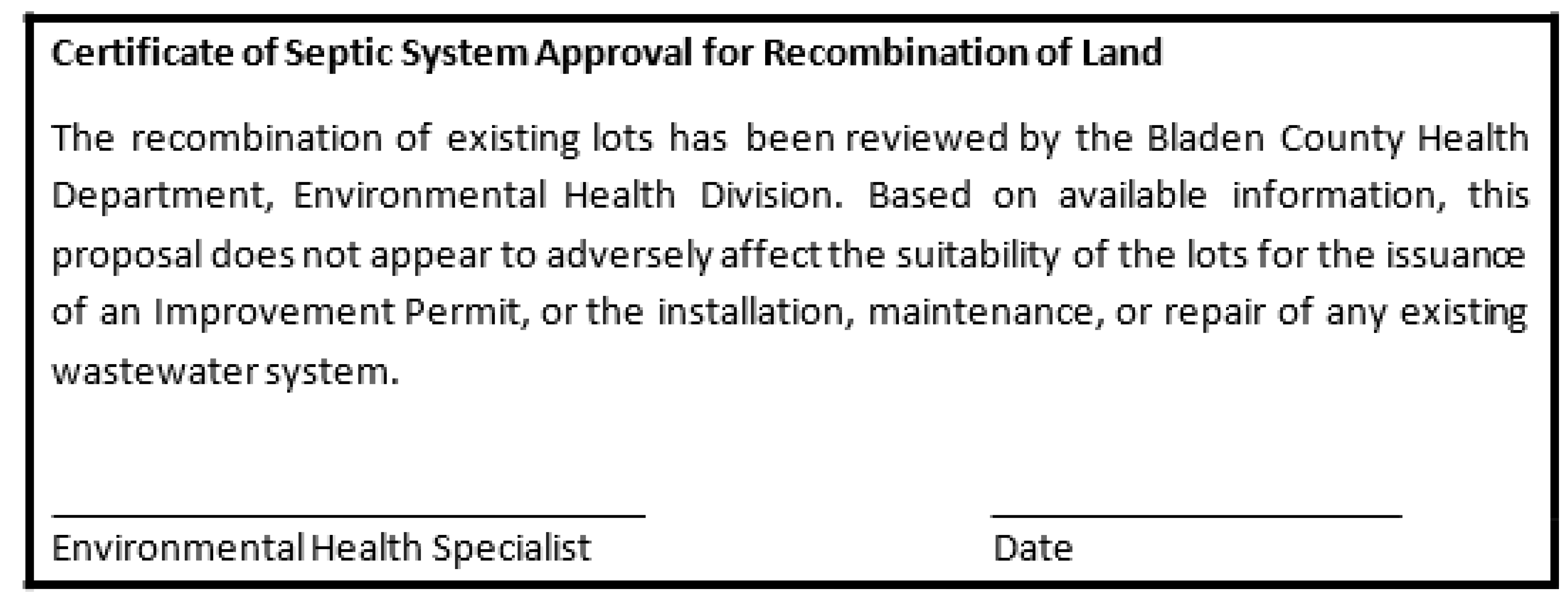
15.34 - COMBINATION AND RECOMBINATION OF LAND
In cases where a combination or recombination of previously subdivided and recorded lots is proposed (such as property lines between lots being reconfigured) that involve individual private septic systems for waste disposal, and an existing house or facility is located on any of the resultant lots that have been reduced in size by the proposal, the following certificate shall be shown on the plat and endorsed by the Bladen County Health Department prior to exemption certification required:
The Bladen County Health Department shall also certify that any vacant lot(s) created or remaining as a result of the combination or recombination have a suitable site for a septic system.
15.35 - RESUBDIVISION PROCEDURES
For any replatting or resubdivision of land, the same procedures, rules and regulations shall apply as prescribed herein for an original subdivision.
15.36 - APPLICATION; PLAN AND PLAT APPROVALS
(a)
Submission. Unless otherwise specified, all applications for plan/plat review and certification or approval under these regulations shall be submitted by the owner of the property or the authorized agent of such owner to the Subdivision Administrator.
(b)
Form of Submission. An application for any certification or approval under these regulations shall be submitted in such form and format as required by these regulations, together with such fees as required.
(c)
Processing. All applications for plan/plat certification or approval shall be submitted, reviewed and processed in accordance with the requirements of these regulations. The Subdivision Administrator may refuse to process an incomplete application.
(d)
Approved Plans and Plats. A copy of required plans and plats or information submitted with the application shall be returned to the applicant after the Planning Board or Board of Commissioners have marked the copy either approved or disapproved and attested to same. A similarly marked copy shall be retained by the Subdivision Administrator.
15.40 - APPLICATION FOR MINOR SUBDIVISION
An application for minor subdivision plat review shall be submitted by filing a copy of the application, on a form approved by the County Board of Commissioners, with the Subdivision Administrator. The application shall consist of a form approved by the County Board of Commissioners accompanied by a Sketch Plan. Two (2) copies of the documents shall be submitted. Submission of the sketch plan shall be accompanied by a filing fee as required in by this Ordinance. The fee schedule shall be set by the County Board of Commissioners.
15.41 - MINOR SUBDIVISION SKETCH PLAN
Prior to submission of a final plat, the subdivider shall submit to the administrator five (5) copies of a sketch plan of the proposed subdivision containing the following information:
(a)
The boundaries of the tract and the portion of the tract to be subdivided;
(b)
The total acreage to be subdivided;
(c)
A sketch vicinity map showing the location of the subdivision in relation to neighboring tracts, subdivisions roads, and waterways;
(d)
The existing and proposed uses of the land within the subdivision and the existing uses of land adjoining it;
(e)
The existing street layout and right-of-way width, lot layout and size of lots;
(f)
The name, address and telephone number of the owner;
(g)
The name, if any, of the proposed subdivision;
(h)
Streets and lots of adjacent developed or platted properties;
(i)
The zoning classification (if applicable) of the tract and of adjacent properties;
(j)
A statement from the county health department that a copy of the sketch plan has been submitted to them, if septic tanks or other on-site water or waste water systems are to be used in the subdivision.
15.42 - ACTION ON MINOR SUBDIVISION SKETCH PLAN
The sketch plan shall be submitted at least 10 (ten) working days prior to the Planning Board meeting at which it will be reviewed. The Planning Board shall review the sketch plan for general compliance with the requirements of this article pertaining to zoning if applicable. The Planning Board shall advise the subdivider or his authorized agent of the regulations pertaining to the proposed subdivision and the procedures to be followed in the preparation and submission of the final plat. One (1) copy of the sketch plan shall be retained as a part of the minutes of the Planning Board and one (1) copy shall be returned to the subdivider or his authorized agent. For their information, the Planning Board shall transmit the third copy of the sketch plan to the board of county commissioners through the Zoning Administrator.
(a)
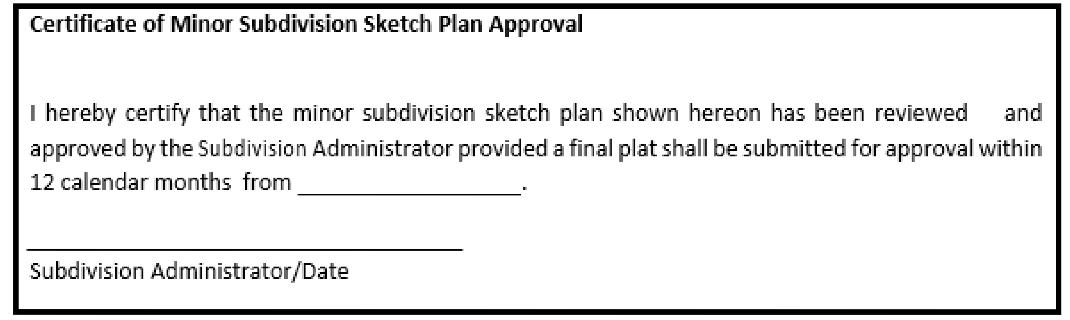
All approved copies of the Sketch Plan shall bear the following statement. Sketch Plan approval shall be valid for 12 calendar months from the date of approval.
15.43 - MINOR SUBDIVISION FINAL PLAT
Upon approval of the sketch plan by the Planning Board the subdivider may proceed with the preparation of the final plat in accordance with the requirements of this article.
(a)
The subdivider shall submit the final plat so marked, to the administrator not less than ten working days prior to the Planning Board meeting at which it will be reviewed.
(b)
The final plat shall be prepared by a professional land surveyor currently licensed and registered in the state by the state board of registration for professional engineers and land surveyors.
(c)
The final plat shall conform to the provisions for plats, subdivisions, and mapping requirements set forth in G.S. 47-30 and the standards of practice for land surveying in the state.
(d)
Five copies of the final plat shall be submitted, two of these shall be on reproducible material; three shall be black or blue line paper prints. Material and drawing medium for the original shall be in accordance with the standards of practice for land surveying in the state where applicable, and the requirements of the county register of deeds.
(e)
The final plat shall be of a size suitable for recording with the county register of deeds and shall be at a scale of not less than one inch equals 200 feet. Maps may be placed on more than one sheet with appropriate match lines.
(f)
Submission of the final plat shall be accompanied by a filing fee of $50.00. This final plat shall meet the specifications in NCGS 47-85. The following signed certificate shall appear on all five copies of the final plat:
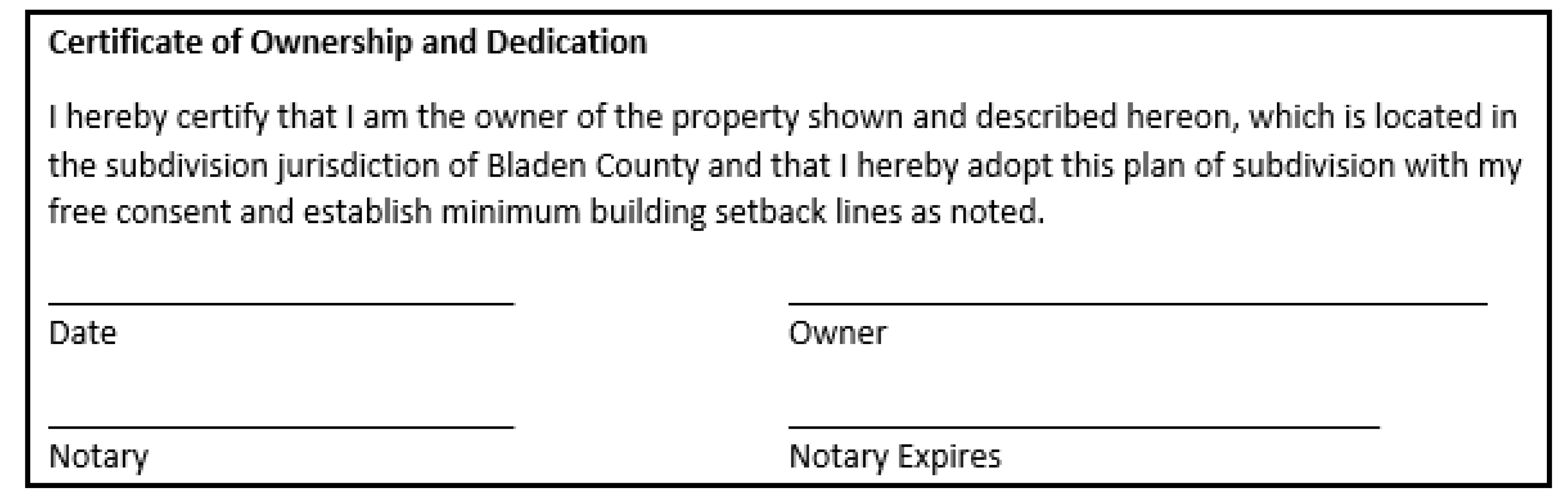
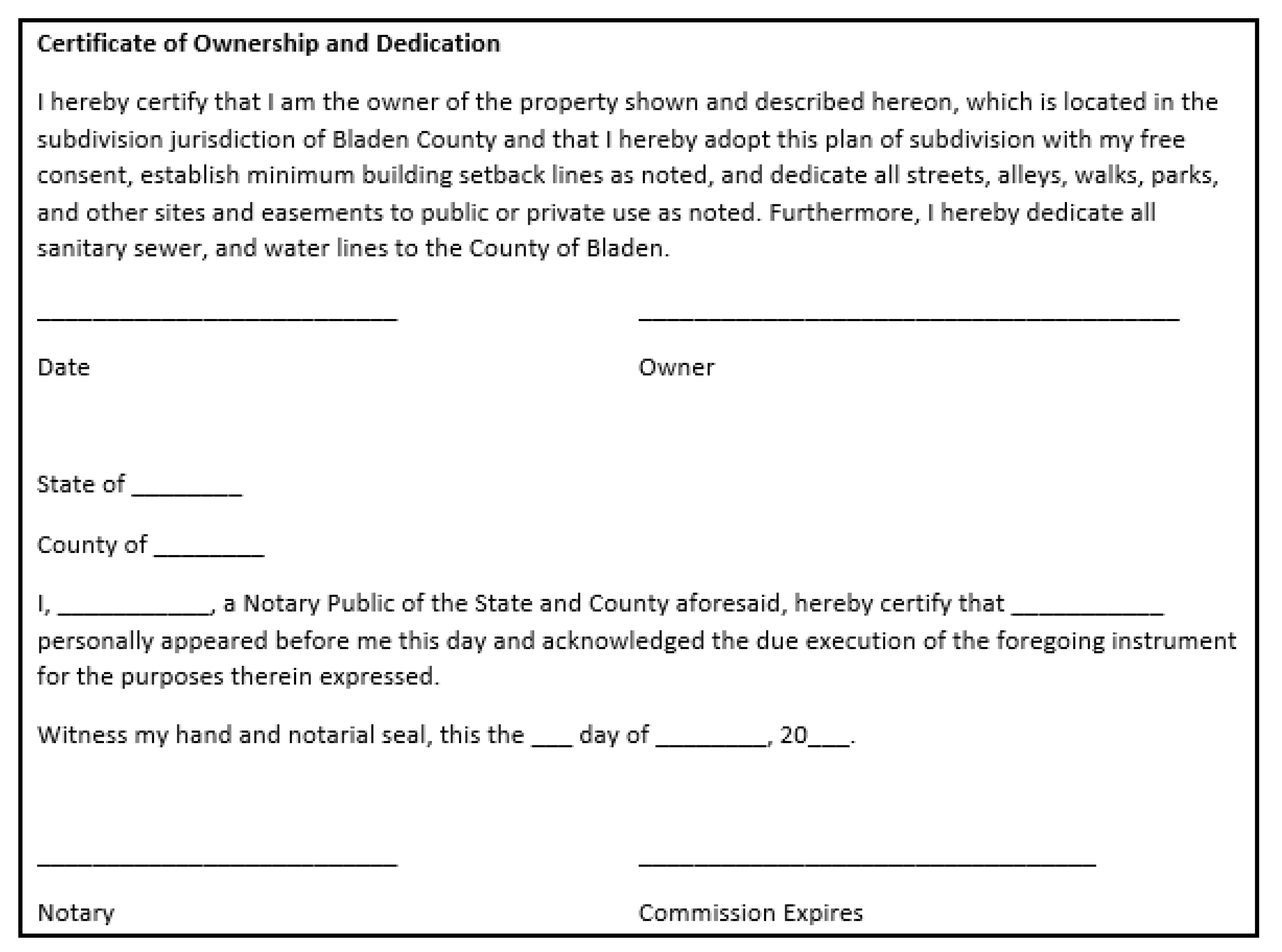
(1)
Certificate of Ownership and Dedication.
(2)
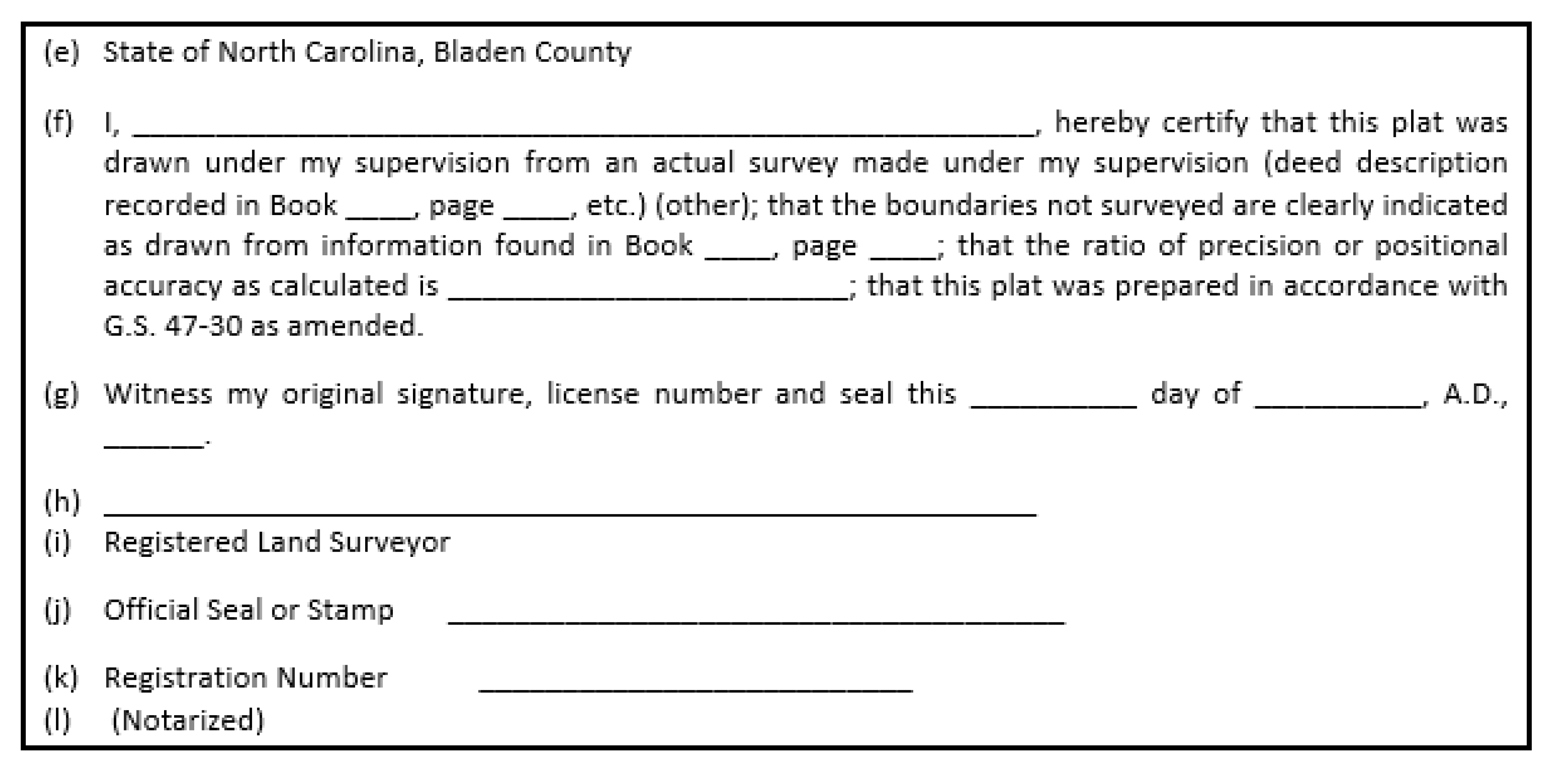
Certificate of Survey and Accuracy. In accordance with the Manual of Practice for Land Surveying in North Carolina, on the face of each map prepared for recordation there shall appear a certificate acknowledged before an officer authorized to take acknowledgments and executed by the person making the survey or map including deeds and any recorded data shown thereon. The certificate shall include a statement of error of closure calculated by latitudes and departures. Any lines on the map which were not actually surveyed must be clearly indicated on the map and a statement included in the certificate revealing the source of information. In accordance with G.S. 47-30, The certificate required shall include (i) the source of information for the survey, (ii) data indicating the ratio of precision or positional accuracy of the survey before adjustments, and (iii) the seal and signature pursuant to G.S. chapter 89C, and shall be in substantially the following form:
(3)
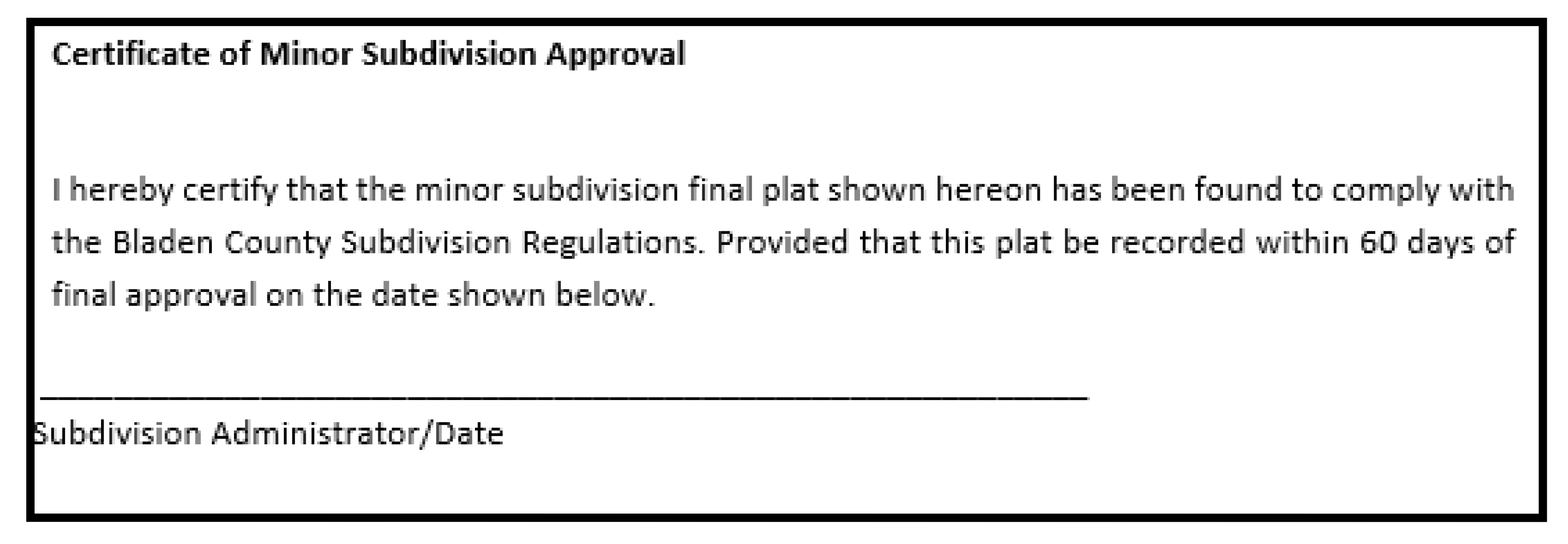
Certificate of Approval for Recording. Following the review by the Subdivision Administrator, the Final Plat shall be approved, conditionally approved with modifications to bring the plat into compliance, or disapproved with reason, within 45 days of its first consideration of the plat.
During the review of the Final Plat the Subdivision Administrator may appoint an engineer or surveyor to confirm the accuracy of the Final Plat (if agreed to by the County Board of Commissioners). If substantial errors are found, the costs shall be charged to the subdivider and the plat shall not be approved until such errors have been corrected.
If the Final Plat is approved, such approval shall be shown on each copy of the plat by the following signed certificate:
15.44 - REVIEW PROCEDURE; APPROVAL OR DISAPPROVAL
(a)
The Planning Board shall review the final plat at or before its next regularly scheduled meeting which follows at least 45 days after the administrator receives the final plat. The Planning Board shall recommend approval with modifications to bring the plat into compliance, or disapprove the final plat with reasons, within 45 days of its first consideration of the plat.
(b)
During its review of the final plat the Planning Board may appoint an engineer or surveyor to confirm the accuracy of the final plat (if agreed to by the board of commissioners). If substantial errors are found, the costs shall be charged to the subdivider and the plat shall not be recommended for approval until such errors have been corrected.
(c)
If the Planning Board recommends approval of the final plat it shall transmit its written recommendations to the subdivider through the administrator.
(d)
If the final plat is disapproved by the Planning Board, the reasons for such disapproval shall be stated in writing, specifying the provisions of this article with which the final plat does not comply. One copy of such reasons and one print of the plat shall be retained by the Planning Board as part of its proceedings; one copy of the reasons and three copies of the plat shall be transmitted to the subdivider. The subdivider shall be given the opportunity to make such changes as will bring the plat into compliance with the provisions of this article and resubmit same for reconsideration by the Planning Board, or may appeal the decision to the board of county commissioners.
(e)
Failure of the Planning Board to make a written recommendation within 45 days after its first review shall constitute grounds for subdivider to apply to the board of county commissioners for approval.
(f)
If the subdivider appeals to the board of county commissioners, the commissioners shall review and approve or disapprove the final plat within 45 days after the plat and recommendations of the Planning Board have been received by the administrator.
(g)
If the Planning Board approves the final plat, such approval shall be shown on each copy of the plat by the following signed certificate:

(h)
If the final plat is approved by the Planning Board, the original tracing and one (1) print of the plat shall be retained by the subdivider. One reproducible tracing and one print shall be filed with the county clerk, and one print shall be returned to the Planning Board for its records.
(i)
The subdivider shall file the approved final plat with the register of deeds of the county within 90 days of Planning Board approval; otherwise such approval shall be null and void.
15.45 - APPEAL
Appeals of subdivision decisions may be made pursuant to G.S. 160D-1403:
(a)
When a subdivision regulation adopted under this Chapter provides that the decision whether to approve or deny a preliminary or final subdivision plat is quasi-judicial, then that decision of the board shall be subject to review by the superior court by proceedings in the nature of certiorari. The provisions of G.S. 160D-406 and this section shall apply to those appeals.
(b)
When a subdivision regulation adopted under this Chapter provides that the decision whether to approve or deny a preliminary or final subdivision plat is administrative, then that decision of the board shall be subject to review by filing an action in superior court seeking appropriate declaratory or equitable relief within 30 days from receipt of the written notice of the decision, which shall be made as provided in G.S. 160D-403(b).
(c)
For purposes of this section, a subdivision regulation shall be deemed to authorize a quasi-judicial decision if the decision-making entity under G.S. 160D-803(c) is authorized to decide whether to approve or deny the plat based not only upon whether the application complies with the specific requirements set forth in the regulation but also on whether the application complies with one or more generally stated standards requiring a discretionary decision to be made.
State Law reference— G.S. 160D-808
15.50 - APPLICATION FOR MAJOR SUBDIVISION
An application for major subdivision plat review shall be submitted by filing a copy of the application, on a form approved by the County Board of Commissioners, with the Subdivision Administrator. The application shall consist of a form approved by the County Board of Commissioners accompanied by a Sketch Plan. Two (2) copies of the documents shall be submitted. Submission of the sketch plan shall be accompanied by a filing fee as required in by this Ordinance. The fee schedule shall be set by the County Board of Commissioners.
15.51 - SKETCH PLANS
(a)
Contents. Prior to the preliminary plat submissions, the subdivider shall submit to the Planning Board five copies of a sketch plan of the proposed subdivision containing the following information:
(1)
A sketch vicinity map showing the location of the subdivision in relation to neighboring tracts, subdivisions, roads, and waterways;
(2)
The boundaries of the tract and the portion of the tract to be subdivided;
(3)
The total acreage to be subdivided;
(4)
The existing and proposed uses of the land within the subdivision and the existing uses of land adjoining it;
(5)
The proposed street layout with approximate pavement and right-of-way width, lot layout and size of lots;
(6)
The name, address, and telephone number of the owner;
(7)
The name, if any, of the proposed subdivision;
(8)
Streets and lots of adjacent developed or platted properties;
(9)
The zoning classification (if applicable) of the tract and of adjacent properties;
(10)
A statement from the county health department that a copy of the sketch plan has been submitted to them, if septic tanks or other on-site water or wastewater systems are to be used in the subdivision.
(b)
Submission and Review Procedure for Sketch Plan.
(1)
The sketch plan shall be submitted at least ten (10) working days prior to the Planning Board meeting at which it will be reviewed.
(2)
The Planning Board shall review the sketch plan for general compliance with the requirements of this article and the Zoning Ordinance, if applicable;
(3)
The Planning Board shall advise the subdivider or his authorized agent of the regulations pertaining to the proposed subdivision and the procedures to be followed in the preparation and submission of the preliminary and final plats.
(4)
If approved, one copy of the sketch plan shall be retained as a part of the minutes of the Planning Board with the other copy being returned to the subdivider or his authorized agent.
(5)
If disapproved, the Planning Board shall notify the Applicant in writing as to the reasons why. The applicant shall have the opportunity to withdraw the plan or adjust the sketch plan and resubmit the plan for review at a subsequent meeting of the Planning Board.
15.52 - PRELIMINARY PLAT SUBMISSION AND REVIEW
(a)
Submission Procedure. Preliminary plats shall meet the specifications in Section 15-54. For every subdivision within the territorial jurisdiction the subdivider shall submit a preliminary plat which shall be reviewed and approved by the Planning Board before any construction or installation of improvements may begin. Five (5) copies of the preliminary plat (as well as any additional copies which the subdivision administrator determines are needed to be sent to other agencies) shall be submitted to the subdivision administrator at least ten (10) working days prior to the Planning Board meeting at which the subdivider desires the review of the preliminary plat.
(b)
Agency Referrals. Prior to submittal of the Preliminary Plat for review by the Planning Board, the Subdivision Administrator shall refer the Plat to the applicable reviewing agencies listed below. In cases where the completion and development of the subdivision would require permits granted by an agency, that agency shall officially approve by certificate or permit the subdivision proposal. The review and certification process shall include, but not be limited to, the following agencies who shall submit their findings, recommendations, and certificates in writing to the Planning Board. The following agencies, as deemed applicable by the Subdivision Administrator, shall be given the opportunity to review and certify within their area of responsibility:
(1)
The District Engineer of the North Carolina Department of Transportation shall review as to existing and proposed publicly dedicated streets and highways, private street, exclusive access easement, and joint driveway connections to State maintained streets and highways, and related drainage systems as they affect such streets and highways. The Subdivision Administrator, Public Works Director, and County engineer shall review as to existing and proposed private streets, exclusive access easements, and joint driveway easements, including their connections to existing and proposed streets maintained by the County. The Public Works Director and County engineer shall review private streets and their related drainage systems as they affect streets and drainage facilities managed by the County.
(2)
The Bladen County Environmental Health Department shall review and certify as to proposed on-site water and sewage systems. The Public Works Director shall review and certify as to proposed public water and sewer systems.
(3)
The Bladen County 911 Addressing Department shall review and certify in regards to proposed street names and property addressing.
(4)
The North Carolina Department of Environment and Natural Resources, Land Quality Section, shall review and certify as to erosion and sediment control as applicable under State sedimentation control regulations.
(5)
The Bladen County Sherriff's Department, Fire Department and Emergency Service Department shall review as to their ability to provide adequate service to the subdivision.
State Law reference— G.S. 160D-803(b)
(c)
Procedure.
The Planning Board shall review the preliminary plat at or before its next regularly scheduled meeting which follows at least 45 days after the administrator receives the preliminary plat and the comments from the appropriate agencies. The Planning Board shall, in writing, recommend approval, conditional approval with recommended changes to bring the plat into compliance, or disapproval with reasons within 45 days of its first consideration of the plat.
(1)
If the Planning Board recommends approval of the preliminary plat, it shall retain one copy of the plat for its minutes, transmit one copy of the plat to the administrator with its recommendation, and return the final copy to the subdivider.
a.
If the Planning Board approves the preliminary plat, such approval shall be noted on two copies of the plat. One copy of the plat shall be retained by the Planning Board and one copy shall be returned to the subdivider. If the Planning Board approves the preliminary plat with conditions, approval shall by noted on two (2) copies of the plat along with a reference to the conditions. One copy of the plat along with the conditions shall be returned to the subdivider. The other copy shall be filed with the documents for the subdivision.
(2)
If the Planning Board recommends conditional approval of the preliminary plat it shall keep one copy of the plat for its minutes, transmit one copy of the plat and its recommendation to the administrator, and return the remaining copy of the plat and its recommendation to the subdivider.
(3)
If the Planning Board recommends disapproval of the preliminary plat, it shall retain one copy of the plat for its minutes, transmit one copy of the plat and its recommendation to the administrator, and return the remaining copy of the plat and its recommendation to the subdivider. If the preliminary plat is disapproved, the subdivider may make the recommended changes and submit a revised preliminary plat, or appeal the decision to the board of county commissioners.
a.
If the Planning Board disapproves the preliminary plat, the reasons for such disapproval shall be specified in writing.
(4)
If the Planning Board does not make a written recommendation within 45 days after its first consideration of the plat, the subdivider may apply to the board of county commissioners for approval or disapproval.
15.53 - FINAL PLAT SUBMISSION AND REVIEW
(a)
Preparation of final plat and installation of improvements. Upon approval of the preliminary plat by the Planning Board, the subdivider may proceed with the preparation of the final plat, and the installation of, or arrangement for required improvements in accordance with the approved preliminary plat and the requirements or this article. Prior to approval of a final plat, the subdivider shall have installed the improvements specified in this article or guaranteed their installation as provided herein. No final plat will be accepted or reviewed by the Planning Board unless accompanied by written notice by the county clerk acknowledging compliance with any applicable improvement or guarantee standards of this Ordinance. The final plat shall constitute only that portion of the preliminary plat which the subdivider proposes to record and develop at that time; such portion shall conform to all requirements of this Ordinance.
(b)
Improvements guarantees.
(1)
Agreement and security required. In lieu of requiring the completion, installation and dedication of all improvements prior to final plat approval, the county may enter into an agreement with the subdivider whereby the subdivider shall agree to complete all required improvements. Once said agreement is signed by both parties and the security required herein is provided, the final plat may be approved by the Planning Board, if all other requirements of this article are met. To secure this agreement, the subdivider shall provide, subject to the approval of the county commissioners, either one, or a combination of the following guarantees not exceeding 1.25 times the entire cost as provided herein:
a.
Surety performance bond. The subdivider shall obtain a performance bond from a surety bonding company authorized to do business in the state. The bond shall be payable to the county and shall be in an amount equal to 1.25 times the entire cost, as estimated by the subdivider and approved by the county commissioners, of installing all required improvements. The duration of the bond shall be until such time as the improvements are accepted by the county commissioners.
b.
Cash or equivalent security. The subdivider shall deposit cash, an irrevocable letter of credit or other instrument readily convertible into cash at face value, either with the county or in escrow with a financial institution designated as an official depository of the county. The use of any instrument other than cash shall be subject to the approval of the county commissioners. The amount of deposit shall be equal to 1.25 times the cost, as estimated by the subdivider and approved by the county commissioners, of installing all required improvements. If cash or other instrument is deposited in escrow with a financial institution as provided in this section, then the subdivider shall file with the county commissioners an agreement between the financial institution and himself guaranteeing the following:
1.
That said escrow account shall be held in trust until released by the county commissioners and may not be used or pledged by the subdivider in any other matter during the term of the escrow; and
2.
That in the case of a failure on the part of the subdivider to complete said improvements the financial institution shall, upon notification by the county commissioners, and submission by the county commissioners to the financial institution of an engineer's estimate of the amount needed to complete the improvements, immediately either pay to the county the funds estimated to complete the improvement up to the full balance of the escrow account, or deliver to the county any other instruments fully endorsed or otherwise made payable in full to the county.
(2)
Default. Upon default, meaning failure on the part of the subdivider to complete the required improvements in a timely manner as spelled out in the performance bond or escrow agreement, then the surety, or the financial institution holding the escrow account shall, if requested by the county commissioners pay all or any portion of the bond or escrow fund to the county up to the amount needed to complete the improvements based on an engineering estimate. Upon payment, the county commissioners, in its discretion, may expend such portion of said funds as it deems necessary to complete all improvements.
(3)
Release of guarantee security. The county commissioners may release a portion of any security posted as the improvements are completed and recommended for approval by the Planning Board. Within 45 days after receiving the Planning Board recommendation, the county commissioners shall approve said improvements. If the county commissioners approve said improvements, then it shall immediately release any security posted.
(c)
Submission Procedure.
(1)
The subdivider shall submit the final plat, so marked, to the administrator not less than 10 (ten) working days prior to the Planning Board meeting at which it will be reviewed; further, the final plat for the first stage of the subdivision shall be submitted not more than six months after the date on which the preliminary plat was approved; otherwise such approval shall be null and void, unless a written extension of this limit is granted by the Planning Board on or before the sixth month anniversary of the approval.
(2)
The final plat shall be prepared by a professional land surveyor currently licensed and registered in the state by the state board of registration for professional engineers and land surveyors.
(3)
The final plat shall conform to the provisions for plats, subdivisions, and mapping requirements set forth in Section 15.54 and the standards of practice for land surveying in the state. Five copies of the final plat shall be submitted; two of these shall be on reproducible material; three shall be black or blue line paper prints. Material and drawing medium for the original shall be in accordance with the standards of practice for land surveying in the state, where applicable, and the requirements of the county register of deeds.
(4)
The final plat shall be of a size suitable for recording with the county register of deeds and shall be at a scale of not less than one inch equals 200 feet. Maps may be placed on more than one sheet with appropriate match lines.
(5)
Submission of the final plat shall be accompanied by a filing fee.
(6)
The final plat shall meet the specifications of this Article. The following signed certificates shall appear on all five copies of the final plat:
a.
Certificate of Ownership and Dedication:
(7)
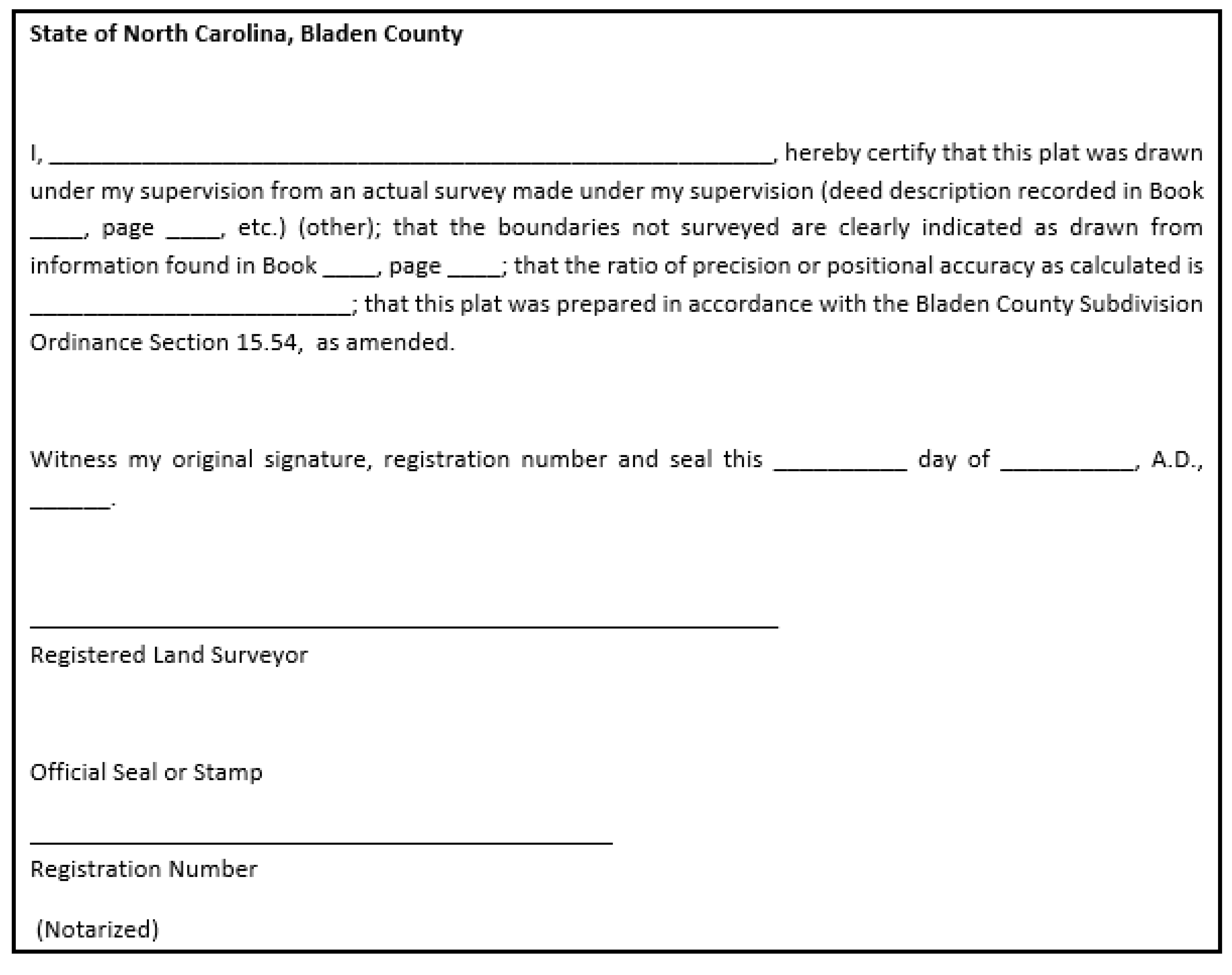
There shall appear on each plat a certificate by the person under whose supervision such survey or such plat was made, stating the origin of the information shown on the plat, including a recorded deed and plat references shown thereon. The ratio of precision as calculated by latitudes and departures before any adjustments must be shown. Any lines on the plat that were not actually surveyed must be clearly indicated and a statement included revealing the source of information. The execution of such certificate shall be acknowledged before any officer authorized to take acknowledgements by the professional land surveyor preparing the plat. All plats to be recorded shall be probated as required by law for the registration of deeds. Where a plat consists of more than one sheet, only the first sheet must contain the certification and all subsequent sheets must be signed and sealed.
b.
Certificate of Survey Accuracy:
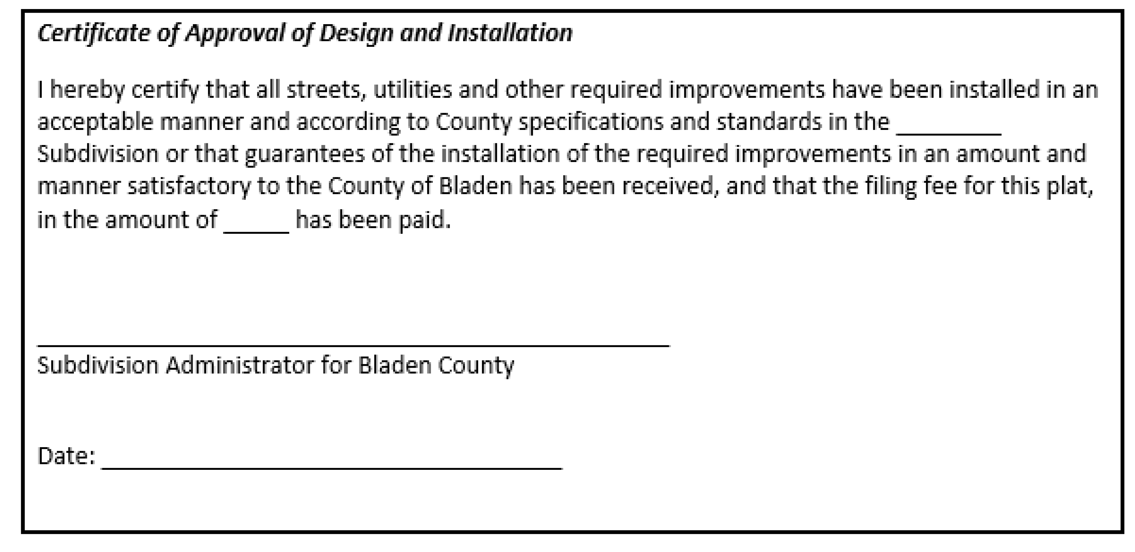
(8)
There shall appear on each plat a certificate of approval of the design and installation of streets, utilities, and other required improvements and payment of filing fee:
a.
Certificate of Approval of Design and Installation:
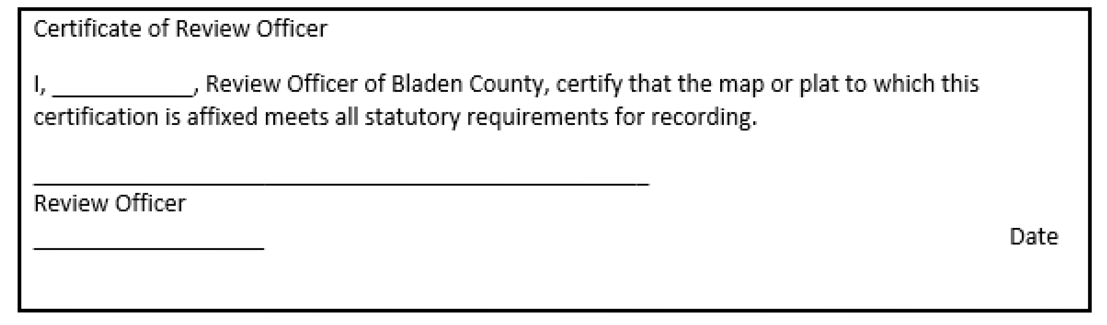
(9)
There shall appear on each plat a certificate of approval of the Review Officer:
a.
Certificate of Review Officer:
(d)
Review Procedure: Approval, Disapproval and Repeal.
(1)
The Planning Board shall review the final plat at or before its next regularly scheduled meeting which follows at least 45 days after the administrator receives the final plat. The Planning Board shall recommend approval, conditional approval with modifications to bring the plat into compliance, or disapproval of the final plat with reasons within 45 days of its first consideration of the plat.
(2)
During its review of the final plat, the Planning Board may appoint a professional land surveyor to confirm the accuracy of the final plat (if agreed to by the county commissioners). If substantial errors are found, the costs shall not be recommended for approval until such errors have been corrected.
(3)
If the Planning Board recommends approval of the final plat it shall retain one copy and transmit all remaining copies of the plat and its written recommendations to the subdivider through the administrator.
(4)
If the Planning Board recommends conditional approval of the final plat with modifications to bring the plat into compliance, it shall retain one print of the plat for its minutes, return its written recommendations and two reproducible copies of the plat to the subdivider, and transmit one print of the plat and its written recommendation to the administrator.
(5)
If the Planning Board recommends disapproval of the final plat, it shall instruct the subdivider concerning resubmission of a revised plat and the subdivider may make such changes as will bring the plat into compliance with the provisions of this article, and resubmit same for reconsideration by the Planning Board, or appeal the decision to the Board of County Commissioners.
(6)
Failure of the Planning Board to make a written recommendation within 45 days shall constitute grounds for the subdivider to apply to the board of county commissioners for approval.
(7)
If the subdivider appeals to the board of county commissioners, the commissioners shall review and approve or disapprove the final plat within 45 days after the plat and recommendations of Planning Board have been received by the administrator.
(8)
If the Planning Board approves the final plat, such approval shall be shown on each copy of the plat by the following signed certificate:
a.
Certificate of Approval for Recording:

(9)
If the final plat is disapproved by the Planning Board, the reasons for such disapproval shall be stated in writing, specifying the provisions of this Ordinance with which the final plat does not comply. One copy of such reasons and one print of the plat shall be retained by the Planning Board as part of its proceedings, one copy of the reasons shall be transmitted to the administrator, and one copy of the reasons and remaining copies of the plat shall be transmitted to the subdivider. If the final plat is disapproved, the subdivider may make such changes as will bring the final plat into compliance and resubmit same for reconsideration by the Planning Board.
(10)
If the final plat is approved by the Planning Board, the original tracing and one print of the plat shall be retained by the subdivider. One reproducible tracing and one print shall be filed with the county clerk, and one print shall be returned to the Planning Board for its records.
(11)
The subdivider shall file the approved final plat with the register of deeds of the county within 90 days of Planning Board approval; otherwise such approval shall be null and void.
15.54 - INFORMATION TO BE DEPICTED ON PLATS—MINOR AND MAJOR SUBDIVISIONS
The information to be contained in or depicted on final plats for minor subdivisions and preliminary and final plats for major subdivisions. An "X" indicates that the information is required.
Table 15-1
Information Requirements for Plats
15.60 - GENERALLY
Each subdivision shall contain the improvements specified in this Part, which shall be installed in accordance with the requirements of this article and paid for by the subdivider, unless other means of financing is specifically stated in this article. Land shall be dedicated and reserved in each subdivision as specified in this article. Each subdivision shall adhere to the minimum standards of design established by this article.
15.61 - SUITABILITY OF LAND
(a)
Land which has been determined by the Planning Board on the basis of engineering or other expert surveys to pose an ascertainable danger to life or property by reason of its unsuitability for the use proposed shall not be platted for that purpose, unless and until the subdivider has taken the necessary measures to correct said conditions and to eliminate said dangers.
(b)
Areas that have been used for disposal of solid waste shall not be subdivided unless tests by the county health department, a structural engineer and a soils expert determine that the land is suitable for the purpose proposed.
(c)
Subdivisions shall not be located in areas that are susceptible to regular flooding as noted on FEMA maps. Existing subdivisions located in hazard areas shall not be allowed to expand.
15.62 - FLOODPLAIN OR FLOOD-PRONE AREAS
(a)
All subdivision proposals shall be consistent to minimize flood damage. Flood prone areas shall be indicated by studies, reports, or maps by agencies including the Federal Emergency Management Agency (FEMA), the US Army Corps of Engineers, the Soil Conservation Service, the Department of Housing and Urban Development, the US Geological Survey, and the North Carolina Department of Environmental and Natural Resources.
(b)
All subdivision proposals shall have public utilities and facilities such as sewer, gas, electrical and water systems located and constructed to minimize flood damage
(c)
Base Flood Elevation (BFE) data shall be provided for subdivision proposals that contain 50 or more lots or that involve a tract of land 5 acres or more in size.
(d)
No structure or land shall hereafter be located, extended, converted, altered, or developed in any way without full compliance with the terms of the current Flood Damage Prevention Ordinance.
(e)
All violations and corrective procedures will be in full compliance with the terms set forth in the current Flood Damage Prevention Ordinance.
15.63 - WETLANDS
If a developer, corporation, private homeowner, or other person proposes to perform construction/filling activities in or near a lake, stream, creek, tributary, or any unnamed body of water and its adjacent wetlands, Federal permit authorization may be required by the US Army Corps of Engineers prior to commencement of earth-disturbing activities. Filling activities include, but are not limited to, construction of road crossings, sewer or utility line installations, grading, placement of soil from ditching or other excavations, or placement of fill for commercial or residential development. A wetlands determination and specific permit requirements may be obtained from the Wilmington Field Office of the US Army Corps of Engineers.
15.64 - STORMWATER AND DRAINAGE
The sub-divider shall develop a stormwater management plan that describes adequate drainage system for the proper drainage of all surface water. See Section 15-65 for Design Standards.
(a)
The stormwater disposal system shall be connected to an approved system where one exists and shall be adequate for all present and future development. The system shall incorporate proper engineering practices to ensure proper drainage.
(b)
No surface water shall be channeled or directed into a sanitary sewer.
(c)
Where a subdivision is traversed by a stream or drainage way, a drainage easement shall be provided conforming with the lines of such stream and of sufficient width as will be adequate for the purpose.
(d)
When an approved system does not exist, the sub-divider shall incorporate North Carolina Department of Environment and Natural Resources Stormwater Best Management Practices Guideline to minimize water quality impacts.
(e)
Any stormwater management plans shall be reviewed/approved by the Subdivision Administrator as part of the review process.
15.65 - SEDIMENTATION AND EROSION CONTROL
The sub-divider shall comply with all requirements of the "North Carolina Sedimentation Pollution Control Act of 1973" and all locally adopted sediment control ordinances.
15.66 - PRE-SALE OR PRE-LEASE OF SUBDIVISION LOTS
(a)
The subdivider, upon approval of the preliminary plat, may enter into contracts to sell or lease the lots shown on the approved preliminary plat, provided that the contract does all of the following:
(1)
Incorporates as an attachment a copy of the approved preliminary plat referenced in the contract and obligates the owner to deliver to the buyer a copy of the approved and recorded final plat prior to closing and conveyance.
(2)
Plainly and conspicuously notifies the prospective buyer or lessee that a final subdivision plat has not been approved or recorded at the time of the contract, that no governmental body will incur any obligation to the prospective buyer or lessee with respect to the approval of the final subdivision plat, that changes between the preliminary and final plats are possible, and that the contract or lease may be terminated without breach by the buyer or lessee if the final approved and recorded plat differs in any material respect from the approved preliminary plat.
(3)
Provides that if the approved and recorded final plat does not differ in any material respect from the plat referred to in the contract, the buyer or lessee may not be required by the seller or lessor to close any earlier than five days after the delivery of a copy of the final approved and recorded plat.
(4)
Provides that if the approved and recorded final plat differs in any material respect from the approved preliminary plat referred to in the contract, the buyer or lessee may not be required by the seller or lessor to close any earlier than 15 days after the delivery of the final approved and recorded plat, during which 15-day period the buyer or lessee may terminate the contract without breach or any further obligation and may receive a refund of all earnest money or prepaid purchase price.
State Law reference— G.S. 160D-807(b)
(b)
The provisions of the subsection 15.66(a)(4) above shall not prohibit any owner or his or her agent from entering into contracts to sell or lease land by reference to an approved preliminary plat for which a final plat has not been properly approved under this ordinance or recorded with the Office of the Bladen County Register of Deeds where the buyer or lessee is any person who has contracted to acquire or lease the land for the purpose of engaging in the business of construction of residential, commercial, or industrial buildings on the land, or for the purpose of resale or lease of the land to persons engaged in that kind of business, provided that no conveyance of that land may occur and no contract to lease it may become effective until after the final plat has been properly approved under the requirements of this chapter and recorded in the Office of the Bladen County Register of Deeds.
State Law reference— G.S. 160D-807(c)
15.67 - COMPLETING DEVELOPMENT IN PHASES
(a)
If a subdivision is to be developed or constructed in phases, the subdivider shall submit plans that clearly show the various phases or stages of the proposed development and the requirements of these regulations that will be satisfied with respect to each phase or stage.
(b)
Preliminary Plats may be vested under the procedures in the Bladen County Zoning Ordinance.
15.68 - AMENDMENT TO AND MODIFICATION OF APPROVED PRELIMINARY PLATS
(a)
Insignificant deviations from the Plat approval issued by the Planning Board are permissible and the Subdivision Administrator may authorize such insignificant deviations. A deviation may be considered insignificant if it does not involve any of the following:
(1)
any substantive change in a condition of approval;
(2)
an increase in the number of building lots proposed;
(3)
any substantial change in the location of, or any decrease in, the amount of open space, buffers, or areas reserved for recreational use;
(4)
any substantial change in pedestrian and/or vehicular access or circulation including road classification;
(5)
any change in the provision of services such as water supply and wastewater disposal;
(6)
any substantial change in the location of utilities or other easements.
(b)
All other requests for changes in approved Preliminary Plats will be processed as a modification to the original application. If such requests are to be acted upon by the Planning Board, new conditions may be imposed only on the specific site or area requested to be modified in accordance with these regulations, but the applicant retains the right to reject such additional conditions by withdrawing his/her request for an amendment and may then proceed in accordance with the previously approved Preliminary Plat.
(c)
The Subdivision Administrator shall determine whether amendments to and modifications of permits fall within the categories set forth above in Paragraph (a).
(d)
An applicant requesting approval of changes shall submit a written request for such approval to the Subdivision Administrator, which request shall identify the changes. Approval of all changes must be given in writing.
(e)
A vested right established in accordance with the Bladen County Zoning Ordinance shall not be extended by any amendments or modifications to an approved site specific development plan unless expressly provided for by the County.
15.69 - PLAT APPROVAL NOT ACCEPTANCE OF DEDICATION OFFERS
(a)
The approval of a plat shall not be deemed to constitute the acceptance by the local government or public of the dedication of any street or other ground, public utility line, or other public facility shown on the plat. However, any governing board may by resolution accept any dedication made to the public of lands or facilities for streets, parks, public utility lines, or other public purposes, when the lands or facilities are located within its planning and development regulation jurisdiction. Acceptance of dedication of lands or facilities located within the planning and development regulation jurisdiction but outside the corporate limits of a city shall not place on the city any duty to open, operate, repair, or maintain any street, utility line, or other land or facility, and a city shall in no event be held to answer in any civil action or proceeding for failure to open, repair, or maintain any street located outside its corporate limits.
(b)
The County shall not have the authority to require, as a condition of subdivision approval, the dedication of water systems or facilities, or other public entity operating a water system shall have agreed to begin operation and maintenance of the water system or water system facilities within one year of the time of issuance of a certificate of occupancy for the first unit of housing in the subdivision, a city or county shall not, as part of its subdivision regulation applied to facilities or land outside the corporate limits of a city, require dedication of water systems or facilities as a condition for subdivision approval.
State Law reference— G.S. 160D-806
15.70 - PERFORMANCE GUARANTEE
(a)
Agreement and security required. In lieu of requiring the completion, installation, and dedication of all improvements prior to final plat approval, the County Board of Commissioners may enter into an agreement with the subdivider whereby the subdivider shall agree to complete all required improvements.
The subdivider shall be allowed to choose which security or combination of securities that he or she wishes to provide from the choices provided below. The county shall not have the authority to dictate which form of security will be accepted as an improvement guarantee, and shall be required to offer a range of options of types of improvements guarantees from which the subdivider may choose.
(b)
Once the agreements are signed by both parties and the security required herein is provided, the final plat may be approved, if all other requirements of this chapter are met. To secure this agreement, the subdivider shall provide either one or a combination of the following guarantees:
(1)
Type. The type of the performance guarantee shall be at the election of the developer. The term "performance guarantee" means any of the following forms of guarantee:
a.
Surety bond issued by any company authorized to do business in this State.
b.
Letter of credit issued by any financial institution licensed to do business in this State.
c.
Other form of guarantee that provides equivalent security to a surety bond or letter of credit.
(2)
Duration. The duration of the performance guarantee shall initially be one year, unless the developer determines that the scope of work for the required improvements necessitates a longer duration. In the case of a bonded obligation, the completion date shall be set one year from the date the bond is issued, unless the developer determines that the scope of work for the required improvements necessitates a longer duration.
(3)
Extension. A developer shall demonstrate reasonable, good-faith progress toward completion of the required improvements that are secured by the performance guarantee or any extension. If the improvements are not completed to the specifications of the local government, and the current performance guarantee is likely to expire prior to completion of the required improvements, the performance guarantee shall be extended, or a new performance guarantee issued, for an additional period. An extension under this subdivision shall only be for a duration necessary to complete the required improvements. If a new performance guarantee is issued, the amount shall be determined by the procedure provided in subdivision (5) of this subsection and shall include the total cost of all incomplete improvements.
(4)
Release. The performance guarantee shall be returned or released, as appropriate, in a timely manner upon the acknowledgement by the local government that the improvements for which the performance guarantee is being required are complete. The local government shall return letters of credit or escrowed funds upon completion of the required improvements to its specifications or upon acceptance of the required improvements, if the required improvements are subject to local government acceptance. When required improvements that are secured by a bond are completed to the specifications of the local government, or are accepted by the local government, if subject to its acceptance, upon request by the developer, the local government shall timely provide written acknowledgement that the required improvements have been completed.
(5)
Amount. The amount of the performance guarantee shall not exceed one hundred twenty-five percent (125%) of the reasonably estimated cost of completion at the time the performance guarantee is issued. The local government may determine the amount of the performance guarantee or use a cost estimate determined by the developer. The reasonably estimated cost of completion shall include one hundred percent (100%) of the costs for labor and materials necessary for completion of the required improvements. Where applicable, the costs shall be based on unit pricing. The additional twenty-five percent (25%) allowed under this subdivision includes inflation and all costs of administration regardless of how such fees or charges are denominated. The amount of any extension of any performance guarantee shall be determined according to the procedures for determining the initial guarantee and shall not exceed one hundred twenty-five percent (125%) of the reasonably estimated cost of completion of the remaining incomplete improvements still outstanding at the time the extension is obtained.
(6)
Timing. A local government, at its discretion, may require the performance guarantee to be posted either at the time the plat is recorded or at a time subsequent to plat recordation.
(7)
Coverage. The performance guarantee shall only be used for completion of the required improvements and not for repairs or maintenance after completion.
(8)
Legal responsibilities. No person shall have or may claim any rights under or to any performance guarantee provided pursuant to this subsection or in the proceeds of any such performance guarantee other than the following:
a.
The local government to whom the performance guarantee is provided.
b.
The developer at whose request or for whose benefit the performance guarantee is given.
c.
The person or entity issuing or providing the performance guarantee at the request of or for the benefit of the developer.
(9)
Multiple guarantees. The developer shall have the option to post one type of a performance guarantee as provided for in subdivision (1) of this section, in lieu of multiple bonds, letters of credit, or other equivalent security, for all development matters related to the same project requiring performance guarantees.
(10)
Exclusion. Performance guarantees associated with erosion control and stormwater control measures are not subject to the provisions of this section.
State Law reference— G.S. 160D-804.1
15.71 - CONSTRUCTION COST ESTIMATE
The financial guarantee shall be accompanied by an itemized estimate for the cost of construction that includes quantities and unit prices for construction materials and activities such as clearing and grading. The estimate shall be prepared by an engineer, contractor, or other individual qualified to calculate the cost to complete the improvements according to approved plans and specifications, who has no direct or indirect ownership interest in the subdivision. The construction cost estimate shall include a 50% construction contingency to account for unanticipated conditions or circumstances discovered during the development process.
15.72 - DEFAULT
Upon default, meaning failure on the part of the sub-divider to complete the required improvements in a timely manner as spelled out in the performance bond or escrow agreement, then the surety, or the financial institution holding the escrow account shall, if requested by the County, pay all or any portion of the bond or escrow fund to the County up to the amount needed to complete the improvements based on an engineering estimate. Upon payment, the Board of Commissioners, in its discretion, may expend such portion of said funds as it deems necessary to complete all improvements.
15.73 - MAINTENANCE OF IMPROVEMENTS
(a)
Improvements installed as a requirement of subdivision approval shall be maintained by the sub-divider until they are accepted for maintenance by:
(1)
For a public street, Bladen County or the North Carolina Department of Transportation as appropriate;
(2)
For utilities, Bladen County;
(3)
For landscaping, the homeowners;
(4)
For private streets, and/or community facilities such as recreation and stormwater management improvements, a homeowners' or neighborhood association, or similar legal entity.
(b)
Where a neighborhood or homeowners' association, or similar legal entity, is to be responsible for the maintenance and control of any improvements required as part of the subdivision approval, the subdivider shall file with the Subdivision Administrator and record with the Final Plat, a declaration of covenants and restrictions, articles of incorporation, where required, and/or by-laws as approved by the County Attorney that will govern the maintenance and control of such improvements. Provisions shall include, but not be limited to, the following:
(1)
The association shall be established before any homes are sold and any building occupied;
(2)
Membership shall be mandatory for each homebuyer and all successive buyers;
(3)
The association shall be responsible for liability insurance, local taxes and maintenance of recreation and other facilities, including streets (e.g., when street maintenance is to be provided by a homeowners' association until such time as the County or State, as applicable, assumes street maintenance responsibility), and utility lines;
(4)
The homeowners must pay their pro rate share of the costs, and any sums levied by the association that remain unpaid shall become a lien on the individual homeowner's property that shall be subordinate only to tax and mortgage liens;
(5)
If all or any portion of the property held by the association is being disposed of, or if the association is dissolved, adequate recreation space shall be deeded to the County or the appropriate unit of local government;
(6)
The lot owner of each dwelling unit or lot shall have voting rights in the association; and
(7)
The homeowners' association shall be able to adjust any assessments to meet changed needs.
(8)
When articles of incorporation are required they shall be submitted in the form in which they will be filed with the North Carolina Secretary of State. Upon filing, a copy of the articles of incorporation shall be provided to the Subdivision Administrator.
15.74 - DEFECTS GUARANTEE
The Planning Board shall require a bond guaranteeing utility taps, street pavement, drainage facilities, water and sewer lines, and other improvements against defects for one year. This bond shall be in the amount determined by the County's engineer and shall be in cash or be made by a surety company authorized to do business in the State.
15.75 - MAINTENANCE GUARANTEE
The Subdivision Administrator shall secure from all sub-dividers a letter in which the sub-divider shall agree to maintain the backfill and any improvements located thereon and therein and any ditch which has been dug in connection with the installation of such improvements. Such letter shall be binding on the sub-divider for a period of one year after the acceptance of such improvements by the County.
15.76 - VACATION OF PLATS
(a)
Any plat or any part of any plat must be vacated by the owner at any time before the sale of any lot in the subdivision by a written instrument to which a copy of such plat shall be attached, declaring the same to be vacated.
(b)
Such an instrument shall be approved by the same agencies as approved the final plat. The governing body may reject any such instrument, which abridges or destroys any public right in any of its public uses, improvements, streets or alleys.
(c)
Such an instrument shall be executed, acknowledged or approved and recorded and filed in the same manner as a final plat; and being duly recorded or filed shall operate to destroy the force and effect of the recording of the plat so vacated, and to divest all public right in the streets, alleys and public grounds, and all dedications laid out or described in such plat.
(d)
When lots have been sold, the plat may be vacated in the manner provided in divisions (a), (b) and (c) of this section by all owners of the lots in such plat joining in the execution of such writing.
15.77 - DEDICATIONS AND RESERVATIONS
(a)
Land subject to flooding as denoted in the county's flood plain maps and land deemed by the Planning Board to be uninhabitable for other reasons including, but not limited to, slopes in excess of 25%, slumping soils, wetlands, habitats for endangered species, and historic/archeological sites, shall not be platted for residential occupancy, nor for such other uses as may increase danger to health, life or property, or aggravated the flood hazard. Such land within a plan shall be set aside for such uses as will not be endangered by periodic or occasional inundation, or will not produce unsatisfactory living conditions.
(1)
Past records of flood levels shall be used to determine sufficient area from the centerline of streams to provide adequate protection from the most severe flood of record.
(b)
Where land is subdivided into larger parcels than ordinary building lots, such parcels shall be arranged so as to allow for the opening of future streets and logical further subdivision.
(c)
Where a proposed residential subdivision contains or is adjacent to a major highway, it shall be planned so as to avoid having lots fronting on the highway in such a manner as to derive their access from said highway, preferably by providing a marginal access street for these lots or by backing the lots to the highway.
(d)
Where a proposed subdivision contains or is adjacent to a railroad right-of-way, it shall be planned so as to avoid having residential lots front on a street, which parallels and is adjacent to the railroad right-of-way.
(e)
Subdivision showing reserve strips controlling access to public ways will not be approved except when the control and disposition of land comprising such strips is placed within the county's jurisdiction under conditions meeting the approval of the Subdivision Administrator.
(f)
All subdivided land shall be part of a usable and numbered lot or it shall be reserved as permanent open space. All major subdivisions shall be required to reserve a minimum of 5% or more of the gross land area as permanent open space, subject to the review of the Planning Board.
(g)
If the entire area shown on an approved preliminary plat is not to be recorded at the same time as one unit, but instead, sections or units of the entire subdivision are to be recorded at subsequent time intervals, then the unit boundaries shall be so designated as to permit each unit recorded to function independently of the unit to follow it in the proposed recording schedule of the subdivider. Temporary turnarounds shall be constructed by the developer, as required by the county, at the ends of streets, which are presently dead-end, but are planned as through streets when the adjacent unit ultimately recorded.
(h)
Areas that have been used for disposal of solid waste shall not be subdivided unless tests by the County Health Department, a structural engineer, and soils expert determine that the land is suitable for the purpose proposed.
15.78 - NAME DUPLICATION
The name of the subdivision shall not duplicate nor closely approximate the name of an existing subdivision within the county.
15.79 - SUBDIVISION DESIGN
(a)
Blocks.
(1)
The lengths, widths, and shapes of blocks shall be determined with due regard to: provision of adequate building sites suitable to the special needs of the type of use contemplated; zoning requirements; needs for vehicular and pedestrian circulation; control and safety of street traffic; limitations and opportunities of topography; and convenient access to water areas.
(2)
Blocks shall not be less than 400 feet or more than 1,800 feet.
(3)
Blocks shall have sufficient width to allow two tiers of lots of minimum depth except where single tier lots are required to separate residential development from through vehicular traffic or another type of use, in nonresidential subdivisions, or where abutting a water area.
(4)
Where deemed necessary by the Planning Board, a pedestrian crosswalk at least 15 feet in width may be required to provide convenient public access to a public area such as a park or school, to a water area, or to areas such as shopping centers, religious or transportation facilities.
(5)
Block numbers shall conform to the county street numbering system.
(b)
Lots.
(1)
If applicable, all lots in new subdivisions shall conform to any zoning requirements of the district in which the subdivision is located. Conformance to zoning requirements means, among other things, that the smallest lot in the subdivision must meet all dimensional requirements of the zoning ordinance. It is not sufficient merely for the average lot to meet zoning requirements. In unzoned areas of the county, the following chart provides dimensional requirements. This chart is for unzoned areas:
Table 15-2
Dimensional Requirements
* Restricted by county ordinance
(2)
Lots shall meet any applicable requirements of the county health department.
(3)
Double frontage lots shall be avoided wherever possible.
(4)
Side lot lines shall be substantially at right angles to or radial to street lines.
(c)
Easements.
(1)
Utility easements. Easements for underground or above ground utilities shall be provided, where necessary, across lots or centered on rear or side lot lines and shall be at least 12 feet wide for water and sanitary sewer lines and as required by the companies involved, for telephone, gas and power lines. The Planning Board will determine whether one easement is sufficient or whether several easements are necessary to accommodate the various facilities and the subdivider shall provide the required easements.
(2)
Drainage easements. Where a subdivision is traversed by a stream or drainage way, an easement shall be provided conforming with the lines of such stream and of sufficient width as will be adequate for the purpose.
(d)
Buffering/Landscaping/Screening. All buffers and landscaping shall conform to the requirements of the Zoning Ordinance as outlined in Part 3 of Article 10 of the Zoning Ordinance, Landscaping, Buffering, and Screening.
(e)
Outdoor Lighting. All outdoor lighting shall conform to the requirements of the Zoning Ordinance as outlined in Part 4 of Article 10 of the Zoning Ordinance, Outdoor Lighting.
15.80 - STREETS
(a)
Type of street required. All subdivision lots shall abut on a public street. All public streets shall be built to the standards of this article and all other applicable standards of the county and the state department of transportation. Public streets which are eligible for acceptance into the state highway system shall be constructed to the standards necessary to be put on the state highway system or the standard in this article, whichever is stricter in regard to each particular item, and shall be put on such system. Streets which are not eligible to be put on the state highway system because there are too few lots or residences shall, nevertheless, be dedicated to the public and shall be in accordance with the standards in this article or the standards necessary to be put on the state highway system, whichever is stricter in regard to each particular item, so as to be eligible to be put on the system at a later date. A written maintenance agreement with provisions for maintenance of the street until it is put on the state system shall be included with the final plat. No lots may be sold until this provision is satisfied.
(b)
Subdivisions street disclosure statement. All streets shown on the final plat shall be designated in accordance with G.S. 136-102.6 and designation as public shall be conclusively presumed an offer of dedication to the public. Where streets are dedicated to the public but not accepted into a municipal or the state system, before lots are sold, and statement explaining the status of the street shall be included with the final plat.
(c)
Half-streets. The dedication of half-streets of less than 60 feet at the perimeter of a new subdivision shall be prohibited. If circumstances render this impractical, adequate provision for the concurrent dedication of the remaining half of the street shall be furnished by the subdivider. Where there exists a half-street in an adjoining subdivision, the remaining half shall be provided by the proposed subdivision. However, in circumstances where more than 60 feet of right-of-way is required, a partial width right-of-way, not less than 60 feet in width, may be dedicated when adjoining undeveloped property is owned or controlled by the subdivider; provided that the width of the partial dedication is such as to permit the installation of such facilities as may be necessary to serve abutting lots. When the adjoining property is subdivided, the remainder of the full required right-of-way shall be dedicated.
(d)
Marginal access streets. Where a tract of land to be subdivided adjoins a principal arterial street, the subdivider may be required to provide a marginal access street parallel to the arterial street or reverse frontage on a minor street for the lots to be developed adjacent to the arterial. Where reverse frontage is established, private driveways shall be prevented from having direct access to the principal arterial.
(e)
Access to adjacent properties. Where, in the opinion of the Planning Board, it is necessary to provide for street access to an adjoining property, proposed streets shall be extended by dedication to the boundary of such property and a temporary turnaround provided.
(f)
Nonresidential streets. The subdivider of a nonresidential subdivision shall provide streets in accordance with I.F-4 of the North Carolina Roads, Minimum Construction Standards, July 1, 1985; and the standards in this article, whichever are stricter in regard to each particular item.
(g)
Design standards. The design of all streets and roads within the jurisdiction of this article shall be in accordance with the accepted policies of the state department of transportation, division of highways, as taken or modified from the American Association of State Highway Officials (AASHO) manuals. The North Carolina Department of Transportation, Division of Highways' Subdivision Roads Minimum Construction Standards, July 1, 1985, shall apply for any items not included in this article, or where stricter than this article. The following signed certificates shall appear on all copies of the final plat:

(h)
Other requirements.
(1)
Through traffic. Through traffic discouraged on residential collector and local streets residential collector and local streets shall be laid out in such a way that their use by through traffic will be discouraged. Streets shall be designed or walkways dedicated to ensure convenient access to places of public assembly.
(2)
Sidewalks. Sidewalks may be required by the Planning Board on one or both sides of the street in areas likely to be subject to heavy pedestrian traffic such as near schools and shopping areas. Such sidewalks shall be constructed to a minimum width of five feet, and shall consist of a minimum thickness of four inches of concrete. All sidewalks shall be placed in the right-of-way, unless the development is platted as a planned unit or group development. Sidewalks shall consist of a minimum of six inches of concrete at driveway crossings.
(3)
Street names. Proposed streets which are obviously in alignment with existing streets shall be given the same name. In assigning new names, duplication of existing names shall be avoided and in no case shall the proposed name be phonetically similar to existing names in the county irrespective of the use of a suffix such as street, road, drive, place, court, etc. All street names and addressing shall comply with the county's 911 Addressing Requirements. Street names shall be subject to the approval of the county.
(4)
Street name signs. The subdivider shall be required to provide and erect street name signs to county standards at all intersections within the subdivision.
(5)
Permits for connection to state roads. An approved permit is required for connection to any existing state system road. This permit is required prior to any construction on the street or road. The application is available at the office of the nearest district engineer of the division of highways.
(6)
Offsets to utility poles. Poles for overhead utilities should be located clear of roadway shoulders, as close to the right-of-way as possible. On streets with curb and gutter, utility poles should be set back a minimum distance of six feet from the face of curb.
(7)
Wheelchair ramps. In accordance with G.S. 136-44.14, all street curbs in the state being constructed or reconstructed for maintenance procedures, traffic operations, repairs, correction of utilities, or altered for any reason after September 1, 1973, shall provide wheelchair ramps for the physically handicapped at all intersection where both curb and gutter and sidewalks are provided and at other major points of pedestrian flow.
(8)
Curb and gutter. The subdivider may construct curbs and gutters, but it is not required by this article for plat approval.
15.81 - UTILITIES
(a)
Water and sanitary sewer systems. Each lot in all subdivisions within the county's jurisdiction shall be provided with an extension of the county's water (and/or sanitary sewer) systems at the subdivider's expense if practical. A subdivision lot in the county's jurisdiction may be provided with extensions to a municipal system in lieu of the county system. Water and sanitary sewer lines, connections, and equipment shall be in accordance with the county standards. All lots in subdivisions not connected to municipal or county water and/or sanitary sewer systems must have a suitable source of water supply and sanitary sewage disposal, which complies with the regulations of the appropriate agencies.
(b)
Storm water drainage system. The subdivider shall provide a surface water drainage system constructed to the standards of the state department of transportation, as reflected in, Handbook for the Design of Highway Surface Drainage Structures, (1973), subject to review by the county engineer/county consulting engineer.
(c)
Streetlights. All subdivisions that have one or more public streets shall have streetlights installed at no more than 200 feet apart along each street. The subdivider is responsible for installation expenses. The long-term maintenance of the streetlights is to be assigned prior to the selling of any lots.
15.82 - OTHER REQUIREMENTS
(a)
Placement of monuments. Unless otherwise specified by this article, the manual of practice for land surveying as adopted by the state board of registration for professional engineers and land surveyors, under the provisions of title 21 of the North Carolina Administrative Code, chapter 56 (21 NCAC 56), shall apply when conducting surveys for subdivisions; to determine the accuracy for survey and placement of monuments, control corners, markers, and property corner ties; to determine the location, design, and material of monuments, markers, control corners, and property corner ties; and to determine other standards and procedures governing the practice of land surveying for subdivisions.
(b)
Construction procedures. No construction or installation of improvements shall commence in a proposed subdivision until the preliminary plat has been approved, and all plans and specifications have been approved by the appropriate authorities. No building, zoning or other permits shall be issued for erection of a structure on any lot not of record at the time of adoption of this ordinance until all the requirements of this article have been met. The subdivider, prior to commencing any work within the subdivision, shall make arrangements with the administrator of this article to provide for adequate inspection. The approving authorities having jurisdiction or their representatives shall inspect and approve all completed work prior to release of the surety.
(c)
Oversized improvements. The county may require installation of certain oversized utilities or the extension of utilities to adjacent property when it is in the interest of future development. If the county requires the installation of improvements in excess of the standards adopted by reference, the county shall pay the cost differential between the improvement required and the standards in this article.
(d)
Exclusive Access Easements. Exclusive access easements serving one lot shall only be permitted in minor subdivisions and shall meet the following standards:
(1)
An exclusive access easement shall serve only one single-family dwelling and its uninhabited accessory structures;
(2)
Lots to be served by an exclusive access easement shall not be created in an area served by public water or sewer;
(3)
The minimum lot size shall be one acre (excluding the easement portion);
(4)
The minimum easement width shall be 25 feet measured up the entire length of the easement;
(5)
The minimum separation between the easement portion and any other platted access or right-of-way shall be 150 feet;
(6)
The location of the easement shall be recorded and labeled on the plat as "private";
(7)
The exclusive access easement shall permit ingress, egress, and regress and necessary utilities required to serve the lot;
(8)
Building setbacks shall be provided as illustrated in Figure 15-1. The easement portion of the lot shall not be used to calculate building setbacks.
(9)
Further subdivision of lots accessed by an exclusive access easement shall be prohibited. A notice of this fact shall be placed on the Final Plat submitted for approval.
Figure 15-1. Illustration of Exclusive Access Easement.

(e)
Construction Standards.
(1)
All standards and specifications of the County shall govern the design, construction, and installation of all improvements. The Board of Commissioners may order suspension of work being performed if such standards and specifications are not being conformed to.
(2)
Prior to the commencement of such construction, the sub-divider shall advise the Subdivision Administrator in writing, at least 15 working days in advance of such work, that construction is to be commenced. The Subdivision Administrator, in conjunction with other applicable agencies, shall inspect such work. During construction, the building site shall be maintained by the subdivider in a safe and sanitary manner. Prior to the issuance of an occupancy permit, all stumps, litter, rubbish, brush, weeds, dead trees, roots, debris, and scrap building materials shall be removed by the subdivider.
(f)
Construction Procedures.
(1)
Commencement. No construction or installation of improvements shall commence in a proposed subdivision until the Preliminary Plat has been approved, and all plans and specifications have been approved by the appropriate authorities.
(2)
Permits. No building or other permits shall be issued for erection of a structure on any lot not of record at the time of adoption of this Ordinance until all the requirements of this Ordinance have been met.
(3)
Access. The Subdivision Administrator shall have access to premises and structures during reasonable hours to make those inspections as deemed necessary by him/her to ensure compliance with this Ordinance.
(4)
Inspection. The sub-divider, prior to commencing any work within the subdivision, shall make arrangements with the Subdivision Administrator to provide for adequate inspection. The approving authorities having jurisdiction or their representatives shall inspect and approve all completed work prior to release of the sureties.
(5)
Erosion Control. The sub-divider shall cause all grading, excavations, open cuts, side slopes, and other land surface disturbances to be so mulched, seeded, sodded, or otherwise protected.
(6)
Existing Flora. The sub-divider shall make every effort to protect and retain all existing trees, shrubbery, vines, and grasses not actually lying in public roadways, drainage ways, building foundation sites, private driveways, soil absorption waste disposal areas, paths, and trails. Such trees are to be protected and preserved during construction. Such trees are to be preserved by well islands or retaining walls whenever abutting grades are altered. Temporary vegetation and mulching shall be used to protect critical areas, and permanent vegetation shall be installed as soon as practical.
(7)
Construction. Construction at any given time shall be confined to the smallest practical area and for the shortest practical period of time.