
Brevard County Unincorporated
City Zoning Code
City Zoning Code
ARTICLE X
- ENVIRONMENTAL PROTECTION AND CONSERVATION1
Cross reference— Environment, ch. 46.
State Law reference— Environmental protection provisions required, F.S. § 163.3202(2)(c)—(2)(e); conservation programs authorized, F.S. § 125.01(1)(k); environmental control, F.S. ch. 403.
DIVISION 2. - AQUIFER PROTECTION[2]
State Law reference— Provisions for protection of potable water wellfields required, F.S. § 163.3202(2)(c); water resources generally, F.S. ch. 373; water wells, F.S. § 373.302 et seq.
DIVISION 3. - SURFACE WATER PROTECTION[3]
State Law reference— Provisions for protection of environmentally sensitive lands required, F.S. § 163.3202(2)(e); water resources, F.S. ch. 373; management and storage of surface waters, F.S. § 373.403 et seq.
DIVISION 4. - WETLAND PROTECTION[4]
State Law reference— Provisions for protection of environmentally sensitive lands required, F.S. § 163.3202(2)(f); management or storage of surface waters, F.S. § 373.403 et seq.; Warren S. Henderson Wetlands Protection Act of 1984, F.S. § 403.91 et seq.
DIVISION 5. - FLOODPLAIN PROTECTION[5]
Cross reference— Stormwater, § 46-161 et seq.
State Law reference— Flood and drainage control programs authorized, F.S. § 125.01(1)(j); provisions regulating areas subject to flooding required, F.S. § 163.3202(2)(d).
DIVISION 7. - WATER-SOURCE HEAT PUMPS[6]
Editor's note— At the request of the county, Ord. No. 85-33, adopted Oct. 8, 1985, has been included in this Code. As the ordinance was not specifically amendatory, such provisions have been designated as ch. 62, art. X, div. 7, §§ 62-3771—62-3774, at the discretion of the editor.
Cross reference— Environment, ch. 46; aquifer protection, § 62-3631 et seq.
State Law reference— Environmental protection provisions required, F.S. § 163.3202(2)(c)—(2)(e); conservation programs authorized, F.S. § 125.01(1)(k); environmental control, F.S. ch. 403.
Sec. 62-3601. - Definitions and rules of construction.
For the purposes of this article, the following definitions shall apply in the interpretation, enforcement and intent of this article. When not inconsistent with the context, words used in the present tense include the future, words in the plural number include the singular, and words in the singular number include the plural. The word "shall" is always mandatory and not merely directory.
Conditional letter of map revision (CLOMR) means FEMA's comment on a proposed project that would, upon construction, affect the hydrologic or hydraulic characteristics of a flooding source and thus result in the modification of the existing regulatory floodway, the effective base flood elevations (BFEs), or the special flood hazard area (SFHA). The letter does not revise an effective NFIP map, it indicates whether the project, if built as proposed, would be recognized by FEMA. FEMA charges a fee for processing a CLOMR to recover the costs associated with the review. Building permits cannot be issued based on a CLOMR, because a CLOMR does not change the NFIP map.
(Ord. No. 2014-14, § 1, 5-1-14)
Sec. 62-3631. - Definitions.
For the purpose of this division, certain terms and words pertain and are defined as follows:
Aquifer means a saturated geologic formation, group of formations or part of a formation that transmits groundwater.
Area IV well field means the geographic area associated with the installation of wells by the City of Titusville as generally depicted in appendix A.
Best management practices means those practices as developed by the U.S. Department of Agriculture, the state department of agriculture or other appropriate agencies.
Borrow pit means a site, tract or parcel of land of less than 50 acres in size from or upon which earth, sand, rock or shell is excavated, and where such excavated earth, sand, rock or shell remains on the site.
Commercial borrow pit means a site, tract or parcel of land of less than 50 acres in size from or upon which earth, sand, rock or shell is excavated, and where such excavated earth, sand, rock or shell is removed from the site.
Development activity means the construction, installation, demolition or removal of a structure, impervious surface or drainage facility; or clearing, scraping, grubbing, killing or otherwise removing the vegetation from a site; or adding, removing, exposing, excavating, leveling, grading, digging, burrowing, dumping, piling, dredging or otherwise significantly disturbing the soil, mud, sand or rock of a site.
Development order means any order granting, denying, granting with conditions or deferring an application for a development permit.
Facility means any nonresidential location or part thereof, including any structure, building, installation or equipment located thereon.
Hazardous materials means any material defined, listed, classified or characterized as a hazardous substance, hazardous waste or toxic substance according to any of the following state or federal codes or regulations:
(1)
F.A.C. ch. 38F-41 (the Florida Substance List).
(2)
Title 40 of the Code of Federal Regulations part 261 (Identification and Listing of Hazardous Wastes).
(3)
Title 40 of the Code of Federal Regulations part 302.4 (Designation of Hazardous Substances).
(4)
Title 40 of the Code of Federal Regulations part 355, appendix A and B (Lists of Extremely Hazardous Substances).
A hazardous material includes any solution, mixture or formulation containing such materials, and also includes any material which, due to its chemical or physical characteristics, is determined by the county administrator or his designee to pose a substantial threat to the life, health or safety of persons or property or to the environment
Highly permeable soils means soils which have a permeability rate greater than 20 inches per hour as identified by the Brevard County Soil Survey, 1974, and which exist to a depth of 60 inches through tests as determined by a certified soil scientist. A proposed testing plan shall be presented to the soil conservation service for approval prior to the reevaluation of the soils.
Impervious surface means a surface which has been compacted or covered with a layer of material so that it is highly resistant to infiltration by water. It includes semipervious surfaces such as compacted clay, as well as most conventionally surfaced streets, roofs, sidewalks, parking lots and other similar surfaces.
Mining operations means the excavation of solid minerals, including but not limited to clay, gravel, phosphate, lime, shell and shells (excluding live shellfish), stone and sand from any mine, quarry, pit or other real property that is greater than 50 acres in size.
Prime wellhead protection areas means those areas which have one of the following land use characteristics:
(1)
Within the City of Titusville's area of critical concern.
(2)
Within 500 feet of a public water supply well.
(3)
Within the boundaries of a development plan that proposes a public water supply well.
(4)
Within the Area IV well field.
Public means pertinent to or serving the people.
Public water supply well means a well constructed or identified for construction under a consumptive use permit for the purpose of providing potable water for general use which serves at least 250 people on a daily basis or has a minimum of 100 service connections. Public water supplies may be either publicly or privately owned.
Recharge characteristics means the capability of a property, prior to any alterations, to transmit groundwater based upon the elevation, slope, compaction and type of soils.
Release means any sudden or gradual spilling, leaking, pumping, pouring, emitting, emptying, discharging, injecting, escaping, leaching, dumping or disposing of hazardous materials, including the abandonment or discarding of barrels, containers and other receptacles containing any hazardous materials, into the environment, in such a manner as to endanger the public health, safety or welfare or the environment, or in violation of any federal, state or local law, rule or regulation.
Remedy means those actions consistent with permanent remedy taken instead of or in addition to removal actions in the event of a release or threatened release, to prevent or minimize the release of hazardous materials so that they do not migrate to cause substantial danger to present or future public health, safety or welfare or the environment. The term includes but is not limited to such action at the location of the release as storage, confinement, perimeter protection using dikes, trenches or ditches, clay cover, neutralization, cleanup of released hazardous materials or contaminated materials, recycling or reuse, diversion, destruction, segregation of reactive wastes, dredging or excavations, repair or replacement of leaking containers, collection of leachate and runoff, on-site treatment or incineration, and any monitoring reasonably required to ensure that such actions protect the public health, safety and welfare and the environment.
Remove means the cleanup or removal of released hazardous materials from the environment, including such actions as it may be necessary to take in the event of the threat of a release, such actions as may be necessary to monitor, assess and evaluate the release or threat of a release, the transportation, storage and disposal of removed material, or the taking of such other actions as may be necessary to prevent, minimize or mitigate damage to the public health, safety or welfare or to the environment which may otherwise result from a release or threat of release. The term includes, in addition, but is not limited to the following: security fencing or other measures to limit access, provision of alternative water supplies, and temporary evacuation and housing of threatened individuals not otherwise provided for.
Solid wastes means sludge from a waste treatment works, water supply treatment plant or air pollution control facility, or garbage, rubbish, refuse or other discarded material, including solid, liquid, semisolid or contained gaseous material resulting from domestic, industrial, commercial, mining, agricultural or governmental operations.
Storage system means a storage tank and all associated integral piping.
Storage tank means an enclosed stationary device which is constructed primarily of nonearthen materials (e.g., metal, concrete, plastic or glass) and which is designed for the primary purpose of storing pollutants.
Threshold amount. The following threshold amounts refer to aggregate totals of liquid and solid hazardous materials and include any combination of liquids and solids. For purposes of this division, one gallon of liquid hazardous materials shall be considered equivalent to ten pounds of solid hazardous material.
(1)
Type 1 and Type 2 recharge areas: Five gallons of liquid or 50 pounds of solid.
(2)
Type 3 recharge areas: Any hazardous material listed in title 40 of the Code of Federal Regulations part 355, appendix A and B (Lists of Extremely Hazardous Substances) which exists at the facility in quantities greater than the threshold planning quantity.
Threshold planning quantity means those amounts of hazardous materials defined in title 40 of the Code of Federal Regulations part 355, appendix A and B (lists of extremely hazardous substances).
Type 1 aquifer recharge areas means those areas that have highly permeable soils and are within the City of Titusville's area of critical concern, or are within 500 feet of a public water supply well or within the boundaries of a development that proposes a public water supply well provided that this area serves to recharge the aquifer from which the well draws.
Type 2 aquifer recharge areas means those areas that have highly permeable soils, are not classified as Type 1 aquifer recharge areas and are above 30 feet mean sea level (NGVD 1929).
Type 3 aquifer recharge areas means those areas that have highly permeable soils, are below 30 feet mean sea level (NGVD 1929) and have highly permeable soils.
(Code 1979, § 14-72; Ord. No. 2010-06, § 1(Attch. A), 3-9-10)
Cross reference— Definitions generally, § 1-2.
Sec. 62-3632. - Purpose and intent.
It is the purpose and intent of this division to maintain the surficial aquifer system by protecting the function of designated aquifer recharge areas. Current and future water supply demands upon the surficial aquifer system can be protected by maintaining predevelopment groundwater levels, topographic elevations and high recharge rates, as well as restricting or prohibiting the presence of hazardous materials within recharge areas. It is also the intent of this division to designate prime wellhead protection, Type 1 and Type 2 aquifer recharge areas as environmentally sensitive areas, and the regulations set out in this division shall apply for the protection of these areas. In addition, these regulations shall also apply to Type 3 aquifer recharge areas. Standards found within this division shall apply to any person, firm, organization or agency constructing septic tanks, undertaking agriculture or forestry operations not utilizing best management practices, undertaking mining operations or construction of private lakes, or undertaking any development project, as well as facilities which receive, store or use solid wastes or hazardous materials.
(Code 1979, § 14-71; Ord. No. 2010-06, § 2(Attch. A), 3-9-10)
Sec. 62-3633. - Exemptions.
The following shall be exempt from the provisions of this division:
(1)
Agriculture and forestry practices utilizing best management practices shall be exempt, provided that these activities do not reduce the recharge characteristics or negatively impact the water quality. This exemption shall not apply to storage or disposal of hazardous materials.
(2)
The following materials are not subject to the provisions of this division:
a.
Commercial products limited to use at the facility solely for office or janitorial purposes.
b.
Prepackaged consumer products sold to individuals for personal, family or household purposes.
(Code 1979, § 14-73)
Sec. 62-3634. - Prime wellhead protection areas.
The following regulations shall apply to prime wellhead protection areas:
(1)
There shall be no abandonment, land-spreading or other release of a hazardous material, or soil, sand or debris containing hazardous materials, on or into the land, surface water or groundwater, or into any drain or conveyance leading to the land, surface water or groundwater.
(2)
New facilities which store, handle or use hazardous materials shall be prohibited after April 3, 1989.
(3)
Underground storage tanks shall be prohibited.
(4)
Solid waste disposal activities shall be prohibited.
(5)
The maximum septic tank density shall be one black water tank and one gray water tank, or one combined tank, per acre.
(6)
Commercial borrow pits, borrow pits, mining operations and private lakes as described in article XIII, division 5, of this chapter shall be prohibited.
(7)
Land alteration shall not alter the recharge or storage characteristics of the area. This includes the removal of high-permeability soils or replacement with lower-permeability soils; compaction; or the cutting, filling, grading or alteration of natural topography without an active development order.
(8)
Wellhead installation in the Area IV well field shall meet the protective measures identified in Chapter 62-521.400 F.A.C.
(Code 1979, § 14-74; Ord. No. 2010-06, § 3(Attch. A), 3-9-10)
Editor's note— Ord. No. 2010-06, § 3(Attch. A), adopted March 9, 2010 amended § 62-3634 title to read as herein set out. Former § 62-3634 title pertained to prime aquifer recharge areas.
Sec. 62-3635. - Type 1 aquifer recharge areas.
The following regulations shall apply to the Type 1 aquifer recharge areas:
(1)
There shall be no abandonment, land-spreading or other release of a hazardous material, or soil, sand or debris containing hazardous materials, on or into the land, surface water or groundwater, or into any drain or conveyance leading to the land, surface water or groundwater.
(2)
New facilities which store, handle or use hazardous materials shall be prohibited after April 3, 1989.
(3)
Underground storage tanks shall be prohibited.
(4)
Solid waste disposal activities shall be prohibited.
(5)
The maximum septic tank density shall be one black water tank and one gray water tank, or one combined tank, per acre.
(6)
The maximum impervious surface shall be 25 percent of the Type 1 recharge area on the site.
(7)
Commercial borrow pits, borrow pits, mining operations and private lakes as described in article XIII, division 5, of this chapter shall be prohibited.
(8)
Land alteration shall not alter the recharge or storage characteristics of the area. This includes the removal of high-permeability soils or replacement with lower-permeability soils; compaction; or the cutting, filling, grading or alteration of natural topography without an active development order.
(Code 1979, § 14-75; Ord. No. 2010-06, § 4(Attch. A), 3-9-10)
Editor's note— Ord. No. 2010-06, § 4(Attch. A), adopted March 9, 2010 amended § 62-3635 title to read as herein set out. Former § 62-3635 title pertained to Class 1 recharge areas.
Sec. 62-3636. - Type 2 aquifer recharge areas.
The following regulations shall apply to the Type 2 aquifer recharge areas:
(1)
The regulations found in [sub]sections 62-3635(1) and (2) shall apply in Type 2 recharge areas.
(2)
Solid waste disposal activities shall be prohibited.
(3)
The maximum impervious surface shall be 35 percent of the Type 2 aquifer recharge area on the site.
(4)
Commercial borrow pits, borrow pits, mining operations and private lakes as described in article XIII, division 5, of this chapter shall be prohibited.
(5)
Land alteration shall not alter the recharge or storage characteristics of the area. This includes the removal of high-permeability soils or replacement with lower-permeability soils; compaction; or the cutting, filling, grading or alteration of natural topography without an active development order.
(Code 1979, § 14-76; Ord. No. 2010-06, § 5(Attch. A), 3-9-10)
Editor's note— Ord. No. 2010-06, § 5(Attch. A), adopted March 9, 2010 amended § 62-3636 title to read as herein set out. Former § 62-3636 title pertained to secondary recharge areas.
Sec. 62-3637. - Type 3 aquifer recharge areas.
The following regulations shall apply to Type 3 recharge areas:
(1)
There shall be no abandonment, land-spreading or other release of a hazardous material, or soil, sand or debris containing hazardous materials, on or into the land, surface water or groundwater, or into any drain or conveyance leading to the land, surface water or groundwater.
(2)
New facilities which store, handle or use hazardous materials in excess of the threshold amount shall be prohibited after April 3, 1989.
(3)
If there is local use from private wells, including irrigation wells, the maximum impervious surface shall be 45 percent of the Type 3 aquifer recharge area on the site, unless the developer can document that the proposed development will not decrease the recharge potential of the site. The use of porous concrete, reuse water and other methods that a certified engineer can use to demonstrate that the proposed development will not decrease the recharge potential of the site will be acceptable to meet the intent of this requirement. Any area which is within a designated wastewater reuse area as outlined in chapter 110, article IV, or utilizing 100 percent reuse water for irrigation as agreed to by the applicant and the county, shall be exempt from this maximum impervious surface requirement. This shall include agreements entered into with the county prior to April 3, 1989. The natural resources management office shall accept the use of porous concrete in Type 3 aquifer recharge areas if certified by a professional civil engineer registered in the State of Florida that installation and maintenance shall be such that the permeability rates meet or exceed manufacturer's specifications.
(4)
If there is not local use from private wells, the natural resources management office shall review the proposed project during the site plan or development approval process, and may waive the 45 percent impervious surface requirement.
(5)
Land alteration shall not alter the recharge or storage characteristics of the area. This includes the removal of high-permeability soils or replacement with lower-permeability soils; compaction; or the cutting, filling, grading or alteration of natural topography without an active development order.
(Ord. No. 2010-06, § 6, 3-9-10)
Sec. 62-3638. - Appeals.
Any appeals relating to any administrative decision or determination concerning implementation or application of the provisions of this division shall be filed in accordance with the provisions set forth in section 62-507, Brevard County Code.
(Ord. No. 2010-06, § 7, 3-9-10)
Sec. 62-3661. - Definitions.
Accessory structure means a building or structure as defined in, and consistent with, chapter 62, article VI of this chapter. Accessory uses shall include but not be limited to all impervious surfaces within the surface water protection buffer.
Alteration of mangroves means the cutting, removing, defoliating, disturbing or otherwise damaging or destroying of mangroves.
Aquatic preserves means those sovereignty lands established by the state and managed under the provisions set forth in F.S. chs. 253 and 258, as amended.
Best public interest means public projects which clearly demonstrate a net benefit to the public, as determined by the board of county commissioners, and which adequately mitigate adverse environmental impacts.
Boat slip means a space designed for the mooring of a single watercraft and usually projecting from a dock or shoreline.
Buffer access means the ability to temporarily or permanently transgress property to the shoreline or other permitted structures, or to access specific sites of the property in the surface water protection buffer by means of allowable uses.
Buffer establishment line means a surveyed contour line along a shoreline from which the landward surface water protection buffer may be identified. The line is established along the approximate land-water interface of a shoreline. The elevation of 0.9 feet N.G.V.D. 1929 shall be used to define the line along the Indian River Lagoon system. The use of this line is exclusive to Brevard County for the sole purpose of establishing the surface water protection buffer and infers no jurisdictional or property boundaries.
Bulkhead and seawall means a manmade shoreline wall, breakwater or encroachment, excluding shoreline stabilization as defined herein, designed or positioned to break the force of waves or to hold back or protect the shoreline from erosion. Headwalls and other similar minor structures necessary for the implementation of permitted stormwater management systems shall not be considered bulkheads.
Canal means a manmade linear waterway constructed through uplands and designed for navigation of vessels excluding those linear waterways whose primary purpose is conveyance of drainage.
Class I waters means waters designated by the state as a source of potable water supply and defined in Chapter 62-302, F.A.C., as amended.
Class II waters means waters designated by the state for shellfish propagation and harvesting as determined by FDEP and defined in Chapter 62-302, F.A.C., as amended.
Class III shellfish harvesting areas means those areas within Class III waters designated suitable for shellfish harvesting by FDEP in Chapter 5L-1, F.A.C., as amended.
Class III waters means waters designated by the state for recreation, and propagation and maintenance of a healthy, well-balanced population of fish and wildlife. This includes all waters within the county, except:
(1)
Those designated as Class I or Class II waters, Class III shellfish areas, Outstanding Florida Waters, and Aquatic Preserves as described in this section;
(2)
Those waters which are part of a designated stormwater management system, which are utilized only for stormwater management and are not considered Class III waters by FDEP;
(3)
Those waters that are manmade water bodies that do not have a direct surface water connection to natural water bodies;
(4)
Existing manmade water bodies not connected to the Indian River Lagoon system which are incidental to bona fide agricultural operations utilizing best management practices (BMPs), on lands having been granted an agricultural tax exemption; and
(5)
Those existing manmade water bodies defined in subsection (4) of this definition which are undergoing conversion during development, as evidenced by an approved development order, to approved designated stormwater management systems not designed to outfall to waters of the state, and which do not increase sediment or pollutant loading to the receiving water body during construction.
Degrade means to discharge or release, through direct or specific manmade activities or events, any substance into the waters within the county which reduces, lowers or contaminates existing receiving water quality.
Direct surface water connection means a situation where the single point of connection of a water body to Class I, II, or III waters is 35 square feet or greater in cross sectional area and normally has a water depth of three feet or greater.
Director means the director of the Brevard County Natural Resources Management Office or designee.
Dock means a fixed or floating structure, including moorings, used for the purpose of berthing buoyant vessels either temporarily or indefinitely.
Elevated structure means those structures designed, constructed and located above the ground surface so as to not impede the natural flow of water on the ground surface and to allow the growth and maintenance of vegetation.
Erosion means the wearing away of land through natural or artificial causes. Gradual erosion means the slow wearing away of land due to natural and/or artificial causes. Accelerated erosion means the rapid or catastrophic loss of land due to natural and/or artificial causes.
FDEP means the Florida Department of Environmental Protection, or its successor agency.
Hazardous material means any material which is either a hazardous substance or hazardous waste as defined in this section. A hazardous material includes any solution, mixture or formulation containing such material.
Hazardous substance means any material defined, listed or classified as a hazardous substance or toxic substance according to any of the following state or federal codes or regulations:
(1)
Chapter 38F-41, F.A.C., as amended, (the Florida Substance List); or
(2)
Title 40 of the Code of Federal Regulations Part 302.4 (Designation of Hazardous Substances).
Hazardous waste means any material defined, listed or classified as a hazardous waste according to the following state or federal codes or regulations:
(1)
Title 40 of the Code of Federal Regulations part 261 (Identification and Listing of Hazardous Substances); or
(2)
Chapter 62-730, F.A.C., as amended (Hazardous Waste).
Impervious surface means a surface which has been compacted or covered with a layer of material so that it is highly resistant to infiltration by water. This shall include but not be limited to semi-impervious surfaces such as compacted clay, as well as most surfaced areas, roofs, sidewalks, paver stones, and other similar structures.
Indian River Lagoon system includes the Indian River, the Banana River, Mosquito Lagoon, Newfound Harbor and Sykes Creek, and their tributaries.
Living shoreline means erosion management techniques, such as the strategic placement of plants, stone, sand, and other structural and organic materials, that are used primarily in areas with low to moderate wave energy, and are designed to mimic natural coastal processes.
Mangrove means any specimen, or any portion of any specimen, living or dead, of the species Avicennia germinans (black mangrove), Laguncularia racemosa (white mangrove), or Rhizophora mangle (red mangrove).
Marina means all boating facilities with three or more wet and/or dry slips (consistent with current County definition). A marina is a facility or structure, which provides mooring, docking, anchorage, fueling, repairs, launching, or other related services for watercraft. Private boat docks associated with single-family lots are exempt from this category.
(1)
Residential marina means community docks exclusively serving subdivisions, condominiums, duplexes, or other multifamily developments. No fueling or repair facilities shall be associated with these marinas.
(2)
Commercial/recreational marina means public or private facilities which provide dockage and other related amenities not exclusively associated with a subdivision, condominium, duplex or other multifamily development.
(3)
Commercial/industrial marina means facilities serving largely commercial interests, including commercial boat building, ship repairs or construction, and commercial seafood harvesting and processing.
Minor structures means nonhabitable structures such as storage sheds, pump houses and gazebos.
Mitigation means restoration, reclamation or compensation for manmade or man-induced environmental damage or adverse conditions. All mitigations for environmental impacts shall be reviewed and approved by NRMO as subject to section 62-3662.
Native vegetation means those plant species indigenous to Florida as determined by the best available scientific and historical documentation and suitable for planting in Brevard County. The Atlas of Florida Native Plants maintained by the Institute for Systemic Botany, University of South Florida shall be used as a reference.
NRMO means the Brevard County Natural Resources Management Office or its successor agency.
Outstanding Florida Waters means those water bodies afforded special protection and described within Chapter 62-302, F.A.C., as amended, and designated under the authority of Chapter 403, F.S., as amended.
Overriding public benefit means the result of a development action by a private property owner that substantially preserves, restores or enhances those natural functions which define areas of critical concern, environmentally sensitive areas, shorelines or water bodies, identified by the county comprehensive plan, NRMO or state or federal agencies. An overriding public benefit shall include but not be limited to proposals which preserve, restore or enhance floodplain, wetland, shoreline or prime aquifer recharge functions and provide for the dedication of associated lands to the county or other acceptable public entity or agency.
Passive recreation means recreational uses where very minimum alteration of vegetation, topography or other native feature is necessary for the enjoyment of the site amenities. Activities which are considered passive include, but are not limited to, hiking, bicycling, nature observation, camping, picnicking, nonmotorized recreation and sports, and archaeological or historic preservation.
Petroleum means oil of any kind and in any form and derivatives thereof, to include but not be limited to crude petroleum or liquid products that are derived from crude petroleum by distillation, cracking, hydroforming or other petroleum refinery processes, including gasoline.
Pier means a fixed or floating structure used to provide over-water pedestrian access from the land for recreational purposes including walking, fishing, swimming, or observing. The berthing of buoyant vessels, either temporarily or indefinitely, is not permitted.
Public interest means demonstrable environmental, social, and economic benefits which would accrue to the public at large as a result of a proposed action, and which would clearly exceed all demonstrable environmental, social, and economic costs of the proposed action. In determining the public interest in a request for use, sale, lease, or transfer of interest in sovereignty lands or severance of materials from sovereignty lands, the board shall consider the ultimate project and purpose to be served by said use, sale, lease, or transfer of lands or materials.
Reinforced rock revetment habitat means an approved bulkhead established between existing bulkheads on each immediately adjacent shoreline, with a required rock revetment adjoining the structure on the waterward side, designed to allow for aquatic habitat and additional shoreline benefits.
Release means any sudden or gradual spilling, leaking, pumping, pouring, emitting, emptying, discharging, injection, escaping, leaching, dumping or disposing of substances or wastes, including the abandonment or discarding of barrels, containers and other receptacles containing any substances or wastes, into the environment, in such a manner as to endanger the public health, safety, aesthetics or welfare or the environment, or in violation of any federal, state or local law, rule or regulation.
Retaining wall means a structure that holds back soil or rock from a building, structure, or area; prevents downslope movement or erosion; or provides support for vertical or near-vertical grade changes.
Safe upland line means a boundary line determined by the FDEP, Bureau of Survey and Mapping, in consultation with the applicant. The safe upland line is normally located landward of either the mean or ordinary high-water line and is based upon the location of known or approximated mean high-water lines, ordinary high-water lines and mature upland vegetative communities, whichever is applicable.
Seawall. See bulkhead.
Shoreline stabilization means alteration of the shoreline or the surface water protection buffer from its natural state for the purpose of minimizing erosion utilizing riprap material, interlocking brick systems, rock revetments, vegetation, living shorelines, retaining structures located in uplands, or other allowable methods.
SJRWMD means the St. Johns River Water Management District, or its successor agency.
Structure means anything constructed or erected, the use of which requires rigid location on the ground or attachment to something having a permanent location on the ground.
Surface water protection buffer means the protected area adjacent to and landward of the surface waters of the county as established by this division. On non-bulkheaded lots, the waterward extent of the surface water protection buffer shall be the buffer establishment line or the safe upland line, as agreed upon by the applicant. Additionally, mean high water line or ordinary high water line may be used if the applicant can provide documentation that the line and associated elevation is specifically approved by FDEP. On bulkheaded lots, the waterward extension of the surface water protection buffer shall be measured from the face of the existing bulkhead.
Temporary access means access in the surface water protection buffer for allowable use for construction, maintenance, restoration, non-native/invasive species removal, or mandated corrective actions.
(Code 1979, § 14-78; Ord. No. 03-22, § 1, 5-20-03; Ord. No. 07-12, § 1, 4-5-07; Ord. No. 07-13, § 2, 4-5-07; Ord. No. 11-13, § 1, 3-22-11; Ord. No. 2011-15, § 1, 5-10-11)
Cross reference— Definitions generally, § 1-2.
Sec. 62-3662. - Reserved.
Editor's note— Ord. No. 2011-15, § 2, adopted May 10, 2011, repealed § 62-3662, which pertained to penalty; additional remedies; restoration of disturbed areas and derived from Code 1979, § 14-82(2).
Sec. 62-3663. - Purpose and intent.
It is the purpose and intent of this division to improve the quality of surface waters within the county, and protect and enhance the natural functions of these waters. It is also the intent of this division to apply the standards set out in this division for development in and adjacent to Class I, II and III waters, Outstanding Florida Waters and Aquatic Preserves.
(Code 1979, § 14-77; Ord. No. 2011-15, § 3, 5-10-11)
Sec. 62-3664. - Administration.
The director shall be responsible for the general administration of this division of this article. The director shall be responsible for all reviews of all applications, in addition to providing the administrative decisions which pertain to this division. Upon request, the director shall provide written confirmation of any decision or findings relating to applications or reviews made pursuant to this division and letters of interpretation or intent.
(Code 1979, § 14-82(1); Ord. No. 2011-15, § 4, 5-10-11)
Sec. 62-3665. - Reserved.
Editor's note— Ord. No. 2011-15, § 5, adopted May 10, 2011, repealed § 62-3665, which pertained to appeals and derived from Code 1979, § 14-82(3).
Sec. 62-3666. - General provisions.
The following provisions shall apply to all Class I, II and III waters, Outstanding Florida Waters, Aquatic Preserves, and conditionally approved Class III shellfish harvesting waters within the county:
(1)
All alterations within the surface water protection buffer shall be reviewed and/or permitted by the county unless exempt pursuant to section 62-3669.
(2)
Projects within the surface water protection buffer requiring a surface water permit shall provide a restoration plan for temporary impacts. Temporary impacts shall be limited to the minimum alteration(s) necessary to accomplish the allowable use. The review, approval, and inspection of the temporary impact restoration plan shall be included as part of the Surface Water permit. Temporary impacts to wetlands shall only be allowed in accordance with chapter 62, article X, division 4.
(3)
Any alteration as allowed under this division, including redevelopment, within the surface water protection buffer shall require stormwater management so as not to degrade the receiving water body water quality. Properties shall, through the use of swales, berms, perforated pipe, native vegetation, or other appropriate methods; convey and detain stormwater runoff prior to discharge to the surface water.
a.
For activities in the surface water protection buffer, stormwater management shall include, but not be limited to:
i.
The provision of a stormwater system designed, signed, and sealed by a professional engineer registered in the State of Florida, which is consistent with Chapter 62-302 F.A.C., as amended, and is capable of preventing the first inch of runoff from a 25-year, 24-hour storm, from all impervious surfaces that drain to the property's shoreline from entering surface waters; or
ii.
A densely planted shoreline of viable native vegetation, a minimum of ten feet in width for the entire length of the shoreline. The types and numbers of plants, ground coverage, and stabilization shall be consistent with appendices B and C of chapter 62, article XIII, division 2 (landscaping, land clearing and tree protection), as amended, or as allowed by the director.
With the exception of activities that are exempt in accordance with section 62-3669, all requirements for stormwater management shall be reviewed, approved, and inspected by the county, as necessary.
b.
All discharges into surface waters shall not degrade existing water quality below existing conditions, or those outlined in Chapter 62-302, F.A.C., as amended.
c.
All stormwater management systems shall be maintained for functionality in perpetuity.
d.
Stormwater management retrofitting in accordance with this subsection, shall be required for all back lot drainage at the time of the allowable activity.
e.
Stormwater management systems shall demonstrate avoidance and minimization of impacts to native vegetation.
f.
The director may consider alternative stormwater management systems that utilize established low impact development best management practices.
(4)
Shoreline stabilization and bulkhead projects completed under a county, and state as applicable, permit may be located with the surface water protection buffer. Any shoreline project involving bulkheads, revetments, or retaining walls shall be implemented by a marine contractor licensed in the State of Florida, or by a person recognized by the director as qualified in construction in the marine environment. Alternatively, projects may be completed by a property owner/builder provided that the project is designed, signed, and sealed by a professional engineer registered in the State of Florida. Shoreline stabilization projects completed primarily by means of vegetation may be implemented by a person recognized by the director as qualified in the evaluation of environmental systems and vegetative resources, such as a biologist, environmental scientist, or landscaping professional.
(5)
All improvements, mitigations and special conditions approved or set forth by this division shall be required to be installed, constructed and maintained in a viable, approved, functional working order.
(6)
All alteration and development shall demonstrate avoidance and minimization of environmental impacts in accordance with chapter 62, article X, division 4.
(7)
Only vegetation identified in appendices B and C of chapter 62, article XIII, division 2 (landscaping, land clearing and tree protection), as amended, or as allowed by the director, shall be planted in the surface water protection buffer. Non-native invasive or undesirable plant species may be removed from the surface water protection buffer in the manner authorized in subsection 62-4334(4), as amended.
(8)
All applications for bulkheads and reinforced rock revetment habitats shall meet the following minimum criteria, as applicable:
a.
For lots along Class I waters, Class II waters, Class III shellfish harvesting areas, Aquatic Preserves, Outstanding Florida Waters, and Class III waters that are not in residential neighborhood canals, the following shall apply:
i.
New bulkheads shall be prohibited.
ii.
For those properties on the Indian River Lagoon system immediately between two adjacent existing bulkheads, NRMO may permit a reinforced rock revetment habitat, provided that all additional required permits and reviews from appropriate agencies have been obtained. All permitted structures shall be subject to the additional requirements of this division. When feasible, the bulkhead portion of the structure shall be located above the mean high-water line.
iii.
The permitted system design shall provide reasonable assurance that the erosion of the abutting properties will not be accelerated by the establishment of the applicant's bulkhead.
iv.
The permitted system shall meet the wetlands avoidance, minimization, and mitigation standards contained within chapter 62, article X, division 4.
v.
The repair and replacement of legally existing bulkheads shall be allowable in accordance with subsection (8)c. of this subsection.
vi.
Stormwater management shall be provided in accordance with subsection 62-3666(3).
vii.
Applications for permits along the Indian River Lagoon system shall be submitted to NRMO for a Surface Water permit. The applicant shall also obtain permits from state and federal agencies, as applicable.
b.
For lots along existing canals in residential neighborhoods, the following shall apply:
i.
The establishment of new bulkheads shall be permittable.
ii.
New bulkheads shall not increase the waterward extension of the existing shoreline except to locate parallel and in line with adjacent existing and legally permitted bulkheads. The director may consider alternative designs that compensate for shoreline irregularities.
iii.
New bulkheads shall meet the avoidance, minimization and mitigation standards contained within the wetlands protection regulations (article X, division 4, Brevard County Code, as amended).
iv.
The permitted bulkhead system design shall provide reasonable assurance that the erosion of the abutting properties will not be accelerated by the establishment of the applicant's bulkhead.
v.
The repair and replacement of legally existing bulkheads shall be allowable in accordance with subsection (8)c. of this subsection.
vi.
Stormwater management shall be provided in accordance with subsection 62-3666(3).
vii.
Applications for permits for any bulkhead on a canal shall be submitted to the Brevard County Building Department for a combined building/surface water permit.
c.
The repair and replacement of bulkheads may be permitted in accordance with the following:
i.
The repair and replacement of legally existing bulkheads on the Indian River Lagoon system shall be allowable, except where the existing structure is less than 50 percent functional per original constructed design and a reinforced rock revetment habitat is not permittable.
ii.
If permittable, the repair and replacement of bulkheads on the Indian River Lagoon system shall require the establishment of a reinforced rock revetment habitat.
iii.
If an existing bulkhead cannot be removed due to safety, structural, or other environmental concerns, the waterward extension of the new bulkhead, where practicable, shall meet the least waterward extension of these criteria:
a)
Shall not exceed a maximum of 18 inches from the existing waterward bulkhead face, except where otherwise permitted by FDEP.
b)
Shall be located parallel and in line with adjacent existing and legally permitted bulkheads.
c)
A bulkhead shall not extend further than 48 inches into a canal as recorded in the public records.
iv.
Stormwater management shall be provided in accordance with subsection 62-3666(3).
v.
For the repair and replacement of a bulkhead on a residential canal meeting all of the following criteria, NRMO shall review and approve only the required stormwater management system, and a surface water permit shall not be required:
a)
The restoration of a bulkhead at its previous location or immediately upland of or within 18 inches waterward of its previous location, as measured from the face of the existing bulkhead to the face of restored bulkhead.
b)
No filling can occur except in the actual restoration of the bulkhead.
c)
No construction shall be undertaken without necessary ownership or leasehold interest, especially where private and public ownership boundaries have changed as a result of natural occurrences such as accretion, reliction, and natural erosion.
d)
This exemption shall be limited to bulkheads that are 50 percent functional per original constructed design.
(9)
For shorelines where bulkheads and reinforced rock revetment habitats are prohibited, shoreline stabilization shall be allowed to protect structures and real property from both gradual and accelerated erosion. A county surface water permit for shoreline stabilization shall be obtained prior to any stabilization activities.
a.
Living shorelines shall be a preferred shoreline stabilization technique.
b.
Riprap material, rock revetments, pervious interlocking brick systems, filter mats, vegetation, and other allowable methods may be used as stabilization methods within the surface water protection buffer. The following standards shall be implemented unless the state provides alternative project-specific construction criteria:
i.
Material shall be natural or clean (free from reinforcing rods and other debris).
ii.
Rock size shall be one to three feet in diameter.
iii.
Slope shall be no steeper than two feet horizontal to one foot vertical.
iv.
Filter fabric shall be installed.
v.
Navigation shall not be impeded.
c.
If a revetment restoration or replacement project meets all of the following criteria, NRMO shall approve the required stormwater management system under an environmental review; however, a county surface water permit shall not be required:
i.
A SJRWMD or FDEP permit or exemption has been issued.
ii.
No filling can occur except in the actual restoration of the revetment.
iii.
The project will not require wetland impacts or the removal of native vegetation.
iv.
No construction shall be undertaken without necessary ownership or leasehold interest, especially where private and public ownership boundaries have changed as a result of natural occurrences such as accretion, reliction, and natural erosion.
v.
This exemption shall be limited to functioning revetments.
(10)
For any proposed shoreline stabilization, NRMO must be provided with plans, test results or other professionally accepted information that affirmatively demonstrates that any proposed shoreline stabilization project will not:
a.
Adversely impact water quality.
b.
Result in the loss of shoreline and aquatic vegetation.
c.
Adversely affect adjacent properties.
d.
Adversely affect biological communities.
e.
Increase the waterward extension of the existing shoreline, except as provided in subsection (8) of this section.
f.
Adversely affect the flow of water or create a navigational hazard.
(11)
During an emergency as declared by the Brevard County Board of County Commissioners, shoreline stabilization may be completed without a permit from NRMO. All work shall be accomplished in accordance with the criteria contained within this division. An after-the-fact permit at the standard fee shall be obtained from NRMO within 90 days of the end of the declared emergency. All applicants shall be subject to and responsible for obtaining all additional necessary federal, state, and local permits.
(12)
New navigation canals connected to the Indian River Lagoon system are not permitted. Existing ditches, drainage rights-of-way, drainage easements and stormwater facilities which connect to the Indian River Lagoon system shall not be widened or deepened to accommodate boat traffic, except when in the best public interest. New boat docks, boathouses and other related structures, or the expansion of these existing structures, shall not be allowed or permitted within or adjacent to existing ditches, drainage rights-of-way, drainage easements or stormwater facilities which connect to the Indian River Lagoon system. Maintenance of existing ditches, drainage rights-of-way, drainage easements or stormwater facilities which connect to the Indian River Lagoon system that have been specifically designated for boat traffic on subdivision plats or site plans, or which have been historically and effectively utilized for buoyant vessel navigation prior to the effective date of the ordinance from which this division is derived, shall be permitted upon review.
(13)
Marina siting criteria shall be as follows:
a.
Development of new residential/recreational, commercial/recreational and commercial/industrial marinas shall be subject to the following conditions:
i.
Marinas shall not be located in approved or conditionally approved shellfish harvesting waters or Class II waters so as to substantially and materially have a negative impact on these waters.
ii.
Commercial/recreational and commercial/industrial marinas shall not be located in Aquatic Preserves or Outstanding Florida Waters so as to substantially and materially have a negative impact on these waters.
iii.
All marinas shall affirmatively demonstrate compliance with Policy 9.9 of the conservation element and Objective 5 and subsequent policies of the coastal management element of the Brevard County Comprehensive Plan, as amended. The affirmation shall include, but not be limited to, siting, habitat, and water quality criteria.
b.
Redevelopment or expansion of existing residential/recreational, commercial/recreational and commercial/industrial marinas shall affirmatively demonstrate compliance with Policy 9.9 of the conservation element and objective 5 and subsequent policies of the coastal management element of the Brevard County Comprehensive Plan, as amended. The affirmation shall include, but not be limited to, siting, habitat, and water quality criteria.
(14)
Onsite sewage treatment and disposal systems.
a.
All onsite sewage treatment and disposal systems (OSTDS) shall be set back at least 100 feet from the buffer establishment line, the safe upland line, mean high water line or ordinary high water line, as determined by the FDEP bureau of survey and mapping, whichever line the applicant prefers.
b.
In those cases where there is insufficient lot depth, the OSTDS may be set back a minimum of 75 feet. Insufficient lot depth does not exist if the structure(s), driveway(s) or other features on the property can be moved and still comply with all applicable codes.
c.
Lots legally established and recorded prior to January 1, 1972, that cannot accommodate a 75-foot OSTDS setback due to insufficient lot depth shall meet FDOH siting criteria.
(15)
Reserved.
(16)
Approved alteration pursuant to this division that occurs within the surface water protection buffer shall be reviewed by NRMO. When a state permit is neither required nor obtained, NRMO shall have the authority to require the applicant to utilize temporary sediment or turbidity control methods during construction. All erosion control methods shall be submitted in writing, shall be approved by NRMO, and shall be installed by the applicant. Sediment and turbidity control methods shall be in place and maintained throughout the alteration process. Erosion and sedimentation control measures may include:
a.
Best management practices as outlined in the Florida Stormwater, Erosion, and Sedimentation Control Inspectors Manual, 2005, FDEP and Florida Department of Transportation, as amended; and as required by Chapter 62-25, F.A.C., as amended.
b.
A densely vegetated buffer in accordance with chapter 62, article XIII, division 2, appendices B and C, as amended, may effectively prevent sedimentation of the surface water body if the vegetation completely or nearly completely covers the ground. Vegetation buffers shall consist of existing vegetation with a greater than 75 percent understory cover and shall remain undisturbed. The removal of existing native vegetation for the replacement of non-native vegetation as a buffer requirement shall be prohibited. Minimum required buffer depths shall be 50 percent of the required surface water protection buffer depth. Additional temporary erosion control methods may be required during construction in conjunction with approved vegetation buffers.
(17)
For structures and impervious areas that existed prior to September 8, 1988, and exceed the allowable impervious impact criteria established herein, remodeling and other types of development which do not increase the amount of impervious surfaces within or threaten the integrity of the surface water protection buffer will be allowed. Proposed redevelopment may occur in the existing vertical envelope or may be relocated within the surface water protection buffer to achieve a net impact reduction. At a minimum, staff will assess the following mitigating factors:
a.
The applicant shall not increase the amount of impervious surfaces within the surface water protection buffer, regardless of location within the buffer.
b.
New impervious areas shall be located parallel with, or landward of, the waterward-most pre-existing impervious areas.
c.
Stormwater management in accordance with subsection 62-3666(3).
(18)
The release of petroleum or hazardous materials into Class I, II and III waters, Aquatic Preserves, Outstanding Florida Waters, and designated stormwater systems shall be prohibited.
(19)
The provisions of this division shall not prohibit the location or construction of public utility crossings or other similar public structures by public utilities, provided these utilities have received all additional required permits or approvals.
(Code 1979, § 14-79; Ord. No. 03-22, § 2, 5-20-03; Ord. No. 07-13, § 3, 4-5-07; Ord. No. 08-01, § 1, 1-8-08; Ord. No. 2011-15, § 6, 5-10-11; Ord. No. 2018-24, § 23, 10-9-18)
Sec. 62-3667. - Class I waters.
The following regulations shall apply to development in and adjacent to Class I waters:
(1)
There shall be a 200-foot surface water protection buffer extending landward from the ordinary high water line, mean high water line, or safe upland line as determined or approved by the FDEP bureau of survey and mapping. In lieu of an approved ordinary high water line, mean high water line, or safe upland line, an alternative line that approximates the water/shoreline interface may be approved by the director.
(2)
Alteration within the surface water protection buffer other than that which is permitted under this division shall be prohibited, unless it is shown to be in the public interest and does not adversely impact water quality and natural habitat. Allowable uses within the surface water protection buffer are passive recreation, hunting, fishing, fish and wildlife management, open space and nature trails, and similar uses. Development within the surface water protection buffer is limited to structures for water access such as docks, boat ramps, pervious walkways, and elevated minor structures.
(3)
No more than 30 percent of any surface water protection buffer of a project or parcel, or the offshore emergent vegetation associated with a project or parcel, may be altered. This shall not preclude mitigation projects or the planting of native vegetation.
(4)
All discharges into Class I waters shall not degrade existing water quality below existing conditions, or those outlined in Chapter 62-302, F.A.C., as amended, for Class I water bodies.
(5)
Dredging or filling of Class I waters shall be prohibited, except for permitted utility crossings, publicly owned recreational projects which do not degrade water quality, environmental restoration projects, necessary maintenance of existing projects, and projects with an overriding public benefit.
(6)
Development of mining operations shall not degrade water quality of Class I waters. No commercial borrow pits or mining operations shall be permitted within the ten-year floodplain of Class I waters.
(7)
The criteria contained in this section do not supersede the floodplain protection criteria set forth in chapter 62, article X, division 5.
(Code 1979, § 14-80; Ord. No. 2011-15, § 7, 5-10-11)
Sec. 62-3668. - Class II waters, Outstanding Florida Waters, Aquatic Preserves, conditionally approved Class III shellfish harvesting waters and Class III waters.
The following regulations shall apply to development in and adjacent to Class II waters, Outstanding Florida Waters, Aquatic Preserves, conditionally approved Class III shellfish harvesting waters, and Class III waters:
(1)
Along Class II waters, Outstanding Florida Waters, Aquatic Preserves and conditionally approved Class III shellfish harvesting waters, a 50-foot surface water protection buffer extending landward from the buffer establishment line, or the ordinary high water line, mean high-water line, or the safe upland line as determined by the FDEP Bureau of Survey and Mapping, whichever the applicant prefers, shall be established.
(2)
Along Class III waters, except conditionally approved Class III shellfish harvesting waters, a 25-foot surface water protection buffer extending landward from the buffer establishment line, or the ordinary high water line, mean high-water line, or the safe upland line as determined by the FDEP bureau of survey and mapping, whichever the applicant prefers, shall be established.
(3)
Except as allowable under subsection 62-3668(7), primary structures shall not be allowed within the surface water protection buffer. Alteration or construction of accessory structures is allowable within the surface water protection buffer provided that:
a.
Stormwater management is provided in accordance with subsection 62-3666(3); and
b.
Impervious areas do not exceed 30 percent of the required buffer area, except for properties on existing residential canals; and
c.
The alteration occurs in accordance with all other applicable federal, state, and local regulations.
Alteration or construction other than that which is allowed under this division shall be prohibited, unless it is shown to be in the public interest and does not adversely impact water quality and natural habitat.
(4)
All alteration shall demonstrate avoidance and minimization of surface water protection buffer impacts, including the location of the alteration within the most landward portion of the buffer, as practicable. The remainder of the surface water protection buffer shall be maintained in unaltered vegetation, except for non-native invasive plants as defined in section 62-4332, as amended. Approved shoreline stabilization systems and temporary access are not subject to the provisions of this section. This shall not preclude mitigation projects, the planting of native vegetation, or the development described in applicable sections of this division within the surface water protection buffer areas.
(5)
For projects or parcels with mangroves, mangrove alteration shall be in compliance with applicable federal and state regulations.
(6)
Temporary access shall be limited to the minimum alteration necessary to accomplish the allowable use and shall require an approved restoration plan in accordance with subsection 62-3666(2).
(7)
For residential lots platted or established by deed on the official record books of the county prior to September 8, 1988, a primary structure may be built within the surface water protection buffer, as indicted below, only if it can be shown that there is insufficient lot depth to allow the development of a primary structure as defined by the existing zoning classification of the property, and if all other alternatives and remedies are not applicable.
a.
Within Class II waters, Outstanding Florida Waters, Aquatic Preserves, and conditionally approved Class III shellfish harvesting waters, primary structures may be built within the landward 25 feet of the surface water protection buffer if all other requirements of this division are met.
b.
Within Class III waters, primary structures may be built within the landward ten feet of the surface water protection buffer if all other requirements of this division are met.
c.
Except for properties on existing residential manmade canals, the total amount of impervious area shall not exceed 30 percent of the required buffer area.
(8)
A surface water protection plan must be submitted to and approved by NRMO prior to the establishment of structures or uses described herein. The surface water protection plan must include:
a.
A survey of the property, signed and sealed by a surveyor registered in the state, locating the mean high-water line, the ordinary high-water line, buffer establishment line, or the safe upland line.
b.
A sketch, drawn to scale, on the survey indicating the location and building dimensions of the structures, and any proposed alteration of the surface water protection buffer.
c.
A description of the type of structures proposed and the construction materials to be used.
d.
A description of how stormwater management shall be provided in accordance with subsection 62-3666(3).
(9)
Dredging and filling shall not be permitted in or connected to Class II waters, Outstanding Florida Waters, Aquatic Preserves, and conditionally approved Class III shellfish harvesting waters unless:
a.
The activity is approved maintenance dredging on existing public navigational channels, or
b.
Where dredging is in the public interest by improving the water quality by removing accumulated silt or improving circulation, or
c.
For maintenance of existing structures and utility crossings, or
d.
For the construction of bulkheads or other shoreline stabilization methods as allowed by this division.
(10)
Discharges into Class II waters, Outstanding Florida Waters, Aquatic Preserves, and conditionally approved Class III shellfish harvesting waters shall not degrade existing water quality below existing conditions, or those standards outlined in Chapter 62-302, F.A.C., as amended, for Class II water bodies, whichever provides for better water quality.
(11)
Discharges into Class III waters shall not degrade existing water quality below existing conditions, or those standards outlined in Chapter 62-302, F.A.C., as amended, for Class III water bodies, whichever provides better water quality.
(12)
Within the surface water protection buffer, the storage of fertilizers, pesticides, hazardous materials or other pollutants which may run off into surface waters shall be prohibited unless the storage system is an above ground vehicular fuel system meeting the requirements of Chapter 62-762 F.A.C., as amended.
(Code 1979, § 14-81; Ord. No. 02-18, § 1, 4-30-02; Ord. No. 03-22, § 3, 5-20-03; Ord. No. 07-12, § 2, 4-5-07; Ord. No. 2011-15, § 8, 5-10-11)
Editor's note— Ord. No. 2011-15, § 8, adopted May 10, 2011, amended § 62-3668 title to read as herein set out. Former § 62-3668 title pertained to Class II waters, outstanding Florida waters, aquatic preserves, conditionally approved Class III shellfishing waters and Class III waters.
Sec. 62-3669. - Exemptions.
Alterations within the surface water protection buffer set forth in subsections (1)—(3) of this subsection shall be exempt from a county surface water permit under this division, provided that the conditions set forth in subsection (4) of this subsection are met:
(1)
The construction of up to 250 square feet of impervious surfaces including, but not limited, to decks, paver stones, and walkways. Except for properties on existing residential canals, impervious areas shall not exceed 30 percent of the required buffer area. Impervious surfaces shall not convey drainage into the surface water protection buffer.
(2)
The construction of elevated walkways, not to exceed five feet in width.
(3)
The removal of non-native invasive plants in accordance with chapter 62, article XIII, division 2.
(4)
Alterations identified in subsections (1)—(3) of this subsection shall meet the following criteria:
a.
Stormwater management is provided in accordance with subsection 62-3666(3); and
b.
The alteration does not necessitate the removal of protected native vegetation in accordance with chapter 62, article XIII, division 2; and
c.
The alteration does not impact wetlands in accordance with chapter 62 article X, division 4; and
d.
The alteration is allowable in accordance with subsection 62-3667; and
e.
Applicants shall be subject to and responsible for obtaining all additional necessary Federal, State, local, and building permits, as applicable.
(Ord. No. 2011-15, § 9, 5-10-11)
Sec. 62-3670. - Appeals.
Any appeals relating to any administrative decision or determination concerning implementation or application of the provisions of this division shall be filed in accordance with the provisions set forth in section 62-507, Brevard County Code, as amended.
(Ord. No. 2011-15, § 10, 5-10-11)
Sec. 62-3671. - Penalty; additional remedies; restoration of disturbed areas.
Penalties for violations of this division shall be as specified in F.S. § 125.69, as amended, or F.S. ch. 162, as amended, or any other appropriate remedy provided by law. The county may seek enforcement action against both the owner of record and any person or entity responsible for carrying out any prohibited action. In addition, mitigation or restoration of the area may be required in order to restore disturbed areas to the previously existing state prior to the unpermitted disturbance. The director shall be responsible for reviewing and approving all restoration or mitigation plans. The provisions of this section are an additional and supplemental means of enforcing county codes and ordinances. Nothing in this section shall prohibit the county from enforcing this Code by injunctive relief, or by any other means provided by law.
(Ord. No. 2011-15, § 11, 5-10-11)
Sec. 62-3691. - Definitions.
For the purpose of this division, certain terms and words pertain and are defined as follows:
Abandoned mine reclamation means the reclamation of altered lands which require intervention to be made safe, environmentally sound and capable of supporting land uses that are reasonable or economically viable and come into compliance with all other current environmental and land development regulations.
Abuts, for the purposes of this division, means sharing all or a portion of a property boundary.
Altered lands means the land areas in which the natural land surface has been disturbed as the result of, or incidental to, land excavation or filling activities.
Best management practices means those practices as developed by the U.S. Department of Agriculture, the state department of agriculture or other appropriate agencies.
Commercial and industrial land development activity can include office, retail, manufacturing, processing, warehousing, packing plants, distribution and dispatching centers, and other activities found in the NAICS manual. Based upon the use, these activities could be in BU-1-A, BU-1, BU-2, TU-1, TU-2, PBP, PIP, IU and IU-1 zoning classifications. Exceptions to this definition would be those uses that meet the definition of redevelopment.
Forestry means the science, application and practice of controlling forest establishment, composition and growth through sound management techniques, based on the owner's management objectives.
High functioning wetlands means wetlands that score 0.66 or above as determined by the wetlands assessment method established in the countywide wetlands study, prepared BKI, Inc. Consulting Ecologists (September 30, 2013), adopted by the board and incorporated herein by this reference. High functioning wetlands analyses shall be prepared by a recognized knowledgeable environmental professional.
Isolated wetlands means wetlands which do not require a U.S. Army Corps of Engineers permit for impact. In the absence of a U.S. Army Corps of Engineers clearance letter, a recognized knowledgeable environmental professional may provide an affidavit affirming that a wetland is isolated in accordance with 33 CFR Part 329 (Definition of Navigable Waters), and U.S. Army Corps of Engineers 404 Determination of Jurisdiction. The use of an isolated wetland affidavit is exclusively for the purposes of this division.
Landscape level wetlands means wetlands that are either (1) five acres or larger; or (2) located within the landscape level polygon depicted on map 9 of the county comprehensive plan conservation element, and the U.S. Army Corps of Engineers determines the wetland is hydrologically connected to the St. Johns River or Indian River Lagoon System. Landscape level wetlands analyses shall be prepared by a recognized knowledgeable environmental professional.
Mine means the altered lands that result from the process of removing minerals or other resources from the land including mining and smelting operations, borrow pits, and commercial borrow pits.
Mitigation means actions taken to offset the adverse effects of wetland losses.
Overriding public benefit means the result of a development action by a private property owner that substantially preserves, restores or enhances those natural functions which define areas of critical concern, environmentally sensitive areas, shorelines or water bodies, identified by the county comprehensive plan, NRM or state or federal agencies. An overriding public benefit shall include but not be limited to proposals which preserve, restore or enhance floodplain, wetland, shoreline or prime aquifer recharge functions and provide for the dedication of associated lands to the county or other acceptable public entity or agency.
Public interest means demonstrable environmental, social, and economic benefits which would accrue to the public at large as a result of a proposed action, and which would clearly exceed all demonstrable environmental, social, and economic costs of the proposed action. In determining the public interest in a request for use, sale, lease, or transfer of interest in sovereignty lands or severance of materials from sovereignty lands, the board shall consider the ultimate project and purpose to be served by said use, sale, lease, or transfer of lands or materials.
Reclamation means the restructuring, reshaping and revegetation of altered lands and water bodies to achieve a safe, environmentally sound condition, capable of supporting land uses that are reasonable or economically viable, and come into compliance with all other current environmental and land development regulations.
Recognized knowledgeable environmental professional means an individual with demonstrated professional education and experience in the environmental science field including the assessment of wetlands in accordance with: F.A.C. chs. 62-340 (Delineation of the Landward Extent of Wetlands and Surface Waters) and 62-345 (Uniform Mitigation Assessment Method), 33 CFR Part 328 (Definition of Waters of the United States), 33 CFR Part 329 (Definition of Navigable Waters), and U.S. Army Corps of Engineers 404 Determination of Jurisdiction. Acceptable experience shall include a minimum of four years of fulltime experience in the identification and evaluation of wetlands resources.
Redevelopment means renovation of a previously developed obsolete commercial or industrial parcel of land or building site which suffer from structural vacancy due to the expiration of their former use and require intervention to achieve a subsequent useful function and come into compliance with all other current environmental and land development regulations.
Release means any sudden or gradual spilling, leaking, pumping, pouring, emitting, emptying, discharging, injecting, escaping, leaching, dumping or disposing of hazardous materials, including the abandonment or discarding of barrels, containers and other receptacles containing any hazardous materials, into the environment, in such a manner as to endanger the public health, safety or welfare or the environment, or in violation of any federal, state or local law, rule or regulation.
Wetland boundary means the boundary of a wetland as defined by the Florida Department of Environmental Protection (FDEP) or St. Johns River Water Management District (SJRWMD) methodology, soil types, hydrological requirements, and vegetation types.
Wetland function means a functional wetland is determined by the ability of the wetland to provide a diversity of habitat and food sources for aquatic and wetland-dependent species, and for threatened and endangered species and species of special concern; to provide flood storage capacity; to provide for the protection of downstream and offshore water resources from siltation and pollution; or to provide for the stabilization of the water table.
Wetlands means wetlands as defined in F.A.C. ch. 62-340, as amended.
(Code 1979, § 14-83.1; Ord. No. 2000-47, § 1, 9-13-00; Ord. No. 05-48, § 1, 9-27-05; Ord. No. 07-16, § 1, 4-27-07; Ord. No. 2014-28, § 1, 9-16-14)
Cross reference— Definitions generally, § 1-2.
Sec. 62-3692. - Purpose and intent.
It is the purpose and intent of this division to protect, preserve, restore, replace and enhance, where feasible, the natural functions of wetlands within the county as to achieve a "no net loss." It is also the intent of this division to apply the standards set out in this division for development in and adjacent to wetlands.
(Code 1979, § 14-83; Ord. No. 2000-47, § 2, 9-13-00)
Sec. 62-3693. - General provisions.
The following regulations shall apply to development proposed in or adjacent to wetlands:
(1)
Any wetlands addressed by a FDEP or SJRWMD permit will be exempt from the county's mitigation standards provided that the FDEP or SJRWMD permit conditions result in "no net loss" of wetlands and is consistent with section 62-3694(e). Therefore, an applicant proposing to alter any wetland must provide the natural resources management department with a copy of the FDEP or SJRWMD permit conditions and if necessary, a copy of staff comments.
(2)
During development plans review, the natural resources management department shall use the national wetlands inventory maps, the county soil survey, aerial photography, information provided by the applicant, or any other applicable source of information, to determine whether wetlands are indicated on the site.
(3)
If these materials indicate that wetlands may exist on the property, a site inspection may be performed by the natural resources management department to determine:
a.
If the wetlands are present;
b.
If they are functional; and
c.
The wetland boundary for each functional wetland on the property.
(4)
Based on this assessment, the natural resources management department shall make recommendations for development within or adjacent to functional wetlands, and required mitigation, if any, consistent with the provisions of sections 62-3694, 62-3695 and 62-3696. The natural resources management department's recommendations shall prioritize wetlands protective activities as avoidance of impacts as the first priority, minimization of impacts as the second priority, and mitigation for impacts as the third priority.
(5)
The natural resources management department may conduct a site visit to confirm wetland boundaries as provided by the applicant. This confirmation shall not be considered a formal wetland determination or delineation. The natural resources management department will not provide a survey sealed by a registered surveyor of a legal description of the wetland boundaries.
(6)
Projects or parcels that have an active county development order previously approved under article X, division 4, allowing wetland impacts that would not comply with current section 62-3694; project redesign may be permitted by the director provided that there is a net reduction in environmental impacts, and the project modifications do not result in the requirement for additional wetland mitigation.
(7)
Prior to plan submittal, the applicant is strongly encouraged to meet with the natural resources management department to discuss the requirements of this division.
(8)
An applicant proposing a project on a property with wetlands shall provide the natural resources management department with:
a.
Site plan depicting proposed use of the property, including limits of all fill, excavation, and clearing.
b.
Documentation confirming the year the property was legally established, if the project property is less than five acres.
c.
Wetlands and their boundaries delineated pursuant to F.A.C. ch. 62-340, as amended.
d.
Identification of all applicable setbacks or buffers as may be required by this division.
e.
If applicable, a copy of the FDEP or SJRWMD permit conditions and a copy of staff comments.
f.
All documentation related to high functioning and landscape level wetland assessments; to include photographs, assessment matrix, map depicting wetland(s) location relative to the landscape level polygon, map depicting wetland(s) location relative to I-95 interchange (if applicable), and map depicting surrounding land uses within 100 meters of the wetland(s).
g.
Any other information that is necessary to determine compliance with the county's land development regulations.
Surveys shall be prepared by a professional land surveyor registered in the state. Documents related to wetland assessments, including wetlands determinations, shall be prepared by a recognized knowledgeable environmental professional.
(Code 1979, § 14-83.2; Ord. No. 2000-47, § 3, 9-13-00; Ord. No. 05-48, § 2, 9-27-05; Ord. No. 07-38, § 1, 8-21-07; Ord. No. 2011-23, § 1, 8-4-11; Ord. No. 2014-28, § 2, 9-16-14)
Sec. 62-3694. - Permitted uses.
(a)
The following uses shall be permitted provided they do not adversely affect the functions of wetlands within the county:
(1)
Non-bona fide agricultural and forestry operations utilizing best management practices, which do not result in permanent degradation or destruction of wetlands;
(2)
Recreation;
(3)
Fish and wildlife management; and
(4)
Open space.
Pursuant to the Florida Agricultural Lands and Practices Act (F.S. ch. 163.3162(4)), any activity of a bona fide agricultural use on land classified as agricultural land pursuant to F.S. § 193.461 is exempt.
(b)
As an alternative to filling, functional isolated wetlands may be utilized within the surface water management system of a project as approved by the county.
(c)
The following land use and density restrictions are established as a maximum density or most intense land use within wetlands that may be considered only if other criteria established in Conservation Element Policy 5.2 of the county comprehensive plan are met:
(1)
Residential land uses within wetlands that are a part of a formal subdivision or site plan, on properties containing wetlands shall be limited to the following:
a.
Residential land uses within wetlands shall be limited to not more than one dwelling unit per five acres unless strict application of this policy renders a legally established parcel as of September 9, 1988, which is less than five acres, as unbuildable. The preceding limitation of one dwelling unit per five acres within wetlands may be applied as a maximum percentage limiting wetland impacts to not more than one and eight-tenths percent of the total non-commercial and non-industrial acreage on a cumulative basis as set forth in section 65-3694(c)(6), for subdivisions and multi-family parcels greater than five acres in area, new town overlays, PUDs, and if applicable, mixed-use land development activities as specified in section 65-3694(c)(5).
b.
For development activities on property greater than five acres, density may be transferred to an upland portion of the site if consistent with all county land development regulations and compatible with adjacent uses.
c.
Except as allowable in section 65-3694(c)(1)a., subdivided lots and multi-family parcels shall contain sufficient uplands for the intended use and for any buffering necessary to maintain the function of the wetland(s), and shall be compatible with adjacent uses.
(2)
Residential land uses within wetlands and created by metes and bounds, which are not part of a formal subdivision, on properties containing wetlands shall be limited to the following:
a.
Residential land uses within wetlands shall be limited to not more than one dwelling unit per five acres unless strict application of this policy would render a legally established parcel as of September 9, 1988, which is less than five acres, as unbuildable. The preceding limitation of one dwelling unit per five acres within wetlands may be applied as a maximum percentage limiting wetland impacts as described in section 65-3694(c)(1)a. Application of the one-unit-per-five-acres limitation shall limit impacts to wetlands for single family residential development on a cumulative basis, to not more than one and eight-tenths percent of the total property as defined in section 65-3694(c)(6).
b.
Except as allowable in section 65-3694(c)(2)a., properties shall contain sufficient uplands for the intended use and for any buffering necessary to maintain the function of the wetland(s), and shall be compatible with adjacent uses.
c.
In addition to impacts allowable in section 65-3694(c)(2)a., on properties where sufficient uplands for the intended use and for any buffering necessary to maintain the function of the wetland(s) exist except for access, wetland impacts may be permitted for single access to the uplands.
(3)
Commercial and industrial land development activities shall be prohibited in wetlands contained in properties designated on the future land use map as commercial or industrial, and in surrounding upland buffers for such wetlands, except as provided below for I-95 interchanges, mitigation qualified roadways, abutting properties, and access to uplands. In no instance shall a proposed land development activity result in increased flooding on adjacent properties. Where the state does not require a buffer, wetland buffers shall be established in accordance with section 62-3694(c)(10). Where impacts are permitted, the applicant is encouraged to propose innovative wetland preservation alternatives. Where the state does not require mitigation for any wetland impact, mitigation shall be provided to meet the county's no net loss policy as defined in section 62-3696.
a.
I-95 interchanges. Impacts to wetlands are permittable for commercial or industrial land development activities on a property that is designated as commercial or industrial on the future land use map, and the proposed wetland impacts are entirely located within one-half mile of the intersection of the off-ramp of the I-95 interchange with the connecting roadway. The one-half mile radius shall be measured from the end of the limited access boundary of I-95. This shall not include those interchanges where I-95 intersects a limited access highway as defined by state statute.
b.
Mitigation qualified roadways. On properties with frontage on mitigation qualified roadways, commercial or industrial land development activities may be permitted in wetlands if the property is designated for commercial or industrial land uses on the future land use map. Mitigation qualified roadways are depicted and identified in a table on map 8 of the comprehensive plan conservation element. An amendment to the comprehensive plan shall be required to add a mitigation qualified roadway to map 8 and the associated table.
For a project that encompasses multiple properties assembled under one site plan development order, wetland impacts for those properties without direct frontage on the mitigation qualified roadway may be permitted only if the properties are combined so that any proposed wetland impact is contained within a property with direct frontage on the mitigation qualified roadway. The assemblage shall be deed restricted for commercial or industrial use.
Wetlands proposed for impact shall be assessed using methodologies established in the countywide wetlands study, prepared BKI, Inc. Consulting Ecologists (September 30, 2013), to determine if they meet the criteria of high functioning wetlands or landscape level wetlands. Impacts to high functioning and landscape level wetlands shall be prohibited unless the proposed impacts are found to be in the public interest, or of overriding public benefit.
c.
Abutting properties. Commercial or industrial land development activities may be permitted in wetlands contained in properties designated for commercial or industrial land uses on the future land use map prior to February 23, 1996, if the property abuts land(s) developed as commercial or industrial as of December 31, 2010, and has sufficient infrastructure available to serve the commercial or industrial use. This shall not apply to properties that are addressed under section 62-3694(c)(3)a., b., and d.
Wetlands proposed for impact shall be assessed using methodologies established in the countywide wetlands study, prepared BKI, Inc. Consulting Ecologists (September 30, 2013), to determine if they meet the criteria of high functioning wetlands or landscape level wetlands. Impacts to high functioning and landscape level wetlands shall be prohibited unless the proposed impacts are found to be in the public interest, or of overriding public benefit.
d.
Access to uplands. Impacts to wetlands for commercial or industrial land development activities limited solely to providing access to uplands, and for no other purpose than providing access as required by the county land development regulations, may be permitted in wetlands contained in properties designated on the future land use map as commercial or industrial of February 23, 1996, only if all of the following criteria are met:
1.
Sufficient uplands exist for the intended use except for access to uplands, and
2.
The property was not subdivided from a larger property after December 31, 2010. This shall not preclude a single shared access through wetlands for properties subdivided after December 31, 2010.
(4)
Institutional and residential professional development activities within wetlands shall be limited to the following:
a.
Institutional or residential professional land development on properties which contain wetlands and which are designated on the future land use map as neighborhood commercial or community commercial shall be considered commercial as set forth in section 62-3694(c)(3). The property shall have sufficient infrastructure available to serve the use.
b.
Institutional or residential professional land development on properties which contain wetlands and which are designated on the future land use map as residential shall be limited to properties of at least five acres unless strict application of this policy renders a legally established parcel as of September 9, 1988, which is less than five acres, as unbuildable.
c.
Wetland impacts for uses that are ancillary to institutional development and required by law shall be included in allowable impacts.
(5)
Beginning on January 1, 2010, mixed-use land development activities may be permitted in wetlands only if all of the following are met:
a.
The land development activities that impact wetlands must be part of a mixed use development that includes a minimum of three of the following land uses: residential, commercial (retail services and/or office), recreation/open space and institutional uses. Industrial land uses shall be prohibited in mixed use land development activities within wetlands. For purposes of this policy mixed use land development activities shall be consistent with the following criteria:
1.
The mixed use land development activity includes a variety of densities, intensities and types designed to promote walking between uses and utilizes a variety of transportation modes such as bicycles, transit and automobiles; and
2.
The residential component of the land development activity is an integrated part of the project and comprises not less than 30 percent of the gross square footage of land uses within the development as shown on a site plan or a sketch plan complying with the standards set forth in chapter 11, policy 9.9.2.
3.
The development is in conformance with an integrated site plan or commercial subdivision which includes both vertical and horizontal mix of uses within a defined area.
b.
Impacts to wetlands from mixed-use development activities (including without limitation impacts resulting from associated improvements such as sidewalks, parking areas and driveways) do not exceed the limitation set forth in section 65-3694(c)(6); and
c.
To the extent direct impacts to wetlands are caused by a particular building or buildings within a mixed-use development, not less than 30 percent of the gross square footage of such building or buildings must be for residential use; or such building or buildings shall be physically attached to a building having not less than 30 percent of its gross square footage permitted for residential use.
(6)
Impacts to wetlands from residential and mixed-use land development activities, on a cumulative basis, shall not exceed one and eight-tenths percent of the non-commercial and non-industrial acreage of a DRI, PUD, parcel acreage or, if the project is within a new town overlay (as defined in chapter 11, policy 9.2), one and eight-tenths percent of the non-commercial and non-industrial acreage within the applicable new town overlay.
(7)
Wetland impacts for activities listed in agricultural zoning classifications as permitted, permitted with conditions, or approved by the board of county commissioners as a conditional use on properties designated as bona fide agricultural lands per F.S. §§ 193.461 and 823.14, may be allowed subject to the following criteria:
a.
The property shall be classified as bona fide agricultural per F.S. §§ 193.461 and 823.14 for not less than ten consecutive years as of the date of the proposed impact;
b.
The property shall have agriculture future land use designation or DRI future land use designation and the proposed use is consistent with the defined agricultural uses under an approved DRI development order;
c.
Upon approval of the impact, no less than 50 percent of the property area shall retain bona fide agricultural use pursuant to section 62-3694(c)(7)a.;
d.
Wetlands proposed for impact shall be assessed using methodologies established in the countywide wetlands study, prepared BKI, Inc. Consulting Ecologists (September 30, 2013), to determine if they meet the criteria of high functioning wetlands or landscape level wetlands. Impacts to high functioning or landscape level wetlands shall be prohibited unless the proposed impacts are found to be in the public interest, or of overriding public benefit;
e.
The property shall have an agricultural zoning classification or be zoned PUD and the proposed use is consistent with the defined agricultural uses in the PUD zoning resolution or approved preliminary development plan;
f.
Where the state does not require mitigation for any wetland impact, mitigation shall be provided to meet the county's no net loss policy as defined in section 62-3696;
g.
Buffer setbacks shall be established in accordance with section 62-3694(c)(10);
h.
Where the allowable use is residential, residential policies shall apply; and
i.
The property shall meet all other state regulatory criteria.
(8)
Redevelopment commercial and industrial land development activities that do not meet the criteria established in section 62-3694(c)(3) may be permitted within wetlands only if the following criteria are met:
a.
Property must have been developed and designated on the future land use map as commercial or industrial prior to February 23, 1996.
b.
Additions to existing structures and/or additions of new buildings on a site shall not be considered redevelopment.
c.
Complies with all current regulations land development regulations.
d.
Wetlands proposed for impact shall be assessed using methodologies established in the countywide wetlands study, prepared BKI, Inc. Consulting Ecologists (September 30, 2013), to determine if they meet the criteria of high functioning wetlands or landscape level wetlands. Impacts to high functioning and landscape level wetlands shall be prohibited unless the proposed impacts are found to be in the public interest, or of overriding public benefit.
e.
Wetland impacts cannot be avoided through alteration of project location, design, or other related aspects.
f.
Wetland impacts have been minimized to the greatest extent possible through project design and location.
g.
Any allowed filling of wetlands for commercial, industrial, or institutional use shall be limited as outlined in section 62-3694(e).
h.
Existing uncontrolled stormwater runoff is mitigated by meeting current stormwater requirements pursuant to article X, division 6 as may be amended.
i.
Where the state does not require a buffer, wetland buffers shall be established in accordance with section 62-3694(c)(10).
(9)
Abandoned mine reclamation plans shall be submitted to the natural resources management department for approval prior to the commencement of activity including, but not limited to, restructuring, reshaping, and revegetation of altered lands. Abandoned mine reclamation may be permitted within wetlands only if the following criteria are met:
a.
Compliance with all current land development regulations.
b.
Wetlands proposed for impact shall be assessed using methodologies established in the countywide wetlands study, prepared BKI, Inc. Consulting Ecologists (September 30, 2013), to determine if they meet the criteria of high functioning wetlands or landscape level wetlands. Impacts to high functioning and landscape level wetlands shall be prohibited unless the proposed impacts are found to be in the public interest, or of overriding public benefit.
c.
Only wetland impacts necessary for the abandoned mine reclamation are proposed and wetland impacts have been minimized to the greatest extent possible.
(10)
Where the state does not require a buffer for those wetlands preserved under sections 62-3694(c)(3) and (7), wetland buffers shall be established based on peer-reviewed publications to include, but not be limited to, buffer zones for water, wetlands, and wildlife in the East Central Florida region, (1990, Brown, M.T., Schaefer, and K. Brandt, published by the Center for Wetlands, University of Florida). Wetland buffer requirements shall be assessed on site-specific conditions to include:
a.
Water quality;
b.
Water quantity/groundwater drawdown; and
c.
Wetland wildlife habitat.
Wetland buffers shall be established by a recognized knowledgeable environmental professional, and reviewed and approved by the natural resources management department.
(11)
In the event that the denial of commercial or industrial development activities in wetlands results in an inordinate burden under the Bert Harris Property Rights Act or a taking under state or federal law, an affected property owner may appeal such denial to the board of county commissioners in the manner provided in section 62-507(b)(2).
(d)
All applications for development shall be reviewed by the natural resources management department to determine utilization or protection of wetlands.
(e)
Any allowed wetland impact shall ensure the protection of wetlands and wetland functional values by prioritizing protective activities with avoidance of impacts as the first priority, minimization of impacts as the second priority, and mitigation for impacts as the third priority. Any wetland impact, authorized under this division, for residential use shall be limited to the structural building area requirements for the primary use as defined by the zoning code, on-site disposal system requirements, and the 100-year flood elevation requirement for first floor elevations, and necessary ingress and egress. Any wetland impact, authorized under this division, for commercial, industrial, or institutional use shall be limited to structural building and parking area requirements, onsite sewage disposal, the 100-year flood elevation requirement for first floor elevations, and ingress and egress to the on-site structures. The amount and extent of wetland impact shall be the minimum required to accomplish these purposes.
(f)
Utility corridors developed or maintained by governmental or investor owned regulated utilities are permitted. Any adverse impact, degradation or destruction of wetlands must be mitigated as provided in section 62-3696.
(Code 1979, § 14-83.3; Ord. No. 2000-47, § 4, 9-13-00; Ord. No. 05-48, § 3, 9-27-05; Ord. No. 07-16, § 2, 4-27-07; Ord. No. 07-38, § 2, 8-21-07; Ord. No. 2011-12, § 1, 3-22-11; Ord. No. 2014-28, § 3, 9-16-14)
Sec. 62-3695. - Prohibitions.
(a)
All other development, except as provided in section 62-3694, shall be prohibited in functional wetlands unless access to the water or shoreline hardening is permitted in accordance with article X, division 3. Any permitted wetland impacts must meet the requirements of subsection 62-3694(e) and section 62-3696.
(b)
Dumping or disposal of solid or liquid wastes shall be prohibited.
(c)
Applying or storing pesticides and herbicides should be prohibited unless such application is required for protection of the public health or removal of invasive, exotic, or nuisance plant species for management and mitigation or conservation purposes approved by Brevard County or removal of invasive, exotic, or nuisance plant species for management and mitigation or conservation purposes approved by Brevard County.
(d)
Public facilities should not be located within wetland areas unless the following apply:
(1)
The facilities are water dependent, such as mosquito control facilities;
(2)
The facilities are water related, such as boat ramps, docks or surface water management facilities;
(3)
The facilities are not adversely affected by periodic flooding or standing water, such as highway bridges and some recreational facilities;
(4)
The building structures are floodproofed and located above the 100-year flood elevation, or removed from the floodplain by appropriately constructed dikes or levees; or
(5)
The facilities are found to be in the public interest and there is no feasible alternative.
(e)
If an activity is undertaken which degrades or destroys a functional wetland, the person authorizing or performing such an activity shall be responsible for repairing and maintaining the wetland. In the event that it is not feasible or desirable for the responsible person to perform the repair and maintenance of the wetland, then the responsible person shall mitigate for the wetland loss.
(Code 1979, § 14-83.4; Ord. No. 2000-47, § 5, 9-13-00; Ord. No. 07-38, § 3, 8-21-07; Ord. No. 2011-12, § 2, 3-22-11)
Sec. 62-3696. - Mitigation.
Any development in wetlands shall provide wetlands for wetland losses as to achieve a "no net loss" of functional wetlands. Mitigation shall be provided as required by Chapter 62-345 Uniform Mitigation Assessment Method, Florida Administrative Code, as may be amended. In cases where the Uniform Mitigation Assessment Method does not apply, mitigation shall occur at a ratio of two to one for each acre or portion thereof. Mitigation should be in-kind and on-site; however, alternative wetland community types and mitigation sites may be considered in lieu of in-kind and on-site mitigation. If mitigation in this manner is not feasible, then such practices as land banking and wetland enhancement may be considered. All such mitigation projects shall be reviewed and approved by the county and agreed to by the property owner prior to the issuance of a development order by the county. The approved mitigation plan shall become part of the approved site plan or subdivision plat. Mitigation may include, but is not limited to wetland restoration, wetland replacement, wetland enhancement, monetary compensation, and wetland preservation. In keeping with the "no net loss" goal of this ordinance, wetland preservation may not be the only form of mitigation provided for wetland impacts.
(Code 1979, § 14-83.5; Ord. No. 2000-47, § 6, 9-13-00; Ord. No. 05-48, § 4, 9-27-05)
Sec. 62-3697. - Penalties; additional remedies.
Penalties for violations of this division shall be specified in F.S. § 125.69, or section 1-7 of this Code. In addition, mitigation shall be required. The director of the natural resources management department shall be responsible for reviewing and approving all restoration or mitigation plans. The provisions of this section are an additional and supplemental means of enforcing county codes and ordinances. Nothing in this section shall prohibit the county from enforcing this section by injunctive relief, or by any other means provided by law.
(Ord. No. 2000-47, § 7, 9-13-00; Ord. No. 07-38, § 4, 8-21-07; Ord. No. 2014-28, § 4, 9-16-14)
Sec. 62-3698. - Appeals.
The director of the natural resources management department, or the designee, shall be responsible for the general administration of this division of this article. The director shall be responsible for all reviews of all applications, in addition to providing the administrative decisions that pertain to this division. Upon request, the director shall provide written confirmation of any decision or findings relating to applications or reviews made pursuant to this division and letters of interpretation or intent.
(Ord. No. 2000-47, § 8, 9-13-00; Ord. No. 2014-28, § 5, 9-16-14)
Sec. 62-3699. - Administration.
The director of the natural resources management office, or the designee, shall be responsible for the general administration of this division of this article. The director shall be responsible for all reviews of all applications, in addition to providing the administrative decisions that pertain to this division. Upon request, the director shall provide written confirmation of any decision or findings relating to applications or reviews made pursuant to this division and letters of interpretation or intent.
(Ord. No. 2000-47, § 9, 9-13-00; Ord. No. 2014-28, § 5, 9-16-14)
Sec. 62-3721. - Definitions.
For the purpose of this division, certain words pertain and are defined as follows:
Agricultural pursuits means activities related to cultivating the soil, producing crops and raising livestock.
Annual floodplain means the floodplain that is below the annual freshwater flood elevation, that is, the area which has a statistical probability of 100 percent of being flooded in any given year according to the best available data as described in section 62-3723(4).
Best management practices means those practices as developed by the U.S. Department of Agriculture, the state department of agriculture or other appropriate agencies.
Best public interest means public projects which clearly demonstrate a net benefit to the public, as determined by the board of county commissioners, and which adequately mitigate adverse environmental impacts.
Compensatory storage means the storage of floodwater that would offset the floodplain storage lost to development.
County manager means county manager or designee.
Estuarine floodplain means lands which have a surface water connection to an estuarine water body during the 100-year flood.
FIRM maps means flood insurance rate maps published by the Federal Emergency Management Agency.
Forestry means the science of application and practice of controlling forest establishment, composition and growth through sound management techniques, based on the owner's management objectives.
Hazardous materials means any material defined, listed, characterized or classified as a hazardous substance, hazardous waste or toxic substance according to any of the following state or federal codes or regulations:
(1)
F.A.C. ch. 38F-41 (the Florida Substance List).
(2)
Title 40 of the Code of Federal Regulations part 261 (Identification and Listing of Hazardous Wastes).
(3)
Title 40 of the Code of Federal Regulations part 302.4 (Designation of Hazardous Substances).
(4)
Title 40 of the Code of Federal Regulations part 355, appendix A and B (List of Extremely Hazardous Substances).
A hazardous material includes any solution, mixture or formulation containing such materials, and also includes any material which, due to its chemical or physical characteristics, is determined by the county manager to pose a substantial threat to life, health or safety of persons or property or to the environment.
Isolated floodplain means any floodprone area which does not have a direct surface water connection to an estuarine or riverine water body.
Mean annual floodplain means the floodplain that is below the annual freshwater flood elevation, that is, the area which has a statistical probability of being flooded at least once every 2.33 years according to the best available data as described in section 62-3723(4).
100-year to 25-year riverine floodplain means the floodplain that is at or below the 100-year freshwater flood elevation, but above the 25-year freshwater flood elevation. The 100-year floodplain has a statistical probability of one in 100 of being flooded in any given year according to the best available data as described in subsection 62-3723(4).
Overriding public benefit means the result of a development action by a private property owner that substantially preserves, restores or enhances those natural functions which define areas of critical concern, environmentally sensitive areas, shorelines or water bodies, identified by the county comprehensive plan. Natural resources management department or state or federal agencies. An overriding public benefit shall include, but not be limited to, proposals which preserve, restore or enhance floodplain, wetland, shoreline or prime aquifer recharge functions and provide for the dedication of associated lands to the county or other acceptable public entity or agency.
Public interest means demonstrable environmental, social, and economic benefits which would accrue to the public at large as a result of a proposed action, and which would clearly exceed all demonstrable environmental, social, and economic costs of the proposed action. In determining the public interest in a request for use, sale, lease, or transfer of interest in sovereignty lands or severance of materials from sovereignty lands, the board shall consider the ultimate project and purpose to be served by said use, sale, lease, or transfer of lands or materials.
Redevelopment means the renovation of a previously developed obsolete commercial or industrial parcel of land or building site which suffers from structural vacancy due to the expiration of its former use and requires intervention to achieve a subsequent useful function and come into compliance with all other current environmental and land development regulations.
Riverine floodplain means lands which have a surface water connection to a major freshwater surface water body during the 100-year flood.
Ten-year floodplain means the floodplain that is at or below the ten-year flood elevation, that is, the area which has a statistical probability of one in ten of being flooded in any given year according to the best available data as described in subsection 62-3723(4).
25-year to ten-year riverine floodplain means the floodplain that is at or below the 25-year freshwater flood elevation, but above the ten-year freshwater flood elevation. The 25-year floodplain has a statistical probability of one in 25 of being flooded in any given year according to the best available data as described in subsection 62-3723(4).
(Code 1979, § 14-84.1; Ord. No. 02-08, § 1, 2-26-02; Ord. No. 2015-27, § 1, 9-3-15)
Cross reference— Definitions generally, § 1-2.
Sec. 62-3722. - Purpose and intent.
It is the purpose and intent of this division to protect and restore, where feasible, the natural functions of floodplains within the county. It is also the intent of this division to apply the standards set out in this division for development in floodplains and floodprone areas.
(Code 1979, § 14-84; Ord. No. 02-08, § 2, 2-26-02)
Sec. 62-3723. - General provisions.
All site plans, subdivision plats, building permits, and other active development orders shall be reviewed by the Natural Resources Management Department to determine their impact upon the estuarine, isolated, and riverine floodplains. The following regulations shall apply to development and redevelopment in, or impact to, designated floodplains and flood-prone areas:
(1)
The following uses shall be permitted within the riverine 100-year, riverine 25-year, riverine ten-year, estuarine, and isolated floodplains of the county:
(a)
Agricultural pursuits, including forestry silviculture operations, utilizing best management practices, and agricultural structures which will not restrict the flow of floodwaters above the ten-year floodplain elevation;
(b)
Recreation consistent with the requirements of the floodplain;
(c)
Fish and wildlife management; and
(d)
Open space.
All site plans, subdivision plats, building permits, and other active development orders shall meet floodway criteria in chapter 62, article XI, division 3, standards for flood hazard reduction, section 62-4062(5).
(2)
Development within floodplain areas shall not have adverse impacts upon adjoining properties.
(3)
Development within all floodplains shall be required to obtain a land alteration permit, if subsequently required by ordinance, with the exception of residences which are limiting fill to house pads, septic systems and single access roads. However, the amount and placement of fill being used must be included within the building permit applications for such single-family residences. This exception is not an exemption from 44 CFR § 60.3(a)(1), (b)(1), (c)(1), (d)(1), or (e)(1), but only from the requirement of obtaining a land alteration permit under article XIII, division 4.
(4)
Elevations of the riverine 100-year, riverine 25-year, and ten-year floodplains shall be determined utilizing the best available data, which includes FIRM maps and the Flood Insurance Study for Brevard County, Florida and Unincorporated Areas, April 3, 1989, prepared by the Federal Emergency Management Agency; and the Mean Annual, ten-year, 25-year and 100-year Profiles for the Upper St. Johns River Under the Existing Conditions, prepared by Dr. Donthamesetti V. Rao, P.E., St. Johns River Water Management District (March 1985).
(5)
Development in isolated floodplain areas shall ensure that off-site post development stormwater discharge rates shall not exceed off-site predevelopment discharge rates. All site plans, subdivision plats, building permits, and other active development orders shall meet the criteria in chapter 62, division 6, stormwater criteria, and article XI, division 3, standards for flood hazard reduction, section 62-3724(e)(4) as it relates to isolated floodplains.
(6)
All site plans, subdivision plats, building permits, and other active development orders shall meet standards for flood hazard reduction criteria in chapter 62, article XI, division 3, and stormwater criteria in chapter 62, division 6.
(7)
Development practices shall be encouraged to minimize total imperviousness and runoff within the riverine floodplain and preserve the flood storage capacity in order to minimize cost to life and property. Practices may include clustering of developed area, provisions for open space, low impact design features, and floodproofing.
(Code 1979, § 14-84.2; Ord. No. 02-08, § 3, 2-26-02; Ord. No. 2014-14, § 1, 5-1-14; Ord. No. 2015-27, § 2, 9-3-15; Ord. No. 2019-26, § 1, 12-5-19)
Sec. 62-3724. - Development regulations.
(1)
There shall be no net change in the rate and volume of floodwater discharged from the pre-development 100-year, 25-year, ten-year, or mean annual riverine floodplain.
(a)
Within the 100-year riverine floodplain (that is the area that is below the 100-year flood elevation but above the 25-year flood elevation).
(i)
Residential density shall be limited to no more than two dwelling units per acre.
(ii)
Commercial, institutional, and industrial land uses shall be limited to a filled footprint of no more than 15,000 square feet per acre, except for redevelopment as specified in subsection 62-3724(1)(f).
(iii)
Density may be transferred from areas within the 25-year to 100-year riverine floodplain to areas above the riverine 100-year floodplain at a density consistent with the service sector.
(iv)
Any expansion of commercial and industrial structure footprint, including parking areas, within the 100-year to 25-year riverine floodplain greater than 25 percent of the earliest permitted development footprint size shall be reviewed by the natural resources management department for compliance.
(v)
Development shall not adversely impact the drainage of adjoining properties. There shall be no net loss of flood storage capacity of the 100-year riverine floodplain, except that undeveloped parcels created prior to February 17, 2011, may fill up to ⅓ acre for development without providing compensatory storage. For other parcels, compensatory storage shall be required for all fill within the floodplain. Compensatory storage calculations for proposed development shall be submitted and approved by engineering staff prior to final approval of any new lot creation, site plan or subdivision application. All site plans, subdivision plats, building permits, and other active development orders shall meet the criteria in chapter 62, division 6, stormwater criteria specific to CLOMR requirements, and increase(s) in flood elevations must be investigated by detailed hydraulic modeling in volume-sensitive floodplains (e.g. lakes, closed basins).
(vi)
Development of a lot or parcel within the 100-year to 25-year riverine floodplain shall provide a contiguous area that includes the primary structure and perimeter buffer, accessory structures, on-site sewage disposal system and buffer, potable on-site well and buffer, and access to the primary and accessory structures. These areas shall be elevated to or above the 100-year base flood elevation (BFE). All site plans, subdivision plats, building permits, and other active development orders shall meet the criteria in chapter 62, division 6, stormwater criteria specific to CLOMR requirements, and increase(s) in flood elevations must be investigated by detailed hydraulic modeling in volume-sensitive floodplains (e.g. lakes, closed basins). All site plans, subdivision plats, building permits, and other active development orders shall also meet floodplain protection criteria in chapter 62, article X, division 5; standards for flood hazard reduction criteria in chapter 62, article XI, division 3; and stormwater criteria in chapter 62, division 6.
(vii)
Access to single-family residential structures on lots adjoining a government maintained road that is not elevated to or above the 100-year BFE and not scheduled to be upgraded within five years from the time of residential permit submittal, may be developed at the elevation of the abutting government maintained roadway. This exception shall not apply to construction in FEMA Regulatory Floodways.
(b)
Within the 25-year floodplain (that is the area that is at or below the 25-year flood elevation but above the ten-year flood elevation).
(i)
Residential density shall be limited to not more than one dwelling unit per two and one-half acres.
(ii)
Commercial and institutional land uses shall be limited to a filled footprint of no more than 3,000 square feet per acre. Commercial uses shall be no greater than one acre, except for redevelopment as specified in section 62-3724(1)(f).
(iii)
Within the same project, the following transfer of densities may occur consistent with the service sector:
1.
Development densities of one dwelling unit per acre may be transferred out of areas in the ten-year to 25-year floodplain to areas in the 25-year to 100-year riverine floodplain.
2.
Development densities consistent with the service sector may be transferred out of the ten-year to 25-year floodplain to areas above the riverine 100-year floodplain.
(iv)
Industrial land uses shall be prohibited, unless the activity is in the best public interest, or except for mining where it does not increase the filled footprint within the 25-year floodplain.
(v)
Any expansion of commercial structures, including parking areas, greater than 25 percent of the earliest permitted development footprint size shall be reviewed by the natural resources management department for compliance.
(vi)
Development shall not adversely impact the drainage of adjoining properties. There shall be no net loss of flood storage capacity of the 25-year riverine floodplain. Compensatory storage calculations for proposed development shall be submitted and approved by engineering staff prior to final approval of any new lot creation, site plan or subdivision application. All site plans, subdivision plats, building permits, and other active development orders shall meet the criteria in chapter 62, division 6, stormwater criteria specific to CLOMR requirements, and increase(s) in flood elevations must be investigated by detailed hydraulic modeling in volume-sensitive floodplains (e.g. lakes, closed basins).
(vii)
Development requiring a land alteration permit, if subsequently required by ordinance, shall not cause a net loss in flood storage capacity within the floodplain.
(viii)
Development of a lot or parcel within the ten-year to 25-year floodplain shall provide a contiguous area that includes the primary structure and perimeter buffer, accessory structures, on-site sewage disposal system and buffer, potable on-site well and buffer, and access to the primary and accessory structures. These areas shall be elevated to or above the 100-year base flood elevation. All site plans, subdivision plats, building permits, and other active development orders shall meet floodplain protection criteria in chapter 62, article X, division 5; standards for flood hazard reduction criteria in chapter 62, article XI, division 3; and stormwater criteria in chapter 62, division 6.
(ix)
Access to single-family residential structures on lots adjoining a government maintained road that is not elevated to or above the 100-year BFE and not scheduled to be upgraded within five years from the time of residential permit submittal, may be developed at the elevation of the abutting government maintained roadway. This exception shall not apply to construction in FEMA Regulatory Floodways.
(c)
Within the ten-year riverine floodplain (that is the area that is at or below the ten-year flood elevation but above the mean annual flood elevation).
(i)
Residential density shall be limited to not more than one dwelling unit per ten acres.
(ii)
Commercial, institutional, and industrial land uses shall be prohibited unless they are in the public interest and the location of the use is integral to its operation.
(iii)
Within the same project, the following transfer of densities may occur consistent with the service sector:
1.
Development densities of one dwelling unit per five acres may be transferred out of areas below the ten-year floodplain to areas in the ten-year to 25-year riverine floodplain.
2.
Development densities of one dwelling unit per acre may be transferred out of areas below the ten-year floodplain to areas in the 25-year to 100-year riverine floodplain.
3.
Development densities consistent with the service sector may be transferred out of the ten-year floodplain to areas above the riverine 100-year floodplain.
(iv)
Development, except for permitted uses, shall be transferred out of the ten-year floodplain unless the project has a special reason or need to locate below the ten-year floodplain and is found to be in the overriding public interest.
(v)
Any expansion of commercial structures, including parking areas, greater than 25 percent of the earliest permitted development footprint size shall be reviewed by the natural resources management department for compliance.
(vi)
Development shall not adversely impact the drainage of adjoining properties. There shall be no net loss of flood storage capacity of the ten-year riverine floodplain. Compensatory storage calculations for proposed development shall be submitted and approved by engineering staff prior to final approval of any new lot creation, site plan or subdivision application. All site plans, subdivision plats, building permits, and other active development orders shall meet the criteria in chapter 62, division 6, stormwater criteria specific to CLOMR requirements, and increase(s) in flood elevations must be investigated by detailed hydraulic modeling in volume-sensitive floodplains (e.g. lakes, closed basins).
(vii)
Development requiring a land alteration permit, if subsequently required by ordinance, shall not cause a net loss in flood storage capacity within the floodplain.
(viii)
Development of a lot or parcel within the ten-year to mean annual floodplain shall provide a contiguous area that includes the primary structure and perimeter buffer, accessory structures, on-site sewage disposal system and buffer, potable on-site well and buffer, and access to the primary and accessory structures. These areas shall be elevated to or above the 100-year base flood elevation. All site plans, subdivision plats, building permits, and other active development orders shall also meet floodplain protection criteria in chapter 62, article X, division 5; standards for flood hazard reduction criteria in chapter 62, article XI, division 3; and stormwater criteria in chapter 62, division 6.
(ix)
Access to single-family residential structures on lots adjoining a government maintained road that is not elevated to or above the 100-year BFE and not scheduled to be upgraded within five years from the time of residential permit submittal, may be developed at the elevation of the abutting government maintained roadway. This exception shall not apply to construction in FEMA Regulatory Floodways.
(d)
Within the mean annual riverine floodplain (that is the area that is at or below the annual flood elevation) residential, commercial, institutional, and industrial land uses shall be prohibited unless the project has a special reason or need to locate within the annual floodplain and it is in the best public interest. The annual riverine floodplains within Brevard County should be left in their natural state, and re-established where feasible.
(e)
To facilitate redevelopment of commercial and industrial land uses, the filled footprint restrictions may be exceeded if compensatory storage is provided. If on-site storage is not feasible, non-contiguous compensatory storage, hydrologically connected to the impacted floodplain may be considered. Off-site compensatory storage shall require an easement that secures perpetual off-site drainage.
(f)
Basins historically separated from the riverine floodplain by berms, dikes, pumps, or other manmade methods shall be considered connected to the floodplain unless such flood control measures are accredited by FEMA. The filled footprint restrictions for commercial and industrial development on a parcel may be exceeded if all of the following criteria are met:
(i)
The basin was established and continuously maintained prior to September 9, 1988.
(ii)
The parcel shall have had a commercial or industrial zoning classification prior to and since September 9, 1988; and its current commercial or industrial zoning classification and FLU designation are consistent pursuant to section 62-1255.
(iii)
Historical flow of water is maintained or rerouted in such a way as the upstream and downstream property owners are not negatively impacted.
(iv)
Where the basin is managed through the operation of pump(s), the applicant shall provide flood management independent of any off-site flood control measures. Where off-site pumping controls or assists removal of stormwater from the basin, a pumping agreement detailing pumping elevations, rates, and cost sharing shall be created which is binding on all parties and transfers with the properties and any subdivisions thereof until or unless a property is removed from the basin.
(v)
A flood study of the basin shall be completed by a professional engineer registered in the State of Florida. The flood study shall affirmatively demonstrate that the modified filled footprint restrictions shall not adversely impact the drainage of adjoining properties, both internal and external to the basin. The flood study shall include the 24- and 96-hour storms for critical floods including, but not limited to, the mean-annual, ten-year, 25-year, and 100-year storm events.
(vi)
A subsequent conversion to a non-commercial or non-industrial future land use shall require a retrofit of compensatory storage.
(2)
Estuarine floodplain.
(a)
Development within an estuarine floodplain shall not negatively impact adjacent properties or receiving water body quality.
(b)
Development of a lot or parcel within an estuarine floodplain shall provide a contiguous area that includes the primary structure and perimeter buffer, accessory structures, onsite sewage disposal system and buffer, access to the primary and accessory structure. These areas shall be elevated to or above the 100-year base flood elevation. All site plans, subdivision plats, building permits, and other active development orders shall also meet floodplain protection criteria in chapter 62, article X, division 5; standards for flood hazard reduction criteria in chapter 62, article XI, division 3; and stormwater criteria in chapter 62, division 6.
(c)
Access to single-family residential structures on lots adjoining a government maintained road that is not elevated to or above the 100-year BFE and not scheduled to be upgraded within five years from the time of residential permit submittal, may developed at the elevation of the abutting government maintained roadway. This exception shall not apply to construction in FEMA Regulatory Floodways.
(3)
Isolated floodplain.
(a)
Development within an isolated floodplain shall not negatively impact adjacent properties or receiving water body quality.
(b)
Development of a lot or parcel within an isolated floodplain shall provide a contiguous area that includes the primary structure and perimeter buffer, accessory structures, onsite sewage disposal system and buffer, access to the primary and accessory structure. These areas shall be elevated to or above the 100-year base flood elevation. All site plans, subdivision plats, building permits, and other active development orders shall also meet floodplain protection criteria in chapter 62, article X, division 5; standards for flood hazard reduction criteria in chapter 62, article XI, division 3; and stormwater criteria in chapter 62, division 6.
(c)
Access to single-family residential structures on lots adjoining a government maintained road that is not elevated to or above the 100-year BFE and not scheduled to be upgraded within five years from the time of residential permit submittal, may be developed at the elevation of the abutting government maintained roadway. This exception shall not apply to construction in FEMA Regulatory Floodways.
(d)
Compensatory storage shall be required for fill in excess of that which will provide an upland buildable area within the floodplain greater than one-third acre in size regardless of the date the lot was created. Compensatory storage for lots within a platted subdivision created after the effective date of this ordinance shall be provided. Compensatory storage calculations for proposed development shall be submitted and approved by engineering staff prior to final approval of any new lot creation, site plan or subdivision application. All site plans, subdivision plats, building permits, and other active development orders shall meet the criteria in chapter 62, division 6, stormwater criteria specific to CLOMR requirements, and increase(s) in flood elevations must be investigated by detailed hydraulic modeling in volume-sensitive floodplains (e.g. lakes, closed basins).
(4)
Development, land alteration, or grading on North Merritt Island in the area from Hall Road, north to State Road 405, excluding federally owned lands, hereinafter referred to as "area," are subject to the following requirements:
(a)
Compensatory storage; and
(b)
Written certification from the engineer of record that there will be no adverse flooding impacts upon properties within the area resulting from the proposed development. Written certification shall be required prior to issuance of a land alteration permit, building permit, site plan, preliminary plat approval, or any other authorization for grading or drainage modifications. The engineer of record shall certify that the proposed development will not increase flood stages, and will not increase the duration of the peak flood stages within the area. Such certification shall be accompanied by a report supporting the certification. This report shall include full engineering data and analysis, in compliance with good engineering practices, and any and all applicable standards, criteria, and regulatory requirements, including the hydraulic and hydrologic modelling and analysis demonstrating that there is no impact; and
(c)
Sealed pre-existing topographic survey or engineered site plan delineating floodplain limits on the property, if any, with base flood elevation using best available flood elevation data. Delineation of floodplains shall use best available pre-alteration ground elevation data.
(d)
A waiver from the compensatory storage requirement may be granted by the county manager or designee where the engineer of record certifies that the proposed design does not increase peak flood stage or duration, based on a stormwater model accepted by the board of county commissioners. Any such stormwater model shall be based on best available data addressing, at minimum; water storage, water volume, groundwater elevations, peak stages, and peak rates for the area.
(e)
Compensatory storage for fill in the area shall be required for single family parcels created prior to the effective date of the ordinance from which this section is derived. However, written certification in subsection (4)(b) shall not be required. If compensatory storage is not available as a result of insufficient depth to groundwater, a compensatory storage waiver must be obtained from the county manager or designee by property owner or designee. The amount of fill for which a waiver may be granted shall be limited to the volume necessary to construct no more than the minimum floor area designated by the applicable zoning classification, plus on-site disposal system and necessary ingress and egress. Compensatory storage waivers shall not be granted for accessory structures requiring fill in the floodplain.
(f)
Properties, including portion thereof, demonstrating discharge of site runoff directly to the Indian River Lagoon, through sheet flow, channels, and/or stormwater systems, without reliance on other conveyances and/or stormwater systems serving other properties, and without impeding flows from other properties to the Indian River Lagoon, are exempt from the compensatory storage requirement.
(g)
An as-built survey shall be submitted to the county within 60 days of project completion.
(h)
Any engineered compensatory storage approved by the county shall be maintained by the owner in perpetuity. Any modifications to the system require approval under this section.
(i)
Land alteration and grading in the area are prohibited unless reviewed and approved under this subsection and subsection 62-4421(a)(5).
(Code 1979, § 14-84.3; Ord. No. 02-08, § 4, 2-26-02; Ord. No. 04-07, § 1, 2-24-04; Ord. No. 09-03, § 1(Attch. C), 1-13-09; Ord. No. 2014-14, § 1, 5-1-14; Ord. No. 2015-27, § 3, 9-3-15; Ord. No. 2019-26, § 2, 12-5-19; Ord. No. 2023-014, § 1, 7-11-23)
Sec. 62-3725. - Prohibitions.
(1)
New dikes, levees or other structures shall not be permitted below the riverine 100-year flood elevation except for structures that have a maximum height of less than the ten-year flood elevation and which will not restrict the flow of the riverine 100-year storm floodwaters. The only potential exceptions to this provision are structures which are shown to have overriding public benefit. Replacement or repair of non-breached dikes is permitted as long as such replacement or repair does not change the status of the floodplain or will maintain the existing ability to utilize the property.
(2)
The following specific uses are not compatible within the floodplain and shall not be permitted:
(a)
Placing, depositing or dumping of solid wastes, including sludge, septage, unprocessed scallop shells and viscera, except for land-spreading for agricultural pursuits or for treated municipal solid sludge; and
(b)
Commercial processing, storing and disposal of hazardous materials.
(Code 1979, § 14-84.4; Ord. No. 02-08, § 5, 2-26-02; Ord. No. 2015-27, § 4, 9-3-15)
Sec. 62-3726. - Penalties; additional remedies.
Penalties for violations of this division shall be specified in F.S. § 125.69, or section 1-7 of the County Code. The county manager shall be responsible for reviewing and approving all mitigation agreements, which shall be subject to the approval of the board of county commissioners. The provisions of this section are an additional and supplemental means of enforcing county codes and ordinances. Nothing in this section shall prohibit the county from enforcing this section by injunctive relief, or by any other means provided by law.
(Ord. No. 02-08, § 6, 2-26-02)
Sec. 62-3727. - Administration.
The county manager shall be responsible for the general administration of this division of this article. The county manager shall be responsible for all reviews of all applications, in addition to providing the administrative decisions that pertain to this division. The county manager shall provide written confirmation of any decision or findings relating to applications or reviews made pursuant to this division and letters of interpretation or intent.
(Ord. No. 02-08, § 7, 2-26-02)
Sec. 62-3751. - Adoption of stormwater management criteria.
Any and all design, construction, installation and maintenance of stormwater management facilities and systems within any established stormwater management system benefit area as defined chapter 110, within the unincorporated areas of the county, shall fully comply with all of the provisions of the stormwater management criteria, a copy of which is attached hereto as exhibit "A," and which criteria are specifically incorporated herein by this reference.
Exhibit A is amended as follows:
1.5 Flood Prone Areas
Development within the 10-, 25-, and 100-year floodplains has further stormwater requirements. Consult the comprehensive plan and floodplain protection ordinance for specific details.
For all subdivision and site plans altering or amending the 100-year floodplain, a conditional letter of map revision or amendment must be initiated with FEMA prior to final plan approval.
(Ord. No. 93-22, § 1(14-85), 8-23-93; Ord. No. 2014-14, § 1, 5-1-14)
Sec. 62-3752. - Public record.
A copy of the stormwater management criteria, exhibit "A" attached hereto, shall be maintained, and open for public inspection, at the office of the county surface water improvement division during regular business hours.
(Ord. No. 93-22, § 1(14-86), 8-23-93)
Editor's note— At the direction of the county, as a part of Supp. No. 87, exhibit A was amended to be included in this Code as set out herein, as well as remaining on file and available for inspection from the county.
Sec. 62-3753. - Application.
The county stormwater management criteria adopted herein, shall be applied by the county to all alteration activities, modifications of existing stormwater management systems, or modifications of existing sites, for which engineering plans have been submitted to the county for review after the effective date of this division. New phases of multiphased projects which had master stormwater systems approved prior to the effective date of these criteria shall not be required to alter the detention/retention criteria in effect at the time of approval of the master stormwater system.
(Ord. No. 93-22, § 1(14-87), 8-23-93)
Sec. 62-3754. - Penalties.
Any person, firm, corporation, association or other group or body who shall violate any provisions of this division, or the stormwater management criteria established hereunder, shall be guilty of a misdemeanor, and, upon conviction thereof, be fined not more than $500.00 or imprisoned in a county jail for not more than 60 days, or both, and in addition shall pay all costs and expenses involved in such cases. Each day any such violation continues to exist shall be considered a separate offense.
(Ord. No. 93-22, § 1(14-88), 8-23-93)
Sec. 62-3755. - Alternate remedies.
In addition to any other remedies, whether civil or criminal, for any violation of this division, or the stormwater management criteria established hereunder, the county may institute in a court of competent jurisdiction any appropriate action or proceeding, including injunction, to prevent or remedy any such violation. Further, the county may take such other lawful action, including code enforcement proceedings under section 2-166 et seq., as may be necessary to prevent or remedy any such violation.
(Ord. No. 93-22, § 1(14-89), 8-23-93)
Sec. 62-3756. - Conflicting regulations.
In the case of direct conflict between any provision of this division, or the stormwater management criteria established hereunder, and any part or provision of any other applicable federal, state, or the county regulation, the more restrictive shall apply.
(Ord. No. 93-22, § 1(14-90), 8-23-93)
EXHIBIT A TO DIVISION 6. (STORMWATER MANAGEMENT CRITERIA)
PURPOSE AND AUTHORITY
The purpose of these standards is to establish the minimum criteria for the design, construction, operation and maintenance of all stormwater management systems and any activity which affects a stormwater management system within the county. Any land alteration activity, modification of existing stormwater management system, or modification of existing site other than subdivisions, site plans, or single family homes which results in stormwater quality degradation or flooding, must be approved by the surface water improvement division. Subdivisions and site plans must be coordinated with surface water improvement division and approved by the engineering department director or his designee (known hereafter as the reviewer).
These criteria do not apply to agricultural zoned properties which are under or entering into a soil conservation service conservation plan or a St. Johns River Water Management District (SJRWMD) agricultural discharge permit.
WAIVERS
1.
General. Where the board finds that undue hardship or unreasonable practical difficulty may result from strict compliance with this exhibit, the board may approve a waiver to the requirements of this exhibit if the waiver serves the public interest.
2.
Conditions. An applicant seeking a waiver will submit a written request to the board stating the reasons for the waiver and the facts which support such waiver. The board shall not approve a waiver unless it determines as follows:
(a)
The particular physical conditions, shape, or topography of the specific property involved causes an undue hardship to the applicant if the strict letter of ordinance [this exhibit] is carried out.
(b)
The granting of the waiver will not be injurious to the other adjacent property or water body.
(c)
The conditions, upon which a request for waiver are based, are peculiar to the property for which the waiver is sought and are not generally applicable to other property and do not result from actions of the applicant; and,
(d)
The waiver is consistent with the intent and purpose of the county zoning ordinance, the county comprehensive plan, and the requirements of this exhibit.
If the board approves a waiver, the board may attach such conditions to the waiver as will assure that the waiver will comply with the intent and purpose of this exhibit.
GENERAL
1.0 Background. The problems associated with stormwater runoff in rapidly urbanizing areas have become well known. These problems relate to both the quantity and quality of stormwater runoff. Major problems include the increased runoff and flooding magnitude and frequency, accelerated erosion of the land and stream channels, and water quality degradation, wetland mismanagement, and under utilization of prime aquifer recharge areas.
The basic underlying cause of these problems is not difficult to understand. The hydrologic systems which have reached a natural equilibrium over centuries simply cannot adjust gracefully to the sudden impact of urban development. Flooding occurs because the increased volume and peak rate of runoff exceeds the natural carrying and/or storage capacity of natural or manmade water bodies. Erosion is accelerated by the decrease of natural vegetation and increase in the volume of runoff which increases flow velocities and flooding frequency. The water quality itself is degraded by the pollutants of urbanization, decrease in natural vegetation, and increase in erosion of soil which is washed off the land surfaces into the streams, lagoon and lakes. In order to minimize the future degradation of the environment, the designer will be required to work within the guidelines of the following general criteria:
(a)
The drainage system for each phase of a development shall be capable of standing on its own if subsequent areas planned for development are not developed.
(b)
The stormwater management system for new development shall have the capacity to carry existing upstream runoff through or around the development.
(c)
The storage and controlled release or retention on site and infiltration into the ground of excess stormwater runoff rate from any new commercial, industrial, and residential developments will be required so that runoff rate therefrom will not be greater than it was prior to such development as specified in section 4.1.
(d)
No site alteration shall allow water to become a health hazard.
(e)
Data shall be required from the applicant to prove the adequacy of the stormwater system.
(f)
While the following design and construction criteria are given, it is not the intention to discourage innovative designs or construction techniques. Such innovations shall be submitted to the reviewer prior to plan preparation to determine their applicability on a case by case basis.
(g)
In the event the applicant chooses to discharge off-site, the applicant shall provide the necessary facilities to drain site run-off to positive outfalls. Those outfalls shall be public drainage systems with adequate capacity, direct discharge to natural creeks, rivers or major wetland systems, or positive outfalls that can be legally maintained in permanent use. If the applicant elects to drain the site into a public drainage system, the applicant must have the consent of the governmental entity which exercises control over the public drainage system. See section 2.2C for more details on easement requirements and section 4.1 for properties with no outfalls.
1.1 Water quantity. All site alteration activities shall provide for such storm-water control structures as may be necessary to insure that the post-development runoff rates will not be greater than the pre-development runoff rates for designated storm events shown in section 4.
No site alteration shall adversely affect the existing surface water flow pattern. Watershed boundaries shall be maintained in order to conform with existing conditions where practical.
1.2 Water quality. Site alterations shall minimize siltation and pollution of Class 1, 2, or 3 or Outstanding Florida Waters (OFW) waters of the state and shall optimize the natural retention and filtering capabilities of wetlands. Surface water discharges of chemicals, hazardous materials, concentrated pollutants, or other substances deemed improper by chapter 14 of this Code shall be prohibited.
1.3 Recharge. Drainage facilities shall be designed to promote the infiltration of natural rainfall into the soil and to minimize direct overland runoff into adjoining streets and watercourses. Storm-water runoff from roofs and other impervious surfaces should be diverted into vegetated areas whenever possible.
Certain areas of the county have soils which are considered to be aquifer recharge zones and have additional drainage requirements. Consult the county office of natural resources management division for specific details of the aquifer recharge ordinance.
1.4 Wetlands. The use of existing wetlands for stormwater treatment rather than destruction of the wetlands is encouraged.
1.5 Flood prone areas. Development within the ten, 25, and 100 year floodplains has further stormwater requirements. Consult the comprehensive plan and floodplain protection ordinance for specific details.
For subdivision and site plans altering or amending the 100 year floodplain, a conditional letter of map revision or amendment must be initiated with FEMA prior to final plan approval.
1.6 Off-Site Improvements. Developments may require off-site drainage improvements in order to insure the proper functioning of the on-site system.
2.0 Easements:
2.1 Purpose. Easements for storm water facilities are needed for maintenance purposes. Conveyance facilities such as pipes, inlets, ditches, and weirs need to be kept open and functional to prevent flooding. Water treatment facilities such as ponds need to be maintained to their design standards to insure the stormwater is cleaned before leaving the system.
Generally, for county maintained systems, i.e. public roads and ditches, the county will maintain the conveyance facilities to prevent flooding. These conveyance facilities include the roads, ditches, inlets, pipes, and outfall structures that carry water into and out of a pond.
The county generally will not maintain the treatment systems because they are not necessary to prevent flooding within the subdivision. It is up to the property owners to maintain the pond or other treatment facilities.
2.2 Requirements. Easements for stormwater facilities shall be provided as follows.
(a)
Retention/detention ponds in subdivisions.
1.
A drainage easement over the pond will be dedicated to the maintenance entity who will be responsible for maintaining the pond to meet the water quality and quantity design standards of the approved plans.
2.
Deed restrictions shall be written making the maintenance entity responsible for maintaining the pond to meet the water quality and quantity design standards of the approved plans. See section 7 for maintenance entity requirements.
3.
A drivable stabilized access easement a minimum of 12 feet wide shall be provided for emergency access from a road to the pond control structure.
4.
Fences shall not be constructed in drainage easements if the fence interferes with the function of the drainage pipes, swales, or ditches in the easement. If the county removes fences in drainage easements in order to maintain drainage facilities, the county shall not be required to replace or pay for said fences.
(b)
Easement dimensions.
1.
Drainage easements shall be given over any portion of a stormwater system not within a right-of-way and necessary for the functioning of the system. The easement shall include the facility plus any required access area to be used for maintenance.
2.
The facility width for open systems shall be measured from top of bank to top of bank. The following criteria establishes the required minimum width of drainage easement.
The maintenance easement shall have a cross slope no steeper than 10:1.
The minimum allowable width of drainage easements or right-of-way may be increased. Any administrative waiver to the above easement width must be approved by the reviewer.
(c)
Other drainage easements.
1.
Private development. The property owner is responsible for maintaining the stormwater system to meet the water quality and quantity standards of the approved plans.
Public drainage facilities which are located within a private development shall be located in a public drainage easement.
2.
Unplatted land. Developments may contain drainage systems which traverse property outside the project limits. These may be adjacent lands which were not platted, future phases of the development to be platted at a later date, part of an overall master plan, as in a planned unit development or site plan, or other circumstances. A drainage easement for the system per section 2.2(b) and its maintenance must be provided to the entity responsible for maintenance.
2.3 Computer software. Computer programs used for drainage calculations shall meet the approval of the reviewer. Stormwater systems with more than one pond should use multiple pond routing software. The reviewer shall maintain a list of approved software which shall be kept at the office of engineering design and review division and may be viewed during normal business hours. Software not on this list shall be submitted to the reviewer along with any documentation and manuals prior to plan submittal. The software will be evaluated against approved software to determine its applicability.
3.0 Plan preparation.
(a)
Master drainage map. The applicant shall include in the construction plans a master drainage map showing all existing and proposed features. The map is to be prepared on a 24-inch by 36-inch sheet on a scale not less than one-inch equaling 100 feet. Size and scale may be adjusted for the larger development if approved by the reviewer. The review of said plans shall be made by or under the direct supervision of a professional engineer. Said drainage map shall include the following features:
(1)
Delineation of all areas draining to the proposed subdivision, all areas tributary to existing structures, and all areas tributary to proposed structures. The pervious, impervious, and total acreage of each area must be stated.
(2)
Topographical information with sufficient elevations to verify the location of all ridges, depressions, conveyances and other water resources. Direction of flow shall be clearly labeled.
(3)
Existing and high water data on existing structures upstream and downstream from the subdivision.
(4)
Notes indicating sources and date of high water data.
(5)
Notes pertaining to existing standing water, areas of heavy seepage, or springs.
(6)
Existing and proposed drainage features such as ditches, swales, roadways, and ponds. Ponds shall have dimensions and be tied to property lines for construction staking purposes.
(b)
Plans. In addition to the drainage map the following information shall be provided:
(1)
Cross sections and details of proposed control structures in ponds shall be drawn to determine feasibility of construction.
(2)
Plan and profiles shall be drawn for all roads with storm sewers at a maximum scale of one-inch to fifty feet. The plan view and profile view for a road shall be drawn on the same sheet of paper. Profiles of all storm sewers in the road shall be shown. Other existing or proposed utilities shall also be shown in such a manner as to easily check for conflicts and minimum cover.
(c)
Drainage calculations. Drainage calculations shall be attached providing the following information:
(1)
Pre-development and post development hydrographs, storage available and required, and minimum and maximum water elevations, stage-discharge calculations, and aquifer recharge calculations.
(2)
Culvert calculations.
(3)
Storm sewer calculations.
(4)
A subsoil investigation report following ASTM standards and performed by a geotechnical engineer shall be submitted with the construction plans and shall include:
a.
Test borings at 500-foot intervals along roadways to a depth sufficient to locate the ground water table or to a depth five feet below the proposed centerline grade, whichever is greater. Additional bores may be required in muck areas to determine the limits of muck areas.
b.
Test bores in all stormwater ponds to determine seasonal high groundwater levels to the satisfaction of the reviewer. If dry ponds are proposed, the test bore should extend to ten feet below existing ground to determine the presence of hardpan or impermeable layers. Permeability tests are required where infiltration calculations are used.
Generally all of the above information is necessary to perform an effective review. Submittals without the above information will not be reviewed until such information is provided.
(d)
Record drawings. After construction of the required improvements, one copy of record drawings signed and sealed by a professional land surveyor shall be provided to the surface water improvement division by the land development division for subdivisions and site plans. Said record drawings shall provide elevations, dimensions, and sizes of the constructed stormwater facilities.
4.0 Design criteria:
4.1 Design storm (minimum).
Streets shall be designed so that the lowest crown elevation is at or above the 25-year peak flood stage.
Rainfall amounts shall be as follows:
10-year 24-hour storm = 7.9"
25-year 24-hour storm = 9.0"
100-year 24-hour storm = 11.0"
25-year 96-hour storm = 12.5"
In order to protect upstream or downstream properties, the retention/detention requirements may be increased if site specific drainage problems are known by the county.
4.2 Retention volume. Stormwater facilities shall meet SJRWMD criteria for retention volumes, treatment methods, and pond design criteria unless otherwise noted.
4.3 Pond flow calculation methods.
1.
The following methods shall be used to design retention/detention facilities:
(a)
Santa Barbara urban hydrograph.
(b)
SCS synthetic unit hydrograph — Use peaking factors as recommended by SJRWMD.
(c)
Overland flow model — Appropriate for flat, rural areas.
(d)
TR 55 — Appropriate for sites ten acres or less. Use the modified tables shown in "appendix A."
(e)
Other approved hydrograph methods.
4.3.1 Calculation variables.
(a)
Rainfall distribution. For hydrograph methods, use the SCS Type II Modified rainfall distribution.
(b)
The soil survey of the county, published by the U.S. Department of Agriculture, shall be the document to determine soil classifications. Curve numbers used in hydrograph calculations shall be determined using exhibit 4-2.
(c)
Soil storage. Post development curve numbers may be calculated by either of the following methods:
1.
Curve numbers from the developed urban section of exhibit 4-2.
2.
Under post development conditions, the pervious areas generally will not percolate water as well as in predevelopment conditions due to compacted yard fill, topsoil additions, sodded grass, and other conditions. Therefore, when calculating a composite post development CN, the pervious areas shall use a CN value based on a 25 percent reduction in soil storage capability. This is accomplished using the following formula:
Soil storage = 1000 / CN - 10
3.
Wet ponds shall be considered impervious areas and dry ponds shall be considered pervious areas.
(d)
Time of concentration. The time of concentration should be divided into various components of flow conditions, i.e. sheet flow, channelized flow, gutter flow, pipe flow, etc. The individualized components will be summed for a total time of concentration.
The following equations from TR-55 shall be used for time of concentration calculations:
1.
Sheet flow for a maximum of 300 feet use the kinematic wave equation.
where: Tt = travel time in hours
n = Mannings coefficient from exhibit 4-5
L = flow length
P
2
= rainfall depth for a two-year storm (five inches)
s = land slope in ft./ft.
2.
Shallow concentrated flow in small swales and gutters.
Unpaved V = 16.13 (s) 0.5
Paved V = 20.33 (s) 0.5
Tc = L / Vx60
where: Tc = travel time in minutes
V = velocity in f/s
s = land slope in ft./ft.
3.
Other conveyance systems shall use the velocity calculated from Manning's equation.
4.4 Retention—Detention facilities.
(a)
Design criteria.
1.
Peak attenuation. Detention facilities shall be designed so that the peak discharge computed for the post development conditions, resulting from the design storm shown in section 4.1, shall not exceed the predevelopment peak discharge resulting from the design storm.
(b)
Outfall. Retention/detention ponds shall be required to have an outfall structure. The location of the structure and the shape of the pond shall be designed such that no "short-circuiting" of flow occurs and that maximum retention of suspended solids is achieved.
Unless otherwise approved by the reviewer outfall structures shall be as simple as possible and shall employ fixed control elevations (i.e., no valves, removable weirs, etc.). The outfall structure shall have a skimmer blade to filter floating trash and oils. The gap between the skimmer and structure will be designed as a free flow, non restricting orifice to meet peak flow rates. It should extend six inches above the design highwater elevation and six inches below the weir or orifice.
(c)
Recovery rates. The retention volume recovery systems should be designed to comply with St. Johns River Water Management District (SJRWMD) criteria from F.A.C. 40C-42. Land locked systems shall infiltrate one-inch of runoff in 72 hours and the remaining volume in 14 days. All other systems shall recover the required retention volume in 72 hours. See "exhibit 4-1" for typical underdrain calculations. A safety factor of two shall be used in the design of infiltration or underdrain systems for retention volume recovery.
(d)
Groundwater table. The seasonal high groundwater table may be lowered to the normal groundwater table depth with the following exceptions:
1.
When a lowering of the groundwater table results in adverse impacts to the hydrology and beneficial functions of adjacent wetlands.
2.
Barrier islands.
3.
When facilities which would negatively impact an aquifer are located in an aquifer recharge zone or when lowering of the groundwater table impacts users of the surficial aquifer as a drinking water supply.
4.
When the tailwater will not allow positive outfall for retention recovery or detention discharges.
5.
The county's wetlands and aquifer recharge ordinances shall be used as a guide in determining the above exceptions.
(e)
Detention facility outfall weir design. In the design of detention facilities, where direct discharge is allowed, that discharge may be controlled by the use of a weir structure. In the event that this control device is utilized, the following weir flow formulas shall apply:
1.
Free discharge: Q=CLH 1.5
Discharge over the crest of a weir structure
where:
Q = discharge, cfs.
*
C = 3.16 for sharpcrested weirs
*
C = 2.7 for broadcrested weirs
L = effective weir length, feet
H = head on weir, feet-head
*Other weir coefficients may be used if the engineer can justify their use to the reviewer.
2.
Submerged discharge. When the tailwater rises above the weir crest elevation the actual discharge over the weir is inhibited by the backwater conditions. The above calculated "free" discharge value is multiplied by the following reduction factor to account for the submergence effect:
Q s = Q f [[(1-H 2 )] 1.5 /H 1 ] 0.385
where, Q
s
= submerged flow, cfs.
Q
f
= free flow, cfs.
H
1
= upstream head above crest, feet-head.
H
2
= downstream head above crest, feet-head.
3.
Narrow weirs. For conditions of high head and/or short weir length, end contractions can restrict flow. To account for this, use the equation:
Leff = L (1-.1nH1)
Leff = effective weir length
L = actual weir length
n = number of end contractions
H1 = head on weir
(f)
Detention facility bleeder design. Bleed down devices may be used in wet detention systems. Such bleed down devices include, but are not limited to, V-notch weirs, slots, under flow gates, circular orifices, etc. All design of the above devices shall be in accordance with recognized formulas and constants, for the bleed down configuration used. A minimum size for all orifices shall be three inches diameter.
(g)
Retention outfall filters. The stormwater retention volume must be treated prior to drawdown to the discharge system. Percolation is encouraged for retention systems to utilize the natural filtration of the existing site soils.
(h)
Side slopes. Wet ponds shall have side slopes no steeper than 5:1 to two feet below normal water surface and 2:1 to 12-foot maximum depth and five-foot minimum depth. For non-wet detention systems, as defined by SJRWMD the five-foot minimum depth can be waived if littoral vegetation is planted in the areas less than five feet deep. The littoral plant types shall follow SJRWMD criteria for littoral zones.
Dry ponds shall have side slopes no steeper than 3:1.
(i)
Slope protection. The disturbed areas in and around the ponds shall be revegetated as follows:
(j)
Pond location. It is strongly recommended that centralized retention/detention ponds be utilized rather than numerous small ponds or individual ponds on individual lots. Swales along side lot lines should be used for conveyance only, not for retention areas.
(k)
Dry ponds. Dry ponds may be used if the bottom of the pond is at least one-foot above the seasonal high ground water level. In type I and II aquifer recharge areas, as defined by the county comprehensive plan, the bottom of a retention pond shall be at least two feet above the seasonal high water table. The reviewer may require a ground water mounding analysis where appropriate. This may occur for soils with low permeability rates, perched groundwater, high pond storage depths, or other reasons. If the bottom of a dry pond is less than one-foot above the seasonal high ground water level due to physical constraints of the site, or with the approval of the reviewer, the bottom of the pond shall be planted with the wetland vegetation to control cattail growth as follows:
Other wetland plants may be used with reviewer approval.
4.5 Roadway (pavement) drainage design.
(a)
General. Good pavement drainage design consists of the proper selection of grades, cross slopes, curb types, inlet location, etc., to remove the design storm runoff from the pavement in a cost effective manner while preserving the safety, traffic capacity and integrity of the highway and street system. These factors are generally considered to be satisfied when excessive spreads of the water are removed from the vehicular travel way and when siltation at pavement low points is not allowed to occur. The standards included herein are intended to accomplish these objectives.
(b)
Roadway grade. The minimum allowable centerline grade for all streets with curb and gutter shall be 0.30 percent and 0.40 percent for curb radii grades.
(c)
Cross-slope. The minimum allowable cross-slope for all streets shall be ¼-inch per foot.
(d)
Drainage structures. All drainage structures, unless specifically detailed in these guidelines, shall at a minimum conform to the latest edition of the FDOT roadway and traffic design standards.
Any drainage structure not detailed in the FDOT design standards shall be designed in conformance with good engineering practices and shall require approval by the reviewer.
Where deemed necessary, the reviewer may require a drainage structure design differing from FDOT design standards.
(e)
Swales.
1.
The use of roadside swales is encouraged to pro mote groundwater recharge and provide stormwater treatment.
2.
Roadside swales shall have maximum front slope of 5:1 seeded or 4:1 sodded and maximum back slope of 3:1 sodded. The minimum flow line grade shall be 0.10 percent when used for conveyance and 0.00 percent when used for retention.
3.
Runoff may be accumulated and carried in the swales up to, but not above, the point where flooding of the shoulders or adjacent property would occur. Ditch blocks in roadside swales shall have a maximum height of 12 inches and shall not be constructed of earth.
4.
Roadside swales can be used for retention if the flow line is a minimum of one-foot above the SHGWT with demonstration by approved groundwater mounding or flow net analysis that the retention volume is recovered within 24 hours.
(f)
Curbs and gutters.
1.
Curb and gutter sections shall have a maximum run of 400 feet between on grade inlets. Distances greater than 400 feet must be substantiated with calculations.
(g)
Runoff determination. The peak rates of runoff for the pavement drainage system shall be determined by the rational method.
FDOT methodology, forms, and intensity curves shall be used. Calculation of junction losses will permit the hydraulic grade line to be raised to the gutter elevation. The minimum time of concentration will be ten minutes.
Exhibit 4-3 shall be used to determine runoff coefficients (c) for drainage areas.
(h)
Stormwater spread into traveled lane. Inlets shall be spaced at all low points, intersections and along continuous grades so as to prevent the spread of water from exceeding tolerable limits. The acceptable tolerable limits for multilane arterial and collector roadways is defined as one traveled lane width. The acceptable tolerable limit for interior subdivision roadways is defined as the seven feet from the face of curb if curb and gutter is used.
(i)
Inlet types. The curb inlet types and capacities to be used shall be the latest version of the state department of transportation inlets.
(j)
Low point inlets. All inlets at low points (sumps) shall be designed to intercept 100 percent of the design flow without exceeding the allowable spread of water onto the traveled lanes as defined above.
(k)
Inlet capacities. Inlet capacities shall be determined using FDOT criteria and tables.
4.6 Storm sewer and culvert design.
(a)
Minimum pipe size. The minimum diameter pipe is 18 inches or equivalent elliptical pipe. The minimum size box culverts shall be three feet by three feet.
(b)
Pipe grade. All storm sewers shall be designed and constructed to produce a minimum velocity of two fps when flowing full. No storm sewer system or portion thereof will be designed to produce velocities in excess of 12 fps for reinforced concrete pipe or eight fps for metal pipe. For other pipe materials the maximum velocity shall be per the manufacturer's recommendations.
The maximum velocity at the outlet pipe shall be in accordance with section 4.7(e) unless velocity control devices are used.
(c)
Pipe cover. Unless otherwise authorized by the reviewer, the minimum cover for all storm pipes shall be:
(d)
Pipe materials. All pipes within public rights-of-way and saltwater or brackish outfalls shall be reinforced concrete pipe or PVC meeting DOT approval. Other pipe materials may be used at other locations if soil conditions allow and with the approval of the reviewer. All steel pipe shall be completely bituminous coated. Round concrete pipe shall use "O" ring joints.
(e)
Conflict manholes. Conflict manholes shall be used only when there is no reasonable alternative design. Where it is necessary to allow a sanitary line or other utility to pass through a manhole, inlet or junction box, the utility shall be ductile iron.
Where utility lines pass through manholes, the utility shall be placed in such a manner as to provide a minimum of one-foot clearance between the bottom of the manhole and the bottom of the shell of the utility pipe.
Conflict manholes shall be over-sized to accommodate the decreased maneuverability inside the structure and flow retardance. All holes in concrete boxes must be sealed and watertight.
(f)
Maximum lengths of pipe. The following maximum runs of pipe shall be used when spacing access structures of any type:
(g)
Design tailwater for pipe systems. The design tailwater level in a pond can be assumed to be the ten-year pond level corresponding to the time at which peak inflow occurs from the storm hydrograph into the pond. In lieu of the above analysis, an optional design tailwater estimate can be obtained by averaging the established 25-year design high water elevation and the normal water surface elevation of the pond. Culverts shall be designed taking into account the tail-water of the receiving facility during design storm conditions.
(h)
Hydraulic gradient line computations. The rational method shall be used for pipe flow calculations. The hydraulic gradient line for the storm sewer system may be computed taking into consideration the design tail-water on the system and the energy losses associated with entrance into and exit from the system, friction through the system, and turbulence in the individual manholes/catch basins/junctions within the system.
The following junction losses shall be used for all inlets and manholes:
where:
H
L
= head loss in feet
V
1
= highest velocity into or out of junction
K = energy loss coefficient from exhibit 4-4.
In order to minimize head losses and clogging, storm drain pipes shall not turn angles greater than 90 degrees when going through inlets and junction boxes without the approval of the reviewer.
(i)
Headwalls. All pipe outlets shall have headwalls or mitered end sections.
(j)
Inverted siphons. Inverted siphons shall not be permitted.
(k)
Outfall sumps. Storm drain pipes with outfall sumps shall not be permitted without the prior approval of the reviewer.
(1)
The required culvert size shall be determined using FDOT design nomographs and procedures.
4.7 Open channel design.
General:
Grass swales and open channels may be used in lieu of a closed conduit system to convey stormwater runoff outside of dedicated roadway and street rights-of-way when sufficient drainage easements or rights-of-way are available. Open conveyance systems are often desirable to assist in the mitigation of pollution problems.
The flow line of roadside and lot line swales shall be at least one-foot above the seasonal high groundwater elevation. It is preferred that other channels also have flow lines one-foot above the seasonal high groundwater level for ease of maintenance and cattail control.
(a)
[Design discharges.] Design discharges shall be calculated per section 4.1.
(b)
Design tailwater. All open channel systems shall be designed taking into consideration the tailwater of the receiving facility or body of water. The tailwater must be determined by calculations based upon the design criteria and frequencies contained in section 4.1.
(c)
Design formula. Design of all open channel systems shall be based upon Manning's equation.
(d)
Roughness coefficients for use in Manning's equation.
* Decrease 30 percent for flows greater than 0.7 feet depth.
(e)
Maximum allowable velocities for unlined open channels on bare soils.
(f)
Maximum allowable velocities for lined open channels.
(g)
Open channel geometry. Open channels may be designed as either a trapezoidal or "V" cross section.
(h)
Minimum longitudinal grade. For open channels the minimum grade allowable shall be 0.10 percent.
(i)
Channel curvature. Channel protection shall be provided when curvature produces erosive velocities as shown above.
(j)
Minimum freeboard. A minimum freeboard of one-foot shall be maintained between peak water surfaces designed from section 4.1 and the top of slope for all open channels.
(k)
[Preferred geometry.] The use of serpentine channel geometry rather than straight channels is encouraged.
(l)
Erosion protection. All open channels shall be seeded or sodded for erosion and silt control. If side slopes are steeper than 5:1 they must be sodded. Side slopes steeper than 3:1 may only be used with reviewer approval.
4.8 Exfiltration trenches. Exfiltration trenches may only be used with the approval of the reviewer. The feasibility of long term maintenance and effectiveness must be demonstrated to the satisfaction of the reviewer.
5.0 Material specifications:
5.1 Pipe. All pipe materials shall conform to the latest edition of the FDOT standard specifications for road and bridge construction.
All pipes not employing a water tight band at the joints shall have all joints wrapped with filter fabric.
5.2 Inlets, manholes and junction boxes. All materials used in the construction of inlets, manholes and junction boxes shall conform to the latest editions of the FDOT roadway and traffic design standards and the FDOT standard specifications for road and bridge construction. Inlets shall have poured inverts.
5.3 Underdrains/exfiltration systems. The following is a list of underdrain materials acceptable for use in the county.
(a)
Perforated corrugated tubing. Corrugated, polyethylene tubing perforated throughout and meeting the requirements of AASHTO M-252.
(b)
Perforated PVC pipe. Polyvinyl-chloride pipe conforming to the requirements of ASTM D-3033. The perforations shall meet the requirements of ASTM C-508.
(c)
Exfiltration pipe. The following is a list of pipe materials acceptable for use in ex-filtration systems:
1.
Aluminum pipe perforated 360 degrees, meeting the requirements of AASHTO M-196.
2.
Perforated class III reinforced concrete pipe with perforations meeting the requirements of ASTM C-444.
3.
Polyvinyl-chloride pipe perforated 360 degrees, meeting the requirements of ASTM D-3033.
(d)
Fine aggregate. Sand filter media shall be of a quality sufficient to satisfy the following requirements:
Washed (less than one percent silt, clay and organic matter)
Uniformity coefficient: 1.5 or greater
Effective grain size: 0.2—0.55 mm
(e)
Coarse aggregate. Clean noncalcarious stone containing no friable materials and a gradation equivalent to FDOT size number 56 or 57.
(f)
Filter fabric envelope (sock). Strong, porous polyester knitted fabric. The envelope shall be a continuous one-piece material that fits over the tubing like a sleeve. It shall be knitted of continuous 100—200 denier yarn and shall be free from chemical treatment or coating that might significantly reduce porosity and permeability. The fabric envelope shall conform to the following minimum properties:
(g)
Filter fabric. Pervious sheet of monofilament yarn woven, knitted or bonded to form a fabric with the following minimum properties:
(h)
Impermeable liner. Eight mil. Visqueen or approved equal.
5.4 Drainage structures. All materials used in the construction of drainage structures shall conform to the latest editions of the FDOT roadway and traffic design standards and the FDOT standard specifications for road and bridge construction.
Sand cement is not an acceptable material for drainage structures, but can be used for erosion control.
5.5 Fencing. Unless otherwise approved by the reviewer, all fencing around ponds shall be six-foot chain link fence with a minimum 15-foot wide double gate opening conforming to the FDOT specifications.
5.6 Sod, seed and mulch. All sod, seed and mulch materials and installation shall conform to the latest edition of the FDOT standard specifications for road and bridge construction.
5.7 Skimmer blades. Skimmer blades shall be made of aluminum, fiberglass, or other material approved by the reviewer.
6.0 Erosion and sediment control. Construction activities can result in the generation of significant amounts of pollutants which may reach surface or ground waters. One of the primary pollutants of surface waters is sediment due to erosion. Excessive quantities of sediment which reach water bodies of floodplains have been shown to adversely affect their physical, biological and chemical properties. Transported sediment can obstruct stream channels, reduce the hydraulic capacity of water bodies of floodplains, reduce the design capacity of culverts and other works, and eliminate benthic invertebrates and fish spawning substrates by siltation. Excessive suspended sediments reduce light penetration and, therefore, reduce primary productivity.
Therefore, the following minimum standards shall apply to any construction or maintenance activities within the county.
6.1 Minimum standards.
1.
Sediment basins and traps, perimeter dikes, sediment barriers and other measures intended to trap sediment shall be constructed as a first step in any land-disturbing activity and shall be made functional before upslope land disturbance takes place.
2.
All sediment control measures are to be adjusted to meet field conditions at the time of construction and be constructed prior to any grading or disturbance of existing surface material on balance of site. Perimeter sediment barriers shall be constructed to prevent sediment or trash from flowing or floating on to adjacent properties.
3.
Permanent or temporary soil stabilization shall be applied to denuded areas within seven days after final grade is reached on any portion of the site. Temporary soil stabilization shall be applied within seven days to denuded areas that may not be at final grade but will remain undisturbed for longer than 30 days. Permanent stabilization shall be applied to areas that are to be left undisturbed for more than one-year.
4.
During construction of the project, soil stock piles shall be stabilized or protected with sediment trapping measures. The applicant is responsible for the temporary protection and permanent stabilization of all soil stockpiles on site as well as soil intentionally transported from the project site. Chapter 62 [section 62-2101 of this Code] should be consulted for protection of stockpiles from wind.
5.
A permanent vegetative cover shall be established on denuded areas not otherwise permanently stabilized. Permanent vegetation shall not be considered established until a ground cover is achieved that, in the opinion of the reviewer, is uniform, mature enough to survive and will inhibit erosion.
6.
Stabilization measures shall be applied to earthen structures such as dams, dikes and diversions immediately after installation.
7.
Surface runoff from disturbed areas that is comprised of flow from drainage areas greater than or equal to three acres shall be controlled by a sediment basin. The sediment basin shall be designed and constructed to accommodate the anticipated sediment loading from the land-disturbing activity. The outfall device or system design shall take into account the total drainage area flowing through the disturbed area to be served by the basin.
8.
After any significant rainfall, sediment control structures will be inspected for integrity. Any damaged devices shall be corrected immediately.
9.
Concentrated runoff shall not flow down cut or fill slopes unless contained within an adequate temporary or permanent channel, flume or slope drain structure.
10.
Whenever water seeps from a slope face, adequate drainage or other protection shall be provided.
11.
Sediment will be prevented from entering any storm drain system, ditch, or channel. All storm sewer inlets that are made operable during construction shall be protected so that sediment-laden water cannot enter the conveyance system without first being filtered or otherwise treated to remove sediment.
12.
Before temporary or newly constructed stormwater conveyance channels are made operational, adequate outlet protection and any required temporary or permanent channel lining shall be installed in both the conveyance channel and receiving channel.
13.
When work in a live watercourse is performed, precautions shall be taken to minimize encroachment, control sediment transport and stabilize the work area to the greatest extent possible during construction. Nonerodible material shall be used for the construction of causeways and cofferdams. Earthen fill may be used for these structures if armored by nonerodible cover materials.
14.
When a live watercourse must be crossed by construction vehicles, a temporary stream crossing constructed of nonerodible material shall be provided.
15.
The bed and banks of a watercourse shall be stabilized immediately after work in the watercourse is completed.
16.
Periodic inspection and maintenance of all sediment control structures must be provided to ensure intended purpose is accomplished. The developer, owner, and/or contractor shall be continually responsible for all sediment leaving the property. Sediment control measures shall be in working condition at the end of each working day.
17.
Underground utility lines shall be installed in accordance with the following standards in addition to other applicable criteria:
(a)
No more than 500 linear feet of trench may be opened at one time.
(b)
Excavated material shall be placed on the uphill side of trenches.
(c)
Effluent from dewatering operations shall be filtered or passed through an approved sediment trapping device, or both, and discharged in a manner that does not adversely affect flowing streams or off-site property.
(d)
Restabilization shall be accomplished in accordance with these regulations.
18.
Where construction vehicle access routes intersect paved public roads, provisions shall be made to minimize the transport of sediment by tracking onto the paved surface. Where sediment is transported onto a public road surface with curbs and gutters, the road shall be cleaned thoroughly at the end of each day. Sediment shall be removed from the roads by shoveling or sweeping and transported to a sediment control disposal area. Street washing shall be allowed only after sediment is removed in this manner. This provision shall apply to individual subdivision lots as well as to larger land-disturbing activities.
19.
All temporary erosion and sediment control measures shall be removed within 30 days after final site stabilization or after the temporary measures are no longer needed, in the opinion of the reviewer. Disturbed soil areas resulting from the disposition of temporary measures shall be permanently stabilized to prevent further erosion and sedimentation.
20.
Properties and waterways downstream from construction sites shall be protected from sediment deposition and erosion.
21.
Phased projects should be cleared in conjunction with construction of each phase.
22.
Erosion control design and construction shall follow the requirements in Index Nos. 101, 102, and 103 of FDOT roadway and traffic design standards.
23.
The reviewer may approve modifications or alternate plans to these erosion control criteria due to site specific conditions.
7. Maintenance entity. A maintenance entity must be established to maintain the stormwater system. The maintenance entity shall meet the qualifications of the St. Johns River Water Management District rules (F.A.C. ch. 40C-42 as may be occasionally amended) regardless of whether a St. Johns River Water Management District permit is required or not.
The maintenance entity shall maintain the stormwater management system so that it functions according to the original design intent. Stormwater management systems which are improperly maintained as determined by the surface water improvement division may be subject to having their stormwater utility mitigation credits revoked and the maintenance entity may be subject to the penalties set forth in this exhibit.
Proper maintenance of a stormwater treatment system shall include at a minimum the following items.
1.
Pond side slopes shall be vegetated for erosion control.
2.
Pond storage volume and geometry shall be maintained to the dimensions shown on the approved plans.
3.
Littoral zone coverage with wetland plants shall be maintained to SJRWMD standards.
4.
Vegetation shall be mowed frequently enough to provide access to the ponds for inspections and maintenance.
5.
Weirs and orifices shall be kept clear of debris to allow their proper functioning.
6.
Skimmer blades shall be maintained to minimize floating debris and oils from leaving the ponds and allow unrestricted flow through the control structure.
7.
The dimensions and elevations of control structures shall be preserved.
8.
Underdrains shall be properly functioning.
9.
Channel dimensions and geometry shall be maintained to approved designs.
10.
Vegetation in dry ponds and channels shall be kept to a minimum so as to maintain flow and storage capacities.
GLOSSARY
Aerial support means structural supports used to suspend utility lines above the ground.
Arterial streets means streets and highways which are used primarily for arterial traffic and defined as such by state statutes.
Bridge means a traversing work for vehicular traffic which maintains the basic cross-section of the waterway below it.
Storm sewer system means a stormwater collection and transmission system consisting primarily of inlets and storm sewers.
Construction means any activity including land clearing, earthmoving or the erection of structures which will result in the creation or alteration of a stormwater management system or the existing ground.
Design high water means the elevation of the water surface as determined by the flow conditions of the design storm.
Design storm means a selected rainfall pattern of specified amount, intensity, duration and frequency that is used as a basis for design.
Detention means the collection and temporary storage of stormwater with subsequent release, at a specified rate, into a downstream system.
Drawdown means lowering the water surface, water table or piezometric surface resulting from a withdrawal of water.
Effective grain size means the diameter of filter sand or other aggregate that corresponds to the ten percentile finer by dry weight on the grain size distribution curve.
Engineer means a professional engineer registered in the state, or other person exempted pursuant to the provisions of F.S. ch. 471.
Exfiltration means a stormwater management procedure which stores runoff in a subsurface collection system and dispose of it by percolation into the surrounding soil.
Filtration means the selective removal of suspended matter from stormwater by passing the water through at least two feet of suitable fine textured granular media such as porous soil, uniformly graded sand and gravel or other natural or artificial aggregate, which may be used in conjunction with filter fabric and underdrain pipe.
Freeboard means a vertical distance between elevation of the design highwater and the lowest elevation of the top of the bank, levee or berm.
Impervious means land surfaces which do not allow, or minimally allow, the penetration of water; included as examples are building roofs, normal concrete and asphalt pavements and some fine grained soils such as clays.
Legal positive outfall means the point at which a stormwater system discharges off the project site; which must be lower than the upstream pipes, ditches, or waterbodies. The discharge point must be in, or flow to, a county or city maintained ditch, pipe, or waterbody.
Maintenance means routine custodial maintenance needed to ensure the functioning of a stormwater management system to meet original design criteria.
Nonstructural means a method or methods of stormwater management which attempts, to the greatest degree possible, to employ natural and self-maintaining systems and limit the use of man-made, maintenance intensive structures.
Open drainage system means a stormwater collection and transmission system consisting primarily of swales, ditches, and canals.
Outfall means the point, location or structure where stormwater runoff discharges from a surface water management system to a receiving body of water or other system.
Outfall structure means the structure or structures which control the discharge of a water management system into another system or receiving water body.
Peak discharge means the maximum instantaneous flow from a given storm condition at a specific location.
Permanent soil stabilization means the use of sodding, seed and mulch, rip rap, or other approved methods to prevent erosion during and after construction activities.
Project area means the area being modified or altered in conjunction with a proposed activity.
Recharge means replenishment of ground water reservoirs by infiltration and transmission through permeable soils.
Retention means the prevention of discharge of a given volume of stormwater runoff by complete on-site storage with subsequent release through accepted water treatment facilities or underdrains.
Riprap means man-made or natural materials placed against an embankment or other work for protection against the action of water. Materials may include sand-cement bags, concrete block, rubble, or formed concrete.
Roadway means a designated travel pathway, either public or private, which is designed for vehicular traffic and is not used primarily as a driveway access to a property.
Seasonal high water table means the highest level of the saturated zone in the soil in a year with normal rainfall.
Short-circuiting means flow characteristics of a detention pond in which a direct flow path exists between the inflow and outflow points, thus diminishing the velocity reduction and settling capability of the pond.
Stabilized maintenance berm means a maintenance pathway stabilized to a LBR of 15.
Stormwater means the flow of water which results from, and which occurs immediately following, a rainfall event.
Stormwater management system means the designed features of the property which collect, convey, channel, hold, inhibit or divert the movement of stormwater.
Sub-basin means a physical division of a larger watershed associated with one reach of the storm drainage system.
Tailwater depth means the depth of flow immediately downstream from the discharge structure, or at the point of discharge.
Temporary soil stabilization means the use of seeding, mulching, netting, blankets, or other approved methods to prevent erosion during construction activities.
Total land area means land holdings under common ownership which are contiguous or land holdings which are served by common surface water management facilities.
Traversing work means any artificial structure or construction that is placed in or across a stream, or other watercourse, or an impoundment.
Underdrain means a system of pipes, gravel, sand, and filtercloth used to recover retention volumes from stormwater ponds or lower the water table under roads or stormwater ponds.
Uniformity coefficient means the number representing the degree of homogeneity in the distribution of particle sizes of filter sand or other granular material. The coefficient is calculated by determining the D60/D10 ratio where D10 and D60 refer to the particle diameter corresponding to the ten and 60 percentile of the material which is finer by dry weight.
Watershed means a geographical area or region that is so sloped either by man or nature that surface runoff is carried away by a single drainage system by gravity to a common outlet or outlets. Also referred to as a drainage basin or drainage area.
Water table means the upper surface of the free ground water in a zone of saturation; locus of points in the soil water at which hydraulic pressure is equal to atmospheric pressure.
EXHIBIT 4-1
UNDER DRAIN DESIGN:
(Pond _______)
Necessary retention volume to meet county criteria water quality standards _______ AF
Le = Average effective seepage length
K = Permeability coefficient. The filter is multilayered; Kgravel - Ksand. The actual permeability coefficient of the sand is estimated to be _______ ft/day. With a safety factor of two use K = _______ ft/day.
H = Head difference between water level and invert of underdrain pipe
i = H/Le (hydraulic gradient)
NOTE: For a conservative approach, assume L = 1.0 when L < 1.0
A = Surface area per linear foot at given elevation
Qn = Discharge per day through sand layer per linear foot at given elevation
Qn = KiA
* Measured from scaled drawing Q AVE. = _______ CFD/LF
For 3 day drawdown period: Volume Dissipated = _______ CFD/LF x 3 day = _______ Ft 3 /LF
Length of underdrain required:
Pipe diameter:
Q = _______CFS, N = .015, S = 0.001FT/FT

Use _______ Linear Feet of _______ In. Dia. fully perforated underdrain pipe.
EXHIBIT 4-2
1 Average runoff condition, and I a = 0.2s.
2 The average percent impervious area shown was used .to develop the composite CN's. Other assumptions are as follows: impervious areas are directly connected to the drainage system, impervious areas have a of 98, and pervious areas are considered equivalent to open space in good hydrologic condition. CN's for other combinations of conditions must be computed.
3 CN's shown are equivalent to those of pasture. Composite CN's may be computed for other combinations of open space cover type.
(Source: USDA. Soil Conservation Service, TR-55, Second Ed., June 1986)
EXHIBIT 4-3
RUNOFF COEFFICIENTSaFOR A DESIGN STORM RETURN PERIOD OF 10 YEARS OR LESS
a Weighted coefficient based on percentage of impervious surfaces and green areas must be selected for each site.
b Coefficients assume good ground cover and conservation treatment.
c Depends on depth and degree of permeability of underlying strata.
Note:
SFR = Single Family Residential
MFR = Multi-Family Residential
EXHIBIT 4-4
ESTIMATING ENERGY LOSSES THROUGH MANHOLES/JUNCTIONS
| SINGLE PIPE JUNCTIONS | ||
|---|---|---|
| TYPE OF MANHOLE/JUNCTION | HEAD LOSS COEFFICIENT (K) | |
| Trunkline only with no bend at junction | 0.5 | |
| Trunkline only with 45º bend at junction |  | 0.6 |
| Trunkline only with 90º bend at junction |  | 0.8 |
| MULTIPLE PIPE JUNCTIONS | ||
|---|---|---|
| TYPE OF MANHOLE/JUNCTION | HEAD LOSS COEFFICIENT (K) | |
| Trunkline with one small lateral |  | 0.6 |
| Trunkline with one large lateral |  | 0.7 |
| 2 Roughly equivalent entrance lines with angle of < 90º between lines |  | 0.8 |
| 2 Roughly equivalent entrance lines with angle of > 90º between lines |  | 0.9 |
| 3 or more entrance lines |  | 1.0 |
NOTE: Above values of K are to be used to estimate energy or head losses through surcharged junctions/manholes in pressure flow portions of a storm sewer system. The energy loss equation is:
with V = larger velocity. in main entrance. or exit line of junction/manhole.
EXHIBIT 4-5
OVERLAND FLOW MANNING'S n VALUES
All values are from Engman (1983), unless noted otherwise.
a Woolhiser (1975).
b Fallow has been idle for one year and is fairly smooth.
c Palmer (1946). Weeping lovegrass., bluegrass, buffalo grass, blue gramma grass, native grass mix (OK), alfalfa, lespedeza.
Note: These values were determined specifically for overland flow conditions and are not appropriate for conventional open channel flow calculations. See Chapter 7 of this volume for open channel flow procedures.
EXHIBIT 4-5
RATIONAL FORMULA
STORM SEWER TABULATION FORM
SS-I
SHEET NO.
DATE _______ PROJECT NO. _______ ROAD _______ COUNTY _______ BY _______ _______ of _______
*
M — Main Line
S — Stub Out/Secondary Line
APPENDIX A TO EXHIBIT A OF DIVISION 6. (STORMWATER MANAGEMENT CRITERIA)
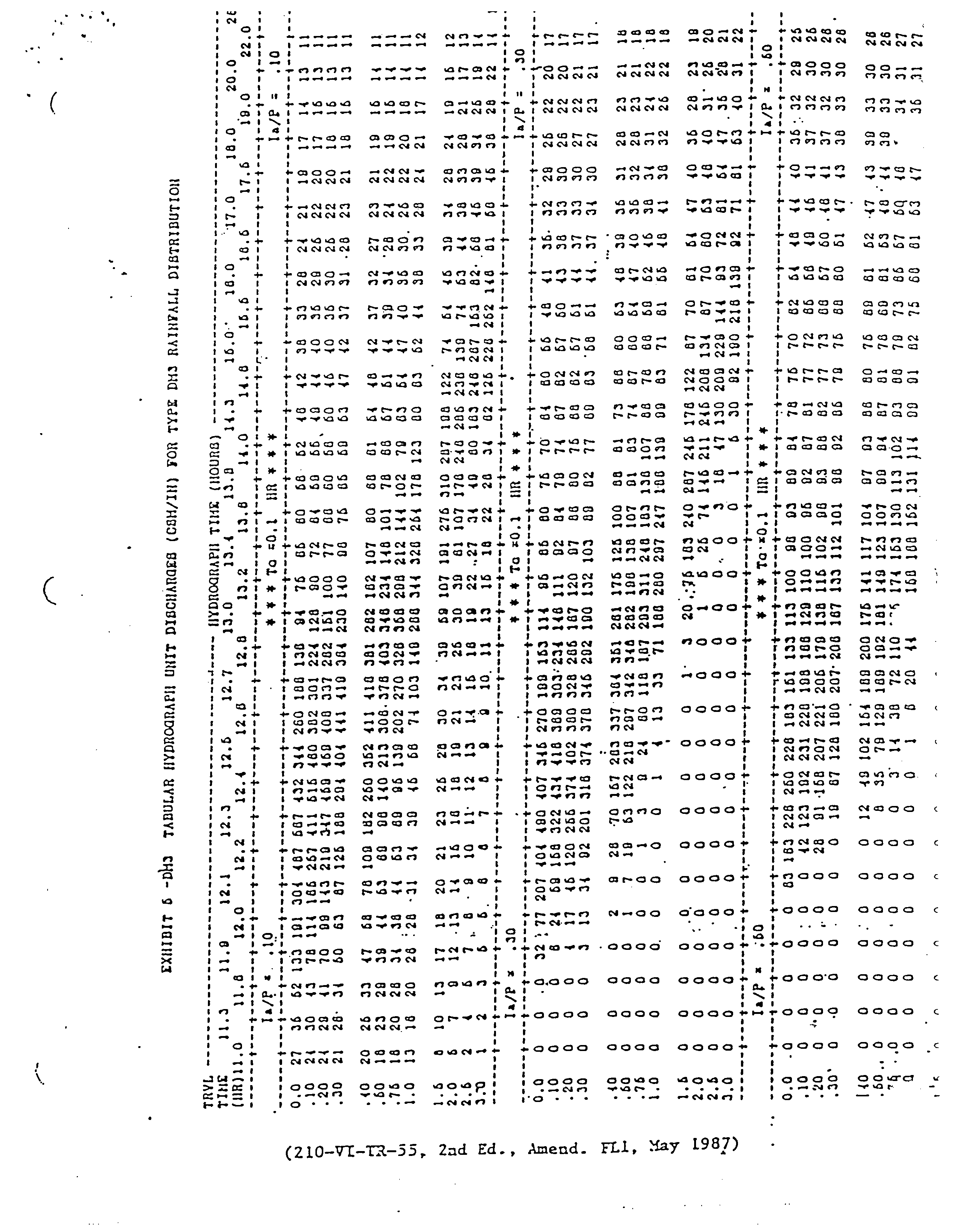
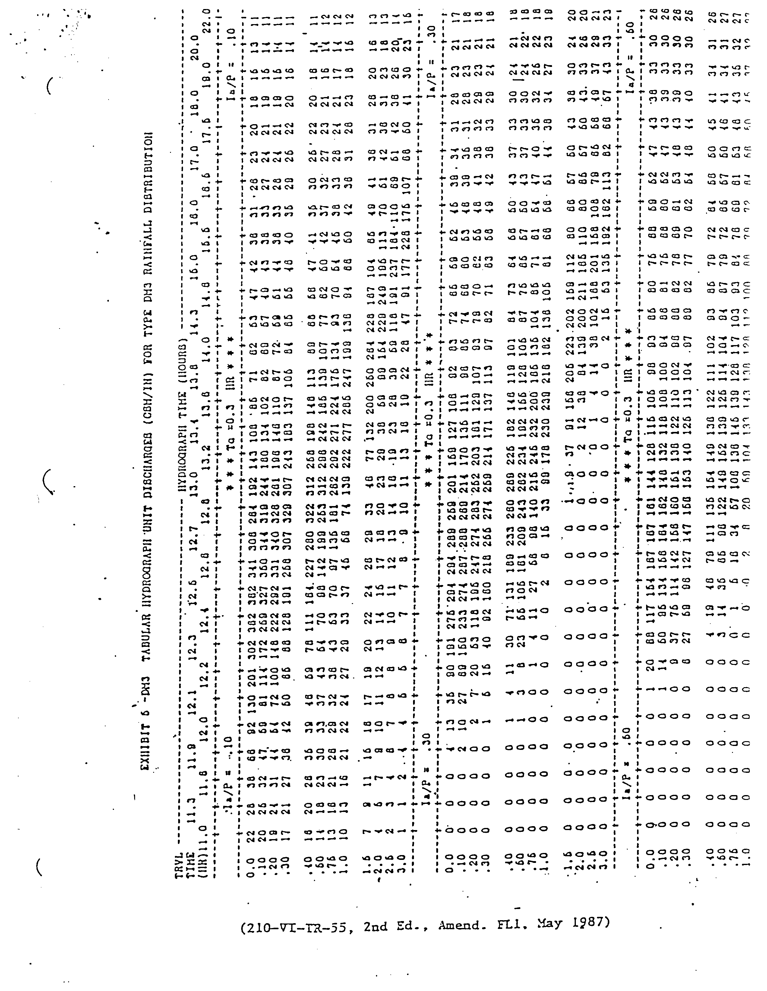
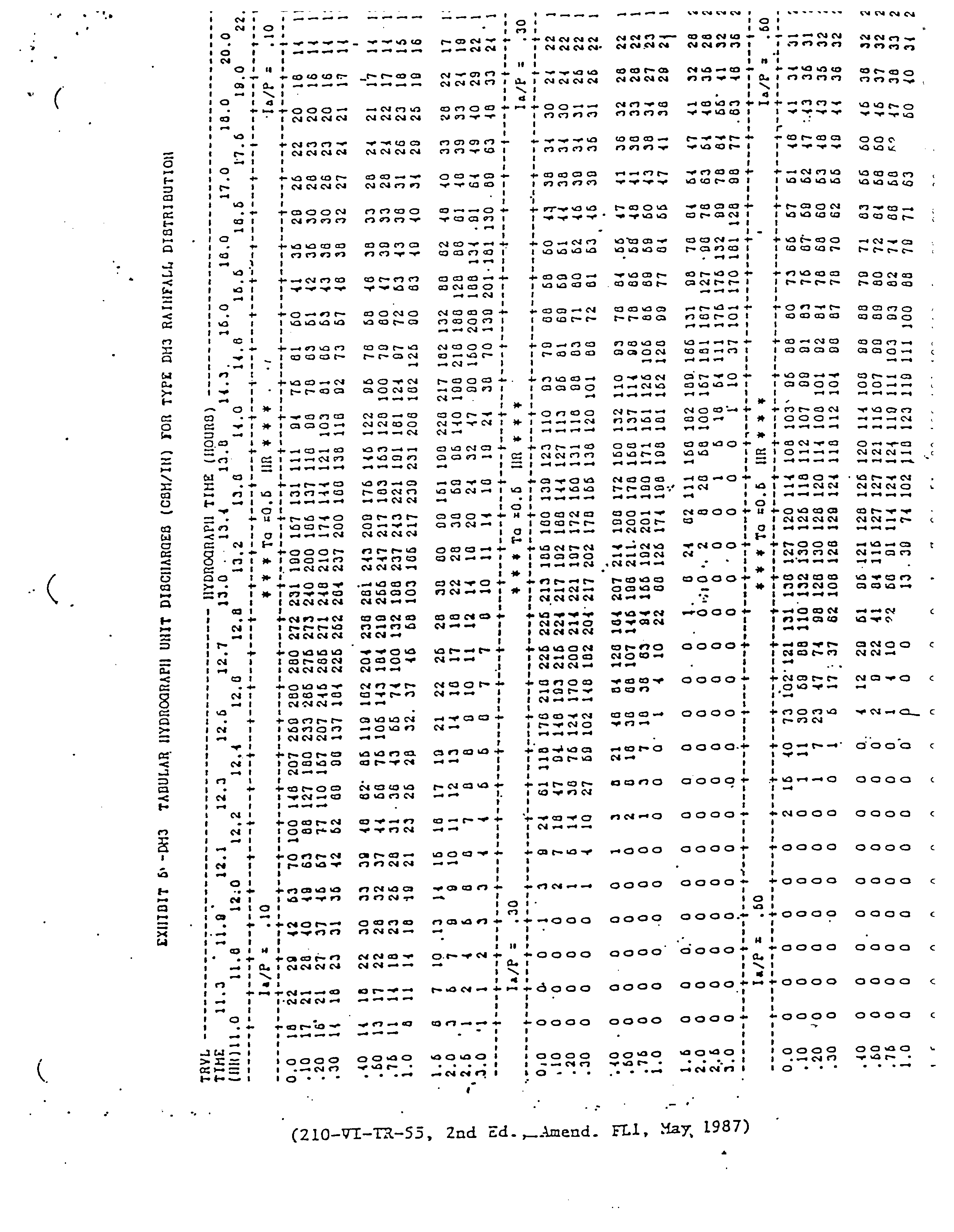
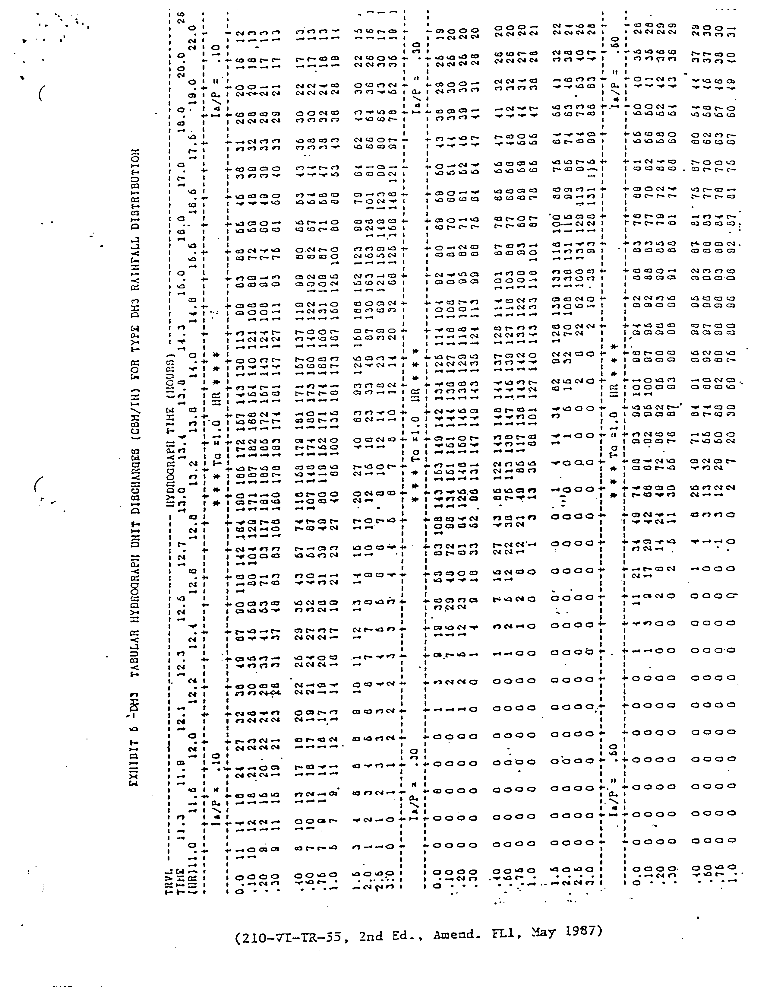
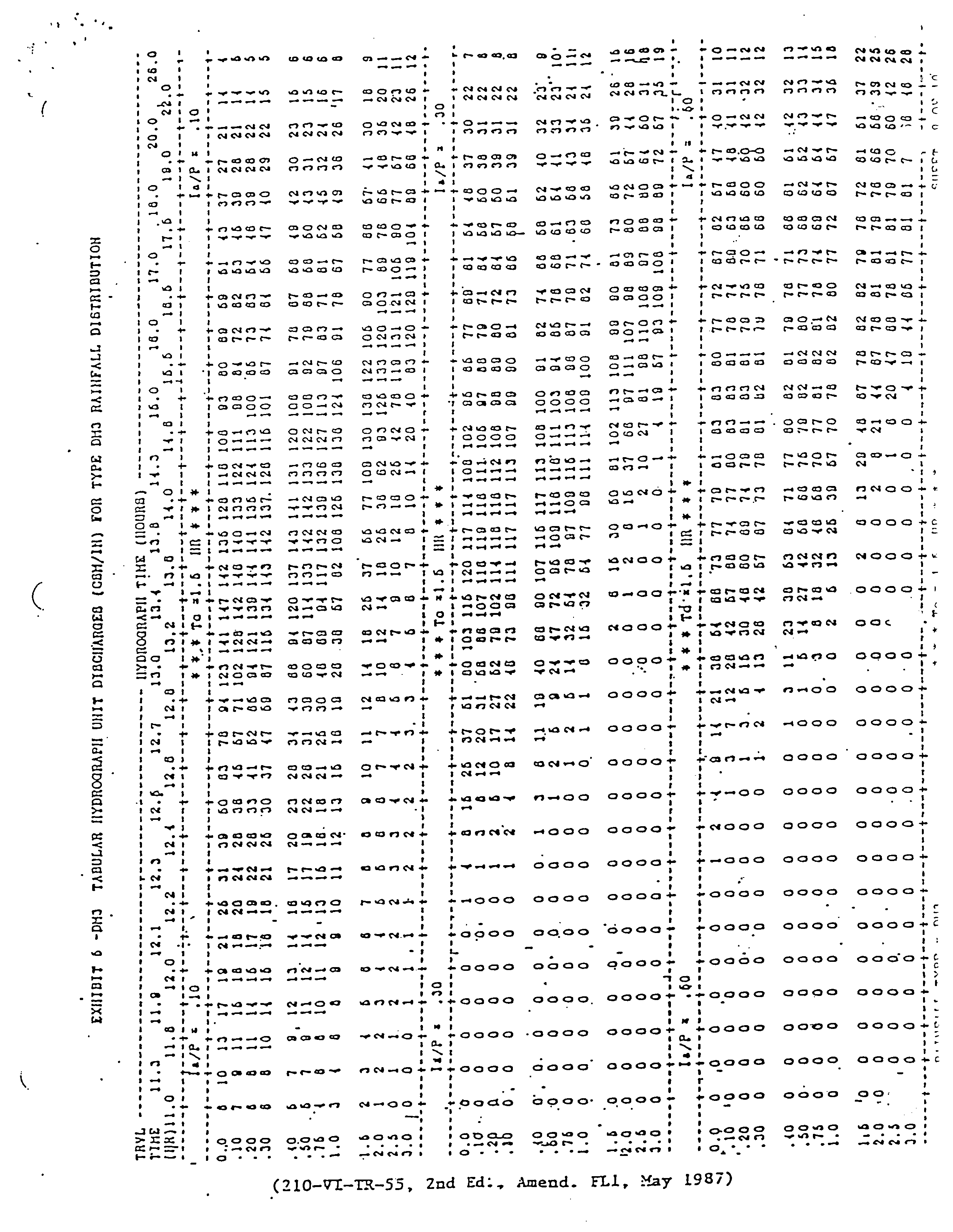
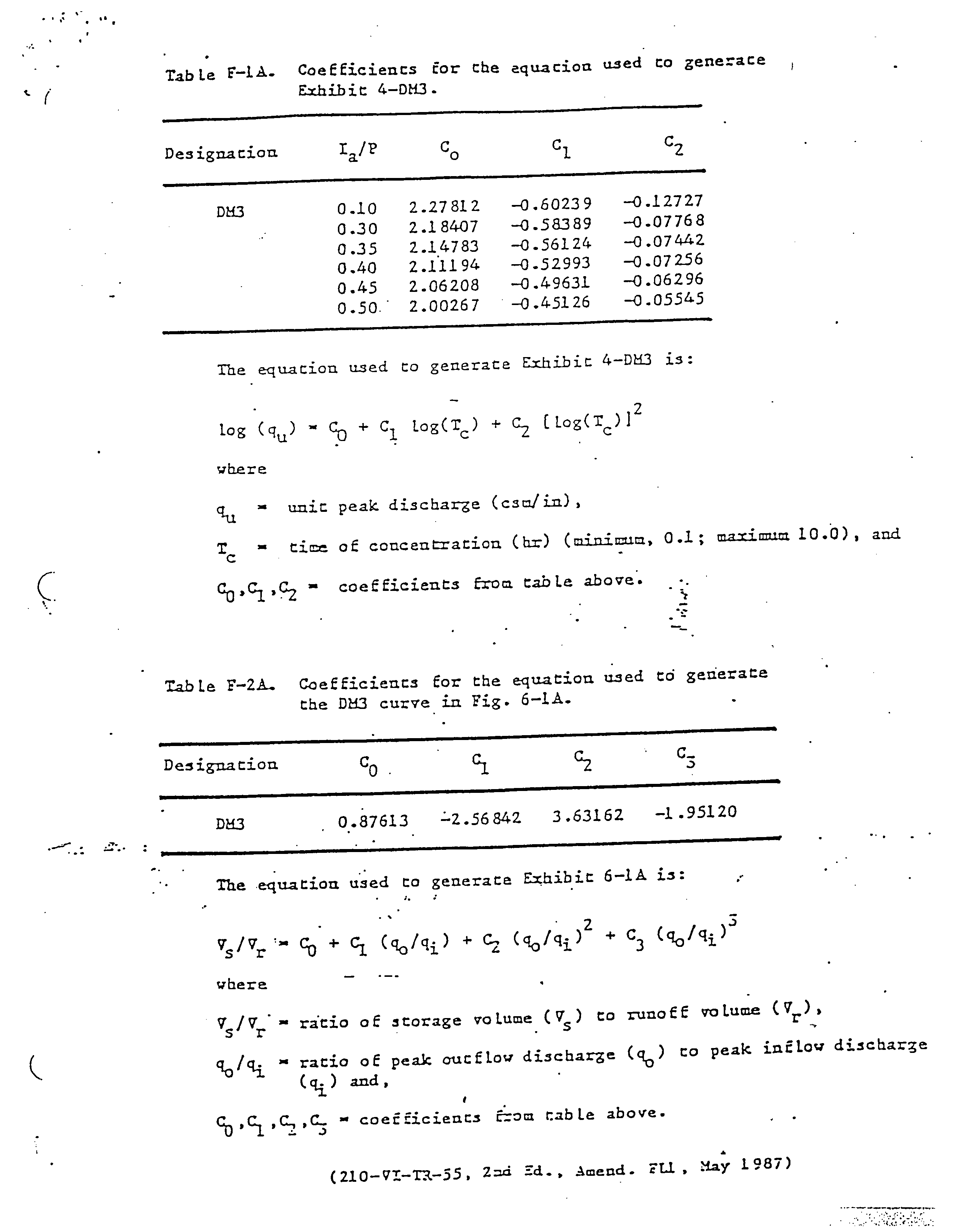
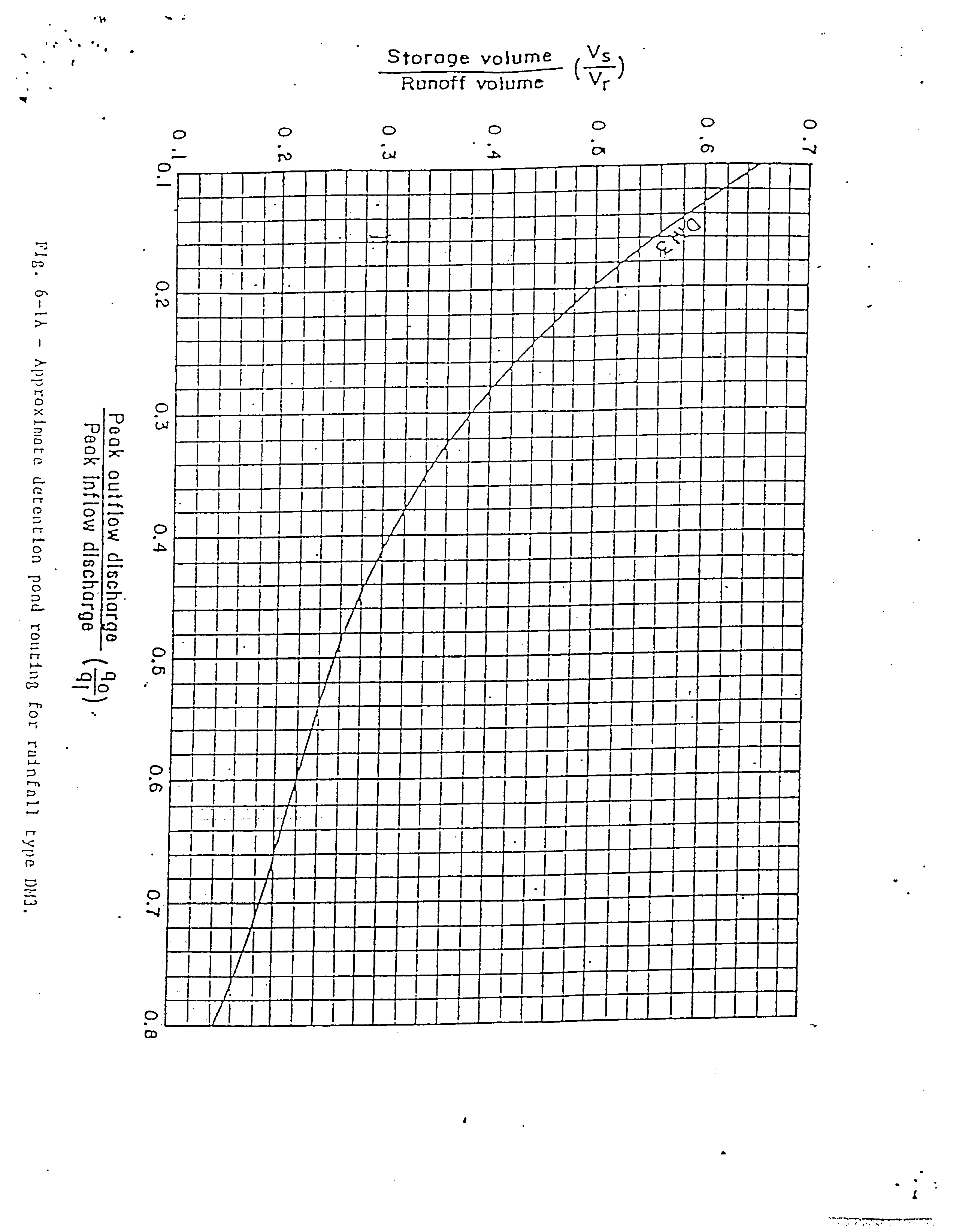
(Ord. No. 93-22, § 1, 8-23-93)
Sec. 62-3757. - Optional pro rata capital contribution payment allowing tie-in to county constructed stormwater systems in lieu of constructing private stormwater facility within the Merritt Island Redevelopment Area (MIRA).
(a)
At the option of both the county and any property owner engaged in a development or redevelopment project within the 165 acres of property lying within the Merritt Island Redevelopment Area, as shown on exhibit A of the ordinance from which this section is derived, the property owner may apply to pay a pro rata capital contribution (pro rata contribution) to the county which will allow the property owner to tie-in and discharge stormwater from the project to county stormwater facilities (hereafter called the "Lakes at Veterans Memorial Park") constructed for the purpose of treating stormwater runoff from existing impervious areas within the basin and providing additional capacity to serve future impervious area within the specific 165 acres of property shown in exhibit A of the ordinance from which this section is derived. This pro rata contribution is not a mandatory fee or contribution. Upon receipt of written approval from the St. Johns River Water Management District or its successor agency for such discharge of water into the Lakes at Veterans Memorial Park, payment of the pro rata contribution may be made to the county by a property owner/applicant in lieu of constructing any stormwater facility that would have been required to be built on the property under existing stormwater regulations. Nothing herein shall be construed to require the county to approve any request to pay a fee for use of such county owned stormwater facilities.
(b)
The amount of the pro rata contribution is based on the proportionate cost of the construction of the stormwater facility established at $0.50 per square foot of the property being treated by the county facility. Any modification to the rate shall be by a resolution of the board of county commissioners based upon the square footage of the entire property to be served by the Lakes at Veterans Memorial Park. Each situation will be analyzed by the county and a specific written decision will be developed for each property that is the subject of an application as follows:
(1)
The Lakes at Veterans Memorial Park will be built in phases (phase 1 treatment for 102 acres and phase 2 treatment for an additional 63 acres). The pro rata contribution formula is calculated on the redevelopment and final build out of approximately 165 acres within the Merritt Island Redevelopment Area (as shown on exhibit A of the ordinance from which this section is derived) for which stormwater treatment and capacity is available.
(2)
The pro rata contribution will be determined for each applicant by calculating the total stormwater capacity of the completed Lakes at Veterans Memorial Park and the associated construction costs of the facilities and then determining the pro rata share of the applicant's discharge of stormwater (quantity and quality) from the applicant's development or redevelopment project. The ratio of the applicant's projected stormwater discharge to the total capacity of the Lakes at Veterans Memorial Park shall be multiplied by the most current annual determination of the present value of the total construction cost of planned or constructed Lakes at Veterans Memorial Park to determine the pro rata fee payable for the current year.
(3)
Each application will be evaluated based upon the cumulative impacts from the proposed development or redevelopment. This process will not apply to privately owned stormwater facilities designed to provide stormwater collection and treatment services for properties within the Merritt Island Redevelopment Area.
(4)
In lieu of a pro rata cash contribution to allow an applicant to tie-in to the Lakes at Veterans Memorial Park, the applicant may offer and the county may accept from an applicant:
a.
A credit under the provisions of subsection (c); or
b.
A negotiated transfer of real property, tangible personal property or other non-monetary considerations of a value comparable to the pro rata contribution, while still meeting the purpose and intent of this section.
Any negotiated transfer credits shall be applied to reduce the amount of the pro rata contribution calculated for the applicant in the manner described in subsection (b)(2).
(5)
Payment or delivery of a pro rata contribution shall be a condition precedent to the issuance of a building permit for any property where development or redevelopment for which an onsite stormwater facility is not being built is proposed within the Merritt Island Redevelopment Area. For such properties, neither construction of the project nor the use of the Lakes at Veterans Memorial Park may be commenced until the pro rata contribution is paid.
(6)
The revenues generated by the pro rata contribution shall only be used for 1) new stormwater infrastructure construction related to the Lakes at Veterans Memorial Park 2) for reimbursement to the county for expenses related to construction of the Lakes at Veterans Memorial Park stormwater infrastructure or 3) the reimbursement of MIRA in the amount of that agency's monetary contribution toward land acquisition costs related to the county-owned Lakes at Veterans Memorial Park, to the extent that the applicant has not received a credit in the manner prescribed in subsection (c).
(7)
The pro rata contribution program will cease when the Lakes at Veterans Memorial Park have reached design capacity.
(8)
An applicant's payment of a pro rata contribution or receipt of a credit under subsection (c) shall not prevent nor be construed to prevent the county from establishing and collecting the annual stormwater utility fee applicable within the district 2 benefit area.
(c)
For properties that currently treat all or a portion of their stormwater regulatory requirement on site, as an alternative to the cash payment of a pro rata contribution allowing an applicant to tie-in to the Lakes at Veterans Memorial Park to meet but not exceed the treatment value currently met on the applicants property, an applicant may request a tie-in credit based on being a bona fide redevelopment project as approved by the Merritt Island Redevelopment Agency in accordance with the terms of any interlocal agreement with the county relating to redevelopment incentives.
(Ord. No. 14-29, § 1, 9-16-14)
Sec. 62-3771. - Purpose and authority.
Purpose. The establishment of a water-source heat pump program is a vital step in insuring the future presence of an adequate water supply for the inhabitants of the county. The general welfare, health, safety and convenience of the community are directly affected by the use and availability of water. It is, therefore, in the interest of the public that a water-source heat pump program be designed and developed in accordance with sound rules and proper minimum standards. The purpose and intent of this division is as follows:
(1)
To establish installation standards for water-source heat pumps that will encourage water conservation practices.
(2)
To provide regulations and controls with necessary enforcement mechanisms.
(Ord. No. 85-33, § 1, 10-8-85)
Sec. 62-3772. - Definitions.
For the purpose of this division, the following terms shall the meaning set forth in this section. When not inconsisitent with the context, words used in the present tense include the future, words in the plural number include the singular, and words in the singular include the plural. The word "shall" is always mandatory and not merely directive.
A.C.C.A. refers to the Air Conditioner Contractors of America.
Artesian well refers to a well that penetrates a confined aquifer in which the water level in that well rises above the top of the aquifer.
Board refers to the board of county commissioners of Brevard County.
Closed-loop. See "earth-coupled closed-loop."
County refers to Brevard County.
Demand valve. A control switch that adjusts, activates or terminates the quantity of flow from a water system.
Development. A material change in the use or character of the land including, but not limited to, the placement of any structure or site improvement on the land.
Division shall mean the environmental services division of Brevard County.
Domestic consumption shall mean water used in direct human contact for drinking, cooking, bathing and cleaning purposes inside a residential or commercial establishment.
Drop-pipe refers to a suction or discharge line installed in a well to a level either below the identified or static water level.
Earth-coupled closed-loop. A closed-tube heat exchanger installed in the ground either vertically or horizontally and filled with a noncorrosive potable fluid circulating under pressure between the loop and heat pump.
Earth-coupled closed-loop borehole. A drilled vertical hole in the earth expressly for the purpose of installing a closed tube heat exchanger.
Grout refers to a mixture of water and Portland cement (American Concrete Institute Type I, ACI Type III or any other types of cement approved by the State of Florida for grouting of well casings), or a mixture of bentonite and water, which is suitable for pumping and has a minimum adhesiveness and is free from organic or foreign matter.
Grouting refers to filling the space around a well casing or closed-loop with a suitable slurry of cement or clay. Grouting and sealing shall be done in accordance with procedures described in the rules of the St. Johns River Water Management District, Chapter 40C-3.517, Florida Administrative Code.
Person shall mean any individual, firm, corporation or other legal entity, whether public or private.
Irrigation shall mean the method by which water is artificially applied to land surfaces, for the purpose of supplementing natural rainfall.
Lot. A parcel of land shown on a recorded plat or on the Brevard County Property Appraiser's map, or any piece of land described by deed in the official record books of Brevard County.
Open discharge system. A single-well installation producing but not returning water to the aquifer of origin.
Open-loop. A two-well installation including both supply and injection wells open to the same aquifer which is capable of producing and accepting water for thermal transfer.
Open recharge system. A single-well installation producing water from an aquifer and partially returning water through infiltration to the aquifer of origin.
Public water supply system shall mean a system for the provision to the public of piped water for human consumption, if such system has at least 15 service connections or regularly serves at least 25 individuals daily at least 60 days out of the year.
Replacement means the replacement of the coils, condenser or parts of the unit sufficient to cost at least 50 percent of the cost of the original unit.
Water refers to potable fluid taken from any source in Brevard County, whether stored in ground or surface units, or from any public or private supply.
Water-source heat pumps includes single or reverse cycle mechanical devices for heating or cooling which requires the use of flowing water as a condensing medium for heat transfer.
Well means any excavation that is drilled, cored, bored, washed, driven, dug, jetted or otherwise constructed when the intended use of such excavation is for the location, acquisition, development or artificial recharge of ground water.
(Ord. No. 85-33, § 2, 10-8-85; Ord. No. 86-16, § 1, 8-5-86)
Sec. 62-3773. - Area of operation; exemptions; implementation.
(a)
Provisions of this division shall apply to all areas of the county.
(b)
This division shall not apply to incorporated municipalities where a water-source heat pump ordinance or ordinances is in effect that is at least as restrictive as herein.
(c)
The curtailments, restrictions and compliance schedules of water uses provided herein shall be implemented as of the effective date of this division.
(Ord. No. 85-33, § 3, 10-8-85)
Sec. 62-3774. - General conditions.
(a)
No individual within the county shall:
(1)
Attach a new or modified water-source heat pump to an existing artesian well;
(2)
Replace an existing water-source heat pump unit now utilizing an artesian well;
(3)
Drill an artesian well for use by water-source heat pump unit;
(4)
Drill a new artesian well for an existing water-source heat pump unit;
Unless said heat pump unit is equipped with a second well of equal or greater depth so that water withdrawn can be returned to the aquifer of origin. This division does not prohibit the use of water from either well for irrigation purposes.
(b)
Prior to December 1, 1986, all existing water-source heat pump units using an artesian well which do not have a return well of equal or greater depth shall be required to have in operation a demand valve which prevents the flow of water from the well when the heat pump unit is not in operation.
(c)
All water-source heat pump units which withdraw water from an artesian well shall install or utilize a second well of equal size and equal or greater depth for the purpose of returning the water to the aquifer of origin, when the heat pump unit is being replaced.
(d)
Water-source heat pump units withdrawing water from the surficial aquifer system may be installed as a single well system if it is an open recharge system, where the discharge is used for irrigation and percolation capacity is available to absorb peak daily discharge within the boundaries of the individual's lot. Where percolation capacity is not available, an open-loop or closed-loop system will be required.
(e)
Injection well standards.
(1)
All open-loop injection systems, including a supply and return well pair, shall be required to have a minimum spacing of 50 feet for new low density single-family residential structures, or those systems under 15 gallons per minute, or those systems under five tons' designed air conditioning load. All other open-loop systems shall follow the minimum horizontal spacing requirements as presented in Table I, made part hereof, for the identified source aquifer. This spacing requirement shall include any wells on the applicant's or adjacent property owner's land. Spacing requirements of 100-F, Florida Administrative Code, or applicable county health codes supersede this standard if more stringent.
_____
TABLE I
MINIMUM HORIZONTAL SPACING
BETWEEN INJECTION WELL AND SUPPLY WELL
FOR FLORIDAN AQUIFER (ARTESIAN) INSTALLATIONS
*Assumption of 8 month use for cooling node.
_____
(2)
Injection well capacity shall equal or exceed 150 percent [of] the design capacity requirements of the water-source heat pump system.
(3)
The injection system of an artesian well shall be designed to provide adequate injection pressures to overcome recorded maximum natural artesian head where present.
(4)
If natural artesian pressure does not exist, a drop-pipe is required. Pressurization of the injection line and drop-pipe shall be done by using a spring-loaded check valve installed in reverse. To obtain the proper setting, adjust the spring as follows:
Water level (static) × 0.43 ° 10 psi or use the following table:
The drop-pipe shall extend below the lowest yearly water level of the well, where the water level is at or below land surface.
(5)
Thermal re-injection limits shall be 15 degrees C. (59 degrees F.) for the heating mode and 35 degrees C. (95 degrees F.) for the cooling mode.
(6)
Maintenance programs such as backflushing and well stimulation of the injection well should be scheduled periodically to reduce pressure build-up and to optimize the thermal exchange characteristics of the well. Well stimulation techniques refer to, but are not limited to, those in § 17-28.12(56) Florida Administrative Code. A licensed water well contractor is required unless prior approval is given by the division.
(7)
All injection wells shall be drilled by licensed water well contractors and permitted where required by the St. Johns River Water Management District, Chapter 40C-3, Florida Administrative Code, or the Florida Department of Environmental Regulation as a Class V injection well, pursuant to Chapter 17-28, Florida Administrative Code, prior to construction.
(8)
Injection wells will be completed to the aquifer and zone of origin unless otherwise directed by the division; open bore holes shall be a minimum of 50 feet.
(9)
System water flows shall not exceed three gallons per minute per ton of air conditioning load installed. A fixed oriface flow device on the discharge side shall be installed to limit the flow as required.
(10)
All open-loop or single-well systems, where authorized, shall have a demand valve to stop the flow of water when the water-source heat pump is not operating. Multipurpose well systems may have a multiple-pump design if a pump shut-off device is necessary to allow withdrawals during heat pump shut-down.
(11)
Well casings shall be completed at or above grade to allow vertical access for maintenance of section procedures in accordance with Chapter 17-21, Florida Administrative Code.
(12)
All wells shall be disinfected prior to operation to prevent cross-contamination between zones or plumes of the aquifer strata producing supply water either identified or unknown.
(f)
Earth-coupled closed-loop borehole standards.
(1)
Vertical boreholes shall be spaced a minimum of 15 feet apart. Horizontal trenches shall be spaced a minimum of six feet apart and tubing will be separated by two feet at four and six feet below grade.
(2)
Boreholes shall be sealed with grout in accordance with Chapter 40C-3.5.17, Florida Administrative Code.
(3)
No additives to the circulating fluid will be approved for placement in either vertical or horizontal earth-coupled closed-loop installations.
(4)
All loops shall be pressure-tested prior to final job completion.
(5)
All vertical boreholes shall be installed by licensed water well contractors.
(g)
No individual shall use a public water supply system to operate a new or modified water-source heat pump unit.
(Ord. No. 85-33, § 4, 10-8-85; Ord. No. 86-16, § 2, 8-5-86)