
Brevard County Unincorporated
City Zoning Code
City Zoning Code
ARTICLE XII
COASTAL SETBACK AND CONTROL LINES1
Cross reference— Coastal construction code, § 22-351 et seq.
Sec. 62-4201.- Definitions and rules of construction.
For the purpose of this article, the following terms shall have the meaning set forth in this section. When not inconsistent with the context, words used in the present tense shall include the future, words in the singular include the plural number, and words in the plural include the singular. The term "shall" is always mandatory and not merely directory.
Beach renourishment means the maintenance of a restored beach by the replacement of sand.
Beach restoration means the placement of sand on an eroded beach for the purposes of restoring it as a recreational beach and providing storm protection for upland properties.
Best public interest means public or private projects which clearly demonstrate a net benefit to the public, as determined by the board of county commissioners, and which adequately mitigate adverse environmental impacts.
Coastal Construction Control Line or Brevard County Coastal Construction Control line means the 1986 Florida Department of Environmental Protection (previously FDNR) Coastal Construction Control Line as established under F.S. § 161.053.
Crest of dune means the highest elevation of the most seaward natural or manmade mound or bluff of sand which has sufficient vegetation, height, continuity, and/or configuration to offer protective value.
Emergency means any occurrence or threat thereof whether accidental or natural, caused by humankind, in war or peace, which results or may result in substantial injury or harm to the population or substantial damage to or loss of property or public funds. For purposes of this definition, a vulnerable structure that is in danger of imminent collapse qualities as an emergency.
Erosion means the wearing away of land or the removal of beach or dune material by wave action, tidal currents, littoral currents or deflation, including horizontal recession or scour, which occurs when the topography of the beach-dune system is completely inundated by a storm surge and wave and current forces erode the beach-dune profile in a vertical direction.
Imminent collapse means the foundation of a structure will fail due to its own weight under normal conditions, resulting in structural damage to the supported structure. This shall be determined by modeling dune erosion anticipated to result from a 15-year return interval storm. Such modeling must be calibrated to the site conditions and performed by a professional engineer licensed in the state, with demonstrated competency in coastal engineering.
Landward means in a direction away from the Atlantic Ocean.
Major accessory structure includes the following structures: swimming pools; bathhouses; detached garages; utility buildings; septic tanks and associated drainfields; package sewer and water plants; parking areas; impervious paved areas; sewer, water, electric, telephone, television cable and other utility lines; storm drains; water retention areas; drainage structures; private roads or streets; and underground storage tanks.
Major habitable structure includes the following structures: houses or single-family residential buildings; mobile homes; modular homes; trailers; multiple-family residential buildings; condominiums; motels; hotels; apartments; restaurants; shops; towers; other similar residential, commercial, industrial, recreational or public buildings.
Minor structure whether permanently attached to the ground or placed upon the ground includes dune and beach walkover structures, beach access ramps and walkways, stairways, viewing platforms, gazebos, boardwalks, lifeguard support stands, decks or porches, sand fences, privacy fences, fishing or ocean piers, pipelines and ocean outfalls.
Modification means any alteration to the existing non-conforming major habitable or major accessory structure that does not expand the vertical envelope established by the existing footprint of the structure further into the area seaward of the coastal setback line.
NGVD means National Geodetic Vertical Datum, as established by the National Ocean Survey.
100-year storm means a shore-incident hurricane or any other storm with accompanying wind, wave and storm surge intensity having a one percent chance of being equaled or exceeded in any given year, during any 100-year interval.
Rigid coastal and shore protection structure means shoreline hardening structures including sea walls, bulkheads, revetments, mound structures, and groins and breakwaters.
Sandbag system means sandbags, geotextiles, tubes, and any other pliable or soft shoreline protection system meant as temporary erosion control measure.
Seaward means in a direction toward the Atlantic Ocean.
Structure means anything which is constructed or erected, the use of which requires rigid location on the ground or attachment to something having a permanent location on the ground.
Vertical envelope means the upward continuation of the structure's external footprint within the area
seaward of the coastal setback line as depicted.
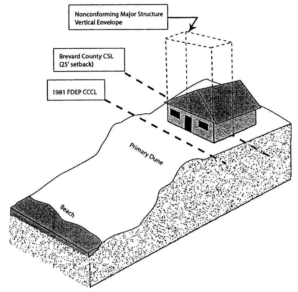
Vertical envelope
Vulnerable structure means any major habitable and major accessory structure or public infrastructure that is in danger of imminent collapse.
(Ord. No. 85-17, § 3, 6-4-85; Ord. No. 2002-21E, § 1, 4-30-02; Ord. No. 03-16, § 1, 3-18-03; Ord. No. 05-53, § 1, 11-1-05)
Sec. 62-4202. - Penalty.
It shall be unlawful for any person to violate any provision of this article, and any person found guilty of violating this article shall be punished by a fine not to exceed $500.00 or by imprisonment in the county jail for a period not to exceed 60 days, or by both such fine and imprisonment. Each day upon which such violation occurs shall constitute a separate offense. For purposes of this article, the word "person" shall include any individual, partnership, corporation, association or other legal entity. The county may also enforce this ordinance by filing an action for injunctive relief, for the costs of restoration or for both.
(Ord. No. 85-17, § 14, 6-4-85; Ord. No. 03-16, § 2, 3-18-03)
Sec. 62-4203. - Additional remedies.
In addition to any other remedies, whether civil or criminal, for any violation of this article by any person, the proper authorities of the county may institute any appropriate action or proceeding, including injunction, in a court of competent jurisdiction.
(Ord. No. 85-17, § 15, 6-4-85)
Sec. 62-4204. - Conflicting regulations.
In case of direct conflict between any provision of this article and a part or provision of any other applicable federal, state, or county law, rule, code or regulation, the more restrictive provision shall apply.
(Ord. No. 85-17, § 17, 6-4-85)
Sec. 62-4205. - Intent.
The board of county commissioners hereby declares that it is the intent of this article to establish a coastal setback line to buffer major habitable and major accessory structures from ocean forces, and to prohibit the construction of major habitable and major accessory structures within the area seaward of the coastal setback line. It is further the intent of this article to discourage the further construction of rigid coastal and shore protection structures, while allowing the state department of environmental protection to maintain jurisdiction and control over regulation of such structures. Further, it is the intent of this article to establish a coastal construction control line, to define that portion of the beach-dune system which is subject to severe fluctuations based on conditions associated with a 100-year storm event, and to employ special construction standards for structures to be located seaward of the coastal construction control line, so as to protect the structures from the perils of storm and sea.
(Ord. No. 85-17, § 2, 6-4-85; Ord. No. 2002-21E, § 2, 4-30-02; Ord. No. 05-53, § 2, 11-1-05)
Sec. 62-4206. - Policy.
(a)
The county possesses approximately 70 miles of high-energy sandy beaches along the Atlantic Ocean. These natural sandy beaches constitute an integral component of the dynamic beach-dune system, which plays a significant role in the economic, scientific, recreational, cultural and environmental well-being of the inhabitants of the county. The integrity of this beach-dune system is dependent upon its ability to fluctuate in response to the natural forces of the ocean, such as tides, waves, winds and storm floods.
(b)
The board of county commissioners recognizes that the beach-dune system constitutes a first line of defense against the attack of storms, waves and currents, and also acts as a sand bank for the county's beaches. Rigid coastal and shore protection structures, such as seawalls, bulkheads, revetments and mound structures, block the movement of sand from the dunes to the beach, thereby preventing the natural renourishment of the sandy beaches. This blockage of sand, coupled with the historical rise in relative sea level, could cause the loss of the natural sandy beaches, if allowed to occur.
(c)
Development of the county's coastal barriers, through construction of beachfront structures, significantly impacts upon the beach-dune system. Excavations associated with the construction of such structures remove sand from the system. Impervious surfaces created through this construction prevent the sand from assuming its proper role in the dynamics of the beach-dune system. Structures located near the dunes deprive the shifting frontal dune of the equilibrium necessary for the beach-dune system to function in its capacity as the first line of defense from ocean forces. Failure of this defense capacity of the beach-dune system during a severe storm event or hurricane could result in substantial loss of property and life, with the county's limited number of evacuation routes from the coastal barrier, congested roadway network, and the resulting impediment to the evacuation of the coastal barrier inhabitants during such an emergency.
(d)
In response to the findings mentioned in subsections (a) through (c) of this section, the board of county commissioners finds and declares that it is in the public interest to preserve and protect the county's coastal barrier beach-dune system from imprudent construction, which would jeopardize the stability of the beach-dune system, accelerate erosion, provide inadequate protection to upland structures and endanger adjacent properties.
(e)
Therefore, the public health, safety and welfare of the inhabitants of the county require the establishment of special construction regulations to allow the beach-dune system to maintain its equilibrium, so as to buffer persons and property from devastation by ocean forces, and the establishment of additional setback requirements to provide that structures located on oceanfront property be set back sufficiently and constructed in a manner so as to provide a useful life thereof, considering the perils of storm and sea.
(Ord. No. 85-17, § 1, 6-4-85)
Sec. 62-4207. - Nonconforming structures.
The setback provisions of sections 62-4212 and 62-4213 shall not apply to any modification, maintenance or repair of any nonconforming structure, provided that such modification, maintenance or repair:
(1)
Does not expand the nonconforming structure further into the area seaward of the coastal setback line;
(2)
Does not alter the foundation except as is necessary to meet current building code for the existing use;
(3)
Does not convert major habitable structures into major accessory structures or major accessory structures into major habitable structures; and
(4)
With the exception of those facilities that meet the criteria specified in section 62-4209, any portion of a structure, seaward of the coastal setback line, that is undermined by erosion cannot be modified, maintained or repaired and must be removed. The remaining portion of the structure may be modified, maintained or repaired provided that:
a.
The seaward most portion of the structure is sufficiently setback from the crest of the dune to provide protection from being undermined by erosion resulting from a 25-year storm event;
b.
The protection determination, as outlined in section 62-4207(4)(a), is sealed by a professional engineer and submitted to the county for review; and
c.
Modification, maintenance, or repair to a structure that has been undermined shall not be permitted closer than 15 feet landward of the crest of dune (see illustration).
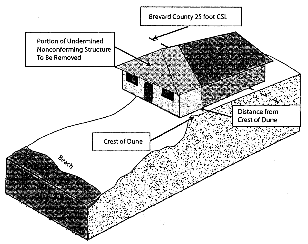
Closer than 15 feet landward of crest of dune prohibited
(Ord. No. 85-17, § 13, 6-4-85; Ord. No. 05-53, § 3, 11-1-05; Ord. No. 2010-025, § 1, 12-2-10)
Sec. 62-4208. - Prerequisites for issuance of building permit.
In addition to those permit application requirements and procedures for the issuance of a building permit by the county building official under the provisions of chapter 22, any person desiring to construct seaward of the established county coastal construction control line shall satisfy the following additional requirements and procedures prior to the issuance of the building permit:
(1)
The applicant shall submit to the county building official a statement describing the proposed work, activity or construction seaward of the established coastal construction control line.
(2)
The applicant shall submit to the county building official a certification by a professional engineer or architect registered in the state that the design plans and specifications for the proposed structures comply with all standards established in this article.
(3)
The applicant shall submit to the county building official two copies of a topographic survey of the subject property, prepared or verified for accuracy not more than six months prior to the date of application, and certified by a land surveyor registered in the state. The topographic survey shall include the following specific information:
a.
The location of the contour line corresponding to elevation 0 NGVD.
b.
The location of any existing vegetation line on the subject property.
c.
The location of the established state department of natural resources coastal construction control line, the county coastal construction control line, the mean high-water line and the coastal setback line for the full width of the subject property, including the location and number of the two nearest baseline monuments of the state department of natural resources.
d.
The location of any existing structures on the subject property, and the location of any proposed construction or activity.
(4)
The applicant shall also submit two copies of detailed final construction plans and specifications for all proposed structures or excavation, including all planned appurtenant structures and utilities. These documents shall be signed and sealed by the design engineer or architect, as appropriate, who must be registered in the state.
(5)
The county building official may require the applicant to provide other site-specific information or calculations as necessary for proper evaluation of the application.
(6)
The conditions described in this section for issuance of a building permit for construction seaward of the coastal construction control line shall be administered by the county building official, in conjunction with chapter 22, taking into account any recommendations submitted by the state department of natural resources, division of beaches and shores, after review of the application and supporting documents.
(Ord. No. 85-17, § 11, 6-4-85)
Sec. 62-4209. - Variances.
Variances from the provisions of the sections specified herein may be granted by the board of county commissioners, after public hearing, pursuant to the following criteria and procedures:
(1)
A fully completed application for variance shall be submitted by the property owner of record or his authorized representative, to the county manager or designee, in accordance with article VI of this chapter. The application shall include, as a minimum, the following information:
a.
The name and address of the applicant.
b.
The street address of the property, if available.
c.
A statement describing the proposed work, activity or construction seaward of the coastal setback line.
d.
A list of names and addresses of owners of all properties located within 500 feet of the subject property.
A notice containing the information mentioned in items a, b, and c of this subsection shall be posted by the applicant on the affected property at least 15 days prior to the public hearing. If the property abuts a public road right-of-way, the notice shall be posted in such a manner as to be visible from the road right-of-way. An affidavit signed by the owner or the applicant evidencing posting of the affected real property shall be received by the board of county commissioners prior to the public hearing.
(2)
The applicant shall also supply one copy of a topographic survey of the subject property, prepared or verified for accuracy not more than six months prior to the date of application, and certified by a land surveyor registered in the state. The topographic survey shall include the following specific information:
a.
The location of the contour line corresponding to elevation 0 NGVD.
b.
The location of any existing vegetation line on the subject property.
c.
The location of the established state department of natural resources coastal construction control line, the county coastal construction control line, the mean high-water line and the coastal setback line for the full width of the subject property, including the location and number of the two nearest baseline monuments of the state department of natural resources.
d.
The location of any existing structures on the subject property, and the location of any proposed construction or activity.
(3)
The applicant shall also submit one copy of detailed final construction plans and specifications for all structures proposed to be constructed seaward of the coastal setback line. These documents shall be signed and sealed by a professional engineer or architect, as appropriate, who must be registered in the state.
(4)
A copy of the fully completed application for variance, together with all supporting documents, shall be reviewed by the county manager or designee. No variance granted by the county shall be deemed in effect until copies of applicable valid state permits for the same location and activity have been received by the county manager or his designee.
(5)
The board of county commissioners may grant the requested variance, after public hearing, in those cases where the facts presented at the public hearing evidence that the project meets the conditions outlined in a, b, or c, of this subsection:
a.
Variances from the provisions of sections 62-4207 and 62-4212 may be granted if the subject property has experienced net natural accretion since September 1972. This shall be linearly interpolated from survey data collected at the state department of natural resources monuments immediately north and south of the subject property. The accretion shall be demonstrated by:
1.
Measuring horizontal accumulation from the toe of the dune as it exists at the time of application, to the point on the dune as it existed in September, 1972, which corresponds to the same elevation as the toe of the dune as it exists at the time of application;
2.
Measuring net profile area increase between the county coastal setback line and the toe of the dune as located in [subsection] #1 above. If there is net gain in the interpolated profile area, linear accretion shall be calculated by dividing the profile area by the dune height. The dune height shall also be interpolated from the state monuments located immediately north and south of the subject property by measuring from the toe of the dune, as located in #1 above, to the highest point of the dune seaward of the county coastal setback line; and
3.
That the granting of the variance shall not be injurious to adjacent properties, or contrary to the public interest.
b.
Variances for minor structures from the provisions of sections 62-4207(1), (2), (4); 62-4212(b); and 62-4213(a)(3)—(6) may be granted if the subject property provides public access to the beach and meets the following criteria and such reasonable conditions as the board deems necessary to maintain the purpose and intent of this article:
1.
Minor structures shall be elevated above dune vegetation and shall allow adequate light penetration;
2.
The access shall not exceed ten feet in width;
3.
The property owner shall provide and maintain signage indicating access is open for public use at all entrance and exit points. Signage dimensions and details shall be submitted for approval by the county and shall comply with all land development regulations;
4.
Property owner shall provide three or more parking spaces for public use;
5.
Shore-parallel boardwalks shall comply with requirements per the Americans with Disabilities Act and shall be prohibited seaward of the Coastal Setback Line, except as required for handicapped access;
6.
The granting of the variance shall not be injurious to adjacent properties, or contrary to the public interest; and
7.
The facility shall assume responsibility of maintaining the dune profile at the property by submitting a perpetual dune maintenance plan sealed by a professional engineer and submitted to the county for review. The plan shall establish the minimum necessary sand requirements so as to:
a.
Minimize adverse impacts to the naturally functioning beach and dune system,
b.
Minimize adverse impacts to adjacent properties,
c.
Be designed so as to not impede public access to or along the shore,
d.
Avoid any adverse impact to marine turtles or their nesting habitat, and
e.
Provide appropriate monitoring to ensure compliance with the dune maintenance plan.
Failure of the property owner to maintain the dune in accordance with the approved plan shall constitute a violation of this article.
c.
Variances from the provisions of sections 62-4207; 62-4212(b), (c); and 62-4213(a)(3)—(6) may be granted if the subject property meets the definition of a water dependent or water enhanced land use as defined in the comprehensive plan, and meets the following criteria and such reasonable conditions as the board deems necessary to maintain the purpose and intent of this article:
1.
The facility is open to the public;
2.
The structure is integral to the operation of the facility;
3.
The granting of the variance shall not be injurious to adjacent properties, or contrary to the public interest; and
4.
The facility shall assume responsibility of maintaining the dune profile at the property by submitting a perpetual dune maintenance plan sealed by a professional engineer and submitted to the county for review. The plan shall establish the minimum necessary sand requirements so as to:
a.
Minimize adverse impacts to the naturally functioning beach and dune system,
b.
Minimize adverse impacts to adjacent properties,
c.
Be designed so as to not impede public access to or along the shore,
d.
Avoid any adverse impact to marine turtles or their nesting habitat, and
e.
Provide appropriate monitoring to ensure compliance with the dune maintenance plan.
Failure of the property owner to maintain the dune in accordance with the approved plan shall constitute a violation of this article.
(6)
If the board of county commissioners grants a requested variance, the board may consider waiving the conditions set forth in [section] 62-4209(b)(7) or 62-4209(c)(4), as applicable, if the applicant provides substantial and competent evidence supporting the waiver of said provisions.
(7)
In determining the extent of accretion experienced in the subject property, the board of county commissioners shall take into account the most recent shoreline survey information produced by a federal, state or local government agency; the recommendation of the county office of natural resources management and, if any, the recommendation of the state department of environmental protection, division of beaches and shores, and bureau of coastal engineering and regulation on the DEP permit application submitted for the proposed construction; the historical seasonal fluctuations for the subject property; and the certified topographical survey and other information submitted by the applicant.
(8)
The maximum extent of variance granted under this section (5)a. shall correspond to the accretion measured at the toe of dune in [subsections] (5)a.1. and (5)a.2. above and shall not exceed 25 feet, as determined by the board of county commissioners after the public hearing.
(9)
All other applicable federal, state and county zoning, building and construction codes, rules and regulations shall be satisfied.
(10)
A courtesy notice of the public hearing under this section shall be mailed by the county manager or designee to all property owners within 500 feet of the subject property, as listed in the application presented.
(Ord. No. 85-17, § 8, 6-4-85; Ord. No. 87-30, § 2, 12-1-87; Ord. No. 96-43, 9-24-96; Ord. No. 2002-21E, § 3, 4-30-02; Ord. No. 03-16, § 3, 3-18-03; Ord. No. 2010-025, § 2, 12-2-10)
Sec. 62-4210. - Coastal setback line established.
There is hereby established and exists a county coastal setback line (referred to in this article as the coastal setback line) for all property located within the unincorporated area of the county. The coastal setback line shall be described as a line 25 feet west by perpendicular measurement from a line previously described in Brevard County Survey Book 2A, pages 15—28 (also known as the 1981 FDEP Coastal Construction Control Line), and delineated on the county coastal setback line map, exhibit A to this article, which is made part of this section by reference.
(Ord. No. 85-17, § 4, 6-4-85; Ord. No. 87-30, § 1, 12-1-87; Ord. No. 2002-21E, § 4, 4-30-02)
Sec. 62-4211. - Exemptions to coastal setback line.
(a)
The setback provisions of sections 62-4210, 62-4212 and 62-4213 shall not apply to any structure for which a building permit has been issued by the county building official, or for which a final site plan or a final development plan has been submitted to or approved by the county, prior to June 10, 1985.
(b)
The setback provisions of sections 62-4210, 62-4212 and 62-4213 shall not apply to the following:
(1)
Any water service laterals which are not more than three-fourths inch in diameter.
(2)
Basic 110 volt, 20 amp maximum, electrical service.
(3)
Sandbag systems, beach renourishment projects, beach restoration projects, or to rigid coastal and shore protection structures that are either approved by the board of county commissioners in an emergency amendment to the coastal management element of the comprehensive plan or approved by the board of county commissioners for areas north of Patrick Air Force Base (PAFB) as a result of an emergency declared by the board.
(Ord. No. 85-17, § 7, 6-4-85; Ord. No. 2002-21E, § 5, 4-30-02)
Sec. 62-4212. - Prohibited structures and activities seaward of coastal setback line.
(a)
No new major habitable or major accessory structures shall be constructed seaward of the coastal setback line.
(b)
No minor structures which are not pile-supported and elevated to a height sufficient to permit maintenance of dune stabilizing vegetation growing beneath the minor structure shall be constructed seaward of the coastal setback line.
(c)
All excavations, including the removal or alteration of soil, sand or vegetation by digging, dredging, filling, drilling, cutting, scooping or hollowing out shall be prohibited seaward of the coastal setback line. This subsection shall not preclude FDEP permitted sandbag systems for vulnerable structures as defined in section 62-4201, beach renourishment projects, beach restoration projects, or dune restoration projects, nor shall this subsection preclude rigid coastal and shore protection structures approved by the board under an emergency amendment to the coastal management element of the comprehensive plan.
(Ord. No. 85-17, § 5, 6-4-85; Ord. No. 2002-21E, § 6, 4-30-02; Ord. No. 03-16, § 4, 3-18-03; Ord. No. 05-53, § 4, 11-1-05)
Sec. 62-4213. - Permitted structures seaward of coastal setback line.
(a)
All minor structures shall meet the following standards:
(1)
Native dune vegetation seaward of the FDEP 1981 Coastal Construction Control Line (CCCL) shall not be removed. Clearing of any native dune vegetation landward of the CCCL shall be the minimum necessary for the construction of the minor structure and shall be accomplished without the use of motorized vehicles. Any altered or cleared areas shall be re-vegetated with native dune plant species following completion of the construction and shall be planted at such density to achieve a minimum coverage of 80 percent within one year following planting. A clearing and re-vegetation plan shall be submitted in conjunction with the building permit application.
(2)
Motorized vehicles on the dune and beach system are prohibited except for governmental vehicles (police and sheriff), fire trucks, ambulances or vehicles necessary to repair utilities, or vehicles utilized during approved renourishment programs or approved scientific investigations. Pedestrian traffic within the vegetated dune areas shall be limited to emergency operations, scientific research, maintenance, cleaning or improvements as authorized by the Natural Resources Management Office and consistent with FDEP regulations.
(3)
Except for sand fences and boardwalks, walkways, stairways or other minor structures designed to provide access to the beach, minor structures shall not be closer than 15 feet to the crest of the dune.
(4)
Boardwalks, walkways, stairways or other minor structures designed to provide access to the beach shall not exceed five feet in width.
(5)
Except for sand fences, minor structures that are detached from the major habitable structure shall be pole-supported, and elevated to a height sufficient to permit the maintenance of dune stabilizing vegetation beneath the structure as prescribed by this section:
a.
The minimum floor elevation shall be at least three feet above existing natural grade. A waiver of this elevation minimum may be provided by the Director where the Florida Department of Environmental Protection has approved a lower elevation to reduce net dune impacts.
b.
The maximum floor elevation shall not exceed ten feet above existing natural grade.
c.
The maximum elevation of the lowest load bearing point of the roof shall not exceed 12 feet from the floor elevation.
d.
The total maximum elevation of the minor structure shall not exceed 20 feet as measured from the existing natural grade to the highest point of the structure excluding boardwalks, walkways, stairways or other minor structures designed to provide access to the beach.
e.
The total square footage of all individual detached minor structures shall not exceed 100 square feet combined excluding boardwalks, walkways, stairways or other minor structures designed to provide access to the beach.
(6)
Minor structures that are attached to the major habitable structure shall be pole-supported or cantilevered, and elevated to a height sufficient to permit the maintenance of dune stabilizing vegetation beneath the structure as prescribed by this section:
a.
The minimum floor elevation shall be at least eight feet above existing natural grade.
b.
The attached minor structure shall not extend more than ten feet seaward of the major habitable structure excluding boardwalks, walkways, stairways and other minor structures designed to provide access to the beach.
c.
There is no square footage limitation on attached minor structures that comply with this section.
(7)
Boardwalks, walkways, stairways or other minor structures designed to provide access to the beach shall not be located parallel to the shore.
(8)
The director may consider alternatives to the design criteria in subparagraphs (3), (4), (5)a., and (7) above with the purpose of meeting the minimum Americans with Disabilities Act standards. The structure shall be elevated above dune vegetation and shall allow adequate light penetration.
(b)
After a duly noticed public hearing, the board of county commissioners may declare that a structure is a vulnerable structure, as defined in section 62-4201. When the board determines that a structure is a vulnerable structure, the board may direct staff to issue a consistency determination letter to the FDEP for sandbag systems, beach renourishment projects or beach restoration projects. The consistency letter shall also indicate the board's preference that setbacks or other non-structural methods of shoreline protection be given the highest priority as the preferred means of addressing vulnerable structures. In addition, the consistency letter may be conditioned upon the applicant's compliance with the standards set forth in subparagraphs (1) through (5) below and the posting of a cash or other bond in an amount representing the cost of maintaining or restoring the sand cover required pursuant to subparagraph (4) upon the failure to maintain the required sand cover. As an alternative to a consistency letter, and subject to subparagraphs (d) and (e) below, upon approval of an emergency amendment to the comprehensive plan the board may approve rigid coastal and shore protection structures. All of the above-referenced shoreline protection measures shall be designed and constructed as to:
(1)
Minimize adverse impacts to the naturally functioning beach and dune system,
(2)
Minimize adverse impacts to adjacent properties,
(3)
Be designed and constructed to not impede public access to or along the shore,
(4)
Avoid any adverse impact to marine turtles or their nesting habitat. Such avoidance shall require the perpetual maintenance of the necessary sand above and seaward of any board approved shoreline protection project to avoid turtle impacts. Failure of the property owner to maintain this sand buffer shall constitute a violation of this article, and
(5)
Any application for a consistency determination letter authorized under this ordinance shall constitute an applicant's consent for the county to record a notice of the conditions incorporated into the consistency determination. Such a notice shall only be recorded after a FDEP permit based upon the consistency letter is issued. The conditions incorporated into the consistency determination may be enforced against the applicant and successor in interest to the applicant in the same manner as prescribed in section 62-4202.
(c)
The county may require dune restoration and revegetation, including perpetual maintenance, both landward and seaward as a component of any shoreline project.
(d)
No new rigid coastal armoring or shoreline hardening structures shall be permitted in unincorporated Brevard County south of Patrick Air Force Base (PAFB) property or within the Archie Carr National Wildlife Refuge, unless an emergency amendment to the coastal management element of the county comprehensive plan authorizing the construction of such a structure is approved by the board of county commissioners in accordance with the review procedures applicable to such emergency comprehensive plan amendments as set forth in F.S. § 163.3187(a).
(e)
North of the PAFB, no new shoreline hardening structures should be permitted unless an emergency exists.
(f)
Where authorized by an approved emergency amendment to the coastal management element of the comprehensive plan pursuant to subsection (d) above or where an emergency exists pursuant to subsection (e) of this section, a shoreline hardening structure my be approved if the following standards are complied with:
(1)
Vertical wood or concrete structures and rock revetments shall only be approved when less structural alternatives, such as beach renourishment, dune restoration and sandbag systems have been determined not to be feasible.
(2)
All shoreline protection measures shall be designed to minimize adverse impacts to the naturally functioning beach and dune system and adjacent properties.
(3)
The county may require dune restoration and revegetation as a component of the shoreline hardening approval both landward and seaward of the proposed structure.
(4)
All shoreline protection shall be designed and constructed to not impede public access to or along the shore.
(g)
For the purposes of this section, the term "approval" shall mean adoption by unanimous vote after review by the state land planning agency.
(Ord. No. 85-17, § 6, 6-4-85; Ord. No. 2002-21E, § 7, 4-30-02; Ord. No. 03-16, § 5, 3-18-03; Ord. No. 05-53, § 5, 11-1-05; Ord. No. 07-14, § 1, 4-10-07; Ord. No. 07-45, § 1, 9-11-07; Ord. No. 2010-003, § 1(Attch. A), 2-23-10; Ord. No. 2010-025, § 3, 12-2-10)
Sec. 62-4214. - Coastal construction control line established.
There is hereby established and exists a county coastal construction control line (referred to in this article as the coastal construction control line), for all property located within the unincorporated area of the county. The coastal construction control line shall be located as depicted on the aerial map of the state department of natural resources, division of beaches and shores (March 1985), exhibit C to this article, which is made a part of this section by reference.
(Ord. No. 85-17, § 9, 6-4-85)
Sec. 62-4215. - Reserved.
Editor's note— Ord. No. 05-53, § 6, adopted November 1, 2005, repealed § 62-4215 in its entirety, which pertained to exemptions from coastal construction control line and derived from Ord. No. 85-17, § 12, adopted June 4, 1985.
Sec. 62-4216. - Reserved.
Editor's note— Ord. No. 2002-44, § 1, adopted August 27, 2002, repealed § 62-4216 in its entirety, which pertained to construction requirements seaward of coastal construction control line and derived from Ord. No. 85-17, § 10, adopted June 4, 1985 and Ord. No. 87-30, § 3, adopted December 1, 1987.
Sec. 62-4217. - Relocation of lines.
The board of county commissioners declares that, as a result of anticipated long-term coastline changes due to storm events, beach erosion, dune damage and rising relative sea level, causing the coastline to continue to move landward, it shall be the intent of the board of county commissioners to reconsider the location of the coastal setback line and coastal construction control line from time to time as such coastline changes dictate the necessity therefor.
(Ord. No. 85-17, § 18, 6-4-85)