
Brevard County Unincorporated
City Zoning Code
City Zoning Code
ARTICLE VII
SUBDIVISIONS AND PLATS1
Editor's note— Ordinance No. 95-30, § 1, adopted July 11, 1995, amended article VII. Formerly, such articles pertained to similar provisions and derived from §§ 14-30.01—14-30.29, 14-30.32—14-30.43 of the 1979 Code.
State Law reference— Subdivision regulations, F.S. § 163.3202(1)(a); plats, F.S. § 177.011 et seq.
DIVISION 2. - PLATS AND PLATTING[2]
Cross reference— County administrator to approve plats for board of county commissioners, § 2-69.
Sec. 62-2801. - Definitions and rules of construction.
For the purposes of this article and article VIII, the following terms shall have the meaning set forth in this section. When not inconsistent with the context, words used in the present tense include the future, words in the plural number include the singular, and words in the singular number include the plural. The word "shall" is always mandatory and not merely directory.
Alley means a public or private right-of-way or passageway, less than 30 feet in width, which usually abuts the rear of the premises, or upon which service entrances or buildings abut, not generally used as a thoroughfare or for general traffic, and not otherwise officially designated as a street.
Applicant means the record owner, or his authorized representative, of a tract of land that is to be used as a subdivision and/or site plan within the scope of this article.
Auxiliary lane means a collective term incorporating right turn lanes, deceleration lanes and left turn lanes that facilitate the safe movement of vehicles onto and/or off of the main roadway.
Benchmark means a relatively permanent object as described in Section 61G17-6.002(1), Florida Administrative Code.
Block means a lot or group of lots entirely and immediately surrounded by streets or highways, railroad rights-of-way, watercourses, subdivision, multifamily boundaries, or any combination thereof.
Board means the board of county commissioners of the county.
BOA means the board of adjustment as described in chapter 62, article II, division 4.
Buffer means the land development regulations concerning vegetative buffers.
Building line means the effective building line as defined by the setback provisions of the county zoning regulations.
Certificate of completion means the certificate issued by the county manager or his designee subsequent to final inspection certifying that all improvements have been completed inconformity with the requirements of this article, the approved construction plans and specifications.
Certificate of occupancy (CO) means written permission to occupy a structure granted by the building official.
Certificate of ownership means an opinion of title of a licensed attorney or title company certifying to the county, based upon an examination of an abstract of title or the official records of the county, that the applicant is the owner in fee simple to the tract submitted for subdivision. The certificate shall also state the names and nature of all liens, mortgages and encumbrances against the title to the tract, if any.
Certified boundary survey means a survey, sketch, map or other exhibit that meets the minimum technical standards for a boundary survey as set forth in Chapter 61G17-6, Florida Administrative Code pursuant to F.S. ch. 472. The field date of the boundary survey must be current and accurately depict the conditions on site at the date of the initial submittal.
Change of use means a change in an existing or previous use on a site or within a structure from one principal use to another principal use such that the change would require a different application of the land development regulations to the latter principal use that what is applicable to the former principal use.
Church means a building used for nonprofit purposes by a recognized or established religion as its place of worship. Such a building may include a residential area for the pastor or minister of the sect.
Collector means a route providing service which is of relatively moderate average traffic volume, moderate average trip length and moderate average operating speeds. A collector road provides both land access service and traffic circulation within neighborhood areas, provides access to neighborhood public facilities and serves as a distribution line between oral and arterial roads.
Comprehensive plan means the future land use map series, future land use element and other elements of the county comprehensive plan adopted on September 9, 1988, by the board of county commissioners and as amended which establishes goals, objectives, policies and criteria relating to the use of land, the provision of supporting services, and the protection of natural resources and environment.
Construction permit means the permit to begin construction of improvements according to the construction plans and specifications approved under this article.
Construction plans and specifications means the engineering plans including the drawings, specifications, tests and data necessary to show construction of the proposed improvements in a subdivision or site plan.
Corridor lots are defined as a parcel of land, which has a narrow, deeded strip of land connecting the main body of the lot, plot, or parcel to a dedicated and accepted road.
County surveyor means the Florida licensed professional surveyor and mapper, and/or their designee employed by the board of county commissioners.
Cul-de-sac means a street with an intersection on one end and a closed turning area on the other.
Drainage means, but not limited to, swales, ditches, storm sewers, seepage basin, culverts, side drains, retention or detention basins, streets, cross drains and canals.
Duplexes means a residential building designated for or occupied by two families, with the number of families in residence not exceeding the number of dwelling units provided.
Easement means any strip of land for public or private utilities, drainage, sanitation, ingress or egress, or other public or private uses subject to the right of use designated in the reservation of the servitude.
Engineer-of-record means a Florida registered professional engineer responsible for the design of the subdivision or site plan.
Engineering revision means any change affecting an engineering design or engineering amendment made subsequent to the original approval.
FDOT means Florida Department of Transportation.
FEMA means Federal Emergency Management Agency.
Final plat means the formal submission of a subdivision map, presented by the subdivider, for approval and recordation. The final plat shall meet the requirements of a plat defined herein.
GML means government managed lands. A zoning classification described in article VI of this chapter, which recognizes the presence of lands and facilities which are managed by federal, state and local governments, special districts and related entities.
Grubbing means the removal of vegetation including trees by digging, raking or dragging.
Handicap/disabled accessibility requirements means to refer to the Florida Board of Building Codes and Standards (accessibility required).
Improvement means an item of construction required under this article in order to improve a tract of land.
Individual onsite sewage treatment and disposal system means a sewage treatment and disposal facility which may contain a standard subsurface, filled or mound drain field system, an aerobic treatment unit, a septic tank, a grease interceptor, a dosing tank, an effluent pump or waterless, incinerating or organic waste composting toilets, installed or proposed to be installed beyond a building sewer on land or the owner or on other land to which the owner or owners have the legal right to install a system. Appurtenances installed within the building sewer prior to treatment receptacle shall not be included in this definition, systems covered by F.S. ch. 402 are not included in this definition.
Individual water supply means a potable water supply, which is furnished by a well on an individual lot. Private water systems, limited use commercial and limited use community water systems are under the jurisdiction of Chapter 64E-8 FAC (F.S. § 381.0062)
Joinder in dedication means the consent to an agreement, document or plat dedication by a party who has an interest in the subject matter of the agreement, document or plat dedication, but who is not himself or herself an active party to the agreement, document or plat dedication.
Limited access means a roadway in which access is provided only at interchanges.
Limited access private street means a roadway not within public ownership that is designated for the exclusive use of the property it services.
Local road means a route providing service that is of relatively low average traffic volume, short average trip length, minimal through-traffic movement and high access to abutting property. Any public roadway not classified as an arterial or collector is a local road.
Lot means a portion of a subdivision or site plan intended as a single building site or a unit for transfer of ownership for development as a unit, or both, the boundaries of which have been clearly designated upon a plat, site development plan or recorded in official record book of the county. "Key lot," "corner lot," "lot depth" and "double-frontage lot," as used in this article, are defined in article VI of this chapter.
Maintenance security means 25 percent of the construction cost of public improvements to be posted with the county by the subdivider, for a minimum of two years upon the construction being accepted by the county.
Metes and bounds means a land description method that details all the boundary lines of land, together with their terminal points and angles.
Minor arterial means a route that interconnects with and augments the major arterials. Minor arterials provide service to trips of moderate lengths at a somewhat lower level of travel mobility than principal arterials, distribute trips to smaller urban areas and communities, provide intracommunity continuity and access public facilities of community-wide significance.
Minor/administrative site plan means expansion of a site plan/building of 50 percent or less subsequent to the issuance of a certificate of completion.
Minor subdivision means the division of a parcel of land into not more than six contiguous residential lots, with no remainder from the parent parcel.
NAVD - 88 means the North American Vertical Datum of 1988.
NGVD - 29 means the National Geodetic Vertical Datum of 1929.
Offstreet parking/offstreet loading means parking and loading that occur onsite and not on the street pavement or within a public right-of-way to preclude interference with the efficiency or safety of traffic flow.
Open space as used in this article is defined in article VI, zoning regulations of this chapter.
Pedestrian way (pedway) means a transportation facility designed for use by pedestrians which may also be used by other forms of nonmotorized transportation.
Performance security means 125 percent of the construction cost of improvements to be posted with the county by the subdivider prior to recordation of the final plat.
PCP means a permanent control point as defined in F.S. ch. 177.
PRM means a permanent reference monument as defined in F.S. ch. 177.
Person means any person, firm, partnership, association, corporation, company or organization of any kind.
Phase means a specified portion of a subdivision and/or site plan that may be developed as an independent entity that is delineated in the preliminary plat or development site plan, whichever is applicable. A distinct stage of development.
Plat means a map or delineated representation of the subdivision of lands, being a complete exact representation of the subdivision and other information in compliance with all applicable sections of F.S. ch. 177, Part One, and sections of this article or any other applicable policy, regulation, ordinance, or law. This term shall include a replat or road plat.
Preapplication means a procedure/conference for establishing the subdivision/site plan process in accordance with the subdivision/site plan regulations.
Preliminary plat means the first formal submission of a subdivision map, presented by the subdivider, with accompanying documents providing the required information about the subdivision. The preliminary plat shall meet the requirements defined herein.
Principal arterial means a route providing service which is relatively continuous and of relatively high traffic volume, long average trip length, high operating speed and high mobility importance that services significant interregional movement between major urban centers and/or public facilities of regional importance.
Private improvements means those improvements required, but not limited to, streets, sidewalks, drainage, preservation areas and other easements and rights-of-way, street signs and signals or water and sewer facilities privately owned and maintained.
Public improvements means those improvements required to be dedicated to the county for use by the public, including, but not limited to streets, sidewalks, drainage, preservation areas and other easements and rights-of-way, street signs and signals, or water and sewer facilities.
Restrictive covenants means an agreement which restricts the use of private property.
Reviewing agencies means those agencies required to review, comment and subsequently approve or disapprove projects per their respective ordinances, articles and/or regulations.
Sanitary sewerage system means a facility for collection, treatment at a central plant and disposal of domestic, commercial or industrial sewage, whether such facility is publicly or privately owned and operated.
Service road means a roadway generally parallel and adjacent to a principal arterial used to control access to the arterial, to function as a street facility serving adjoining property, to segregate local traffic from through-traffic and to maintain circulation of traffic on each side of the arterial. Also known as frontage roads and marginal access roads.
Site plan or site development plan means site and construction plans submitted for review and approval in compliance with the requirements of article VII and article VIII.
Site plan/amendment means any changes to the original approved site plan by the applicant or successor prior to the certificate of completion.
Street means a road which affords the principal means of access by vehicles to abutting property.
Subdivider means the owner of record or his/her authorized representative of a tract of land that is to be used as a subdivision within the scope of this article.
Subdivision means the division of a parcel of land, whether improved or unimproved, into three or more contiguous lots, tracts or parcels of land, designated by reference to the number or symbol of the lot or parcel contained in the plat of such subdivision, for the purpose, whether immediate or future, of transfer of ownership or, if the establishment of a new street is involved, any division of such parcel. The term includes a minor subdivision, re-subdivision and, when appropriate to the context, relates to the process of subdividing or to the land subdivided.
Topographical map/survey means a survey of selected natural and artificial features of a part of the earth's surface to determine horizontal and vertical spatial relations. The topographic survey shall met [meet] the requirements as set forth in Chapter 61G17-6, minimum technical standards, Florida Administrative Code, pursuant to F.S. ch. 472.
Tract means the total actual parcel of land that is being divided into a subdivision. Tract may also refer to a smaller parcel of land platted for purposes other than a buildable lot; including, but not limited to, retention areas, common areas, right-of-way, conservation, landscape buffers and recreational areas.
Undue hardship means a hardship which exists due to conditions or circumstances peculiar to the applicant's land and does not result from the actions of the applicant.
Urban means that area within the adjusted urban area boundary as defined by the metropolitan planning organization (MPO), the Florida Department of Transportation (FDOT), and the Federal Highway Administration.
Variance means variance as defined in article II, division 5, section 62-253 of this chapter.
Vesting means the three-year time period of time from site development plan approval to final certificate of occupancy (C.O.) or certificate of completion.
Watercourse means a stream of water flowing in a definite course, provided continued flow is unnecessary if the stream has substantial existence.
Water system means a community facility for the supply and distribution of potable water, whether the facility is publicly or privately owned and operated.
Wetland means those areas as defined in section 62-3691, as amended.
(Ord. No. 95-30, § 1, 7-11-95; Ord. No. 01-35, § 1, 7-24-01; Ord. No. 2004-13, § 1, 4-13-04; Ord. No. 10-20, 10-12-10; Ord. No. 17-09, § 1, 5-9-17)
Sec. 62-2802. - Exhibits.
The exhibits, 1—26, referred to in this article and adopted by reference and incorporated herein are part of this article and article VIII. The language of this article and article VIII shall control in the event of conflict between any figure contained in an exhibit.
(Ord. No. 95-30, § 1, 7-11-95; Ord. No. 08-09, § 1, 4-1-08)
Editor's note— Exhibits 1—26, attached to Ord. No. 08-09, § 1, adopted Apr. 1, 2008, set out herein have not been history noted but will be history noted upon amendments thereto.
Exhibit 1
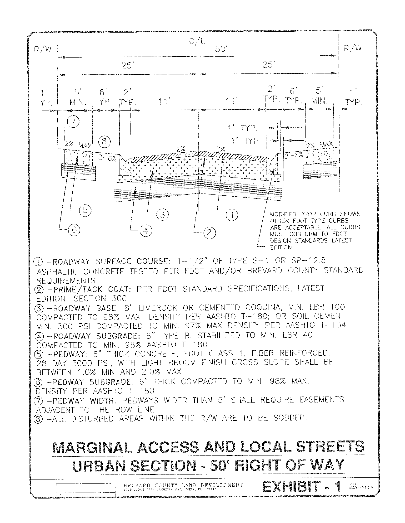
Exhibit 2
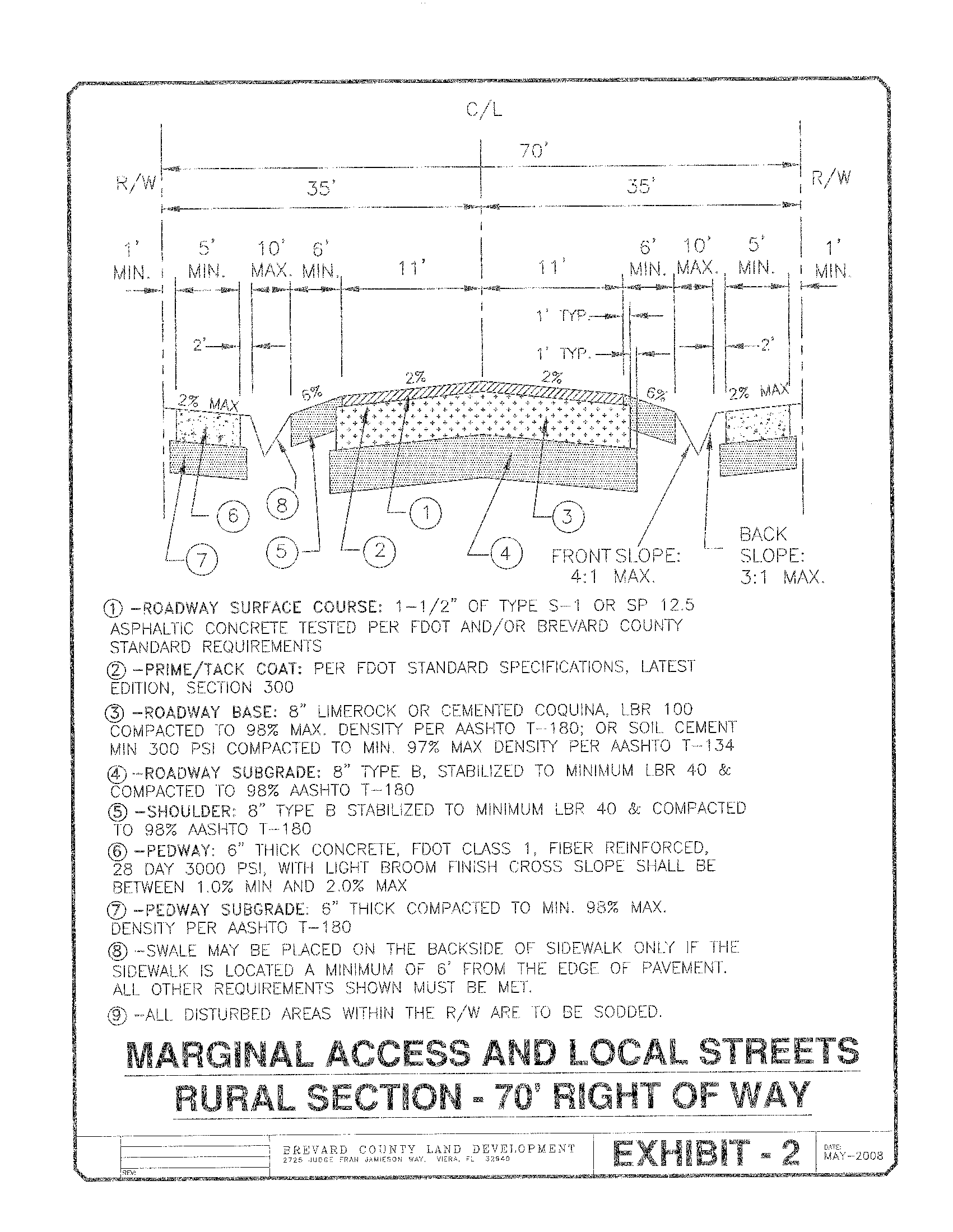
Exhibit 3
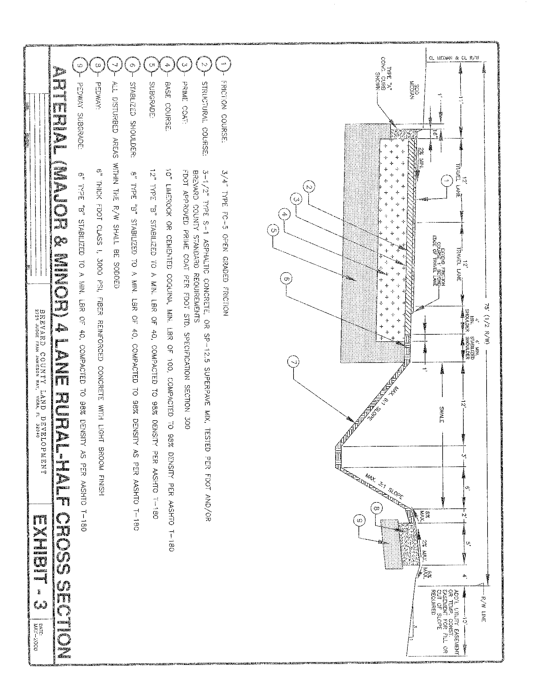
Exhibit 4
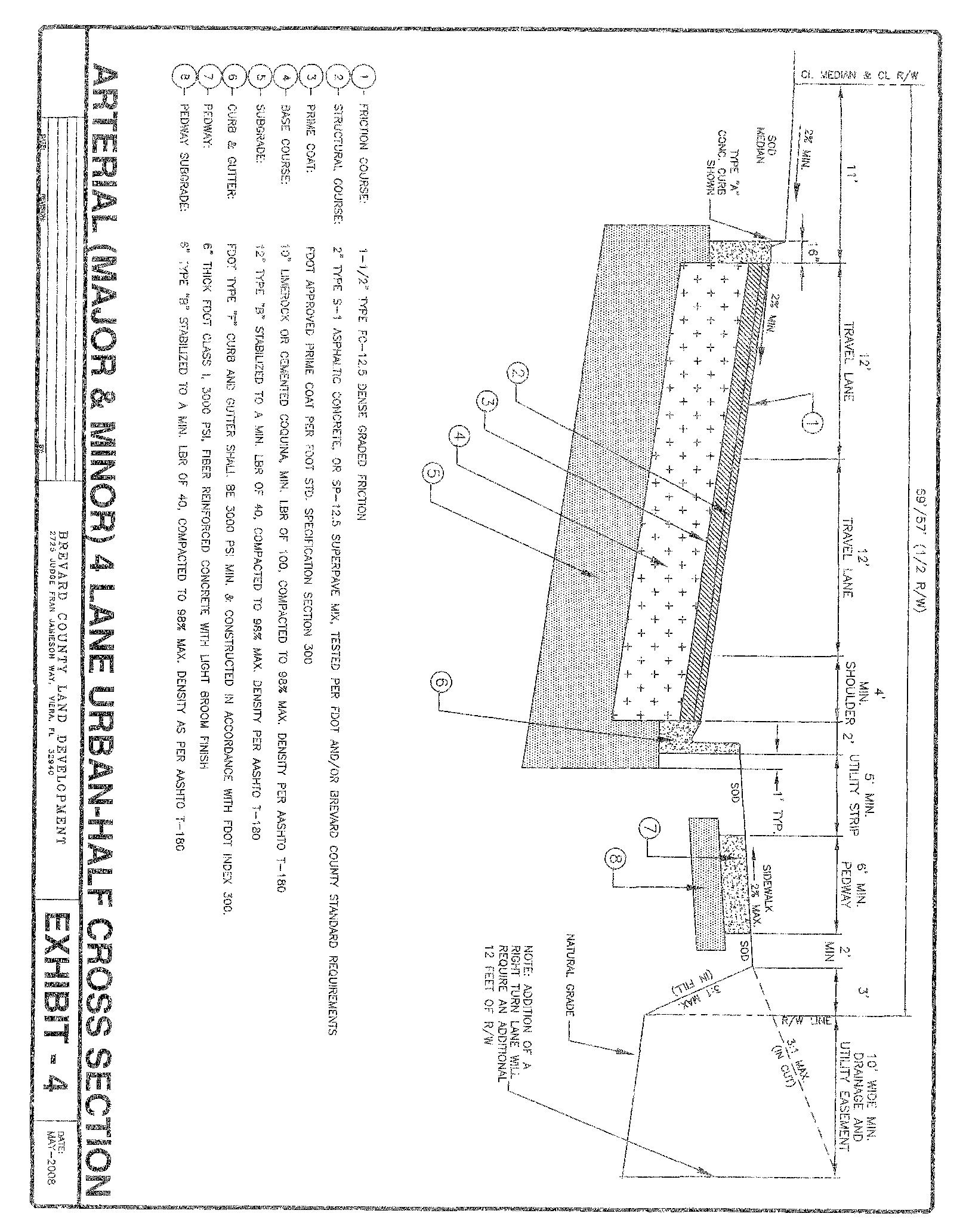
Exhibit 5
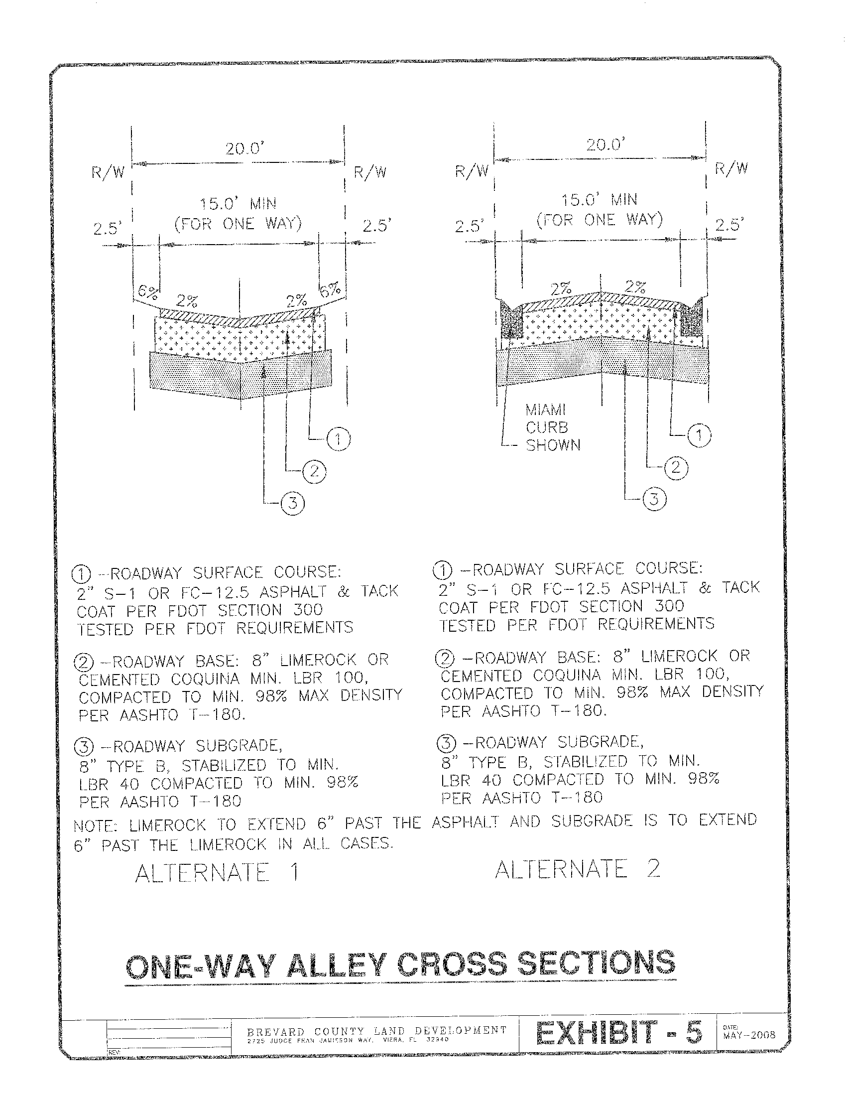
Exhibit 6
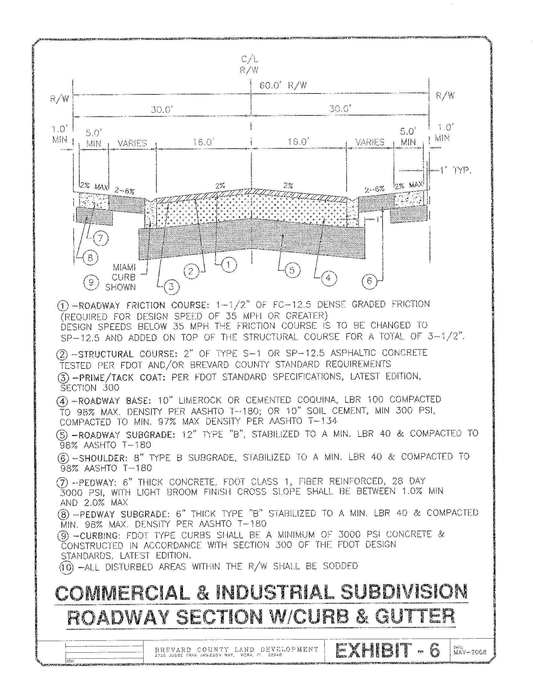
Exhibit 7
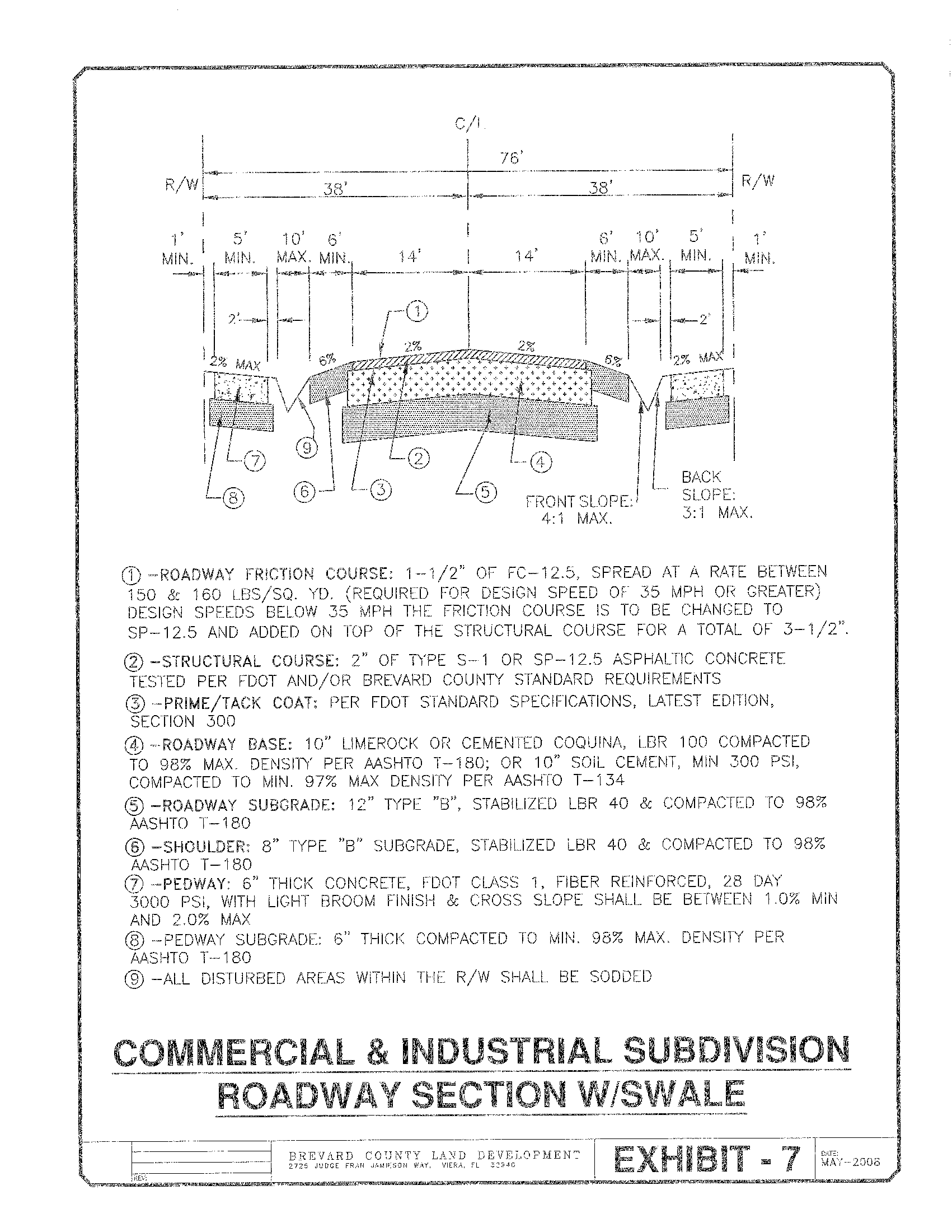
Exhibit 8
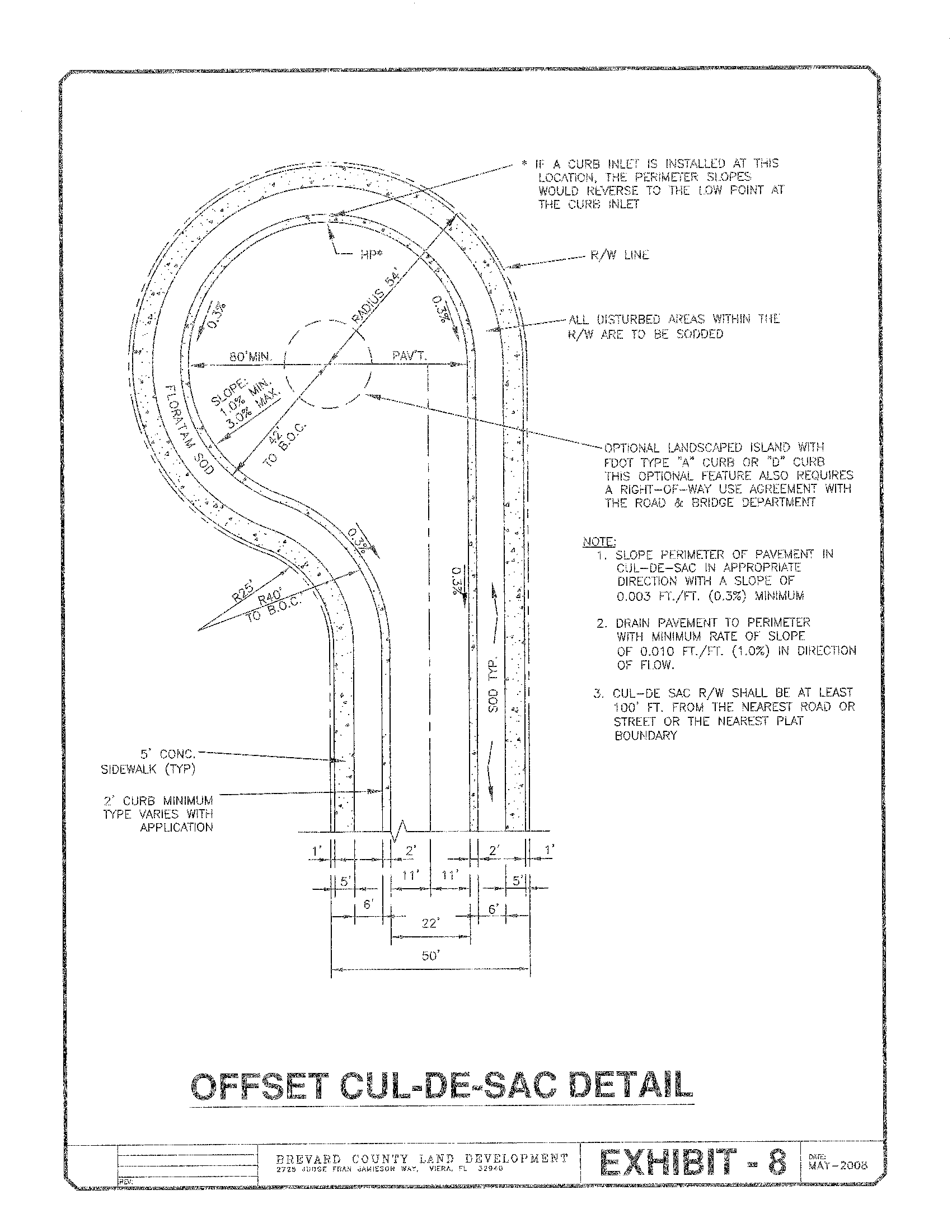
Exhibit 9
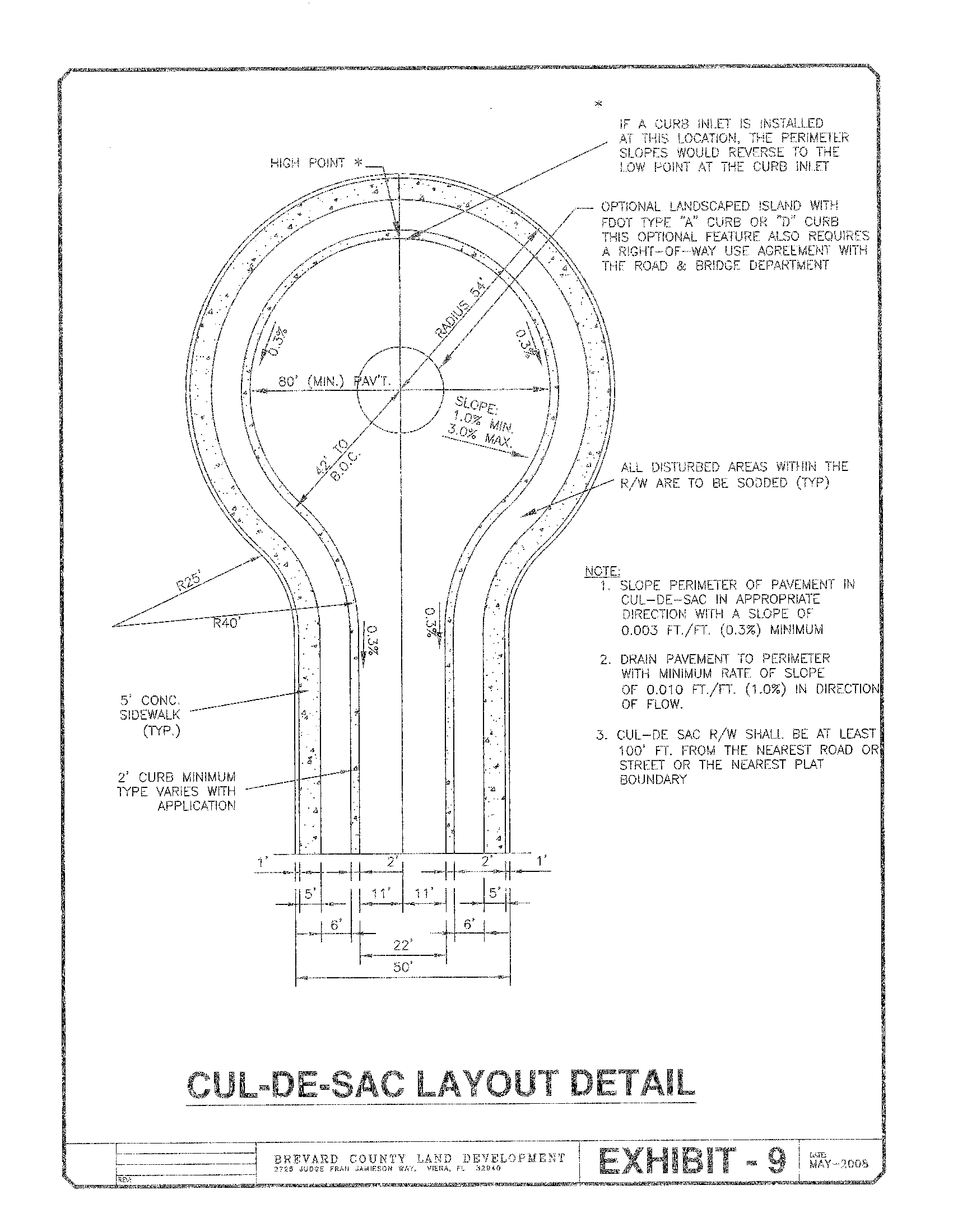
Exhibit 10
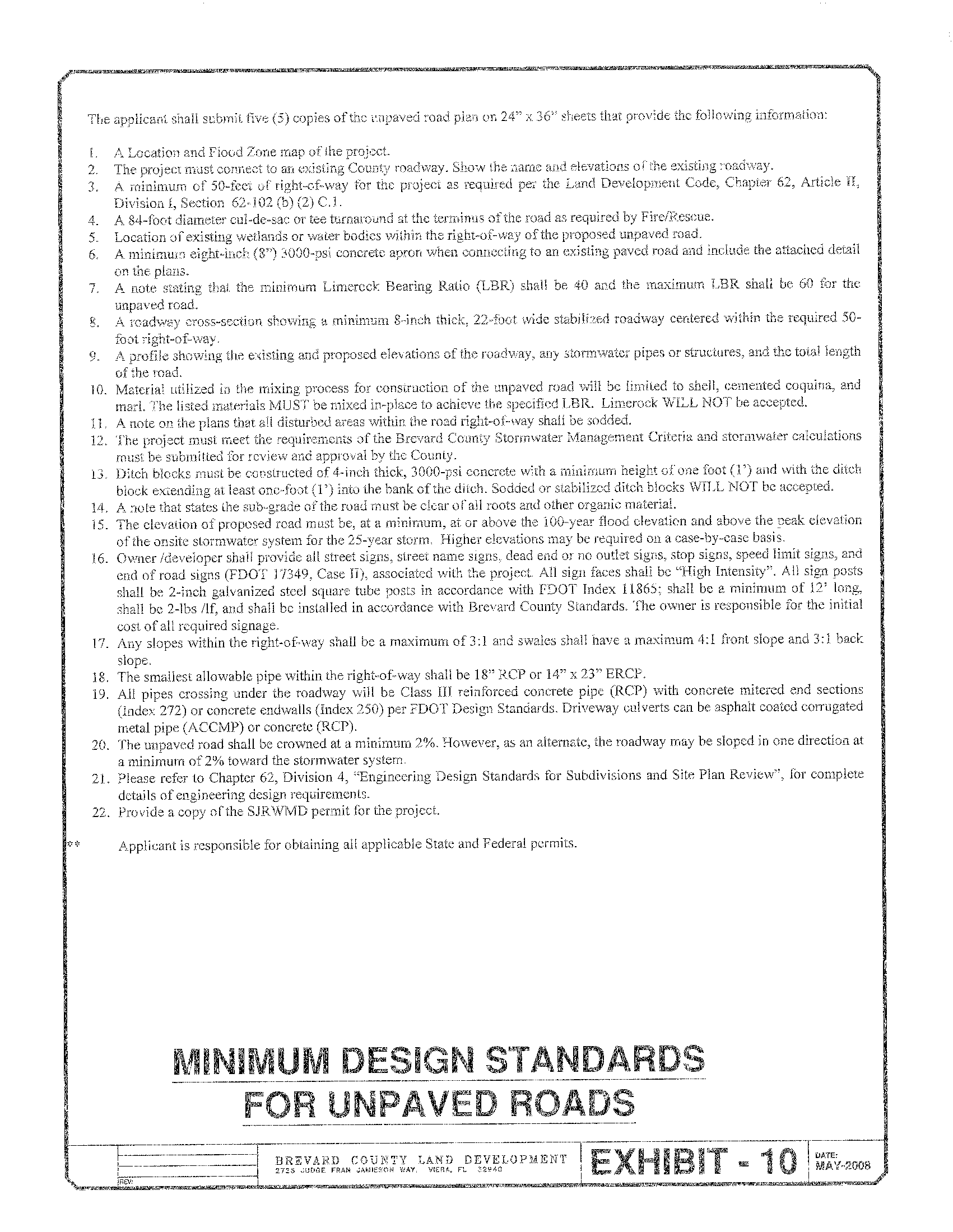
Exhibit 11
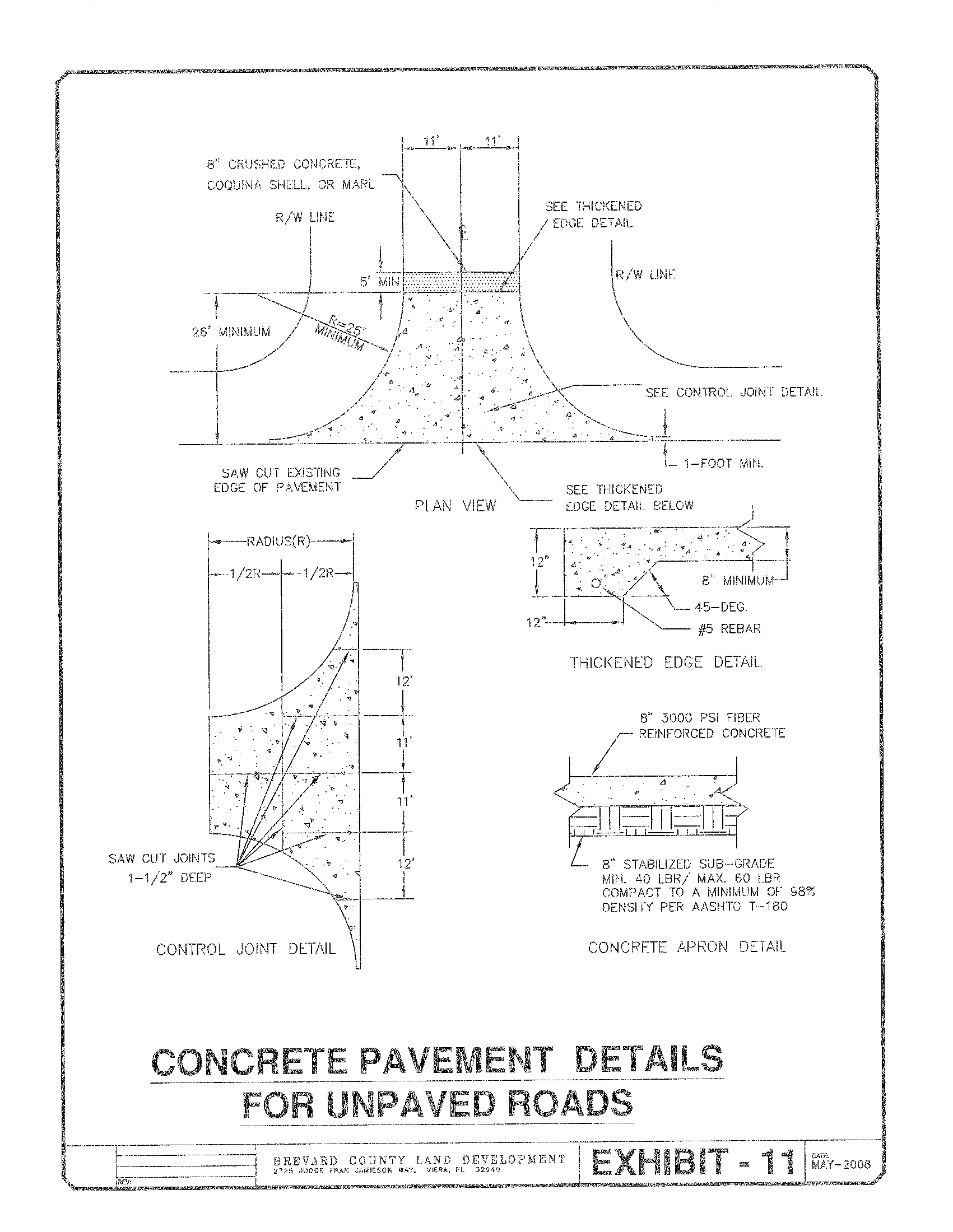
Exhibit 12
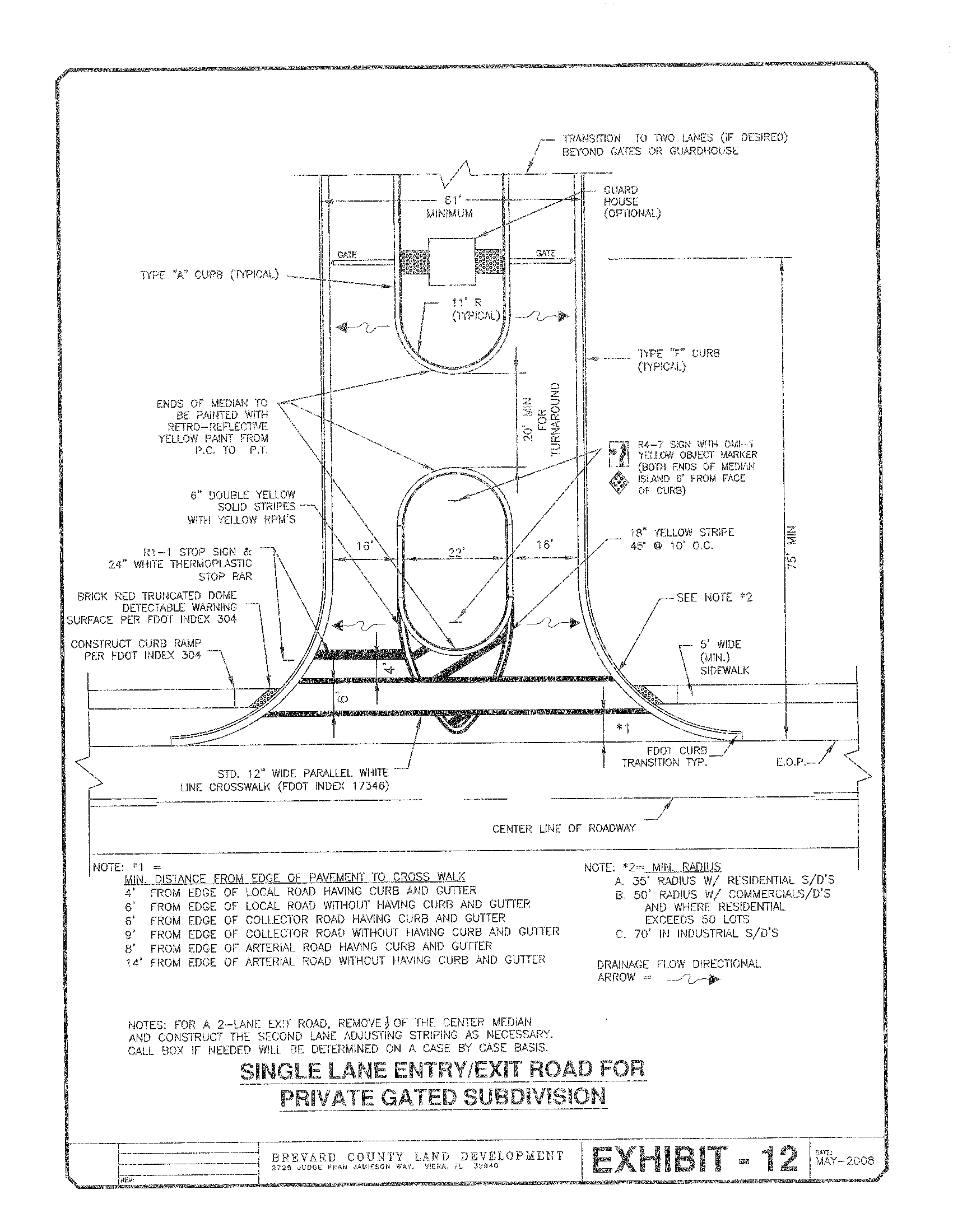
Exhibit 13
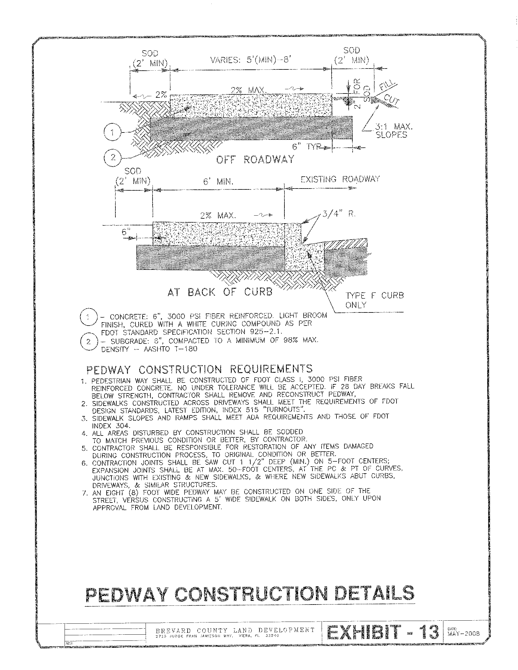
Exhibit 14
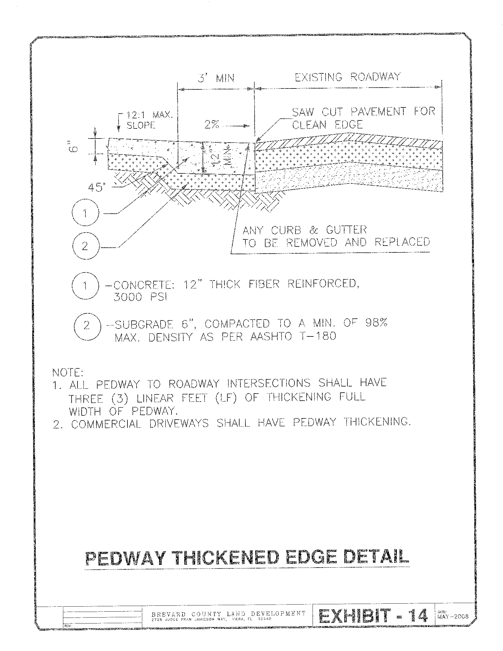
Exhibit 15
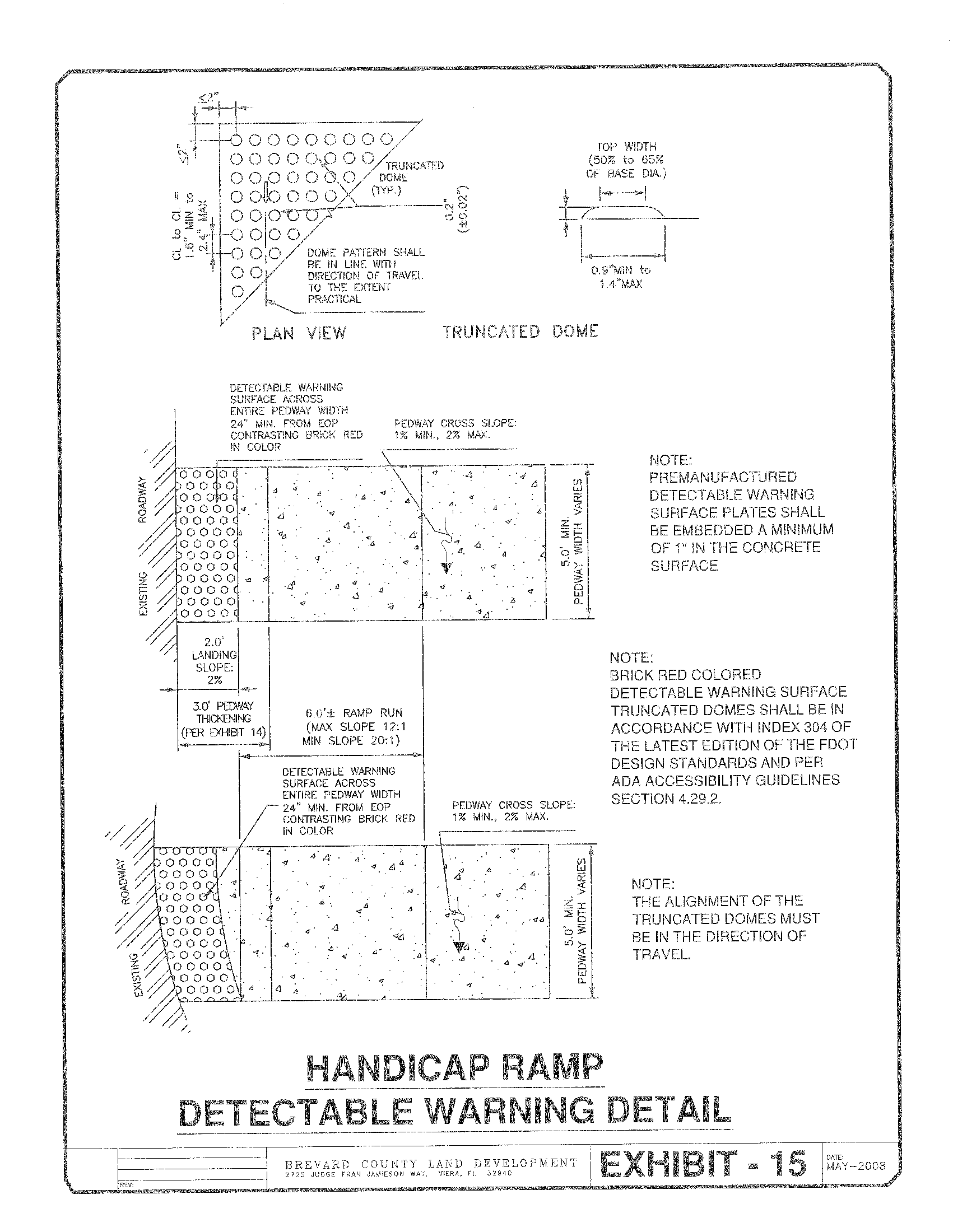
Exhibit 16
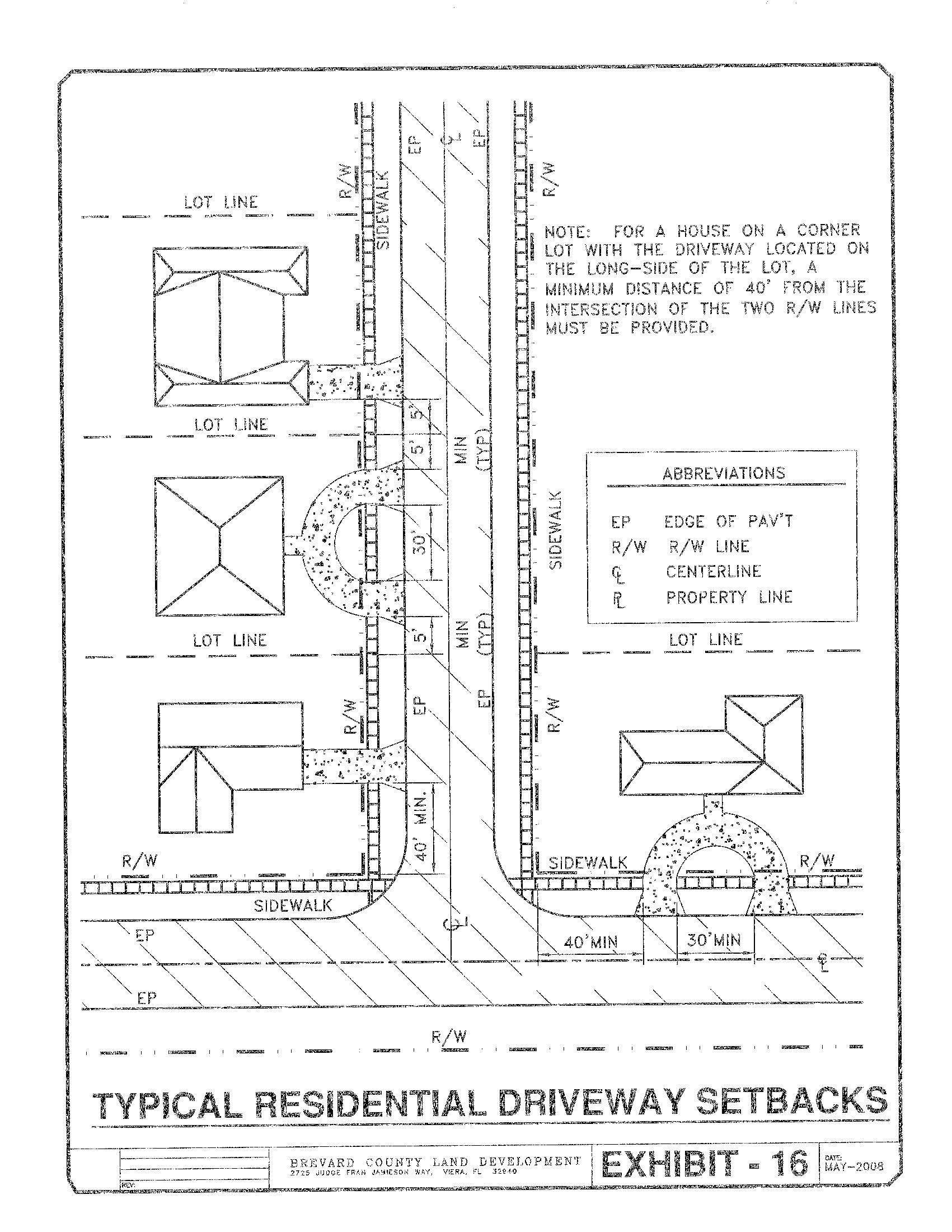
Exhibit 17
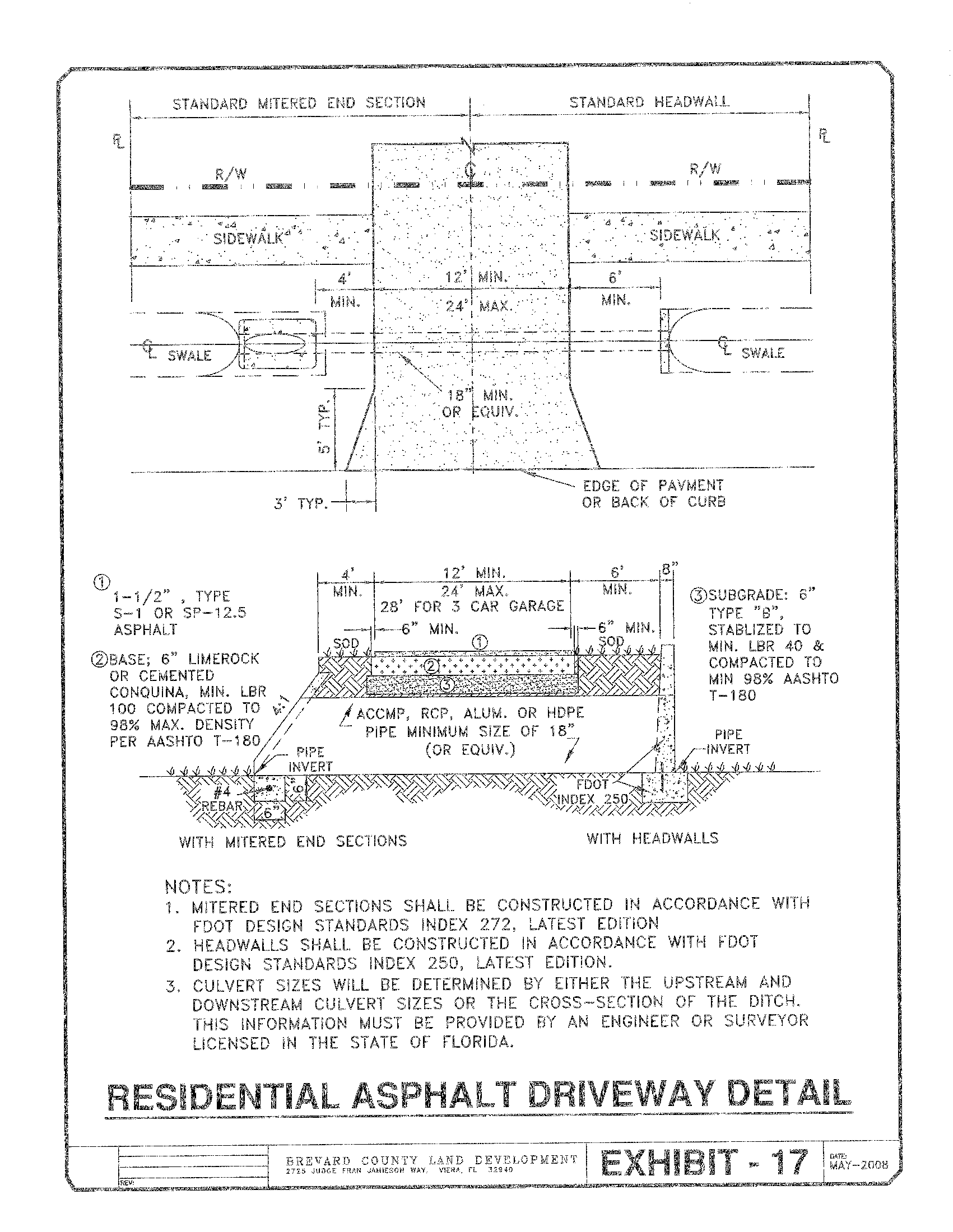
Exhibit 18
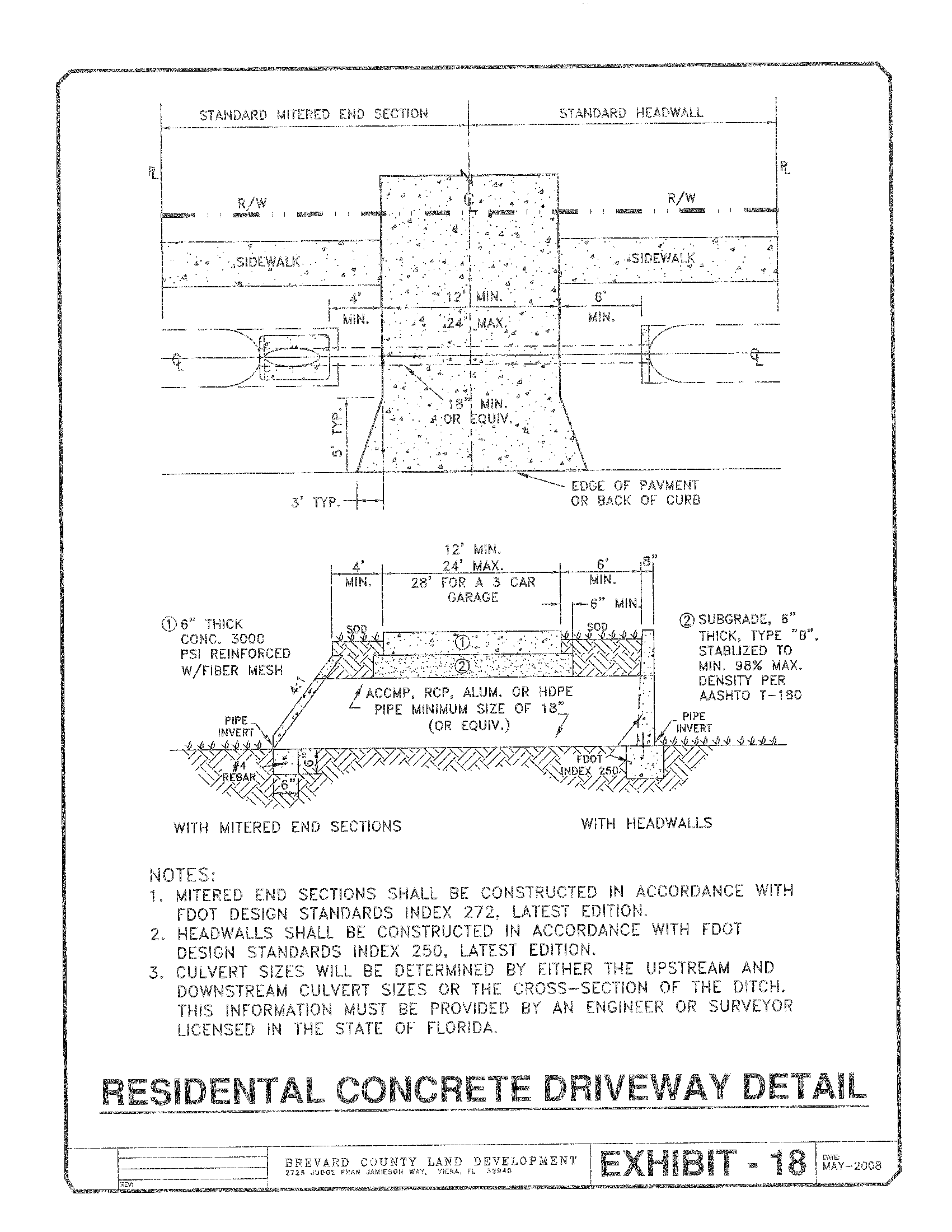
Exhibit 19
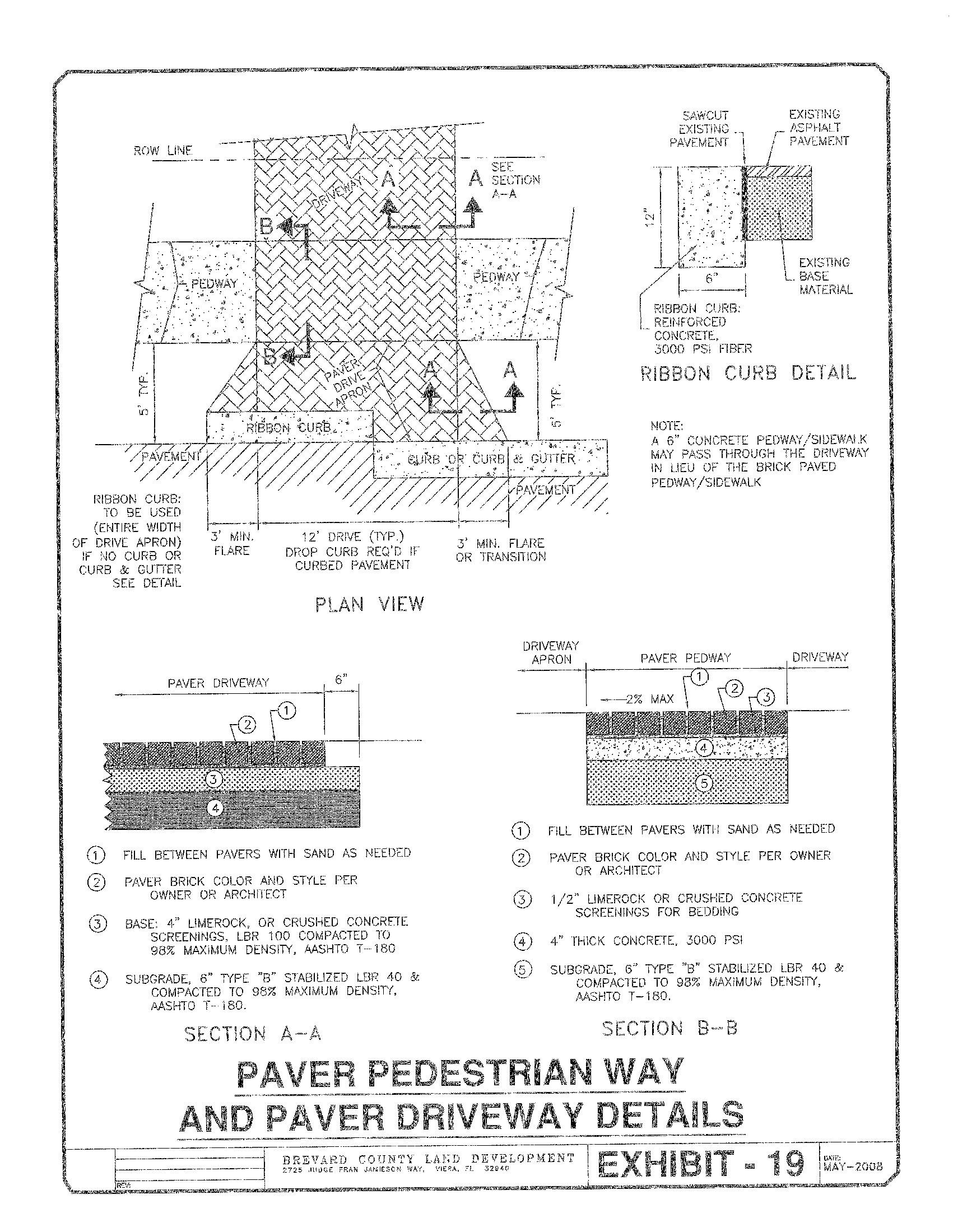
Exhibit 20
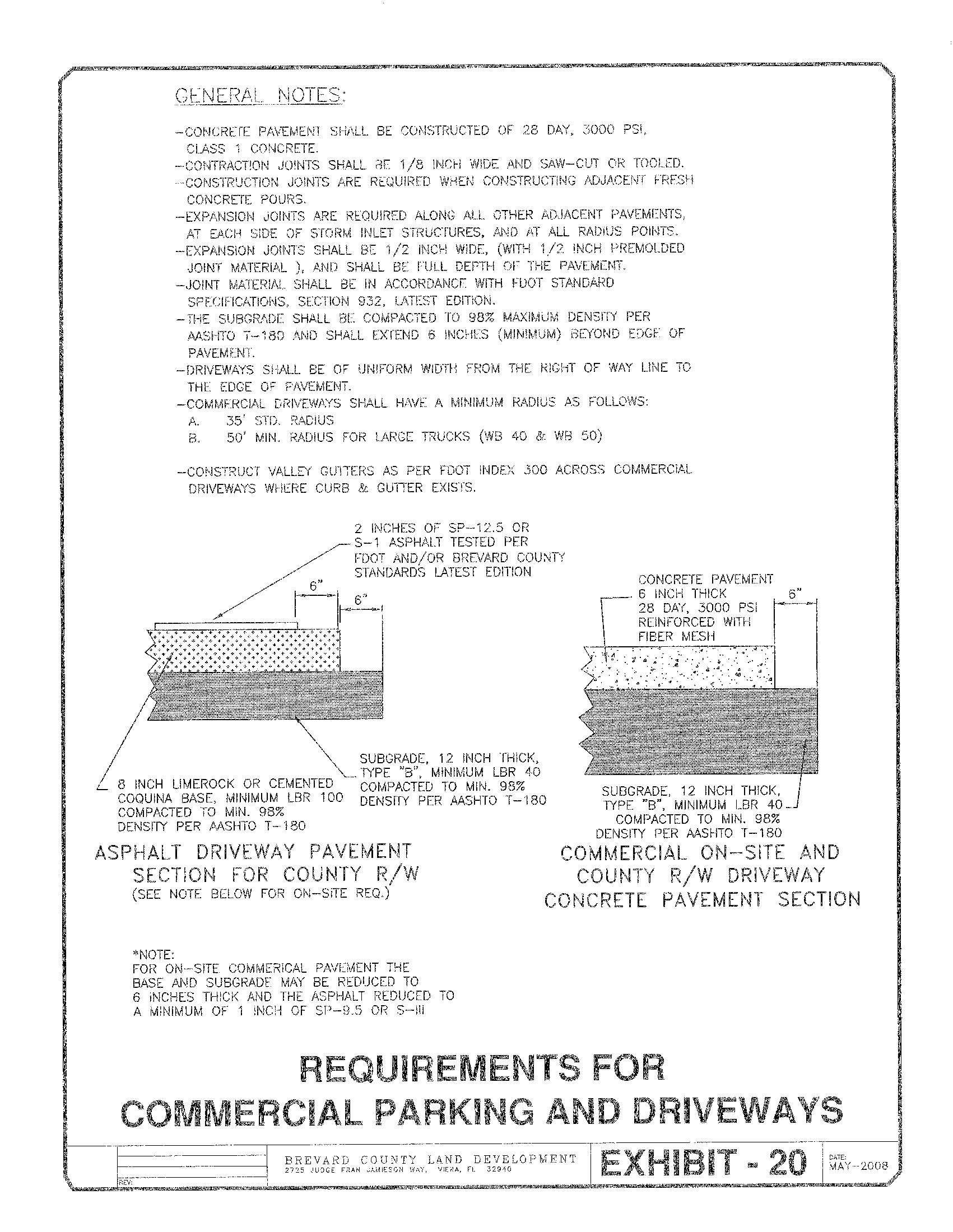
Exhibit 21
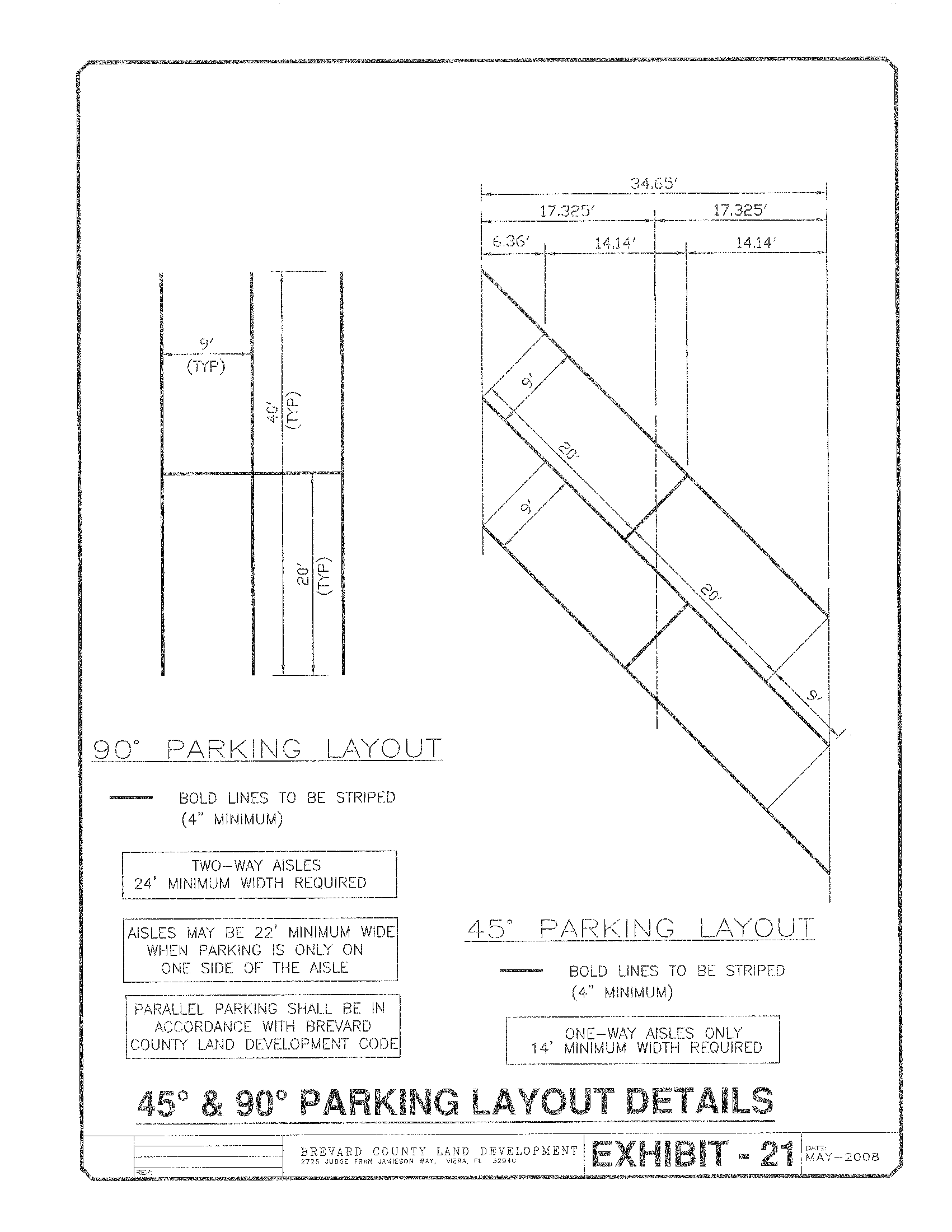
Exhibit 22
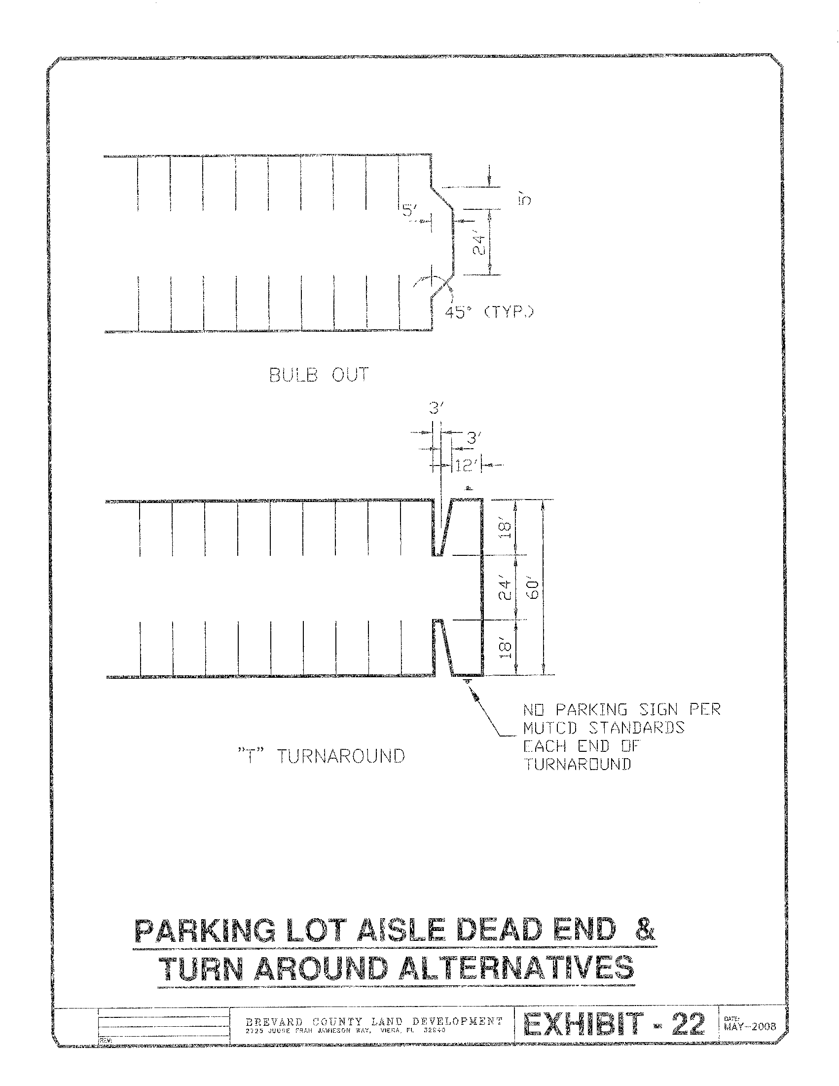
Exhibit 23
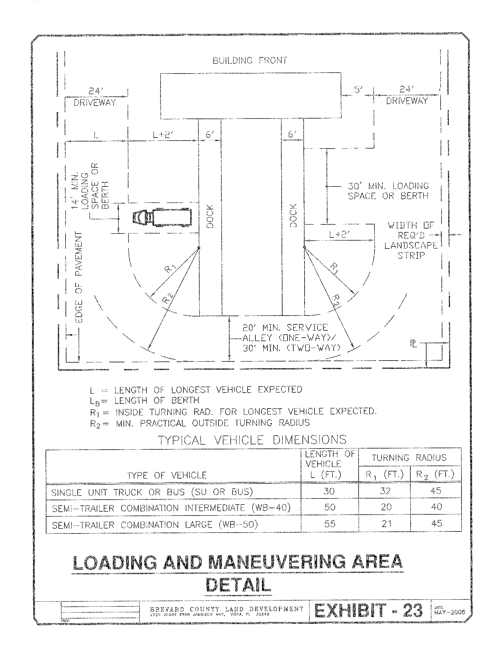
Exhibit 24A
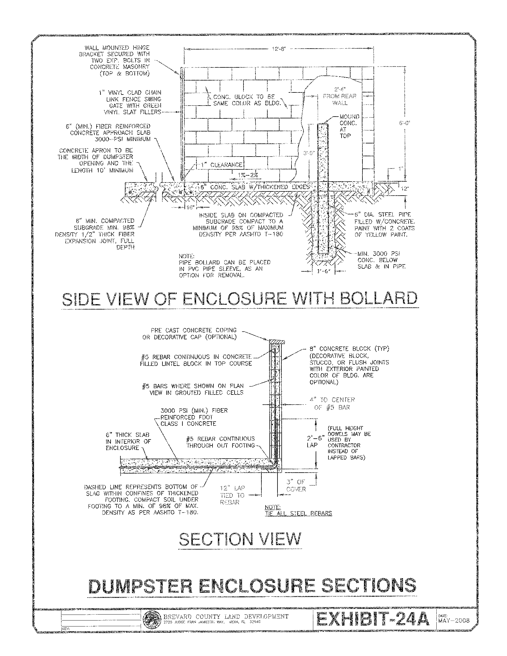
Exhibit 24B
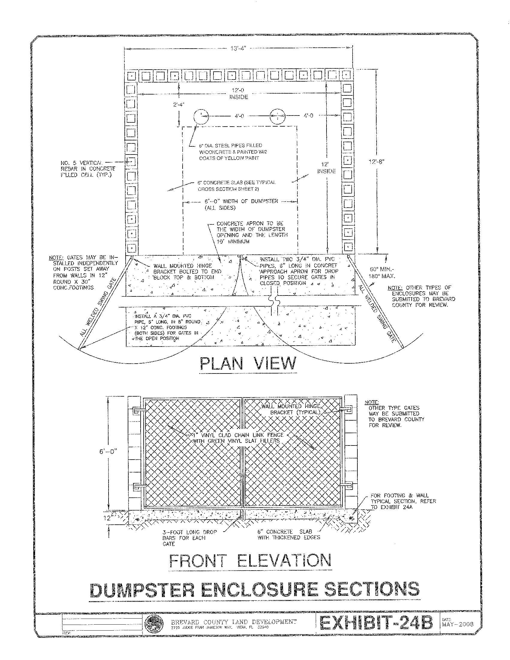
Exhibit 25
Exhibit 26
Sec. 62-2803. - Purpose.
The purpose of this article is:
(a)
To provide standards and procedures for the acceptance, processing and final action on subdivision applications and platting.
(b)
To ensure that a proposed development is noninjurious to contiguous and/or other directly affected properties, and to further ensure that its impacts are compatible and harmonious with the surrounding, general character of the area.
(c)
To further the health, safety and general welfare of the public through the adoption of local subdivision regulations which are consistent with F.S. ch. 177.
(d)
To implement the orderly, efficient and economical development of land, consistent with the comprehensive plan.
(e)
To establish minimum standards for subdivision design and provide for the installation of the necessary public infrastructure to service new development.
(f)
To outline responsibilities of ownership and maintenance of public and private infrastructure within the platted lands.
(g)
To provide guidelines and procedures to ensure that subdivision plans contain essential information and data, both graphic and written, necessary to provide a fair and uniform review process.
(Ord. No. 95-30, § 1, 7-11-95; Ord. No. 10-20, 10-12-10)
Sec. 62-2804. - Subdivision plats and platting; recording.
(a)
It shall be unlawful for any person to submit a plat for the subdivision of land located in the county outside of any municipality to the clerk of the circuit court or his representative for the purpose of recording such plat in the office of the clerk of the circuit court of the county, until such plat has been approved by the board or their designee under the provisions of this article. In the event an unapproved plat is recorded, it shall be stricken from the public records upon the adoption of an appropriate resolution by the board. No changes, erasures, modifications or revisions shall be made in any plat after final approval without the consent of the board.
(b)
No plat shall be recorded, unless a constructed road is built, inspected and approved by the county within a publicly dedicated right-of-way providing access to the subdivision. In instances where legal access is provided to the subdivision by a privately maintained right-of-way, such right-of-way must be irrevocable, paved or built to county standards, inspected and approved by the county, and open to public and emergency vehicles.
(c)
In either case of a public or private road providing access, a plat may be recorded if a road, not yet constructed, inspected, and approved by the county, within a proposed public or private right-of-way has had security delivered in the amount of 125 percent of the construction cost to the county of the portions not yet completed.
(Ord. No. 95-30, § 1, 7-11-95; Ord. No. 10-20, 10-12-10)
Sec. 62-2805. - Subdivision plan submission procedure
General requirements: When a subdivision of any land is proposed, the owner of the land shall apply for and secure approval of such subdivision in accordance with article VII subdivision regulations. A subdivision shall be required for the division of a parcel of land whether improved or unimproved, into three or more lots, and a subdivision plat shall be recorded. No lots or parcels which would be created, shall be sold, nor shall any building permit be approved for the erection of any structure on said lots or parcels until approval is obtained pursuant to this article.
(a)
Review stages: There are three stages of review for subdivision plan approval: the preapplication conference, construction plan/preliminary plat review and the final plat review.
(1)
Preapplication conference: The first stage is the preapplication conference. This stage is mandatory for the applicant, and allows the applicant to solicit comments from the reviewing agencies on the proposed subdivision prior to submittal and review of preliminary plat and construction plans.
(2)
Construction plans and preliminary plat review: The second stage is the construction plans and preliminary plat review. The applicant formally submits construction plans and preliminary plat for review and approval by the county reviewing agencies.
(3)
Final plat review: The third stage is final plat review. This stage follows construction plans and the preliminary plat review and is the final stage necessary before recording a plat. The applicant, after obtaining construction plans and preliminary plat approval, may receive final plat approval by the board.
(b)
Subdivisions: A subdivision shall be processed as established herein and shall be required to complete all three stages of review, unless the division meets the definitions and requirements of a minor subdivision.
(c)
Minor subdivisions: Division of such parcels into no more than six lots that comply with the following criteria shall be considered a minor subdivision and shall be reviewed in two stages: (1) construction plans and preliminary plat review, and (2) the final plat review. The applicant may request a preapplication conference in addition to the required review stages. A minor subdivision may be approved for a division of land if the following conditions are met:
(1)
All proposed lots are for detached single-family residential lots.
(2)
A new street of not more than 1,320 feet in total length, is being established and the new street directly connects to an existing county maintained right-of-way.
(3)
All lots being created shall have fee simple access on a public or private maintained street.
(4)
All lots shall meet the minimum lot frontage area and dimensional requirements for the zoning and future land use designation in which they are located.
(5)
The subdivision shall be all inclusive and shall not consist of more than one phase of development.
(d)
Replats or subdivisions that do not require the creation of new streets or right-of-way, and are not located within a flood zone, may be reviewed under an application for final plat review and approval. A lot grading plan, drainage plan, and wetlands delineation shall be included with the final plat for county review and approval.
(e)
Exemptions: The following are exempt from the subdivision platting process subject to conformance to all other land development regulations, including but not limited to, lot design and lot drainage requirements of article VII:
(1)
The division of land into parcels of more than five acres, where all proposed lots access a county maintained road, not involving any change in street lines or easements of whatsoever kind is not to be deemed a subdivision within the meaning of this article.
(2)
The division of one parcel or lot into no more than two lots where both of the proposed lots meet the minimum frontage requirements abutting a county maintained road and there is no change in street lines or easements.
(Ord. No. 95-30, § 1, 7-11-95; Ord. No. 2004-13, § 2, 4-13-04; Ord. No. 10-20, 10-12-10; Ord. No. 17-09, § 2, 5-9-17)
Sec. 62-2806. - Required improvements within a subdivision.
Each subdivision shall contain improvements designed and constructed according to the requirements and specifications of this article and the applicable policies, regulations, ordinances and articles of the county and the laws of the state as follows:
(1)
Streets paved, designed and constructed according to the standards and requirements of applicable ordinances and articles. However, in minor subdivisions the county may approve unpaved roads subject to the following criteria:
1.
The surrounding area has a future land use designation in the comprehensive plan as residential 1:2.5 or lower density and the access road connects to an existing county maintained unpaved road.
2.
The roadway is designed and constructed according to the minimum design standards for unpaved roads, exhibit 10A, for minor subdivisions.
3.
The proposed rights-of-way are private and not county maintained.
4.
The developer provides a mechanism to ensure maintenance such as a homeowners association or maintenance agreement.
(2)
Pedestrian ways, sidewalks and/or bikeways designed and constructed according to the standards and requirements of applicable ordinances, articles and in accordance with the comprehensive plan. The applicant shall be responsible for constructing sidewalks, bikeways and/or pedestrian ways that do not abut a single-family lot and said improvements shall be installed prior to the final inspection of the subdivision improvements for the issuance of a certificate of completion. Sidewalks, bikeways and/or pedestrian ways adjacent to single-family lots shall be installed prior to the issuance of the certificate of occupancy for the dwelling. Where appropriate, the county manager or their designee may require that the applicant construct pedestrian facilities with the subdivision infrastructure adjacent to single-family lots and/or offsite to ensure public safety and welfare. Pedestrian and bicycle accommodations may be accomplished by alternative means upon approval by the board.
(3)
Drainage and water management facilities designed and constructed according to the standards and requirements of applicable ordinances and the surface water management criteria.
(4)
A sanitary sewerage system must be designed under the provisions of this article and all other applicable policies, laws, ordinances, articles and regulations. If an individual sewage disposal is permitted within the tract, it must be designed and approved based upon the required standards of the environmental health services and/or water resource department.
(5)
A water system must be designed under the provisions of this Code and other applicable policies, laws, ordinances, articles and regulations. If an individual water supply is permitted within the tract, it must be designed and approved based upon the required standards under the jurisdiction of the county health department, environmental health services and/or water resource department.
(6)
Approved traffic control devices, including signage, pavement markings and signalization shall be provided to control and circulate traffic within the subdivision, as well as external to the subdivision as may be required. Traffic control devices shall be in accordance with the most recent editions of the Manual on Uniform Traffic Control Devices, Florida Department of Transportation Standard Specifications for Road and Bridge Construction, including the Traffic Signal Supplement and County specifications.
(7)
Lot filling and grading in compliance with approved plans.
(8)
Consideration and provision of school bus stop and school access needs, as may be required to protect public safety.
(9)
The placement of permanent reference monuments and permanent control points by a licensed professional surveyor.
(10)
Any open space and recreational improvements required by the county land development regulations and comprehensive plan.
(11)
Compliance with the most recently adopted edition of the Florida Fire Prevention Code including but not limited to, water systems, utilities, and street design.
(12)
Such other improvements as deemed necessary to comply with the requirements of this article, and to protect the public health, safety and welfare.
(Ord. No. 95-30, § 1, 7-11-95; Ord. No. 2004-13, § 3, 4-13-04; Ord. No. 10-20, 10-12-10)
Sec. 62-2807. - Preapplication conference.
(a)
General: Before making application for construction plans and preliminary plat approval, the applicant and surveyor, engineer or land planner are required to discuss the preliminary studies and sketches for a subdivision with all reviewing agencies. This step does not require the filing of a plat. This step is to provide an opportunity for the applicant to avail himself of the advice and assistance of governmental agencies to facilitate the preparation and review of construction plans and final plats.
The pre-application conference schedule will be posted at the beginning of each year, and may be amended by the county as needed with proposed meetings on average once every two weeks. To have a project placed on the pre-application conference agenda, the information listed in subsections (b) and (c) must be submitted to the appropriate county department by close of business two weeks prior to the scheduled conference. Staff comments will then be presented to the applicant or their engineer prior to the conference.
The applicant will have six months from the date of the pre-application conference in which to submit final engineering plans and preliminary plat in order for the project design to be approved under the existing code of ordinances that were in effect as of the date of the pre-application conference. Any project submitted beyond six months after the pre-application conference will be required to schedule an additional pre-application conference and pay all appropriate fees.
(b)
Pre-application plans: The applicant shall provide two copies of a subdivision sketch plan, or one electronic copy of the plan, along with the required exhibits and information, to the county prior to the pre-application conference.
(c)
Required exhibits and information: The subdivision sketch and preliminary studies shall contain a location map showing the relationship of the proposed subdivision to existing and proposed facilities as indicated on the future land use map series of the comprehensive plan, and shall contain the general information including, but not limited to, the following:
(1)
Forms and fees:
Application for subdivision review and approval.
Zoning verification form.
Authorization to act as applicant form.
Applicable review fees.
(2)
General information on the existing site conditions, water management facilities, soil conditions, flood plain data, topography, trees, vegetation types, wetlands and preservation areas, adjacent community facilities, utilities and surrounding property conditions.
(3)
General description of the proposed subdivision, including proposed number of lots, approximate lot width and depth, building size and type. Proposed stages of development, if appropriate, should be shown.
(4)
In sketch form, a plan showing the proposed pattern of streets, lots and water management facilities in relation to existing natural conditions of the site and its surroundings.
(5)
A legal description of the parcel including, but not limited to section, township and range.
(6)
The owners, developers and engineer of record's name, address and telephone number.
(7)
Subdivision plans shall be 24 inches by 36 inches.
(Ord. No. 95-30, § 1, 7-11-95; Ord. No. 2004-13, § 4, 4-13-04; Ord. No. 10-20, 10-12-10; Ord. No. 17-09, § 3, 5-9-17)
Sec. 62-2808. - Application for construction plans and preliminary plat review and approval.
Applications shall include all of the necessary information and engineering for construction, including, but not limited to, the following requirements and standards of this article. Incomplete application packages will not be accepted for review.
(a)
Submission: All applicants shall make application for subdivision and new roadway construction review by furnishing to the county, two construction packages, including preliminary plat of the proposed subdivision, or one electronic copy. Such construction plans and preliminary plat shall be drawn at a scale of not smaller than one inch equals 100 feet. In the event the subdivision exceeds 100 acres in area, the applicant may submit a preliminary plat at a uniform scale of not smaller than one inch equals 200 feet.
(b)
Design and required information: Construction plans for such subdivision shall be designed in conformity with the general design standards established in this article. All submittals will be made to the county and shall contain the following information:
(1)
Preliminary plat shall be prepared in conformance with F.S. § 177.091(2), (3), (4) through (6), (9) through (11), (14), (15), (18) and contain all conceptual lot dimensions.
(2)
Two signed and sealed copies of a boundary and topographic survey.
(3)
Two copies of stormwater calculations shall be submitted.
(4)
Tree survey, existing tree canopy coverage and landscaping plan as required per landscaping/land clearing ordinance.
(5)
Title block: The title or name of the proposed subdivision, county and state; date of preparation; name and address of the owner of the tract proposed for subdivision; and the name, address, signature, seal and registration number of the surveyor engaged to prepare the preliminary plat.
(6)
North arrow, total acreage, number of lots and delineation of each phase of development.
(7)
Complete legal description: A full and detailed description of the tract showing the township and range in which such tract is situated and the section or part of sections to be platted.
(8)
Vicinity map: A vicinity map insert shall be made part of the construction plans showing the general location of the site using the names and locations of nearby streets and prominent natural or manmade landmarks. Scale shall be sufficient to indicate the zoning and current land use of the property contiguous to the site, including properties separated from the site by a public/private street. Copies of road maps will not be accepted as vicinity maps.
(9)
Existing features: The location, name, width or size of any of the following existing features, both on and immediately contiguous to the subdivision tract: conservation areas, wetlands, platted property lines, streets, sidewalks, bike paths, water courses, railroads, all public and private rights-of-way, public and private easements, parks and other public and private open spaces, bridges and existing facilities across a public or private right-of-way shall be shown with proposed improvements, i.e., landscaping.
(10)
Public and private open spaces including preservation/conservation areas, rights-of-way and easements: The names, locations and widths of all proposed streets, alleys, parks, lakes and waterways, sidewalks, bikeways and other public and private improvements. For any parcel of land located contiguous to natural lakes, streams of the Indian River Lagoon System, the mean high water elevation line shall be depicted on the plan.
When individual onsite sewage treatment and disposal systems are proposed, indicate the mean high water line of tidally influenced surface water bodies and/or the mean annual flood line of permanent nontidal surface water bodies as defined in F.S. § 381.0065.
(11)
Dedications and reservations: All parcels of land proposed to be dedicated or reserved for public and private use, together with the purpose and the conditions or limitations of such proposed dedications or reservations, if any.
(12)
Lot lines and lot numbers and blocks: Lots shall be numbered in consecutive, clockwise order, starting with the numeral one for the first lot in each block. Each block will be lettered and blocks will be separated by rights-of-ways and/or common tracts.
(13)
Lot sizes: The acreage or square footage and dimensions of each lot shall be shown on the plan, either in each individual lot or on a separate table on the face of the plan.
(14)
Water management system: The proposed location and width of ponding, drainage, water retention and maintenance facilities.
(15)
Utilities: The right-of-way and/or easement and the location of water, telephone, electricity, sewage, cable television and other utilities will be identified as practical, and the responsibility of maintenance shall be stated on the subdivision plan.
Individual onsite sewage treatment and disposal systems must be designed in accordance with Chapter 64E-6, Florida Administrative Code.
Two copies of the hydraulic and/or lift station calculations as required by the Water Resources Department criteria for water and sanitary sewerage systems within Brevard County.
(16)
Topography: Elevations based on NGVD of 1929 or NAVD-88 shall be depicted by contour lines of one-foot intervals upon the engineering plans or shall be otherwise provided upon a separate instrument attached to and by reference made a part of such plat. Permanent bench marks shall be established for each subdivision.
(17)
Data as necessary to show the soil and topography is suitable for the proposed uses of the property in the subdivision.
The applicant may be required to provide additional topographic data sufficient to analyze drainage impacts on adjacent properties.
(18)
Data to demonstrate the impact the proposed improvement shall have on prime aquifer water recharge areas, if applicable, and the groundwater table.
(19)
Information about the elevations of the proposed home-sites and roads.
(20)
The applicant may be required to provide a traffic impact analysis report defining the offsite impacts, based on the county concurrency evaluation criteria, of the proposed development and identify the appropriate mitigation measures.
(21)
The applicant may be required to provide such other information including technical data and reports as the county finds reasonably necessary to insure the subdivision shall conform with the requirements of this section and other sections of this article and other applicable laws, ordinances, articles and regulations.
(22)
A certificate of ownership.
(23)
Boundaries of existing wetlands, proposed impacts to wetlands and proposed wetland mitigation plans shall be provided. Copies of any permits previously issued by the St. Johns River Water Management District for the project shall be provided for review.
(c)
Review: The county shall provide agency review comments or approval within ten working days of the receipt of a complete application for the initial submittal. Subsequent submittals will be reviewed within five working days. Instances where the proposed development plan contains a large acreage, number of units, may affect regional resources, or the intensity of the proposed use warrants, the county manager or designee may extend the aforementioned review period to a maximum of 30 calendar days. In those cases, the applicant shall be notified prior to the expiration of the original review period.
(d)
Agency comments: The county will provide the applicant the comments and recommendations of the agencies and advise the applicant of a date for a development review meeting with the applicant to review the agencies' comments and recommendations. The date of the meeting may be set for a time after the expiration of such ten-working-day period. The meeting schedule will be posted at the beginning of each year, and may be amended by the county as needed with proposed meetings on average once every two weeks. To have a project placed on the development review meeting agenda, the complete submittal must be received by close of business prior to the deadline posted for the scheduled meeting. Staff comments will be presented to the applicant or their engineer prior to the meeting.
(e)
Approval: Upon satisfactory completion of such review and approval of the proposed construction plans and plat by the applicable agencies, the construction package shall be approved based upon a consideration of the requirements of this article and other applicable policies, ordinances, articles, laws and regulations and the conditions which affect development within the vicinity of the tract.
(f)
Filing fee: The board reserves the right to establish from time to time by resolution a fee in an amount deemed necessary to reimburse the county, the cost incurred in reviewing and approving plans and plats.
(g)
Time limit: The applicant shall have 24 months from the date of formal submittal in which to obtain approval of the construction plans and preliminary plat. If an applicant has not obtained approval within 24 months the application shall become null and void and the applicant must reapply under the provisions of this article.
(Ord. No. 95-30, § 1, 7-11-95; Ord. No. 01-59, § 1, 10-2-01; Ord. No. 2004-13, § 5, 4-13-04; Ord. No. 10-20, 10-12-10; Ord. No. 17-09, § 5, 5-9-17)
Sec. 62-2809. - Construction permits.
(a)
Approval of construction permit: An applicant must obtain a single construction permit from the county for the construction of all subdivision improvements. After approval of the construction plans, an applicant may apply for a construction permit by providing the following information to the county:
(1)
The applicant must furnish copies of all regulatory permits including, but not limited to, St. Johns River Water Management District, Florida Department of Environmental Protection, (with the exception of the Army Corp of Engineers, Florida Fish and Wildlife Commission and U. S. Fish and Wildlife) required for the site.
(2)
The general contractor must furnish copies of all licenses including, but not limited to, the following: general contractor's license, business tax receipt from Brevard County, municipality or other county in which his primary office is located within the State of Florida. The contractor must also furnish a copy of his workman's compensation insurance and liability insurance.
(3)
The reviewed and approved final engineering plans and preliminary plat. All construction plans and specifications must be signed and sealed by a professional civil engineer who is registered in the state.
(4)
Engineer of record's certification of engineering inspection fees and payment of said fees.
(5)
A pre-construction conference will be scheduled by the county with the developer, project engineer, prime contractor and inspection staff. (The conference may be waived by the county if the project is a continuation of an existing site under construction where the same engineer, contractor and testing laboratory are being utilized.)
(b)
[Display of permit:] The construction permit must be posted by the applicant in a conspicuous place in the open at the construction site.
(1)
Construction before final plat recordation: The applicant shall submit the final construction plans and specifications as required in section 62-2808 of this article for subdivision improvements. A certificate of ownership shall accompany such plans and specifications. The improvements covered under this permit shall be completed prior to final plat and certificate of completion may be issued at the time of final plat recordation for private roads or if a maintenance bond is posted for public roads, or
(2)
Construction after final plat recordation: The applicant shall submit the final construction plans and specifications as required in section 62-2808 of this article for subdivision improvements. The plans and specifications shall be submitted and the applicant shall provide security required in section 62-2844 for the performance of such construction. The construction permit shall be for all improvements which are to be constructed after final plat approval.
(c)
Time limit of construction permit and revocation: A construction permit shall be valid for a period of 36 months from the date of approval of the final engineering plans and preliminary plat. Additional construction permits may be administratively approved for 12-month periods subject to the following criteria:
(1)
The applicant shall submit a set of plans, for county review and approval, that provide for the remaining unconstructed infrastructure improvements to be designated and installed pursuant to the most up to date construction standards; and
(2)
The applicant posts an up to date performance security based on the latest construction cost pursuant to section 62-2844; and
(3)
The applicant pays additional inspection fees based on the latest construction cost; and
(4)
The final plat has been recorded within 36 months of the board's approval of the final engineering plans and preliminary plat.
(Ord. No. 95-30, § 1, 7-11-95; Ord. No. 2004-13, § 6, 4-13-04; Ord. No. 2007-003, § 22, 2-20-07; Ord. No. 10-20, 10-12-10; Ord. No. 12-34, § 1, 10-23-12; Ord. No. 17-09, § 6, 5-9-17)
State Law reference— Penalty for ordinance violations, F.S. § 125.69.
Sec. 62-2810. - Engineering revision.
If an engineering revision is required to an approved engineering plan, the applicant must submit the revised engineering plans with the appropriate fees and documentation to the county for a ten-calendar-day review by the appropriate agencies.
Upon approval by staff, the revised sheets will be forwarded to the county for distribution to the applicant and affected agencies.
(Ord. No. 2004-13, § 7, 4-13-04; Ord. No. 10-20, 10-12-10; Ord. No. 17-09, § 7, 5-9-17)
Sec. 62-2841. - Application for final plat review and approval.
(a)
General. The final plat submitted for approval by the board shall meet the requirements of F.S. ch. 177, and subsections (c) and (d), as amended, and shall be in conformity with the preliminary plat as approved. The purpose of this section is to set forth the standards and procedures applicable to submitting and obtaining approval for subdivision plats. The regulations contained in this Code are in additions to those set forth in F.S. ch. 177 and the Florida Administrative Code, (F.A.C.), 61G17-6.
(b)
Filing. Five copies of the final plat, and one electronic copy shall be submitted to the county with the documents specified in subsection (c) for a 15-working day review.
(c)
Information required to accompany the plat.
(1)
Applicable review fees.
(2)
Boundary survey.
a.
The submitted plat shall be accompanied by a boundary survey that complies with F.A.C. 61G17-6 and is signed and sealed by the surveyor and mapper whose signature and seal appears on the dedication block of the plat. The survey must be current within 180 days of submittal.
b.
Plats bordering on tidally affected navigable waters shall comply fully with the requirements of F.S. ch. 177, part II relative to the determination of the mean high water (MHW) and the notification requirements set forth therein. Said boundary line shall be delineated by bearings and distance.
c.
Plats bordering on nontidal navigable waters shall establish the ordinary high water line in accordance with accepted methods and procedures. Said boundary line shall be delineated by bearings and distances.
d.
A witness line referencing the boundary line in [subsection] 2(b)(c) shall be established and monumented when the boundary line cannot be monumented due to obstructions, or when such corners are in an inaccessible place.
(3)
Title opinion/certification. The title opinion/certification shall accompany the boundary survey and shall contain names of owner(s) with fee simple title, mortgagee(s), if any, and list all easements and other encumbrances, if any, impacting the property. The legal description of the property contained in the title opinion/plat certification shall be identical to the legal description shown on the plat. The title work must be current within 180 days of submittal. Prior to recordation of the plat in the public records, the plat certificate must be updated and be issued within 30 days of the recordation date.
(4)
Security for performance of construction as provided in this Code or security for maintenance for public improvements meeting the requirements of this Code if the infrastructure improvements have been completed and a certificate of completion has been requested as provided in this Code.
(5)
All paperwork required by reviewing agencies shall include but not be limited to the final plat check sheet completed, signed and sealed by the surveyor of record, and the closure sheets showing the lot/tract designation, acreage, and/or square footage and mathematical error of closure; digital copy of the final plat in a "dwg" format that meets the requirements outlined in the final plat check sheet and has been approved by all agencies.
(6)
Vertical control field notes that comply with the county vertical control manual for the required permanent benchmarks, only if no performance bond is in place. (See subsection (d)(6)h. for further explanation).
(d)
Requirements and information on the plat.
(1)
Sheet layout.
a.
Size and material. The plat shall be drawn or printed on a 24-inch by 36-inch Mylar, or other approved material.
b.
Margins. All sheets must be drawn with a minimum of three inches on the left side and one-half-inch margin on the remaining three sides; unless otherwise mandated by the county clerk of court.
c.
Text size. To ensure legibility, all lettering upon the plat shall comply with the following minimum text size requirements:
Minimum 0.10 inch text height (0.10 × scale of the plat).
Example: 0.10 × 50 (scale) = minimum text height of 5.0
Excluding the following plat features:
1.
Vicinity map.
2.
Index map.
d.
Line size and type. The plat boundary line shall be a solid continuous line type with a heavy pen weight to distinguish said boundary line from all other lines.
e.
North arrow. The north arrow must be depicted on each sheet of the plat.
f.
Scale. The scale used to draw the plat cannot be smaller than one inch equals 100 feet. A scale of one inch equals 80 feet or 90 feet is not permitted. The scale shall be stated and graphically shown on each sheet.
g.
Vicinity map. The first sheet of the plat shall contain a vicinity map showing the location of the subdivision relative to major roadways and adjoining properties.
h.
Index map. If more than one sheet is required for the map, the plat shall contain an index map on sheet one showing the entire subdivision and indexing the area shown on each succeeding sheet. Each sheet shall contain an index delineating that portion of the subdivision shown on that sheet in relation to the entire subdivision.
When more than one sheet must be used to accurately portray the lands subdivided, each sheet shall show the particular number of that sheet and the total number of sheets included, as well as clearly labeled match lines between map segments.
(2)
Plat description and plat notes. The plat description shall be so complete that from it, without reference to the plat, the starting point and boundary can be determined.
a.
The boundary dimensions, bearings and legal calls contained in the legal description shall be labeled along the exterior plat boundary line.
b.
On a plat with multiple sheets, the overall plat boundary shall be illustrated on one sheet and shall relate to the plat legal description. The legal description shall include the total acreage of the platted land.
c.
The plat description shall match, exactly, the legal description contained in the title opinion and/or title certification.
d.
Each plat note shall be separated by a single or double space.
e.
Plat notes shall be organized by topic (i.e. easements, public dedication, private reservation, and tract notes, etc.).
f.
Mandatory plat notes.
1.
All lot drainage is private and is to be maintained by the individual lot owner, or the declared maintenance entity (i.e. homeowner association).
2.
Plats which contain private rights-of-way, private stormwater tracts and private drainage easements shall have the following note: "An ingress and egress easement is hereby dedicated to Brevard County over and across all private drainage easements, private stormwater tracts and private roadways for law enforcement, emergency access and emergency maintenance."
3.
The following wording is required on the plat and in the Homeowners' Association Declarations and Covenants: "Each lot owner purchasing a lot shown on this plat consents to the imposition of a Municipal Service Benefit Unit by Brevard County or other governmental entity for maintenance of common areas in the event of the failure of the Homeowners' Association to maintain properly the common areas in conformance with the applicable regulatory permits or other applicable regulations. An easement to the common area must be granted to Brevard County prior to establishment of an MSBU."
4.
All plats must provide the following note: "All lot drainage is private and is the responsibility of the individual lot owner and/or the Homeowners' Association to maintain."
Notwithstanding other provisions herein, the vote of 50 percent plus one of the lot owners shall constitute a dedication of the common area to the county. The adoption of an MSBU ordinance to provide maintenance to the common area shall be deemed acceptance of the dedication to the county.
(3)
Name of the subdivision.
a.
The plat shall have a name acceptable to the county. When the plat is a new subdivision, the name of the subdivision shall not duplicate or be phonetically similar to the name of any existing subdivision.
b.
When the plat is an addition to a recorded subdivision, it shall carry the same name as the existing subdivision followed by a suitable phase designation or similar modifier, when applicable.
(4)
Certification of the surveyor. In addition to F.S. § 177.061, the language in the certification box shall also include the following: "I completed the Boundary Surveyor of the lands shown in the foregoing plat. This plat was prepared under my direction and supervision. This plat complies with all the survey requirements of Chapter 177, Part 1, Florida Statutes and Brevard County Code Section 62-2841(C) (D)." For the purposes of this section, the certification shall also contain the signature, registration number, and name of firm (if applicable), address, and seal of the surveyor certifying the plat.
(5)
Dedication.
a.
All elements of the infrastructure created by the plat, (i.e. storm water management, lakes, landscaping, conservation easements, recreational areas, streets, common areas, public utility easements, private drainage easements, etc.), must be dedicated to an appropriate entity with the power and authority to maintain the improvements.
b.
The dedication must identify the specific purpose of each easement created by the plat and the entity with the right to use the easement.
(6)
Survey data. Sufficient survey data shall be shown to positively describe the boundary of each lot, block, R/W, tract, easement and all other areas shown on the plat.
a.
Easements.
1.
All easements dedicated by the plat shall be graphically illustrated on the plat and/or described in the plat notes.
2.
All existing easements, and/or easements contained in the title opinion/certification shall be labeled with a reference to the official recording document number and page, the type of easement and the grantee. The existing easement(s) shall be graphically illustrated on the plat or if the easement description cannot be depicted, then it shall be stated in the plat notes.
3.
All easements shall be labeled private or public, type of easement and the width, (when possible.).
4.
For plats which contain a public easement located within private streets or other rights-of-way, the following note must be placed on the plat: "In the event that Brevard County disturbs the surface of a private street due to maintenance, repair or replacement of a public improvement located therein, then the county shall be responsible for restoring the street surface only to the extent which would be required if the street were a public street in accordance with county specifications."
5.
For plats which contain private streets, an easement must be created over all private streets for law enforcement.
b.
Tracts.
1.
Private roads shall be placed in a tract.
2.
The plat shall contain a tract summary table listing the tract designation, purpose, ownership and maintenance responsibility for all tracts depicted on the plat. When possible, the tract summary table shall be placed on sheet 1 of the plat.
c.
Bearings. The bearing basis shall be noted on the plat (grid north, true north, assumed north, etc.), and referenced to a well-established and monumented line.
d.
Boundary/lot/tract closures. The plat shall mathematically close, and closure sheets shall be provided for the overall plat boundary lots and tracts. Closure sheets shall include the lot/tract designation, acreage and/or square footage and the mathematical error of closure.
e.
Adjoining properties.
1.
Platted adjoining properties shall be identified by a subdivision name, plat book and page, together with the graphic depiction and labeling of lots, tracts, easements and rights-of-ways adjoining the plat boundary.
2.
If the adjoining land is unplatted, the plat shall so state and provide the instrument record number, (deed book or official record book and page numbers).
3.
Gaps/hiatus. Deed/plat gaps occurring along the perimeter of the plat shall be resolved prior to the final plat submittal. If this cannot be achieved due to circumstances beyond the control of the owner, then the gap or hiatus shall be graphically shown and labeled.
4.
Boundary overlaps are not acceptable and shall be resolved prior to the preliminary plat approval.
5.
Encroachments of permanent improvements are not acceptable and shall be resolved prior to preliminary plat approval.
f.
Line and curve tables. Line and cure tables shall be used only when it is not possible to show the required survey data on the plat.
When it is not possible to show line or curve data information on the plat, a tabular form may be used subject to the following conditions or exceptions:
1.
The plat boundary shall not be tabulated.
2.
Where curve data is tabulated along the centerline of the right-of-way, a minimum of the curve designation number shall be shown.
3.
Curve and line tables reflecting the tabulated data will appear on the map sheet on which the curves appear.
g.
Permanent reference monuments (PRMs).
1.
Permanent reference monuments (PRMs) shall be graphically shown and fully described on the plat.
2.
Prior to final approval of the plat for recordation, the county surveyor or his/her designee, shall physically inspect the PRMs to verify placement. The inspection must be initiated by the surveyor of record and coordinated with the county survey office.
3.
The surveyor of record or his/her designee shall be on site at the scheduled time of inspection. The PRM check will not be performed if the monumentation is not flagged or well identified.
4.
Where plat boundary corners are found to coincide with previously set PRMs, the description and stamping of the existing PRMs shall be labeled on the plat.
5.
Witness corners/offset corners. PRMs set on an offset/witness line shall be shown on the plat and shall be stamped "offset" or "witness" corner. Said witness corners shall be tied to the plat boundary.
h.
Permanent control points (PCPs).
1.
Permanent control points (PCPs) shall be graphically shown and fully described on the plat. The PCPs shall be in place prior to final subdivision improvement inspection by the county. The county surveyor or his/her designee shall make a field inspection to verify placement of PCPs. The site inspection is in accordance with the standard set forth in subsection (6)g. PRMs.
2.
When it is necessary to set offset PCPs, the surveyor shall file an affidavit if the offset PCP is not noted on the plat.
3.
When a surveyor, other than the platting surveyor, sets permanent control points as provided in this rule, the surveyor shall file an affidavit describing the points.
i.
Lot/tract monumentation. Lot and tract corner monumentation shall be set in accordance with the requirements in F.S. ch. 177, part 1. The lot and tract corners shall be in place prior to final subdivision improvement inspection by the county. The county surveyor or his/her designee shall make a field inspection to verify placement of the lot/tract corners. The inspection shall be in accordance with the standard set forth in subsection (6)g. PRMs.
j.
Section lines/government lot lines/grant lines. All section lines, quarter section lines, government lot lines and grant lines occurring within the subdivision shall be indicated by lines drawn upon the plat, with appropriate words and figures.
When the plat description is based on or tied to the public land survey system (PLSS), the plat shall be accurately tied to such PLSS corner(s); the PLSS corner(s) shall be described on the plat and shall be tied to the plat boundary by bearings, distances and state plane coordinates, except if the subdivision is a replat or a phase of a previously recorded subdivision, in such case, a tie to a permanent reference monument (PRM) from the parent plat is sufficient.
k.
State plane coordinates.
1.
State plane coordinates shall be shown on a minimum of two successive permanent reference monuments and any section corners shown as described in subsection (6)j. The coordinates shall be based on the North American Datum 1983, latest adjustment, U.S. Survey feet.
2.
The state plane coordinates shall be derived from redundant field measurements that meet and/or exceed third order, class I standards as set forth by the Federal Geodetic Control Committee (FGCC).
3.
A table shall be shown on sheet one containing the geodetic control station(s) name or designation, NGS PID number, state plane and geographical coordinates, combined scale factor, convergence angle. Also included shall be the horizontal datum and the adjustment date.
4.
Distances shall be shown and noted as ground distances.
5.
Upon final plat approval by the county and/or recordation of the plat, the electronic data file shall be submitted. The data that shall be included on the digital submittal will be described on the final plat check sheet (see subsection (c)(5)).
l.
Benchmarks. Plats shall have a minimum of two benchmarks established on site in an accessible location.
• Plats that contain 20 acres or less require a minimum of two benchmarks.
• Plats that contain more than 20 acres and less than 40 acres require a minimum of three benchmarks.
• Plats that contain over 40 acres require a minimum of three benchmarks or one benchmark per one-quarter-mile of roadway, whichever is greater.
1.
The benchmarks shall be a one and one-half-inch stamped brass disk and shall be provided to the surveyor of record by the county survey section.
2.
The benchmarks shall be tied to NAVD 88 and shall be established in accordance with the standards and procedures outlined in the county vertical control manual which can be found on the county website.
3.
Field notes that comply with the county vertical control manual shall be submitted with final plat submittal if a performance bond is not in place. If there is a performance bond, the field notes shall be submitted 30 days prior to the final inspection of the subdivision improvements.
4.
The plat notes shall contain the following standard note: "Benchmark(s) PID # are located within the boundaries and/or vicinity of the plat. Please call the county surveying office or visit the website to obtain the vertical data.
5.
Regarding multiphased subdivisions only, when the surveyor of record can show the above requirements of benchmarks to be excessive, the county shall waive the minimum benchmark requirement. This rule considers benchmarks set in previous phases of the development and is not to be used to circumvent the established minimum requirement of benchmarks.
(e)
Dedication of public improvements. All public improvements or property designated for public purpose on any approved final plat, including, but not limited to, all streets, alleys, easements, rights-of-way and public areas, shall be expressly dedicated on the face of the final plat by the owner as indicated on the certificate of ownership. In addition, such final plat shall contain a statement of dedication to the county, other appropriate government units or public utilities for all water lines, gravity sewer line, pressure line, cable television, pumping stations and appurtenances located within the tract as provided.
(f)
Dedication of private improvements. All private improvements or property designated for private purpose on any approved final plat, including, but not limited to, all streets, alleys, easements, rights-of-way and private areas, shall be expressly dedicated on the face of the final plat by the owner as indicated on the certificate of ownership. In addition, such final plat shall contain a statement of dedication to appropriate government units or public utilities for all water lines, gravity sewer lines, pressure lines, cable television, pumping stations and appurtenances located with the tract as provided.
(g)
Acceptance of public improvements. Approval of such final plat shall be deemed accepted by the county upon the dedication of public improvements, water lines, gravity sewer lines, pressure lines, pumping stations, appurtenances, streets, alleys, easements, rights-of-way, recreational areas, ponding areas, water recharge areas, canals, drainage facilities and other public areas dedicated to the county. The board's acceptance of dedications for public purposes shall be affixed to the face of the plat.
(h)
Acceptance of private improvements. Approval of such final plat shall be deemed accepted by the county upon the dedication of private improvements, with the exception of county water and sewer facilities which are publicly dedicated, appurtenances, streets, alleys, easements, rights-of-way, recreational areas, ponding areas, water recharge areas, canals, drainage facilities and other private areas. The board's acceptance of dedications for public and private purposes shall be affixed to the face of the plat.
(i)
Final plat approval. Upon final plat review and approval by the reviewing agencies, the applicant may submit the Mylar, signed by the owner and surveyor, and associated documents and fees necessary for recording. The board shall either approve, disapprove or approve subject to specified conditions. Upon compliance with the required certifications and security requirements, and with the other requirements and provisions of this article and other applicable policies, ordinances, articles, laws and regulations, such final plat shall be entitled to be recorded by the clerk of the circuit court of the county under the applicable provisions of F.S. ch. 177.
(j)
Homeowners' association declarations, covenants and restrictions, incorporation and by-laws. The declarations, covenants and restrictions, incorporation and by-laws must be recorded prior to or with the final plat.
(k)
Recording in sequential order. Plats will be recorded by staff in the public records of the county in sequential order. Example: Phase 1 followed by phase 2 followed by phase 3, etc.
(l)
Time limit. The final plat shall be recorded prior to the 36 months expiration date of the final engineering and preliminary plat approval. Unless otherwise stipulated below, failure to record the final plat within this time limitation shall mean the final engineering and preliminary plat, construction permit, and final plat are null and void.
(1)
The final plat for a minor subdivision which does not require final engineering and preliminary plat approval shall be recorded within 24 months from the date of application submittal.
(2)
At a minimum, the first final plat phase of a multiple phase final engineering plan and preliminary plat shall be recorded within 36 months of the approval date of the final engineering and preliminary plat. Each subsequent phase that is not recorded within the initial 36 months shall be recorded in intervals not greater than 12 months from the previous phase's recording date. Failure to record any subsequent phase within said 12-month timeframe shall null and void the final engineering and preliminary plat, construction permit, and final plat of the remaining unrecorded phase(s) of the final engineering plan and preliminary plat. Extensions of construction permits shall comply with the stipulations of section 62-2809(c).
(Ord. No. 95-30, § 1, 7-11-95; Ord. No. 2004-13, § 8, 4-13-04; Ord. No. 08-09, § 2, 4-1-08; Ord. No. 10-20, 10-12-10; Ord. No. 12-34, § 2, 10-23-12; Ord. No. 17-09, § 8, 5-9-17)
Sec. 62-2842. - Inspections, notifications and certificate of completion.
(a)
Inspections: The county manager or his designee and representatives of any reviewing agency shall have the right and privilege to inspect and visit the tract for the purpose of insuring that all improvements are being constructed in conformity with the provisions of this article, and such approved construction plans and specifications.
(b)
Notification: The applicant shall notify the county manager or his designee of any changes to the approved construction plan. Any changes to the approved construction plans may require additional planning, review, permits and/or inspections.
The failure to notify the county manager or his designee of the commencement and completion of the construction of such items may be good cause for the county manager or his designee to refuse to recommend issuance of a certificate of completion. All utility improvements must be inspected by the appropriate utility representative prior to backfilling.
(c)
Issuance of certificate of completion: Upon completion of construction of the improvements, the applicant or his authorized representative shall provide to the county manager or his designee items as follows:
(1)
A letter stipulating that construction of the improvements has been completed and requesting final inspection and approval. A document from a professional engineer licensed in the State of Florida with his seal affixed certifying that the improvements have been constructed in conformity with the approved construction plans and specifications.
(2)
The testing reports and certificates of compliance from material suppliers specified in these regulations.
(3)
Three sets of an as built survey meeting the requirements of Section 61G17, F.A.C., and signed and sealed by a surveyor licensed in the State of Florida. All as-built plans must provide road elevations; slopes; inverts; pavement width; location; outfall location and elevations; and pond size and depth, and any additional as-built data to ensure completion in accordance with the approved construction plans.
(4)
A document from the county utilities director approving all utility installations. If a municipality is accepting a public water and/or sewer system, there must be a documentation indicating municipal acceptance of the construction of the water and/or sewer system.
(5)
Certification, signed and sealed by a state registered surveyor, and the PCPs and PRMs are in place.
(6)
The fire marshal or his designee shall approve the water system with regards to water for fire-fighting and fire flows.
(7)
Upon receipt of the above items, the county manager or his designee shall review such data and make a final inspection of the constructed improvements and shall notify the applicant of any items of noncompliance of such construction with the approved construction plans and specifications, and the provisions and requirements of this article.
(d)
A certificate of completion shall be issued by the county manager or his designee when the construction of such improvements is completed in conformity with the design contained in the approved construction plans and specifications, and the provisions and requirements of this article and applicable codes. The county manager or his designee shall refuse to issue a certificate of completion should a reviewing agency determine the workmanship or materials of the improvements do not meet the technical standards set forth in this article or applicable codes.
(Ord. No. 95-30, § 1, 7-11-95; Ord. No. 10-20, 10-12-10)
Sec. 62-2843. - Payment of taxes.
All outstanding ad valorem taxes levied against the tract shall be paid in full prior to the recording of the final plat.
(Ord. No. 95-30, § 1, 7-11-95)
Sec. 62-2844. - Performance security.
(a)
Performance security: An applicant shall be required to secure its performance security of the construction required under this article by a surety bond, letter of credit, savings account, certificate of deposit or execution of a tri-party escrow agreement. Such security shall not be required if a certificate of completion has been issued for all the subdivision improvements prior to final plat recordation. Where security is required, the applicant shall deliver a contract, and bids from at least two qualified, licensed general construction contractors or an estimate certified by the professional engineer of record for the complete construction of all improvements in compliance with the approved construction plans and specifications, design of the final plat, and the requirements of this article. A performance bond will not be accepted should the county manager or his designee determine that all construction be completed prior to the recording of the final plat.
(b)
Release or reduction of performance security: No security shall be released until a certificate of completion has been posted under this article. The county manager or designee upon the recommendation of the county development engineer, and upon recommendation from other interested county departments, may release or reduce the amount of required security upon the completion and acceptance by the appropriate governmental units of all utility installations for the subdivision or the completion and approval of all the roads and drainage systems. The amount of the reduction of the security shall be relative to the amount of the cost of the utilities or roads and drainage which constitutes the entire subdivision improvement cost estimate used for posting security under this article. Upon the release or reduction of the security after completion of the improvement(s), the applicant shall be required to post security for the maintenance of such improvement.
(c)
Maintenance security: Where a request is made for acceptance of maintenance by the county of public improvements, security for maintenance in the amount of 25 percent of the construction cost of such public improvements shall be posted with the county. The security shall provide that the county shall be indemnified if the applicant does not replace or fully repair any public improvements in the subdivision which are defective in materials or workmanship, or which were not constructed in compliance with the approved plans and specifications, the design of such final plat, or the requirements of this article. The terms of the security shall provide that the security shall expire two years from the date the improvement was accepted for maintenance by county, unless the county serves by mail to the applicant written notice of routine maintenance deficiencies, that the improvements are defective in materials or workmanship, or were not constructed in compliance with the approved plans and specifications, the design of such final plat, or the requirements of this article within the two years. The county shall require an extension of such maintenance security if construction of subsequent phases causes construction traffic upon the completed roads of the prior phase.
(d)
Nature of security: The applicant shall deliver performance security in the amount of 125 percent of the estimated construction costs of the improvements that such improvements will be built within two years according to the approved construction plans and specifications, the final plat and the requirements of this article. The applicant will file maintenance security in the amount of 25 percent of the initial security for the maintenance of public improvements on completion of construction for a period of two years. The applicant shall provide the board security as follows:
(1)
The applicant shall deliver to the board a good and sufficient surety bond guaranteeing the construction of the subdivision improvements, and that such improvements shall be free from defects in materials and workmanship.
The bonds required by this section shall be issued from a company licensed as a surety in the state, listed by the U.S. Treasury Department, and rated AAAAA in Best Insurance Guide. The form of the bond submitted under this section shall be approved and filed with the county; or
(2)
The applicant shall deliver to the board a good and sufficient letter of credit issued by a banking institution guaranteeing the construction of the subdivision improvements and that such improvements shall be free from defects in materials and workmanship; or
(3)
The applicant shall establish a tri-party escrow account or provide a certificate of deposit in a federally insured bank or savings and loan institution. The tri-party escrow account or certificate of deposit, or letter of credit shall specify that payment to the county shall be made on the written demand of the county to the bank or institution and notice to the applicant that subdivision improvements have not been completed as required or that such improvements are not free from defects in materials or workmanship.
The applicant shall execute a performance contract with the board and the bank or financial institution when a surety bond, letter of credit, certificate of deposit or tri-party escrow account is furnished as security. Any bond or letter of credit furnished the board shall contain an agreement that the surety or financial institution shall pay the board costs, including reasonable attorneys' fees if the board finds it necessary to commence legal action on the security.
(e)
Security for municipalities: If the applicant is required to construct a public water system which will be accepted by a municipality, the applicant shall furnish the municipality such security as the municipality may require, including security for both performance and maintenance as may be required.
(Ord. No. 95-30, § 1, 7-11-95; Ord. No. 97-14, § 1, 5-27-97; Ord. No. 10-20, 10-12-10; Ord. No. 2025-15, § 2, 8-12-25)
Sec. 62-2845. - Model homes.
(a)
Up to two single-family building permits may be applied for by providing metes and bounds surveys as part of the building permit application for model homes. The surveys must indicate that the parcel has adequate road frontage on an existing constructed and maintained roadway.
(b)
A temporary certificate of occupancy may be issued for model homes for the sole purpose of public inspection and marketing. No other commercial or residential activities are permitted under such a certificate of occupancy. Prior to issuance of a temporary certificate of occupancy for a model home within a subdivision, the road abutting the model home lot must be constructed to finish grade as designed and approved. All street inlets must be connected to the retention/detention ponds to provide a functioning stormwater system. Availability for water for firefighting must be approved by the fire marshal or his designee. These improvements will be inspected and approved by the appropriate county department prior to the issuance of a temporary certificate of occupancy. In subdivisions with a sanitary sewerage system, model homes must be connected to the sewerage system or approval must be obtained from utilities and consumer health to install a temporary individual onsite treatment and disposal system. When sewer becomes available, connection must be made and the temporary system must be properly abandoned.
(Ord. No. 95-30, § 1, 7-11-95; Ord. No. 10-20, 10-12-10)
Editor's note— Ord. No. 10-20, adopted Oct. 12, 2010, amended § 62-2845 title to read as herein set out. Former § 62-2845 title pertained to issuance of temporary certificate of occupancy for model homes.
Sec. 62-2846. - Issuance of building permit.
No building permit may be issued on a lot or parcel that has not met the subdivision requirements of this Code except as described herein for model homes within a proposed subdivision. A building permit shall not be issued by the county for construction on a lot or unit within a tract of a subdivision until the final plat has been recorded. Upon recordation of the final plat, the county may issue appropriate building permits. If the subdivision roads have not been completed to the finished grade, the applicant shall establish subdivision benchmarks within 300 feet of any subdivision lot prior to the issuance of a building permit.
(Ord. No. 95-30, § 1, 7-11-95; Ord. No. 2004-13, § 9, 4-13-04; Ord. No. 10-20, 10-12-10)
Sec. 62-2847. - Issuance of certificate of occupancy.
A certificate of occupancy will not be issued for any structure within a subdivision until the roads, drainage and utilities are built to county specifications, inspected and approved by the county. This provision applies to all requirements whether identified as private or publicly dedicated improvements. This condition shall be in addition to compliance with all building code criteria.
(Ord. No. 95-30, § 1, 7-11-95; Ord. No. 10-20, 10-12-10)
Sec. 62-2848. - Approval of development phases.
The applicant shall have the option of delineating proposed development phases within a final engineering plan and preliminary plat of any proposed subdivision. The development phases shall be of such a size and design that they may exist independently as a subdivision in complete conformity with the requirements and shall be specified on the approved preliminary plat. In such an event, the applicant shall have the option of requesting either final plat approval or the issuance of a certificate of completion of one or more of such development phases in conformity with all the procedures and requirements of this code.
Failure to record the first final plat in a phased subdivision prior to the expiration of the construction permit shall result in automatic revocation of such construction permit. Subsequent final plat submittals within a phased development shall be recorded within one-year of the application submittal date. The expiration date of the construction permit shall coincide with the expiration date of the most recently submitted development phase. Extensions shall comply with the stipulations of section 62-2809(c).
(Ord. No. 95-30, § 1, 7-11-95; Ord. No. 10-20, 10-12-10; Ord. No. 12-34, § 3, 10-23-12)
Sec. 62-2849. - Waivers and appeals.
(a)
Where the county manager and/or his designees, and affected agencies find that undue hardship or unreasonable practical difficulty may result from strict compliance with this article, the county manager shall approve a waiver to the requirements of this article if the waiver serves the public interest.
However, if in the opinion of the land development section, the intensity and location of the development warrants an evaluation by the board, the county manager may require that the applicant obtain board approval. The applicant shall be advised by the county manager, when it is determined that board action will be required.
(b)
Conditions: An applicant seeking a waiver shall submit a written request to the county manager for the waiver stating the reasons for the waiver and the facts which support such waiver. All requests for waivers must be submitted prior to or in conjunction with preliminary plat, final engineering or final plat approval. The county manager and affected agencies shall not approve a waiver, unless they determine the following:
(1)
The particular physical conditions, shape or topography of the specific property involved causes an undue hardship to the applicant if the strict letter of the code is carried out.
(2)
The granting of the waiver will not be injurious to the other adjacent property;
(3)
The conditions, upon which a request for waiver are based, are peculiar to the property for which the waiver is sought and are not generally applicable to other property and do not result from actions of the applicant; and
(4)
The waiver is consistent with the intent and purpose of the county zoning regulations, the county land use plan of the county and the requirements of this article.
(5)
Delays attributed to state or federal permits.
(6)
Natural disasters.
(7)
County development engineer and affected agencies concur that an undue hardship was placed on the applicant.
If the county manager and affected agencies approves a waiver, the county development engineer may attach such conditions to the waiver to assure that the waiver will comply with the intent and purpose of this code.
(c)
The board of county commissioners shall hear appeals relating to any administrative decision or determination concerning implementation or application of article VII. provisions, and shall make the final decision approving or disapproving the decision or interpretation.
The request for appeal shall be submitted to the land development section within 30 calendar days of the decision or determination. Land development shall schedule a hearing before the board of county commissioners within 30 calendar days of receipt of the written request. The request shall contain the basis for the appeal.
(Ord. No. 95-30, § 1, 7-11-95; Ord. No. 2004-13, § 10, 4-13-04)
Sec. 62-2881. - Planned unit developments.
The development of a subdivision as a planned unit development under the zoning regulations of the county shall be in conformity with such zoning regulations and the final development plan for a planned unit development, and other applicable requirements under this code. The board shall have the right to waive or vary the design, dedication and construction requirements of such a planned unit development from any of the provisions of this code if the proposed final development plan is in conformity with the requirement of such zoning regulations for a planned unit development and provided that:
(1)
Such waiver does not violate the purpose and intent of any requirement of this article for the protection of the public health, safety and welfare in the subdivision of land.
(2)
All procedures specified in this article for the approval of a final plat for recording or the issuance of a certificate of completion, as the case may be, are strictly adhered to.
(3)
All exhibits, certificates and information required in this article for the approval of a preliminary and final plat and the issuance of a certificate of completion, are strictly adhered to under the applicable specified procedures.
(Ord. No. 95-30, § 1, 7-11-95)
Sec. 62-2882. - Enforcement.
The board shall have the right to enforce by injunction or any other appropriate legal means compliance with the requirements of this article.
(Ord. No. 95-30, § 1, 7-11-95)
Sec. 62-2883. - General design requirements and standards.
(a)
General design requirements and standards are indicated in article VII, division 4, Brevard County Engineering and Construction Standards, may periodically be amended by the county development engineer, except for road drawings (exhibit 1-9) and/or private use which has been built, inspected and construction approved and when appropriate maintained by the county.
(b)
Conformance with existing development plans: All proposed subdivisions shall conform to the existing county comprehensive plan, the land development regulations of the county, the zoning regulations of the county and any appropriate conditions of a development of regional impact development order. (No lot or parcel of land, including any common area dedicated to the use of residents of the subdivision shall be created either by inclusion within or exclusion from a tract, which cannot be properly utilized for a permitted use under the existing zoning regulations.)
(c)
Public use requirements: In the design of a proposed subdivision, due consideration shall be given to a reservation or dedication of land for streets, highways, bikeways, school sites and other public open space requirements, as such use may be required by the county land use plan and other adopted county plans.
(d)
Buffer requirements: In the design of a proposed residential subdivision, a minimum 15-foot perimeter buffer shall be required. Such buffer shall remain undisturbed along all property boundaries and shall be platted as a common tract, separate from individual lots. Landscape improvements may be constructed within said buffer tract subject to review and approval by the county. The buffer requirements described herein shall not apply to minor subdivisions.
(Ord. No. 95-30, § 1, 7-11-95; Ord. No. 01-77, § 1, 12-4-01; Ord. No. 2004-13, § 11, 4-13-04; Ord. No. 10-20, 10-12-10)
Sec. 62-2884. - Preservation of natural, archaeological or historic features.
Historic preservation: In all subdivisions, the applicant is required to take reasonable measures to preserve all natural, archeological and historic features which are consistent with the historic preservation element of the county comprehensive plan. Some of these features are large trees, native vegetation, water resources, archeological and historic areas, structures and similar community assets. Where human burial sites are discovered, the applicant shall adhere to the provisions of F.S. ch. 872.
(Ord. No. 95-30, § 1, 7-11-95)
Sec. 62-2885. - Design of streets.
Access to streets required: Every unit within a subdivision shall have approved access to a street dedicated for public and/or private use which has been built, inspected and construction approved and when appropriate maintained by the county. No subdivision shall be designed in such a manner so as to landlock parcels or prevent the possibility of future access to parcels outside the boundary of the plat.
(Ord. No. 95-30, § 1, 7-11-95; Ord. No. 10-20, 10-12-10)
Sec. 62-2886. - Design of blocks.
(a)
General: The widths and shapes of blocks shall be determined with due regard to:
(1)
Provision of adequate building sites suitable to the special needs of the use contemplated.
(2)
Zoning requirements as to lot size and dimensions.
(3)
Such access, circulation, control and safety of street traffic as deemed necessary to protect the public health, safety and welfare as approved by the traffic engineering division.
(4)
Blocks will be lettered and be separated by rights of ways, open space and/or common tracts and/or other tracts.
(b)
Width: Blocks should have sufficient width to allow two tiers of lots. Blocks may consist of single tier lots where such are required to separate residential development from through vehicular traffic or from nonresidential uses.
(Ord. No. 95-30, § 1, 7-11-95; Ord. No. 2004-13, § 12, 4-13-04)
Sec. 62-2887. - Design of lots.
(a)
General: Lot arrangement and design shall be such that all lots will provide satisfactory and desirable building sites, appropriate for the location of the subdivision and for the type of development and use contemplated.
(b)
Frontage: All lots shall front on a public or private street dedicated and/or accepted by the board. Lots having double street frontage shall be avoided where the streets are essentially parallel, unless it is necessary to provide separation of residential development from railroads or arterial roads and streets. In such cases, provision shall be made either for marginal access streets or for lots to back up to the arterial right-of-way shall be in conformance with the set-back lines of both streets, but shall not have access to the arterial right-of-way.
(c)
Lot access: Except for a minor subdivision, all lot access is to be internal within the final plat boundary.
(d)
Corridor lot: A maximum of two corridor lots may be allowed within a minor subdivision processed according to the subdivision platting regulations. Each corridor lot shall have a minimum lot area of one acre, excluding the access corridor. Each access corridor shall be a minimum of 25 feet in width, being a portion of the main body of the lot. No more than two access corridors may be located side by side, a minimum of 90 feet apart on collector and arterial roads, and 40 feet apart on local streets, regardless of ownership; providing that property located between the access corridors meets the minimum lot width, depth and size requirements of the county zoning requirements.
(Ord. No. 95-30, § 1, 7-11-95; Ord. No. 10-20, 10-12-10)
Sec. 62-2888. - Design of utility; drainage; access easements.
(a)
General: All easements shall be provided in accordance with this section, unless the public works department determines that additional easement width is required. Easements may be required on front, rear or side lot lines. If utility or access easements are planned adjacent to the subdivision boundary, the full width necessary shall be provided within the proposed subdivision. Utility easement shall be identified on the plat as such with an accurate description of the nature of such easement. There shall be easements adjacent to the subdivision borders to allow access to mosquito control vehicles, if appropriate.
(b)
Utility installation: Except for the main feeder line, service lateral distribution utility lines of all kinds, including electrical power and light, telephone and telegraph, cable television, water, sewer and gas shall be constructed and installed beneath the surface of the ground, unless all lots are one-half acre or greater in size. The underground installation of incidental appurtenances such as transformer boxes, pedestal mounted terminal boxes, meter boxes for electricity or similar hardware necessary for the provision of electric and communication utilities shall not be required. Below ground level installation shall not be required for major electric and communication feeder lines which serve more than one subdivision or which connect utility substations. If the physical condition of the tract prevents underground installation of utilities, the county development engineer in concurrence with the affected agencies may waive the requirement for underground installation of utilities in accordance with this code.
(c)
Width of utility and drainage easements: All side easements shall be equal to or greater than the required zoning side setbacks. All front or rear easements, shall be not less than seven and one-half feet wide for each lot. Easements shall be of sufficient size to allow utility vehicles access to construct, maintain and repair all utilities or drainage facilities.
(Ord. No. 95-30, § 1, 7-11-95)
Sec. 62-2889. - Subdivision signs, walls and fences.
(a)
General: The applicant may construct a subdivision sign and wall or fence in conjunction with the development of a subdivision provided such construction is in accordance with this article.
(b)
Conditions:
(1)
The plans for such walls, fences and signs shall be submitted at the time the plans for other subdivision improvements are submitted. If a wall and/or fence is not detailed with final engineering plans, a site plan will be required with applicable fees.
(2)
No sign, wall or fence shall be constructed which interferes with the line of sight of motorists approaching or exiting a subdivision. No sign or wall or fence can be constructed within a sight-distance-triangle as illustrated in "Exhibit 1." the sides of the sight-distance-triangle adjacent to the road right-of-way shall not be less than 15 feet where the subdivision abuts a highway or major arterial and no less than 25 feet where it abuts a collector street. This distance is measured from the edge of right-of-way. Where the sight distance triangle is measured from the edge of pavement, the criteria in Exhibit 1 and Exhibit 1-A, shall be utilized.
(3)
A wall or fence, if constructed, shall be built on private property along the frontage of the subdivision adjacent to the roadway. The wall or fence shall not exceed eight feet in height and shall be of one uniform architectural design. Walls are not to be constructed within public utility easements unless an easement agreement is executed with the board of county commissioners.
(4)
All walls, fences and signs shall be constructed in accordance with building and construction standards and codes. The land development section shall approve the location, size and materials of all walls or fences and subdivision signs.
(5)
No sign shall be higher than four feet in height and cannot exceed 100 square feet in overall size, however, subdivision signs which are part of a wall or fence shall not exceed eight feet in height.
(6)
Subdivision walls or fences and signs are exempt from the county zoning regulations.
(7)
No signs, walls or fences will be permitted within public right-of-way, including median tracts.
(Ord. No. 95-30, § 1, 7-11-95; Ord. No. 2004-13, § 13, 4-13-04)
Sec. 62-2890. - Design of waterway developments.
General: Waterway developments shall be designed so as to provide for the continuous circulation of water within its network of canals. Dead-end canals are prohibited. The applicant must make adequate provision for the private maintenance of canals in the future. Such provision shall include the designation of a party who shall be financially responsible for such maintenance and must be noted on the plat. Deed restrictions, if required by the county, shall be attached to the final plat as a separate instrument. Adequate provisions shall be made on the plat or through deed restrictions for rights of ingress and egress.
(Ord. No. 95-30, § 1, 7-11-95)
Sec. 62-2891. - Lot drainage.
(a)
General. Subdivision lot design shall ensure that the drainage of surface water from lots is diverted to a storm sewer conveyance or other drainage improvement designed to receive surface water so as not to create a hazard. Lot grading and elevation of building pads shall also be designed to drain surface water away from buildings.
(b)
Building floor elevations. Establishment of building floor elevations shall be based on the minimum performance standards contained in this section, section 22-48, and article XI, Flood Protection. In the event of conflict, the most stringent standard that provides the highest floor elevation shall govern the design.
(c)
Lot grading design. Lot grading must be designed and constructed to provide drainage of surface water from all lots and prevent ponding or accumulation of surface water. The minimum allowable slope for the centerline of swales conveying surface water is one percent.
(d)
Lot grading drainage plans. subdivision construction plans must include lot grading and drainage information and details to include but not limited to:
(1)
Identify standard FHA/VA/HUD drainage type for each lot as type A (rear to front), type B (split drainage), type C (front to rear), or modified/combinations of the drainage types.
(2)
Proposed lowest floor elevation for buildings enclosed by a solid roof and walls, including garages, on each lot.
(3)
Proposed elevation at lot corners and at other locations to adequately show the slope gradient and drainage of the lots.
(4)
Identify the surface water discharge location(s) receiving the drainage from each lot.
(5)
Location and cross section of any proposed swales on the lots.
(6)
Identify that lot grading and elevation of building pads is designed to drain surface water away from buildings and provide the minimum slope requirements for building foundation drainage as required by the Florida Building Code.
(7)
Arrows indicating direction of surface water flow.
(8)
Identify any drainage structures, yard drains, or other similar drainage structures or features intended to receive or convey surface water on the lots.
(Ord. No. 95-30, § 1, 7-11-95; Ord. No. 2015-06, § 1, 3-31-15)
Sec. 62-2892. - Construction and design for subdivision drainage.
A system shall be provided for draining the lots, roads and streets in the subdivision and for handling drainage run-off that comes into or across the subdivision from the outside. Soil types shall be considered and ultimate land usage assumed for selection of proper run-off coefficients within the drainage areas involved. The system shall be designed by accepted engineering principles for design floods in accordance with the surface water ordinance.
(Ord. No. 95-30, § 1, 7-11-95)
Sec. 62-2893. - Construction and design requirements for streets.
When not addressed by county regulations and/or ordinances, all materials, construction procedures and specifications contained in the DOT Manual entitled "Standard Specifications for Road and Bridge Construction," and "Roadway and Traffic Design Standards," per most current DOT manual, shall be fully applicable to the construction of streets and bridges within any subdivision.
(Ord. No. 95-30, § 1, 7-11-95)
Sec. 62-2894. - Fire hydrant location.
In all subdivisions with a public or privately maintained water supply, the applicant shall install sufficient fire hydrants in order that a fire hydrant is located within 750 feet of the center of each subdivision lot measured from the fire hydrant to the center of the lot by the closest public or private right-of-way.
(Ord. No. 95-30, § 1, 7-11-95)
Sec. 62-2895. - Commercial and industrial subdivisions.
(a)
Purpose: The purpose of this section is to permit the development of nonresidential subdivisions devoted exclusively to commercial or industrial activities, and to establish separate requirements for those subdivisions based upon their characteristics such as high vehicular traffic volumes, heavy truck traffic, rail access and increased sewage, waste disposal and drainage needs. All commercial and industrial subdivisions shall be subject to the requirements, restrictions and regulations of this article, unless otherwise specified in this section.
(b)
In commercial and industrial subdivisions, the nearest street extending parallel or approximately equal to a railroad shall, whenever practical, be at a sufficient distance from the railroad right-of-way to insure suitable depth for commercial or industrial lots.
(c)
Buffer measures: The applicant shall make reasonable provision to protect contiguous residential areas from the proposed commercial or industrial subdivisions. These provisions include constructing vegetative or other suitable buffers which screen the residential areas from commercial and industrial subdivisions, and extra lot depth on lots backing up to residential property. Roads which carry truck traffic shall not be built adjacent to the boundaries of residential areas. The commercial and industrial subdivision shall not have direct vehicular access to a local residential street.
(d)
Sidewalks: Sidewalks are required in accordance with article 7, division 4. When required, sidewalks shall be installed prior to the final inspection for building occupancy.
(e)
Utilities: For areas zoned or used for an industrial or manufacturing purpose or its equivalent, a sanitary sewerage system is considered available if it exists within one-fourth mile of the nearest property line of the development or measured and accessed via existing easements or rights-of-ways. Unless all lots are one-half acre or greater in size, underground utility installations are required in commercial subdivisions. Industrial subdivisions do not require underground utility installations.
(f)
Design of blocks: Nonresidential blocks shall have sufficient length to serve the intended use without adversely affecting traffic circulation on existing or proposed streets. The width of the block shall be sufficient to provide adequate service areas and parking without requiring vehicular maneuvering on public road right-of-way. Lots within such blocks shall require a common vehicular access alley dedicated to the use, maintenance and benefit of all lots within the block, or marginal access street shall be provided to reduce the number of ingress and egress points onto the abutting street.
(g)
If private roadways are utilized in a commercial or industrial subdivision, the face of the plat must include a notation identifying the maintenance entity. (This notation is an addition to the dedication block).
(Ord. No. 95-30, § 1, 7-11-95)
Sec. 62-2896. - Vacation of plats.
(a)
Should a replat be submitted, the area identified as public interest on the underlying plat of record shall be vacated prior to or simultaneously with final plat approval.
(b)
An applicant may apply for the vacation of any or any part of any plat at any time before the sale of any lot therein, by a written instrument, to which a copy of such plat shall be attached, requesting the same to be vacated.
(c)
When any lots in a subdivision have been sold, the plat may be vacated in the manner herein provided by all the owners of all the lots in such subdivision joining in the application in writing for such vacation.
(d)
The board will vacate any plat or part of a plat in accordance with the procedures established in F.S. ch. 177 if the board finds the vacation of the plat is in the public interest.
(Ord. No. 95-30, § 1, 7-11-95)
Cross reference— Vacating of roads, rights-of-way and easements, § 86-36 et seq.
State Law reference— Vacating plats, F.S. § 177.101.
Sec. 62-2897. - Modifications to approved final plat.
After a final subdivision plat approval is granted by the board and recorded in the public records, the platted property shall only be developed in the manner and for the purpose shown on the plat unless a modification is approved by the board with notice to any affected property owners. However, nothing herein shall prevent more than one residential lot from being used in connection with a single residential structure.
(Ord. No. 97-14, § 1, 5-27-97)
Sec. 62-2955. - Purpose.
The purpose of this division is to preserve and protect public health, safety and welfare, through the provision of transportation technical guidelines and performance standards for land development activity. Specifically, activities regulated under article VII. and article VIII. of this Code. These guidelines and standards provide a framework for development, allowing sufficient flexibility to balance quality of development, safety, cost, environmental preservation and other important community values.
(Ord. No. 95-30, § 1, 7-11-95)
Sec. 62-2956. - Transportation technical guidelines and performance standards.
(a)
Roadway.
(1)
Right-of-way width shall be sufficient to accommodate all public facilities, including, but not limited to: pavement, drainage, pedestrian ways, auxiliary lanes, medians, utilities and landscaping.
Generally, the minimum right-of-way width for local streets shall be 50 feet. Additional width may be required by the county manager or his designee if necessary to accommodate drainage or other public facilities. The minimum width may be reduced by the county development engineer, if public benefit, such as environmental preservation, can be demonstrated by the applicant.
Right-of-way requirements for all other roadway types shall be determined by an engineering analysis, prepared by the engineer-of-record, of the width required to accommodate necessary public facilities, as defined by the county development engineer.
(2)
Pavement width. Generally, the minimum pavement width for local streets shall be 22 feet. Additional width may be required by the county manager or his designee if necessary for public safety.
Minimum width requirements for auxiliary lanes, collector, arterials and limited access highways shall be in accordance with the Florida Department of Transportation Minimum Standards for Design Construction and Maintenance of Streets and Highways, current edition. Additional width may be required by the county manager or his designee if necessary for public safety. Shoulders are required on all collector, arterial and limited access highways in accordance with the Florida Department of Transportation Minimum Standards for Design Construction and Maintenance of Streets and Highways, current edition.
(3)
Cul-de-sac design. Generally, cul-de-sacs shall terminate with a circular right-of-way with a minimum diameter of 100 feet and a paved area with a minimum diameter of 84 feet. The right-of-way for the cul-de-sac shall be at least 100 feet from the nearest road or street or the nearest plat boundary. This distance may be reduced to 50 feet where a minimum ten feet wide, four feet high opaque, vegetative buffer is provided.
Where a street is to be temporarily terminated at a property line and is to be continued when adjacent property is subdivided, either a temporary turnaround having an outside diameter of 84 feet or a "T" type turnaround shall be provided. Sufficient right-of-way shall be dedicated to accommodate the temporary cul-de-sac or turnaround.
These requirements may be modified by the county manager or his designee if public benefit has been demonstrated by the applicant.
(4)
Auxiliary lanes. The county manager or his designee may require auxiliary lanes in order to facilitate public safety and reduce congestion. Auxiliary lanes shall be designed and constructed in accordance with the Florida Department of Transportation Minimum Standards for Design Construction and Maintenance of Streets and Highways, current edition.
(5)
Intersection standards. The minimum pavement (outside edge) turning radius for intersecting local streets shall be 25 feet.
The county manager or his designee may designate turning radii for collector and arterial intersections based on engineering recommendations to be provided by the applicant's engineer-of-record.
The engineer-of-record shall provide appropriate sight distance consideration for each intersection and shall designate the sight distance triangle on the construction plans. The sight distance triangle shall not be obscured with landscaping, walls or other appurtenances.
(6)
Accommodation of future transportation facilities. The county manager or his designee shall advise the applicant of future transportation facilities that may affect the proposed development of the subdivision or site plan. The applicant and the county manager or his designee shall coordinate efforts to accommodate future transportation facilities through design. Dedication of future right-of-way or other improvements necessary to accommodate the impact of the applicant's project may be required, but only to the extent authorized by law.
In some cases, where the proposed development abuts existing transportation facilities, the county manager or his designee may require the extension of such facilities through the proposed development.
(7)
Traffic control devices. Traffic control devices, including signing, pavement markings and signalization shall be in accordance with the United States Department of Transportation Manual on Uniform Traffic Control Devices, Florida Department of Transportation Standard Specifications for Roadway and Traffic Design Standards and Brevard County Standards, current edition.
Proposed traffic control devices shall be designated on the construction plans, subject to approval by the county development engineer.
(8)
Access management. Access points to public or private streets shall be designed to minimize disruption to through traffic and optimize public safety. The county traffic engineering section shall be authorized to develop and implement access management standards based on sound engineering judgment and preservation of capacity and public safety. Reference manuals, such as the Florida Administrative Code Rule 14-96, 14-97 (Access management) shall be used as guidelines in analyzing access requests. The applicant may appeal access restrictions to the board of county commissioners within 30 days from the decision of the county traffic engineering section.
(9)
Medians. Medians may be provided at the discretion of the applicant for local streets. The engineer-of-record shall consider public safety, speed limit, sight distance and other relevant factors in the design of the median, subject to the approval of the county traffic engineering section.
Medians may be provided at the discretion of the applicant for collector and arterial roadways only in accordance with the Florida Department of Transportation Minimum Standards for Design Construction and Maintenance of Streets and Highways, current edition.
(10)
Landscaping. Landscaping may be provided at the discretion of the applicant for local streets. The engineer-of-record shall consider public safety, clear zone, speed limit, sight distance and other relevant factors in the design of the landscaping, subject to the approval of the county traffic engineering section.
Landscaping may be provided at the discretion of the applicant for collector and arterial roadways only in accordance with the Florida Department of Transportation Minimum Standards for Design Construction and Maintenance of Streets and Highways, current edition.
(b)
Multi-modal transportation facilities.
(1)
Transit. The applicant shall consider incorporating public transit into the design of the subdivision or site plan. Where appropriate, coordination with the director of the county transit services may be required. The applicant shall also consider incorporation of school bus stop areas where appropriate.
(2)
Bicycle and pedestrian facilities. The applicant shall provide sidewalks adjacent to roadways on which the development abuts and adjacent to all roadways within the development, with a minimum width of five feet. Sidewalks within the development shall be provided on both sides of the roadway. Sidewalks shall be designed and constructed in accordance with the Florida Department of Transportation Roadway and Traffic Design Standards, current edition, and Americans with Disabilities Act (ADA) standards. A width of not less than four feet may be considered where necessary to provide consistency with established widths or to address right-of-way constraints.
Where appropriate, the county manager or his designee may request additional bicycle and pedestrian facilities to link the development with commercial, school or recreational areas. Additional width may be required if justified in developed urban areas, or in the vicinity of schools, or to protect public safety and welfare.
The applicant may propose alternative bicycle and pedestrian facilities, such as recreational trails, subject to approval of the county development engineer.
In addition, the applicant shall provide additional bicycle and pedestrian facilities as may be required by the county comprehensive plan.
In areas where it can be demonstrated by the applicant that there is no current or future need for sidewalks in the immediate area, the sidewalk requirement may be administratively waived, provided that a sidewalk assessment agreement is entered into by the property owner. The administrative decision may be appealed to the county commission.
(3)
Alternative transportation. In those cases where the applicant demonstrates alternative transportation modes can be successfully incorporated into the development, the applicant may propose a reduction in those facilities, such as parking, that typically accommodate a development primarily dependent upon the automobile for transportation. The county manager or his designee and transit services shall review the proposal and make recommendations to the board of county commissioners.
(c)
Construction specifications. Construction of transportation facilities shall be in accordance with Exhibits 1 through 26, and when not, Florida Department of Transportation Standard Specifications for Road and Bridge Construction, Manual of Uniform Minimum Standards for Design, Construction and Maintenance for Streets and Highways, and Roadway and Traffic Design Standards.
(Ord. No. 95-30, § 1, 7-11-95; Ord. No. 97-14, §§ 3, 4, 5-27-97; Ord. No. 2000-22, § 1, 4-11-00; Ord. No. 10-20, 10-12-10)
Sec. 62-2957. - Access management.
(a)
Driveway access. The design and location of driveway connection(s) to the county roadway system shall be consistent with the specifications of the Florida Department of Transportation (FDOT) and chapter 14-97 state highway system access classification system and access management standards unless otherwise cited in this section.
(b)
Shared driveways and cross access. To eliminate unnecessary driveways and to promote internal trip capture, the following standards shall apply to new development parcels where practicable.
(1)
Undeveloped parcels with less than 660 feet right-of-way frontage, the driveway shall be located along the property line of the abutting vacant property to facilitate shared driveway access.
(2)
Undeveloped parcels with greater than 660 feet right-of-way frontage shall provide cross access easements to all adjacent properties to utilize any proposed driveway access.
(3)
The county manager or designee may waive these requirements based upon a study prepared to accepted traffic engineering standards and approved by county staff that demonstrates public safety, traffic flow, or other conflicting issues.
(c)
Subdivision entrances and cross access. To provide for traffic flow and emergency ingress and egress to subdivisions, the following standards shall apply to parcels where practicable.
(1)
(2)
Where approved by the county manager or designee, the additional entrances do not have to be open for normal traffic but must be accessible to emergency vehicles and built to county standards.
(Ord. No. 2013-33, § 1, 9-17-13)
Sec. 62-3000. - Standards for open space subdivision design.
(a)
Incentives.
(1)
To encourage use. Application for a subdivision plat under this division and section of the land development regulations is a voluntary process and a rezoning application is not required to utilize the flexible development standards so long as the zoning classification remains the same. This subsection may be applied for in all single family zoning classifications with the standard review required for plat approval before the board of county commissioners.
(2)
To encourage cluster development. Clustering of development is permitted to encourage the efficient use of land that is intended to result in: narrower and shorter local street and utility networks than are typically required, smaller lot sizes, reduced impervious surface coverage to lessen stormwater runoff, protection of aquifer recharge areas, interconnected open spaces, reduced development expenses and long term infrastructure maintenance and renovation costs. See sections 62-2849, 62-2881, and 62-2956 of the Land Development Regulations for waiver criteria related to streets and rights-of-way.
(3)
To encourage open space and public access. Dedication of land fee simple for public use, including trails, connected open space corridors, and passive and active recreation, may be encouraged by the county commission who are authorized to offer a density bonus for this express purpose.
A residential density bonus for providing open space may be granted up to 25 percent above the maximum residential lot yield allowed in any existing conventional residential zoning districts identified in this ordinance, consistent with the County Comprehensive Plan.
The final total number of actual building lots in open space subdivisions may not exceed the maximum lot yield and density bonus permitted by this subsection.
The decision whether to accept an applicant's offer to dedicate fee simple open space tracts or connected corridors for trails systems shall be at the discretion of the board of county commissioners. The commission's decision shall be guided by the goals, objectives and policies, contained in the County's Comprehensive Plan Recreation and Open Space and Conservation Elements, and or the Brevard County Greenways and Trails Master Plan adopted by the Brevard Metropolitan Planning Organization or, the board of county commissioners.
(b)
The minimum percentage of open space and the calculation of development area. The minimum percentage of land that shall be designated as permanent open space:
(1)
A minimum of 35 percent of the total subdivision area which may include the following kinds of land:
a.
Existing naturally occurring wetlands;
b.
Riverine floodplains, as shown on official FEMA maps;
c.
Uplands.
Subdivisions on lands located in GU, PA, AGR, AU, and REU zoning categories shall have a minimum open space requirement of 50 percent.
The above areas shall be undivided open space, to facilitate open space monitoring and enforcement, and to promote appropriate management by a single entity according to land management standards.
(2)
All undivided permanent open space shall be restricted from further subdivision through a private conservation easement, with third party right of enforcement, in a form acceptable to the county and duly recorded on the plat of record and the county land records.
(3)
The purposes for which open space areas are proposed shall be documented by the developer on all subdivision plans. No more than one percent of the minimum required secondary open space shall be developed as active recreation area with supporting infrastructure.
(4)
Stormwater management facilities shall be designed to provide beneficial and functional wildlife habitat. The basin facilities shall be constructed with littoral shelves and planted with native wetland species. Pond shorelines and slopes shall be planted and maintained with native plant species. Maintenance standards for all ponds shall be detailed in the open space management plan. Stormwater facilities may be included as part of the minimum required secondary open space. No more than 30 percent of the secondary open space shall be used for stormwater management facilities. If site specific conditions favor upland protection in secondary open space the placement of permitted stormwater facilities in primary open space areas is allowed. Land within the rights-of-way of high-tension power lines or underground pipelines shall not be calculated as part of minimum required open space.
(5)
Due to established residential densities, and existing small lot size requirements, applicants with property that is zoned EU, EU-1, EU-2, RU-1-13, RU-1-11, RU-1-9, RU-1-7, may request a waiver from the county manager, or designee, of the 35 percent open space requirement in subsection (b)(1) above to accomplish interconnected open space. A preliminary subdivision plat plan shall be submitted for this waiver determination. The decision to either approve or disapprove the waiver request shall be based on minimum consistency with the specific criteria in section 62-3000 (d)(4), (11), (12), (13), and (14). A waiver may not result in less than a minimum 20 percent of interconnected non-wetland secondary open space in these proposed subdivisions. In this instance, no more than 30 percent of the secondary open space can be used for wet stormwater detention or retention facilities. If site specific conditions favor upland protection in secondary open space the placement of permitted stormwater facilities in primary open space areas is allowed.
To facilitate flexible subdivision designs and residential lot plans, front yard setbacks for the zoning categories listed above in this paragraph may be ten feet from the property line. Front loaded garages shall be setback 20 feet from the front property line. All other setbacks apply. The amount of the density bonus shall be determined using the following table:
Open space to density bonus ratio for zoning categories in section 62-3000(b)(5) above:
35% Open Space = 25% Density Bonus
30% Open Space = 20% Density Bonus
25% Open Space = 15% Density Bonus
20% Open Space = 10% Density Bonus
(6)
The amount of primary and secondary open space, road right of way, stormwater facilities and development area in open space subdivisions shall be calculated using the formula format in subsection (g). All formula calculations and results are to be shown in a tabular format on final engineering plans and the prepared plats.
(7)
Calculation of the development area acreage for residential lots shall be determined using the following formula in subsection (g). Total upland on site acreage - Total road right of way acreage = Remaining on site upland acreage - Total stormwater facilities acreage in development area = Remaining on site upland acreage - Total adjusted secondary open space acreage = Total lot development area acreage.
(c)
Location of permanent open space. The location of permanent open space conserved through compact residential development shall be consistent with the policies contained in the recreation and open space, and conservation elements of the County Comprehensive Plan, and with the criteria contained in subsections (c) and (d) of section 62-3000 below.
(1)
Permanent open space shall be comprised of two types of land: "Primary Open Space Areas" and "Secondary Open Space Areas." All lands within both Primary and Secondary Open Space Areas are required to be protected by a permanent private conservation easement or fee simple dedication to the County, a land trust, or conservancy.
(2)
Primary open space areas. This category consists of naturally occurring wetlands and lands within riverine floodplains. All naturally occurring wetlands within the subdivision site shall be preserved.
Secondary open space areas. This category consists of uplands. Although the locations of primary open space areas are predetermined by the locations of floodplains and wetlands greater latitude exists in the designation of secondary open space areas except that they shall include buffers along all natural waterbodies, water courses, and wetlands soils classified as "very poorly drained" in the Soil Survey of Brevard County, Florida, USDA Soil Conservation Service. On sites with wetlands, up to 50 percent of the secondary open space requirement can be satisfied with wetland acreage from the primary open space area.
The location of secondary open space areas shall be guided by the maps and the goals objectives and policies contained in the recreation and open space, and conservation elements of the County's Comprehensive Plan, and shall include all or part of the following resources:
a.
Woods;
b.
Aquifer recharge areas;
c.
Areas with highly permeable ("excessively drained") soil;
d.
Significant wildlife habitat areas and natural communities;
e.
Sites listed by the Florida Natural Areas Inventory (FNAI) as State or Globally Imperiled;
f.
Prime agricultural soils and lands;
g.
Historic, archaeological or cultural features listed (or eligible to be listed) on national, state or county registers or inventories;
h.
Scenic views into the property from existing public roads.
Secondary open space areas typically consist of upland forests, flatwoods, oak scrub, sand pine scrub, hammocks, pastures, groves, existing fields, and sites listed on the FNAI that are part of the ecologically connected matrix of natural areas significant for wildlife habitat and water quality protection.
(3)
General locational standards. The plat engineer shall design subdivisions, around both the primary and secondary open space areas that make up the total required open space. The four-step design process shall begin with the delineation of all potential open space, after which potential house sites are located. Access road alignments are then identified, with lot lines being drawn in as the final step.
Both primary and secondary open space areas shall be placed in undivided preserves, which may adjoin housing areas that have been designed in a compact manner to create areas that can be used by all residents of the development.
Undivided open space shall be directly accessible to the largest practicable number of lots within an open space subdivision. To achieve this:
a.
The majority of houselots shall abut undivided open space in order to provide direct views and access;
b.
Safe and convenient pedestrian access to the open space from lots not adjoining the open space shall be provided, except in the case of farmland, or other resource areas vulnerable to trampling damage or human disturbance, as identified in the open space management plan. Pedestrian access to and through open space areas is reserved in the event that agricultural uses are discontinued and shall be referenced on the final plat and in the open space management plan.
c.
Where the undivided secondary open space is designated as separate, noncontiguous parcels or tracts, no parcel shall consist of less than three acres in area nor have a length-to-width ratio in excess of 4:1, except such areas that are designed as neighborhood commons, upland buffers to wetlands, waterbodies or watercourses, or trail links.
(4)
Interconnected open space network. As these criteria are implemented, the open spaces in each new subdivision are intended to eventually adjoin each other, ultimately forming an interconnected network of primary and secondary open space areas across the County. The only elements of this network that may necessarily be open to the public are those lands that have been dedicated for public use and which are typically configured in a linear fashion according to the Recreation and Open Space Element of the County Comprehensive Plan, and or as recommended in the Brevard County Greenways and Trails Master Plan adopted by the Brevard Metropolitan Planning Organization or, the board of county commissioners.
(d)
Evaluation criteria. In evaluating the layout of lots and open space, the following criteria shall be used by the plat engineer and shall be considered by development review staff, the county natural resources management office, and personnel designated by the county manager, as indicating design appropriate to the site's natural, historic, and cultural features, and meeting the purposes of this section. Diversity and originality in lot layout shall be encouraged to achieve the best relationship between development and open space areas. Accordingly, county staff shall evaluate proposals to ensure that the proposed plat is designed consistent with the following:
(1)
Protects and preserves regulated floodplains and wetlands;
(2)
Preserves and maintains mature forests, flatwoods, hammocks, existing fields, pastures, and groves, and creates sufficient buffer areas on site to minimize conflicts between residential and agricultural uses;
(3)
If development must be located on open fields or pastures because of greater restraints in all other parts of the site, dwellings should be sited on the least prime agricultural soils, or in locations at the far edge of a field, as seen from existing public roads;
(4)
Maintains or creates an upland buffer of natural native species vegetation at a depth consistent with the wetland permitting requirements of the St. Johns Water Management District, adjacent to wetlands and surface waters, including rivers, creeks, springs, lakes and ponds, vernal pools, marshes and estuaries;
(5)
Designs around existing hedgerows and treelines between fields or pastures, and minimizes impacts on large woodlands and natural communities (greater than three acres), especially those containing many mature trees or a significant wildlife habitat. Design shall also take into consideration protection of house sites and development clusters from potential forest and wild fires. Preliminary consultation with the State of Florida Department of Agriculture, Division of Forestry, the county cooperative extension service, and the county natural resources management office is strongly encouraged while preparing site analysis plans that meet these criteria;
(6)
Leaves scenic views and vistas unblocked or uninterrupted, particularly as seen from public thoroughfares;
(7)
Avoids siting new construction on prominent elevations or dunes by taking advantage of lower topographic features;
(8)
Protects wildlife habitat areas of species listed as Endangered, Threatened, or of Special Concern by the State of Florida Natural Areas Inventory, the Florida Committee on Rare and Endangered Plants and Animals, the U.S. Fish and Wildlife Service, and the Florida Fish and Wildlife Conservation Commission;
(9)
Designs around and preserves sites of historic, archaeological, or cultural value, as needed to safeguard the character of the feature;
(10)
Protects rural roadside character and improves public safety by avoiding development fronting directly onto existing public roads. Establishes buffer zones along rural roads and any road corridors designated as scenic by the Comprehensive Plan;
(11)
Landscapes common areas such as neighborhood parks, cul-de-sac islands, with native shade tree species and shrubs with high wildlife conservation value. In traditional neighborhood or town center layouts canopy shade trees shall be planted at forty-foot intervals on one or both sides of each street, so the streetscape will have a shaded and traditional appearance. The trees shall generally be located along the sidewalk or footpath, and the edge of the street within a planting strip not less than eight feet in width;
(12)
Includes an internally interconnected bicycle and pedestrian circulation system made up of sidewalks, bike-paths, and passive recreation trails, or multi-purpose trails that have external offsite linkages;
(13)
Provides open space that is reasonably contiguous. Fragmentation of open space shall be minimized so that these resource areas are not divided into numerous small parcels. Long thin strips of open space land shall be avoided unless the open space feature is linear and is needed to connect with watercourses or trails. Such subdivision open spaces shall be designed as part of larger contiguous and integrated system. This system is to be consistent with the policies in the open space and recreation, and conservation elements of the county comprehensive plan and, or the county greenways and trails master plan adopted by the Brevard Metropolitan Planning Organization or, the board of county commissioners.
(14)
Provides active recreational areas in suitable locations that offer convenient access by residents and adequate screening from nearby house lots.
(e)
Lot size and lot lines, and setbacks.
(1)
Lot size and lot lines. Lot lines are generally midway between house locations. A maximum ten percent of the total lots may be L-shaped "flag-lots" meeting the county's minimum standards for the same in section 62-102 of the Land Development Regulations. Minimum lot size requirements for flag lots may be less than one acre but shall be consistent with the minimum lot sizes listed below excluding the flag stem. Side yard setbacks for all lots may be no less than ten percent of the minimum lot width in the table below in (e)(1) except for side street setbacks on corner lots, which shall be no less than ten feet. However, the required side yard setback shall not be required to exceed the zoning classification's standard setback in article VI. of this chapter.
Rear yard setbacks shall be no less than 20 feet, except for screen porches, which shall be set back no less than ten feet.
All other setbacks apply per the existing zoning regulation criteria, except for front setbacks for some classifications as described in subsection (b)(5).
The minimum permitted lot sizes, and the minimum lot width and depth, in eligible zoning categories are as follows:
(2)
Proposed single family lot subdivisions that directly abut an existing single family subdivision, or legally approved, but not yet constructed, single family residential subdivision filed on the county land records shall be designed as follows. Each lot on the perimeter of the open space subdivision in this scenario shall specifically mirror or exceed the lot size, depth, and width, of the abutting subdivision's lots. The primary structures on the perimeter open space subdivision lots shall have the same average building heights and building footprint as those found on the existing residential lots that abut the proposed open space subdivision and shall be designed, constructed, and used or occupied as single family residential units. Exemptions from all, or a portion, of these requirements may be permitted provided that the applicant graphically demonstrates on a scaled site plan, presented to the board of county commissioners for approval during the subdivision process, that any proposed combination of supplemental landscaping, structure designs, fences, walls, and earthen berms will buffer and ensure compatibility with existing and future land uses that abut the land proposed for development as an open space subdivision.
(f)
Management and maintenance of open space.
(1)
General.
a.
The primary and secondary open space shall remain undivided and protected by a permanent private conservation easement with third party right of enforcement. The open space shall be managed by a homeowners association with mandatory membership, or be deeded fee simple to the county, or a recognized land trust or conservancy for management purposes. The decision whether to accept an applicant's offer of dedicated fee simple open space shall be at the discretion of the board of county commissioners. Open space lands may include pre existing agricultural or forestry operations with the owner of such lands retaining title to property while placing a permanent private conservation easement on the proposed open space. All agricultural or forestry operations in open space shall be consistent with a county approved open space management plan. The open space management plan shall specify conservation techniques, measurements for management success, and stipulate management funding mechanisms in perpetuity. A special forestry management and preservation buffer shall be incorporated into the open space management plan for subdivisions that abut active forestry operations. The minimum forestry buffer area width within open space shall be 300 feet along residential lot boundaries.
b.
A map and an open space management plan describing ownership, use and maintenance responsibilities shall be submitted with the preliminary subdivision plat for all open spaces for review and approval by the county manager, the county natural resources management office or other designee. The approved map and open space management plan shall be filed with the final subdivision plat on the county land records, with the county planning and zoning office, and the county natural resources management office. All undivided open space shall remain in a condition consistent with the approved management plan. Verification of the creation of a homeowners association with mandatory membership and language providing notice that an association exists shall be referenced in all deeds and on the final plat. This language is required prior to filing of the final plat with the County. The details of the open space management plan shall be included in all deeds as deed restrictions enforced by a homeowners' association with mandatory membership.
(2)
Ownership options.
a.
An owner or homeowners association may lease, or dedicate fee simple, permanent open space lands to any other qualified local or state agency, land trust, or conservancy for operation and maintenance of open space lands.
b.
The lease shall be subject to the review and approval by the county manager, or designee. Any proposed transfer or assignment of the lease shall be reviewed and approved by the county manager, or designee and the county natural resources management office. Lease agreements and lease transfers shall be recorded with the county recorder of deeds, filed with the county planning and zoning office and the county natural resources management office.
c.
An owner or homeowners association may transfer open space to a private or nonprofit organization, whose purpose is to conserve open space, farmlands and/or natural resources, provided:
1.
The organization is a bonafide conservation organization with perpetual existence;
2.
The conveyance contains appropriate provisions for proper reverter or retransfer; and
3.
The owner and the organization enter into an open space management plan and maintenance agreement.
(3)
Maintenance standards.
a.
The owner or homeowners association shall be responsible for raising all funds required for operations, maintenance, or physical improvements to the open space.
b.
In the event that any successor organization shall fail to maintain the undivided open space in reasonable condition consistent with the development and management plan, the County may serve written notice upon the owner setting forth the manner in which the owner has failed to maintain the undivided open space in reasonable condition.
c.
Failure to adequately maintain the undivided open space in reasonable order and condition as specified in the management plan constitutes a violation of this section. The county is hereby authorized to give notice to the owner or occupant of any violation, directing the owner to remedy the same. After notice is provided, and no remedy action has been taken within 14 days of written notice by the county, fines may be assessed for uncorrected violations of up to $250.00 per day for the length of time the property remains in violation of this section.
(g)
Open space subdivision formula.
(1)
The formula is to be utilized in open space subdivision design consistent with the location of permanent open space criteria, and the four step design process in the general location standards of subsection 62-3000(c).
(2)
Compile the following site factors for use in the calculations below:
Zoning Category per section 62-3000(e)(1)=
Total Site AC =
Total Upland AC On Site =
Total Wetland & Riverine Floodplain AC (This is Primary Open Space) =
Total Road Right of Way AC (10% of Upland AC) =
Total Stormwater Facilities AC (15% of Upland AC) =
Total Secondary Open Space AC (This is upland area) (35%* of Total Site AC*) =
*50% of Total Site AC if in GU, PA, AGR, AU, and REU Zoning Categories per Section 63-3000(b)(1)
Calculation of Adjusted Secondary Open Space AC
In the calculation of the Adjusted Secondary Open Space AC the amount of total wetlands and riverine floodplain acreage subtracted for credit can not total more than 50 percent of the Secondary Open Space factored above per Section 62-3000(c)(2).
Total Secondary Open Space AC _______ - Total Wetland & Riverine Floodplain AC _______ = _______ AC Adjusted Total Secondary Open Space
Calculation of Total Stormwater Facilities AC Permitted in the Adjusted Secondary Open Space AC
Total Adjusted Secondary Open Space AC _______ × .30 = _______ AC
Calculation of Total Minimum Stormwater Facilities AC Required in the Development Area AC
Total Stormwater Facilities AC _______ - Total Stormwater Facilities AC Permitted in Secondary Open Space AC _______ = * AC
(*If a negative number results enter 0 AC of Stormwater Facilities Required in the Development Area AC)
Calculation of the Lot Development Area AC Formula:
Total Upland AC On Site _______ - Total Road Right of Way AC _______ = _______ AC
Remaining Upland AC Onsite _______ - Total Stormwater Facilities AC in Development Area AC _______ = _______ AC
Remaining Upland AC On Site _______ - Total Adjusted Secondary Open Space AC _______ = Total Lot Development Area AC of _______ AC
Calculation of the Number of Building Lots Permitted:
Total Lot Development Area AC _______ × 43,560 sq. ft. = _______ sq. ft. of Development Area divided by the Minimum Permitted Lot Size per Zoning Category in Section 62-3000 E.1
_______ sq. ft. = _______ Building Lots in the Development Area AC
Undisturbed Secondary Open Space AC (upland area)
Disturbed Secondary Open Space AC as Stormwater Facilities
+ AC
Undisturbed Wetlands and Riverine Floodplain AC as Primary Open Space
+ _______ AC
Total Primary Open Space (Wetland & Floodplain) AC + Undisturbed Secondary Open Space AC + Disturbed Secondary Open Space AC as Stormwater Facilities =
= _______ AC
Total Lot Development Area AC + Road Right of Way AC + Stormwater Facilities AC In Lot Development Area AC =
+ _______ AC
Total Site AC
= _______ AC
The Total Building Lots Permitted In Development Area AC as calculated in 2. above = _______ Building Lots*.
*(The final total number of actual building lots in open space subdivisions may not exceed the maximum lot yield and density bonus permitted per subsection 62-3000(a)(3)).
(Ord. No. 01-13, § 2, 3-20-01; Ord. No. 01-61, § 1, 10-2-01; Ord. No. 2004-13, § 14, 4-13-04)