
Brevard County Unincorporated
City Zoning Code
City Zoning Code
ARTICLE XIII
LANDSCAPING, TREE PROTECTION, LAND CLEARING AND LAND ALTERATION1
State Law reference— Conservation programs authorized, F.S. § 125.01(1)(k).
DIVISION 2. - LAND CLEARING, LANDSCAPING AND TREE PROTECTION[2]
Editor's note— Ord. No. 09-24, §§ 7-14, adopted Sept. 15, 2009, included provisions that renumbered §§ 62-4340-62-4346 as 62-4341-62-4347 as herein set out. See the Code Comparative Table for complete derivation. Ord. No. 06-55, §§ 1—17, adopted October 24, 2006, repealed and reenacted division 2, §§ 62-4331—62-4337, to read as herein set out. Formerly, division 2 pertained to landscaping and derived from the Code of 1979, §§ 14-110, 14-110.1—14-110.5; Ord. No. 99-55, §§ 1, 2, adopted October 12, 1999; Ord. No. 02-26, §§ 1—4, adopted May 21, 2002; Ord. No. 02-35, § 1—9, adopted July 23, 2002.
DIVISION 3. - RESERVED[3]
Editor's note— Ord. No. 06-55, §§ 1, 2, adopted October 24, 2006, repealed division 3, §§ 62-4361—62-4367 in its entirety, which pertained to land clearing and tree protection and derived from the Code of 1979, §§ 14-111.1—14.111.6; Ord. No. 99-54, § 1, adopted October 12, 1999; Ord. No. 02-26, §§ 5, 6, adopted May 21, 2002; Ord. No. 02-35, § 10, adopted July 23, 2002. Similar provisions may be found at division 2.
DIVISION 5. - PRIVATE LAKES[4]
Cross reference— Waterways, ch. 122.
Sec. 62-4331. - Purpose and intent.
The board of county commissioners finds that the health, safety and welfare of its citizens can best be protected by land use regulations that support and enforce the following community goals:
(1)
Promote the establishment, management and conservation of native vegetative communities.
(2)
Promote visual and aesthetic buffers between land uses.
(3)
Encourage the protection of Heritage or Specimen Trees.
(4)
Promote water conservation and aquifer recharge.
(5)
Encourage creative landscape designs.
(6)
Protect life and property by appropriately planting trees and vegetation.
(7)
Preserve and enhance property values.
(8)
Control soil erosion and mitigate heat, air and water pollution.
(9)
Provide regulations that are user-friendly, flexible and minimize conflicts with other land development regulations while protecting property rights.
(Ord. No. 06-55, § 3, 10-24-06)
Sec. 62-4332. - Definitions.
Active development order means an action by the county approving a site development plan, final development plan or subdivision plat, or the issuance of a permit pursuant to Chapter 22, Brevard County Code.
Adverse site conditions means existing site conditions that adversely affect the implementation of the provisions of this Division and that hinder plant viability and growth. Examples include, but are not limited to:
(1)
Existing topographic elevation changes that would result in the likelihood that preserved or planted materials would not survive.
(2)
Existing areas of buried solid waste at a depth that would affect viability of preserved or planted materials.
(3)
Existing electrical lines or utility easements that prevent or restrict the preservation or planting of landscape materials.
(4)
Barrier island planting conditions that cannot support certain hardwood species.
(5)
Existing, expansive water bodies or preserved natural areas where their location might prohibit the installation of required landscaping or buffers or that conflict with preservation.
(6)
Redevelopment sites where existing landscaping does not meet current standards and where existing site conditions, such as but not limited to, impervious surfaces, access locations, or building locations, prevent the site from meeting the current landscaping requirements.
(7)
Sites where type or distribution of existing canopy or other protected trees are such that preservation requirements would prohibit site development or conflict with required development standards, such as stormwater or roadway designs.
Adverse site conditions do not include plan designs that do not avoid preservation areas or trees to the greatest extent feasible.
After-the-fact permit means a permit issued after a violation has occurred for the primary purpose of correcting the violation (if the activity would have been permittable) or for bringing the violator into compliance with existing regulations.
Agricultural activity means any use or action commonly associated with the raising of crops, livestock, silviculture, forestry, groves, pasture, nurseries, or combinations of such activities.
Alternate landscape enhancement plan means a plan that provides property owners with adverse conditions the flexibility to design a landscape plan to manage the specific, adverse site conditions.
Area of alteration means the area of the site, parcel or lot where alteration and/or disturbance will occur. If any excluded, nonaltered areas will be credited towards the required landscaping and/or canopy, then the area(s) is considered area of alteration for the purposes of landscaping and canopy requirements calculation.
Bona fide agricultural use means the commercial agricultural use of a site, parcel, or lot that has been classified as agricultural land pursuant to F.S. § 193.461.
Caliper means the diameter of the trunk of a tree, or the sum of the stems of a multistemmed tree, measured six inches above natural grade, development grade or root ball.
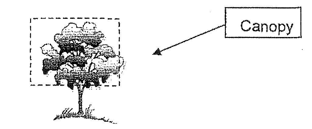
Canopy means the area consisting of a tree's branches in all directions from its trunk, the outer edge of which is the dripline.
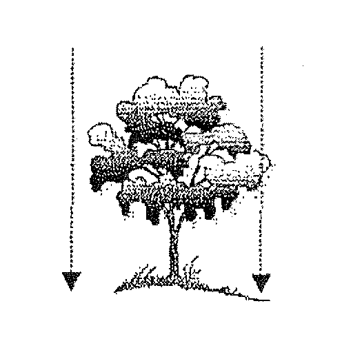
Canopy coverage means the aerial extent of ground within the drip line of the tree.
Canopy species means a native hardwood or softwood tree, not including palms, that provides sufficient canopy to mitigate the Heat Island Effect.
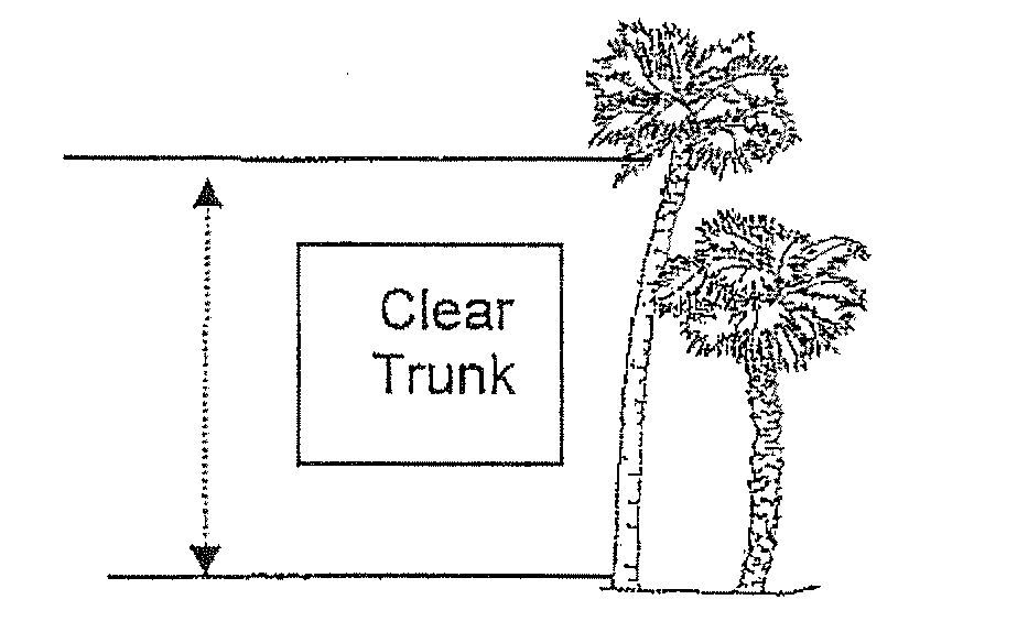
Clear trunk means a measurement from the soil line to the point in the canopy where the trunk caliper begins to taper abruptly. On many palms, this point will lie at the base of the petiole of the third or fourth youngest but fully expanded leaf.
Diameter at breast height (dbh) means the diameter of the trunk of a tree, or the sum of the stems of a multistemmed tree, measured four and one-half feet above natural or development grade.
Director means the director of the Brevard County Natural Resources Management Office or designee.
Dripline means an imaginary vertical plumb line that extends downward from the tips of the outermost tree branches and intersects the ground.
Florida Friendly Landscaping means the utilization of nine principles in landscape design. These nine principles are:
(1)
Right plant, right place;
(2)
Drought tolerant plantings;
(3)
Fertilize appropriately;
(4)
Mulch;
(5)
Attract wildlife;
(6)
Control yard pests responsibly;
(7)
Recycle;
(8)
Reduce stormwater runoff; and
(9)
Protect the waterfront.
Fruit and nut crop means apples, atemoya, annon, avocado, banana, blackberries, blueberries, chestnut, citrus, figs, grapes/muscadine, jackfruit, mango, mayhaw, nectarines, papaya, passion fruit, peaches, pears, pecans, persimmon, plums, quince, raspberry, star apple, sugar apple, tamarind and any other species as deemed appropriate for Brevard County based on chilling requirements, cold hardiness, warm weather adaptability, and variety adaptation.
Greatest extent feasible shall include, but not be limited to, relocation of roads, buildings, ponds, increasing building height to reduce building footprints or reducing vehicular use areas.
Hand-clearing means the use of hand-held tools or hand-held machinery including chainsaws, string trimmers, pruning shears, machetes, or scythes. Hand clearing does not include the use of tractors, push or riding mowers, or other similar machinery.
Heat Island Effect means the increase in temperature in urban areas compared to the surrounding rural lands usually because of reduced vegetative cover or excessive use of impervious surfaces.
Hydrozone means the grouping of plant species with similar watering needs in landscaped areas having appropriate microclimate, soil, and water conditions so that all plants in that area thrive.
Improper pruning means the following:
(1)
Pruning that reduces the height or spread of a tree that has not attained maturity, by altering the dominant stem(s) within the tree crown to such a degree as to remove the natural canopy of the tree; or
(2)
Pruning that leaves stubs or results in a flush cut (a cut too close to the main branch or trunk that does not allow for proper healing); or splitting of limb ends; or
(3)
Peeling or stripping of bark; or the removal of bark to the extent that, if a line is drawn at any height around the circumference of the tree, over one-third of the length of the line falls on portions of the tree where bark no longer remains; or
(4)
Using climbing spikes and hooks, except for purposes of total tree removal or as specifically permitted by the Florida Urban Forestry Council or American National Standards Institute (ANSI A-300); or
(5)
Destroying the natural habit of growth which causes irreparable damage and permanent disfigurement to a tree such that, even with regrowth, the tree will never regain the original characteristics of its tree species, or is a danger to the public or property; or
(6)
Pruning that results in flat-cutting the top or sides of a tree, to sever the leader or leaders or to prune a tree by stubbing off mature wood, except where removal of a branch is necessary to protect public safety.
(7)
Exception: The removal of diseased or dead portions of a tree or the removal of an interfering, obstructing or weak branch shall not constitute improper tree pruning under this section. Interference with or obstruction of streetlights, stop signs or traffic signals is an example of pruning which, if accomplished by the International Society of Arboriculture's pruning standards, American National Standards Institute (ANSI A-300), the Florida Urban Forestry Council, or the University of Florida Cooperative Extension Service's circular Publication No. 853 entitled Pruning Landscape Trees and Shrubs, is not a violation of this division.
(8)
All nonnative noxious plants as defined in this section are exempt from improper tree pruning standards.
ISA means the International Society of Arboriculture.
Land clearing means the removal or cutting down of vegetation, including trees, root-raking on any site, parcel or lot. This does not include allowable mowing, trimming or pruning so as to maintain vegetation in a healthy, viable condition.
Landscaped earth berm means an earthen mound which is not greater than four feet in height and which is sodded and planted with additional vegetation to meet the specifications of the required vegetative buffer classification.
Landscape plan means a plan drawn to an appropriate engineering scale depicting existing and proposed vegetation and prepared by a recognized knowledgeable person.
Landscaping means the preservation or planting of vegetation to enhance the natural or built environment pursuant to the provisions of this division.
Mangrove means any specimen of the species Avicennia germinans (Black Mangrove), Laguncularia racemosa (White Mangrove) or Rhizophora mangle (Red Mangrove).
Mowing means to cut down grass or other herbaceous growth that could be removed using light machinery and does not increase soil compaction or result in significant soil movement. In no event shall mowing increase soil compaction or cause reduction in viability of vegetation.
Native vegetation means those plant species indigenous to Florida as determined by the best available scientific and historical documentation and suitable for planting in Brevard County. The Atlas of Florida Vascular Plants maintained by the institute for Systemic Botany, University of South Florida shall be used as a reference.
NRMO means the Brevard County Natural Resources Management Office or its successor agency.
Nonnative invasive plant, for the purposes of this ordinance, means the "prohibited" species listed in the IFAS (Institute of Food and Agricultural Science—University of FL) Plant List as may be amended.
Pervious area means an area that permits water and air to permeate or penetrate to the roots of existing or planted vegetation. Pervious Areas do not include materials such as compacted marl or clay, pavement, or concrete. Turf block, pavers, or other similar materials and installation techniques that considerably inhibit permeation and penetration of water and air or necessitate root removal or grade change are not considered pervious.
Protected tree means, with the exception of nonnative invasive or undesirable plants, a hardwood tree having dbh of ten inches or greater located on the mainland or Merit Island or having a dbh of 1.5 inches on the barrier island; or a softwood tree, such as a pine, having a dbh of 14 inches or greater or 1.5 inches on the barrier island.
Recognized knowledgeable person means an individual knowledgeable in the identification and evaluation of vegetative resources, such as a forester, biologist, ecologist, horticulturist, Florida registered landscape architect, licensed landscape contractor, certified International Society of Arboriculture arborist, certified nurseryman, Florida Nursery, Growers and Landscape Association Certified Landscape Designer or a person having acceptable experience. Acceptable experience shall include a minimum of a four-year degree in horticulture, ecology, forestry, botany, landscape architecture or a minimum of four years of fulltime experience in the identification and evaluation of vegetative resources.
Redevelopment means renovation of a previously developed, obsolete commercial or industrial parcel of land where reasonably viable use of the buildings or improvements is impaired by reason of deterioration, age, or obsolescence such that the conditions are leading to economic distress or endangering life or property. The term obsolescence includes, but is not limited to, inadequate infrastructure, access or transportation facilities; inadequate provisions for ventilation, light, air, sanitation, drainage or open space: outdated development patterns: and depressed property values.
Re-growth control means removal or trimming of individual plants before the plants reach the onset of flowering.
Restoration plan means a plan submitted to NRMO for review that addresses revegetation, replacement, and/or reestablishment of an area that has been illegally cleared.
Roll back provisions (as specified in section 62-4335) apply only to land clearing activities on lands that are not classified as agricultural land as of October 24, 2006, or that are engaged in agricultural pursuits not classified as bona fide as defined in F.S. § 193.461. For these properties, no new development order or rezoning request may be submitted which would enjoy the current cleared state for a minimum of three years from the commencement of agricultural activity. Specifically, if a new development order or rezoning request is submitted within three years of the commencement of agricultural activity, the submittal shall reflect the pre-cleared conditions of the site and apply the current ordinance to the pre-cleared conditions.
Root protection zone means the pervious area beneath a tree centered on the trunk. For preserved trees, this means the area beneath the drip line of the tree. Root protection zones that include existing impervious area(s) not adversely affecting the viability of the tree, may be acceptable. Pursuant to section 62-4346, the director may consider a waiver to the required root protection zone that does not adversely impact the viability of the tree.
Soil amendment means a replacement or improvement to the soil providing for optimum root and plant growth of vegetative materials.
Specimen tree means a tree considered an important community asset due to its unique or noteworthy characteristics or values. A tree may be considered a specimen tree based on its size, age, rarity or special historical or ecological significance. Specimen trees include large hardwoods (oaks, maples, etc.) or softwoods (pines, cypress, cedars, etc.) in good condition as determined by a recognized knowledgeable person, with a dbh of 24 inches or greater and smaller understory trees (stoppers, hollies, etc.) in good condition with a dbh of ten inches or greater.
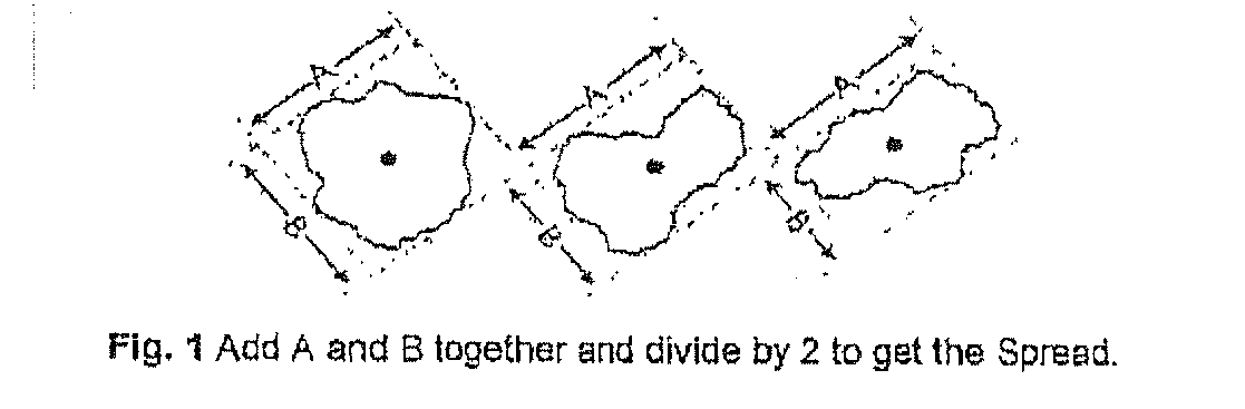
Spread means the crown diameter measured by taking the average of the widest branch spread and the branch spread perpendicular to it.
Tree is a perennial, woody plant that is generally characterized by having a self-supporting trunk with secondary branches. Trees shall be classified as follows:
(1)
Large trees: Average maximum height exceeding 40 feet.
(2)
Medium trees: Average maximum height of 25 feet but less than 40 feet.
(3)
Small trees: Average maximum height of ten feet but less than 25 feet.
Understory means an underlying layer of low native vegetation usually associated with trees.
Undesirable plant means the "Invasive: Not Recommended" or "Caution" species listed in the IFAS (Institute of Food and Agricultural Science-University of Florida) Plant List as may be amended. Plants shall be considered undesirable if not eligible for any use, limited use, or cautioned in any zone—North, central or south.
Vegetative buffer area means an area of undisturbed native vegetation or vegetation established consistent with the surrounding vegetation and soil types. This area shall be located along the perimeter of properties where required by the county.
Vegetation means any plant material, including but not limited to trees, shrubs, vines, herbs and grasses. Vegetation shall be classified as follows:
(1)
Large trees: Average maximum height exceeding 40 feet.
(2)
Medium trees: Average maximum height of 25 feet but less than 40 feet.
(3)
Small trees: Average maximum height of ten feet but less than 25 feet.
(4)
Shrubs, ground cover and vines: Average maximum height of less than ten feet, which completely covers the ground at maturity.
(5)
Palm trees: All heights.
Vegetative communities means a natural association of vegetative plants, including but not limited to both trees and understory.
Vehicular use area means any area used for the purpose of driving, maneuvering, parking, storing, loading or unloading or displaying of motor vehicles and boats, excluding rivers, lagoons, streams, public rights-of-way, and permitted driveways and parking areas for single-family residences. Motor vehicles shall include, but are not limited to, automobiles, trucks, vans, campers and motorcycles.
Viable means plant material exhibiting a healthy and vigorous condition having live foliage out to the tips of all branches and stems. Palms shall have no dead spots or yellowing.
Xeriscapingtm or water-wise landscaping means the utilization of seven principles to conserve water in the landscape. These seven principles are:
(1)
Plan and design;
(2)
Soil analysis and amendment;
(3)
Appropriate plant selection;
(4)
Reduction of turf areas;
(5)
Efficient irrigation;
(6)
Mulching; and
(7)
Proper maintenance.
(Ord. No. 06-55, § 4, 10-24-06; Ord. No. 08-01, § 2, 1-8-08; Ord. No. 09-24, § 1, 9-15-09; Ord. No. 2012-28, § 1, 9-4-12)
Sec. 62-4333. - Applicability.
The provisions of this division shall apply to the unincorporated areas of the county. The requirements to remove nonnative invasive plants at the time of development and control re-growth of such plants in the required area within the site shall apply countywide and prospectively to property on and after May 21, 2002.
(Ord. No. 06-55, § 5, 10-24-06; Ord. No. 08-01, § 3, 1-8-08)
Sec. 62-4334. - Exemptions.
The following land uses and activities shall be exempt from the requirements of this division:
(1)
Pursuant to the Florida Agricultural Lands and Practices Act (F.S. Ch. 163.3162(4)), any activity of a bona fide agricultural use on land classified as agricultural land pursuant to F.S. § 193.461.
(2)
Single-family lots that are 1.25 acres or less, and have a certificate of occupancy, are exempt from the canopy and preservation requirements of this division as long as minimum landscaping requirements as may be required by this division are met and maintained.
(3)
Single-family lots that are more than 1.25 acres but less than or equal to 2.5 acres, and have a certificate of occupancy, are exempt from the canopy and preservation requirements of this division as long as specimen tree and minimum landscaping requirements as may be required by this division are met and maintained.
(4)
The removal of any plant that is a nonnative invasive or undesirable plant as specified in section 62-4332 of this division except within shoreline protection buffers as defined by article X, the Brevard County Coastal Construction Setback Line as defined by article XII, and wetlands as defined by article X. Within these areas, nonnative invasive or undesirable plant removal is exempt if:
a.
Removal does not eliminate, destroy or damage existing native vegetation, wetland habitats, floodplains, required erosion control or stormwater management systems, or endangered or threatened species or their habitats.
b.
Removal does not undermine shoreline integrity or promote increased shoreline or upland erosion.
c.
Removal does not increase sediment or nutrient loading to the adjacent water bodies.
d.
Removal is achieved by hand-clearing.
e.
Roots shall not be removed below ground. Above ground foliage may be cut and stumps treated appropriately.
f.
Herbicides are used to treat the invasive species as approved for aquatic use.
Other methods may be considered pursuant to a Small Scale Land Clearing permit as outlined in Section 62-4338.
(5)
Public or private linear projects and utility corridors developed or maintained by governmental or investor owned regulated utilities that do not require an active development order are exempt if determined to be in the public interest as defined in the Brevard County Comprehensive Plan Glossary. Linear projects include federal, state and county roadways, such as arterial and collector roads, sidewlaks, trails and paths.
(6)
Emergency removal of a dead or seriously damaged tree that poses immediate threat to the health, safety and welfare of the property owners or the general public. Prior to emergency removal, immediate threat should be documented to include but not be limited to (1) photographs of the tree(s) including any areas that may be damaged, diseased, or infested (2) approximate measurements including tree height, spread, dbh, and (3) distance to structure(s) or other immovable target(s) if felled.
(7)
When the proposed land clearing activity is regulated by another state or federal agency and such regulations may pre-empt local regulations.
(8)
The removal of vegetation that has been ordered by the County, pursuant to the provisions of chapter 114, article II. Prior to issuing the order for removal of vegetation pursuant to the provisions of chapter 114, article II, code enforcement shall consult NRMO. If the removal conflicts with the requirements or intent of this division, the county manager or designee shall negotiate a resolution of the conflict.
(9)
The removal of fruit and nut crops unless used to satisfy the landscaping performance standards of this division.
(10)
The removal of vegetation for the purposes of survey or soil testing by such companies licensed to conduct such activities is exempt if:
a.
Removal is limited to the minimum amount required by the activity and shall average no greater than ten feet in width.
b.
Protected and specimen trees are not removed.
c.
Removal does not eliminate, destroy or damage wetland habitats, floodplains, required erosion control or stormwater management systems, or endangered or threatened species or their habitats.
d.
Removal does not undermine shoreline integrity or promote increased shoreline or upland erosion.
e.
Removal does not increase sediment or nutrient loading to the adjacent water bodies.
f.
Roots shall not be removed below ground.
Other methods may be considered pursuant to a small scale land clearing permit as outlined in section 62-4338.
(11)
All lands that have an existing, active land clearing permit or approved, active site plan or building permit shall be exempt from requirements of this division that are inconsistent with the previous ordinance.
(Ord. No. 06-55, § 6, 10-24-06; Ord. No. 07-17, § 1, 4-24-07; Ord. No. 08-01, § 4, 1-8-08; Ord. No. 09-24, § 2, 9-15-09)
Sec. 62-4335. - Non-bona fide agricultural land clearing activities.
(a)
To the extent provided by law, any activity of a bona fide agricultural use on land classified as agricultural land pursuant to F.S. § 193.461 is exempt from the requirements of this division (see section 62-4334). However, land clearing activities on lands not classified as agricultural land pursuant to F.S. § 193.461 shall meet the following requirements:
(1)
NRMO shall be provided with a completed non-bona fide agricultural land clearing application.
(2)
NRMO shall be provided one copy of a completed and signed conservation plan from USDA.
(3)
The proposed agricultural activity shall be a use or activity permitted by the existing zoning of the property.
(4)
Abutting properties shall be notified by the applicant of the proposed land clearing activity. Written verification of the notification shall be required by NRMO.
(5)
Properties where the proposed agricultural activity is not a bona fide agricultural use, shall be subject to the three-year roll-back.
(b)
Proposed bona fide agricultural use land clearing activities on lands that are proposed, but not yet classified as agricultural land pursuant to F.S. § 193.461 shall be subject to the three-year roll-back requirements in this division as defined in section 62-4332.
(Ord. No. 06-55, § 7, 10-24-06; Ord. No. 08-01, § 5, 1-8-08)
Sec. 62-4336. - Penalties and remedies.
(1)
General penalties. Unless permitted through an after-the-fact permit, violations of this division shall be punished pursuant to section 62-5 and section 1-7, Brevard County Code, as amended. Violations of this division are considered irreparable and irreversible in nature.
(2)
Special provisions.
a.
Each quarter acre, or fraction thereof, of land clearing in violation of this division shall constitute a separate violation.
b.
Additionally, if protected trees are cut down on or removed from the site, each tree shall constitute a separate violation.
c.
The board of county commissioners may establish a schedule of fines to be assessed pursuant to section 2-176 by resolution.
d.
The board of county commissioners may establish by resolution both mitigating and aggravating factors to be considered in assessment of a fine imposed pursuant to section 2-176, Brevard County Code.
(3)
Additional remedies. In addition to any fines imposed one or more of the following remedies shall apply:
a.
Properties that are in violation of this division shall not have permits approved nor certificate of occupancy or completion issued pursuant to this division until the violation has been resolved to the satisfaction of the county.
b.
For projects with valid active development order or other land clearing authorization granted under this division, the director may issue a stop-work order immediately on verification of the violation by the county. Work being done contrary to the provisions of this code or in a dangerous or unsafe manner, shall immediately cease. Such notice shall be in writing and shall be given to the owner of the property, or to the owner's agent, or to the person doing the work, and shall state the conditions under which work may be resumed. Where an emergency exists, the director shall not be required to give a written notice prior to stopping the work. A property owner may appeal a stop work order by requesting a special magistrate hearing in writing and filed within 30 calendar days after the decision is rendered by the director. Appeals shall be in a form acceptable to the director.
c.
Restoration, replacement, and/or mitigation shall be required for all violations. The director shall be responsible for reviewing and approving all restoration plans. All restoration plans shall be prepared by a recognized knowledgeable person and shall meet the requirements of an alternative landscape enhancement plan as outlined in subsections 62-4345(2) and (3). Restoration plans shall be submitted with fee as approved by board resolution. Landscape maintenance and/or performance bonds may be required with restoration plans pursuant to sections 62-4341(17) and 62-4343.
d.
All fines shall be deposited in an arbor trust fund. Fines collected shall be dedicated to fulfill the purposes of this section.
e.
Funds collected from fines prior to the enactment of this ordinance that have not been committed shall be allocated to the arbor trust fund.
(Ord. No. 06-55, § 8, 10-24-06; Ord. No. 08-01, § 6, 1-8-08; Ord. No. 09-24, § 3, 9-15-09)
Sec. 62-4337. - Permit application requirements and review process.
Unless specifically exempted by section 62-4334, a permit shall be required prior to any land clearing activities. NRMO shall provide application forms for those properties not part of an application for an active development order, such as survey, soil, and engineering testing and small scale land clearing permits. If a property is the subject of a building permit, subdivision or site plan permit, the information required in this section shall be provided in the appropriate application. Prior to submittal of the plans required in this section, the applicant is strongly encouraged to meet with the county to discuss the requirements of this division. Except for single-family lots, all landscape and land clearing plans shall be prepared by a recognized knowledgeable person. All plans submitted for landscaping and land clearing permits that are part of a subdivision or site plan application, shall be approved in writing by a professional civil engineer, professional architect or landscape architect, registered in the State of Florida and proficient in site design.
(1)
Application requirements:
a.
Name, address and phone number. If the applicant is not the property owner of record, written authorization from the property owner is required.
b.
Legal description of the property.
c.
Location map showing the property's relationship to nearby roads and landmarks.
d.
Boundary survey drawn to scale not to exceed one inch to 100 feet, depicting all existing and proposed structures, lot dimensions, and location and amount of clearing proposed.
e.
Survey of all existing protected trees and canopy coverage, and identified to species and dbh. For properties greater than five acres, an alternative methodology of locating individual trees may be used if the methodology is approved by NRMO. The tree survey shall be prepared by a professional land surveyor registered in the State of Florida.
f.
Depiction of existing and proposed tree canopy boundaries.
g.
The zoning classification and land uses for the property and abutting properties.
h.
Wetlands and their boundaries that have been delineated pursuant to Chapter 62-340, Florida Administrative Code, as amended.
i.
Proposed use of the property.
j.
Aerial photograph depicting location of proposed activities on the property.
k.
If the application is for approval of a landscape plan as part of a building permit, subdivision or site plan application, the following additional information is required on the plans:
i.
All parking areas.
ii.
All other vehicular use areas, access aisles and drives.
iii.
Natural and manmade water bodies.
iv.
On-site sewage disposal systems or central sewer lines.
v.
Location of proposed source of irrigation supply.
vi.
Size, number and species of all required landscape materials.
vii.
Description and location of all existing trees and native vegetation and vegetative communities to be preserved.
viii.
All existing and proposed utility and drainage easements, poles or structures.
ix.
All applicable setback and buffers as may be required by article X and XII of this chapter.
x.
Limits of fill, excavation, and clearing with applicable square footages.
l.
Any other information that is necessary to determine compliance with the County's land development regulations.
(2)
Review process for applications other than building permits:
a.
Upon receipt of the application and fee, NRMO shall review the application within 15 calendar days to determine that all required information has been submitted and is sufficient for review purposes. This review period may be extended by NRMO due to unusual circumstances, including but not limited to, natural disasters resulting in an increased workload. The applicant shall be notified of the deficient items. Upon submittal of the deficient or missing information by the applicant, NRMO shall review the application to determine that the requested information has been provided. If the requested information has not been provided or is insufficient, the applicant shall be notified that no further review will be performed by NRMO until the requested information is provided or sufficient.
b.
Once the application has been deemed complete or the applicant has notified NRMO in writing that no further information will be provided, NRMO shall review the application within 15 calendar days to determine its compliance with the performance standards contained in this division and shall either approve or deny the permit application. This review period may be extended by NRMO due to unusual circumstances, including but not limited to, natural disasters resulting in an increased work load.
(3)
Building permit applications shall be processed and reviewed through the building code office procedures.
(Ord. No. 06-55, § 9, 10-24-06; Ord. No. 08-01, § 7, 1-8-08; Ord. No. 09-24, § 4, 9-15-09)
Sec. 62-4338. - Land clearing performance standards.
Unless specifically exempted by section 62-4334, all land clearing activities shall meet the performance standards for the applicable activity listed in this section. Land clearing activities for lands with existing certificates of occupancy or completion shall meet the minimum standards in sections 62-4338 and 62-4339 in perpetuity except as allowed by this division and as approved by NRMO. Any land clearing activities shall be in compliance with chapter 62, articles II, X, XII, and XIII of the county code. All land clearing activities shall comply with the following performance standards:
(1)
A land clearing permit shall expire 90 days from the date of issuance for single-family lots and shall expire concurrently with the construction permit for subdivisions and multifamily, commercial, institutional, public and industrial projects. A reasonable extension not to exceed 60 days may be authorized by the Director for single-family residential provided appropriate justification warrants, such as unusual weather, seasonal situations or inability to obtain permits from other agencies.
(2)
The applicant shall post the land clearing permit on the affected property in such a manner as to be visible from an abutting road. The land clearing permit shall remain posted on the affected property during all applicable land clearing activity. It is the responsibility of the applicant to maintain the land clearing permit in a clearly visible manner at all times.
(3)
The trimming, pruning, maintenance or removal of Mangroves shall be consistent with applicable federal and/or state regulations, as applicable. Permits from appropriate agencies shall be provided for verification prior to the issuance of a land clearing permit by the county.
(4)
Vegetative buffers or other ground covers that retard erosion must be established or installed within seven days after final grade of a subdivision, commercial, industrial or multifamily project has been obtained or within 14 days after the last construction activity has occurred. Erosion and sedimentation control measures shall be in compliance with the best management practices as outlined in the Florida Stormwater, Erosion, and Sedimentation Control Inspectors Manual. 2005. Florida Department of Environmental Protection and Florida Department of Transportation, as may be amended and as required by Chapter 62-25, Florida Administrative Code, as may be amended.
(5)
Small scale land clearing permit. Small scale land clearing permits shall be considered an administrative waiver for land clearing.
a.
The owner of the property proposed to be cleared, or the authorized agent, shall submit an application for the proposed land clearing activity to the county, on such form as provided by the county. The small scale land clearing permit shall expire 30 days from the date of issuance. A reasonable extension not to exceed 60 days may be authorized by the director provided appropriate justification warrants, such as unusual weather, seasonal situations or inability to obtain permits from other agencies.
b.
The applicant shall post the small scale land clearing permit on the affected property in such a manner as to be visible from an abutting road. The small scale land clearing permit shall remain posted on the affected property during all applicable land clearing activity. It is the responsibility of the applicant to maintain the small scale land clearing permit in a clearly visible manner at all times.
c.
Only one small scale land clearing permit shall be approved per calendar year for any property, regardless of ownership.
d.
Up to 50 percent of the understory of the area of the site or one acre, whichever is less, can be approved for removal.
e.
Up to ten percent native canopy of the area of the site can be approved for removal.
f.
Specimen trees can not be approved for removal.
g.
Land clearing approval shall be based on the results of a site visit by NRMO and documentation as submitted by the applicant. NRMO shall consider whether the property meets basic landscape, specimen, and tree preservation requirements, reason(s) for removal and certified ISA arborist reports, if available. Verifiable safety and welfare issues, removal other than hand-clearing in environmentally sensitive areas, and habitat/fire management will be considered under small scale land clearing permit. If tree(s) are approved for removal, NRMO shall assign appropriate replacement for removed tree(s) per subsection 62-4341(19).
(6)
If the project is not completed prior to the expiration date of the active development order or other land clearing authorization granted under this division, the cleared areas shall be vegetated to the minimum canopy preservation, tree preservation and landscaping standards.
(7)
Land clearing shall include any intentional or negligent act or lack of protective measures that affects viability, including, but not limited to:
a.
Improper pruning.
b.
Damage inflicted upon the root system by the application of toxic substances, including herbicides, solvents, oil, gasoline, and diesel fuel.
c.
Damage caused by the operation of machinery, including but not limited to, soil compaction and trunk or root injury.
d.
Damage caused by the storage of materials.
e.
Damages from injury which results or is likely to result in pest infestation.
f.
Change in natural grade to the root system through excavation or filling.
(Ord. No. 06-55, § 10, 10-24-06; Ord. No. 08-01, § 8, 1-8-08; Ord. No. 09-24, § 5, 9-15-09)
Sec. 62-4339. - Canopy and tree preservation performance standards.
All development shall meet the performance standards listed in this section. Single-family lots two and one-half acres or less are exempt from subsections 62-4339(2)(c) through (i) below. Single-family lots greater than one and one-fourth acres, shall comply with specimen tree requirements.
Additional incentives for increased canopy preservation and landscaping are located in section 62-4344, entitled incentives for increased canopy and tree preservation and increased landscaping.
(1)
For platted subdivisions, canopy and tree preservation requirements will be based on the entire area of alteration of the subdivision, including lots and demonstrated at the time of plat review. However, canopy shall not be preserved on individual lots unless part of a contiguous, continuous area of canopy with sufficient protective language, noted on the approved landscape plan, to prohibit activities that are detrimental to the perpetual preservation of the area. The general landscaping requirements shall be demonstrated for common areas of the subdivision (including but not limited to common use, recreational structures, open spaces tracts, and buffers) at the time of plat review. Individual properties within the subdivision shall be reviewed for compliance with general landscaping requirements during the building permit process, if not addressed prior to certification of completion. If all tree preservation requirements and general landscaping requirements are met at the time of development based on area of alteration including individual lots, those lots will be exempt from review for compliance with general landscaping requirements during the building permit process. All required landscaping shall be maintained in accordance with section 62-4343.
(2)
The amount of canopy coverage preservation on each property shall be determined using the following standards based on the property's area of alteration, commercial, institutional, and industrial parcels three acres or less shall not be required to meet minimum canopy preservation criteria below:
a.
No more than 50 percent of planted trees shall be of any one genus (i.e. Quercus, Pinus, Acer, etc.) to encourage biodiversity and decrease impacts from disease.
b.
A 25 percent reduction in the minimum canopy preservation and canopy achieved by planted trees of the area of alteration shall be given for canopy, and understory if present, preserved in a contiguous, continuous tract on-site, as opposed to individual trees. Canopy, and understory if present, shall meet 100 percent of the required total canopy percentage of the area of alteration to be permitted the 25 percent reduction. For sites between ten and 25 acres in size, two contiguous, continuous tracts will be allowed. For sites between 25 and 100 acres in size, three contiguous, continuous tracts will be allowed. For every 100 acres, or fraction thereof, thereafter, one additional contiguous, continuous tract will be allowed. No credit shall be given to preservation areas less than 15 feet in width, nor shall they be considered to make separate preservation tracts contiguous or continuous. This option shall not be available for properties with scattered canopy. For the purposes of canopy preservation, existing undisturbed vegetated understory in excess of an average of 24 inches in height associated with existing trees shall be considered as preserved canopy area.
For properties where contiguous, continuous preservation is appropriate, the following chart shall apply:
c.
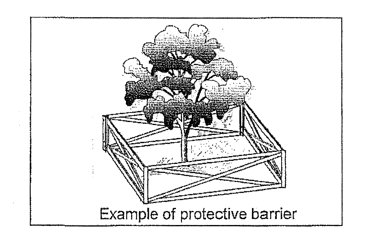
Preserved trees shall have protective barriers during construction which encompass the root protection zone. The protective barrier must be adequate to make a minimum 30-inch tall, visual, durable barrier. Acceptable barrier materials include but are not limited to silt fence (nontrenched), orange mesh fencing, wood barrier, lath and tape/rope, staked hay bales or other barrier as provided by the design consultant on the development plan and approved by NRMO. Protective barriers shall be placed no more than two and one-half feet inside established root protection zone prior to any land clearing, alteration, or commencement of construction including grading and filling. For all development, except single-family lots not platted as part of a subdivision, it shall be the responsibility of the applicant/owner to schedule an inspection with NRMO or provide a notarized statement from a recognized knowledgeable person, professional land surveyor registered in the State of Florida, professional civil engineer, or professional architect, registered in the State of Florida and proficient in site design that protective barriers have been correctly installed. Failure to schedule an inspection or provide the notarized statement prior to any land clearing, alteration, or commencement of construction including grading and filling, shall constitute a violation of this division and may be subject to stop work order and other penalties and remedies pursuant to section 62-4336. The only allowable activities prior to filing the notarized statement with NRMO shall be those activities necessary for compliance with Stormwater Pollution Prevention Plans (SWPPP) and Florida Department of Environmental Protection (FDEP) National Pollutant Discharge Elimination System (NPDES).
d.
Credits for canopy preservation greater than the minimum required shall be given in accordance with the provisions in Section 62-4344.
e.
Canopy preservation areas in new subdivisions, industrial, institutional, public, or commercial developments shall be within separate tracts, declaration of covenants, recorded plat condition, or with sufficient protective language, noted on the approved landscape plan, to prohibit activities that are detrimental to the perpetual preservation of the area.
f.
Activities permitted within canopy preservation areas include landscaping, passive recreation areas, fences, boardwalks, trails, decks and paths as long as these areas are pervious and not within the root protection zone of any tree, except as permitted herein, and do not necessitate the removal of vegetation, except as approved by NRMO. Decks, boardwalks, and trails may not exceed 25 percent of the total root protection zone. Habitat management practices, such as prescribed fire, may occur within the root protection zone. In no event shall a root protection zone be less than 100 square feet for planted or preserved trees and 25 square feet for planted or preserved palms.
g.
Credit for canopy preservation shall not be given for areas excluded from the area of alteration.
h.
Canopy coverage achieved through the use of planted trees shall be credited at 25 percent of the projected canopy at maturity of the species as specified in appendix C. If the actual canopy of the planted tree is larger than 25 percent of the mature canopy size, actual canopy coverage of the particular tree shall be credited.
i.
Existing trees that are successfully relocated elsewhere on the property can be credited towards the canopy coverage requirements but shall not be credited towards preservation requirements.
j.
If existing canopy is less than the listed minimum canopy preservation requirement, the existing canopy percentage shall be used in lieu of the minimum canopy preservation requirement. Total canopy percentage shall be recalculated using the new minimum preserved canopy plus the required planted canopy.
k.
Vegetation defined as non-native invasive or undesirable plants pursuant to section 62-4332 shall not be credited towards fulfillment of preservation or planting requirements.
l.
Plantings in areas that may be potentially cleared in the future or where planting will impede maintenance operations cannot be credited towards landscaping and preservation and is prohibited.
m.
For external expansion projects, existing trees that are determined to be viable by an ISA certified arborist may be credited toward canopy preservation if no additional impervious impact is proposed within the root protection zone of the tree.
(3)
All development subject to this division shall preserve protected trees unless specifically exempted herein.
(4)
Where on-site canopy and tree preservation performance standards cannot be met due to adverse site conditions, the process and standards in section 62-4345 shall be applied.
(Ord. No. 06-55, § 11, 10-24-06; Ord. No. 08-01, § 9, 1-8-08; Ord. No. 09-24, § 6, 9-15-09; Ord. No. 2010-01, § 1(Attch. B), 1-12-10)
Sec. 62-4340. - Tree root protection and planting chart.
If an existing tree meets the tree root protection and planting chart requirements, the entire canopy shall count toward the preserved canopy. This includes canopy over impervious surfaces.
For palm trees, the root protection zone area shall be 25 square feet and have a radius no less than two feet.
(Ord. No. 09-24, § 7, 9-15-09)
Sec. 62-4341. - Landscaping performance standards.
Unless specifically exempted by section 62-4335 or otherwise provided for by resolution, all development shall meet the performance standards listed in this section. Single-family lots less than 2.5 acres but greater than 1.25 acres are exempt from removal and replacement criteria as outlined in subsection 62-4341(18), but must preserve or relocate specimen trees on-site to the greatest extent feasible. Single-family lots 1.25 acres or less are exempt from removal and replacement criteria as outlined in subsection 62-4341(18), including specimen tree criteria. Special landscaping overlays may be enacted by county ordinance.
(1)
No certificate of occupancy or certificate of completion shall be issued by the county without full satisfaction of the following landscaping requirements by the applicant in accordance with the approved development order.
(2)
Satisfaction of the landscaping standards shall be achieved through the preservation of existing native vegetation to the greatest extent feasible. When the minimum landscaping standards cannot be achieved through preservation, plantings of new vegetation shall be required to meet the standards.
(3)
All development shall meet the following standards through preservation, plantings, or a combination thereof:
All plantings shall be at least Florida No. 1 grade as defined by the Grades & Standards for Nursery Plants. 1998. Division of Plant Industry, Florida Department Agriculture and Consumer Services, as may be amended. Fruit and nut crops, appropriate to Brevard County, shall be considered for credit towards required plantings provided size specifications, as outlined above, are met.
(4)
At least 50 percent of trees required for preservation and planting shall be of native species. At least 50 percent of shrubs and groundcovers shall be native species or recommended by "Waterwise Florida Landscapes", 2004. Florida Water Management Districts, as may be amended. vegetation defined as nonnative invasive or undesirable plants per section 62-4332 shall not be credited towards fulfillment of preservation or planting requirements.
(5)
Road frontage and vehicular use areas. This section does not apply to single-family lots, parcels or lots platted as part of an approved subdivision. For residential subdivisions and commercial, public, institutional, or industrial projects, the following specific locational landscape requirements shall be satisfied:
a.
Type B, roadway buffer in accordance with the vegetative buffering requirements of this division.
b.
To mitigate the Heat Island Effect, vehicular use areas shall have appropriate shading.
i.
For each ten parking spaces, one planted or preserved tree shall be provided and distributed throughout the parking area. Plantings may be clustered to promote healthy trees and sustainable design. For all vehicular use areas, 25 percent of the required trees shall be large species of minimum size. Medium size tree species shall also meet minimum size requirements. Small species shall constitute a maximum 25 percent of the required trees and shall meet minimum size specifications.
ii.
Parking spaces immediately abutting a landscape buffer required pursuant to section 62-4341 or vegetated lands of comparable quality subject to a recorded plat condition. Declaration of covenants, or with sufficient protective language, noted on the approved landscape plan, to prohibit activities that are detrimental to the perpetual preservation of the area, shall be exempted from this subsection.
iii.
Where bus, recreational vehicle, boat, motorcycle, golf cart, or any other nonstandard spaces are provided, a landscape island twice the size of each nonstandard space shall be provided for each ten nonstandard spaces. There shall be one planted or preserved tree (minimum 2.5 inches caliper) for every 300 square feet contained within the landscape island.
c.
For commercial and industrial uses, for each 400 square feet of vehicular use area other than parking, there shall be an additional ten square feet of landscaping. The placement of this must be in association with the vehicular use area and shall be integrated within the vehicular use area in a manner compatible with vehicular movement.
(6)
Additions or modifications to existing structures. Any applicant for an active development order for an external expansion, modification or addition to structures existing on the property, where the expansion or addition shall increase the applicable floor area of the structure at least 50 percent for single-family residential dwellings and 25 percent for all other development shall comply with all landscaping requirements specified in this division. Where demolition of existing buildings or creation of separate buildings is being proposed or has occurred, these areas shall meet current performance standards. Where vehicular use areas are being expanded or replaced, such areas shall be required to meet the standards in subsection 62-4341(5) as applicable. Where expansion for all development, excluding single-family residential dwellings, is visible from the road from any angle, pavement or concrete cut-outs shall be required to satisfy buffer and parking lot landscape islands to mitigate the Urban Heat Island Effect. Buffer requirements shall follow those outlined in section 62-4342 where feasible. Parking lot landscape island requirements shall follow those outlined in subsections 62-4341(5)(b) and (c) where feasible. Alternative landscape enhancement plans shall not be required for cut-outs that can not feasibly meet the strict application of the requirements, landscape plans shall be reviewed as standard landscape and land clearing applications.
(7)
Standards for plant materials. All plant materials utilized to satisfy the landscaping requirements in this division shall conform to the standards for Florida No. 1 grade as defined by the Grades & Standards for Nursery Plants. 1998. Division of Plant Industry, Florida Department of Agriculture and Consumer Services, as may be amended.
(8)
Minimum size of newly planted trees. Trees used to fulfill the landscaping requirements in this division, shall meet the following overall height, caliper and spread requirements, at the time of planting, by species classification:
a.
Large species: Twelve feet tall with 2.5-inch diameter (caliper) minimum and five-foot spread.
b.
Medium species: Ten feet tall with 1.5-inch diameter (caliper) minimum and three-foot spread.
c.
Small species: Eight feet tall with one-inch diameter (caliper) minimum and two-foot spread.
d.
Palms: Ten feet of clear trunk.
For single-family residential lots, eight feet tall, one inch minimum caliper, three-foot spread trees may be substituted on a 3:1 basis for each required large species tree.
(9)
Use of palms. Preservation of palms, or the planting of palms, may only be used to satisfy up to 25 percent of the required landscaping unless barrier island conditions prohibit the use of less salt-tolerant plants.
(10)
Use of synthetic plants. In no event shall synthetic plants such as manmade, plastic, rubber or silk plants be used for landscaping credits. Removal of existing landscape materials for installation of synthetic plants is prohibited.
(11)
Selection of plant materials. The selection of new plant materials or preservation of existing vegetation to satisfy the landscaping or preservation requirements in this division shall be compatible with the proposed use of the site, type of soils, hydroperiods, climate, water quality and other general environmental concerns.
(12)
Location of plant materials. The vegetation utilized to satisfy the landscaping requirements in this division shall be located on the site in such a manner that the vegetation shall:
a.
Not interfere with drainage systems or utility services or create an unsafe visual clearance or other safety or maintenance hazard. This does not prohibit the appropriate plantings in stormwater retention or detention areas or within utility easements.
b.
Be placed in a manner that will not interfere with vehicular or pedestrian traffic and circulation or visibility.
c.
Be protected from vehicular encroachment.
(13)
Planting in homeowner association (HOA) owned property/tracts/landscape easements/right-of-way. Single-family homeowners may plant required landscaping in immediately adjacent homeowner association owned property/tracts/landscape easements/right-of-way. These plantings shall be credited toward satisfaction of landscaping requirements provided that:
a.
The plantings are part of a landscape plan approved as part of the final plat for the development or written agreement such as HOA documents shall be provided that demonstrate that such planting are permissible. Homeowner must provide written documentation verifying HOA approval of proposed plantings.
b.
The area of planting is included in the area of alteration calculation.
(14)
Site preparation. Before landscape installation, the applicant shall provide documentation that the soils are suitable for the prescribed plantings. Any soil amendments shall be preformed in accordance with accepted industry standards. For multifamily, institutional, public, residential subdivisions, commercial and industrial development, certification by a registered or certified landscape professional will be required as proof that such soil amendments have been made prior to the issuance of the certificate of occupancy or completion.
(15)
Prior to the issuance of the certificate of occupancy or certificate of completion for single-family, subdivision, multifamily, commercial, institutional, public and industrial projects, and at the time of development of government-owned lands, all nonnative invasive plants, as defined in this division, shall be removed. For lots greater than five acres, the requirement to remove and control re-growth of nonnative invasive plants applies to five contiguous acres to and including the area of alteration as defined in section 62-4332. After the issuance of the certificate of occupancy or certificate of completion, re-growth of nonnative invasive plants shall be controlled in perpetuity. The requirements to remove nonnative invasive plants at the time of development and control re-growth of such plants in the required area within the site shall apply countywide and prospectively to property after October 24, 2006. Australian pine may be retained on-site with a waiver from the director if maintained at its current extent.
(16)
For projects using Xeriscaping tm or water-wise landscaping, the following criteria shall be met:
a.
Landscape plans must clearly demonstrate that plant species are grouped by hydrozones (i.e., natural areas, drought tolerant areas, and oasis areas). In addition, the landscape must be installed as detailed in the landscape plan.
b.
Property must be 100 percent free of nonnative invasive and undesirable plants.
c.
A layer of at least three inches of nonsynthetic inorganic or organic mulches must be present. The use of mulch containing Chromated Copper Arsenate (CCA) is expressly prohibited. NRMO has the authority to inspect and require testing of newly placed mulch material for CCAs and the responsibility to deny final approval of a landscape plan if mulches containing CCAs are used.
d.
No more than 50 percent of the landscape shall be equipped with high volume (micro) irrigation delivery systems.
e.
Soil analysis and letter confirming appropriate amendments must be submitted to NRMO.
f.
Property must be free of nuisance vegetation as defined in chapter 114, article II.
g.
Landscape must be appropriately maintained. Improper pruning shall not constitute appropriate maintenance. In no event shall overgrowth as defined in chapter 114, article II be allowable as Xeriscaping tm or water-wise landscaping.
h.
Consistent with Florida law, the automatic irrigation system, if any, must be equipped with an automatic rain sensor shut-off device.
i.
If criteria in [subsections] a. through h. are met in their entirety, NRMO may provide special recognition in the form of a listing on the Brevard County web site or via signage to be displayed in the landscape and a 50 percent reduction of the required shrubbery square footage per acre of area of alteration shall be credited.
j.
Any yard conforming to the Florida Native Back Yard Program or any similar program officially endorsed by the State of Florida shall not constitute a nuisance.
(17)
Performance bond. When the county manager or designee determines that circumstances indicate that the planting of trees or vegetation prior to the issuance of a certificate of occupancy or certificate of completion would not be prudent, for reasons such as an improper time of year for the planting of trees, the applicant may post a performance bond with the board of county commissioners, in a form acceptable to the county. The performance bond, if posted, shall be in an amount of no less than 125 percent of the estimated cost of all trees and vegetation to be planted, plus labor, pursuant to the requirements of this division. The performance bond shall be received and accepted by the county prior to the issuance of the certificate of occupancy or certificate of completion.
(18)
Replacement criteria. Specimen and protected trees shall be preserved or relocated on-site to the greatest extent feasible. Where the site, parcel or lot has met canopy coverage requirements as outlined in section 62-4339, without the use of an alternative landscape enhancement plan, site, parcel or lot shall not be subject to replacement criteria with the exception of specimen trees. Where the removal of a protected or specimen tree is necessary below the minimum canopy preservation percentage required per section 62-4339, an alternative landscape enhancement plan shall be required that meets the criteria in section 62-4344.
(Ord. No. 06-55, § 12, 10-24-06; Ord. No. 08-01, § 10, 1-8-08; Ord. No. 09-24, § 8, 9-15-09)
Sec. 62-4342. - Landscape buffers.
The purpose of the vegetative buffering requirements set out in this section is to provide visual and physical screening and buffering between potentially incompatible uses and to reduce the effects of glare, noise and incompatible activities, to include commercial, institutional, public, and industrial uses when they abut existing residential uses.
(1)
Type A, compatibility buffer. Where a fence or wall is required by article VI of this chapter, the Type A buffer, as defined in this subsection, may be utilized in lieu of the required fence or wall. This buffer classification shall be used to separate commercial, institutional, public or industrial uses from residential uses. The Type A buffer shall be completely opaque from the ground up to a height of at least six feet, except where located within 25 feet of a road, where it shall be four feet in height. In conjunction with this buffer, a minimum 20-foot vegetated area shall be provided. There shall be no parking or structures other than permitted signage located within this vegetated area.
a.
The opaque buffer may utilize a masonry wall, wood fence, landscaped earth berm, planted or existing vegetation or any combination thereof that maintains a completely opaque buffer.
b.
Location of fences and walls. Where a fence or wall is used to fulfill the screening requirements within a vegetative buffer, it shall be located one foot inside of the property line that abuts the residential zoning. When an impediment such as a drainage easement, ditch or water body runs along a property line, an administrative waiver may be granted by the director to allow the masonry wall or fence to be placed along the edge of the ditch or water body instead of on the property line. Where there are existing trees within the buffer area, the fence or wall shall be located so as to preserve the trees.
(2)
Type B, roadway buffer. This buffer classification shall be required for all development excluding individual single-family homes not within platted subdivisions. This buffer shall be landscaped, be located adjacent to any public road and have a minimum width of 15 feet. There shall be no parking or structures other than permitted signage located within this vegetated area.
(3)
Planting requirements. The planting requirements for the vegetative buffer areas shall be consistent with Appendix B as amended, and shall be credited toward the overall landscaping requirements. Minimum buffering and landscaping of vehicular use areas shall be met regardless of other requirements.
(Ord. No. 06-55, § 13, 10-24-06; Ord. No. 08-01, § 11, 1-8-08; Ord. No. 09-24, § 9, 9-15-09)
Sec. 62-4343. - Maintenance and inspections.
(1)
Except as allowed by subsection 62-4341(17), the health and viability of all required landscape materials on the site, whether preserved or newly planted, must be maintained through proper care or replacement in perpetuity after issuance of the certificate of occupancy, certificate of completion, or restoration as may be required to resolve a code violation.
(2)
For multifamily, residential subdivisions, commercial, institutional, public and industrial projects, failure to have viable landscape materials or preserved areas consistent with the approved landscape plan after of the issuance of the certificate of occupancy or certificate of completion shall constitute a violation as described under section 62-4336. Failure to remove nonnative invasive plants and control re-growth prior to the final landscaping inspection is a violation of this division and shall be enforced pursuant to section 62-4336. The county reserves the right to enter property to make the necessary inspections.
(3)
An on-site inspection shall be conducted prior to the approval of the land clearing permit.
(Ord. No. 06-55, § 14, 10-24-06; Ord. No. 08-01, § 12, 1-8-08; Ord. No. 09-24, § 10, 9-15-09)
Sec. 62-4344. - Incentives for increased canopy and tree preservation and increased landscaping.
To encourage the preservation of canopy, protected trees and specimen trees, the following incentives are provided. Incentives shall not in any case be used to offset the requirements in subsection 62-4341(5) and section 62-4342 except as authorized in [subsection] (3)(d) of this section.
(1)
Tree preservation. A preserved/relocated native tree in excess of the minimum required under sections 62-4339, 62-4341, and 62-4342 that meets the standards below may be substituted for any of the trees required by the landscaping requirements of this section.
a.
Credit ratio: Preserved/relocated native trees shall be credited for required trees, pursuant to the following ratio:
b.
Trees ineligible for credit ratio: No credit shall be granted for trees:
1.
Defined as nonnative invasive plants per section 62-4332.
2.
Palms of any species.
3.
Dead, dying, diseased or insect infested.
4.
Damaged from improper pruning defined in section 62-4332.
5.
For preserved trees, where root protection zones have been impacted in conflict with section 62-4340.
6.
Where native understory, if present, has not been preserved within the root protection zone.
7.
For relocated trees, where relocation techniques have not been approved by NRMO as part of approved landscape plan.
(2)
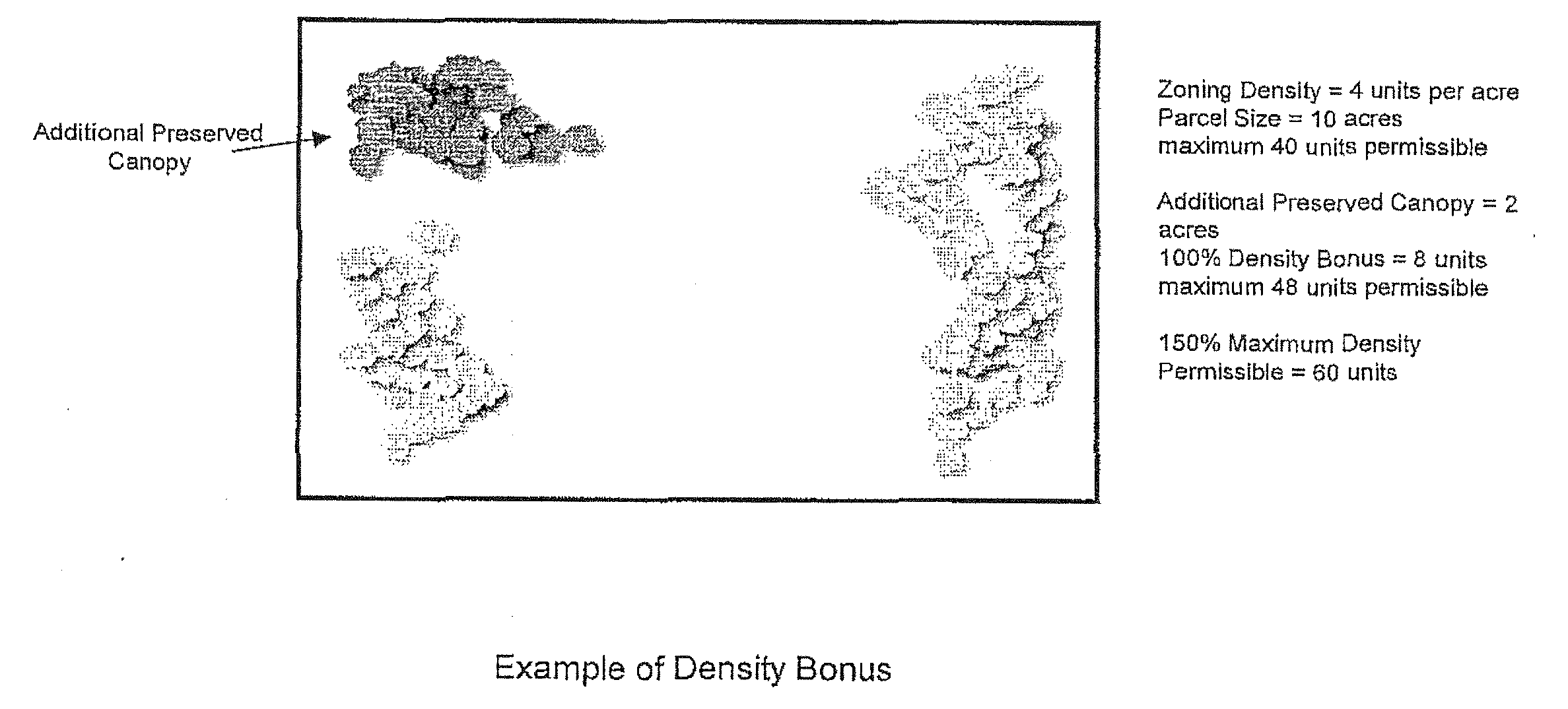
For preservation of canopy greater than the minimum total canopy required for the land use and its associated root protection zone, a density bonus equal to 100 percent of the excess canopy preservation area shall be granted not to exceed 150 percent of the density assigned to the property. If other density transfers or bonuses are used in combination with this incentive, the overall density of the property shall not exceed 150 percent of that permitted by the zoning district.
(3)
Preservation of vegetation of special concern. In addition to credit for additional preservation of trees or canopy, landscaping credit may be accumulated for the preservation on the site of any of the following vegetation of special concern that is in a healthy condition:
a.
For each 100 square feet of land containing no dimension less than ten feet, that is predominately vegetated by rare, endangered or threatened plant species as listed in Volume 5, Plants, Rare and Endangered Biota of Florida, University Presses of Florida, Gainesville, Florida, and as listed in F.S. § 581.185, the property owner shall receive 200 square feet of landscape credit for that class of vegetation. No species of Mangroves shall be eligible for points under this subsection.
b.
For each 100 square feet of vegetation classified as hardwood hammock, barrier island scrub, cypress domes or sand pine scrub associations preserved on the site, total tree planting requirements shall be reduced by five percent when the vegetative community is preserved intact; and the vegetative community preserved comprises an area of no less than 100 square feet with no dimension less than ten feet. Where the reduction includes replacement inches, each 100 square feet of preservation shall not exceed a value of 20 inches dbh replacement inches as required per subsection 62-4331(18).
c.
For each 100 square feet of vegetation classified as barrier island association preserved on the site, landward of the county coastal setback line, total landscaping requirements shall be reduced by five percent when the vegetative community is preserved intact and the vegetative community preserved comprises an area of no less than 100 square feet with no dimension less than ten feet. Where the reduction includes replacement inches, each 100 square feet of preservation shall not exceed a value of 20 inches dbh replacement inches as required per subsection 62-4331(18).
d.
For each 100 square feet of native vegetation preserved adjacent to a scenic vista or public roadway classified as arterial or collector, Type B, roadway buffer requirements may be waived for the equivalent area if the native vegetative community is preserved and maintained intact and the vegetative community preserved comprises an area of no less than 100 square feet with no dimension less than ten feet.
e.
If Mangroves do not presently exist on shorelines contiguous to estuarine waters and are planted on four-foot centers, the requirements for shrubs may be reduced accordingly. The minimum size of newly planted Mangroves shall be fully rooted three-gallon container plants with a minimum height of 15—18 inches.
(Ord. No. 06-55, § 15, 10-24-06; Ord. No. 08-01, § 13, 1-8-08; Ord. No. 09-24, § 11, 9-15-09)
Sec. 62-4345. - Alternative landscape enhancement plans, mitigation, and compensation.
In cases of adverse site conditions or hardship, alternative landscape enhancement plans may be considered. Such plans shall be signed and sealed by a landscape architect registered in the State of Florida except for individual single-family homes not part of a platted subdivision. Alternative landscape enhancement plans may consist solely or a combination of on-site preservation, landscaping enhancement, on-site mitigation, off-site mitigation and compensation. In all cases, the standards for alternative landscape enhancement plans shall be, in combination or as stand-alone solutions, on-site preservation of existing native vegetation, on-site landscape enhancement, on-site mitigation, off-site mitigation, and compensation.
(1)
Alternative landscape enhancement plans are intended to provide increased flexibility for sites demonstrating existing adverse site conditions. Alternative landscape enhancement plans shall meet the following performance standards on-site:
a.
Results in landscaping that exceed specific goals and intent of landscape regulations.
b.
Provides sufficient tree plantings to achieve a tree canopy equal to five percent greater than the minimum required at the time of development.
c.
Provides heat island mitigation and landscape buffers, as required by the landscaping code.
d.
Replaces protected trees with new plantings of canopy species trees at a rate of 25 percent of the cumulative diameter at breast height (dbh) of the trees removed, using a minimum 50-percent four-inch caliper plantings. The remaining 50 percent replacement plantings shall be a minimum two and one-half inch caliper plantings. Of the two and one-half inch caliper plantings, up to 20 percent may be non-native. In no event shall undesirable or non-native invasive plantings be used for replacement.
e.
Specimen trees shall be preserved or relocated on site to the greatest extent feasible. Specimen trees that can not be preserved or relocated on site shall be subject to replacement with new plantings of canopy species trees at a rate of 33 percent of the cumulative diameter at breast height (dbh) of the trees removed, using a minimum four-inch caliper plantings. The remaining 50 percent replacement plantings shall be a minimum two and one-half inch caliper plantings. Of the two and one-half inch caliper plantings, up to 20 percent may be non-native. In no event shall undesirable or non-native invasive plantings be used for replacement.
f.
Where scrub oaks (Quercus myrtifolia, Q. chapmanii, Q. inopina, Q. virginiana var. maritime, Q. geminata) are removed from a site, parcel or lot, and the project is subject to an Alternative Landscape Enhancement Plan, replacement shall be at 150% on a square footage basis. Replacement of scrub oaks on-site shall be achieved to the greatest extent feasible. Replacement shall be with minimum three-gallon scrub oak plant material, however a minimum of 25 percent of the planted area shall be seven gallons or larger. Spacing radius shall be equal to height of scrub oak material obtained. Where replacement on-site is not possible due to adverse site conditions, compensation may be considered as established by resolution.
g.
Parking shall not exceed the minimum required for the proposed use(s).
h.
For sites where greater than 75 percent of the existing canopy is of the same genus, replacement trees shall be exempt from subsection 62-4339(2)(a).
(2)
Mitigation. When the applicant has provided clear and convincing evidence that demonstrates the canopy preservation and tree preservation performance standards can not be met on the subject property, the applicant may submit an alternative landscape enhancement plan that includes mitigation. Mitigation can consist of a combination of restoration and replacement of trees and canopy through tree plantings, relocation of trees to another site, (with written authorization from the receiving property owner), off-site canopy preservation or monetary compensation. For all mitigation, except for compensation, the applicant is responsible for maintenance in perpetuity. The types of mitigation and applicable standards are as follows:
a.
Restoration and replacement.
i.
For every protected tree that can not be preserved or re-located on-site, the size of the replacement tree shall be at least four inches dbh and the number of planted trees required shall be determined by a ratio of 25 percent of the protected tree's dbh. Replacement trees shall be native canopy species trees, as approved by NRMO.
ii.
Specimen trees that can not be preserved or relocated on-site shall be subject to replacement with new plantings of native canopy species trees, as approved by NRMO, at a rate of 33 percent of the cumulative diameter at breast height (dbh) of the trees removed, using a minimum four-inch dbh plantings.
iii.
All restoration or replacement areas shall be permanently protected in a recorded plat condition, or declaration of covenants recorded in the official records of Brevard County, or with sufficient protective language, as noted on the approved landscape plan, which shall be noted as a condition of approval, in property records maintained by Brevard County government.
b.
Relocation.
i.
For every protected tree that can not be preserved or reasonably relocated on-site, the protected tree may be relocated to another site acceptable to the county. Reasonable relocation includes techniques such as root pruning, tree spades and other similar techniques. Relocation techniques shall be reviewed and approved by the county prior to being used for any relocation of trees both on and off the property.
ii.
All relocation areas shall be permanently protected in a recorded plat condition, or declaration of covenants recorded in the official records of Brevard County, or with sufficient protective language, as noted onthe approved landscape plan, which shall be noted as a condition of approval, in property records maintained by Brevard County government.
c.
Off-site preservation. Off-site preservation will be based on square footage of canopy at a ratio of two to one of similar quality and diversity. Equal to or greater quality and diversity shall be determined by a certified arborist.
(3)
Compensation. Compensation for the loss of canopy and protected trees shall be determined as follows:
a.
Compensation (C) for trees of known Number REMoved (NREM) and known Total DBH (TDBH) shall be calculated using the costs established by resolution.
b.
Compensation for trees of known Number REMoved (NREM) but unknown total diameter shall be calculated using the costs established by resolution.
c.
Compensation for trees for which neither the total diameter nor the number can be determined shall be made under the assumption that the site is 100 percent forested. Compensation shall be calculated using the costs established by resolution, or the valuation provided by a tree appraisal conducted by an arborist certified by the International Society of Arboriculture or landscape architect registered in the State of Florida and where the appraisal was conducted in accordance with the methodology contained in the Guide for Plant Appraisal, 9th edition, as amended and published by the International Society of Arboriculture.
d.
Compensation for specimen trees illegally removed or destroyed shall be three times the calculated cost of C.
e.
All compensation funds shall be deposited in the trust fund established by section 62-4336 of this division.
(Ord. No. 06-55, § 16, 10-24-06; Ord. No. 08-01, § 14, 1-8-08; Ord. No. 09-24, § 12, 9-15-09; Ord. No. 2010-01, § 2(Attch. B), 1-12-10)
Sec. 62-4346. - Waivers.
(1)
An administrative waiver to the requirements of this Code may be granted when the director has determined that:
a.
The site will not support the required trees and vegetative communities to be preserved as well as the required landscaping. This situation may occur when preservation far exceeds what is required by Code, thereby limiting planting area.
b.
Up to 34 percent reduction in required Type A and/or Type B buffer depth is warranted due to adverse site conditions. The reduced buffer shall meet vegetative and opacity requirements pursuant to section 62-4342. The applicant shall also provide visual and physical screening and buffering between potentially incompatible uses to reduce the effects of glare, noise and incompatible activities, including but not limited to circumstances where commercial, institutional, public, and industrial uses abut existing residential uses to the greatest extent feasible.
c.
Type A and/or Type B buffers cannot be installed due to safety concerns verified in writing by a law enforcement agency.
d.
A specimen tree meeting size criteria does not meet the definition because it is not unique based on its age, rarity or special historical or ecological significance considering the immediate site or surrounding area.
e.
Pre-development impervious coverage of a root protection zone has not historically adversely impacted the viability of the tree, the tree may still be counted toward canopy, tree preservation and landscaping performance standards pursuant to sections 62-4339, 62-4340 and 62-4341.
f.
A redevelopment site cannot reasonably comply with the buffer requirements of section 62-4342 due to adverse site conditions and compliance with the buffer requirement unduly impairs the intended use of the property. Where the buffer waiver is approved, the site shall meet opacity requirements pursuant to section 62-4342. The applicant shall also provide visual and physical screening and buffering between potentially incompatible uses to reduce the effects of glare, noise and incompatible activities, including but not limited to circumstances where commercial, institutional, public, and industrial uses abut existing residential uses to the greatest extent feasible. The applicant must demonstrate that efforts have been taken to meet these requirements in locations where appropriate. This waiver may only be approved where acceptable mitigation is demonstrated in an Alternative Landscape Enhancement Plan (ALEP) to mitigate for the lack or reduction of buffers. For Type A buffer waivers, the ALEP must be approved as part of a public hearing process with notification to contiguous property owners to address neighboring residential concerns. Advertising and notification costs shall be the responsibility of the applicant.
It is the intent of this division that preservation of native and Florida-friendly vegetation shall take precedence over additional planting of vegetation.
(2)
When the county manager or designee determines that a minor administrative adjustment to the applicable parking standards in nonresidential zoning classifications would allow for the preservation or additional planting of native or Florida-Friendly Landscaping on the site, upon a written request by the applicant, together with a vegetation survey, submitted with the required landscaping plan, the county manager or designee may administratively waive up to 30 percent of the applicable parking standards for the property. If the parking requirements of any other section of this Code conflict with the landscaping requirements of this division, the conflict may be resolved by the county manager or designee.
(Ord. No. 08-01, § 15, 1-8-08; Ord. No. 09-24, § 13, 9-15-09; Ord. No. 2012-28, § 2, 9-4-12)
Sec. 62-4347. - Appeals.
Any appeals relating to any administrative decision or determination concerning implementation or application of the provisions of this division shall be filed in accordance with the provisions set forth in Section 62-507, Brevard County Code.
(Ord. No. 08-01, § 16, 1-8-08; Ord. No. 09-24, § 14, 9-15-09)
Sec. 62-4391. - Definitions.
For the purpose of this division, the following terms shall have the meaning set forth in this section:
Abandoned mine reclamation means the reclamation of previously altered lands which require intervention to be made safe, environmentally sound and capable of supporting land uses that are reasonable or economically viable and come into compliance with all other current environmental and land development regulations.
Altered lands means the land areas in which the natural land surface has been disturbed as the result of, or incidental to, land excavation or filling activities.
Annual floodplain means the annual riverine floodplain as defined within article X, division 5, of this chapter.
Aquifer means a saturated geologic formation, group of formations, or part of a formation that transmits groundwater.
Aquifer recharge areas means those areas classified as either prime, class I or secondary aquifer recharge areas by the criteria set forth in article X, division 2, of this chapter.
Blasting agent means any material or mixture, consisting of fuel and oxidizer, intended for blasting and not otherwise defined as an explosive, provided the finished product, ready for use or shipment, cannot be detonated by means of a number 8 test blasting cap when unconfined.
Board means the board of county commissioners.
Class I aquifer recharge areas means the class I aquifer recharge areas defined within article X, division 2, of this chapter.
Clean debris means includes those materials so defined within chapter 94.
Conditional use permit (cup) means a written warrant, permit or zoning resolution granted by the board in accordance with the provisions of article VI of this chapter authorizing a specified use such as land alterations, private lakes or mining operations.
Construction debris means materials generally considered not to be water soluble and nonhazardous in nature, including but not limited to steel, glass, brick, concrete, asphalt roofing material, pipe, gypsum wallboard and lumber, from the construction or destruction of a structure as part of a construction or demolition project, or from the renovation or maintenance of a structure.
County means Brevard County, Florida.
Depiction means a representation of the required information using appropriate drawings, maps, illustrations, pictures or other similar visual means.
Detention basin means that element of a surface water drainage system designed and constructed incidental to an approved site development plan or subdivision plan for the purpose of collecting and temporarily storing stormwater in such a manner as to provide for treatment through physical, chemical or biological processes with subsequent gradual release of the stormwater.
Detonator means any device containing a detonating charge that is used for initiating detonation of an explosive and includes, but is not limited to, blasting caps and electric blasting caps of instantaneous and delay types.
Director means the director of the county office of natural resources management, or the director's designee.
Endangered species means species listed as endangered in the Official Lists of Endangered and Potentially Endangered Fauna and Flora in Florida, compiled by the state game and fresh water fish commission.
Excavation means the removal of rock, stone, minerals, shell, sand, marl, clay, muck or other like materials by any process from their natural state and location, regardless of whether or not the materials are to be utilized on the site, whether or not the materials are to be offered for sale or trade or bargained for anything of value. Land excavation can include earthmoving, land alteration or private lake activities.
Explosives means any chemical compound, mixture, or device, the primary purpose of which is to function by explosion. The term "explosives" includes, but is not limited to, dynamite, nitroglycerin, trinitrotoluene, other high explosives, black powder, pellet powder, initiating explosives, detonators, safety fuses, squibs, detonating cord, igniter cord, and igniters. "Explosives" does not include cartridges for firearms and does not include fireworks as defined in chapter 791.
Explosive materials means explosives, blasting agents or detonators.
Filling activities means the adding of any material to alter the existing topography of the land.
Groundwater means the water occurring beneath the natural land surface.
Haul route means those public and private roads upon which vehicles transporting land excavation or fill materials shall travel.
Isolated wetlands means isolated wetlands as defined within article X, division 4, of this chapter.
Lake means a body of standing water occupying a natural basin or manmade depression in the earth's surface.
Lake creation means land excavation which will result in the creation or enlargement of a lake.
Land alteration means the process of excavating, filling and reclaiming lands.
Land alteration permit (LAP) means a permit issued by the county for the excavation, filling and reclamation of lands within the county.
Land alteration plan means documentation provided to the county with required information describing proposed land alteration activities for the purpose of determining whether a land alteration permit may be issued.
Legal description means a property description as recorded in the office of the clerk of the circuit court for the county.
Littoral zone means a shallow water region typically around the perimeter of a lake, stormwater management system or pond, or within a lake, where there is light penetration to the bottom and which is typically occupied by rooted plants.
Mine means the altered lands that result from the process of removing minerals or other resources from the land including mining and smelting operations, borrow pits, and commercial borrow pits.
Natural topography means the surface of the earth as it exists prior to the commencement of excavation or filling activities, and includes the surface of any land previously excavated or filled, whether reclaimed or not.
100-year floodplain means the 100-year riverine floodplain as defined within article X, division 5, of this chapter.
Person means any corporation, individual, partnership, association or other entity, including any officer or governing or managing body thereof.
Prime aquifer recharge areas means the prime aquifer recharge areas as defined within article X, division 2, of this chapter.
Private lake means a land excavation on private property up to ten acres in size intended to generate fill material for on-site development or to provide a recreational or aesthetic amenity, and where the fill is not removed from the site.
Professional engineer means an engineer registered by the state department of professional regulation.
Professional land surveyor means a land surveyor registered by the state department of professional regulation.
Putrescible materials means any material which decays, including but not limited to trees, lumber, land clearing debris and other organic materials.
Reclaimed land means land upon which reclamation activities have been completed by the applicant and approved by the county.
Reclamation means the restructuring, reshaping and revegetation of altered lands and water bodies to achieve a safe, environmentally sound condition, capable of supporting land uses that are reasonable or economically viable, and come into compliance with all other current environmental and land development regulations.
Reclamation plan means the plan submitted to the county which describes the filling, backfilling, restructuring, reshaping and revegetation of a land alteration site and describes the proposed activities which are intended to occur on the property after land alteration ceases and reclamation has been completed. This plan will set forth the process of restoration to be followed, provide the required details of how and when reclamation will be accomplished and demonstrate how the property may be utilized as productive land after land alteration has been completed.
Reclamation unit means a specified area of land upon which restoration or reclamation activities will be accomplished within a specified period of time as specified in the land alteration permit.
Removal of vegetation means land clearing as defined within division 3 of this article.
Resource of particular concern means an area as identified and designated for protection within management documents by the county, including but not limited to archaeological resources, conservation areas and easements, wetlands, floodplains, recharge areas, surface waters and wildlife corridors established by county, state or federal agencies.
Retention basin means that element of the stormwater management system such as infiltration reservoirs or basins, usually dry, which provide complete on-site storage of a specific volume of stormwater runoff.
Secondary recharge areas means the secondary recharge areas as defined within article X, division 2, of this chapter.
Species of special concern means species listed as being of special concern in the Official Lists of Endangered and Potentially Endangered Fauna and Flora in Florida compiled by the state game and fresh water fish commission.
Stormwater management system means the designed features of any property which collect, convey, channel, hold, inhibit or divert the movement of stormwater. This definition includes but is not limited to retention and detention basins.
Ten-year floodplain means the ten-year riverine floodplain as defined within article X, division 5, of this chapter.
Threatened species means species listed as threatened in the Official Lists of Endangered and Potentially Endangered Fauna and Flora in Florida compiled by the state game and fresh water fish commission.
25-year floodplain means the 25-year riverine floodplain as defined within article X, division 5, of this chapter.
Wetlands means wetlands as defined within article X, division 4, of this chapter.
(Code 1979, § 14-112.1; Ord. No. 04-06, § 1, 2-24-04; Ord. No. 06-67, § 2, 12-12-06; Ord. No. 07-16, § 3, 4-27-07; Ord. No. 2013-17, § 1, 5-28-13; Ord. No. 2019-12, 12-5-19)
Cross reference— Definitions generally, § 1-2.
Sec. 62-4392. - Correction of violations.
If land alteration occurs in violation of this division, no further alteration may occur on the subject property until such time as the violation is rectified by issuance of a valid permit or restoration of the site occurs.
(Code 1979, § 14-112.13; Ord. No. 2019-12, 12-5-19)
Sec. 62-4393. - Additional remedies.
In addition to any other remedy, whether civil or criminal, for any violation of this division, the county may institute any appropriate action or proceeding, including injunction, in a court of competent jurisdiction.
(Code 1979, § 14-112.14; Ord. No. 2019-12, 12-5-19)
Sec. 62-4394. - Purpose and intent.
(a)
The purpose of this division is to protect the public health, safety and general welfare and the natural environment of the county through the establishment of reasonable standards for the review and regulation of land alteration activities, and to establish procedures and standards that clearly set forth the criteria by which applications are reviewed and decisions made on approval or denial of a land alteration permit and whereby reviews are conducted in a similar manner to that utilized in other site plan and subdivision plan reviews.
(b)
It is the intent of this division to ensure that the excavation, filling and reclamation of lands in the county resulting from the removal of such materials as vegetation, muck, peat, clay, shell, sand, gravel, marl, stone, rock, minerals and the like is accomplished in accordance with the provisions of this division and in a manner that will protect the public health and safety and the land and water resources of the county.
(Code 1979, § 14-112; Ord. No. 2019-12, 12-5-19)
Sec. 62-4395. - Prohibited activities.
Prohibited activities shall include:
(1)
Any nonexempt land alteration activities occurring without a valid land alteration permit.
(2)
Any land alteration activities occurring in violation of a land alteration permit.
(3)
Knowingly receiving fill material derived from a site for which a valid land alteration permit does not exist.
(4)
Knowingly hauling fill material from a site for which a valid land alteration permit does not exist.
(5)
Conducting work associated with land alteration on a site for which a valid land alteration permit does not exist.
(6)
The use of any materials other than clean debris or on-site use of construction debris as fill.
(7)
Any land alteration activities occurring without applicable federal, state or other local government permits.
(8)
Any land alteration activities occurring in violation of any applicable federal, state or other local government permits.
(9)
Conducting work associated with land alteration on a site for which any required federal, state or other local government permits do not exist.
(Code 1979, § 14-112.12; Ord. No. 2019-12, 12-5-19)
Sec. 62-4396. - Location of land alteration activities.
(a)
Aquifer recharge areas.
(1)
Prime and class I aquifer recharge areas. Land alteration activities are not permitted within prime or class I aquifer recharge areas.
(2)
Secondary aquifer recharge areas. For alterations proposed in these recharge areas, the applicant shall provide certification by a professional engineer that the proposed alteration will:
a.
Not increase the rate and volume of runoff from the property;
b.
Not substantially decrease the ability of the property to recharge the groundwater aquifer; and
c.
Not adversely affect the quality of any existing groundwater on the site.
(b)
Setbacks generally.
(1)
No land alteration activities larger than 50 acres shall be permitted within:
a.
The setbacks set forth within section 62-1939, pertaining to specific conditions for mining and smelting operations.
b.
Fifty feet of a resource of particular concern, unless permitted pursuant to Article X or XII.
(2)
No land alteration activities between ten and 50 acres shall be permitted within:
a.
The setbacks set forth within section 62-1936, pertaining to specific conditions for land alteration.
b.
Fifty feet of a resource of particular concern, unless permitted pursuant to article X or XII.
(c)
Authority to require additional setback. The director may require greater setbacks if the director finds such greater setbacks would be necessary to protect resources of particular concern or adjoining property not owned by the applicant, or for the implementation of the county comprehensive plan, including but not limited to the conservation, stormwater management, future land use and transportation elements.
(Code 1979, § 14-112.7; Ord. No. 07-57, § 1, 12-4-07; Ord. No. 2011-17, § 7, 5-26-11; Ord. No. 2019-12, 12-5-19)
Sec. 62-4397. - Operation of land alteration activities.
(a)
Boundary markers. Permanent boundary corners with intermediate stakes at minimum intervals of 300 feet at all limits of alteration shall be staked, marked and maintained with visible flags in accordance with approved plans for permits.
(b)
Fencing. Unless otherwise authorized by the director, all land excavation areas adjacent to a residential zoning category or within urban or urbanizing service sectors shall be secured with a fence to prevent unauthorized access to the land excavation so as to protect the public from hazards on the property. All points of access shall be secured when no activity is occurring. The director may require that warning signs also be posted. In determining whether a fence is required and the type of fence to be required, the director shall consider the following factors:
(1)
The location, size, depth and side slopes of the excavation.
(2)
The nature of the surrounding uses and the county comprehensive plan for the area.
(3)
The depth of the water, if any, in the land excavation during the period of excavation activity.
(4)
Natural or manmade features existing on the site.
The director shall allow the fence to be removed after the reclamation is completed and approved by the director. All other applicable requirements as stated in article VI of this chapter must also be met.
(c)
Hours of operation. No trucking or hauling activities shall be conducted between one-half hour after sunset and one-half hour before sunrise. Other hours of operation restrictions may be placed on land alteration activities by the director. In determining whether hours of operation restrictions will be placed on land alteration activities, the director shall consider the following factors:
(1)
The proximity and type of surrounding land uses.
(2)
The type of land alterations proposed.
(3)
The type of equipment and kinds of processes that are proposed to be used during the land alteration.
(d)
Haul routes.
(1)
No haul route shall be on a roadway functionally classified as a local road except under any of the following circumstances:
a.
Commercial or industrial zoned properties. The land alteration activity is within a commercial or industrial zoned parcel or lot and whose proposed haul route does not include travel on local roads that service existing residential uses.
b.
Other properties. The land alteration activity is incidental to the primary purpose of the proposed development of the property and meets all of the following standards:
i.
Activity shall not exceed 60 days in duration; and
ii.
Land alteration activities are limited to between one-half hour after sunrise and one-half hour before sunset, Monday through Friday.
iii.
Permit extensions for land alteration activities beyond the initial 60-day limitation may be granted by the Board of County Commissioners when circumstances beyond the control of the applicant have occurred that have delayed completion of the land alteration activity. Requests for extensions shall include detailed information on said circumstances that clearly demonstrate conditions that were beyond the control of the applicant. No more than two extensions may be granted for the project.
c.
Public interest projects. The land alteration activity has been determined by the Board of County Commissioners in a duly noticed public hearing to be in the public interest.
(2)
If a haul route contains a dirt road segment, the applicant shall maintain the dirt road segment in a satisfactory operating condition as determined by the transportation department, and shall control dust generated by equipment and vehicles within 500 feet of any residence.
(3)
Asphalt aprons shall be required for all access points to public roads from land alteration sites from which material is excavated and transported on any public road, subject to a waiver by the county engineer.
(4)
On the site, excavated material shall be transported along a course from the land excavation to the point of access which would have the least adverse impact, if any, on surrounding land uses and resources of particular concern.
(5)
No crossings of county or state roads or rights-of-way by draglines or other equipment not designed for use on such roads shall be permitted without the prior written approval of the county engineer.
(6)
Trucking or hauling activities shall not result in damage to roads and bridges located along any proposed haul routes.
(e)
Water quality and quantity.
(1)
Land alteration operations shall not detrimentally impact the quality of groundwater and surface water available for recharge to the surficial aquifer.
(2)
Land alteration operations shall not have an adverse impact on the quality or quantity of either surface water or groundwater on surrounding property or upon the surface water drainage system servicing the proposed land alteration site or the surrounding property. Applicants must ensure that the proposed operation meets the water quality standards of the state department of environmental regulation and the St. Johns River Water Management District.
(3)
Point source discharges of water into waters of the state are prohibited in connection with land alteration activities without appropriate state permits. In no event may any discharges of water or liquid wastes have an adverse effect on water quality, riverine or aquatic biota, or preexisting lawful uses of water bodies off the property to be altered. The county may require the applicant to conduct water quality monitoring of receiving water bodies and submit results regarding water quality to the county.
(4)
Treatment of stormwater from disturbed lands shall be provided by retention or detention basins, settling ponds, or performance equivalent structures or systems.
(5)
Best management practices shall be employed throughout the land alteration activity to prevent erosion and loss of soil from the property and sedimentation of off-property surface water bodies or facilities.
(6)
Land alteration operations shall not reduce the volume of water recharged on the site, nor shall the level of the surficial aquifer, water table or Floridan Aquifer beyond the boundaries of the property be reduced. The director may require the applicant to install appropriate monitoring or observation wells, and may require the applicant to submit monitoring reports regarding water level fluctuations.
(f)
Noise levels. Increases in ambient noise levels resulting from land alteration activities shall not result in decibel readings in excess of the maximum allowable noise level limits as specified in chapter 46, article IV.
(g)
Dust. The land alteration shall be operated in such a manner that fugitive dust emissions are in compliance with article VI, division 6, subdivision III, of this chapter. Dirt roads may require regular watering to minimize dust emission. The county may require the land alteration operation to cease whenever fugitive dust emissions occur which result in or cause a public nuisance.
(Code 1979, § 14-112.8; Ord. No. 04-06, § 2, 2-24-04; Ord. No. 2019-12, 12-5-19)
Sec. 62-4398. - Reclamation of disturbed property.
All lands disturbed by land alteration activities, shall be reclaimed in accordance with the following standards:
(1)
Scheduling. In all types of land alteration, reclamation, including revegetation of upland areas, shall be completed within 180 days of completion of the altering activity. Revegetation of littoral zones of lakes shall be completed within one year of completion of the altering activity.
(2)
Revegetation. All altered lands shall be revegetated with indigenous species whenever possible, according to the standards set forth in divisions 2 and 3 of this article.
(3)
Topography and drainage.
a.
Except for water bodies, low-profile berms and surface water management systems, all final contours on reclaimed land shall be no steeper than the original contours of the site.
b.
The reclamation plan shall provide for restoration as nearly as possible to prealteration drainage characteristics. In no event shall the applicant permit unplanned stream channel, wetland or lake development.
(4)
Soils. Topsoil, segregated and stored prior to land alteration, or other suitable soil or strata, properly conditioned, shall be applied to the surface of all reclaimed lands as necessary to provide a suitable growing medium for all required revegetation. Revegetation, mulching, contouring or other acceptable soil conservation practices shall be used to enhance soil stabilization. Should washes and rills develop after revegetation, the applicant shall repair the eroded slopes and stabilize the area.
(5)
Site cleanup. All construction debris, refuse, junk, and wornout unusable equipment or materials, including footings, poles, pilings and cables, shall be removed from all altered lands as part of the reclamation process. All structures shall also be dismantled and removed except where their reuse is consistent with post- reclamation land use goals. Temporary roads shall be returned to grade.
(6)
Incidental wetlands. Impacts to functional wetlands resulting from the previous or current land alteration activity are permitted, with mitigation, where said impacts are necessary to meet the approved restoration plan.
(Code 1979, § 14-112.9; Ord. No. 07-16, § 4, 4-27-07; Ord. No. 2019-12, 12-5-19)
Sec. 62-4399. - Specific standards for individual land use types.
(a)
In addition to the specific standards described in this section, the following land uses shall be revegetated in accordance with the standards set forth in divisions 2 and 3 of this article:
(1)
Agricultural lands. Lands reclaimed for agricultural use shall be:
a.
Sufficiently level and free of holes, gullies and washouts to permit safe operation of conventional agricultural equipment.
b.
Settled and firmed to the extent that the land will support conventional agricultural equipment and that livestock will be able to walk on the surface of the land.
(2)
Lakes. Lands reclaimed as lakes shall meet the following standards in addition to those outlined within subsection 62-4398(3), pertaining to topography and drainage. A vegetated littoral zone below mean high-water shall be established for lakes. A mixture of native vegetation shall be established by natural colonization, by inoculation or by planting within 12 months after the excavation activity is completed. Where planting is used, plantings shall be on three-foot centers and shall consist of species found in subsection (b) of this section. The applicant shall provide the director with a quarterly report, including photographs of the littoral zone, for a period of two years after the lake has been completed. At the end of this two-year period, if the plants have not attained 80 percent coverage of the required planted area, replanting must occur to attain the appropriate coverage. Herbicides approved for aquatic use may be applied to control undesirable aquatic plants.
a.
Side slopes shall be not steeper than five feet horizontal to one foot vertical to a mean water depth of five feet. Slopes deeper than five feet shall be no steeper than two to one.
b.
No portion of the lake shall exceed 35 feet in depth below the mean water level, unless a St. Johns River Water Management District permit is obtained for the additional depth and the following information is provided to and approved by the board of county commissioners:
1.
Adequate assurance that no adverse impact will occur to adjacent resources of particular concern;
2.
Representative soil profiles of the borrow location to a depth of at least five feet below the proposed final depth of the lake.
3.
Representative data on the water levels, chloride concentrations, and head calculations from permanent shallow and deep well monitoring stations including well locations and construction logs. If the additional depth is approved, periodic monitoring of these parameters will be required, as necessary.
4.
Assurance that the hydrologic conditions will not be adversely impacted so as to cause a connection between aquifers.
5.
A model of the effects of groundwater withdrawal on the surrounding area if the project is not providing a rim ditch to recharge the water withdrawn during excavation.
6.
The applicant shall immediately notify the county and the St. Johns River Water Management District in writing of any previously submitted information that is later discovered to be inaccurate.
7.
If unanticipated significant adverse impacts occur to resources of particular concern, the county may revoke the permit in whole or in part to curtail or abate further adverse impacts, unless the impacts can be mitigated by the applicant. It shall be the financial responsibility of the applicant to curtail or abate any adverse impacts or, if the adverse impact is caused by a breach of a permit condition, to restore the resource to a condition that existed prior to the breach of the condition.
8.
A bond may be required by the board as necessary to provide adequate assurance that no adverse impacts will occur to adjacent resources. The bond shall be set in an amount of the costs reasonably calculated to correct or repair a reasonably foreseeable violation of the conditions of approval imposed by the board or the St. Johns River Water Management District.
c.
For the purposes of establishing an area that will sustain fish and wildlife and to provide for water quality maintenance, all lakes shall include a littoral zone in accordance with the following design criteria:
1.
When lakes are utilized within a stormwater management system and pretreatment of the stormwater is provided prior to entering the lake, a littoral zone comprising 25 percent of the total surface area of the lake at mean water level shall be provided.
2.
When lakes are utilized within a stormwater management system and pretreatment of the water is not provided prior to entering the lake, a littoral zone comprising 30 percent of the total surface area of the lake at mean water level shall be provided.
3.
When lakes are not utilized within a stormwater management system, and stormwater is not entering the lake, a littoral zone comprising 15 percent of the total lake area at mean water level shall be provided.
In some cases the director may allow the area covered by native littoral vegetation to be established off the site when this would enhance an existing or created wildlife habitat and when this would not adversely affect the water quality of the lake.
(3)
Wildlife habitats. Except where altered lands are reclaimed to agricultural lands, wetlands or lakes, they shall be reclaimed to wildlife habitat with native species typical of this area of the state.
(b)
Plant species suitable for and sometimes available from nurseries for littoral zone plantings of private lakes are as follows:
Other plant species may be acceptable for littoral zone plantings. Species other than those listed in this subsection must be approved by the office of natural resources management prior to planting.
(Code 1979, § 14-112.10; Ord. No. 99-30, § 1, 4-27-99; Ord. No. 2019-12, 12-5-19)
Sec. 62-4421. - Required; prerequisites for issuance.
(a)
A permit for land alteration activities shall be obtained from the director whenever:
(1)
The total acreage of all excavations within a single parcel of land is greater than or equal to three-quarters of an acre, regardless of the depth of excavation, and the fill is removed from the parcel of land;
(2)
The total acreage of all excavations within a single parcel of land is less than three-quarters of an acre and where the excavation has an accumulation of water greater than six feet in depth, and the fill is removed from the parcel of land; or
(3)
The total acreage of all filled areas within a single parcel of land is greater than or equal to three-quarters of an acre.
(4)
Abandoned mine reclamation. Such reclamations shall comply with subsections 62-4398(2) through (5), section 62-4399, subsections 62-4423(e) through (i), section 62-4424 and section 62-4425, as applicable.
(5)
Minor land alteration permit. Land alteration and grading less than ¾-acre on North Merritt Island in the area from Hall Road, north to State Road 405, excluding federally owned lands, are subject to the following requirements:
a.
Minor land alteration permits applications shall provide the following:
1.
Description of proposed activities.
2.
The name, address and telephone number of the owner or owners of the land for which the permit is requested. If the applicant is not the owner, a notarized statement from the owner consenting to the alteration shall be attached to the application.
3.
The name, address and telephone number of the Florida registered professional engineer of record for the project.
4.
The legal description and street address, if any, of the parcel of land for which the permit is requested.
5.
A property survey, prepared by a professional land surveyor, depicting property boundaries, existing structures, onsite sewage disposal systems, easements, floodplains using the most current data available to and approved by the county, and all wetlands and other water bodies on the property.
6.
Plans to protect water bodies from sedimentation and water quality degradation.
7.
All required documentation demonstrating compliance with the requirements and criteria in subsection 62-3724(4).
b.
Multiple minor land alteration permits on a property that cumulatively would meet the criteria in subsections (1)—(4) are subject to a land alteration permit.
c.
Minor land alteration activities shall meet the criteria set forth in section 62-4396 and subsection 62-4397(e).
d.
Minor land alteration activities shall be completed within 60 days of permit issuance.
e.
Minor land alteration activities shall comply with all other applicable county, state, and federal regulations.
(b)
All persons desiring to excavate an area greater than five acres in size must obtain both a land alteration permit and a conditional use permit from the county for the excavation. The land alteration permit and the conditional use permit can be applied for at the same time. If the land alteration permit is denied, the conditional use permit shall not be issued. In cases where land alteration will cause a removal of vegetation, a land clearing permit or a notification of land clearing, whichever is applicable, will be required. No land clearing permit or notification of land clearing, whichever is applicable, shall be issued until a land alteration permit is issued. The land alteration permit can be revoked or suspended if other applicable federal, state or other local government permits are not obtained.
(c)
All land alteration on North Merritt Island in the area from Hall Road, north to State Road 405, excluding federally owned lands, is subject to the compensatory storage and written certification requirements and criteria of subsection 62-3724(4).
(Code 1979, § 14-112.2; Ord. No. 07-16, § 5, 4-27-07; Ord. No. 2019-26, § 3, 12-5-19)
Sec. 62-4422. - Exemptions.
The following alterations shall be permitted under this division without the requirement of a land alteration permit, provided such alteration occurs in accordance with applicable federal, state and local regulations:
(1)
County projects or maintenance of county projects that have been approved by the county manager or designee and are determined to be in the best public interest.
(2)
Land alteration activities and the creation of drainage systems which are incidental to agricultural pursuits where no excavated materials are sold, whether directly or indirectly, or transferred from one-parcel of land to any noncontiguous parcel.
(3)
Excavation of materials for the construction of a private lake for which the conditions of division 5 have been met.
(4)
Maintenance of nonagricultural drainage facilities, recreational facilities or navigation canals when such activities are approved by the county engineer.
(5)
Maintenance of agricultural drainage facilities on lands which are in agricultural use.
(6)
Installation of utilities and wells.
(7)
Excavation relating to the accessory use of land when the excavation is to be refilled upon completion of the excavation, such as excavation relating to the placement of septic tanks and drainfields and grave digging operations.
(8)
Construction of swimming pools under a valid building permit.
(9)
Alterations or leveling for private drives to provide ingress or egress.
(10)
Stormwater management systems no deeper than 12 feet and drainage facilities that are required and approved by the county engineer and included within an approved site plan or subdivision plat.
(11)
Excavations for wetland mitigation projects required by federal, state or local governments and agencies.
(12)
Minimal fill adequate for house pads, septic systems and roads built in conjunction with an approved building permit, site plan or subdivision plat.
(13)
Alterations which have been issued a conditional use permit and which have begun construction prior to the effective date of the ordinance from which this division is derived. For the purposes of this division, any physical alteration of the land directly associated with the alteration activity shall constitute a beginning of construction.
(Code 1979, § 14-112.3; Ord. No. 2013-17, § 2, 5-28-13; Ord. No. 2019-12, 12-5-19)
Sec. 62-4423. - Financial security; required information; certification of compliance; inspections.
(a)
Financial security. Unless specifically exempted in this division, it shall be unlawful for any person to alter land without prior issuance of a land alteration permit pursuant to the following conditions:
(1)
Road damage or improvement bond. Prior to using roads in the county for truck transport of land excavation materials, the applicant may be required to post a bond sufficient to indemnify the county for any damage to such roads from such use. The road and bridge division will determine the amount of the bond. If improvements to any county or state roads will be necessitated by such truck use, the applicant shall pay for the cost of such improvement and shall post a bond prior to permit approval to guarantee such payment.
(2)
Financial security for reclamation plans.
a.
Required. An applicant shall be required to secure its performance of the reclamation required under this division by a performance bond, letter of credit, savings account or cash. The applicant shall deliver bids from at least two qualified licensed general construction contractors or an estimate certified by a professional engineer for the complete construction of all reclamation in compliance with the approved reclamation plans and the requirements of this division.
b.
Nature of security. The applicant shall deliver security in the amount of 100 percent of the estimated costs of the reclamation, insuring that reclamation of the altered area will occur within the time period specified in the plan. The applicant shall provide the board of county commissioners security as follows:
1.
The applicant shall deliver to the board a good and sufficient performance bond guaranteeing the performance of the reclamation activities and that such work shall be free from defects and properly done;
2.
The applicant shall deliver to the board a good and sufficient letter of credit issued by a banking institution located in the county in accordance with section 62-2848, with such letter of credit guaranteeing performance of the reclamation activities and that such reclamation is free from defects and properly done; or
3.
The applicant shall establish a savings account or provide a certificate of deposit in a county bank or savings and loan institution. The savings account or certificate of deposit shall specify that payment to the county shall be made on the written demand of the county to the bank or institution and notice to the applicant that reclamation activities have not been completed as required or that such reclamation is not free from defects in materials or workmanship.
A letter of credit shall be accepted as security where the total cost of the reclamation project is less than $100,000.00. The applicant shall execute a performance agreement with the board and the bank or financial institution when a letter of credit, certificate of deposit or savings account is furnished as security. Any bond or letter of credit furnished the board shall contain an agreement that the surety or financial institution shall pay the board costs, including reasonable attorneys' fees, if the board finds it necessary to commence legal action on the security.
(3)
Form of bonds. The bonds required by this section shall be issued from a company licensed as a surety in the state, listed by the U.S. Treasury Department, and rated AAAAA in Best's Insurance Guide. The form of the bond submitted under this section shall be approved by the county, and the bond shall be filed with the clerk of the circuit court in the county.
(4)
Release or reduction of security. No security shall be released until a certificate of completion of the reclamation project has been issued.
(b)
Identification information. The following information is required:
(1)
The name, address and telephone number of the owner or owners of the land for which the permit is requested. If the applicant is not the owner, a notarized statement from the owner consenting to the alteration shall be attached to the application.
(2)
The name, address and telephone number of the applicant's agent residing in the county upon whom service of legal process may be made.
(3)
The name, address and telephone number of the Florida registered professional engineer of record for the project.
(4)
The name and address of all owners of land contiguous to the property to be altered, together with a map showing the location of their ownership.
(5)
The legal description and street address, if any, of the parcel of land for which the permit is requested, and a copy of the deed reflecting ownership of the land.
(c)
Information regarding existing conditions. Prior to the issuance of any land alteration permit, a description of existing conditions, including the following information, must be provided to the county. For sites less than ten acres in size, the information requested in this subsection shall be prepared in favor of the county by a professional land surveyor or a professional engineer, with the exception of subsections (c)(1)c, (c)(8) and (c)(9). For sites ten acres in size or greater, the information must be certified in favor of the county by a professional land surveyor or a professional engineer, with the exception of subsections (c)(1), (c)(8) and (c)(9).
(1)
Topographic maps of the property showing contour lines, at two-foot intervals, of the actual ground contours prior to the commencement of alteration. These maps shall include a north arrow, date, and scale of one inch equals 20 feet, one inch equals 50 feet, one inch equals 100 feet, or one inch equals 200 feet. Through overlays or other graphic techniques, the maps shall clearly show:
a.
The boundary of the property.
b.
The location of the 100-year, 25-year and ten-year floodplains as indicated by The Flood Insurance Study for Brevard County, Florida, and Unincorporated Areas, April 3, 1989, prepared by the Federal Emergency Management Agency; and The Mean Annual, Ten-Year, 25-Year and 100- Year Profiles for the Upper St. Johns River Under the Existing Conditions, prepared by Dr. Donthamesetti V. Rao, P.E., St. Johns River Water Management District (March 1985), or the most current data available to and approved by the county.
c.
All wetlands and other water bodies on the property.
(2)
Blue line aerials of the property prior to the commencement of alteration at a scale of one inch equals 200 feet or one inch equals 400 feet.
(3)
A description and depiction of existing land use on the property and within 100 feet of the property, and existing structures, roads, easements, septic systems and utility lines.
(4)
An inventory of all existing wells on the property, including locations, depths, water source, estimated annual extraction rates, water use and proposed disposition of the wells.
(5)
A description and depiction of specific soil types or soil associations occurring on the property.
(6)
The location for permit display.
(7)
A description and depiction of the surface hydrology on the property, including mean water level and average flows of all surface watercourses, and drainage patterns.
(8)
A description and depiction of the vegetative associations on the property.
(9)
An indication of which wetlands will be preserved, or disturbed but restored, or negatively impacted.
(d)
Information regarding proposed activities. Prior to the issuance of a land alteration permit, a description of proposed activities must be provided to the county. At a minimum, excavation and filling projects must provide the information requested within the indicated requirements listed in this subsection. Such descriptions must be prepared and certified by a professional land surveyor or professional engineer according to the same size thresholds established in subsection (c) of this section.
(1)
A description and depiction of the units to be altered, the sequence of alteration, and the estimated periods of time involved.
(2)
Depiction of the areas to remain undisturbed and calculation of the acreage of land to be disturbed by alteration activities.
(3)
A description of the hydrological impacts of the proposed alteration activities, including impacts on post-reclamation drainage patterns. Effects on mean water level and average base flows of surface watercourses shall also be given, as well as effects on the surficial aquifer and wetlands during and after the completion of alteration operations.
(4)
A description of erosion and nonpoint pollution control measures to be taken during alteration activities, specifying the extent, density and types of vegetative cover to be used, plans and layout of any erosion control structures or devices, and measures to reduce fugitive dust from unpaved roads, processing areas, loading facilities and similar sources.
(5)
Cross section of proposed excavation and fill areas showing:
a.
Elevation of existing ground.
b.
Peak elevation of proposed fill.
c.
Lowest point of proposed excavation.
d.
Typical side slopes.
(6)
Applicable St. Johns River Water Management District, State Department of Environmental Regulation or other applicable permits or completed permit applications. If the operation is exempt from permits, a letter of exemption must be provided.
(7)
Applicable county drainage permits. If the operation will be dewatering or otherwise discharging water into a county-maintained drainage facility, a letter of exemption must be provided.
(8)
Identification of the materials to be excavated and the estimated yearly production of ore, product and byproduct.
(9)
A description and depiction of the location of all proposed storage and haul routes, including but not limited to permanent roads, bridges, railroad tracks or other permanent transportation facilities.
(10)
A description of any chemical processes proposed to be used, and the nature, type and expected efficiency rate of any pollution control devices used in the operation.
(11)
A description of the use of water and the water recirculation system, including identification of the estimated quantities of water to be extracted, impounded or diverted, dewatering pumpage and the locations thereof, any aquifer recharge systems and the locations thereof, and a description of well construction and any dam or diversion structures. This shall include engineering estimates of the monthly water balance for the projected highest, lowest and average rainfall sequence for the operation life of the excavation, accounting for all sources of water input to the water recirculation facilities and ore processing steps and all water outputs and losses from the system. This shall also include an explanation of computational methods and assumptions.
(12)
A description of solid and liquid waste to be created by the excavation operation, including quantities, locations of generation and disposal, disposal methods, time schedules for disposal, and the physical, chemical and radiological properties of the waste.
(13)
Plans to protect water bodies from sedimentation and water quality degradation. Water bodies associated with the recirculation water system are exempt from this requirement.
(14)
A description of the location of equipment storage, maintenance and fueling facilities, if any.
(15)
Disclosure of land alteration activity that may involve the use of explosive materials and a depiction of where such activities may take place.
(e)
Reclamation plan. The reclamation plan submitted with the application for land excavations shall include the following information. With the exception of subsections (e)(2), (8), (9) and (12) of this section, reclamation plans shall also be prepared and certified in favor of the county by a professional land surveyor or professional engineer according to the site size thresholds established in subsection (c) of this section.
(1)
The plan shall include a site plan with a north arrow, date, and scale of one inch equals 20 feet, one inch equals 50 feet, one inch equals 100 feet, or one inch equals 200 feet.
(2)
The plan shall describe the manner in which restructuring, reshaping and revegetation will be accomplished, including type, size and density of vegetation to be used.
(3)
The plan shall show all areas to be reclaimed by depicting or describing what manmade and natural features will exist when the reclamation plan is completed.
(4)
The plan shall depict the area to become a lake for all lake creations.
(5)
The plan shall delineate the configuration and area of the littoral zone for all lake creations.
(6)
The plan shall depict a typical cross section, with contours generally oriented lengthwise through the alteration area, showing areas to be filled, backfilled, reconstructed or reshaped. High and mean water elevations shall also be shown when a lake creation is proposed.
(7)
When a fence, wall or vegetative buffer is proposed or required, its location shall be depicted within the reclamation plan.
(8)
The plan shall document how the proposed reclamation of the property relates to existing and planned land uses in the area and how it complies with the county comprehensive plan.
(9)
Where a conflict exists between the reclamation plan and the county comprehensive plan, the reclamation plan shall state how and when these conflicts will be reconciled.
(10)
Alternative reclamation plans may be submitted at any time to reflect changing land use patterns and character.
(11)
The plan shall include a description of how water quality and wildlife habitat will be maintained in the future.
(12)
The plan shall include a description of the recreational amenities created by the reclamation activity, if any.
(f)
Relationship to other permit applications. When the proposed alterations are also the subject of a development of regional impact application pursuant to F.S. ch. 380, or where a St. Johns River Water Management permit is required, the alteration plan application need not duplicate the information presented in the DRI or St. Johns River Water Management District permit application, which when simultaneously submitted to the county for review may be appropriately cross referenced in the alteration plan application.
(g)
Fee. The required fee shall be established by resolution of the board.
(h)
Certification of compliance. Within 60 days of the completion of the land alteration activities permitted under this division, the applicant shall provide the county a certified statement that the alteration activities outlined within the application have been completed according to the conditions of the permit. The certification shall be provided by a professional land surveyor or professional engineer.
(i)
Inspections. Inspections of a land alteration site may be conducted by the director to determine whether the land alteration permit conditions are being met.
(Code 1979, § 14-112.4; Ord. No. 06-67, § 3, 12-12-06; Ord. No. 2019-12, 12-5-19)
Sec. 62-4424. - Review criteria.
(a)
If the director determines that the proposed land alteration activity does not meet the requirements of this section or the mandatory requirements of sections 62-4396, 62-4397, 62-4398 and 62-4399, or the proposed activity is deemed incompatible with existing or planned land uses, then the land alteration permit shall be denied.
(b)
At a minimum, the following factors shall be considered during the review of a land alteration permit application. However, the criteria outlined within subsection (b)(1) of this section shall only be considered within the land alteration permit review process when a project does not require a conditional use permit.
(1)
The compatibility of the proposed land alteration with existing and planned land uses as stipulated in the county comprehensive plan.
In making a determination of compatibility, the director shall consider the mandatory requirements of sections 62-4396, 62-4397, 62-4398 and 62-4399, as well as the following items:
a.
The nature of existing and planned land uses.
b.
The nature of surrounding land uses.
c.
The size of the proposed land alteration.
d.
The effect of increased truck traffic generation on existing and planned land uses.
e.
The proximity to residences, schools, hospitals and recreation areas, such as parks and playgrounds.
f.
Cumulative impacts of all permitted land alterations within one mile of the proposed land alteration.
(2)
Negative impacts to resources of particular concern. Alteration resulting in negative impacts to resources of particular concern shall be cause for denial of the land alteration permit.
(3)
Application for and receipt of applicable federal, state or other local government permits. If federal, state or other permits have not been received, the land alteration permit shall be conditional upon receipt of applicable permits.
(Code 1979, § 14-112.5; Ord. No. 2019-12, 12-5-19)
Sec. 62-4425. - Suspension.
(a)
Except as provided in subsection (b) of this section, if a violation of this division is found, the director shall notify the permit holder in writing and give him a reasonable time to correct the violation. If the violation is not corrected by the time specified for correction by the director, the permit may be suspended by the director, and the notice shall so state.
(b)
If the director has reason to believe a violation presents a serious threat to the public health, safety and welfare, or if the violation is irreparable or irreversible in nature, the director shall make a reasonable effort to notify the permit holder, and may immediately suspend the permit.
(c)
The permit holder may appeal the suspension of a permit to the board of county commissioners.
(;Code 1979, § 14-112.11; Ord. No. 2019-12, 12-5-19)
Sec. 62-4426. - Appeals.
Appeals to the director's decisions under this division may be made to the board of county commissioners.
(Code 1979, § 14-112.6; Ord. No. 2019-12, 12-5-19)
Sec. 62-4451. - Definitions.
For the purpose of this division, the following terms shall have the meaning set forth in this section:
Accessory use means a use on the same lot or parcel of land with and of a nature customarily incidental and subordinate to the primary use or structure.
Agricultural pursuit means the human-controlled cultivation and harvest of plant and animal species, including both freshwater and marine plant and aquatic animal species.
Aquifer means a saturated geologic formation, group of formations or part of a formation that transmits groundwater.
Artesian well means a well drilled deep enough to reach water under pressure that will force such water above the top of the aquifer, but not necessarily above ground level. An artesian well can be under enough pressure to raise the water above ground level without the aid of pumps.
Berm means a manmade ridge of earth constructed to control or confine water. For the purpose of this division, a berm shall constitute a bank of earth surrounding a lake for the purposes of preventing stormwater from entering the lake.
Board of adjustment means the board of adjustment as defined within article II, division 4, of this chapter.
Conditional use permit (CUP) means a written warrant, permit or zoning resolution granted by the board in accordance with the provisions of article VI of this chapter authorizing a specified use such as the operation of commercial borrow operations or mining operations.
County means Brevard County, Florida.
Detention basin means that element of a surface water drainage system designed and constructed incidental to an approved site development plan or subdivision plan for the purpose of collecting and temporarily storing stormwater in such a manner as to provide for treatment through physical, chemical or biological processes with subsequent gradual release of the stormwater.
Director means the director of the county office of natural resources management, or the director's designee.
Lake means a body of standing water occupying a natural basin or manmade depression in the earth's surface. The definition of lake shall not include a body of standing water identified as a detention or retention basin.
Littoral zone means a shallow water region typically around the perimeter of a lake or pond, or within a lake, where there is light penetration to the bottom and which is typically occupied by rooted plants.
Mean sea level means the average level of the surface of the sea between high and low tides.
Permitted primary structure means a primary structure which has a valid county building permit.
Person means any corporation, individual, partnership, association or other legal entity, including any officer or governing or managing body thereof.
Primary structure means a building which exists permanently on the site, used as a residential unit, or used for a business, agricultural, industrial or commercial purpose.
Primary use means the principal use of a parcel of land.
Private lake means a land excavation on private property up to ten acres in size intended to generate fill material for on-site development or to provide a recreational or aesthetic amenity, and where the fill is not removed from the parcel of land.
Public water supply well means a well constructed for the purpose of providing potable water for general use which serves at least 250 people on a daily basis or has a minimum of 100 service connections. Public water supplies may be either publicly or privately owned.
Public water system means a system which provides piped water to the public for human consumption.
Sewer system means a system used in connection with the collection, treatment, purification or disposal of sewage effluent and residue. Septic tank systems shall not be included in this definition.
Stormwater management system means the designed features of any property which collect, convey, channel, hold, inhibit or divert the movement of stormwater. This definition includes but is not limited to retention and detention basins.
Swale means a typically dry manmade trench designed to convey stormwater during and following rainfall events, and which is planted with vegetation for the purpose of soil stabilization, stormwater treatment and nutrient uptake, and which is designed to prevent erosion and reduce pollutant discharges.
(Code 1979, § 14-113.1)
Cross reference— Definitions generally, § 1-2.
Sec. 62-4452. - Correction of violations.
If private lake excavation occurs in violation of this division, no further alteration may occur on the subject property until such time as the violation is rectified by issuance of a valid permit or restoration of the site occurs.
(Code 1979, § 14-113.12)
Sec. 62-4453. - Additional remedies.
In addition to any other remedy, whether civil or criminal, for any violation of this division, the county may institute any appropriate action or proceeding, including injunction, in a court of competent jurisdiction.
(Code 1979, § 14-113.13)
Sec. 62-4454. - Purpose and intent.
The purpose of this division is to regulate the location and construction of private lakes utilized as sources of fill for on-site development or as onsite aesthetic or recreational amenities, and to provide construction and vegetation standards to maintain good water quality within the lakes and provide wildlife habitat.
(Code 1979, § 14-113)
Sec. 62-4455. - Prohibited activities.
Prohibited activities shall include:
(1)
Any nonexempt private lake activities occurring without a valid private lake permit.
(2)
Any private lake activities occurring in violation of a private lake permit.
(3)
Knowingly receiving fill material derived from a site for which a valid private lake permit does not exist.
(4)
Knowingly hauling fill material from a site for which a valid private lake permit does not exist.
(5)
Conducting work associated with private lake development on a site for which a valid private lake permit does not exist.
(6)
Any private lake activities occurring without applicable federal, state or other local government permits.
(7)
Any private lake activities occurring in violation of any applicable federal, state or other government permits.
(8)
Conducting work associated with a private lake on a site for which any required federal, state or other local government permits do not exist.
(9)
Construction of any private lake greater than ten acres in size.
(Code 1979, § 14-113.11)
Sec. 62-4456. - Location; maximum lot coverage.
(a)
Private lakes shall be allowed as an accessory use to an existing primary structure or permitted primary structure in all zoning classifications except environmental areas (EA). Private lakes shall also be allowed as a primary use in agricultural (AU) and productive agriculture (PA) classifications where such lakes are used for an agricultural pursuit.
(b)
In any zoning classification, private lakes shall cover no more than 50 percent of the parcel, and no portion of the open waters of the lake shall be permitted within appropriate setbacks contained within article VI of this chapter, or within:
(1)
Twenty-five feet of any property line if the property is within a public or private sewer service system, or 75 feet from any property line and from any existing septic systems if the property is not within a sewer service system.
(2)
Fifty feet of any property line and from any existing septic system, if the property is served by an on-site septic tank disposal system and was platted prior to 1972 as stated in F.S. § 381.0065(4)(f)(2).
(3)
Twenty-five feet from a utility easement, if the width of the easement is equal to or greater than the minimum required property line setback.
(4)
Twenty-five feet from any right-of-way line of a road, street, or highway.
(5)
Twenty-five feet from any surface water or area that holds water at least 72 hours after a rainfall event as defined in F.S. § 381.0065(2)(m).
(6)
A prime or class I aquifer recharge area as defined in article X, division 2, of this chapter.
(7)
The annual or ten-year floodplain of the Indian River lagoon system or the St. Johns River as defined in article X, division 5, of this chapter.
(8)
Wetlands as defined in article X, division 4, of this chapter.
(Code 1979, § 14-113.4; Ord. No. 99-03, § 1, 1-26-99)
Sec. 62-4457. - Design and construction guidelines; time limit for completing excavation.
(a)
Prior to commencement of excavation for a private lake, a copy of applicable county, water management district, state and federal permits or exemptions shall be filed with the office of natural resources management.
(b)
The applicant shall have 90 days after a private lake permit has been issued to complete excavation whenever the total acreage of private lakes within a single parcel is no larger than five acres. One extension, not to exceed 30 days, may be granted by the office of natural resources management.
(c)
The applicant shall have 180 days after a private lake permit has been issued to complete excavation whenever the total acreage of all private lakes within a single parcel is greater than five acres.
(d)
Blasting or use of explosives as a means of excavating a private lake is prohibited.
(e)
No excavation or material removal operations shall be conducted between one-half hour after sunset and one-half hour before sunrise.
(f)
When completed, the side slopes around the perimeter of the lake shall be no steeper than five feet horizontally to one foot vertically to a normal water depth of at least five feet below the water surface. Average slopes below five feet water depth shall be no steeper than two feet horizontally to one foot vertically. Slopes may be shallower than five to one to satisfy littoral zone requirements.
(g)
No portion of a lake shall exceed 12 feet in depth below the mean water level, unless it is part of a required stormwater management system which has received a waiver of depth requirements from the board of county commissioners.
(h)
Discharge of waters from a private lake, including water generated by dewatering activities during construction, into a county-maintained stormwater management system or onto surrounding parcels is prohibited, unless applicable county stormwater discharge permits, St. Johns River Water Management dewatering permits, or any other federal or state agency permits have been obtained.
(i)
In areas which are served by public water supply systems, artesian wells may be used to maintain lake levels. The director shall determine which methods are appropriate to maintain lake levels. Where a bottom liner is used, a float actuator must also be installed to prevent discharge from the lake or negative impacts to adjoining properties. Where a float actuator is utilized without a liner, the lake level must be set at an appropriate level, as determined by the director, such that discharge will not occur off-site or negatively impact adjoining properties. In areas which are served by a private water supply system, artesian wells may not be used to maintain lake levels or to flush lakes except for lakes used for agricultural purposes.
(Code 1979, § 14-113.5)
Sec. 62-4458. - Vegetation standards.
(a)
A vegetated littoral zone below mean high-water shall be established for a private lake larger than three-quarters of an acre in size. A mixture of native vegetation shall be established by natural colonization, by inoculation or by planting within 12 months after issuance of a private lake permit. When planting is utilized, plantings shall be on three-foot centers using species contained within the list in subsection (d) of this section. The applicant shall provide the director with a quarterly report, including photographs of the littoral zone, for a period of two years after the lake has been completed. At the end of this two-year period, if the plants have not attained 80 percent coverage of the required planted area, additional planting and monitoring will be required. Herbicides approved for aquatic use may be applied to control undesirable aquatic plants.
(b)
When lakes are utilized within stormwater management systems and littoral plantings are required, the area covered by littoral plants must comprise a minimum of 30 percent of the total lake area at mean water level.
(c)
When lakes are not utilized within a stormwater management system and littoral plantings are required, the area covered by native littoral vegetation must comprise a minimum of 15 percent of the total lake area at mean water level.
(d)
Plant species suitable and sometimes available from nurseries for littoral zone plantings of private lakes are as follows:
Other plant species may be acceptable for littoral zone plantings. Species other than those listed in this subsection must be approved by the office of natural resources management prior to planting.
(Code 1979, § 14-113.6)
Sec. 62-4459. - Certification of compliance.
Within 60 days of the completion of the private lake, the applicant shall provide the director a certified statement that the lake was constructed to the proper size and side slope, and that the correct percentage cover of vegetation has been planted according to the conditions of the permit. The certification shall be provided by a professional land surveyor or professional engineer. For private lakes less than five acres in size, an affidavit indicating that the lake was constructed to the proper specifications shall be provided to the director by the applicant.
(Code 1979, § 14-113.8)
Sec. 62-4481. - Required; application.
(a)
A permit for excavation of a private lake shall be obtained from the director whenever the total acreage of all private lakes within a single parcel of land is greater than or equal to three-quarters of an acre, but no larger than ten acres, and all excavated material remains on the parcel of land. If excavated material is removed from the parcel of land, a land alteration permit must be obtained. A conditional use permit shall also be obtained from the board of county commissioners for excavation of a private lake whenever the total acreage of all private lakes within a single parcel of land is greater than five acres, but no larger than ten acres, and all excavated material remains on-site. No private lake permit shall be issued for excavations greater than ten acres in size. A private lake permit and the conditional use permit can be applied for at the same time. If the conditional use permit is denied, the private lake permit shall restrict the total acreage of all private lakes within a single parcel of land to less than five acres. Notwithstanding permitting requirements, the locational, vegetative and construction requirements of this division (sections 62-4456, 62-4457 and 62-4458) apply to all private lakes less than three-quarters of an acre in size.
(b)
A St. Johns River Water Management District permit for a stormwater management system may be presented to the county to fulfill the con-struction and vegetation requirements of this division. The St. Johns River Water Management District permit shall not be used to fulfill locational standards mandated by this division.
(c)
Unless specifically exempted in this division, it shall be unlawful for any person to excavate a private lake without prior issuance of a private lake permit pursuant to the following conditions. Prior to any construction of a private lake, the applicant shall submit a completed private lake permit application and the required fee established by resolution of the board of county commissioners. The form provided by the county shall, at a minimum, include the following information:
(1)
The name, address and telephone number of the owner or owners of the land for which the permit is requested shall be provided. If the applicant is not the owner, a notarized statement from the owner consenting to excavation of such a lake shall be attached to the application.
(2)
The name, address and telephone number of the person excavating the private lake shall be provided.
(3)
The application shall include the legal description and street address, if any, of the parcel of land for which the permit is requested, and a copy of the deed reflecting ownership of the land.
(4)
The application shall include a survey, sketch or other drawing of the land showing the property lines, right-of-way lines, easement lines, on-site sewage disposal systems, structures and private wells on the site, and wells and septic tank systems within 100 feet of the lake excavation.
(5)
The application shall include a site plan showing the location and size of the proposed lake, including required setbacks, and delineating the configuration of the planted littoral zone of the lake, and a cross sectional drawing generally oriented along the longer axis of the lake, referring to mean sea level datum, showing the original land surface, proposed depth of the excavation area, slope of the sides, and expected depth of the water in the lake at the completion of the excavation.
(6)
Where an artesian well is to be used to maintain lake levels, the elevation of the seasonal high-water table must be provided.
(Code 1979, § 14-113.2)
Sec. 62-4482. - Exemptions.
No private lakes permit shall be required for:
(1)
Private lakes where the total acreage of all lakes on a single parcel of land is less than three-quarters of an acre. Notwithstanding permitting requirements, the locational, vegetative and construction requirements of this division (sections 62-4456, 62-4457 and 62-4458) apply to all private lakes less than three-quarters of an acre in size.
(2)
Excavations that have a valid land alteration permit or an existing valid conditional use permit for land alteration.
(3)
Excavations begun but not completed prior to April 6, 1990, which must be completed or in compliance with this division within 180 days of April 6, 1990.
(4)
Construction and maintenance of drainage or recreational facilities or navigation canals when such activities are approved by the county engineer or are included within an approved site plan or subdivision plat.
(5)
Installation of utilities and wells.
(6)
Excavation relating to the accessory use of land and drainage when the excavation is to be refilled upon completion of the excavation, such as excavation relating to the placement of septic tanks and drainfields and grave digging operations.
(7)
Construction of swimming pools under a valid building permit.
(8)
Alterations or leveling for private drives to provide ingress or egress.
(9)
Excavations for required stormwater management systems no deeper than 12 feet required in connection with an approved county site plan or subdivision plat.
(10)
Excavations for wetland mitigation projects required by federal, state or local governments and agencies.
(Code 1979, § 14-113.3)
Sec. 62-4483. - Fee.
The required fee for a private lake permit shall be established by resolution of the board of county commissioners.
(Code 1979, § 14-113.7)
Sec. 62-4484. - Inspections.
Inspections of a private lake site may be conducted by the director to determine whether the private lake permit conditions are being met.
(Code 1979, § 14-113.9)
Sec. 62-4485. - Suspension.
(a)
Except as provided in subsection (b) of this section, if a violation of this division is found, the director shall notify the permit holder in writing and give him a reasonable time to correct the violation. If the violation is corrected and then recurs, or if the violation is not corrected by the time specified for correction by the director, the permit may be suspended by the director, and the notice shall so state.
(b)
If the director has reason to believe a violation presents a serious threat to the public health, safety and welfare, or if the violation is irreparable or irreversible in nature, the director shall make a reasonable effort to notify the permit holder, and may immediately suspend the permit.
(c)
The permit holder may appeal the suspension of a permit to the board of adjustment in accordance with the provisions of article II, division 4, of this chapter.
(Code 1979, § 14-113.10)
Sec. 62-4486. - Variance.
An administrative variance to section 62-4456(b), entitled location; maximum lot coverage, section 62-4457(f), (i), entitled design and construction guidelines, and section 62-4458, entitled vegetation standards; time limit for completing excavation, may be granted by the director of the office of natural resources management, pursuant to the following criteria:
(1)
The director may grant a variance in those cases where the facts presented evidence the following:
a.
That the location of the existing or proposed pond shall not violate the minimum setbacks required for onsite sewage treatment disposal systems as defined in F.S. § 381.0065(4)(f)(2).
b.
That the granting of the variance shall not adversely impact adjacent properties.
c.
That the location of subject pond shall not substantially alter the functionality of existing wetlands or drainage features.
d.
That the intent of the criteria sought to be modified is addressed through unique characteristics of the land or other conditions proposed with the variance.
(2)
The director may attach to the variance such reasonable conditions as deemed necessary to maintain the purpose and intent of this article.
(3)
All other applicable federal, state, and county zoning, building, and construction codes, rules, and regulations shall be satisfied.
(Ord. No. 99-03, § 2, 1-26-99)