
Brighton City Zoning Code
19.14 ZONES
ZONING MAP, AND BOUNDARIES
19.14.010 ZONES ESTABLISHED
For the purpose of this Title, the Town of Brighton is divided into classes of zones, as follows:
FM-10 Forestry Multifamily Zone
FM-20 Forestry Multifamily Zone
FR-0.5 Forestry and Recreation Zone
FR-1 Forestry and Recreation Zone
FR-20 Forestry and Recreation Zone
C-V Commercial Zone
19.14.020 ZONING MAP EXHIBIT
The Official Zoning Map of the Town of Brighton as set forth below. 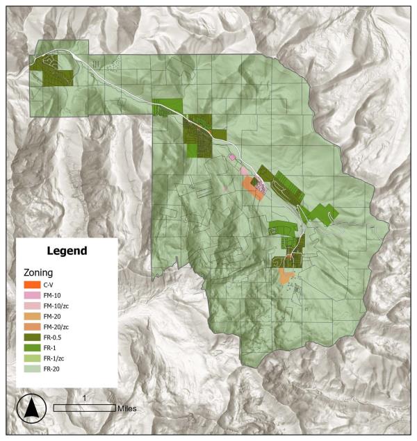
19.14.030 FILING OF THIS TITLE AND ZONING MAPS
This Title and the maps shall be filed in the custody of the Town Clerk and may be examined by the public subject to any reasonable regulations established by the Town Clerk.
19.14.040 BOUNDARY LOCATION RULES
- Where uncertainty exists as to the boundary of any zone, the following rules shall apply:
- Wherever the zone boundary is indicated as being approximately upon the centerline of a street, alley or block, or along a property line, then, unless otherwise definitely indicated on the map, the centerline of the street, alley or block, or such property line, shall be construed to be the boundary of the zone;
- Whenever such boundary line of such zone is indicated as being approximately at the line of any river, irrigation canal or other waterway or railroad right-of-way, or public park, or other public land, or any section line, then in such case the center of the stream, canal or waterway, or of the railroad right-of-way, or the boundary line of such public land or such section line shall be deemed to be the boundary of the zone;
- Where the application of the above rules does not clarify the zone boundary location, the Land Use Hearing Officer shall interpret the map.
19.14.050 ZONING OF ANNEXED AREAS
Properties that are annexed into the Town of Brighton shall be given a zoning designation by action of the Council at the time of annexation. The Council shall be guided by the general plan and by the criteria set forth in Table 19.16-2 in zoning the subject property. Annexations of multiple parcels may result in more than one zone applying to the annexation area; however, except in the case of overlay zones, only one zone may apply to each parcel.