
Bryan County Unincorporated
City Zoning Code
City Zoning Code
ARTICLE VI
SITE DEVELOPMENT STANDARDS
This article sets the rules for lot/site development.
DIVISION 8. - SIGNS
This division of the UDO shall be referred to as the sign code of Bryan County or sign code.
Sec. 114-600. - Principal structures.
(a)
Agricultural district. With the exception of bona fide agricultural structures, only one principal structure and its customary accessory structures pursuant to article VII, division 2 may hereafter be erected on any lot. Any dwelling, including site-built dwellings, manufactured homes, mobile homes, or modular homes, shall be deemed to be a principal structure. The total number of principal structures on a lot may be increased in accordance with section 114-508, Agricultural/Residential District Use Conditions.
(b)
Rural residential and certain residential districts. In the RR-2.5, RR-1.5, RR-1, and R-15 districts, only one principal structure and its customary accessory structures pursuant to article VII, division 2 may hereafter be erected on any lot. Any dwelling, including site-built dwellings, manufactured homes, mobile homes, or modular homes, shall be deemed to be a principal structure. The total number of principal structures on a lot may be increased in accordance with section 114-508, Agricultural/Residential District Use Conditions.
(c)
Multi-family and manufactured housing park districts. In the R-M and R-MH districts, there may be more than one principal residential structure and more than one accessory structure (e.g., clubhouse, office administration building) situated on a lot, provided that:
(1)
An unobstructed accessway at least 20 feet wide is maintained from a road to each structure for use by service and emergency vehicles; and
(2)
Each structure on the lot is separated from any other structure on the lot by at least the minimum building separation requirement pursuant to article VIII and the building code.
(d)
Non-residential districts. In the B-1, B-2, C-I, I-1, I-2, P/I, WP, and WB districts, more than one principal structure devoted to non-residential uses may be situated on a lot, provided that:
(1)
An unobstructed accessway at least 20 feet wide is maintained from a road to each structure for use by service and emergency vehicles; and
(2)
Each structure on the lot is separated from any other structure on the lot by at least four feet unless a greater separation is required by the applicable building codes.
(e)
Tracts with multiple dwellings or principal structures. Where more than one dwelling or principal structure legally existed on a tract at the effective date of this UDO, such tract may be divided into an individual lot for each such dwelling or principal structure if the community development director determines that each lot meets the applicable requirements of this article or a variance is granted by the board of adjustments.
(f)
Planned development districts. Unless specifically modified by the approval of a PD, the provisions of this article shall apply to all development within the PD.
(Ord. No. 06-2020, § 3, 12-8-2020)
Sec. 114-601. - Minimum living area.
Except for guest houses and accessory dwelling units, no structure, including, but not limited to, multiple family dwelling units intended for residential use shall be constructed or placed which has a total living area of less than 400 square feet per dwelling unit.
(Ord. No. 06-2020, § 3, 12-8-2020)
Sec. 114-602. - General lot requirements.
All lots shall comply with the following design standards:
(a)
Road access. Each lot shall abut a road or approved access easement, have sufficient road frontage and have access to the road as required in this article.
(b)
Lot lines. Side lot lines shall be as nearly as practical at right angles to straight road lines and radial to curved road lines.
(c)
Corner lots. Corner lots shall have sufficient width and depth to permit the establishment of required setbacks from both roads.
(d)
Lot dimensions. The area and dimensions of lots shall comply with the minimum standards of this article unless modified through the planned development process or varied by the board of adjustment. Minimum lot size requirements, however, may not be varied.
(e)
Flag lots. Flag lots are intended to only be used for the preservation of agricultural and sensitive lands or to address unique topographical situations in an A or RR district and are not intended to act in lieu of an interior subdivision road built to County standards. After determination by the community development director that standard lots are not feasible, the community development director or board of commissioners may, in order to encourage more efficient use of land and to help preserve agricultural and sensitive lands, allow flag lots to be developed subject to the following conditions.
(1)
The property cannot be subdivided with typical street frontage either at the present or in the foreseeable future.
(2)
The flagpole or access strip portion of said lot shall front on a dedicated public or approved private street. The minimum width of the access strip portion of the lot shall be 30 feet.
(3)
No building or construction, except for driveways, shall be allowed on the access strip portion of said lot.
(4)
Fencing may be required between the driveway and adjacent lots properties, provided that the fence height shall not exceed three and one-half feet within the front setback of the adjacent lot and shall comply with sight triangle requirements.
(5)
All lot size and setback requirements shall be the same as required by the zoning district in which the lot is located. The access strip portion of the lot shall not be used to calculate the minimum lot size. Setbacks shall be shown on the plat, and setbacks on all sides shall meet the applicable zoning district interior side setback requirement
(6)
Flag lots shall not be subdivided or otherwise altered in area or dimension unless all resulting lots comply with the provisions of this UDO.
(Ord. No. 06-2020, § 3, 12-8-2020)
Sec. 114-603. - Block requirements.
(a)
Purposes. The block standards of this section are established to facilitate emergency access to and evacuation from lots; to provide convenient access between various parts of a subdivision and between the subdivision and surrounding areas; and to minimize traffic congestion and traffic hazards.
(b)
Maximum block length generally. Except as provided in paragraph (c) of this section the length of a block shall not exceed 1,800 feet unless the county finds that existing lot patterns, natural features, open space or community amenities preclude compliance.
(c)
Maximum block length in R-15 and R-M districts. In R-15 and R-M districts, unless the county finds that existing lot patterns, natural features, open space or community amenities preclude compliance:
(1)
Block lengths shall not exceed 600 feet; and
(2)
Cul-de-sac and dead-end roads shall not exceed 600 feet in length.
(d)
Cross-block connections. Where block lengths exceeding 1,000 feet are found to be necessary, the county may require installation of cross-block multi-purpose trails to improve bicycle and pedestrian connectivity (see Exhibit 603).
Exhibit 603: Sample Cross-Block Connection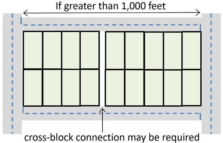
(e)
Secondary access required. For subdivisions with 30 or more single-family, duplex or townhouse lots, or multi-family and manufactured home developments with 30 or more units, secondary road access shall be required. The fire chief and engineering director may approve the provision of emergency access in lieu of secondary street access for subdivisions or multi-family developments with 100 or fewer dwelling units.
(Ord. No. 06-2020, § 3, 12-8-2020)
Sec. 114-604. - Easements.
All easements within subdivisions and along individual lots must be designed in accordance with the Engineering Design Manual and must be shown on a final plat. A non-permanent structure (e.g., flagpole, mailbox, fence, etc.) may be located within an easement required pursuant to this Section, but fences may not impede drainage flows. The county may require the non-permanent structure to be removed if needed to address maintenance or drainage issues. The following types of easements shall be required within subdivisions:
(a)
Individual lot. Easements having a minimum width of five feet and located along the side lot lines and a minimum of ten feet along the rear lot lines shall be provided, as required, for utility lines, underground mains and cables, and drainage. If required, the property owner will provide a greater width for the easements at the direction of the engineering director.
(b)
Drainage. Where a proposed subdivision or site development is traversed by a watercourse, drainage way, channel, or stream, the developer of such proposed subdivision shall offer the county an exclusive stormwater easement that shall conform substantially with the lines of such watercourse, drainage way, channel, or stream and shall be of such additional width as deemed necessary for access and maintenance purposes by the public works director. At a minimum, the access and maintenance easement shall be 20 feet in width along one side of the drainage channel. Such easements may be used as a location for pedestrian ways, bikeways and other amenities which do not conflict with the basic maintenance function of such easements.
(c)
County maintenance easement. Maintenance easements shall be provided when deemed necessary by the public works director and/or engineering director.
(d)
Utilities. Easements for utilities serving a proposed subdivision or non-residential development must be shown on the final plat or site plan. If a final plat is not required, the engineering director may require an owner to execute an easement document.
(Ord. No. 06-2020, § 3, 12-8-2020)
Sec. 114-605. - Mailbox kiosks.
(a)
Mailboxes shall be provided in compliance with United States Postal Service requirements. If mailbox kiosks (cluster mailbox) are required for either residential subdivisions or commercial development, the following standards shall apply: Installation of the mailbox unit(s), as well as any associated shelters, lighting, parking, and other related amenities shall be the responsibility of the developer;
(b)
Maintenance of the mailbox unit(s), as well as any associated shelters, lighting, parking, and other related amenities shall be the responsibility of the homeowners, homeowners' association, or property management association;
(c)
Cluster mailbox units shall be prohibited within the public right-of-way;
(d)
Cluster mailbox units, and any associated structures, shall not adversely impact sight distance to any driveway or road intersection, as determined by the engineering director. Whenever feasible, the mailbox unit should be located within an amenity center, if one is proposed for the development;
(e)
Cluster mailbox unit(s) shall be located in area(s) that will best allow for vehicle stacking or parking without creating pedestrian safety or vehicle safety issues, as determined by the engineering director;
(f)
A paved area with adequate ingress/egress, designed to the meet the requirements of the Engineering Department, shall be provided to allow vehicles to pull off the roadway safely while retrieving mail;
(g)
All access to cluster mailbox unit(s) shall comply with current ADA and Georgia Accessibility Code standards. Any sidewalks required by this UDO shall be incorporated into the mailbox area(s);
(h)
The mailbox unit(s) must be installed according to the manufacturer's standards; and
(i)
The mailbox unit(s) and shelter, if any, shall be exempt from the normal setback requirements. Shelters or other structures are subject to building permit requirements.
(Ord. No. 06-2020, § 3, 12-8-2020)
Sec. 114-610. - Structure height.
(a)
District standards. Subject to the provisions of this section, buildings and structures shall not exceed the maximum heights established in the applicable zoning district's development standards.
(b)
Measurement. The height of a building is the vertical distance measured from the mean elevation of finished grade at the front building line or the base flood elevation to the highest point of a flat roof or parapet, the deck line of a mansard roof, or the midpoint between the ridge and the eave for a pitched roof (see building height definition for more detail). When a roof plane with the tallest ridge has dormers, height shall be based on the primary roof plane, with the dormers having no impact on height measurement unless they are higher than the highest ridge.
(c)
Institutional structures. The following buildings, where authorized in a zoning district, may be constructed to any height subject to Fire and Building Codes and the requirement that any portion of a structure exceeding the maximum height of the district is set back from each property line at least one foot for every one foot that that portion of the building exceeds the maximum height of the applicable zoning district:
(1)
Government offices;
(2)
Schools;
(3)
Libraries; and
(4)
Hospitals larger than 10,000 square feet of floor area.
(d)
Exceptions. The maximum height regulations shall not apply to:
(1)
Belfries, cupolas, domes, monuments, water towers, transmission towers, steeples, chimneys, smokestacks, radio towers, masts and aerials, conveyors, and fire towers.
(2)
Bulkheads, elevator penthouses, water tanks, cooling towers, scenery lofts and similar structures provided that such structures shall cover not more than 25 percent of the total roof area of the building on which such structure is located.
(3)
Heating and air conditioning equipment, solar collectors and similar equipment, fixtures and devices are exempt, provided that they are set back from the edge of the roof a minimum distance of one foot for every foot the feature extends above the roof surface. Screen or parapet walls shall be constructed to the height of any fixture taller than three feet in height that would be visible from a street or residential property abutting the property.
(e)
Additional rules for specific structures.
(1)
Towers and antennas, where allowed, are subject to the provisions of chapter 113 of the Bryan County Code.
(2)
Fences in the RR, R, and PD zoning districts may not exceed eight feet in height and may not exceed ten feet in height for all other districts. Additionally, in the RR, R, and PD zoning districts, the maximum height of a fence in the front yard shall be four feet.
(f)
Height transitions. The following provisions for height transitions are measured from property lines of parcels where multi-family, mixed-use or non-residential structures abut an arterial connector or collector road, or A-5, RR or R-15 zoning district.
(1)
In all districts, balconies that are located above the second story shall be setback at least 100 feet from affected property lines.
(2)
In a R-M district, portions of the building exceeding 35 feet shall be set back at least 100 feet from affected property lines.
(3)
In C-1, I-1 and I-2 districts, portions of the building exceeding 35 feet shall be setback an additional two feet from the required building setback for each foot of height in excess of 35 feet as illustrated in Exhibit 610c.
Exhibit 610c: Height Transitions Lots Abutting A-5, RR or R-15 District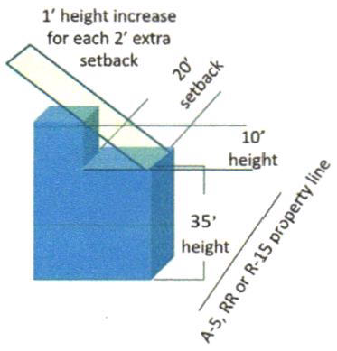
(Ord. No. 06-2020, § 3, 12-8-2020; Ord. No. 08-2024, § 2, 4-9-2024)
Sec. 114-611. - Setbacks.
(a)
Principal structures. No principal structure shall be located within any required setback area required by this UDO, except as provided herein.
(b)
Setbacks for accessory structures.
(1)
Agricultural and rural residential districts. Except as provided herein, no accessory structure shall be located within any required setback area.
(2)
Residential districts. Except as provided herein, no accessory structure shall be located within any required front, side, or rear setback.
(3)
Commercial, industrial and public/institutional districts. Except as provided herein, no accessory structure shall be located within any required setback area except in the WB district.
(c)
Allowed setback encroachments.
(1)
Piers, docks, and other water-dependent accessory structures may be located in any required setback or yard on lots that abut a body of water or marsh.
(2)
A patio at grade associated with a residential use, path, or walkway may be located in any required setback or yard provided that they are not located within a required buffer. For a patio at grade, no portion of the patio, however, may be closer than five feet to a property line.
(3)
A fence, wall, mailbox, power pole, light pole, or berm may be located in any required setback or yard.
(4)
Signs may be located in a required setback that abuts a road.
(5)
In R-15 zoning districts:
a.
A detached single-family or duplex residence may encroach a maximum of five feet into the required front setback, provided that a front-facing garage is set back to the required front setback.
b.
An unenclosed covered front porch may extend up to ten feet from the allowed building front setback provided that the porch is at least five feet in depth (see Exhibit 611a).
Exhibit 611a: Allowable Front Porch Encroachment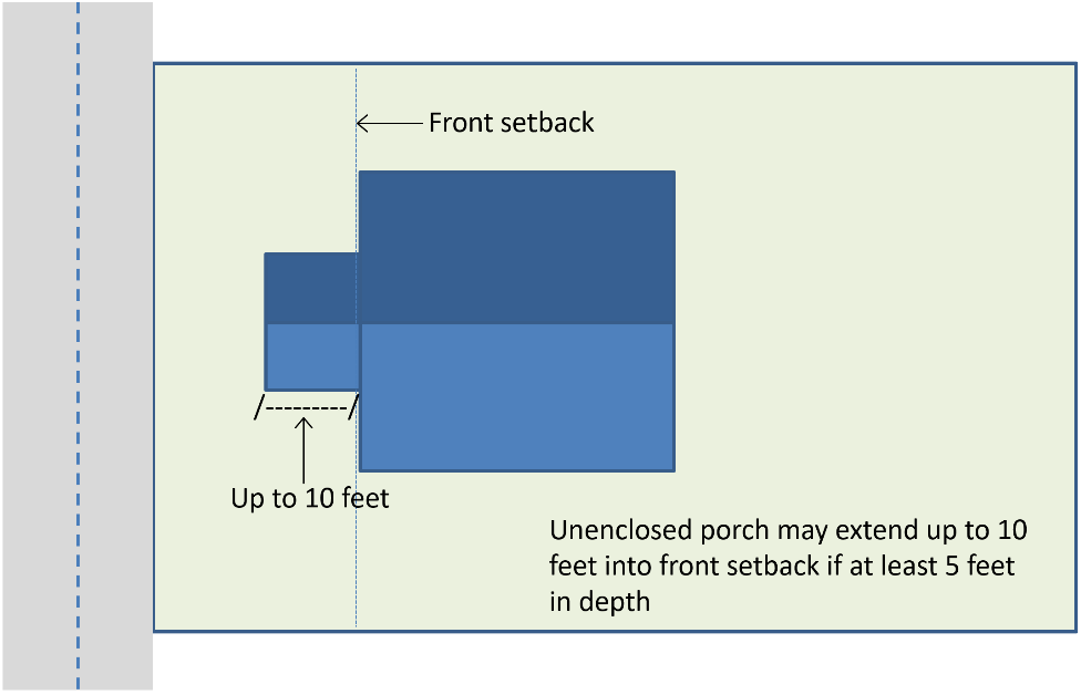
c.
Accessory swimming pools, open and unenclosed, may encroach a maximum of ten feet into a required rear setback. Every swimming pool shall be protected by a safety fence or barrier approved by the building official. Patios at grade shall be governed by paragraph (c)(2) of this section.
d.
For enclosed, including screened, swimming pools, all portions of the swimming pools must meet required setbacks.
1.
Eaves and overhangs may encroach up to two feet into required building setbacks, subject to building and fire code limitations.
2.
A step, stoop, and unenclosed porch (except for porches addressed in paragraph (5) of this section), awnings or other appurtenances may extend up to five feet from the minimum required side or rear setback for the applicable portion of the structure, provided such features do not impede pedestrian circulation.
3.
Canopies and portes cochere may encroach up to 50 percent of the required front or street side setback areas on lots occupied by churches, schools, hospitals, clinics, funeral homes, hotels, assisted living centers, continuing care retirement communities, or governmental buildings, and institutions of a philanthropic, educational, or religious nature.
(d)
Mechanical equipment. Mechanical equipment shall not be located within any front yard; it may encroach up to three feet into a required side or rear setback if screened from view from adjacent streets or abutting property.
(e)
Setbacks for principal structures. The minimum setbacks for principal structures shall comply with the development standards established for the applicable zoning district. Standards for the PD district shall be determined in conjunction with PD approval. Additional setbacks may be required to meet height, parking, planting, buffering, stormwater, or other standards specified in this article or the use standards of article V, article VII, and article VIII.
(f)
Setback measurement. The setback is the shortest horizontal distance from the applicable property line to nearest extension of any part of a building or regulated structure that is substantially a part of the building or structure itself and not a mere appendage to it (such as a flagpole, etc.). The following rules are used to identify the applicable yard on which the setbacks are based when the yard cannot be readily determined based on the definition. (see Exhibits 611b and 611c)
(1)
When a lot has street frontage on two contiguous sides, the frontage shall be determined by the community development director based on the most prevalent orientation of lots on each street. Where lots along a block face front equally on each street, the shorter of the two property lines abutting the street shall be considered the front property line and the longer property line shall be considered the exterior side or street side property line.
(2)
A duplex, multi-family dwelling, mixed-use, or non-residential structure located on a corner lot that has front entries to separate units on each street shall be considered to have frontage on each street and shall meet front setback requirements on each street.
(3)
When a lot has frontage on two non-contiguous property lines (e.g., for through lots), the lot is considered to have two front yards, and each shall be subject to the front yard setback requirements.
(4)
For lots served by an access easement, the front yard shall be determined by the orientation of the house and location of the driveway.
(5)
Setbacks from roads identified in the Capital Improvement Plan and with an identified funding source for widening shall be measured from the future right-of-way.
Exhibit 611b: Front Yard Determination for Normal and Double-Frontage or Through Lots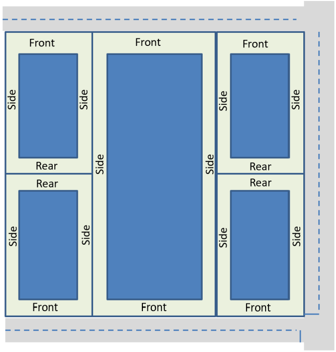
Exhibit 611c: Front Yard Determination for Flag Lots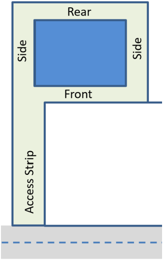
(6)
When a lot has more than one property line that is opposite the front yard, the rear property line shall be the lot line that is closest to paralleling the front property line and the rear setback shall be measured from that property line. The other property line shall be considered a side property line. (see Exhibit 611d)
Exhibit 611d: Determining Rear and Side Yards for Irregular Lots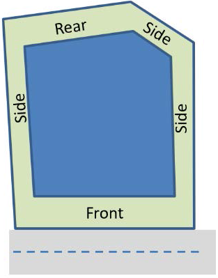
(Ord. No. 06-2020, § 3, 12-8-2020)
Sec. 114-612. - Lot area, lot width, density and gross area coverage.
The minimum lot area, lot width, and gross area coverage shall comply with the development standards for the applicable zoning district. Standards for the PD district shall be determined in conjunction with PD approval. These requirements also may be affected by parking, planting, buffering, stormwater, wastewater or other standards specified in this article or the specific use standards of article V, article VII, and article VIII.
(a)
Measuring density. Density shall be calculated on a net basis for major residential subdivisions and multi-family development. The overall density for a major residential subdivision or multi-family development, not located in a PD, shall be calculated by excluding areas dedicated to jurisdictional wetlands, ponds, and drainage canals. Minor subdivision density may be calculated on a gross density basis provided that each parcel has sufficient buildable area and complies with health department requirements.
(b)
Measuring lot width. Minimum lot width is the shortest distance between side property lines at all points between the front and rear setbacks (see Exhibit 612a).
Exhibit 612a: Lot Width Measurement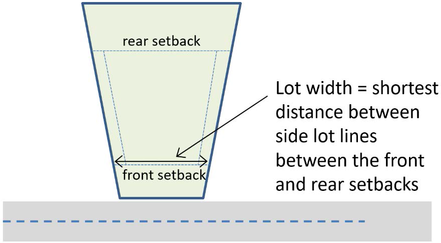
(c)
Maximum percentage of gross land area to be covered. The maximum percentage of gross land area to be covered is the percentage of the lot that has impervious coverage, including buildings, impervious pavement, and other impervious surfaces, including the water surface area of a swimming pool. Gravel and other surfaces on a compacted base shall be considered impervious surfaces.
(d)
Lots on cul-de-sac roads. Frontage for lots abutting a cul-de-sac turn-around shall be at least 35 percent of the minimum lot width (see Exhibit 612b).
Exhibit 612b: Minimum Frontage for Cul-de-sac Lots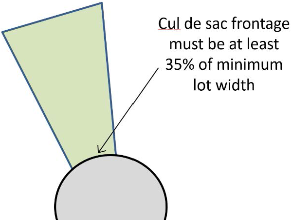
(e)
Lots on exterior of road curves. Frontage for lots located on the outside of a curve in the road shall be at least 70 percent of the minimum lot width (see Exhibit 612c)
Exhibit 612c: Lot Frontage on Road Curves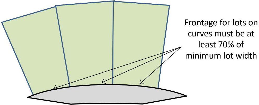
(f)
Lots with non-continuous road frontages (existing). Where the road frontage of a tract that is an existing lot of record is not continuous ("non-continuous tract") and where the road frontage of any part of a non-continuous tract ("non-continuous part") does not meet the minimum road frontage, such non-continuous tract may still be subdivided, provided (see Exhibit 612d):
(1)
The number of lots does not exceed the number of non-continuous parts;
(2)
The lot meets the minimum width and area requirements of the applicable zoning district; and
(3)
All of the road frontage of a non-continuous part is used as a lot.
Exhibit 612d: Existing Lots with Non-continuous Frontage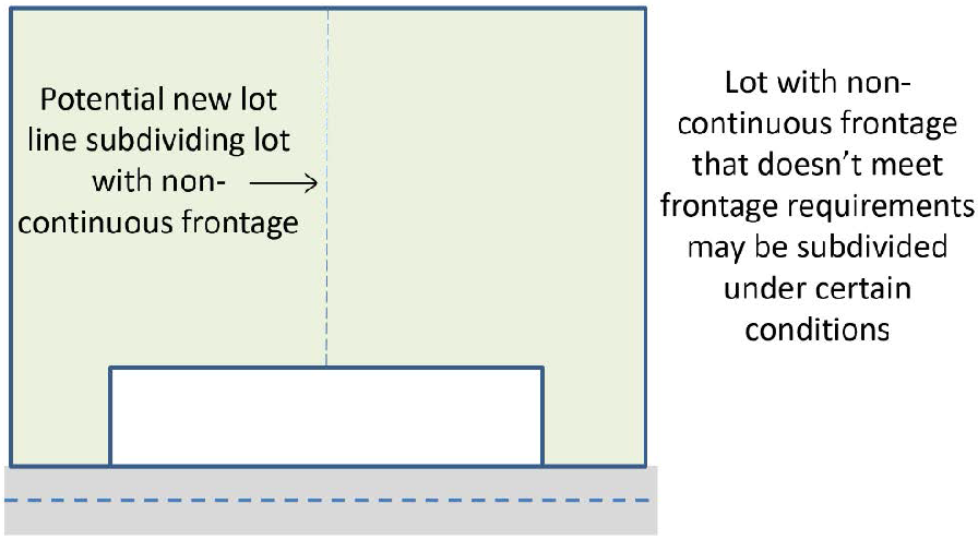
(g)
Lots with non-continuous road frontages (new). When a new lot is proposed with non-continuous road frontage, each non-continuous part must meet minimum road frontage requirements.
(Ord. No. 06-2020, § 3, 12-8-2020)
Sec. 114-613. - Access and circulation.
(a)
Commercial development projects should be designed to provide connections between neighborhoods, adjacent compatible uses and area-wide trail systems. When adjacent residential and/or non-residential uses can mutually benefit from connection rather than separation, connective elements shall be incorporated into the project design. Benefits, location, and specific improvements will be evaluated on a case-by-case basis. Examples of connective elements include:
(1)
Pedestrian walkways;
(2)
Pedestrian gates;
(3)
Common landscape areas; and
(4)
Other design features that allow/encourage two-way access between uses.
(b)
On-site circulation systems for non-residential development shall be designed to avoid conflicts between vehicular, bicycle, and pedestrian traffic.
(c)
Drive aisles shall meet the minimum requirements identified in the parking specifications section.
(d)
Pursuant to requirements of the Americans with Disabilities Act (ADA), all non-residential developments shall be designed with a minimum of one designated pedestrian path from each abutting street to the primary entrance(s) of the development.
(e)
For large-scale development, internal pedestrian walkways shall be distinguished from driving surfaces through the use of raised sidewalks, special pavers, bricks, and/or scored/stamped concrete/asphalt and shall comply with ADA requirements. Large-scale development, for purposes of this standard, is generally development in the B-2, P/I and C-I zoning districts and total building square footage exceeding 10,000 square feet.
(f)
To minimize conflicting vehicle turning movement along major roadways, shared access drives within and between integrated non-residential developments are encouraged to reduce the number of curb cuts. The county also encourages reciprocal access between non-residential developments to provide for convenience, safety, and efficient circulation. If incorporated, a reciprocal access agreement shall be recorded with the land by the owners of abutting properties to ensure that there will be continued availability of the shared access.
(Ord. No. 06-2020, § 3, 12-8-2020)
Sec. 114-614. - Purpose.
Recognizing that different land uses have varying requirements for off-street parking, the county finds it necessary to establish minimum requirements for facilities and space for the off-street parking of vehicles and loading and unloading of goods, in order to promote the economic vitality, safety of pedestrians and motorists, the orderly movement of people, vehicles and goods, and safe access to properties.
(Ord. No. 06-2020, § 3, 12-8-2020)
Sec. 114-615. - Applicability.
(a)
Generally. No development permit shall be issued that causes any of the following situations unless the use for which the permit is being sought complies with these off-street parking and loading regulations:
(1)
New building or use. Whenever a new building or use is established.
(2)
Expansion of a building or structure. Whenever an existing building or structure is enlarged, and the enlargement causes an increase in the number of required parking spaces.
(3)
Expansion or change of use. Whenever the use of an existing building, structure or site is expanded or changed so that it will increase the number of required parking spaces.
(4)
Resurfacing or enlarging existing parking areas. Whenever an existing parking lot is resurfaced or is expanded by the greater of ten percent or six spaces, parking lot surfaces shall comply with the provisions of this UDO. For purposes of this section, resurfacing does not apply to patching, resealing, seal-coating or overlaying existing surfaces.
(b)
Existing structures and uses. Structures and land uses in existence on the date of enactment of this UDO, or structures and uses for which building permits have been applied for or approved on the said date, shall not be subject to the parking and loading requirements set forth in this section. However, any parking and loading facilities now existing to serve such structures or uses may only be reduced if they continue to comply with the minimum parking and loading standards established herein.
(c)
Exemptions. The community development director may adjust or waive the requirement for additional parking in the following circumstances:
(1)
If the expansion or change of use of an existing development increases the demand for spaces but the applicant demonstrates the adequacy of existing parking to meet existing and projected demands.
(2)
If the expansion or change of demand is less than the greater of ten percent of the total parking requirement or five or fewer spaces. This provision may be used only once for any given site.
(3)
If the existing parking is non-conforming, yet accommodates existing demands, the community development director may base the increased parking requirement on the demand created by the expansion of the building or use.
(Ord. No. 06-2020, § 3, 12-8-2020)
Sec. 114-616. - Location of parking.
(a)
One- and two-family dwellings in A, RR or R districts.
(1)
Off-street parking facilities for one- and two-family dwellings shall be located on the same lot as the building served.
(2)
The combined area of driveways to garage, rear and/or side yard parking facilities shall not exceed 30 percent of the front yard area. The remaining front yard area shall be pervious landscape area.
(3)
Where parking spaces are located in a rear yard, paved parking may not exceed 40 percent of the rear yard.
(4)
Driveways on abutting lots shall be separated by at least five feet of pervious landscape space unless the properties use a shared driveway.
(5)
The parking of vehicles in the area reserved for pervious landscaping space is prohibited.
(6)
No vehicle may be parked, stored or maintained on any public road or public road right-of-way, except where parallel parking on the public road was provided in the approved design of the public road. Commercial vehicles with greater than 26,000 gross vehicle weight rating (GVWR) are prohibited from being parked in any public road.
(7)
Vehicles parked on a lot and visible from the street, must be operable and have current registration, i.e., license plate. Vehicles not complying with this requirement will be considered an inoperable motor vehicle as defined in the International Property Maintenance Code, and they must either be parked or stored in an enclosed structure or parked or stored behind the structure and screened from view.
(b)
Multifamily dwellings.
(1)
At least 50 percent of parking spaces required for multifamily dwellings shall be provided within 50 feet of the building served by the parking.
(2)
Up to 50 percent of required parking may be located within 200 feet of the building served by the parking and shall be connected by continuous pedestrian facilities.
(3)
No parking space shall be located in the required setbacks, except for the rear setbacks.
(4)
No off-street parking space shall be located closer than ten feet to any residential building wall.
(c)
Mixed-use development. Required off-street parking for mixed-use development shall be located on the same parcel or parcel contiguous with the development.
(d)
Non-residential development. Off-street parking facilities for all other industrial or commercial establishments should be located on-site or on the same parcel or a parcel adjacent to the site. Where required parking cannot be provided on-site, it shall be provided on a lot that is located within 300 feet of the development and connected by continuous pedestrian facilities.
(Ord. No. 06-2020, § 3, 12-8-2020)
Sec. 114-617. - Parking specifications.
(a)
Parking dimensions.
(1)
For single family and duplex lots, the minimum width for tandem driveway parking shall be ten feet with a minimum of 40 feet in length from the right-of-way, and the minimum width for side-by-side driveways shall be 20 feet and a minimum of 20 feet in length.
(2)
For multi-family and non-residential developments, except as otherwise provided in this section, each parking space and the necessary access aisles shall have at least the minimum dimensions listed in Exhibit 617, depending on the parking angle and the direction of the traffic flow. The length may be reduced by two feet when protective devices (curbing or curb stops) are provided. However, the overhang will not extend into the required buffers, required landscaped areas, required accessibility or other similar areas. However, the dimensions of all parallel parking stalls will not be less than nine feet by 22 feet. Handicapped parking stalls will not be less than eight feet by 19 feet with an aisle separation of five feet (13 feet by 19 feet overall).
(b)
Marking. Parking spaces in lots shall be marked by painted lines to indicate individual spaces and in compliance with ADA and MUTCD standards. Signs or markers, as approved by the engineering director, will be used as necessary to insure efficient traffic operation of the lot. All parking facilities, except single-family detached and duplex dwellings, will be designed so that all existing movements onto a public street are in a forward motion.
(c)
Compact car and motorcycle parking. In parking areas containing ten or more parking spaces, and upon the approval of the community development director and engineering director:
(1)
Up to 20 percent of the parking spaces may be designated for compact car parking in spaces measuring eight feet in width by 16 feet in length. If such spaces are provided, they shall be conspicuously designated as reserved for small or compact cars only.
(2)
Up to five percent of the required parking spaces may be designated for motorcycle or motor scooter parking in spaces measuring at least four feet wide by nine feet long.
(d)
Driveways. Driveways that are not parking aisles shall be not less than 16 feet in width for one-way traffic and 24 feet in width for two-way traffic.
(e)
Head-in parking. With the exception of driveways for single-family, duplex and townhouse lots:
(1)
Head-in parking shall not be counted towards required off-street parking unless the community development director finds that provisions have been made for the extension of a safe public pedestrian walkway that connects to existing or future sidewalks along the applicable street. Additionally, the engineering director must approve all head-in-parking to ensure public safety is maintained.
(2)
No parking space shall be counted that requires pedestrians to walk between head-in parking spaces and a public street. Head-in parking may be approved for alleys and private drives.
Exhibit 617: Minimum Parking Lot Dimensions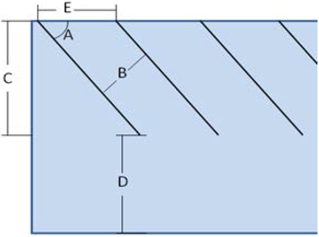
(f)
Parking surfacing.
(1)
Parking and loading areas shall be graded and surfaced, marked and maintained in a dust-free condition in accordance with the provision of this section. Pervious pavement approved by the engineering director may be considered in lieu of pavement wherever feasible.
(2)
Parking areas having more than ten spaces shall be paved or surfaced with pervious or impervious pavement approved by the engineering director. In reviewing the surfacing material, the engineering director shall consider the following factors:
a.
Volume of traffic;
b.
Frequency of use;
c.
Size and location of the parking area;
d.
Type of land use requiring the parking;
e.
Topography; and
f.
Control measures needed for stormwater, erosion and dust management.
(3)
Subject to the provisions of paragraph (f)(2) of this section, permitted small businesses and single-family/duplex projects that are not part of a major subdivision will be exempt from paving in any zoning district when the following conditions are met:
a.
The required number of parking spaces is ten or fewer.
b.
The required handicap parking spaces, walkways, and driveway apron are paved;
c.
Any future expansion or change in use dictating more than ten required parking spaces will require the developer to pave all required parking and access drives, existing and proposed;
d.
The minimum surfacing excluding handicapped surfaces cited in paragraph (3)(b) shall be recycled concrete or graded aggregate base; and
e.
An unpaved parking area is consistent with the size and location of the parking area, the type of land use requiring the parking and consistent with the surrounding uses and development patterns.
(Ord. No. 06-2020, § 3, 12-8-2020)
Sec. 114-618. - Required number of parking spaces.
Exhibit 618 establishes the minimum number of required parking spaces for uses.
(a)
In determining the number of parking spaces required, if calculations result in fractional parts of parking spaces, the number of spaces required shall be construed to be the next highest whole number.
(b)
Whenever there is a change of use, increase in floor area, or increase in the number or dwelling units that would increase the number of required spaces, additional parking spaces shall be provided in number caused by the change unless there are sufficient spaces to serve the increased activity.
(c)
The required number of spaces may be reduced by the community development director if the applicant provides a parking demand analysis documenting that the use will require fewer spaces and the community development director determines that the reduction will not reduce the viability of future use of the site. The parking demand analysis must be prepared by a traffic engineer or similarly qualified individual. See section 114-417 for detailed administrative relief provisions.
(d)
The number of spaces or area reserved for off-street parking or loading in accordance with the provisions of this division shall not be reduced in size or changed to any other use unless the permitted use it serves is discontinued or modified.
(e)
Required parking spaces shall not be used for storage or display of merchandise, signs, vehicles used in connection with a business, dumpsters or operations associated with the use.
(f)
The required space for any number of separate uses may be combined in one lot, but the required space assigned to each use may not be assigned to another use, except where the community development director approves shared parking pursuant to section 114-620.
(g)
Required handicap spaces shall be in addition to the required minimum number of parking spaces.
Exhibit 618: Minimum Number of Parking Spaces Required1
(Ord. No. 06-2020, § 3, 12-8-2020)
Sec. 114-619. - Accessible parking spaces.
Handicap accessible parking spaces shall be provided in compliance with the Americans with Disabilities Act. Exhibit 619 provides the minimum required number of handicap parking spaces.
Exhibit 619: Minimum Number of Accessible Parking Spaces Required
(Ord. No. 06-2020, § 3, 12-8-2020)
Sec. 114-620. - Shared parking.
(a)
Two or more buildings or uses may share a common parking facility; provided, the number of parking spaces available shall equal the required number of spaces for all the uses computed separately.
(b)
Cumulative parking requirements for mixed-use developments or shared facilities may be reduced by the community development director as part of site plan review where the applicant demonstrates the continued availability of sufficient parking to meet all users.
(c)
The following documentation shall be provided in conjunction with a request for shared parking:
(1)
A shared parking analysis submitted to the community development director that clearly demonstrates the feasibility of shared parking. The study must address, at a minimum, the size and type of the proposed development or combination of uses, the composition of tenants, the anticipated rate of parking turnover and the anticipated peak parking and traffic loads for all uses that will be sharing off-street parking spaces.
(2)
A shared parking plan and agreement signed by owner of the shared parking area stating that:
a.
The land comprising the parking area shall never be disposed of, except in conjunction with the sale of the building so long as the facilities are required; and
b.
The owner agrees to bear the expense of recording the agreement which shall bind his or her heirs, successors, and assigns.
(d)
An attested copy of the shared parking agreement between the owners of record shall be submitted to the community development director to be recorded in a form established by the county attorney. The agreement must be recorded before issuance of a certificate of occupancy for any use to be served by the shared parking area. A shared parking agreement may only be revoked if all required off-street parking spaces will be provided on-site. The county may agree to void the written agreement if other off-street facilities are provided in accord with these parking regulations.
(Ord. No. 06-2020, § 3, 12-8-2020)
Sec. 114-621. - Temporary parking.
For temporary uses and special events that result in a temporary reduction in the availability of required parking spaces or create a need for temporary off-site parking, such as outdoor sales events (seasonal sales), festivals or fairs, concerts, or sporting events, the community development director may authorize the use of a portion of the required parking area for other purposes on a temporary basis or permit temporary off-site parking, upon a demonstration by the applicant that temporary off-site parking is located and designed to ensure safe and efficient circulation for both pedestrians and vehicles (a site plan may be required to demonstrate this), the proposed special event satisfies all other applicable county regulations and:
(a)
The loss of the required parking spaces may be offset by requiring employees or customers to park elsewhere or that due to the time of year or nature of the on-site business, the required spaces are not needed;
(b)
All or part of the displaced parking may be accommodated on unpaved areas of the site;
(c)
Permission has been granted by affected owners or operators to use their parking facilities; or
(d)
The duration of the special event is so short or of such a nature as to not create any appreciable parking shortage for the normal operation of the existing on-site use;
(Ord. No. 06-2020, § 3, 12-8-2020)
Sec. 114-622. - Maximum allowed parking.
To minimize excessive areas of pavement that detract from aesthetics, contribute to high rates of storm water runoff and generate reflective heat, the minimum parking space requirements of this section shall not be exceeded by more than ten percent, unless the applicant demonstrates, and the community development director determines, that the parking is necessary to accommodate the use on a typical day. Further, the community development director, at the recommendation of the engineering director may require that parking spaces provided in excess of the minimum requirement to be located on permeable surfaces.
(Ord. No. 06-2020, § 3, 12-8-2020)
Sec. 114-623. - Parking lot design and use.
Parking lots having ten or more spaces shall be designed in accordance with the provisions of this section.
(a)
Location of parking lots. Parking lots for newly developed or redeveloped sites shall, to the greatest extent possible, be in the interior side or rear yards.
(b)
Parking lot and vehicle use area planting. Planting requirements for areas within and abutting vehicle use areas and parking lots are established in section 114-631.
(c)
Ingress and egress. Adequate vehicular ingress and egress to the parking area shall be provided by means of clearly limited and defined drives. All parking lots shall provide interior access and circulation aisles for all parking spaces. The use of public streets for maneuvering into or out of off-street parking spaces shall be prohibited except as authorized for single-family and duplex residential lots.
(d)
Curbing. A six inch concrete curb or approved alternative shall be provided around all sides of any parking lot of 10 or more spaces to protect landscaped areas, sidewalks, buildings, or adjacent property from vehicles that might otherwise extend beyond the edge of the parking lot. Curb openings are allowed for stormwater drainage, as approved by the engineering director. Plantings and sidewalks shall be set back two feet from curbs and sidewalks adjacent to curbs shall be a minimum of six feet wide to allow for bumper overhang. Approved barriers will be provided along boundaries to control entrance and exit of vehicles or pedestrians. Off-street parking spaces will be separated from walkways, sidewalks, streets, alleys and required yards by a wall, fence, or curbing.
(e)
Lighting. Adequate lighting will be provided if off-street parking spaces are to be used at night. Equipment for lighting parking facilities will be arranged so that light does not interfere with traffic, is shielded or directed away from adjoining residences, and produces no glare across residential property boundaries. Lighting fixtures in parking areas shall conform to the requirements of article VI, division 9.
(f)
Fire lanes. Fire lanes shall be designated on the site and posted with signage prior to occupancy. Vehicle circulation shall meet turning radius requirements set by the Emergency Services Director.
(g)
Pedestrian access. Parking lots should have a direct pedestrian connection to the building entry points, especially if the parking is located along the side and/or behind the buildings. Designated pedestrian access shall be provided from all public parking areas to the primary building entrances.
(h)
Crosswalks. Pedestrian pathways and crosswalks in parking areas shall be distinguished from asphalt driving surfaces through the use of durable, low-maintenance, surface materials such as pavers, bricks, or scored, stamped or colored concrete to enhance pedestrian safety and comfort as well as the attractiveness of the parking area.
(i)
Barrier free parking in parking lots. Within each parking lot, signed and marked barrier free spaces shall be provided at a convenient location, in accordance with the applicable requirements of the Americans with Disabilities Act of 1990 (ADA). Where a curb exists between a parking lot surface and a sidewalk entrance, an inclined approach or curb cut with a gradient of not more than a 1:12 slope and width of a minimum four feet shall be provided for wheelchair access.
(j)
Maintenance. All parking areas shall be maintained free of trash and debris. Surface, curbing, light fixtures and signage shall be maintained in good condition.
(k)
Limitations on use of parking lots.
(1)
Off-street parking areas are intended only for temporary vehicle parking. Except when land is used as storage space in connection with the business of a repair or service garage, use of parking areas or open land is not permitted for the storage or parking of wrecked or junked cars, or for creating a junk yard or nuisance.
(2)
Loading spaces, as required in section 114-625, and parking spaces, required in section 114-618, shall be considered separate and distinct requirements and shall be provided as individual components on the site. In no case shall one component be construed as meeting the requirements of the other.
(3)
Parking lots and loading areas shall not be used for the long-term storage of trucks or trailers, except where such outdoor storage is specifically permitted in the zoning district. Overnight parking or storage of commercial vehicles shall be prohibited, except for uses and locations approved for vehicle storage. This shall not be construed to prohibit the parking overnight of commercial fleet vehicles or the short-term parking of trailers in loading bays or staging areas related to commercial or industrial uses.
(4)
It shall be unlawful to use a parking lot or open area to store or park any vehicle for the purpose of displaying vehicles for sale, except in an approved vehicle sales dealership.
(Ord. No. 06-2020, § 3, 12-8-2020)
Sec. 114-624. - Bicycle parking.
In addition to off-street vehicular parking requirements, the following bicycle parking requirements shall be met for all mixed-use, commercial, institutional, and multi-family residential uses unless waived by the community development director:
(a)
Bicycle parking shall be provided in an amount equal to five percent of the minimum required off-street parking spaces for vehicles or ten bicycle spaces, whichever is less; but no fewer than two spaces.
(b)
Such parking shall be located in close proximity to the primary entrances used by customers, visitors, or residents.
(c)
Bicycle parking areas shall be designed to utilize bike racks installed on all-weather surfaces.
(d)
Bicycle parking areas and pathways connecting them to the buildings they serve shall be lighted for the safety of the cyclists and to discourage theft.
(e)
Bicycle parking shall be encouraged, though not required, for any individual building having a gross floor area of 5,000 square feet or less unless the building is part of a larger common site plan.
(Ord. No. 06-2020, § 3, 12-8-2020)
Sec. 114-625. - Loading.
(a)
Uses requiring loading area. On the same premises with every building, structure or part thereof, erected and occupied for manufacturing, storage, warehouse, retails sales, consumer services or other uses similarly involving the receipt or distribution of vehicles, materials or merchandise, there shall be provided and maintained on the lot adequate space for standing, loading and unloading services in order to avoid undue interference with public use of the streets, alleys and parking spaces. This provision shall not apply to retail sales and consumer service uses of less than 5,000 square feet.
(b)
Loading space requirements. Loading and unloading spaces shall be paved unless otherwise approved by the engineering director and shall measure at least ten feet wide by 50 feet deep. Exhibit 625 lists the minimum number of required loading spaces.
Exhibit 625: Minimum Number of Off-Street Loading Spaces
(c)
Orientation of overhead doors. Overhead doors for truck loading areas shall not face a public right-of-way or shall be screened to not be visible from a public street or an adjacent A, RR or R district.
(d)
Residential setback. Loading and unloading spaces shall not be located closer than 100 feet from any RR, R or PD district boundary, unless the spaces are wholly within a completely enclosed building or completely screened from the RR, R, or PD district. Screening shall comply with the screening standards in division 5 of this article.
(Ord. No. 06-2020, § 3, 12-8-2020)
Sec. 114-626. - Purpose.
The requirements of this division are intended to:
(a)
Maintain the rural character of Bryan County;
(b)
Protect and preserve mature, native, and healthy trees;
(c)
Increase tree coverage to enhance the environmental and aesthetic benefits that trees provide;
(d)
Improve the appearance of vehicular and pedestrian use areas;
(e)
Provide buffers for different land uses to eliminate or minimize potential nuisances such as dust, litter, noise, glare of lights, signs and unsightly buildings or parking areas; and
(f)
Protect and conserve property values within the Bryan County.
(Ord. No. 06-2020, § 3, 12-8-2020)
Sec. 114-627. - Applicability.
This division shall apply to the following development activities and uses:
(a)
Buffers shall be required for development requiring major subdivision, planned development or site plan approval in accordance with section 114-630.
(b)
Tree preservation shall be required for development requiring minor or major subdivision, planned development or site plan approval, and for any use other than those exempted by section 114-634.
(c)
Canopy retention or replacement shall be required for all major residential and non-residential subdivisions, planned developments and for development of multi-family, mixed-use or non-residential development.
(d)
Parking lot landscaping shall be required for development requiring a PD approval or site plan approval in accordance with section 114-631.
(e)
Landscape maintenance shall be required for all new development, redevelopment and use of existing properties in accordance with section 114-633.
(Ord. No. 06-2020, § 3, 12-8-2020)
Sec. 114-628. - Exemptions.
The following uses shall be exempt from the provisions of this division:
(a)
Lots developed for single-family and duplex residential uses that are not a part of a major subdivision;
(b)
Public utility providers are exempt from tree preservation requirements for facilities in easements and rights-of-way but are subject to perimeter buffering requirements for substations, lift stations and treatment plants;
(c)
Commercial timber operations;
(d)
Mitigation of wetlands pursuant to an approved plan from the US Army Corps of Engineers (USCOE);
(e)
Trees grown specifically for sale by commercial nurseries; and
(f)
Any bona fide agricultural or silviculture use.
(Ord. No. 06-2020, § 3, 12-8-2020)
Sec. 114-629. - Buffers required.
(a)
Purpose and applicability. Buffers are intended to retain the rural character of Bryan County and to minimize negative impacts between abutting developments. Buffers are required:
(1)
Along the perimeter boundaries of major subdivisions;
(2)
Along arterial and collector street frontage for all major subdivisions and for developments requiring site plan approval; and
(3)
Along the boundaries between properties in different zoning districts at the time of subdivision and site plan development.
(b)
Subdivision boundary buffers. The outer perimeter buffers around major subdivisions shall be at least 30 feet in depth. If other buffer requirements conflict with the minimum depth of this paragraph, the greater standard shall apply. Such buffers may be platted as part of lots for development for agricultural, multi-family, mixed-use, and non-residential subdivisions, but must be on a separate lot for residential development in a RR or R district. The same buffer requirement applies to any parcel being zoned to a commercial, business or industrial use.
(c)
Arterial and collector road buffers. Any major subdivision or development requiring site plan approval that abuts an arterial or collector street shall provide a buffer along the street meeting the following requirements.
(1)
Minimum buffer depth shall be:
a.
One-hundred feet along an arterial road for a subdivision in an RR, R-15, RM or R-MH, or PD zoning district;
b.
Fifty feet along an arterial road for a development in B-1, B-2, C-I, I-1, I-2, or P/I district;
c.
Thirty feet along collector roads; and
d.
For the WP district, the minimum buffer shall comply with the standards identified in article V, division 5, section 114-520(d).
(2)
Buffer design shall comply with the provisions of section 114-630.
(3)
Subdivision and site entrances and driveways may traverse required buffers.
(4)
For industrial or commercial retail or service uses, the applicant may request to develop a streetyard as provided in section 114-631 instead of a buffer. The community development director may approve such request if the streetyard would maintain the character areas and fulfill the purposes identified in section 114-626(a).
(d)
Buffers between land uses and zoning districts. At the boundaries of different zoning districts, between certain land uses, or between uses within planned developments that are only authorized in different zoning districts (e.g., between single family residential and multi-family residential or between non- residential and residential uses), buffers shall comply with the minimum requirements established in Exhibit 629 and the design requirements of section 114-630. Where Exhibit 629 specifies more than one applicable buffer type for the proposed development, the widest required buffer applies.
Exhibit 629: Minimum Buffer Widths Between Land Uses and Zoning Districts
(Ord. No. 06-2020, § 3, 12-8-2020; Ord. No. 18-2022, § 3, 12-13-2022)
Sec. 114-630. - Buffer design requirements.
(a)
Generally. Buffers required under this section shall consist of undisturbed vegetation, planted trees and shrubs, or a combination of vegetation (planted or existing) and walls and berms that effectively screen development from the abutting road or property. The intent of these requirements is to encourage the preservation of mature and healthy, and indigenous vegetation. It is not the intent of this UDO to require existing vegetation to be removed in order to plant immature non-native species or maintain unhealthy tree stands.
(b)
When required. Prior to approval of construction plans for a subdivision or site plan requiring buffers, the applicant shall submit the landscape plans with buffer details for review and approval.
(c)
Buffer planting requirements.
(1)
Planted buffers. Exhibit 630a and Exhibit 630b list the number of each type of plant required to be planted within buffers that are planted in conjunction with subdivision or site development. At least 30 percent of large and medium buffer trees and 75 percent of small buffer trees and shrubs shall be evergreens, except as otherwise specified in this division. Not more than 25 percent of required trees or shrubs may be of the same species.
Exhibit 630a: Minimum Buffer Planting Requirements
Exhibit 630b: Minimum Buffer Planting Requirements for I-1 and I-2 Districts
(2)
Existing vegetation. Where mature existing vegetation is protected and retained during the development process, the community development director may reduce the required buffer plantings upon finding that the existing vegetation will accomplish equivalent or better screening than a planted buffer. When the existing vegetation is insufficient to provide adequate screening, the required additional plantings shall be located to enhance the effectiveness of the natural buffer's screening and to ensure that not more than 25 percent of trees or shrubs (existing and planted) are of the same species.
(3)
Buffer maintenance.
a.
Required buffers will not be disturbed for any reason except for permitted signs, driveways, sidewalks, or other pedestrian or bicycle paths, walls, fences, or required landscaping, landscaping maintenance and replacement, or maintenance and construction of utility lines and drainage features that cross the buffer.
b.
Where utility or drainage easements exist along property lines, the buffer shall be located adjacent to the easement and may be reduced by the width of the easement on the property where the buffer is required or 25 percent of the required buffer width, whichever is smaller.
(4)
Buffers with supplemental walls or berms. All walls and berms shall meet the following requirements. When walls or berms are provided but are not otherwise required by this division, the minimum width of a required buffer may be reduced by five feet. Fences have no impact on the minimum required width of a buffer.
a.
Walls. Any wall used as part of a buffer shall be constructed in durable fashion of brick, stone, or other masonry material or a combination thereof. Walls shall be a minimum height of six feet. Where walls are included in the buffer, they shall be located along the interior side of the buffer.
b.
Berms. Berms shall be a minimum height of four feet with a maximum slope of 3:1. Berms in excess of six feet in height shall have a maximum slope of 4:1 as measured from the exterior property line. Berms shall be stabilized to prevent erosion and shall be landscaped. Exhibit 630c and Exhibit 630d illustrate the two buffer options where berms are required.
Exhibit 630c: 40-foot Buffer Option for RM District Adjacent to RR, R-15, or RMH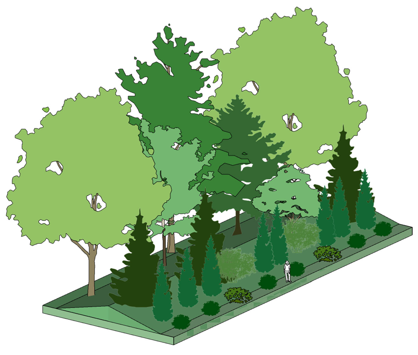
Exhibit 630d: I-1 and I-2 Districts 40-foot Type C Buffer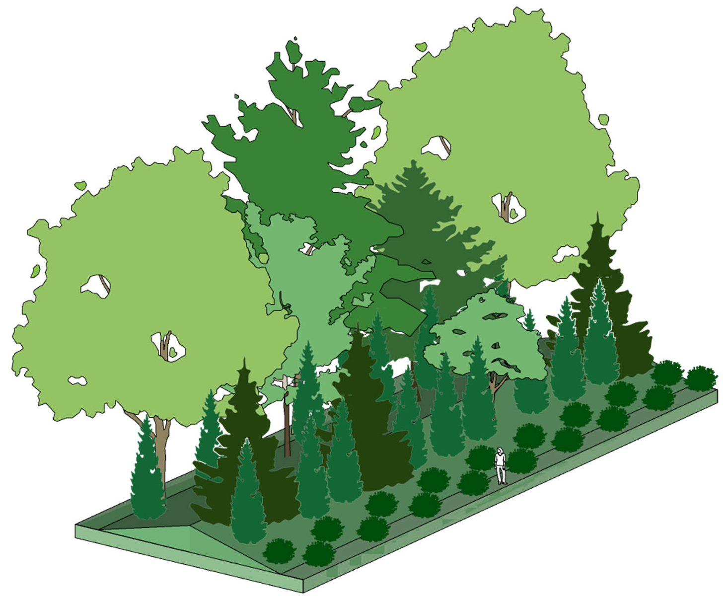
(Ord. No. 06-2020, § 3, 12-8-2020; Ord. No. 18-2022, § 3, 12-13-2022)
Sec. 114-631. - Parking area landscaping.
(a)
Applicability. Parking area planting requirements shall apply to all development or redevelopment that requires the establishment of ten or more parking spaces.
(b)
Existing parking lots. For existing parking lots that currently do not comply with the required parking lot plantings, such plantings shall be provided when any one of the following occurs:
(1)
A new principal building is constructed;
(2)
A building addition is constructed that expands the building footprint by at least the lesser of 30 percent or 5,000 square feet;
(3)
Rehabilitation of a building with a non-conforming parking lot that exceeds 50 percent of the appraised value of the building.
(4)
An existing parking lot is reconstructed or repaved or substantially modified;
(5)
When an existing parking lot under 10,000 square feet in area is expanded by 50 percent or more in total surface area; or
(6)
When an existing parking lot over 10,000 square feet in area is expanded by 25 percent or more in total surface area.
(c)
Interior parking lot planting.
(1)
An interior planting island shall be provided for every ten spaces. Each island shall contain a minimum of 200 square feet with a minimum dimension of eight feet. Islands are not required in parking areas dedicated to tractor trailer parking. The community development director shall have final authority on determining if an area shall be considered "tractor trailer truck parking."
(2)
Ten percent of the parking area (spaces and drive aisles) will be landscaped in a manner as to divide and break up the expanse of paving with islands and barriers. These areas must be located throughout the parking area so that no parking space is more than 100 feet from the nearest tree. For every ten off-street parking spaces, a minimum of one tree and three shrubs must be planted within required islands and barriers of the parking area.
(3)
Planting islands should be dispersed in a safe and efficient manner to promote safe pedestrian and traffic movements, and to increase on-site stormwater detention. (See Exhibit 631)
(4)
Parking lot planting shall be provided in addition to required buffers or perimeter plantings provided by the applicant.
Exhibit 631a: Sample Interior Parking Island and Parking Lot Layout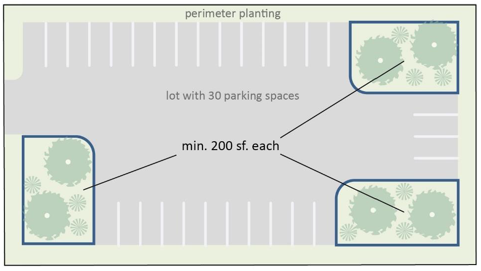
(d)
Parking areas abutting residential lots. On side and rear lot lines where parking areas abut any single-family or duplex residential lot, the required buffer shall include a berm or an opaque wall or fence, not taller than six feet in height and not less than 42 inches in height.
(e)
Streetyard planting for industrial and commercial areas abutting right-of-way. For properties abutting arterial or collector roads that are used for industrial or commercial retail, service, or office uses, the applicant may request to provide a street yard in lieu of a buffer. Such request must be approved by the community development director. If approved, the street yard shall be adjacent to the public right-of-way and include a planting strip along the entire length of the perimeter of the street facing area excluding authorized driveway widths.
(1)
For all development abutting arterial and collector roads, the following standards shall apply:
a.
A minimum 25-foot-deep landscaped street yard shall be established parallel to the entire front of the property along the road right-of- way in lieu of the required buffer. If an easement parallels the right-of-way frontage and precludes the ability to meet the streetyard requirement, the streetyard shall be in addition to the easement or increased to the extent that the planting requirements can be met. (Example: If a 15-foot power easement was directly adjacent to the right-of-way and did not permit trees within it, the 25 foot street yard would commence from the interior edge of the easement for a total of 40 feet).
b.
The street yard shall include the number and type of plants specified in Exhibit 631b and illustrated in Exhibits 631c, 631d, 631e, and 631f.
Exhibit 631b: Streetyard Planting Specifications
Exhibit 631c: 25 ft Arterial Street Streetyard for Retail, Service, and Office Uses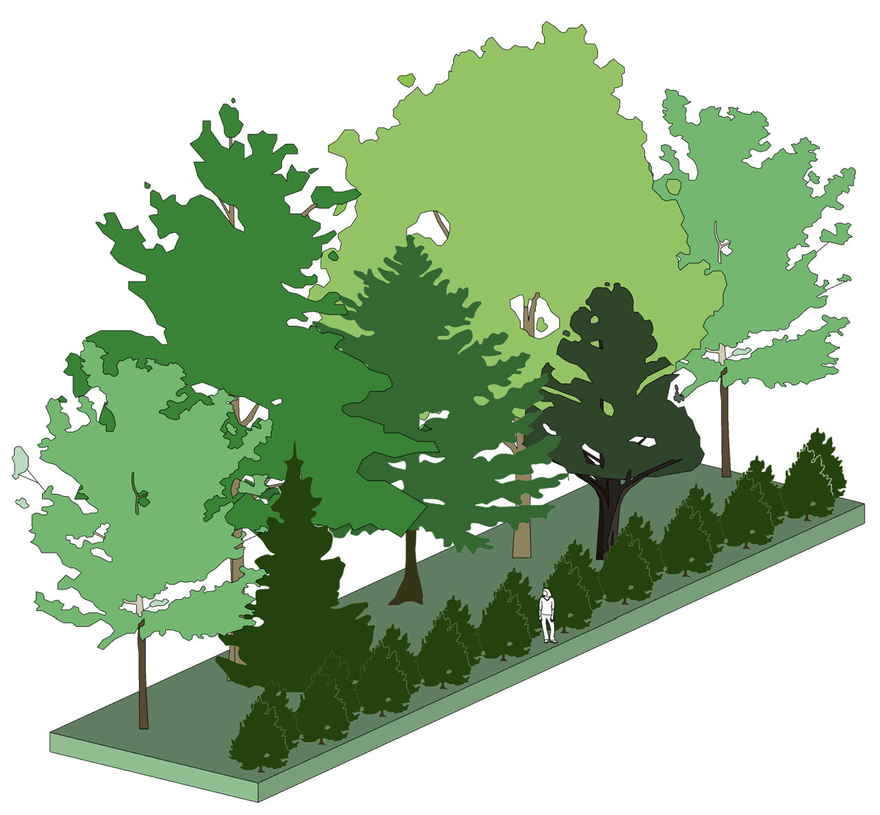
Exhibit 631d: 25 ft Collector Street Streetyard for Retail, Service, and Office Uses
Exhibit 631e: 35 ft Arterial Street Streetyard for Industrial Uses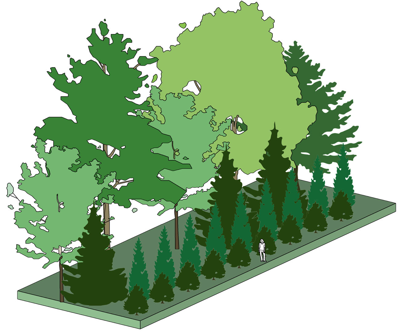
Exhibit 631f: 25 ft Collector Street Streetyard for Industrial Uses
c.
Driveways should be defined using a mixture of trees, shrubs and groundcovers that will create a sense of arrival. Clusters of flowering and other ornamental plant species such as knockout roses, ornamental grasses and annuals is strongly encouraged. A minimum of 200 square feet shall be planted on each side of the entrance drive. Sight triangle requirements of section 114-1008 shall be maintained.
(2)
All required street yards shall contain only living landscaping materials, mulch, and fences or walls; provided, the following may be located within the streetyard when approved by the community development director:
a.
Walls and fences less than five feet in height shall be encouraged;
b.
Vehicular access drives placed approximately perpendicular to the right-of-way;
c.
Electrical, telephone, gas, water supply, sewage disposal, and other utilities may be constructed to pass through or across the required streetyard area. If the installation of such services impacts the requirements of this UDO, additional landscaping and/or streetyard area may be required to meet the intent and standards of this section;
d.
Foot and bicycle paths (including sidewalks);
e.
Landscape sculpture, lighting fixtures, trellises, pedestrian amenities and arbors;
f.
Signs;
g.
Berming or mounding of soil; and
h.
Bioretention and other heavily vegetated stormwater BMPs.
(3)
When calculating lot frontage for minimum plantings, driveways shall be subtracted from the linear foot total.
(4)
Where existing or created lagoons and drainage swales will occupy a substantial portion of the required streetyard, additional depth may be required to achieve the intent of this section.
(5)
Any area not otherwise planted shall be mulched.
(Ord. No. 06-2020, § 3, 12-8-2020; Ord. No. 18-2022, § 3, 12-13-2022)
Sec. 114-632. - Additional screening, planting and fencing requirements.
(a)
Screening of outdoor storage, service areas, mechanical equipment and dumpsters. For multi-family, commercial, mixed-use, and industrial uses, authorized outdoor storage, service areas, mechanical equipment and dumpsters shall be screened with walls so they are not visible from adjacent properties or public right-of-way, in accordance with the following:
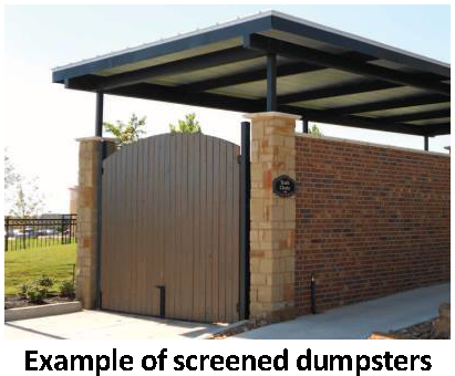
(1)
The design of a screening wall, excluding the gate, shall be the same architectural style and materials as the principal building or buildings on the lot.
(2)
The height of a wall shall be adequate to block view to the area being screened, but shall not exceed eight feet, except as otherwise allowed by this section.
(3)
The height of a wall shall be measured from the finished grade at the base of the wall to the top of the wall, but shall not include columns or posts.
(4)
Walls shall be interrupted at intervals not exceeding 25 feet by architectural features such as pilasters or columns or by various species of plants that are at least as tall as or taller than the wall.
(5)
Such walls shall be setback a minimum of five feet from any adjacent property lines.
(6)
In industrial districts, the community development director may approve the use of a combination of fencing and plantings in lieu of a wall to screen such features from abutting industrial property.
(b)
Landscaping at the base of signs. There shall be established a landscaping area around each principal freestanding sign that is equal to or greater than the total area of all sides of the sign structure. The sign landscaping area shall extend from the base or structural supports of the sign equally in every direction, but no less than five feet. Within this sign landscaping area, the following standards shall apply:
(1)
All portions of the sign landscaping area shall be surrounded by protective covering and covered by landscape materials except for those ground areas that are covered by permitted structures. A minimum of 80 percent of the required landscape area shall be covered with living plant materials, which may include any combination of ground covers and shrubs or mulch.
(2)
Shrubs that are provided within the sign landscaping area must be at least 12 inches tall at the time of planting and be of a species that will not normally exceed four feet in height at maturity.
(3)
Plant materials may be clustered for decorative effect following professional landscaping standards for spacing, location and design.
(c)
Street trees. For single family and duplex lots within a major subdivision, including a PD, at least two large canopy trees shall be planted within the six-foot planting strip, as required in article X, between the edge of pavement for the road and the sidewalk along the frontage of each lot. The developer shall include a street tree planting plan and installation schedule with the required landscape plans. Unless otherwise approved by the board of commissioners, street tree maintenance and replacement shall be the responsibility of the subdivision's Homeowner's Association. In order to provide a unified streetscape, street trees do not need to comply with the maximum genus and species requirements. The CCRs for the homeowners' association shall clearly identify maintenance responsibility for the trees, and the ongoing duty to maintain the street trees. The street trees shall also count toward required tree canopy for the overall subdivision. If the homeowners' association fails to maintain the street trees, the county may remove and replace such trees and bill the homeowners' association.
(d)
Fences and walls.
(1)
Except as otherwise required by this UDO, a fences or walls shall be constructed in durable fashion of brick, stone, or other masonry material or wood posts and planks or metal or other materials specifically designed as fencing materials or a combination thereof.
(2)
Unless otherwise specified, required walls and fences shall be a minimum height of six feet above grade.
(3)
No more than 25 percent of required fence surfaces shall be left open and the finish side of the fence shall face the abutting road or property. A chain link fence with plastic, metal or wooden slats may not be used to satisfy fencing requirements.
(4)
No fence or wall located in a required setback in a RR-2.5, RR-1.5, RR-1, R-15, R-M, RMH and PD zoning district shall be built to a height more than eight feet above grade.
(5)
No fence or wall located in a required setback in a business, commercial or industrial district shall be taller than ten feet above grade.
(6)
The capital of a fence post or column may extend up to two feet above the maximum height limit.
(7)
No fence or wall may be constructed which will block or impede the flow of stormwater runoff within a storm drainage easement.
(8)
All fences and walls located at road intersections shall conform to the sight requirements at intersections in section 114-1008.
(Ord. No. 06-2020, § 3, 12-8-2020; Ord. No. 18-2022, § 3, 12-13-2022)
Sec. 114-633. - Plant, planting and maintenance standards.
(a)
Plant material standards. The following standards apply as a minimum to all required buffer, streetyards, and other planting requirements, including plantings for canopy coverage unless specifically stated in other parts of this division.
(1)
Native and regionally appropriate plant species are required. Invasive species, as identified by the United States Forest Service and/or the University of Georgia, are prohibited from being planted.
(2)
All plant and tree material shall meet the American Standard for Nursery Stock standards that are published by and available from the American Association of Nurserymen.
(3)
Tree and landscape materials selected for planting must be free from injury, pests, disease, nutritional disorders or root defects, and must be of good vigor in order to assure a reasonable expectation of survivability.
(4)
The minimum standards specified in Exhibit 633a shall apply to all plantings required by this section at time of planting, except as otherwise specified.
Exhibit 633a: Plant Specifications1
(b)
Installation standards.
(1)
Installation of trees and landscape materials shall be in accordance with the standards established by the American National Standards Institute (ANSI).
(2)
Root barriers shall be installed within landscape/streetyard areas with less than seven feet between the back of curb and the sidewalk to prevent root penetration and destruction of infrastructure.
(3)
Large and medium canopy trees shall not be planted underneath or directly adjacent to overhead power lines and shall be a minimum of ten feet from any building or underground utility unless a root barrier is used.
(4)
Small trees and palms shall be a minimum of five feet from any building or underground utility.
(5)
Permanent built in or temporary water systems shall be installed to ensure the plants will survive the critical establishment period. This may include the use of tree gator watering bags for replacement or new trees.
(c)
Planting bond. A planting bond for tree and/or landscape installation that cannot be planted because of continued construction, weather, and/or plant availability may be utilized for a period of up to six months. This bond allows a project to receive a certificate of occupancy once all other requirements have been met. The planting bond shall be equal to 100 percent of the total cost of materials and installation, plus 15 percent contingency. The planting bond will be released upon final inspection and compliance with the approved landscaping plan. Planting bonds shall be in the form of cashier's check, bond, or letter of credit.
(d)
Maintenance guarantee.2[1]
(1)
Maintenance guarantee required. Prior to the issuance of a certificate of occupancy, the developer shall submit a maintenance guarantee in the form provided in paragraph (d)(3), below, for all of the landscaping required to meet the provisions of this division.
(2)
Amount of maintenance guarantee. The amount of the guarantee shall be 25 percent of the total cost of landscaping installation, including materials and maintenance, as identified by a registered landscape architect, and approved by the community development director. The maintenance guarantee shall remain in effect for a minimum of two years after issuance of the certificate of occupancy. After one year and upon approval of the community development director, the maintenance bond may be reduced to 50 percent of the total cost of the original bond.
(3)
Type of security. The security shall be in the form of a maintenance bond, an irrevocable letter of credit, or cashier's check.
(4)
Release of maintenance guarantee. Prior to the community development director releasing/closing the maintenance guarantee, the applicant shall submit a request for final inspection no less than 30 days but no more than 60 days in advance of the maintenance guarantee expiring. If the community development director or duly authorized representative, determines the required landscaping does not comply with the maintenance standards specified in section 114-633(e), below, the applicant shall be required to take the necessary corrective action to meet the required standards. The community development director may require an updated registered landscape architect's cost estimate and an updated/amended maintenance guarantee.
(e)
Maintenance standards.
(1)
All plant material shall be maintained in good condition at all times in accordance with standards established by ANSI. All required plantings that die or are destroyed must be replaced, during the next suitable planting season.
(2)
To ensure the viability of all plant material, the landscape plan and/or tree protection and preservation plan shall identify the permanent water system.
(3)
Attaching lights, signage, fence rails, and any other items to trees is strictly prohibited.
(4)
All sites are required to remain in compliance with the requirements for development of this division and are subject to inspection by the county for this purpose. If deficiencies are found, the owner of the property shall be notified to correct the deficiencies within 90 days. If the deficiencies are not corrected in 90 days, the county will seek administrative or judicial relief, as appropriate.
(5)
From the effective date of this UDO, no person, firm, corporation or other entity shall trim, prune, cut, excavate near, dig or trench near, or otherwise disturb any tree on any property owned or controlled by the county and subject to this UDO without strictly complying with the following regulations:
a.
Trees on public property may be pruned for utility line clearance only by tree pruners who have attended a certified utility line training course within a 12-month period of pruning activity. At each pruning site, names of pruning crew with date of certification shall be available for county review. All pruning of public trees shall be done in accordance with the American National Standard for Tree Care Operations (ANSI A300-2001) and the most current standards as developed by the National Arborist Association.
b.
Requirements pertaining to utility companies.
1.
Prior to conducting any non-emergency tree pruning, all utility companies shall notify the community development director in writing, no less than three days prior to the start of any work.
2.
Utilities and telecommunications companies shall use directional pruning unless the county otherwise consents in writing.
3.
The county may halt the cutting when it is deemed to be detrimental to any protected tree or when the cutting exceeds what is needed for continued utility service.
4.
When in the judgment of a utility company and the community development director, a tree interferes with the safe and reliable operation of the electric power system along a street right-of-way and cannot be pruned in accordance with ANSI Standard A300 to provide the required clearance, the utility company may offer to remove the tree and replant an acceptable specie tree for the location or in a location mutually acceptable to the county, the utility company, and the property owner. Such trees may be planted on public land, or private property, within the limitations and intent of this section.
(f)
Protection of trees during site development and construction.
(1)
The area directly beneath and covered by the canopy of a tree shall be designated as a tree protection zone (see Exhibit 633b: Tree Protection Zone) and shall be kept safe from harmful impact during construction and site development.
(2)
Trees designated on the tree protection and preservation plan as protected trees must be completely enclosed by rigid tree protection fencing as approved by a licensed Georgia Landscape Architect or International Society of Arboriculture ISA certified Arborist prior to clearing or grading or the erection of any building. Tree protection fencing must be located as described on the tree protection and preservation plan.
(3)
Tree protection fencing must remain in place until all construction has been completed or final occupancy permit has been issued, whichever is last.
(4)
Failure to install tree protection fencing prior to any clearing, demolition, or construction will result in the loss of tree protection credits, a stop work order, and/or a possible fine.
(5)
Any damage to protected trees, breach of the tree protection zone, or other protection violation outlined herein which occurs during site development and construction phases must be documented and reported to the community development director within seven days.
Exhibit 633b: Fencing for Tree Protection Zone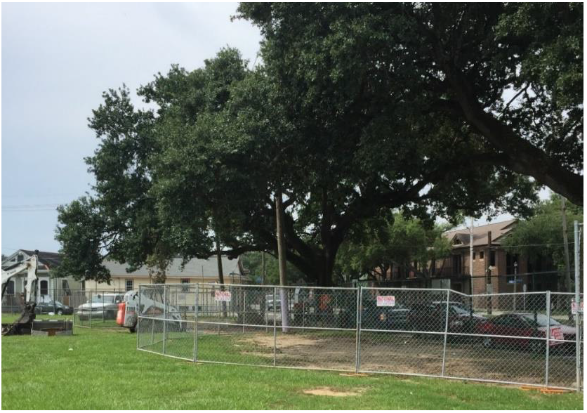
(g)
General tree protection.
(1)
The area directly beneath and within the drip line of trees shall be designated as the critical root zone (see Exhibit 633c).
(2)
No soil disturbance or compaction, stock piling of soil or other construction materials, vehicular traffic, or storage of equipment are allowed in the critical root zone.
(3)
No ropes, signs, wires, unprotected electrical installation, or other device or material shall be secured or fastened around or through a tree.
(4)
Toxic chemicals, gas, smoke, salt brine, oil, or other injurious substances shall not be stored or allowed to seep, drain, or empty within the critical root zone.
(5)
Except for sidewalks and curb and gutter, no paving with concrete, asphalt, or other impervious material within the drip line of trees to be retained shall be allowed.
Exhibit 633c: Critical Root Zone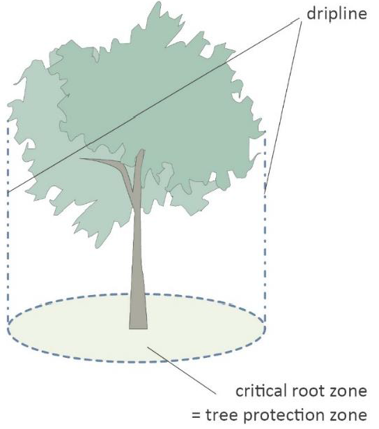
(Ord. No. 06-2020, § 3, 12-8-2020; Ord. No. 18-2022, § 3, 12-13-2022)
Spaced no more than 50 feet on center for the entire lot frontage. Where overhead utilities preclude planting large trees, groups of three small canopy trees shall be provided for each one large tree required.
Sec. 114-634. - Canopy retention and tree preservation.
(a)
Purpose. The purpose of this section is to maintain tree canopy coverage in Bryan County and to protect and preserve heritage and historic trees. These provisions apply to residential and non-residential properties and development as identified herein.
(b)
Canopy retention.
(1)
Canopy requirements. All applicable development shall be required to maintain a minimum tree canopy of 40 percent. Trees may be tiered and grouped with small canopy trees planted under the canopy of a new or existing large or medium canopy tree; however, a maximum of three small canopy trees per one large or medium canopy tree shall be allowed in calculating total canopy coverage. Total canopy coverage shall be computed from sum of the small, medium or large canopy trees retained or planted. All trees retained or planted subject to other provisions of this division may be used to satisfy this requirement.
(2)
Applicability. Canopy requirements of this section are applicable to:
a.
Major subdivisions (including planned developments) being developed;
b.
Non-residential, multi-family, and mixed-use projects (including commercial development in planned developments) being developed;
c.
Any activity requiring issuance of a land disturbance permit, except for individual residential lots and minor subdivisions.
(3)
Canopy analysis. The tree protection and preservation plan, including tree survey, shall be submitted with landscape plans as required in section 114-420. The plan shall be based on the gross area to be developed and shall show the canopy line for each proposed tree. Once the developer sells individual lots, the builder/owner is responsible for implementing the plan for individual lots.
(4)
Standards for compliance. The canopy requirement must be met whether or not a site had trees prior to development or disturbance of the applicable site. The canopy may be achieved by preserving existing trees, by planting new trees according to the minimum standards of this UDO or by a combination of the two. Minimum tree canopy shall be calculated and established pursuant to the formula and analysis set forth in Appendix D-3 to this UDO. Any existing tree of not less than six inches DBH left in good growing condition on the property is eligible to be counted toward the minimum required canopy and has to be protected. Existing trees that will remain and be used toward meeting minimum canopy requirements, shall be identified on the tree protection and preservation plan of the required landscape plan.
(5)
Trees in wetlands. Fifty percent of the canopy coverage in wetlands can be utilized to satisfy the canopy coverage requirements. In the General Industrial (I-2) zoning district, the allowable percent shall be 75. If canopy coverage in wetlands meets the 40 percent gross canopy coverage required by this UDO, the developer/builder shall still be required to meet the planting requirements identified in other sections of this UDO, (e.g., street tree requirement buffers, screening, and parking lot planting).
(6)
Qualifying trees. Trees replanted to achieve canopy requirements are to be selected from species listed in section 114-635. Indigenous species may be selected for replanting even though it may not be included in section 114-635 upon approval by the community development director. In addition, replanting shall be at the ratio of not less than one large or medium canopy tree for every three small canopy trees. Canopy credit may be met by planting all large or medium canopy trees, but not by planting only small canopy trees. No more than 25 percent of any one species may be included in any replanting plan. All replacement trees will be maintained properly to ensure their survivability.
(c)
Tree preservation.
(1)
Protected tree classifications. These regulations shall apply to two categories of trees: Heritage Trees and Historic Trees. Heritage trees and historic trees shall be collectively known as protected trees.
a.
Heritage tree. All trees meeting a minimum of 16 inches diameter at breast height (dbh) up to 28 inches dbh.
b.
Historic tree. A historic tree, due to its age and stature, is considered to have irreplaceable value and is defined as any tree 28 inches in dbh or greater.
(2)
Removal of single/individual trees. Except as otherwise exempt, it shall be unlawful to fell, improperly prune, or otherwise destroy a Protected Tree without first obtaining a tree removal permit from the community development director. A tree removal permit shall not be necessary to remove a tree creating imminent danger to other trees, permanent structures, public utilities, rights-of-way or persons or for the ordinary pruning, trimming, and maintenance of a protected tree. A tree posing imminent danger shall be defined as one damaged by a storm, fire, or vehicular accident such that its structural integrity is seriously compromised and that the tree can be reasonably expected to fall and injure persons or structures. Applications for permit shall be submitted as outlined in article IV.
(3)
Major subdivision/site plan development. All applications for sketch plat, construction plans or site plan approval, must include a Tree Survey with protected trees identified. The tree survey may be submitted with required landscape plans or separately. The tree survey shall comply with the submittal requirements identified section 114-420. Protected Trees, unless otherwise permitted by these regulations, shall not be removed or be caused to be removed until such Construction Plans and Landscape Plans are approved.
(4)
Standards for property development. The following criteria shall be followed with respect to the applicable property development:
a.
Subdivision of parcel: The subdivider shall make conscious efforts to avoid protected trees in proposing placement of rights-of-way and easements. Additionally, lots shall be platted in a way that avoids removal of historic trees or groupings of heritage trees such as locating them in the middle of proposed lots. Lot lines should be platted adjacent to protected trees to retain them as design features and vegetative buffers and to mitigate storm water run-off and erosion problems.
b.
Building envelopes: Historic trees within proposed building envelopes shall be mitigated, in accordance with paragraph (f) of this section. Heritage trees within proposed building envelopes, as well as those within 20 feet of the envelope, may be removed when necessary without mitigation.
c.
Yards and buffers: Protected trees shall not be removed from required yards, streetyards, or buffers. A protected tree may be limbed up if located outside a required buffer, or if located within a required visual buffer or clearance zone. Heritage trees may be limbed up to eight feet, while historic trees may be limbed up to 16 feet to provide view sheds.
d.
Means of access and parking: Historic trees shall not be removed to make way for parking lots, parking space, drive aisles, or driveways, unless the applicant demonstrates to the satisfaction of the community development director that no reasonable alternative exists. If removal is permitted, the applicant shall mitigate as required in paragraph (f) of this section. Heritage trees may be removed in these locations, but mitigation shall be required in accordance with paragraph (f) of this section.
e.
Outdoor uses and active recreation areas. Protected trees may be removed on land where the proposed principal use is conducted primarily outside; provided, mitigation shall be required in accordance with paragraph (f) of this section. The community development director shall determine whether the proposed outdoor use qualifies under this provision and that the protected tree removal is the minimum necessary to accommodate the proposed use. Qualifying uses shall include, but are not limited to: outdoor sales areas with minimal ancillary indoor space, transportation and construction businesses that store fleet vehicles on-site, outdoor storage of oversized bulk items that cannot practically be stored under roof, industrial activities and processes that do not occur under roof, as well as recreation areas, such as golf courses, athletic fields, courts, and pools managed by schools, public recreation departments, country clubs, home owners associations and other legally established organizations.
(5)
Waters of the state: Protected trees within 25 feet of any water of the State shall be preserved and no disturbance shall occur within the critical root zone, even if more than 25 feet distant from such water.
(6)
Streets: Protected trees may be removed without mitigation from rights-of-way to allow for arterial and collector street construction, including widening, intersection improvements, parallel bicycle/pedestrian improvements, and drainage improvements. Historic trees removed for construction of local street projects shall be mitigated in accordance with paragraph (f) of this section, while heritage trees may be removed from local street rights-of-way without mitigation. This provision only applies to projects undertaken by local or State government.
(7)
Water, sewer, and drainage improvements: Protected trees may be removed, but must be mitigated in accordance with paragraph (f) of this section, for installation of water, sewer, and drainage infrastructure and implementation of associated easements. This provision only applies to projects undertaken by local or State government.
(d)
Timbering/logging. If a property owner timbers/logs a property pursuant to silviculture operations, the property owner, including successors in interest, may not submit an application for sketch plat, site plan, or construction plan approval for a period of two years after the end of silviculture operations unless the property owner conducted a tree survey in accordance with this UDO and submitted the tree survey to the community development department. All protected trees identified on the tree survey that are removed shall be mitigated if the property owner seeks to develop the property before the expiration of the two-year period.
(e)
Violation and penalty.
(1)
The removal, damage or destruction of a protected tree without a required tree removal permit or approval of the tree preservation and protection plan of the landscape plan, shall constitute a violation of this UDO. Each protected tree that is removed, damaged or destroyed shall constitute a separate offense. Each day during which the loss of the tree goes unmitigated, as provided below, shall be judged a separate offense.
(2)
In lieu of any fines and penalties incurred by a violator of this section, the community development director may require tree replacement as a condition of granting certificates of occupancy. Replacement trees shall be required such that the total caliper-inches of new trees shall be equivalent to a 50 percent increase in the mitigation requirements as set forth in in accordance with paragraph (f) of this section. In no case, however, shall any replacement tree measure less than four inch dbh for heritage trees and historic trees.
(3)
In the event that violations of this section result in the issuance of a stop work order, the violator shall be responsible for tree replacement, payment of fines or posting a financial guarantee, as determined by the community development director, before construction is allowed to resume.
(4)
In the event that the violator of tree protection standards cannot be identified and located, the developer shall be held responsible for fines and mitigation.
(f)
Mitigation for tree removal; fee in lieu. Trees planted for mitigation shall meet performance standards per this section. In addition, the following requirements shall apply:
(1)
Mitigation for heritage trees shall occur at a rate of 50 percent, where every two inches of heritage trees removed, measured in dbh, shall be replaced by one inch of mitigation trees, measured in caliper-inches.
(2)
Mitigation for historic trees shall occur at a rate of 100 percent, where every inch of historic trees removed, measured in dbh, shall be replaced by one inch of mitigation trees, measured in caliper-inches.
(3)
Any tree planted for mitigation shall measure at least four inches dbh for Heritage trees and historic trees, at the time of planting.
(4)
Any tree at least six inches dbh but less than 16 inches dbh retained within the area of disturbance may be retained to contribute, inch for inch, to a tree mitigation requirement; provided, the tree does not stand in a wetland, any required buffer, or other area in which the tree would otherwise be required to be conserved. Such trees shall be protected as heritage trees.
(5)
In lieu of planting trees required for mitigation, the developer may, if approved by community development director, pay a fee per caliper-inch in an amount set by the board of commissioners. The fee shall be based on the current cost, at wholesale value, of installing a required tree to standards of the American Nursery and Landscape Association and its maintenance for one year.
(6)
Fees in lieu shall be put into an account reserved solely for the beautification of public lands and rights-of-way in Bryan County.
(7)
Trees planted for mitigation in new developments shall be in addition to those required for streetscapes, buffering and parking lots and shall be used to create a streetyard in existing developments where such streetyard does not currently exist.
(Ord. No. 06-2020, § 3, 12-8-2020; Ord. No. 21-2021, § 2, 9-14-2021)
Sec. 114-635. - Plant lists.
(a)
Large canopy trees: Acceptable large canopy trees are listed in Exhibit 635a. Large canopy trees reach heights of 50 feet or taller, and are suitable for areas with more than 400 square feet of total planting area.
Exhibit 635a: Large Canopy Trees
(b)
Medium canopy trees: Acceptable medium canopy trees are listed in Exhibit 635b. Medium canopy trees reach heights of 30 to 50 feet, and are suitable for areas with more than 100 to 200 square feet of total planting area.
Exhibit 635b: Medium Canopy Trees
(c)
Small canopy trees: Acceptable small canopy trees are listed in Exhibit 635c. Small canopy trees reach heights of up to 25 feet and are suitable for areas with more than 60 square feet of total planting area.
Exhibit 635c: Small Canopy Trees
(d)
Shrubs: Acceptable shrubs are listed in Exhibits 635d-i, which distinguish shrubs based on size and whether they are evergreen or deciduous.
Exhibit 635d: Large Evergreen Shrub Species List (Shrubs 8-12 feet in height)
Exhibit 635e: Large, Deciduous Shrub Species List (Shrubs 8-12 feet in height)
Exhibit 635f: Medium Evergreen Shrub Species List (Shrubs 3—8 feet in height)
Exhibit 635g: Medium Deciduous Shrub Species List (Shrubs 3—8 feet in height)
Exhibit 635h: Small Evergreen Shrub Species List (Shrubs to 3 feet in height)
Exhibit 635i: Small Deciduous Shrub Species List (Shrubs under 3 feet in height)
(Ord. No. 06-2020, § 3, 12-8-2020; Ord. No. 18-2022, § 3, 12-13-2022)
Sec. 114-636. - Purposes and applicability.
(a)
Open space retention is essential to:
(1)
Maintain Bryan County's rural character;
(2)
Limit stormwater runoff;
(3)
Improve aesthetics of residential and non-residential development;
(4)
Ensure proper functioning of the county's stormwater management systems;
(5)
Maintain water quality; and
(6)
Preserve wildlife habitat.
(b)
The open space requirements of this division apply to major subdivisions and site development plans within certain zoning districts.
(Ord. No. 06-2020, § 3, 12-8-2020)
Sec. 114-637. - Open space required.
(a)
Required area. Except as provided in paragraph (c) of this section, every development shall include the minimum percentage of its gross acreage as open space as is shown in Exhibit 637.
Exhibit 637: Minimum Open Space
(b)
Open space includes. For purposes of this section, open space means an area that:
(1)
Is not encumbered with any substantial structure;
(2)
Is not devoted to use as a roadway, parking area, or sidewalk, provided, however, that multi-user trails may be counted towards required open space;
(3)
Reflects the character of the land as of the date development began. Wooded areas shall be left in their natural or undisturbed state except for the cutting of trails for walking, bicycling or jogging. Areas not wooded shall be landscaped for open play fields, picnic areas or similar facilities. For non-residential development, the open space shall be properly vegetated and landscaped with the objective of creating an area that is consistent with the purposes of this division;
(4)
Does not include more than 50 percent of the open space requirement in non-tidal wetlands;
(5)
Is used as a required buffer area; and
(6)
For residential uses:
a.
Is part of an independent lot shown on the plan as being reserved for open space; and
b.
Is legally and practicably accessible to the residents of the development or to the public if the open space is dedicated to the county pursuant to section 114-639.
(c)
Areas not allowed as open space. The following areas shall not count toward common open space set-aside requirements:
(1)
Private lots, required setback areas, yards, balconies and patios dedicated for use by a specific dwelling unit;
(2)
Electric or gas transmission line rights-of-way;
(3)
Public right-of-way or private streets and drives;
(4)
Open parking areas and driveways for dwellings;
(5)
Land covered by structures except for ancillary structures associated with the use of the open space such as gazebos and picnic shelters;
(6)
Designated outdoor storage areas;
(7)
Land areas between buildings of less than 40 feet;
(8)
Land areas between buildings and parking lots or driveways of less than 40 feet in width;
(9)
Required setbacks; and
(10)
Detention/retention facilities except as provided section 114-642.
(d)
Small site development.
(1)
Applicability. For sites that would result in the required reservation of less than one-half acres of open space, the applicant for major subdivision or site plan approval may request and the approval body may accept payment in lieu of reservation of open space.
(2)
Fee determination. The amount of the fee shall be equal to the appraised value of developable land within the boundaries of the property prior to site development.
(3)
Use of fees. All fees in lieu of open space shall be placed in a separate open space fund that the county may use for the purchase or improvement of open space or recreational lands within the half of the county in which the property for which the fee was collected is located.
(Ord. No. 06-2020, § 3, 12-8-2020)
Sec. 114-638. - Ownership and maintenance of required open space.
(a)
Open space required to be provided by the applicant in accordance this division shall not be dedicated to the public but shall remain under the ownership and control of the developer (or the developer's successor) or a homeowners' association or similar organization that satisfies the criteria established in section 114-640. Open space within a residential subdivision shall be designated as an independent lot on the plat and shall be noted as being reserved for their intended purposes. For non-residential development, including multi-family, the open space may remain within the same lot as the development.
(b)
The person or entity identified in paragraph (a) as having the right of ownership and control over such recreational facilities and open space shall be responsible for the continuing upkeep and proper maintenance of the same.
(c)
For multi-family developments or other residential developments that do not have an HOA, an Open Space Provision and Maintenance Plan shall be submitted as a part of the application for development approval including the project phasing schedule. This plan shall designate and indicate the boundaries of all open-space areas required by this UDO. The plan shall:
(1)
Designate areas to be reserved as active open space. The specific design of open-space areas shall be sensitive to the physical and design characteristics of the site; and
(2)
Specify the manner in which the open space shall be perpetuated, maintained, and administered.
(d)
Open space, located on a separate parcel, may be dedicated to a registered land trust, if approved by the board of commissioners.
(Ord. No. 06-2020, § 3, 12-8-2020)
Sec. 114-639. - Dedication of open space.
If any portion of any lot proposed for residential or commercial development lies within an area designated on the officially adopted recreation master plan as a park or part of the greenway system or bikeway system, the area so designated shall be included as part or all of the open space requirement of section 114-637 and dedicated to public use. Dedication of acreage in excess of the minimum required acreage is voluntary and acceptance of the dedication is entirely at the discretion of the county.
(Ord. No. 06-2020, § 3, 12-8-2020)
Sec. 114-640. - Homeowners associations.
Homeowners associations or similar legal entities that are responsible for the maintenance and control of common areas, including open space, shall be:
(a)
Established before any lot in the development is sold or any building occupied;
(b)
Be granted clear legal authority to maintain and exercise control over such common areas and facilities; and
(c)
Have the power to compel contributions from residents of the development to cover their proportionate shares of the costs associated with the maintenance and upkeep of such common areas and facilities.
(Ord. No. 06-2020, § 3, 12-8-2020)
Sec. 114-641. - Open space linkages.
Where a trail, natural area or public park is dedicated to or acquired by the county, such area may be credited toward the minimum amount of common open space required.
(Ord. No. 06-2020, § 3, 12-8-2020)
Sec. 114-642. - Open space design criteria.
All required open space shall meet the following design criteria, as applicable:
(a)
Water bodies, retention areas, detention basins and wetlands basins, may constitute up to 40 percent of required open space, provided that retention facilities are designed to provide safe access to water, i.e. an observation deck, fishing pier, etc. Retention or detention areas shall be given a natural character and shall be constructed of natural materials. Terracing, berming, and contouring are required in order to naturalize and enhance the aesthetics of the basin.
(b)
Unless otherwise approved by the engineering director, side slopes to detention/retention facilities shall provide at least three feet of horizontal run for each foot of vertical rise.
(c)
Designated open space within residential development, single and multi, should be of a suitable size, location, dimension, topography and general character, and have proper road and/or pedestrian access to be usable open space. Open space provided pursuant to this requirement shall be accessible to all residents of the development and shall measure at least 30 feet across its narrowest dimension.
(d)
Not more than 20 percent of required open space may be used to meet the active recreational facilities requirement identified in article VI, division 7. The land area of the open space used for active recreational facilities, however, does not count toward the minimum land area required pursuant to the active recreation land minimums in section 114-645(b) and (c). All passive park land may be counted towards required open space.
(Ord. No. 06-2020, § 3, 12-8-2020)
Sec. 114-643. - Purposes and applicability.
(a)
Recreational facilities are essential to:
(1)
Promote a sense of community;
(2)
Enhance the quality and livability of residential development; and
(3)
Promote the health of Bryan County residents.
(b)
The recreational facility requirements of this division apply to planned developments, major residential subdivisions, and multi-family or mixed-use developments, having a residential component, requiring subdivision or site plan approval.
(Ord. No. 06-2020, § 3, 12-8-2020)
Sec. 114-644. - Ownership and maintenance of recreational areas.
(a)
Recreational facilities required to be provided by the applicant in accordance this division shall not be dedicated to the public but shall remain under the ownership and control of the developer (or the developer's successor) or a homeowners' association or similar organization that satisfies the criteria established in section 114-640.
(b)
The person or entity identified in paragraph (a) as having the right of ownership and control over such recreational facilities shall be responsible for the continuing upkeep and proper maintenance of the same.
(Ord. No. 06-2020, § 3, 12-8-2020)
Sec. 114-645. - Recreational facility requirements.
(a)
When required. In conjunction with an application for preliminary development plan approval in a PD district, site plan approval for multi-family development, or sketch plat approval for a major subdivision, the applicant shall identify proposed recreational facilities that will be provided in conjunction with the development of the proposed subdivision. The application shall identify the land areas, types and sizes of facilities, and proposed equipment. The recreational facilities associated with the preliminary development plan, site plan, or sketch plat approval shall be the minimum facilities that must be constructed before 30 percent of the lots or multi-family dwelling units in any phase of a subdivision or development have been issued a building permit.
(b)
Required recreational facilities. All subject development shall include the following recreational facilities:
(1)
Active recreational land. In addition to required open space, single-family and multi-family developments with 50 or more dwelling units in one or more phases shall provide active recreation facilities on one or more parcels totaling at least one and one-half acres of usable area plus one-half acre for each additional 50 dwelling units. Active recreational land and open space areas, as provided for in section 114-637(b), may be developed in any combination of active recreational facilities listed in paragraph (c) of this section.
(2)
Active recreational land (multi-family). For multi-family developments, with fewer than 50 dwelling units, the developer shall provide active recreational land at a rate of 150 square feet per dwelling unit. This recreational land shall be used to meet the minimum active playground requirement in paragraph (c). This requirement may be waived if the proposed multi-family project is within a quarter mile of a public park.
(c)
Eligible active recreational facilities. Where active recreational facilities are required by paragraph (b)(1) of this section, the development shall include any combination of the following facilities that totals one credit per 50 dwelling units. In calculating required credits, if a development exceeds the 50 dwelling units by 24 or fewer units, the required credit shall be rounded down and if it exceeds the 50 dwelling units by 25 or more dwelling units, the required credit shall be rounded up. For example, if the development has 124 units, two credits are required, but if the development has 125 units, three credits are required. Subject developments shall provide a combination of recreational facilities and may not satisfy requirements by providing multiples of only one type of facility (e.g., three picnic areas to achieve 1.5 credits).
(1)
Active recreation fields - These may consist of open fields or sport-specific fields encompassing at least 2.5 acres for each credit.
(2)
Swimming pool - Swimming pools shall include at least 1,250 square feet of pool surface and 2,000 square feet of deck area for each 50 dwelling units served in the development. Restrooms, showers, and changing areas are required.
(3)
Sports courts - These may consist of tennis courts, basketball courts, volleyball courts, multi-purpose courts or similar facilities encompassing 40,000 square feet for each one-half credit.
(4)
Picnic areas - These may consist of independent covered picnic tables or shelters accommodating multiple picnic tables. These may abut open spaces but shall not be used to satisfy required open space acreage. At least one acre of land, ten tables, and two restrooms shall be provided for each one-half credit.
(5)
Community activity building - Indoor community activity space may be provided in the amount of 30 square feet per dwelling unit. Restrooms must be included. One credit shall be given for the minimum square footage met.
(6)
Active playground - These may consist of a minimum of 2,400 square feet of play area and play equipment in locations so that each dwelling unit is within one-quarter of a mile of a playground. Each active playground shall, at a minimum, include swings, a slide, climbing apparatus, and a bench, or equivalent recreational amenities as determined by the community development director. One-half credit shall be provided for each active playground.
(d)
Modification of recreational facilities. The community development director may approve minor modifications of recreational facilities approved by the board of commissioners upon finding that the proposed facilities will provide equal or greater recreational value for residents of the development. Any modification deemed by the Director to be major shall require approval of the board of commissioners.
(e)
Major subdivisions—Passive recreational facilities. For major subdivisions with less than 50 dwelling units, the board of commissioners may require passive recreational facilities through the sketch plat or preliminary development plan approval process if the board of commissioners determines that based on location of the subdivision (i.e., distance to recreational facilities, and/or the integration of the required open space into the overall development) fails to provide sufficient recreational opportunities for the residents.
(Ord. No. 06-2020, § 3, 12-8-2020)
Sec. 114-660. - Purposes.
(a)
It is not the intent of this sign code to regulate the message that signs convey, to foreclose important and distinct mediums or expression for political, religious, or personal messages, or to suggest the county should regulate the content of signs in any manner. It is, however, the intent of this chapter to regulate the time, place, and manner of sign placement in a manner sufficient to meet the public purposes articulated in this section.
(b)
These sign regulations are intended to:
(1)
To promote the mental and physical health, safety and welfare of the public by providing for the orderly and harmonious display of signs within the county;
(2)
To maintain and enhance the aesthetic environment by minimizing visual clutter, encouraging a positive visual environment, and avoiding the erection of displays which produce deleterious and injurious effects to adjacent properties and to the natural beauty of the environment;
(3)
To provide for the safety of the traveling public, both vehicular and pedestrian, by limiting distractions, hazards, and obstructions;
(4)
To maintain the county's ability to attract sources of economic development and growth and to aid in the identification of properties and enterprises for the convenience of the public;
(5)
To protect the rural character of the county;
(6)
To encourage the effective use of signs as a means for communication in the county by allowing the maximum amount of expression or speech consistent with its compatibility with the aesthetic, public health, safety and welfare concerns that the county is charged by law and the Georgia Constitution with preserving and protecting; and
(7)
To enable the fair and consistent enforcement of these sign regulations while supporting the policies contained in the comprehensive plan.
(Ord. No. 06-2020, § 3, 12-8-2020)
Sec. 114-661. - Findings.
The board of commissioners finds that:
(a)
Sign regulations achieve public safety rationales not achieved by provisions of the International Building Code, as adopted by the county. Without sign regulations, signs can pose a clear danger to public safety. It has been long recognized that sign controls are needed to promote traffic safety and avoid traffic accidents. Signs can distract motorists by impairing visibility. Traffic safety is improved by restricting the size, height, and locations of signs. Signs, if unregulated, can confuse motorists by mimicking traffic safety signals and signs.
(b)
Unregulated signs may negatively affect the character of communities and the value of buildings. For example, blighted signs and antiquated signs and sign structures (i.e., the pole with a blank structure for a sign face) can contribute to an overall image of blight and a reduction of property values in declining areas if not addressed and removed via sign controls. Unregulated signs can reduce the effectiveness of signs needed to direct the public because they compete with public purpose signs and reduce their visibility and effectiveness. Unregulated signage in special character areas would almost assuredly neutralize any public plan and investments to improve streetscapes.
(c)
Sign regulation serves the interests of the business community. Unregulated competition among businesses where individual business signs are not adequately visible results in too many signs and a point of diminishing returns. Sign regulations help to maintain the scenic heritage and unique character of the community by implementing uniformity of standards and quality in signs. Signs substantially influence the appearance of the community, and sign regulation is essential to the community's long-term economic viability. Sign controls improve visual character.
(d)
Signs are a proper use of private property, a means of personal free expression and a necessary component of a commercial environment. As such, signs are entitled to the protection of the law. However, an improperly regulated sign environment imposes health and safety dangers to the public.
(e)
Effective sign regulation lessens hazardous conditions, confusion and visual clutter caused by the proliferation, improper placement, illumination and excessive height and size of signs which compete for the attention of pedestrians and vehicular traffic.
(f)
Proper regulation of signs is a necessary prerequisite to a peaceable, orderly and safely designed business environment.
(g)
Through proper regulation of signs, the aesthetic attractiveness and economic well-being of the county will be enhanced as a place to live, work and conduct business.
(h)
Concerns about aesthetic and safety issues, as balanced with concerns about freedom of expression or speech, are reasonably promoted in the county by the provisions of these sign regulations. Some signage has a single targeted function and identification of such signage by description is impossible without referring to its function. For instance, address numerals are used for the sole purpose of providing addresses, which is of benefit to persons looking for those addresses and is essential to public safety personnel responding to emergencies. Signs at the entrances to subdivisions or major developments favor a similar purpose in enabling both the traveling public and emergency personnel to quickly locate entrances for the purpose of either visitation or responding to emergency calls. While such signage is referenced based upon the function it serves within the context of this UDO, the provisions of this sign code are unrelated to the content of the speech provided and allow maximum expressive potential to sign owners.
(Ord. No. 06-2020, § 3, 12-8-2020)
Sec. 114-662. - Applicability.
(a)
The regulations and requirements of this sign code apply to all signs that are or are intended to be viewed from a public right-of-way or adjacent property, or to be viewed from outdoor areas of private property, except as otherwise exempt under this sign code.
(b)
A sign may be erected, placed, established, painted, created, or maintained within the planning jurisdiction of the county only in conformance with the standards, procedures, exemptions, and other requirements of this UDO. Section 114-422 establishes the procedures to permit a variety of types of signs in commercial, residential and industrial areas that are subject to the standards of this sign code, which:
(1)
Exempts certain signs as specifically provided;
(2)
Prohibits certain types of signs;
(3)
Identifies signs that may be permitted in various locations and circumstances;
(4)
Establishes standards for the design of signs generally and within specified zoning districts;
(5)
Establishes rules for sign measurement and maintenance and;
(6)
Describes how non-conforming signs should be addressed and the rules for sign removal.
(Ord. No. 06-2020, § 3, 12-8-2020)
Sec. 114-663. - Exemptions.
Exhibit 663 lists the types of signs that are exempt from specific requirements of this sign code and describes the extent of the exemption and related requirements for the specified type of sign.
Exhibit 663. Signs Exempt from Certain Sign Code Provisions
(Ord. No. 06-2020, § 3, 12-8-2020)
Sec. 114-664. - Prohibited signs.
Exhibit 664 lists the types of signs that are prohibited and establishes additional requirements related to specific types of prohibited signs.
Exhibit 664. Prohibited Signs
(Ord. No. 06-2020, § 3, 12-8-2020; Ord. No. 3-2025, § 2, 1-14-2025)
Sec. 114-665. - General sign requirements.
(a)
Generally. The following regulations shall apply to all signs:
(1)
Unless otherwise provided in this sign code, no sign shall be erected, constructed, modified, replaced, structurally altered, or relocated within the county without prior issuance of a permit.
(2)
All signs shall be designed, constructed, and maintained in accordance with the following standards:
a.
Except for banners, flags and temporary signs conforming in all respects with the requirement of this sign code, all signs shall be constructed of permanent materials and shall be permanently attached to the ground, a building, or other structure by direct attachment to a rigid wall, frame, or structure.
b.
Every sign, including, but not limited to, those signs for which permits are required, shall be maintained in a safe, presentable, and sound structural condition.
(3)
All signs in areas adjacent to the rights-of-way of roads of the State highway system, which roads are also a part of the interstate and primary systems of highways within the State, are subject to the provisions of O.C.G.A. title 46, art. 3, pt. 2 (O.C.G.A. § 32-6-70 et seq.) As such, they shall comply with all provisions of such statute and shall meet all requirements and obtain all necessary permits under said code. However, in instances where the provisions of this chapter are more restrictive, the provisions of this chapter shall control.
(4)
The creation, construction or maintenance of freestanding signs in areas adjacent to and/or visible from interstate highway system rights-of-way shall be limited to: B-1 Neighborhood Commercial, B-2 General Commercial, C-1 Interchange Commercial, and I-1 and I-2 Industrial Districts.
(5)
No signs, except as otherwise specified, shall exceed the standard building height limit of the district in which they are located. Portable signs shall require issuance of a sign permit pursuant to section 114-422 and comply with all setback and area requirements in applicable zoning districts.
(6)
All signs requiring foundation mountings shall be designed by a Georgia registered engineer.
(b)
Basic standards.
(1)
All permanent signs must be of a professional character, be erected by a qualified sign professional, and comply with the provisions of this sign code. Homemade lettered signs shall not be permitted, whether or not a permit is required, except for temporary signs.
(2)
Signs shall be consistent with the appearance of the general neighborhood in which located. Signs shall not constitute a traffic hazard or contribute to traffic problems through confusion with traffic control devices, interference with the field of vision of motorists using streets or driveways in the area, or by creating a visual distraction for motorists.
(c)
Sight triangle. Signs shall not be placed within the sight triangle as defined in section 114-1008.
(d)
Sign placement.
(1)
No person shall paste, print, nail, tack or otherwise fasten any card, banner, handbill, sign, poster or advertisement or notice of any kind, or cause the same to be done, on any private property, without the written consent of the owner of such property.
(2)
No person shall construct, erect, operate, use or maintain any sign without the written permission of the owner or other person in lawful possession or control of the property on which such structure or sign is located.
(3)
No person shall erect a sign on public property other than the governmental entity responsible for such property or public utility companies or contractors occupying or working on public property pursuant to government contract or franchise. Nailing, posting, securing signs, temporary or permanent, to trees located on county property or within county right-of-way is prohibited.
(4)
For signs in a planned development (PD), each property or individual project within the PD shall conform to the sign regulations established as part of the zoning approval for the PD. If no such provisions are included in the zoning approval of the PD, each property or individual development within a PD shall conform to the provisions of this sign code in accordance with the land use of said property (or the predominant use of the ground floor in the case of a mixed-use building).
(e)
Illumination and movement.
(1)
Except as otherwise specifically permitted in this sign code, signs shall not contain any intermittent, moving, blinking, flashing, oscillating, scrolling, or fluttering lights or animated parts; nor shall any device be used that has a changing light intensity, brightness of color or give such illusion, except as otherwise specifically permitted by this sign code.
(2)
Except authorized electronic message signs, the light source for any illuminated sign shall not be directly visible from adjacent streets or property. Exposed neon-type tubing as part of any sign and/or on a building shall not be permitted. Backlight silhouetted halo letters shall be permitted, provided the light source is fully concealed.
(3)
For all signs, the level of illumination emitted or reflected from a sign shall not be of intensity sufficient to constitute a demonstrable hazard to vehicular traffic or pedestrians on any right-of- way or parking lot from which the sign may be viewed. All illumination must be of reasonable intensity and shall not spill onto adjacent properties or rights-of-way. Signs adjacent to residential buildings and streets shall not be of such brightness to cause reasonable objection from adjacent RR, R, or PD districts or residential uses.
(4)
Illuminated signs abutting a RR, R or PD district or use shall be at least 25 feet from the nearest property line of a RR, R or PD district.
(5)
If illuminated, the illumination shall not interfere with the visibility of, or obscure, an official traffic sign, device, or signal.
(Ord. No. 06-2020, § 3, 12-8-2020)
Sec. 114-666. - Regulations for specific types of signs.
(a)
Private directional signs. Within a development, private directional signs may be erected to identify where specific uses within the development are located, provided that the sign complies with the Manual for Uniform Traffic Control Devices (MUTCD) standards and the sign has not more than four and one-half square feet in sign area.
(b)
Freestanding signs.
(1)
All permanent freestanding signs other than authorized outdoor advertising and pole signs allowed in the C-I, I-1 and I-2 district shall be monument signs.
(2)
A property or development will be permitted only one freestanding sign, except as follows:
a.
Double frontage lots with more than 500 feet of frontage on two or more arterial roads will be permitted a second freestanding sign, provided the total message area of the second sign does not exceed 50 percent of that allowed for the first sign and the signs are located a minimum of 250 feet apart. Distance shall be measured from the outer edge of each sign and/or supporting structure.
b.
Buildings containing at least 500,000 square feet of gross floor area or more and with more than one vehicular access point and a minimum of 1,000 feet of road frontage may be permitted a second freestanding monument sign. Each sign must be located at a separate entrance, spaced at least 500 feet apart.
(3)
Outparcels that meet the minimum road frontage requirements for a lot in the applicable zoning classification will be permitted one freestanding sign. Outparcels will not be deemed to overlap or to share frontage or area in any way with other outparcels or with the larger property of which they are a part.
(4)
On a developed lot without road frontage, one freestanding sign will be permitted. The sign shall not exceed ten feet in height or 50 square feet of sign area. The sign will be located where access for the business is located. Written permission must be obtained from the owner of the property where the sign is located.
(5)
No freestanding sign shall be located closer than 75 feet to another freestanding sign on a parcel that abuts an arterial road or 50 feet on a parcel that abuts a collector road. However, if this provision precludes a sign on any parcel, the community development director may approve a permit for a freestanding sign on the applicable parcel.
(c)
Wall signs. Signs on the walls of a building (including signs attached flat against the wall, and painted wall signs) shall comply with applicable provisions of this sign code and not exceed the maximum area established in section 114-667.
(d)
Projecting signs. Signs attached at an angle to a wall (including a 90-degree angle) may extend outward from the wall of a building not more than five feet.
(e)
Electronic message center signs.
(1)
Locations. Subject to the provisions of this section up to one Electronic Message Center (EMC) may be allowed per lot as a part of a freestanding sign in the B-2 and C-I zoning districts. EMCs shall not be allowed for any other type of sign regulated by this UDO except signs that are internal to a building and not located within four feet of a window, and signs that are not visible from adjacent right-of-way within the B-2 and C-I districts.
(2)
Maximum size. EMC signs are only allowed if incorporated into a larger sign, and shall not exceed eight square feet of EMC sign area per sign in the C-I district or four square feet per sign for signs in a B-2 district. Signs having two back-to-back faces with EMCs shall be counted as one sign with the sign area calculated from one side of the sign.
(3)
Luminance. All EMCs shall have an automatic dimmer that limits the brightness based on ambient light conditions to no more than the maximum luminance allowed in this section. EMCs shall be adjusted at the time of installation so that auto-dimming shall be set so that the luminance is no greater than 0.3 foot-candles brighter than ambient lighting conditions.
(4)
Frequency of message change and transitions. Each message on an EMC shall remain static for no less than eight seconds. Transitions shall not include any animation, blinking or flashing and shall not include any blank screens lasting longer than one second. For EMCs that are divided into multiple frames, not more than one frame may change in any way other than brightness more than once per day unless all frames change concurrently.
(5)
Animation. No EMC shall include any animation that creates the appearance of motion.
(6)
Default settings. The EMC shall be programmed with a static default message or image so that if a malfunction occurs, the default message shall freeze the sign in one position and the maximum brightness shall be 100 nits or 9.29 foot-candles.
(7)
Non-conforming signs. No EMC shall be installed as part of or in place of any non-conforming sign unless the sign is brought into full compliance with the provisions of this UDO.
(8)
Gas price signs. Gas pricing signs shall not be subject to the provisions of this section.
(f)
Outdoor advertising signs. Outdoor advertising signs are permitted only on properties with direct frontage along designated interstate rights-of-way and shall meet the following requirements:
(1)
Uniform size. The outside measurements of all such signs shall be 12 feet in height and not greater than 50 feet in length, with or without trim (600 square feet).
(2)
Illumination. All illuminated outdoor advertising signs shall use base-mounted fluorescent or mercury vapor lights and shall be activated and deactivated by photo-electric cells. Additional lighting, including, but not limited to, neon, animation and running lights, is prohibited.
(3)
Height above highway/interstate grade. All outdoor advertising signs shall be a minimum of ten feet above adjacent highway/interstate pavement measuring from the lower portion of the sign face. Sign structures shall not exceed 80 feet in height. Two signs in the same location (back-to-back, over and under, or "V" formation) shall be the same height above the highway/interstate's surface.
(4)
Protrusions prohibited. Protrusions beyond the face of the sign are prohibited, with the exception of aprons.
(5)
Zones where permitted. Outdoor advertising signs are only permitted in the C-1, I-1, and I-2 zoning districts. Final location of outdoor advertising signs must comply with state of Georgia requirements for outdoor advertising signs (O.C.G.A § 32-6-70, et. seq.).
(6)
Spacing. Outdoor advertising sign locations shall be no less than 500 feet apart measuring from the two closest points, regardless of the dimensions of the lots on which they stand.
(7)
Distance from right-of-way/property lines. Outdoor advertising signs shall be no less than 15 feet from the right-of-way line, and 15 feet or a distance equal to the height of the sign, whichever is greater, from all other property lines. In addition, the outdoor advertising sign must meet all distance and buffer requirements established by the state of Georgia for outdoor advertising signs (O.C.G.A § 32-6-70, et seq.).
(8)
Locations limited per quadrant. Outdoor advertising signs adjacent to the right-of-way and visible from I-16 and I-95 shall be restricted to a designated "Billboard Zone" within each interchange quadrant (Exhibit 666). This zone begins at a point 500 feet from where the pavement begins or ceases to widen at entrance and exit ramps, to accommodate the longest ramp, and extends for a length of 1,200 feet. A maximum of three outdoor advertising signs may be permitted within each interchange quadrant.
(9)
General advertisement signs. Other than outdoor advertising signs located within a designated "Billboard Zone," general advertisement signs adjacent to interstate highways and visible from the main traveled way of I-16 and I-95 are prohibited, except for right-of-way logos on standards furnished by the department of transportation. Logos shall be defined as an easily read and identifiable symbol such as Shell Oil, Exxon Oil, Holiday Inn or independent company trademarks of a size to be approved the department of transportation.
(10)
Marsh and historic area locations. No outdoor advertising sign shall be placed in or obstruct the view of a marshland area or any historic area designated by the board of commissioners.
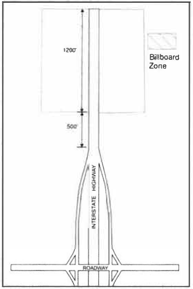
Exhibit 666: Billboard Zone
(g)
Subdivision/multifamily development entrance signs.
(1)
Purpose. In addition to serving the important role of helping to find properties within the county, subdivision entrance signs help define the character and quality of a neighborhood. For these reasons, this unique type of identification sign is encouraged within the county for subdivisions or multi-family developments with less than 30 lots/dwellings and required for subdivisions/multi-family development with 30 lots/dwellings or more as identified in section 114-1011.
(2)
Locations. All subdivision entrance signs must be located outside the limits of the public right-of-way, except for median signs located in the subdivision's median. Entrance signs are to be placed in a location that will not obstruct the vehicle sight distance. Signs located within the median of subdivision roads must be located outside the limit of the intersecting right-of-way.
(3)
Approval. All proposed signs must be approved by the engineering director and the community development director and meet the entry sign requirements identified in section 114-1011.
(4)
Maintenance. Subdivision entrance signs will not be maintained by the county.
(5)
Dimensions. Subdivision entrance signs are required to be monument signs or lettering placed on a brick or other masonry wall. Signs outside the right-of-way shall be less than eight feet in height. Median signs must be less than three and one-half feet in height measured from the road centerline intersection. Maximum sign area shall not exceed the requirements of section 114-667.
(6)
Lighting. Subdivision entrance signs may be unlit, externally illuminated or have backlit lettering. The sources of lightning may not be visible from public right-of-way or adjacent properties.
(h)
Digital gas price signs.
(1)
Locations. Digital signs utilizing LED, LCD, or similar technology, may be permitted within the "B-1," "B-2," and "C-I" zoning districts, to advertise the sales price of fuel sold on the premises.
(2)
Maximum size. The digital gas pricing element must be incorporated into a permitted freestanding or pole sign and may not occupy more than 25 percent of the total permitted sign face area.
(3)
Movement. Digital gas price signs shall not have any movement, scrolling. or other special effects and shall display gas pricing only.
(4)
Luminance. All digital gas price signs shall have an automatic dimmer that limits the brightness based on ambient light conditions to no more than the maximum luminance allowed in this section. EMCs shall be adjusted at the time of installation so that auto-dimming shall be set so that the luminance is no greater than 0.3 foot-candles brighter than ambient lighting conditions.
(5)
Non-conforming signs. Existing non-conforming gas station signage shall not be permitted to install digital gas price signs unless the sign is brought into compliance with this UDO.
(Ord. No. 06-2020, § 3, 12-8-2020; Ord. No. 3-2025, § 2, 1-14-2025; Ord. No. 16-2025, § 2, 9-9-2025)
Sec. 114-667. - Sign requirements by zoning district.
(a)
District standards. Exhibit 667a and Exhibit 667b list the types of signs allowed in each zoning district, the maximum dimensions of those signs and other applicable criteria.
Exhibit 667a: Sign Requirements for A, RR, and R Zoning Districts
Exhibit 667b: Sign Requirements for Non-residential Zoning Districts
(b)
Additional district provisions. The following standards apply in addition to and may modify the general district sign provisions in paragraph (a) of this section.
(1)
In the C-I district:
a.
For parcels that abut an interstate, the property owner may, in addition to the sign area authorized in Exhibit 667b, erect a single pole sign not taller than 80 feet above the nearest abutting interstate travel lane.
b.
The pole sign shall be erected in such a manner that it is oriented towards the interstate travel lanes. No portion of the sign shall be less than 15 feet from the edge of the abutting interstate right-of-way.
c.
Poles signs are permitted only within the designated "Interstate Pole Sign Zone" within each interchange quadrant (Exhibit 667c). This zone begins at a point 150 feet from the edge of the nearest intersecting right-of-way and extends to no more than 500 feet beyond the point where the pavement begins or ceases to widen at entrance or exit ramps, to accommodate the longest ramp.
d.
The pole sign must be located on the same parcel as the permitted activity or business being advertised.
e.
A minimum spacing of 500 feet shall be required between pole signs.
f.
The maximum allowable sign face area for permitted pole signs shall not exceed 600 square feet.
Exhibit 667c: Interstate Pole Sign Zone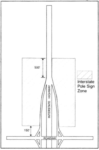
(2)
In a PD district, only those signs meeting the design criteria set forth for residential and B-1 districts are permitted unless otherwise incorporated into the plans for planned developments approved by the board of commissioners.
(3)
In the I-1 and I-2 districts:
a.
Applicability. The signage standards in this subsection shall apply to large-scale business and industrial parks located in the I-1 and I-2 zoning districts that meet or exceed 500,000 square feet of combined gross floor area. All signage regulated under this subsection, shall require approval of a master signage plan in accordance with Section 114-422 of this UDO.
b.
Development Park Entrance Signs.
(i)
For large-scale business or industrial parks with internal private roadways, one entrance sign may be erected per arterial or collector street frontage serving as a principal entrance.
(ii)
The maximum height of a development entrance sign shall not exceed 30 feet, measured from finished grade to the top of the sign structure.
(iii)
All entrance signs shall be set back a minimum of 35 feet from the public right-of-way.
(iv)
The overall sign structure shall reflect an architectural theme consistent with the design of the business or industrial park. Colors and finishes shall be coordinated with surrounding buildings and entry features.
(v)
Tenant panels may be incorporated into the sign face but must maintain uniformity in size and color. Logos and graphics are permitted, but the use of franchise-specific or tenant-specific colors is prohibited.
(vi)
Each tenant panel shall not exceed two feet in height, and lettering within panels shall not exceed 18 inches in height.
c.
Internal Wayfinding Signs.
(i)
Internal wayfinding signs may be installed along private drive aisles within large-scale business or industrial parks to direct traffic to buildings, tenants, or other on-site facilities.
(ii)
Wayfinding signs shall not exceed 12 feet in height and shall have a maximum sign face area of 50 square feet per sign.
(iii)
Wayfinding signs shall be located entirely within the private right-of-way or on private property and shall not obstruct sight lines or interfere with driver or pedestrian visibility at intersections, driveways, or internal roadway crossings.
(iv)
All wayfinding signage shall be designed with a consistent architectural theme, color palette, and materials that are compatible with the buildings and signage elsewhere in the development.
(v)
Logos or symbols may be used for identification purposes, but advertising, franchise branding, or tenant-specific colors shall not be permitted.
(Ord. No. 06-2020, § 3, 12-8-2020; Ord. No. 3-2025, § 2, 1-14-2025; Ord. No. 16-2025, § 2, 9-9-2025)
Sec. 114-668. - Sign measurement.
The following principles shall control the computation of sign area and sign height:
(a)
Computation of area of individual signs. The area of a sign face (which is also the sign area of a wall sign or other sign with only one face) shall be computed by means of the smallest square, circle, rectangle, triangle, or combination thereof that will encompass the extreme limits of the wiring, representation, emblem, or other display, together with any material or color forming an integral part of the background of the display or used to differentiate the sign from the backdrop or structure against which it is placed, but not including any supporting framework, bracing, or decorative fence or wall.
(b)
Computation of area of multi-faced signs. The sign area for a sign with more than one face shall be computed by adding together the area of all sign faces. When two sign faces are placed back to back, so that both faces cannot be viewed from any point at the same time, and when such sign faces are part of the same sign structure, the sign area shall be computed by the measurement of one of the faces.
(c)
Computation of height. The height of a sign shall be computed as the distance from the base of the sign at normal grade to the top of the sign face. Normal grade shall be construed to be the newly established grade after construction, exclusive of any filling, berming, mounding, or excavating solely for the purpose of locating the sign. In cases in which the normal grade of the sign is lower than the grade of the adjacent public street, normal grade shall be construed to be the grade of the adjacent public street. The term "adjacent public street" shall mean the street providing approved vehicle access to the property and which does or would bear the street address for the property.
(d)
Computation of maximum total permitted sign area. To determine the maximum sign area, the total square footage for every sign on the parcel, including freestanding, wall signs, projecting, and window signs, shall calculated. Maximum total sign area shall comply with the zoning district standard.
(Ord. No. 06-2020, § 3, 12-8-2020)
Sec. 114-669. - Sign maintenance.
(a)
Every sign, including those signs for which permits are required and those for which no permits or permit fees are required, shall be maintained in a safe, presentable and good structural condition at all times, including repair or replacement of defective parts, painting, repainting, cleaning and other acts required for the maintenance of the sign.
(b)
To prevent rust, peeling, flaking, fading, or rotting, all signs and supports shall be painted, unless anodized or similarly treated.
(c)
Broken panels, missing letters, defective illumination, torn fabric, flaking or peeling paint and other damage to a sign, shall be replaced or repaired.
(d)
If determination is made by the county that any sign is unsafe, not secure, in violation of any applicable law or a public danger, notice of such violation shall be given to the property owner and/or occupant where such sign is located. The property owner and/or occupant shall have 30 days from the date of said notice to remove, repair, or remedy said violation.
(Ord. No. 06-2020, § 3, 12-8-2020)
Sec. 114-670. - Temporary signs.
(a)
Temporary signs; allowed.
(1)
Signs in addition to those allowed under section 114-663 and section 114-666 are allowed on a property for the duration of a temporary event (as defined below). Such additional signs shall not be restricted as to the message displayed on the sign but must comply with the provisions of this section. If a sign meets the requirements of this section, i.e., qualifies as a temporary sign, no permit is required. The county, however, may remove any sign, regardless of the need for a permit, which fails to comply or maintain compliance with all requirements for temporary signs.
(2)
Temporary signs must comply with all requirements of this sign code, except as modified by the provisions of this section, including the prohibitions of section 114-664 and general requirements applying to all signs.
(3)
All temporary signs must be installed at a fixed location.
(b)
Temporary event defined. A temporary event is an activity having a specific duration or the end of which is related to a specific action, usually lasting for only a few days, or for certain temporary events, potentially a couple of or months at a time. Temporary events include but are not limited to such activities as:
(1)
The offering of a property or premises for sale or rent.
(2)
An election, political campaign, referendum or ballot proposition put to the voters as part of county, state or federal governance.
(3)
Special business promotions other than "grand openings", such as but not limited to "close-out sales" and seasonal sales events.
(4)
A grand opening for a new business.
(5)
A yard sale.
(6)
The construction of a building or development project, or the rehabilitation, remodeling or renovation of a building.
(7)
A public announcement of a special event or seasonal activity not intended for commercial use by an individual or a nonprofit organization.
(c)
Duration of temporary sign placement. Temporary signs may be placed on any property upon initiation of a temporary event, and must be removed upon the termination of the event. Initiation/termination of particular events shall be interpreted as follows:
(1)
Sale or lease of a building or premises. Initiation upon the availability of the building or premises for sale or lease, and termination upon the closing of the sale or execution of the rental agreement.
(2)
Building construction or remodeling. Initiation upon issuance of a building permit authorizing the construction, interior finish or remodeling, and termination within seven days after issuance of the certificate of occupancy.
(3)
Residential or nonresidential subdivision or condominium under development. Initiation upon sketch plat or site plan approval by the County. Termination upon the sale of 95 percent of the lots, dwelling units or sale or lease of 95 percent of the buildings or units in the final phase, or at the end of 12 continuous months during which no building permits have been issued for new construction within the development, whichever occurs first.
(4)
Public issue. Initiation 90 days prior to the applicable election and termination within seven days after the election of all candidates to office or resolution of all ballot questions put to the voters in the election.
(5)
Special business promotion.
a.
Initiation upon announcement of the special sale or sales event, and termination upon its completion or seven days after initiation, whichever occurs first.
b.
A special business promotion event may not occur for more than seven continuous days once a month and no more than seven total days each month on the same property for each business or tenant, regardless of the number of businesses on the property.
c.
Additional provisions apply to banners placed during a special business promotion event.
(6)
Grand opening.
a.
Initiation upon announcement of the grand opening event, and termination upon its completion or 14 days after initiation, whichever occurs first.
b.
For purposes of this section, a grand opening event may not occur for more than 14 continuous days and may occur only once for a business that has newly occupied the property.
c.
Portable signs and festoons are allowed for 14 days during a grand opening event.
(7)
Yard sale. Initiation two days prior to the announced date of the sale, and termination at the end of the announced date.
(8)
Nonprofit public announcement. Initiation upon the placement of the sign and termination not more than 14 days after such placement.
(9)
Other temporary events. The initiation and termination dates for any temporary event not listed above shall be determined by the community development director for each temporary event, based on considerations such as: normal beginning and ending dates for such an event, the scheduled occurrence of the event, or similarities to other temporary events listed above or having previously occurred. Unless the community development director finds that there are unique circumstances surrounding the event, the sign shall be limited to 14 days of display.
(d)
Number and size of temporary signs. Only one temporary sign related to each temporary event per business or tenant may be located on a property at any one time, unless otherwise specified below:
(1)
Sale or lease of a mixed-use or non-residential building or premises. One building sign may be substituted for an authorized window or wall sign on each tenant space that is available for sale or lease, and the authorized free-standing sign may be used as a second sign.
(2)
Residential or nonresidential subdivision or condominium under development. During construction of a residential or nonresidential subdivision or condominium development:
a.
Non-residential development. One non-illuminated sign, not exceeding 40 square feet in area, displaying the name of the building, the contractor, the architects, the engineer, the owners, and the financial, selling and development agencies is permitted upon the premises of any work under construction, alteration, or removal.
b.
Residential subdivision signs. Temporary signs announcing a land subdivision development, and not exceeding 40 square feet in combined area per development, are permitted on the premises of the land subdivision. One sign shall be allowed at each subdivision entrance.
(3)
Election or political campaign. Up to five back-to-back or single-face signs not exceeding:
a.
Four and one-half square feet per sign face and three feet in sign height on a lot in any A, RR, R, or PD district; and
b.
Sixteen square feet per face and six feet in sign height in any other district.
(4)
Large non-residential buildings. For a non-residential building containing 50,000 square feet of gross floor area or more, the following shall apply:
a.
During the construction or remodeling of a commercial, industrial or institutional use building containing 50,000 square feet of gross floor area or more, no more than two temporary freestanding or wall signs shall be allowed, not exceeding 64 square feet in area nor more than 10 feet in height; and,
b.
During the start-up period while a commercial, industrial or institutional use building containing 50,000 square feet of gross floor area or more is initially for sale or lease, no more than two additional freestanding signs shall be allowed, not exceeding 64 square feet in area not more than 10 feet in height.
(5)
Nonprofit public announcement. No limit on the number of signs but signs shall not be located in rights- of-way.
(e)
Location of temporary signs. All temporary signs shall be located on private property at least ten feet from any street right-of- way line. Temporary signs shall be no closer to the right-of-way than adjacent permanent signs in the area. All temporary signs shall be located at least ten feet from any side or rear property line and the pavement edge of a driveway. The sign location must not obstruct visibility exiting the drive.
(f)
Temporary banners, portable signs, festoons and spectacular signs or device. One banner is allowed as temporary signage during a special business promotion event in accordance with the duration, number, size, location and lighting limitations of this sign code, and in accordance with the following additional provisions:
(1)
Such a banner shall be placed on the site or on a building in such a manner as not to create a safety hazard as determined by the community development director. They shall meet the same setback requirements as all other temporary signs.
(2)
In the B-1, B-2, C-I, P-I, WB, I-1, and I-2 districts, a banner is allowed to exceed the maximum area established in paragraph (f)(3) of this section if covering and no larger than a sign face that has been damaged by windstorm or other casualty. Such banners may be displayed for up to 45 days or up to 180 days if the sign owner has entered into a contract for repair or replacement of the damaged sign.
(3)
All other banners in a B-1, B-2, C-I, P-I, WB, I-1, or I-2 district shall meet the following requirements:
a.
The banner may be displayed for no longer than 30 days;
b.
The banner shall not exceed 32 square feet in overall surface area and ten feet in height or width,
c.
The banner is one-sided and located entirely against a building or lawful, pre-existing sign, and
d.
The banner is stretched tightly and securely fastened at each corner or edge.
(Ord. No. 06-2020, § 3, 12-8-2020)
Sec. 114-671. - Non-conforming signs.
Signs that, on the effective date of this UDO or any amendments thereto, were approved and legally erected under previous sign restrictions, and that became or have become nonconforming with respect to the requirements of this UDO due to its adoption or amendment, may continue in existence subject to the remaining provisions of this section.
(a)
No increase in size of the nonconforming sign shall be permitted.
(b)
Any existing sign that was legally erected but has become nonconforming with respect to setback from a street due to road widening may be moved to meet the setback requirement of this UDO; provided, the sign shall not be increased in size, shape or changed in any manner, except to become conforming.
(c)
Existing, legally nonconforming signs, hereafter reconstructed, repaired, altered or replaced due to damage incurred by an act of God or other accident, shall be allowed to be restored to their original condition and location.
(d)
Unless the structural base, pole or support of a sign is completely replaced; repairs, alterations and replacements made to legally nonconforming signs do not constitute a new sign and thus will be allowed to be restored to their original condition. In the event of conflict between the provisions of this section and other sections of the UDO, the most stringent requirements shall prevail and be controlling.
(Ord. No. 06-2020, § 3, 12-8-2020)
Sec. 114-672. - Removal of signs.
(a)
The building official shall cause the removal of any sign that, in the building official's sole discretion, endangers the public safety, such as an abandoned; dangerous; or materially, electrically or structurally defective sign. Any other sign for which no permit has been issued or which is otherwise in violation of this UDO shall also be subject to removal in accordance with this section.
(b)
Any temporary sign erected in violation of the provisions of this section may be removed immediately by the building official. Any sign so removed shall be retained at a designated county facility until recovered by the sign owner following payment of applicable fees. Any sign not recovered within ten days will be destroyed.
(c)
The building official shall prepare a written notice to be sent by first class mail which shall describe the sign and specify the violation involved and which shall state that if the sign is not removed or the violation is not corrected within 30 days, the sign shall be removed in accordance with the provisions of this section.
(d)
The notice shall be mailed to the owner of the property on which the sign is located, the owner of the sign and the occupant of the property. If any such person is unknown or cannot be found, notice shall be mailed to that person's last known address, if any, and posted on the sign or on the premises.
(e)
Any sign removed by the building official pursuant to the provisions of this section shall become the property of the county and may be disposed of in any manner deemed appropriate. The cost of removal of the sign by the County shall constitute a lien against the property and shall be recoverable in the same manner as county property taxes. The cost of removal shall include any and all incidental expenses incurred in connection with the sign's removal.
(Ord. No. 06-2020, § 3, 12-8-2020)
Sec. 114-673. - Purposes.
The general purpose of this division is to protect and promote the public health, safety and welfare, the quality of life, the ability to view the night sky, and ongoing operations on Fort Stewart by establishing regulations and a process of review for exterior lighting. These provisions establish standards for exterior lighting to:
(a)
Protect against direct glare and excessive lighting;
(b)
Provide safe roadways for motorists, cyclists and pedestrians;
(c)
Protect and reclaim the ability to view the night sky, and help preserve the quality of life;
(d)
Prevent light trespass in all areas of the County's jurisdiction or adjacent jurisdictions;
(e)
Promote efficient and cost-effective lighting;
(f)
Ensure that sufficient lighting can be provided where needed to promote safety and security;
(g)
Allow for flexibility in the style of lighting fixtures; and
(h)
Provide lighting guidelines.
(Ord. No. 06-2020, § 3, 12-8-2020)
Sec. 114-674. - Applicability.
(a)
All applications for construction plan, site plan and PD final development plan approval shall include lighting plans showing location, type, height and lumen output of all proposed and existing fixtures. The applicant shall provide enough information to verify that lighting conforms to the provisions of this UDO. The community development director shall have the authority to request additional information in order to achieve the purposes of this UDO.
(b)
All exterior lighting installed after the effective date of this UDO in any and all zoning districts in the county shall be in conformance with the requirements established herein and any other applicable ordinances. All existing lighting in any and all zoning districts in the County shall be addressed as follows:
(1)
All existing lighting located on a subject property that will be modified or replaced as part of an application for a site plan or PD final development plan approval is required to be brought into conformance with this UDO. Conformity shall occur prior to issuance of certificate of occupancy or final inspection.
(2)
Non-conforming lighting shall not be moved to any other location unless the move results in the entire light being brought into compliance with all applicable regulations of this UDO.
(3)
If a light is destroyed or rendered inoperable for any reason other than failure of the bulb it shall not be repaired unless such repair will bring the light into compliance with all applicable regulations of this UDO.
(Ord. No. 06-2020, § 3, 12-8-2020)
Sec. 114-675. - Exemptions.
The following are exempt from the requirements of the UDO:
(a)
Outdoor lighting fixtures on advertisement signs on interstates and federal primary highways;
(b)
Street lights installed and/or regulated by a utility company;
(c)
Outdoor lighting fixtures existing and legally installed prior to the effective date of this UDO;
(d)
Navigational lighting systems at airports and other lighting necessary for aircraft safety;
(e)
Outdoor lighting fixtures that are necessary for worker safety;
(f)
Holiday lights for the period from October 25th to January 15th, except that flashing holiday lights are prohibited on commercial properties;
(g)
Vehicular lights and all temporary emergency lighting needed by the fire and sheriff's departments, or other emergency services;
(h)
Outdoor accent lighting for single-family residential properties provided that each light fixture emits no more than 1,000 lumens; and
(i)
Lighting at county parks.
(Ord. No. 06-2020, § 3, 12-8-2020)
Sec. 114-676. - General standards.
All exterior lighting, excluding streetlights, shall comply with the following standards. Lighting fixtures shall be full cut-off fixtures with the light source fully shielded, with the following exceptions:
(a)
Luminaires. All luminaires shall have a cutoff at 90 degrees or less and comply with the standards in Exhibit 676.
(b)
Motion sensor lighting. Sensor activated lighting may be unshielded provided it is located in such a manner as to prevent direct glare and lighting into properties of others or into a public right-of-way, and provided the light is set to only go on when activated and to go off within five minutes after activation has ceased, and the light shall not be triggered by activity off the property.
(c)
Non-essential and security lighting. All non-essential exterior commercial and residential lighting is encouraged to be turned off after business hours and/or when not in use. Lights on a timer are encouraged. Sensor activated lights are encouraged to replace existing lighting that is desired for security purposes.
(d)
Floodlamps and area lights. All floodlamps and area lights shall be aimed downward at least 45 degrees and no portion of the light bulb shall extend below the bottom edge of an external shield. Any floodlamp or area light emitting 1,000 or more lumens shall be aimed downward at least 60 degrees. The light source of floodlamps and area lights shall not be visible from adjacent properties or the public right-of-way. Flood lights with directional shielding and photocells with timers that allow a flood light to go on at dusk and off by eleven p.m. are encouraged.
(e)
Canopy lights service stations. The average lighting level for new and existing service stations shall be no greater than three lumens per square foot under the canopy. All lighting shall be recessed to ensure that no light source is visible from or causes glare on public rights-of-way or adjacent property
(f)
Towers. All radio, communication and navigation towers that require lights shall have dual lighting capabilities. For daytime, the white strobe light may be used, and for nighttime lights shall be used in compliance with FAA standards and allow for the minimum impact to avian species.
Exhibit 676: Standards for Luminaires with Total Cutoffs
*Measured at the property line
**Measured from the ground to light source.
Example of Luminaire with Total Cutoffs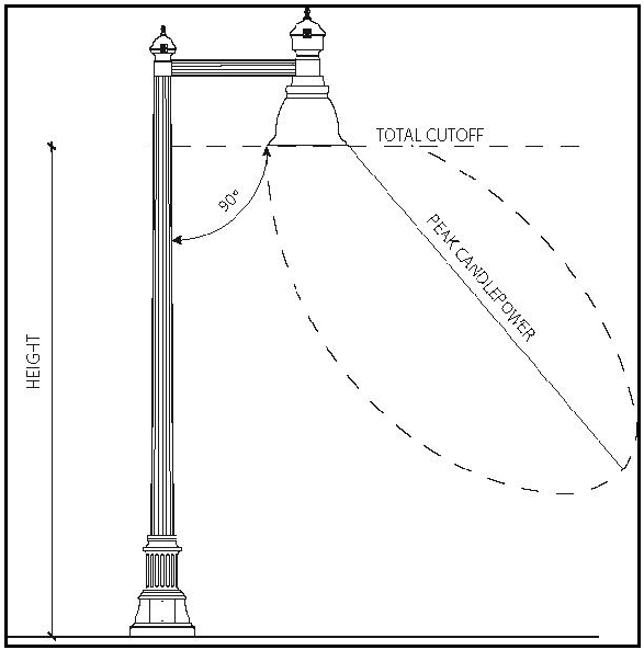
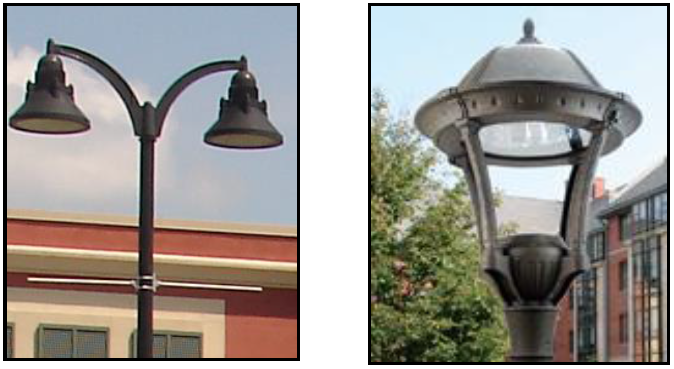
(g)
Temporary lighting. Temporary lighting that conforms to the requirements of this UDO shall be allowed. Non-conforming temporary exterior lighting may be permitted by the community development director only after considering (1) the public and/or private benefits which will result from the temporary lighting; (2) any annoyance or safety problems that may result from the use of the temporary lighting; and (3) the duration of the temporary non-complying lighting. The applicant shall submit a detailed description of the proposed temporary non-complying lighting to the community development director in compliance with the temporary use permit application process.
(h)
Outdoor sports field/outdoor performance area lighting.
(1)
These standards shall not apply to properties subject to state or federal safe lighting standards.
(2)
Because of their unique requirements for nighttime visibility and their limited hours of operation, ball fields, playing fields and tennis courts are exempted from the exterior lighting standards of paragraphs (a), (b) and (c) of this section. These outdoor recreational uses must meet all other requirements of this UDO.
(3)
The outdoor recreational uses specified above shall not exceed a maximum permitted post height of 80 feet.
(4)
The outdoor recreational uses specified above may exceed a total cutoff angle of 90 degrees, provided that the luminaire is shielded to prevent light and glare spillover to adjacent right-of-way or residential property. The maximum permitted illumination at the property line shall not exceed two lumens per square foot.
(i)
Lighting of outdoor display areas.
(1)
Outdoor display areas shall have a maximum point of illuminance of 20 lumens per square foot.
(2)
All light fixtures shall meet the IESNA definition of Cutoff Fixtures. Forward throw fixtures (type IV light distribution, as defined by the IESNA) are required within 25 feet of any public street right-of way.
(Ord. No. 06-2020, § 3, 12-8-2020)
Sec. 114-677. - Types of improvements.
Except as otherwise provided by the subdivision and site improvement regulations, a developer shall provide, install and pay for, at a minimum, the following improvements to serve the subdivision or site development. Utilities shall be located in accordance with the applicable right-of-way cross section for the proposed development.
(a)
Water supply and distribution;
(b)
Sanitary sewerage collection;
(c)
Sewage disposal systems;
(d)
Roadway(s) and site access;
(e)
Sidewalks/trails and connectivity to adjacent developments;
(f)
Stormwater management and drainage facilities;
(g)
Road name signs and traffic control devices;
(h)
Electricity;
(i)
Recreational facilities (residential subdivisions); and
(j)
Landscaping.
(Ord. No. 06-2020, § 3, 12-8-2020)