
Buena Vista City Zoning Code
ARTICLE 16
02 - Zoning Districts
Sec. 2.1. - Districts established.
Zoning districts are established as shown in Table 2.1. They are organized into the following categories:
2.1.1. Base Zoning Districts. Base zoning districts are established by the Town's adoption of the Official Zoning Map and subsequently by approval of a rezoning pursuant to Section 6.4.1. Approval of initial zoning or a rezoning authorizes the full range of development allowed by the standards applicable to the base zoning district.
2.1.2. Overlay Districts.
A.
Overlay zoning districts are established initially by the Town's adoption of the Official Zoning Map and subsequently by approval of a rezoning pursuant to Section 6.4.1. They are superimposed over one (1) or more underlying base or planned development zoning districts.
B.
Section 2.6, Overlay Districts, identifies the overlay zoning districts and sets forth each district's purpose and the standards that modify those of underlying districts.
C.
If the standards for an overlay district conflict with those for an underlying base zoning district, planned unit development district, or another applicable overlay district, the more restrictive standards shall apply.
D.
If the standards in a PUD located within the APO district conflict with the APO district standard, the APO standards shall apply.
2.1.3. Planned Unit Developments.
A.
Planned unit development (PUD) districts are established by the Town's approval of a PUD rezoning pursuant to Section 6.4.2. Development in a PUD district is subject to the standards included in or referenced in an approved PUD concept plan.
B.
Section 2.7, Planned Unit Development, describes the general purpose of PUD districts and sets forth base requirements applicable to all such districts, including the minimum development standards to be addressed in the district's PUD concept plan and the means of modifying the standards of this UDC through a PUD approval.
2.1.4. Zoning Map
A.
Established District Boundaries. The boundaries of zoning districts are established as shown on the map entitled "Official Zoning Map, Town of Buena Vista, Colorado" adopted by the Board of Trustees and certified by the Town Clerk. The map and all explanatory matter are adopted as part of this UDC. Amendments to the Official Zoning Map shall be in accordance with the procedures in Section 6.4.1, Rezoning.
B.
Interpretation of District Boundaries. Where uncertainty exists with respect to the boundaries of any of the zoning districts as shown on the Official Zoning Map, the following rules shall apply:
1.
Where district boundaries are indicated as approximately following the centerlines of streets, alleys, highways, streams, irrigation ditches, rivers, street or railroad rights-of-way or such centerlines extended, such centerlines and/or extensions shall be construed to be the boundaries.
2.
Where district boundaries are indicated as approximately following lot lines, such lot lines shall be construed to be the boundaries.
3.
Where district boundaries are indicated as approximately running parallel to the centerlines of streets, alleys, highways or railroads, or rights-of-way of same, such district boundaries shall be construed as being parallel to the centerlines and at a distance as indicated on the Official Zoning Map. If no distance is given, the distance shall be determined by the use of the scale shown on the Official Zoning Map.
4.
Where a district boundary line divides a lot in single ownership, the district requirements for the least restricted portion of such lot shall be deemed to apply to the whole lot, provided that such extensions shall not include any part of such a lot more than thirty-five (35) feet beyond the district boundary line.
5.
In the event of any other uncertainty not mentioned in this section, the Town Administrator shall recommend the location of such boundaries to the Board of Adjustment and the Board of Adjustment shall make the final determination.
(Ord. 5 §3, 2022)
Sec. 2.2. - Summary tables of dimensional standards.
In case of a discrepancy with the summary tables for any specific zoning district in this Article, the master tables in this section govern.
2.2.1. Residential Districts.
Table 2.2: Summary of Residential District Dimensional Standards
2.2.2. Mixed-Use and Commercial Districts.
Table 2.3: Summary of Mixed-Use and Commercial District Dimensional Standards
2.2.3. Other Nonresidential Districts.
Table 2.4: Summary of Other Nonresidential District Dimensional Standards
(Ord. 15 §§6, 7, 2018; Ord. 19 §2, 2018; Ord. 21 §1, 2018; Ord. 5 §§1, 2, 2019; Ord. 3 §1, 2020; Ord. 5 §4, 2022; Ord. 19 §10, 2024; Ord. 21 §1, 2024; Ord. 08 §§3—5, 13, 14, 2025)
Sec. 2.3. - Residential districts.
2.3.1. General Purposes of All Residential Districts. The residential districts established in this section are intended to:
A.
Provide appropriately located lands for residential development that are consistent with the policies and actions of the Comprehensive Plan;
B.
Ensure adequate light, air, privacy, recreation areas, and open space for each dwelling, and protect residents from the negative effects of noise, incompatible population density, traffic congestion, flooding, and other significant adverse environmental impacts;
C.
Protect residential areas from fires, explosions, airborne contaminants and substances, and other public safety hazards;
D.
Provide for residential housing choice, affordability, and diversity with varying housing densities, types, and designs of houses that are on permanent foundations;
E.
Provide for safe and efficient vehicular access and circulation and promote bicycle-, pedestrian-friendly neighborhoods;
F.
Provide for public services and facilities needed to serve residential areas and accommodate public and semi-public land uses that complement residential development while protecting residential areas from incompatible nonresidential development; and
G.
Create neighborhoods and preserve existing community character while accommodating new infill development and redevelopment consistent with the Town's goals and objectives.
2.3.2. Low-Density Residential District (R-1).
A.
Purpose. The R-1 district is intended primarily for low-density single-family detached dwellings. The R-1 district should have connected streets, and accessibility to public uses such as parks, open spaces, and schools.
B.
R-1 District Dimensional Standards.
Table 2.5: R-1 District Dimensional Standards
2.3.3. Small Lot Single-Family Residential District (R-1.5)
A.
Purpose. The R-1.5 district is intended primarily for small lots with single-family detached dwellings to increase affordability with higher residential densities where other multifamily uses may not be desired due to the densities, setbacks, and building heights allowed within other zone districts. It is also intended to provide affordable long-term affordable ownership opportunities by dedication of a portion of lots to the Town. The R-1.5 district should have connected streets, active front yards without garages, except where absolutely necessary, and should concentrate parking to the rear of lots abutting alleys and also provide accessibility to public uses such as parks, open spaces, and schools. New development shall match the overall development pattern of surrounding existing single-family subdivisions (predominately without alleys) by matching lot configurations and setbacks at the exterior boundary of the subdivision.
B.
Availability of Zone and Adjustments in Dimensional Standards.
1.
Availability. The R-1.5 District zone is only available for parcels which are a minimum of 5 acres in size. The OT Overlay zone is not permitted for parcels zoned as part of the R-1.5 District zone.
2.
Adjustment of Dimensional Standards.
a.
The minimum lot area may be reduced to three thousand five hundred (3,500) square feet and the minimum lot width may be reduced to thirty-five (35) feet, if at the time of subdivision of the parcel, the following conditions are satisfied:
i.
Alleys and off-street parking. Alleys shall require a minimum of twenty (20) feet of dedicated right of way with a minimum of a sixteen (16) foot constructed surface. Alley shall be the primary vehicular access to a minimum of ninety percent (90%) of the lots. Off street parking shall be located at the rear of lots abutting an alley;
ii.
Parks. The area calculated for required park space shall be calculated from the number of lots not dedicated to the Town for affordable housing pursuant to subsection iii below. Parks shall be constructed by the subdivider, including landscaping and amenities, as part of the overall plans for the subdivision; and
iii.
One of the following:
A.
A minimum of thirty percent (30%) of the difference in maximum number of lots permitted pursuant to the R-1 zone district standards and the maximum number of lots permitted in the R-1.5 zone district with the minimum lot area of three thousand five hundred (3,500) square feet are dedicated to the Town, or other agency as determined by the Town, for affordable housing. For illustration purposes, if one hundred (100) lots are permitted pursuant to the R-1 zone district standards and one hundred seventy-nine (179) lots are permitted pursuant to R-1.5, a minimum of twenty-four (24) lots (79x30% =23.7) must be dedicated to Town; or
B.
Other strategies, as approved by the Town Administrator, that result in at least thirty percent (30%) of the proposed lots are dedicated to the Town or other agency as determined by the Town, for affordable housing and compatibility is maintained with adjoining residential developments.
C.
R-1.5 District Dimensional Standards.
Table 2.6: R-1.5 District Dimensional Standards
2.3.4. General Residential District (R-2).
A.
Purpose. The R-2 district is intended primarily for single-family detached dwellings, two-family dwellings, and other medium-density residential uses. The district should have connected streets, and accessibility to public uses such as parks, open spaces, and schools. The district may also serve as a transition between higher-density neighborhoods and lower-density neighborhoods, or between low-density mixed-use developments and residential neighborhoods.
B.
R-2 District Dimensional Standards.
Table 2.7: R-2 District Dimensional Standards
Editor's note— Ord. 5, §§5, 6, adopted Feb. 8, 2022, renumbered § 2.3.3. and Table 2.6, to be § 2.3.4, and Table 2.7 to make room for a new § 2.3.3. Small Lots Single-Family Residential District (R-1.5).
2.3.5. High-Density Residential District (R-3).
A.
Purpose. The R-3 district is intended for a broad range of residential use types, including single-family and multifamily residential development at medium- and/or high-densities. The district is intended for locations close to commercial and mixed-use areas, near downtown, and may serve as a transition between lower-density residential districts and commercial or other nonresidential areas. The district should have connected streets, and accessibility to public uses such as parks, open spaces, and schools.
B.
R-3 District Dimensional Standards.
Table 2.8: R-3 District Dimensional Standards
(Ord. 15 §§8—10, 2018; Ord. 19 §§3, 4, 2018; Ord. 21 §§2, 3, 2018; Ord. 5 §§3—5, 2019; Ord. 5 §§5—7, 2022; Ord. 04 §2, 2023; Ord. 08 §§2, 5, 2025; Res. 01 §10, 2025)
Editor's note— Ord. 5, §§5, 6, adopted Feb. 8, 2022, renumbered § 2.3.4. and Table 2.7, to be § 2.3.5, and Table 2.8 to make room for a new § 2.3.3. Small Lots Single-Family Residential District (R-1.5).
Sec. 2.4. - Mixed-use and commercial districts.
2.4.1. General Purposes of All Mixed-Use and Commercial Districts. The mixed-use and commercial districts are intended to promote compact, mixed-use and commercial development patterns that provide an opportunity to live, work, create, and shop in pedestrian-friendly environments.
A.
Provide strong multi-modal (e.g., pedestrian, bicycle, automobile, public transportation) connections between diverse uses to create a busier, safer, and more exciting environment for residents, employees, and visitors;
B.
Encourage efficient land use by facilitating compact, higher-density development and minimizing the amount of land that is needed for surface parking while reducing vehicle trips;
C.
Encourage both a vertical and horizontal mix of land uses;
D.
Provide for an interesting and walkable environment;
E.
Accommodate development intensities appropriate to the scale of the area served by the district;
F.
Facilitate efficient vehicular traffic flow by allowing only land uses developed with comprehensively planned access, egress, and internal circulation systems; and
G.
Provide a range of office, retail, service, institutional, and related uses to meet household and business needs along highway corridors.
2.4.2. Mixed-Use One District (MU-1)
A.
Purpose. The MU-1 district is intended to allow for a vertical or horizontal mix of residential and commercial land uses. The MU-1 district is intended to provide small, compact mixed-use centers that are walkable and compatible in scale and character with surrounding neighborhoods. The MU-1 district is intended to support a mix of low- to medium-density residential, retail, cultural, entertainment, and office uses that maintain an active street presence.
B.
MU-1 District Dimensional Standards.
Table 2.9: MU-1 District Dimensional Standards
2.4.3. Mixed-Use Two District (MU-2).
A.
Purpose. The MU-2 district is intended to allow for a vertical or horizontal mix of residential and commercial land uses in activity centers along the town's primary transportation corridors and gateways. The MU-2 district is intended to support a mix of residential, retail, cultural, entertainment, and office uses that are consistent with Buena Vista's character and meet both local and regional needs. The MU-2 district accommodates medium- and high-density residential, and is intended to provide for pedestrian-scale development with an active street presence.
B.
MU-2 District Dimensional Standards
Table 2.10: MU-2 District Dimensional Standards
2.4.4. Mixed-Use Main Street District (MU-MS).
A.
Purpose. The MU-MS district is intended to allow for a vertical or horizontal mix of residential and commercial land uses except single-family dwellings along East Main Street in downtown Buena Vista, and other "main street" developments throughout the Town. The district is intended to maintain a vibrant downtown with shopping opportunities, offices, entertainment, lodging, and civic uses. The MU-MS district is intended for predominantly vertical mixed-use (commercial on first floor and other commercial or residential above), with occasional horizontal mixed-use. The MU-MS district places an emphasis on an active street presence with appropriate character and form.
B.
Compliance with Historic Preservation Regulations. Exterior alterations to an existing building, alterations affecting a party wall between units in an existing building or between existing buildings, a change in use of an existing building, or new construction in the MU-MS district shall be subject to provisions of Title 19 of this Code
C.
MU-MS District Dimensional Standards.
Table 2.11: MU-MS District Dimensional Standards
2.4.5. Highway Commercial District (HC).
A.
Purpose. The HC district is intended to:
1.
Strengthen the Town's economic base, and provide employment opportunities close to home for residents of the Town and surrounding communities;
2.
Minimize the impact of commercial development on residential uses; and
3.
Provide for retail sales and services that require good automobile access, and for other uses not requiring a centralized location but that do require highway frontage, comparatively large lot areas, and open sales yards or unenclosed storage areas.
B.
HC District Dimensional Standards.
Table 2.12: HC District Dimensional Standards
(Ord. 15 §§11, 12, 2018; Ord. 5 §§6, 7, 2019; Ord. 15 §1, 2022; Ord. 08 §§1—5, 13, 2025; Res. 01 §9, 2025)
Sec. 2.5. - Other nonresidential districts.
2.5.1. General Purposes of Other Nonresidential Districts. The other nonresidential districts are intended to:
A.
Provide appropriately located areas consistent with the Comprehensive Plan for industrial, recreational, and airport uses;
B.
Strengthen the Town's economic base and provide year-round employment opportunities close to home for residents of the Town and surrounding communities;
C.
Provide parks, open space, and other public facilities that serve the needs of the community;
D.
Minimize any negative impact of nonresidential development on adjacent residential districts and uses; and
E.
Maintain efficient airport operations.
2.5.2. Light Industrial District (I-1).
A.
Purpose. The I-1 district is intended to allow for the fabrication, assembly, processing, storage, and manufacture of goods and materials with related retail and wholesale activities. The I-1 district is intended for uses and operations within enclosed buildings and in a manner that avoids dangerous, noxious, or unsightly land uses.
B.
I-1 District Dimensional Standards.
Table 2.13: I-1 District Dimensional Standards
2.5.3. Open Space/Recreation District (OSR).
A.
Purpose. The OSR district is intended to allow for open space and community recreation. The OSR district discourages any use that would be detrimental to the recreational value of the areas to be included within this district.
B.
OSR District Dimensional Standards.
Table 2.14: OSR District Dimensional Standards
2.5.4. Airport District (AP).
A.
Purpose. The AP district is intended to allow for development activities unique to the Central Colorado Regional Airport. This district is intended to serve the specific requirements and programming conditions of the airport that cannot be served by any other base zoning district. Permitted uses are those typically associated with airports, and do not include residential uses other than flight crew quarters.
B.
AP District Dimensional Standards.
Table 2.15: AP District Dimensional Standards
(Ord. 08 §§1, 3, 5, 2025)
Sec. 2.6. - Overlay district.
2.6.1. Old Town Overlay District (OT).
A.
Purpose. The intent of the OT district is to preserve and protect the historic design of the Town and to create a compact, walkable, and mixed-use downtown core area. Infill development is critical to ensuring retail and commercial vitality on Main Street by locating more residents within walking distance of services. Infill development maximizes the efficiency and effectiveness of existing infrastructure that the Town already pays to maintain. The Old Town Overlay District shall apply to all residentially-zoned lots that were part of the original Town of Buena Vista Subdivision Plat, Crossman Addition Subdivision, Loan's Addition Subdivision, or Buena Vista Land Company's Addition No. 1.
B.
Dimensional Standards. The dimensional standards applicable to parcels and lots within the Old Town Overlay are included in the dimensional standards tables in the R-1, R-2, and R-3 base zoning districts.
2.6.2. Airport Protection Overlay District (APO).
A.
Purpose. The purpose of the APO district is to minimize exposure of residential and other sensitive land uses to aircraft and their potential impacts, including noise, to minimize risks to public safety from aircraft accidents, and to discourage traffic congestion and incompatible land uses proximate to, and within, the APO district.
B.
Warning and Disclaimer of Liability. The degree of protection provided by this section is considered reasonable for regulatory purposes and is based on engineering and scientific methods of study and does not imply that areas outside the airport influence will be totally free from potential safety issues associated with aircraft activity. This section shall not create a liability on the part of, or cause an action against, the Town or any officer or employee of the Town, for any damages that may result directly or indirectly from the reliance on this section.
C.
Nonconforming Structures or Uses.
1.
These regulations shall not require any change in the construction, alteration, or intended use of any structure, the construction, alteration, or use of which began prior to the effective date of this Section and is diligently prosecuted; provided, however, that when the nonconforming structure is destroyed or damaged it shall comply with Section 1.5, Nonconformities.
2.
The owner of any nonconforming structure or object of natural growth is hereby required to permit the installation, operation, and maintenance thereon of such markers and lights as required by the 14 CFR Part 77, to indicate to the operators of aircraft in the vicinity of the airport the presence of such nonconforming structures or objects of natural growth. Such markers and lights shall be installed, operated, and maintained at the expense of the owner of such nonconforming structure or object of natural growth.
D.
APO District Standards.
1.
General Standards. All land use applications in the APO district shall comply with the following requirements:
a.
Federal Aviation Regulations 14 CFR Part 77;
b.
Noise attenuation in building design shall be provided; and
c.
An avigation easement shall be provided for all new development.
2.
Use Limitations. No use within the APO district shall:
a.
Create electrical interference with radio communication between the airport and aircraft;
b.
Make it difficult for pilots to distinguish between airport lights and other lights;
c.
Cause glare directed skyward in the direction of aircraft so as to interfere with air traffic;
d.
Impair visibility in the vicinity of the airport;
e.
Attract a collection of birds reasonably expected to interfere with aircraft or the use of the airport; or
f.
Otherwise endanger the landing, taking off, or maneuvering of aircraft at the airport or in the vicinity of the airport.
3.
Height Limitations. Height limitations within the APO district, except as otherwise provided in this section, are subject to the limitation of the base zoning district within which the property is located. No structure or object of natural growth shall be constructed, erected, altered, or permitted to grow or to be maintained in excess of height limits for the applicable underlying zoning district, or the height limitation set forth in this subsection, whichever is lower.
4.
Runway Protection Zone (RPZ). Except as otherwise provided in this section, no use that would result in a man-made structure or natural object shall be permitted in the RPZ, unless expressly allowed by the FAA or otherwise approved by the FAA.
5.
Review Procedures.
a.
Generally. Review for compliance with the requirements of the APO district shall follow the procedure for the review of the underlying application.
b.
Notice to FAA. Notice to the FAA in the form required by Section 77.7 of the 14 CFR Part 77 must be provided by the applicant for applications involving the following types of new construction or alteration:
i.
Any construction exceeding two hundred (200) feet in height;
ii.
Any construction exceeding the height limitation established by the imaginary ceiling for the following slopes:
(a)
One hundred (100) to one (1) for a horizontal distance of twenty thousand (20,000) feet from the nearest point of the nearest runway of each airport described in this subsection with its longest runway more than 3,200 feet in actual length, excluding heliports.
(b)
Fifty (50) to one (1) for a horizontal distance of ten thousand (10,000) feet from the nearest point of the nearest runway of each airport described in this subsection with its longest runway no more than three thousand two hundred (3,200) feet in actual length, excluding heliports.
(c)
Twenty-five (25) to one (1) for a horizontal distance of five thousand (5,000) feet from the nearest point of the nearest landing and takeoff area of each heliport described in this subsection.
iii.
Or as otherwise required by 14 CFR Part 77 (including without limitation 14 CFR Part 77, Section 77.9).
c.
Submittal Requirements. In addition to any other submittal requirements required by this UDC, an application for new development, rezoning, or subdivision approval for land in the APO district shall include the following:
i.
An avigation easement signed by the landowner that acknowledges flight operations above the land, recorded in the office of the county clerk and recorder. The reception number or book and page of the recorded easement shall be noted on subsequent approved plans and plats involving the land.
ii.
A study which shows compliance with the FAA, 14 CFR Part 77, and if a plat is required, a plat note on the Final Plat stating that the plat is in compliance with 14 CFR Part 77.
iii.
Referral to the Central Colorado Regional Airport Manager and other affected reviewing agencies for review and comment.
Sec. 2.7. - Planned unit development.
2.7.1. Purpose. The purpose of the planned unit development (PUD) option is to:
A.
Encourage innovation and flexibility in the development of land to promote variety in the type, design, and layout of buildings;
B.
Result in greater benefit to the Town than could otherwise be achieved through the UDC;
C.
Improve the integration, character, and quality of land uses;
D.
Promote the more efficient use of land and infrastructure while achieving compatibility of land uses;
E.
Achieve economy in the delivery and maintenance of public services; and
F.
Promote the preservation of open space and natural and scenic areas.
2.7.2. Applicability.
A.
PUD zoning may be applied to any property within any zoning district pursuant to Section 6.4.2.
B.
The PUD concept plan shall designate a default base zoning district that shall regulate dimensional and use standards not otherwise in the PUD plan. Any other provisions or procedures that are not specified by the PUD concept plan shall be regulated by this UDC.
2.7.3. PUD Standards.
A.
Minimum Land Area. The minimum project area for a PUD shall be five (5) acres to prevent use of the PUD process for smaller projects that do not comply with UDC requirements, except that co-housing developments shall have a minimum project area of one (1) acre.
B.
Clustering Lots. The clustering of development with useable common open areas shall be permitted to encourage access to common open areas and to reduce street and utility construction and maintenance costs. Clustering is also intended to accommodate contemporary building types that share common side walls, combined service facilities, or similar architectural innovations, whether or not providing for separate ownership of land and buildings.
C.
Residential Density. The average residential density shall be calculated by summing the number of residential dwelling units planned within the boundary of the PUD and dividing by the total gross areas expressed in acres within the boundary of the PUD. Averaging and transferring of densities within the PUD shall be allowed upon a showing of conformance to the purpose of this UDC. The average density of dwelling units in a PUD may be greater than the maximum permitted for a similar use in other zoning districts.
D.
Building Height. The maximum height of buildings may be increased above the maximum permitted for similar buildings in other zoning districts. Maximum height shall be determined by considering the following:
1.
The probable effect on surrounding slopes and/or terrain;
2.
Adverse visual impacts on adjacent sites or other areas in the vicinity;
3.
Potential impacts to adjacent sites caused by shadows, loss of air circulation, or loss of view;
4.
Influence on the general vicinity, with regard to extreme contrast, vistas, and open space; and
5.
Fire protection needs as a result of the proposed building height.
E.
Permitted Uses. The PUD concept plan shall specify the uses allowed within the PUD.
F.
Common Open Space.
1.
Amount Required. A minimum of twenty-five percent (25%) of the total area within the boundary of any PUD shall be devoted to usable and accessible common open space. The Board of Trustees may reduce such requirement if it finds that such decrease is warranted because the needs of the occupants of the PUD for common open space can otherwise be met through the proposed PUD and the surrounding area.
2.
Ownership and Maintenance.
a.
Unless otherwise approved by the Board of Trustees, the common open space of a PUD shall be owned and maintained by the property owners within the PUD, or other organization or district. If such owners or organization fails to maintain the common open space in accordance with the PUD concept plan or this UDC, the Board of Trustees may serve written notice to the organization or residents of the PUD, specifying the nature of the failure to maintain the common open space. The notice shall include a demand that such deficiencies of maintenance be mitigated within thirty (30) days.
b.
If the deficiencies set forth in the original notice or in subsequent modifications are not mitigated within thirty (30) days or any extension granted, the Town, in order to preserve the taxable values of the properties within the PUD and to prevent the common open space from becoming a public nuisance, may enter upon the common open space and abate such deficiencies as a nuisance. The entry and maintenance shall not vest in the public any rights to use the common open space except when the same is voluntarily dedicated to the public by the owners.
c.
The cost of such abatement by the Town shall include actual cost, plus twenty-five percent (25%), and the owners of properties within the PUD, who have the right to use such open space, shall be liable for such costs. The Town shall provide a notice of assessment of such costs to each property owner within the PUD, who have the right to use such open space and such amount shall be due within sixty (60) days of the date of the notice of the assessment. Any assessment shall be a lien upon the properties subject to the notice and if not paid by the due date, the Town may certify such amount to the county Clerk and Recorder to be collected in the same manner as taxes.
Sec. 2.8. - Measurements and exceptions.
2.8.1. Lot Size.
A.
Minimum Dimensions. All lots shall meet the minimum lot area and width requirements in the dimensional standards table for the appropriate zoning district in which it is located, unless the lot is nonconforming or a deviation from these requirements is approved pursuant to this UDC. New lots shall also meet the development standards set forth in Section 5.2, Subdivision Design Standards.
B.
Number of Principal Structures or Uses on a Lot.
1.
Generally. More than one (1) principal building is allowed on a single lot within the MU-1, MU-2, MU-MS, HC, I-1, OSR, and PUD zoning districts subject to the requirements in this Section.
2.
Co-Housing Development. Multiple dwellings may be erected on a lot as part of a co-housing development subject to the requirements of this UDC.
3.
Site Plan Required. An application to allow for more than one (1) principal residential building on a lot shall require approval of a site plan pursuant to Section 6.5.1, Site Plan Review.
2.8.2. Setbacks.
A.
Required Setbacks. No building, structure, or lot shall be developed, used, or occupied unless it meets the minimum setback requirements in the dimensional standards table for the appropriate zoning district in which it is located. Setbacks shall be measured from the property lines to the exterior wall of any structure over thirty (30) inches in height, except as otherwise provided in this Subsection 2.8.2.
B.
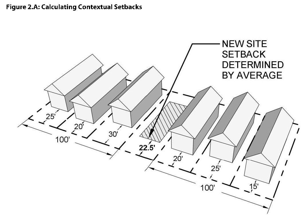
Contextual Setbacks. For infill development on any lot where the average front setback of existing dwellings that are located either wholly or in part within one hundred (100) feet of each side of the subject lot, within the same block and zoning district, fronting on the same side of the street, and the setbacks of those existing dwellings is less than the zoning district requirement, then the minimum front setback shall be the average of the setbacks of those existing dwellings. When the contextual average is more restrictive, the underlying zoning district setback requirement shall apply. See Figure 2.A below.
C.
Projections into Required Setbacks.
1.
Sills, belt course, cornices, buttresses, ornamental features, gutters, and eaves may project into a required minimum setback by a maximum of two (2) feet. If a side setback is three (3) feet, sills, belt course, cornices, buttresses, ornamental features, gutters, and eaves may project into the required minimum side setback by a maximum of nine (9) inches.
2.
Open or enclosed fire escapes, steel, concrete, or masonry outside stairways, and balconies may project into a required minimum setback by a maximum of three and one-half (3.5) feet. The Planning Director may approve a material other than steel, concrete, or masonry for outside stairways provided the Planning Director determines in writing that the material's resistance to fire is equal to or greater than the steel, concrete, or masonry that is adequate for the planned stairways.
3.
Chimneys and flues may project into a minimum setback by a maximum of three and one-half (3.5) feet.
4.
Mechanical equipment. Mechanical equipment, such as condensers, fans, air handling units, and other serviceable and permanently mounted equipment may encroach into required setbacks provided an agreement acceptable to the Town, is recorded against the neighboring property allowing access over the neighboring property for purposes of maintaining, repairing, or replacing such mechanical equipment when necessary.
D.
Exceptions to Setbacks.
1.
Zero Setbacks. In the R-1, R-1.5, R-2, R-3, MU-1, MU-2, and MU-MS districts, there shall be no setback between internal dwelling units for single-family attached and two-family dwellings, if allowed as a permitted use or special use. Side setbacks shall still apply to the end dwelling units on the side of the building not attached to another dwelling unit.
2.
Corner Lots.
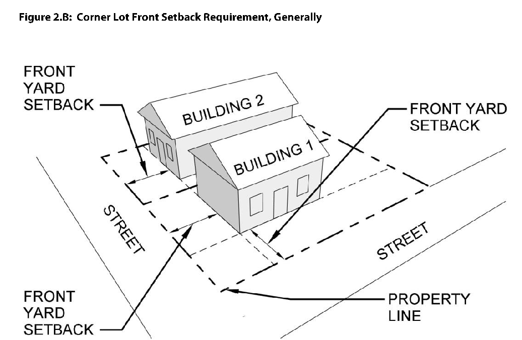
a.
Where a side yard abuts a street, the setback requirement for the side yard shall be the same as the front yard setback requirement for lots or property facing the same street, except as otherwise provided for in the dimensional standards.
b.
On corner lots in the Old Town Overlay, the front setback shall only apply to the building frontage with the least width dimension. On the other street frontage, the side yard setback shall be zero provided the building complies with all other regulations of this UDC and the adopted building code.
3.
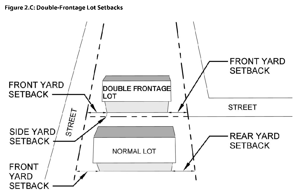
Double-Frontage Lots.
a.
Where double-frontage lots exist, front yard setback requirements shall apply wherever the lot abuts street or highway right-of-way.
b.
For lots in the Old Town Overlay in the R-1, R-2, or R-3 zoning districts, the front setback shall be determined by the Town Administrator.
4.
Handicap Ramps. Handicap access ramps and associated railings may be located within required front, side, and rear setbacks.
5.
Storage Sheds and Accessory Buildings (other than ADUs). Storage sheds and accessory buildings other than ADUs shall not be subject to side or rear setback requirements provided that the shed and/or accessory structure:
a.
Does not exceed two hundred (200) square feet in residential districts, and one hundred twenty (120) square feet in all other districts;
b.
Does not exceed a height of fifteen (15) feet;
c.
Is not placed in any portion of an easement; and
d.
Is not placed on a permanent foundation.
6.
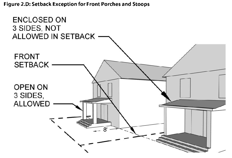
Front Porches and Stoops. In residential and mixed-use districts, covered or uncovered front porches and stoops that are unenclosed on three (3) sides may extend up to a maximum of eight (8) feet into the required front setback.
7.
Ground-Mounted Solar. In the residential districts, ground-mounted solar facilities may encroach into the required side or rear setback up to five (5) feet from the property line if they are not located over an easement.
8.
Animal Enclosures. New animal enclosures shall be located at least three (3) feet from all property lines, per Section 7-95 of the municipal code.
2.8.3. Building Height.
A.
Generally. No building shall be erected or altered that will exceed the height limit for the applicable zoning district, unless otherwise provided in this UDC.
B.
Measuring Building Height. The height of buildings shall be measured on a vertical plane from the average natural or finished grade, whichever is lower, to the highest point on the roof surface. The average grade shall be calculated by adding the highest and lowest natural or finished grade divided by two (2).
C.
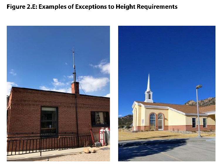
Exceptions to Height Requirements.
1.
Architectural Features. Chimneys, antennas, flag poles, bell towers, steeples, vents, roof access stairs, or other roof or building appurtenances extending from the surface of the roof may extend up to ten (10) feet above the maximum building height.
2.
Rooftop Mechanical Equipment. Rooftop mechanical equipment and any required screening may extend up to five (5) feet above the maximum building height.
3.
Parapet Walls. Parapet walls may extend above the maximum building height up to three (3) feet for commercial buildings, or for residential buildings containing two (2) or more dwelling units.
4.
Rooftop Solar. Rooftop solar panels may extend above the maximum building height up to five (5) feet.
2.8.4. Summary of Permitted Encroachments.
Table 2.16: Permitted Encroachments into Setbacks and Above Height Requirements
(Ord. 15 §12, 2018; Ord. 21 §5, 2018; Ord. 5 §8, 2022; Ord. 27 §1, 2022; Ord. 21 §7, 2024; Ord. 08 §§1, 6, 2025)