
Buffalo City Zoning Code
ARTICLE II
DISTRICTS AND DISTRICT REGULATIONS
DIVISION 4. - FLOODPLAIN ORDINANCE[2]
Editor's note— Ord. No. 2024-2, § 1(1.0—14.0), adopted May 20, 2024, repealed the former Div. 4, § 50-137, and enacted a new Div. 4 as set out herein. The former Div. 4 pertained to floodplain overlay district and derived from Code 1985, § 11.82.
Sec. 50-33. - Districts established.
The following zoning classifications are established within the city:
(Code 1985, § 11.40(1))
Sec. 50-34. - District boundaries.
(a)
Generally. Zoning district boundary lines generally follow lot lines, railroad right-of-way lines, the center of watercourses or the corporate limit lines, all as they existed upon the effective date of the ordinance from which this chapter is derived.
(b)
Appeal regarding exact location of boundary. Appeals concerning the exact location of a zoning district boundary line shall be heard by the council serving as the board of adjustment and appeals.
(c)
Vacation of right-of-way does not affect boundary. When any street, alley or public right-of-way vacated by official action of the city, the zoning district abutting the centerline of the alley or other public right-of-way shall not be affected by such proceeding.
(Code 1985, § 11.40(2))
Sec. 50-35. - Zoning map.
The location and boundaries of the districts established in this chapter are set forth on the city zoning map on file with the city clerk. The zoning map and all the notations, references and other information shown thereon shall have the same force and effect as if fully set forth herein and thereby made a part of this chapter by reference.
(Code 1985, § 11.40(3))
Sec. 50-36. - Annexed territory.
Annexed territory shall be in the A-1 district unless special action is taken to place it in another district.
(Code 1985, § 11.40(4))
Sec. 50-59. - A-1 Agricultural District.
(a)
Purpose. The A-1 Agricultural District is intended to provide a district which will allow suitable areas of the city to be retained and utilized for low density residential, open space or agricultural uses, prevent rapid urbanization and provide economy in public expenditures for public utilities and service.
(b)
Permitted uses. The following are permitted uses in an A-1 district:
(1)
Farming and agricultural related buildings and structures subject to state pollution control standards, but not including commercial feed lots or other commercial operations.
(2)
Public parks, playgrounds, recreational areas, wildlife areas and game refuges.
(3)
Nurseries, greenhouses, tree farms, and landscape material operations (not including retail sales).
(4)
Single-family dwellings.
(5)
Essential services.
(6)
Stands for the sale of agricultural products, provided the products are primarily raised on the premises.
(7)
Airports and directly related facilities.
(c)
Accessory uses. The following are permitted accessory uses in an A-1 district:
(1)
Operation and storage of such vehicles, equipment and machinery which are incidental to permitted or conditional uses allowed in this district.
(2)
The boarding or renting of rooms to not more than two persons.
(3)
Living quarters of persons employed on the premises.
(4)
Home occupations.
(5)
Recreational vehicles and equipment.
(6)
Non-commercial greenhouses and conservatories.
(7)
Swimming pools, tennis courts and other recreational facilities which are operated for the enjoyment and convenience of the residents of the principal use and their guests.
(8)
Tool houses, sheds and similar buildings for storage of domestic supplies and noncommercial recreational equipment.
(9)
Private garages, parking spaces and car ports for licensed and operable passenger cars and trucks.
(d)
Conditional uses. The following are conditional uses in an A-1 district (requires a conditional use permit based upon procedures set forth in and regulated by article XIII, division 3 of this chapter):
(1)
Governmental and public related utility buildings and structures necessary for the health, safety and general welfare of the city, provided that:
a.
When abutting a residential use in a residential use district, the property is screened and landscaped in compliance with section 50-358.
b.
The provisions of section 50-699 are considered and satisfactorily met.
(2)
Public or semi-public recreational buildings and neighborhood or community centers; public and private educational institutes limited to elementary, junior high and senior high schools; and religious institutions such as churches, chapels, temples and synagogues, provided that:
a.
Side yards shall be double that required for the district, but no greater than 30 feet.
b.
Adequate screening from abutting residential uses and landscaping is provided in compliance with section 50-358.
c.
Adequate off-street parking and access is provided on the site or on lots directly abutting directly across a public street or alley to the principal use in compliance with article V, division 2 of this chapter and that such parking is adequately screened and landscaped from surrounding and abutting residential uses in compliance with section 50-358.
d.
Adequate off-street loading and service entrances are provided and regulated where applicable by article V, division 3 of this chapter.
e.
The provisions of section 50-699 are considered and satisfactorily met.
(3)
Commercial recreational areas including golf course and country clubs, swimming pools, ice arenas and similar facilities, provided that:
a.
The principal use, function or activity is recreation in character.
b.
Not more than 40 percent of the land area of the site be covered by buildings or structures.
c.
When abutting a residential use and a residential use district, the property is screened and landscaped in compliance with section 50-358.
d.
The land area of the property containing such use or activity meets the minimum established for the district.
e.
The provisions of section 50-699 are considered and satisfactorily met.
(4)
Commercial riding stables, dog kennels, animal hospitals with overnight care and similar uses, provided that:
a.
Any building in which animals are kept, whether roofed shelter or enclosed structure, shall be located a distance of 100 feet or more from any lot line.
b.
The animals shall, at a minimum, be kept in an enclosed pen or corral of sufficient height and strength to retain such animals. The pen or corral may not be located closer than 100 feet from a lot line.
c.
The provisions of Minn. R. 6244.0900 are complied with.
d.
All other applicable state and local regulations pertaining to nuisance, health and safety conditions, etc., are complied with.
e.
The provisions of section 50-699 are considered and satisfactorily met.
(5)
Cemeteries, provided that:
a.
The site accesses on a minor arterial.
b.
The site is landscaped in accordance with section 50-358.
c.
The provisions of section 50-699 are considered and satisfactorily met.
(6)
Solar energy generation as a principal use, provided that:
a.
The solar farm is situated in a location that will not likely impede the normal urban development of the community or the logical extension of utilities to other urban development.
b.
The facility will occupy no more than 40 acres in any contiguous parcels of land.
c.
The facility will be constructed using landscaping and screening, as well the most effective technologies to avoid glare or other visual impacts on surrounding property.
d.
No such principal solar energy generation use shall be located within one mile of any other similar facility.
e.
The owner of the property and the operator of the facility shall enter into an agreement with the city that, at such time that municipal sewer and water are extended and available to the property, the property owner and operator will agree to do one of the following:
1.
Pay the property's normal share of utility extension costs, including trunk fees, as well as the costs of extending such utilities through or around the property to adjacent property for future connection to other lands; or
2.
Cease operation of the facility within two years of such utility extension, clear the property of the solar generating equipment, and restore the property to a condition that will accommodate the development of an urban use.
(7)
Farm buildings within 300 feet of an existing residence or residential platted lot, provided that the provisions of section 50-699 are considered and satisfactorily met.
(e)
Lot requirements and setbacks. The following minimum requirements shall be observed in an A-1 District subject to additional requirements, exceptions and modifications set forth in this chapter:
(1)
Lot area: 40 acres.
(2)
Lot width: 600 feet.
(3)
Setbacks:
a.
Front yards: Not less than 50 feet.
b.
Side yards: Not less than 20 feet on each side nor less than 50 feet on the side yard abutting a public right-of-way.
c.
Rear yards: 30 feet.
(Code 1985, § 11.41)
Sec. 50-60. - R-R Rural Residential District.
(a)
Purpose. The purpose of the R-R Rural Residential District is to provide for large lots, low density single-family detached residential dwelling units and directly related, complementary uses in areas of the city containing highly unique natural features and amenities.
(b)
Permitted uses. The following are permitted uses in an R-R district:
(1)
Single-family detached dwellings.
(2)
Public parks and playgrounds.
(3)
Essential services.
(c)
Accessory uses. The following are permitted accessory uses in an R-R district:
(1)
Private garages, parking spaces and car ports for licensed and operable passenger cars and trucks not to exceed a gross weight of 12,000 pounds, as regulated by section 50-259(f). Private garages are intended for use to store the private passenger vehicles of the family or families resident upon the premises, and in which no business service or industry is carried on. Such garage shall not be used for the storage of more than one commercial vehicle owned or operated by a resident per dwelling unit. Garages accessory to single-family homes shall be designed to accommodate expansion to a third stall, if not initially constructed as such.
(2)
Recreational vehicles and equipment.
(3)
Home occupations.
(4)
Non-commercial greenhouses and conservatories.
(5)
Swimming pool, tennis courts and other recreational facilities which are operated for the enjoyment and convenience of the residents of the principal use and their guests.
(6)
Tool houses, sheds and similar buildings for storage of domestic supplies and noncommercial recreational equipment.
(7)
Boarding or renting of rooms to not more than one person.
(d)
Conditional uses. The following are conditional uses in an R-R district which require a conditional use permit based upon procedures set forth in and regulated by article XIII, division 3 of this chapter:
(1)
Public or semi-public recreational buildings and neighborhood or community centers; public and private educational institutions limited to elementary, junior high and senior high schools; and religious institutions such as churches, chapels, temples and synagogues, provided that:
a.
Side yards shall be double that required for the district, but no greater than 30 feet.
b.
Adequate screening from abutting residential uses and landscaping is provided in compliance with section 50-358.
c.
Adequate off-street parking and access is provided on the site or on lots directly abutting directly across a public street or alley to the principal use in compliance with article V, division 2 of this chapter and that such parking is adequately screened and landscaped from surrounding and abutting residential uses in compliance with section 50-358.
d.
Adequate off-street loading and service entrances are provided and regulated where applicable by article V, division 3 of this chapter.
e.
The provisions of section 50-699 are considered and satisfactorily met.
(2)
Governmental and public regulated utility buildings and structures necessary for the health, safety and general welfare of the city, provided that:
a.
Compatibility with the surrounding neighborhood is maintained and required setbacks and side yard requirements are met.
b.
Equipment is completed enclosed in a permanent structure with no outside storage.
c.
Adequate screening from neighboring uses and landscaping is provided in compliance with section 50-358.
d.
The provisions of section 50-699 are considered and satisfactorily met.
(3)
Residential planned unit development, as regulated by article III of this chapter.
(e)
Lot requirements and setbacks. The following minimum requirements shall be observed in an R-R district subject to additional requirements, exceptions and modifications set forth in this chapter:
(1)
Lot area.
a.
Interior: 40,000 square feet.
b.
Corner: 40,000 square feet.
(2)
Lot width.
a.
Interior: 150 feet.
b.
Corner: 150 feet.
(3)
Setbacks:
a.
Front yards: Not less than 40 feet.
b.
Side yards: Not less than 20 feet from the adjacent lot, nor less than 40 feet on the side yard abutting a public right-of-way.
c.
Rear yards: 30 feet.
(Code 1985, § 11.42)
Sec. 50-61. - R-1 Residential Single-Family Suburban District.
(a)
Purpose. The purpose of the R-1 Residential Single-family Suburban District is to provide for suburban density single-family detached residential dwelling units and directly related, complementary uses.
(b)
Permitted uses. All permitted uses allowed in an R-R district are permitted in an R-1 district.
(c)
Accessory uses. All permitted accessory uses allowed in an R-R district are permitted in an R-1 district.
(d)
Conditional uses. The following are conditional uses in an R-1 district which requires a conditional use permit based upon procedures set forth in and regulated by article XIII, division 3 of this chapter:
(1)
All conditional uses allowed in an R-R district are permitted in an R-R district.
(2)
Bed and breakfast facilities. Bed and breakfast may be allowed by conditional use permit as an accessory use to the principal use as a single-family home, subject to the following conditions. It is the intent of this subsection that a bed and breakfast facility is clearly incidental to the single-family residential use, and that the residential character of the neighborhood is retained. Such facilities may not be approved if it is found that traffic, activity, lights, noise, or other factors significantly alter residential character, and which cannot be adequately mitigated through reasonable conditions:
a.
Facilities shall be operated by the owner-occupant of the residential property on which the bed and breakfast is proposed.
b.
All bed and breakfast units shall be established within the principal structure.
c.
A maximum of three bed and breakfast units, in addition to the residential occupant, shall be allowed within a single structure.
d.
The facility shall have a state issued license for lodging and food service, and comply with and maintain all health, safety, building, and fire codes as may be required or applicable.
e.
Not more than the equivalent of one full-time person shall be employed by the bed and breakfast facility who is not a resident of the property.
f.
Dining and other facilities shall not be opened to the public but shall be used exclusively by the residents and registered guests of the facility.
g.
A floor plan shall be submitted showing that the principal structure has a minimum size of 1,800 square feet of living area and shall show any proposed building alterations necessary to accommodate the bed and breakfast use.
h.
The parcel shall be no less than 100 feet in lot width, and no less than 15,000 square feet in lot area.
i.
A site and landscaping plan shall be submitted illustrating the proposed parking area for at least three spaces for each residential unit and one space for each licensed bed and breakfast unit. No bed and breakfast parking shall be allowed within the required front or side yards of the parcel. These parking areas shall be improved with asphalt and screened with landscaping but shall be exempt from other commercial parking requirements of this chapter.
j.
One nameplate sign may be allowed identifying the bed and breakfast facility of not more than two square feet in area, attached to the principal structure. The sign shall be designed and constructed of materials complementary to the principal structure and may not be illuminated.
(e)
Lot requirements and setbacks. The following minimum requirements shall be observed in an R-1 district subject to additional requirements, exceptions and modifications set forth in this chapter:
(1)
Lot area: 12,000 square feet.
(2)
Lot width, interior: 85 feet. Corner: 100 feet.
(3)
Setbacks:
a.
Front yards: Not less than 30 feet.
b.
Side yards:
1.
Interior lots: Not less than 15 feet each, except a side yard where there is an attached garage may be reduced to five feet.
2.
Corner lot: Not less than 20 feet on the side yard abutting a public street.
c.
Rear yards: 30 feet.
(4)
Impervious surface: No more than 35 percent.
(f)
Interim use permitsfor craft retreat facilities. Craft retreat facilities may be allowed by interim use permit as the principal use in a single-family home structure, subject to the following conditions. It is the intent of this subsection that a craft retreat facility will be operated in such a way that the residential character of the neighborhood is retained. Such facilities may not be approved if it is found that traffic, activity, lights, noise, or other factors significantly alter residential character, and which cannot be adequately mitigated through reasonable conditions:
(1)
All craft retreat facility units shall be established within the principal structure.
(2)
A maximum of 12 occupants shall occupy a craft retreat facility at any one time.
(3)
Craft retreat facilities shall be rented to only one group, participating together in a common hobby, at any one time.
(4)
No common group shall occupy any craft retreat facilities for more than four consecutive days.
(5)
The facility shall have a state issued license for lodging, and comply with and maintain all health, safety, building, and fire codes as may be required or applicable.
(6)
The owner of a craft retreat facility shall own the property on which the retreat facility is located, and further shall reside on a parcel no more than 500 feet from the property on which the craft retreat facility is located.
(7)
Not more than the equivalent of one full-time person shall be employed by the craft retreat facility who is not a resident of the owner's property.
(8)
Dining and other facilities shall not be opened to the public but shall be used exclusively by the members of the common group of registered guests of the facility.
(9)
A floor plan shall be submitted showing that the principal structure has a minimum size of 1,800 square feet of living area and shall show any proposed building alterations necessary to accommodate the craft retreat use.
(10)
No alterations may be made to the principal or accessory structures on the subject property that would have the effect of interfering with putting the property to use as a single-family home upon expiration of the craft retreat facility use.
(11)
To accommodate adequate yard and parking space, the parcel shall be no less than 85 feet in lot width, and no less than 12,000 square feet in lot area.
(12)
A site and landscaping plan shall be submitted illustrating the proposed parking area for at least one staff parking space, plus one space for each two persons for whom retreat capacity is provided. No more than two of the required spaces shall be allowed within the required front or side yards of the parcel. All parking areas shall be improved with pavement (asphalt, concrete, or pavers) and screened with landscaping, but shall be exempt from other commercial parking requirements of this chapter.
(13)
One nameplate sign may be allowed identifying the craft retreat facility of not more than two square feet in area, attached to the principal structure. The sign shall be designed and constructed of materials complementary to the principal structure and may not be illuminated.
(14)
Craft retreat facilities shall require a separate business license from the city, renewable on an annual basis. The city shall issue licenses such that no more than three such licenses are in effect at any one time.
(15)
The applicants shall enter into an interim use permit development agreement with the city, providing for a date of termination of the use which is no more than five years from the date of approval by the city council. Requests for subsequent interim use permits shall be subject to full processing requirements of this chapter. Consideration of subsequent interim use permits shall take into account compliance with licensing terms and pattern of complaints, where applicable.
(16)
If at any time, a license for the operation of a craft retreat facility is revoked, such event shall result in concurrent revocation of the interim use permit.
(Code 1985, § 11.43)
Sec. 50-62. - R-2 Residential Single-Family Urban District.
(a)
Purpose. The purpose of the R-2 Residential Single-family Urban District is to provide for urban density single-family detached residential dwelling units and directly related, complementary uses.
(b)
Permitted uses. All permitted uses allowed in an R-1 district are permitted in an R-2 district.
(c)
Accessory uses. All permitted accessory uses allowed in an R-2 district are permitted accessory uses allowed in an R-1 district.
(d)
Conditional uses. Conditional uses in an R-2 district require a conditional use permit based upon procedures set forth in and regulated by article XIII, division 3 of this chapter. Conditional uses allowed in an R-R district are conditional uses allowed in an R-1 district.
(e)
Lot requirements and setbacks. The following minimum requirements shall be observed in an R-2 district subject to additional requirements, exceptions and modifications set forth in this chapter:
(1)
Lot area: 8,000 square feet.
(2)
Lot width: 75 feet.
(3)
Setbacks:
a.
Front yards: Not less than 30 feet.
b.
Side yards:
1.
Interior lot: Not less than ten feet each except that a side yard containing an attached garage may be reduced to five feet.
2.
Corner lot: Not less than 20 feet on the side yard abutting a public street.
c.
Rear yards: 25 feet.
(4)
Impervious surface: No more than 35 percent.
(Code 1985, § 11.44)
Sec. 50-63. - R-3 Traditional Residential Single- and Two-Family District.
(a)
Purpose. The purpose of the R-3 Transitional Residential Single- and Two-Family District is to provide for low to moderate density one- and two-unit dwellings and directly related, complementary uses in the traditional residential areas of the city, particularly near and around the downtown area.
(b)
Permitted uses. The following are permitted uses in an R-3 district:
(1)
All permitted uses allowed in an R-2 district are permitted in an R-3 district.
(2)
Two-family dwelling units.
(c)
Accessory uses. All permitted accessory uses allowed in an R-2 district are permitted in an R-3 district.
(d)
Conditional uses. Conditional uses in an R-3 district require a conditional use permit based upon procedures set forth in and regulated by article XIII, division 3 of this chapter. Conditional uses allowed in an R-2 district are conditional uses allowed in an R-3 district.
(e)
Lot requirements and setbacks. The following minimum requirements shall be observed in an R-3 district subject to additional requirements, exceptions and modifications set forth in this chapter:
(1)
Lot area:
a.
Single-family: 8,000 square feet.
b.
Two-family: 10,500 square feet.
(2)
Lot width:
a.
Single-family: 60 feet.
b.
Two-family: 80 feet.
(3)
Setbacks:
a.
Front yards: Not less than 20 feet.
b.
Side yards: Not less than five feet from each adjacent lot, nor less than 15 feet on the side yard abutting a public right-of-way.
c.
Rear yards: 30 feet for principal buildings, and five feet for accessory buildings. Garages on alleys shall comply with the requirements of article V, division 2 of this chapter.
(4)
Impervious surface: No more than 45 percent.
(Code 1985, § 11.45)
Sec. 50-64. - R-4 Residential Townhouse, Quadraminium and Low-Density Multiple-Family District.
(a)
Purpose. The purpose of the R-4 Residential Townhouse, Quadraminium and Low-Density Multiple-Family district is to provide for low to moderate density through the mixture of one and two unit and medium density dwellings and directly related, complementary uses.
(b)
Permitted uses. The following are permitted uses in an R-4 district:
(1)
Two-family dwellings.
(2)
Triplex and fourplex multiple-family units.
(3)
Townhouses and quadraminiums.
(c)
Accessory uses. The following are permitted accessory uses in an R-4 district, as may be regulated in article IV; article V, division 2; article VI, division 2 of this chapter:
(1)
Private garages, parking spaces and car ports for licensed and operable passenger cars and trucks not to exceed a gross weight of 12,000 pounds, as regulated by section 50-259(f). Private garages are intended for use to store the private passenger vehicles of the family or families resident upon the premises, and in which no business service or industry is carried on. Such garage shall not be used for the storage of more than one commercial vehicle owned or operated by a resident per dwelling unit. Such garage shall not be used for the storage of more than one commercial vehicle owned or operated by a resident per dwelling unit.
(2)
Double bungalows, quadraminium and townhouse units which do not meet the minimum first floor area requirements as provided in section 50-196, subject to the following conditions being met:
a.
The units are otherwise permitted uses in the district.
b.
The units are designed so as to provide for, at minimum, a total of 130 percent of the area prescribed in section 50-196, on more than one floor or level.
c.
The units may not be further subdivided.
d.
The units meet all local building codes and FHA construction guidelines.
e.
Compliance with procedural requirements for conditional uses in article XIII, division 3 of this chapter.
(3)
Recreational vehicles and equipment.
(4)
Noncommercial greenhouses and conservatories.
(5)
Swimming pool, tennis courts and other recreational facilities which are operated for the enjoyment and convenience of the residents of the principal use and their guests.
(6)
Tool houses, sheds and similar buildings for storage of domestic supplies and noncommercial recreational equipment.
(7)
Boarding or renting of rooms to not more than one person.
(d)
Conditional uses. The following are conditional uses in an R-4 district which requires a conditional use permit based upon procedures set forth in and regulated by article XIII, division 3 of this chapter:
(1)
All conditional uses subject to the same conditions as allowed in an R-3 district with the exception of accessory apartments.
(2)
Single-family dwellings as part of a townhouse plat and association developed as a planned unit development.
(e)
Lot requirements and setbacks. The following minimum requirements shall be observed in an R-4 district subject to additional requirements, exceptions and modifications set forth in this chapter:
(1)
Lot area: 15,000 square feet.
(2)
Lot width: 100 feet.
(3)
Setbacks:
a.
Front yards: Not less than 30 feet.
b.
Side yards: Not less than ten feet from each adjacent lot, nor less than 20 feet on the side yard abutting a public right-of-way.
c.
Rear yards: 30 feet.
(4)
Impervious surface: No more than 45 percent.
(Code 1985, § 11.46)
Sec. 50-65. - R-5 Suburban Residential Multiple-Family District.
(a)
Purpose. The purpose of the R-5 Suburban Residential Multiple-Family District is to provide for high density housing in multiple family structures and complementary uses. The R-5 district is intended to encourage high-quality and high-amenity multiple-family development in appropriate locations around the community with exposure and access to major roadways and commercial facilities.
(b)
Permitted uses. The following are permitted uses in an R-5 district:
(1)
Multiple family dwelling structures.
(2)
Public and private parks and playgrounds.
(3)
Essential services.
(4)
Multiple family dwelling structures containing eight or less dwelling units.
(5)
Public parks and playgrounds.
(6)
Essential services.
(c)
Accessory uses. The following are permitted accessory uses in an R-5 district:
(1)
All permitted accessory uses allowed in an R-4 district are permitted accessory uses in an R-5 district.
(2)
Off-street loading.
(d)
Conditional uses. Residential planned unit developments are conditional uses in an R-5 district which requires a conditional use permit based upon procedures set forth in and regulated by article XIII, division 3 of this chapter.
(e)
Lot requirements and setbacks. The following minimum requirements shall be observed in an R-5 district subject to additional requirements, exceptions and modifications set forth in this chapter:
(1)
Lot area: Two acres.
(2)
Lot width: 200 feet.
(3)
Setbacks:
a.
Front yards: Not less than 70 feet.
b.
Side yards: Not less than 40 feet on any one side yard nor less than 70 feet on the side yard abutting a public right-of-way.
c.
Rear yards: 30 feet.
(4)
Impervious surface: 35 percent.
(f)
Additional development standards in the R-5 district.
(1)
Parking areas.
a.
No front yard shall be occupied by parking areas that cover more than 50 percent of the space between the street and the front building line.
b.
Parking and circulation lanes shall be set back from the street no less than 25 feet.
c.
Parking spaces accessory to the building shall include no fewer than one covered space per dwelling unit.
d.
Parking areas accessory to the building shall include no more than 1.1 open, uncovered parking spaces per unit.
(2)
Landscaping.
a.
Required landscaping shall include no fewer than one overstory tree per each 40 feet of perimeter lot line, plus one ornamental tree for each 3,000 square feet of gross lot area, plus one shrub per each 500 square feet of gross lot area.
b.
Landscaping shall focus on the space between the buildings and the public street to present a park-like appearance from neighboring areas.
c.
Where the property abuts residential areas of lesser density zoning, the project shall include a landscaping buffer that screens parking and circulation areas from view.
(3)
Building architecture.
a.
Buildings shall incorporate extensive use of stone and brick in the design.
b.
Buildings shall incorporate substantial variation in the roofline to avoid the impression of a large monolithic structure, including variation in roof ridge lines, gables, and similar features.
c.
Buildings shall incorporate extensive variation in the plane of all walls, utilizing articulation in wall location, balconies, and other features.
(4)
Density. The allowable density, as expressed in lot area per unit, in the R-5 zoning district shall be 2,500 square feet per unit. This density may be increased by conditional use permit where the city finds that the proposed project meets all other minimum standards of the district and this chapter and demonstrates other substantive amenities and improvements to justify the additional density. No such density increase may reduce lot area per unit below 1,500 square feet per unit in the R-5 district.
(Code 1985, § 11.47)
Sec. 50-66. - R-6 Downtown Residential High-Density Multiple-Family District.
(a)
Purpose. The purpose of the R-6 Downtown Residential High-Density Multiple-Family District is to provide for high density residential uses, and directly related uses, in and around the central business district, in support of the traditional commercial areas.
(b)
Permitted uses. The following are permitted uses in an R-6 district:
(1)
All permitted uses allowed in an R-5 district are permitted uses allowed in an R-6 district.
(2)
Multiple family dwelling structures containing more than eight dwelling units.
(c)
Accessory uses. All permitted accessory uses as allowed in an R-5 district are permitted accessory uses allowed in R-6 district.
(d)
Conditional uses. Conditional uses in an R-6 district require a conditional use permit based upon procedures set forth in and regulated by article XIII, division 3 of this chapter. Conditional uses allowed in an R-5 district are conditional uses allowed in an R-6 district.
(e)
Lot requirements and setbacks. The following minimum requirements shall be observed in an R-6 district subject to additional requirements, exceptions and modifications set forth in this chapter:
(1)
Lot area: 15,000 square feet.
(2)
Lot width: 100 feet.
(3)
Setbacks:
a.
Front yards: 30 feet.
b.
Side yards: Not less than 15 feet on any one side, nor less than 30 feet on the side yard abutting the major street.
c.
Rear yards: 30 feet.
(4)
Impervious surface: 75 percent.
(5)
Density. The allowable density, as expressed in lot area per unit, in the R-6 zoning district shall be 2,500 square feet per unit. This density may be increased by conditional use permit where the city finds that the proposed project meets all other minimum standards of the district and this chapter and demonstrates other substantive amenities and improvements to justify the additional density. No such density increase may reduce lot area per unit below 1,250 square feet per unit in the R-6 district.
(Code 1985, § 11.48)
Sec. 50-67. - R-7 Residential Special Purpose, High Density Zoning District.
(a)
Purpose. The R-7 Residential Special Purpose High Density Zoning District is intended to provide a district for high density multiple-family housing and special purpose residential dwellings.
(b)
Permitted uses. All permitted uses allowed within an R-6 district are allowed within an R-7 district.
(c)
Accessory uses. All permitted accessory uses allowed within an R-6 district are permitted accessory uses allowed within an R-7 district.
(d)
Conditional uses. The following are conditional uses in an R-7 district which requires a conditional use permit based upon procedures set forth in and regulated by article XIII, division 3 of this chapter:
(1)
All conditional uses, subject to the same conditions, as allowed in an R-6 district, except single-family detached dwellings.
(2)
Nursing homes and similar group housing, but not including hospitals, sanitariums or similar institutions, provided that:
a.
Provision be made on the site for adequate open space and recreational areas to properly serve the residences of the facility as determined by the council.
b.
Only the rear yard shall be used for play or recreational areas. The area shall be fenced and controlled and screened in compliance with section 50-358.
c.
The site shall be served by an arterial or collector street of sufficient capacity to accommodate traffic which will be generated.
d.
All signing and informational or visual communication devices shall be in compliance with the provisions of chapter 34.
e.
All state laws and statutes governing such use are strictly adhered to and all required operating permits are secured.
f.
Adequate off-street parking is provided in compliance with article V, division 2 of this chapter.
g.
One off-street loading space in compliance with article V, division 3 of this chapter is provided.
h.
The provisions of section 50-699 are considered and satisfactorily met.
i.
Side yards shall be screened in compliance with section 50-358.
(3)
Elderly (senior citizen) housing, provided that:
a.
Not more than ten percent of the occupants may be persons 55 years of age or under.
b.
To continue to qualify for the elderly housing classification, the owner or agency shall annually file with the city administrator and the zoning administrator a certified copy of a monthly resume of occupants of such a multiple dwelling, listing the number of tenants by age and clearly identifying and setting forth the relationship of all occupants 60 years of age or under to qualified tenants, or to the building.
c.
There is adequate off-street parking in compliance with article V, division 2 of this chapter.
d.
One off-street loading space in compliance with article V, division 3 of this chapter.
e.
Parking areas are screened and landscaped from view of surrounding and abutting residential districts in compliance with section 50-358.
f.
All signing and informational or visual communication devices shall comply with the provisions of chapter 34.
g.
The principal use structure is in compliance with the state uniform building code.
h.
Elevator service is provided to each floor level above ground floor.
i.
Usable open space, as defined in section 50-3, at a minimum is equal to 20 percent of the gross lot area.
j.
The provisions of section 50-699 are considered and satisfactorily met.
(4)
Apartment density bonus. Except for elderly housing, a maximum of 25 percent reduction in square feet of lot area per unit for multiple family dwellings of ten units or more as required in section 50-196(b) based upon the following bonus features and square foot reductions:
(e)
Lot requirements and setbacks. The following minimum requirements shall be observed in an R-7 district subject to additional requirements, exceptions and modifications set forth in this chapter:
(1)
Lot area: 15,000 square feet.
(2)
Lot width: 100 feet.
(3)
Setbacks:
a.
Front yards: Not less than 30 feet.
b.
Side yards: Not less than 15 feet on any one side, nor less than 30 feet on the side yard abutting the major street.
c.
Rear yards: 30 feet.
(4)
Impervious surface: 75 percent.
(Code 1985, § 11.49)
Sec. 50-68. - R-MH Manufactured Housing Residential District.
(a)
Purpose. The purpose of an R-MH Manufactured Housing Residential District is to provide a separate district for manufactured housing parks, distinct from other residential areas.
(b)
Permitted uses. Single-family detached manufactured housing units are permitted uses in an R-MH district.
(c)
Accessory uses. Any accessory use permitted in an R-2 district are permitted accessory uses in an R-MH district
(d)
Conditional uses. Conditional uses in an R-MH district require a conditional use permit based upon procedures set forth in and regulated by article XIII, division 3 of this chapter. All conditional uses allowed in an R-2 district, except farm buildings, are allowed conditional uses in R-MH district.
(e)
Design/operational standards for manufactured housing.
(1)
General provisions.
a.
All land area shall be:
1.
Adequately drained.
2.
Landscaped to control dust.
3.
Clean and free from refuse, garbage, rubbish or debris.
b.
No tents shall be used for other than recreational purposes in a manufactured housing park.
c.
There shall not be outdoor camping anywhere in a manufactured housing park.
d.
Access to manufactured housing parks shall be as approved by the city.
e.
All structures (fences, storage, cabana, etc.) shall require a building permit from the building official.
f.
The area beneath a manufactured housing unit shall be enclosed except that such enclosure must have access for inspection.
g.
Laundry and clothing shall be hung out to dry only on lines located in city approved areas established and maintained exclusively for that purpose, as identified on the manufactured housing park site plan.
h.
A manufactured housing park shall have an adequate central community building with the following features:
1.
Laundry drying areas and machines.
2.
Laundry washing machines.
3.
Public toilets and lavatories.
4.
Storm shelter.
Such buildings shall have adequate heating in all areas and be maintained in a safe, clean and sanitary condition.
(2)
Site plan requirements.
a.
Legal description and size in square feet of the proposed manufactured housing park.
b.
Location and size of all manufactured housing unit sites, dead storage areas, recreation areas, laundry drying areas, roadways, parking sites, and all setback dimensions (parking spaces, exact mobile home sites, etc.).
c.
Detailed landscaping plans and specifications.
d.
Location and width of sidewalks.
e.
Plans for sanitary sewage disposal, surface drainage, water systems, underground electrical service and gas service.
f.
Location and size of all streets abutting the manufactured housing park and all driveways from such streets to the manufactured housing park.
g.
Road construction plans and specifications.
h.
Plans for any and all structures.
i.
Such other information as required or implied by these manufactured park standards or requested by public officials.
j.
Name and address of developer.
k.
Description of the method of disposing of garbage and refuse.
l.
Detailed description of maintenance procedures and grounds supervision.
m.
Details as to whether all of the area will be developed a portion at a time.
(3)
Design standards.
a.
Park size. The minimum area required for a manufactured housing park designation shall be five acres.
b.
Individual manufactured housing site (homes 14 feet wide or less).
1.
Each manufactured housing site shall contain at least 5,000 square feet of land area for the exclusive use of the occupant with a width of no less than 50 feet and a depth of no less than 100 feet.
2.
Each manufactured housing site shall have frontage on an approved roadway and the corner of each manufactured home shall be marked and each site shall be numbered:
c.
Individual home sites (homes in excess of 14 feet, but less than 18 feet in width).
1.
Each manufactured housing site shall contain at least 6,050 square feet of land area for the exclusive use of the occupants having a width of no less than 55 feet and a depth of no less than 110 feet.
2.
Each manufactured housing site shall have frontage on an approved roadway and the corner of each manufactured home site shall be marked and each site shall be numbered.
d.
Individual manufactured housing sites (homes over 18 feet in width).
1.
Each manufactured housing site shall contain at least 6,500 square feet of land area for the exclusive use of the occupant with a width of no less than 65 feet and a depth of no less than 100 feet.
2.
Each manufactured housing site shall have frontage on an approved roadway and the corner of each manufactured home site shall be marked and each site shall be numbered.
e.
Individual manufactured housing unit site setbacks.
1.
In manufactured housing parks existing prior to January 1, 1985, no unit shall be parked closer than ten feet to its side lot lines nor closer than 20 feet to its front lot line or within ten feet of the rear lot line.
2.
In manufactured housing parks created after January 1, 1985, no unit shall be parked closer than ten feet to its side lot lines nor closer than 30 feet to its front lot line, or within ten feet of its rear lot line.
f.
Building requirements.
1.
No principal structure shall exceed one story or 25 feet, whichever is least.
2.
No accessory structure shall exceed 15 feet in height.
3.
The unit structure is in compliance with the model manufactured home installation standards, 24 CFR 3285.
g.
Parking.
1.
Each manufactured housing site shall have off-street parking space for two automobiles.
2.
Each manufactured housing park shall maintain additional hard surfaced off-street parking lots for guests of occupants in the amount of one space for each five sites.
3.
Access drives off roads to all parking spaces and unit sites shall be hard surfaced according to specifications established by the city.
h.
Utilities.
1.
All manufactured housing units shall be connected to a public water and sanitary sewer system or a private water and sewer system approved by the state department of health.
2.
All installations for disposal of surface stormwater must be approved by the city.
3.
All utility connections shall be as approved by the city.
4.
The source of fuel for cooking, heating or other purposes at each manufactured housing site shall be as approved by the city.
5.
All utilities shall be underground; there shall be no overhead wires or supporting poles except those essential for street or other lighting purposes.
6.
No obstruction shall be permitted that impedes the inspection of plumbing, electrical facilities and related mobile home equipment.
7.
The method of garbage, waste and trash disposal must be approved by the city.
8.
The owner shall pay any required sewer connection fees to the city.
9.
The owner shall pay inspection and testing fees for utility service to the city.
10.
Facilities for fire protection shall be installed as required by the city.
i.
Internal roads and streets.
1.
Roads shall be surfaced as approved by the city.
2.
All roads shall have a concrete (mountable, roll type) curb and gutter.
3.
All streets shall be developed with a roadbed of not less than 24 feet in width. If parking is permitted on the street, then the roadbed shall be at least 36 feet in width. To qualify for the lesser sized street, adequate off-street parking must be provided.
4.
The park shall have a street lighting plan approved by the city.
j.
Recreation.
1.
All manufactured housing courts shall have at least ten percent of the land area developed for recreational use (tennis court, children's play equipment, swimming pool, golf green, etc.) developed and maintained at the owner/operator's expense.
2.
In lieu of land dedication for public park purposes, a cash contribution as established by section 40-223 shall be paid to the city.
k.
Landscaping.
1.
Each site shall be properly landscaped with trees, hedges, grass, fences, windbreaks and the like.
2.
A compact hedge, redwood fence or landscaped area shall be installed around each manufactured home park and be maintained in first class condition at all times as approved.
3.
All areas shall be landscaped in accordance with landscaping plan approved by the council.
l.
Lighting.
1.
Artificial light shall be maintained during all hours of darkness in all buildings containing public toilets, laundry equipment and the like.
2.
The manufactured housing park grounds shall be lighted as approved by the city from sunset to sunrise.
m.
Storage.
1.
Enclosed storage lockers (when provided) shall be located either adjacent to the manufactured home in a manufactured housing park or at such other place in the park as to be convenient to the unit for which it is provided.
2.
Storage of large items such as boats, boat trailers, etc., shall be accommodated in a separate secured and screened area of the park.
n.
General development. For those items not specifically referenced, the design standards as established by chapter 40 shall be utilized for general development guidelines.
(f)
Registration.
(1)
It shall be the duty of the operator of the manufactured housing park to keep a record of all homeowners and occupants located within the park. The register shall contain the following information:
a.
The name and address of each unit occupant.
b.
The name and address of the owner of each unit.
c.
The make, model and year of the unit.
d.
The state, territory or county issuing such license.
e.
The date of arrival and departure of each unit.
f.
The number and type of motor vehicles of residents in the park.
(2)
The park operator shall keep the register available for inspection at all times by authorized city, state and county officials, public health officials and other public offices whose duty necessitates acquisition of the information contained in the register. The register shall not be destroyed until after a period of three years following the date of departure of the registrant from the park.
(g)
Maintenance. The operator of any manufactured housing park, or a duly authorized attendant or caretaker shall be responsible at all times for keeping the park, its facilities and equipment, in a clean, orderly, operable and sanitary condition. The attendant or caretaker shall be answerable, along with the operator, for the violation of any provisions of these regulations to which the operator is subject.
(h)
Review procedures. All informational elements as required in subsection (e)(2) of this section shall be submitted to the city in accordance with the normal time schedule outlined for zoning district amendments, whether or not the proposal requires a rezoning. Proposals for manufactured housing park expansions on properly zoned land shall be reviewed for compliance with the applicable standards and requirements contained in subsection (e) of this section by all designated and official city review bodies.
(Code 1985, § 11.50)
Sec. 50-69. - R-B Residential-Business Transition District.
(a)
Purpose. The purpose of the R-B Residential-Business District is to provide for high density residential use and for the transition in land use from residential to low intensity business allowing for the intermixing of such uses.
(b)
Permitted uses. All permitted uses allowed in an R-7 district are permitted uses allowed in an R-B district.
(c)
Accessory uses. All permitted accessory uses allowed in an R-7 district are permitted accessory uses in an R-B district.
(d)
Conditional uses. The following are conditional uses in an R-B district which requires a conditional use permit based upon procedures set forth in and regulated by article XIII, division 3 of this chapter:
(1)
All conditional uses allowed in an R-7 district are conditional uses allowed in an R-B district.
(2)
Hospitals, medical offices and clinics, dental offices and clinics, professional offices and commercial offices, veterinary clinics (not including outside kennels) and funeral homes and mortuaries, provided that:
a.
The site and related parking and service entrances are served by an arterial or collector street of sufficient capacity to accommodate the traffic which will be generated.
b.
Adequate off-street parking is provided in compliance with article V, division 2 of this chapter.
c.
Adequate off-street loading is provided in compliance with article V, division 3 of this chapter.
d.
Vehicular entrances to parking or service areas shall create a minimum of conflict with through traffic movement.
e.
When abutting an R-1 or R-2 district, a buffer area with screening and landscaping in compliance with section 50-358 shall be provided.
f.
All signing and information or visual communication devices shall be in compliance with the provisions of chapter 34.
g.
The provisions of section 50-353(d) are considered and satisfactorily met.
(3)
Retail commercial activities, provided that:
a.
Merchandise is sold at retail.
b.
Retail activity is located within a structure whose principal use is not commercial sales.
c.
Retail activity shall not occupy more than 15 percent of the gross floor area of the building.
d.
No directly or indirectly illuminated sign or sign in excess of ten square feet identifying the name of the business shall be visible from the outside of the building.
e.
No signs or posters of any type advertising products for sale shall be located on the outside of the building.
f.
The provisions of section 50-699 are considered and satisfactorily met.
(4)
Buildings combining residential and non-residential uses allowed in this district, provided that:
a.
Residential and nonresidential uses shall not be contained on the same floor.
b.
Residential and nonresidential uses shall not conflict in any manner.
c.
Residential building standards as outlined in this section are met.
d.
Provisions of section 50-699 are considered and satisfactorily met.
(e)
Lot requirements and setbacks. The following minimum requirements shall be observed in an R-B district, subject to additional requirements, exceptions and modifications set forth in this chapter:
(1)
Lot area: 15,000 square feet.
(2)
Lot width: 100 feet.
(3)
Setbacks:
a.
Front yards: Not less than 30 feet.
b.
Side yards: Not less than 15 feet on any one side, nor less than 30 feet on the side yard abutting the major street.
c.
Rear yards: 30 feet.
(Code 1985, § 11.51)
Sec. 50-70. - R-A Rural Residential Transition District.
(a)
Purpose. The purpose of the R-A Rural Residential Transition District is to provide for a low-density residential district in areas which are not yet capable of providing a full range of public utilities and services. In addition, this district will provide for and control the future development of such areas as they change from predominantly rural to predominantly urban in character, including the eventual timing of utility service extensions. This district is to be applied strictly in those areas which are expected to develop in an urban pattern and is not appropriate for permanent remote large lot rural residential development.
(b)
Permitted uses. The following are permitted uses in an R-A district:
(1)
Single-family detached dwellings in compliance with this chapter.
(2)
Public parks, trails and playgrounds.
(3)
Essential services.
(c)
Accessory uses. All permitted accessory uses in an R-R district are permitted accessory uses in an R-A district.
(d)
Conditional uses. The following are conditional uses in an R-A district which requires a conditional use permit based upon procedures set forth in and regulated by article XIII, division 3 of this chapter:
(1)
Conditional uses listed in the R-R district are conditional uses in an R-A district.
(2)
Single-family detached dwellings which vary from the setback requirements of this district.
(e)
Lot requirements, standards, and setbacks. The following minimum requirements shall be observed in an R-A district, subject to additional requirements, exceptions and modifications set forth in this chapter:
(1)
Lot area: 60,000 square feet, unsewered.
(2)
Lot width:
a.
Interior: 180 feet at the front setback lines.
b.
Corner: 200 feet at the front setback line.
(3)
Setbacks:
a.
Front yards: Not less than 30 feet.
b.
Side yards for lots of no more than 250 feet in width:
1.
Interior: Not less than 15 feet on one side nor less than 100 feet on the other side yard.
2.
Corner: Not less than 30 feet on the side abutting a street and 100 feet on the interior side, or not less than 15 feet on the interior side and not less than 110 feet on the side abutting a street.
c.
Side yards for lots of more than 250 feet in width:
1.
Interior: Not less than 15 feet on one side and 180 feet on the other side.
2.
Corner: Not less than 30 feet on the side abutting a street and 180 feet on the interior side, or not less than 15 feet on the interior side and 190 feet on the side abutting a street.
d.
Rear yards. Not less than 30 feet where the lot depth is equal to or less than 280 feet and not less than 180 feet where the lot depth is greater than 280 feet.
(f)
Special district requirements.
(1)
Sanitary requirements.
a.
Upon establishment of any R-A district and platting of lots in that district, a report from a certified soils engineer must be submitted by the developer to the city documenting the maximum number of single-family private sanitary systems the soils on the site can accommodate in compliance with state and local health regulations. The number of lots platted in this district may at no time exceed the quantity specified in such a report. Regardless of the findings of this report, however, in no case shall the minimum lot sizes be reduced in any subdivision.
b.
All dwellings constructed in the R-A district shall be required to be built so as to facilitate the future connection to the public sanitary sewer and water. Upon the availability of public utility services such as sanitary sewer and water, all existing dwelling units shall have 12 months from the date of availability to connect to the public utility services. All dwellings constructed after utility services are made available must connect at the time of dwelling unit construction.
(2)
Subdivision requirements. As the R-A district is intended to facilitate the transition of rural land to urban densities, all subdivisions must be designed to facilitate future resubdivisions. Such a resubdivision plan must be included with the preliminary plat application. Where the resubdivision plan includes the construction of future streets, the streets must be platted as street easements at the time of the original plat filing. To assure a full disclosure of the requirement for connection to public utilities, a covenant shall be added to the deed for any lot in such a subdivision describing the connection requirements. Any resubdivision must comply with the performance standards of the zoning district. The intent of the R-A district is to provide for the eventual rezoning and resubdivision of the R-A development.
(Code 1985, § 11.52)
Sec. 50-72. - B-2 Limited Business District.
(a)
Purpose. The purpose of the B-2 Limited Business District is to provide for low intensity retail or service outlets which deal directly with the customer for whom the goods or services are furnished. The uses allowed in this district are to provide goods and services on a limited community market scale and are to be located only in areas which are well served by collector or arterial street facilities at the edge of residential districts.
(b)
Permitted uses. The following are permitted uses in a B-2 district:
(1)
Art and school supplies.
(2)
Bakery goods and baking of goods for retail sales on the premises.
(3)
Bank, savings and loan, savings credit unions and other financial institutions.
(4)
Bicycle sales and repairs.
(5)
Candy, ice cream, popcorn, nuts, frozen desserts and soft drinks.
(6)
Camera and photographic supplies.
(7)
Delicatessens.
(8)
Dry cleaning pick-up and laundry pick-up stations, including incidental repair and assembly, but not including processing.
(9)
Drugstores.
(10)
Florist shops.
(11)
Frozen food stores, but not including a locker plant.
(12)
Gift or novelty stores.
(13)
Grocery, fruit or vegetable stores, but not including sales from movable, motorized vehicles.
(14)
Grocery, supermarkets.
(15)
Hardware stores.
(16)
Hobby stores, including handicraft classes, but not to exceed 15 students.
(17)
Ice sales with storage not to exceed five tons.
(18)
Insurance sales.
(19)
Liquor, off-sales.
(20)
Locksmiths.
(21)
Meat markets, but not including processing for a locker plants.
(22)
Medical and dental offices and clinics.
(23)
Paint and wallpaper sales.
(24)
Personal services.
(25)
Plumbing, television, radio, electrical sales and such repair as are accessory use to the retail establishments permitted within this district.
(26)
Public utility collection offices.
(27)
Public garages.
(28)
Real estate sales.
(29)
Shoe repairs.
(c)
Accessory uses. The following are permitted accessory uses in a B-2 district:
(1)
Commercial or business buildings and structures for a use accessory to the principal use but such use shall not exceed 30 percent of the gross floor space of the principal use.
(2)
Off-street parking as regulated by article V, division 2 of this chapter, but not including semi-trailer trucks.
(3)
Off-street loading as regulated by article V, division 3 of this chapter.
(4)
Adult uses, accessory, as regulated by section 50-425.
(d)
Conditional uses. The following are conditional uses allowed in a B-2 district which requires a conditional use permit based upon procedures set forth in and regulated by article XIII, division 3 of this chapter: commercial planned unit development as regulated by article III of this chapter.
(e)
Lot requirements and setbacks. The following minimum requirements shall be observed in a B-2 district, subject to additional requirements, exceptions and modifications set forth in this chapter:
(1)
Lot area: 15,000 square feet.
(2)
Lot width: 100 feet.
(3)
Setbacks:
a.
Front yards: Not less than 30 feet.
b.
Side yards: Not less than ten feet on any one side, nor less than 30 feet on the side yard abutting a street.
c.
Rear yards: 20 feet.
(Code 1985, § 11.61; Ord. No. 2021-4, § 1(11.61), 7-19-2021)
Sec. 50-73. - B-3 Highway Commercial District.
(a)
Purpose. The purpose of the B-3 Highway Commercial District is to provide for and limit the establishment of motor vehicle oriented or dependent high intensity commercial and service activities.
(b)
Permitted uses. The following are permitted uses in a B-3 district:
(1)
Auto accessory stores.
(2)
Motor vehicle and recreation equipment sales, uses, structures and outdoor sales and storage accessory thereto.
(3)
Commercial recreational uses.
(4)
Motels, motor hotels and hotels, provided that the lot area contains not less than 500 square feet of lot area per unit.
(5)
Restaurants, cafes, on and off-sale liquor.
(6)
Private clubs or lodges serving food and beverages.
(7)
Adult uses, principal, as regulated by section 50-425.
(8)
Dog kennels.
(9)
Retail commercial printing, provided that no less than 20 percent of the floor area is devoted to retail sales and display.
(10)
Retail establishments that sell lower-potency hemp edibles as defined in M.S.A. § 342.01, subd. 50.
(c)
Accessory uses. The following are permitted accessory uses in a B-3 district:
(1)
All permitted accessory uses as allowed in a B-2 district.
(2)
Semi-truck parking.
(d)
Conditional uses. The following are conditional uses in a B-3 district which requires a conditional use permit based upon procedures set forth in and regulated by article XIII, division 3 of this chapter:
(1)
Drive-through and convenience food establishments, provided that:
a.
The architectural appearance and functional plan of the building and site shall not be so dissimilar to the existing buildings or area so as to cause impairment in property values or constitute a blighting influence within a reasonable distance of the lot.
b.
At the boundaries of a residential district, a strip of not less than five feet shall be landscaped and screened in compliance with section 50-358.
c.
Each light standard island and all islands in the parking lot landscaped or covered.
d.
Parking areas shall be screened from view of abutting residential districts in compliance with section 50-358.
e.
Parking areas and driveways shall be curbed with continuous curbs not less than six inches high above the parking lot or driveway grade.
f.
Vehicular access points shall be limited, shall create a minimum of conflict with through traffic movements, shall comply with article V, division 2 of this chapter and shall be subject to the approval of the city engineer and the city planner.
g.
All lighting shall be hooded and so directed that the light source is not visible from the public right-of-way or from an abutting residence and shall be in compliance with section 50-360.
h.
The entire area shall have a drainage system which is subject to the approval of the city engineer.
i.
The entire area other than occupied by buildings or structures or plantings shall be surfaced with a material which will control dust and drainage and which is subject to the approval of the city engineer.
j.
All signing and informational or visual communication devices shall be in compliance with the provisions of chapter 34.
k.
The provisions of section 50-699 are considered and satisfactorily met.
(2)
Commercial car washes (drive-through, mechanical and self-service), provided that:
a.
The architectural appearance and functional plan of the building and site shall not be so dissimilar to the existing buildings or areas as to cause impairment in property values or constitute a blighting influence.
b.
Magazining or stacking space is constructed to accommodate that number of vehicles which can be washed during a maximum 30-minute period and shall be subject to the approval of the city engineer and city planner.
c.
At the boundaries of a residential district, a strip of not less than five feet shall be landscaped and screened in compliance with section 50-358.
d.
Each light standard island and all islands in the parking lot landscaped or covered.
e.
Parking or car magazine storage space shall be screened from view of abutting residential districts in compliance with section 50-358.
f.
The entire area other than occupied by the building or planting shall be surfaced with material which will control dust and drainage which is subject to the approval of the city engineer.
g.
The entire area shall have a drainage system which is subject to the approval of the city.
h.
All lighting shall be hooded and so directed that the light source is not visible from the public right-of-way or from an abutting residence and shall be in compliance with section 50-360.
i.
Vehicular access points shall be limited, shall create a minimum of conflict with through traffic movement and shall be subject to the approval of the city engineer and city planner.
j.
All signing and informational or visual communication devices shall be in compliance with the provisions of chapter 34.
k.
Provisions are made to control and reduce noise.
l.
The provisions of section 50-699 are considered and satisfactorily met.
(3)
Gas station, auto repair, minor, and tire and battery stores and service, provided that:
a.
Regardless of whether the dispensing, sale or offering for sale of motor fuels or oil is incidental to the conduct of the use or business, the standards and requirements imposed by this chapter for motor fuel stations shall apply. These standards and requirements are, however, in addition to other requirements which are imposed for other uses of the property.
b.
The architectural appearance and functional plan of the building and site shall not be so dissimilar to the existing buildings or area as to cause impairment in property values or constitute a blighting influence within a reasonable distance of the lot.
c.
The entire site other than that taken up by a building, structure or plantings shall be surfaced with a material to control dust and drainage which is subject to the approval of the city engineer.
d.
A minimum lot area of 20,000 square feet and minimum lot widths of 150 feet.
e.
A drainage system subject to the approval of the city engineer shall be installed.
f.
A curb not less than six inches above grade shall separate the public sidewalk from motor vehicle service areas.
g.
The lighting shall be accomplished in such a way as to have no direct source of light visible from adjacent land in residential use or from the public right-of-way and shall be in compliance with section 50-360.
h.
Wherever fuel pumps are to be installed, pump islands shall be installed.
i.
At the boundaries of a residential district, a strip of not less than five feet shall be landscaped and screened in compliance with section 50-358.
j.
Each light standard landscaped.
k.
Parking or car magazine storage space shall be screened from view of abutting residential districts in compliance with section 50-358.
l.
Vehicular access points shall create a minimum of conflict with through traffic movement, shall comply with article V, division 2 of this chapter and shall be subject to the approval of the city engineer.
m.
All signing and informational or visual communication devices shall be minimized and shall be in compliance with the provisions of chapter 34.
n.
Provisions are made to control and reduce noise.
o.
No outside storage except as allowed in compliance with article VI, division 2 of this chapter.
p.
Sale of products other than those specifically mentioned in this subsection are subject to a conditional use permit and shall be in compliance with subsection (d)(6) of this subsection.
q.
All conditions pertaining to a specific site are subject to change when the council, upon investigation in relation to a formal request, finds that the general welfare and public betterment can be served as well or better by modifying the conditions.
r.
The provisions of section 50-699 are considered and satisfactorily met.
(4)
Convenience store with gasoline. Grocery or food operations, with convenience gas (no vehicle service or repair), provided that:
a.
Permitted uses. The retail sales involve uses or activities which are allowed in a B-2 or B-3 district.
b.
Take-out food. Convenience/deli food is of the take-out type only and that no provision for seating or consumption on the premises is provided. Furthermore, that the enclosed area devoted to such activity, use and merchandise shall not exceed 15 percent of the gross floor area.
c.
Sanitation. That any sale of food items is subject to the approval of the health inspector who shall provide specific written sanitary requirements for each proposed sale location based upon applicable state and county regulations.
d.
Licenses. That the non-automotive sales shall qualify for and be granted an annual food handling, retail sales license or other license, as circumstances shall require, in addition to the conditional use permit.
e.
Area. That the approximate area and location devoted to non-automotive merchandise sales shall be specified in general terms in the application and in the conditional use permit. Exterior sales shall be subject to a separate conditional use permit.
f.
Hours of operation. The hours of operation shall be limited to 6:00 a.m. to 12:00 midnight, unless extended by the council.
g.
Motor fuel facilities. Motor fuel facilities are installed in accordance with state and city standards. Additionally, adequate space shall be provided to access gas pumps and allow maneuverability around the pumps. Underground fuel storage tanks are to be positioned to allow adequate access by motor fuel transports and unloading operations do not conflict with circulation, access and other activities on the site. Fuel pumps shall be installed on pump islands.
h.
Canopy. A protective canopy located over pump island may be an accessory structure on the property and may be located 20 feet or more from the front lot line, provided adequate visibility both on and off site is maintained. Canopy signs shall be calculated as a part of the maximum sign area for the property.
i.
Compatibility. The architectural appearance and functional plan of the building and site shall not be so dissimilar to the existing buildings or area as to cause impairment in property values or constitute a blighting influence within a reasonable distance of the lot. All sides of the principal and accessory structures are to have essentially the same or a coordinated, harmonious finish treatment.
j.
Dust control and drainage. The entire site other than that taken up by a building, structure or plantings shall be surfaced with a material to control dust and drainage which is subject to the approval of the city.
k.
Area. A minimum lot area of 22,500 square feet and minimum lot dimensions of 150 feet by 130 feet. The council may exempt previously developed or previously platted property from this requirement provided that the site is capable of adequately and safely handling all activities and required facilities.
l.
Curb separation. A continuous and permanent concrete curb not less than six inches above grade shall separate the public sidewalk from motor vehicles areas.
m.
Landscaping. At the boundaries of the lot, a strip of not less than five feet shall be landscaped and screened in compliance with article VI, division 2 of this chapter.
n.
Light standards landscaped. Each light standard shall be landscaped.
o.
Access. Vehicular access points shall create a minimum of conflict with through traffic movement and shall be subject to the approval of the city.
p.
Pedestrian traffic. An internal site pedestrian circulation system shall be defined and appropriate provisions made to protect such areas from encroachments by parked cars or moving vehicles.
q.
Noise. Noise control shall be as required in noise control provisions of this chapter.
r.
Outside storage. No outside storage except as allowed in compliance with article VI, division 2 of this chapter. An enclosed screened area is to be provided for rubbish and dumpsters.
s.
The provisions of section 50-699 are considered and satisfactorily met.
(5)
Open or outdoor service, sale and rental other than those specified as a principal use in this district, provided that:
a.
Outside services, sales and equipment rental connected with the principal use is limited to 50 percent of the gross floor area of the principal use.
b.
Outside sales areas are fenced or screened from view of neighboring residential uses or an abutting R district in compliance with section 50-358.
c.
All lighting shall be hooded and so directed that the light source shall not be visible from the public right-of-way or from neighboring residences and shall be in compliance with section 50-360.
d.
Sales area is grassed or surfaced to control dust.
e.
The use does not take up parking space as required for conformity to this chapter.
f.
The provisions of section 50-353(d) are considered and satisfactorily met.
(6)
Accessories, enclosed retail, rental or service activity other than that allowed as a permitted use or conditional use within this section, provided that:
a.
Such use is allowed as a permitted use in a B-2 district.
b.
Such use does not constitute more than 30 percent of the lot area and not more than 50 percent of the gross floor area of the principal use.
c.
Adequate off-street parking and off-street loading in compliance with the requirements of article V, divisions 2 and 3 of this chapter is provided.
d.
All signing and informational or visual communication devices shall be in compliance with the provisions of chapter 34.
e.
The provisions of section 50-699 are considered and satisfactorily met.
(7)
Commercial uses allowed as a permitted use within the B-2 district, provided that:
a.
The type of activity complies with the intent of this zoning district and the objectives of the comprehensive plan.
b.
The provisions of section 50-699 are considered and satisfactorily met.
(8)
Retail or wholesale trade conducted by auction, provided each of the following conditions are met:
a.
All sales shall be held indoors unless a separate conditional use permit is obtained to allow outdoor sales.
b.
The use is compatible with the surrounding, existing and future land uses of the area.
c.
There will be no outdoor storage, except as allowed in compliance with article VI, division 2 of this chapter. An enclosed, fully screened area is to be provided for rubbish and dumpsters.
d.
Noise control shall be as required in noise control provisions of this chapter.
e.
Vehicular access points shall create a minimum of conflict with through traffic movement and shall be subject to the approval of the city.
f.
The site shall be landscaped in conformance with article VI, division 2 of this chapter.
g.
Parking and loading requirements must be reviewed and comply with article V, divisions 2 and 3 of this chapter.
h.
All lighting shall be hooded and so directed that the light source shall not be visible from the public right-of-way or from neighboring residences and shall be in conformance with section 50-360.
i.
The entire area shall have a drainage system which is subject to the approval of the city engineer.
j.
There shall be no food or perishable items available for auction at the site unless adequate refrigeration is on site and food handling license is obtained and the equipment is approved by the state health inspector.
k.
All conditions pertaining to a specific site area subject to change when the council, upon investigation in relation to a formal request, finds that general welfare and public betterment can be served as well or better by modifying the conditions.
l.
All signage shall be in conformance with the sign regulation provisions of this Code.
m.
The provisions of section 50-699 are considered and satisfactorily met.
(9)
Livestock auction sales as a principal or accessory use in the B-3 district, provided that:
a.
The use is not an animal feedlot operation.
b.
All state or federal permits shall be obtained and on file with the city.
c.
The use shall be in conformance with the required yard setback.
d.
The site shall have access to a major thoroughfare street.
e.
If the activity is a principal use, it shall be fully screened from the highway in conformance with article VI, division 2 of this chapter.
f.
There shall be no permanent signage on the site or in the city indicating the use.
g.
All temporary signs shall be in conformance with provisions of this Code relating to signs.
h.
All provisions of subsection (d)(8) of this section are considered and satisfactorily met.
i.
The provisions of section 50-699 are considered and satisfactorily met.
(10)
Outdoor display of agricultural equipment and materials for retail sale, or outdoor display of equipment for rent as an accessory use in the B-3 district, provided that:
a.
The use must occupy not more than ten percent of the front yard of the lot on which the principal building is located.
b.
Any such use must not take up parking space as required by this chapter.
c.
Any such use in the front yard must be paved.
d.
The maximum total amount of outdoor display and storage must occupy no more than 150 percent of the floor space of the principal building on the lot.
e.
Equipment stored or displayed outdoors must be directly related to the principal use of the parcel.
f.
Storage and display areas which are not paved must be fully screened from the view of surrounding properties and from the public right-of-way. Storage may not be taller than the screening fence.
g.
Landscaping of the area is to be included to provide a buffer from surrounding properties. The landscaping plan is to be approved by the zoning administrator.
(11)
Entertainment venues. Business locations providing for the assembly of persons, either indoor or outdoor, in which entertainment is provided as all or part of the business services, including both live or recorded entertainment, but not including incidental background music or similar services, nor those uses expressly listed as permitted uses in this chapter. Examples of such businesses include, but are not limited to, amusement places, dance halls, reception halls and similar facilities, provided that:
a.
Any noise shall be controlled so as to not be audible from residentially zoned property without a separate permit from the city.
b.
The facility shall be responsible for the control of crowds before, during, and after business hours, including dispersal of loitering in adjacent parking lots, sidewalks, or similar spaces.
c.
The operator or owner shall be responsible for employing appropriate levels of security for the entertainment venue. Examples of such security may include security cameras, security staffing, or similar methods. Where off-site security is a concern, the operator or owner shall notify public safety personnel as necessary.
d.
Hours of operation shall be approved by the city council.
e.
Other conditions of operation approved by the city council.
f.
The conditional use permit shall be reviewed on an annual basis by the planning commission for compliance with the terms of the permit.
(12)
Major auto repair, provided that:
a.
Setbacks from any residentially zoned property are not less than 100 feet.
b.
Outdoor storage of repair vehicles is completely screened from adjoining residentially zoned property to a height of not less than eight feet. Where screening is eight feet in height or less, the screening shall consist of a solid-wall fence consistent with the requirements of the zoning ordinance, and landscaping on the outside of the fence area. Structures of more than eight feet in height used to screen such storage shall not require the additional landscaping.
c.
Storage areas shall be surfaced with bituminous or concrete pavement. The storage area shall have a drainage plan approved by the city engineer, which may include concrete curbing or other elements as necessary.
d.
No area used for the storage of repair vehicles shall be located in any space between the front building line and the public right-of-way.
e.
The site meets all other requirements applied to other uses in the B-3 district.
(13)
Retail establishments that sell cannabis product as defined in M.S.A. § 342.01, subd. 20, subject to the licensing requirements in City Code chapter 45, provided that:
a.
Cannabis businesses with a retail license shall be located a minimum distance of 700 feet from any primary and secondary school and 300 feet from a public park, measured from the property line of the school and park to the principal structure of the cannabis retail business.
b.
Cannabis retailers must operate and maintain a closed-circuit television (CCTV) surveillance system. The CCTV video surveillance system must operate 24 hours per day, seven days per week, and visually record all sales areas and all points of entry and exit.
c.
A cannabis retail use is prohibited from sharing a common entrance with a business licensed as a tobacco products shop.
d.
Odor is mitigated.
(e)
Lot requirements and setbacks. The following minimum requirements shall be observed in a B-3 district subject to additional requirements, exceptions and modifications set forth in this chapter:
(1)
Lot area: 15,000 square feet.
(2)
Lot width: 100 feet.
(3)
Setbacks:
a.
Front yards: Not less than 30 feet.
b.
Side yards: Not less than 20 feet on any one side, nor less than 30 feet on the side yard abutting a street.
c.
Rear yards: 30 feet.
(Code 1985, § 11.62; Ord. No. 2020-4, 12-21-2020; Ord. No. 2023-4, § 1, 3-20-2023; Ord. No. 2023-10, § 1, 7-17-2023; Ord. No. 2024-8, § 2, 12-2-2024)
Sec. 50-74. - B-4 General Business District.
(a)
Purpose. The purpose of the B-4 General Business District is to provide for the establishment of commercial and service activities which draw from and serve customers from the entire community or region.
(b)
Permitted uses. The following are permitted uses in a B-4 district:
(1)
All permitted uses as allowed in a B-2 and B-3 district.
(2)
Antique or gift shops.
(3)
Amusement places (such as dance halls or roller rinks).
(4)
Animal clinics (with no overnight care).
(5)
Books, office supplies or stationery stores.
(6)
Bowling alleys.
(7)
Carpets, rugs and tiles.
(8)
Coin and philatelic stores.
(9)
Copy services, but not including printing press or newspaper.
(10)
Costumes, clothes rental.
(11)
Department and discount stores.
(12)
Dry cleaning including plant accessory heretofore, pressing and repairing.
(13)
Dry good stores.
(14)
Electrical appliance stores, including incidental repair and assembly, but not fabricating or manufacturing.
(15)
Employment agencies.
(16)
Furniture stores.
(17)
Furriers when conducted only for retail trade on premises.
(18)
Garden supply stores.
(19)
Insurance sales, claims and branch offices.
(20)
Jewelry stores and luggage stores.
(21)
Leather goods and luggage stores.
(22)
Record - music shops.
(23)
Sewing machine sales and services.
(24)
Shoe stores.
(25)
Tailor shops.
(26)
Theatres, not of the outdoor drive-in type.
(27)
Toy stores.
(28)
Travel bureaus, transportation ticket offices.
(29)
Variety stores.
(30)
Wearing apparels.
(31)
Pawnshops and pawnbrokers.
(32)
Secondhand goods dealers.
(33)
Retail establishments that sell lower-potency hemp edibles as defined in Minn. Stat. § 342.01, subd. 50.
(34)
Place of worship.
(c)
Accessory uses. All permitted accessory uses in a B-3 district are permitted accessory uses in a B-4 district.
(d)
Conditional uses. The following are conditional uses in a B-4 district which requires a conditional use permit based on procedures set forth in and regulated by article XIII, division 3 of this chapter:
(1)
All conditional uses subject to the same conditions as allowed in the B-3 district.
(2)
Commercial printing establishments or newspaper provided that:
a.
The architectural appearance and functional plan of the building and site shall not be so dissimilar to the existing buildings or area so as to cause impairment in property values or constitute a blighting influence within a reasonable distance of the lot.
b.
The entire area shall have a drainage system which is subject to the approval of the city engineer.
c.
At the boundaries of the residential district, a strip of not less than five feet shall be landscaped and screened in compliance with section 50-358.
d.
The entire area other than occupied by buildings or structures or plantings shall be paved and curbed to control dust and drainage, subject to approval of the city engineer.
e.
Number of parking spaces shall be consistent with a retail sales and service business. At least one off-street parking space is required for each 200 square feet of floor area.
f.
Parking areas shall be screened from view of abutting residential districts in compliance with section 50-358.
g.
Parking areas and driveways shall be curbed with continuous curbs not less than six inches high above the parking lot or driveway grade.
h.
Adequate space is provided for loading facilities which does not disrupt parking for access circulation. Loading facilities and their access, shall be separated from customer parking area and located in the rear or side yard.
i.
Loading area shall be fenced and screened from view of neighboring residential uses and districts in compliance with section 50-358.
j.
Vehicular access points shall be limited, shall create a minimum of conflict with through traffic movements, shall comply with article V, divisions 2 and 3 of this chapter and shall be subject to the approval of the city engineer and the city planner.
k.
All lighting shall be hooded and so directed that the light source is not visible from the public right-of-way or from an abutting residence and shall be in compliance with section 50-360.
l.
Each light standard island and all islands in the parking lot shall be landscaped or covered.
m.
All signing and informational or visual communication devices shall be in compliance with the provisions of chapter 34.
n.
The provisions of section 50-699 are considered and satisfactorily met.
o.
No outside storage occurs on the site.
(3)
Brewery/taproom, provided that:
a.
The use qualifies for, and receives, all appropriate licensing from the city, and any other applicable agency.
b.
The facility provides adequate space for off-street loading and unloading of all trucks greater than 22 feet in length.
c.
Loading docks are not visible from adjoining public streets or adjoining residential use or zoning.
d.
No outdoor storage is permitted on the site, with the exception that waste handling (refuse or recycling) may occur in an enclosure that is fully screened from adjoining streets and residential use or zoning.
e.
No odors from the business may be perceptible beyond the property line.
f.
The business must be housed in a building that utilizes building design similar to, or compatible with, common commercial architecture, and shall avoid large wall expanses which contribute to an industrial environment.
g.
Parking supply shall be provided on-site, or through off-site arrangement which avoid street parking on residential streets. Off-site or reduced parking supply shall require separate approval per the requirements of section 50-264(30), articles III and V, division 2 of this chapter.
h.
No exterior lighting source, including sign lighting, shall be visible from adjoining residential property.
(e)
Lot requirements and setbacks. The following minimum requirements shall be observed in a B-4 district, subject to additional requirements, exceptions and modifications set forth in this chapter:
(1)
Lot area: 20,000 square feet.
(2)
Lot width: 100 feet.
(3)
Setbacks: 30 feet when abutting a street or a residential district.
(Code 1985, § 11.63; Ord. No. 2023-4, § 2, 3-20-2023; Ord. No. 2023-7, § 3, 4-3-2023; Ord. No. 2024-8, § 3, 12-2-2024)
Sec. 50-75. - B-5 Central Business District.
(a)
Purpose. The purpose of the B-5 Central Business District is to provide specifically for the regulation of high intensity commercial uses located within the downtown Central Business District.
(b)
Permitted uses. All permitted uses allowed in B-2, B-3 and B-4 districts are permitted uses in a B-5 district.
(c)
Accessory uses. All permitted accessory uses in a B-4 district are permitted accessory uses in a B-5 district.
(d)
Conditional uses. The following are conditional uses in a B-5 district which requires a conditional use permit based upon procedures set forth in and regulated by article XIII, division 3 of this chapter:
(1)
All conditional uses subject to the same conditions as allowed in the B-4 district except for retail establishments that sell cannabis product as defined in M.S.A. § 342.01, subd. 20.
(2)
Public or semi-public recreational buildings and neighborhood or community centers; public educational institutions; private educational institutes limited to elementary, junior high, senior high schools, or colleges; religious institutes such as church, temples, and synagogues; provided that the provisions of section 50-59(d) are considered and satisfactorily met.
(3)
Residential dwelling units, subject to the following conditions:
a.
The residential dwelling unit does not occupy a street level floor.
b.
At least one parking space per unit must be provided on site, or proof is shown of arrangements for private parking nearby.
c.
No physical improvements, either interior or exterior, may preclude future reuse for commercial purposes.
d.
No more than one floor of the building may be occupied by a residential use.
e.
Unit floor areas must comply with section 50-196(b).
f.
Compliance with conditional use requirements of article XIII, division 3 of this chapter.
(4)
Off-street parking facilities which encroach into the five-foot required parking lot setback. Such parking facilities must meet the following criteria:
a.
The parking lot shall be constructed no closer than two feet from the property line.
b.
The parking lot shall be entirely paved and curbed.
c.
Intense landscaping shall occupy all open areas bordering or within the parking area.
d.
Entrance/exit only signs shall be posted where necessary.
e.
Winter snow storage areas shall be provided in accordance with section 50-259(h)(17) or snow shall be hauled off-site.
f.
Parking lot dimensions shall meet the required angles, widths, and depths designated by section 50-258.
g.
Lighting shall be in compliance with section 50-360.
h.
The encroachment is necessary to accommodate the parking demand calculations of this chapter.
i.
All other applicable requirements designated in article V, division 2 of this chapter.
(5)
Brewery/taprooms as regulated in section 50-74(d)(3).
(6)
Multiple-family residential dwelling units in a single building which occupy the ground floor, provided that:
a.
The project is comprised of no fewer than 20 residential units.
b.
The project is approved as a part of a planned unit development process, and all requirements and standards of such process have been found to be consistent with the comprehensive plan and land use policies related to the site in question.
c.
Density is no greater than 1,000 square feet per unit, except in the case of elderly housing as allowed in this chapter.
(e)
Lot requirements and setbacks. The following minimum requirements shall be observed in a B-5 district subject to additional requirements, exceptions and modifications set forth in this chapter:
(1)
Lot area: None.
(2)
Lot width: None.
(3)
Setbacks: 30 feet when abutting a residential district.
(Code 1985, § 11.64; Ord. No. 2024-8, § 4, 12-2-2024)
Sec. 50-76. - B-6 Health Care Facility District.
(a)
Purpose. The purpose of the B-6 Health Care Facility District is to provide for the establishment of exclusive medical service developments and directly supportive facilities.
(b)
Permitted uses. The following are permitted uses in a B-6 district:
(1)
Medical offices and clinics.
(2)
Dental offices and clinics.
(3)
Retail commercial facilities and service businesses which provide medical, dental and optical products or service only.
(4)
Medical, dental and optical related research and manufacturing facilities.
(5)
Hospitals.
(6)
Commercial leased offices.
(c)
Accessory uses. The following are permitted accessory uses within a B-6 district:
(1)
Commercial or business buildings and structures for a use accessory to the principal use.
(2)
Food service as minor part of an institution, hospital or retail service facility.
(3)
Off-street parking as regulated by article V, division 2 of this chapter.
(4)
Off-street loading as regulated by article V, division 3 of this chapter.
(d)
Conditional uses. The following are conditional uses in a B-6 district which requires a conditional use permit based upon procedures set forth and regulated by article XIII, division 3 of this chapter:
(1)
Retail commercial activities, provided that:
a.
Merchandise is sold at retail.
b.
The products being sold are directly related to or supportive of medical facilities and their users. Examples are the following or similar to:
1.
Drug stores.
2.
Flower shops.
3.
Card/gift shops.
c.
All signing and informational or visual communication devices shall be in compliance with the provisions of chapter 34.
d.
Adequate off-street parking is provided in compliance with article V, division 2 of this chapter.
e.
Adequate screening is provided from abutting low-density residential property in compliance with article VI, division 2 of this chapter.
(2)
Nursing homes and similar group housing accommodating 17 or more individuals, provided that:
a.
Side yards are double the minimum requirements established for this district and are screened in compliance with section 50-358.
b.
Only the rear yard shall be used for play or recreational areas. The areas shall be fenced and controlled and screened in compliance with section 50-358.
c.
The site shall be served by an arterial or collector street of sufficient capacity to accommodate traffic which will be generated.
d.
All signing and informational or visual communication devices shall be in compliance with the provisions of chapter 34.
e.
All state laws and statutes governing such use are strictly adhered to and all required operating permits are secured.
f.
Adequate off-street parking is provided in compliance with article V, division 2 of this chapter.
g.
One off-street loading space in compliance with article V, division 3 of this chapter is provided.
(3)
Elderly (senior citizen) housing, provided that:
a.
Not more than ten percent of the occupants may be 60 years of age or older.
b.
To continue to qualify for the elderly housing classification, the owner or agency shall annually file with the city administrator a certified copy of a monthly resume of occupants of such a multiple dwelling, listing the number of tenants by age and clearly identifying and setting forth the relationship of all occupants 60 years of age or under to qualified tenants, or to the building.
c.
There is adequate off-street parking in compliance with article V, division 2 of this chapter.
d.
One off-street loading space in compliance with article V, division 3 of this chapter.
e.
Parking areas are screened and landscaped from view of surrounding and abutting residential districts in compliance with section 50-358.
f.
All signing and informational or visual communication devices shall be in compliance with the provisions of chapter 34.
g.
The principal use structure is in compliance with the state uniform building code.
h.
Elevator service is provided to each floor level above ground floor.
i.
Usable open space at minimum is equal to 20 percent of the gross lot area.
(4)
Commercial/health care planned unit development as regulated by section 50-83.
(e)
Lot requirements and setbacks. The following minimum requirements shall be observed in a B-6 district subject to additional requirements, exceptions and modifications set forth in this chapter:
(1)
Lot area: 15,000 square feet.
(2)
Lot width: 100 feet.
(3)
Setbacks:
a.
Front yards: Not less than 30 feet.
b.
Side yards: Not less than 20 feet on any one side, nor less than 30 feet on the side yard abutting a street.
c.
Rear yards: Not less than 20 feet.
(Code 1985, § 11.65)
Sec. 50-77. - B-W Business-Warehousing District.
(a)
Purpose. The purpose of the B-W Business-Warehousing District is to provide for the establishment of wholesale and retail trade of large volume or bulk commercial items storage and warehousing. The overall character of the B-W district is intended to be transitional in nature, thus industrial uses allowed within this district shall be limited to those which can compatibly exist adjacent to commercial and lower density activities.
(b)
Permitted uses. The following are permitted uses in a B-W district:
(1)
Radio and television stations.
(2)
Warehouses.
(3)
Governmental and public utility buildings and structures.
(4)
Cartage and express facilities.
(5)
Building materials sales.
(6)
Transportation terminals.
(7)
Wholesale business and office establishments.
(8)
Commercial recreation.
(9)
Research laboratories.
(c)
Accessory uses. The following are permitted accessory uses in a B-W district:
(1)
All permitted accessory uses as allowed in a B-4 district.
(2)
Semi-truck parking.
(d)
Conditional uses. The following are conditional uses in a B-W district which requires a conditional use permit based upon procedures set forth and regulated by article XIII, division 3 of this chapter:
(1)
Open or outdoor service, sale and rental as a principal or accessory use, provided that:
a.
Outside services, sales and equipment rental connected with the principal use is limited to 50 percent of the gross floor area of the principal use.
b.
Outside sales areas are fenced and screened from view of neighboring residential uses or an abutting R district in compliance with section 50-358.
c.
All lighting shall be hooded and so directed that the light source shall not be visible from the public right-of-way or from neighboring residences and shall be in compliance with section 50-360.
d.
The use does not take up parking space as required for conformity to this chapter.
e.
Sales area is grassed or surfaced to control dust.
f.
The provisions of section 50-699 are considered and satisfactorily met.
(2)
Accessory, enclosed retail, rental, service, or processing, manufacturing activity other than that allowed as a permitted use or conditional use within this section, provided that:
a.
Such use is allowed as a permitted use in a B-4 or I-1 district.
b.
Such use does not constitute more than 50 percent of the gross floor area of the principal use.
c.
Adequate off-street parking and off-street loading in compliance with the requirements of article V, divisions 2 and 3 of this chapter is provided.
d.
All signing and informational or visual communication devices shall be in compliance with the provisions of chapter 34.
e.
The provisions of section 50-699 are considered and satisfactorily met.
(3)
Commercial/industrial planned unit development, as regulated by article III of this chapter.
(4)
Nursery and landscaping operations as a principal or accessory use, provided that:
a.
No more than 50 percent of gross lot area is utilized as growing fields.
b.
Outdoor sales/display area shall be limited to 30 percent of the gross lot area and not take upon required parking or loading area in conformity with this chapter.
c.
The provisions of section 50-699 are considered and satisfactorily met.
(e)
Lot requirements and setbacks. The following minimum requirements shall be observed in a B-W district subject to additional requirements, exceptions and modifications set forth in this chapter:
(1)
Lot area: 20,000 square feet.
(2)
Lot width: 100 feet.
(3)
Setbacks:
a.
Front yards: Not less than 30 feet.
b.
Side yards:
1.
Not less than 20 feet on any one side, nor less than 30 feet on the side yard abutting a street.
2.
Side yards abutting residentially zoned property: Not less than 30 feet on the side yard abutting the residentially zoned property, nor less than 20 feet on the other side yard.
c.
Rear yards: Not less than 30 feet.
(Code 1985, § 11.66)
Sec. 50-78. - BC Business Campus District.
(a)
Purpose. The purpose of the Business Campus District is to provide for the establishment of limited light industrial business offices, wholesale showrooms, and related uses in an environment which provides a high level of amenities, including landscaping, preservation of natural features, architectural controls, and other features. The overall intention of the BC district is to be transitional in nature between the BW Business Warehousing and I-1 Light Industrial District.
(b)
Permitted uses. The following uses are permitted uses in a BC district:
(1)
Commercial/professional offices.
(2)
Wholesale showrooms.
(3)
Conference centers.
(4)
Radio and television stations.
(5)
Governmental and public utility buildings and structures.
(6)
Indoor commercial recreation and outdoor civic centers.
(7)
Laboratories.
(8)
Commercial printing establishments.
(c)
Accessory uses. The following are permitted accessory uses in the BC district:
(1)
Commercial or business buildings and structures for a use accessory to the principal use but such use shall not exceed 30 percent of the gross floor space of the principal use.
(2)
Off-street parking as regulated by article V, division 2 of this chapter.
(3)
Off-street loading as regulated by article V, division 3 of this chapter.
(d)
Conditional uses. The following are conditional uses in a BC district which requires a conditional use permit based upon procedures set forth and regulated by article XIII, division 3 of this chapter:
(1)
Manufacturing, compounding, assembly, packaging, treatment or storage of products and materials provided that:
a.
The proposed use complies with the design standards outlined in subsection (e) of this section.
b.
The provisions of article XIII, division 3 of this chapter are considered and satisfactorily met.
(2)
Warehousing/storage, provided that:
a.
The proposed use complies with the design standards outlined in this section.
b.
The provisions of article XIII, division 3 of this chapter are considered and satisfactorily met.
(3)
Commercial/industrial planned unit development as regulated by section 50-83.
(4)
Indoor limited retail sales accessory to office/manufacturing uses, provided that:
a.
Location.
1.
All sales are conducted in a clearly defined area of the principal building reserved exclusively for retail sales. The sales area must be physically segregated from other principal activities in the building.
2.
The retail sales area must be located on the ground floor of the principal building.
b.
Sales area. The retail sales activity shall not occupy more than 15 percent of the gross floor area of the building.
c.
Access. The building where such use is located is one having direct access to a collector or arterial level street without the necessity of using residential streets.
d.
Hours. Hours of operation are limited to 8:00 a.m. to 9:00 p.m.
e.
The provisions of this section are considered and satisfactorily met.
(5)
Outdoor storage. Open and outdoor storage is a conditional use, provided that procedures set forth and regulated by section 50-366 are followed.
a.
The storage area is in compliance with article XIII, division 3 of this chapter and the following.
b.
Storage area shall be limited to a maximum of 20 percent of the gross lot area.
c.
Storage area shall be setback 30 feet from all property lines.
d.
The storage area is surfaced with bituminous to control dust.
e.
The provisions of article XIII, division 3 of this chapter are considered and satisfactorily met.
(6)
Food distribution, food shelf, provided that:
a.
The facility is located on a roadway which permits retail traffic to avoid conflicts with commercial/industrial traffic.
b.
The facility has adequate parking for distribution to avoid on-street parking.
c.
The facility has adequate space for off-street loading to avoid utilizing the public street.
d.
The facility meets the requirements and processing of article XIII, division 3 of this chapter.
(e)
Design and site plan standards. The following minimum requirements shall be observed in the BC district subject to additional requirements, exceptions and modifications set forth in this article:
(1)
Site plan requirements. Site plan requirements must be submitted in accordance with chapter 40, article III.
(2)
Lot requirements and setbacks.
a.
Lot area: 30,000 square feet.
b.
Lot width: 100 feet.
c.
Lot setback requirements:
1.
Front yards: Not less than 50 feet.
2.
Side yards:
(i)
Not less than 20 feet on any one side, nor less than 30 feet on the side yard abutting a street.
(ii)
Not less than 30 feet on the side yard abutting a residential zoning district.
3.
Rear yards: Not less than 30 feet, nor less than 40 feet abutting a residential zoning district.
d.
Lot coverage. Not less than 30 percent of the lot, parcel or tract of land shall remain as a grass plot including shrubbery, plantings, or fencing and shall be landscaped.
(3)
Building type and construction and roof slope.
a.
All building materials and construction must be in conformance with article IV of this chapter.
b.
In the BC district, all buildings constructed of curtain wall panels of finished steel, aluminum or fiberglass shall be required to be faced with brick, wood, stone, architectural concrete cast in place or pre-cast panels on all wall surfaces.
(4)
Parking. Detailed parking plans in compliance with article V, division 2 of this chapter, shall be submitted for city review and approved before a building permit may be obtained.
(5)
Loading. A detailed off-street loading plan, including berths, area, and access shall be submitted to the city in conformance with the provisions of article V, division 3 of this chapter for review and approval prior to issuance of a building permit.
(6)
Trash receptacles. All buildings shall provide an enclosed trash receptacle area in conformance with section 50-365.
(7)
Landscaping. A detailed landscaping plan in conformance with section 50-358 shall be submitted to the council and approved before a building permit may be obtained.
(8)
Usable open space. Every effort shall be made to preserve natural ponding areas and features of the land to create passive open space.
(9)
Signage. A comprehensive sign plan must be submitted in conformance with section 50-7.
(Code 1985, § 11.67)
Sec. 50-79. - I-1 Light Industrial District.
(a)
Purpose. The purpose of the I-1 Light Industrial District is to provide for the establishment of warehousing and light industrial development. The overall character of the I-1 district is intended to have an office/warehouse character, thus industrial uses allowed in this district shall be limited to those which can compatibly exist adjacent to both lower intensity business uses and high intensity manufacturing uses.
(b)
Permitted uses. The following are permitted uses in an I-1 district:
(1)
All permitted uses as allowed in the B-W district.
(2)
Trade school.
(3)
Laboratories.
(4)
The manufacturing, compounding, assembly, packaging, treatment, or storage of products and materials.
(5)
Commercial printing establishments.
(c)
Accessory uses. The following are permitted accessory uses in an I-1 district: all permitted accessory uses as allowed in the B-W district.
(d)
Conditional uses. The following are conditional uses in an I-1 district which requires a conditional use permit based upon procedures set forth in and regulated by article XIII, division 3 of this chapter: Industrial planned unit development as regulated by article III of this chapter.
(e)
Lot requirements and setbacks. The following minimum requirements shall be observed in an I-1 district, subject to additional requirements, exceptions and modifications set forth in this chapter:
(1)
Lot area: 40,000 square feet.
(2)
Lot width: 100 feet.
(3)
Setbacks:
a.
Front yards: Not less than 50 feet.
b.
Side yards: Not less than 30 feet on any one side, nor less than 50 feet on the side yard abutting a street.
c.
Rear yards: 30 feet.
(Code 1985, § 11.70)
Sec. 50-80. - I-2 Heavy Industrial District.
(a)
Purpose. The purpose of the I-2 Heavy Industrial District is to provide for the establishment of heavy industrial and manufacturing development and use which because of the nature of the product or character of activity requires isolation.
(b)
Application of performance requirements. All uses provided for under the I-2 district shall show proof of ability to comply with the performance requirements of this chapter prior to issuance of any construction permit.
(c)
Permitted uses. The following are permitted uses in an I-2 district:
(1)
Any use permitted in the I-l district.
(2)
Automobile major repair.
(d)
Accessory uses. All permitted accessory uses allowed in an I-1 district are permitted accessory uses in an I-2 district.
(e)
Conditional uses. The following are conditional uses in an I-2 district which requires a conditional use permit based upon procedures set forth and regulated by article XIII, division 3 of this chapter:
(1)
All conditional uses allowed in an I-l district.
(2)
Storage, utilization or manufacture of materials or products which could decompose by demolition.
(3)
Refuse and garbage disposal.
(4)
Crude oil, gasoline, or other liquid storage tanks.
(5)
The cultivation, manufacture, wholesaling, and transportation of cannabis, provided that:
a.
Cannabis cultivation must be conducted inside an enclosed building that meets the design requirements of section 50-194 and may not take place in hoop houses, greenhouses, or other similar structures.
b.
Cannabis cultivation must comply with existing noise standards, must limit light and glare from escaping the building, and must control odors so that they cannot be detected from outside the structure.
c.
Cannabis businesses must operate and maintain a closed-circuit television (CCTV) surveillance system. The CCTV video surveillance system must operate 24 hours per day, seven days per week, and visually record all points of entry and exit.
d.
All lighting shall be hooded, downcast, and not create glare to any other property.
e.
No outdoor storage shall be allowed.
f.
Waste-handling equipment and processes shall be enclosed and indoors.
(f)
Lot requirements and setbacks. The following minimum requirements shall be observed in an I-2 district subject to additional requirements, exceptions and modifications set forth in this chapter:
(1)
Lot area: 40,000 square feet.
(2)
Lot width: 100 feet.
(3)
Setbacks:
a.
Front yards: Not less than 40 feet.
b.
Side yards:
1.
Not less than 15 feet on any one side, nor less than 40 feet on the side yard abutting a street.
2.
Side yards abutting residentially zoned property; not less than 40 feet on the side abutting the residentially zoned property.
c.
Rear yards: 30 feet.
(Code 1985, § 11.71; Ord. No. 2024-8, § 5, 12-2-2024)
Sec. 50-82. - I-4 Airport Industrial District.
(a)
Purpose. The purpose of the I-4 Airport Industrial District is to provide specifically for the regulation of uses located adjacent to or near an airport.
(b)
Permitted uses. The following are permitted uses in an I-4 District:
(1)
All permitted uses as allowed in the I-2 District.
(2)
Aircraft hangars.
(3)
Flight based operations, including maintenance, sales and charter activities.
(4)
Aircraft repair.
(c)
Accessory uses. The following are permitted accessory uses in an I-4 district:
(1)
All permitted accessory uses as allowed in an I-2 district.
(2)
Semi-truck parking.
(d)
Conditional uses. The following are conditional uses in an I-4 district which requires a conditional use permit based upon procedures set forth in and regulated by article XIII, division 3 of this chapter:
(1)
Industrial planned unit development as regulated by article III of this chapter.
(2)
Open and outdoor service, storage, sale and rental as a principal or accessory uses provided that:
a.
Outdoor services, sales and storage are fenced and screened from view of neighboring residential use or an abutting R district in compliance with section 50-358.
b.
Tie-down facilities are provided for aircraft stored outdoors.
c.
All lighting is hooded and so directed that the light source is not visible from the public right-of-way or from neighboring residences and is in compliance with section 50-360.
d.
The use does not take up parking space as required for conformity to this chapter.
e.
Sales, service and storage areas are grassed or surfaced to control dust.
f.
The provisions of section 50-699 are considered and satisfactorily met.
(e)
Lot requirements, setbacks and building standards. The following minimum requirements shall be observed in an I-4 district, subject to additional requirements, exceptions and modifications set forth in this chapter:
(1)
Lot area: 40,000 square feet.
(2)
Lot width: 100 feet.
(3)
Setbacks:
a.
Front yards: Not less than 40 feet.
b.
Side yards: Not less than 15 feet on any one side, nor less than 40 feet on the side yard abutting a street.
(4)
Building requirements. Totally metal sided structures will be allowed as a permitted use, as well as all other such structures which comply with the uniform building code.
(Code 1985, § 11.73)
Sec. 50-83. - PUD Planned Unit Development District.
(a)
Purpose. The purpose of the PUD Planned Unit Development District is to provide for the integration and coordination of land parcels as well as the combination of varying types of residential, commercial and industrial uses.
(b)
Application. All permitted, permitted accessory, or conditional uses contained in sections 50-59 through 50-82 shall be treated as potentially permitted uses within a PUD district.
(c)
Special procedures. Whether requested as a rezoning or initially established by city action alone, a PUD Planned Unit Development District shall be established and governed subject to the amendment and procedure requirements as outlined in article XIII, division 2 of this chapter, plus the procedures and conditions imposed by article III of this chapter.
(Code 1985, § 11.80)
Sec. 50-84. - P/OS Parks and Open Space Zoning District.
(a)
Purpose. The purpose of the P/OS Parks and Open Space District is to provide for, identify, preserve and enhance public and private open space, natural areas, and improved park and recreational areas that are set aside for recreation, conservation, preservation, and cultural activities, primarily including open and outdoor areas, as well as support and ancillary structures and facilities.
(b)
Permitted uses. The following uses are permitted in the P/OS district:
(1)
Publicly owned parks, golf courses, playfields, natural areas, and recreational uses and directly related buildings and structures.
(2)
Other uses customary and incidental to parks, open space and recreational uses.
(3)
Essential services.
(4)
Cellular telephone antenna located upon a public structure as regulated by section 50-511.
(c)
Accessory uses. The following uses are permitted accessory uses in the P/OS district:
(1)
Off-street parking as regulated by article V, division 2 of this chapter.
(2)
Offices accessory to a permitted or conditional principal use.
(3)
Gardening and other horticultural uses.
(4)
Decorative landscape structures/features.
(5)
Other uses customary and incidental to parks, open space and recreational uses.
(6)
Public utility structures and facilities including sanitary sewer, storm sewer, water, electrical, and similar facilities.
(d)
Conditional uses. The following are conditional uses in the P/OS district which requires a conditional use permit based upon procedures set forth in and regulated by article XIII, division 3 of this chapter:
(1)
Off-street parking as a principal use as regulated by article V, division 2 of this chapter.
(2)
Cemeteries or memorial gardens, provided that:
a.
Adequate screening from abutting and adjoining residential uses and landscaping is provided.
b.
The use meets the minimum setback requirements for principal structures.
c.
Adequate on-site roads and traffic control are provided to avoid conflicts with neighboring land.
(3)
Community centers provided that:
a.
Adequate screening from abutting and adjoining residential uses and landscaping is provided.
b.
Adequate off-street parking and access is provided and that such parking is adequately screened and landscaped from adjoining and abutting residential uses.
c.
Adequate off-street loading and service entrances are provided and regulated where applicable by article V, division 3 of this chapter.
(4)
Private golf courses, provided the following requirements are satisfied:
a.
Clubhouses containing the following accessory uses may be permitted, but shall be restricted by the size of the premises and the potential impacts on surrounding developments:
1.
Locker rooms.
2.
Meeting rooms.
3.
Pro shops.
4.
Restaurants and bars.
b.
Fairways and greens shall be designed with buffer areas that provide protection to surrounding development from golf course activity.
c.
A gradual physical and visual transition shall be provided between the driving range and any adjacent areas with natural vegetation.
d.
All maintenance facilities shall be located on the premises in a manner that minimizes visual impacts on surrounding development.
1.
Wind energy conversion systems (WECS) as regulated by section 50-486.
2.
Cellular telephone antennas and towers not located upon a public structure as regulated by section 50-511.
(e)
Lot requirements and setbacks. The following minimum requirements shall be observed in the P/OS district, subject to additional requirements, exceptions and modifications set forth in this chapter:
(1)
Lot area: None.
(2)
Setbacks for buildings: Setbacks in yards abutting other districts shall be double those of the abutting district, or the following, whichever is greater:
a.
Front yards: Not less than 30 feet.
b.
Side yards:
1.
Interior lots: Not less than 15 feet.
2.
Corner lots: Not less than 20 feet on a side yard abutting a public street.
c.
Rear yards: 20 feet.
(Code 1985, § 11.83)
Sec. 50-112. - Statutory authorization and policy.
(a)
Statutory authorization. This division is adopted pursuant to the authorization and policies contained in the shoreland management standards, Minn. R. 6120.2500—6120.3900, the planning and zoning enabling legislation in M.S.A. ch. 462.
(b)
Policy. The uncontrolled use of shorelands of the city affects the public health, safety and general welfare not only by contributing to pollution of public waters, but also by impairing the local tax base. Therefore, it is in the best interests of the public health, safety and welfare to provide for the wise subdivision, use and development of shorelands of public waters. The state legislature has delegated responsibility to local governments of the state to regulate the subdivision, use and development of shorelands of public waters and thus preserve and enhance the quality of surface waters, conserve the economic and natural environmental values of shorelands, and provide for the wise use of waters and related land resources. This responsibility is recognized by the city.
(Code 1985, § 11.81(1))
Sec. 50-113. - General provisions and definitions.
(a)
Jurisdiction. The provisions of this district shall apply to the shorelands of the public water bodies as classified in section 50-115. Pursuant to Minn. R. 6120.2500—6120.3900, no lake, pond or flowage less than ten acres in size need be regulated in the city's shoreland regulations. A body of water created by a private user where there was no previous shoreland may, at the discretion of the council, be exempt from this section. Shoreland areas are defined as land located within the following distances from public waters:
(1)
1,000 feet from the ordinary high-water level of a lake, pond or flowage; and
(2)
300 feet from a river or stream; or the landward extent of a floodplain designated by ordinance on a river or stream, whichever is greater.
The limits of shorelands may be reduced whenever the waters involved are bounded by topographic divides which extend landward from the waters for lesser distances and when approved by the commissioner.
(b)
Compliance. The use of any shoreland of public waters; the size and shape of lots; the use, size, type and location of structures on lots; the installation and maintenance of water supply and waste treatment systems, the grading and filling of any shoreland area; the cutting of shoreland vegetation; and the subdivision of land shall be in full compliance with the terms of this section and other applicable regulations.
(c)
Enforcement. The city is responsible for the administration and enforcement of this section. It is unlawful to violate any of the provisions of this section or to fail to comply with any of its requirements (including violations of conditions and safeguards established in connection with grants of variances or conditional uses). Violations of this section can occur regardless of whether or not a permit is required for a regulated activity pursuant to section 50-114.
(d)
Interpretation. In their interpretation and application, the provisions of this section shall be held to be minimum requirements and shall be liberally construed in favor of the council and shall not be deemed a limitation or repeal of any other powers granted by state statutes.
(e)
Abrogation and greater restrictions. It is not intended by this section to repeal, abrogate, or impair any existing easements, covenants, or deed restrictions. However, where this section imposes greater restrictions, the provisions of this section shall prevail.
(f)
Definitions. Unless specifically defined in section 1-2, words or phrases used in this section shall be interpreted so as to give them the same meaning as they have in common usage and so as to give this section its most reasonable application. For the purpose of this section, the terms "must" and "shall" are mandatory and are not permissive. All distances, unless otherwise specified, shall be measured horizontally.
(Code 1985, § 11.81(2))
Sec. 50-114. - Administration.
(a)
Permits required.
(1)
A permit is required for the construction of buildings or building additions (and including such related activities as construction of decks and signs), the installation or alteration of sewage treatment systems, and those grading and filling activities not exempted by section 50-116(4)c. Application for a permit shall be made to the zoning administrator on the forms provided. The application shall include the necessary information so that the site's suitability for the intended use can be determined and that a compliant sewage treatment system will be provided.
(2)
A permit authorizing an addition to an existing structure shall stipulate that an identified nonconforming sewage treatment system, as defined by section 50-116(h) shall be reconstructed or replaced in accordance with the provisions of this section.
(b)
Certificate of zoning compliance. The zoning administrator shall issue a certificate of zoning compliance for each activity requiring a permit, as specified in subsection (a) of this section. This certificate will specify that the use of land conforms to the requirements of this section. Any use, arrangement or construction at variance with that authorized by permit shall be deemed a violation of this section and shall be punishable as provided in section 50-113(c).
(c)
Variances.
(1)
Variances may only be granted in accordance with M.S.A. ch. 462 as applicable. A variance may not circumvent the general purposes and intent of this section. No variance may be granted that would allow any use that is prohibited in the zoning district in which the subject property is located. Conditions may be imposed in the granting of a variance to ensure compliance and to protect adjacent properties and the public interest. In considering a variance request, the council must also consider whether the property owner has reasonable use of the land without the variance, whether the property is used seasonally or year-round, whether the variance is being requested solely on the basis of economic considerations, and the characteristics of development on adjacent properties.
(2)
The council shall hear and decide requests for variances in accordance with article XIII, division 3 of this chapter. When a variance is approved after the department of natural resources has formally recommended denial in the hearing record, the notification of the approved variance required in subsection (d) of this section shall also include the council's summary of the public record/testimony and the findings of facts and conclusions which supported the issuance of the variance.
(3)
For existing developments, the application for variance must clearly demonstrate whether a conforming sewage treatment system is present for the intended use of the property. The variance, if issued, must require reconstruction of a nonconforming sewage treatment system.
(d)
Notifications to the department of natural resources.
(1)
Copies of all notices of any public hearings to consider variances, amendments or conditional uses under local shoreland management controls must be sent to the commissioner or the commissioner's designated representative and postmarked at least ten days before the hearings. Notices of hearings to consider proposed subdivisions/plats must include copies of the subdivision/plat.
(2)
A copy of approved amendments and subdivisions/plats, and final decisions granting variances or conditional uses under local shoreland management controls must be sent to the commissioner or the commissioner's designated representative and postmarked within ten days of final action.
(Code 1985, § 11.81(3))
Sec. 50-115. - Shoreland classification system and land use districts.
(a)
Shoreland classification system. The public waters of the city have been classified in the following subsections consistent with the criteria found in Minn. R. 6120.3300 and the protected waters inventory map for the county:
(1)
Shoreland area. The shoreland area for the waterbodies listed in subsections (a)(2) and (3) of this section, shall be as defined in section 50-113(a) and as shown on the official zoning map.
(2)
Lakes.
a.
Natural environment lakes are generally small, often shallow lakes with limited capacities for assimilating the impacts of development and recreational use. They often have adjacent lands with substantial constraints for development such as high-water tables, exposed bedrock, and unsuitable soils. These lakes, particularly in rural areas, usually do not have much existing development or recreational use. Natural environment lakes subject to this division are Mary Lake (86-49) and Albert Lake (86-129).
b.
Recreational development lakes are generally medium-sized lakes of varying depths and shapes with a variety of landform, soil, and groundwater situations on the lands around them. They often are characterized by moderate levels of recreational use and existing development. Development consists mainly of seasonal and year-round residences and recreational-oriented commercial uses. Many of these lakes have capacities for accommodating additional development and use. Recreational development lakes subject to this division are Varner Lake (86-91) and Mink Lake (86-88).
c.
General development lakes are generally large, deep lakes or lakes of varying sizes and depths with high levels and mixes of existing development. These lakes often are extensively used for recreation and, except for the very large lakes, are heavily developed around the shore. Second and third tiers of development are fairly common. The larger examples in this class can accommodate additional development and use. General development lakes subject to this division are Pulaski Lake (86-53) and Buffalo Lake (86-90).
(3)
Rivers and streams. Tributary river segments consist of watercourses mapped in the protected waters inventory that have not been assigned one of the river classes. These segments have a wide variety of existing land and recreational use characteristics. The segments have considerable potential for additional development and recreational use, particularly those located near roads and cities. Tributary river segments subject to this division are the unnamed tributary to Buffalo and the unnamed tributary to Mary Lake.
(b)
Land use district descriptions.
(1)
Criteria for designation. The land use districts in subsection (b)(2) of this section, and the delineation of a land use district's boundaries on the official zoning map, must be consistent with the goals, policies, and objectives of the city's comprehensive land use plan and the following criteria, considerations and objectives:
a.
General considerations and criteria for all land uses within the shoreland overlay district.
1.
Preservation of natural areas;
2.
Present ownership and development of shoreland areas.
3.
Shoreland soil types and their engineering capabilities;
4.
Topographic characteristics;
5.
Vegetative cover;
6.
In-water physical characteristics, values, and constraints;
7.
Recreational use of the surface water;
8.
Road and service center accessibility;
9.
Socioeconomic development needs and plans as they involve water and related land resources;
10.
The land requirements of industry which, by its nature, requires location in shoreland areas; and
11.
The necessity to preserve and restore certain areas having significant historical or ecological value.
b.
Factors and criteria for planned unit developments.
1.
Existing recreational use of the surface waters and likely increases in use associated with planned unit developments;
2.
Physical and aesthetic impacts of increased density;
3.
Suitability of lands for the planned unit development approach;
4.
Level of current development in the area; and
5.
Amounts and types of ownership of undeveloped lands.
(2)
Land use districts. The land use designations for the district shall follow the permitted, accessory, and conditional use designations as defined and outlined in the base zoning districts found in article II of this chapter and shall be properly delineated on the official zoning map for the shorelands of the city. These land use districts are in conformance with the criteria specified in Minn. R. 6120.3200(3).
(Code 1985, § 11.81(4))
Sec. 50-116. - Zoning and water supply/sanitary provisions.
(a)
Lot area and width standards. The lot area (in square feet) and lot width standards (in feet) for single, duplex, triplex and quad residential lots created after the effective date of the ordinance from which this section is derived for the lake and river/stream classifications are the following:
(1)
Unsewered lakes.
a.
Natural environment.
b.
Recreational development.
c.
General development.
(2)
Sewered lakes.
a.
Natural environment.
b.
Recreational development.
c.
General development.
(3)
River/stream lot width standards. There are no minimum lot size requirements for rivers and streams. The lot width standards for single, duplex, triplex and quad residential developments for the six river/stream classifications are:
(4)
Additional special provisions.
a.
Residential subdivisions with dwelling unit densities exceeding those in the tables in subsections (a)(2) and (3) of this section, can only be allowed if designed and approved as residential planned unit developments under section 50-119. Only land above the ordinary high-water level of public waters can be used to meet lot area standards, and lot width standards must be met at both the ordinary high-water level and at the building line. The sewer lot area dimensions in subsection (a)(2) of this section can only be used if publicly owned sewer system service is available to the property.
b.
Subdivisions of duplexes, triplexes, and quads on natural environment lakes must also meet the following standards:
1.
Each building must be set back at least 200 feet from the ordinary high-water level;
2.
Each building must have common sewage treatment and water systems in one location and serve all dwelling units in the building;
3.
Watercraft docking facilities for each lot must be centralized in one location and serve all dwelling units in the building; and
4.
No more than 25 percent of a lake's shoreline can be in duplex, triplex, or quad developments.
c.
Lots intended as controlled accesses to public waters or as recreation areas for use by owners of non-riparian lots within subdivisions are permissible and must meet or exceed the following standards:
1.
They must meet the width and size requirements for residential lots and be suitable for the intended uses of controlled access lots.
2.
If docking, mooring, or over-water storage of more than six watercraft is to be allowed at a controlled access lot, then the width of the lot (keeping the same lot depth) must be increased by the percent of the requirements for riparian residential lots for each watercraft beyond six, consistent with the following table:
Controlled Access Lot Frontage Requirements
d.
They must be jointly owned by all purchasers of lots in the subdivision or by all purchasers of non-riparian lots in the subdivision who are provided riparian access rights on the access lot.
e.
Covenants or other equally effective legal instruments must be developed that specify which lot owners have authority to use the access lot and what activities are allowed. The activities may include watercraft launching, loading, storage, beaching, mooring, or docking. They must also include other outdoor recreational activities that do not significantly conflict with general public use of the public water or the enjoyment of normal property rights by adjacent property owners. Examples of non-significant conflict activities include swimming, sunbathing, or picnicking. The covenants must limit the total number of vehicles allowed to be parked and the total number of watercraft allowed to be continuously moored, docked, or stored over water, and must require centralization of all common facilities and activities in the most suitable locations on the lot to minimize topographic and vegetation alterations. The covenants must also address the need for sanitary facilities, rubbish and storage collection, and require all parking areas, storage buildings, and other facilities and adjacent lots to be screened by vegetation or topography as much as practical from view from the public water, assuming summer, leaf-on conditions.
(b)
Placement, design, and height of structures.
(1)
Placement of structures on lots. When more than one setback applies to a site, structures and facilities must be located to meet all setbacks. Where structures exist on the adjoining lots on both sides of a proposed building site, structure setbacks may be altered without a variance to conform to the adjoining setbacks from the ordinary high-water level, provided the proposed building site is not located in a shore impact zone or in a bluff impact zone. Structures shall be located as follows:
a.
Sewage setbacks. Structure and on-site sewage system setbacks (in feet) from ordinary high-water level.
b.
Additional structure setbacks. The following additional structure setbacks apply, regardless of the classification of the waterbody.
c.
Bluff impact zones. Structures and accessory facilities, except stairways and landings, must not be placed within bluff impact zones.
(2)
Design criteria for structures.
a.
High water elevations. Structures must be placed in accordance with any floodplain regulations applicable to the site. Where these controls do not exist, the elevation to which the lowest floor, including basement, is placed or floodproofed must be at a level at least three feet above the highest known water level, or three feet above the ordinary high-water level, whichever is higher.
b.
Stairways, lifts and landings. Stairways and lifts are the preferred alternative to major topographic alterations for achieving access up and down bluffs and steep slopes to shore areas. Stairways and lifts must meet the following design requirements:
1.
Stairways and lifts must not exceed four feet in width on residential lots. Wider stairways must be used for commercial properties, public open space recreational properties, and planned unit developments;
2.
Landings for stairways and lifts on residential lots must not exceed 32 square feet in area. Landings larger than 32 square feet may be used for commercial properties, public open space recreational properties, and planned unit developments;
3.
Canopies or roofs are not allowed on stairways, lifts, or landings;
4.
Stairways, lifts and landings may be either constructed above the ground on posts or pilings, or placed into the ground, provided they are designed and built in a manner that ensures control of soil erosion;
5.
Stairways, lifts and landings must be located in the most visually inconspicuous portions of lots, as viewed from the surface of the public water assuming summer, leaf-on conditions, whenever practical; and
6.
Facilities such as ramps, lifts or mobility paths for physically disabled persons are also allowed for achieving access to shore areas, provided that the dimensional and performance standards of items listed in subsection (b)(2)b.1 through 5 of this section, are complied with in addition to the requirements of Minn. R. ch. 1340.
c.
Significant historic sites. No structure may be placed on a significant historic site in a manner that affects the values of the site unless adequate information about the site has been removed and documented in a public repository.
d.
Steep slopes. The zoning administrator must evaluate possible soil erosion impacts and development visibility from public waters before issuing a permit for construction of sewage treatment systems, roads, driveways, structures, or other improvements on steep slopes. When determined necessary, conditions must be attached to issued permits to prevent erosion and to preserve existing vegetation screening of structures, vehicles, and other facilities as viewed from the surface of public waters, assuming summer, leaf-on vegetation.
(3)
Height of structures. All structures in residential districts, except churches and nonresidential agricultural structures, must not exceed 25 feet in height. Height of structure is as defined in section 50-3.
(c)
Shoreland alterations. Alterations of vegetation and topography will be regulated to prevent erosion into public waters, fix nutrients, preserve shoreland aesthetics, preserve historic value, prevent bank slumping, and protect fish and wildlife habitat.
(1)
Vegetation alterations.
a.
Vegetation alteration necessary for the construction of structures and sewage treatment systems and the construction of roads and parking areas regulated by subsection (d) of this section are exempt from the vegetation alteration standards of this subsection.
b.
Removal or alteration of vegetation, except for agricultural and forest management uses as regulated in subsections (f)(1) and (2) of this section is allowed subject to the following standards:
1.
Intensive vegetation clearing within the shore and bluff impact zones and on steep slopes is not allowed. Intensive vegetation clearing for forest land conversion to another use outside of these areas is allowable as a conditional use if an erosion control and sedimentation plan is developed and approved by the soil and water conservation district in which the property is located.
2.
In shore and bluff impact zones and on steep slopes, limited clearing of trees and shrubs and cutting, pruning, and trimming of trees is allowed to provide a view to the water from the principal dwelling site and to accommodate the placement of stairways and landings, picnic areas, access paths, livestock watering areas, beach and watercraft access areas, and permitted water-oriented accessory structures or facilities, provided that:
(i)
The screening of structures, vehicles, or other facilities as viewed from the water, assuming summer leaf-on conditions, is not substantially reduced;
(ii)
Along rivers, existing shading of water surfaces is preserved; and
(iii)
The provisions of subsection (c)(1) of this section are not applicable to the removal of trees, limbs, or branches that are dead, diseased, or pose safety hazards.
(2)
Topographic alterations/grading and filling.
a.
Grading and filling and excavations necessary for the construction of structures, sewage treatment systems, and driveways under validly issued construction permits for these facilities do not require the issuance of a separate grading and filling permit. However, the grading and filling provisions of this subsection must be incorporated into the issuance of permits for construction of structures, sewage treatment systems, and driveways.
b.
Public roads and parking areas as regulated by subsection (d) of this section.
c.
Notwithstanding subsections (c)(2)a and b of this section, a grading and filling permit will be required for:
1.
The movement of more than ten cubic yards of material on steep slopes or within shore or bluff impact zones; and
2.
The movement of more than 50 cubic yards of material outside of steep slopes and shore and bluff impact zones.
d.
The following considerations and conditions must be adhered to during the issuance of construction permits, grading and filling permits, conditional use permits, variances and subdivision approvals:
1.
Grading or filling in any Type 2, 3, 4, 5, 6, 7 or 8 wetland must be evaluated to determine how extensively the proposed activity would affect the following functional qualities of the wetland:
(i)
Sediment and pollution trapping and retention;
(ii)
Storage of surface runoff to prevent or reduce flood damage;
(iii)
Fish and wildlife habitat;
(iv)
Recreational use;
(v)
Shoreline or bank stabilization; and
(vi)
Noteworthiness, including special qualities such as historic significance, critical habitat or endangered plants and animals, or others.
The applicant is responsible for determining whether the wetland alteration being proposed requires permits, reviews, or approvals by other local, state, or federal agencies such as a watershed district, the state department of natural resources, or the United States Army Corps of Engineers. Documentation of such is required prior to issuance of permits.
2.
Alterations must be designed and conducted in a manner that ensures only the smallest amount of bare ground is exposed for the shortest time possible;
3.
Mulches or similar materials must be used, where necessary, for temporary bare soil coverage, and permanent vegetation cover must be established as soon as possible;
4.
Methods to minimize soil erosion and trap sediments before they reach any surface water feature must be used;
5.
Altered areas must be stabilized to acceptable erosion control standards consistent with the field office technical guides of the local soil and water conservation districts and the federal soil conservation service;
6.
Fill or excavated material must not be placed in a manner that creates an unstable slope;
7.
Plans to place fill or excavated material on steep slopes must be reviewed by qualified professionals for continued slope stability and must not create finished slopes of 30 percent or greater;
8.
Fill or excavated material must not be placed in bluff impact zones;
9.
Any alterations below the ordinary high-water level of public waters must first be authorized by the commissioner under M.S.A. § 105.42;
10.
Alterations of topography must only be allowed if they are accessory to permitted or conditional uses and do not adversely affect adjacent or nearby properties; and
11.
Placement of natural rock riprap, including associated grading of the shoreline and placement of a filter blanket, is permitted if the finished slope does not exceed three feet horizontal to one foot vertical, the landward extent of the riprap is within ten feet of the ordinary high-water level, and the height of the riprap above the ordinary high-water level does not exceed three feet.
e.
Connections to public waters. Excavations where the intended purpose is connection to a public water, such as boat slips, canals, lagoons, and harbors, must be controlled by local shoreland controls. Permission for excavations may be given only after the commissioner has approved the proposed connection to the public waters.
(d)
Placement and design of roads, driveways, and parking areas.
(1)
Public and private roads and parking areas must be designed to take advantage of natural vegetation and topography to achieve maximum screening from view from public waters. Documentation must be provided by a qualified individual that all roads and parking areas are designed and constructed to minimize and control erosion to public waters consistent with the field office technical guides of the local soil and water conservation district, or other applicable technical materials.
(2)
Roads, driveways, and parking areas must meet structure setbacks and must not be placed within bluff and shore impact zones, when other reasonable and feasible placement alternatives exist. If no such alternatives exist, they may be placed within these areas, and must be designed to minimize adverse impacts.
(3)
Public and private watercraft access ramps, approach roads, and access-related parking areas may be placed within shore impact zones provided the vegetative screening and erosion control conditions of this subsection are met. For private facilities, the grading and filling provisions of subsection (c)(2) of this section must be met.
(e)
Stormwater management. The following general and specific standards shall apply:
(1)
General standards.
a.
When possible, existing natural drainageways, wetlands, and vegetated soil surfaces must be used to convey, store, filter, and retain stormwater runoff before discharge to public waters.
b.
Development must be planned and conducted in a manner that will minimize the extent of disturbed areas, runoff velocities, erosion potential, and reduce and delay runoff volumes. Disturbed areas must be stabilized and protected as soon as possible and facilities or methods used to retain sediment on the site.
c.
When development density, topographic features, and soil and vegetation conditions are not sufficient to adequately handle stormwater runoff using natural features and vegetation, various types of constructed facilities such as diversions, settling basins, skimming devices, dikes, waterways, and ponds may be used. Preference must be given to designs using surface drainage, vegetation, and infiltration rather than buried pipes and manmade materials and facilities.
(2)
Specific standards.
a.
Impervious surface coverage of lots must not exceed 25 percent of the lot area.
b.
When constructed facilities are used for stormwater management, documentation must be provided by a qualified individual that they are designed and installed consistent with the field office technical guide of the local soil and water conservation districts.
c.
New constructed stormwater outfalls to public waters must provide for filtering or settling of suspended solids and skimming of surface debris before discharge.
(f)
Special provisions for commercial, industrial, public/semipublic, agricultural, and forestry.
(1)
Standards for commercial, industrial, public and semipublic uses.
a.
Surface water-oriented commercial uses and industrial, public, or semipublic uses with similar needs to have access to and use of public waters may be located on parcels or lots with frontage on public waters. Those uses with water-oriented needs must meet the following standards:
1.
In addition to meeting impervious coverage limits, setbacks and other zoning standards in this section, the uses must be designed to incorporate topographic and vegetative screening of parking areas and structures;
2.
Uses that require short-term watercraft mooring for patrons must centralize these facilities and design them to avoid obstructions of navigation and to be the minimum size necessary to meet the need; and
3.
Uses that depend on patrons arriving by watercraft may use signs and lighting to convey needed information to the public, subject to the following general standards:
(i)
No advertising signs or supporting facilities for signs may be placed in or upon public waters. Signs conveying information or safety messages may be placed in or on public waters by a public authority or under a permit issued by the county sheriff;
(ii)
Signs may be placed, when necessary, within the shore impact zone if they are designed and sized to be the minimum necessary to convey needed information. They must only convey the location and name of the establishment and the general types of goods or services available. The signs must not contain other detailed information such as product brands and prices, must not be located higher than ten feet above the ground, and must not exceed 32 square feet in size. If illuminated by artificial lights, the lights must be shielded or directed to prevent illumination out across public waters; and
(iii)
Other outside lighting may be located within the shore impact zone or over public waters if it is used primarily to illuminate potential safety hazards and is shielded or otherwise directed to prevent direct illumination out across public waters. This does not preclude use of navigational lights.
b.
Uses without water-oriented needs must be located on lots or parcels without public waters frontage, or, if located on lots or parcels with public waters frontage, must either be set back double the normal ordinary high water level setback or be substantially screened from view from the water by vegetation or topography, assuming summer, leaf-on conditions.
(2)
Agriculture use standards.
a.
General cultivation farming, grazing, nurseries, horticulture, truck farming, sod farming, and wild crop harvesting are permitted uses if steep slopes and shore and bluff impact zones are maintained in permanent vegetation or operated under an approved conservation plan (resource management systems) consistent with the field office technical guides of the local soil and water conservation districts or the federal soil conservation service, as provided by a qualified individual or agency. The shore impact zone for parcels with permitted agricultural land uses is equal to a line parallel to and 50 feet from the ordinary high-water level.
b.
Animal feedlots must meet the following standards:
1.
New feedlots must not be located in the shoreland of watercourses or in bluff impact zones and must meet a minimum setback of 300 feet from the ordinary high-water level of all public waters basins.
2.
Modifications or expansions to existing feedlots that are located within 300 feet of the ordinary high-water level or within a bluff impact zone are allowed if they do not further encroach into the existing ordinary high water level setback or encroach on bluff impact zones.
3.
Forest management standards. The harvesting of timber and associated reforestation must be conducted consistent with the provisions of the state nonpoint source pollution assessment-forestry, published by the state pollution control agency, and the provisions of Forest Management Guidelines, 2012, published by the state forest resources council.
(g)
Conditional uses. Conditional uses allowable within shoreland areas shall be subject to the review and approval procedures, and criteria and conditions for review of conditional uses as found in article XIII, division 3 of this chapter and any other applicable provisions of this chapter. The following additional evaluation criteria and conditions apply within shoreland areas:
(1)
Evaluation criteria. A thorough evaluation of the waterbody and the topographic, vegetation, and soils conditions on the site must be made to ensure:
a.
The prevention of soil erosion or other possible pollution of public waters, both during and after construction;
b.
The visibility of structures and other facilities as viewed from public waters is limited;
c.
The site is adequate for water supply and on-site sewage treatment; and
d.
The types, uses, and numbers of watercraft that the project will generate are compatible in relation to the suitability of public waters to safely accommodate these watercraft.
(2)
Conditions attached to conditional use permits. The city, upon consideration of the criteria listed in subsection (g)(1) of this section, and the purposes of this section, shall attach such conditions to the issuance of the conditional use permits as it deems necessary to fulfill the purposes of this section. Such conditions may include, but are not limited to, the following:
a.
Increased setbacks from the ordinary high-water level;
b.
Limitations on the natural vegetation to be removed or the requirement that additional vegetation be planted; and
c.
Special provisions for the location, design, and use of structures, sewage treatment systems, watercraft launching and docking areas, and vehicle parking areas.
(h)
Water supply and sewage treatment.
(1)
Water supply. Any public or private supply of water for domestic purposes must meet or exceed standards for water quality of the state department of health and the state pollution control agency.
(2)
Sewage treatment. Any premises used for human occupancy must be provided with an adequate method of sewage treatment, as follows:
a.
Publicly-owned sewer systems must be used where available.
b.
All private sewage treatment systems must meet or exceed the state pollution control agency's standards for individual sewage treatment systems contained in the document titled, "Individual Sewage Treatment Systems Standards, Chapter 7080," a copy of which is adopted by reference and made a part of this section.
c.
On-site sewage treatment systems must be set back from the ordinary high-water level in accordance with the setbacks contained in subsection (b)(1) of this section.
d.
All proposed sites for individual sewage treatment systems shall be evaluated in accordance with the criteria in subsections (h)(2)d.1 through 4 of this section. If the determination of a site's suitability cannot be made with publicly available, existing information, it shall then be the responsibility of the applicant to provide sufficient soil borings and percolation tests from on-site field investigations. The following evaluation criteria shall be applied:
1.
Depth to the highest known or calculated groundwater table or bedrock;
2.
Soil conditions, properties, and permeability;
3.
Slope;
4.
The existence of lowlands, local surface depressions, and rock outcrops.
e.
Nonconforming sewage treatment systems shall be regulated and upgraded in section 50-117(3).
(Code 1985, § 11.81(5))
Sec. 50-117. - Nonconformities.
All legally established nonconformities as of the effective date of this section may continue, but they will be managed according to applicable state statutes and other Code provisions for the subjects of alterations and additions, repair after damage, discontinuance of use, and intensification of use; except that the following standards will also apply in shoreland areas:
(1)
Construction and nonconforming lots of record.
a.
Subject to the requirements of section 50-405, lots of record in the office of the county recorder on the date of enactment of local shoreland controls that do not meet the requirements of section 50-116(a), may be allowed as building sites without variances from lot size requirements, provided the use is permitted in the zoning district, the lot has been in separate ownership from abutting lands at all times since it became substandard, was created compliant with official controls in effect at the time, and sewage treatment and setback requirements of this section are met.
b.
A variance from setback requirements must be obtained before any use, sewage treatment system, or building permit is issued for a lot. In evaluating the variance, the board of adjustment and appeals shall consider sewage treatment and water supply capabilities or constraints of the lot and shall deny the variance if adequate facilities cannot be provided.
c.
If, in a group of two or more contiguous lots under the same ownership, any individual lot does not meet the requirements of section 50-116(a), the lot must not be considered as a separate parcel of land for the purposes of sale or development. The lot must be combined with one or more contiguous lots so they equal one or more parcels of land, each meeting the requirements of section 50-116, as much as possible.
(2)
Additions/expansions to nonconforming structures.
a.
All additions or expansions to the outside dimensions of an existing nonconforming structure must meet the setback, height, and other requirements of subsection (1) of this section. Any deviation from these requirements must be authorized by a variance pursuant to section 50-114(c).
b.
Deck additions may be allowed without a variance to a structure not meeting the required setback from the ordinary high-water level if all of the following criteria and standards are met:
1.
The structure existed on the date the structure setbacks were established;
2.
A thorough evaluation of the property and structure reveals no reasonable location for a deck meeting or exceeding the existing ordinary high water level setback of the structure;
3.
The deck encroachment toward the ordinary high-water level does not exceed 15 percent of the existing setback of the structure from the ordinary high-water level or does not encroach closer than 30 feet, whichever is more restrictive; and
4.
The deck is constructed primarily of wood and is not roofed or screened.
(3)
Nonconforming sewage treatment systems.
a.
A sewage treatment system not meeting the requirements of section 50-116(h), must be upgraded, at a minimum, at any time a permit or variance of any type is required for any improvement on, or use of, the property. For the purposes of this section, a sewage treatment system shall not be considered nonconforming if the only deficiency is the sewage treatment system's improper setback from the ordinary high-water level.
b.
The council has, by formal resolution, notified the commissioner of its program to identify nonconforming sewage treatment systems. The city will require upgrading or replacement of any nonconforming system identified by this program within a reasonable period of time which will not exceed two years. Sewage systems installed according to all applicable local shoreland management standards adopted under M.S.A. § 105.485, in effect at the time of installation, may be considered as conforming unless they are determined to be failing, except that systems using cesspools, leaching pits, seepage pits, or other deep disposal methods, or systems with less soil treatment area separation above groundwater than required by the Minn. R. ch. 7080 for design of on-site sewage treatment systems, shall be considered nonconforming.
(Code 1985, § 11.81(6))
Sec. 50-118. - Subdivision/platting provisions.
(a)
Land suitability. Each lot created through subdivision, including planned unit developments authorized under section 50-119, must be suitable in its natural state for the proposed use with minimal alteration. Suitability analysis by the city shall consider susceptibility to flooding, existence of wetlands, soil and rock formations with severe limitations for development, severe erosion potential, steep topography, inadequate water supply or sewage treatment capabilities, near shore aquatic conditions unsuitable for water based recreation, important fish and wildlife habitat, presence of significant historic sites, or any other feature of the natural land likely to be harmful to the health, safety, or welfare of future residents of the proposed subdivision or of the city.
(b)
Consistency with other controls. Subdivisions must conform to all official controls of the city. A subdivision will not be approved where a later variance from one or more standards in official controls would be needed to use the lots for their intended purpose. In areas not served by publicly owned sewer and water systems, a subdivision will not be approved unless domestic water systems are available and a sewage treatment system consistent with section 50-116(b) and (h), can be provided for every lot. Each lot shall meet the minimum lot size and dimensional requirements of section 50-116(a), including at least a minimum contiguous lawn area that is free of limiting factors sufficient for the construction of two standard soil treatment systems. Lots that would require use of holding tanks must not be approved.
(c)
Information requirements. Sufficient information must be submitted by the applicant for the city to make a determination of land suitability. The information shall include at least the following:
(1)
Topographic contours at ten-foot intervals or less from United States Geological Survey maps or more accurate sources, showing limiting site characteristics;
(2)
The surface water features required in state law, M.S.A. § 505.03, to be shown on plats, obtained from United States Geological Survey quadrangle topographic maps or more accurate sources;
(3)
Adequate soils information to determine suitability for building and on-site sewage treatment capabilities for every lot from the most current existing sources or from field investigations such as soil borings, percolation tests, or other methods;
(4)
Information regarding adequacy of domestic water supply; extent of anticipated vegetation and topographic alterations; near-shore aquatic conditions, including depths, types of bottom sediments, and aquatic vegetation; and proposed methods for controlling stormwater runoff and erosion, both during and after construction activities;
(5)
Location of 100-year floodplain areas and floodway districts from existing adopted maps or data; and
(6)
A line or contour representing the ordinary high-water level, the "toe" and the "top" of bluffs, and the minimum building setback distances from the top of the bluff and the lake or stream.
(d)
Dedications. When a land or easement dedication is a condition of subdivision approval, the approval must provide easements over natural drainage or ponding areas for management of stormwater and significant wetlands.
(e)
Platting. All subdivisions that create five or more lots or parcels that are 2½ acres or less in size shall be processed as a plat in accordance with M.S.A. ch. 505. No permit for construction of buildings or sewage treatment systems shall be issued for lots created after the effective date of the ordinance from which this section is derived unless the lot was approved as part of a formal subdivision.
(f)
Controlled access or recreational lots. Lots intended as controlled accesses to public waters or for recreational use areas for use by non-riparian lots within a subdivision must meet or exceed the sizing criteria in section 50-116(a)(4).
(Code 1985, § 11.81(7))
Sec. 50-119. - Planned unit developments (PUDs).
(a)
Types of PUDs permissible. Planned unit developments (PUDs) are allowed for new projects on undeveloped land, redevelopment of previously built sites, or conversions of existing buildings and land. The land use districts in which they are an allowable use are identified in the land use district descriptions in section 50-115(b)(4) and the official zoning map.
(b)
Processing of PUDs. Planned unit developments must be processed as a conditional use.
(c)
Application for a PUD. The applicant for a PUD must submit the following documents prior to final action being taken on the application request:
(1)
A site plan or plat for the project showing locations of property boundaries, surface water features, existing and proposed structures and other facilities, land alterations, sewage treatment and water supply systems (where public systems will not be provided), and topographic contours at ten-foot intervals or less. When a PUD is a combined commercial and recreational development, the site plan or plat must indicate and distinguish which buildings and portions of the project are residential, commercial, or a combination of the two.
(2)
A property owners association agreement (for residential PUDs) with mandatory membership, and all in accordance with the requirements of subsection (f) of this section.
(3)
Deed restrictions, covenants, permanent easements or other instruments that:
a.
Properly address future vegetative and topographic alterations, construction of additional buildings, beaching of watercraft, and construction of commercial buildings in residential PUDs; and
b.
Ensure the long-term preservation and maintenance of open space in accordance with the criteria and analysis specified in subsection (f) of this section.
(4)
When necessary, a master plan/drawing describing the project and the floor plan for all commercial structures to be occupied.
(5)
Those additional documents as requested by the zoning administrator that are necessary to explain how the PUD will be designed and will function.
(d)
Site "suitable area" evaluations. Proposed new or expansions to existing planned unit developments must be evaluated using the following procedures and standards to determine the suitable area for the dwelling unit/dwelling site density evaluation in section 50-116(e).
(1)
The project parcel must be divided into tiers by locating one or more lines approximately parallel to a line that identifies the ordinary high-water level at the following intervals, proceeding landward:
Shoreland Tier Dimensions
(2)
The suitable area within each tier is next calculated by excluding from the tier area all wetlands, bluffs, or land below the ordinary high-water level of public waters. This suitable area and the proposed project are then subject to either the residential or commercial planned unit development density evaluation steps to arrive at an allowable number of dwelling units or sites.
(e)
Residential and commercial PUD density evaluation. The procedures for determining the "base" density of a PUD and a density increase multipliers as follows. Allowable densities may be transferred from any tier to any other tier further from the waterbody but must not be transferred to any other tier closer.
(1)
Residential PUD base density evaluation. The suitable area within each tier is divided by the single residential lot size standard for lakes or, for rivers, the single residential lot width standard times the tier depth, unless the city has specified an alternative minimum lot size for rivers which shall then be used to yield a base density of dwelling units or sites for each tier. Proposed locations and numbers of dwelling units or sites for the residential planned unit developments are then compared with the tier, density, and suitability analysis herein and the design criteria in subsection (f) of this section.
(2)
Commercial PUD base density evaluation.
a.
Determine the average inside living area size of dwelling units or sites within each tier, including both existing and proposed units and sites. Computation of inside living area sizes need not include decks, patios, stops, steps, garages, or porches and basements, unless they are habitable space.
b.
Select the appropriate floor area ratio from the following table:
Commercial Planned Unit Development
Floor Area Ratios
Public Waters Classes
For average unit floor areas less than shown, use the floor area ratios listed for 200 square feet. For areas greater than shown, use the ratios listed for 1,500 square feet. For recreational camping areas, use the ratios listed at 400 square feet. Manufactured home sites in recreational camping areas shall use a ratio equal to the size of the manufactured home, or if unknown, the ratio listed for 1,000 square feet.
c.
Multiply the suitable area within each tier by the floor area ratio to yield total floor area for each tier allowed to be used for dwelling units or sites.
d.
Divide the total floor area by tier computed in subsection (e)(2)c of this section by the average inside living area size determined in subsection (e)(2)a of this section. This yields a base number of dwelling units and sites for each tier.
e.
Proposed locations and numbers of dwelling units or sites for the commercial planned unit development are then compared with the tier, density and suitability analysis herein and the design criteria in section 50-118.
(3)
Density increase multipliers.
a.
Increases to the dwelling unit or dwelling site base densities previously determined are allowable if the dimensional standards in section 50-116 are met or exceeded and the design criteria in section 50-118(f) are satisfied. The allowable density increases in subsection (e)(3)b of this section, will only be allowed if structure setbacks from the ordinary high-water level are increased to at least 50 percent greater than the minimum setback, or the impact on the waterbody is reduced an equivalent amount through vegetative management, topography, or additional means acceptable to the city and the setback is at least 25 percent greater than the minimum setback.
b.
Allowable dwelling unit or dwelling site density increases for residential or commercial planned unit developments:
Dwelling Site Density Increases
(f)
Maintenance and design criteria.
(1)
Maintenance and administration requirements.
a.
Before final approval of a planned unit development, adequate provisions must be developed for preservation and maintenance in perpetuity of open spaces and for the continued existence and functioning of the development.
b.
Open space preservation. Deed restrictions, covenants, permanent easements, public dedication and acceptance, or other equally effective and permanent means must be provided to ensure long-term preservation and maintenance of open space. The instruments must include all of the following protections:
1.
Commercial uses prohibited (for residential PUDs);
2.
Vegetation and topographic alterations other than routine maintenance prohibited;
3.
Construction of additional buildings or storage of vehicles and other materials prohibited;
4.
Uncontrolled beaching of watercraft prohibited; and
5.
Development organization and functioning. Unless an equally effective alternative community framework is established, when applicable, all residential planned unit developments must use an owners' association with the following features:
(i)
Membership must be mandatory for each dwelling unit or site purchaser and any successive purchasers;
(ii)
Each member must pay a pro-rata share of the association's expenses, and unpaid assessments can become liens on units or sites;
(iii)
Assessments must be adjustable to accommodate changing conditions; and
(iv)
The association must be responsible for insurance, taxes, and maintenance of all commonly owned property and facilities.
(2)
Open space requirements. Planned unit developments must contain open space meeting all of the following criteria:
a.
At least 50 percent of the total project area must be preserved as open space;
b.
Dwelling units or sites, road rights-of-way, or land covered by road surfaces, parking areas, or structures, except water-oriented accessory structures or facilities, are developed areas and shall not be included in the computation of minimum open space;
c.
Open space must include areas with physical characteristics unsuitable for development in their natural state, and areas containing significant historic sites or unplatted cemeteries;
d.
Open space may include outdoor recreational facilities for use by owners of dwelling units or sites, by guests staying in commercial dwelling units or sites, and by the general public;
e.
Open space may include subsurface sewage treatment systems if the use of the space is restricted to avoid adverse impacts on the systems;
f.
Open space must not include commercial facilities or uses, but may contain water-oriented accessory structures or facilities;
g.
The appearance of open space areas, including topography, vegetation, and allowable uses, must be preserved by use of restrictive deed covenants, permanent easements, public dedication and acceptance, or other equally effective and permanent means; and
h.
The shore impact zone, based on normal structure setbacks, must be included as open space. For residential PUDs, at least 50 percent of the shore impact zone area of existing developments or at least 70 percent of the shore impact zone area of new developments must be preserved in its natural existing state. For commercial PUDs, at least 50 percent of the shore impact zone must be preserved in its natural state.
(3)
Erosion control and stormwater management. Erosion control and stormwater management plans must be developed and the PUD must:
a.
Be designed, and the construction managed, to minimize the likelihood of serious erosion occurring either during or after construction. This must be accomplished by limiting the amount and length of time of bare ground exposure. Temporary ground covers, sediment entrapment facilities, vegetated buffer strips, or other appropriate techniques must be used to minimize erosion impacts on surface water features. Erosion control plans approved by a soil and water conservation district may be required if project size and site physical characteristics warrant; and
b.
Be designed and constructed to effectively manage reasonably expected quantities and qualities of stormwater runoff. Impervious surface coverage within any tier must not exceed 25 percent of the tier area, except that for commercial PUDs, 35 percent impervious surface coverage may be allowed in the first tier of general development lakes with an approved stormwater management plan and consistent with section 50-116(c).
(4)
Centralization and design of facilities. Centralization and design of facilities and structures must be done according to the following standards:
a.
Planned unit developments must be connected to publicly owned water supply and sewer systems, if available. On-site water supply and sewage treatment systems must be centralized and designed and installed to meet or exceed applicable standards or rules of the state department of health and section 50-116(b) and (h). On-site sewage treatment systems must be located on the most suitable areas of the development, and sufficient lawn area free of limiting factors must be provided for a replacement soil treatment system for each sewage system;
b.
Dwelling units or sites must be clustered into one or more groups and located on suitable areas of the development. They must be designed and located to meet or exceed the following dimensional standards for the relevant shoreland classification: setback from the ordinary high-water level, elevation above the surface water features, and maximum height. Setbacks from the ordinary high-water level must be increased in accordance with subsection (e)(3) of this section for developments with density increases;
c.
Shore recreation facilities, including, but not limited to, swimming areas, docks, and watercraft mooring areas and launching ramps, must be centralized and located in areas suitable for them. Evaluation of suitability must include consideration of land slope, water depth, vegetation, soils, depth to groundwater and bedrock, or other relevant factors. The number of spaces provided for continuous beaching, mooring, or docking of watercraft must not exceed one for each allowable dwelling unit or site in the first tier (notwithstanding existing mooring sites in an existing commercially used harbor). Launching ramp facilities, including a small dock for loading and unloading equipment, may be provided for use by occupants of dwelling units or sites located in other tiers;
d.
Structures, parking areas, and other facilities must be treated to reduce visibility as viewed from public waters and adjacent shorelands by vegetation, topography, increased setbacks, color, or other means acceptable to the city, assuming summer, leaf-on conditions. Vegetative and topographic screening must be preserved, if existing, or may be required to be provided;
e.
Accessory structures and facilities, except water-oriented accessory structures, must meet the required principal structure setback and must be centralized; and
f.
Water-oriented accessory structures and facilities may be allowed if they meet or exceed design standards contained in section 50-116(b) are centralized.
(g)
Conversions. The city may allow existing resorts or other land uses and facilities to be converted to residential and planned unit developments if all of the following standards are met:
(1)
Proposed conversions must be initially evaluated using the same procedures for residential planned unit developments involving all new construction. Inconsistencies between existing features of the development and these standards must be identified.
(2)
Deficiencies involving water supply and sewage treatment, structure color, impervious coverage, open space, and shore recreation facilities must be corrected as part of the conversion or as specified in the conditional use permits.
(3)
Shore and bluff impact zone deficiencies must be evaluated and reasonable improvements made as part of the conversion. These improvements must include, where applicable, the following:
a.
Removal of extraneous buildings, docks, or other facilities that no longer need to be located in shore or bluff impact zones;
b.
Remedial measures to correct erosion sites and improve vegetative cover and screening of buildings and other facilities as viewed from the water; and
c.
If existing dwelling units are located in shore or bluff impact zones, conditions are attached to approvals of conversions that preclude exterior expansions in any dimension or substantial alterations. The conditions must also provide for future relocation of dwelling units, where feasible, to other locations, meeting all setback and elevation requirements when they are rebuilt or replaced.
(4)
Existing dwelling units or dwelling site densities that exceed standards in subsection (e) of this section may be allowed to continue but must not be allowed to be increased, either at the time of conversion or in the future. Efforts must be made during the conversion to limit impacts of high densities by requiring seasonal use, improving vegetative screening, centralizing shore recreation facilities, installing new sewage treatment systems, or other means.
(Code 1985, § 11.81(8))
Sec. 50-137. - Statutory authorization and purpose.
(a)
Statutory authorization. This floodplain ordinance is adopted pursuant to the authorization and policies contained in M.S.A. ch. 103F; Minn. R. 6120.5000—6120.6200; the rules and regulations of the National Flood Insurance Program (NFIP) in 44 CFR § 59 to 78; and the planning and zoning enabling legislation in M.S.A. ch. 462.
(b)
Purpose.
(1)
This division regulates development in the flood hazard areas of the City of Buffalo. These flood hazard areas are subject to periodic inundation, which may result in loss of life and property, health and safety hazards, disruption of commerce and governmental services, extraordinary public expenditures for flood protection and relief, and impairment of the tax base. It is the purpose of this division to promote public health, safety, and general welfare by minimizing these losses and disruptions.
(2)
This division is adopted in the public interest to promote sound land use practices, and floodplains are a land resource to be developed in a manner which will result in minimum loss of life and threat to health, and reduction of private and public economic loss caused by flooding.
(3)
This division is adopted to maintain eligibility in the National Flood Insurance Program.
(4)
This division is also intended to preserve the natural characteristics and functions of watercourses and floodplains in order to moderate flood and stormwater impacts, improve water quality, reduce soil erosion, protect aquatic and riparian habitat, provide recreational opportunities, provide aesthetic benefits, and enhance community and economic development.
(c)
Abrogation and greater restrictions. It is not intended by this division to repeal, abrogate, or impair any existing easements, covenants, or other private agreements. The standards in this division take precedence over any less restrictive, conflicting local laws, ordinances, or codes. All other ordinances inconsistent with this division are hereby repealed to the extent of the inconsistency only.
(d)
Warning and disclaimer of liability. This ordinance does not imply that areas outside the floodplain districts or land uses permitted within such districts will be free from flooding or flood damages. Not all flood risk is mapped. Larger floods do occur, and the flood height may be increased by man-made or natural causes, such as ice jams or bridge openings restricted by debris. This ordinance does not create liability on the part of the city or its officers or employees for any flood damages that result from reliance on this division, or any administrative decision lawfully made hereunder.
(e)
Severability. If any section, clause, provision, or portion of this division is adjudged unconstitutional or invalid by a court of law, the remainder of this division shall not be affected and shall remain in full force.
(Ord. No. 2024-2, § 1(1.0), 5-20-2024)
Sec. 50-138. - Definitions.
Unless specifically defined, words or phrases used in this division must be interpreted according to common usage and so as to give this division its most reasonable application.
Accessory structure. A structure, as defined in this division, that is on the same parcel of property as, and is incidental to, the principal structure or use; an accessory structure specifically excludes structures used for human habitation.
Base flood. A flood has a one-percent chance of being equaled or exceeded in any given year. "Base flood" is synonymous with the term "regional flood" used in Minn. R. 6120.5000.
Base flood elevation (BFE). The elevation of the base flood, regional flood, or one-percent annual chance flood. The term "base flood elevation" is used in the flood insurance study.
Basement. Any area of a structure, including crawl spaces, having its floor subgrade (below ground level) on all four sides, regardless of the depth of excavation below ground level.
Building. See structure.
Channel. A natural or artificial depression of perceptible extent, with definite beds and banks to confine and conduct flowing water either continuously or periodically.
Conditional use. A land use or development that would not be appropriate generally but may be allowed with appropriate restrictions upon a finding that certain conditions as detailed in the zoning ordinance exist, the use or development conforms to the comprehensive land use plan of the community, and the use is compatible with the existing neighborhood.
Development. Any man-made change to improved or unimproved real estate, including, but not limited to buildings or other structures, mining, dredging, filling, grading, paving, excavation or drilling operations, or storage of equipment or materials.
Equal degree of encroachment. A method of determining the location of floodway boundaries so that floodplain lands on both sides of a stream are capable of conveying a proportionate share of flood flows.
FEMA. Federal Emergency Management Agency.
Farm fence. An open type of fence of posts and horizontally run wire, further specified in M.S.A. § 344.02, subd. 1(a—d).
Flood. A temporary rise in the stream flow or water surface elevation from any source that results in the inundation of normally dry land areas.
Flood fringe. The portion of the one-percent annual chance floodplain is located outside of the floodway.
Flood insurance rate map (FIRM). An official map on which the Federal Insurance Administrator has delineated both the special flood hazard areas and the risk premium zones applicable to the community. A FIRM that has been made available digitally is called a digital flood insurance rate map (DFIRM).
Flood insurance study (FIS). The study referenced in section 50-139(b), which is an examination, evaluation, and determination of flood hazards, and if appropriate, corresponding surface elevations, or an examination, evaluation, and determination of mudslide (i.e. mudflow) and/or flood-related erosion hazards.
Floodplain. The beds, channel and the areas adjoining a wetland, lake or watercourse, or other source which have been or hereafter may be inundated by the base flood.
Floodproofing. A combination of structural and nonstructural additions, changes, or adjustments to properties and structures subject to flooding, primarily for the reduction or elimination of flood damages.
Floodway. The bed of a wetland or lake and the channel of a watercourse and those portions of the adjoining floodplain which must be reserved to carry or store the base flood discharge without cumulatively increasing the water surface elevation more than one-half foot.
General floodplain. Those floodplains designated on the flood insurance rate maps referenced in section 50-139(b), but that do not have a delineated floodway.
Light duty truck. Any motor vehicle that has all three of the following:
(1)
Eight thousand five hundred pounds gross vehicle weight rating or less;
(2)
Vehicle curb weight of 6,000 pounds or less; and
(3)
Basic vehicle frontal area less than 45 square feet.
Lowest floor. The lowest floor of the lowest enclosed area (including basement). An unfinished or flood resistant enclosure, used solely for parking of vehicles, building access, or storage in an area other than a basement area, is not considered a building's lowest floor; provided, that such enclosure is not built so as to render the structure in violation of the applicable nonelevation design requirements of 44 CFR § 60.3.
Manufactured home. A structure, transportable in one or more sections, which is built on a permanent chassis and is designed for use with or without a permanent foundation when attached to the required utilities. The term "manufactured home" does not include the term "recreational vehicle."
New construction. Structures for which the start of construction commenced on or after the effective date of an adopted floodplain management regulation and includes any subsequent improvements to such structures.
Principal structure. The main building or other structure on a lot that is utilized for the property's principal use.
Reach. A hydraulic engineering term to describe a longitudinal segment of a stream or river influenced by a natural or man-made obstruction. In an urban area, the segment of a stream or river between two consecutive bridge crossings would most typically constitute a reach.
Recreational vehicle. A vehicle that is built on a single chassis, is 400 square feet or less when measured at the largest horizontal projection, is designed to be self-propelled or permanently towable by a light duty truck and is designed primarily not for use as a permanent dwelling but as temporary living quarters for recreational, camping, travel, or seasonal use. Those vehicles not meeting this definition shall be considered a structure for the purposes of this division. For the purposes of this division, the term recreational vehicle is synonymous with the term "travel trailer/travel vehicle."
Regulatory flood protection elevation (RFPE). An elevation that is one foot above the elevation of the base flood plus any increases in the water surface elevation caused by encroachments on the floodplain that result from designation of a floodway. These increases in water surface elevations are typically identified in the floodway data tables, found in the flood insurance study.
Repetitive loss. Flood related damages sustained by a structure on two separate occasions during a ten-year period for which the cost of repairs at the time of each such flood event on the average equals or exceeds 25 percent of the market value of the structure before the damage occurred.
Stage increase. Any increase in the water surface elevation during the one-percent annual chance flood caused by encroachments on the floodplain.
Start of construction. Includes substantial improvement, and means the date the permit was issued, provided the actual start of construction, repair, reconstruction, rehabilitation, addition placement, or other improvement was within 180 days of the permit date. The actual start means either the first placement of permanent construction of a structure on a site, such as the pouring of slab or footings, the installation of piles, the construction of columns, or any work beyond the stage of excavation; or the placement of a manufactured home on a foundation. Permanent construction does not include land preparation, such as clearing, grading, and filling; nor does it include the installation of streets and/or walkways; nor does it include excavation for a basement, footings, piers, foundations, or the erection of temporary forms; nor does it include the installation on the property of accessory buildings, such as garages or sheds not occupied as dwelling units or not part of the main structure. For a substantial improvement, the actual start of construction means the first alteration of any wall, ceiling, floor, or other structural part of a building, whether or not that alteration affects the external dimensions of the building.
Structure. A roofed building, including a gas or liquid storage tank, that is principally above ground, as well as a manufactured home. Recreational vehicles not considered travel ready, as detailed in section 50-146(b)(2), shall also be considered a structure for the purposes of this division.
Subdivision. Land that has been divided for the purpose of sale, rent, or lease, including planned unit developments.
Substantial damage. Damage of any origin sustained by a structure where the cost of restoring the structure to its before damaged condition would equal or exceed 50 percent of the market value of the structure before the damage occurred.
Substantial improvement. Any reconstruction, rehabilitation, addition, or other improvement of a structure, the cost of which equals or exceeds 50 percent of the market value of the structure before the "start of construction" of the improvement. This term includes structures that have incurred "substantial damage," regardless of the actual repair work performed. The term does not, however, include either:
(1)
Any project for improvement of a structure to correct existing violations of state or local health, sanitary, or safety code specifications which have been identified by the local code enforcement official and which are the minimum necessary to assure safe living conditions; or
(2)
Any alteration of a "historic structure," provided that the alteration will not preclude the structure's continued designation as a "historic structure." For the purpose of this division, "historic structure" is defined in 44 CFR § 59.1.
Variance. "Variance" means the same as that defined in 44 CFR § 59.1 and M.S.A. § 462.357, subd. 6(2).
Watercourse. A channel in which a flow of water occurs either continuously or intermittently in a definitive direction. The term applies to either natural or artificially constructed channels.
(Ord. No. 2024-2, § 1(2.0), 5-20-2024)
Sec. 50-139. - Jurisdiction and districts.
(a)
Lands to which ordinance applies. This ordinance applies to all lands within the jurisdiction of the city within the boundaries of the floodway, flood fringe and general floodplain districts.
(1)
The floodway, flood fringe or general floodplain districts are overlay districts. The standards imposed in the overlay districts are in addition to any other requirements. In case of a conflict, the more restrictive standards will apply.
(2)
Where a conflict exists between the floodplain limits illustrated on the official floodplain maps and actual field conditions, the base flood elevation (BFE) shall be the governing factor in locating the outer boundaries of the one-percent annual chance floodplain.
(3)
Persons contesting the location of the district boundaries will be given a reasonable opportunity to present their case to the planning commission and to submit technical evidence.
(b)
Incorporation of maps by reference. The following maps together with all attached material are hereby adopted by reference and declared to be a part of the official zoning map and this division. The attached material includes the Flood Insurance Study for Wright County, Minnesota, and Incorporated Areas, and the flood insurance rate map panels enumerated below, all dated June 20, 2024, all prepared by the Federal Emergency Management Agency. These materials are on file at city hall.
(c)
Districts.
(1)
Floodway district. Those areas within zones A and AE as shown on the flood insurance rate maps referenced in section 50-139(b) that are determined to be located in the floodway using the delineation methods in section 50-143(d).
(2)
Flood fringe district. Those areas within zones A and AE as shown on the flood insurance rate maps referenced in section 50-139(b) are determined to be located in the flood fringe using the delineation methods in section 50-143(d).
(3)
General floodplain district. Those areas within zone A and AE as shown on the flood insurance rate maps referenced in section 50-139(b).
(d)
Annexations. The flood insurance rate map panels referenced in section 50-139(b) may include floodplain areas that lie outside of the corporate boundaries of the city at the time of adoption of this division. If any of these floodplain land areas are annexed into the city after the date of adoption of this division, the newly annexed floodplain lands will be subject to the provisions of this division immediately upon the date of annexation. Annexations into panels not referenced in section 50-139(b) require ordinance amendment in accordance with section 50-150.
(Ord. No. 2024-2, § 1(3.0), 5-20-2024)
Sec. 50-140. - Requirements for all floodplain districts.
(a)
Permit required. A permit must be obtained from the zoning administrator to verify compliance with all applicable standards outlined in this division prior to the following uses or activities:
(1)
The erection, addition, modification, rehabilitation, repair, or alteration of any building, structure, or portion thereof. Normal maintenance requires a permit to determine if such work, either separately or in conjunction with other planned work, constitutes a substantial improvement, as specified in section 50-148(a)(3).
(2)
The construction of a fence, pool, deck, or placement of anything that may cause a potential obstruction.
(3)
The change or expansion of a nonconforming use.
(4)
The repair of a structure that has been damaged by flood, fire, tornado, or any other source.
(5)
The placement of fill, excavation, utilities, on-site sewage treatment systems, or other service facilities.
(6)
The storage of materials or equipment, in conformance with section 50-140(c)(2).
(7)
Relocation or alteration of a watercourse (including stabilization projects or the construction of new or replacement dams, culverts, and bridges). A local permit is not required if a public waters work permit has been obtained from the department of natural resources unless a significant area above the ordinary high-water level is also to be disturbed.
(8)
Any other type of "development," as defined in section 50-138 of this division.
(b)
No permit required. Certain uses or activities may be exempt from obtaining a permit, such as planting a garden, farming, or other obviously insignificant activities such as putting up a mailbox or flagpole. The continuation of existing uses, when the associated activities do not encroach further on the regulatory floodplain or trigger associated standards in this division, do not require a permit.
(c)
Minimum development standards.
(1)
All development must:
a.
Be designed (or modified) and adequately anchored to prevent flotation, collapse, or lateral movement resulting from hydrodynamic and hydrostatic loads, including the effects of buoyancy.
b.
Be constructed with materials and equipment resistant to flood damage.
c.
Be constructed by methods and practices that minimize flood damage.
d.
Be constructed with heating, ventilation, duct work, and air conditioning equipment and other service facilities elevated at least up to the regulatory flood protection elevation (RFPE). Water, sewage, electrical, and other utility lines below the RFPE shall be constructed so as to prevent water from entering or accumulating within them during conditions of flooding.
e.
Be reasonably safe from flooding and consistent with the need to minimize flood damage.
f.
Be assured of providing adequate drainage to reduce exposure to flood hazards.
g.
Not be detrimental to uses in adjoining areas; and
h.
Not adversely affect the efficiency or restrict the flood carrying capacity of the channel and adjoining floodplain of any tributary watercourse or drainage system.
i.
Ensure that any fill or other materials are protected from erosion, discharge, and sediment entering surface waters by the ese of vegetative cover or other methods as soon as possible.
(b)
Materials that, in time of flooding, are buoyant, flammable, explosive, or could be injurious to human, animal, or plant life shall be stored at or above the regulatory flood protection elevation (RFPE), floodproofed, or protected by other measures as approved by the zoning administrator. Storage of materials likely to cause pollution of the waters, such as sewage; sand; rock; wrecked and discarded equipment; dredged spoil; municipal, agricultural, or industrial waste; and other wastes as further defined in M.S.A. § 115.01, are prohibited unless adequate safeguards approved by the Minnesota Pollution Control Agency are provided. For projects not requiring approvals by the Minnesota Pollution Control Agency, adequate safeguards must be approved by the zoning administrator prior to issuance of a permit.
Table 1. Summary of Permitting Requirements for Structures
*Note: many of these standards are cross-referenced
(Ord. No. 2024-2, § 1(4.0), 5-20-2024)
Sec. 50-141. - Floodway district.
(a)
Permitted uses in floodway. Development allowed in the floodway district is limited to that which has low flood damage potential and will not obstruct flood flows, increase velocities, or increase the water surface elevations of the one-percent annual chance flood. The following uses and activities may be allowed with a permit, subject to the standards in section 50-141(b):
(1)
Agricultural uses, recreational uses, parking lots, loading areas, airport landing strips, water control structures, navigational facilities, as well as public open space uses.
(2)
Roads, driveways, railroads, trails, bridges, and culverts.
(3)
Public utility facilities and water-oriented industries which must be in or adjacent to watercourses.
(4)
Grading, filling, land alterations, and shoreline stabilization projects.
(5)
No structures, as defined in section 50-138, are allowed in the floodway district, except structures accessory to the uses detailed in sections 50-141(a)(1) and 50-141(c)(1), which require a CUP under section 50-141(c)(2).
(b)
Standards for permitted uses in floodway. In addition to the applicable standards detailed in section 50-140:
(1)
The applicant must demonstrate that the development will not result in any of the following during the one-percent annual chance flood: cause a stage increase of 0.00 feet or greater, obstruct flood flows, or increase velocities. This shall be demonstrated through hydrologic and hydraulic analysis performed by a professional engineer or using other standard engineering practices (e.g. projects that restore the site to the previous cross-sectional area). This is commonly documented through a "no-rise certification."
(2)
Any development that would result in a stage increases greater than 0.00 feet may only be allowed with a permit if the applicant has applied for and received approval for a conditional letter of map revision (CLOMR) in accordance with 44 CFR § 65.12. Map revisions must follow the procedures in sections 50-147(a)(5) and 50-150.
(3)
Any development resulting in decreases to the water surface elevation of the base flood identified in the flood insurance study requires a letter of map revision (LOMR) following the procedures in sections 50-147(a)(5) and 50-150.
(4)
Any development in the beds of public waters that will change the course, current or cross section is required to obtain a public waters work permit in accordance with M.S.A. § 103G.245 or a utility crossing license in accordance with M.S.A. § 84.415, from the department of natural resources, or demonstrate that no permit is required, before applying for a local permit.
(5)
Fill and other land alteration activities must offer minimal obstruction to the flow of flood waters and be protected from erosion and sediment entering surface waters by the use of vegetative cover, riprap or other methods as soon as possible.
(c)
Conditional uses in floodway. The following uses and activities may be permitted as conditional uses, subject to the standards detailed in sections 50-141(d):
(1)
Structures accessory to uses detailed in sections 50-141(a)(1) and 50-141(c)(1).
(d)
Standards for conditional uses in floodway. In addition to the applicable standards detailed in sections 50-140, 50-141(b) and 50-147(b):
(1)
Accessory structures. Structures accessory to the uses detailed in sections 50-141(a)(1) and 50-141(c)(1) must be constructed and placed so as to offer a minimal obstruction to the flow of flood waters and are subject to the standards in section 50-142(b)(3) of this division.
(Ord. No. 2024-2, § 1(5.0), 5-20-2024)
Sec. 50-142. - Flood fringe district.
(a)
Permitted uses in flood fringe. Any uses or activities allowed in any applicable underlying zoning districts may be allowed with a permit, subject to the standards set forth in sections 50-142(b).
(b)
Standards for permitted uses in flood fringe. In addition to the applicable standards detailed in section 50-140:
(1)
Residential structures.
a.
Elevation on fill. Structures erected, constructed, reconstructed, altered, or moved on fill within the flood fringe district shall be placed so that the lowest floor, as defined in section 50-138 of this division, is elevated at or above the regulatory flood protection elevation (RFPE). The finished fill elevation shall be at or above the elevation associated with the base flood plus any stage increases that result from designation of a floodway. Fill must extend at the same elevation at least 15 feet beyond the outside limits of the structure. Elevations must be certified by a registered professional engineer, land surveyor or other qualified person designated by the zoning administrator. Elevation methods alternative to these fill standards are subject to a conditional use permit, as provided in section 50-142(c)(1) of this division (figure 1).
Figure 1: Overview of fill standards for residential structures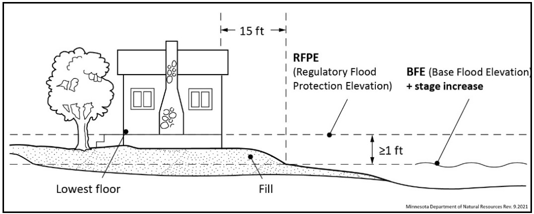
(2)
Nonresidential principal structures. Nonresidential principal structures must meet one of the following construction methods:
a.
Elevation on fill. Structures may be elevated on fill, meeting the standards in section 50-142(b)(1)a of this division. Fill for nonresidential structures is not required to be extended 15 feet beyond the outside limits of the structure.
b.
Alternative elevation methods. Structures may be elevated using methods alternative to the fill standards in section 50-142(b)(1)a of this division. Such methods include the use of blocks, pilings (figure 2), filled stem walls (figure 3), or internally flooded enclosed areas (figure 4) such as crawl spaces, attached garages, or tuck under garages.
| Figure 2: Blocks or pilings | Figure 3: Filled stem walls | Figure 4: Internally flooded enclosed area |
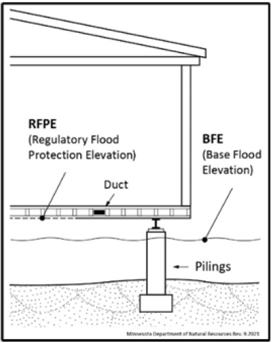 | 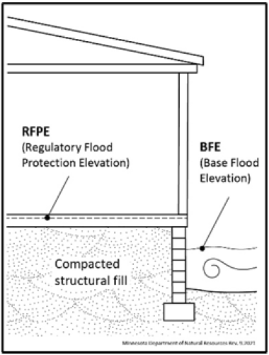 | 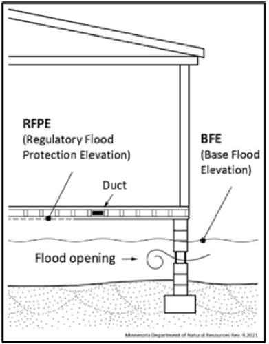 |
Designs accommodating for internally flooded enclosed areas must be certified by a registered professional engineer or architect, or meet or exceed the standards detailed in FEMA Technical Bulletin 1, as amended, as well as the following standards:
1.
The lowest floor, as defined in section 50-138 of this division, shall be elevated at or above the regulatory flood protection elevation (RFPE).
2.
The floor of the enclosed area must be at or above the exterior grade on at least one side of the structure.
3.
To allow for the equalization of hydrostatic pressure, there shall be a minimum of two openings below the base flood elevation on at least two sides of the structure. The bottom of all openings shall be no higher than one foot above grade. The openings shall have a minimum net area of not less than one square inch for every square foot of enclosed area subject to flooding, have a net area of not less than one square inch for every square foot of enclosed area subject to flooding, and shall allow automatic entry and exit of floodwaters without human intervention.
4.
Internally flooded enclosed areas shall only be used for the parking of vehicles, building access, or storage. Bathrooms and toilet rooms shall not be allowed.
c.
Dry floodproofing. Structures having watertight enclosed basements or spaces below the regulatory flood protection elevation (RFPE) must meet the following standards:
1.
Walls must be substantially impermeable to the passage of water, with structural components having the capacity of resisting hydrostatic and hydrodynamic loads and effects of buoyancy, at least up to the regulatory flood protection elevation (RFPE);
2.
Must meet the standards of FEMA Technical Bulletin 3, as amended; and
3.
A registered professional engineer or architect shall be required to certify that the design and methods of construction meet the standards detailed in this section.
(3)
Accessory structures. All accessory structures must meet the following standards:
a.
Structures shall not be designed or used for human habitation.
b.
Structures will have a low flood damage potential.
c.
Structures with fewer than two rigid walls, such as carports, gazebos, and picnic pavilions, may be located at an elevation below the regulatory flood protection elevation.
d.
Structures with two or more rigid walls, must meet one of the following construction methods:
1.
Wet floodproofing. Structures may be floodproofed in a way to accommodate internal flooding. Such structures shall constitute a minimal investment not to exceed 576 square feet in size, one-story in height, and shall only be used for parking and storage. To allow for the equalization of hydrostatic pressure, there shall be a minimum of two openings on at least two sides of the structure and the bottom of all openings shall be no higher than one foot above grade. The openings shall have a minimum net area of not less than one square inch for every square foot of enclosed area subject to flooding and shall allow automatic entry and exit of floodwaters without human intervention.
2.
Elevation on fill. Structures may be elevated on fill, meeting the standards in section 50-142(b)(1)a of this division. Fill is not required to be extended 15 feet beyond the outside limits of the structure.
3.
Alternative elevation methods. Structures may have their lowest floor elevated above the regulatory flood protection elevation (RFPE) through methods alternative to the fill standards in section 50-142(b)(3)d.2 and must meet the standards in section 50-142(b)(2)b of this division.
4.
Dry floodproofing. Structures may be dry-floodproofed, or watertight, meeting the standards in section 50-142(b)(2)c of this division.
(4)
Any facilities used by employees, or the general public must be designed with a flood warning system acceptable to the city that provides adequate time for evacuation or be designed to ensure that within the area inundated during the base flood event, the depth (in feet) multiplied by the velocity (in feet per second) is less than four.
(5)
Manufactured homes and recreational vehicles must meet the standards of Section 50-146 of this division.
(c)
Conditional uses in flood fringe. The following uses and activities may be permitted as conditional uses, subject to the standards in sections 50-142(d):
(1)
Alternative elevation methods—Residential structures. Residential structures with their lowest floor elevated above the regulatory flood protection elevation (RFPE) using methods alternative to the fill requirements in section 50-142(b)(1).
(d)
Standards for conditional uses in flood fringe. In addition to the applicable standards detailed in sections 50-140, 50-142(b) and 50-147(b):
(1)
All residential structures with lowest floors elevated through alternative elevation methods must meet the standards in section 50-142(b)(2)b of this division.
(Ord. No. 2024-2, § 1(6.0), 5-20-2024)
Sec. 50-143. - General floodplain district.
(a)
Permitted uses in general floodplain district.
(1)
Until the floodway is delineated, allowable uses will be restricted to those listed in the floodway district, section 50-141.
(2)
All other uses are subject to a floodway/flood fringe determination as provided in section 50-143(d), in addition to the standards provided in sections 50-143(b) and 50-143(c). Permitted uses shall be determined as follows:
a.
If the development is determined to be in the floodway district, section 50-141 applies.
b.
If the development is determined to be in the flood fringe district, section 50-142 applies.
(b)
Determining flood elevations.
(1)
All development requires a determination of the base flood elevation (BFE). Exceptions to this requirement include projects that restore the site to the previous cross-sectional area, such as shore stabilization or culvert replacement projects. Base flood elevations (BFE) may be found using best available data from any federal, state, or other source (including MNDNR's Lake and Flood Elevations Online (LFEO) Viewer).
(2)
The regulatory flood protection elevation (RFPE) can be determined by assuming a one-half foot stage increase to accommodate for future cumulative impacts. A stage increase does not need to be assumed along lakes, wetlands, and other basins that are not affected by velocities.
(c)
Encroachment analysis.
(1)
Encroachments due to development may not allow stage increases more than one-half foot at any point, unless through a map revision following the procedures in sections 50-147(a)(5) and 50-150. This evaluation must include the cumulative effects of previous encroachments and must be documented with hydrologic and hydraulic analysis performed by a professional engineer or using other standard engineering practices. A lesser water surface elevation increase of one-half foot is required if, due to the water surface level increase, increased flood damage would potentially result.
(2)
Alterations or changes that result in stage decreases are allowed and encouraged.
(d)
Standards for the analysis of floodway boundaries.
(1)
Requirements for detailed studies. Any development, as requested by the zoning administrator, shall be subject to a detailed study to determine the regulatory flood protection elevation (RFPE) and the limits of the floodway district. This determination must be consistent with the minimum standards for hydrologic and hydraulic mapping standards and techniques, as detailed in Minn. R. 6120.5600, subp. 4 and FEMA Guidelines and Standards for Flood Risk Analysis and Mapping, as revised. Additionally:
a.
A regulatory floodway necessary to carry the discharge of the one-percent annual chance flood must be selected without increasing the water surface elevation more than one-half foot at any point. This determination should include the cumulative effects of previous encroachments. A lesser water surface elevation increase of one-half foot is required if, due to the water surface level increase, increased flood damages would potentially result; and
b.
An equal degree of encroachment on both sides of the stream within the reach must be assumed in computing floodway boundaries, unless topography, existing development patterns, and comprehensive land use plans justify a modified approach, as approved by the department of natural resources.
(2)
Other acceptable methods. For areas where a detailed study is not available or required:
a.
Development prohibited in floodways (e.g. most buildings) requires a floodway/flood fringe determination to verify the development is within the flood fringe. This determination must be done by a professional engineer or utilize other accepted engineering practices. The department of natural resources may also provide technical assistance and must approve any alternative methods used to determine floodway boundaries.
(Ord. No. 2024-2, § 1(7.0), 5-20-2024)
Sec. 50-144. - Subdivision standards.
(a)
Subdivisions. All subdivided land must meet the following requirements. Manufactured home parks and recreational vehicle parks or campgrounds are considered subdivisions under this division.
(1)
All lots within floodplain districts must be suitable for a building site outside of the floodway district.
(2)
Subdivision of lands within the floodplain districts may not be approved if the cost of providing governmental services would impose an unreasonable economic burden on the city.
(3)
All subdivisions must have vehicular access both to the subdivision and to the individual building sites no lower than two feet below the regulatory flood protection elevation (RFPE) unless a flood warning/emergency evacuation plan has been approved by the city.
(4)
The floodway and flood fringe district boundaries, the regulatory flood protection elevation (RFPE) and the required elevation of all access roads must be clearly identified on all required subdivision drawings and platting documents.
(Ord. No. 2024-2, § 1(8.0), 5-20-2024)
Sec. 50-145. - Public and private utilities, service facilities, roads, bridges, and railroads.
(a)
Public transportation facilities. Railroad tracks, roads, and bridges must be elevated to the regulatory flood protection elevation (RFPE) where such facilities are essential to the orderly functioning of the area, or where failure or interruption would result in danger to public health or safety. Minor or auxiliary roads or railroads may be constructed at a lower elevation where failure or interruption of transportation services would not endanger the public health or safety. All public transportation facilities should be designed to minimize increases in flood elevations.
(b)
Public utilities. All utilities such as gas, electrical, sewer, and water supply systems to be located in the floodplain must be elevated and/or floodproofed to the regulatory flood protection elevation (RFPE), be located and constructed to minimize or eliminate flood damage and be designed to eliminate infiltration of flood waters into the systems and discharges from the systems into flood waters. All public utilities should be designed to minimize increases in flood elevations. New solid waste management facilities, as defined in Minn. R. 7035.0300, are prohibited in the one-percent annual chance floodplain. Water supply systems are subject to the provisions in Minn. R. 4725.4350.
(c)
Private on-site water supply, individual sewage treatment systems, and other service facilities. Private facilities shall be subject to applicable provisions detailed in section 50-145(b). In addition, new or replacement on-site sewage treatment systems are to be located to avoid impairment to them or contamination from them during times of flooding, shall not be located in a designated floodway, and are subject to the provisions in Minn. R. 7080.2270.
(Ord. No. 2024-2, § 1(9.0), 5-20-2024)
Sec. 50-146. - Manufactured homes and recreational vehicles.
(a)
Manufactured homes. Manufactured homes and manufactured home parks are subject to applicable standards for each floodplain district. In addition:
(1)
New and replacement manufactured homes must be placed and elevated in compliance with section 50-142 of this division and must be securely anchored to a system that resists flotation, collapse, and lateral movement. Methods of anchoring may include, but are not limited to, use of over-the-top or frame ties to ground anchors.
(2)
New manufactured home parks and expansions to existing manufactured home parks must meet the appropriate standards for subdivisions in section 50-144 of this division.
(b)
Recreational vehicles. New recreational vehicle parks or campgrounds and expansions to existing recreational vehicle parks or campgrounds are prohibited in any floodplain district. Recreational vehicles placed in existing recreational vehicle parks, campgrounds, or lots of record in the floodplain must either:
(1)
Meet the requirements for manufactured homes in section 50-146(a), or
(2)
Be travel ready, meeting the following criteria:
a.
The vehicle must be fully licensed.
b.
The vehicle must be ready for highway use, meaning on wheels or the internal jacking system, attached to the site only by quick disconnect type utilities.
c.
No permanent structural type additions may be attached to the vehicle.
d.
Accessory structures may be permitted in the flood fringe district, provided they do not hinder the removal of the vehicle should flooding occur, and meet the standards outlined in sections 50-140 and 50-142(b)(3).
(Ord. No. 2024-2, § 1(10.0), 5-20-2024)
Sec. 50-147. - Administration.
(a)
Duties. A zoning administrator or other official must administer and enforce this division.
(1)
Permit application requirements. Permit applications must be submitted to the zoning administrator. The permit application must include the following, as applicable:
a.
A site plan showing all existing or proposed buildings, structures, service facilities, potential obstructions, and pertinent design features having an influence on the permit.
b.
Location and detail of grading, fill, or storage of materials.
c.
Copies of any required local, state, or federal permits or approvals.
d.
Other relevant information requested by the zoning administrator as necessary to properly evaluate the permit application.
(2)
Recordkeeping. The zoning administrator must maintain applicable records in perpetuity documenting:
a.
All certifications for dry floodproofing and alternative elevation methods, where applicable.
b.
Analysis of no-rise in the floodway district, as detailed in section 50-141(b)(1), and encroachment analysis ensuring no more than one-half foot of rise in the general floodplain district, as detailed in sections 50-143(b)(2) and 50-143(c)(1).
c.
Final elevations, as applicable, detailing the elevation to which structures and improvements to structures are constructed or floodproofed. Elevations shall be determined by an engineer, architect, surveyor, or other qualified individual, as approved by the zoning administrator.
d.
Substantial damage and substantial improvement determinations, as detailed in section 50-148(a)(3), including the cost of improvements, repairs, and market value.
e.
All variance actions, including justification for their issuance, and must report such variances as requested by the Federal Emergency Management Agency.
(3)
Certificate of zoning compliance for a new, altered, or nonconforming use. No building, land or structure may be occupied or used in any manner until a certificate of zoning compliance has been issued by the zoning administrator stating that the finished fill and building floor elevations or other flood protection measures follow the requirements of this division.
(4)
Notifications for watercourse alterations. Before authorizing any alteration or relocation of a river or stream, the zoning administrator must notify adjacent communities. If the applicant has applied for a permit to work in public waters in accordance with M.S.A. § 103G.245, this will suffice as adequate notice. A copy of the notification must also be submitted to FEMA.
(5)
Notification to FEMA when physical changes increase or decrease base flood elevations. Where physical changes affecting flooding conditions may increase or decrease the water surface elevation of the base flood, the city must notify FEMA of the changes in order to obtain a letter of map revision (LOMR), by submitting a copy of the relevant technical or scientific data as soon as practicable, but no later than six months after the date such supporting information becomes available. Within the general floodplain district, a map revision is only required if development results in stage increases greater than one-half feet.
(b)
Conditional uses and variances.
(1)
Process.
a.
An application for a conditional use permit will be processed and reviewed in accordance with the provisions of this division.
b.
An application for a variance to the provisions of this division will be processed and reviewed in accordance with M.S.A. § 462.357, subd. 6(2) and this division.
(2)
Additional variance criteria. The following additional variance criteria must be satisfied:
a.
Variances must not be issued within any designated regulatory floodway if any increase in flood levels during the base flood discharge would result.
b.
Variances from the provisions of this division may only be issued by a community upon:
1.
A showing of good and sufficient cause.
2.
A determination that failure to grant the variance would result in exceptional hardship to the applicant; and
3.
A determination that the granting of a variance will not result in increased flood heights, additional threats to public safety, extraordinary public expense, create nuisances, cause fraud on or victimization of the public, or conflict with existing local laws or ordinances.
c.
Variances from the provisions in this division may only be issued upon a determination that the variance is the minimum necessary, considering the flood hazard, to afford relief.
d.
Variances must be consistent with the general purpose of these standards and the intent of applicable provisions in state and federal law.
e.
Variances may be used to modify permissible methods of flood protection, but no variance shall permit a lesser degree of flood protection than the regulatory flood protection elevation (RFPE).
f.
The zoning administrator must notify the applicant for a variance in writing that:
1.
The issuance of a variance to construct a structure below the base flood level will result in increased premium rates for flood insurance up to amounts as high as $25.00 for $100.00 of insurance coverage; and
2.
Such construction below the base flood level increases risks to life and property. Notification must be maintained with a record of all variance actions.
(3)
Considerations for approval. The city must consider all relevant factors specified in other sections of this division in granting variances and conditional use permits, including the following:
a.
The potential danger to life and property due to increased flood heights or velocities caused by encroachments.
b.
The danger that materials may be swept onto other lands or downstream to the injury of others.
c.
The safety of access to the property in times of flood for ordinary and emergency vehicles.
(4)
Conditions of approval. The city may attach such conditions to the granting of variances and conditional use permits as it deems necessary to fulfill the purposes of this division. Such conditions may include, but are not limited to, the following:
a.
Limitations on period of use, occupancy, and operation.
b.
Imposition of operational controls, sureties, and deed restrictions.
c.
The prevention of soil erosion or other possible pollution of public waters, both during and after construction.
d.
Other conditions as deemed appropriate by the planning commission and city council.
(c)
Notifications to the department of natural resources.
(1)
All notices of public hearings to consider variances or conditional uses under this division must be sent via electronic mail to the department of natural resources respective area hydrologist at least ten days before the hearings. Notices of hearings to consider subdivisions/plats must include copies of the subdivision/plat.
(2)
A copy of all decisions granting variances and conditional uses under this division must be sent via electronic mail to the department of natural resources respective area hydrologist within ten days of final action.
(Ord. No. 2024-2, § 1(11.0), 5-20-2024)
Sec. 50-148. - Nonconformities.
(a)
Continuance of nonconformities. A use, structure, or occupancy of land which was lawful before the passage or amendment of this division, but which is not in conformity with the provisions of this division, may be continued subject to the following conditions:
(1)
Within the floodway and general floodplain districts (when a site has been determined to be located in the floodway following the procedures in section 50-143(c), or when the floodway has not been delineated), any expansion or enlargement of uses or structures is prohibited.
(2)
Within all districts, any addition, modification, rehabilitation, repair, or alteration shall be in conformance with the provisions of this division, shall not increase the flood damage potential or increase the degree of obstruction to flood flows, and where applicable, must be protected to the regulatory flood protection elevation (RFPE).
(3)
If any nonconforming structure is determined to be substantially damaged or substantially improved based on the procedures in section 50-148(b), it may not be reconstructed except in conformity with the provisions of this division.
(4)
If any nonconforming use, or any use of a nonconforming structure, is discontinued for more than one year, any future use of the premises must conform to this division.
(5)
If any nonconforming structure has utilities, electrical, or mechanical equipment damaged due to flooding, it must be rebuilt in conformance with the elevation requirements in section 50-140(c)(1)d to the greatest extent practicable. This requirement shall apply regardless of the determinations made in section 50-148(b).
(b)
Substantial improvement and substantial damage determinations. Prior to issuing any permits for additions, modifications, rehabilitations, repairs, alterations, or maintenance to nonconforming structures, the zoning administrator is required to determine if such work constitutes substantial improvement or repair of a substantially damaged structure. A determination must be made in accordance with the following procedures:
(1)
Estimate the market value of the structure. In the case of repairs, the market value of the structure shall be the market value before the damage occurred and before any restoration or repairs are made.
(2)
Estimate the cost of the project. The property owner shall accommodate for inspection, and furnish other documentation needed by the zoning administrator to evaluate costs.
a.
Improvement costs shall be comprised of the market rate of all materials and labor, as well as the costs of all ordinary maintenance and upkeep carried out over the past one year.
b.
Costs to repair damages shall be comprised of the market rate of all materials and labor required to restore a building to its pre-damaged condition regardless of the work proposed, as well as associated improvement costs if structure is being restored beyond its pre-damaged condition.
(3)
Compare the cost of the improvement, repairs, or combination thereof to the estimated market value of the structure and determine whether the proposed work constitutes substantial improvement or repair of a substantially damaged structure, as defined in section 50-138 of this division.
a.
For the purposes of determining whether the proposed work would constitute substantial improvement, the evaluation shall also include all rehabilitations, additions, or other improvements completed since the community has adopted floodplain standards impacting this structure.
b.
If any nonconforming structure experiences a repetitive loss, as defined in section 50-138 of this division, it shall be considered substantially damaged and must not be reconstructed except in conformity with the provisions of this division.
(4)
Based on this determination, the zoning administrator shall prepare a determination letter and notify the property owner accordingly. Structures determined to be substantially damaged or substantially improved may not be reconstructed except in conformity with the provisions of this division.
(Ord. No. 2024-2, § 1(12.0), 5-20-2024)
Sec. 50-149. - Violations and penalties.
(a)
Uses in violation of the ordinance. Every structure, fill, deposit, or other use placed or maintained in the floodplain in violation of this division shall be considered a public nuisance.
(b)
Civil remedies. The creation of a public nuisance may be enjoined and the maintenance of a public nuisance under this division may be abated by an action brought by the city or the department of natural resources.
(c)
Enforcement. Violations of the provisions of this division constitute a misdemeanor and is punishable as defined by law. The zoning administrator may utilize the full array of enforcement actions available to it including, but not limited to prosecution and fines, injunctions, after-the-fact permits, orders for corrective measures or a request to the National Flood Insurance Program for denial of flood insurance. The city must act in good faith to enforce these official controls and to correct ordinance violations to the extent possible so as not to jeopardize its eligibility in the National Flood Insurance Program.
(Ord. No. 2024-2, § 1(13.0), 5-20-2024)
Sec. 50-150. - Amendments.
(a)
Ordinance amendments. Any revisions to the floodplain maps by the Federal Emergency Management Agency or annexations of new map panels require an ordinance amendment to update the map references in section 50-139(b) of this division.
(b)
Required approval. All amendments to this division must be submitted to the department of natural resources for review and approval prior to adoption, for compliance with state and federal rules and requirements. The floodplain ordinance shall not be considered valid until approved.
(Ord. No. 2024-2, § 1(14.0), 5-20-2024)