
Calexico City Zoning Code
CHAPTER 17
09 - SPECIAL ZONES
17.09.110 - Purposes.
The mobilehome park zone is intended for the exclusive development of mobilehome parks. All mobilehome parks shall be developed in accordance with the provisions of this chapter. (1992 zoning ord. (part))
17.09.120 - Permitted and conditional uses—MHP zone.
The following uses shall be permitted uses where the symbol "P" appears and shall be permitted uses subject to a conditional use permit where the symbol "C" appears in the column beneath each zone designation. Where the symbol "X" appears the use shall be prohibited.
(1992 zoning ord. (part))
17.09.130 - Property development standards—MHP zone.
The following regulations shall apply to the site of a mobilehome park. Additional regulations may be specified as conditions of approval through development review by the planning commission.
A.
General Requirements. The following requirements are minimum unless otherwise stated.
_____
_____
B.
Special Requirements. The following special requirements shall apply to development of mobilehome spaces and to facilities within a mobilehome park. Additional requirements may be specified as conditions of development review.
1.
Mobilehome Space and Units. Each space shall have dimensions capable of accommodating a rectangle with minimum dimensions of twenty-eight feet by fifty-five feet. All mobilehomes shall be at least double wide coaches.
2.
Accessory Structures. Carports, patio covers, storage buildings, and similar structures accessory to a mobilehome may be located no closer than five feet to the boundary of a mobilehome space.
3.
Access and Access Drives. All mobilehome access shall be from a publicly maintained street, however, access drives within a mobilehome park shall be privately owned, and shall be at least twenty-eight feet wide exclusive of adjoining parking areas.
4.
Sidewalks. Concrete sidewalks at least four and one-half feet in width shall be provided to serve each mobilehome space and to serve all central or common facilities within the mobilehome park. Sidewalks need not adjoin access drives.
5.
Landscaping. Not less than twenty percent of each mobilehome space shall be landscaped with plant materials, including at least one fifteen gallon size tree on each space.
6.
Screening and Landscaping. Required yards shall be landscaped in accord with a site development plan to be approved in accordance with the procedures of development review. Screening of the mobilehomes shall be provided around the entire site by a six foot wall and landscaping.
7.
Mobilehome Park Accessory Buildings and Use. Accessory buildings and uses serving the entire mobilehome park, including recreation facilities, laundry areas, mobilehome park offices, and maintenance or storage buildings, shall be located at least fifty feet from the exterior boundaries of the mobilehome park site. All exterior maintenance or storage areas shall be enclosed by a six-foot masonry wall.
8.
Cable TV service shall be available to each mobilehome space.
9.
Common recreation facilities shall be provided commensurate with the proposed or intended residents including, a meeting room, pool and spa and one of the following:
a.
Putting green;
b.
Pitch and putt golf course;
c.
Children's play area;
d.
Lawn/open space general recreation areas; and
e.
Recreation lakes.
10.
Recreation vehicle storage areas, fully screened from view of the public and private streets shall be provided. The CC&R's shall prohibit the storage of RVs on the unit space.
11.
All unit spaces plus the caretaker's unit and any recreation buildings shall be served with city water and sewer.
12.
Skirting or screening of the unit wheels shall be required. (1992 zoning ord. (part))
17.09.140 - Pre-existing mobilehome parks.
A pre-existing mobilehome park shall not be deemed nonconforming by reason of failure to meet the minimum requirements prescribed by this section, provided that the regulations of this section shall apply to the enlargement or expansion of a pre-existing mobilehome park, and provided that a pre-existing mobilehome park on a site less than ten acres shall not be further reduced in area. (1992 zoning ord. (part))
17.09.150 - Signs.
No sign or outdoor advertising structure shall be permitted in an MHP zone except as provided in Chapter 17.01, Article XI. (1992 zoning ord. (part))
17.09.210 - Purpose.
A.
Planned development regulations are intended to facilitate development of areas designated on the zoning map by permitting greater flexibility and, consequently, more creative and imaginative designs for the development of such areas than generally is possible under conventional zoning or subdivision regulations.
B.
These regulations are further intended to promote more economical and efficient use of the land while providing a harmonious variety of choices, a higher level of amenities, and, preservation of natural and scenic qualities of open spaces. (1992 zoning ord. (part))
17.09.220 - Permitted and conditional uses—PD zone.
A.
Planned developments, subject to the issuance of a conditional use permit.
B.
Permitted and conditional uses in accordance with those indicated for the R zones, C zones and I zones. (1992 zoning ord. (part))
17.09.230 - Property development standards—PD zone.
A.
General Requirements. The following requirements are minimum unless otherwise stated.
_____
_____
B.
Special Requirements. The following special development requirements shall apply to all planned developments:
1.
The planned development shall be designed and developed in a manner compatible with and complementary to existing and potential development in the immediate vicinity of the project site. Site planning on the perimeter shall provide for the protection of the property from adverse surrounding influences, as well as protection of the surrounding areas from potentially adverse influences within the development.
2.
In residential developments, where individual lotting is desired, there shall be a three thousand net square foot minimum area requirement for individual lots or sites.
3.
For residential projects, required open space shall comprise at least thirty percent of the total area of the planned development. Land occupied by buildings, street, driveways or parking spaces may not be counted in satisfying this open space requirement; provided, however, that land occupied by any recreational buildings and structures may be counted as required open space.
4.
All lawn and landscaped areas reserved for common use shall be provided with a permanent automatic watering system adequate to irrigate such areas, unless it is left in its natural state, if natural features worthy of preservation exist on the site. Open space left in its natural state shall be kept free of litter and shall at no time constitute a health, safety, fire or flood hazard.
5.
If the project is to be developed in stages, the development plan shall coordinate improvement of the open space, the construction of buildings, structures, and improvements in such open space, and the construction of buildings in order that each development stage achieves a proportionate share of the total open space and environmental quality of the total planned development.
6.
All or any part of the required open space shall be reserved for use in common by the occupants of the planned development. Areas permanently reserved for common open space shall be reserved for the use and enjoyment of the occupants in a manner which makes the city, or a public district or public agency a party to and entitled to enforce the reservation. The planning commission may require that open space easements over the required open space be conveyed to the city.
7.
No building, except as hereinafter provided, shall be located closer than five feet to any interior vehicular or pedestrian way, court, plaza, open parking lot or any other surfaced area reserved for public use or for use in common by occupants of the planned development. Such setback shall generally be measured from the nearest edge of a surfaced area; provided, however, that where no sidewalk exists in conjunction with a public or private street, such setback shall be measured from the nearest edge of the street right-of-way or private road easement.
8.
All public streets within or abutting the proposed planned development shall be dedicated and improved to city specifications for the particular classification of street. When the developer desires to retain any street within the development as private streets, such streets shall be irrevocably offered for dedication and maintained for their intended purpose by the homeowners or property association or other means acceptable to the planning commission.
9.
Planned developments shall relate harmoniously to the topography of the site, shall make suitable provision for the preservation of canals, water courses, drainage areas, and similar features and areas, and, shall otherwise be so designed as to use and retain such features and amenities to the greatest extent possible.
10.
All utilities within a planned development shall be placed underground. (1992 zoning ord. (part))
17.09.240 - Accessory uses and structures—PD zone.
Accessory uses and structures shall be located as specified on the development plans as approved by the planning commission; provided, however, that accessory structures shall meet all of the setbacks for site development as specified in underlying zone in which it is located. (1992 zoning ord. (part))
17.09.250 - Signs—PD zones.
No sign or outdoor advertising structure shall be permitted except as prescribed in Chapter 17.01, Article XI. (1992 zoning ord. (part))
17.09.310 - Purposes.
The specific plan overlay zone is included in the zoning ordinance to achieve the following purposes:
A.
To promote and protect the public health, safety, and welfare.
B.
To implement the objectives and policies of the general plan.
C.
To safeguard and enhance environmental amenities and the quality of development.
D.
To attain the physical, social, and economic advantage resulting from comprehensive and orderly planned use of land resources.
E.
To lessen congestion and assure convenience of access; to secure safety from fire, flood, and other dangers; to provide for adequate light, air, sunlight, and open space; to promote and encourage conservation of scarce resources; to prevent overcrowding of land and undue concentration of population; to facilitate the creation of a convenient, attractive, and harmonious community; to attain a desirable balance of residential and employment opportunities; and to expedite the provision of adequate and essential public services.
F.
To facilitate development within the city in accordance with the general plan by permitting greater flexibility, and encouraging more creative and imaginative designs for major development projects subject to large-scale community planning.
G.
To promote more economical and efficient use of the land while providing a harmonious variety of housing choices and commercial and industrial activities, a high level of urban amenities, and preservation of natural and scenic qualities of open space.
H.
To provide a process for initiation, review, and regulation of large-scale comprehensively planned communities that affords the maximum flexibility to the developer within the context of an overall development program and specific, phased development plans coordinated with the provision of necessary public services and facilities. (1992 zoning ord. (part))
17.09.320 - Use regulations—SP zone.
A.
Allowable use in each specific plan zone shall be as established by a development plan text approved by the city council. The development plan text may incorporate uses by reference to specific base zone provisions, or may establish specific use lists with definitions pertaining thereto.
B.
Existing uses within the specific plan zone at the time of its establishment shall be deemed allowable and incorporated in the development plan, unless terminated, discontinued, or changed pursuant to a specific time schedule incorporated in the development plan text.
C.
Unless otherwise provided by the development plan text, public utility facilities and publicly-owned facilities shall be allowable subject to a conditional use permit.
D.
Unless otherwise provided by the development plan text, accessory uses or facilities shall be subject to the same use regulation provisions as the principal use or facility.
E.
Each allowable use in the specific plan zone shall be subject to a development review.
F.
Temporary use pursuant to Section 17.11.110 and home occupations pursuant to Chapter 17.11, Article II, shall be allowable in each specific plan. (1992 zoning ord. (part))
17.09.330 - Property development standards—SP zone.
A.
General Requirements.
1.
Specific plan zone shall include a minimum area of fifty contiguous acres, under single ownership or otherwise subject to unified planning, construction, and development by a person, corporation, or other entity. Property owned by public utilities, local districts or local governments will not be counted toward the fifty acre minimum, but may be used as a connector of single ownership. The city council may reduce the minimum acreage requirement in cases where the specific plan zone provides greater protection of the goals and objectives of the general plan.
2.
A specific plan zone shall be established upon application of a property owner, in accordance with procedures set forth in Chapter 17.01, Article III and subject to the following provisions:
a.
Submission of a development plan for consideration by the city council, pursuant to this title.
b.
Determination by the council upon recommendation of the planning commission that the establishment of the zone and approval of the development plan shall:
1.
Provide for the development of a comprehensively planned community within the zone that is superior to development otherwise allowable under alternate regulations.
2.
Provide for development within the zone in a manner consistent with the general plan and with related development and growth policies of the city.
3.
Provide for the construction, improvement, or extension of transportation facilities, public utilities, and public services required by development with the zone.
4.
There shall be no minimum yard requirement for individual lots except as established by a development plan, a conditional use permit, or development review.
5.
There shall be no minimum usable open space requirement for individual lots, except as established by development plan, a conditional use permit, or by development review.
6.
There shall be a maximum height of thirty-five feet or two stories within fifty feet of the exterior boundaries of the zone, the maximum height shall be fifty feet or four stories whichever is less and no coverage requirement for individual lots, except as established by a development plan, a conditional use permit, or by development review.
7.
The maximum number of dwelling units within a specific plan zone shall not exceed the ability of the city to provide services in accordance with the general plan and applicable city ordinances; provided that the distribution of units within the zone and the maximum residential density on any individual site or within designated portions of the zone shall be governed by the development plan, conditional use permit, or development review.
In the event the general plan does not establish a maximum residential density for said site, the city council upon recommendation of the planning commission, shall determine the appropriate density based on detailed review of the development plan and text and the provisions of this section.
B.
Special Requirements.
1.
The specific plan overlay zone and all uses therein shall be designed and developed in a manner compatible with and complementary to existing and potential development in the general vicinity of the zone. Site planning on the perimeter shall provide for the mutual protection of the zone and surrounding property from potential adverse influences.
2.
All public streets within or abutting the development shall be dedicated and improved to city specifications for that particular classification of street. Private streets within the development shall be dedicated and improved to city specifications for that particular classification of street. Private streets within the development shall be irrevocably offered for dedication and maintained for their intended purpose by means acceptable to and enforceable by the city. Consideration of other forms of access, such as pedestrian ways, courts, plazas, driveways, horse trails, bike trails, or open parking lots offered for dedication may be made at the time of the development plan and text consideration as a means of meeting requirements for open space or park dedication requirements. (1992 zoning ord. (part))
17.09.340 - Performance standards—SP zone.
A.
All development within a specific plan overlay zone shall relate harmoniously to the topography of the site, shall make suitable provision for the preservation of watercourse, drainage areas, canals, and similar features, and shall otherwise be so designed inasmuch as possible, to use and retain or enhance the natural features and amenities to the best advantage.
B.
Mechanical and electrical equipment, including air conditioners, antennas, pumps, heating or cooling or ventilating equipment, exterior lighting, or similar equipment shall be located and operated in a manner so as not to unreasonably disturb the peace, quiet, and comfort of neighboring residents. Excluding roof-mounted solar collector panels and decorative exterior lighting, all such equipment and devices shall be screened from view from an abutting street, and shall not be located in a street yard.
C.
All areas for storage of maintenance equipment, and all service areas including refuse storage and collection facilities, shall be enclosed by a fence, wall, and/or landscape screen.
D.
All uses within a specific plan overlay zone shall provide off-street parking and loading facilities pursuant to Chapter 17.13. The applicant may apply for and receive administrative relief from Chapter 17.13 at the time of development review consideration by the planning commission and approval of the city council, when verified proof has been submitted through specific examples of existing projects and/or expert testimony that supports reduced parking standards or stalls.
E.
The proposed means for assuring continuing existence, maintenance and operation of the various common elements and facilities.
F.
Additional site development regulations and performance standards applicable to individual uses or to designated portions of a specific plan zone may be established by the development plan, conditional use permit, or development review approval pursuant to the development plan. (1992 zoning ord. (part))
17.09.350 - Pre-application procedure.
A.
Prior to submitting an application for a specific plan overlay zone, or implementation thereof, the applicant or prospective developer shall hold preliminary consultations with the director of planning and other city officials to obtain information and guidance before entering into binding commitments incurring substantial expense in the preparation of plans, surveys, and other data. Such preliminary consultations should be relative to a conceptual development plan which includes, but is not limited to, the following:
1.
Proposed land uses to be developed within the zone.
2.
Development concepts to be employed.
3.
Schematic maps, illustrative material, and narrative sufficient to describe the general relationships between land uses, and the intended design character and scale of principal features.
4.
A preliminary time schedule for development, including quantitative data, such as population, housing units, land use acreage, and other data sufficient to illustrate phasing of development and potential impact on public service requirements.
B.
Following initial preliminary consultations pursuant to this section, the director may require submission of a housing market analysis, satisfactory to the director of planning demonstrating the need for housing by price range and number of dwelling units. Such analysis may be requested as a part of the pre-application review procedure, may be made a requirement for submission of an application for a specific plan overlay zone or implementation thereof, or may be requested as part of the environmental assessment or EIR.
C.
Following initial preliminary consultations pursuant to this section, the director may require submission of a commercial and/or industrial market analysis satisfactory to the director of planning for any proposed shopping center or major commercial and/or industrial uses, showing the need for such uses in the location required and the inadequacy of existing zoned sites to meet this need. The market analysis shall include, but not be limited to, the following:
1.
Determination of potential trade area.
2.
Determination of potential employment area.
3.
Estimates of existing and future population of the trade area.
4.
Estimates of existing and future employment.
5.
Determination of existing and potential effective buying power for the proposed commercial development.
6.
Determination of the net potential customer buying power for the proposed commercial development.
Such analysis may be requested as part of the pre-application review procedure, and may be made a requirement of submission of an application for a specific plan overlay zone, or implementation thereof, or may be requested as part of the environmental assessment or EIR.
D.
Following initial preliminary consultation pursuant to this section, the director may require presentation of the conceptual development plan to the planning commission and city council. Such presentation shall be for information purposes only, and shall be in addition to subsequent public review requirements pursuant to an application for a specific plan overlay zone, or implementation thereof, and submission of development plan. (1992 zoning ord. (part))
17.09.360 - Development plan.
A.
The development to be submitted for the implementation of and/or with an application for a specific plan overlay zone shall include the following:
1.
A boundary survey map of the property and a calculation of the gross land area within the proposed zone. A tentative subdivision map may be substituted if the applicant proposes to subdivide the property.
2.
A topographic map and general grading concept plan with specific sections for sensitive areas, as determined by the director of planning and public works for the property and adjacent land within one hundred feet of the property, shown at contour intervals not to exceed one foot for natural slopes of two percent or less. For natural slopes over two percent contour interval shall not exceed five feet.
3.
Maps and supporting tabulations showing the current general plan land use designation, the current zoning classification, and the current land use within the proposed zone and on adjacent sites within three hundred feet. The location of structures and other significant improvements shall be shown.
4.
A land use plan identifying areas within the proposed zone and uses to be developed therein, supported by proposed or projected acreage, population, housing units, employment, and such related planning and development data as the director of planning may require.
5.
A development plan indicating the general phasing or anticipated schedule. Said plan shall indicate the total phasing of the specific plan and areas to be developed in phases and the anticipated time schedule for beginning of construction and for completion of each phase of development. Said plan shall include a pro rata share of amenities, parks, and open space. This is a generalized schedule and may be adjusted according to market constraints as the specific plan develops.
6.
A circulation plan, showing existing and proposed public and private streets, pedestrian ways, trails, and related transportation access or circulation features required to serve the proposed development. The circulation plan shall be supported by schematic drawing. (1992 zoning ord. (part))
17.09.370 - Adoption of zone and development plan.
A.
An application for a specific plan overlay zone, if required and the development plan submitted with the application shall be subject to review and approval in the same manner as prescribed in Chapter 17.01, Article III.
B.
Each specific plan overlay zone established shall be indicated on the zoning map by the letters "SP" located after the base zone. The development plan as modified and approved by the city council, is incorporated into this title. (1992 zoning ord. (part))
17.09.380 - Amendments to development plan.
A.
A development plan may be amended in the same manner as provided by Chapter 17.01, Article III, for a change of zone boundaries or for a change in the regulations applicable within a zone. Amendment of a development plan shall be subject to the same findings as prescribed for initial enactment or implementation of a specific plan overlay zone and adoption of the development plan applicable to the specific plan overlay zone.
B.
An amendment to a development plan may be initiated by the city council. An amendment may also be initiated by the applicant for the specific plan overlay zone or a successor thereto, provided such applicant or successor has, at the time of application for an amendment, a continuing controlling interest in development or management of uses within the specific plan overlay zone. (1992 zoning ord. (part))
17.09.390 - Review of development progress.
A.
The director of planning shall review each specific plan zone annually, and shall submit a report to the city council containing the following:
1.
A summary of the development status within the specific plan and an assessment of progress during the year toward completion of development authorized by the development plan including adherence to development schedules and phasing.
2.
A statement of any changes in land use and economic development trends, housing market indicators, commercial and industrial development rates, or programs for provision of public facilities and services which, in the opinion of the director, vary significantly from those upon which the development plan were based, and which could adversely affect continued progress toward completion of development within the specific plan.
B.
A copy of the annual report of the director shall be provided to the applicant and to such other interested parties or successors as deemed appropriate by the director. (1992 zoning ord. (part))
17.09.410 - Purposes.
This zone is intended for general agriculture. Only those additional uses are permitted that are complimentary to, and can exist in harmony with agriculture. In addition to the objectives outlined in Section 17.01.110, Purpose and scope, the agricultural zone is included in the zoning regulations to achieve the following purposes:
A.
To preserve agricultural production until such time as development is appropriate;
B.
Maintain the natural character of the land;
C.
Provide for private use of land under limited development; and
D.
Promote public health and safety. (1992 zoning ord. (part))
17.09.420 - Permitted and conditional uses—A zone.
The following uses shall be permitted uses where the symbol "P" appears and shall be permitted uses subject to a conditional use permit where the symbol "C" appears. Where the symbol "X" appears the use is prohibited.
(1992 zoning ord. (part))
17.09.430 - Property development standards.
The following regulations shall apply to the site of a permitted or conditional use. The requirements are minimum unless otherwise stated.
A.
Special Requirements.
1.
In the agricultural zone, the number of permitted large animals shall conform to the requirements of Articles III and IV of Chapter 17.11.
B.
General Requirements.
* Exceptions for agricultural buildings and/or structures which are necessary for the operation of an agricultural business are permitted up to a maximum height of seventy-five feet so long as the structure does not interfere with flight take offs and landings and is not used for human or animal habitation.
(1992 zoning ord. (part))
17.09.440 - Off-street parking.
Off-street parking facilities shall be provided for each use as prescribed in Chapter 17.13, Off-Street Parking. (1992 zoning ord. (part))
17.09.450 - Accessory buildings and structures.
Accessory buildings and structures used for livestock shall not be located closer than one hundred feet from the front property line and shall be at least fifty feet from any existing dwelling or public facility on a contiguous property. (1992 zoning ord. (part))
17.09.460 - Walls and fences.
A.
A wall or fence not more than six feet in height may be maintained along the property lot lines.
B.
Within the area designated for a dwelling, walls and fences shall not exceed a height of thirty-six inches within the required front yard setback.
C.
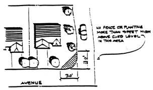
Within the area designated for a dwelling, a wall or fence adjacent to a driveway or street providing vehicular access to an abutting lot or street shall not exceed thirty-six inches in height within fifteen feet of the intersection of said driveway and the street right-of-way. Corner cut-offs may be required in special circumstances for safety and visibility (see example as follows):
D.
Within the area designated for a dwelling, a wall or fence may be constructed a minimum distance of five feet from the ultimate right-of-way at a maximum height of six feet when there is no parkway planting area adjacent to the sidewalk. Where there is a parkway planting area adjacent to the curbing no setback is required to construct a fence six feet in height.
E.
A wall or fence shall not be constructed in such a manner so as to block or restrict vehicular access to a dedicated or implied dedicated alley, access or way.
F.
Fiberglass sheeting, bamboo sheeting or other similar temporary material shall not be permitted as a fencing material on street yard frontages. (1992 zoning ord. (part))
17.09.470 - Signs.
No sign, outdoor advertising structure, or display or any character shall be permitted except as prescribed in Chapter 17.01, Article XI. (1992 zoning ord. (part))
17.09.510 - Purpose.
The purposes of the OS open space zone are based upon the general plan objectives and the following general purposes:
A.
To provide protection in areas of fire, geologic, seismic or flood hazards through restriction of intensive uses.
B.
To promote the retention of open space for recreational use and for the protection of natural resources.
C.
To promote the preservation of open spaces, protect natural features, offer views to residents, and maintain open areas where flood, fire, geologic and seismic conditions may endanger public health and safety. (1992 zoning ord. (part))
17.09.520 - Permitted and conditional uses—OS zone.
The following uses shall be permitted uses where the symbol "P" appears; and shall be permitted uses subject to a conditional use permit where the symbol "C" appears in the column beneath each zone designation; and shall be prohibited uses where the symbol "X" appears.
(1992 zoning ord. (part))
17.09.530 - Property development standards—OS zone.
A.
General Requirements. Development standards such as site dimensions, height limitations and setbacks shall all be determined on a site-by-site basis. Consideration shall be given to surrounding properties and developments in order to blend and remain consistent with the area. Other factors for determination of standards shall be topography, water/drainage, significant ridgeline, oak tree preservation, significant ecological areas, circulation, use of site, and any environmental factors related to the site.
B.
Performance Standards. Development within the open space zone shall adhere to the following:
1.
Minimize alteration to the natural landform.
2.
Protect areas capable of replenishing ground water supplies.
3.
Protect the natural drainage of the area.
4.
Protect waterways from indiscriminate erosion and pollution.
5.
Protect lands having biological significance.
6.
Protect areas with significant native vegetation and habitat value.
7.
Protect natural areas for ecologic, educational, and other scientific study purposes.
8.
The director of planning and/or the planning commission may, through the development review process, require additional improvements to a development in the open space zone if it is needed for the protection of the public health, safety, or general welfare. (1992 zoning ord. (part))