
Carrabelle City Zoning Code
ARTICLE XIII
DEFINITIONS
PART 13.01.00 - WORD USAGE
The following rules shall be observed in the application and interpretation of provisions of this code, except when the context clearly requires otherwise:
The words "shall," "should," or "must" are mandatory. The word "may" is permissive.
Words used or defined in one tense or form shall include other tenses or derivative forms.
Words in the singular shall include the plural; words in the plural shall include the singular.
In the event of a conflict between the text of this code and any illustrations, captions, figures or other graphic material, the text shall control.
The word "includes" shall not limit a term to the specified examples, but is intended to extend its meaning to all other instances or circumstances of like kind or character.
The words "person," "owner," or "developer" includes a profit or nonprofit corporation, company, partnership, association, individual governing agency.
The words "used" or "occupied" as applied to any land or building include the words intended, arranged or designed to be used or occupied.
Unless specifically defined below, words or phrases used in this code shall have the meaning of common usage which gives this code its most reasonable applications.
PART 13.02.00 - DEFINITION OF TERMS
Abandonment: To stop the use of property intentionally. When the use of a property has ceased and the property has been vacant for 12 months, abandonment of use will be presumed unless the owner can show that a diligent effort has been made to sell, rent, or use the property for a legally permissible use.
Abutting: Having a common border with, or being separated from such a common border by a right-of-way, alley, or easement.
Access: A means of vehicular or pedestrian approach, entry to, or exit from property.
Access management: The process of providing and managing access to land development while preserving the regional flow of traffic in terms of safety, capacity, and speed.
Access point:
1.
A driveway, a local street, or a collector street intersecting an arterial street;
2.
A driveway or a local street intersecting a collector street; or
3.
A driveway or a local street intersecting a local street.
Accessory apartment: A secondary dwelling unit established in conjunction with and clearly subordinate to a primary dwelling unit, whether a part of the same structure as the primary dwelling unit or a detached dwelling unit on the same lot.
Accessory structure: A subordinate structure detached from but located on the same lot as a principal building. The use of an accessory structure must be identical and accessory to the use of the principal building. Accessory structures include garages, decks, and fences.
Accessory use: A structure or use that (1) is subordinate in area, extent, and purpose to the principal use; (2) contributes to the comfort, convenience, or necessity of the principal use; and (3) is located on the same lot and in the same zoning district as the principal use.
Acreage, gross: The acreage within the perimeter of a development tract, plus one-half the right-of-way of all adjoining streets and alleys.
Acreage, net: The area within lot boundaries of all lands comprising the building site. A net acre shall not include any portion of the abutting dedicated streets, alleys, waterways, canals, lakes, or any such dedicated right-of-way by whatever name known.
Adaptive reuse: Rehabilitation or renovation of existing building(s) or structures for any use(s) other than the present use(s).
Addition (to an existing building): Any walled and roofed expansion to the perimeter of a building in which the addition is connected by a common load-bearing wall other than a fire wall. Any walled and roofed addition which is connected by a fire wall or is separated by independent perimeter load-bearing walls is new construction.
Administrator: Shall mean and be synonymous with the terms city manager, development director, zoning administrator, building official, their designee, or any other official authorized in this code to perform specific duties.
Adult use, adult bookstore: An establishment that has a substantial portion of its stock-in- trade and offers for sale, for any form of consideration, any one or more of the following: 1) books, magazines, periodicals, or other printed matter, or photographs, films, motion pictures, video cassettes, slides, or other visual representation that are characterized by an emphasis upon the depiction or description or projection of sexual activities or specified anatomical areas; or 2) instruments, devices, or paraphernalia that are designed for use in connection with specified sexual activities.
Adult use, massage parlor: An establishment where, for any form of consideration, massage, alcohol rub, fomentation, electric or magnetic treatment, or similar treatment or manipulation of the human body is administered, unless such treatment or manipulation is administered by a medical practitioner, chiropractor, acupuncturist, physical therapist, or similar professional person licensed by the state. This definition does not include an athletic club, health club, school, gymnasium, reducing salon, spa, or similar establishment where massage or similar manipulation of the human body is offered as an incidental or accessory service.
Adverse impact: A negative consequence for the physical, social, or economic environment resulting from an action or project.
Aerobic treatment unit: Any Department of Health and Rehabilitative Services approved onsite individual sewage disposal system which will consistently provide a level of sewage treatment equal to or exceeding that of a Class I aerobic treatment unit in compliance with National Sanitation Foundation Standard 40, revised May 1983. The unit must also meet all requirements of the American National Standards Institute.
Aesthetic zoning: The regulation of building or site design to achieve desirable appearance.
Affordable housing: means housing for which monthly rents or monthly mortgage payments, including taxes, insurance, and utilities, do not exceed 30 percent of that amount which represents the percentage of the median adjusted gross annual income for the households or persons indicated in F.S. § 420.0004, F.S. Affordable housing definitions that are prescribed by other affordable housing programs administered by either the United States Department of Housing and Urban Development or too State of Florida may be used by local governments if such programs are implemented by the local government to provide affordable housing. (Rule 9J-5)
Aggrieved party:
1.
Any person or persons or entity or entities who can demonstrate that their property will be injured by a decision of either the zoning officer or the planning board or the zoning board of review or any official of the city involved in enforcement of this zoning code; or
2.
Anyone requiring notice pursuant to this zoning code.
Agricultural protection zoning:Regulations that protect the agricultural land base by limiting non-farm uses, prohibiting high-density development, requiring houses to be built on small lots, and restricting subdivision of the land into parcels that are too small to farm.
Agricultural-related industry:
1.
Packaging plants including, but are not limited to, washing sorting, crating, and other functional operations such as drying, field crushing, or other preparation in which the chemical and physical composition of the agricultural product remains essentially unaltered, but does not include processing activities, or slaughterhouse, animal reduction yards, and tallow works.
2.
Processing plants.
Agricultural uses: Activities within land areas which are predominantly used for the cultivation of crops and livestock including: cropland; pastureland; orchards; vineyards; nurseries; ornamental horticulture areas; groves; confined feeding operations; specialty farms; and silviculture areas. (Rule 9J-5)
Air rights: The ownership or control of all land, property, and that area of space at and above a horizontal plane over the ground surface of and used for railroad or expressway purposes. The horizontal plane shall be at a height that is reasonable, necessary, or legally required for the full and free use of the ground surface.
Airport approach area: An imaginary surface longitudinally centered on the runway centerline, extending outward and upward from the end of the runway, and is based upon the type of approach available or planned for that runway end.
Airport clear zone: A designated area of land which is subject to peak aircraft noise and on which there is the highest potential of danger from airport operations. (Rule 9J-5)
Airport facility: Any area of land or water improved, maintained or operated by a governmental agency for the landing and takeoff of aircraft, or privately owned paved runways of 4,000 or more feet in length, and any appurtenant area which is used for airport buildings, or other airport facilities or rights-of-way. (Rule 9J-5)
Airport obstruction: Any structure, object of natural growth, existing condition, or use of land which obstructs the airspace required for the flight of aircraft in landing or taking off at an airport or which otherwise increases the risk of danger to aircraft operations. (Rule 9J-5)
Alley: A public or private way permanently reserved as a secondary means of access to abutting property. An unnamed public or private right-of-way less than 22 feet wide that is primarily designed to serve as secondary access to the rear or side of those properties whose principal frontage is on some other street.
Alteration: Any change, addition, or modification in construction or occupancy of an existing structure. Any enlargement; addition; relocation; repair; remodeling, change in number of living units; development of or change in an open area; development of or change in a sign, by painting or otherwise; or other change in a facility, but excluding painting except as provided above for signs; ordinary maintenance for which no building permit is required; and demolition or removal.
Alteration, incidental: Modifications to a building or structure that are of a cosmetic nature, replacement of utilities, rearrangement of internal partitions. The replacement of load bearing walls is not to be construed as incidental alteration.
Alteration, structural: Any change in the supporting members of a building or structure, such as bearing walls, columns, beams, or girders; provided, however, that the application of any exterior siding to an existing building for the purpose of beautifying and modernizing shall not be considered a structural alteration.
Alternative tower structure: Man-made trees, clock towers, bell steeples, light poles and similar alternative design mounting structures that camouflage or conceal the presence of antennas or towers.
Amateur radio tower: A freestanding or building-mounted structure, including any base, tower or pole, antenna, and appurtenances, intended for airway communication purposes by a person holding a valid amateur radio (HAM) license issued by the Federal Communications Commission.
Amenity: Aesthetic or other characteristics of a development that increase its desirability to a community or its marketability to the public. Amenities may differ from development to development but may include such things as a unified building design, recreational facilities (e.g., a swimming pool or tennis court), security systems, views, landscaping and tree preservation, or attractive site design.
Amendment, comprehensive plan: Any action of a local government which has too effect of amending, adding to, deleting from or changing an adopted comprehensive plan element or map or map series, including an action affecting a prior plan or plan amendment adoption ordinance, but shall not mean a legislative act which only codifies local legislation or makes corrections. updates and modifications of the capital improvements element concerning costs, revenue sources, acceptance of facilities or facility construction dates consistent with the plan as provided in F.S. § 163.3177(3)(b), and corrections, updates, or modifications of current costs in other elements, as provided in F.S. § 163.3187(2), F.S. Throughout this chapter, references to a plan or comprehensive plan shall also be deemed to refer to a plan amendment. (Rule 9J-5)
Amortization: A method of eliminating nonconforming uses or structures by requiring the termination of the nonconforming use or structure after a specified period of time.
Animal boarding place: Any structure, land, or combination thereof used, designed, or arranged for the boarding, breeding or care of dogs, cats, pets, fowl, horses, or other domestic animals for profit, but exclusive of animals used for agricultural purposes.
Annexation: The act or process of adding land to a governmental unit, usually an incorporated place, by an ordinance, a court order, or other legal action.
Antenna: Any system of wires, poles, rods, reflecting discs, or similar devices used for the transmission or reception of electromagnetic waves external to or attached to the exterior of any building.
Antenna, telecommunication: Any exterior apparatus or design for telephonic radio or television communications through the sending and/or receiving of electromagnetic waves.
Antique mall: A building that is partitioned to provide spaces for the sale of antiques by antique dealers, for items such as clocks, lamps, clothing rugs, toys, furniture, and the like.
Apartment: A room or suite of rooms, with toilet and culinary accommodations, used or designed for use as a residence by a family, located in a building containing two or more such rooms or suites or located in a building devoted primarily to nonresidential use.
Apartment hotel: A building designed for or containing both apartments and individual hotel guest rooms under resident supervision (maintaining) an inner lobby through which all tenants must pass to gain access to apartments and hotel rooms.
Aquaculture: The hatching, raising, and breeding of fish or other aquatic plants or animals for sale or personal use.
Aquifer: A geologic formation, group of formations, or part of a formation that contains sufficient saturated, permeable material to yield significant quantities of water to wells and springs.
Arcade: An area contiguous to a street or plaza that is open and unobstructed to a height of not less than 12 feet and that is accessible to the public at all times. Any portion of an arcade occupied by building columns, landscaping, statuary, pools, or fountains shall be considered part of the arcade for the purpose of computing a floor-are premium credit. The term "arcade" shall not include off.street parking areas, or open pedestrian walkways. The floor of any arcade shall be level with the adjoining street, or plaza.
Arcaded sidewalk: A covered pedestrian walkway contiguous to a street, plaza or square that is open to the public.
Archaeological resources: Material evidence of past human activity found below the surface of the ground or water, portions of which may be visible above the surface.
Archery range: An outdoor facility that may include buildings or structures used for target practice with bows and arrows.
Architectural features: Architectural features of a building shall include cornices, eaves, gutters, belt courses, sills, lintels, by windows, chimneys, and decorative ornaments.
Architectural recesses: Portions of a building wall at street level which are set back from the street line so as to create articulation of the building wall and/or to provide space for windows or doors, provided such recesses are not part of the required public space or open space of a lot.
Architectural review: Regulations and procedures requiring the exterior design of structures to be suitable, harmonious, and in keeping with the general appearance, historic character, and/or style of surrounding areas. A process used to exercise control over the design of buildings and their settings.
Area of shallow flooding: A designated AO Zone on a flood insurance rate map (FIRM) with base flood depths from one to three feet where a clearly defined channel does not exist, where the path of flooding is unpredictable and indeterminate, and where velocity flow may be evident.
Area of special flood hazard: Land in the flood plain subject to a one percent or greater change of flooding in any given year.
Art gallery: An establishment engaged in the sale, loan, or display of art books, paintings, sculpture, or other works of art. This clarification does not include libraries, museums, or non- commercial art galleries.
Art, public: Any visual work of art displayed for two weeks or more in an open city-owned area on the exterior of any city-owned facility, within any city-owned facility in areas designated as public area, lobbies, or public assembly areas, or on non-city property if the work of art is installed or financed, either wholly or in part, with city funds or grants procured by the city.
Arterial road: A roadway providing service which is relatively continuous and of relatively high traffic volume, long trip length. and high operating speed. In addition, every United States numbered highway is an arterial road. (Rule 9J-5)
Automobile, compact: Any vehicle less than six feet wide and 15 feet long.
Automobile dealership: A retail business primarily housed in a structure and characterized by a mixture of related uses upon a commercial site; however, the principal use of the site shall be the marketing of new or used automobiles, whether by sale, rent, lease, or other commercial or financial means. Secondary supporting uses may also exist upon the same site, such as maintenance, repair and service areas, parts storage areas, and financial service areas.
Automobile dealership, new: The use of any building, land area, or other premises or portion thereof, for the display, sale, or lease of new automobiles, panel trucks or vans, trailers or recreational vehicles and including any warranty repair work and other repair service conducted as an accessory use.
Automobile dealership, used: The use of land for the display or sale of used automobiles, panel truck or vans, trailers or recreations vehicles.
Automobile repair services: Any building, structure, improvements, or land used for the repair and maintenance of automobiles, motorcycles, trucks, trailers, or similar vehicles including but not limited to body, fender, muffler or upholstery work, oil change and lubrication, painting, tire service and sales, or installation of CB radios, car alarms, stereo equipment or cellular telephones.
Automobile sales lot: Premises on which new or used passenger automobiles, trailers, mobile homes or trucks in operating condition are displayed in the open for sale or trade. Any such lot where vehicles are sold. Vehicles on these lots must be able to pass state vehicle inspection requirements.
Awning: A temporary hood or cover that projects from the wall of a building and that may include a type which can be retracted, folded, or collapsed against the face of a supporting building.
Banner: A mounted piece of cloth, fabric, or other non-rigid material displaying or not displaying an emblem, insignia, motto, slogan, or other message. Examples of such banners include, but are not limited to, streamers, bunting, pennants, ensigns, and standards which are not included under the definition of flag.
Bar: An area primarily devoted to the serving of alcoholic beverages and in which the service of food is only incidental to the consumption of such beverages.
Base flood: The flood, from whatever source, having a 1 percent chance of being equaled or exceeded in any given year, otherwise commonly referred to as the 100-year flood.
Base flood elevation: That elevation, expressed in feet above mean sea level, to which flooding can be expected to occur on a frequency of once in every 100 years, or which is subject to a one percent or greater chance of flooding in any given year.
Basement: means that portion of a building having its floor subgrade (below ground level) on all sides.
Beauty salon: Any commercial establishment, residence, vehicle, or other establishment, place, or event wherein cosmetology is offered or practiced on a regular basis for compensation; may include the training of apprentices under regulations of the board.
Bed-and-breakfast (B&B): A transient lodging establishment, generally in a single-family dwelling and/or detached guesthouses, primarily engaged in providing overnight or otherwise temporary lodging for the general public and may provide meals for compensation.
Berm: An earthen mound designed to provide visual interest on a site, screen undesirable views, reduce noise, or fulfill other such purposes. A man-made mound of earth in excess of two feet in vertical height used to shield or buffer properties from adjoining uses, highways, or noise, or to control the direction of surface water flow. A mound or embankment of earth, usually two to six feet in height.
Best management practices: Conservation practices or systems of practices and management measures that: (a) control soil loss and reduce water-quality degradation caused by nutrients, animal waste, toxins, and sediment; (b) minimize adverse impacts to surface water and groundwater flow, circulation patters, and to the chemical, physical, and biological characteristics of wetlands; and (c) includes allowing proper use and storage of fertilizers/pesticides.
Bicycle and pedestrian ways: Any road, path or way which is open to bicycle travel and traffic afoot and from which motor vehicles are excluded. (Rule 9J-5)
Blight: Unsightly condition including the accumulation of debris, litter, rubbish, or rubble; fences characterized by holes, breaks, rot, crumbling, cracking, peeling or rusting; landscaping that is dead, characterized by uncontrolled growth or lack of maintenance, or damaged; and any other similar conditions of disrepair and deterioration regardless of the condition of other properties in the neighborhood.
Block: An area of land bounded by a street, or by a combination of streets and public parks, cemeteries, railroad rights-of-way, exterior boundaries of a subdivision, shorelines of waterways, or corporate boundaries.
Boarding house: A single-family dwelling where more than two, but fewer than six rooms are provided for lodging for definite periods of times. Meals may or may not be provided, but there is one common kitchen facility. No meals are provided to outside guests.
Borrow pit: An area from which soil or other unconsolidated material are removed to be use, without further processing, as fill for activities such as landscaping, building construction, or highway construction and maintenance. Any place or premises where dirt, soil, sand, gravel, or other material is removed below the grade of surrounding land, for any purpose other than that necessary and incidental to site grading or building construction.
Boundary: A line, which mayor may not follow a visible feature, that defines the limits of a geographic entity such as a block, block numbering area, census tract, county, or place.
Breakaway wall: A wall that is not part of the structural support of the building and is intended through its design and construction to collapse under specific lateral loading forces without causing damage to the elevated portion of the building or the supporting foundation system.
Breezeway: A structure for the principal purpose of connecting the main building or buildings on a property with other main buildings or accessory buildings.
Brownfield: Abandoned, idled, or underused industrial and commercial facilities where expansion or redevelopment is completed by real or perceived environmental contamination.
Buffer: A strip of land, fence, or border of trees, etc., between one use and another, which mayor may not have trees and shrubs planted for screening purposes, designed to set apart one use area from another. An appropriate buffer may vary depending on uses, districts, size, etc., and shall be determined by the appropriate local board.
Buffer strip: A portion of a lot or a land area used to visually separate one use from another through the use of vegetation, screening and distance; to shield or obstruct noise illumination, visual, or other incompatibilities or nuisances. A buffer is measured from the common property line of the different uses.
Bufferyard: A unit of land, together with a specified type and amount of planting thereon, and any structures which may be required between land uses to eliminate or minimize conflicts between them.
Buffer zone: An area of land separating two distinct land uses that acts to soften or mitigate the effects of one land use on the other.
Buildable area: The area of a lot remaining after the minimum yard and open space requirements of the zoning ordinance have been met.
Buildout: Development of land to its full potential.
Building: Any structure built for support, shelter, or enclosure for any occupancy or storage.
Building, detached: Any building or structure separated by at least five feet in horizontal distance from any other building or structure.
Building frontage: Those building elevations that face upon a road or parking area between the building and the road.
Building, principal: A building in which the primary use of the lot on which the building is located is conducted.
Build-to Line: An alignment established a certain distance away from the curb line along which the front elevation of a building must be built.
Cabinet or Woodworking Shop: Any business that stores, saws, shapes, or fabricates wood products for assembly on or off of the premises.
Caliper: A horticultural method of measuring the diameter of nursery stock. For trees less than four inches in diameter, the measurement should be taken at six inches above ground level. For trees greater than four inches in diameter up to and including 12 inches, the caliper measurement must be taken at 12 inches above the ground level. For trees greater than 12 inches in diameter, the trunk is measured at breast height (diameter at breast height or DBH), which is 4.5 feet above the ground.
Campground: Temporary or permanent buildings, tents, or other structures established or maintained as a temporary wing quarter, operated continuously for a period of five days or more for recreation, religious, education, or vacation purposes.
Camp, recreation: An establishment consisting of a permanent building or group of permanent buildings used periodically by an association of persons where seasonal accommodations for recreational purposes are provided only to the members of such association and not anyone who may apply.
Candlepower: Luminous intensity expressed in candelas. The amount of light that will illuminate a surface one foot distant from a light source to an intensity of one footcandle. Maximum (peak) candlepower is the largest amount of candlepower emitted by any lamp, light source, or luminaire.
Capacity: The maximum lawful level of designed use of any structure, or part thereof, as determined by the city's adopted building code and expressed in terms of occupants, seats, persons, employees, or other units specified by the building code.
Capital budget: That portion of each local government's budget which reflects capital improvements scheduled for a fiscal year. (Rule 9J-5)
Capital improvement: Physical assets constructed or purchased to provide, improve or replace a public facility and which are large scale and high in cost. The cost of a capital improvement is generally nonrecurring and may require multi-year financing. For the purposes of this rule, physical assets which have been identified as existing or projected needs in the individual comprehensive plan elements shall be considered capital improvements.
Capital improvements budget: The capital improvement program put into dollars and cents terms, indicating the prorated amount to be expended for each project listed over a given period, and including the sources of revenue. Capital improvements element (CIE): That portion of the Comprehensive Plan which guides the provision of the needed capital improvements identified in the other plan elements.
Capital improvements program (CIP): A proposed schedule of all future projects listed in order of construction priority together with cost estimates and the anticipated means of financing each project. Included are all major projects requiring the expenditure of public funds, over and above the annual local government's operating expenses, for the purchase, construction, or replacement of the physical assets for the community.
Car wash, industrial: Mechanical facilities for the washing, waxing, and vacuuming of automobiles, heavy trucks, and buses.
Car wash, self-service: A car wash wherein the customer provides labor and where no self- propelled wash racks are provided.
Carnival: A traveling or transportable group or aggregation of rides, shows, games or concessions or any combination thereof.
Carport: A permanent roofed structure permanently open on at least two sides, designed for or occupied by private passenger vehicles.
Catering service: An establishment that serves and supplies food to be consumed off premises.
Central Business District (CBD): A compact urban core area of a municipality or unincorporated urbanized area which serves as the primary center for economic activity in the jurisdiction. (9J-5)
Certificate of occupancy: A document issued by the proper authority allowing the occupancy or use of a building and certifying that the structure or use has been constructed or will be used in compliance with all the applicable municipal codes and ordinances.
Change of occupancy: A discontinuance of an existing use of a different kind or class. Change of occupancy is not intended to include a change of tenants or proprietors unless accompanied by a change in the type of use.
Charitable organization: Nonprofit organizations that are supported primarily by charity and whose principal function is the performance of charitable works or religious activities. This definition shall include but not be limited to churches mosques, synagogues, or other religious institutions. Not included in this definition are social organizations and clubs.
Child care center: Any place operated by a person, society, agency, corporation, institution, or any other group that is licensed by the state wherein are received seven or more children under 17 years of age who are not related to such person and whose parents or guardians are not residents in the same house and with such person, society, agency, corporation, or institution responsible for the control and care of children enrolled therein. Child care center or day care center does not include a Sunday school conducted by a religious organization where children are cared for during short periods of time while persons responsible for such services are attending religious activities.
Child day care home: A private home in which not more than 12 minor children are given care and supervision for periods of less than 24 hours a day, unattended by a parent or legal guardian, except children related to an adult member of the family by blood, marriage, or adoption.
Clear-cutting: Removal of an entire stand of trees and shrubs.
Clear vision triangle: The vision triangle at a street intersection or street and railroad intersection shall be formed horizontally, by measuring 40 feet along the roadway edges or roadway and railroad track edges from the intersection of the roadway edges, or roadway edge and railroad track and connecting those points, and vertically by measuring between three feet and ten feet into the lot as measured from the sidewalk edge that is closest to the property line (or from the property line if no sidewalk exists), and 20 feet along the sidewalk edge (or property line if no sidewalk exists) parallel to the street, and vertically by measuring between three feet and ten feet above grade. An area of unobstructed vision at street intersections between three and eight feet above the gutter line and within a triangular area at the street corner, which area is bounded by:
1.
The street property lines of the corner lot and a line connecting points 25 feet distant from the intersection of the property lines of such lot; or
2.
The curb lines of an intersection and a line connecting points 35 feet distant from the comer of the intersection, such corner determined by projecting the curb lines oul to a specific point, whichever is the lesser.
Clubhouse: A building to house a club or social organization not conducted for private profit, as documented by state or federal records, and which is not an adjunct to or operated by or in connection with a public tavern, cafe, or other public place.
Clustering: The grouping together of structures and infrastructure on a portion of a development site. (9J-5)
Cluster development: A development design technique that concentrates buildings in specific areas on a site to allow remaining land to be used for recreation, common open space, or the preservation of historically or environmentally sensitive features.
1.
A residential use that divides land into not more than the number of lots permissible.
2.
A conventional subdivision on the same property in the same zone, but where the size of individual lots may be reduced in order to gain common open space.
3.
Development in which a number of dwelling units are placed in closer proximity than usual, or are attached, with the purpose of retaining an open space area.
4.
The site planning technique of grouping dwelling units around courts, parking areas, common open spaces and private drives as opposed to fronting all on a public street.
Coastal high hazard area: The area subject to high velocity waters caused by, but not limited to, hurricane wave wash. The area is designated on a FIRM as Zone VI—30, VE or V.
Coffee house: An informal restaurant primarily offering coffee, tea, and other beverages, and where light refreshments and limited menu meals may also be sold.
Collector road: A roadway providing service which is of relatively moderate traffic volume, moderate trip length, and moderate operating speed. Collector roads collect and distribute traffic between local roads or arterial roads. (Rule 9J-5)
Commercial uses: Activities within land areas which are predominantly connected with the sale, rental and distribution of products, or performance of services. (Rule 9J-5)
Common area: Land within a development, not individually owned or dedicated for public use, which is designed and intended for the common use or enjoyment of the residents of the development and may include complementary structures and improvements.
Communication tower: Any structure over 30 feet in height above ground level designed to support antennas or transmission cables.
Community park: A park located near major roadways, and designed to serve the needs of more than one neighborhood. (Rule 9J-5)
Compatibility: A condition in which land uses or conditions can coexist in relative proximity to each other in a stable fashion over time such that no use or condition is unduly negatively impacted directly or indirectly by another use or condition. (Rule 9J-5)
Compatible:
1.
Having harmony in design and/or appearance between two or more attributes of a structure;
2.
Having harmony in design and/or appearance between two or more structures;
3.
Having harmony in design and/or appearance between two or more attributes of a neighborhood; or
4.
Having harmony in use or function between two or more attributes of a neighborhood or area.
Comprehensive plan: A plan for development of an area which recognizes the physical, economic, social, political, aesthetic, and related factors of the community involved.
Concurrency: means that the necessary public facilities and services to maintain the adopted level of service standards are available when the impacts of development occur. (Rule 9J-5)
Concurrency management system: The process used to determine that public facilities and services needed to support development are available concurrent with the impacts of such development.
Condominium: A multiple dwelling or development containing individually owned dwelling units and jointly owned and shared areas and facilities, which dwelling or development is subject to the provisions of (state and local laws). Real estate, portions of which are designated for separate ownership and the remainder of which is designated for common ownership solely by the owners of those portions. Real estate is not a condominium unless the undivided interests in the common elements are vested in the unit owners. The ownership of individual dwelling units located on a lot or lots which are owned in common by individual unit owners, or any division of the interests in real property, including easements and leases of over five years, that have the effect of permitting more than one dwelling unit on a lot without the division of the fee simple interest in said lot.
Cone of Influence: Zones delineated by iso-travel time contours and the one foot drawdown contour within cones of depression of wells which obtain water from the unconfined or surficial aquifer system. These zones are calculated, based on the rate of movement of groundwaters in the vicinity of wells at a specific pumping rate.
Conservation: The management of natural resources to prevent waste, destruction, or degradation.
Conservation element: One of the seven state-mandated elements of a local general plan, it contains adopted goals, policies, and implementation programs for the conservation, development, and use of natural resources, including water and its hydraulic force, forests, soils, rivers, and other waters, harbors, fisheries, wildlife, minerals, and other natural resources.
Conservation uses: Activities or conditions within land areas designated for the purpose of conserving or protecting natural resources or environmental quality, including areas designated for such purposes as flood control. protection of quality or quantity of groundwater or surface water, floodplain management, commercially or recreationally valuable fish and shellfish, or protection of vegetative communities or wildlife habitats. (Rule 9J-5)
Consignment store: A retail establishment engaged in selling used merchandise, such as clothing, furniture, books, shoes, or household appliances, on consignment, or retail establishment engaged in selling donated used merchandise that is operated by an organization granted federal tax exemption pursuant to section 501 (c)(3) of the Internal Revenue Service Code as amended. Merchandise is brought to the establishment and processed by marking, cleaning, sorting, and storing as a major part of the principal use. Such stores do not include those selling vehicle, auto parts, scrap or waste.
Consistent: Free from variation or contradiction. Programs in the general plan are to be consistent, not contradictory or preferential. State law requires consistency between a general plan and implementation measures such as the zoning ordinance.
Construction field office: A mobile home, travel trailer, truck trailer, and/or other structure used as an office in conjunction with a construction project.
Contiguous: In contact, adjoining, or touching another object, item, parcel or area, as distinguished from being adjacent.
Convalescent center: A building wherein for compensation, nursing care is provided for persons suffering from illness, other than mental or contagious, which is not of sufficient severity to require hospitalization, or persons requiring further institutional care after being discharged from a hospital other than a mental hospital. Occupancy of a convalescent home by any patient shall not exceed 30 days within any calendar year.
Convenience store: A small retail establishment usually located within or associated with another use that offers for sale convenience goods, such as prepackaged food items, tobacco, periodicals, and other household goods.
Cornice: Any horizontal member, structural or nonstructural, of any building, projecting outward from the exterior walls at the roof line, including eaves and other roof overhang.
Cost-benefit analysis: An analytic method whereby the actual and hidden costs of a proposed project are measured against the benefits to be received from the project.
Cottage industry: A family owned industry operated by family members who reside on the premises.
Covered walkway: A pedestrian walkway that is covered by a roofed structure that may be wholly supported by a building or may be wholly or partially supported by columns, poles, or braces extending from the ground.
Day care center: A place other than an occupied dwelling that provides for the care of children or adults; or a large care home. Those receiving care are not all related to each other by blood or marriage and are not legal wards or foster children of the attendant adults, and for which care a payment, fee, or grant is made.
Decibel A-weighted (dBA): A unit for describing the amplitude of sound as measured on a sound level meter using the A-weighting network.
Delicatessen: An establishment where food is sold for consumption off-premises and no counters or tables for on-premises consumption of food are provided, but excludes groceries and supermarkets.
Density: An objective measurement of the number of people or residential units allowed per unit of land, such as residents or employees per acre. (Rule 9J-5)
Density bonus: The granting of the allowance of additional density in a development in exchange for the provision by the developer of other desirable amenities from a public perspective (e.g., public open spaces, plazas, art, landscaping, etc.).
Density, gross: The numerical value obtained by dividing the total number of dwelling units in a development by the gross area of the tract of land (in acres) within a development. This would include all nonresidential land uses and private streets of the development, as well as rights-of-way of dedicated streets; the result being the number of dwelling units per gross acre of land.
Density, maximum allowable: The number of dwelling units allowed on a parcel of land based upon the gross, overall area of the parcel without any consideration for land areas required for road rights-of-way, easements, and other nonresidential uses. However, in using gross area to compute allowable dwelling units, the overall area of the parcel shall be adjusted by subtracting the area of any sub parcel of unbuildable or submerged lands, In computing the maximum allowable density for any parcel, any fractional dwelling count shall be equal to zero dwelling units.
Density, net: The numerical value obtained by dividing the total number of dwelling units in a development by the area of the actual tract of land (in acres) upon which the dwelling units are proposed to be located and including common open space and associated recreational facilities within the area; the result being the number of dwelling units per net residential acre of land. Net density calculations exclude rights-of-way of publicly dedicated streets and private streets. The total number of dwelling units divided by the net project area. In determining net density, all land area associated with and accessory to the dwelling unit, including private streets and driveways, off-street parking facilities, and common open space and recreational facilities, shall be included in the calculation. Net density calculations exclude rights-of-way of publicly dedicated streets and nonresidential structures, land uses and accessory facilities.
Depth to seasonal water table: The distance below the ground surface at which one can find water during the wettest season of the year
Design review/design control: The comprehensive evaluation of a development and its impact on neighboring properties and the community as a whole, from the standpoint of site and landscape design, architecture, materials, colors, lighting, and signs, in accordance with a set of adopted criteria and standards. Design control requires that certain specific things be done and that other things not be done. Design control language is most often found within a zoning ordinance. Design review usually refers to a system set up outside of the zoning ordinance, whereby projects are reviewed against certain standards and criteria by a specially established design review board or committee.
Detention area: An area that is designed to capture specific quantities of stormwater and to gradually allow its absorption by the ground.
Developable acres, net: The area within the development boundaries, not including areas for public or private streets, driveways, or utility easements.
Developer's agreement: An agreement by a developer with the city that clearly establishes the developer responsibility regarding specified aspects of a development project such as project phasing, the provision of public and private facilities, and improvements and any other mutually agreeable terms and requirements.
Development controls: Standards in the comprehensive plan which control the development or use of land and which are in addition to the densities, intensities, and uses assigned to land by the future conditions maps. (Rule 9J-5)
Development: The carrying out of any building activity or mining operation, the making of any material change in the use or appearance of any structure or land, or the dividing of land into three or more parcels. (F.S. § 380)
Development: Any man-made change to improved or unimproved real estate, including, but not limited to, buildings or other structures, mining, dredging, filling, grading, paving, excavating, drilling operations, or permanent storage of materials or equipment.
Development impact fee: See "impact fee."
Development of regional impact (DRI): Any development that, because of its character, magnitude, or location, would have a substantial effect upon the health, safety, or welfare of citizens of more than one county. (Rule 9J-2)
Development permit: A permit signifying compliance with the provisions of this ordinance as to design, use, activity, height, setbacks, density, site planning, special use status, and/or planned unit development status.
Development right: The right to develop land by a land owner who maintains fee-simple ownership over the land or by a party other than the owner who has obtained the rights to develop. Such rights usually are expressed in terms of density or intensity allowed under existing zoning. For example, one development right may equal one unit of housing or may equal a specific number of square feet of gross floor area in one or more specified zone districts.
Diameter at breast height (DBH): Diameter at breast height or the diameter in inches of a tree measured at four and one-half feet above the existing grade.
Downzoning: A change in the zoning classification of land to a classification permitting development that is less intensive or dense, such as from multi-family to single family or from commercial to industrial to residential. A change in the opposite direction is called "upzoning."
Drainage:
1.
Surface water runoff; and
2.
The removal of surface water or groundwater in a manner that releases the stormwater at a sufficiently slow rate to avert flooding from land by drains, grading, or other means that include runoff controls to minimize erosion and sedimentation during and after construction or development, the means for preserving the water supply, and the prevention or alleviation of flooding.
Drainage basin (or stormwater basin): The area defined by topographic boundaries which contributes stormwater to a watershed, drainage system, estuarine waters, or oceanic waters, including all areas artificially added to the basin. (Rule 9J-5)
Drainage detention structure: A structure which collects and temporarily stores stormwater for the purpose of treatment through physical, chemical, or biological processes with subsequent gradual release of the stormwater (Rule 9J-5)
Drainage facilities (or stormwater management facilities): A system of man-made structures designed to collect, convey, hold, divert or discharge storm water, and includes storm water sewers, canals, detention structures, and retention structures. (Rule 9J-5)
Drainage retention structure: A structure designed to collect and prevent the release of a given volume of stormwater by complete on-site storage. (Rule 9J-5)
Drip line: An imaginary vertical line that extends from the outermost branches of a tree's canopy to the ground.
Driveway, common: A driveway shared by adjacent property owners and privately owned and maintained.
Driveway, cross access: A service drive providing vehicular access between two or more continuous sites so the driver need not enter the public street system.
Drug store: A store where the primary business is the filling of medical prescriptions and the sale of drugs, medical devices and supplies, and nonprescription medicines. Nonmedical products may be sold as well.
Duplex: A structure containing two dwelling units, each of which has direct access to the outside.
Dwelling: A building or part of a building, containing living, sleeping, housekeeping accommodations, and sanitary facilities for occupancy by one or more families. A building, or structure of portion thereof, designed for occupancy by one family for residential purposes as a single housekeeping unit. In no case shall a motor home, trailer coach, automobile chassis, tent, or portable building be considered a dwelling.
Dwelling, multifamily: A dwelling or group of dwellings on one lot, containing separate living units for three or more families, having separate or joint entrances, and including apartments, group homes, row house, and condominiums; also multiple dwellings.
Dwelling, single family: A building designed exclusively for and occupied exclusively by one family.
Dwelling, three family: A building designed exclusively for or occupied exclusively by no more than three families living independently of each other in three separate dwelling units.
Dwelling unit: A single unit providing complete, independent living facilities for one or more persons, including permanent provisions for living, sleeping, eating, cooking, and sanitation.
Easement: A grant by a property owner to the use of land by the public, a corporation, or persons for specific purposes as the construction of utilities, drainage ways and roadways.
Easement, access: An easement created for the purpose of providing vehicular or pedestrian access to a property.
Eave: The projecting lower edges of a roof overhanging the wall of a building.
Educational uses: Activities and facilities of public or private primary or secondary schools, vocational and technical schools, and colleges and universities licensed by the Florida Department of Education, including the areas of buildings, campus open space, dormitories, recreational facilities or parking. (Rule 9J-5)
Elderly housing: A multiple-family structure, controlled by either a public body, institutional body, or nonprofit corporation, 80 percent of whose occupants shall be 65 years of age or over, or a multiple-family structure where each unit is occupied by at least one person who is 55 years of age or over and is retired, and where the rental arrangement includes a requirement that all members of each household consume at least one meal per day in a congregate dining facility contained within the multiple-family structure.
Elderly housing, assisted living: Services in these establishments include assistance with daily activities, such as dressing, grooming, bathing, etc. These are also referred to as board and care establishments.
Elderly housing, congregate care facility: Funded through the 1978 Congregate Housing Services Act, many of these establishments served meals and other services in low-income and federally subsidized housing. Now, many establishments provide such services to other nonsubsidized housing facilities and the services they offer include housekeeping, laundry, transportation, recreational programs, and other convenient stores. A facility for long-term residence exclusively by persons 60 years of age or older, and which shall include, without limitation, common dining and social and recreational features, special safety and convenience features designed for the needs of the elderly, such as emergency call systems, grab bars and handrails, special door hardware, cabinets, appliances, passageways, and doorways designed to accommodate wheelchairs, and the provision of social services for residents which must include at least two of the following: meal services, transportation, housekeeping, linen, and organized social activities.
Elderly housing, lifecare or continuing care services: Retirement centers operated by traditional church or social welfare organization where residents tum their entire assets in exchange for housing, personal care, convenience care, and some health care. Recently, some of these centers developed other financial arrangement (instead of turning over all assets) for those who want these services. Other terms used for such establishments are: endowment facilities, founder's care facilities, continuing care retirement centers, etc.
Elderly housing, residential care facility: A facility that provides primarily nonmedical resident services to seven or more individuals in need of personal assistance essential for sustaining the activities of daily living, or for the protection of the individual, excluding members of the resident family or persons employed as facility staff, on a 24-hour a day basis.
Elderly/retirement housing: A residential complex containing multifamily dwellings designed for and principally occupied by senior citizens. Such facilities may include a congregate meals program in a common dining area, but exclude institutional care such as medical or nursing care and are distinguished from life care retirement centers as elsewhere defined.
Elevated building: A non-basement building built to have the lowest floor elevated above the ground level by means of fill, solid foundation perimeter walls, pilings, columns (posts and piers), shear walls, or breakaway walls.
Employee parking area: The portion of total required parking at a development used by on-site employees. Unless specified in the city's zoning/building code, employee parking shall be calculated as follows: commercial: 30 percent (devoted to employees); Office/professional: 85 percent; Industrial/manufacturing: 90 percent.
Endangered species: A species of animal or plant is considered to be endangered when its prospects for survival and reproduction are in immediate jeopardy from one or more causes.
Environmentally sensitive lands: Areas of land or water which are determined necessary by the local government, based on locally determined criteria, to conserve or protect natural habitats and ecological systems. (Rule 9J-5)
Evacuation routes: Routes designated by county civil defense authorities or the regional evacuation plan for the movement of persons to safety in the event of a hurricane. (9J-5)
Exaction: A contribution or payment required as an authorized precondition for receiving a development permit and usually refers to mandatory dedication (or fee in lieu of dedication) requirements found in many subdivision regulations.
Existing construction: Any structure for which the "start of construction" commenced before (the effective date of the first floodplain management code, ordinance, or standard based upon specific technical base flood elevation data which establishes the area of special flood hazard) or (specific date).
Existing manufactured home park or subdivision: A manufactured home park or subdivision for which the construction of facilities for servicing the lots on which the manufactured homes are to be affixed (including at a minimum the installation of utilities, the construction of streets, and either final site grading or the pouring of concrete pads) is completed before the effective date of the floodplain management regulations adopted by a community (before the effective date of the first floodplain management code, ordinance, or standard based upon specific technical base flood elevation data which established the area of special flood hazard) or (specific date).
Expansion to an existing manufactured home park or subdivision: The preparation of additional sites by the construction of facilities for servicing the lots on which the manufactured homes are to be affixed (including the installation of utilities, the construction of streets, and either final site grading or the pouring of concrete pads).
Extent: The amount of development, including the area or size in acres. (Rule 9J-5)
FAA: The Federal Aviation Administration.
Facade: The exterior wall of a building exposed to public view or that wall viewed by persons not within the building.
FCC: The Federal Communication Commission.
Fee simple: A form of land ownership that includes all property rights, including the right to develop land.
Flea market: An outdoor commercial activity, not including shopping centers, individual retail operations, or sales conducted by a non-profit or charitable organization, that is open to the general public and composed of five or more semi-enclosed or outdoor stalls, rooms, stands, or spaces used for the purpose of display and sale, exchange, or barter of merchandise.
Food store: A retail establishment primarily selling food as well as other convenience and household goods.
Flood or flooding: A general and temporary condition of partial or complete inundation of normally dry land areas from:
1.
The overflow of inland or tidal waters;
2.
The unusual and rapid accumulation or runoff of surface waters from any source.
Flood plains: Areas inundated during a 100-year flood event or identified by the National Flood Insurance Program as an A Zone or V Zone on flood insurance rate maps or flood hazard boundary maps. (Rule 9J-5)
Floodprone areas: Areas inundated during a 100-year flood event or areas identified by the National Flood Insurance Program as an A Zone on flood insurance rate maps or flood hazard boundary maps. (Rule 9J-5)
Flood hazard boundary map (FHBM): An official map used by the Federal Emergency Management Agency where the boundaries of the area of special flood hazard have been defined as "Zone A".
Flood insurance rate map (FIRM): An official map on which the Federal Emergency Management Agency has delineated both the areas of special flood hazard and the risk premium zones applicable to the community.
Flood insurance study: The official report provided by the Federal Emergency Management Agency containing flood profiles, as well as the flood boundary floodway map and the water surface elevation of the base flood.
Floodway: The channel of a river or-other watercourse and the adjacent land areas that must be reserved in order to discharge the base flood without cumulatively increasing the water surface elevation more than one foot.
Floor: The top surface of an enclosed area in a building (including basement), i.e., top of slab in concrete slab construction or top of wood flooring in wood frame construction. The term does not include the floor of a garage used solely for parking vehicles.
Floor area, gross: The total area of a building measured by taking the outside dimensions of the building at each floor level intended for occupancy or storage.
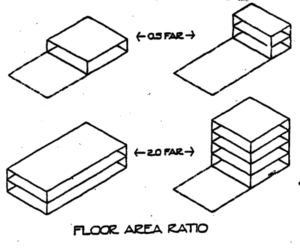
Floor area ratio (FAR): The floor area of a building or buildings on a lot divided by the lot area. (See illustration)
Frontage: The portion of a block that abuts a street.
Functionally dependent facility: A facility which cannot be used for its intended purpose unless it is located or carried out in close proximity to water, such as a docking or port facility necessary for the loading and unloading of cargo or passengers, shipbuilding, ship repair, or seafood processing facilities. The term does not include long-term storage, manufacture, sales, or service facilities.
Functional relationship: A complementary and interactive relationship among land uses or development, including at a minimum a substantial and positive exchange of human interaction, goods, resources, institutions, services, jobs or workers between land uses or developments. (Rule 9J-5)
Grade: The average level of the finished surface of the ground adjacent to the exterior walls of the building.
Grading: The act of excavation or filling or combination thereof or any leveling to a smooth horizontal or sloping surface on a property, but not including normal cultivation associated with an agricultural operation.
Grandfathered: The status accorded certain properties, uses, and activities that legally exist prior to the day of adoption of the zoning ordinance or provisions of the zoning ordinance.
Groundwater: Water that occurs beneath the land surface, also called subsurface water or subterranean water. Groundwater includes water in the zone of saturation of a water-bearing formation.
Groundwater recharge: The natural process of infiltration and percolation of rainwater from land areas or streams through permeable soils into water holding rocks that provide underground storage ("aquifers").
Groundwater recharge area: A catchment basin or watershed underlain by layers of alternating permeable and impermeable strata such that excess rainfall not lost by evapotranspiration or runoff is retained and stored in subterranean porous layers of soil. (Components of such a system could include ponds, wetland swales, bay forests, dunes, and marsh.)
Group home: A facility which provides a living environment for unrelated residents who operate as the functional equivalent of a family, including such supervision and care as may be necessary to meet the physical, emotional and social needs of the residents. Adult congregate living facilities comparable in size to group homes are included in this definition. It shall not include rooming or boarding homes, clubs, fraternities, sororities, monasteries or convents, hotels, residential treatment facilities, nursing homes, or emergency shelters. (9J-5)
Growth management: The use by a community of a wide range of techniques in combination to determine the amount, type, and rate of development desired by the community and to channel that growth into designated areas. Growth management policies can be implemented through growth rates, zoning, capital improvement programs, public facilities ordinances, urban limit lines, standards for levels of service, and other programs. The use by a community of a wide range of techniques in combination to permit it to determine its own amount, type, and rate of growth, and channel it into designated areas.
Guest house: An attached or detached building that provides living quarters for guests and (a) contains no kitchen or cooking facility; (b) is clearly subordinate and incidental to the principal residence on the same building site; and (c) is not rented or leased, whether compensation be direct or indirect. An attached or detached accessory building used to house guests of the occupants of the principal building, and which is not rented nor offered for rent.
Hazardous waste: Solid waste, or a combination of solid wastes, which, because of its quantity, concentration, or physical, chemical, or infectious characteristics, may cause, or significantly contribute to, an increase in mortality or an increase in serious irreversible or incapacitating reversible illness or may pose a substantial present or potential hazard to human health or the environment when improperly transported, disposed of, stored, treated or otherwise managed. (Rule 9J-5)
Health care facility: A facility or institution, whether public or private, principally engaged in providing services for health maintenance, diagnosis or treatment of human diseases, pain, injury, deformity or physical condition, including, but not limited to, a general hospital, diagnostic center, treatment center, rehabilitation center, extended care center, nursing home, intermediate care facility, outpatient laboratory, or central services facility serving one or more institutions.
Highest adjacent grade: The highest natural elevation of the ground surface, prior to construction, next, to the proposed walls of a building.
Historic, certified local government: A government meeting the requirements of the National Historic Preservation Act of 1966, as amended, and the implementing regulations of the U.S. Department of the Interior and the State of Florida.
Historic, certificate of appropriateness: A document evidencing approval by the historic preservation board of an application to make a material change in the appearance of a designated historic property or of a property located within a designated historic district.
Historic, contributing resource: A building, structure, site, or object which is at least 50 years old and which is located within the boundaries of a designated historic district or historic property and which contributes to the historic or architectural character of the property or district.
Historic, demolition:_An act or process that destroys or razes in whole or in part a resource or permanently impairs its structural integrity.
Historic district: A geographically definable area designated by the board as a historic district pursuant to the criteria established in this code.
Historic, exterior architectural features: The architectural style, general design and arrangement of the exterior of a building or other structure, including but not limited to the building material and type, style and material of windows, doors, signs and other appurtenant architectural fixtures, features, details or elements relative to the foregoing.
Historic, Florida Conference of Preservation Boards and Commissions: A coalition of Florida historic preservation boards and commissions. Formed under the auspices of the Florida Trust for Historic Preservation, its primary functions are to educate preservation commission members and to enable commissions to share ideas.
Historic, local register of historic places: A listing of buildings, structures, sites, objects and districts that have attached a level of local, state, or national historical and architectural significance.
Historic, material change: A change in appearance that will affect either the exterior architectural of a designated historic property or resource located within a designated historic district, such as:
1.
A reconstruction or alteration of the size, shape or facade including additions, relocation of any doors or windows, or removal, obscuring or alteration of any architectural features, details or elements (excluding exterior paint and colors);
2.
A demolition or relocation.
3.
A new construction.
Historic, National Register of Historic Places: A United States Department of the Interior listing of buildings, sites, structures, objects, and districts that have attained a quality of significance and integrity as determined by the National Historic Preservation Act of 1966, as amended.
Historic, non-contributing resource: A building, structure, site, or object which is not 50 years old and which is located within the boundaries of a designated historic district or historic property but does not contribute to the historic or architectural character of the property or district.
Historic, ordinary repairs or maintenance: Any work for which a building permit is not required by law where the purpose and effect of such work is to correct any deterioration or decay of or damage to a resource or any part thereof and to restore the same, as nearly as may be practicable, to its conditions prior to the occurrence of such deterioration, decay or damage.
Historic preservation: The preservation of historically significant structures and neighborhoods until such time as, and in order to facilitate, restoration and rehabilitation of the building(s) to a former condition.
Historic properties: An individual building, structure, site or object including the adjacent area necessary for the proper appreciation thereof designated by the Board as a historic property pursuant to the criteria established in Article IV of this land development code.
Historic Resources: All areas, districts or sites containing properties listed on the Florida Master Site File, the National Register of Historic Places, or designated by a local government as historically, architecturally, or archaeologically significant.
Historic, Secretary of the Interior's Standards for Rehabilitation and Guidelines for Rehabilitating Historic Buildings: A federal document stating standards and guidelines for the appropriate rehabilitation and preservation of historic buildings.
Historic, state historic preservation officer: The official designated to administer the state historic preservation program established for purpose of carrying out the provisions of the National Historic Preservation Act of 1966, as amended.
Historic structure: Any structure that is:
1.
Listed individually in the National Register of Historic Places (a listing maintained by the Department of Interior) or preliminarily determined by the Secretary of the Interior as meeting the requirements for individual listing on the National Register;
2.
Certified or preliminarily determined by the Secretary of the Interior as contributing to the historical significance of a registered historic district or a district preliminarily determined by the Secretary to quality as a registered historic district;
3.
Individually listed on a state inventory of historic places in states with historic preservation programs that have been approved by the Secretary of Interior; or
4.
Individually listed on a local inventory of historic places in communities with historic preservation programs that have been certified either by an approved state program as determined by the Secretary of the Interior; or directly by the Secretary of the Interior in states without approved programs.
Historic survey(s): Comprehensive surveys conducted by historic preservation professional including the identification, research, and documentation of buildings, structures, sites and objects of historical, cultural, archaeological or architectural importance in the City of Carrabelle.
Historic, undue economic hardship: Any action taken or desired under Article IV of this land development code which would place an onerous and excessive financial burden upon an owner that would amount to the taking of the owner's property without just compensation.
Home occupation: An occupation carried on in a dwelling unit by the resident thereof; provided that the use is limited in extent and incidental and secondary to the use of the dwelling unit for residential purposes and does not change the character thereof.
Homeowner's association: An incorporated nonprofit organization operating under recorded land agreements through which:
1.
Each lot owner is automatically a member; and
2.
Each lot is automatically subject to a proportionate share of the expenses for the organization's activities, such as maintaining common property.
Hotel: A building in which lodging is provided and offered to the public for compensation, and which is open to transient guests and is not a rooming or boarding house as herein defined.
Housing, low-income: Housing that is affordable, according to the U.S. Department of Housing and Urban Development, for either home ownership or rental, and that is occupied, reserved, or marketed for occupancy for households with a gross household income that does not exceed 50 percent of the median gross household income for households of the same size within the housing region in which the housing is located.
Hurricane shelter: A structure designated by local officials as a place of safe refuge during a storm or hurricane. (Rule 9J-5)
Impact: The effect of any direct man-made actions or indirect repercussions of man-made actions on existing physical, social, or economic conditions. The effect on the local public facilities in a given area produced by the additional population attracted by development.
Impact fee: A payment of money imposed by city on development activity pursuant to this chapter as a condition of granting development approval and/or a building permit in order to pay for the planned facilities needed to serve new growth and development activity. "Impact fee" does not include a reasonable permit fee, an application fee, the administrative fee for collecting and handling impact fees, the cost of reviewing independent fee calculations, or the administrative fee required for an appeal.
Impact fee, transportation: The impact fee designated to pay for public streets and roads. A payment of money required from development, as a condition of development approval, to pay for transportation facilities needed to serve new growth and development and that is reasonably related to the new development that (creates additional demand and need for transportation facilities, that is a proportionate share of the cost of the public facilities, and that is used for facilities that reasonably benefit the new development. A transportation impact fee may be used to pay for system improvement costs previously incurred by the city, to the extent that new growth and development will be served by the previously constructed improvements, provided such fee shall not be imposed to make up for any system improvement deficiencies. A transportation impact fee does not include a reasonable permit or application fee.
Impervious surface: Any hard-surfaced, man-made area that does not readily absorb or retain water, including, but not limited to, building roofs, parking and driveway areas, graveled areas, sidewalks, and paved recreation areas.
Impervious surface ratio (ISA): A ratio derived by dividing the amount of the site that is covered by any material that substantially reduces or prevents the infiltration of stormwater by the total horizontal area of the lot. Impervious surfaces include, but are not limited to, roofs, streets, sidewalks, and parking lots paved with asphalt, concrete, compacted sand, compacted gravel, or clay.
Improvement: Any building, structure, bridge, work of art, area, parking facility, public facility, fence, gate, wall, landscaping, or other object constituting a physical addition to real property, or any part of such addition.
Industrial uses: The activities within land areas predominantly connected with manufacturing, assembly, processing, or storage of products. (Rule 9J-5)
Industry, heavy: A use engaged in the basic processing and manufacturing of materials or products predominately from extracted or raw materials, or a use engaged in storage of or manufacturing processes using flammable or explosive materials, or storage or manufacturing processes that potentially involves hazardous or commonly recognized offensive conditions.
Industry, light: A use engaged in the manufacture, predominately from previously prepared materials, of finished products or parts, including processing, fabrication, assembly, treatment, packaging, incidental storage, sales and distribution of such products, but excluding basic industrial processing.
Infill: Development or redevelopment of land that has been bypassed, remained vacant, and/or is underused as a result of the continuing urban development process. Generally, the areas and/or sites are not particularly of prime quality, however, they are usually served by or are readily accessible to the infrastructure (services and facilities) provided by the applicable local governmental entity. Use of such lands for new housing and/or other urban development is considered a more desirable alternative than to continue to extend the outer development pattern laterally and horizontally thus necessitating a higher expenditure for capital improvements than would be required for infill development. The use of infill development, among others, promotes the best use of resources and also will tend to have a positive impact upon the tax and other fiscal policies.
Infill project: A development project located on a parcel located in a predominantly developed area and adjacent to existing residential, commercial, or civic land uses on at least two sides.
Infrastructure: Those man-made structures which serve the common needs of the population, such as: sewage disposal systems; potable water systems; potable water wells serving a system; solid waste disposal sites or retention areas; stormwater systems; utilities; piers; docks; wharves; breakwaters; bulkheads; seawalls; bulwarks; revetments; causeways; marinas; navigation channels; bridges; and roadways. (Rule 9J-5)
Ingress: Access, entry point or entrance.
Intensity: An objective measurement of the extent to which land may be developed or used, including the consumption or use of the space above, on or below ground; the measurement of the use of or demand on natural resources; and the measurement of the use of or demand on facilities and services (Rule 9J-5). The range or scale or concentration of findings, often measured by floor area ratios or building coverage. The magnitude of activity affecting the development of densities, traffic flow, commercialism, tourism, and land use. Any ratio that assesses the relative level of activity of a land use, including, but not limited to, a floor area ratio, building coverage ratio, or impervious surface ratio.
Junkyard: A building structure, or parcel of land, or portion thereof, used for collecting, storage, or sale of waste paper, rags, scrap metal, rubber tires, bottles, or discarded material. Where such materials are a byproduct of a permitted use, such activity shall be considered outdoor storage.
Kennel: Any premises, except where accessory to an agricultural use, where domestic animals, such as dogs and cats, are boarded, trained, or bred.
Kiosk: A freestanding structure upon which temporary information and/or posters, notices, and announcements are posted, or a freestanding building with one or more open sides from which commercial activities are conducted.
Land alteration: Land alteration is any activity which removes vegetation from or changes the topography of the land by grubbing, tree removal, clearing, grading, filling, or excavating, except for activities undertaken to maintain existing grounds.
Land banking: The acquisition of land by a local government or other public purpose entity for use or resale at a later date. Banked lands have been used for development of low-and moderate-income housing, expansion of parks, and development of industrial and commercial centers. Federal rail banking law allows railroads to bank unused rail corridors for future rail use while allowing interim use as trails.
Land clearing: The removal of vegetation from any site, parcel or lot except when land is cleared and cultivated for bona fide agricultural or garden use in a district permitting such use. Mowing, trimming, pruning, or removal of vegetation to maintain it in a healthy, viable condition is not considered clearing.
Landscaped visual barrier: Evergreen trees, and/or evergreen shrubs providing equivalent buffering, planted to provide a year-round dense screen within three years from the time of planting.
Landscaping, interior: A landscaped area or areas within the shortest circumferential line defining the perimeter or exterior boundary of the parking or loading area, or similar paved area, excluding driveways or walkways providing access to the facility (as applied to parking and loading facilities or to similar paved areas).
Landscaping, perimeter: A landscaped area adjoining and outside the shortest circumferential line defining the perimeter or exterior boundary of the parking or loading area, or similar paved area, excluding driveways or walkways providing access to the facility (as applied to parking and loading facilities or to similar paved areas).
Large Scale Retail: Any new commercial retail building, whose total gross leasable area equals or exceeds 25,000 square feet, specifically mercantile uses, and/or shopping center uses.
Leapfrog development: New development separated from existing development by substantial vacant land. Development that occurs well beyond the existing limits of development and thus leaves intervening vacant land behind. This bypassing of the next-in-line lands at the urban fringe results in the haphazard shotgun pattern of urbanization known as "sprawl."
Level of service: An indicator of the extent or degree of service provided by, or proposed to be provided by, a facility based on and related to the operational characteristics of the facility. Level of service shall indicate the capacity per unit of demand for each public facility. (Rule 9J-5)
Level of service standard (LOS), traffic: A scale that measures the amount of traffic that a roadway or intersection can accommodate, based on such factors as maneuverability, driver dissatisfaction, and delay. Level of service A indicates a relatively free flow of traffic, with little or no limitation on vehicle movement or speed. Level of service B describes a steady flow of traffic, with only slight delays in vehicle movement and speed. All queues clear in a single signal cycle. Level of Service C denotes a reasonably steady, high-volume flow of traffic, with some limitations on movement and speed, and occasional backups on critical approaches. Level of Serve D designates the level where traffic nears an unstable flow. Intersections still function, but short queues develop and cars may have to wait through one cycle during short peaks. Level of Service E represents traffic characterize by slow movement and frequent (although momentary) stoppages. This type of congestion is considered severe, backup is not uncommon at peak traffic hours, with frequent stopping, longstanding queues, and blocked intersections. Level of Service F describes unsatisfactory stop-and-go traffic characterized by "traffic jams" and stoppages of long duration. Vehicles at signalized intersections usually have to wait through one or more signal changes, and "upstream" intersections may be blocked by the long queues.
Limited access facility: A roadway especially designed for through traffic, and over, from, or to which owners or occupants of abutting land or other persons have no greater than a limited right or easement of access. (Rule 9J-5)
Live-work quarters: Buildings or spaces within buildings that are used jointly for commercial and residential purposes where the residential use of the space is secondary or accessory to the primary use as a place of work.
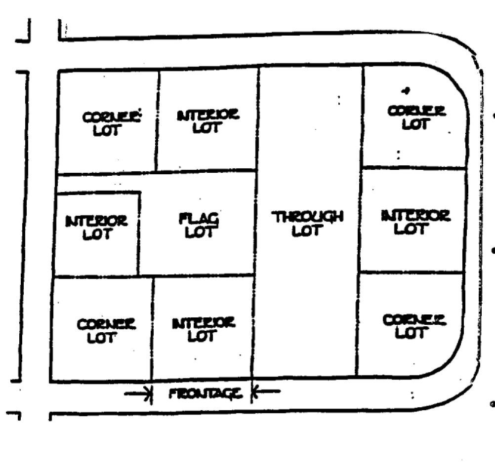
Loading space: An off-street space on the same lot with a building or group of buildings for temporary parking of a commercial vehicle while loading and unloading merchandise or materials.
Lot: A parcel of land occupied or intended for occupancy by a use. permitted in this chapter, including one main building, together with any accessory buildings, open spaces, and parking spaces required by this chapter and having its principal frontage upon a street or upon an officially approved place. A parcel of land recorded in the office of the clerk of the court, or a parcel described by metes and bounds, the description of which has been so recorded. A contiguous parcel of land in identical ownership throughout, bounded by other lots or streets, and used or set aside and available for use as the site of one or more buildings or other definite purpose. For the purpose of this title, a lot mayor may not coincide with a lot of record.
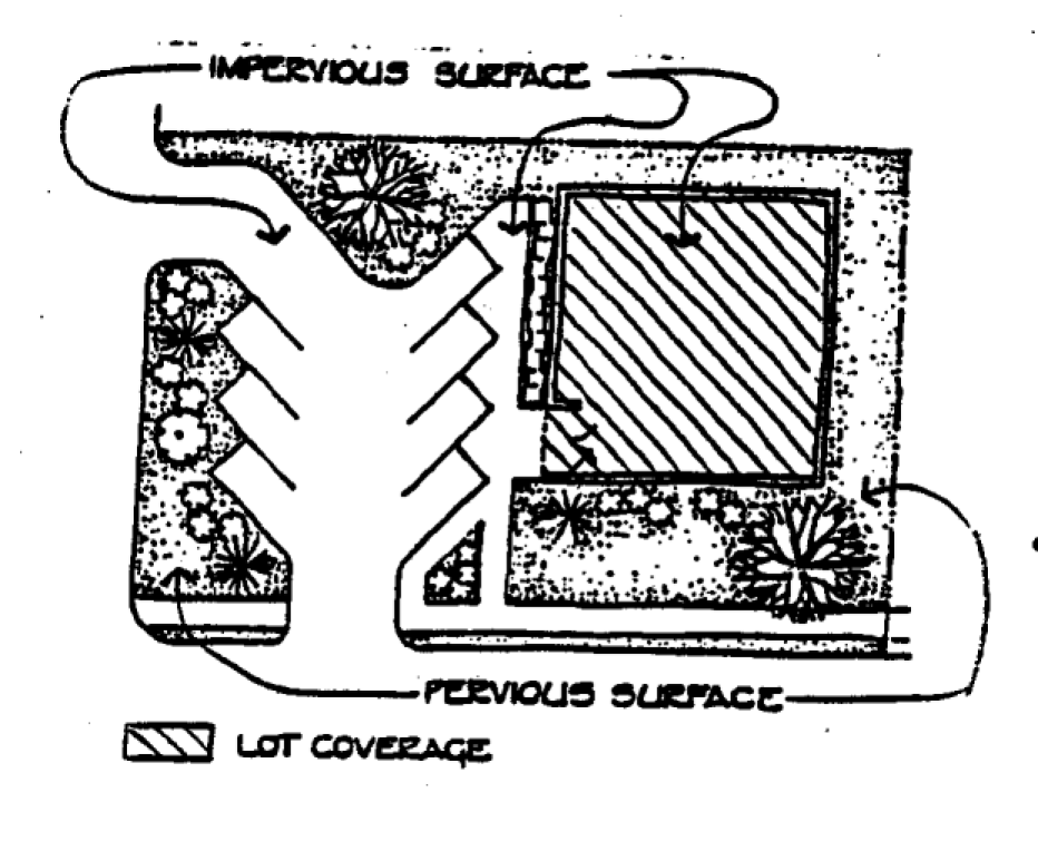
Lot coverage: A measure of intensity of land use that represents the portion of a site that is impervious (i.e. does not absorb water). This portion includes, but is not limited to, all areas covered by buildings, parked structures, driveways, roads, sidewalks, and any area of concrete asphalt. In the case of lumberyards, areas where lumber is stored also constitutes impervious surfaces.
Lot, double frontage: A lot having frontage on two non-intersecting streets, as distinguished from a comer lot.
Lot, nonconforming: A lot that lawfully existed prior to the enactment of the requirements of this chapter, but which does not meet the minimum lot size or lot width requirements of the zoning district in which it is located.
Lot of record: A lot that is part of a recorded subdivision or a parcel of land that has been recorded at the county recorder's office containing property tax records.
Lumber yard: An area used for the storage, distribution and sale of finished or rough-cut lumber and lumber products, but not including the manufacture or fabrication of lumber, lumber products, or firewood.
Main Street: A street connecting adjacent land uses and local streets with parks, plazas and squares in a Traditional Marketplace Development (TMD).
Major trip generators or attractors: means concentrated areas of intense land use or activity that produces or attracts a significant number of local trip ends. (Rule 9J-5)
Mangrove stand: An assemblage of mangrove trees which is" mostly low trees noted for a copious development of interlacing adventitious roots above the ground and which contain one or more of the following species: black mangrove (Avicennia nitida); red mangrove (Rhizophora mangle); white mangrove (Longuncular-iaracemosa) ;and buttonwood (Conocarpus erecta.)
Manufactured housing: A factory-built, single-family structure that is manufactured under the authority of 42 U. S. C. Sec. 5401, the National Manufactured Home Construction and Safety Standards Act, is transportable in one or more sections, is built on a permanent chassis, and is used as a place of human habitation; but which is not constructed with a permanent hitch or other device allowing transport of the unit other than for the purpose of delivery to a permanent site, and which does not have wheels or slides permanently attached to its body or frame.
Manufacturing, heavy: The manufacture or compounding process of raw materials. These activities or processes would necessitate the storage of large volumes of highly flammable, toxic matter or explosive materials needed for the manufacturing process. These activities may involve outdoor operations as part of their manufacturing process.
Manufacturing, light: The manufacture, predominantly from previously prepared materials, of finished products or parts, including processing, fabrication, assembly, treatment and packaging of such products, and incidental storage, sales, and distribution of such products, but excluding basic industrial processing and custom manufacturing.
Marina: A water access dependent facility established for the purpose of providing safe commercial storage and mooring for boats and which may offer accessory services such as fueling, repair, and accommodations for launching and retrieving such vessels. This definition does not include private docks defined pursuant to F.S. § 403.813(1)b, that are used for recreational, noncommercial activities provided that such structures do not exceed 500 square feet or, in areas not designated Outstanding Florida Waters, 1,000 square feet of over-water surface area.
Marquee: A canopy or covered structure projecting from and supported by a building.
Master plan: A comprehensive long-range plan intended to guide growth and development of a community or region and one that includes analysis, recommendation, and proposals for the community's population economy, housing, transportation, community facilities, and land use.
Megachurch: A large, specialized type of house of worship that includes such nontraditional accessory uses as retail safes, residential uses, amusement parks, and sports and entertainment facilities, as an integrated part of the development.
Mean high water (MHW): The average height of the high waters over a nineteen year period, or for shorter periods of observation: the average height of the high waters after corrections are applied to eliminate known variations and to reduce the results to the equivalent of mean nineteen year value, as defined in F.S. ch. 177.
Mean sea level (MLW): The average height of the sea for all stages of the tide. Used as a reference for establishing various elevations within the floodplain. The term is synonymous with the National Geodetic Vertical Datum (NGVD).
Metes and bounds: A description of land prepared by a state-registered land surveyor providing measured distances and courses from known or established points on the surface of the earth.
Metropolitan planning organization (MPO): A local government entity that has legal jurisdiction over a geographic area for government service planning such as transportation and land-use planning.
Minerals: All solid minerals, including clay, gravel, phosphate rock, lime, shells (excluding live shellfish), stone, sand, heavy minerals, and any rare earths, which are contained in the soils or waters of the state. (Rule 9J-5)
Mitigation: Measures taken to eliminate or minimize damages from development activities, such as construction in wetlands or regulatory floodplain filling, by replacement of the resource or other means of compensation.
Mixed-use development: A single building containing more than one type of land use or a single development of more than one building and use, where the different types of land uses are in close proximity, planned as a unified complementary whole, and functionally integrated to the use of shared vehicular and pedestrian access and parking areas.
Mobile home: A structure, transportable in one or more sections, which is 8 body feet or more in width and which is built on an integral chassis and designed to be used as a dwelling when connected to the required utilities and includes the plumbing, heating, air-conditioning, and electrical systems contained therein. For tax purposes, the length of a mobile home is the distance from the exterior of the wall nearest to the drawbar and coupling mechanism to the exterior of the wall at the opposite end of the home where such walls enclose living or other interior space. Such distance includes expandable rooms, but excludes bay windows, porches, drawbars, couplings, hitches, wall and roof extensions, or other attachments that do not enclose interior space. In the event that the mobile home owner has no proof of the length of the drawbar, coupling, or hitch, then the tax collector may in his or her discretion either inspect the home to determine the actual length or may assume four feet to be the length of the drawbar, coupling, or hitch. (Chapter 320.01 F.S.) This definition applies only to units constructed prior to June 15, 1976.
Mobile home park: A parcel of land under one ownership that has been planned and improved for the placement of two or more mobile homes for rental purposes for nontransient use.
Moderate-income persons: One or more natural persons or a family, the total annual adjusted gross household income of which is less than 120 percent of the median annual adjusted gross income for households within the state, or 120 percent of the median annual adjusted gross income for households within the metropolitan statistical area (MSA) or, if not within an MSA, within the county in which the person or family resides, whichever is greater. (F.S. § 420.0004)
Moratorium: A freeze on all new development pending the completion, adoption, or revision of a comprehensive plan.
Motel: A building or group of buildings in which lodging is provided to transient guests, offered to the public for compensation, and in which access to and from each room or unit is through an exterior door.
Motor vehicle, abandoned: A vehicle that does not bear a current license plate unless said vehicle is stored within a completely enclosed building or unless it is stored on a bona fide sales lot and is in a satisfactory operating condition.
Motor vehicle, commercial: Any vehicle used or designed to be used for business or commercial purposes that infringes on the residential character of residential districts and includes, but is not necessarily limited to: a bus, cement truck, commercial tree-trimming equipment, construction equipment, dump truck, garbage truck, panel truck, semi-tractor, semi-trailer, stake bed truck, step van, tank truck, tar truck, or other commercial type vehicle licensed by the (state) as a commercial vehicle or truck.
Multiple-family building: A detached building designed and used exclusively as a dwelling by three or more families occupying separate suites.
National Geodetic Vertical Datum (NGVD): As corrected, in 1929 is a vertical control used as a reference for establishing varying elevations within the floodplain.
Native vegetation: Any indigenous tree, plant, or shrub adapted to soil and climatic conditions occurring on site.
Natural drainage features: The naturally occurring features of an area which accommodate the flow of significant amounts of stormwater, such as streams, rivers, lakes, sloughs, floodplains and wetlands. (Rule 9J-5)
Natural drainage flow: The pattern of surface and storm water drainage through or from a particular site before the construction or installation of improvements or prior to regrading. (Rule 9J-5)
Natural groundwater aquifer recharge areas: Areas contributing to or providing volumes of water which make a contribution to the storage or regional flow of an aquifer. "Natural groundwater recharge areas" or "groundwater recharge areas" have the same meaning.
Neighborhood convenience store: Establishments primarily engage in the provision of frequently or recurrently needed goods for household consumption, such as prepackaged food and beverages and limited household supplies and hardware. Neighborhood convenience stores shall not include fuel pumps or the selling of fuel for motor vehicles. Typical uses include neighborhood markets and country stores.
Neighborhood plan: The master plan for a particular neighborhood or district that provides specific design standards and guidelines regulating the development and use of the property.
Neighborhood Park: A park which serves the population of a neighborhood and is generally accessible by bicycle or pedestrian ways. (Rule 9J-5)
Neotraditional development: An approach to land-use planning and urban design that promotes the building of neighborhoods with a mix of uses and housing types, architectural variety, a central public gathering place, interconnecting streets and alleys, and edges defined by greenbelts or boulevards. The basic goal is integration of the activities of potential residents with work, shopping, recreation, and transit all within walking distance.
New construction: Any structure for which the "start of construction" commenced after (the effective date of the first floodplain management code, ordinance, or standard based upon specific technical base flood elevation data which establishes the area of special flood hazard.) or (specific date). The term also includes any subsequent improvements to such structure.
New manufactured home park or subdivision: A manufactured home park or subdivision for which the construction of facilities for servicing the lots on which the manufactured homes are to be affixed (including at a minimum, the installation of utilities, the construction of streets, and either final site grading or the pouring of concrete pads) is completed on or after the effective date of floodplain management regulations adopted by a community.
New Urbanism: The process of reintegrating the components of modern life—housing, workplace, shopping and recreation—into compact, pedestrian-friendly, mixed-use neighborhoods linked by transit and set in a larger regional open space framework. Refer to "neotraditional development."
Nonconforming activity: An activity that, under the zoning regulations, is not itself a permitted activity where it is located or does not conform to the off-street parking or loading requirements, performance standards, or other requirements applying to activities. However, an activity of the character described above shall not be deemed a nonconforming activity to the extent that it has been or is hereafter authorized by a subsisting conditional use permit variance, or other special zoning approval.
Nonconforming building: A structure or building, the size, dimensions, or location of which was lawful prior to the adoption of, revision, or amendment to a zoning ordinance, but which fails by reason of such adoption, revision, or amendment to conform to the present requirements of the zoning district.
Nonpoint source pollution: Any source of water pollution that is not a point source. (Rule 9J-5)
Nonprofit organization: Any person(s), partnership, association, corporation or other group whose activities are conducted for unselfish, civic, or humanitarian motives, or for the benefit of others, and not for the gain of any private individual or group and may include, but shall not be limited to patriotic, philanthropic, social service, welfare, benevolent, educational, civic, fraternal, cultural, charitable, scientific, historical, athletic, or medical activities.
Nursing home: A home licensed by the state for the aged or chronically or incurably ill persons in which five or more such persons not of the immediate family are provided with food and shelter or care for compensation, but not including hospitals, clinics, or similar institutions devoted primarily to the diagnosis and treatment of the sick or injured.
Office, professional: The office of a member of a recognized profession maintained for the conduct of that profession. A profession is a vocation, calling, occupation, or employment requiring training in the liberal arts or sciences, or combination thereof, requiring advanced study in a specialized field; any occupation requiring licensing by the state and maintenance of professional standards applicable to the field.
Office, professional district: A district that includes the less intensive office and professional center land uses including low-rise office parks, single freestanding office buildings, depository facilities, such as banks, and residential structures converted to office use.
Official zoning atlas: A map or series of maps adopted by the city council and maintained by the administrator depicting the division of the incorporated area of the city into zoning districts as specifically established in sec 2.02.01 of this code.
Oil change facility: Operations that provided lubrication and/or checking, changing, or additions of those fluids and filters necessary to the maintenance of a vehicle. It is intended that these services will be provided while customers wait, generally within a 15- to 20-minute time period.
Onsite sewage disposal system (OSDS): Any domestic sewage treatment disposal facility, including standard subsurface systems (septic tank systems), alternative systems or experimental systems, installed or proposed to be installed on land of the owner or on other land to which the owner or owners have the legal right to install a system.
Open space: Any land or area, the preservation of which in its present use would:
1.
Conserve and enhance natural or scenic resources; or
2.
Protect streams or water supply: or
3.
Promote conservation of soils, wetlands, beaches, or tidal marshes; or
4.
Enhance the value to the public of abutting or neighboring parks, forests, wildlife preserves, nature reservations, or sanctuaries; or
5.
Enhance recreation opportunities.
Open space, common: An open space within a residential development reserved for the exclusive use of residents of the development, and their guests.
Outdoor display area: An area of designated size used for the display of merchandise or tangible property normally vended within the contiguous business or organization. Multiple items may be displayed on a rack but shall not be stacked upon each other. The placement of goods for sale or for advertisement, outside of the building or structure, including but not limited to vehicles, garden supplies, gas, tires, motor oil, food and beverages (vending machines), boats and farm equipment, motor homes and clothes.
Overlay zone: Superimposing certain additional requirements upon a basic use zoning district without altering the requirements of the basic use district. In the instance of conflicting requirements, the stricter of the conflicting requirement shall apply.
Parapet: That portion of a wall which extends above the roof line.
Parcel: A contiguous quantity or area of land owned and recorded as property of the same claimant, person or company.
Park: A neighborhood, community, or regional park. (Rule 9J-5).
Park, minipark: Small neighborhood park of approximately one acre or less.
Park, neighborhood: City-or county-owned land intended to serve the recreation needs of people living or working within one-half mile radius of the park.
Park, passive use: A park featuring passive recreation pursuits, such as interpretive programs and trail systems that take advantage of geological, biological, or scenic resources located within the park but not including recreational facilities, such as swimming pools, gyms, and playing fields.
Park, private: A tract of land presently owned or controlled and used by private or semi-public persons, entities, groups, etc. for active and/or passive recreational purposes.
Parking area, public: An open area, excluding a street or other public way, used for the parking of automobiles and available to the public, whether for free or for compensation.
Parking lot: An off-street, surfaced, ground level open area, for the temporary storage of five or more motor vehicles.
Parking lot, commercial: A parcel of land or portion thereof used for the parking or storage of motor vehicles as a commercial enterprise for which any fee is charged independently of any other use of the premises.
Parking, off-street: Space occupied by automobiles on premises other than streets. A space adequate for parking a motor vehicle with room for opening doors on both sides, together with property related access to a public street or alley and maneuvering room.
Parking, on-street: The storage space for an automobile that is located within the street right-of-way.
Parking, shared: A public or private parking area used jointly by two or more uses.
Parking space, compact: A space in a garage or parking area, not less than 7.75 feet wide clear dimension and 16 feet long clear dimension, reserved for the parking of only one compact automobile.
Parking space, tandem: A parking space within a group of two or more parking spaces arranged one behind the other. An arrangement of parking spaces such that one or more spaces must be driven across in order to access another space or spaces.
Patio house: A detached, single-family unit typically situated on a reduced-size lot that orients outdoor activity within rear or side yard patio areas for better use of the site for outdoor living space.
Pedestrlan-orlented development: Development designed with an emphasis primarily on the street sidewalk and on pedestrian access to the site and building, rather than on auto access and parking areas. The building is generally placed close to the street and the main entrance is oriented to the street sidewalk. There are generally windows, or display cases along building facades which face the street. Typically, buildings cover a large portion of the site. Although parking areas may be provided, they are generally limited in size and they are not emphasized by the design of the site.
Performance bond: A document issued by a surety, in return for a fee or premium, guaranteeing the performance of the terms and conditions of a development approval.
Performance standards: Zoning regulations that permit uses based on a particular set of standards of operation rather than on particular type of use. Performance standards provide specific criteria limiting noise, air pollution, emissions, odors, vibration, dust, dirt, glare, heat, fire hazards, wastes, traffic impacts, and visual impact of a use.
Permit, special use: A permit that authorizes the recipient to make use of property in accordance with the requirements of this ordinance as well as any additional requirements imposed by the board of adjustment.
Pervious surface: A surface that presents an opportunity for precipitation to infiltrate into the ground.
Planned development (PD): A tract of land developed as a unit under single ownership or unified control, which includes one or more principal buildings or uses and is processed under the Planned Unit Development provisions of this ordinance. Also, a parcel of land planned as a single unit, rather than as an aggregate of individual lots, with design flexibility from traditional siting regulations (such as side yards, setbacks, and height limitations) or land-use restrictions (such as prohibitions against mixing land uses within a development). The greater flexibility in locating buildings and in combining various land uses often makes it possible to achieve certain economics in construction, as well as the preservation of open space and the inclusion of many amenities.
Planting strip: A section of land not less than ten feet in width intended to contain plant materials and for the purpose of creating a visual separation between uses or activities.
Plat, final record: The final map of all or a portion of a subdivision or site plan that is presented to the proper review authority for final approval.
Plat, preliminary: A map of a subdivision of land showing required features that is submitted to the platting authority for purposes of preliminary consideration and approval. Preliminary approval may be given to typical land subdivision, abbreviated, right-of- way acquisition, and tideland plats.
Point source pollution: Any source of water pollution that constitutes a discernible, confined, and discrete conveyance, including but not limited to any pipe, ditch, channel, tunnel, conduit, well, discrete fissure, container, rolling stock, concentrated animal feeding operation, or vessel or other floating craft, from which pollutants are or may be discharged. This term does not include return flows from irrigated agriculture. (Rule 9J-5)
Pollution: The presence in the outdoor atmosphere, ground or water of any substances, contaminants, noise, or manmade or man-induced alteration of the chemical, physical, biological, or radiological integrity of air or water, in quantities or at levels which are or may be potentially harmful or injurious to human health or welfare, animal or plant life, or property, or unreasonably interfere with the enjoyment of life or property. (Rule 9J-5)
Porch: A platform extending from a building entrance. The structure may or may not be roofed and not be more than 75 percent enclosed by walls.
Porous paving system: A system providing erosion control, softening hard surfaces, reducing storm water/snow-melt runoff, and/or providing green space. The system includes concrete, plastic, or other systems that may incorporate grass or other landscaped surfaces.
Potable water facilities: A system of structures designed to collect, treat, or distribute potable water, and includes water wells, treatment plants, reservoirs, and distribution mains. (Rule 9J-5)
Potable water wellfield: The site of one or more water wells which supply potable water for human consumption to a water system which serves at least 15 service connections used by year-round residents or regularly serves at least 25 year-round residents. (Rule 9J-5).
Primary containment: The first level of product tight containment, ie., the inside portion of that container which comes into immediate contact on its inner surface with the hazardous material being contained.
Primary protection zone: An area extending 200 feet radially from any well supplying potable water to the City of Carrabelle water system.
Private recreational facility/club: Recreational center for the exclusive use of members and their guests with facilities usually including swimming pools and/or tennis courts, but specifically excluding golf courses.
Private recreation sites: means sites owned by private, commercial or non-profit entities available to the public for purposes of recreational use. (Rule 9J-5)
Property, abandoned: Personal property of any type the owner of which has failed to make satisfactory claim and proof of ownership within 60 days after notice has been provided.
Public access: The ability of the public to physically reach, enter or use recreation sites. (Rule 9J-5)
Public buildings and grounds: Structures or lands that are owned, leased, or operated by a government entity, such as civic and community centers, hospitals, libraries, police stations, fire stations, and government administration buildings. (Rule 9J-5)
Public recreation sites: Sites owned or leased on a long-term basis by a federal, state, regional or local government agency for purposes of recreational use. (Rule 9J-5)
Public Transit: Passenger services provided by public, private or non-profit entities such as the following surface transit modes: commuter rail, rail rapid transit, light rail transit, light guideway transit, express bus, and local fixed route bus. (Rule 9J-5)
Purchase of development rights: The acquisition of a governmentally recognized right to develop land which is severed from the realty and held or further conveyed by the purchaser. (Rule 9J-5)
Quality of Life: The attributes or amenities that combine to make an area a good place to live. Examples include the availability of political, educational, and social support systems; good relations among constituent groups; a healthy physical environment; and economic opportunities for both individuals and businesses.
Reconstruction: As used in historic preservation, the process of reproducing by new construction the exact form and detail of a vanished structure, or part thereof, as it appeared during a specific period of time. Reconstruction is often undertaken when the property to be reconstructed is essential for understanding and interpreting the value of an historic district and sufficient documentation exists to insure an exact reproduction of the original.
Recreation: The pursuit of leisure time activities occurring in an indoor or outdoor setting. (Rule 9J-5)
Recreation facility: A component of a recreation site used by the public such as a trail, court, athletic field or swimming pool. (Rule 9J-5)
Recreation, active: Leisure activities, usually performed with others, often requiring equipment and taking place at prescribed places, sites, or fields. The term active recreation includes but is not limited to, swimming, tennis, and other court games, baseball and other field sports, golf and playground activities.
Recreation, passive: Recreational activities that generally do not require a developed site. This generally includes such activities as hiking, horseback riding, and picnicking.
Recreation vehicle (RV): Any vehicle designed and/or used for living or sleeping and/or recreational purposes and equipped with wheels to facilitate movement from place to place, and automobiles when used for living or sleeping purposes and including pick-up coaches (campers), motorized homes, boats, travel trailers, and camping trailers not meeting the specifications required for a manufactured home or mobile home.
Recreational vehicle: A vehicle which is:
1.
Built on a single chassis;
2.
400 square feet or less when measured at the largest horizontal projection;
3.
Designed to be self-propelled or permanently towable by a light duty truck; and
4.
Designed primarily not for use as a permanent dwelling but as temporary living quarters for recreational, camping, travel, or seasonal use.
Recreation vehicle (RV) park: A commercial use providing space and facilities for motor homes or other recreational vehicles for recreational use or transient lodging. There is no minimum required stay in a recreational vehicle park. Uses where unoccupied recreation vehicles are offered for sale or lease, or are stored, are not included.
Regional park: A park which is designed to serve two or more communities. (Rule 9J-5)
Resident population: Inhabitants counted in the same manner utilized by the United States Bureau of the Census, in the category of total population. Resident population does not include seasonal population. (Rule 9J-5)
Residential uses: Activities within land areas used predominantly for housing. (Rule 9J-5)
Retention basin: A wet or dry stormwater holding area, either natural or manmade, this does not have an outlet to adjoining watercourses or wetlands other than an emergency spillway.
Right-of-way: A strip of land acquired by reservation, dedication, prescription, or condemnation and intended to be occupied by a street, trail, water line, sanitary sewer, and/or other public utilities or facilities.
Roadway functional classification: The assignment of roads into categories according to the character of service they provide in relation to the total road network. Basic functional categories include limited access facilities, arterial roads, and collector roads, which may be subcategorized into principal, major or minor levels. Those levels may be further grouped into urban and rural categories. (Rule 9J-5)
Roof line: Either the edge of the roof or the top of the parapet, whichever forms the top line of the building silhouette and, where a building has several roof levels, this roof or parapet shall be the one belonging to that portion of the building on whose wall the sign is located.
Roundabout traffic circle: A raised island that is usually landscaped and located at the intersection of two streets used to reduce traffic speeds and accidents without diverting traffic onto adjacent residential streets.
Rural areas: Low density areas characterized by social, economic and institutional activities which may be largely based on agricultural uses or the extraction of natural resources in unprocessed form, or areas containing large proportions of undeveloped, unimproved, or low density property. (Rule 9J-5)
Sand dunes: Naturally occurring accumulations of sand in ridges or mounds landward of the beach.
Sanitary sewer facilities: Structures or systems designed for the collection, transmission, treatment, or disposal of sewage and includes trunk mains, interceptors, treatment plants and disposal systems. (Rule 9J-5)
Sanitary sewer interceptor: A wastewater conduit which connects directly to, and transmits sewage to, a treatment plant. (Rule 9J-5)
Sanitary sewer trunk main: A wastewater conduit which connects directly to, and transmits sewage to, an interceptor. (Rule 9J-5)
Screening:
1.
A method of visually shielding or obscuring one abutting or nearby structure or use from another by fencing, walls, berms, or densely planted vegetation; and
2.
The removal of relatively course floating and/or suspended solids by straining through racks or screens.
Seasonal population: Part-time inhabitants who utilize, or may be expected to utilize, public facilities or services, but are not residents. Seasonal population shall include tourists, migrant farmworkers, and other short-term and long-term visitors. (Rule 9J-5)
Secondary containment: The level of product-tight containment external to and separate from the primary containment. Secondary containment shall consist of leak-proof trays under containers, floor curbing or other containment systems and shall be of adequate state-approved size and design to handle all spills, leaks, overflows, and precipitation until appropriate action can be taken. The specific design and selection of materials shall be sufficient to preclude and substance loss. Containment systems shall be sheltered so that the intrusion of precipitation is effectively prevented.
Secondary frontage: A type of building frontage in a traditional marketplace development (TMD) that allows for variable front setbacks and more frequent physical separation between buildings than allowed on primary frontages.
Secondary protection zone: An area extending between 200 and 1,000 feet radially from any well supplying potable water to the City of Carrabelle Water System.
Services: The programs and employees determined necessary by local government to provide adequate operation and maintenance of public facilities and infrastructure as well as those educational, health care, social and other programs necessary to support the programs, public facilities, and infrastructure set out in the local plan or required by local, state, or federal law. (Rule 9J-5)
Setback: The minimum distance by which any building or structure must be separated from a street right-of-way or lot line.
Shopping center or business center: A group of three or more business establishments within a single architectural plan, with common ownership of property, or cooperative or condominium ownership
Sidewalk cafe: A portion of an eating or drinking place, located on a public sidewalk that provides waiter or waitress service and is either an enclosed or unenclosed sidewalk cafe as defined. No portion of a sidewalk cafe shall be used for any purpose other than dining and circulation therein. Any outdoor dining area located in any public sidewalk or right-of-way that is associated with a restaurant or other eating and drinking establishment on a contiguous adjacent parcel.
Sidewalk sale: Outdoor sale, conducted by the proprietor, of products normally sold inside a retail establishment. A promotional sales event conducted outside the confines of the commercial or manufacturing structure in which such business is normally conducted and which occurs on a paved or concrete area on the same lot as the structure. A seasonal or occasional sale held on the sidewalk or other structure along the front or side of a particular store or establishment where goods are offered for sale to the public, typically at a discounted price.
Sight distance triangle: The triangular area formed by a diagonal line connecting two points located on intersecting street right-of-way lines (or a right-of-way line and the curb or edge of a driveway).
Sign: Any letters, figures, design, symbol, trademark, or illuminating device intended to attract attention to any place, subject, person, firm corporation, public performance, article, machine or merchandise whatsoever and painted, printed or constructed and displayed in any manner whatsoever out of doors for recognized advertising purposes. However, this shall not include any official court or public notices nor the flag, emblem or insignia of a government, school or religious group when displayed for official purposes. Interior signs, if located on a window or within a distance equal to the greatest dimension of the window and if obviously intended for viewing from the exterior, shall be considered an exterior sign for purposes of this article.
Sign, area or surface area: The area enclosed by one rectangle, parallelogram, triangle, circle or semicircle, the sides of which make contact with the extreme points or edges of the sign, including the supporting structure which does not form part of the sign proper or of the display. The area of a sign composed of characters or words attached directly to a large, uniform building wall surface shall be the smallest rectangle, parallelogram, triangle, circle or semicircle which encloses the whole group.
Sign, banner: A mounted piece of cloth, fabric or other nonrigid material displaying or not displaying an emblem, insignia, motto, slogan or other message. Examples of such banners include, but are not limited to, streamers, bunting, pennants, ensigns, and standards which are not included under the definition of flag.
Sign, bench: A sign which is indelibly drawn, painted, printed or otherwise affixed upon a bench.
Sign, billboard: A billboard is any off-site sign and governed by those sections regarding off-site signs.
Sign, changeable copy: An integral part of a sign not covering more than 50 percent of the total sign area and designed so as to readily allow the changing of its message by removable letter panels, posters, etc. Unless otherwise specifically provided, all signs permitted by this chapter may also be changeable copy signs.
Sign, combination: A single, on-site nonanimated sign composed of one sign relating to the entire premises on which it is located, and one or more additional signs of substantially the same size, material, and design, arranged in a compact group on the same structure, and relating to individual establishments on the premises. All permanent on-site signs otherwise allowed for a premise may be combination signs (combination signs shall be considered on-site signs for each establishment to which they relate, and shall be credited against the applicable on-site sign allowances for such establishments).
Sign, computer: A sign conveying messages by means of electrical impulse at changing intervals and controlled by a computer.
Sign, directional: A sign used for the purpose of indicating the location or direction of any object, place, or area.
Sign, double-faced: A sign which has two display surfaces backed against the same background, one (1) face of which is designed to be seen from one direction and the other from the opposite direction, every point on each face being either in contact with the other face or in contact with the same background.
Sign, flag: The emblem of any nation, organization of nations, state, city, religious, fratemal, or civic organization on cloth, fabric, or other nonrigid material.
Sign, freestanding (ground): A self-supporting sign resting on or supported by means of poles, standards, or any other types of base on the ground and not affixed to a building.
Sign, identification: A sign which indicates no more than the name, address, company logo, and occupation or function of any establishment or premises. Identification signs may also include other messages of a nonprofit institutional nature such as meeting dates, times of service, etc.
Sign, illuminated: A sign containing integral artificial illumination or a sign which is artificially illuminated from an exterior source or any sign containing electric wiring.
Sign, location: A lot, premises, building, wall or any place whatsoever upon which a sign is located.
Sign, lollypop: A sign which is attached to a single pole or stake that is designed to be driven into the ground and is not stabilized into the ground or affixed in place by any other device than the stake to which the sign is attached.
Sign, marquee: A sign painted on or otherwise attached to any awning, canopy, or marquee.
Sign, multi-face: A sign having three or more faces which are not parallel nor back-to-back, upon which the same or dissimilar copy is displayed.
Sign, non-conforming: An existing sign lawful at the time of the passage of this code which does not conform to the provisions, requirements, and regulations of the code.
Sign, occupant: A sign bearing only address, postbox number, or name(s) of occupant(s) on premises.
Sign, off-site: A sign relating to products, accommodations, services, or activities available to the public off the premises on which the sign is located.
Sign, political: A sign or poster advertising a candidate for public office or political cause, subject to election.
Sign, portable: Any sign whose design and/or construction is manifestly intended to be of a portable nature, whether anchored, carried, left freestanding, towed, self- propelled, or attached to a vehicle including those attached to a truck, trailer, taxi, or other vehicles while in the course of business.
Sign, projecting: A sign affixed to any building, wall, or structure and extending beyond the building wall or structure more than 12 inches.
Sign, real estate: A sign advertising the sale, rental or lease of premises or part of the premises on which the sign is displayed.
Sign, roof: A sign attached to and/or extending above the surface of the roof of any building.
Sign, sandwich/A-frame: A double or single-faced sign which is portable and may readily be moved from place to place. This type of sign is generally freestanding and not affixed to the ground in any way although some temporary type of attachment to the ground is occasionally used.
Sign, snipe: A small sign of any material including paper, cardboard, wood and metal when tacked, nailed or attached in any way to trees, poles or other objects.
Sign, subdivision: A sign which contains only the name of a platted subdivision.
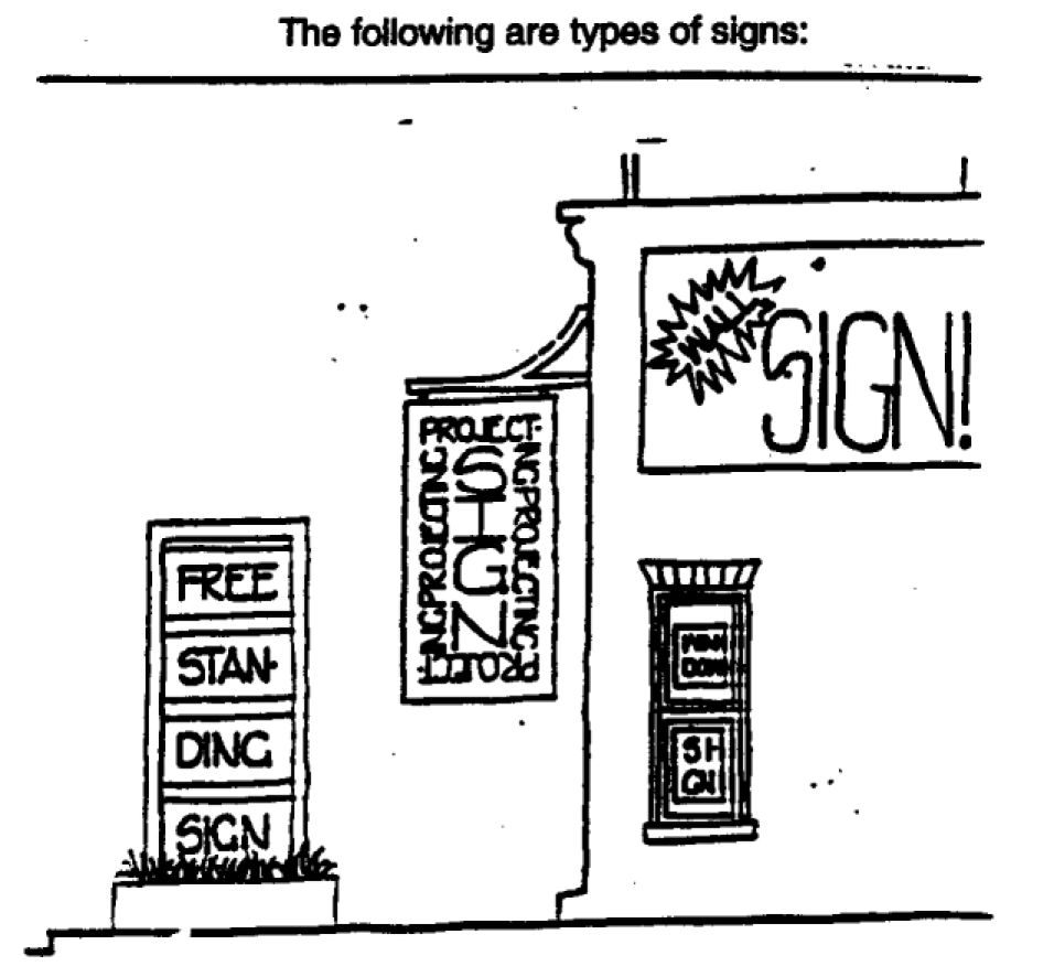
Sign, trailer: A sign that is affixed or placed on a trailer or other portable device that may be pulled by a vehicle.
Sign, vehicle mounted: A sign which is displayed on any automobile, bus, truck, trailer, or vehicle and is incidentally displayed in connection with the use of such vehicle for transportation purposes. Allowable signs are painted or magnetic signs which identify the company to which a car belongs and painted, magnetic, or attached political signs. Vehicle signs of a political nature also must meet the criteria for political signs.
Sign, wall: A sign painted on, carved in, or otherwise affixed to and mounted parallel to a building facade or wall in such manner that the facade or wall becomes the supporting structure for or forms the background surface of the sign.
Sign, window/advertising posters: A sign placed in a window or affixed thereto in such a manner as to be observable from the exterior of the premises.
Site plan: A plan, to scale showing uses and structures proposed for a parcel of land as required by the regulations. Includes lot lines, streets, building sites, reserved open space, buildings, major landscape features-both natural and manmade-and, depending on requirements, the locations of proposed utility lines.
Smart growth: Planning, regulatory, and development practices and techniques founded upon and promoting the following principles:
1.
Using land resources more efficiently through compact building forms, infill development, and moderation in street and parking standards in order to lessen land consumption and preserve natural resources;
2.
Supporting the location of stores, offices, residences, schools, recreational spaces, and other public facilities within walking distance of each other in compact neighborhoods that are designed to provide alternate opportunities for easier movement and interaction;
3.
Providing a variety of housing choices so that the young and old, single persons and families, and those of varying economic ability may find place to live;
4.
Supporting walking, cycling, and transit as attractive alternatives to driving; providing alternative routes that disperse, rather than concentrate, traffic congestion; and lower traffic speeds in neighborhoods;
5.
Connecting infrastructure and development decisions to minimize future costs by creating neighborhoods where more people use existing services and facilities, and by integrating development and land use with transit routes and stations; and
6.
Improving the development review process and development standards so that developers are encouraged to apply the principles stated above.
Solid waste: Sludge from a waste treatment works, water supply treatment plant, or air pollution control facility or garbage, rubbish, refuse, or other discarded material, including solid. liquid, semisolid, or contained gaseous material resulting from domestic, industrial, commercial, mining, agricultural, or governmental operations. (Rule 9J-5)
Solid waste facilities: Structures or systems designed for the collection, processing or disposal of solid wastes, including hazardous wastes, and includes transfer stations, processing plants, recycling plants, and disposal systems. (Rule 9J-5)
Solid waste processing plant: A facility for incineration, resource recovery, or recycling of solid waste prior to its final disposal. (Rule 9J-5)
Solid waste transfer station: A facility for temporary collection of solid waste prior to transport to a processing plant or to final disposal. (Rule 9J-5)
Special events: Circuses, fairs, carnivals, festivals, or other types of special events that:
1.
Run for longer than one day but not longer than two weeks;
2.
Are intended to or likely to attract substantial crowds;
3.
Are unlike the customary or usual activities generally associated with the property where the special event is to be located; and
4.
A temporary outdoor use on private property that extends beyond the normal uses and standards allowed by the zoning ordinance of the city.
Except as otherwise specifically provided, only those events held on commercial-zoned property are subject to the provisions of this code. Special event includes, but is not limited to, art shows, sidewalk sales, pumpkin and Christmas street sales, haunted houses, carnivals (major and minor), special auto sales, grand openings, festivals, home exhibitions, and church bazaars.
Special exception: A special exception is a use that would not be appropriate generally or without restrictions throughout the zoning division or district but which, if controlled as to the number, area, location, or relation to the neighborhood, would promote the public health, safety, welfare, morals, order, comfort, convenience, appearance, prosperity, or general welfare. Such uses may be permitted in such zoning division or district as special exceptions, if specific provisions for such special exceptions are made in this code.
Spot zoning: A change in district boundaries, variances, and other amendments to the zoning code and use and area maps that violate sound principles of zoning and are characterized by the following:
1.
Individuals seek to have property rezoned for their private use.
2.
Usually the amount of land involved is small and limited to one or two ownerships.
3.
The proposed rezoning would give privileges not generally extended to property similarly located in the area.
4.
Applications usually show little or no evidence of, or interest in, consideration of the general welfare of the public, the effect on surrounding property (including adequate buffers), whether all uses permitted in the classification sought are appropriate in the locations proposed, or conformity to the comprehensive plan or to comprehensive planning principles (including alterations to the population density patterns and increase of load on utilities, schools, and traffic.)
Sprawl: Urban development or uses that are located in predominantly rural areas, or rural areas interspersed with generally low-intensity or low density urban uses, and which are characterized by one or more of the following conditions:
1.
The premature or poorly planned conversion of rural land to other uses;
2.
The creation of areas of urban development or uses that are not functionally related to land uses which predominate the adjacent area; or
3.
The creation of areas of urban development or uses that fail to maximize the use of existing public facilities or the use of areas within which public services are currently provided. Urban sprawl is typically manifested in one or more of the following land use or development patterns: Leapfrog or scattered development; ribbon or strip commercial or other development; or large expanses of predominantly low-intensity, low-density, or single-use development.
Start of construction: (for other than new construction or substantial improvements under the Coastal Barrier Resources Act (P. L. 97-348)), includes substantial improvement, and means the date the building permit was issued, provided the actual start of construction, repair, reconstruction, or improvement was within 180 days of the permit date. The actual start means the first placement of permanent construction of a building (including a manufactured home) on a site, such as the pouring of slabs or footings, installation of piles, construction of columns, or any work beyond the stage of excavation or the placement of a manufactured home on a foundation. Permanent construction does not include land preparation, such as clearing, grading and filling; nor does it include the installation of streets and/or walkways; nor does it include excavation for a basement, footings, piers or foundations or the erection of temporary forms; nor does it include the installation on the property of accessory buildings, such as garages or sheds not occupied as dwelling units or not part of the main building. For a substantial improvement, the actual start of construction means the first alteration of any wall, ceiling, floor, or other structural part of a building, whether or not that alteration affects the external dimensions of the building.
Storage, outside: The storage, collection or display for more than three consecutive days, or any part of a day for three consecutive days, of any products, materials, equipment, appliances, vehicles not in service, and/or personal property of any kind on an unenclosed, uncovered area.
Store front: The front of a retail establishment facing a street where the main building entrance is located.
Stormwater: The flow of water which results from a rainfall event. (Rule 9J-5)
Stormwater facilities: Manmade structures that are part of a stormwater management system designed to collect, convey, hold, divert, or discharge stormwater, and may include stormwater sewers, canals, detention facilities and retention facilities. (Rule 9J-5)
Street: A public right-of-way used for vehicular and pedestrian traffic.
Street, arterial: A major street for carrying a large volume of through traffic in the area; normally controlled by traffic signs and signals.
Street capacity: The maximum number of vehicles which have a reasonable expectation of passing over a given section of a lane or a roadway in one direction, or in both directions for a two-lane, or four-lane highway, during a given time period under prevailing traffic conditions. In the absence of a modifier, capacity is based upon hourly volumes.
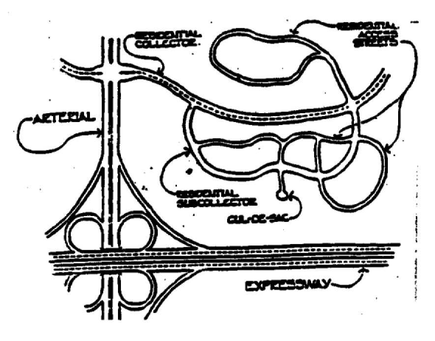
Street, collector: A street carrying traffic from local streets to the major system of arterial streets and highways and including the principal entrance streets to a residential development and principal streets for circulation within such a development.
Street furniture: Those features associated with a street that are intended to enhance that street's physical character and use by pedestrians, such as benches, trash receptacles, kiosks, lights, newspaper racks, etc.
Street, gridlike pattern (or flexible grid): A street system based upon a standard grid pattern (i.e., checkerboard blocks); however, offset intersections, loop roads, and cul-de-sacs as well as angled or curved road segments may also be used on a limited basis. The block pattern is characterized by regular (i.e., rectangular or trapezoidal) blocks and irregular polygons do not predominate.
Street, local: A street that is designed to carry residential traffic between collector or other streets or highways and abutting properties.
Street, private: Any right-of-way or area set aside to provide vehicular access within a development that is not dedicated or intended to be dedicated to the city and that is not maintained by the city.
Street, public: A public roadway, constructed within the boundaries of an officially deeded and accepted public right-of-way, which affords principal means of access to abutting property. For purposes of density calculations, a public street shall constitute all of the area within the public right- of-way.
Structure: A walled and roofed building that is principally above ground, a manufactured home, a gas or liquid storage tank,or other man-made facilities or infrastructures.
Subdivision: The division of a parcel of land, whether improved or unimproved, into two or more lots or parcels of land for the purpose, whether immediate or future, of transfer of ownership or building development.
Suitability: The degree to which the existing characteristics and limitations of land and water are compatible with a proposed use or development. (Rule 9J-5)
Sustainable development: Development that maintains or enhances economic opportunity and community well-being while protecting and restoring the natural environment upon which people and economies depend. Sustainable development meets the needs of the present without compromising the ability of future generations to meet their own needs.
Substandard housing: Residential dwellings that, because of their physical condition, do not provide safe and sanitary housing.
Substantial damage: Damage of any origin sustained by a structure whereby the cost of restoring the structure to its before damaged condition would equal or exceed 50 percent of the market value of the structure before the damage occurred.
Substantial improvement: Any combination of repairs, reconstruction, alteration, or improvements to a building, taking place during (the life of a building) (a fifty year period), in which the cumulative cost equals or exceeds fifty percent of the market value of the building. The market value of the building should be (1) the appraised value of the building prior to the start of the initial repair or improvement, or (2) in the case of damage, the value of the building prior to the damage occurring. This term includes structures which have incurred "substantial damage", regardless of the actual repair work performed. For the purposes of this definition, "substantial improvement" is considered to occur when the first alteration of any wall, ceiling, floor, or other structural part of the building commences, whether or not that alteration affects the external dimensions of the building. The term does not, however, include any project for improvement of a building required to comply with existing health, sanitary, or safety code specifications which have been identified by the code enforcement official and which are solely necessary to assure safe living conditions.
Substantially improved existing manufactured home parks or subdivisions: Where the repair, reconstruction, rehabilitation or improvement of the streets, utilities and pads equals or exceeds 50 percent of the value of the streets, utilities and pads before the repair, reconstruction or improvement commenced.
Tavern: Any establishment serving alcoholic beverages for on-premises consumption in conjunction with or without any form of entertainment, or any establishment selling alcoholic beverages to be called for or taken out by customers or to be delivered. A food service establishment which derives at least 51 percent of its gross revenue from the sale of food and non- alcoholic beverages shall not be considered a tavern for purposes of this land development code.
Temporary outdoor sale: Any sale made by a person, firm, or corporation engaging in the temporary business of selling goods, wares, or merchandise from a tent, truck, vending cart, or other area outside of a permanent structure on property owned or leased by the person, firm, or corporation. The temporary outdoor sales, except those conducted by charitable organizations as defined, must be secondary to or incidental to the principal permitted use or structure existing on the property, and not incompatible with the intent of the district. The outdoor sale of Christmas trees is exempt from this definition.
Tower, telecommunication: A structure that is designed and constructed primarily for the purpose of supporting one or more antennas, including self-supporting lattice towers, guide towers or monopole towers. The term includes radio, and television transfer towers, microwave towers, common-carrier, towers, cellular phone towers, alternative towers structures and the like.
Townhouse: A one-family dwelling unit, with a private entrance, which is part of a structure whose dwelling units are attached horizontally in a linear arrangement and having totally exposed front and rear wall to be used for access, light, and ventilation.
Traditional neighborhood development: A development that exhibits several of the following characteristics: alleys, streets laid out in a grid system, buildings oriented to the street, front porches on houses, pedestrian-orientation, compatible, mixed land uses, village squares and greens.
Traffic calming: Reducing motorist speed, decreasing motor vehicle volumes, and increasing safety for pedestrians and nonmotorized vehicles.
Traffic impact analysis: An analysis of the effect of traffic generated by a development on the capacity, operations, and safety of the public street and highway system.
Transfer of development rights (TDR): The conveyance of development rights by deed, easement or other legal instrument authorized by local law to another parcel of land and the recordation of that conveyance among the land records of (the municipality).
Transfer of development rights (TDR), receiving area: The area within which development rights transferred from a TOR sending area can be used.
Transfer of development rights (TDR), sending area: The area from which TDRs can be transferred.
Transmissivity: The property of soils influencing the rate at which water migrates vertically or laterally.
Transportation demand management: Strategies and techniques that can be used to increase the efficiency of the transportation system. Demand management focuses on ways of influencing the amount and demand for transportation by encouraging alternatives to the single-occupant automobile and by altering local peak hour travel demand. These strategies and techniques may, among others, include: ridesharing programs, flexible work hours, telecommuting, shuttle services, and parking management. (Rule 9J-5)
Transportation disadvantaged: Those individuals who because of physical or mental disability, income status, or age are unable to transport themselves or purchase transportation and are therefore dependent upon others to obtain access to health care, employment, education, shopping, social activities, or other life-sustaining activities. (Rule 9J-5)
Transportation system management: Improving roads, intersections, and other related facilities to make the existing transportation system operate more efficiently. Transportation system management techniques include demand management strategies, incident management strategies, and other actions that increase the operating efficiency of the existing system. (Rule 9J-5)
Tree bank: A fund established by a city to provide an opportunity to make a cash payment to the city in lieu of providing required landscape stock on a site.
Trip end: The origin or destination of a trip. Each trip has two ends which constitute a two-direction vehicle movement at the origin or destination of the trip.
Trip generation rate: The total number of trip ends produced by a specific land use or activity per day.
Triplex: A building containing three individual dwellings. Accessory dwelling units are not included in this definition.
Urban area: An area of or for development characterized by social, economic and institutional activities which are predominantly based on the manufacture, production, distribution. or provision of goods and services in a setting which typically includes residential and nonresidential development uses other than those which are characteristic of rural areas. (Rule 9J-5)
Urban design: The attempt to give form, in terms of both beauty and function, to selected urban areas or to whole cities. Urban design is concerned with the location, mass, and design of various urban components and combines elements of urban planning, architecture, and landscape architecture.
Urban fringe: Land at the edge of an urban area usually made up of mixed agricultural and urban land uses.
Urban growth boundary (UGB): The boundary or line marking the limit between the urban growth areas and other areas such as rural and resource areas where urban growth is not encouraged, as designated by the county in consultation with cities, under the requirements of the GMA.
Urban sprawl: Urban development or uses which are located in predominantly rural areas, or rural areas interspersed with generally low-intensity or low-density urban uses, and which are characterized by one or more of the following conditions:
1.
The premature or poorly planned conversion of rural land to other uses;
2.
The creation of areas of urban development or uses which are not functionally related to land uses which predominate the adjacent area; or
3.
The creation of areas of urban development or uses which fail to maximize the use of existing public facilities or the use of areas within which public services are currently provided.
Urban sprawl is typically manifested in one or more of the following land use or development patterns: Leapfrog or scattered development; ribbon or strip commercial or other development; or large expanses of predominantly low-intensity, low-density, or single-use development. (Rule 9J-5)
Use, permitted: A use permitted in a district without the need for special administrative review and approval, upon satisfaction of the standards and requirements of this ordinance. Any use listed as a principal permitted use or as an accessory use. The term further includes a conditional use, as listed for the particular district, provided a conditional use permit is obtained.
V-Zones: Areas subject to high velocity waters caused by, but not limited to, hurricanes, storms or wave wash. The area is designated on the FIRM as Zone V1-30.
Vacation: The termination of, or termination of interest in, an easement, right-of-way, or public dedication of land.
Variance: A departure from any provision of the zoning requirements for a specific parcel, except use, without changing the zoning ordinance or the underlying zoning of the parcel. A variance usually is granted only upon demonstration of hardship based on the peculiarity of the property in relation to other properties in the same zone district.
Vegetative communities: Ecological communities, such as coastal strands, oak hammocks, and cypress swamps, which are classified based on the presence of certain soils, vegetation and animals. (Rule 9J-5)
Vehicle: Automobiles, trucks, trailers, construction equipment and other such mobile equipment.
Volume-to-capacity ratio: A measure of the operating capacity of a roadway or intersection, in terms of the number of vehicles passing through, divided by the number of vehicles that theoretically could pass through when the roadway or intersection is operating at its designed capacity. Abbreviated as "v/c". At a v/c ratio of 1.0, the roadway or intersection is operating at capacity. If the ratio is less than 1.0, the traffic facility has additional capacity. Although ratios slightly greater than 1.0 are possible, it is more likely that the peak hour will elongate into a "peak period".
Water dependant structure: A structure, excluding habitable structures, used for water access placed within the waterfront overlay district including, but not limited to, docks, marinas, marine fueling stations other than bulk storage facilities, seafood processing house, and boat ramps.
Water recharge areas: Land or water areas through which groundwater is replenished. (Rule 9J-5)
Water-related uses: Activities which are not directly dependent upon access to a water body, but which provide goods and services that are directly associated with water-dependent or waterway uses. (Rule 9J-5)
Water wells: Wells excavated, drilled, dug, or driven for the supply of industrial, agricultural or potable water for general public consumption. (Rule 9J-5)
Wellhead protection area: An area designated by local government to provide land use protection for the groundwater source for a potable water wellfield, as defined in this rule chapter, including the surface and subsurface area surrounding the wellfield. Differing levels of protection may be established within the wellhead protection area commensurate with the capacity of the well and an evaluation of the risk to human health and the environment. Wellhead protection areas shall be delineated using professionally accepted methodologies based on the best available data and taking into account any zone of contribution described in existing data. (Rule 9J-5)
Wetland: Those areas that are inundated and saturated by surface or groundwater at a frequency and duration sufficient to support, and that under normal circumstances, do support a prevalence of vegetation typically adapted for life in saturated soil conditions, including swamps, marshes, bogs, and similar areas.
Xeriscaping: A set of garden design and landscape maintenance principles that promote good horticultural practices and efficient use of water. The term xeriscape is a registered trademark of the National Xeriscape Council and means water-conserving, drought-tolerant landscaping. Landscaping characterized by the use of vegetation that is drought- tolerant or a low water use in character.
Zero lot line: A planned arrangement of buildings which touch lot lines, thereby providing zero yard on that side.
Zoning: The division of a city or county by legislative regulations into areas, or zones, which specify allowable uses for real property and size restrictions for buildings within these areas