
Champaign City Zoning Code
ARTICLE XI
SUPPLEMENTARY REGULATIONS
DIVISION 5. - FREESTANDING TOWERS[13]
Editor's note— Council Bill No. 2011-038, § 7, adopted Mar. 1, 2011, renamed ch. 37, Sec. XI, Div. 5 from "Freestanding Telecommunication Towers" to "Freestanding Towers".
Sec. 37-581. - Purpose.
The purpose of these regulations is to protect natural resources, minimize the impacts of urban development, and respond to unique conditions in the community that are not specifically addressed elsewhere in this chapter.
(C.B. No. 2018-149, § 1(Exh. A), 9-18-18)
Sec. 37-582. - Intent.
The intent of the regulations regarding properties adjacent to watercourses and waterbodies is to:
(a)
Prevent property damage from flooding, erosion, and pollution.
(b)
Provide for adequate maintenance of watercourses or waterbodies.
(c)
Provide for adequate controls so the watercourses or waterbodies will function according to the intended design as part of the stormwater management system.
(d)
Enhance the aesthetic quality of the water feature so it becomes an asset to the neighborhood and community.
(C.B. No. 2018-149, § 1(Exh. A), 9-18-18)
Sec. 37-583. - Setbacks for lots around watercourses or waterbodies.
(a)
For purposes of determining the required rear or side yard setback as established in Article IV, Development Standards, the setback shall be measured from the edge of the structure to the top of the bank of the watercourse or waterbody.
(b)
In no case shall any structure, fence, accessory building, or similar obstruction be located within five (5) feet of the top of the bank of any watercourse. This area shall be referred to as the setback area.
(c)
For purposes of this section, the bank shall mean the natural or man-made slope immediately bordering the watercourse or waterbody containing and/or confining the normal water flow.
(d)
For purposes of this section, the top of the bank shall be determined by the observed high water mark, or one foot above the maximum discharge elevation or outlet control structure that controls the water elevation of a body of water.
(C.B. No. 2018-149, § 1(Exh. A), 9-18-18)
Sec. 37-584. - Standards for maintenance.
(a)
The setback area shall be kept free of trash, litter, and weeds.
(b)
No shrubs shall be allowed in the setback area. Only trees from the plant list in the technical appendix may be planted in the setback area. The setback area must be covered with groundcover, non-living decorative material such as bark, woodchips, decorative rock or stone, or other similar materials. Garden plots, alternative landscapes, and walkways are permitted within the setback area.
(c)
The owner shall maintain all plant materials and decorative treatments in such a manner as to protect their functional integrity. The owner shall replace all plant materials that have died within one year.
(d)
There shall be no trash or dumpster areas, no storage of hazardous materials, no vehicle maintenance operation, or other source of non-point pollution contained within the setback area.
(C.B. No. 2018-149, § 1(Exh. A), 9-18-18)
Sec. 37-587. - Intent.
The intent of the regulations regarding properties adjacent to watercourses and waterbodies is to:
(a)
Preserve the quality and quantity of groundwater resources;
(b)
Assure a safe and adequate water supply for present and future generations;
(c)
Preserve groundwater resources currently in use and those aquifers having a potential for future use as a public water supply.
(C.B. No. 2018-149, § 1(Exh. A), 9-18-18)
Sec. 37-588. - Definitions.
Act shall mean the State of Illinois Environmental Protection Act.
Agency shall mean the Illinois Environmental Protection Agency.
Board shall mean the Illinois Pollution Control Board.
Maximum setback zone shall mean the area around a community water supply well, established and described on a map which is available for inspection in the office of the city clerk.
Minimum setback zone shall mean the area around a community water supply well, established and described on a map which is available for inspection in the office of the city clerk.
Potential primary source shall mean any wellhead at a facility or site not currently subject to a removal or remedial action which:
(1)
Is utilized for the treatment, storage, or disposal of any hazardous or special waste not generated at the site.
(2)
Is utilized for the disposal of municipal waste not generated at the site, other than landscape waste, and construction and demolition debris.
(3)
Is utilized for the landfilling, land treating, surface impounding, or piling of any hazardous or special waste that is generated on the site or at other sites owned, controlled, or operated by the same person.
(4)
Stores or accumulates at any time more than seventy-five thousand (75,000) pounds of any hazardous substance above ground, or more than seven thousand five hundred (7,500) pounds below ground of any hazardous substances.
Potential secondary source shall mean any wellhead at a facility or a site not currently subject to removal or remedial action, other than a potential primary source, which:
(1)
Is utilized for the landfilling, land treating, or surface impounding of waste that is generated on the site or at other sites owned, controlled, or operated by the same person, other than livestock and landscape waste, and construction and demolition debris.
(2)
Stores or accumulates at any time more than twenty-five thousand (25,000) but not more than seventy-five thousand (75,000) pounds above ground, or more than two thousand five hundred (2,500) but not more than seven thousand five hundred (7,500) pounds below ground, of any hazardous substances.
(3)
Stores or accumulates at any time more than twenty-five thousand (25,000) gallons above ground, or more than five hundred (500) gallons below ground, of petroleum, including crude oil or a fraction thereof which is not otherwise specifically listed or designated as a hazardous substance.
(4)
Stores or accumulates pesticides, fertilizers, or road oils for purposes of commercial application or for distribution to retail sales outlets.
(5)
Stores or accumulates at any time more than fifty thousand (50,000) pounds of any de-icing agent.
(6)
Is utilized for handling livestock waste or for treating domestic wastewaters other than private sewage disposal systems as defined in the Private Sewage Disposal Licensing Act.
(C.B. No. 2018-149, § 1(Exh. A), 9-18-18)
Sec. 37-589. - Primary and secondary sources prohibition.
(a)
Except as provided otherwise in this article, no person shall place a potential primary source, or potential secondary source within the minimum setback zone.
(b)
Except as provided in this article, no person shall place a potential primary source within the maximum setback zone.
(C.B. No. 2018-149, § 1(Exh. A), 9-18-18)
Sec. 37-590. - Waivers, exceptions and exclusions.
(a)
If the owner of a potential primary source or potential secondary source, is granted an exception, waiver, or Certificate of Minimal Hazard under the provisions of the Act, or if such use is excluded from the Act, such person or use shall be deemed to have a waiver, exception, or exclusion to the same extent as provided for in the Act.
(b)
In no case shall a landfill or land treating operation be subject to such waivers, exceptions or exclusions.
(C.B. No. 2018-149, § 1(Exh. A), 9-18-18)
Sec. 37-594. - Erosion control.
All developments of five (5) acres or more, shall take measures to control erosion in accordance with the provisions in Chapter 31 of the Municipal Code.
(C.B. No. 2018-149, § 1(Exh. A), 9-18-18)
Sec. 37-595. - Floodplain requirements.
Sec. 37-596. - Stormwater management.
All developments of five (5) acres or more, shall comply with stormwater management measures in accordance with the provisions in Chapter 31 of the Municipal Code.
(C.B. No. 2018-149, § 1(Exh. A), 9-18-18)
Sec. 37-597. - Intent.
The intent of regulation for exterior lighting and glare is to:
(a)
Provide minimal lighting of public and private property for the safety, security, and convenience of occupants and the general public and;
(b)
To eliminate or reduce the nuisance and hazards of excessive light and glare.
(C.B. No. 2018-149, § 1(Exh. A), 9-18-18)
Sec. 37-597.1. - Lighting requirements in the Curtis Road Interchange Area Overlay District.
Sec. 37-598. - Parking lot lighting.
(a)
Definitions for all terms and standards in this section shall be defined from the 1984 edition of the IES Lighting Handbook, reference volume, New York; Illuminating Engineering Society of North America.
(b)
All parking lots where the number of parking spaces exceed ten (10) spaces and are less than fifty (50) spaces, shall at a minimum provide at least one lighting fixture for every ten (10) parking spaces. The fixture shall be mounted at least ten (10) feet above ground. No fixture shall have a cut-off of greater than seventy-five (75) degrees.
(c)
All parking lots with fifty (50) or more spaces shall submit a lighting plan which demonstrates that adequate illumination is provided to attain a minimum of one footcandle per square foot of surface area. Light fixtures shall operate from dusk until dawn or until the business closes for the night.
(d)
The owner shall maintain all lights. Lights shall be kept in working order and shall be operated as required. Failure to install, maintain, or operate the required lights, shall be considered a violation and shall be subject to enforcement action in Article XIV, Administration and Enforcement.
(C.B. No. 2018-149, § 1(Exh. A), 9-18-18)
Sec. 37-599. - Lighting design standards.
(a)
Maximum height for luminaries shall be in accordance with the following:
(1)
When light source or luminaire has no cutoff:
(2)
When light source or luminaire has total cutoff of light at an angle of ninety (90) degrees or greater:
(3)
When light source or luminaire has total cutoff of light at an angle of less than ninety (90) degrees and is located so that the bare light bulb, lamp, or light source is completely shielded from the direct view of an observer five (5) feet above the ground at the point at which the cutoff angle intersects the ground:
(b)
No luminaire shall be placed within the buffer yard abutting a residential district. Luminaries within twenty (20) feet of a residential district shall have a total cutoff of light at an angle of less than ninety (90) degrees, and is located so that the bare light bulb, or lamp is completely shielded from the direct view of an observer at a point, five (5) feet above the ground at the point at which the cutoff angle intersects the ground. Such light shall face away from any residential district.
(C.B. No. 2016-211, § 1(Exh. A), 10-18-16; C.B. No. 2018-149, § 1(Exh. A), 9-18-18)
Sec. 37-600. - Exempted uses.
The following uses shall be exempted from the lighting design standards:
(a)
Ball diamonds, tennis courts, and playing fields.
(b)
Streetlights and fixtures on utility poles.
(C.B. No. 2018-149, § 1(Exh. A), 9-18-18)
Sec. 37-601. - Prohibited lights.
The following lighting is prohibited for all uses in all zoning districts:
(a)
Flickering of flashing lights.
(b)
Laser lights or holograms.
(C.B. No. 2018-149, § 1(Exh. A), 9-18-18)
Sec. 37-602. - Intent.
The intent of this article regarding telecommunication towers is to:
(a)
Provide a special use permit process that is in compliance with federal law.
(b)
Protect residential areas and land uses from adverse visual impacts of freestanding telecommunication towers.
(c)
Minimize the total number of towers throughout the community while maximizing the use of each tower that is sited.
(d)
Enhance the ability of telecommunication carriers to provide services in an effective and efficient manner.
(C.B. No. 2007-041, § 5, 2-20-07; C.B. No. 2018-149, § 1(Exh. A), 9-18-18)
Sec. 37-603. - Definitions.
(a)
Array shall mean a grouping of radio frequency transmitters erected on a freestanding telecommunication tower or on an existing structure.
(b)
Co-location shall mean equipment affixed to or erected upon existing freestanding or remote freestanding [wireless communication facilities] or other communication towers.
(c)
Freestanding telecommunication towers shall mean any structure that is designed and constructed primarily for the purpose of supporting one (1) or more antennas, for the transmission of various forms of communication, including wireless telephone, radio and television signals, pager signals and other similar communications. This definition includes radio and television transmission towers, microwave towers, cellular telephone towers and other similar communication towers. Electrical transmission and distributions towers, telephone poles and non-commercial freestanding towers shall be excluded from this definition.
(d)
Non-commercial freestanding tower shall mean a tower, satellite dish or similar freestanding structure constructed for the purpose of amateur radio, ham radio or residential television reception.
(e)
Publicly owned emergency communications tower shall mean any structure erected by a public entity for the sole purpose of broadcasting emergency communications.
(f)
Tower height shall mean the measurement from the at grade base of tower to the top of the highest point of the tower or array or any attached structure or device.
(g)
Monopole tower shall mean a structure that is a single, upright pole, engineered to be self-supporting and requiring no guy wires or lateral cross-members.
(h)
Lattice tower shall mean a structure that is self-supporting with multiple legs and cross-bracing of structural steel.
(i)
Guy-wire tower shall mean a structure that is of mono pole or lattice tower design that is supported in whole or in part by guy wires and ground anchors or other means of support besides the superstructure of the tower itself.
(j)
Stealth tower shall mean a structure disguised in a way which is designed to blend into the surrounding environment, typically one that is architecturally integrated into a structure.
(C.B. No. 2007-041, § 5, 2-20-07; C.B. No. 2011-038, § 1, 3-1-11; C.B. No. 2018-149, § 1(Exh. A), 9-18-18)
Sec. 37-604. - Waivers and exemptions.
The following are considered exempt freestanding facilities and are not governed by this article:
(a)
Electrical transmission and distribution towers and telephone poles.
(b)
Publicly owned emergency communication towers.
(c)
Wireless radio structure utilized for the temporary emergency communications in the event of a disaster.
(C.B. No. 2007-041, § 5, 2-20-07; C.B. No. 2018-149, § 1(Exh. A), 9-18-18)
Sec. 37-605. - Standards for noncommercial freestanding towers.
The following provisions shall govern noncommercial freestanding towers:
(a)
A tower must meet the setback requirements for accessory structures.
(b)
A tower must be setback from adjacent residential structures a distance equal to the height of the tower.
(c)
A tower may not exceed fifty (50) feet in height in any residential zoning district and must comply with any additional applicable development standards in this Chapter.
(C.B. No. 2007-041, § 5, 2-20-07; C.B. No. 2011-038, § 2, 3-1-11; C.B. No. 2018-149, § 1(Exh. A), 9-18-18)
Editor's note— Council Bill No. 2011-038, § 2, adopted Mar. 1, 2011, renamed § 37-605 from "Standards for noncommercial freestanding telecommunication towers" to "Standards for noncommercial freestanding towers".
Sec. 37-606. - Standards for freestanding telecommunication towers.
The following provisions shall govern freestanding telecommunication towers:
(a)
If a freestanding telecommunication tower is allowed by right, the tower must meet the applicable building setback requirements for the zoning district.
(b)
A tower within three hundred (300) feet of a residentially zoned parcel, must be setback from that parcel a minimum distance of one and one-half (1.5) times the height of the tower.
(c)
No tower shall be constructed on a lot between the front building line and right-of-way or in the required front yard setback on a lot that is not improved with a building.
(d)
The type and height of tower shall be restricted based on the zoning district in which they are located as provided in Table XI-A.*
(e)
All towers must provide the degree of screening based on their proximity to residentially zoned parcels as described in Table XI-B.*
(f)
Co-location on an existing tower shall be allowed by right given that the height of the tower is not changed.
(g)
A tower constructed completely within an existing building shall be allowed by right.
(h)
An array constructed on top of or attached to an existing building shall be allowed by right given that the overall height of the building from grade to the top of the array is not increased by more than fifteen (15) feet.
(C.B. No. 2007-041, § 5, 2-20-07; C.B. No. 2017-010, § 2(Exh. B), 1-3-17; C.B. No. 2017-130, § 2(Exh. B), 6-6-17; C.B. No. 2018-149, § 1(Exh. A), 9-18-18)
Note— *Table XI-A and Table XI-B are set out herein as Exhibit A located at the end of this Division.
Sec. 37-607. - Freestanding telecommunication towers as provisional uses.
Freestanding telecommunication towers shall be permitted as a provisional use in the I1, I2, CG, CB1, CB2, CB3, CO, and IBP Zoning District and shall contain the appropriate level of screening as defined in Table XI-B.*
(C.B. No. 2007-041, § 5, 2-20-07; C.B. No. 2011-038, § 3, 3-1-11; C.B. No. 2016-211, § 1(Exh. A), 10-18-16; C.B. No. 2018-149, § 1(Exh. A), 9-18-18; C.B. No. 2022-050, § 1(Exh. 1), 4-5-22)
Editor's note— Council Bill No. 2011-038, § 3, adopted Mar. 1, 2011, renamed § 37-607 from "Towers as provisional uses." to "Freestanding telecommunication towers as provisional uses".
Note— *See note following § 37-606.
Sec. 37-608. - Freestanding telecommunication towers as special uses.
(a)
Special use permits shall be required for all freestanding telecommunication towers located within the SF1, SF2, IT-SF1, IT-SF2, MF1, MF2, MF3, MFUniv, CN, MHP, IT-MR1, IT-MR2, MHP and IT-MX zoning districts.
(b)
A special use permit shall be required if the proposed freestanding telecommunication tower is located on a non-residentially zoned district but within three hundred (300) feet of a residentially zoned district.
(C.B. No. 2007-041, § 5, 2-20-07; C.B. No. 2009-084, § 7, 5-19-09; C.B. No. 2011-038, § 4, 3-1-11; C.B. No. 2016-211, § 1(Exh. A), 10-18-16; C.B. No. 2018-149, § 1(Exh. A), 9-18-18)
Editor's note— Council Bill No. 2011-038, § 4, adopted Mar. 1, 2011, renamed § 37-608 from "Towers as special uses." to "Freestanding telecommunication towers as special uses".
Sec. 37-609. - Application for special use.
No freestanding telecommunication tower that requires a special use permit as specified in this ordinance shall receive zoning approval without applying for and receiving special use permit approval from the City Council. The application for a special use permit shall be made to the Planning Department and shall include each of the following:
(a)
A completed special use permit application
(b)
A site plan showing the location of the tower with all property lines, building footprints, and public right-of-way within a distance of two hundred (200) feet.
(c)
An elevation drawing of the tower depicting all arrays, potential collocation opportunities, and equipment cabinets.
(d)
Engineering plans stamped by a professionally licensed engineer in the State of Illinois.
(e)
If any existing telecommunication towers are located within one (1) mile of the proposed tower, a map depicting the locations of those towers and letters from the owners of each of those towers acknowledging the inability of co-locating on that tower.
(f)
A copy of either the Federal Communications Commission (FCC) license or agreement with an FCC-licensed telecommunications provider for use or lease of the support structure. A letter of commitment to comply with all Federal Aviation Administration (FAA) and FCC standards.
(g)
A landscaping plan in accordance with this article.
(h)
A propagation map depicting wireless providers current coverage and proposed coverage with construction of new tower.
(i)
Any other information requested by the Zoning Administrator to determine if the conditions for the special use will be met.
(C.B. No. 2007-041, § 5, 2-20-07; C.B. No. 2011-192, § 1, 10-4-11; C.B. No. 2018-149, § 1(Exh. A), 9-18-18)
Sec. 37-610. - Findings for granting a special use.
Procedure for the approval of a special use permit shall be the same as provided for in section 37-267. Before making any recommendation to City Council to approve or deny the application for a special use, the Plan Commission shall make a determination, based solely upon evidence presented at a public hearing conducted by the Plan Commission, on whether the application satisfies all of the following criteria:
(a)
That the proposed use conforms to all the applicable regulations and standards of the district in which it shall be located.
(b)
That the applicant has analyzed all co-location opportunities and identified all potential locations within existing structures to place their tower and has otherwise pursued all possible alternatives to the construction of a new facility.
(c)
That the proposed use is reasonably necessary to provide wireless communications services to the area.
Should a tower not be approved by City Council, the Planning Director shall issue to the applicant a written explanation of the action.
(C.B. No. 2007-041, § 5, 2-20-07; C.B. No. 2018-149, § 1(Exh. A), 9-18-18)
Sec. 37-611. - Existing towers.
(a)
Freestanding Telecommunication Towers existing as of January 30, 2007 will be exempt from the special use permit requirement and the provisions of this article with the exception that an eight-foot opaque fence shall be constructed to enclose the tower and all associated equipment around the base of the tower within six (6) months of the adoption.
(b)
Any change in type or height of a tower built before January 30, 2007 shall be subject to the provisions of this article.
(C.B. No. 2007-041, § 5, 2-20-07; C.B. No.2011-038, § 5, 3-1-11; C.B. No. 2018-149, § 1(Exh. A), 9-18-18)
Sec. 37-612. - Removal of freestanding telecommunication towers.
(a)
If a freestanding telecommunications tower is no longer being used for the purpose of transmission, the owner shall notify the City within sixty (60) days of the time the use ceases.
(b)
If a freestanding telecommunications tower is believed to be inoperable, the City shall notify the tower owner and seek written proof that the tower is still in operation.
(c)
In the event that a freestanding telecommunications tower becomes inactive for more than sixty (60) days, the tower shall be removed by the owner within one hundred twenty (120) days after written notification from the City.
(d)
In the event that a freestanding telecommunications tower has not been removed within one hundred twenty (120) days after notification by the City, the tower is hereby declared a public nuisance and the provisions in Chapter 22 shall apply.
(C.B. No. 2007-041, § 5, 2-20-07; C.B. No. 2008-146, § 4, 6-17-08; C.B. No. 2011-038, § 6, 3-1-11; C.B. No. 2018-149, § 1(Exh. A), 9-18-18; C.B. No. 2024-028, § 1(Exh. 1), 3-5-24)
Editor's note— Council Bill No. 2011-038, § 6, adopted Mar. 1, 2011, renamed § 37-612 from "Removal of towers" to "Removal of freestanding telecommunication towers".
Exhibit A
(C.B. No. 2016-211, § 1(Exh. A), 10-18-16; C.B. No. 2018-149, § 1(Exh. A), 9-18-18; C.B. No. 2022-050, § 1(Exh. 1), 4-5-22; C.B. No. 2024-028, § 1(Exh. 1), 3-5-24)
TABLE XI-B (Levels of Screening)
Level 1 (Low Intensity). Fencing shall be required for all towers located a distance greater than five hundred (500) feet of a residentially zoned parcel. The fence shall be constructed to a minimum height of eight (8) feet and enclose the tower and all associated structures.
Level 2 (Medium Intensity). Opaque fencing shall be required for all towers located at a distance between two hundred (200) and five hundred (500) feet of a residentially zoned parcel. An opaque fence shall be constructed of wood, masonry, or synthetic material, be a minimum height of eight (8) feet, and enclose the tower and all associated structures.
Level 3 (High Intensity). Opaque fencing and landscaping shall be required for all towers located at a distance less than two hundred (200) feet of a residentially zoned parcel. Opaque fencing of wood, masonry, or synthetic materials at a minimum height of eight (8) feet and enclosing the tower and all associated structures shall be constructed. Tree and/or shrubs shall also be provided around the outside perimeter of the fenced area. Trees and shrubs may be combined but in no case shall there be a gap between landscaping materials of more than three (3) feet.
(C.B. No. 2018-149, § 1(Exh. A), 9-18-18)
Sec. 37-616. - Intent.
The intent of this division regarding wind energy conversion systems is to:
(a)
Provide regulations for the construction and operation of wind energy conversion systems in the City of Champaign and within the one and one-half (1.5) mile radius surrounding the zoning jurisdiction of the City of Champaign.
(b)
Provide regulations to facilitate the development of wind energy conversion systems, while protecting adjacent land uses from adverse noise, visual, and other negative impacts that may be associated with a wind energy conversion system.
(c)
Facilitate the development of low impact, sustainable energy sources within the City of Champaign and its jurisdiction.
(C.B. No. 2009-236, § 1, 12-15-09; C.B. No. 2018-149, § 1(Exh. A), 9-18-18)
Sec. 37-617. - Definitions.
The following terms when used in this division shall have the meaning specified herein except where the context clearly indicates or requires a different meaning:
Diameter, rotor shall mean the length of any rotor, or blade, as measured from the tip of the rotor to the center of the turbine multiplied by two (2).
Extraterritorial jurisdiction shall mean any area which is:
(1)
Located outside, but within one and one-half (1.5) miles of the corporate limits of the City; and
(2)
Is not located within the subdivision jurisdiction of another city or village.
Extraterritorial wind energy conversion system or Extraterritorial WECS shall mean any WECS which is or may be located within the extraterritorial jurisdiction.
Facility owner shall mean any person or entity having an equity interest in a WECS.
Institutional use shall mean an educational facility, golf course, sports arena, religious institution, athletic field or publicly owned property, provided that, said term shall exclude parks and cemeteries whether publicly or privately owned.
Operator shall mean any person or entity responsible for the day-to-day operation and maintenance of a WECS.
Publicly owned property shall mean land, buildings or structures owned by any governmental body or public agency including city, county, state or federally owned properties, other than public rights-of-way.
Shadow flicker shall mean the moving shadows or shaded areas which are cast by rotating turbine blades.
Small wind energy conversion system or small WECS shall mean any wind energy conversion system consisting of a single wind turbine having a maximum generating capacity of one hundred (100) kw, which is intended to generate energy for any contiguous property primarily for the use or consumption on that property.
Tower, monopole shall mean a wind energy conversion system tower consisting of a single pole, constructed without guy wires and anchors.
Wind energy conversion structure or wind turbine shall mean a device that converts wind energy into electricity through the use of either a horizontal or vertical axis wind turbine generator, and includes the nacelle, rotor, tower and pad transformer, if any.
Wind energy conversion system or WECS shall mean an electric generating facility, whose main purpose is to supply wind-generated electricity, consisting of one (1) or more wind turbines and other accessory structures and buildings, including substations, meteorological towers, electrical infrastructure, transmission lines and other appurtenant structures and facilities.
Wind energy conversion system, building-mounted shall mean a wind energy conversion system located on a building.
Wind energy conversion system height shall mean the height of a freestanding wind energy conversion system must be measured as the distance from the ground level to the highest point on the tower, including the vertical length of any extensions such as the rotor blade. The height of a building mounted wind energy conversion system shall be measured as the distance from the point where the base of the system is attached to the building or to the lowest point on the wind energy conversion system, whichever is closer to the ground, to the highest point on the wind energy conversion system, including the vertical length of any extensions such as the rotor blade.
Wind farm means any wind energy conversion system other than a small wind energy conversion system as defined in this division.
(C.B. No. 2009-236, § 1, 12-15-09; C.B. No. 2018-149, § 1(Exh. A), 9-18-18)
Sec. 37-618. - Site Requirements.
In addition, to meeting any other applicable requirements in this Code, wind energy conversion systems shall be constructed in accordance with the restrictions set forth in this Section:
a.
Wind Energy Conversion Structure Height and Rotor Blade Diameter Restrictions. The height of a wind energy conversion structure and the diameter of the motor blade shall not exceed the following restrictions for various uses and zoning districts. The height of a wind energy conversion structure shall be measured from ground level to the top of the highest blade at the highest point extended.
1.
For Single- and Two-Family dwellings, Multifamily dwellings, and Non-Residential uses within the SF1, SF2, MF1, MF2, MF3, MFUniv, MHS, MHP, IT-SF1, IT-SF2, IT-MR1 and IT-MR2 Zoning Districts the maximum height of a wind energy conversion structure, shall not exceed one hundred (100) feet. The maximum diameter, as measured from the tip of the rotor or blade to the center of the turbine multiplied by two (2), shall not exceed fifty (50) feet.
2.
For any use that is located in a non-residential district and located within one thousand (1,000) feet of the boundary of a lot zoned or planned for residential land use, the maximum height of a wind energy conversion structure shall be one hundred (100) feet and the maximum diameter of the rotors, or the blades, shall be fifty (50) feet. For any use that is located in a non-residential district and more than one thousand (1,000) feet away from any boundary of a lot zoned or planned for residential use the maximum height of a wind energy conversion structure shall be one hundred seventy-five (175) feet. The maximum diameter of the rotors, or the blades, for wind energy conversion systems shall not exceed one hundred (100) feet.
3.
Building-mounted Wind Energy Conversion Systems in residential zoning districts shall not exceed ten (10) feet higher than the highest point on the roof of the structure it is mounted to.
b.
Setbacks.
1.
Setback requirements for wind energy conversion structures. The minimum setback from the property line for any wind energy conversion structure shall be the total height of said structure measured from ground level.
c.
Noise.
1.
No wind energy conversion system or combination of wind energy conversion systems on a single parcel shall create noise that exceeds the regulatory standards set by the Illinois EPA Pollution Control Board at any property line where the property on which the wind energy conversion system is located. Measurement of sound levels shall not be adjusted for, or averaged with, non-operating periods. Any wind energy conversion system exceeding this level shall immediately cease operation upon notification by the City of Champaign Zoning Administrator and may not resume operation until the noise levels have been reduced in compliance with the required standards and verified by an independent third party inspector.
d.
Multiple Wind Systems.
1.
Multiple wind systems may be allowed if they meet all regulations as required herein.
2.
The number of wind turbines on any given parcel of land shall be limited to:
i.
Three (3) wind energy conversion structures for parcels of land having an area of five (5) acres or less.
ii.
Five (5) wind energy conversion structures for parcels of land having an area, greater than five (5) acres and not exceeding ten (10) acres.
iii.
There shall be no limit to the number of wind energy conversion structures for parcels of land having an area greater than ten (10) acres.
3.
There shall be no limit to the number of roof-mounted wind energy conversion systems on any given parcel of land.
e.
Force Wind Standards.
1.
Wind Energy Conversion Systems must be engineered to withstand wind forces of up to one hundred ten (110) miles per hour.
f.
Removal of nuisance wind systems or turbines.
1.
The Wind Energy Conversion System or individual turbine is hereby declared to be a public nuisance if it has been inoperable or has not been operated to generate any electricity for one hundred eighty (180) or more consecutive days.
2.
Upon receipt of written notice from the Zoning Administrator or Administrator's designee that a Wind Energy Conversion System or individual wind turbine has become a public nuisance as defined in paragraph f.1 above, the Owner of a wind energy conversion system and associated facilities shall have one hundred eighty (180) days to restore the wind energy conversion system or individual turbine to operating condition and operation for the generation of electricity or remove it from the property, provided that in the event the Zoning Administrator or Administrator's designee determines that, because of its condition, the WECS or individual turbine poses a great and immediate threat to the public health, safety or welfare, then the City may remove the structure(s) that specifically pose such a great and immediate threat without any prior notice to said owner, assess the owner for all costs incurred for said removal and file a lien for said costs in the manner provided herein.
3.
A written notice of public nuisance described herein may be personally delivered to the owner or authorized agent of the WECS in question, or delivered by First Class U.S. Mail. A written notice delivered by First Class U.S. Mail shall be deemed received by said owner three (3) business days after its deposit in the U.S. Mail system.
4.
The failure of any owner to comply with the requirements to either restore to operation or remove a public nuisance WECS or individual turbine as provided herein shall be deemed a violation of this Zoning Ordinance and shall be deemed implied consent by said owner to the City to allow the City to remove, or hire someone else to remove said wind system or individual turbine, as the case may be, and to charge said owner for the entire cost of said removal. Said cost of removal incurred by the City shall be deemed a lien against the property, and the City shall be authorized to file a notice of said lien in the Office of the Champaign County Recorder of Deeds for the cost of removing the wind energy conversion system. Removal of a wind energy conversion system that constitutes a public nuisance shall include removal of: the turbines, tower, and any above ground improvements, including fencing.
5.
The City may foreclose upon any lien for removal costs as provided herein in accordance with the procedures provided for foreclosure of a mortgage in the Illinois Mortgage Foreclosure Law, 735 ILCS 5/15-1101 et seq.
g.
Signage.
1.
Commercial marking, messages, banners, or signs of any kind on the wind energy conversion system or tower shall be prohibited.
h.
Tower Access.
1.
The tower shall not be accessible for climbing. No rungs shall be provided for the first twelve (12) feet of the tower, the climbing apparatus shall be covered, and any other approved preventative measures, which may be applicable.
i.
Color.
1.
The exterior color of the wind energy conversion system shall be limited to black, white, off-white, and grey, and the surface shall be non-reflective.
j.
Lighting.
1.
No lights shall be installed on the tower, unless required to meet FAA regulations.
k.
Permit for Extra-territorial Wind Energy Conversion Systems.
1.
An application to site and construct an extraterritorial WECS shall be considered by the City in the same manner as if the applicant had submitted an application for the placement of a WECS within the corporate limits of the city. The applicant, facility owner, operator, and any participating landowner with respect to any approved application for an extraterritorial WECS shall be subject to the terms and conditions of this Code and any approving ordinance or resolution in the same fashion and to the same extent as if the WECS were located within the corporate limits of the City.
l.
Shadow Flicker.
1.
Wind Conversion Energy Systems shall be designed and located to minimize shadow flicker. Shadow flicker expected to fall on a roadway or a residential structure shall be acceptable under the following circumstances:
i.
The flicker, assuming sunlight will not be obscured by cloud cover during the entire course of the year, will not fall on the location of concern for more than thirty (30) hours per year; and
ii.
With regards to flicker falling on roadways, the traffic volumes are less than five hundred (500) vehicles per day on the roadway.
2.
The applicant shall provide a shadow flicker model for any wind energy conversion system over one hundred fifty (150) feet tall. The shadow flicker model shall demonstrate that the wind energy conversion system meets the stated provisions.
m.
Vibrations.
1.
The Wind Energy Conversion Structure shall not cause any vibrations detectible by persons without the aid of scientific instruments on any adjacent property.
n.
Tower Type.
1.
In residential districts, the type of tower a wind turbine may be mounted on shall be restricted to a monopole tower.
o.
Minimum Ground Clearance.
1.
The blade tip of a Wind Energy Conversion System, at its lowest point, shall have a ground clearance of no less than twenty (20) feet.
p.
Electromagnetic Interference.
1.
The Wind Energy Conversion System shall not cause any electromagnetic interference with any radio, television, microwave communication, or satellite navigation on other properties.
2.
If the Wind Energy Conversion System is found to cause electromagnetic interference on other properties, the owner shall make any necessary and reasonable changes to the Wind Energy Conversion System within ninety (90) days of notice from the Zoning Administrator, including removal or relocation of the Wind Energy Conversion System to eliminate any electromagnetic interference.
q.
Energy Efficient Subdivision.
1.
Any subdivision which is developed with the specific intention of providing wind energy to the property owners within the subdivision shall be allowed to construct a Wind Energy Conversion System on a commons lot to be maintained by the homeowners association.
a.
A wind energy conversion system within an energy efficient subdivision shall not be required to meet any setbacks.
b.
A wind energy conversion system within an energy efficient subdivision shall be required to be constructed prior to the issuance of any building permits for any structures within the subdivision.
c.
A wind energy conversion system within an energy efficient subdivision shall not exceed a maximum height of a wind energy conversion structure shall be one hundred seventy-five (175) feet. The maximum diameter of the rotors, or the blades, for wind energy conversion systems more than one hundred (100) feet.
d.
A wind energy conversion system within an energy efficient subdivision shall meet all other requirements of this chapter.
r.
Proposed Wind Energy Conversion Systems exceeding the Height regulations of this ordinance.
1.
Proposed Wind Energy Conversion Systems which exceed the height limitation of this ordinance shall be required to submit a Special Use Permit application in compliance with Article V of this Chapter.
2.
The proposed Special Use Permit shall meet the following findings of fact:
i.
That the proposed wind energy conversion system is designed, located, and proposed to be operated so that it will not be unreasonably injurious or unreasonably detrimental to the district in which it may be located or otherwise injurious to the public welfare. It shall be the applicant's burden to submit evidence to demonstrate the anticipated impacts of the proposed wind energy conversion system.
ii.
Other than height regulations in this division, the proposed use conforms to all the applicable regulations and standards of the district in which it shall be located.
iii.
That the proposed use is consistent with the City of Champaign Comprehensive Plan.
3.
The issuance of a Special Use Permit for a Wind Energy Conversion System to exceed the height limitations of this chapter shall only be allowed in the CI, IBP, I1, and I2 Zoning Districts. A special use permit for a Wind Energy Conversion System to exceed the height limitations shall be allowed in the City of Champaign's Extra-territorial Jurisdiction in areas that are one thousand five hundred (1,500) feet away from any residential land use or areas planned for residential land uses by the City of Champaign Future Land Use Map in the Comprehensive Plan and its subsequent amendments and updates.
4.
The applicant shall submit the following documentation as part of the Special Use Permit application:
i.
A noise study, prepared by a qualified professional, demonstrates that except for intermittent episodes, the wind energy conversion system shall not emit noise in excess of the limits established by the State of Illinois Pollution Control Board. The noise study shall include:
a.
A description and map of the projects noise producing features, including the range of noise levels expected, and the basis of the expectation.
b.
A description and map of the noise sensitive environment, including any sensitive noise receptors e.g., residences, hospitals, libraries, schools, places of worship, parks, area with outdoor workers and other facilities, where quiet is important or where noise could be a nuisance within one thousand (1,000) feet.
c.
A description and map of the cumulative noise impacts of any problem area identified.
d.
A description of the project's proposed noise control features and specific measures proposed to mitigate noise impacts for sensitive receptors as identified above to a level of insignificance.
ii.
A shadow flicker model that demonstrates that shadow flicker shall not fall on, or in, any existing residential structure and that establishes that shadow flicker expected to fall on a roadway or a portion of a residentially zoned parcel may be acceptable if the flicker does not exceed thirty (30) hours per year at the location of concern; and the flicker will fall more than one hundred feet (100') from an existing residence; or the traffic volumes are less than five hundred (500) vehicles on the roadway that is impacted by the flicker. The shadow flicker model shall:
a.
Map and describe within a one-thousand-foot radius of the proposed dispersed wind energy system the topography, existing residences and location of their windows, locations of other structures, wind speeds and directions, existing vegetation, and roadways. The model shall represent the most probable scenarios of wind constancy, sunshine constancy, and wind directions and speed;
b.
Calculate the locations of shadow flicker caused by the proposed project and the expected durations of the flicker at these locations, calculate the total number of houses per year of flicker at all locations;
c.
Identify problem areas where shadow flicker will interfere with existing of future residences and roadways and describe proposed mitigation measures, including, but not limited to, a change in siting of the wind energy conversion system, a change in the operation of the wind energy conversion system, or grading or landscaping mitigation measures.
(C.B. No. 2009-236, § 1, 12-15-09; C.B. No. 2016-211, § 1(Exh. A), 10-18-16; C.B. No. 2017-014, § 6(Att. F), 2-7-17; C.B. No. 2018-149, § 1(Exh. A), 9-18-18; C.B. No. 2022-050, § 1(Exh. 1), 4-5-22)
Sec. 37-619. - Purpose.
The purpose of this section is to establish substantive standards for development of land identified as being in the Curtis Road Interchange Area Overlay District in the Curtis Road Interchange Area Master Plan, an element of the City's Comprehensive Plan, and to establish a zoning approval process. Developments within the Curtis Road Interchange Area Overlay District that are located within the corporate boundaries of the City, or that are subject to an annexation agreement with the City that sets forth the City zoning requirements that will apply to the development of the property subject to said agreement, are required to meet higher standards for design than in other areas in the City. This is the City's primary southern entryway from Interstate-57. Development within these districts is subject to the provisions of the specific zoning district, as well as to the following provisions within this article.
(C.B. No. 2017-014, § 6(Att. F), 2-7-17; C.B. No. 2018-149, § 1(Exh. A), 9-18-18)
Sec. 37-619.1. - Definitions.
(a)
Overall Development Plan shall mean a scaled drawing indicating the generalized physical conditions and proposed improvements and supporting materials as described in Table XI-C of this Article.
(b)
Site Plan shall mean a scaled drawing indicating the physical conditions and proposed improvements and supporting materials as described in Table XI-F of this Article.
(C.B. No. 2017-014, § 6(Att. F), 2-7-17; C.B. No. 2018-149, § 1(Exh. A), 9-18-18)
Sec. 37-619.2. - General Requirements for development applications within the Curtis Road Interchange Area Overlay District.
The development of land within the Curtis Road Interchange Area Overlay District that is within the corporate limits of the City, or that is subject to an annexation agreement that applies City zoning regulations to the property that is subject to said agreement, shall be subject to the following requirements:
(a)
The development shall be in accordance with an Overall Development Plan approved pursuant to the process and compliant with the substantive standards required in this Division.
(b)
The Overall Development Plan shall depict proposed plans for development of a minimum of twenty (20) acres, provided that overall Development Plans for parcels less than twenty (20) acres in size platted as of October 1, 2015 shall at a minimum include the entire parcel;
(c)
The Overall Development Plan must meet the requirements listed in Table XI-C.
(C.B. No. 2017-014, § 6(Att. F), 2-7-17; C.B. No. 2018-149, § 1(Exh. A), 9-18-18)
Sec. 37-619.3. - Overall Development Plan Design Requirements.
This Section contains Design Requirements for Overall Development Plans within the Curtis Road Interchange Area Overlay District. All developments in the District are subject to approval of an Overall Development Plan, which must include all of the elements and comply with all of the standards included in Table XI-C.
(C.B. No. 2018-149, § 1(Exh. A), 9-18-18)
Table XI-C Design Requirements for the Curtis Road Interchange Area Overlay District
Stage 1: Overall Development Plan
| GENERAL REQUIREMENTS Purpose: The purpose of the Overall Development Plan is to mitigate traffic and land use conflicts within the development and ensure compatibility with the surrounding property. The site plan shall ensure accessibility for users of all modes of transportation. The Overall Development Plan shall be designed to create a cohesive arrangement of infrastructure, buildings and site improvements, which minimizes impacts from or on surrounding land uses as well as on the environment. The Overall Development Plan shall be designed to facilitate active choices to ensure the health of users. | |
| 1.0 | No structure shall be built within fifty (50) feet of the Interstate 57 right-of-way. |
| 1.1 | Along the Interstate 57 right-of-way, a ten (10) foot wide multi-use trail shall be built within a twenty-five (25) foot public access easement. This multi-use trail shall connect to the bicycle and pedestrian bridge over Interstate 57 and be integrated into the pedestrian and bike network. |
| 1.2 | Street lighting shall conform to the University District standard except the luminaire shall be dark sky compliant and the light source shall be LED. The luminaire oriented toward the street shall be a cobra-head style, while the luminaire oriented toward the sidewalk shall conform to the amended University District standard. Light poles may have a maximum height of twenty-seven (27) feet along collector level streets and twelve (12) feet along local streets. |
| 1.3 | Street furniture and fixtures on public streets shall conform to the University District standard, as approved by the City Engineer. |
| 1.4 | Each Overall Development Plan shall include an infrastructure phasing plan showing how infrastructure will be extended for future development. The infrastructure phasing plan is subject to approval by the City Engineer. |
| 1.5 | No person shall construct any fence to a height greater than eight (8) feet above the ground level, or construct on such area an opaque fence to a height greater than three (3) feet between the front building line, where set by ordinance, and the street. Chain link, wire mesh or similar types of transparent fences may be constructed to a height no greater than six (6) feet between the front building line, where set by ordinance, and the street. Where a through lot has two (2) front building lines by definition, this subsection shall be construed to refer only to the side of the lot actually used as the front yard. On through corner lots a sight triangle as defined in section 37-98(5) shall be maintained. |
| TRANSPORTATION Purpose: The layout of the circulation system is basic to the design of a development within the Curtis Road Interchange Area Overlay District. The transportation and circulation system shall be publicly accessible and provide for efficient and safe movement of pedestrians, bicycles, transit and vehicles, through and adjacent to the development. | |
| 2.0 | A minimum of one public street connection to adjacent parcels must be shown for each 20 acres of development. |
| 2.1 |
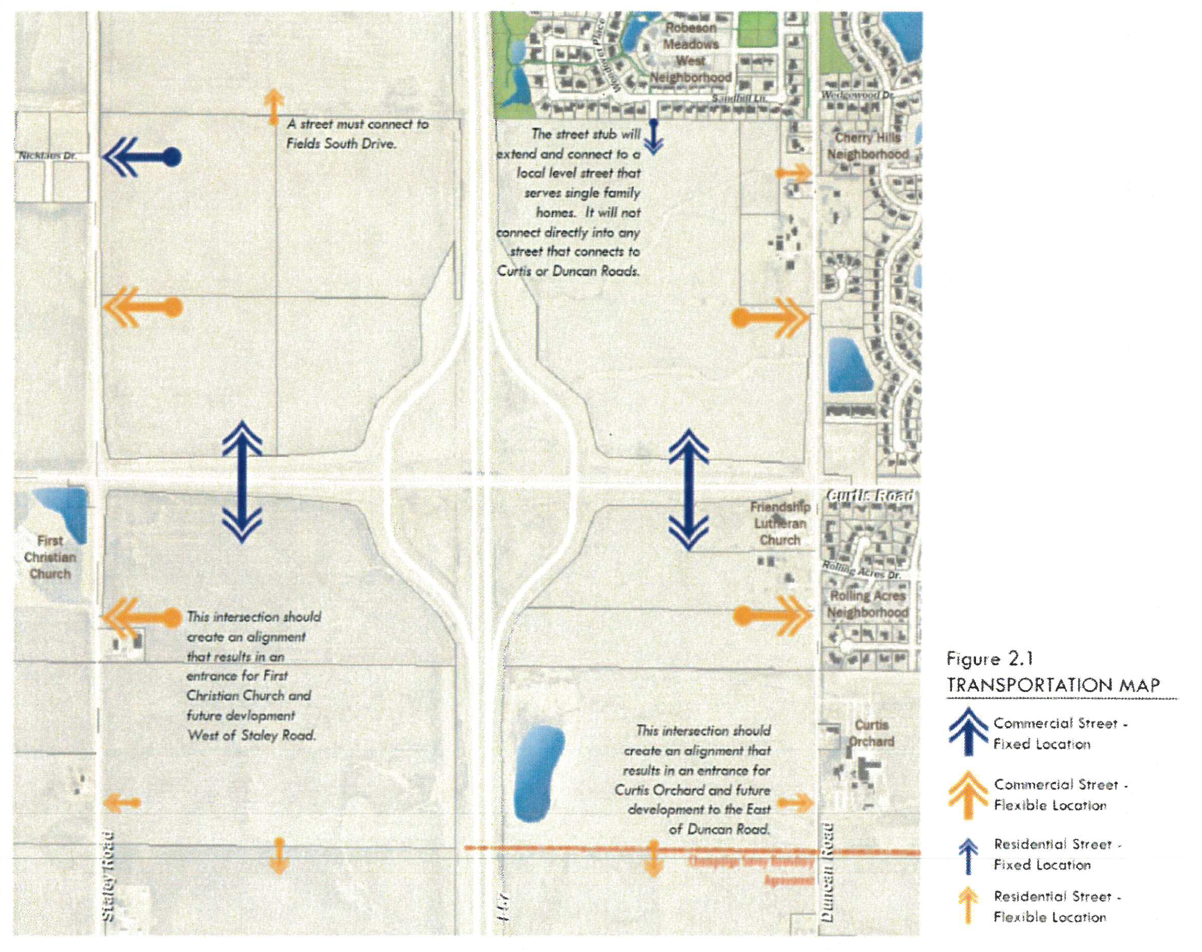
Access points onto Staley, Duncan and Curtis Roads shall be located in accordance
with the Curtis Road Interchange Area Master Plan, Transportation Map, Figure 2.1.
The design of the access points is subject to standards provided by the Manual of
Practice and shall be the result of a Traffic Impact Analysis approved by the City
Engineer.
 |
| 2.2 | The development shall be designed with the minimum number of access points to public streets necessary to serve the traffic generated by the proposed use, as demonstrated by the required traffic impact analysis. |
| 2.3 | Wendover Place will only connect to local streets serving residential development. The street must make a minimum of two turning movements before connecting to an arterial street, such as Duncan or Curtis Roads. |
| 2.4 | All development shall be arranged in a pattern of interconnecting streets in a grid-like pattern to facilitate transit and mobility of all users. Streets that terminate in a cul-de-sac design are not permitted. |
| 2.5 | In each quadrant, a paved landing area to accommodate a transit stop shall be provided near the primary intersection of collector streets. The location shall be determined in conjunction with the Champaign-Urbana Mast Transit District. |
| 2.6 | Approval of any development in the District shall be conditioned upon the applicant's agreement to annex the property subject to the development into the Champaign-Urbana Mass Transit District service area. An annexation agreement with the Champaign Mass Transit District shall be required if the parcel is not within the service area. |
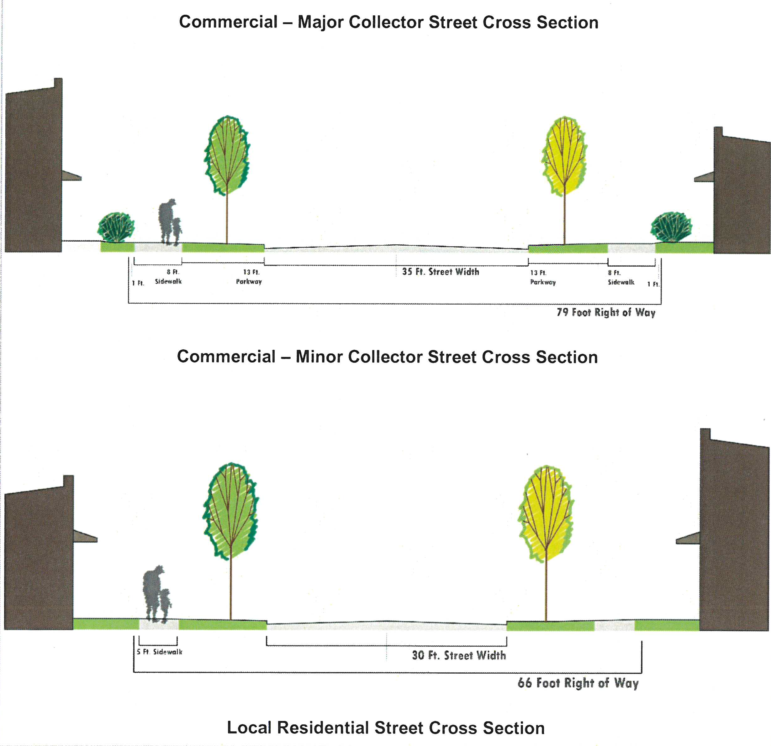
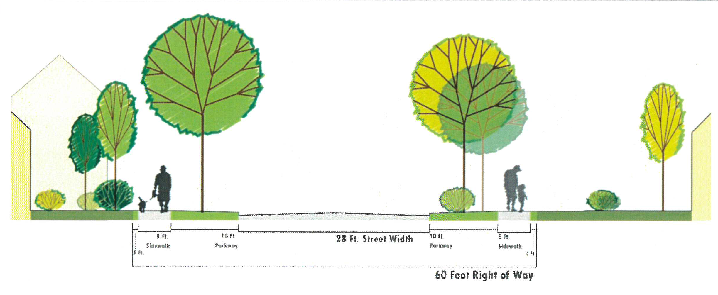
| 2.7 | Street cross-sections shall follow the right of way, pavement and sidewalk widths shown in 4.3 of this table, and the Champaign Manual of Practice. |
| OUTDOOR GATHERING SPACES AND PUBLIC PARKS Purpose: Development shall provide for both the preservation of natural areas and the creation of open spaces that are close to work and home for active and passive recreation to improve public health and quality of life. These spaces shall be provided on private property, through a public access easement, or through dedication to the Champaign Park District. | |
| 3.0 | Any Development that includes one or more parcels zoned SF1, SF2, MF1 and MF2 that have a total area of 10 or more acres shall include one or more parcels that have been dedicated to the Champaign Park District for recreational purposes. The minimum total area of all parcels dedicated for said purpose shall be calculated at the rate of three-quarters (3/4) of an acre per 10 acres of residential development. Publicly dedicated multi-use trails may account for up to 50% of the minimum area required for said recreational purposes. No parcel dedicated for said purposes shall be less than one and one-half acres in size. |
| 3.1 | In addition to areas dedicated to the Park District for recreational purposes, or otherwise dedicated or reserved for streets, sidewalks, trails or other public ways or for parking lots, each overall Development Plan that includes at least five acres shall include and designate a minimum amount of open space on privately owned parcels or on privately controlled commons areas which will be designed and available for outdoor gatherings of users of said non-residential uses and shall meet or exceed the design standards in 3.2 below. The minimum total area for said required outdoor gathering spaces shall be calculated at the rate of 15,000 square feet per 20 acres of land devoted to non-residential purposes. Said required outdoor gathering spaces may be distributed throughout the site, but no single contiguous area designated as an outdoor gathering space may have an area of less than 5,000 square feet. At least one outdoor gathering space shall be centrally located and a focal point for the development, with the remaining development designed around this element. The outdoor gathering spaces shall be accessible to users via sidewalk and/or trail connections. |
| 3.2 | Outdoor Gathering Space will be designed to serve customers and employees of adjacent businesses and employers. The Overall Development Plan shall include an attachment illustrating the character, square footage, general location and design concept for each Outdoor Gathering Space. This attachment shall describe the basic landscaping elements, hardscape features and amenities and shall include an ownership and management plan for the space(s). At a minimum, landscaping, shade trees, seating, and trash receptacles shall be incorporated into the design. |
| PEDESTRIAN AND BICYCLE NETWORK Purpose: The required pedestrian and bicycle network provides mobility choices for employees, customers and residents of this area. The thoughtfully designed network provides safe and convenient access to destinations within the area and nearby to facilitate active transportation and recreation. | |
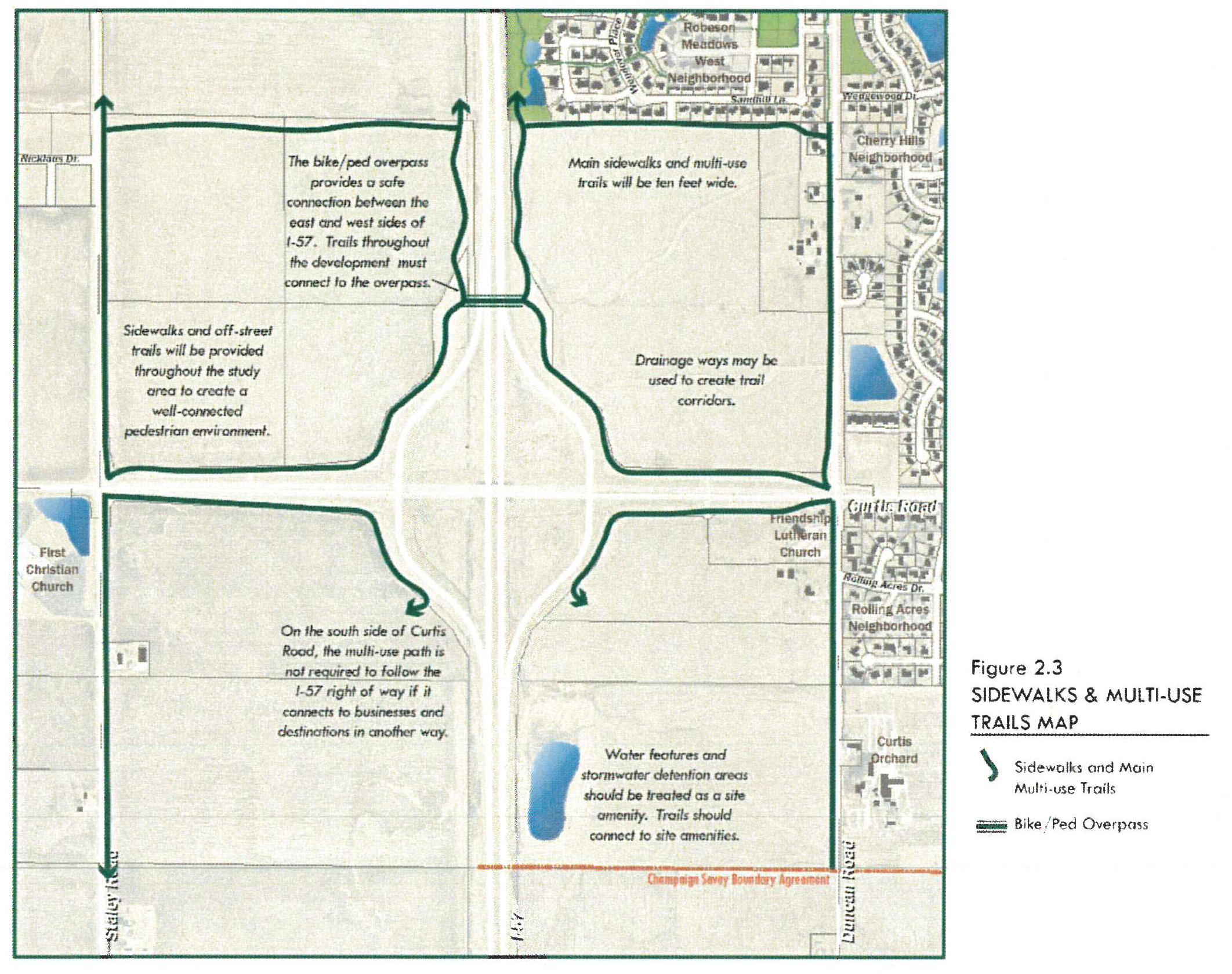
| 4.0 |
A site plan or other design drawing depicting the pedestrian and bicycle network shall
be included in the Overall Development Plan. The pedestrian and bicycle network shall
connect businesses, neighborhoods, outdoor gathering spaces, and other destinations
within and adjacent to the development. This network shall be designed in accordance
with the Curtis Road Interchange Area Master Plan, Figure 2.3 - Sidewalks and Multi-Use
Trails. Primary multi-use trails, defined as trails that connect directly to the Interstate 57 bicycle and pedestrian
overpass and public parks shall be publicly dedicated and shall be ten (10) feet in
width. Secondary multi-use trails, defined as trails that primarily serve the internal pedestrian circulation network
may be privately owned and shall be a minimum of eight (8) feet in width. Where the
pedestrian network includes planned connections through a development parcel, these
connections shall be depicted on the site plan for the parcel submitted with the building
permit for said parcel.
 |
| 4.1 | Required sidewalks along Duncan Road, Staley Road and Curtis Road shall have a minimum width of ten (10) feet and shall otherwise be designed to accommodate pedestrians and bicycles, provided that sidewalks adjacent to parcels developed prior to June 1, 2016, may be reduced to eight (8) feet in width if needed to accommodate existing site improvements. Wherever possible, the sidewalk shall be located within the road right-of-way. If location within the road right-of-way is not possible, the Developer shall dedicate or otherwise grant a public access easement to the City for that purpose. Said public access easement shall have a minimum width of twelve (12) feet to accommodate any sidewalk less than ten feet in width, and a minimum width of fifteen (15) feet to accommodate sidewalks meeting the minimum ten (10) foot width requirements. |
| 4.2 | Along the north side of Curtis Road, a sidewalk having a minimum width of ten (10) feet shall be located in a public access easement adjacent to the Interstate 57 on/off ramps, having a minimum width of fifteen (15) feet. Said public access easement and sidewalk shall, connect to a bicycle and pedestrian overpass located approximately one-quarter mile north of Curtis Road, as determined by the Illinois Department of Transportation. Upon completion of the sidewalk and bicycle and pedestrian overpass, the sidewalk and easement will be dedicated to the Champaign Park District. The dedicated bicycle and pedestrian overpass provides the sidewalk connection over Interstate 57. |
| 4.3 |
Sidewalks shall be in compliance with Figure 2.2 Street Cross Sections, and Manual
of Practice with five (5) foot wide sidewalks on local residential streets and minor
commercial streets and eight (8) foot wide sidewalks on main commercial collector
streets. Striped crosswalks are required at all intersections. Sidewalks continuing
across commercial entrances shall be highlighted via pavement treatment clearly delineating
the continuity of the sidewalk.
  |
| GREEN INFRASTRUCTURE Purpose: Development shall be constructed with regard for the environment to avoid adverse impacts on existing natural features, drainage, erosion, water quality, and to improve habitat. | |
| 5.0 | Detention and stormwater facilities will be designed to serve the entire Overall Development Plan area. They will be designed to minimize the total number of stormwater detention basins and promote the sharing of said basins by multiple properties. The size and design of these facilities shall comply with the requirements of the City's Subdivision Regulations and Manual of Practice, provided that where enhanced or relaxed design requirements are expressly provided in this Division, said enhanced or relaxed requirements shall apply. The general location and size of stormwater detention shall be shown on the Overall Development Plan and said Plan shall include a detailed ownership and management plan for said facilities. |
| 5.1 | A vegetative buffer of native and pollinator supporting plantings having a minimum width of twenty (20) feet shall surround all detention and drainage ways. |
| 5.2 | Detention and stormwater facilities will be located and designed to improve the appearance and views throughout the site. No basin may be surrounded by opaque or chain link fencing. |
| 5.3 |
If it can be demonstrated that post-development runoff from the 2-year storm will
be completely detained by low impact technologies within the development, then either
the release rate described in section 23.02 D of the Manual of Practice or the release
rate described below can be used to determine the required detention storage volume.
a. Alternate Release Rate. The controlled release rate of stormwater runoff from developments subject to this section shall not exceed the subject property's rate of runoff from a 100-year storm prior to the proposed development. The design rate at which stormwater runoff is delivered to a designated stormwater storage area shall be based on a 100-year storm after full development. The storm sewers, however, shall be designed to deliver a runoff resulting from a 10-year storm, flowing under gravity conditions. The balance of runoff is to be delivered by overland flow or in the storm sewers under surcharge conditions. In the event the natural downstream channel or storm sewer system is inadequate to accommodate the required release rate, the allowable release rate shall be reduced to that rate permitted by the capacity of the downstream channel or storm sewer system without overflowing its banks or surcharging of sewers. b. Storage Volume. The volume of storage capacity provided in detention facilities shall be sufficient to control the excess stormwater runoff, resulting from a 100-year rainfall as published by the Illinois State Water Survey in Technical Letter 13. c. Outlet Structures. Outlet structures for detention facilities shall be designed with multiple stages so that the fully developed release rate of stormwater runoff for the 2-year, 10-year, 25-year and 100-year storms does not exceed the pre-development rate of runoff from those storms. |
| 5.4 | Trees of four-inch (4") caliper or greater shall be incorporated in the site design and protected from damage during construction and from future use of the development whenever possible. |
| PARKING Purpose: Vehicular parking facilities shall be designed so that they will not be the dominant feature in the development. Surface parking lots shall be minimized in size through parking maximums set forth below and shared parking and will be screened from view by buildings and landscaping. | |
| 6.0 | Parking areas shall be designed to be shared by multiple uses, especially uses with differing peak parking times, in compliance with Table VII-E. Documentation of shared parking shall be provided in compliance with Sec. 37-357(c)(3). |
| 6.1 | Parking lots shall provide no less than 75% and no more than 125% of the minimum number of parking spaces that would otherwise be required in Article VII, Division 4. Residential uses are exempt from the maximum. The Planning and Development Director may approve an alternative number of parking spaces if an analysis of parking demand demonstrates justification for such alternative. |
(C.B. No. 2018-062, § 1(Exh. A), 5-1-18; C.B. No. 2018-149, § 1(Exh. A), 9-18-18)
Sec. 37-619.4. - Overall Development Plan application requirements.
Any person or entity seeking approval of any development in the Curtis Road Interchange Area Overlay District shall comply with the specifications in Table XI-D. Application materials must be deemed complete in order for the application to be processed.
(C.B. No. 2017-014, § 6(Att. F), 2-7-17; C.B. No. 2018-149, § 1(Exh. A), 9-18-18)
Table XI-D: Procedure for Approvals for Overall Development Plan Within the Curtis Road Interchange Area Overlay District
(C.B. No. 2018-149, § 1(Exh. A), 9-18-18)
Sec. 37-619.5. - Overall Development Plan Approval process.
Any person or entity seeking approval of any development in the Curtis Road Interchange Area Overlay District shall comply with each of the procedures or steps identified in Table XI-D in the sequence provided in said table, and comply with the specifications for submittals in Table XI-E.
(C.B. No. 2018-149, § 1(Exh. A), 9-18-18)
Table XI-E: Application Checklist for Approvals for Overall Development Plans Within the Curtis Road Interchange Area Overlay District
(C.B. No. 2017-014, § 6(Att. F), 2-7-17; C.B. No. 2018-062, § 2(Exh. A), 5-1-18; C.B. No. 2018-149, § 1(Exh. A), 9-18-18)
Sec. 37-619.6. - Site Plan Design Requirements.
For any development within the Curtis Road Interchange Area Overlay District, a site plan is required to be submitted and shall be consistent with the approved Overall Development Plan. Any person or entity seeking approval of any development in the Curtis Road Interchange Area Overlay District shall comply with each of the requirements identified in Table XI-F. Property with SF-1 and SF-2 Zoning are not subject to Table XI-F: Design Requirements for the Curtis Road Interchange Area Overlay District. Where the standards differ between Table XI-F and other standards of Chapter 37 of the Champaign Municipal Code, Table XI-F will supersede the conflicting standard.
(C.B. No. 2018-149, § 1(Exh. A), 9-18-18)
Table XI-F
Design Requirements for Curtis Road Interchange Area Overlay District
Stage 2: Site Plan
| BUILDING DESIGN | |
| Purpose: To ensure buildings within the Curtis Road Interchange Overlay District are composed of durable materials and have a cohesive and compatible architectural design. | |
| 1.0 | No structure shall exceed seventy-five (75) feet in height. |
| 1.1 | Where a structure exceeds a height of forty (40) feet, the building must be setback from any adjacent residentially zoned parcel by a minimum of 200 feet. |
| 1.2 | Any exterior walls 125 feet in length or greater that face a public street, private street or outdoor gathering space must include a minimum of two (2) feet in variation of the vertical plane of wall at intervals of seventy-five (75) feet or less. At least 50% of the vertical surface area of each horizontal interval must be recessed, projected, or offset to meet this requirement. Intervals do not need to be equal in length. |
| 1.3 |
Each building shall have a primary entrance facing a public street, private street
or outdoor gathering space. The facade containing the primary entrance shall be the
primary facade of the building. The entrance shall connect to a public sidewalk, adjacent
trail or outdoor gathering space in the most direct route, as determined by the Zoning
Administrator, via an on-site pedestrian walkway. The pedestrian walkway shall meet
the following requirements:
a. The walkway must be a minimum of five (5) feet wide. Where the walkway is parallel to a parking row, it must be buffered by a minimum of three (3) feet from walkway edge to back of curb. The buffered area may be turf or landscape plantings. b. Where a pedestrian walkway crosses a drive aisle or vehicle lane, the pedestrian walkway material shall differ from the drive aisle material by composition, texture, or through the use of a differing color that is integral to the material. |
| 1.4 | The primary entrance shall be covered by a shelter that is no less than three (3) feet in depth and five (5) feet in width. This shelter may be provided with a projection from the wall, an inset into the wall, or a combination of the two. |
| 1.5 | Exterior building cladding must be of one or more of the following materials: true brick, genuine stone, precast concrete, glass, wood and rigid fiber cement product. Synthetic materials such as synthetic stucco (e.g. EIFS), vinyl siding, and pre-fabricated metals are permitted to comprise up to a maximum of twenty percent (20%) of a building's façade, excluding areas for glazing. |
| 1.6 |
Buildings two stories or more in height must have an expression line, such as a cornice,
delineating the first floor.
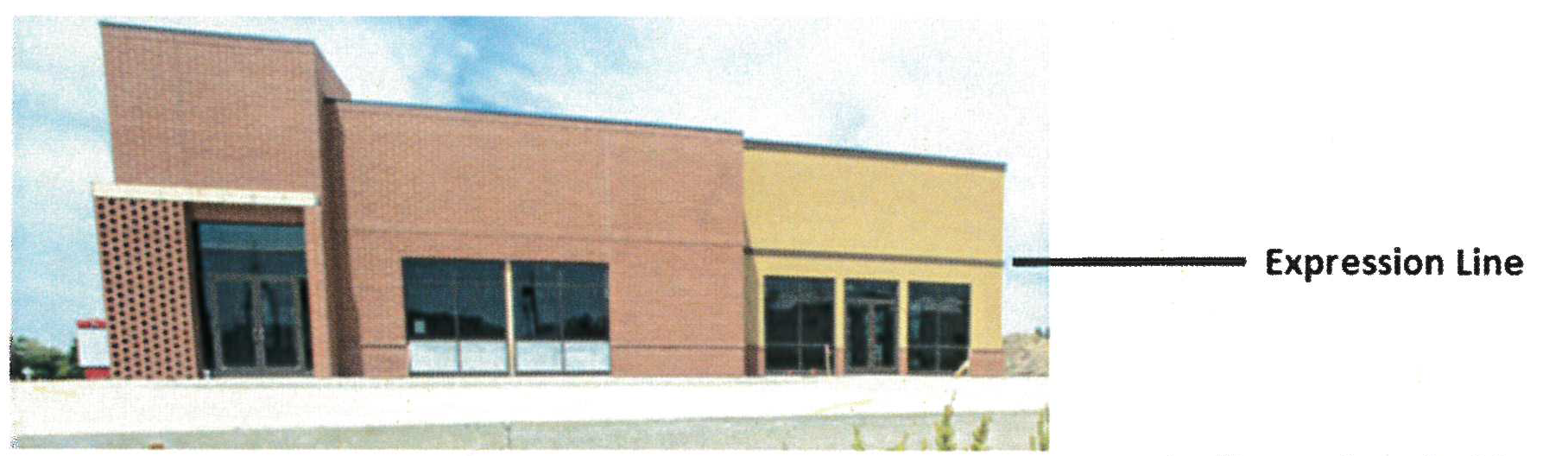 A one story building shall have an expression line delineating the first floor or
shall have an expression line located at the top of the building.
A one story building shall have an expression line delineating the first floor or
shall have an expression line located at the top of the building.
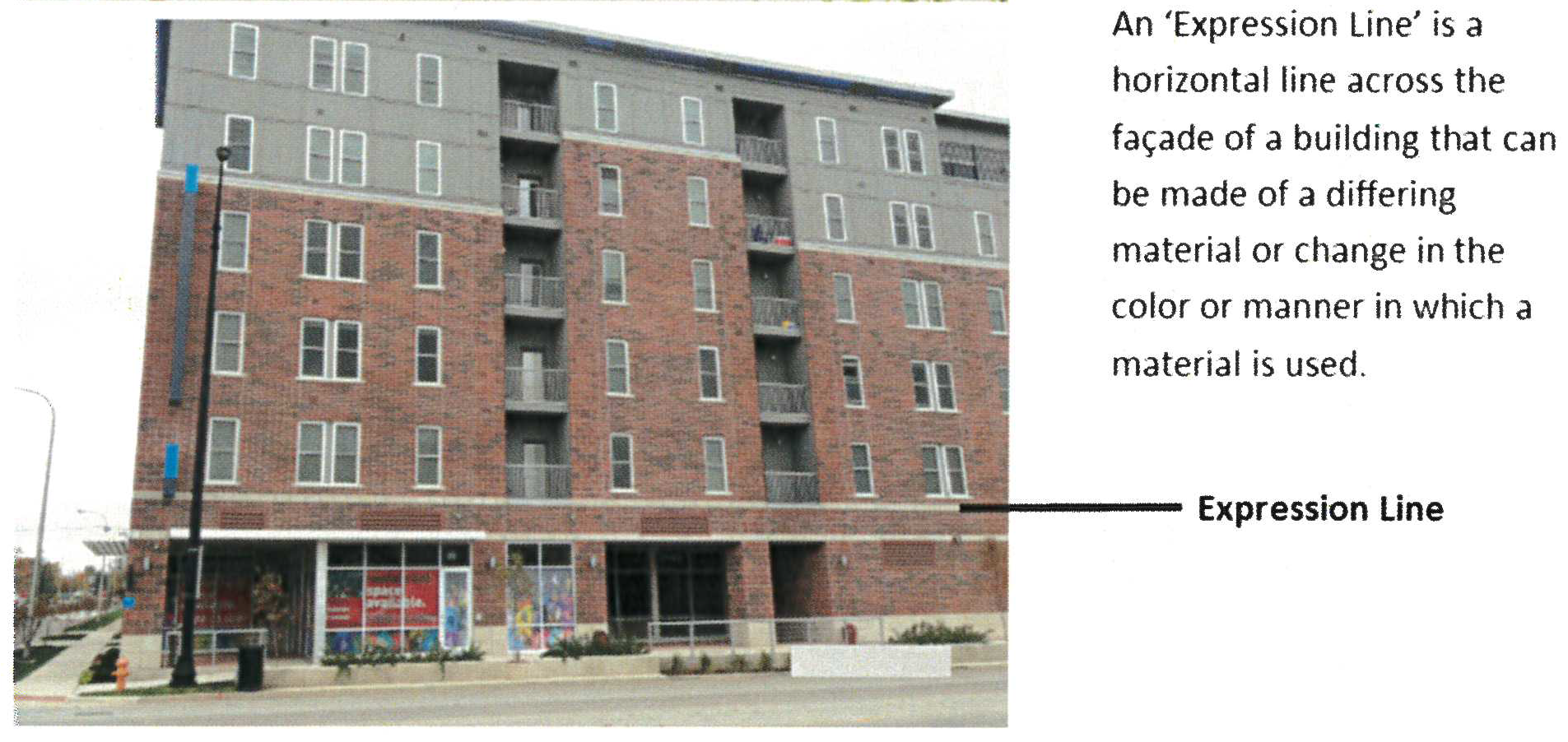 |
| 1.7 |
Where the principal use buildings share one lot and are less than twenty (20) feet
from one another, the height of any cornice or expression line delineating the first
floor shall be placed at the same height.
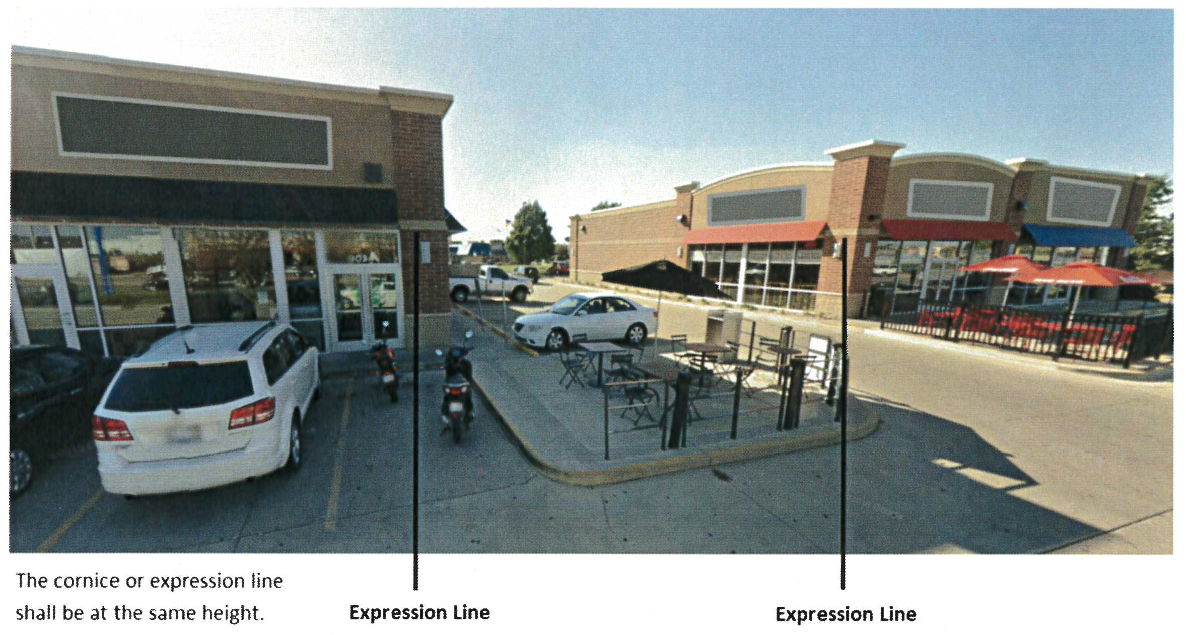 |
| 1.8 | Awnings are permitted and shall be constructed of durable materials. Awnings may not be constructed of plastic nor be internally illuminated. |
| 1.9 |
A minimum of 35% of the area of the ground floor of the primary facade must consist
of transparent glass. A minimum of 35% of the area of the ground floor of a second
facade, selected by the applicant, must also consist of transparent glass. The Planning
and Development Director may, at his or her discretion, approve a reduction of the
minimum requirement for transparent glass of the ground floor of the second facade
to no less than 17%. This waiver may only be approved if the applicant provides a
site and building analysis demonstrating that utility, loading or other unsightly
features either within or outside the building cannot be located in such a way to
enable the required standard to be met. The calculation shall be measured from the
ground to the top of the building, unless the building is two stories or greater.
For buildings two stories or greater, a minimum of 17% of the area of each upper floor building facade must consist of transparent glass. No more than two facades are subject to this requirement. The calculation shall be measured from the expression line delineating the upper floor to the top of the building. Mirror reflective glass is prohibited. The percentage of glazing for each facade area subject to this requirement shall be provided on the building permit. |
| 1.10 | Loading docks, overhead doors, and other vehicular service entries shall be screened in accordance with Sec. 37-559 and not be located on a façade facing the public right-of-way, outdoor gathering space or commons area. |
| 1.11 | Each site must include space to adequately store all refuse, including recycling, until such time as the refuse is collected by a licensed waste hauler. |
| 1.12 | Refuse storage areas integrated into a building shall not be accessed from the side of the building that faces a public right-of-way. |
| 1.13 | Refuse storage areas separated from the building shall be consolidated and sized to adequately accommodate all refuse, including recycling, containers. Refuse storage areas shall be enclosed on all sides, with an opaque wall exceeding the height of the dumpster lid when opened. Refuse storage areas shall also include gates, or doors, that can be opened to access refuse and recycling containers. Refuse storage areas shall be clad in the same materials used on the exterior of the main building. |
| 1.14 |
Refuse storage areas shall include a horizontal cover or screen over the top of the
enclosure. The horizontal screen or cover shall be integrated into the enclosure design.
In lieu of a horizontal cover or screen, specialty dumpsters or waste receptacles
may be used in place of traditional dumpsters or waste receptacles. The specialty
dumpster(s) or waste receptacle(s) must include the following: a fully enclosed design
with a disposal lid comprised of heavy-gauge metal that opens and closes via gravity
when dumped and deposit doors comprised of heavy-gauge metal that are self-closing.
The manufacturer's specifications of the specialty dumpster must be attached to the
building permit.
 |
| 1.15 | Entities that offer food or other goods that are commonly consumed or used on site shall provide an outdoor wastebasket within ten feet of each public entrance, drive-through window, and outdoor seating area. Such uses may include, but are not limited to: mini-mart/service station, restaurant, and retail uses. |
| 1.16 | Exterior mechanical equipment, including but not limited to, HVAC, utility meters or electrical cabinets must be screened from view using either built materials or landscaping from the approved plant material list. Exterior mechanical equipment cannot be located on a primary façade. |
| PARKING AND ACCESS DESIGN | |
| Purpose: To ensure a safe an efficient traffic network that reduces conflicts between vehicles, pedestrians and bicyclists as well as to improve the aesthetic quality of the area. | |
| 2.0 | Parking areas, loading areas and access drives must be sited and designed in accordance with the standards outlined in Article VII of the Zoning Ordinance, as well as the requirements of this Table XI-F. |
| 2.1 | Parking lots shall provide no less than 75% and no more than 125% of the minimum number of parking spaces that would otherwise be required in Article VII, Division 4. Residential uses are exempt from the maximum. The Planning and Development Director may approve an alternative number of parking spaces if an analysis of parking demand demonstrates justification for such alternative. |
| 2.2 | When more than one principal use is established on a single lot, parking shall be shared in compliance with Sec. 37-357(c)(3). |
| 2.3 | A minimum of 50% of the vehicular parking spaces shall be located to the side or rear of the principal building. The Planning and Development Director may approve an alternative parking design if an analysis of parking demand demonstrates justification for such alternative. |
| 2.4 | For uses containing a drive-through, order boxes, menu boards, and pick-up or drop-off windows are prohibited in the front yard and on the front façade of the building. If the property is on a corner lot, the order box, menu board and pick-up or drop-off windows may be located on the buildings side façade or yard facing the street only when located at the rear two-thirds of the façade or yard. Menu boards shall contain landscaping around the menu board. |
| LANDSCAPING AND SCREENING | |
| Purpose: To beautify the district with landscaping materials and to adequately screen parking, storage and utility areas. Landscaping and screening is also provided to protect the natural environment through the use of "best management practices", including shade trees, low impact stormwater management techniques and pollinator supporting plants. | |
| 3.0 | Landscaping and screening shall be in compliance with the standards set forth in Article X, as well as the requirements of this Table XI-F. |
| 3.1 | Selection of plant materials shall be in conformance with the Approved Plant List, found in the Appendix of the Champaign Municipal Code. A minimum of 50% of species selected shall be those designated in the Approved Plant List as "pollinator supporting." |
| 3.2 | Stormwater management plans shall demonstrate a Low Impact Design (LID) approach as a component of the overall stormwater management system for the site. LID includes stormwater management practices such as rain gardens, bio-retention areas, green roofs, and parking lot absorption islands. The site plan shall include best management practices designed to retain the 24-hour, 1-year storm with a discharge rate at or below the pre-development discharge rate. The stormwater management system is subject to approval by the City Engineer. |
| 3.3 | Parking Lot Perimeter. In lieu of Section 37-555, parking lot perimeter setback, screening and landscaping shall meet the following
standards:
A. Parking lots shall be setback from the property line by a minimum of ten (10) feet and shall be screened with plantings. B. Parking lot perimeter screening shall have a minimum height of thirty-six (36) inches. Where the parking lot perimeter faces a public street, screening shall not exceed forty-two (42) inches in height. Screening provided by plantings shall obtain that height through natural growth within three years of the planting date. C. The Landscape Plan shall demonstrate a screening plan with plantings that will achieve a continuous hedge along 85% of the perimeter of the parking lot, where adjacent to a public or private street. The continuous hedge shall be achieved through natural growth within three years of the planting date. To achieve a continuous hedge, a minimum of one tree per twenty-five (25) feet and a minimum of five shrubs between each tree are required. At access points, screening may be reduced to allow for an adequate site triangle. D. Decorative fences or walls shall be allowed to provide up to fifty (50) percent of the required screening for the areas where they are used. Where decorative fencing is installed, one tree per twenty-five (25) feet is required. Required plantings shall be installed on the side of the decorative fence or wall that faces the street. Decorative fences shall be at least seventy-five (75) percent opaque and shall adhere to the following requirements: i. Materials. The decorative fence or wall shall consist of treated wood or naturally resistant wood such as redwood, cypress, or cedar, decorative split face concrete blocks or brick masonry; ii. Braces, supports or posts shall be located on the side of the property providing the screening; iii. In the front yard, fences may not exceed three feet in height, in the rear yard, fences may not exceed ten feet in height. Decorative fences or walls shall utilize the definitions and standards outlined in Division 3 - Yards and Setback Requirements. E. Parking lot design shall implement low-impact methods for stormwater management. This includes curb inlets coupled with parking lot edge zones that capture, filter and slow the flow of stormwater runoff. The final design of the parking lot edge zones, including the selected plantings, shall be approved by the City Engineer. F. The reference elevation for the base of the required screen shall be the surface of the parking area that is to be screened. |
| 3.4 | Parking Lot Interior. In lieu of Section 37-556, Parking lot interior landscaping shall meet the following standards:
A. Landscape islands shall be located at the ends of all rows of parking. For rows greater than 20 spaces, there shall be additional islands at a rate of one per fifteen (15) spaces. Fifteen spaces is along one side of a parking island. B. Landscape islands shall have an average minimum width of eight (8) feet wide from back of curb to back of curb and 150 square feet and shall be protected by a barrier curb. C. Each Landscape Island shall contain at least one tree approved for parking lot interiors from the approved plant list in the Appendix of the Champaign Municipal Code. A minimum of 75 percent of trees selected shall be designated as shade trees. There must be a minimum of two tree species selected. D. A continuous planting strip between parking rows may be substituted for the required landscaped islands. The planting strip shall be a minimum of eight (8) feet in width and shall be protected by a barrier curb with inlets allowing stormwater to drain into the planting strip. The planting strip shall be designed as a bioretention area that is depressed from the grade of the parking lot to capture and reduce the flow rate pollutant load of stormwater using Low Impact Design principles. A minimum of one tree for every six (6) parking spaces shall be planted in any such strip, with a tree at the end of each strip. E. Landscape Islands shall be designed to capture and reduce the flow rate of stormwater using Low Impact Design principles. A minimum of 75% of the total square footage of parking lot Landscape Islands shall be designed as bioretention areas and depressed from the grade of the parking lot. Inlets in the barrier curb shall be constructed to allow stormwater runoff to drain into the island. The final design of the Landscape Islands, including the selected plantings, shall be approved by the City Engineer. |
| 3.5 |
In parking lots with five or more parallel parking rows of 18 spaces or more, OR parking
lots over 150 spaces, a continuous median island with pedestrian walkway must be provided
running the length of the parking lot, connecting the primary public entrance to the
building with the public sidewalk. The continuous median island shall adhere to the
following standards:
i. Total width shall be a minimum of thirteen (13) feet from back of curb to back of curb. The island shall contain a minimum eight (8) foot planting area with a five (5) foot pedestrian sidewalk. ii. A minimum of one tree for every six parking spaces shall be planted in the space, with a tree at each end of the island. iii. An access point from the drive aisle to the walkway must be provided a minimum of every twelve spaces. The access point must meet ADA standards for accessibility. iv. Where a pedestrian walkway crosses a drive aisle or vehicle lane, the pedestrian walkway material shall differ from the drive aisle material by composition, texture, or through the use of a differing color that is integral to the material. v. An additional median island shall be provided for each additional 200 spaces. In lieu of the additional median island, alternative pedestrian facilities that function to slow parking lot traffic and safely convey pedestrians from the main public entrance to the main public thoroughfare may be approved at the discretion of the Planning and Development Director. The continuous median island with pedestrian walkway may be substituted for the required landscaped islands described in 3.4 (above) for the parking rows impacted. |
| 3.6 | Service and storage areas may not be located at the front of buildings. Service and storage areas shall be screened from any public or private street, or adjacent property with a 100 percent opaque masonry or wood fence, landscaping or any combination thereof which provides a minimum height of six (6) feet. |
| 3.7 | Street trees along public streets and private access drives shall be provided in the public right-of-way at a ratio of at least one (1) tree per fifty (50) feet of frontage. |
| 3.8 | The use of barbed and/or razor wire is prohibited. |
| SIGNAGE | |
| Purpose: To allow for an appropriate amount of signage but yet not detract from high-quality aesthetics for development in the Curtis Road Interchange Overlay District. | |
| 4.0 |
Signs in the Curtis Road Interchange Overlay District shall meet the requirements
of Article VIII, with the following exceptions:
(a) Freestanding signs. Freestanding signs shall only be monument-style signs and signs shall not be mounted on a pole. Freestanding signs for three or fewer businesses shall have a maximum height of six (6) feet. Freestanding signs for four or more businesses shall have a maximum height of twenty (20) feet. When located within the visibility triangle required by Section 37-195, the maximum height shall be three (3) feet. (b) Shopping center signage. Signage for shopping centers, as defined in Sec. 37-437(i), will follow the standards outlined in Article VIII, and shall be a maximum height of twenty (20) feet. (c) OASS and Interstate Highway Signs, as otherwise provided therein, are not permitted in the Curtis Road Interchange Overlay District. |
| LIGHTING | |
| Purpose: Lighting standards are intended to provide adequate lighting for safety, security and convenience of users, yet reduce impacts of light pollution on occupants of adjacent properties and the environment. | |
| 5.0 | All private exterior lighting, including lighting on buildings as well as parking lot lights, shall at a minimum, meet the requirements set forth by the International Dark Sky Association and the Illuminating Engineering Society of North America in their 2011 Model Lighting Ordinance. |
| 5.1 | Where street lights are required to be installed in the public right-of-way, the street lights used shall conform to those required in the University District as provided in the Champaign Municipal Code, except that the luminaire shall be dark sky compliant and the light source shall be LED. An alternative light source that has greater energy efficiency than an equivalent LED light source may be permitted with the approval of the City Engineer. The luminaire oriented toward the street shall be a cobra-head style, while the luminaire oriented toward the sidewalk shall conform to the amended University District standard. Light poles may have a maximum height of twenty-seven (27) feet along collector level streets and twelve (12) feet along local streets. |
| 5.2 | Under-canopy lighting shall be fully recessed into the canopy to minimize light trespass. During business hours, canopy lighting shall not exceed five (5) footcandles. After business hours, canopy lighting shall not exceed one footcandle. Lighting level shall be measured at the property line. |
| 5.3 | Parking lot lighting shall be mounted no higher than twenty-six (26) feet high and shall be fully shielded. Luminaires shall be certified as "Dark Sky Compliant" by the International Dark Sky Association. The light source shall be LED. An alternative light source that has greater energy efficiency than an equivalent LED light source may be permitted with the approval of the City Engineer. |
| 5.4 | All development applications are required to include a photometric lighting plan. Photometric lighting plans shall show maximum average lighting levels per lot of five (5) footcandles for commercial and office uses. Multifamily residential uses shall have maximum average lighting levels per lot of one (1) footcandles. In addition, lighting plans shall show a maximum of 0.2 footcandles at the property line when property line is within or adjacent to the MF1 or MF2 zoning district or within 250 feet of any lot zoned SF-1 or SF-2, land outside of the municipal boundaries of the City of Champaign that is designated for low-density residential use in the generalized future land use map of the Comprehensive Plan, and future zoning of SF-1 or SF-2 as specified in a recorded annexation agreement. |
| 5.5 | On lots which abut residentially zoned property or property that is designated by the Comprehensive Plan for future residential land use, all outdoor lighting fixtures must be set back a minimum of thirty (30) feet from the nearest residentially zoned property line. |
| 5.6 | After 11:00 pm, parking lot lighting must be turned off or reduced by at least fifty percent (50%) of full operational level. For safety purposes, entities that provide services after 11:00 p.m. must provide parking lot lighting levels of not less than 0.2 footcandles as measured horizontally at the surface on which the light pole is mounted. The manufacturers specifications demonstrating that specified light fixtures include this capability shall be attached to the building permit. |
(C.B. No. 2017-014, § 6(Att. F), 2-7-17; C.B. No. 2018-062, § 3(Exh. A), 5-1-18; C.B. No. 2018-149, § 1(Exh. A), 9-18-18)
Sec. 37-619.7. - Site Plan Review Process.
The required site plan shall be submitted as a component of an application for a building permit. The site plan will be evaluated for compliance with the approved Overall Development Plan. If the site plan does not comply with the approved Overall Development Plan, the applicant shall revise the site plan to achieve compliance with the approved Overall Development Plan or shall apply for an amended Overall Development Plan as described in Secs. 37-619—37.619.5.
(C.B. No. 2017-014, § 6(Att. F), 2-7-17; C.B. No. 2018-149, § 1(Exh. A), 9-18-18)
Sec. 37-620. - Purpose.
The purpose of this ordinance is to regulate the time, place and manner of Cannabis Business Establishments in the City of Champaign as authorized by the State of Illinois through the Cannabis Regulation and Tax Act (the "Act").
(C.B. No. 2019-193, § 1(Exh. A), 10-15-19)
Sec. 37-621. - Applicability.
Where this ordinance is different from applicable State law, or in instances where State law is amended, the more restrictive of the state or local laws shall apply.
(C.B. No. 2019-193, § 1(Exh. A), 10-15-19)
Sec. 37-622. - Definitions.
These definitions supplement the applicable definitions in the Act and shall be interpreted consistently with the Act.
Cannabis Business Establishment means any business or organization licensed by the State of Illinois to grow, process, infuse, dispense, or transport cannabis or cannabis products for medical or adult use.
Cannabis Craft Grower means a facility licensed by the State of Illinois to cultivate, dry, cure, and package cannabis for sale at a dispensary or use in a processing facility. A craft grower may be located on the same property as a licensed dispensary, infuser, processor or transporter as licensed by State law and permitted by local regulations.
Cannabis Cultivation Center means a facility operated by an organization or business that is licensed by the State of Illinois to grow, cultivate, process, transport and perform other necessary activities to provide cannabis and cannabis-infused products to licensed Cannabis Business Establishments.
Cannabis Dispensary means a facility licensed by the State of Illinois to sell medical and adult use cannabis and other related products to purchasers or to qualified medical cannabis patients and caregivers.
Cannabis Infuser means a facility licensed by the State of Illinois to directly incorporate cannabis flower or cannabis concentrate to create a cannabis infused product.
Cannabis Processor means a facility licensed by the State of Illinois to either extract constituent chemicals or compounds to produce cannabis concentrate or incorporate cannabis or cannabis concentrate into a product formulation to produce a cannabis product.
Cannabis Transporter means a facility licensed by the State of Illinois to store and transport cannabis on behalf of a cannabis business establishment.
(C.B. No. 2019-193, § 1(Exh. A), 10-15-19)
Sec. 37-623. - Permitted Locations.
Cannabis Business Establishments are permitted uses in the following zoning districts in accordance with Table XI-G:
Table XI-G Permitted Zoning Districts for Cannabis Business Establishments
(C.B. No. 2019-193, § 1(Exh. A), 10-15-19)
Sec. 37-624. - Performance Standards for all Cannabis Business Establishments.
The cannabis business establishment shall comply with all statutory requirements of the Act and that the operator of the cannabis business establishment provide a copy of the State-approved license and license application documentation required by the Act to the Planning and Development Department.
(C.B. No. 2019-193, § 1(Exh. A), 10-15-19)
Sec. 37-625. - Purpose.
The purpose of this division is to define Accessory Dwelling Units and regulate their location, construction and use on a lot.
(C.B. No. 2022-117, § 1(Exh. A), 6-21-22)
Sec. 37-626. - Definitions.
Accessory Dwelling Unit, or "ADU" shall mean a dwelling unit that is accessory but separate to a residential Principal Use on a lot. Accessory Dwelling Units vary in type distinguished by being either a Detached ADU, an Attached ADU or an Internal ADU.
Attached ADU shall mean an ADU that is an expansion of an existing Principal Structure and is self-contained with a separate means of egress.
Detached ADU shall mean an ADU that is freestanding and not attached to an existing Principal Structure. This includes ADUs that are combined with a detached garage Accessory Structure on a lot. Detached ADUs may share utility connections that also serve the Principal Structure.
Internal ADU shall mean an ADU that is wholly within an existing Principal Structure, without expanding the Principal Structure, and is self-contained with a separate means of egress.
(C.B. No. 2022-117, § 1(Exh. A), 6-21-22)
Sec. 37-627. - Permitted Zoning Districts.
Accessory Dwelling Units, in any type defined herein, shall be permitted in any Residential Zoning District listed in Section 37-42; Table III-A of this Chapter.
(C.B. No. 2022-117, § 1(Exh. A), 6-21-22)
Sec. 37-628. - Performance Standards.
(a)
Number of Accessory Dwelling Units. There shall be a maximum of one Accessory Dwelling Unit allowed per lot.
(b)
Size of ADU. For lots up to 7,200 square feet in area, the maximum floor area for an Accessory Dwelling Unit shall be 600 square feet. For lots 7,201 square feet or larger in area, the maximum floor area for an Accessory Dwelling Unit shall be 800 square feet.
(c)
Detached ADUs with other Accessory Structures.
(1)
Detached ADUs are not allowed to be combined with any Accessory Structure other than a detached garage.
(2)
For Detached ADUs combined with a detached garage, the floor area of the ADU shall count toward the size allowance for ADUs and the square footage of the garage shall count toward the size allowance for Accessory Structures as provided for in this Chapter.
(3)
In no case shall the floor area of an ADU combined with either a new or existing Accessory Structure exceed the size allowance for ADUs.
(d)
Placement of Detached Accessory Dwelling Units. No Detached ADU shall be located between the front building line of the Principal Structure and the front lot line.
(e)
Height.
(1)
The maximum height of any Detached ADU shall be 24 feet. For ADUs built in conjunction with a detached garage, the total height of the structure cannot exceed 24 feet.
(2)
For any Attached ADU or Interior ADU, the maximum height shall be that of the underlying zoning district.
(f)
Setbacks.
(1)
The setback requirements for ADUs shall be those required for a Principal Structure in the underlying zoning district.
(2)
For new construction of a combined Detached ADU and detached garage Accessory Structure, the combined structure shall meet the setback requirements of the underlying zoning district.
(3)
If a Detached ADU is to be established in an existing detached Accessory Structure, either in combination with the Accessory Structure or by fully converting the Accessory Structure to an ADU, and the Accessory Structure was originally constructed over ten years prior to the application of a building permit for the ADU, and the existing structure does not meet the Setback requirements for Principal Structures in the underlying zoning district, then the Detached ADU is exempt from those Setback standards. This provision also applies to new construction of a Detached ADU on the foundation of an existing Accessory Structure built ten years prior. In these cases, the existing encroachment into the setback cannot be increased or extended with the new Detached ADU.
(g)
Requirements for Floor Area Ratio, Open Space Ratio, Maximum Building Footprint and Maximum Lot Coverage requirements.
(1)
Detached ADUs are exempt from the requirements for Floor Area Ratio, Open Space Ratio, Maximum Building Footprint or Maximum Lot Coverage.
(2)
Attached ADUs and Internal ADUs shall comply with the calculation requirements for Floor Area Ratio, Open Space Ratio, Maximum Building Footprint and Maximum Lot Coverage as required in the underlying zoning district.
(h)
Off-Street Parking. No additional off-street vehicular or bicycle parking spaces are required for an ADU provided the Principal Use is compliant for the required number of off-street parking spaces.
(i)
Access. Detached ADUs located behind Principal Structures must be accessible from the public right-of-way for emergency purposes with at least three (3) feet of width between the Principal Structure and the lot line.
(j)
Maximum Occupancy. The maximum occupancy of an ADU shall be no more than two (2) persons unrelated to each other by blood, marriage or legal adoption.
(k)
Home Occupations/Business Use of ADU. Home Occupations, or any other business use, shall not be permitted within an Accessory Dwelling Unit.
(l)
ADU Ownership. Accessory Dwelling Units shall not be sold separate from the Principal Structure located on the same lot.
(m)
Compliance with Building Code Requirements. The construction of an Accessory Dwelling Unit shall be in compliance with all building code requirements and be approved for a building permit prior to construction.
(C.B. No. 2022-117, § 1(Exh. A), 6-21-22; C.B. No. 2025-037, § 1(Exh. A), 3-18-25)