
Columbia City Zoning Code
ARTICLE 5
- SUBDIVISIONS
Sec. 29-5.1. - Subdivision standards.
(a)
Applicability.
(1)
The standards in this article 5 shall apply to land in all districts except the M-DT district whenever land is subdivided or re-subdivided to create, change, or establish the boundaries of parcels for development or redevelopment, unless this chapter provides an exception.
(2)
In the M-DT district, all subdivisions shall comply with the requirements of the regulating plan and other applicable standards in section 29-5.1, including but not limited to requirements for blocks, through connectivity, intersections, terminating streets, alleys, and sidewalks, and shall also comply with the M-DT district recommended street cross-sections in appendix A to the greatest degree practicable. If the requirements of section 29-4.2 conflict with the provisions of this section 29-5.1, the provisions of section 29-4.2 shall apply. If the provisions of section 29-4.2 are silent on a topic addressed by this section 29-5.1, the provisions of this section 29-5.1 shall apply.
(b)
Avoidance of sensitive areas. Except under approved special safeguards, land shall be neither subdivided nor developed, where there is a finding by the council that a proposed subdivision or development poses a threat to the safety, health and general welfare of inhabitants of the land or surrounding areas due to flooding, improper drainage, steep slopes, rock formations, adverse earth formations, topography, utility easements or other adverse conditions. Portions of the proposed subdivision or development that cannot be developed without damage to sensitive areas shall be set aside for such use as shall not pose an undue hazard to life and property.
(1)
Land analysis map.
(i)
Each application for subdivision or re-subdivision of a land area of five (5) acres or more, either alone or contiguous with another subdivision by the same applicant, shall prepare and submit a land analysis map identifying sensitive lands to be protected from development. Such map shall be provided at the time of concept review for property proposed to be preliminarily platted regardless of the parcel size. In preparing such land analysis map, those areas shown on the future land use map of the city's comprehensive plan as "sensitive" shall be identified as well as other areas which through reasonable investigation should be known to be sensitive areas.
(ii)
The land analysis map shall identify, as sensitive lands to be protected from development, all of the following:
(A)
Stream corridors, which shall include all land from top-of-bank to top-of-bank of any waterway, shown as a solid blue or dashed blue line on the corresponding USGS 7.5 minute quadrangle map and further defined within chapter 12A of the City Code;
(B)
Steep slopes, which shall include all land with a natural undisturbed average vertical slope of twenty-five (25) percent or more and height of ten (10) feet or greater, measured from top-of-slope to foot-of-slope, plus an additional ten (10) feet or additional setback as required by chapter 12A as it relates to stream buffers; and
(C)
Any lands designated as floodway on the Flood Insurance Rate Maps (FIRMs) for the City of Columbia or FIRMs for unincorporated Boone County if the subject subdivision or re-subdivision is not inside the city's boundary. In instances where the designated floodway has been modified or amended by action of the Federal Emergency Management Agency (FEMA) and is not reflected on the adopted FIRM Maps, proof of such modification or amendment shall be provided at the time of land analysis map submission and shall be recognized as the official boundary of the floodway.
(iii)
The land analysis map shall further identify that portion of a site located within the flood plain (i.e. flood fringe) shown on the Flood Insurance Rate Maps (FIRMs) for the City of Columbia or FIRMs for unincorporated Boone County if the subject subdivision or resubdivision is not inside the city's boundary. Such areas shall not be considered restricted from development; however, they are subject to the development standards of the FP-O (floodplain overlay) district. Preservation and avoidance of such areas in the course of site development may qualify for a "preservation bonus" in accordance with the provisions provided below.
(2)
Avoidance of sensitive lands. The applicant shall lay out the subdivision or re-subdivision so that:
(i)
To the greatest degree practicable, no lot intended for development shall include land features designated as sensitive lands, as indicated in section 29-5.1(b)(ii), unless such inclusion is supported by:
(A)
Written and graphical documentation that avoidance was not possible and the corresponding code provision(s) requiring such inclusion, to meet the regulatory requirements of this chapter, are cited, and
(B)
Written certification by a Missouri Licensed Professional Engineer that such inclusion will not pose a threat to the health, safety, and welfare of the inhabitants of the surrounding land.
(ii)
If any lot intended for development includes designated sensitive lands, construction of permanent structures shall be restricted to a designated building envelope that does not include any designated sensitive land areas. The sensitive lands on the lot shall be permanently protected by designation within a preservation easement or located on a separate common lot; and
(iii)
Street crossings of sensitive land areas are minimized to the maximum extent practicable.
(3)
Adjustment of minimum lot sizes. If the avoidance of designated sensitive lands except floodways results in a subdivision containing fewer buildable parcels than would have been allowed if sensitive lands were not avoided, the applicant may adjust the minimum lot size and/or lot width in the subdivision by up to fifteen (15) percent to recapture as many lots as would have been possible if sensitive lands were not avoided. This reduction shall not be combined with any other lot area or width reduction permitted elsewhere within this chapter.
(4)
Preservation bonus—Floodplain/flood fringe avoidance. If a property owner or developer chooses to voluntarily restrict subdivision development from those areas shown on the land analysis map as floodplain/flood fringe, in addition to those areas identified as "sensitive features", the following shall be permitted:
(i)
For developments zoned R-1, R-2, R-MF, M-OF, and M-N, where single- or two-family lots are created, minimum lot size and/or lot width may be reduced up to twenty-five (25) percent of that required by this chapter. This reduction shall not be combined with any other lot area or lot width reduction permitted elsewhere within this chapter.
(ii)
For developments zoned R-MF, M-OF, M-N, M-C, or IG parking may be reduced by a maximum of ten (10) percent from that required by Table 4.3-1, unless otherwise restricted within this chapter.
(c)
Streets.
(1)
Street improvements generally.
(i)
Streets, curbs and gutters shall be improved to comply with the standards in this chapter, the adopted city street and storm sewer specifications and design standards, and all design standards and specifications promulgated by the director of public works or adopted by the council, and in accordance with the final construction plans required to be approved prior to final plat approval.
(ii)
Notwithstanding any provisions of this chapter or standards listed in subsection (i), if land is subdivided in the R-1 district or subdivided for single-family residential development in a PD district, and the minimum size of each lot is two (2) acres or more in size:
(A)
The subdivision shall not be required to install sidewalks along roadways classified below collector status, or curbs or gutters, but may manage street-related stormwater through the use of bioswales or natural areas designed to allow infiltration of stormwater into the soil, rather than transmitting it to a piped stormwater system.
(B)
The director of public works may approve alternative construction standards for road surfaces and lane widths to reflect anticipated low traffic volumes and preserve rural character while protecting traffic safety and emergency service access.
(2)
Responsibility for improvements costs. Except as otherwise provided herein, the costs of construction of required public improvements shall be paid by the applicant. It is the policy of the city to participate in or contribute only to certain additional costs of construction of major thoroughfares over and above the normal costs of local standard streets, when streets are designated at higher standards by the city. Such participation, and its timing, is not mandated and is solely at the discretion of the council, according to the needs of the community.
(3)
Connectivity.
(i)
Streets. Streets shall comply with the following standards:
(A)
Local streets shall be designed to provide convenient and safe access for all modes of transportation, including bicycles and pedestrians, to all properties and to permit efficient drainage and utility systems.
(B)
Through streets shall be designed as shown in Figure 5.1-1. The street alignment shall be determined at the time of platting, but the plat shall include at least the number of direct connections between arterials or collectors as shown in Figure 5.1-1. If the provisions of section 29-5(c)(1)(ii) regarding large lot residential development apply, then only the provisions of Figure 5.1-1 applicable to arterial and collector streets apply.
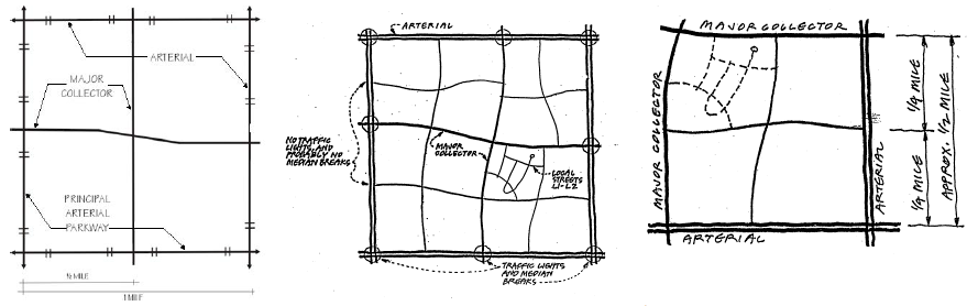
Figure 5.1-1. Required street layouts
(C)
As an alternative to complying with the through street requirements of subsection (B) above, the applicant may prepare a connectivity index calculation that divides the number of street segments within the plat (i.e. sections of streets between intersecting streets) by the number of intersections within and at the boundaries of the plat to achieve a connectivity index of 1.65 or more. An example of a connectivity index calculation is shown in Figure 5.1-2 below.
(D)
Straight streets more than eight hundred (800) feet long shall be avoided to discourage speeding, but may be approved by the director in the event a shorter street is impracticable due to terrain or other unique site constraints.
(E)
Individual local residential street segments should serve no more than thirty (30) dwelling units without additional street connections unless otherwise permitted for by this chapter.
(F)
Cul-de-sacs and loop (U-shaped) streets should not exceed three hundred (300) feet in length but may be approved in unique circumstances to avoid steep slopes, major creeks, floodplains, wetlands and other sensitive environmental areas.
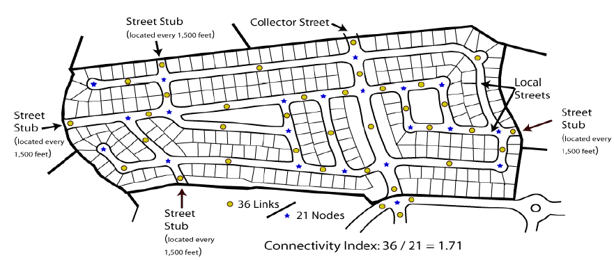
Figure 5.1-2: Connectivity Index
(G)
Where a subdivision abuts or contains an existing arterial street or highway having limited access, lots abutting such roadways shall be arranged such that the rear yards abut the arterial street or highway, or access to such lots is provided from an adjacent frontage road or other street design which provides for adequate protection of residential properties, affords separation of through and local traffic, provides a safe route for all modes of transportation, and provides for suitable access to the property involved.
(H)
When a new subdivision adjoins unplatted or undeveloped land, the new streets shall be carried to the boundaries of such land unless vehicular access is unnecessary or inappropriate due to existing or proposed development with incompatible traffic generation on the adjacent platted or unplatted lands or designation of sensitive areas. A temporary turnaround approved by the director of public works shall be installed at the point where the properties connect, except when the terminus of the street is less than one hundred fifty (150) feet from an intersecting street right-of-way.
(I)
Where street connections to adjoining land are not provided and there is a need for non-vehicular public access to a school, park, trail or other area or use, the city may require the dedication and improvement of a green space access easement or trail easement to serve the needs of the proposed development. Whenever such public improvements are required, the city shall accept ownership and maintenance in the form of fee title or an easement, as determined in the best interest of the public.
(J)
Permanent terminal streets shall not be longer than seven hundred fifty (750) feet, measured from the center of any cul-de-sac to the right-of-way line of the nearest through street from which it derives.
(K)
Four-way intersections of local streets will be platted and constructed according to the standards set forth in appendix A unless otherwise approved by the director of public works.
(ii)
Blocks. Streets shall intersect at intervals not exceeding six hundred (600) feet or less than two hundred fifty (250) feet. Blocks shall have sufficient depth to provide for two (2) tiers of lots of appropriate depth. The director may approve exceptions to block depth when blocks are adjacent to major streets, railroads, waterways, or other sensitive environmental areas (e.g., steep slopes, waterways).
(4)
Widths.
(i)
The right-of-way width required to be dedicated and the pavement width required to be constructed for streets shall comply with the standards in appendix A for each street classification.
(ii)
Proposed subdivisions that include existing street right-of-way narrower than required by appendix A shall provide for dedication of additional right-of-way width along one or both sides of the street. Proposed subdivisions abutting only one side of such streets shall provide for dedication of additional right-of-way width to constitute one-half (½) of the right-of-way width required.
(5)
Grades.
(i)
The grades of streets shall comply with the standards and design criteria in appendix A.
(ii)
Where it is impracticable to comply with the standards set forth in appendix A, written approval to deviate from the specific standards which cannot be met must be obtained from the director of public works, who shall make a determination as to whether the requested deviation is necessary and consistent with protection of the public and traffic safety.
(6)
Curves. Curves shall comply with the design criteria in appendix A unless the director of public works determines that a more restrictive requirement is necessary to safeguard the public health, safety and general welfare from potentially hazardous street design.
(7)
Alleys.
(i)
Residential alleys shall be permitted in all residential districts.
(ii)
Nonresidential alleys shall be provided in mixed use and special districts when off-street loading and parking are not otherwise provided.
(iii)
The right-of-way width of an alley shall be twenty (20) feet and the pavement width shall be sixteen (16) feet, except in the M-DT district, where alley improvements and new alleys should be designed in accordance with the M-DT district alley cross-section in appendix A, when feasible.
(iv)
When alleys intersect, the intersection right-of-way lines shall be rounded by a curve with a radius of at least five (5) feet in length.
(8)
Transportation impact analysis. The city may require that a transportation impact analysis (TIA) be prepared as part of the approval process for any new development. An estimate of the trips generated by a proposed development will be completed to determine if a TIA is required. Any proposed development that would produce one hundred (100) or more trips in and out of the development site at peak hour shall be required to submit a TIA in accordance with the provisions contained in the UDC Administrative Manual. The purpose of the TIA is to estimate the traffic impacts created by the new development on the surrounding street system. Any significantly adverse traffic impacts identified in the TIA must be mitigated by the applicant.
(d)
Sidewalks.
(1)
Applicability.
(i)
The following standards apply to any subdivision that receives final plat approval after the effective date of this chapter and any subdivision platted before 2001 that is less than twenty-five (25) percent built-out. Any subdivision platted before 2001 and built-out by twenty-five (25) percent or more shall complete construction in accordance with the sidewalk standards in place at the time of final plat approval.
(ii)
Undeveloped lots shown on subdivision plats that received final approval before January 1, 2001 shall install sidewalks in compliance with the city street and storm sewer specifications and design standards now applicable or later issued by the director of public works or adopted by the council, along their respective street frontage(s), unless otherwise specified in this chapter.
(2)
Standard requirements.
(i)
No permit shall be issued for the construction of a new building or additions to buildings on property located on an arterial or collector street unless:
(A)
A sidewalk exists adjacent to the property along the arterial or collector street; or
(B)
The plans for the building provide for the construction of such a sidewalk; or
(C)
Otherwise specified as a note on the plat or in a performance contract between the developer and the city.
(ii)
The requirements of subsection (i) do not apply to construction of accessory buildings.
(iii)
No certificate of occupancy shall be issued for any building described in subsection (i) if the building plans provide for construction of a sidewalk along an arterial or collector street unless the sidewalk has been constructed or the property owner has provided a bond, letter of credit or other instrument acceptable to the director of public works guaranteeing construction of the sidewalk within six (6) months of issuance of the certificate of occupancy.
(iv)
Sidewalks are not required along streets classified as freeways.
(v)
Sidewalks shall be required on both sides of expressways and frontage roads unless the council determines that potential or existing pedestrian volumes do not necessitate sidewalks to safeguard the public health, safety and general welfare.
(vi)
Sidewalks shall be constructed within all pedestrian easements and on both sides of all internal streets and on the abutting side of any adjacent street unless otherwise specified in this UDC.
(vii)
A sidewalk shall not be required along a residential access street that is less than two hundred fifty (250) feet in length and terminates in a cul-de-sac. Sidewalks shall be a minimum of five (5) feet in width along all other streets.
(viii)
Where a final plat creates a common lot or a non-buildable lot, a sidewalk shall be constructed along the portion of each street abutting the lot at the same time the abutting street is constructed or within three (3) years of such lot being created when such lots abut an existing street. No street shall be accepted for public maintenance upon which a common lot or non-buildable lot fronts without first having such sidewalk located adjacent to such lot being installed. This subsection shall not apply to any subdivision that received final plat approval before January 1, 2006.
(ix)
Sidewalks shall be constructed to comply with the standards contained in this section 29-5.3(d)(2) and with the city design standards and specifications established by the director of public works or adopted by the council.
(x)
Whenever a permit is issued to construct, reconstruct, repair, alter or grade any sidewalk curb, curb cut, driveway or street, handicapped ramps shall be required to be installed in accordance with design standards included in the city's standard plan and specifications at all curb and driveway crossings to be constructed, reconstructed, repaired or altered; provided, that the director of public works may waive said requirement if he determines that requirement of handicapped ramps is impractical under all the circumstances.
(xi)
The council may require a sidewalk to be constructed to standards higher than the minimum standards of this section 29-5.1(d)(2) provided that the city compensate the property owner for the additional cost of constructing the sidewalk.
(e)
Bike lanes and pedways. Bicycle lanes and pedways shall be designed and constructed in accordance with appendix A and all applicable design standards and specifications promulgated by the director of public works or adopted by council.
(f)
Lots.
(1)
Lot arrangement. Lots shall be arranged to comply with building permit requirements of this chapter as to minimum size and width in the zone district where the property is located, as well as access, relation to topography, provision of utility service, or other conditions specified in this chapter or in other standards and specifications adopted by the city. Lots in subdivisions that qualify for the solar access density bonus in section 29-4.1(b)(2) or the cluster subdivision density bonus in section 29-4.1(b)(3), and lots that are organized to avoid sensitive lands as described in section 29-5.1(b) shall comply with the minimum lot size and width in the zone districts where the lots are located, as adjusted by the provisions of those sections of this chapter.
(i)
Corner lots. Corner lots shall have sufficient width for compliance with front and side yard building setback requirements set forth in this chapter.
(ii)
Side lot lines. Side lot lines should generally be at right angles to straight streets and radial to curved streets.
(iii)
Tier lots (aka flag lot or stem lot). The commission may allow tier lots on previously unplatted land when the following criteria are met:
(A)
Tier lot design is the only feasible means to access lots due to extreme topographic conditions;
(B)
The stem of a tier lot, that is, the portion of the lot which connects its required yard area and its buildable area with its public access, shall not be less than twenty (20) feet nor more than fifty-nine (59) feet in width and not shorter than twenty-five (25) feet nor longer than two hundred fifty (250) feet in length and may not be included within any required yard area set forth in this chapter; and
(C)
The allowance of tier lots will not endanger the public health, safety and general welfare.
(iv)
Frontage.
(A)
Except as otherwise provided and specifically authorized under this chapter, all lots, tracts or parcels shall have actual frontage upon a street, which provides direct vehicular access to the lot. In context sensitive situations (e.g., topography, existing or proposed development patterns) where actual street frontage is not feasible, the director may permit a lot with an irrevocable access easement suitable to the city counselor, or designee, rather than actual street frontage, if the public health, safety, and general welfare is not compromised.
(B)
Common lots for the purposes of storm water management features may be created without having actual street frontage provided that such lots have an established means of ingress/egress by an irrevocable access easement suitable to the city counselor, or designee.
(C)
Common lots created for recreational purposes (active or passive) shall have a minimum of twenty (20) feet of street frontage. Such frontage may be actual lot frontage or provided through an irrevocable access easement suitable to the city counselor, or designee.
(D)
Newly platted or re-subdivided non-residential lots that propose direct driveway connection to an arterial or collector street shall have a minimum of three hundred (300) feet of frontage along the street right-of-way. Shared access for parking and driveways may be required to promote internal development connectivity.
(v)
Shape. Lots in mixed use or special zone districts shall not be created with protrusions, extensions or stems of less than thirty (30) feet in width.
(2)
Lot access.
(i)
Each lot shall have access allowing vehicles, pedestrians, and bicycles to pass from a public street directly onto the lot, or from a public street to the lot over an irrevocable access easement approved by the city counselor, or designee.
(ii)
A maximum of thirty (30) lots or units shall be permitted to be accessed from a single point of ingress/egress unless otherwise specified by the most current adopted edition of the International Fire Code or authorized by the City of Columbia Fire Department.
(iii)
Private residential driveways are prohibited on arterial or collector streets unless the director determines that no alternative access is practicable.
(iv)
Non-residential driveway spacing shall conform to the provision of the most current edition of the Missouri Department of Transportation Access Management Guidelines or access management standards promulgated by the city.
(v)
Streets that dead-end or "stub" into property that is adjacent to the property being subdivided shall not count as a second access until such time as the dead-end or "stub" street is connected to a through street and constructed to city standards.
(3)
Lot lines. No building or structure shall be constructed across an existing lot line, except surface parking areas when such surface parking area is not prohibited from being constructed across an existing lot line by any other section of the city code.
(4)
Lot combination. No lot in any existing subdivision may be combined with another lot without complying with the requirements of section 29-5.2.
(g)
Public improvements.
(1)
Standards and specifications. All required public improvements, including but not limited to streets and utilities, shall be installed or constructed in accordance with the procedural requirements in section 29-5.2, or in related public improvements standard specifications or policies established by the city department or other entity responsible for the design, operation, or maintenance of that type of improvement.
Upon notice that the improvements have been completed in accordance with the city's requirements, the designing engineer shall, under his seal and signature, submit as-built tracings for the street, storm sewer and sanitary sewer construction.
(2)
Drainage and storm sewers.
(i)
Flood-prone areas. Any portion of land being subdivided that is located within the limits of maximum flooding of the one hundred (100) year flood, as determined by the Boone County Digital Flood Insurance Rate Map (DFIRM), released March 17, 2011, and amendments to that map on file with the director, shall be developed so as not to endanger the health, safety and general welfare of the inhabitants of the city, and in compliance with the provisions of this chapter.
(ii)
Storm sewers. Storm sewers with curbs and gutters shall be provided for lots unless the director of public works approves open channels with design features, such as vegetated swales and check dams to reduce runoff velocity and allow infiltration. Sidewalks and pedways shall not be located between the street and open channel. Improvements shall conform to standards contained in the city street and storm sewer specifications and design standards, and the city storm drainage standards, and all applicable design standards and specifications promulgated by the director of public works or adopted by the council.
(iii)
Driveways across drainage features. Driveways that cross drainageways or ditches, to connect to public streets, shall be constructed as required by the director of public works to protect traffic safety and avoid traffic congestion.
(iv)
Streets crossing streams. Streets that cross streams shall be designed and constructed to minimize the disruption to the stream channel and buffer zone. Streams should be crossed only when necessary to connect the street network.
(3)
Street trees. Notwithstanding the provisions of section 29-4.4(b), installation of street trees shall comply with the provisions of section 29-4.4(d)(2).
(4)
Utilities. Utilities, including but not limited to water, sewer, natural gas, electric and telephone lines, and fire hydrants, shall be provided to lots in accordance with standards and specifications governing the construction and installation of such utilities adopted by council or promulgated by the city departments or utility companies responsible for those utilities.
(5)
Easements.
(i)
Generally. Easements for public and private utilities shall be provided abutting all street right-of-way and in other locations in accordance with facility requirements and design standards. To the maximum extent feasible, utilities shall be located in designated easements and not in the street right-of-way.
(ii)
M-DT district easements. The dedication of easements abutting rights-of-way in the M-DT district may conflict with buildings constructed at the required building line (RBL). For property in the M-DT district, the dedication of a ten (10) foot utility easement along right-of-way is not mandatory; however, may be required by the city if it is found that there is insufficient area within existing street or alley rights-of-way to allow for the adequate provision of current and future city services and facilities.
(Ord. No. 23524, § 1, 5-7-18; Ord. No. 24562, § 1, 3-1-21; Ord. No. 25182, § 1, 11-7-22)
Sec. 29-5.2. - Subdivision of land procedures.
(a)
Applicability.
(1)
The provisions of this section 29-5.2 shall apply to all divisions of land within the city into new or different lots for development, except as noted in subsection (2) below or as exempted by state or federal law or court decisions interpreting those laws.
(2)
A transaction involving the sale or exchange of small tracts or parcels of land to or between adjoining properties where such sale or exchange does not create additional lots or parcels for development does not reduce any area designated as a common lot or as common ground on a plat and does not otherwise violate this chapter shall be exempt from the requirements of this section 29-5.2. Transactions involving the sale or exchange of tracts or parcels of land which increase or decrease the total square footage of either the conveying or receiving lot by more than three (3) percent shall not be considered "small" for the purposes of this subparagraph. Small area transfers shall not involve any land which has been included in an approved preliminary plat but not final platted.
(b)
General provisions.
(1)
No street shall be constructed nor shall any street be accepted or maintained by the city, nor shall any street lighting, water or sewer service be extended to or connected, nor shall any building, electrical, plumbing, occupancy or other permit or license be issued for the construction of any building or improvement on land which does not meet the definition of "lot" in section 29-1.11. This requirement shall not apply to alterations of existing buildings that increase the gross floor area or building footprint by less than ten (10) percent of the existing footprint.
(2)
All persons are hereby notified of the existence of the comprehensive plan of the city, as amended, and of any sites or areas within any proposed subdivision that may be designated on the comprehensive plan, as amended, as sites or areas for possible acquisition by condemnation or purchase by the city for public uses and purposes.
(3)
The council may allow the subdivider to place notes on the plat that are explanatory or that impose obligations on the property owner or that restrict use of the property. Obligations and restrictions set forth in notes on a plat may be eliminated only by ordinance or resubdivision, and such obligations and restrictions shall not be eliminated unless the council determines that the elimination will not be detrimental to any land in the subdivision, to any neighboring property, or the general public health, safety, and general welfare of the city.
(4)
The proposed name of the subdivision shall not duplicate or sound like the name of any other subdivision, any existing or platted street, or any established business or development in Boone County.
(5)
The criteria for approval of a major, minor, or administrative subdivision is whether the proposed preliminary or final plat conforms to this chapter, the comprehensive plan, and to all other city ordinances and regulations.
(6)
An application for subdivision of land shall include all land that the subdivider proposes to subdivide. All contiguous unplatted land, up to 80 acres, under single ownership or control shall be included as part of the preliminary plat. Nothing herein is intended to limit a subdivider from platting more than eighty (80) acres.
(7)
An application for a final plat shall:
(i)
Include either the entire subdivision, or a section thereof, which derives access from an existing road;
(ii)
Be in substantial compliance with the preliminary plat, as approved;
(iii)
Be accompanied by final construction plans for the requisite public improvements, drawn under the supervision of a registered professional engineer and attested to by his signature and seal, all in accordance with the applicable standards; and
(iv)
Be accompanied by an improvements guarantee offered for acceptance by the Council, in a form satisfactory to the city counselor, or designee.
(8)
Any request for deviation from the subdivision standards of section 29-5.1 shall be included in the preliminary plat application as a request for a "design adjustment". A recommendation on any request for design adjustment shall be made by the director and the commission, and shall be decided by council, simultaneously with review and final decision on the plat.
(9)
If a design adjustment is requested, the director or commission may recommend approval of the design adjustment if it determines that the following criteria have been met, and the council shall consider these criteria in making a decision on the requested design adjustment:
(i)
The design adjustment is consistent with the city's adopted comprehensive plan and with any policy guidance issued to the department by council;
(ii)
The design adjustment will not create significant adverse impacts on any lands abutting the proposed plat, or to the owners or occupants of those lands;
(iii)
The design adjustment will not make it significantly more difficult or dangerous for automobiles, bicycles, or pedestrians to circulate in and through the development than if the subdivision standards of section 29-5.1 were met;
(iv)
The design adjustment is being requested to address a unique feature of the site or to achieve a unique design character, and will not have the effect of decreasing or eliminating installation of improvements or site features required of other similarly situated developments; and
(v)
The design adjustment will not create adverse impacts on public health and safety.
(c)
Procedure.
(1)
Sequence of subdivision process.
(i)
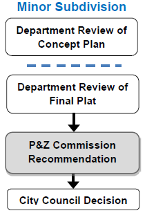
An applicant for a minor subdivision shall apply for and secure approval of the proposed subdivision through a two-step process including: (1) concept review, and (2) final plat.
(ii)
An applicant for a major subdivision shall apply for and secure approval of the proposed subdivision through a three-step process including: (1) concept review, (2) preliminary plat, and (3) final plat.
(iii)
An applicant for an administrative subdivision shall apply for and secure approval of the proposed subdivision through a one-step process including: (1) administrative plat approval.
(iv)
A tract split is an alternative to subdivision which is intended to allow for the initial division of large tracts of land and requires completion of the subdivision process (preliminary and final platting) prior to development of the property. An applicant for a tract split shall apply for and secure approval of the split through a two-step process including: (1) concept review, and (2) tract split.
(2)
Coordination with PD zoning. Whenever a proposed development plan for a PD district requires a subdivision of land, approval of the subdivision of land shall be required in addition to approval of the PD district and development plan. Subdivision review may be carried out simultaneously with the review of the development plan, and the required information may be included in a single document that serves as both a development plan and a preliminary plat, as described in the following procedure:
(i)
An application for approval of a development plan for a PD district shall include all information normally required for submission and approval of a preliminary subdivision plat.
(ii)
Commission review and recommendation of the preliminary plat shall be accomplished at the time of, and as a part of, its review and recommendation of the PD development plan.
(iii)
Approval of the PD development plan shall constitute approval of the preliminary subdivision plat.
(3)
Procedures by platting action.
(i)
Concept review. Before preparing the preliminary plat of a major subdivision or the final plat of a minor subdivision, the subdivider shall discuss with the director the procedure for adoption of a subdivision plat and the requirements for general layout of streets, reservations of land, street improvements, drainage, sewerage, fire protection, utilities, the availability of existing services, and other similar requirements of this chapter or other city ordinances or regulations. The director shall also advise the subdivider, when appropriate, to discuss the proposed subdivision with those city officials who must recommend approval of certain aspects of the subdivision plat coming within their jurisdiction. The geographic scope of the review shall include the whole property held in common ownership for which whole or partial subdivision platting is desired by the subdivider, as well as the surrounding property that might reasonably be affected by subdivision of the subject property. The concept review is an informal discussion made available to the subdivider, and the subdivider may, after meeting with the director, proceed to prepare and submit a preliminary plat for a major subdivision or a final plat for a minor subdivision.
(ii)
Preliminary plat.
(A)
The director shall refer each application for approval of a preliminary plat to the appropriate city departments, together with an indication of its tentative agenda placement before the commission, and shall receive reports from other departments as to the conformance of the proposed plat with this chapter and other city ordinances and regulations. If a design adjustment has been requested, the departments may comment on the proposed design adjustment.
(B)
The director shall request the subdivider to make such changes to the plat as are necessary to comply with this chapter and other city ordinances and regulations, or to address any adverse impacts of a proposed design adjustment.
(C)
The director shall forward the plat to the commission and advise the commission of the conformance or nonconformance of the plat with this chapter and other city ordinances and regulations. If a design adjustment has been requested, the director may advise the commission on any potential impacts of the requested design adjustment.
(D)
The commission shall hold a public meeting on the preliminary plat and shall make a decision to recommend the plat (including any requested design adjustments) to council for approval, conditional approval, or denial. The applicant shall be advised in writing of the commission's recommendation.
(E)
Within sixty (60) days after submission of a completed application for approval of a preliminary plat to the commission, the commission shall recommend approval or disapproval of the plat to the council, otherwise the plat is deemed a recommendation for approval by the commission (including any requested design adjustments), except that the director or commission, with the consent of the subdivider, may extend the sixty-day period.
(F)
The council shall take action on the preliminary plat by resolution; however, an ordinance shall be required if any design adjustments have been requested. If the commission has recommended denial of the preliminary plat, the council, by a vote of not less than two-thirds of its entire membership, may overrule the disapproval. The council shall take action on an application for approval of a preliminary plat within forty-five (45) days after submission of a commission recommendation, otherwise the recommendation of the commission shall be deemed to be the recommendation of the council.
(G)
Approval of a preliminary plat by the council shall confer upon the applicant for a period of five (5) years, beginning at the effective date of council approval, the following rights:
1)
The terms and conditions under which the preliminary plat was given approval shall not be changed except as required in subsection 3) below.
2)
The subdivider may submit on or before the expiration date a final plat for the whole or any part of the subdivision for approval.
3)
Each final plat for land included in the preliminary plat application shall comply with any new technical or engineering standards or requirements adopted by council between the date of the preliminary plat approval and the date of each final plat application for land included in the preliminary plat.
4)
If the subdivider fails to submit a combined total of one-fourth (¼) of the preliminarily approved lots (in either a single or multiple) final plats before the expiration date, the preliminary plat approval shall expire and be of no force or effect.
5)
The director may grant a one-year extension if no change to a city ordinance would require a change in the plat. Appeal for an adverse decision shall be made to the council. Any subsequent extensions shall be made to council for a specified period on such terms and conditions as the council may approve.
(iii)
Final plat. Following the approval of the preliminary plat of a major subdivision or completion of the concept review for a minor subdivision, the subdivider may file an application for final plat approval in order to complete the subdivision process. The application shall be in substantial compliance with the approved preliminary plat.
(A)
For a minor subdivision:
1)
The director shall refer the application for approval of a final plat to the appropriate city departments, together with an indication of its tentative agenda placement before the council, and shall receive reports from the departments as to the conformance of the proposed plat with this chapter and other city ordinances and regulations. If a design adjustment has been requested, the departments may comment on the proposed design adjustment.
2)
As a result of review by the other departments, the director shall request the subdivider to make such changes necessary to cause the plat to be in conformance with this chapter and other city ordinances and regulations. If a design adjustment has been requested, the director may advise the commission on any potential impacts of the requested design adjustment.
3)
The commission shall make a decision to recommend the plat (including any requested design adjustments) to council for approval, conditional approval, or denial. The subdivider shall be advised in writing of the commission's recommendation.
4)
The council shall take action on the plat (including any requested design adjustments) by ordinance within sixty (60) calendar days after its submission to the council, and failure of the council to act within that time period shall be deemed approval, except that the director or council may extend the sixty-day period to a stated future date with the consent of the subdivider. If the commission has recommended denial of any requested design adjustments, the council, by a vote of not less than two-thirds (⅔) of its entire membership, may overrule the denial.
(B)
For a major subdivision:
1)
The director shall refer the application for approval of a final plat (including any requested design adjustments) to the appropriate city departments, together with an indication of its tentative agenda placement before the council, and shall receive reports from the departments as to the conformance of the proposed plat with this chapter and other city ordinances and regulations. If a design adjustment has been requested, the departments may comment on the proposed design adjustment.
2)
As a result of review by the other departments, the director shall request the subdivider to make such changes necessary to cause the plat to be in conformance with this chapter and other city ordinances and regulations. If a design adjustment has been requested, the director may advise the commission on any potential impacts of the requested design adjustment.
3)
When a subdivider has requested a design adjustment in conjunction with a request for major subdivision approval, the commission shall make a recommendation on the adjusted plat to council for approval, conditional approval, or denial. If there are no requested design adjustments, the plat shall be submitted directly to the city manager for council consideration. The subdivider shall be advised in writing of the commission's recommendation on the adjusted plat.
4)
The director shall forward the plat to the city manager for council consideration and advise the council as to its conformance or nonconformance with this chapter and other city ordinances and regulations.
5)
The city manager shall certify to the council whether the final plat is in accordance with the approved preliminary plat, whether the subdivider has requested any design adjustments which have been considered by the commission, and whether all conditions precedent established by the council have been met.
6)
Following certification by the city manager to the council, the council shall take action on the final plat (including any requested design adjustments). The council shall take action by ordinance on the final plat within sixty (60) calendar days after its submission to the council, and failure of the council to act within that time period shall be deemed approval, except that the council may extend this period to a stated future date with the consent of the subdivider. If the commission has recommended denial of any requested design adjustments, the council, by a vote of not less than two-thirds (⅔) of its entire membership, may overrule the denial.
(iv)
Signing and recording. After council approval of a final plat, the mayor shall affix his signature thereto, and this shall be attested to by the city clerk, and the seal of the city affixed thereto. It shall be the responsibility of the city clerk to file the plat with the office of the county recorder of deeds. Simultaneously, the city clerk shall cause to be recorded all other documents required to be recorded with the plat, pursuant to council approval and as determined by the city counselor, or designee.
(d)
Resubdivision or replat.
(1)
Applicability. A change to an approved or recorded final plat shall require resubdivision. Only that portion of the plat being changed must be resubdivided. If approved, the applicant shall be required to prepare a revised final plat and the city clerk shall record the revised final plat before the revisions shall be in effect.
(2)
Procedure for a major subdivision.
(i)
If the director determines the proposed resubdivision is in substantial conformance with a valid approved preliminary plat, the subdivider shall apply for and secure approval of a revised final plat from council.
(ii)
If the director determines that proposed resubdivision is a substantial change from the approved preliminary plat, the subdivider shall apply for and secure approval of a revised preliminary plat from the commission, and then approval of a final plat from council, to complete the resubdivision. At the subdivider's option, the preliminary and final plat documents may be submitted at the same time and may be reviewed and considered for approval by council at the same time.
(3)
Procedure for a minor subdivision. The subdivider shall apply for and secure approval of a revised final plat from council, to complete the resubdivision.
(4)
Criteria for approval. A resubdivision of land shall only be approved by the council if the council determines that:
(i)
The resubdivision would not eliminate restrictions on the existing plat upon which neighboring property owners or the city have relied, or, if restrictions are eliminated, the removal of such restrictions is in the best interest of the public;
(ii)
Adequate utilities, storm drainage, water, sanitary sewer, electricity, and other infrastructure facilities are provided to meet the needs of the resubdivision, or, there will be no adverse effect on such infrastructure facilities caused by the resubdivision; and
(iii)
The replat would not be detrimental to other property in the neighborhood, or, if alleged to be detrimental, the public benefit outweighs the alleged detriment to the property in the neighborhood.
(5)
Administrative plat.
(i)
Applicability. The subdivider may file an administrative plat with the director, if the plat meets the following criteria:
(A)
The plat does not create, vacate, or change the location and/or size of streets;
(B)
The plat does not create any additional residential lot or mixed use lots that will contain residential uses;
(C)
The plat does not combine more than two (2) lots;
(D)
The plat does not create any lot, when lots are combined, that results in more than one hundred twenty (120) feet of a lot line along any one (1) street;
(E)
The plat does not alter any area reserved for public use or any area designated as a common lot; and
(F)
The plat does not eliminate any condition imposed by council.
(ii)
Procedure.
(A)
The director may approve the administrative plat if the director determines that the revised lots and application materials, including but not limited to any utility construction documents, easements, and performance guarantees, have been approved and comply with this chapter and all other city ordinances and regulations.
(B)
On approval of the administrative plat, the director shall sign the plat and cause it to be recorded with the recorder of deeds.
(C)
No occupancy permit shall be issued for property included in the administrative plat unless and until the requirements of this section are met and all required utility work is completed.
(D)
In the event the director does not approve the administrative plat, the applicant may then prepare and submit an application for a minor or major resubdivision.
(e)
Reserved.
(f)
Tract split.
(1)
Applicability. The tract split procedure is intended to simplify the orderly subdivision of large tracts of land for separate parcel sale through an administrative approval process. Preparation of a formal subdivision plat, commission review, and council approval are not required for a tract split, but will be required when the parcels resulting from a tract split are further divided into individual lots or prior to development.
(2)
Procedure.
(i)
The director shall complete a concept review of the application and consult with other city departments and public or quasi-public agencies as he may deem necessary to confirm compliance with this chapter and other city ordinances and regulations.
(ii)
The director shall approve or disapprove the request, and notify the subdivider in writing of the decision, within fourteen (14) calendar days after application filing.
(iii)
If the director determines that the application does not qualify for approval as a tract split, the application shall be treated as a minor or major subdivision, depending on the number of parcels being created and the need for improvements or dedication of land.
(iv)
The director, on approval of a tract split, shall certify to the recorder of deeds that the tract split survey complies with all the provisions of this chapter.
(v)
Except as otherwise provided in this chapter, no permit for street or utility extension, nor permit for building development shall be issued for any of the parcels resulting from an approved tract split unless or until such parcel or portion of a parcel has been approved as a major or minor subdivision.
(3)
Criteria for approval. The director may approve a tract split if the director determines that the following criteria have been met:
(i)
The property shall be divided into not more than five (5) parcels.
(ii)
Adequate provision has been made for future subdivision of the resulting parcels for development, for the opening of future streets to serve the parcels, and for the extension of utilities or related public improvements and facilities, as required by the procedures, and subject to the standards and criteria, in this chapter.
(iii)
The resulting parcel configuration does not adversely affect development of the balance of the tract or parcels, or of adjoining properties, and does not conflict with any provision of the comprehensive plan, this chapter, or other city ordinances or regulations.
(g)
Monuments.
(1)
Monuments shall be selected from the types described by the "Missouri Standards for Property Boundary Surveys" of the Missouri Board for Architect, Professional Engineers, Professional Land Surveyors, and Professional Landscape Architects.
(2)
Monuments shall be set or confirmed at all controlling corners on the boundary of the subdivision and all block corners, points of intersections, points of curvature and points of tangency within the subdivision.
(3)
On an individual lot within a subdivision, monuments shall be set or confirmed at all the corners of the lot.
(h)
Completion and dedication of improvements.
(1)
Requirement. The subdivider shall be required to complete all public improvements and utilities required by the council, and upon completion shall dedicate such public improvements and utilities to the city, free and clear of all liens and encumbrances on the property, unless the existence of such liens and encumbrances are approved by the city. The subdivider shall construct and complete all required public improvements and utilities before approval of the final plat unless the subdivider provides adequate security to ensure completion of the subdivision improvements as set forth herein.
(i)
If completion and dedication of improvements and utilities as described in subsection (a) above has not been completed prior to final plat approval, the Council may require a surety bond, escrow secured with cash, irrevocable letter of credit deposited with the city, or performance agreement to secure actual construction and installation of the improvements and utilities to be completed within a reasonable period specified by the council and expressed in the bond or other security, in an amount and with reasonable conditions satisfactory to the council.
(ii)
All required public improvements, including but not limited to streets and utilities, shall be installed or constructed in accordance with the design standards and requirements in this chapter and set forth in related public improvements standard specifications or policies established by the city departments charged with responsibility for those improvements.
(iii)
Required improvements shall be inspected during construction and installation to ensure satisfactory completion of those improvements, in accordance with inspection requirements adopted by the council or by the city departments charged with responsibility for those improvements.
(iv)
Approval of a final plat, and acceptance of improvements shown on that plat by the council, shall not prevent the council from causing public improvements to be enhanced, enlarged or upgraded, in order to accommodate a higher level of service demand resulting from any subsequent change in the use of land within the subdivision, whether by benefit assessment, agreement among the parties or by such other mechanism as may be available now or may subsequently become available to the council.
(2)
Failure to complete improvements. If any improvement or utility is not completed or installed and duly accepted for dedication within the time period specified in the performance agreement or other security instrument, either by reason of incompletion or by reason of substandard construction, the council may, at its option:
(i)
Declare any bond or other approved security instrument to be forfeited, pursue legal and equitable action to obtain necessary funds from the sureties, and cause satisfactory completion and installation of all improvements and utilities previously required;
(ii)
Declare an applicable improvements guarantee agreement to be breached and pursue legal and equitable action to cause satisfactory completion and installation of the improvements and utilities;
(iii)
The council may extend the time limit set for satisfactory completion of the improvements and utilities for one year upon the request of the subdivider and showing of a reasonable necessity for such extension. The council may approve no more than three (3) one-year extensions, and may approve no extension without a reasonable showing of the necessity for the extension. In the event that an extension of the time limit is granted, the council may require further financial assurances for completion in the form of a performance bond or other acceptable security instrument; or
(iv)
Pursue any legal or equitable action necessary to ensure satisfactory completion of the improvements or utilities.
(3)
Reduction or release of guarantees. In those cases where a performance bond or other security instrument guarantee has been made to secure construction of public improvements, the amount of guarantee may be reduced upon public acceptance of dedicated portions of the required improvements. The amount of surety shall not be reduced to an amount less than the estimated cost of constructing the required improvements which have not yet been accepted by the city. In no case shall the amount retained by the city be less than five (5) percent of the original amount, pending completion and acceptance of all of the required improvements. Upon acceptance of the dedication of the final portion of the improvements, the city shall authorize the release of the remaining portion of the improvements guarantee.
(Ord. No. 24563, § 1, 3-1-21; Ord. No. 24564, § 1, 3-1-21; Ord. No. 25183, § 1, 11-7-22)