
Columbia City Zoning Code
APPENDIX A
STREET STANDARDS
Sec. A.1. - Design standards for streets, sidewalks and bikeways.
(a)
Purpose and intent.
(1)
The 2025 Transportation Plan established a functional classification system consisting of major arterials, minor arterials, major collectors and neighborhood collectors. In developing new design standards, it was determined that local residential and local non-residential streets should also be included. This provides for an integrated street system.
(2)
A roadway system must balance the conflicting goals of traffic movement and access to land. Arterials are primarily for the movement of through traffic; collectors provide equal attention to land access and through traffic; and local streets provide access to individual parcels of land at the expense of through traffic. Selecting the proper roadway design for each functional classification is vital to development of a system of roadways which provides the needed connectivity between all areas of the city as well as the capacity to handle future traffic volume.
(3)
Design elements encompassing right-of-way width, pavement width, number of travel lanes, bike lane width, use of curb and gutter, sidewalk and pedway width, parking, driveways, buffer strip width, and utility easements must be appropriately selected to provide the function, character, traffic volume and speed desired.
(4)
Major streets serve a development pattern that ranges from low density residential to intensely developed commercial centers and corridors. To meet such varied conditions and address neighborhood livability factors requires an array of design approaches. A "one standard fits all" is not consistent with traffic needs or the wide variety of situations encountered.
(5)
In several of the street types, an alternative design will be considered or may be required when conditions specified in the standards are found to exist. This language was drafted specifically to allow a design appropriate for the land use and traffic conditions being created by a proposed development. The alternative design may be requested by the developer or recommended by city staff or the commission. Criteria are included to provide guidance in selecting the proper street design to match the expected conditions. If the alternative design exceeds the standard design for a particular street type, it shall be presumed to satisfy these requirements. In all other cases, the final decision shall rest with the council.
(b)
Application of design standards.
(1)
The design standards are intended to result in a more predictable and acceptable outcome for street improvements. Due to the wide range of circumstances, however, the standards need to be applied with a certain amount of flexibility. Street construction activity consists of building completely new streets as well as making minor improvements to existing streets. Many existing streets will not be changed at all in the next several years while others will be candidates for additional lanes, intersection reconfiguration, or major reconstruction. Unlike new streets, existing streets have physical constraints to being retrofitted to meet new standards due to a narrow right-of-way or the proximity of buildings, utilities or mature trees. Additionally, adjacent property owners often voice concern about more traffic, speeding, noise, storm water runoff, and other issues.
(2)
To deal with the application of design standards, two (2) categories of improvements have been developed. Major projects consist of significant improvements to the street system and the design standards are to be interpreted as requirements. In situations where it is not feasible, practical or desirable for a proposed street improvement to meet the required standards, a design exception may be considered and approved by the council as part of the public hearing process. Major projects include:
(i)
Construction of a new street;
(ii)
Major reconstruction of an existing street (e.g. upgrade to city standards); and
(iii)
Major widening of an existing street (e.g. addition of one or more lanes).
(3)
For minor improvements the design standards are regarded as a guideline rather than an absolute requirement. In such cases, if the standards are not attainable a design exception will not be required. Minor projects include:
(i)
Resurfacing or partial reconstruction of the pavement;
(ii)
Installation of traffic calming devices;
(iii)
Intersection improvements (e.g. traffic signals, turn lanes, etc.);
(iv)
Reconstruction resulting in incidental widening; and
(v)
Installing bike lanes or sidewalks on existing streets.
(4)
Major projects typically entail significant citizen input in evaluating location and design alternatives. Meetings are held with interested parties such as property owners and residents followed by public hearings by the council. Citizen input on minor projects varies.
(5)
Resurfacing usually involves public notice but little citizen involvement whereas traffic calming measures can entail extensive citizen participation in the location and design process.
(6)
In regards to private development, the proposed standards would normally only apply to undeveloped land that is being platted for the first time. The standards could, however, apply to a previously developed area under two (2) circumstances:
(i)
The area is being replatted to create a different street and lot layout for redevelopment and the construction of new buildings; or
(ii)
The area is being rezoned to allow more intensive development (e.g. changing from residential to commercial and thus from residential to non-residential streets).
(7)
Development occurring within the M-DT district shall meet the M-DT urban space standards section below, unless otherwise approved by the director.
(8)
A request for an exception to the design standards may be submitted at the time of preliminary plat review and shall be processed as a variance as provided by the subdivision regulations.
(c)
Local residential street design standards.
(1)
Residential streets provide direct access to residential dwellings and other allowed uses. They should be designed for this intended function and exhibit characteristics which contribute to a safe and attractive living environment. This can be achieved by providing a diversity of street types, each serving a specific role. Right-of-way and pavement widths less than the general standard should provide acceptable levels of access, safety and convenience for all users, including emergency service providers, while enabling enhanced site design and creation of attractive streetscapes. Subdivision layouts should avoid the creation of pass through routes for external traffic while allowing local drivers to move easily to and from higher order streets.
(i)
The design standard for a typical residential street shall be as follows:
(A)
Right-of-way: Fifty (50) feet wide;
(B)
Pavement: Twenty-eight (28) feet wide measured from back of curb;
(C)
Turnarounds: Terminal streets shall have a turnaround at the closed end that complies with the most current City of Columbia adopted edition of the International Fire Code. In no instance shall a terminal street be constructed with an outside right-of-way diameter of less than ninety-four (94) feet and a roadway pavement diameter of seventy-six (76) feet unless otherwise authorized by the fire official and approved by the director of public works;
(D)
Drainage: Curb and gutter system;
(E)
Sidewalks: Five (5) feet wide on both sides constructed one foot inside the right-of-way;
(F)
Parking: Permitted on both sides of the street;
(G)
Buffer strip: Five (5) feet wide with trees permitted in the right-of-way subject to compliance with city policies and regulations; and
(H)
Utility easements: Ten (10) feet on both sides adjacent to the right-of-way. The city and public utility providers will not be responsible for the restoration of any landscaping placed within utility easements that is removed or damaged as a result of constructing, repairing or maintaining public utilities.
(ii)
In place of the typical residential street, a request may be submitted at the time of preliminary plat review for approval of one or more of the following alternative streets:
(A)
A residential feeder will be considered or may be required when one or more of the following conditions exist: 1) the intended use and adjacent zoning allows duplex or multi-family dwellings; 2) the expected average daily traffic (ADT) exceeds five hundred (500); or 3) the street collects localized traffic within a subdivision and leads to a collector or arterial street. A residential feeder shall conform to the following design standards:
1)
Right-of-way: Fifty (50) feet wide;
2)
Pavement: Thirty-two (32) feet wide measured from back of curb;
3)
Sidewalks: Five (5) feet wide on both sides constructed one foot inside the right-of-way;
4)
Buffer strip: Three (3) feet wide with only ornamental trees permitted; and
5)
Other features: Same as a residential street.
(B)
An access street will be considered when all of the following conditions exist: 1) the intended use and adjacent zoning is single-family detached dwellings; 2) the street is no longer than seven hundred fifty (750) feet; and 3) the expected ADT is less than two hundred fifty (250) feet. An access street shall conform to the following design standards:
1)
Right-of-way: Forty-four (44) feet wide;
2)
Pavement: Twenty-four (24) feet wide measured from back of curb;
3)
Turnarounds: Terminal streets shall have a turnaround at the closed end that complies with the most current City of Columbia adopted edition of the International Fire Code. In no instance shall a terminal street be constructed with an outside right-of-way diameter of less than ninety-four (94) feet and a roadway diameter of seventy-six (76) feet unless otherwise authorized by the fire official and approved by the director of public works;
4)
Sidewalks: Same as a residential street, except sidewalks shall not be required on cul-de-sacs less than two hundred fifty (250) feet in length;
5)
Parking: Permitted on one side only; and
6)
Other features: Same as a residential street.
(2)
The design standard for residential alleys shall be as follows:
(i)
Right-of-way: Eighteen (18) feet wide;
(ii)
Pavement: Sixteen (16) feet wide measured from edge of pavement (no curb and gutter);
(iii)
Travel lanes: Two-way traffic allowed;
(iv)
Maximum length: Five hundred (500) feet between connecting streets;
(v)
Parking: Parking in alley prohibited;
(vi)
Setbacks: Garages, carports and open parking spaces shall be set back at least five (5) feet from the right-of-way; and
(vii)
Utility lines: Both overhead and underground utility lines may be installed in the right-of-way.
(d)
Local non-residential street design standards.
(1)
A non-residential street is a low volume, low speed street which provides access to commercial, industrial, institutional, and other intensive land uses. Generally, only two (2) travel lanes are needed. In some cases, these streets may carry considerable truck traffic, require wider driveways for access to loading docks, and have a need for on-street parking. Direct connections to collector and arterial streets are essential.
(i)
The design standard for a non-residential street shall be as follows:
(A)
Right-of-way: Sixty-six (66) feet wide;
(B)
Pavement: Thirty-six (36) feet wide measured from back of curb;
(C)
Turnarounds: Terminal streets shall have a turnaround at the closed end that complies with the most current City of Columbia adopted edition of the International Fire Code. In no instance shall a terminal street be constructed with an outside right-of-way diameter of less than ninety-four (94) feet and a roadway diameter of seventy-six (76) feet unless otherwise authorized by the fire official and approved by the director of public works;
(D)
Sidewalks: Five (5) feet wide on both sides constructed one foot inside the right-of-way;
(E)
Parking: Permitted on both sides of the street;
(F)
Buffer strip: Nine (9) feet wide with trees permitted in the right-of-way subject to compliance with city policies and regulations; and
(G)
Utility easements: Same as a standard residential street.
(ii)
In place of the typical non-residential street, a request may be submitted at the time of preliminary plat review for approval of one or more of the following alternatives:
(A)
An Option A street will be considered when two (2) or more of the following conditions exist: 1) the intended use and adjacent zoning is commercial, light industrial, office, and/or multi-family residential; 2) the expected ADT is less than four thousand (4,000); 3) the street is primarily intended to provide access to property and secondarily to serve through traffic; and 4) there is a nearby collector or arterial street to accommodate future traffic from surrounding land. Option A streets shall conform to the following design standards:
1)
Right-of-way: Sixty (60) feet wide;
2)
Pavement: Thirty (30) feet wide measured from back of curb;
3)
Parking: Not permitted on either side;
4)
Other features: Same as a typical non-residential street.
(B)
An Option B street will be considered when all of the following conditions exist: 1) the intended use and adjacent zoning is office and/or multi-family residential; 2) the street is no longer than seven hundred fifty (750) feet; 3) the expected ADT is less than one thousand (1,000); 4) the street is intended to provide access to property and not serve through traffic; and 5) there is a nearby collector or arterial street to accommodate future traffic from the development of surrounding land. Option B streets shall conform to the following design standards:
1)
Right-of-way: Sixty (60) feet wide;
2)
Pavement: Thirty (30) feet wide measured from back of curb;
3)
Parking: Permitted on one side only;
4)
Buffer strip: Nine (9) feet wide with trees permitted as a typical non-residential street; and
5)
Other features: Same as a typical non-residential street.
(C)
An Option C street will be considered or may be required when two (2) or more of the following conditions exist: 1) the intended use and adjacent zoning is intensive commercial and/or industrial; 2) the expected ADT exceeds four thousand (4,000); 3) the street will serve a significant amount of through traffic; 4) the street will connect to two (2) collector or arterial streets; 5) there will be a significant number of left turns to and from abutting driveways; and 6) there will be a significant amount of truck traffic. Option C streets shall conform to the following design standards:
1)
Right-of-way: Sixty-six (66) feet wide;
2)
Pavement: Thirty-eight (38) feet wide measured from back of curb to provide for two (2) travel lanes thirteen (13) feet wide and a twelve (12) foot two-way center turn lane;
3)
Turnarounds: Terminal streets are not permitted;
4)
Parking: Not permitted on either side; and
5)
Other features: Same as a typical non-residential street.
(e)
Neighborhood collector street design standards.
(1)
A neighborhood collector is intended to collect traffic from surrounding residential areas and connect to major streets; serve local, non-residential land uses such as schools, churches, and parks; and promote neighborhood livability. These streets provide two (2) traffic lanes for shared use by vehicles and bicycles at low to moderate driving speeds (thirty (30) mph), accommodate an ADT volume of one thousand five hundred (1,500) to three thousand five hundred (3,500) vehicles, and generally, connect to only one arterial or major collector street. They may also provide direct access to property and contain on-street parking.
(i)
Two (2) types of neighborhood collector streets are allowed. Either type may be required or proposed provided a statement of justification is submitted for the subject location.
(A)
Option A streets are intended to provide direct access to property and provide some periodic on-street parking for abutting uses. The design standard shall be as follows:
1)
Right-of-way: Sixty (60) feet wide;
2)
Pavement: Thirty-four (34) feet wide measured from back of curb;
3)
Travel lanes: Two (2) travel lanes each thirteen and a half (13.5) feet wide;
4)
Sidewalks: Five (5) feet wide on both sides constructed one foot inside the right-of-way;
5)
Parking: Permitted on one side of the street only. A bulb-out may be built near intersections to create recessed parking, calm traffic and assist pedestrians;
6)
Driveways: Permitted on both sides of the street;
7)
Buffer Strip: Seven (7) feet wide with trees permitted in the right-of-way subject to compliance with city policies and regulations; and
8)
Utility easements: Same as a standard residential street.
(B)
Option B streets are intended to primarily collect neighborhood traffic and not provide direct access to property. The design standard shall be as follows:
1)
Right-of-way: Sixty (60) feet wide;
2)
Pavement: Thirty (30) feet wide measured from back of curb;
3)
Travel lanes: Two (2) shared travel lanes each fifteen (15) feet wide;
4)
Sidewalks: Five (5) feet wide on both sides constructed one foot inside the right-of-way;
5)
Parking/Driveways: Not permitted on either side;
6)
Buffer strip: Nine (9) feet wide with trees allowed as for Option A streets; and
7)
Other features: Same as Option A streets.
(f)
Major collector street design standards.
(1)
A major collector is a mid-volume, multi-modal street (ADT of three thousand five hundred (3,500) to eight thousand five hundred (8,500) vehicles) which collects traffic from several neighborhoods and moves the traffic to the arterial network. These streets provide access to retail centers, office complexes, institutional uses such as colleges and hospitals, and multi-family residential areas. Major collectors typically have two (2) undivided travel lanes with a left turn lane at key intersections. A two-way center turn lane or intermittent raised median may be provided to manage access at high traffic locations. Typically, direct access to one and two-family residences is prohibited with consolidated driveways allowed for other uses when controlled as to location. No on-street parking is permitted.
(i)
The design standard for a typical major collector street shall be as follows:
(A)
Right-of-way: Sixty-six (66) feet wide;
(B)
Pavement: Thirty-six (36) feet wide measured from back of curb;
(C)
Travel lanes: Two (2) lanes each twelve (12) feet wide;
(D)
Bike lanes: Striped bike lane on both sides six (6) feet from back of curb;
(E)
Sidewalks: Five (5) feet wide on both sides constructed one foot inside the right-of-way;
(F)
Parking: Not permitted on either side;
(G)
Driveways: Controlled as to location and width for access management purposes;
(H)
Buffer strip: Nine (9) feet wide with trees permitted in the right-of-way located four (4) feet from edge of street and sidewalk subject to compliance with city policies and regulations; and
(I)
Utility easements: Same as a standard residential street.
(ii)
In place of the typical major collector, a request may be submitted at the time of preliminary plat review for approval of one or more of the following alternative streets:
(A)
An Option A street will be considered or may be required when the following conditions exist: 1) the intended use and zoning of nearby land is one- or two-family residential and/or large open land areas such as parks, churches, and schools; and 2) the street is intended to serve through traffic and not provide direct access to property. Option A streets shall conform to the following design standards:
1)
Right-of-way: Sixty-six (66) feet wide;
2)
Pavement: Thirty-two (32) feet wide measured from back of curb;
3)
Travel lanes: Two (2) shared use travel lanes each sixteen (16) feet wide;
4)
Bike lanes: No striped bike lanes;
5)
Sidewalk/Pedway: A five-foot wide sidewalk on one side and an eight-foot wide pedway on the other side constructed one-foot inside the right-of-way;
6)
Parking: Not permitted on either side;
7)
Driveways: Not permitted on either side;
8)
Buffer strip: Nine (9) to ten (10) feet wide with trees permitted as for a typical major collector; and
9)
Other features: Same as a typical major collector.
(B)
An Option B street will be considered or may be required when one or more of the following conditions exist: 1) the intended use and/or zoning of adjacent land is retail commercial, office, institutional or multi-family residential; 2) the expected ADT exceeds six thousand (6,000); and 3) the street will or is likely to connect to two (2) arterial streets. Option B streets shall conform to the following design standards:
1)
Right-of-way: Seventy-six (76) feet wide;
2)
Pavement: Forty-four (44) feet wide measured from back of curb;
3)
Travel lanes: Two (2) shared use travel lanes each sixteen (16) feet wide plus a center two-way left-turn lane twelve (12) feet wide;
4)
Bike lanes: No striped bike lanes;
5)
Pedway/Sidewalk: An eight-foot wide pedway on one side and a five-foot wide sidewalk on the other side constructed one-foot inside the right-of-way;
6)
Parking: Not permitted on either side;
7)
Driveways: Controlled as to location and width for access management purposes;
8)
Buffer strip: Eight (8) to nine (9) feet wide with trees permitted as for a typical major collector; and
9)
Other features: Same as a typical major collector.
(g)
Minor arterial street design standards.
(1)
A minor arterial is a mid-to-high volume multi-modal street (ADT of seven thousand five hundred (7,500) to twenty thousand (20,000) vehicles) which moves a large portion of internal city traffic. Minor arterials usually connect to major arterials or expressways and provide access to such traffic destinations as retail shopping areas, employment centers, and many residential neighborhoods. These streets have a minimum of two (2), undivided travel lanes but may have up to four (4) travel lanes with a raised median and left turn lane at intersections to manage traffic access. Typically, direct access to property is restricted and no on-street parking is permitted. Three types of minor arterial streets are permitted. Each type may be allowed or required depending upon the surrounding land use pattern, traffic conditions or other circumstances.
(i)
An Option A street will be considered or may be required when the intended use or zoning of nearby land is predominantly residential or large open land areas such as parks, churches, and schools. Option A streets shall conform to the following design standards:
(A)
Right-of-way: Eighty-four (84) feet wide;
(B)
Pavement: Total width is forty (40) feet measured from edge of shoulder;
(C)
Travel lanes: Two (2) lanes, each twelve (12) feet wide;
(D)
Paved shoulder: One foot on each side for bikes and emergency parking;
(E)
Drainage: Open channel or swale system without curb and gutter;
(F)
Sidewalk: Five (5) feet wide on one side constructed foot inside the right-of-way;
(G)
Pedway: Eight (8) feet wide on one side constructed one foot inside the right-of-way;
(H)
Parking: Not permitted on either side;
(I)
Driveways: Controlled as to location and width for access management purposes;
(J)
Buffer strip: Fourteen (14) to fifteen (15) feet wide on each side. Trees permitted in the right-of-way when located outside of the drainage channel and four (4) feet from edge of sidewalk or pedway subject to compliance with city policies and regulations; and
(K)
Utility easements: Same as a standard residential street.
(ii)
An Option B street will be considered or may be required when the following conditions exist: 1) the intended use or zoning of nearby land is residential or large open land areas such as parks, churches, and schools; and 2) the ADT volume of the street is projected to exceed fifteen thousand (15,000) vehicles in twenty (20) years. Option B streets shall conform to the following design standards:
(A)
Right-of-way: One hundred (100) feet wide;
(B)
Pavement: Total width is forty (40) feet measured from edge of shoulder;
(C)
Travel lanes: One lane twelve (12) feet wide located on each side of a twelve-foot center median; and
(D)
Other features: Same as Option A.
(iii)
An Option C street will be considered or may be required when the intended use or zoning of adjacent land is predominantly commercial, industrial, office, or institutional. Option C streets shall conform to the following design standards:
(A)
Right-of-way: Eighty-four (84) feet wide;
(B)
Pavement: Forty-eight (48) feet wide measured from back of curb;
(C)
Travel lanes: Two (2) travel lanes twelve (12) feet wide plus a twelve-foot wide center two-way left turn lane;
(D)
Bike lanes: Striped six (6) feet wide bike lane on each side measured from back of curb;
(E)
Drainage: A curb and gutter system is most common;
(F)
Buffer strip: Ten (10) feet wide on each side. Trees permitted in the right-of-way when located six (6) feet from edge of street and four (4) feet from edge of sidewalk or pedway subject to compliance with city policies and regulations; and
(G)
Other features: Same as Option A.
(h)
Major arterial street design standards.
(1)
A major arterial is a high volume multi-modal street (ADT of fifteen thousand (15,000) or more vehicles) which handles the bulk of through traffic within the city. Major arterials connect to expressways and freeways as well as provide access to major traffic destinations such as regional shopping centers and major universities. These streets usually have at grade intersections which are spaced well apart. It is very common for major arterials to have four (4) lanes with a continuous raised median except for a left turn lane at major intersections. Direct access to property is usually prohibited or limited to right-in, right-out and no on-street parking is permitted. Two (2) types of major arterial streets are permitted. Each type may be allowed or required depending upon the surrounding land use, traffic conditions or other circumstances.
(i)
An Option A street will be considered or may be required when vehicle speeds are moderate, right-of-way is limited, and access is restricted thereby mitigating the need for a median. Option A streets shall conform to the following design standards:
(A)
Right-of-way: One hundred six (106) feet wide;
(B)
Pavement: Total width of sixty (60) feet measured from back of curb or edge of pavement;
(C)
Travel lanes: Four (4) lanes each twelve (12) feet wide;
(D)
Bike lanes: Striped six (6) feet wide bike lane on each side measured from back of curb;
(E)
Drainage: May be built with curb and gutter or an open swale;
(F)
Sidewalk: Five (5) feet wide on one side constructed one foot inside the right-of-way;
(G)
Pedway: Eight (8) feet wide on one side constructed one foot inside the right-of-way;
(H)
Parking: Not permitted on either side;
(I)
Driveways: Controlled as to location and width for access management purposes;
(J)
Buffer strip: Fourteen (14) to seventeen (17) feet wide on each side. Trees permitted in the right-of-way located ten (10) feet from edge of street and four (4) feet from edge of sidewalk or pedway subject to compliance with city policies and regulations; and
(K)
Utility easements: Same as a standard residential street.
(ii)
An Option B street will be considered or may be required when the projected ADT volume of the street could reasonably exceed twenty thousand (20,000) vehicles in twenty (20) years and/or the street connects to a freeway or expressway. Option B streets shall conform to the following design standards:
(A)
Right-of-way: One hundred ten (110) feet wide;
(B)
Pavement: Total width of fifty-two (52) feet measured from back of curb or edge of pavement;
(C)
Travel lanes: One inner lane twelve (12) feet wide and one outer lane fourteen (14) feet wide on each side of a sixteen-foot wide center median which may include a twelve-foot wide left-turn lane at intersections;
(D)
Bike lanes: No bike lane on either side;
(E)
Sidewalk: Five (5) feet wide on one side constructed one foot inside right-of-way;
(F)
Pedway: Ten (10) feet wide on one side constructed one foot inside right-of-way;
(G)
Buffer strip: Twelve (12) to thirteen (13) feet wide on each side. Trees permitted in the right-of-way located eight (8) feet from edge of street and four (4) feet from edge of sidewalk or pedway subject to compliance with city policies and regulations; and
(H)
Other features: Same as Option A.
(Ord. No. 24568, § 1, 3-1-21)
Sec. A.2. - Street names and numbers.
(a)
Names. The council shall approve all public and private street names and suffixes within the city. A subdivider shall propose a name, pre-directional (if necessary) and suffix for each new or renamed street within a proposed subdivision in accordance with the street name standards set forth in the UDC Administrative Manual.
Names of new streets shall not duplicate or sound like existing or platted street names in Boone County unless the new street is a continuation of an existing or platted street. Names of new streets shall not duplicate or sound like any established business or development in Boone County. Names shall be easily spelled and pronounced.
(b)
Suffixes. All streets should conform to standard street suffixes as follows:
(1)
Major thoroughfares designated as such in the transportation plan should be designated as boulevards or avenues, or other suffixes appropriate to the context.
(2)
Thoroughfares of more than one thousand (1,000) feet should be designated as streets, avenues, drives or roads, or other suffixes appropriate to the context.
(3)
Streets of less than one thousand (1,000) feet should be designated as courts, places, ways, circles, lanes or terraces, or other suffixes appropriate to the context.
(c)
Signs. Street signs shall be installed and readable from each direction of travel.
(d)
Addresses. Addresses shall be assigned by the director to comply with the addressing system of the city. Broadway shall be the north-south base line and the designation of north and south shall be indicated on either side of Broadway. Garth Avenue shall be the east-west base line and the designation of east and west shall be shown on either side of Garth Avenue.
Sec. A.3. - Street widths.
(a)
The right-of-way width required to be dedicated and the pavement width required to be constructed for streets, according to street classification, shall be:
(b)
In low density, single-family residential subdivisions, the width of local residential streets may be reduced from thirty-two (32) feet to twenty-eight (28) feet (estate lanes) if the subdivision complies with all of the following criteria:
(1)
Lots abutting the proposed estate lane may not exceed an overall density of one dwelling unit per acre.
(2)
No lot abutting the proposed estate lane may be less than one hundred twenty-five (125) feet wide at the building line.
(3)
The street may not be designed to accommodate through traffic. Cul-de-sac, loop and horseshoe streets beginning and ending within a main block will ordinarily satisfy this requirement.
(4)
In all other respects, street paving and related public improvements design for estate lanes shall be according to the design standards for local residential streets contained or referenced herein.
(Ord. No. 24191, § 1, 3-16-20)
Sec. A.4. - Street grades.
The grades of streets shall comply with the following ranges. Where it is impracticable to comply with these standards, a written approval to deviate therefrom must be obtained from the director of public works.
Sec. A.5. - Curves.
Curves shall comply with the following design criteria unless the director of public works determines that a more restrictive requirement is necessary to safeguard the public health, safety and general welfare from potentially hazardous street design.
(a)
When street pavement lines or street right-of-way lines deflect, the lines shall be connected by a horizontal curve having a maximum degree of center line curvature of 57°29′ for local residential streets, 25°00′ for local nonresidential streets, 12°30′ for collector streets, 7°30′ for arterial streets, and 5°00′ for freeways, except that street right-of-way lines may deflect, provided the deflection angle is less than or equal to 10°00′.
(b)
A tangent segment at least two hundred (200) feet in length shall be maintained between curves on all streets, except for local residential streets.
(c)
All vertical grade changes shall be connected by vertical curves of sufficient length to provide a smooth transition and proper sight distance. Vertical grade changes of two (2) percent or less algebraically may be connected by chords if the design engineer encounters unusual circumstances such as facilitating drainage; however, sight distances must be maintained.
Sec. A.6. - Intersections.
(a)
Streets shall intersect one another at as near a ninety (90) degree angle as possible. No intersection of streets at angles less than sixty (60) degrees shall be approved.
(b)
When streets intersect at a ninety (90) degree angle or when a street intersects with a cul-de-sac terminal bulb, the intersection right-of-way lines shall be rounded by a curve with a radius of not less than twenty (20) feet for residential streets and not less than thirty (30) feet for nonresidential streets.
(c)
When streets intersect at an angle of less than ninety (90) degrees, the director of public works may require the intersecting right-of-way lines to be rounded by a curve with a radius greater than, required for streets intersecting, at a ninety (90) degree angle.
(d)
The intersection of more than two (2) streets at any one point shall be avoided except where necessary to secure a proper street system.
(e)
Intersecting streets shall have center lines as nearly straight as possible. Streets with center line offsets at intersections shall be offset by less than five (5) feet or more than one hundred twenty-five (125) feet.
Sec. A.7. - Terminal streets.
Terminal streets shall have a turnaround at the closed end of such street that complies with the most current City of Columbia adopted edition of the International Fire Code. In no instance shall a terminal street be constructed with less than a seventy-six-foot outside roadway diameter and a right-of-way diameter of ninety-four (94) feet unless otherwise authorized by the fire official and approved by the director of public works.
(Ord. No. 24568, § 1, 3-1-21)
Sec. A.8. - Alleys.
(a)
Residential alleys shall be permitted in all residential areas.
(b)
Nonresidential alleys shall be provided in commercial and industrial districts when off-street loading and parking are not otherwise provided.
(1)
The right-of-way width of an alley shall be twenty (20) feet and the pavement width shall be sixteen (16) feet.
(2)
When alleys intersect, the intersection right-of-way lines shall be rounded by a curve with a radius of not less than five (5) feet in length.
Sec. A.9. - Driveway access restrictions.
Any subdivision of land intended for single-family or two-family residential development shall be prohibited from taking driveway access onto arterial and collector roadways unless otherwise approved by the director. The access prohibition shall be indicated on the subdivision plat by a notation on each lot subject to this regulation. This subsection shall not apply to any subdivision with a preliminary plat approved before June 17, 1996.
Sec. A.10. - M-DT district urban space standards.
(a)
Applicability.
(1)
The urban space standards apply to new development as well as the reconstruction of existing streets and other public (and publicly accessible) spaces.
(2)
The urban space standards establish the rules and standards for the street space and squares and greens within the M-DT district.
(b)
Intent.
(1)
M-DT district properties are coded to be "perimeter blocks" with buildings placed along the outer edges of their block. The urban space standards ensure the coherence and appropriateness of the street-space.
(2)
Although commonly thought of as just squares, greens or parks, the public realm is much more; it includes the complete street-space—the public domain between the building facades: the travel lanes between the curbs as well as the sidewalks; the squares and greens within the M-DT district.
(3)
The urban space standards:
(i)
Establish an environment that encourages and facilitates pedestrian activity and "walkable" streets that are comfortable, efficient, safe, and interesting;
(ii)
Ensure the coherence of the street-space, serving to assist residents, building owners, and managers with understanding the relationship between the street-space and their own property; and
(iii)
Contribute to ultimate sustainability. Native trees and plants contribute to privacy, the reduction of noise and air pollution, shade, maintenance of the natural habitat, conservation of water, and rainwater management.
(4)
Property frontages and facades are part of the public realm, literally forming the walls of the street-space and are therefore subject to more regulation than the other portions of the private property.
(5)
The private, interior portions of the lots (toward the alley, rear lot or lot lines) are less controlled to allow residents and operators to utilize these spaces as environments unseen by the public and allow residents to have private open space (semi-private for apartment and condominium dwellers), gardens and courtyards.
(c)
Street-Space standards.
(1)
General provisions.
(i)
All plant material (including trees) shall be in accordance with the requirements of article 4 of this Code.
(ii)
Mechanical and electrical equipment including, but not limited to the following, may not be stored or located within any street space:
• Air compressors,
• Pumps,
• Exterior water heaters,
• Water softeners,
• Private garbage cans (not including public sidewalk waste bins), and
• Storage tanks.
Water pumps for public fountains or irrigation not visible are not included in the prohibition of location of equipment within any street space and temporary placement of private garbage cans within the street-space may be allowed to accommodate scheduled pick-up.
(2)
Street trees.
(i)
Each street-space must have street trees planted along the street tree alignment line generally in the centerline of the tree lawn or not less than three (3) feet from the back of the curb, unless otherwise specified in the regulating plan, and at an average spacing not greater than thirty (30) feet on center (average calculated per block face). Where necessary, spacing allowances may be made to accommodate curb cuts and infrastructure elements; however, at no location may street tree spacing exceed forty-five (45) feet on center except where necessary for transit stops or stations. Required street tree planting area configurations are specified in the street type specifications and below.
(ii)
Required tree planting area minimum specifications are as follows:
(A)
Street tree planting areas shall be at grade or not greater than six (6) inches in height above the sidewalk;
(B)
Soil surface area shall not be less than one hundred ten (110) square feet per isolated tree or ninety (90) square feet per tree for connected (tree lawn) situations, as illustrated in the following figures;
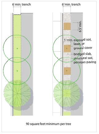
Figure A-1: Continuous Soil Area Configuration Options: low pedestrian traffic areas
(left), high pedestrian traffic areas (right)
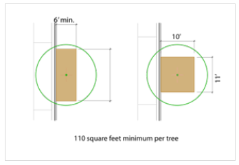
Figure A-2: Individual Tree Planting
(C)
No dimension of the soil surface area may be less than six (6) feet unless otherwise specified in this chapter;
(D)
A pervious paving strip, maximum twelve (12) inches wide, may be placed at the back of the curb for access to on-street parking. This pervious strip is not measured against the required soil surface area; and
(E)
The street-space types are configured for street tree trenches (connected soil areas). The above requirements may be met through the use of bridged slab, structural soil, or other techniques that clearly exceed these standards in the fostering of vital and long-lived street trees (See Figure A-1).
(iii)
At planting, street trees shall be at least three and a half (3.5) inches caliper, measured four (4) feet above grade and at least ten (10) feet in overall height. Species shall be selected from the street tree list set forth herein. Consult with the director for the designated tree species for a particular street-space.
(iv)
Any unpaved ground area shall be planted with ground cover, flowering vegetation, or climbing vines, not to exceed twelve (12) inches in maturity so as to not interfere with pedestrian or truck travel (minimum seven (7) feet clear over the sidewalk and fourteen (14) feet over any travel lanes) and to maintain visibility.
(3)
Street tree specifications.
(i)
Species in the street tree list are for placement as shown in street type specifications, or as specified in the regulating plan for placement along a street tree alignment line. The use of alternate species may be permitted, but only if approved by the director.
(ii)
Street trees are part of an overall street-space plan designed to provide both canopy and shade and to give special character and coherence to each street. The desired aesthetic shall be achieved through the use of native and/or proven hardy adapted species. The list of appropriate street tree species may change over time and will be periodically amended by the director. Inclusion in this list shall be based on the following criteria:
(A)
Structural. Street trees shape and subdivide the street-space, increasing pedestrian comfort and adding (literal) value to the street/community. "canopy shade tree" species grow to heights in excess of sixty (60) feet and have a broad canopy—enabling the trees to clear auto and pedestrian traffic, form a ceiling-like enclosure, and open a clear view of the street-space at eye-level.
(B)
Tree survivability. Proper planting techniques and configurations provide a healthy environment in which the street tree can thrive—this will ensure that the trees increase their value to the community as they grow.
(C)
Form. Species are planted consistently along a given street-space to provide a special form and character. This provides species diversity among streets at the same time it provides a specific street character by planting different street-spaces with different tree.
(4)
Street tree list.
(i)
Invasive species, as identified by the Missouri Department of Conservation's invasive species list, are prohibited.
(ii)
The following list contains all approved tree species (large canopy trees with a mature height of sixty (60) feet and above) for use in the M-DT district. The list may include native and acceptable adapted species. Species marked with an asterisk may be placed within larger soil area locations such as parks, dooryards, squares, or in the wider tree lawns of the major streets.
(5)
Street-Space elements.
(i)
Streetlights shall:
(A)
Be installed on both sides of the street-space, aligned with the street trees, except where otherwise designated on the regulating plan;
(B)
Use the double-globed luminaires on sixteen-foot poles, for major streets; and
(C)
Use the single-globed luminaires on fourteen-foot poles, for district streets.
(ii)
At the time of development, the developer is required to install streetlights and sidewalks, as illustrated in the street type specifications, on the street-space frontage being developed.
(iii)
Sidewalks not otherwise designated in the regulating plan or street type specifications shall provide a minimum six-foot clear walkway and be constructed to meet all city (and ADA) standards and specifications.
(iv)
Street furniture is an element of the overall street-space design—not an afterthought. Street furnishings should be simple, functional, and durable.
(6)
Pedestrian pathway. The area within a pedestrian pathway shall be a public access easement or public right of way. The easement width for these pathways must not be less than twenty (20) feet with a paved walkway not less than ten (10) feet wide providing an unobstructed view straight through its entire length, except where otherwise specified on the regulating plan.
(d)
Street-Space recommendations.
(1)
Intent.
(i)
The street-space is a community's first and foremost public space and should be just as carefully designed and planned as any park or public building. The character of the street-space—both its scale and its details—plays a critical role in determining the pedestrian quality of a given location.
(ii)
Street-spaces must balance the needs of all forms of traffic—auto, transit, bicycle and pedestrian—to maximize mobility and convenience for all residents and users. Their character will vary depending on their location: some streets will carry a large volume of traffic and provide a more active and intense urban pedestrian experience while others will provide a less active and more intimately scaled street-space.
(iii)
These are city streets—not "roads, highways, arterials, or collectors"—and must be developed as such to create people-oriented places balancing all transportation modes. The neighborhood street-spaces are designed primarily for walkability and pedestrian comfort, with automobile movement as a secondary focus. The specifications for major streets grant more to the free movement of vehicles, while maintaining good walkability.
(2)
Street design principles.
(i)
The appropriate design of streets is one of the most important design elements for a downtown area.
(ii)
To design for continuous free-flowing traffic creates situations where vehicles will travel at speeds greater than desirable for pedestrians.
(iii)
With appropriate design techniques, drivers shall choose slower speeds and less aggressive behavior, a feat typically not achieved through basic speed limit signage/postings.
(iv)
Scale is a threshold design consideration for street design elements (from signage to crossing distances)—in a downtown area it should be that of the pedestrian.
(v)
An interconnected street network allows traffic capacity to be diffused and maintained across numerous streets.
(vi)
Emergency vehicle access shall be maintained, but with an interconnected street network, there shall always be at least two (2) routes of access to any lot or parcel.
(vii)
Differences between "requirements" and "preferences" can be significant—increased lane width and the accompanying increased vehicle speeds more often than not decrease overall safety for pedestrians.
(viii)
On-street parking slows passing vehicular traffic and acts as a buffer between moving vehicles and pedestrians.
(ix)
Overall function, comfort, safety and aesthetics of a street are more important than efficiency alone.
(x)
In a downtown area, non-vehicular traffic should be provided with every practical advantage so long as safety is not adversely affected.
(xi)
Street design should take into consideration what is reasonably foreseeable, not every situation that is conceivably possible.
(xii)
Designing a street to facilitate (rather than accommodate) infrequent users may actually be the wrong design for the frequent users of the space.
(xiii)
When the street design creates a conflict between the vehicular and non-vehicular user, it should be resolved in favor of the non-vehicular user.
(3)
Street types. The street type recommendations illustrate model configurations for the street-spaces within the M-DT district. The plans and sections specify vehicular travel lane widths, curb radii, sidewalks, tree planting areas, and on-street parking configurations.
(i)
District street types.
(A)
The preferred and recommended models for most streets within the M-DT District are listed below. The numbers refer to dimensions of the street-space, the literal distance between building façades—including travel lanes, any on-street parking, and curb and gutter. The range they represent allows for variations in the street-space per the Regulating Plan. Detailed cross sections are provided in Figures A-3 through A-5 below.
1)
DS 66-74 (most district streets);
2)
DS 53-60 (ROW constrained district streets); and
3)
DS alley.
(B)
The M-DT district is designed to be the ideal complement to good transit service.
(C)
The district street-spaces are configured such that in-lane bicycle travel is appropriate.
(D)
Dooryards and alleys are generally reserved for utility easements.
(ii)
Major street type. The preferred and recommended models for the major thoroughfares in the downtown-DT district are listed below. A detailed cross-section is provided in Figure A-6 below.
(A)
DS Broadway.
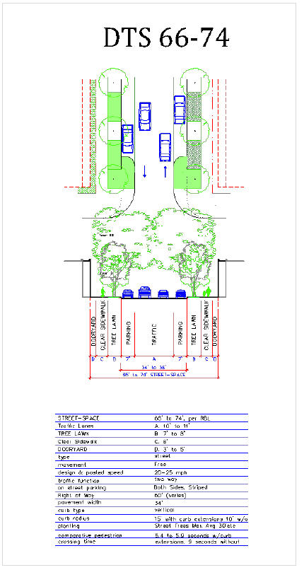
Figure A-3: DTS 66-74 (Most M-DT District Streets)
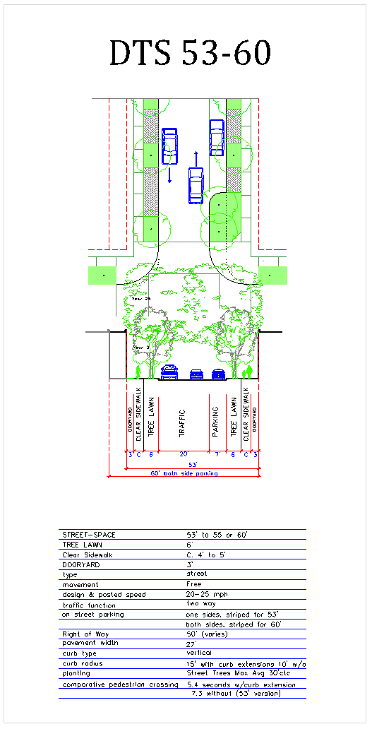
Figure A-4: DTS 53-60 (ROW Constrained M-DT District Streets)
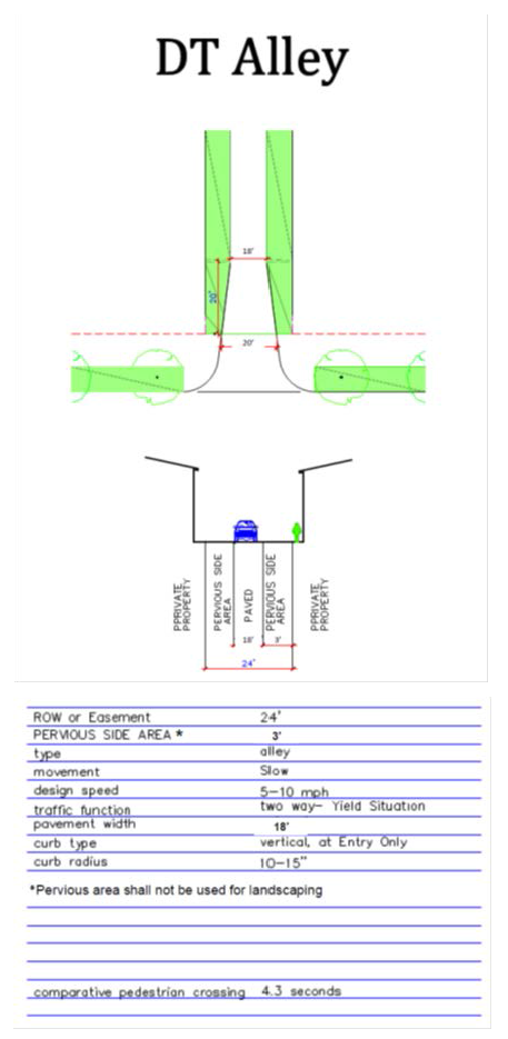
Figure A-5: DTS Alley
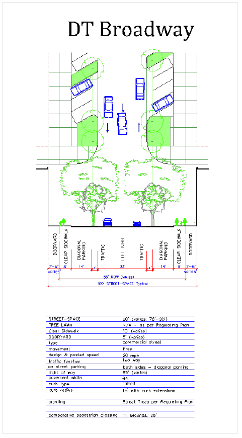
Figure A-6: DS Broadway