
Columbus City Zoning Code
CHAPTER 5
Environmental Protection
[Sec. 5.1.1. - Purpose of Chapter 5.]
This Article sets out the minimum requirements and standards for the protection of the natural environment within Columbus, including the treatment of rivers and streams, water supply watersheds, groundwater resources and wetlands, in accordance with State requirements.
Sec. 5.2.1. - Purposes of Water Resources Protection.
This Chapter proscribes restrictions on the use of land near certain rivers and streams, within water supply watersheds, within groundwater recharge areas susceptible to pollution, and in wetlands in order to:
A.
Protect the drinking water quality of the rivers, streams, reservoirs and aquifers that supply water to the residents of the jurisdiction and the State;
B.
Protect the natural habitat of animal and plant life relative to water resources; and
C.
Protect valuable water-related natural resources for recreation, to help control erosion and sedimentation of soil into Columbus' rivers and streams, for contribution to drought management, and to help absorb floodwaters.
Section 5.3.1. - Identification of Protected Rivers and Streams.
The following rivers and streams are declared to be protected rivers and streams and are regulated under the provisions of this Article:
A.
The Chattahoochee River; and
B.
All other perennial streams or watercourses, other than the Chattahoochee River.
Section 5.3.2. - Restrictions Affecting Protected Rivers and Streams.
A.
Stream Buffers Along Protected State Rivers. A natural vegetative stream buffer is established as follows:
1.
Land Included. The stream buffer shall include all lands within 100 feet of the Chattahoochee River, inclusive of any islands, as measured horizontally from the uppermost part of the riverbank. The area between the top of the banks and the edge of the river shall be included within the River Corridor Protection Plan.
2.
Restrictions on Use of Land. Land may not be used, and vegetation shall not be disturbed, within the stream buffer by building construction, development activity, septic tanks or septic tank drain fields, the handling of hazardous wastes, or for any other purpose except for the permitted uses listed below.
(A)
A land use existing prior to the adoption of the River Protection Plan.
(B)
A single-family dwelling, provided that:
(1)
The dwelling is located on a lot having an area of at least two acres, not including any area that lies between the riverbanks;
(2)
Only one dwelling is located on the lot; and
(3)
A septic tank drain field shall not be located within the stream buffer.
(C)
Timber production and harvesting, subject to the following conditions:
(1)
Forestry activity shall be consistent with best management practices established by the Georgia Forestry Commission; and
(2)
Forestry activity shall not impair the drinking quality of the river water as defined by the federal Clean Water Act.
(D)
Wildlife and fisheries management activities consistent with the purposes of Section 12-2-8 of Article 1, Chapter 2, Title 12 of the O.C.G.A.
(E)
Public road and utility crossings complying with all requirements of the Georgia Soil Erosion and Sedimentation Control Act.
(F)
Recreational usage consistent either with the maintenance of a natural vegetative stream buffer or with river-dependent recreation, such as a boat ramp.
(G)
Agricultural production and management, subject to the following conditions:
(1)
Agricultural activity shall be consistent with best management practices established by the Georgia Soil and Water Conservation Commission;
(2)
Agricultural activity shall not impair the drinking quality of the river water as defined by the federal Clean Water Act; and
(3)
Agricultural activity shall be consistent with all state and federal laws, including all regulations promulgated by the Georgia Department of Agriculture.
(H)
Public wastewater treatment and natural water quality treatment or purification facilities, and public water and sanitary sewerage mains.
(I)
Utilities, other than public water or sewerage facilities, provided that:
(1)
Utilities that cannot feasibly be located outside the buffer area, as determined by Columbus;
(2)
Installation and maintenance of the utilities shall be such as to protect the integrity of the stream buffer to the greatest extent that is reasonably possible; and
(3)
Utilities shall not impair the drinking quality of the river water.
(J)
Mining activities, if permitted by DNR pursuant to the Georgia Surface Mining Act of 1968.
(K)
Other uses permitted by the zoning district and by DNR under Section 404 of the Clean Water Act.
B.
Other Protected Streams.
1.
Streams in Water Supply Watersheds. All protected streams located within a water supply watershed must comply with the natural stream buffer and setback requirements established for streams and reservoirs in the watershed. See Section 5.4.2. for buffer requirements.
2.
All Other Streams.
(A)
Other Streams in General. For perennial streams for which there are no stream buffer or setback restrictions otherwise established by this Section, there is established a buffer along the banks of any state waters in the widths indicated under Section 5.3.2. B.2(A)(1), below, except where the EPD Director determines to allow a variance that is at least as protective of natural resources and the environment, where otherwise allowed by the EPD Director pursuant to Code Section 12-2-8, or where a drainage structure or a roadway drainage structure must be constructed, provided that adequate erosion control measures are incorporated in the project plans and specifications and are implemented; provided, however that buffers of at least 25 feet established pursuant to this Section shall remain in force unless a variance is granted by the EPD Director as provided in this paragraph. The following requirements shall apply to any such buffer:
(1)
Except where a stream buffer of greater width is required by this Section, or as provided in Section 5.3.2B.2(B) for trout streams, below, there is established a buffer along the banks of any state waters, as measured horizontally from the point where vegetation has been wrested by normal stream flow or wave action, of 50 feet for all new development projects. For all other lands that are already developed, the undisturbed area must be at least 25 feet.
(2)
No land-disturbing activities shall be conducted within a stream buffer and a stream buffer shall remain in its natural, undisturbed state of vegetation until all land-disturbing activities on the construction site are completed. Once the final stabilization of the site is achieved, a stream buffer may be thinned or trimmed of vegetation as long as a protective vegetative cover remains to protect water quality and aquatic habitat and a natural canopy is left in sufficient quantity to keep shade on the stream bed; provided, however, that any person constructing a single-family residence, when such residence is constructed by or under contract with the owner for his or her own occupancy, may thin or trim vegetation in a buffer at any time as long as protective vegetative cover remains to protect water quality and aquatic habitat and a natural canopy is left in sufficient quantity to keep shade on the stream bed.
(3)
The buffer shall not apply to the following land-disturbing activities, provided that they occur at an angle, as measured from the point of crossing, within 25 degrees of perpendicular to the stream; cause a width of disturbance of not more than 50 feet within the buffer; and adequate erosion control measures are incorporated into the project plans and specifications are implemented:
(a)
Stream crossings for water lines; or
(b)
Stream crossings for sewer lines.
(4)
The buffer shall not apply to any ephemeral stream. Unless exempted as along an ephemeral stream, the buffers of at least 25 feet established pursuant to part 6 of Article 5, Chapter 5 of Title 12, the "Georgia Water Quality Control Act", shall remain in force unless a variance is granted by the director.
(B)
Trout Streams.
(1)
There is established a 50-foot buffer as measured horizontally from the point where vegetation has been wrested by normal stream flow or wave action along the banks of any state waters classified as "trout streams" pursuant to Article 2 of Chapter 5 of Title 12, the "Georgia Water Quality Act", except where a roadway drainage structure must be constructed, provided, however, that small springs and streams classified as trout streams which discharge an average annual flow of 25 gallons per minute or less shall have a 25-foot buffer or they may be piped, at the discretion of the landowner, pursuant to the terms of a rule providing for a general variance promulgated by the Board of Natural Resources, as long as any such pipe stops short of the downstream landowner's property and the landowner complies with the buffer requirement for any adjacent trout streams. The EPD Director may grant a variance from such buffer to allow land-disturbing activity, provided that adequate erosion control measures are incorporated in the project plans and specifications and are implemented.
(2)
The following requirements shall apply to such buffer:
(a)
No land-disturbing activities shall be conducted within a stream buffer and a stream buffer shall remain in its natural, undisturbed, state of vegetation until all land-disturbing activities on the construction site are completed. Once the final stabilization of the site is achieved, a buffer may be thinned or trimmed of vegetation as long as a protective vegetative cover remains to protect water quality and aquatic habitat and a natural canopy is left in sufficient quantity to keep shade on the stream bed: provided, however, that any person constructing a single-family residence, when such residence is constructed by or under contract with the owner for his or her own occupancy, may thin or trim vegetation in a buffer at any time as long as protective vegetative cover remains to protect water quality and aquatic habitat and a natural canopy is left in sufficient quantity to keep shade on the stream bed; and
(b)
The buffer shall not apply to the following land-disturbing activities, provided that they occur at an angle, as measured from the point of crossing, within 25 degrees of perpendicular to the stream, cause a width of disturbance of not more than 50 feet within the buffer; and adequate erosion control measures are incorporated into the project plans and specifications and are implement:
(i)
Stream crossings for water lines; or
(ii)
Stream crossings for sewer lines.
C.
Notation of Restrictions. Restrictions shall be noted on the plats and deeds of included properties to maintain any designated natural stream buffer area, undisturbed area or construction setback required by these regulations. Stream buffers are to be included in natural resource or conservation easements for new development projects in accordance with the provisions for such easements in the Ownership of Open Space Article of the Resource Conservation Chapter of this UDO.
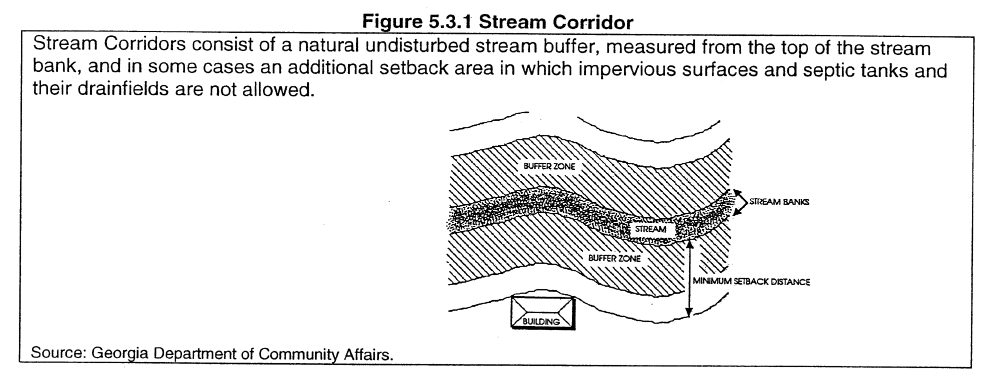
Figure 5.3.1 Stream Corridor
Table 5.3.1 Stream Buffers and Setbacks
Summary of River Corridor, Stream Corridor and Water Supply Watershed Requirements
D.
The fact that land-disturbing activity for which a permit has been issued results in injury to the property of another shall neither constitute proof of nor create a presumption of a violation of the standards provided for in this ordinance or the terms of the permit.
(Ord. No. 10-35, § 1, 7-13-10)
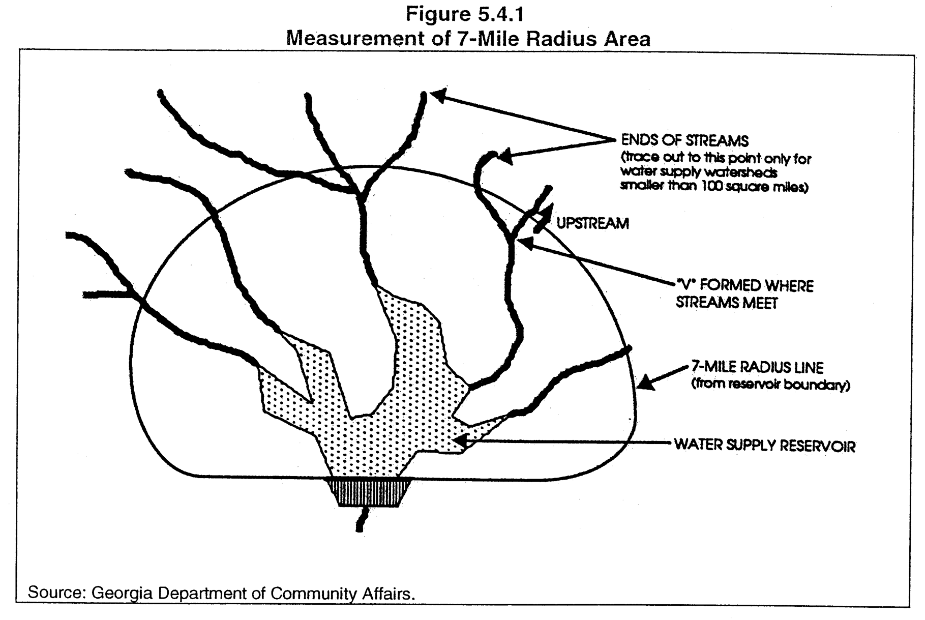
Section 5.4.1. - Water Supply Watersheds with Reservoir.
The Chattahoochee watershed is recognized as a large water supply watershed, having 100 square miles or more of drainage area above the Lake Oliver water supply intake. The watershed qualifies further for environmental protection because the drainage area supplies water to the Lake Oliver water supply reservoir. A second reservoir, Upatoi Creek is located wholly within the Ft. Benning Reservation.
Section 5.4.2. - Chattahoochee River Watershed.
All water flow of the county is directed to the Chattahoochee River, either directly or indirectly through intermediate drainage basins.
A.
Protected Watershed.
1.
Establishment of Protected Watershed Areas. The protected watershed area includes all or any portion of the following drainage basins and areas within the corporate boundaries of Columbus:
(A)
The Lake Oliver water supply reservoir;
(B)
All lands within 150 feet of any water supply reservoir boundary; and
(C)
All lands within the Chattahoochee watershed located within a 7-mile radius of the boundary of any water supply reservoir.
2.
Restrictions within a Protected Watershed Area. Within the protected watershed area, the restrictions listed below shall apply.
(A)
Natural Stream Buffer Around Water Supply Reservoir. A natural stream buffer shall be established and maintained within 150 feet of the banks of the reservoir boundaries. Vegetation, land disturbance and land uses shall be controlled by the provisions of the Lake Oliver Reservoir Management Plan, and the Upatoi Creek Water Management Plan as approved by the Georgia Department of Natural Resources (DNR).
(B)
Hazardous Materials. Any new facility that handles hazardous materials of the types listed in Section 313 of the Emergency Planning Right-To-Know Act, excluding underground storage tanks, and in amounts of 10,000 pounds or more on any one day, shall perform their operations on impermeable surfaces having spill and leak collection systems as prescribed by DNR.
B.
Protected Stream Corridors.
1.
Definition of Protected Stream Corridors. Within the protected watershed area, all lands within 150 feet of the banks on both sides of any perennial stream or river, located within a 7-mile radius of the boundary of the Lake Oliver and Upatoi Creek reservoirs, shall be established as protected stream corridors and conform to the provisions of this Section.
2.
Restrictions within Protected Stream Corridors. Along a protected stream corridor the restrictions listed below shall apply.
(A)
A natural stream buffer shall be established and maintained within 100 feet of both sides of the banks of any perennial stream within the protected stream corridor.
(B)
No clearing, earth moving, construction or ground disturbance is allowed within the 100-foot wide natural stream buffer. Exceptions include bike and footpaths constructed of permeable material, gravity sanitary sewers, and road crossings perpendicular to streams. The installation of storm sewers will also be allowed. The area that is within this restricted construction area is to be left natural or developed as a trail with a minimum of disturbance to the natural habitat.
(C)
No impervious surfaces shall be constructed within the 150-foot wide protected stream corridor.
(D)
Septic tanks and septic tank drainfields are prohibited within the protected stream corridor.
C.
Appeals to Council. Appeals to council shall conform to Section 10.11.6.1 of this ordinance.
(Ord. No. 08-66, § 1, 11-25-08; Ord. No. 10-17, § 1, 5-25-10)
Section 5.5.1. - Definition of Protected Groundwater Recharge Areas.
Groundwater recharge areas are defined as "significant recharge areas" by the State of Georgia and are protected relative to their susceptibility to pollution.
A.
Significant Recharge Areas. Significant recharge areas are defined by DNR using criteria developed by them, and have been mapped on DNR's Hydrologic Atlas 18, 1989 edition.
B.
Pollution Susceptibility Category. Categories of relative vulnerability of an aquifer to pollution, classified as higher, average or lower, are defined by the DNR using criteria developed by them, and have been mapped on DNR's Hydrologic Atlas 20, along with the most significant recharge areas.
C.
Incorporation of Recharge Area Maps. The Hydrologic Atlas 18 and the Hydrologic Atlas 20 are hereby adopted and incorporated into this Article as though set forth herein.
Section 5.5.2. - Protected Groundwater Recharge Area Restrictions.
A.
Land Use Restrictions. Within any significant recharge area, as defined and delineated by the DNR, the land use restrictions listed below shall apply.
1.
Hazardous Waste Treatment Facilities. New hazardous waste treatment or disposal facilities are prohibited.
(A)
Impermeable Surfaces. Any facility that involves the treatment, storage or disposal of hazardous waste, if permitted by DNR and the zoning district, shall perform such operations on an impermeable surface having a spill and leak collection system.
(B)
Impermeable Surfaces. Any facility that handles hazardous materials of the types listed in Section 312 of the Resource Conservation and Recovery Act of 1976h, excluding underground storage tanks, and in amounts of 10,000 pounds or more on any one day, shall perform their operations on impermeable surfaces having spill and leak collection systems as prescribed by DNR.
2.
Sanitary Landfills. New sanitary landfills, if permitted by DNR and the zoning district, shall have synthetic liners and leachate collection systems.
3.
Above-ground Chemical and Petroleum Tanks. A new above-ground chemical or petroleum storage tank must have secondary containment of 110% of the volume of the tank or 110% of the volume of the largest tank in a cluster of tanks. This requirement does not apply to:
(A)
Any tank having a maximum capacity of less than 660 gallons; and
(B)
Any tank used for agricultural purposes, provided it complies with all Federal requirements.
B.
Lot Size Restrictions. Several significant groundwater recharge areas in the City have been mapped by the State on DNR's Hydrologic Atlas 18, primarily in the southern part of Columbus. The significant groundwater recharge areas in the southern half of the city are classified as having "average" susceptibility to pollution and the northern half as having "lower" susceptibility to pollution.
1.
Lower Pollution Susceptibility Areas. Within a significant recharge area classified as having "lower" susceptibility to pollution, the following restrictions shall apply.
(A)
Agricultural Waste Impoundment Sites. New agricultural waste impoundment sites larger than 50 acre-feet must be lined. The liner must be constructed of compacted clay having a thickness of 1 foot and a vertical hydraulic conductivity of less than 5 × 10 -7 cm/sec or other criteria established by the U.S. Soil Conservation Service.
(B)
Septic Tanks. A new home served by a septic tank/drain field system must be approved by the County Health Department and must be located on a lot or parcel of land that is at least 110% of the minimum lot size required by Table MT-1 of the Department of Human Resource's Manual for On-Site Sewage Management Systems.
(C)
Manufactured Home Park. A new manufactured home park served by a septic tank/drain field system must be approved by the County Health Department and must be located on a lot or parcel that is at least 110% of the minimum lot or space size required by Table MT-2 of the Department of Human Resource's Manual for On-Site Sewage Management Systems.
2.
Average Pollution Susceptibility Areas. Within a significant recharge area classified as having "average" susceptibility to pollution, the following restrictions shall apply.
(A)
Agricultural Waste Impoundment Sites. New agricultural waste impoundment sites larger than 15 acre-feet must be lined. The liner must be constructed of compacted clay having a thickness of 1 foot and a vertical hydraulic conductivity of less than 5 × 10 -7 cm/sec or other criteria established by the U.S. Soil Conservation Service.
(B)
Septic Tanks. A new home served by a septic tank/drain field system must be approved by the County Health Department and must have a lot that is at least 125% of the minimum lot size required by Table MT-1 of the Department of Human Resource's Manual for On-Site Sewage Management Systems.
(C)
Manufactured Home Park. A new manufactured home park served by a septic tank/drain field system must be approved by the County Health Department and must have a lot or space that is at least 125% of the minimum lot or space size required by Table MT-2 of the Department of Human Resource's Manual for On-Site Sewage Management Systems.
Section 5.6.1. - Definition of Protected Wetlands.
A.
Wetlands. "Wetlands" are areas that are inundated or saturated by surface or groundwater at a frequency and duration sufficient to support, and that under normal circumstances do support, a prevalence of vegetation typically adapted for life in saturated soil conditions. Wetlands generally include swamps, marshes, bogs and similar areas.
B.
Identification. Protected wetlands are those wetlands identified on the National Wetlands Inventory maps prepared by the U.S. Fish and Wildlife Service, or otherwise approved by the U.S. Army Corps of Engineers based on competent studies prepared by a registered and qualified professional engineer.
C.
New Wetland Areas. Any new wetland area constructed as a best management practice for stormwater control is also considered a protected wetland once construction is complete.
Section 5.6.2. - Wetlands Map Adopted.
The National Wetlands Inventory Map (NWI Map) prepared by the U.S. Fish and Wildlife Service covering the City is hereby adopted and incorporated herein by reference as the official map of protected wetlands in the city.
A.
Limit of NWI Map. The NWI Map does not necessarily represent the boundaries of jurisdictional wetlands within the city and cannot serve as a substitute for a delineation of wetland boundaries by the U.S. Army Corps of Engineers, as required by Section 404 of the Clean Water Act, as amended.
B.
Affect of Local Actions. Any local government action under these regulations does not relieve the landowner from federal or state permitting requirements.
Section 5.6.3. - Restrictions on Use of Protected Wetlands.
Within any protected wetlands area, the following restrictions shall apply.
A.
Alteration or Degradation. Alteration or degradation of a protected wetland requires prior approval by the U.S. Army Corps of Engineers under Section 404 of the federal Clean Water Act.
B.
Hazardous or Toxic Wastes. Hazardous or toxic waste at receiving, treatment or disposal facilities are prohibited.
C.
Sanitary Landfills. Sanitary landfills are prohibited.
D.
Land Uses Permitted. Land uses that may be allowed if permitted by the zoning district and by the Section 404 permit include:
1.
Timber production and harvesting; wildlife and fisheries management.
2.
Camping, hiking, hunting and fishing recreation activities.
3.
Public wastewater treatment and natural water quality treatment or purification facilities; and
4.
Other uses permitted under Section 404 of the Federal Clean Water Act.
Section 5.6.4. - Plans for Land Disturbance Permits.
Design professionals shall indicate wetlands on appropriate plan sheets required for a land disturbance permit application. The design professional that prepared the required plans accompanying the permit application shall add a statement to the appropriate plan sheets indicating whether or not wetlands are located on the property by checking the appropriate box. At a minimum, the statement shall be placed on the Grading Plan; the Erosion, Sedimentation and Pollution Control Plan; and the Stormwater Management Site Plan.
Figure 5.6.1
Wetlands Certification
(Ord. No. 08-66, § 1, 11-25-08)
Section 5.6.5. - Requirement for Local Permit.
No regulated activity will be permitted within protected wetlands without written permission or a permit from the City. If the area proposed for development is located within 50 feet of a wetlands boundary, as determined using the National Wetlands Inventory Map and certification of the design professional, no land disturbance permit affecting the wetland or the 50-foot wide area around the wetland will be issued by the City until a Section 404 Permit or Letter of Permission is issued from the U.S. Army Corps of Engineers.