
Columbus City Zoning Code
CHAPTER 7
PROJECT DESIGN STANDARDS
ARTICLE 6. - SURVEY MONUMENTS
Exterior subdivision boundaries, lots and street corners shall be established as provided in this Article.
[Section 7.1.1. - Purpose of chapter.]
This Chapter sets out the minimum requirements and standards for construction of subdivisions and other land development projects, including general principals of design and layout and requirements for such public facilities as streets and utilities.
Section 7.2.1. - Standard Design Specifications.
Standard design specifications of the City of Columbus, as such are adopted by the Council and as may be amended from time to time, are incorporated into this Ordinance as though set forth within the body of this Ordinance. In the case of a conflict between the Standard Design Specifications and the text of this Ordinance, the text of this Ordinance shall control.
Section 7.2.2. - Traffic Signs and Street Striping.
The installation of all traffic control signs and street striping shall be governed by the standards contained in the Manual on Uniform Traffic Control Devices, latest edition, published by the Federal Highway Administration of the U.S. Department of Transportation.
Section 7.2.3. - Georgia DOT Standard Specifications.
Unless otherwise specially set forth in this Ordinance or the Standard Design Specifications of the City of Columbus, all of the materials, methods of construction, and workmanship for the work covered in reference to street construction and storm drainage construction shall conform to the latest standard specifications of the Georgia Department of Transportation (DOT).
Section 7.2.4. - AASHTO Design Standards.
Design criteria and standards not specifically set forth herein shall conform to the latest edition of the AASHTO Policy on Geometric Design of Highways and Streets.
Section 7.2.5. - Stormwater Management.
The design, construction, operation and maintenance of the stormwater system, including stormwater detention facilities and all conveyances whether piped or open, shall conform to the provisions of the Georgia Stormwater Management Manual, Volume 2, published August 2001 and as may be amended from time to time.
Section 7.3.1. - Suitability of the Land.
Land physically unsuitable for subdivision or development because of flooding, poor drainage, topographic, geologic or other such features that may endanger health, life or property, aggravate erosion, increase flood hazard, or necessitate excessive expenditures of public funds for supply and maintenance of services shall not be approved for subdivision or development unless adequate methods are formulated by the developer for solving the problems. Such land shall be set aside for such uses as shall not involve such a danger.
Section 7.3.2. - Comprehensive Plan and Other Adopted Plans Conformance.
In addition to the requirements established herein, all subdivision plats and development site plans shall comply with the following laws, rules and regulations, and written proof of such compliance must be furnished when requested by the Director of Planning.
A.
Compliance with Comprehensive Plan. All proposed subdivisions and developments shall conform to the Comprehensive Plan and development policies in effect at the time of submission to the Planning Division.
B.
Platting of Streets and Other Features. All highways, streets and other features of the Comprehensive Plan shall be platted by the developer in the location and to the dimension indicated on the Comprehensive Plan or the Columbus-Phenix City Transportation Improvement Program.
C.
Georgia DOT Approval Required. In subdivisions or developments related to or affecting any State or U.S. numbered highway, the approval of the Georgia DOT shall be required in accordance with State law (see the Development Review Procedures and Permits Chapter of this Ordinance).
D.
Dedication or Reservation of Public Lands. When features of other plans adopted by the City Council, such as schools or other public-building sites, parks or other land for public uses, are located in whole or in part in a subdivision, such features shall be either dedicated or reserved by the subdivider for acquisition within a reasonable time by the appropriate public agency.
E.
Refusal of Land Proposed to be Dedicated. Whenever a plat proposes the dedication of land to public use that the City Council finds not required or suitable for such public use, the City Council shall refuse to approve the plat, and shall notify the land developer of the reasons for such action.
F.
Adopted Codes. The subdivision or plat shall comply with applicable land development regulations, building and housing codes, and all other applicable laws, ordinances and regulations.
1.
Dimensional Requirements. A conventional subdivision must meet all lot dimensional requirements of the applicable zoning district in which it is located.
2.
Resource Conservation Subdivision. A resource conservation subdivision must meet all lot dimensional requirements as established by these development regulations under the Resource Conservation Chapter, depending on the zoning district in which it is located.
G.
Official Zoning Map. All subdivision plats and development site plans shall comply with the Official Zoning Map of Columbus.
H.
Health Department and State Agencies. All subdivision plats and development site plans shall comply with all rules of the Muscogee County Health Department and appropriate state agencies.
Section 7.3.3. - Name of Subdivision or Development Project.
The name of each subdivision or development project must have the approval of the Planning Division. The name shall not duplicate nor closely approximate the name of an existing subdivision or development project in Columbus.
Section 7.3.4. - Street Layout.
A.
Minimum Separation Interval.
1.
Subdivision streets that intersect a State or U.S. numbered highway shall do so at intervals of not less than 800 feet, or as required by the DOT, whichever is greater.
2.
Intersections with arterial streets shall be at least 800 feet apart measured from centerline to centerline.
3.
The distance between all other street intersections, measured centerline to centerline, shall be no less than 250 feet on collector streets and 125 feet on local streets.
B.
Through Traffic. Streets shall be laid out within a development so as to discourage through traffic and excessive speed on local streets. However, the provision for the extension and continuation of arterial and collector streets into and from adjoining areas is required.
C.
Street Layout Designs. Street layout designs shall conform to Section 6.4.5 of this ordinance.
(Ord. No. 05-32, § 1, 4-5-05; Ord. No. 08-72, § 1, 12-16-08)
Section 7.3.5. - Lots.
A.
Minimum Lot Dimensions and Areas. All lots proposed in a subdivision shall meet or exceed the area and dimensional requirements of this Ordinance for the zoning district in which the lots are located.
B.
Authority of Health Department. Nothing contained in this Article shall be construed as preventing the Health Department, after study of the conditions existing in a proposed subdivision, from requiring that all or any portion of the area of such subdivision shall not be built upon or that the minimum lot sizes set forth in this Development Ordinance are inadequate and must be increased to ensure the protection of the public health.
C.
Adequate Building Sites. Each lot shown on a preliminary or final subdivision plat shall contain a building site large enough for a normal building that will meet all building setback requirements and not be subject to flood or periodic inundation. Neither lot remnants nor lots that will require variances shall be platted.
D.
Arrangement of Side Lot Lines. Insofar as practical, side lot lines shall be at right angles to straight street lines or radial to curved street lines (including cul-de-sacs).
E.
Corner Lots. Corner lots shall be sufficiently large to permit the location of buildings so as to conform to the front building lines on both streets.
F.
Minimum Setback Along Highways.
1.
Arterial Roads. For any lot that adjoins an arterial road, the minimum building setback along such road shall be 100 feet from the right-of-way line; provided that the setback may be reduced by the Engineering Department to a distance equal to the building setback required on the lot by the zoning district plus the amount of right-of-way that will be required in the future. Future right-of-way requirements shall be determined by the classification of the road and future improvement plans based on a 20-year build-out study of traffic demand.
2.
Minimum Frontage. All lots shall front on a minimum of 25 feet of dedicated public right-or-way or upon a right-of-way that has received the legal status of such, except as provided for within specific zoning districts in Section 7.4.2.
G.
Areas Reserved for Future Development. If any portion of a tract is reserved for future subdivision development, the minimum lot width and frontage of the reserved area may be reduced to the width required for a future street to serve such area.
1.
Identification. Such a reserved area must be labeled "Reserved for Future Development" on the final subdivision plat, and the portion of the lot where a street will be built must be labeled "Future Street."
2.
Requirements for Building Permits. Such a reserved area will not be eligible for issuance of a building permit unless the lot meets all requirements of the Zoning Ordinance, including minimum lot width and frontage requirements of the applicable zoning district.
H.
Plats Straddling Political Boundaries. Whenever access to a subdivision is required across land in another governmental jurisdiction, the Director of Inspections and Codes may request assurance from the City Attorney or the other county to ensure that access is legally established, and that the access road is adequately improved. In general, lot lines shall be laid out so as to not cross-jurisdictional boundary lines.
(Ord. No. 05-32, § 1, 4-5-05; Ord. No. 08-72, § 1, 12-16-08; Ord. No. 09-22, § 1, 6-2-09)
Section 7.4.1. - Required Improvements; Major Subdivisions.
The following improvements shall be provided by the developer or at the developer's expense in every major subdivision, as defined in the Development Review Procedures and Permits Chapter of this Ordinance, and in every individual multi-family or nonresidential development in accordance with the standards contained in this Article.
A.
Monumentation. Survey monumentation of the public streets and lot lines in such a subdivision.
B.
Street Access. Streets providing access to such a development and to all lots in such a subdivision, including the extension of streets required to provide access to adjoining properties.
1.
Improvements. Streets contained wholly within such a subdivision shall be improved to the full standards contained in this Chapter. Existing streets that adjoin such a development shall be improved to the full standard of this ordinance.
2.
Curb and Gutter. Curb and gutter where required along all roadways.
3.
Sidewalks. Sidewalks as required by this Chapter.
C.
Drainage. Stormwater drainage and detention facilities.
D.
Street Names and Traffic Control. Street name signs, stop bars, striping and traffic control signs as approved by the City shall be provided at the developer's expense.
E.
Driveway Access. Driveways and development entrances shall be provided in accordance with Article 9 of this Chapter at the time of initial development or, for individual lots, at the time of building construction.
F.
Water Supply.
1.
Public Water Supply Required. Public water service shall be provided to every lot in such a subdivision and to every development for both domestic use and fire protection if public water is available within 1,500 feet of the subdivision or development.
(A)
Connection of Water Mains. Water mains shall be connected to the existing public water system and extended past each lot.
(B)
Compliance. All water system improvements shall meet the Columbus Waterworks standards for public water service.
(C)
Installation. A contractor approved by the Columbus Waterworks shall install all elements of the water system, including mains, valves, service laterals through the curb line, and fire hydrants at the developer's expense.
(D)
Minimum Water Flow. Water flow shall supply a minimum of 550 gallons per minute at hydrants.
2.
New Construction. New construction of a principal building on any lot that is within 100 feet of an existing public water line shall be required to connect to the public water line.
3.
Unavailability of Public Service. If a public water system is not available nor under bid or contract to be available, the subdivider shall provide a water supply using a community water system or individual wells in conformity with the regulations of the Muscogee County Health Department, these development regulations and all other applicable laws and regulations.
4.
Community Water System. If a community water system is created, it must be designed to provide a minimum fire flow of 550 gallons per minute, meet City of Columbus standards, and a special tax district and a homeowners association shall be established for the subdivision at the time of final plat recording. The homeowners association shall:
(A)
Require mandatory and automatic membership of each lot owner;
(B)
Provide for the collection of adequate payments for all expenses of the system; and
(C)
Provide that the association cannot be dissolved without the approval of the Council.
G.
Sanitary Waste Disposal.
1.
Connection Required. Every lot in such a subdivision and every development shall be connected to a public sanitary sewerage system if sanitary sewerage is available as determined by the Columbus Waterworks.
(A)
Connection. Sewer lines shall be connected to the City of Columbus' sanitary sewerage system and extended past each lot in accordance with all Columbus Waterworks requirements.
(B)
Installation. Every element of the sanitary sewerage system, including mains, lift stations, outfalls, and laterals, shall be installed at the developer's expense by a contractor approved by the Columbus Waterworks.
2.
New Construction. New construction of a principal building on any lot that is within 100 feet of an existing public sanitary sewerage line shall be required to connect to the public sanitary sewerage line.
3.
Unavailability of Public System. If a public sewerage system is not available nor under bid or contract to be available, each lot shall be provided with septic tanks or other on-site disposal systems in accordance with the regulations of the Muscogee County Health Department, these development regulations and all other applicable laws and regulations.
4.
Community Septic System. If a community septic system is created, a special tax district and a homeowners association shall be established for the subdivision at the time of final plat recording. The homeowners association shall:
(A)
Require mandatory and automatic membership of each lot owner;
(B)
Provide for the collection of adequate payments for all expenses of the system; and
(C)
Provide that the association cannot be dissolved without the approval of the Council.
(Ord. No. 08-72, § 1, 12-16-08; Ord. No. 12-53, § 3, 12-4-12)
Section 7.4.2. - Required Improvements; Private Streets.
A.
Applicability. Private streets, reserve strips, or access easements are prohibited except in multi-family and nonresidential developments, or as otherwise approved by the City Council on a case-by-case basis.
B.
Compliance. Private streets shall comply with all requirements and standards that apply to public streets for the type of development that they serve. Streets serving apartment and condominium developments and associated storm drainage shall be constructed to the residential public street standards of this Ordinance. Driveways and parking lot aisles shall not be considered as "streets."
C.
Owner's Release. At the time of purchasing property that is served by a private street that is constructed using standards that are the same as those required for public streets, upon any sale or resale of a property, the purchaser shall acknowledge by execution of a release that the street is private and not maintained by the City, and that maintenance of the street is the responsibility of the owner or other private association or entity identified in the release. The release is to be prepared using a form acceptable to the Attorney to the Columbus Consolidated Government and shall be recorded with the Clerk of the Superior Court.
D.
Other Standards. A private street subdivision shall meet all other requirements and standards that apply to public subdivisions, such as storm water runoff and detention requirements, the provision of utilities, and traffic and street name signs.
1.
Identification of Private Streets. Private streets shall be denoted as such on the street name signs for each such street.
(A)
Names of Proposed Streets. Proposed streets, which are extensions of, or in alignment with, existing or other proposed streets shall have the same name.
(B)
Duplication of Street Names. Street names shall not duplicate or be phonetically similar to existing street names.
(C)
Signs. Street name signs shall be blue in color and labeled as private along with the street name, in accordance with City requirements.
2.
Gates. Any gate placed across a private street that limits access to a subdivision or development shall provide for unimpeded access by emergency vehicles, governmental vehicles on official business, and delivery services including the U.S. Postal Service. Accessibility to such gated communities shall comply with all standards and requirements of the City for access activation, and shall be of breakaway construction.
Section 7.4.3. - Required Improvements; Minor Subdivisions.
By definition, a minor subdivision does not involve the construction of major public improvements, such as new streets or stormwater detention. However, the following improvements are required in order to adequately serve the lots and protect the safe operation of the existing road:
A.
Right-of-way Dedication. Right-of-way shall be dedicated along the property's frontage from the centerline of the existing road equal to one-half of the minimum requirement for the classification of the road, as established in this Chapter.
B.
Preservation of Stormwater Capacity. The stormwater carrying capacity of the road, whether in an existing ditch or gutter, shall not be compromised. If the stormwater characteristics of the existing road are inadequate to accommodate the new lots, the Director of Engineering may require improvement of the roadway ditch as appropriate.
C.
Monumentation. All lot corners shall be marked with an iron pipe or one-half inch iron pin at least 24 inches long and driven flush or no more than one inch above the finished grade.
Section 7.5.1. - Guarantee of Work.
A.
Minimum Guarantee. The subdivider shall guarantee all work performed by him or his agent against failure for a period of two years after completion of work.
1.
Bond Required. To ensure compliance with the above, a bond in the amount of five percent of the estimated costs of the work shall be posed. Security for said bond shall be endorsed by a banking, lending or mortgaging institution.
2.
Intent of Bond. This, however, is not to be construed as an alternative to acceptance of any doubtful or substandard work, nor is it intended to include failure due to utilities installed after the developer has completed his work.
Section 7.5.2. - Inspection During Construction.
A.
Inspections. All construction performed under the auspices of these regulations shall be subject to inspection by the Department of Engineering. The contractor shall be responsible for notifying this department in writing prior to commencement of any such work. If the contractor fails to make this notification, the contractor shall then be responsible for the expense of any operation or laboratory testing required by the City Engineer to ascertain compliance with specifications.
Section 7.5.3. - Acceptance of Improvements.
A.
Rejection of Materials or Work. The City Engineer shall have the authority to reject any material or work that does not meet the requirements of specifications adopted by council. Prior to the filing of a final plat, the subdivider shall be required to certify to the Department of Engineering in writing that all street, drainage and other improvements that are to be dedicated to the City have been completed in accordance with the construction plans previously approved by the Department of Engineering.
B.
Completion of Improvements. A final subdivision plat shall not be approved by the City or accepted for recordation by the Clerk of the Superior Court until all required improvements have been constructed in a satisfactory manner and approved by the Engineering Director.
Section 7.6.1. - Required Monuments.
Unless otherwise provided herein, all other street or lot corners shall be marked with an iron pipe or one-half inch iron pin at least 24 inches long and driven no less than one inch or up to six inches above the finished grade.
Section 7.6.2. - Installation.
All such monuments shall be properly set in the ground and shall be approved by a registered land surveyor prior to the time of final plat approval.
Section 7.7.1. - Purpose and Intent.
Easements shall be required in connection with subdivisions or developments for the following purposes, as provided in this Article.
Section 7.7.2. - Utility Easements.
A.
Utility Easements. Whenever it is necessary or desirable to locate a public utility line outside of the street right-of-way, the line shall be located in an easement dedicated to the City or other appropriate public entity for such purpose.
B.
Minimum Requirements. Easements for water and sanitary sewers shall meet the requirements of the Columbus Waterworks.
Section 7.7.3. - Drainage Easements.
This Section applies to public easements for drainage facilities. Private drainage easements providing for stormwater flow between two properties may also be shown on the subdivision plat, but are easements between the two property owners and are not public easements.
A.
Installation. Drainage easements shall be cleared and opened using best management practices at the time of development to control surface water run-off. Run-off slopes and side slopes shall be specified by the developer's engineer according to good engineering practices.
B.
Easement Required.
1.
Location. A publicly dedicated drainage easement is to be provided along any man-made drainage channel or drainage pipe that is part of the stormwater management system approved by the City for the property and is located outside a street right-of-way.
2.
Minimum Requirements. All easements shall be no less than 20 feet wide when used as an open ditch. Piped storm drainage shall have a minimum easement width based on pipe diameter, as follows:
Table 7.7.1
Easement Widths for Drainage Pipe
C.
Identification and Maintenance. Drainage easements located off the street right-of-way shall be clearly defined on the plat and deed of the individual property owner, and such property owner shall keep the easement free of obstructions and maintain that part of the easement within the property owner's boundary line so that free and maximum flow is maintained at all times.
D.
Public Recreation Areas.
1.
Area to be Dedicated. Lakes, ponds, creeks, boat ramps, and similar areas may be accepted for maintenance if and only if sufficient land is dedicated for a public recreation area, access to said area is provided, and the area is approved by the Department of Parks and Recreation.
2.
Acceptance. If such area constitutes a necessary part of the drainage system as defined in the surface drainage plan, said area may be accepted by the Council only if access is provided and the area is approved by the Department of Engineering.
3.
Time of Acceptance. All such areas, if they are to be accepted, must be accepted before approval and recordation of the final plat.
Section 7.7.4. - Overlapping Easements.
Easements for sanitary sewers and drainage purposes may be combined, but must be a minimum of 30 feet if in combination.
Section 7.8.1. - Access.
A.
Access Provided. A publicly approved street complying with the requirements of this Article shall serve every development and every lot within a subdivision, either a publicly dedicated street or an approved private street.
B.
Access to Public Streets. Every development and every subdivision shall have access to the public street system via a paved roadway.
C.
Future Streets. When land is subdivided into larger parcels than ordinary building lots, such parcels shall be arranged and designed so as to allow for the opening of future streets and to provide access to those areas not presently served by streets.
D.
Elimination of Access. A subdivision or development shall not be designed in a way that would completely eliminate street access to adjoining parcels of land.
E.
Reserve Strips. Reserve strips shall be prohibited.
F.
Limitation on Single Entrances. A single entrance road to a subdivision shall serve no more than 120 lots/units.
(Ord. No. 18-39, § 1, 7-31-18; Ord. No. 24-020, § 1, 4-23-24)
Section 7.8.2. - Street Classifications.
A.
Classification and Definition of Streets. Streets are classified according to the function that they serve. The classification of specific streets is maintained by the City on road inventory listings and maps as appropriate, provided that a "low volume local street" shall be a local street that carries or is expected to carry fewer than 300 vehicle trips per day.
B.
Relation to Present and Future Street System. The street pattern within a development or subdivision shall provide for the continuation or appropriate projection of the existing street pattern at the same or greater width, but in no case less than the required minimum width in the section of the community involved, unless the Director of Engineering deems such extension undesirable. Topography, natural features such as streams and tree growth shall be considered.
1.
Minimum Requirements. Every subdivision and every development project shall contain and abut streets that meet at least the minimum requirements of this Ordinance for a local street. Access from a substandard street not having at least the lowest minimum right-of-way width required by the City, the local street standard, shall not be allowed.
2.
Proposed Subdivisions. For proposed subdivisions, multi-family or nonresidential developments accessing an existing, dedicated or platted street whose right-of-way is inadequate, the developer shall make available to Columbus, at fair market value the additional rights-of-way necessary to meet the minimum right-of way standards beyond that required for a local street.
3.
Existing Streets. Existing streets that adjoin a development or subdivision boundary shall be deemed a part of the subdivision.
(A)
Extension of Street Width. The proposed street system within a subdivision shall have the right-of-way of existing streets extended no less than the required minimum width for the street's classification.
(B)
Additional Dedication Required.
(1)
Subdivisions that adjoin only one side of an existing street shall dedicate one-half of the additional right-of-way needed to meet the minimum width requirement for a local street, and shall reserve for acquisition such right-of-way as needed if the street classification requires greater width than for a local street.
(2)
If any part of the subdivision includes both sides of an existing street, all of the required additional right-of-way shall be dedicated to local street standards, and reserved for acquisition if the street classification requires greater right-of-way than a local street.
4.
Provision of Access. Where, in the opinion of the Director of Engineering, it is necessary to provide for street access to adjoining property or existing streets, proposed streets shall be extended by dedication of right-of-way to the boundary of such property or existing street through the development.
Section 7.8.3. - Design Standards for Streets.
A.
Arterial Streets. All State or U.S. numbered highways shall meet all design requirements of and be approved by the Georgia DOT. Arterials that are not under the jurisdiction of the Georgia DOT also shall be constructed to DOT standards.
B.
Local and Collector Streets. All local, collector and marginal access streets shall comply with the design and construction requirements of this Ordinance, except that all State or U.S. numbered highways shall meet all design requirements of and be approved by the Georgia DOT.
C.
Minimum Width of Right-of-way. Minimum width of right-of-way, measured from lot line to lot line, shall comply with the requirements of Table 7.8.1.
Table 7.8.1
Minimum Right-of-Way Width
D.
Additional Right-of-way. Right-of-way width greater than shown on Table 7.8.1 may be required in accordance with road improvement projects approved as part of the most recently adopted Columbus-Phenix City Transportation Improvement Program.
E.
Vertical Alignment of Streets.
1.
Minimum Grade. All streets shall have a minimum grade of 0.5%. Minimum grade on cul-de-sacs should be 1.0% or otherwise maintain 0.5% in curb line.
2.
Minimum Design Speeds. Minimum design speeds and maximum grades for proposed streets by street classification shall comply with Table 7.8.2.
Table 7.8.2
Street Grades and Design Speed
3.
Changes in Grade. All changes in grade shall be connected by a vertical curve so constructed as to afford a minimum sight distance.
4.
Minimum Stopping Sight Distance. The sight distance shall be measured from the driver's eyes, which are assumed to be 3.5 feet in height above the pavement surface, to an object 2 feet high on the pavement. Minimum sight distances shall be maintained in accordance with Table 7.8.3.
Table 7.8.3
Minimum Vertical Sight Distance
5.
Minimum Sight Distances for Subdivision Intersections. Intersections within subdivisions shall be designed with a grade not to exceed eight percent for a minimum distance of 100 feet.
F.
Horizontal Alignment of Streets.
1.
Where a deflection angle of more than 5 degrees in the alignment of a street occurs, the radius of curvature of the center line of said street shall be not less than as provided in Table 7.8.4, or as allowed by AASHTO Design Standards for the design speed of the street.
Table 7.8.4
Horizontal Alignment
2.
Minimum Curved Street Tangent. On a horizontal curve having a design speed greater than 30 mph, there shall be a minimum 100 foot tangent between curved road sections. Tangents between curved road sections on roads with design speeds of 30 mph or less are encouraged but not required.
3.
Intersections. All streets shall intersect at no less than 60 degrees, and as near a right angle as possible.
(A)
Limitation. An intersection shall involve the confluence of at least three but no more than four traffic approaches.
(B)
Measurement. The angle of intersection is to be measured at the intersection of the street centerlines.
(C)
Line of Sight. Such intersecting streets shall provide an uninterrupted line of sight from the center point of the intersection for not less than the minimum sight distance required in accordance with these development requirements.
4.
"Eyebrow" intersections. The junction of two approaches along a road, meeting at an "eyebrow" cul-de-sac, shall not be considered an "intersection" if the two approaches are no more than 500 feet long (measured from the nearest intersection), the interior angle formed by the two approaches is no less than 90 degrees, and the number of lots gaining access from the two approaches and the "eyebrow" cul-de-sac is no more than 30.
5.
Multiple Intersections Prohibited. Multiple intersections involving the junction of more than four approaches shall be prohibited unless otherwise approved by the Department of Engineering.
6.
Intersection Islands. Islands at intersections shall be subject to individual approval by the Engineering Director. In no case shall anything extend more than three feet above the back of the curb within the right-of-way of the intersecting street.
7.
Curb Lines at Intersections. Curb lines at street intersections shall have a radius of curvature of not less than 15 feet between local streets, 25 feet for collector-to-collector intersections, and 30 feet connecting any street to an arterial.
8.
Intersecting Right-of-way Lines. Intersecting street right-of-way lines shall parallel the back of curb of the roadway, or shall be mitered along both streets from the point of intersection of the right-of-way lines and the back-of-curb radius lines.
9.
Traffic Calming. Traffic calming designs or techniques are encouraged and will be considered for approval by the Engineering Department on a case-by-case basis.
G.
Sight Visibility Triangle at Street and Driveway Intersections.
1.
Sight Visibility Triangle Required. A sight visibility triangle shall be located at every street intersection with another street or a private driveway.
2.
Sight Distance Required.
(A)
The sight distance for horizontal curves at subdivision entrances and all intersections is determined by the line of sight available assuming the eyes of the driver to be 3.5 feet above grade, and the approaching vehicle to be 4.25 feet high.
(B)
The sight distance is measured along the existing edge of pavement beginning at the centerline of the proposed entrance and ending where the line of sight intersects it.
(C)
Examples of obstructions are vegetation, ground cover, signs, existing topography, etc.
(D)
This paragraph shall not apply where the zoning ordinance requires no building setback line.
3.
Sight Visibility Triangle Delineated.
(A)
At public street intersections, the two intersecting street right-of-way lines and a line connecting the right-of-way lines at the points indicated in Figure 7.8.1.
(B)
At private driveway intersections with public streets, the edge of the driveway's pavement or back of curb will be used for the sight triangle measurements along the driveway.
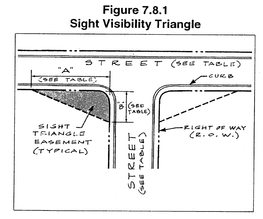
Figure 7.8.1
Table 7.8.5
Minimum Horizontal Sight Distance at Intersections
(See Illustration)
4.
Vegetation and Trees. The planting of trees or other vegetation or the location of structures exceeding 30 inches in height that would obstruct the clear sight across the sight visibility triangle shall be prohibited.
H.
Dead-end Streets and Culs-de-sac.
1.
Maximum Length. A cul-de-sac shall be no more than 750 feet long unless necessitated by topographic or other conditions and approved by the Engineering Department.
2.
Termination. Culs-de-sac shall terminate in a circular turnaround having a minimum right-of-way of at least 100 feet in diameter, and a paved turnaround with a minimum outside diameter of 80 feet.
3.
Minimum Standards. Such a street shall be provided at the closed end with a turnaround having right-of-way and roadway dimensions as set forth in the Columbus Standard Details.
4.
Termination of Temporary Dead-end Streets.
(A)
A dead-end street other than a cul-de-sac shall be allowed where the logical extension of a subdivision street is terminated or future access to adjoining property is required under Section 7.8.2.B.4. A dead-end street other than a cul-de-sac also shall be allowed as a temporary stage of construction of a street that is intended to be extended in a later stage of construction within the same development. All such temporary dead-end streets shall be provided with a temporary turn-around having a roadway radius of 40 feet if:
(1)
One or more lots front exclusively on or gain their access from the street; and
(2)
Extension of the street is not under construction when the Final Plat is submitted for recording.
(B)
If required to have a temporary turn-around, such temporary turn-around shall consist of 6 inches of graded aggregate base. The temporary turn-around shall be paved to the full dimensions and construction standards for a cul-de-sac if the street is not extended prior to the end of the maintenance period and construction plans have not been submitted to the Engineering Department for the extension.
I.
Alleys and Service Drives. Alleys shall not be provided in residential blocks except where the subdivider produces satisfactory evidence of the need for alleys. Where an alley has been specifically authorized or required by the Planning Department, it shall be a private drive and shall comply with the minimum design standards indicated below.
1.
Minimum Width and Paving. The roadbed width shall be no less than 20 feet, containing a paved roadway of no less than 16 feet exclusive of gutters.
2.
Dead-end Alleys. Dead-end alleys shall be provided with a turn-around having a radius of at least 40 feet.
J.
Half Streets Prohibited. Half streets are prohibited. Whenever a street is planned adjacent to the proposed subdivision tract boundary, the entire street right-of-way shall be platted within the proposed subdivision.
K.
Appeal of Street Design Standards. Any property owner aggrieved by a determination made pursuant to the standards set forth in this Code section 7.8.3 may seek a variance to such standard upon request to council. A variance shall be issued ONLY when there is:
1.
A finding of good and sufficient cause;
2.
A determination that failure to grant the variance would result in exceptional hardship;
3.
A finding that Council has received and reviewed the recommendations of the Department of Engineering, the Department of Planning, the Department of Public Works, the Columbus Police Department, and the Columbus Fire and EMS Department concerning the variance request; and
4.
A determination by Council that the granting of a variance will not interfere with the provision of City services along the impacted streets, inhibit the access of public safety vehicles into the affected area, result in, extraordinary public expense, or otherwise threaten the safety of the public.
(Ord. No. 05-32, § 1, 4-5-05; Ord. No. 08-72, § 1, 12-16-08; Ord. No. 18-4, § 1, 1-23-18)
Section 7.8.4. - Street Improvements.
Streets shall be constructed and paved with top courses that comply with the following standards.
A.
Minimum Width of Roadway.
1.
Minimum Width for Curb and Gutter Streets. The minimum roadway width for curb and gutter streets, measured back to back of curb, shall be as required for the street type on Table 7.8.6.
Table 7.8.6
Street Base and Pavement
2.
Minimum Width for Streets without Curb and Gutter. For streets without curb and gutter, the minimum roadway width for a collector street is 48 feet measured from edge to edge of the pavement, and for a commercial, industrial or residential local street the minimum is 24 feet. Requirements for the street base, binder and topping are the same as shown on Table 7.8.6.
B.
Street Base.
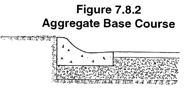
1.
Graded Aggregate Base Course. The base course shall consist of mineral aggregate and may be a combination of natural deposit or a blend of the materials specified. All materials are subject to approval by the Engineering Director. If a blend of materials is used, it shall be blended through a base plant that meets the latest specifications of the Georgia DOT Specification 815.
2.
Thickness. Street base material shall conform to the thickness as required for the street type on Table 7.8.6.
3.
Extension. The street base for collector and arterial streets shall extend fully under curb and gutter at least four inches thick, as illustrated. The street base need not extend under the curb and gutter on local streets. For streets without curbs, the base shall extend at least 1 foot beyond the edge of payment.
4.
Replacement of Unsuitable Materials. Wherever unsuitable material is found in the subgrade, the unsuitable material shall be replaced with graded aggregate stone or other suitable material recommended by a registered Geotechnical Engineer and acceptable to the City Engineer.
C.
Pavement Topping.
1.
Roadway Binder. After the base has been inspected and accepted, the roadway or street shall be surfaced with Type "B" binder if required for the street type on Table 7.8.6.
2.
Tack Coat. Tack coat shall be applied on a prepared asphalted road surface according to the requirements of DOT Specification 413.
3.
Final Topping. Final topping shall consist of a course of Type "E" asphaltic cement as required for the street type indicated in Table 7.8.6.
4.
Two-stage Paving. If two-stage paving for residential streets is approved by the Engineering Director, the developer shall place a 2-inch binder course on the street but may delay final paving.
(A)
Binder Surface Installation. Prior to the expiration of the two year maintenance bond, the binder surface will be primed with suitable asphaltic materials as provided in DOT Specification 412.
(B)
Surface Installation. After the prime has been inspected and accepted, the roadway or street shall be surfaced with a minimum 1½ inch of Type "E" asphaltic concrete wearing surface.
5.
Acceptance Prohibited. A surface treatment pavement as a finished wear surface will not be accepted. All asphaltic concrete will be mixed in an asphalt plant complying with applicable and current requirements of the DOT.
D.
Curb and Gutter.
1.
Required.
(A)
New Streets. Curb and gutter are required on all new streets and new construction on existing streets, including acceleration and deceleration lanes and travel lane widenings on both sides of the roadway where required by this Chapter.
(B)
Exemptions.
(1)
Curb and gutter are not required for subdivisions with lots of one acre or more and an average lot frontage of at least 200 feet, provided that curb and gutter is required on the radius at all intersections.
(2)
Curb and gutter may be deleted if the street design is intrinsic to the stormwater management plan and designed using good engineering practice in accordance with the Georgia Stormwater Management Manual.
2.
Dimensional Standards.
(A)
Standards for Local Residential Streets. Local residential street curbs shall be Portland cement concrete, 30-inch standard curbing consisting of 6-inch curb top × 24-inch gutter width × 12-inch back depth, vertical or roll back type, with a minimum strength of 3,000 p.s.i. at 28 days. The street curb may be reduced to 24-inch standard curbing (with a gutter width of 18-inches) for curbing along a low volume local street.
(B)
Standards for All Other Streets. Curbs along collectors and local commercial or industrial street curbs shall be Portland cement concrete, 30-inch standard curbing consisting of 6-inch curb top × 24-inch gutter width × 12-inch back depth, vertical type only, with a minimum strength of 3,000 p.s.i. at 28 days.
3.
General Standards. Curbing along streets shall comply with the standards listed below.
(A)
Line and Grade. Developer's engineer or surveyor shall set line and grade.
(B)
Expansion Joints. One-half inch expansion joints of pre-molded bitumastic expansion joint material shall be provided at all radius points and at intervals not to exceed 30 feet in the remainder of the curb and gutter. Control joints/saw cut joints shall be provided every 10 feet of curb length.
(C)
Special Curbing Design. The Engineering Director shall individually approve special curbing design such as center islands.
(D)
Installation. Curb and gutter shall be set true to line and grade and finished by skilled workers to the section shown on the plans.
(E)
Rejection. Inferior workmanship or construction methods resulting in unsightly curb and gutter will be cause for rejection of the finished work.
(F)
Completion. All curbing shall be backfilled and grassed.
(G)
Storm Drainage. Adequate storm drainage structures shall be provided. The curb and gutter shall be constructed so as to present a smooth, even line both horizontally and vertically.
4.
Valley Gutter. A valley gutter may be used across a driveway at its intersection with a street. However, valley gutters shall not be allowed across streets at street intersections unless specifically approved by the Engineering Director.
E.
Slopes and Shoulder Improvements.
1.
Streets with Curb and Gutter. On streets with curb and gutter, the shoulders shall slope one-quarter inch to the foot toward the roadway for at least 10 feet from back of curb, and no more than one-half inch to the foot for the remainder of the right-of way width.
2.
Streets with Ditch Drainage. On streets with ditch drainage, the shoulders shall slope three-quarters of an inch to the foot away from the roadway for at least five feet to the drainage channel. The maximum slope for the drainage channel shall be three feet of run for each one foot of fall, minimum two feet deep, with a minimum two foot wide channel at the bottom of the ditch. Other options are acceptable as contained in the Georgia Stormwater Management Manual, volume 2.
Section 7.8.5. - Street Names.
A.
Approval of Street Names.
1.
In no case shall the name for a proposed public or private street duplicate existing street names in Columbus, irrespective of the use of a suffix such as: street, avenue, boulevard, road, pike, drive, way, place, court or other derivatives.
2.
All street names must be reviewed and approved through the Engineering Department prior to address assignments in order to prevent duplication or confusion with existing streets.
3.
Proposed streets obviously in alignment with other existing and named streets shall bear the names of the existing streets.
B.
Names for Private Streets and Driveways.
1.
Private Street Names for Apartments and Businesses. In the case of apartment complexes or corporate entities a private drive or street name may be utilized for addressing purposes provided it is reviewed and approved through the Geographic Information Division (GIS) of the Department of Engineering and provided it meets the minimum safety requirements set forth below. The drive or street shall not serve more than one business or complex and shall be restricted to using a single name and number for the entire complex.
2.
Minimum Standards for Private Street Name Assignments. In the interest of public safety for fire protection, a private drive/street must meet all of the following minimum requirements to qualify for street name and address assignments:
(A)
The drive/street shall be clearly delineated with curb and gutter or a minimum 5-foot shoulder for a distance of at least 50 feet measured from the edge of pavement of the public street. The drive/street may not have parking wells immediately adjacent thereto in this distance.
(B)
The minimum width of paving or concrete shall be 15 feet.
(C)
The minimum vertical clearance shall be 15 feet.
(D)
A minimum radius of 50 feet shall be utilized for any horizontal curves. The width shall be widened to 20 feet in these curved areas. All curves should meet the requirements of the AASHTO guidelines, current edition.
(E)
A minimum 50-foot tangent must be provided between horizontal curves.
(F)
Any bridge structures must be designed to carry a minimum of 67,000 pounds.
(G)
Adequate utilities for fire protection must be provided.
3.
Maintenance Responsibility. The approval of a private drive/street name for address assignment shall not constitute acceptance of responsibility or liability for maintenance of any private drive/street by Columbus Consolidated Government.
(Ord. No. 05-32, § 1, 4-5-05; Ord. No. 09-22, § 1, 6-2-09)
Section 7.8.6. - Street Name Signs.
Street name signs of a type approved by the City are to be placed at all intersections. Street name signs shall be installed by the City at the developer's expense on public streets, private streets and driveways.
Section 7.8.7. - Traffic Signs.
A.
Compliance with Manual. Traffic control signs shall conform to the U.S. Manual on Uniform Traffic Control Devices. The City shall install these signs at the developer's expense.
B.
Location. All other intersections shall have stop signs located according to the Manual on Uniform Traffic Control Devices. The City shall install these at the developer's expense.
Section 7.8.8. - Street Addresses.
A.
Address Assignment.
1.
Authority to Assign Addresses. The Geographic Information Division (GIS) Division of the Department of Engineering shall have sole authority to assign addresses and notify the appropriate agencies of such assignment.
2.
Copy of Final Plat Required. A copy of a plat as filed and recorded with the Clerk of Superior Court shall be provided to the GIS Division by the owner prior to any address assignment.
3.
Timing. A minimum of three business days will be required to process new addresses or changes to existing addresses.
B.
Posting Addresses.
1.
Placement of Addresses. It shall be the responsibility of the owner or occupant of every building, mobile home or residence to have placed thereon in a place visible from the street (both private and public) numbers at least 2 inches high showing the official address number assigned to that location.
2.
Change of Address. Upon receiving notice from the GIS Division that an address change is required, the owner or occupant will be required to remove the existing numbers and replace with the new numbers within 60 days of the date of the notice.
3.
Failure to Post the Correct Address. Failure to post the correct address upon notice will be deemed a violation of this UDO.
Section 7.9.1. - Minimum Standards.
A.
Limitation on Single Entrances. A single entrance road to a subdivision shall serve no more than 120 lots/units.
(Ord. No. 18-39, § 2, 7-31-18; Ord. No. 24-020, § 2, 4-23-24)
Section 7.9.2. - Driveway Access to City Roads.
A.
Driveway Entrances. Subdividers or property owners shall obtain a driveway encroachment permit from the Department of Engineering to construct driveway entrances on public street rights-of-way. All construction shall be in accordance with the standards of the Department of Engineering.
B.
Residential Lot Access to Arterial and Collector Roads. Residential lots in any major or minor subdivision shall have no direct driveway access to a collector or arterial street unless approved by the Council, or to a State or U.S. numbered highway unless approved by the Georgia DOT.
C.
Reverse Frontage Lots. Reverse frontage lots may be utilized but are not required in major residential subdivisions where direct access to a City street, or to a State or U.S. numbered highway, is not allowed.
D.
Access Easements. An easement of at least 25 feet in width, across which there shall be no right of access, shall be platted along the line of lots abutting any major collector or arterial road in a major subdivision or private street subdivision such that no driveways have direct access to such streets. The backs of the adjacent houses must be screened from view as indicated below.
1.
Vegetation. The easement may retain its natural vegetation if existing trees and understory shrubs will adequately screen the view of the backs of the adjacent houses.
2.
Supplemental Vegetation. Supplemental vegetation may be added within the easement to provide adequate screening.
3.
Earthen Berms. The easement may be improved with a landscaped earthen berm of no less than 4 feet in height.
E.
Intersection of Driveways with Roads. Driveways shall not intersect adjacent roads at an interior angle less than 60 degrees.
F.
Gated Entrances. The design of gated entrances, including the location of the gate, shall be approved by the Engineering Department on a case-by-case basis. The distance between the gate and the street, the need for and design of a deceleration lane, and traffic restrictions such as right-in/right-out movements, will be determined based on the anticipated traffic demand and operational characteristics of the facility.
G.
Location of Driveways. On subdivided lots that access an existing City street, the driveway shall be placed as far as possible from existing road intersections to maximize sight distance.
Section 7.9.3. - Residential Subdivision Entrances.
A.
Single Entrance Roads. A single entrance road to a subdivision shall serve no more than 99 lots. Where the property configuration prohibits or makes impractical the installation of more than one entrance, the Director of Engineering may waive this requirement following sound engineering practice.
B.
Required Additional Entrances Required.
1.
Multiple Entrances. When more than one entrance is required, the first additional entrance shall be provided to serve up to an additional 150 lots, and each additional entrance thereafter shall be provided for each additional 250 lots.
2.
Additional Improvements. Alternately, or in combination with additional subdivision entrances, improvements such as dedicated left-turning lanes, center turn lanes, merge lanes, signalization, etc., may be required based on the recommendations of a professionally prepared traffic study.
C.
Subdivisions of more than 20 Lots. All residential subdivisions containing more than 20 lots shall construct a deceleration lane at each entrance to the subdivision on an existing major collector or arterial street. Other subdivisions shall provide offset radii and 50 foot tapers.
D.
Traffic Impact Study.
1.
Study Required. Residential major and private street subdivisions exceeding 250 lots shall be required to submit a traffic study to determine if additional improvements such as dedicated left-turning lanes, center turn lanes, merge lanes, signalization, etc., are required for safe traffic operations along the City street and at each entrance.
2.
Additional Steps or Improvements. If the traffic study determines that further steps or improvements should be taken to protect the traveling public, the additional requirements shall be imposed by the Engineering Director.
Section 7.9.4. - Commercial/Industrial Subdivision Entrances.
A.
Deceleration Lanes Required. A deceleration lanes shall be installed at all entrance roads into a commercial or industrial subdivision.
B.
Traffic Impact Study.
1.
Study May be Required. The Director of Engineering may require a traffic study to determine if the project's size warrants a center turn lane, longer deceleration lane, an acceleration lane or other improvements.
2.
Required Improvements. If the traffic study determines that further steps or improvements should be taken to protect the traveling public, the Director of Engineering will impose the additional requirements.
Section 7.9.5. - Driveways for Nonresidential, Multifamily and Mobile Home Developments.
A.
Deceleration Lanes Required. Service stations and other nonresidential uses, apartment/condo and mobile home complexes shall install deceleration lanes.
B.
Interior Subdivision Street Access. Service stations and other commercial businesses on corner lots that have frontage on interior subdivision streets shall have access only from the main street.
C.
Corner Lots. Commercial businesses on corner lots that have frontage on a local or minor collector side street shall install an additional lane out to the intersection if driveway access from said side street is provided.
D.
Traffic Impact Study.
1.
Study May be Required. The Director of Engineering may require a traffic study to determine if a center turn lane, a longer deceleration lane, an acceleration lane or other improvements will be necessary.
2.
Improvements Required. If the traffic study determines that the traffic generated by the project and the existing City street warrants it, the Director of Engineering will require the additional improvements or other mitigating measures.
Section 7.9.6. - Driveway Access to a State Road.
Access onto a State road shall comply with existing Georgia DOT requirements, except that the entrance must be paved. A copy of the Georgia DOT permit shall be submitted to the Engineering Department before the plans can be approved.
Section 7.9.7. - Widening for Development Entrances.
A.
Minimum Deceleration/Acceleration Lane Width. When required, minimum pavement width, not including curbs, and right-of-way to accommodate acceleration and deceleration lanes at development entrances are established in Table 7.9.1. Only deceleration lanes are required.
Table 7.9.1
Acceleration/Deceleration Lanes
B.
Measurement of Lane Length. Lane length is measured 200 feet from intersection centerline to beginning of taper. Tapers are 50 feet. Vertical face curb and gutter is required through the radii, excluding the tapers. The additional lane can be stopped at the projected property line if there is inadequate right-of-way or excessive cut or fills to install the lane. In this case, the tapers would start at the projected property line unless excessive cut or fills would encroach on the right-of-way limits of the abutting property.
C.
Catch Basins. The developer will pay the cost of any catch basins that must be constructed when an existing County road is required to be developed.
D.
Utilities and Drain Pipes. Utilities and drain pipes shall be relocated at the developer's expense outside of the acceleration/deceleration lanes. Waterlines can remain beneath the additional lanes.
E.
Completion of Curbing. The area behind all curbing shall be backfilled and grassed.
Section 7.10.1. - Required Sidewalks.
A.
Sidewalks; When Required. Sidewalks shall be required in all residential developments and in commercial and industrial developments, except as provided under paragraph B. below.
B.
Exemptions from Sidewalk Requirements. Sidewalks are not required under the following circumstances:
1.
No Curb and Gutter. Sidewalks are only required along streets that have street curbs.
2.
Large Lot Residential Subdivisions. Sidewalks are not required for residential subdivisions in which all of the lots are one acre or more in size and the average lot frontage of all lots is at least 200 feet.
3.
Short Cul-de-sac Streets. Sidewalks are not required on cul-de-sac streets that are no longer than 300 feet and provide direct access to no more than 10 dwellings. The length is measured from the centerline of the intersecting street to the radial center of the circular cul-de-sac turnaround. This exemption does not apply to temporary dead-end streets allowed under Section 7.8.3.H.4.
4.
Trail System Provided. In conservation subdivisions and planned unit developments, sidewalks may be waived by the Engineering Department for all lots that are otherwise directly connected to an off-street trail system provided within the development. Such a trail system must be provided as a permanent amenity as part of the development, and shall be the maintenance responsibility of the development's homeowners' association.
Section 7.10.2. - Sidewalk Location.
A.
Location Adjacent to Property Lines. Sidewalks shall be located not less than one foot from the property line to prevent interference of encroachment by fencing, walls, hedges or other planting or structures placed on the property line at a later date.
B.
Location Adjacent to Curbs. Sidewalks shall be located not less than two feet from the back of curb.
C.
Location on Street Side. Sidewalks shall be located on east and north sides of streets unless a different side of the street is approved by the Engineering Director to avoid conflicts with utilities or to provide continuity with adjacent sidewalks; provided that there shall be a sidewalk on at least one side of the street.
D.
Location on Culs-de-sac. Sidewalks along cul-de-sac streets may be terminated at the cul-de-sac turnaround, connecting into the street roadway where the pavement widens from the standard street travelway into the turnaround section.
Section 7.10.3. - Construction of Sidewalks.
Sidewalks shall comply with the construction requirements listed below.
A.
Width and Thickness. Concrete sidewalks shall be a minimum of 5 feet wide and 5 inches thick.
B.
Minimum Strength. Concrete shall be at least 3,000 p.s.i. at 28 days' strength.
C.
Completion. Upon completion, sidewalks shall be backfilled and grassed.
D.
Timing of Installation. Sidewalks shall be shown on construction drawings for the streets, and shall be accommodated in grading plans and activities for right-of-way preparation, but may be installed on a lot-by-lot basis after the final plat for the subdivision or phase is recorded. Within a final-platted subdivision, the required sidewalk along each lot frontage shall be installed no later than when the driveway is installed, provided that all sidewalks throughout the final-platted subdivision shall be installed prior to the end of the maintenance period. Sidewalk installation shall provide continuity to adjoining sidewalks as to grades, appearance and construction standards.
Section 7.11.1. - Location of Utilities in Streets.
A.
Above-ground Utilities. Telephone poles, street light poles, telephone junction boxes and other public or private utility structures placed above ground within a street right-of-way must be at least nine feet back from the back of the street curb or edge of pavement and at least one foot back from the edge of any sidewalk, whichever is farthermost from the roadway.
B.
Underground Utilities. Utilities placed underground shall be placed within the right-of-way in accordance with the City's Standard Utility Location Cross-Section, or as otherwise approved by the Engineering Director on construction drawings for the project.
Figure 7.11.1
Section 7.11.2. - Pavement Cuts.
A.
Review and Approval. All utility construction plans within City right-of-way shall be reviewed and approved by the Engineering Director.
B.
Trenches. All trenches shall be backfilled and compacted the same day the trench is opened.
1.
Compaction under Paving. Trenches under the paving shall be returned to 95% compaction.
2.
Compaction Elsewhere. Trenches elsewhere shall be returned to 90% compaction.
C.
Road Cut Policy. The City's policy is no existing city roads can be open cut unless unusual circumstances warrant it. The Engineering Director shall be contacted for permission to open cut any existing City road, prior to any cut.
1.
Storm Sewer Installation. Storm sewers 36 inches or smaller in diameter shall be bored.
2.
Trenches. If the City allows open cutting all trenches under existing paving shall be backfilled and compacted in six inch lifts and excavated to allow for six inches of 3,000 p.s.i. concrete and one and one-half inches of asphaltic concrete to be placed.
3.
Paving Cut. A paving cut shall be widened to a minimum of 12 inches beyond the edges of the trench and excavated to allow for the six inches of 3000 p.s.i. concrete and one and one-half inches of asphaltic concrete to be placed.
4.
Edges of Cuts. The edges of the paving cut shall be smooth.
5.
Final Wearing Surfaces. A final wearing surface of one and one-half inches of Type "E" asphaltic concrete shall be poured and rolled after the concrete is cured.
Section 7.12.1. - Stormwater Management.
The reasons for adopting stormwater management regulations are listed below.
A.
Health, Safety and Welfare. Surface water runoff can carry pollutants and nutrients into receiving waters. Polluted stormwater discharge has an adverse impact on health safety, welfare and the quality of life.
B.
Flooding. Uncontrolled stormwater drainage can increase the incidence of flooding and the level of floods, endangering roads, other public and private property, and human life.
C.
Runoff. Altered land surfaces can change the rate and volume of runoff. These changes may have the following results:
1.
Stream banks can erode and slump, resulting in widening of streams;
2.
Tree root systems can be undercut;
3.
Erosion rates can increase; and
4.
Streambeds can become more uniform and shallow, providing less varied aquatic habitat.
D.
Municipal Separate Storm Sewer System. Current and anticipated growth will contribute to and increase the need for improvement and maintenance of the municipal separate storm sewer system.
Section 7.12.2. - Objectives and Purpose.
Objectives and purposes of a stormwater management system are indicated below.
A.
Regulation. Regulate the municipal separate storm sewer system.
B.
Protection. Protect, preserve and enhance water quality and fish and wildlife habitat within the service area and downstream receiving waters.
C.
Water Quantity and Quality. Protect downstream receiving waters from water quality and quantity impacts.
D.
Compliance with State and Federal Law. Comply with the DNR and the U.S. Environmental Protection Agency (EPA) stormwater regulations developed pursuant to the Clean Water Act.
E.
Best Management Practices. Require development plans to minimize the transport of pollutants to the municipal separate storm sewer system by incorporating Best Management Practices into the design.
F.
Minimize Flooding. Establish procedures that minimize damage from flooding, while recognizing that natural fluctuations in water levels are beneficial.
G.
Construction of Drainage Systems. Require construction of drainage systems that aesthetically and functionally approximate natural systems.
Section 7.12.3. - Prohibited Discharges.
A.
Prohibited Discharges. It is unlawful, and is a violation of this Section, for any person to throw, drain, run, allow to seep or otherwise discharge to any part of any separate storm sewer system, Waters of the United States, or State Waters or to cause, permit, suffer to be thrown, drained, run, allowed to seep or otherwise discharge into any separate storm sewer system, Waters of the United States or State Waters anything except unpolluted storm water runoff, unless otherwise exempted.
B.
It is a defense to prosecution under Subsection A. that a discharge of water not composed entirely of storm water resulted or occurred exclusively from one or more of the following sources, activities, or events:
1.
Full compliance with an NPDES permit, other than the NPDES permit granted to the Columbus Consolidated Government (CCG) for discharges from the municipal separate storm sewer system.
2.
Discharges or flows from firefighting.
3.
Agricultural storm water runoff.
4.
Water line flushing, excluding a flushing from water line disinfection by super chlorination or other means unless:
(A)
The total residual chlorine has been reduced to less than five mg/L; and
(B)
The discharge contains no harmful quantity of chlorine or any other chemical used in line disinfection.
5.
Lawn watering, landscape irrigation, or other irrigation water.
6.
A diverted stream flow or natural spring.
7.
Uncontaminated pumped groundwater or rising groundwater.
8.
Uncontaminated groundwater infiltration (drain tile or French drain).
9.
A foundation drain, crawl space pump, footing drain, or sump pump, if the discharge is uncontaminated.
10.
A potable water source not containing a harmful substance or material from the cleaning or draining of a storage tank or other container.
11.
Air conditioning condensation that is unmixed with water from a cooling tower, emissions scrubber, emissions filter, or other source of pollutant.
12.
Individual residential car washing.
13.
Water from riparian habitats or wetlands.
14.
Water used in street washing that is not contaminated with any soap, detergent, degreaser, solvent, emulsifier, dispersant, or other harmful cleaning substance.
15.
Stormwater runoff from a roof that is not contaminated by any runoff or discharge from an emissions scrubber, emissions filter, or other source of pollutant.
16.
Swimming pool water that:
(A)
Has been de-chlorinated so that total residual chlorine is less than five mg/L; and
(B)
Contains no harmful quantity of muriatic acid (~20% hydrochloric acid) or other chemical used in the treatment or disinfection of swimming pool water or in pool cleaning.
17.
A temporary car wash sponsored by a civic group, school, or a religious or other nonprofit organization.
18.
Industrial Cooling Water under the authorization and direction of the Director of the Georgia Environmental Protection Division and appropriate NPDES permit. The temperature of the discharge water shall not vary more than five degrees (Celsius) hotter or cooler than the temperature of the receiving water.
19.
Other unpolluted water.
C.
No defense to prosecution is available under Subsection B. if:
1.
The discharge in question has been determined by the Director, or his or her designee to be the source of a pollutant to the storm water drainage system, waters of the United States, or State Water;
2.
Written notice of such determination has been provided to the discharger; and
3.
The discharge has occurred more frequently than or beyond the limits permitted by the Director on a case-by-case basis.
D.
In any civil or criminal action, the discharger has the burden of proving that a discharge in violation of Subsection A. is uncontaminated or falls within a defense to prosecution under Subsection B. Prima facie proof that a discharge is uncontaminated must be made in the form of an analysis by a certified laboratory, using standard methods or procedures prescribed by USEPA regulations. A copy of the laboratory analysis must be sent to the CCG Director of Engineering;
E.
A person commits an offense if he discharges or causes to be discharged into any separate storm water drainage system, waters of the United States, or state water a pollutant or substance that causes or contributes in causing CCG to violate a water quality standard, CCG's NPDES permit, or any state-issued discharge permit for discharges from the CCG's separate storm water drainage system.
F.
A person commits an offense if he/she discharges or allows or permits the discharge of any of the following into any separate storm water drainage system:
1.
Used oil, antifreeze, or any other motor vehicle fluid.
2.
Industrial waste.
3.
Hazardous waste, including hazardous household waste.
4.
Domestic wastewater, septic tank waste, grease trap waste, or grit trap waste.
5.
Garbage, rubbish, or yard waste.
6.
Wastewater from:
(A)
Any commercial car wash facility;
(B)
Any vehicle washing, cleaning, or maintenance at any new or used automobile or other vehicle dealership, rental agency, body shop, repair shop, or maintenance facility (to be enforced beginning January 1, 2016);
(C)
Any washing, cleaning, or maintenance of any business, commercial, or public service vehicle (including a truck, bus, or heavy equipment) by a business or public entity that operates more than two of such vehicles (to be enforced beginning January 1, 2016);
(D)
The washing, cleaning, de-icing, or other maintenance of aircraft;
(E)
Any commercial mobile power washer or the washing or other cleaning of a building exterior if the wastewater contains any soap, detergent, degreaser, solvent, or other harmful cleaning substance;
(F)
Floor, rug, or carpet cleaning;
(G)
The wash down or other cleaning of pavement if the wastewater contains any harmful quantity of soap, detergent, solvent, degreaser, emulsifier, dispersant, or other harmful cleaning substance; or
(H)
The wash down or other cleaning of any pavement where any spill, leak, or other release of oil, motor fuel, or other petroleum or hazardous substance has occurred, unless all harmful quantities of the released material have been previously removed.
7.
Effluent from a cooling tower, condenser, compressor, emissions scrubber, or emissions filter or the blow down from a boiler.
8.
Ready-mixed concrete, mortar, ceramic or asphalt base material, or hydro mulch material, or wastewater from the cleaning of vehicles or equipment containing or used in transporting or applying such material.
9.
Runoff or wash down water from any animal pen, kennel, or fowl or livestock containment area.
10.
Filter backwash from a swimming pool, fountain, or spa with a total chlorine residual of greater than five mg/L.
11.
Swimming pool water that contains:
(A)
Total residual chlorine of five mg/L or more; or
(B)
Any harmful quantity of muriatic acid (~20% hydrochloric acid) or other chemical used in the treatment or disinfection of swimming pool water or in pool cleaning.
12.
Discharge from water line disinfection by super chlorination or other means if:
(A)
The total residual chlorine is at five mg/L or more; or
(B)
The discharge contains any harmful quantity of another chemical used in line disinfection.
13.
Fire protection water containing oil or a hazardous substance or material, unless treatment adequate to remove pollutants occurs prior to discharge, except that this prohibition does not apply to discharges or flow from firefighting by the fire department.
14.
Water from a water curtain in a spray room used for painting vehicles or equipment.
15.
Contaminated runoff from a vehicle wrecking yard.
16.
Any substance or material that will damage, block, or clog the storm water drainage system.
17.
Any discharge from a petroleum storage tank, any leachate or runoff from soil contaminated by a leaking petroleum storage tank, or any discharge of pumped, confined, or treated wastewater from the remediation of a petroleum storage tank release, unless the discharge complies with all state and federal standards and requirements and does not contain a harmful quantity of any pollutant.
G.
A person commits an offense if he discharges into any separate storm water drainage system a harmful quantity of sediment, silt, earth, soil or other material associated with:
1.
Clearing, grading, excavating, or other construction activities; or
2.
Land filling or other placement or disposal of soil, rock, or other earth materials in excess of what could be retained on site or captured by employing sediment and erosion control measures to the maximum extent practicable.
H.
Illicit Connections. It is unlawful for a person, company, corporation, etc. to connect any pipe, open channel or other conveyance system that discharges polluted water to any separate storm sewer system within Columbus, Georgia.
1.
All connections to the storm water system shall carry only storm water runoff as defined herein or those discharges exempted under Section 7.12.3.B. All connections must be reviewed for permit prior to work being performed.
2.
Improper connections in violation of this Chapter must be corrected and redirected to the correct system of conveyance within 30 days at the owner's/operator's expense. If it required to be connected to the sanitary sewer system then approval and proper permits must be obtained from the Columbus Water Works. Proof of that approval shall be presented to the Department of Engineering prior to the commencement of corrective work. The Columbus Water Works has the authority at that time to require the owner/operator to provide pretreatment of the discharge prior to entering the sanitary system. The financial responsibility for the pretreatment system and the relocation of any conveyance system(s) shall be the owner/operator's and not that of the Columbus Consolidated Government or the Columbus Water Works.
(Ord. No. 15-53, § 1, 10-27-15)
Section 7.12.4. - Applicability and Exemptions.
All storm drainage installation and systems shall comply with the requirements of this Article.
A.
Drainage Required. An adequate drainage system, including necessary ditches, pipes, culverts, drains, inlets, bridges, etc., shall be provided for the proper drainage of all surface water.
B.
Stormwater Management Plan.
1.
Plan Required. All persons proposing development or construction in the city shall prepare a stormwater management plan.
2.
Approval Required. No final subdivision plat shall be approved and no development or building permit shall be issued until and unless the stormwater management site plan has been reviewed and approved by the Engineering Director, except as exempt below.
C.
Applicability.
1.
The stormwater management standards listed below are required for any new development and/or redevelopment site that meets one or more of the following criteria:
(A)
New development that creates, or adds 5,000 square feet or greater of impervious surface, or that involves land disturbing of 5,000 square feet or greater or,
(B)
Redevelopment that creates, replaces or adds 5,000 square feet or greater of new impervious surface, or that involves land disturbing activity of one acre or more, including projects less than one acre if they are part of a larger common plan of development or sale, or,
(C)
Any commercial or industrial new development or redevelopment, regardless of size, with a SIC or NAICS that requires coverage under the State of Georgia's NPDES Industrial Stormwater Discharge Permitting Program, or a hotspot use as defined below.
(D)
Redevelopment sites that involve land disturbing of 5,000 square feet or greater, but less than one acre.
(E)
For the purposes of engineering calculations, replacement of impervious surface shall assume that the site's predevelopment state is "pasture in good condition" or equivalent.
(F)
These standards will be required of all land disturbing plan applications initially received after January 1, 2016.
2.
For sites that meet one or more of the above criteria, the permittee shall ensure that the following minimum standards are incorporated into the site plan:
(A)
Stormwater Runoff Quality/Pollutant Reduction. Stormwater runoff shall be adequately treated prior to discharge. The stormwater management system shall be designed to remove at least 80 percent of the average annual post-development total suspended solids (TSS) load or equivalent as defined in the Georgia Stormwater Management Manual. Compliance with this performance standard is presumed to be met if the stormwater management system is sized to capture and treat the water quality volume, which is defined as the runoff volume resulting from the first 1.2 inches of rainfall from a site.
(B)
Stream Channel/Aquatic Resource Protection. Steam Channel and/or Aquatic Resource Protection shall be provided by using the following approaches: 1) 24-hour extended detention storage of the 1-year, 24-hour return frequency storm event; 2) erosion prevention measures such as energy dissipation and velocity control; and 3) preservation of the applicable stream buffer.
(C)
Overbank Flood Protection. Downstream Overbank Flood Protection shall be provided by controlling the post-development peak discharge rate to the predevelopment rate for the 25-year, 24-hour storm event.
(D)
Extreme Flood Protection. Extreme Flood Protection shall be provided by controlling the 100-year, 24-hour storm event such that flooding is not exacerbated.
D.
Definitions. The following terms have special meaning as used in this Article:
1.
New development is defined as land disturbing activities, structural development (construction, installation or expansion of a building or other structure), and/or creation of impervious surfaces on a previously undeveloped site.
2.
Redevelopment is defined as structural development (construction, installation or expansion of a building or other structure), creation or addition of impervious surfaces, replacement of impervious surface not part of routine maintenance, and land disturbing activities associated with structural or impervious development. Redevelopment does not include such activities as exterior remodeling.
3.
A hotspot is defined as a land use or activity on a site that produces higher concentrations of trace metals, hydrocarbons or other priority pollutants than are normally found in urban stormwater runoff. Examples of hotspots include gas stations, vehicle service and maintenance areas, salvage yards, material storage sites, garbage transfer facilities, and commercial parking lots with high-intensity use.
E.
Exemptions. The following development activities are exempt from the minimum stormwater management standards:
1.
Individual single-family residential lots. (Single-family lots that are part of a subdivision or phased development project are not exempt from the minimum standards); and
2.
Additions or modifications to existing single-family structures.
F.
Additional Requirements.
1.
New development or redevelopment in critical or sensitive areas, namely watersheds that contribute to Columbus's drinking water source, Lake Oliver, or watersheds listed on the most current 303(d) Impaired Waters list, published by the Georgia Environmental Protection Division, may be subject to additional performance and or regulatory criteria. Furthermore, these sites may be required to utilize or restrict certain structural controls in order to protect a special resource or address certain water quality or drainage problems identified for a drainage area/watershed.
2.
This requirement for additional Best Management Practices (BMPs) or restriction of the use of certain BMPs will be at the discretion of the Director of Engineering or his/her designee on a case-by-case basis.
(Ord. No. 15-53, §§ 2, 3, 10-27-15)
Section 7.12.5. - Minimum Stormwater Management Standards.
The following standards are the minimum stormwater management performance requirements for new development or redevelopment sites falling under the applicability criteria above. A detailed technical explanation of each minimum standard is provided in the Georgia Stormwater Management Manual, Volume 2, Section 1.2.
A.
Use of Better Site Design Practices for Stormwater Management. Site designs should preserve the natural drainage and treatment systems and reduce the generation of additional stormwater runoff and pollutants to the fullest extent practicable.
B.
Stormwater Runoff Quality.
1.
All stormwater runoff generated from a site shall be adequately treated before discharge. Stormwater management systems (which can include both structural stormwater controls and better site design practices) must be designed to remove 80% of the average annual postdevelopment total suspended solids (TSS) load and be able to meet any other additional watershed- or site-specific water quality requirements.
2.
It is presumed that a stormwater management system complies with this performance standard if:
(A)
It is sized to capture and treat the prescribed water quality treatment volume, which is defined as the runoff volume resulting from the first 1.2 inches of rainfall from a site; and
(B)
Appropriate structural stormwater controls are selected, designed, constructed, and maintained according to the specific criteria in this Manual.
(C)
Runoff from hotspot land uses and activities is adequately treated and addressed through the use of appropriate structural stormwater controls and pollution prevention practices.
C.
Stream Channel Protection. Stream channel protection shall be provided by using all of the following three approaches:
1.
24-hour extended detention storage of the 1-year, 24-hour return frequency storm event;
2.
Erosion prevention measures such as energy dissipation and velocity control; and
3.
Preservation of the applicable stream buffer.
D.
Overbank Flood Protection. Downstream overbank flood protection shall be provided by controlling the post-development peak discharge rate to the predevelopment rate for the 25-year, 24-hour return frequency storm event. If control of the 1-year, 24-hour storm (Minimum Standard #3) is exempted, then overbank flood protection shall be provided by controlling the post-development peak discharge rate to the predevelopment rate for the 2-year through the 25-year return frequency storm events.
E.
Extreme Flood Protection. Extreme flood protection shall be provided by controlling and/or safely conveying the 100-year, 24 hour return frequency storm event such that flooding is not exacerbated. Existing and future floodplain areas should be preserved as possible.
F.
Downstream Analysis. A downstream hydrologic analysis shall be performed to determine if there are any additional impacts in terms of peak flow increase or downstream flooding while meeting Minimum Standards A through E. This analysis shall be performed at the outlet(s) of the site, and downstream at each tributary junction to the point(s) in the conveyance system where the area of the portion of the site draining into the system is less than or equal to 10% of the total drainage area above that point.
G.
Groundwater Recharge. Annual groundwater recharge rates should be maintained to the extent practicable through the use of nonstructural methods.
H.
Construction Erosion and Sedimentation Control. Erosion and sedimentation control practices shall be utilized during the construction phase or during any land disturbing activities.
I.
Minimum Standard #9 - Stormwater Management System Operation and Maintenance. The stormwater management system, including all structural stormwater controls and conveyances, shall have an operation and maintenance plan to ensure that it continues to function as designed.
J.
Minimum Standard #10 - Pollution Prevention. To the maximum extent practicable, the development project should [shall] implement pollutant prevention practices and have a stormwater pollution prevention plan.
K.
Minimum Standard #11 - Stormwater Management Site Plan. The development project shall prepare a stormwater management site plan for local government review that addresses Minimum Standards A through J.
Section 7.12.6. - Standards to be Used in Designing System.
A.
Storm Detention Facilities. All development plans will require a hydrology study stamped and signed by a registered engineer or landscape architect. If detention has been waived or provided in a previous section, then a letter with supporting documents should be provided. Permanent detention facilities will be required, and shall be designed so that the following standards shall apply:
1.
Excess Runoff. The excess runoff created by new development shall be compensated for in accordance with the provisions of the Georgia Stormwater Management Manual.
2.
Water Quality Treatment. Water quality treatment shall be in accordance with the provisions of the Georgia Stormwater Management Manual.
3.
Detention Requirements. Detention shall be provided such that the peak rate of flow from the site after development will not exceed the corresponding flow that would have been created by the 2-year, 10-year, 25-year and 100-year return frequency storms prior to development.
4.
Detention Pond Size Determination. The size, capacity and operational characteristics of a stormwater detention facility shall be in accordance with the provisions of the Georgia Stormwater Management Manual.
5.
Emergency Overflow Devices. An emergency overflow device, excluding the throttling device, for a detention pond shall be designed to pass the 100-year peak inflow without overtopping the dam.
6.
Minimum Berm Width. The top of the berm shall be a minimum of 15 feet wide when 3:1 slopes are used and 10 feet wide with 5:1 slopes.
7.
Stability. Slopes shall be stable under all conditions including maintenance, and a minimum 3:1 on City accepted ponds.
8.
Vegetative Coverage. Full and living coverage of an approved permanent grass devoid of noxious weeds shall be provided.
9.
Pond Bottom. The bottom of the pond shall be firm enough to be maintained by mechanical means per City standards.
10.
Access. A ten foot wide access road shall be required around the circumference of the pond, where topography does not prohibit this. The access road shall be located within a 20-foot wide access easement that is deeded to the City, fully accessible to maintenance vehicles, and void of any conflicts with utilities, fences, landscaping and similar items.
11.
Fencing. Where fences are provided they shall be a minimum 3.5 and 6 feet high.
(A)
Chain Link Fencing. Commercial gage chain link fence shall be screened.
(B)
Wood Fencing. If it a wood fence is desired it shall be placed on the lots of the individual property owners. These fences shall be the maintenance responsibility of individual owners and this responsibility shall be shown on the plats and deeds at dedication.
12.
Hydrological Study. As part of the hydrological study, consideration shall be given to the flow capacity of downstream drainage structures. If the downstream system is inadequate, the developer is required to either improve the down stream drainage structure or provide additional storage in the detention facility.
13.
Damming. In approved cases the detention may be provided by damming a natural basin with minimal clearing. The required discharge structure opening must be large enough to prevent stoppage from leaves and other debris naturally occurring. Also, the volume should be adequate to account for natural growth of vegetation.
B.
Storm Drains.
1.
Sizing and Location of Drainage Structures. Sizing and location of all existing and proposed drainage structures shall be the responsibility of a registered professional engineer or landscape architect, subject to approval by the City Engineer.
2.
Sloping of Pipes. Storm drainage pipes shall be sloped so as to maintain a minimum velocity of 3 feet per second (fps) so that sediment will not collect.
3.
Standards for Materials and Installation. Georgia DOT Standard 1030D, or most current standard, shall be used in determining class (concrete) or gauge of pipe under fill, method of backfilling and pipe installation.
4.
Drainage Formula. The drainage formula used in determining size of drainage structure shall be determined by the developer's engineer or landscape architect according to accepted engineering practice, subject to approval of the City Engineer.
5.
Certification. A registered engineer or landscape architect shall certify the storm drain pipe sizes.
6.
Design Storm Event. The 25-year storm event shall be used in designing the storm drains, inlets, cross-drains, etc. that comprise the drainage system. In cases where a spring, creek, or other watercourse traverses the property, the 100-year storm event will be used for design. Lane spread shall be no more than ½ the travel lane width.
C.
Subdrainage. Subdrainage will be installed to control the surplus ground water by intercepting sidehill seepage or by lowering or regulating the ground water level where such conditions exist.
D.
Bridge Design. Bridges shall be designed for a 100-year storm event.
Section 7.12.7. - Maintenance of Ponds and Facilities.
A.
Facilities to be Accepted by the City. If a proposed residential facility or pond is intended for acceptance by the City, then it must be located on a separate lot and deeded to the City along with an access way that is at least 20 feet in width containing the 10-foot wide access road. The access way shall either be a portion of the lot having frontage on a street, or an access easement connecting the lot to a street. The access road shall be constructed to standard specifications of the Engineering Department. The lot need not meet zoning requirements as a buildable lot.
B.
Variance. A variance from side yard setbacks may be requested from the Planning Division if the 20-foot access prohibits the builders from complying with zoning requirements.
C.
Petition for Acceptance. The developer should petition the City for acceptance upon completion of construction.
D.
Bond. A continuous two year maintenance bond to cover the maintenance and construction shall be provided. The bond will remain in effect until released by the Department of Engineering at which time the City will assume maintenance of the facility.
E.
Perimeter Buffering. The perimeter of the parcel deeded to the City for detention ponds and access shall be planted with good living 4 foot high Burford Holly, Ligustrum Japonicum (wax leaf privet), Leland Cypress, or approved equal and set 4-foot on centers.
1.
Minimum Maintenance Period. All plants shall be in good living condition at the end of the two year maintenance period and shall have been planted a minimum of one year.
2.
Extended Warranty for Planting. If the 1 year planting cannot be met then an extended warranty shall be required.
F.
Maintenance of Private Stormwater Management Facilities.
1.
The owner/operator of a private stormwater management facility (i.e., a facility not accepted by the City that serves any development) shall perpetually be responsible for the proper operation and maintenance of said facility. Failure to operate or maintain a stormwater management facility in accordance with this chapter shall be a violation of this Chapter. Should it become necessary for the City to perform work (or have a private contractor perform work on behalf of the City) in order to maintain a private facility, then the City may place a lien against the property until full reimbursement for the work performed by City forces, or work paid for by the City, is recovered.
2.
The owner of a private stormwater management facility shall submit an annual maintenance report to the City. The annual report will document all maintenance and inspection activities conducted by the owner on his/her stormwater management facility(ies) for each calendar year. Blank maintenance and inspection reports, provided by the City, shall be completed by the owner or his/her designee for each facility and returned to the City no later than January 31 of the following year. This requirement applies to all existing and future stormwater management facilities; both inside and outside the Combined Sewer Area and shall go into effect January 1, 2016. The first reports under the requirement will be due by January 31, 2017. Failure to provide the City with an adequate Annual Report by the deadline shall be a violation of this Chapter.
3.
Maintenance and Inspection standards and schedules expected by the City mirror those found in the most recently published Georgia Stormwater Management Manual (GSMM). Should prescribed maintenance and inspection activities and recommended schedules not be included in the GSMM, those activities and schedules recommended by the device's manufacturer, at a minimum, will be required.
(Ord. No. 09-52, § 1, 11-10-09; Ord. No. 15-53, § 4, 10-27-15)
Section 7.12.8. - Cross Drain Pipes.
A.
Minimum Size. Cross drain pipes shall be not less than 15 inches in size when under the street.
B.
Location. A storm drain pipe running parallel to the existing primary road shall not be located beneath any proposed acceleration/deceleration lanes. The Director of Engineering may modify or waive this requirement if unusual circumstances exist such as topography.
C.
Inlet and Outlet Ends. The inlet and outlet end of all storm drain pipes, shall have concrete flared end sections, concrete headwalls, or mitered ends with concrete collars or slope-paved headwalls that comply with the standards of Georgia DOT. The collars shall be a minimum of four inches thick and extend 18 inches beyond the limits of the pipe.
Section 7.12.9. - Stormwater Ditches.
All man-made ditches between storm drain pipes and downstream of storm drain pipes shall be designed by a registered professional engineer or landscape architect in accordance with the provisions of the Georgia Stormwater Management Manual, Volume 2. The ditch profile and cross-sections every 50 feet shall be shown on the plans. The plans shall show the velocity and flow at each cross-section.
Section 7.12.10. - Materials and Installation.
A.
Materials and Installation. Materials and installation requirements for storm sewer pipes shall conform to Georgia DOT standards or to the specifications of the Engineering Department.
B.
Construction Standards for Storm Drains.
1.
All concrete pipe must be reinforced and meet AAS14TO M170. That which is used within the ROW must be Class III. Conditions such as shallow cover or depths that exceed 25 feet may require a higher class pipe.
2.
Any storm drain structure over 3.5 feet must have steps per the Georgia DOT standards.
3.
All pipe in storm drain structures shall be struck even with the inside wall.
4.
Preformed joint sealer, which conforms to AASHTO M198 for Type B flexible plastic gaskets, shall be used in lieu of the mortar jointing method.
5.
The interior surfaces of all storm drain structures shall be smoothed to an acceptable standard using mortar mixed to the manufacturer's specifications.
6.
All frames, grates, rings and cover, etc., must conform to the standards set forth in the Georgia DOT specifications. The current Columbus standard for manhole ring and cover is the US Foundry 223 or equal.
7.
Backfilling of trenches shall be accomplished immediately after the pipe is laid. The fill around the pipe shall be placed in layers not to exceed 6 inches with each layer being thoroughly compacted. All material shall have an in place density of 98%-modified proctor to a depth of 6 inches below the finished grade, and 95%-modified proctor at depths greater than 6 inches below the finished grade. Compaction requirements shall be attained by the use of mechanical compaction methods. Each layer of backfill shall be placed loosely and thoroughly compacted in place.
8.
All backfill shall be nonplastic in nature, free from roots, vegetative matter, waste, construction material or other objectionable material. Said material shall be capable of being compacted by mechanical means and shall have no tendency to flow or behave in a plastic manner under the tamping blows.
(A)
Removal. Material deemed by the Engineer as unsuitable for backfill purposes shall be removed and replaced with selected backfill material.
(B)
Water. Water shall not be permitted to rise in trenches that are not backfilled after the pipe has been placed.
Section 7.12.11. - Minimum Clearances.
A.
Culverts. At least two feet between the bottom of the base or sub-base, if used, and the exterior crown of the culvert (top of pipe) is required under the roadway.
B.
Pipes in Easements. Pipes included in easements shall have a minimum cover of one foot or at the manufacturers' recommendations.
C.
Underground Utilities. A minimum of six inches of cover shall be provided between underground utilities and exterior crown of culverts.
D.
Trench Construction. Trench construction for storm drainage pipe shall be in accordance with DOT.
Section 7.12.12. - Driveway Culverts.
A.
Culvert Required. Driveway pipe shall be sized for the 25-year storm event.
B.
Pipe Materials. Driveway culverts may be PVC, Reinforced Concrete Pipe or High Density Polyethylene (smooth lined type "S").
C.
Inlets and Outlets. The inlet and outlet end of all driveway culverts shall have either flared-end sections or concrete headwalls that meet the standards of Georgia DOT.
Section 7.12.13. - Field Changes
Changes in construction plans caused by field conditions shall be made at the direction of the Engineering Inspector as approved by the Director of Engineering with the cost of such changes to be paid by the developer.
Section 7.12.14. - Monitoring of Industrial Stormwater Dischargers.
A.
Industrial Stormwater Discharge Permittee Definition.
1.
Permittees must have a storm water discharge associated with industrial activity from the permittee's primary industrial activity, as identified by Sectors A through AA and AB below.
2.
Sector AB. This permit also authorizes storm water discharges under Sector AB from any industrial activity designated by EPD where the designation is based on the potential for contribution to a violation of a water quality standard or for significant contribution of pollutants to Waters of the State. Sector AB permittees must be notified by EPD that the permittee is eligible for coverage under Sector AB of this permit.
3.
Municipally owned or operated industrial facilities must comply with the permit and monitoring requirements for all types of industrial activities that such installations perform.
B.
Applicability and Exceptions.
1.
Applicability.
(A)
Applicability under this Ordinance is limited to discharges from facilities in the sectors of industrial activity summarized below. These sector descriptions are based on SIC Codes and Industrial Activity Codes from USEPA regulations. References to "sectors" in Ordinance (e.g., sector-specific monitoring requirements under the State Industrial Stormwater Discharge Permit) refer to these groupings. Please note: Facilities may be subject to more than one sector.
2.
Exceptions.
(A)
Applicable facilities located within Columbus-Muscogee County's Combined Sewer Area are not required to obtain coverage under the State of Georgia's Industrial Stormwater Discharge Permit and are therefore exempt from the requirements of this section.
(B)
Facilities that have satisfied the conditions of "No Exposure Exclusion" are not subject to this Section.
C.
Notification of Applicability.
1.
The Columbus Consolidated Government's Department of Engineering will mail notices to applicable facilities each January as a reminder of the specific requirements of this Section.
2.
Included in this notification will be a compliance summary form (CCG Compliance form) to be used by the facility for reporting purposes.
D.
Reporting of Regulatory Inspections/Sample Analysis Reports.
1.
Purpose.
(A)
The Columbus Consolidated Government is required to develop, implement and maintain an Industrial Stormwater Monitoring Program as a NPDES Phase I Municipal Stormwater Permittee. This Section is designed to fully satisfy that mandate.
2.
Reporting and Required Documentation.
(A)
The owner/manager of a covered facility shall submit an Annual Stormwater Compliance Report to the City. This annual report will document all inspection, sampling and maintenance activities conducted by the permittee each calendar year. Blank annual stormwater compliance reports, provided by the City, shall be completed by the permittee or his/her designee for each permitted site and returned to the City by either certified mail or email (stormwaterreports@columbusga.org) no later than January 31 of the following year. This requirement applies to all covered facilities and shall go into effect January 1, 2016. The first reports under the requirement will be due no later than January 31, 2017.
(B)
Required documentation under this section includes:
(1)
CCG Compliance Form
(2)
Signed Stormwater Pollution Prevention Plan Certification (as required by State permit)
(3)
Quarterly Visual First Flush Examination Forms (as required by State permit)
(4)
Annual Laboratory Analysis Summary (if required by State permit)
(5)
Annual Compliance Inspection Report (as required by State permit)
(6)
Maintenance Records for Stormwater Management Facilities (see 7.12.7.F.2, ponds, constructed wetlands, proprietary devices, etc.)
E.
Failure to Report.
1.
Failure to provide the City with an adequate Annual Stormwater Compliance Report by the deadline shall be a violation of this Chapter.
(Ord. No. 15-53, § 5, 10-27-15)
Section 7.13.1. - Connection Required.
Any single-family or multifamily dwelling, commercial or industrial establishment shall be connected to a public water supply. Water mains and connection to the water supply shall be at the cost of the property owner. The installation of said mains and connection to each lot shall be installed prior to the paving of the street.
(Ord. No. 11-55, § 1, 11-8-11)
Section 7.13.2. - Water Not Available.
Where a public water supply is not available, each lot in a subdivision shall be furnished with a water supply system acceptable to and approved by the Health Department.
Section 7.13.3. - Design Criteria.
Water systems must be designed as outlined by the Columbus Water Works Department.
Section 7.14.1. - Availability.
Any single-family or multifamily dwelling, commercial or industrial establishment shall be connected to public sewer if located within 1,500 feet, or in the written opinion of the Columbus Health Department and the Columbus Water Works that the public sanitary sewer is within a reasonable distance. Said written opinion shall be reviewed by the Planning Department and Engineering Department prior to submission to the requesting party. Connecting into the system and providing sanitary sewer service to each lot within the bounds of the subdivision shall be at the cost of the property owner. The installation of all street sewers shall be installed prior to the paving of the street. Connection shall be at the cost of the property owner.
(Ord. No. 11-55, § 1, 11-8-11)
Section 7.14.2. - Sewerage Not Available.
A.
Easements Required. If sewerage is not available, a 30 foot permanent easement shall be shown on the plans and dedicated to the City of Columbus for future use, in those areas where a proposed subdivision is adjacent to a creek or branch whose drainage area is 200 acres or greater.
B.
Alternative Disposal. An alternate method of sewage disposal for each lot or a community sewage disposal system may be used provided it is in compliance with the standards of the Health Department and the Columbus Water Works.
Section 7.14.3. - Design Factors.
Sewers shall be designed according to criteria and design standards provided by the Columbus Water Works.