
Columbus City Zoning Code
CHAPTER 6
RESOURCE CONSERVATION
ARTICLE 4. - RESOURCE CONSERVATION SUBDIVISIONS
As an option to conventional subdividing of the land, the developer may elect to create a resource conservation subdivision under the provisions of this Article.
Section 6.1.1. - Purpose.
This Article sets out requirements for the protection or conservation of valuable historic and natural resources, and for the development of resource conservation subdivisions.
Section 6.1.2. - Applicability.
As used in this Chapter, the term "subdivision" does not include those subdivisions classified as "minor subdivisions" under this Ordinance. Such minor subdivisions are exempt from the preliminary plan requirements for project approval under the provisions of the Development Review Procedures and Permits Chapter of this Ordinance.
Section 6.2.1. - Conventional Subdivisions.
A.
Defined. A conventional subdivision is a subdivision in which all lots meet or exceed the minimum lot size, lot width, and all other dimensional requirements of the property's zoning district.
B.
Minimum Open Space. At least 100% of all areas classified as Primary Conservation Areas within a site proposed to be developed as a conventional subdivision must be included within a conservation easement, as further provided in this Article. There is no minimum amount of open space that must be set aside in a conventional subdivision.
Section 6.2.2. - Resource Conservation Subdivision Option.
A.
Defined. A resource conservation subdivision is a subdivision in which the lot sizes, lot widths, and other dimensional requirements are established by this Chapter, while the number of lots allowed is based on the zoning district of the property and the conservation of valuable resources. A resource conservation subdivision application shall be submitted to the Planning Advisory Commission for review and recommendations and to the Columbus Council for final action.
B.
Permitted Zoning Districts. Only properties zoned RE10, RE5, RE1, RT, SFR1, SFR2, SFR3 and SFR4 may be approved as a resource conservation subdivision.
C.
Minimum Area for Conservation, Preservation or Recreational Use. At least 100% of all areas classified as Primary Conservation Areas within a site proposed to be developed as a resource conservation subdivision, but no less than 20% of the total site, must be set aside as open space for conservation, preservation or recreational use, as further provided below. If less than 20% of the site is located within Primary Conservation Areas, then areas classified as Secondary Conservation Areas are to be given preference for inclusion in the minimum required open space.
(Ord. No. 24-004, § 1, 1-23-24)
Section 6.3.1. - Primary Conservation Areas.
Primary Conservation Areas are areas that are required to be preserved as open space in any major subdivision or private street subdivision. Primary Conservation Areas include the areas identified below.
A.
River and Stream Channels. These areas are defined as the area between the top of bank and the opposite top of bank of any river, stream or other body of water classified as "state waters."
B.
Required River and Stream Buffers. Undisturbed stream buffers extending along the banks of the Chattahoochee River, the Lake Oliver Reservoir, and all perennial streams and other state waters that are required by this Ordinance (except for activities that are exempt from the soil erosion and sedimentation control provisions of the Land Development Activities Chapter of this Ordinance). Stream buffer widths are established under the Environmental Protection Chapter of this Ordinance.
C.
Registered Historic or Archeological Assets. Sites or areas registered with the State or the National Register of Historic Places qualify under this category since preservation is desirable although not mandated by law. Information regarding all such sites is available from the Georgia Office of Historic Preservation.
D.
Wildlife Habitats of Threatened or Endangered Species. The following have been identified by the Federal or the State governments as threatened or endangered species in Muscogee County:
Table 6.3.1
Threatened or Endangered Species Identified in Muscogee County
E.
Cemeteries. Any cemetery or place of burial recognized by the Muscogee County Tax Commissioner as tax exempt pursuant to O.C.G.A. § 48-5-41, and any "family plot" or other burial ground discovered on the site, must be protected under the requirements of state law pursuant to O.C.G.A. § 36-72-1, et seq. For the purposes of this Section, State law currently defines "burial ground" and "cemetery" as follows:
1.
"Burial ground" means an area dedicated to and used for interment of human remains. The term shall include privately owned burial plots, individually and collectively, once human remains have been buried therein. The fact that the area was used for burial purposes shall be evidence that it was set aside for burial purposes.
2.
"Cemetery" or "cemeteries" means any land or structure in this state dedicated to and used, or intended to be used, for interment of human remains. It may be either a burial park for earth interments or a mausoleum for vault or crypt interments or a combination of one or more thereof.
F.
Wetlands. Wetlands are illustrated generally on the Wetlands Inventory Maps published by the U.S. Fish and Wildlife Service, and are delineated by the U.S. Corps of Engineers.
G.
Buffer areas Around Wetlands and Habitats of Endangered Species. Additional lands in their natural state provided around designated wetlands and critical wildlife habitats as protective buffers are recognized as Primary Conservation Areas. A wetland buffer must extend at least 50 feet from the wetland, and a buffer around a wildlife habitat must be at least 100 feet deep.
H.
Flood Hazard Areas. All areas within the 100-year floodplain but lying outside any floodway, wetland or other designated Primary Conservation Area fall under this category. The boundaries of the 100-year floodplain are designated as the "flood hazard area" on maps prepared by FEMA, and must be confirmed as to their specific location on the Preliminary Plat.
Section 6.3.2. - Secondary Conservation Areas.
Secondary Conservation Areas are areas that are encouraged but not required to be preserved as open space in any major subdivision or private street subdivision. Secondary Conservation Areas include the areas listed below.
A.
Areas Greater Than 5,000 Square Feet of Steep Slopes. Slopes greater than 25% are to be identified from the topographic data required for the Preliminary Plat. Areas comprising 5,000 contiguous square feet or less are not considered Secondary Conservation Areas.
B.
Areas Greater Than 40,000 Square Feet with Slopes of 15% To 25%. Slopes between 15% and 25% are to be identified from the topographic data required for the Preliminary Plat. Areas comprising 40,000 contiguous square feet or less are not considered Secondary Conservation Areas.
C.
Soils with Exposed Bedrock or Rock Outcroppings. Areas with exposed bedrock or rock outcroppings must be identified through observation on each site. Areas comprising 40,000 contiguous square feet or less are not considered Secondary Conservation Areas.
D.
Mature Timber Stands or Significant Trees. Forests and timberlands that have developed mature stands of trees qualify for conservation consideration. Individual trees that are specimen trees or otherwise have significance through their size, age, species or historic value may be designated as a Secondary Conservation Area to the extent of the tree's dripline.
E.
Viewshed Protection Areas. These areas are set aside either to screen the view of the subdivision development from abutting roadways or to protect existing scenic views into the subdivision site of rural heritage features. If intended to screen the subdivision development, the viewshed buffer must be adequately vegetated with trees and understory growth to provide an adequate screening effect. If intended to preserve a scenic view, the viewshed protection area must provide an adequate width or orientation in order to preserve the view. Examples of rural heritage features include the following:
F.
Village Greens, Parkways. These areas create neighborhood assets by providing open space and passive recreation close to the homes in a subdivision. A village green is an open space area surrounded by streets and/or building lots on at least three sides, and intended for common neighborhood use. A parkway is a narrow strip of open space surrounded by streets on all sides, intended as a landscaped element or passive recreation area for the neighborhood.
G.
Passive Recreational Areas. Common areas solely designated and improved for passive recreational activities, such as picnicking, walking, relaxation and repose, may be treated as Secondary Conservation Areas. Active recreation areas, including but not limited to golf courses, swimming pools, sports fields and courts, and community buildings and grounds are not considered conservation uses or conservation areas.
Section 6.3.3. - Other Areas.
Other Areas comprise the remainder of a subdivision site, outside of any Primary or Secondary Conservation Area. These include:
A.
Major Easements. These easements confer some restrictions on their use by the property owner and are not appropriate to be included within the buildable portion of a lot. These types of easements include electric power transmission lines of 69 Kilovolts (Kv) or greater, liquid or natural gas transmission pipelines, and private roads or access drives that traverse the site.
B.
Minor Easements. These are easements that do not interfere with the normal property rights of an owner in a way that would make their exclusion from a lot desirable. These types of easements often contain stormwater drainage ways or pipes, cross-easements for shared driveways, and temporary easements for road construction.
C.
Unconstrained Land. The balance of the subdivision site, exclusive of all designated conservation areas and easements, comprise the "unconstrained land" portion of a site and present no particular difficulties for the development of the site.
Section 6.4.1. - Purposes of Resource Conservation Subdivisions.
The purposes of these provisions, among others, are as follows:
A.
To recognize the current development rights of property owners established through zoning;
B.
To conserve open land, including those areas containing unique and sensitive natural features such as woodlands, steep slopes, streams, floodplains, and wetlands, by setting them aside from development;
C.
To provide greater design flexibility and efficiency in the siting of services and infrastructure, including the opportunity to reduce length of roads, utility runs, and the amount of paving required for residential development;
D.
To reduce erosion and sedimentation by the retention of existing vegetation and the minimization of development on steep slopes;
E.
To enhance water quality of streams and waterways, and to protect valuable groundwater resources;
F.
To create neighborhoods with direct visual access to open land, with amenities in the form of neighborhood open space, and with a strong neighborhood identity;
G.
To provide multiple options for landowners in order to minimize impacts on environmental resources (such as wetlands, floodplain, and steep slopes) and disturbance of natural or cultural features (such as mature woodlands, critical wildlife habitats, historic buildings, and archeological sites).
H.
To conserve scenic views and elements of the county's rural character, and to minimize perceived density, by minimizing views of new development from existing roads; and
I.
To provide for the conservation and maintenance of open land within Muscogee County to achieve the above-mentioned goals and for enhanced passive recreational use by residents.
Section 6.4.2. - Resource Conservation Subdivision Process.
In order to achieve the open space requirement while attaining the development capacity of a subdivision site, all of the steps listed below must be accomplished.
A.
Identify Conservation Areas. Conservation areas must be identified and mapped. The designations of the various areas considered Primary and Secondary Conservation Areas include references to sources of information to help determine their location.
B.
Determine Conventional Development Capacity. The development capacity of the site must be determined in order to preserve current property rights. This process involves the determination of the number of lots that could be created through conventional means under the site's zoning category.
C.
Establish Resource Conservation Development Capacity. To the conventional development capacity of a site are added "bonus" lots in return for the preservation of additional valuable open space beyond the minimum required.
D.
Design the Subdivision. In order to balance the conservation of valuable resources with current development rights, flexibility is given in minimum lot size and other dimensional requirements. Under no circumstances, however, may a property be developed with more lots than the site's conventional capacity plus "bonus" lots for additional conservation.
Section 6.4.3. - Development Capacity.
This Section presents the methodology through which the maximum number of lots that can be developed in a specific resource conservation subdivision is determined. This methodology recognizes current land development capacities established under existing zoning of the site and calculates the practical ability of the site to support development considering the constraints, or lack of constraints, presented by the land itself. An alternate approach is allowed, which requires a convention subdivision layout for the property to determine the maximum "base" lots.
A.
Usable Land Factors. Many sites contain areas that present practical difficulties in their development, such as the presence of wetlands and streams, poor soil conditions, steep slopes, and State or Federally protected habitats of threatened or endangered species. Development of these types of areas is already restricted or controlled under various laws and regulations. Other areas present legal constraints to development, such as existing easements and rights-of-way.
1.
Usable Land Factors. The usable land factors shown on Table 6.4.1 are established to determine the extent to which portions of a site are usable for subdivision development. Unusable land has a factor of "0%" since development would be restricted entirely under existing laws relating to flood hazard protection, soil erosion and sedimentation control, cemeteries, watershed protection, and endangered species. At the other end of the spectrum, lands that present no practical or regulatory development restrictions have a factor of "100%" reflecting their status as fully usable.
2.
Other Land Areas. Other types of areas present some, but not total, practical difficulty and have factors assigned that reflect their normal ability to be utilized in a development. For instance, to a very modest extent, some portions of wetlands, power easements and large rock outcroppings can be included within the minimum lot area of a buildable lot and are therefore considered partially "usable" to a small extent. Flood plains and steep slopes also present difficulties that can be overcome to some extent, and portions of these areas are also often included within the minimum lot area of buildable lots but away from the actual house site. However, the remaining portions of these areas are normally included in areas of a subdivision's lots outside of the minimum lot requirements; thus these remaining portions do not add to the usability of the site for additional lots and are therefore considered only partially "unusable."
Table 6.4.1
Usable Land Factors
B.
Usable Land Calculation. The amount of usable land that is available for development on a site is determined by multiplying the number of acres in each of the land area types by the Usable Land Factor. For calculation purposes, where land area types overlap, the most restrictive category—the one having the lowest Usable Land Factor applies. The calculation can be accomplished using the worksheet in Table 6.4.2.
Table 6.4.2
Worksheet to Determine Usable Acres
C.
Number of Lots Allowed. The number of lots allowed to be developed in a resource conservation subdivision is based on the maximum number of buildable lots that could be practically created under the site's zoning classification, plus any bonus lots allowed under these provisions.
1.
"Base" Lots. Calculation of base lots shall comply with the following standards.
(A)
Establishment of Base Lots. The number of buildable lots meeting minimum lot requirements that could be practically created under the site's zoning classification establishes the "base" number of lots for the site, and is determined by multiplying the total Usable Acres of the site times the Maximum Density for the applicable zoning classification of the property. The Maximum Density factors are shown on Table 6.4.3 in units per acre for each zoning district. The calculation of each Maximum Density factor takes into consideration an amount for the abutting street that will serve the lot, and an amount for inefficiencies in design and platting that occur because of site shape and lot location.
Table 6.4.3
Maximum Density Factors by Zoning District
(B)
Base Lots. The "base" number of lots (that is, the maximum number of buildable lots that could be practically created on the site, if developed under conventional means) is determined by multiplying the total Usable Acres of the site times the Maximum Density for the applicable zoning classification of the property. (See the worksheet on Table 6.4.4) The maximum number of "base" lots may not exceed the whole number part of the calculation; partial lots are not allowed; for instance, a calculated 21.8 would allow 21 whole lots.
(C)
Alternate Approach to Determining "Base" Lots. The conventional development capacity under the site's zoning classification establishes the "base" number of lots for the site. As an alternate to the methodology presented in Subparagraphs (A) and (B), above, the number of lots may be determined from a conventional subdivision design for the property. Such design must meet all requirements for a conventional subdivision under these development regulations for the property's zoning classification. Such conventional subdivision design shall be prepared in accordance with the requirements of a preliminary plat as provided in the Development Review Procedures and Permits Chapter of this Ordinance.
2.
"Bonus" Lots. Additional lots are allowed in the subdivision for the preservation of valuable open space over and above the minimum amount required to be set aside. The minimum portion of the site that must be set aside as open space coincides with the areas that contain all Primary Conservation Areas, but no less than 20% of the total site. To the extent that Secondary Conservation Areas are set aside as open space over and above the minimum 20% requirement for the site, lots will be added to the "base" number of lots for an increased total number of allowed lots.
(A)
Number of Bonus Lots. The number of bonus lots is directly related to the additional acreage in Secondary Conservation Areas that is set aside as open space. For every 1% of the total site area set aside as open space beyond the minimum required, the number of "base" lots may be increased by 1%. The bonus calculation is subject to the criteria listed below.
(1)
The land area for bonus lot consideration must fall under one or more of the Secondary Conservation Area classifications as defined above.
(2)
The acreage in Secondary Conservation Areas must be first applied to the minimum 20% open space requirement if the land set aside under Primary Conservation Areas does not total 20%. This rule applies even though the balance of the designated 20% area is not comprised of Secondary Conservation Areas in its entirety.
(3)
The number of bonus lots may not exceed the whole number part of the calculation; partial lots are not allowed; for instance, a calculated 21.8 would allow 21 whole lots.
3.
Total Allowable Lots.
(A)
Total Lots, Calculated. The worksheet shown on Table 6.4.4 can be used to calculate the total number of lots that are allowed in a particular resource conservation subdivision.
(B)
Maximum Total Number of Lots. The maximum number of lots that can be achieved in a resource conservation subdivision, regardless of the total number calculated on Table 6.4.4, shall not exceed the gross area of the subdivision times the maximum density allowed for the zoning district in which the resource conservation subdivision is located. See Table 2.2.1 in Chapter 2 for maximum densities allowed in the various residential zoning districts.
Table 6.4.4 Worksheet to Determine Total Allowable Lots
(Ord. No. 05-32, § 1, 4-5-05)
Section 6.4.4. - Resource Conservation Subdivision Lot Standards.
The following standards apply to the layout and minimum requirements for all lots within a resource conservation subdivision.
A.
Minimum Lot Area and Width. Notwithstanding any calculated number of "base" or bonus lots, all lots within a resource conservation subdivision must meet or exceed the minimum requirements listed below, depending on the sewage disposal system utilized and the distance or buffering from adjacent property.
1.
Lots Located Near Adjacent Land. Any lot in a resource conservation subdivision that is located within 100 feet of the periphery of the development shall have the same or greater lot size and lot width as the minimum required by the zoning of the property adjacent to the conservation subdivision closest to said lot. For the purposes of this requirement, the term "adjacent to" shall also mean "across the street from."
2.
Lots Located Away From or Buffered From Adjacent Land. The following shall control the minimum lot size and width of lots in a resource conservation subdivision that are located 100 feet or more from the periphery of the development.
(A)
Lots Served by Sanitary Sewer. Lots in a resource conservation subdivision that are connected to public sanitary sewer shall meet or exceed the following minimum lot sizes and widths, depending on the distance or buffering from the periphery of the development, as follows:
(1)
For lots located 100 feet or more from the periphery of the development, the minimum lot size shall be 80% of the Usable Area of the subdivision (Table 6.4.2) divided by the total number of Allowable Lots (Table 6.4.4).
(2)
For lots located between 100 feet and 350 feet from the periphery of the development, the minimum lot width shall be 70% of the minimum required by the zoning of the conservation subdivision or 100 feet, whichever is less. By way of example, in the RE1 district (which has a minimum lot width of 125 feet) the lots in a resource conservation subdivision could be 87.5 feet wide, while in the RE5 district (which requires a minimum lot width of 200 feet) the lots in a resource conservation subdivision could be 100 feet wide (70% of 200 = 140 feet; 100 feet is less).
(3)
The minimum lot width shall be 60% of the minimum required by the zoning of the conservation subdivision or 100 feet, whichever is less, under either of the following situations:
(a)
The lot is located between 100 feet and 350 feet from the periphery of the development and is buffered from the adjacent property by an opaque screen, or
(b)
The lot is located more than 350 feet from the periphery of the development.
(B)
Septic Tank and Community Sewage Disposal System Lots.
(1)
For lots served by individual on-site septic tank systems, the minimum lot size shall be the minimum size established by the Muscogee County Health Department. These minimum lot sizes may be adjusted in accordance with the provisions of the Environmental Protection Chapter of this Ordinance, to protect significant groundwater recharge areas.
(2)
For lots served by a community sewage disposal system, minimum lot sizes shall be as approved by the Muscogee County Health Department under rules of the Georgia Department of Human Resources.
(3)
In no case shall the minimum lot size and minimum lot width of septic tank or community sewage disposal system lots in a conservation subdivision be less than the sizes and widths allowed for similarly located sewered lots.
(C)
"Opaque Screen" Defined. For the purposes of this Section, the following definitions apply:
(1)
Opaque means impenetrable to view, or so obscuring to view that features, buildings, structures, and uses become visually indistinguishable.
(2)
Screening means a method of visually shielding or obscuring one abutting or nearby structure or use from another. Screening may consist of any combination of the following; existing or planted vegetation comprised of trees and understory shrubs; masonry walls or all-weather (non-wooden) fencing; earthen berms or natural topography.
Table 6.4.5
Conservation Subdivision Lot Sizes and Widths
B.
Maximum Number of Lots. In no event is the total number of lots in a resource conservation subdivision to exceed the Total Allowable Lots permitted under these regulations, which totals both the practical development capacity of the subdivision under current zoning (the "base" lots) plus the total "bonus" lots.
C.
Other Minimum Lot Requirements. Setbacks shall be established in the preliminary plat. Setbacks shall be appropriate for the reduced lot size.
(Ord. No. 21-063, 12-14-21)
Section 6.4.5. - Street Design Standards.
Innovative and creative design standards for construction of the subdivision street system, including stormwater management considerations, traffic calming techniques, on-street parking provisions and roadway dimensional requirements (other than cross-sectional construction standards for base, binder and topping) may be approved by the Engineering Department for incorporation into the Project Approval of the preliminary subdivision plat.
A.
The streets shall meet AASHTO standards for a 25 mph design.
B.
The street system shall incorporate traffic calming techniques, such as horizontal curves, roundabouts, mid-street traffic circles or other generally recognized techniques as approved by the Engineering Department.
Section 6.4.6. - Reserved.
Editor's note— Ord. No. 07-1, § 1, adopted Jan. 9, 2007, deleted § 6.4.6, which pertained to expiration and renewal and derived from the original codification of this UDO adopted on December 14, 2004.
[Section 6.5.1.0. - Allowed Uses of Open Space.]
The following requirements apply to land set aside for conservation in fulfillment of the provisions of this Chapter and additional areas set aside as open space, whether under a conservation easement in a conventional subdivision or as open space in a resource conservation subdivision.
Section 6.5.1. - Undisturbed Areas.
Certain areas identified as Primary or Secondary Conservation Areas shall remain in their natural, undisturbed state. Such undisturbed areas include floodways; stream buffers; viewshed buffers; critical wildlife habitats and buffers; wetlands and wetland buffers; and mature timber stands except for managed forestry activities, including harvesting.
Section 6.5.2. - Allowed Uses in Other Areas.
The following uses are allowed in open space land areas to the extent that they are compatible with the protection and preservation of areas required by law but not otherwise required to remain undisturbed, and are allowed uses under the site's zoning classification.
A.
Conservation. Conservation of open land in its natural state, such as woodland, open field, or managed meadow.
B.
Agricultural Use. Agricultural and horticultural uses, including raising crops, pasturelands and dairy operations, along with associated buildings including residences that are specifically needed to support an active, viable agricultural or horticultural operation. Specifically excluded are commercial livestock operations involving swine, poultry, mink, and other animals likely to produce highly offensive odors.
C.
Pasture. Pastureland for horses used solely for recreational purposes. Equestrian facility buildings and grounds shall be permitted but may not be located in any Primary Conservation Area.
D.
Silviculture. Silviculture, in keeping with established standards for selective harvesting and sustained yield forestry, and best management practices endorsed by the Georgia Forestry Commission.
E.
Neighborhood Open Spaces. Neighborhood open space uses such as village greens, commons, picnic areas, community gardens, trails, and similar low-impact passive recreational uses specifically excluding motorized off-road vehicles, rifle ranges, golf courses, sports fields and courts, community recreation buildings and grounds, swimming pools, and other active recreation uses.
F.
Pathways. Pathways and trails, and passive recreation activities such as fishing, picnicking, and nature interpretation.
G.
Water Supply. Water supply and sewage disposal system reserve fields and stormwater detention areas designed, landscaped, and available for use as an integral part of the open space. The septic tank and drain field required for on-site sewage disposal must be located on the lot of the house it serves. Areas within the open space used for water supply, reserve fields or stormwater detention must be located outside of any Primary or Secondary Conservation Area, and must be established by easements between the appropriate parties and recognized in the conservation easement covering the open space.
H.
Easements. Easements for drainage, access, sewer or water lines, or other public purposes.
I.
Above-ground Utility Rights-of-way. Above-ground utility and street rights-of-way may traverse conservation areas but shall not count toward the minimum required open space land.
Section 6.6.1. - Design Principles.
The following principles shall guide the layout of open space set aside to meet the minimum open space requirements of this Chapter and to those areas set aside to achieve "bonus" lots in a resource conservation subdivision. These guidelines can, but need not be applied by the developer to additional lands set aside as open space that exceed the requirements of this Chapter.
A.
Areas Included. Open space areas must include all Primary Conservation Areas and those Secondary Conservation Areas set aside to qualify for "bonus" lots. Illustrated below are acceptable and unacceptable approaches to protection of important conservation resources.
B.
Fragmentation. Fragmentation of open space land must be minimized so that these resource areas are not divided into numerous small parcels located in various parts of the development. To the greatest extent practical, the open space land should be designated as a single block with logical, straightforward boundaries. Long, thin strips of conservation land should be avoided unless necessary to connect other significant areas or when they are designed to protect linear resources such as streams, steep slopes or trails.
C.
Design. Open space areas should be designed as part of larger continuous and integrated open space systems. Whenever possible, they should connect with existing or potential open space areas on adjoining parcels.
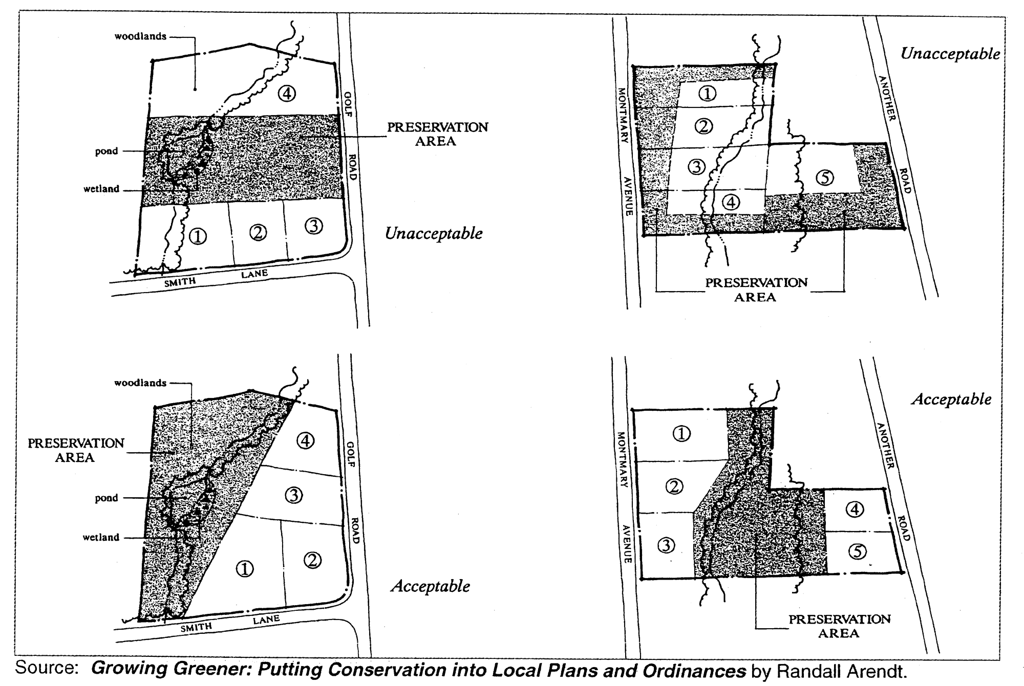
Preservation Area
Section 6.6.2. - Design Requirements.
The following are minimum requirements that apply to the layout of open space set aside to meet the minimum open space requirements of this Chapter and to those areas set aside to achieve "bonus" lots in a resource conservation subdivision.
A.
Minimum Width. The minimum width of any open space area shall be 100 feet, as measured perpendicular to the centerline between the boundaries of the open space, except as noted below.
1.
Natural Boundaries. Any portion of a Primary or Secondary Conservation Area that, by the very nature of its designated boundaries, is less than 100 feet in width. Examples include strips of steep slopes and "fingers" of floodplains that extend up drainage swales.
2.
Parkways. Parkways between road travelways designated as Secondary Conservation Areas, which must be at least 26 feet in width.
3.
Viewsheds. Viewshed buffers, if provided to screen the view of the subdivision development, must be at least 200 feet in width unless the topography of the land adequately screens the view of the buildings in the subdivision from the abutting roadway.
B.
Minimum Size. The minimum size of any open space area shall be two acres of contiguous land, except as provided below.
1.
Primary or Secondary Conservation Areas. A portion of a Primary or Secondary Conservation Area that adjoins the site and extends into the site covering an area of less than two acres.
2.
Isolated Steep Slope. An isolated strip of steep slope, provided that such an area having a slope greater than 25% must comprise at least 5,000 square feet, and such an area having between 15% and 25% must comprise an area of at least 40,000 square feet.
3.
Buffer Areas. Buffer areas around wetlands or habitats of endangered or threatened species, provided that the combination of the buffer area and the wetland or wildlife habitat must contain at least two acres of contiguous area.
4.
Historic and Archeological Assets. Historic or archeological assets and specimen trees that can be adequately protected by an area of less than two acres.
5.
Parkways. Parkways between road travelways that are limited in size due to intersecting roads.
C.
Path and Street Crossings. Where path systems cross an internal subdivision street, the access points must be directly across from each other and clearly identified both to the motorist and pedestrian by signage and crosswalk striping. Where a path crosses any public road, the path must be grade separated (i.e., by a tunnel or bridge), or located at a traffic control device such as a regulated intersection or flashing light approved by the City.
Section 6.7.1. - Conservation or Natural Resource Easements; Required.
A.
Primary Conservation Areas. All primary conservation areas in a conventional subdivision or a resource conservation subdivision that are required to be protected by the provisions of this UDO, shall be permanently protected from further subdivision, development, and unauthorized use as follows:
1.
By a natural resource easement in a conventional subdivision; or
2.
By a conservation easement in a resource conservation subdivision.
B.
Secondary Conservation Areas. Lands in secondary conservation areas that are designated by the developer for protection shall be included within a natural resource easement in a conventional subdivision or a conservation easement in a resource conservation subdivision.
Section 6.7.2. - Natural Resource Easements.
A.
Natural Resource Easements; Creation. The natural resource easement, when required, shall be shown on the final subdivision plat and recorded with the Clerk of the Superior Court at the same time as the final plat.
1.
When included within the lots in a subdivision, the natural resource easement shall be granted at no cost to an entity that meets the provisions for a Homeowners Association in Section 6.7.4.
2.
When the land to be included in the easement is owned by the homeowners association, the easement shall be created and granted as a conservation easement under the provisions of Section 6.7.3.
3.
The natural resource easement shall grant a third-party right of enforcement to the Columbus Consolidated Government to enforce, at its discretion, any of the terms of the natural resources easement.
B.
Guidelines for Natural Resource Easements. The following guidelines must be incorporated into any natural resource easement in a form acceptable to the City Attorney:
1.
The easement specifically and clearly must identify the boundaries of the property subject to the easement through reference to the easement area shown on the final subdivision plat;
2.
The easement must contain restrictions as to what the owner may do with the property and specifically delineates what may not be done with the property. Limitations shall be consistent with the type of area protected and the requirements of this Article applicable to such areas, and may include but shall not be confined to prohibitions against subdivision, earthmoving, dumping, signs, utility lines, construction, changes to existing structures, and uses made of the property;
3.
The easement must provide for the right of the holder of the easement to inspect the property to assure observance of restrictions and also provides for enforcement procedures;
4.
The easement must contain provisions governing its amendment, including provisions that the easement shall not be altered or terminated except with the express written permission of the Columbus Consolidated Government.
Section 6.7.3. - Conservation Easements.
A.
Conservation Easement Required. All primary conservation areas and all open space areas in a resource conservation subdivision shall be permanently protected from further subdivision, development, and unauthorized use, by a conservation easement. The conservation easement shall be approved by the City, and either:
1.
Co-signed by the City and donated to a private nonprofit conservation organization or land trust;
2.
Co-signed by the City and donated to a non-profit homeowners association; or
3.
Donated to the Columbus Consolidated Government if accepted by the City.
B.
Conservation Easements; Creation. The conservation easement shall be created subject to the provisions of O.C.G.A. § 44-10-1, et seq., which is known as the "Georgia Uniform Conservation Easement Act."
1.
The conservation easement shall be approved by the City Council and shall be granted at no cost to a charitable corporation, charitable association or charitable trust that qualifies as a "holder" under the Georgia Uniform Conservation Easement Act.
2.
The conservation easement shall grant a third-party right of enforcement to the Columbus Consolidated Government to enforce, at its discretion, any of the terms of the conservation easement.
3.
The conservation easement may not be granted to the owner of the property to which the easement will apply, including a homeowners association holding natural resource conservation areas as common open space in a resource conservation subdivision.
C.
Guidelines for Conservation Easements. The guidelines listed below are required to be incorporated into any conservation easement.
1.
Special Qualities. The easement must recognize and describe in a statement of purpose the special qualities of the property subject to the easement. Conditions within the tract subject to the conservation easement may be shown by map and/or photograph.
2.
Ownership. The easement must clearly identify the owner of the property subject to the easement, the holder of the easement and co-signer, and the responsibilities of the property owner, easement holder and co-signer.
3.
Boundaries. The easement specifically and clearly must identify the boundaries of the property subject to the easement, either by metes and bounds legal description or survey plat.
4.
Restrictions. The easement must contain restrictions as to what the owner may do with the property and specifically delineates what may not be done with the property. Limitations may include but are not confined to prohibitions against subdivision, earthmoving, dumping, signs, utility lines, construction, changes to existing structures, and certain uses made of the property.
5.
Rights of Inspection. The easement must provide for the right of the easement holder and co-signer to inspect the property to assure observance of restrictions. It also provides for enforcement procedures.
6.
Maintenance. The easement provides for the maintenance of the open space.
7.
Amendments. The easement contains provisions governing its amendment, including provisions that the easement shall not be altered except with the express written permission of the easement holder, property owner, and any cosigners.
Section 6.7.4. - Open Space Ownership.
In addition to a conservation easement, the open space areas in a resource conservation subdivision shall be permanently protected through ownership either by a nonprofit homeowners association, a private nonprofit conservation organization or land trust, or by the Columbus Consolidated Government, if accepted by the City. Protection shall be provided as indicated below.
A.
Homeowners Association. Open space may be owned and managed in common by a nonprofit homeowners association, subject to the requirements listed below.
1.
Approval of Association. The developer of the subdivision shall obtain approval from the City, prior to the approval of a preliminary plat, of a description of the homeowners association, including bylaws and methods for maintaining open space.
2.
Establishment of Association. The homeowners association shall be established by the subdivision developer and endowed with a financial subsidy from the developer prior to the approval of a final plat on the property. The amount of the financial subsidy shall be no less than that required by the plan for maintenance of open space and operation of common facilities approved for the subdivision or development as provided in the Development Review Procedures and Permits Chapter of this Ordinance. The amount of the financial subsidy shall include an amount no less than the estimated taxes, operation and maintenance costs for the open space to be incurred for a period of no fewer than 3 years from the time at which control of the association will be turned over to the purchasers of the subdivision lots or homes.
3.
Membership. Membership of each nonopen space lot owner in the subdivision shall be mandatory and automatic.
4.
Responsibilities of Association. The homeowners association shall be responsible for maintenance, insurance, and taxes on the open space within the subdivision. The association shall be required to assess dues for the maintenance of open space, purchase of insurance, and payment of taxes, unless another income source is proven to be available. Members of the association shall share equitably the costs of open space development and maintenance as indicated in bylaws. The association shall be empowered with the legal ability to place liens on non-open space lot owners for failure to pay association dues.
5.
Dissolution of Association. The homeowners association shall not be dissolved without the consent of the City Council. If common ownership of the open space by a homeowners association is proposed and approved, then the open space shall be subject to permanent deed and final plat restrictions or covenants on the future use, development, and subdivision of the open space, in addition to the requirement of a conservation easement.
6.
Maintenance Funds. The City may require that the homeowners association establish a minimum amount of funds to be initially deposited and maintained in a maintenance account.
B.
Private Nonprofit Conservation Organization or Land Trust. With the City's approval, the open space may be transferred, in whole or in part, to a private nonprofit conservation organization or land trust, subject to the criteria listed below.
1.
Nature of Organization. The organization is a bona fide conservation organization intended to exist indefinitely.
2.
Reversion or Transfer of Responsibilities. The conveyance contains appropriate provisions for proper reverter or transfer in the event that the organization becomes unwilling or unable to continue carrying out its functions.
3.
Financial Ability. The organization demonstrates to the satisfaction of the City that the organization is financially capable of executing its responsibilities, including stewardship and maintenance of the open space.
4.
Subsidy. The developer provides to the organization a financial subsidy for the maintenance and operation costs of the open space and any associated facilities prior to the approval of a final plat on the property. The financial subsidy shall include an amount no less than the estimated taxes, operation and maintenance costs for the open space to be incurred for a period of no fewer than 3 years from the time at which ownership of the open space will be turned over to the organization.
C.
Fee Simple Dedication to the City. Dedication in fee simple ownership to the public for recreational and/or open space use, is a possible mechanism for the permanent retention and maintenance of some or all of the open space within the subdivision, at the sole discretion of the City Council, and subject to the criteria listed below.
1.
Basis of Approval of Dedication. Dedication to the City shall only be approved if the City Council finds that the size, shape, location, type of open space, or cost of development or maintenance of such open space or the availability of open space would make public ownership desirable or necessary.
2.
Decision by Council. The decision to accept open space for fee simple public ownership shall be at the sole discretion of the City Council.
3.
When Required. The City generally will require dedication of all open space or park and recreation areas indicated for acquisition in the County's Comprehensive Plan or capital improvement program.
4.
Maintenance Bond. The Council may require a maintenance bond or other financial security with a duration of 12 months following public acceptance in an amount sufficient to ensure that such lands do not cause unwarranted public expenditures because of faulty conditions or construction. The City shall have authority to cash said bond in the event substandard conditions or construction are evident. Otherwise, following the one-year period following public dedication, with satisfactory performance, the City shall return the performance bond to the subdivider.
5.
Deed Required. In addition to the required conservation easement, a deed for open space lands in a form acceptable to the City Attorney in favor of the Columbus Consolidated Government shall be signed and recorded prior to or along with recordation of any final plat pertaining to land within the subdivision.
D.
Multiple Ownership. In some cases, different parties, depending on the actual use of the open space and the resources that are being protected, may own different portions of the open space. For instance, the portion of the open space that may provide important assets to the life of the neighborhood—village greens, passive recreation areas, horse riding pasturage or open vistas, may be most appropriately owned and maintained by a homeowners association, while critically important features requiring non-use preservation, such as a forested floodplain or the habitat of endangered wildlife, may be best donated to a conservation organization.
Section 6.7.5. - Maintenance.
A.
Responsibility. The cost and responsibility for maintenance of the open space and any facilities located in the open space shall be the responsibility of the property owner, unless that responsibility is specifically transferred as part of the conservation easement.
B.
Maintenance Plan. The applicant shall, at the time of preliminary plat submission, provide a plan for maintenance of open space and operation of common facilities in accordance with the requirements listed below.
1.
The plan shall define ownership.
2.
The plan shall establish necessary regular and periodic operation and maintenance responsibilities for the various kinds of open space.
3.
The plan shall establish staffing responsibility, insurance requirements, and associated costs and define the means for funding the maintenance of the open space and operation of any common facilities on an ongoing basis. Such funding plan shall include the means for funding long-term capital improvements as well as regular yearly operating and maintenance costs.
4.
Any changes to the maintenance plan shall be first approved by the City.
C.
Failure to Maintain. In the event that the organization established to maintain the open space and the common facilities, or any successor organization thereto, fails to maintain all or any portion thereof in reasonable order and condition, the City may assume responsibility for maintenance, in which case any escrow funds shall be paid to the Columbus Consolidated Government and any prior existing maintenance agreements shall be revoked or suspended. The City thereupon may enter the premises and take corrective action, including extended maintenance. The costs of such corrective or continuing action may be charged to the owner of the open space or common facilities and/or to the individual property owners of the subdivision at the sole discretion of the City. Such costs may include administrative costs and penalties. Costs may be recovered as indicated below.
1.
Property Assessments. The City may apportion the costs among the property owners in the subdivision as an assessment, payable over one or more years. Such assessment shall become a lien on said properties until satisfied. Notice of such lien shall be filed by the City in the office of the Clerk of the Superior Court.
2.
Special Taxes. The City may establish a special tax district encompassing the subdivision and levy an ad valorem property tax annually in an amount adequate to fund maintenance and operations of the open space.