
Copperas Cove City Zoning Code
ARTICLE II
- ZONING DISTRICTS AND DIMENSIONAL STANDARDS
Sec. 20-2-1. - Zoning districts established. AG, AR, BP, DT, HC, HI, HR, LI, LR, LF, MR, NC, PD, PC, PF, RC, RE
(a)
Generally. Table 20-2-1-1, Zoning Districts:
(1)
Establishes the zoning districts for the city; and
(2)
Establishes purpose statements for each district.
(b)
Base zoning districts. All properties within the city limits have an associated base zoning district. A base zoning district applies a uniform set of standards, including, but not limited to, those related to:
(1)
Permitted, limited, conditional, and prohibited uses;
(2)
Land use standards; and
(3)
Building site design standards.
(c)
Overlay districts. An overlay district establishes regulations that combine with the regulations of an underlying base zoning district. The purposes of overlay districts are to:
(1)
Authorize uses via a set of standards for such uses that are not otherwise allowed in the base zoning district;
(2)
Establish additional or different conditions for such uses; or
(3)
Prohibit uses otherwise allowed in the base zoning district.
(d)
Special area districts. A special area district is suited for the special area future land use areas of the future land use plan map or for targeted areas of the city with unique circumstances. Thus, the geographic location for such districts is limited. For example, the Primary Corridor (PC) Overlay District may only be applied to the two (2) corridors described in Table 20-2-1-1, Zoning Districts, below.
(Ord. No. 2023-36, § 2(Exh. A), 10-17-23)
Sec. 20-2-2. - Official zoning map.
(a)
Generally. The City of Copperas Cove is divided into the zoning districts described in section 20-2-1, Zoning Districts Established. The districts and their boundaries shall be shown upon the map, which is made a part of these regulations and titled "Official Zoning Map".
(b)
Force and effect. The official zoning map, together with all legends, references, symbols, boundaries, and other information, is part of, and has the same force of law as the text of this ordinance.
(c)
Status of the zoning map. The official zoning map that is on file with the city secretary shall control in the event of a conflict between the map that is on file and any other paper or digital reproduction of the map.
(d)
Determination of zoning district boundaries.
(1)
Guidance. If there is uncertainty in determining the location of zoning district boundaries on the map accompanying and made a part of these regulations, the following rules shall apply:
a.
Where district boundaries are indicated as approximately following the center lines of streets or highways, street lines or highway right-of-way lines, such center lines, street lines or highway right-of-way lines shall be construed to be said boundaries, except that where boundaries of adjacent districts are shown to be at street or highway right-of-way on opposite sides of such street or highway, the center line shall be construed to be the boundary.
b.
Where district boundaries are so indicated that they approximately follow the lot lines, such lot lines shall be construed to be said boundaries.
c.
Where boundaries are so indicated that they are approximately parallel to the center lines or street lines of streets, or the center lines of right-of-way lines of highways, such district boundaries shall be construed as being parallel thereto and at such distance therefrom as indicated on the zoning map. If no distance is given, such dimensions shall be determined by the use of the scale on said zoning map.
d.
In unsubdivided property, the district boundary lines on the zoning map shall be determined by use of the scale appearing on the map, unless dimensions are given on the map.
e.
In the case of a district boundary line dividing a property into two (2) parts, the district boundary line shall be construed to be the property line nearest the district boundary line as shown.
f.
Whenever any street, alley or other public way is vacated by official action of the city council, the zoning district adjoining each side of such street, alley or public way shall be automatically extended to the center of such vacation and all area included in the vacation shall then, and henceforth, be subject to all regulations of the extended districts.
g.
Where the streets or alleys on the ground differ from the streets or alleys as shown on the zoning map, the streets or alleys on the ground shall control.
(2)
BOA determination. If the boundary remains uncertain, the board of adjustment shall interpret the official zoning map in a public hearing to determine the location of the boundary in question.
(e)
Newly annexed areas. After the effective date of this ordinance, all territory annexed into the city shall be initially zoned AG, Agricultural District; or, if deemed appropriate, the planning and zoning commission may recommend to the city council another zoning district, based upon existing conditions and any relevant recommendations of the future land use plan map. Individuals requesting voluntary annexation may request the appropriate zoning based on the proposed use of the property being annexed.
(f)
Consistency with future land use plan map. Zoning map amendments (rezonings) shall be consistent with the comprehensive plan and future land use plan map. Any proposed rezoning that is not consistent with the comprehensive plan or future land use plan map shall require a parallel application to amend the city's future land use plan map to align with the proposed rezoning. Refer to Table 20-2-1-1, Zoning Districts, to determine the zoning districts that are associated with each future land use plan area.
(Ord. No. 2023-36, § 2(Exh. A), 10-17-23)
Sec. 20-2-3. - Residential district dimensional standards. AG, HR, LR, MR, RE
(a)
Applicability. All permitted uses in residential zoning districts shall meet the requirements for minimum lot size, building setback, and maximum building height as shown in the tables below.
(b)
Development type. Within the residential zoning districts, there are three (3) development types: conventional, cluster, and infill. The development types described in Table 20-2-3-1, Residential Development Types, are selectively permitted in each district as listed in the respective tables in this section.
(c)
Common open space.
(1)
Common open space shall be required for cluster development types, as provided in the tables below.
(2)
Common open space shall be owned and maintained by one (1) of the following entities:
a.
A homeowners association;
b.
The city; or
c.
A land bank.
(3)
If the city or a land bank is unwilling to take ownership of common space, and the developer does not propose a homeowners association, then the developer shall either:
a.
Provide an in-kind contribution equal to the most recent county tax appraised value of the amount of land that would have been dedicated as common open space; or
b.
Utilize the conventional development type, which does not require common open space.
(d)
Infill eligibility. The Infill development type may only be applied to properties that meet the following characteristics:
(1)
If it is a single lot that previously had a single use on it, has been vacant or unoccupied for more than one (1) year;
(2)
If it is a single lot or group of lots under common development with multiple tenants, has been a minimum of twenty-five (25) percent vacant or unoccupied for more than a year; or
(3)
A minimum of fifty (50) percent of the linear feet of the property's side or rear property lines are encumbered by environmentally sensitive or constrained areas such as floodplains or topography with slopes greater than 1:4.
| Table 20-2-3-1 Residential Development Types | |
|---|---|
| Name and Description | Illustration |
| Conventional Conventional development is the standard form whereby the maximum density is achieved by use of minimum lot sizes and common open space. | 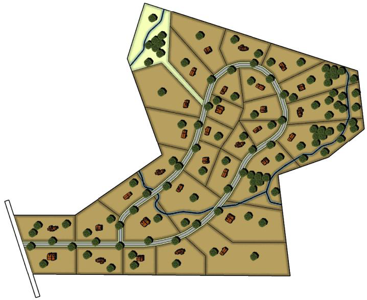 |
| Cluster Cluster development preserves and accommodates topography and site resources by consolidating smaller lots and/or different housing types around the natural resources of the property. Clustering may produce the same or higher densities than that of a conventional development, often resulting in lower infrastructure costs per dwelling. | 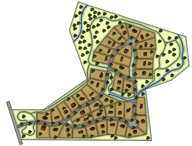 |
| Infill Infill development consists of smaller lots and more flexible setbacks than Conventional or Cluster developments. Infill development makes efficient use of land and infrastructure on vacant or underutilized lots or for occupied structures in already developed areas. | 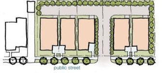 |
(e)
Dimensional standards. Tables 20-2-3-2 through 20-2-3-6 establish the dimensional standards for the various housing and development types in the agricultural and residential zoning districts.
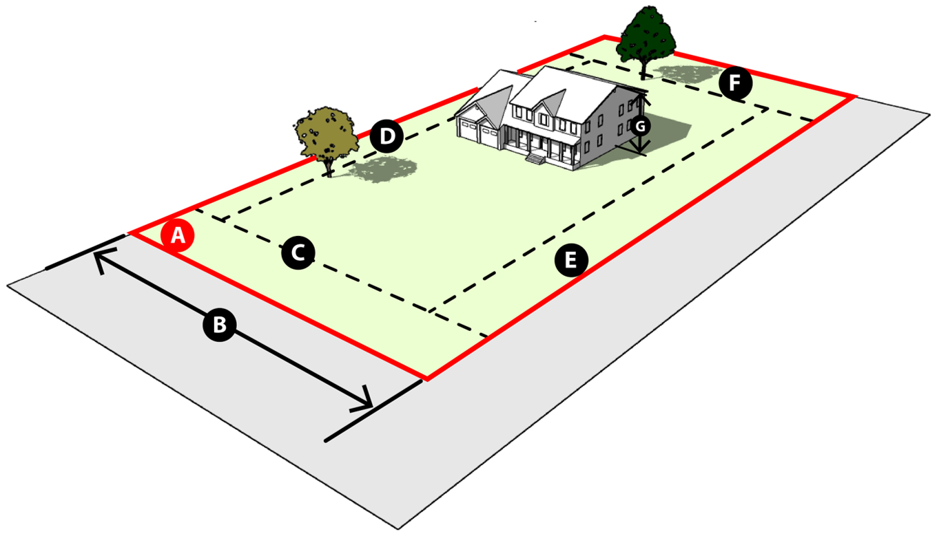
| Table 20-2-3-2 AG Dimensional Standards AG | |||||||||
|---|---|---|---|---|---|---|---|---|---|
| Development Type | Gross Density | Open Space | Lot Dimensions, minimums | Bulk Standards | |||||
| Development Type |
Units per
Acre, max. | Common Open space, min. (percent) |
Lot Area
per Unit, min. (sq. ft) (A) |
Lot Width
per Unit, avg. (ft.) (B) 1 | Setbacks, min. (ft) |
Height,
max. (ft.) (G) | |||
|
Front
(C) | Side Interior (D) |
Exterior Side
(E) |
Rear
(F) | ||||||
| Single-Family Detached Dwelling | |||||||||
| Conventional | 0.5 | 0 | 87,120 | 100 | 50 | 30 | 50 | 100 | 35 |
| Non-Residential | |||||||||
| N/A | N/A | N/A | 87,120 | 100 | 50 | 30 | 50 | 100 | 35 |
 | |||||||||
|
TABLE NOTES:
1. Where a lot has less width than required in separate ownership on the effective date of this Ordinance, the lot width requirement shall not prohibit the erection of a single-family dwelling. | |||||||||
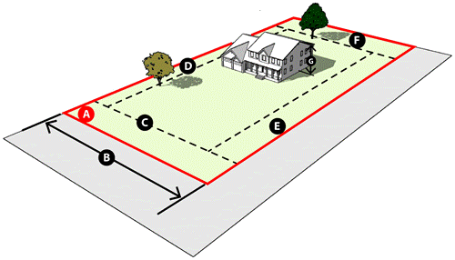
| Table 20-2-3-3 RE Dimensional Standards RE | |||||||||
|---|---|---|---|---|---|---|---|---|---|
| Development Type | Gross Density | Open Space | Lot Dimensions, minimums | Bulk Standards | |||||
| Development Type |
Units per
Acre, max. | Common Open space, min. (percent) |
Lot Area
per Unit, min. (sq. ft) (A) |
Lot Width
per Unit, avg. (ft.) (B) 1 | Setbacks, min. (ft) |
Height,
max. (ft.) (G) | |||
|
Front
(C) | Side Interior (D) |
Exterior Side
(E) | Rear (F) | ||||||
| Single-Family Detached Dwelling | |||||||||
| Conventional | 2.0 | 0 | 21,780 | 100 | 25 | 15 | 20 | 25 | 35 |
| Non-Residential | |||||||||
| N/A | N/A | N/A | 43,560 | 100 | 50 | 15 | 20 | 25 | 35 |
 | |||||||||
|
TABLE NOTES:
1. Where a lot has less width than required in separate ownership on the effective date of this Ordinance, the lot width requirement shall not prohibit the erection of a single-family dwelling. | |||||||||
| Table 20-2-3-4 LR Dimensional Standards LR | |||||||||
|---|---|---|---|---|---|---|---|---|---|
| Development Type | Gross Density | Open Space | Lot Dimensions, minimums | Bulk Standards | |||||
| Development Type |
Units per
Acre, max. | Common Open space, min. (percent) |
Lot Area
per Unit, min. (sq. ft) (A) |
Lot Width
per Unit, avg. (ft.) (B) 1 | Setbacks, min. (ft) |
Height,
max. (ft.) (G) | |||
|
Front
(C) | Side Interior (D) |
Exterior Side
(E) | Rear (F) | ||||||
| Single-Family Detached Dwelling | |||||||||
| Conventional | 6.5 | 0% | 6,000 | 60 | 25 | 7.5 | 15 | 25 | 35 |
| Infill | 8.5 | 0% | 4,500 | 45 | 20 | 5 | 10 | 15 | 35 |
| Non-Residential | |||||||||
| Refer to the standards for the Neighborhood Commercial (NC) zoning district in Section 20-2-4, Nonresidential and Mixed-Use District Dimensional Standards | |||||||||
 | |||||||||
|
TABLE NOTES:
1. Where a lot has less width than required in separate ownership on the effective date of this Ordinance, the lot width requirement shall not prohibit the erection of a single-family dwelling. | |||||||||
| Table 20-2-3-5 MR Dimensional Standards MR | |||||||||
|---|---|---|---|---|---|---|---|---|---|
| Development Type | Gross Density | Open Space | Lot Dimensions, minimums | Bulk Standards | |||||
| Development Type |
Units per
Acre, max. | Common Open space, min. (percent) |
Lot Area
per Unit, min. (sq. ft) (A) |
Lot Width
per Unit, avg. (ft.) (B) 1 | Setbacks, min. (ft) |
Height,
max. (ft.) (G) | |||
|
Front
(C) | Side Interior (D) |
Exterior Side
(E) | Rear (F) | ||||||
| Single-Family Detached Dwelling | |||||||||
| Conventional | 8.5 | 0% | 4,500 | 45 | 25 | 5 | 10 | 15 | 35 |
| Infill | 10.5 | 0% | 4,000 | 40 | 20 | 5 | 10 | 10 | 35 |
| Duplex or Single-Family Attached Dwelling | |||||||||
| Conventional | 15.5 | 0% | 2,000 | 20 | 25 | 5 | 10 | 10 | 35 |
| Infill | 19.5 | 0% | 1,600 | 20 | 15 2 | 5 | 10 | 10 | 35 |
| Non-Residential | |||||||||
| Refer to the standards for the Neighborhood Commercial (NC) zoning district in Sec. 20-2-4, Nonresidential and Mixed-Use District Dimensional Standards | |||||||||
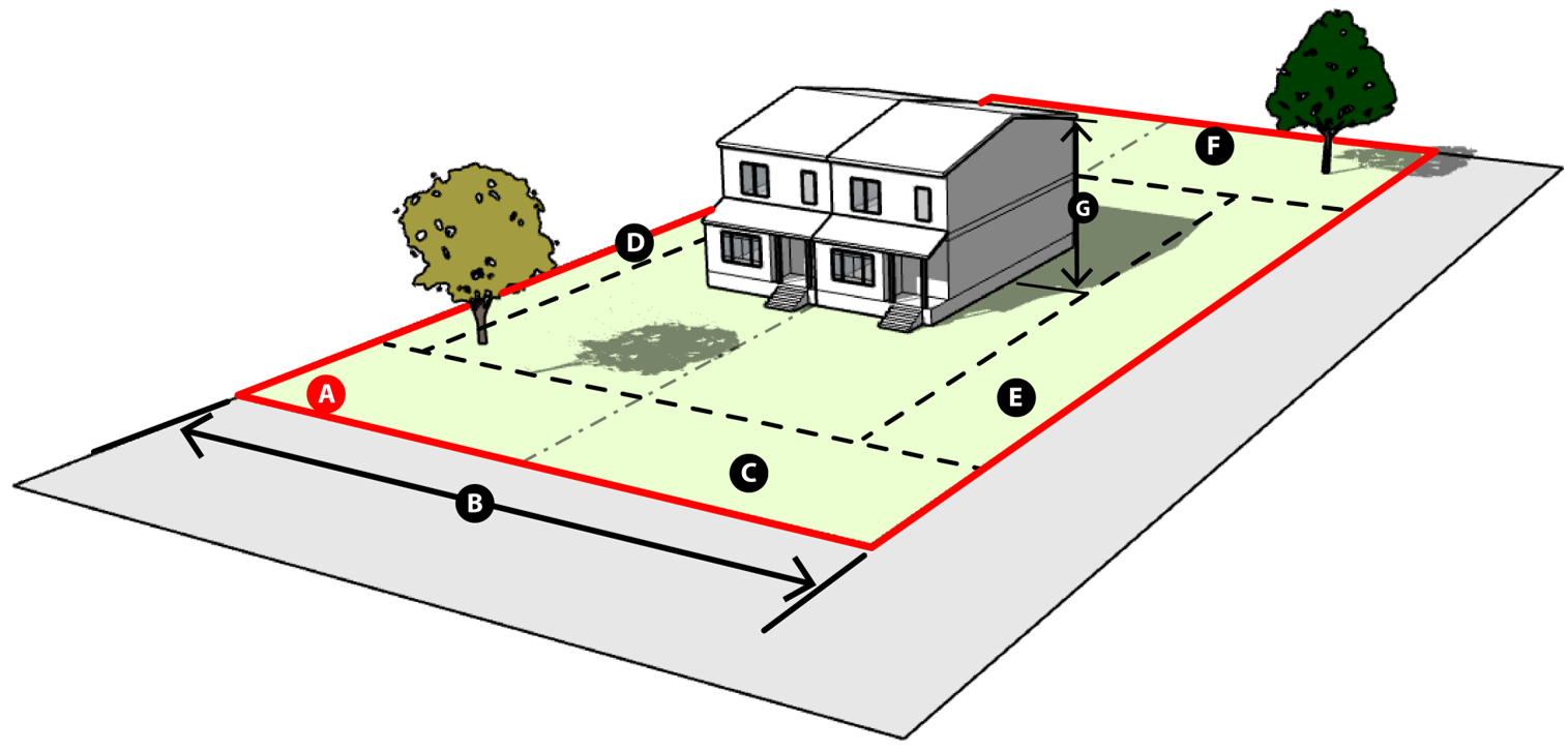 | |||||||||
|
TABLE NOTES:
1. Where a lot has less width than required in separate ownership on the effective date of this Ordinance, the lot width requirement shall not prohibit the erection of a single-family dwelling. 2. Front-loaded garages shall have a minimum setback of 20 feet. The remainder of the front of the building may have a 15-foot setback. | |||||||||
| Table 20-2-3-6 HR Dimensional Standards HR | |||||||||
|---|---|---|---|---|---|---|---|---|---|
| Development Type | Gross Density | Open Space | Lot Dimensions, minimums | Bulk Standards | |||||
| Development Type |
Units per
Acre, max. | Common Open space, min. (percent) |
Lot Area
per Unit, min. (sq. ft) (A) |
Lot Width
per Unit, avg. (ft.) (B) 1 | Setbacks, min. (ft) |
Height,
max. (ft.) (G) | |||
|
Front
(C) | Side Interior (D) |
Exterior Side
(E) | Rear (F) | ||||||
| Single-Family Detached Dwelling | |||||||||
| Conventional | 10.5 | 0% | 3,750 | 40 | 25 | 7.5 | 15 | 20 | 35 |
| Cluster | 12.0 | 5% | 3,200 | 40 | 20 | 7.5 | 15 | 20 | 35 |
| Infill | 15.0 | 0% | 2,400 | 40 | 10 2 | 5 | 5 | 10 | 35 |
| Duplex, Single-Family Attached or Townhouse Dwelling | |||||||||
| Conventional | 15.0 | 0% | 2,000 | 20 | 25 | 7.5 | 15 | 20 | 35 |
| Cluster | 20.0 | 5% | 1,600 | 20 | 20 | 7.5 | 15 | 20 | 35 |
| Infill | 25.0 | 0% | 1,200 | 20 | 10 2 | 5 | 5 | 10 | 35 |
| Multi-Family Dwelling | |||||||||
| Conventional | 23.0 | 0% | 1,800 | 25 3 | 20 | 7.5 | 15 | 25 | 60 |
| Cluster | 30.0 | 5% | 1,400 | 25 3 | 10 2 | 7.5 | 15 | 25 | 60 |
| Infill | 44.0 | 0% | 1,000 | 25 3 | 10 2 | 5 | 5 | 15 | 60 |
| Non-Residential | |||||||||
| Refer to the standards for the Neighborhood Commercial (NC) zoning district in Section 20-2-4, Nonresidential and Mixed-Use District Dimensional Standards | |||||||||
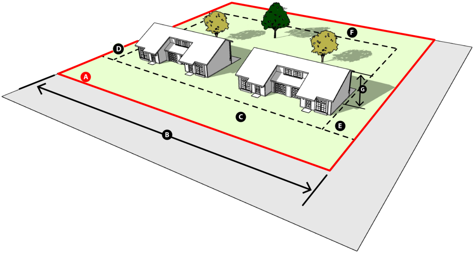 | |||||||||
|
TABLE NOTES:
1. Where a lot has less width than required in separate ownership on the effective date of this Ordinance, the lot width requirement shall not prohibit the erection of a single-family dwelling. 2. Front-loaded garages shall have a minimum setback of 20 feet. The remainder of the front of the building may have a 10-foot setback. 3. Absolute minimum lot width, not per unit. | |||||||||
(Ord. No. 2023-36, § 2(Exh. A), 10-17-23)
Sec. 20-2-4. - Nonresidential and mixed-use district dimensional standards.
(a)
Applicability. All permitted uses in nonresidential and mixed-use zoning districts shall meet the requirements for minimum lot size, building setback, and maximum building height as shown in Table 20-2-4-1, Dimensional Standards by Zoning District, below.
| Table 20-2-4-1 Dimensional Standards by Zoning District | |||||||||
|---|---|---|---|---|---|---|---|---|---|
| Dimensional Standard | NC | DT | RC | HC | BP | LI 7 | HI 7 | PF | |
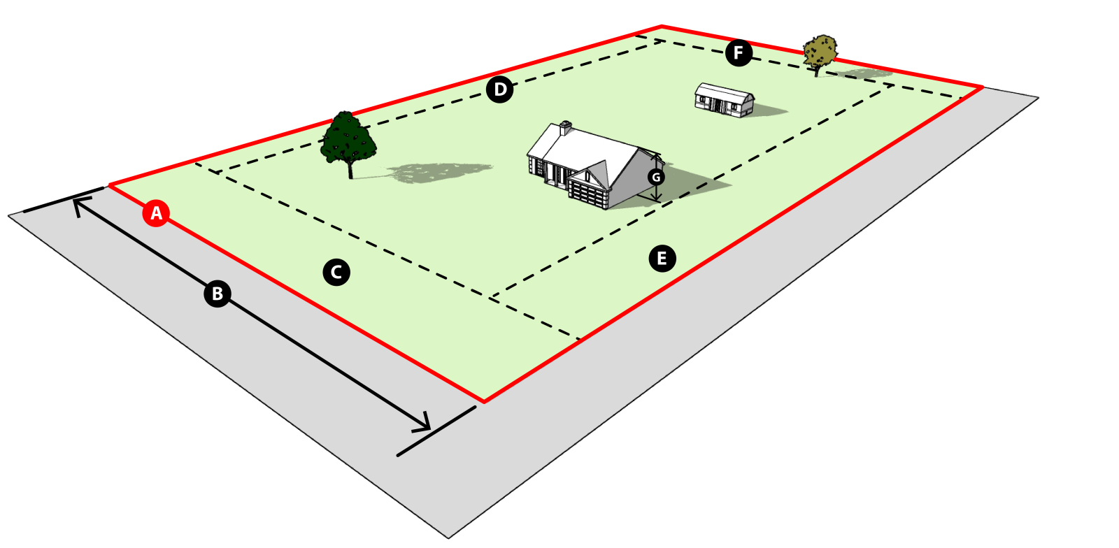
| Lot Area (minimum square feet) (A) | 6,000 | 3,000 | 6,000 | 6,000 | 6,000 | 6,000 | 6,000 | 6,000 | |
| Lot Width (min. ft.) (B) 1 | 60 | 30 | 60 | 60 | 60 | 60 | 60 | 60 | |
| Building Setback | Front (min.) (C) 3,4 | 25 | 0 | 25 | 25 | 25 | 30 | 30 | 25 |
| Interior side (min.) (D) 6 | 0 | 0 | 0 | 0 | 0 | 0 | 0 | 0 | |
| Exterior side (min.) (E) 5,6 | 15 | 0 | 15 | 15 | 15 | 25 | 25 | 15 | |
| Rear (min.) (F) 4 | 0 | 0 | 0 | 0 | 0 | 0 | 0 | 0 | |
| Height (max. ft.) (G) 2, 8 | 60 | 60 | 60 | 60 | 60 | 60 | 200 | 60 | |
 | |||||||||
|
TABLE NOTES:
1. The width of a lot bordering a street on a curve or contour shall be measured at the building line. 2. No structure may be erected to a height in excess of that permitted by the regulations of the Federal Aviation Administration (FAA) as may exist at the time and whose regulations apply to the area in which the structure is being erected. 3. No parking, storage, or similar use shall be permitted in required front yards except that automobile parking will be permitted in accordance with Section 20-4-2, Parking, Loading, and Stacking. 4. Open and unenclosed terraces or porches and eaves and roof extensions may project into the required front or rear yard for a distance not to exceed four feet; provided, however, that no supporting structure for such extensions may be located within the required front yard. 5. Under no circumstances shall an exterior side setback reduce the buildable width of a lot to less the 40 feet. 6. A roof overhang, an open fire escape or an outside stairway may project not more than two and one-half feet over a required side setback, but no closer than five feet to a property line. 7. Along railroad lines or railroad spurs, no setbacks shall be required. 8. FAA regulations require landowners to mark any towers between 50′ and 200′ on their property. | |||||||||
(Ord. No. 2023-36, § 2(Exh. A), 10-17-23)
Sec. 20-2-5. - Special area and overlay districts.
(a)
PC, Primary Corridor Overlay District.PC
(1)
Purpose. The Primary Corridor (PC) overlay district is established to recognize the Business 190 and Interstate 14 corridors as unique areas that promote a mix of uses including commercial, retail, office, and special areas, along the corridor.
(2)
Applicability. The PC overlay district applies to properties with property frontage along Business Highway 190 or Interstate 14 within the city limits. This overlay district is illustrated on the official zoning map.
(3)
Permitted uses. The uses listed in Table 20-3-1-1, Use Table, as permitted, limited, or conditional for each base zoning district upon which the PC overlay district is applied, shall be permitted, limited, or conditional uses allowed in the overlay. In addition, uses in the following use categories shall be permitted by right regardless of the base zoning district:
a.
Offices;
b.
Restaurants; and
c.
Retail repair, sales, and service.
(4)
Dimensional standards.
a.
Residential development. Dimensional requirements for new residential development in the PC overlay district shall comply with the standards for the HR zoning district in Table 20-2-3-6, HR Dimensional Standards.
b.
Nonresidential development. Proposed new mixed-use and nonresidential development in the PC overlay district shall comply with the underlying base zoning district standards, as outlined in section 20-2-4, Nonresidential and Mixed-Use District Dimensional Standards, except that:
i.
The minimum lot width shall be 125 feet.
(5)
Development landscaping. The foundation landscaping, site landscaping, and parking lot landscaping standards established in section 20-4-3, Landscaping, Buffering, and Screening, shall be required in the PC overlay district.
(6)
Bufferyards. When a new structure is proposed in the PC overlay district, and the property is adjacent to a residential use in a base zoning district of AG, RE, LR, MR, or HR, on the side or the rear, a Type B bufferyard, in accordance with section 20-4-3, Landscaping, Buffering, and Screening, shall be provided. This requirement shall not apply to the re-use of an existing building.
(7)
Building design standards.
a.
Applicability. These building design standards shall only apply to a building facade that is within one hundred (100) feet of the Business 190 or Interstate 14 right-of-way.
b.
Articulation. A building facade shall be no more than seventy-five (75) linear feet before incorporating a change in front building plane of a minimum of five (5) feet for a distance of twenty (20) feet.
c.
Blank wall. A building facade shall utilize a minimum of one (1) of the following strategies:
i.
Planters, pots, and other landscaping along the base of the building facade;
ii.
Wall art such as murals or sculptures;
iii.
Canopies and awnings that define the street level and are positioned to highlight entryways and primary facades;
iv.
Display cases or product displays;
v.
Peaked roof forms;
vi.
Arches;
vii.
Decorative lighting;
viii.
Outdoor patios or plazas;
ix.
Clearly differentiating architectural details such as moldings that are integrated into the building structure and design; or
x.
Integral planters or wing walls that incorporate landscaped areas and/or places for sitting.
d.
Screening of mechanical and service equipment.
i.
All service and utility areas (transformers, electric meters, etc.) positioned outside of any building shall be screened from public rights-of-way and adjacent tracts.
ii.
Any non-vegetative screening shall be compatible in appearance with the design of the primary building served.
iii.
Rooftop mechanical equipment shall be screened from view from the public right-of-way.
e.
Screening of waste and recycling receptacles.
i.
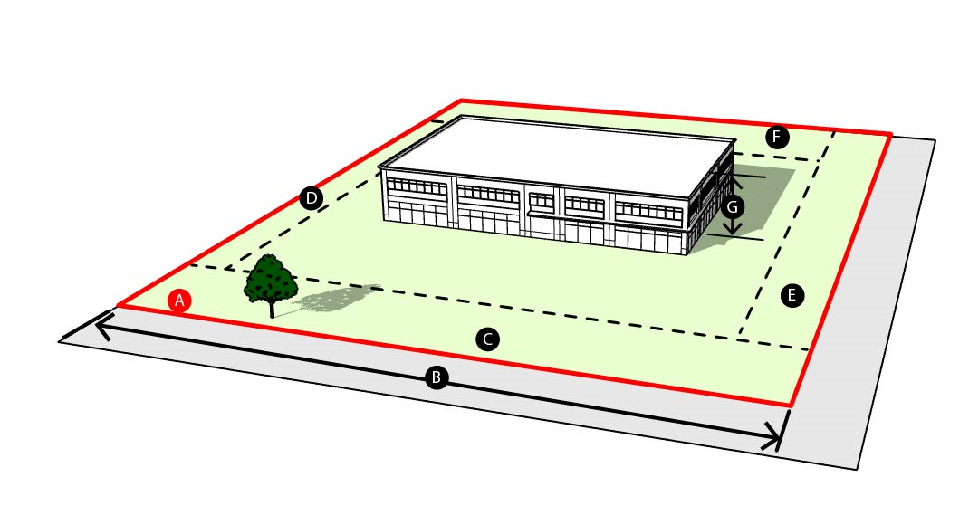
All waste and recycling receptacles shall be screened from view from the public right-of-way and adjacent parcels, as depicted in Figure 20-2-5(a)-1, Screening of Waste and Recycling Receptacles.
ii.
The design of the screening shall be compatible with the architectural design of the building served.
iii.
Trash receptacles shall be placed in a four-sided enclosure, a minimum of two feet taller than the height of the receptacle.
(8)
Prohibited uses. The following uses shall be prohibited regardless of the base zoning district for those uses listed in Table 20-3-1-1, Use Table;
a.
Self-service storage;
b.
Warehousing.
(b)
PD, Planned Development Overlay District.PD
(1)
Applicability. Planned Development (PD) overlay districts may be approved in each base zoning district except for AG and AR.
(2)
Administration. The unique character of PD overlay districts require their administrative processing as an overlay zoning district in this ordinance. The approval process is outlined in section 20-6-3(d), Zoning Map Amendment.
(3)
Standards. The proposed PD overlay district shall meet the following standards:
a.
Comprehensive plan. A PD overlay district must conform with the objectives of the comprehensive plan.
b.
Ownership. The site of the PD overlay district must be under single ownership and/or unified control.
c.
Compatibility.
i.
The uses permitted in a PD overlay district must be of a type and so located as to exercise no undue detrimental influence upon surrounding properties;
ii.
The PD overlay district shall not endanger the public health, welfare, or safety, nor shall it substantially diminish or impair property values in the neighborhood in which it is to be located; and
iii.
The PD overlay district must be of a character and contain such uses that are needed in the area of the proposed project.
d.
Development standards.
i.
Area. The minimum area required to qualify for a PD Overlay District:
(A)
For residential uses: no minimum area required;
(B)
For nonresidential development: one (1) contiguous acre; and
(C)
No minimum area shall be required for pre-existing, legally subdivided lots upon which a nonresidential use is being proposed.
ii.
Density. The net density or intensity of a PD overlay district (either in dwelling units for residential uses, or in floor area for all other uses) shall generally correspond to the net density regulations imposed by the underlying zoning district. The net density of the PD overlay district is not necessarily required to precisely correspond with the normal net density of the underlying zoning district, but instead should reflect that district's character through complementary building types and architectural design. If the net density of the proposed development substantially exceeds the net density permitted in the underlying zoning district in excess of twenty (20) percent, it is required that a zoning map amendment application accompany the PD overlay district application.
iii.
Building separation. The minimum horizontal distance between buildings shall be:
(A)
Ten (10) feet between clustered or "zero lot line" single-family detached buildings;
(B)
Six (6) feet between single-family detached buildings;
iv.
Parking requirements.
(A)
Adequate parking shall be provided and shall be in general conformance with the parking regulations provided in section 20-4-2, Parking, Loading and Stacking, unless changes are warranted by the particular characteristics of the proposed PD overlay district;
(B)
Additional parking spaces for guests, customers, the handicapped, recreational vehicles, and other common storage and/or parking uses in PD overlay districts, shall be required by the city council, acting upon the recommendation of the planning and zoning commission, if warranted by the particular characteristics of the proposed PD overlay district.
v.
Landscaping and open space requirements. Landscaping and open space provisions, not including those buffer or perimeter treatments being proposed for the project as a whole, shall meet or exceed those outlined in section 20-4-3, Landscaping, Buffering, and Screening, which outlines the requirements for the base zoning districts.
vi.
Access. Adequate provision shall be made to provide ingress and egress so designed as to minimize both internal and external traffic hazards and congestion.
vii.
Utilities. Adequate provision for the installation and maintenance of all utilities, including drainage, shall be provided.
viii.
Other regulations. The provisions of the City of Copperas Cove Subdivision Regulations, Sign Regulations, and other City Codes, as amended, shall be adhered to, unless a waiver is granted by the city council, acting upon the recommendation of the planning and zoning commission.
(4)
Departure from standards. The PD overlay district may depart from strict conformance with the required density, dimension, area, height, bulk, use (excluding manufactured homes and adult-oriented businesses), and specific content regulations of this ordinance to the extent specified in the preliminary plat and documents authorizing the PD overlay district so long as the proposal provides tangible benefits to the neighborhood or community in which it is located. These benefits shall be in the form of provisions of exceptional amenities, design excellence, etc. that exceed the minimum requirements of this ordinance. The waiver of any requirement shall be the direct cause of accrual of positive benefits to the residents of the development and to the general community (e.g., waiver of yard requirements might result in more usable open space). Departure from any requirement specified in this chapter or other city ordinances and regulations is a privilege, and shall be granted only upon recommendation of the planning and zoning commission and approval by the city council.
(c)
LF, Low Flight Overlay District. LF
[1]
Properties within this overlay district, as depicted on the official zoning map, are subject to the low-level flight corridor provisions of the Fort Hood and Military Land Use Compatibility Study.
(d)
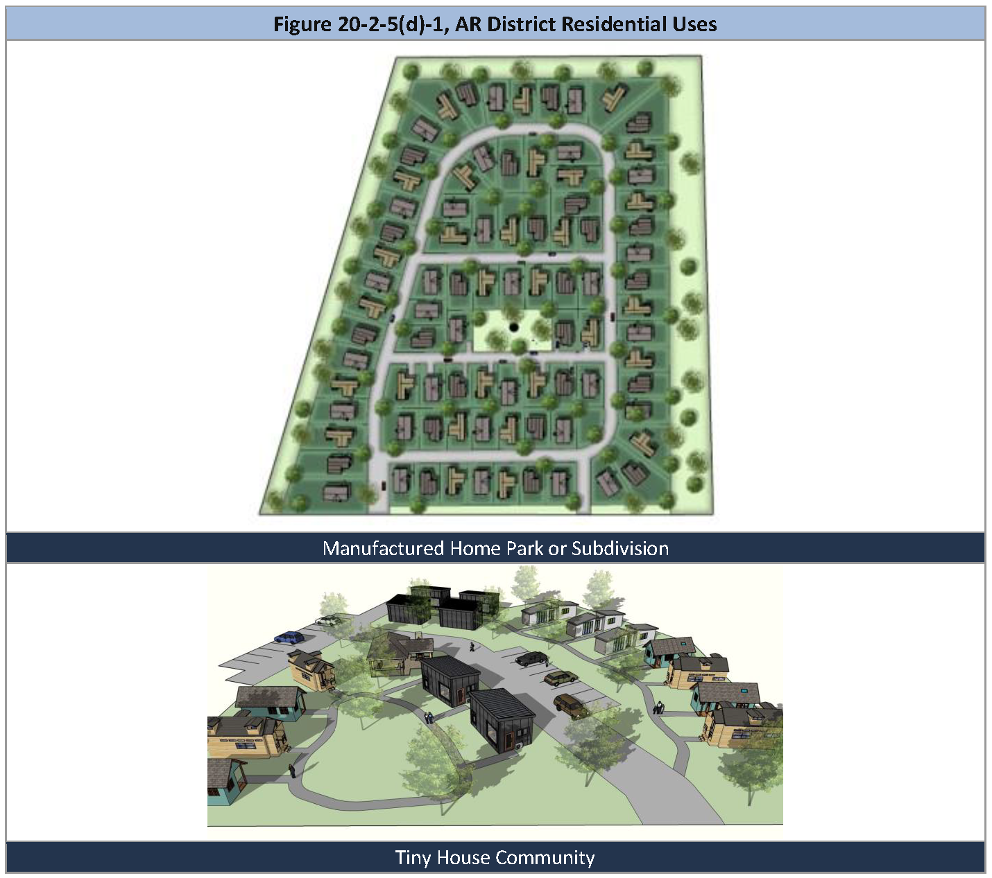
AR, Alternative Residential.AR
(1)
Purpose. The Alternative Residential (AR) district provides for an arrangement of housing that may be constructed or manufactured on- or off-site and which may be placed on individual lots or a common lot. This district accommodates manufactured home parks and subdivisions or tiny house community formats.
(2)
Applicability. The AR District may be applied within any medium density land use area on the future land use plan map. This district provides for different housing type options that contribute to the overall availability of housing choice in the city. These housing options may be appropriate on smaller infill properties suitable for this scale of development, when the adjacent uses and natural environment provide for compatibility, and in locations proximate to employment areas.
(3)
Land uses. Refer to section 20-3-1, Use Table.
(4)
Dimensional standards.
a.
Residential uses. Dimensional requirements for new residential development in the AR District shall comply with the standards in Table 20-2-5(d)-1, AR District Lot and Building Standards, below.
b.
Nonresidential development. Proposed new mixed-use and nonresidential development in the AR District shall comply with the requirements of the NC District in section 20-2-4, Nonresidential and Mixed-Use District Dimensional Standards.
(5)
AR District use standards.
a.
Recreational vehicle park. Refer to section 20-3-4, Conditional Use Standards.
b.
Manufactured home park or subdivision. Refer to section 20-3-4, Conditional Use Standards.
c.
Tiny house community. Refer to section 20-3-4, Conditional Use Standards.
(7)
Open space and buffering. The following shall apply to required open space in the AR District.
a.
Open space.
i.
Open space shall be provided in developments that are five (5) or more acres and at the minimum required in Table 20-2-5(d)-1, AR District Lot and Building Standards. Such open space shall include a natural area, central green, lawn or garden area, playground, or plaza as a central focal point of all dwellings.
ii.
A maximum of fifty (50) percent of required open space in the AR district may consist of private property or manufactured home pad sites. The other fifty (50) percent of the required open space shall be owned and maintained by either a homeowners' association, in the case of a manufactured home subdivision or tiny house community, or by the management of the manufactured home park.
b.
Walkways. Improvements of the common areas shall include pedestrian walkways connecting each dwelling or group of dwellings to the common open space.
c.
Buffer requirements. The site shall provide a buffer around the perimeter that preserves existing vegetation and incorporates landscape materials, berms, or a wall or fence to provide a visual buffer from adjacent development. See section 20-4-3, Landscaping, Buffering, and Screening.
(8)
Garages. The following garage structure requirements shall apply to a residential use in the AR District.
a.
Access. If provided, detached garages serving more than one (1) dwelling unit shall be accessed via a private drive or alley.
b.
Number of bays. A detached garage building shall not exceed four (4) car bays unless it is screened by a buffer required in section 20-4-3, Landscaping, Buffering, and Screening.
c.
Design. Detached garage buildings shall be consistent in architecture and design to the principal dwellings.
(Ord. No. 2023-36, § 2(Exh. A), 10-17-23; Ord. No. 2025-5, § 2, 2-18-25; Ord. No. 2025-13, § 3, 5-6-25)