
Coquille City Zoning Code
Division II
Land Use Districts
CHAPTER 17.46 - FLOODPLAIN MANAGEMENT[1]
Editor's note— Ord. No. 1510, adopted November 3, 2018, amended Ch. 17.46 in its entirety to read as herein set out. Former Ch. 17.46 pertained to the same subject matter, consisted of §§ 17.46.010—17.46.070, and derived from Ord. No. 1438, 2003; Ord. No. 1473, adopted April 1, 2009; Ord. No. 1475, adopted July 6, 2009; and Ord. No. 1490, adopted March 3, 2014.
Chapter 17.55 - RIVERFRONT MIXED USE (RMU) OVERLAY[2]
Editor's note— Ord. No. 1488, § 1(Exh. A), adopted July 1, 2013, set out provisions intended for use as chapter 17.56. For purposes of classification, and at the editor's discretion, these provisions have been included as chapter 17.55.
17.20.010 - Classification of land use districts.
Every parcel, lot, and tract of land within the city of Coquille is designated with a land use (zoning) district. The use of land is limited to the uses allowed by the applicable land use district and/or overlay zone. The applicable land use districts and overlay zone(s) are determined based on the land use district map and the provisions of this chapter, which shall be consistent with the city of Coquille comprehensive plan, as indicated in Table 17.20.010
Table 17.20.010
(Ord. 1471 § 2 (part), 2008)
17.20.020 - Land use district map.
A.
Consistency with Land Use District Map. The boundaries of the land use districts contained within this chapter shall coincide with the land use district boundaries identified on the city's official zoning map, retained by the city recorder. Said map by this reference is made a part of this development code. The official zoning map, and any map amendments, shall be maintained by the city. See Chapter 17.104 for a compilation of recent map and text amendments.
B.
Applicability of Land Use Standards. Each lot, tract, and parcel of land or portion thereof within the land use district boundaries designated and marked on the zoning map, is classified, zoned and limited to the uses hereinafter specified and defined for the applicable land use district.
(Ord. 1471 § 2 (part), 2008)
17.20.030 - Determination of land use district boundaries.
Where due to the scale, lack of scale, lack of detail or illegibility of the city zoning map, or due to any other reason, there is uncertainty, contradiction or conflict as to the intended location of a district boundary line, the boundary line shall be determined by the planning official in accordance with all of the following criteria:
A.
Rights-of-Way. Boundaries indicated as approximately following the centerlines of streets, highways, railroad tracks, alleys, irrigation canals, bridges, or other right-of-way shall be construed to follow such centerlines. Whenever any public right-of-way is lawfully vacated, the lands formerly within the vacated right-of-way shall automatically be subject to the same land use district designation that is applicable to lands abutting the vacated areas. In cases where the right-of-way formerly served as a land use district boundary, the lands within the right-of-way now vacated shall be allocated proportionately among the subject land use districts.
B.
Parcel, Lot, Tract. Boundaries indicated as approximately following the boundaries of a parcel, lot, or tract shall be construed as following such boundaries.
C.
Jurisdiction Boundary. Boundaries indicated as approximately following a city or county boundary, or the urban growth boundary, shall be construed as following said boundary.
D.
Natural Features. Boundaries indicated as approximately following a river, stream, drainage channel, drainage basin, topographic contour or other changeable natural feature not corresponding to any feature listed in subsections A through C of this section, shall be construed as following such feature, except that the location may be corrected administratively through a Type II
(Code Interpretation) procedure, in accordance with Chapter 17.108.
(Ord. 1471 § 2 (part), 2008)
17.24.010 - Residential district—Purpose.
The residential district is intended to promote the livability, stability and improvement of the city's neighborhoods, while accommodating a wide variety of needed housing types, including attached and detached housing, multiple-family housing, senior housing, manufactured and site-built housing, group housing, and other special needs housing. The residential district also accommodates parks, schools, places of worship, and other services that are necessary to serve the neighborhoods. The district standards are based on the following principles:
A.
Promote the orderly development and improvement of Coquille's neighborhoods;
B.
Make efficient use of land and public services and implement the comprehensive plan;
C.
Designate land for the range of housing types and densities needed by the community, including owner-occupied, rental housing, and special needs housing;
D.
Provide flexible lot standards that encourage compatibility between land uses, efficiency in site design, and environmental compatibility;
E.
Provide for compatible building and site design at an appropriate scale; provide standards that are in character with the landforms and architecture existing in the community;
F.
Apply the minimum amount of regulation necessary to ensure compatibility with existing residences, schools, parks, transportation facilities, and neighborhood services;
G.
Reduce reliance on the automobile for neighborhood travel and provide options for walking and bicycling;
H.
Provide direct and convenient access to schools, parks and neighborhood services;
I.
Maintain and enhance the city's historic character and traditional neighborhood lot and block development patterns.
(Ord. 1471 § 2 (part), 2008)
17.24.020 - Residential district—Allowed land uses.
Table 17.24.020 identifies the land uses that are allowed in the residential district. The specific land use categories are described and uses are defined in Chapters 17.08 and 17.12.
Table 17.24.020 Land Uses Allowed in Residential District (R)
Key:
S= Permitted with standards (Section 17.24.110)
CU = CU permit required (Chapter 17.92)
N = Not permitted
(Ord. 1471 § 2 (part), 2008; Ord. No. 1526, 11-6-2023)
17.24.030 - Residential district—Development standards.
The development standards in Table 17.24.030 apply to all uses, structures, buildings, and development, and major remodels, in the residential district.
Table 17.24.030 Development Standards for Residential District
(Except as modified by Section 17.24.050, Residential infill standards or Section 17.96.040, Master planned development)
1 Lot size may be adjusted by up to twenty (20) percent through lot size averaging following the land division procedures in Section 17.88.040. Minimum lot sizes do not apply to open space tracts where as a condition of land division approval the use is limited to open space or utilities only.
2 Sight distances shall be maintained per city standards. The city may defer to guidelines from the American Association of State Highway Officials (AASHTO).
(Ord. 1471 § 2 (part), 2008)
17.24.040 - Residential district—Setbacks—Exceptions, reverse frontage lots, flag lots.
A.
Residential Yard Setbacks—Purpose. Residential setback yards provide space for private yards and building separation for fire protection/security, building maintenance, sunlight and air circulation. The setback yard standards contained in Table 17.24.030 encourage the orientation of buildings with street visibility for public safety and neighborhood security. The standards also promote human-scale design and traffic calming by diminishing the visual presence of garages along the street and encouraging the use of front porches and house entrances oriented to street sidewalks, as is commonplace in Coquille's neighborhoods.
B.
Setback Yards—Exceptions.
1.
Where existing lawfully established buildings have yard setbacks that are less than the minimum standards of this code, they are allowed to remain as legal, nonconforming structures.
2.
The following architectural features may encroach into the setback yards by no more than thirty-six (36) inches, provided that a setback of not less than thirty-six (36) inches is preserved, all applicable building and fire codes are met, and the clear vision standards in Section 17.60.030 are met. Eaves, chimneys, bay windows, overhangs, and similar architectural features may encroach into a setback yard by not more than thirty-six (36) inches. Porches, decks and similar unenclosed structures may extend into front yard setbacks as provided in Table 17.24.030. Walls and fences built on property lines are subject to the height standards in Table 17.24.030 and the provisions of Sections 17.60.020(N), Vision Clearance, and 17.64.050, Fences and walls.
C.
Setback Yards—Reverse Frontage Lots. On reverse frontage lots (through lots), the front yard setback standard shall apply to both streets. Reverse frontage lots are also subject to the fence height and setback requirements in Section 17.24.030 and the landscape buffer requirements in Section 17.64.030.
D.
Setback Yards—Flag Lots. The front yard of a flag lot shall be determined based on one of two options:
1.
Parallel to the street from which access is taken; or
2.
Parallel to the flag pole from which access is taken.
The applicant for a building permit may choose either subsection (D)(1) or (D)(2), except as otherwise prescribed by conditions of a prior land use approval (e.g., partition or subdivision conditions of approval). The city may impose such conditions as provided for infill development under Section 17.24.050, or as provided for land divisions under Section 17.88.040.
(Ord. 1471 § 2 (part), 2008)
17.24.050 - Residential district—Infill standards.
The purpose of this section is to ensure compatibility of new development and redevelopment to existing residences and to provide flexibility in code standards. The setback standards in this section supersedes those in Table 17.24.030 when a building or building addition is proposed on a lot in a residential district that was platted prior to the effective date of the ordinance codified in this title. Prior to issuance of a building permit, the planning official shall use the criteria and standards in subsections A and B of this section, in determining applicable setbacks and building heights.
A.
Compatibility with Yards of Adjacent Residence(s). Except as provided in subsection D of this section, when an existing single-family residence is located within twenty (20) feet of the subject site on the same side of the street, and said residence has a front yard setback that is greater than the minimum setback in Section 17.24.030, a front yard setback similar to that of the nearest single-family residence(s) shall be used. "Similar" means the setback is equal to or within five feet of the setback provided by the nearest single-family residence on the same side of the street (Figure 17.24.050(A)). For example, if the existing single-family residence has a front yard setback of thirty (30) feet, then the new building shall have a front yard setback of not less than twenty-five (25) feet and not more than thirty-five (35) feet. If the new building is to be located between two existing residences, then the owner may choose a setback for the new building that is within five feet of the average setback of both adjacent residences. In no case may a front setback be less than five feet, or less than the minimum special street setback along such designated streets.
Figure 17.24.050(A) Residential Infill Front Yards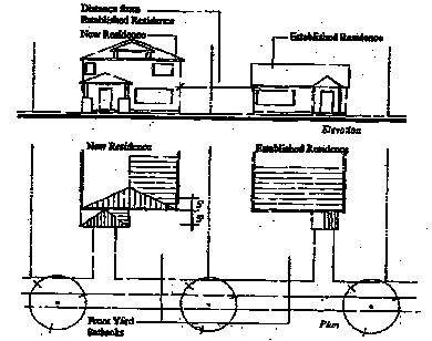
B.
Exception to Standard for Redevelopment Potential on Adjacent Lot(s). The planning official may waive the provisions of subsection A of this section upon determining that the subject single-family residential building located closest to and within twenty (20) feet of the subject site is redevelopable. "Redevelopable," for the purposes of this section, means a lot either has an assessed market value that exceeds the assessed market value of all improvements on the lot, based on the most recent data from the Coos County assessor's office.
(Ord. 1471 § 2 (part), 2008)
17.24.060 - Residential district—Housing density.
Allowable housing densities are calculated by dividing the total parcel or lot area by the applicable lot size standard after subtracting street rights-of-way. Areas reserved for flag lot access (flag poles) are not counted for the purpose of calculating minimum lot sizes.
(Ord. 1471 § 2 (part), 2008)
17.24.070 - Residential district—Lot coverage and impervious surfaces.
The maximum allowable lot coverage shall be as provided in Table 17.24.030. For the purposes of residential district development, lot coverage is calculated as the percentage of a lot or parcel covered by impervious surfaces (e.g., asphalt, concrete, and similar impervious paving). It does not include planted areas, and other areas allowing storm water infiltration, as approved by the city.
(Ord. 1471 § 2 (part), 2008)
17.24.080 - Residential district—Structure height—Measurement, exceptions.
Building heights shall conform to the standards in Table 17.24.030, and subsections A and B of this section:
A.
Building/Structure Height Measurement. Building height for the purposes of this code is measured as the vertical distance above a reference datum (grade plane) to the highest point (peak) of a roof. The height of a stepped or terraced building is the maximum height of any segment of the building.
B.
Exclusions from Maximum Building Height Standards. Chimneys, bell towers, steeples, roof equipment, flag poles, and similar features not for human occupancy are exempt from the maximum building heights, provided that all applicable fire and building codes are met.
(Ord. 1471 § 2 (part), 2008)
17.24.090 - Residential district—Building orientation.
A.
Purpose. The following standards are intended to orient building entrances toward streets to promote pedestrian-oriented development where walking is encouraged, and to discourage automobile-oriented development. Placing residences and other buildings close to the street also encourages crime prevention, natural surveillance or security, and safety by having more "eyes-on-the-street."
B.
Applicability. This section applies to buildings and developments that are subject to site design review (e.g., multifamily, attached single-family/townhomes, commercial buildings).
C.
1.
Residential District Building Orientation.
Figure 17.24.090(C)(1)
Site Plan—Acceptable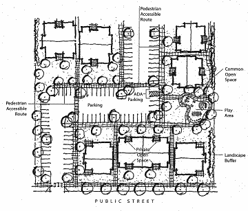
Site Plan—Unacceptable
2.
Off-street parking, driveways, and other vehicle areas shall not be placed between buildings and the street(s) to which they are oriented, as per this subsection and Figure 17.24.090(C)(1); except the following vehicle areas are allowed where the approval body finds that they will not adversely affect pedestrian safety and convenience:
a.
Nursing homes, assisted living facilities, and similar institutional uses may have one driveway located between the street and the primary building entrance, provided that the building's primary entrance is connected to an adjacent street by a pedestrian walkway and the driveway/parking area is crossed by a clearly defined pedestrian walkway, as required by Section 17.60.030. The intent of this exception is provided for one drop-off/loading zone where necessary to serve building occupants with special needs.
b.
Single-family dwellings may have one paved driveway for the purpose of accessing garages and/or other on-site parking areas conforming to the requirements of this code.
c.
Attached single-family housing developments (townhomes) with street-facing garages may have one combined driveway access located between the street and the primary building entrance for every two attached dwelling units, provided the driveway meets the following criteria, as generally shown in Figure 17.24.090(C)(2):
i.
Where two abutting townhomes have street-facing garages, they shall share one driveway access that does not exceed sixteen (16) feet in width where it crosses the sidewalk and where it intersects the street (excluding driveway apron);
ii.
All primary building entrances shall be connected to the driveway (and sidewalk) via a pedestrian walkway that is not less than three feet wide;
iii.
The maximum number of consecutively attached townhomes with garages facing the same street is four (two driveways); and
iv.
All garage openings and carport openings shall be setback at least twenty (20) feet from the street, and shall be recessing at least six feet behind the front building elevation closest to subject street.
Figure 17.24.090(C)(2) Townhome Building Orientation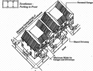
d.
Commercial buildings and uses (e.g., neighborhood commercial or mixed-use) shall have all of their off-street parking located behind or to the side of such buildings and uses and screened from abutting properties in accordance with Chapter 17.68, as generally shown in Figure 17.24.090(C)(3). Off-street parking shall not be located between any building and any street.
Figure 17.24.090(C)(3) Commercial Orientation in a Residential District
3.
Where a site contains multiple buildings and there is insufficient street frontage to which buildings can be oriented, a primary entrance may be oriented to common green, open space, plaza, or courtyard (e.g., cottage cluster). When oriented in this way, the primary entrance(s) and green, plaza, or courtyard shall be connected to the street by a pedestrian walkway meeting the standards in Section 17.60.030. See example in Figure 17.24.090(C)(1), "Site Plan—Acceptable."
(Ord. 1471 § 2 (part), 2008)
17.24.100 - Reserved.
(Ord. 1471 § 2 (part), 2008)
17.24.110 - Residential district—Special use standards.
This section provides standards for the specific land uses and building types identified in Table 17.24.020. The standards are intended to control the scale and compatibility of those uses within the residential district. The standards in Section 17.24.040 supplement (are in addition to and do not replace) the standards in Section 17.24.030. This section applies to the following uses and building types, as specified in subsections A through K of this section: accessory dwelling; attached single-family (townhouses or rowhouses) and attached duplexes; bed and breakfast inns; group living (residential care homes and residential care facilities); home occupations; manufactured homes; manufactured/mobile home parks; multiple-family housing; short-term vacation rentals; zero-lot line housing (not common wall); temporary medical hardship dwellings.
A.
Accessory Dwelling (Attached, Separate Cottage, or Above Detached Garage). Accessory dwellings shall conform to all of the following standards:
1.
Floor Area. Accessory dwellings shall not exceed eight hundred (800) square feet of floor area, or forty (40) percent of the primary unit, whichever is smaller. The unit can be a detached cottage, a unit attached to a garage, or in a portion of an existing house.
2.
Exempt from Density. Accessory dwellings are exempt from the housing density standards of the residential district, due to their small size and low occupancy levels.
3.
Oregon Structural Specialty Code. The structure shall comply with the Oregon Structural Specialty Code.
4.
Owner-Occupied. The primary residence or accessory dwelling shall be owner-occupied. Alternatively, the owner may appoint a resident caretaker of the principal house and manager of the accessory dwelling. The owner may be required to provide evidence of owner-occupancy upon request by the city.
5.
One Unit. A maximum of one accessory dwelling unit is allowed per lot.
6.
Building Height. The building height of detached accessory dwellings (i.e., separate cottages) shall not exceed the height of the primary dwelling.
7.
Buffering. The approval body may require a landscape hedge or fence be installed on the property line separating a detached accessory dwelling from an abutting single-family dwelling, unless the applicant and the owner of the abutting single-family dwelling agree in writing not to install the hedge or fence, and such evidence is presented to the city.
B.
Attached Single-Family (Townhouses and Rowhouses) and Duplexes. Single-family attached housing with three or more dwellings (lots), and attached duplex housing (two or more consecutively attached duplexes containing four or more dwellings), shall comply with the standards in subsections (B)(1) and (B)(2) of this section, which are intended to control development scale; avoid or minimize impacts associated with traffic, parking, and design compatibility; and ensure management and maintenance of common areas.
1.
Alley Access Required for Subdivisions Principally Containing Townhomes or Duplexes. Subdivisions, or phases of subdivisions, proposed to contain three or more consecutively attached single-family dwellings on any block, and developments with two or more attached duplexes (four plus dwelling units), shall provide vehicle access to all such lots and units from an alley or interior parking court, as described in Section 17.60.020. Alley(s) and parking court(s) shall be created at the time of subdivision approval, and may be contained in private tracts or, if approved by the city, in public right-of-way, in accordance with Section 17.72.020, Transportation standards, and Chapter 17.88, Land Divisions and Property Line Adjustments.
2.
Common Areas. Any common areas (e.g., landscaping, private tracts, common driveways, private alleys, building exteriors, and/or similar common areas) shall be owned and maintained by a homeowner's association or other legal entity as approved by the city. A copy of any applicable covenants, restrictions and conditions shall be recorded and provided to the city prior to building permit approval.
C.
Bed and Breakfast Inns. Where bed and breakfast inns are allowed in the residential district, they shall comply with all of the following standards. (See also vacation rentals, which are different than bed and breakfast inns, under subsection I of this section.)
1.
Accessory Use. The use must be accessory to a household already occupying the structure as a residence.
2.
Maximum Size. Not more than four bedrooms for guests, and a maximum of eight guests are permitted per night. A bed and breakfast use may occupy the primary dwelling and/or not more than one lawfully established guest cottage or accessory dwelling unit.
3.
Length of Stay. Maximum length of stay is twenty-eight (28) days per guest; anything longer is classified as a hotel or commercial lodging.
4.
Employees. Up to two nonresident employees. There is no limit on residential employees.
5.
Food Service. May be provided only to overnight guests of the business, except where a restaurant use is also permitted (e.g., conditional use in the residential district).
6.
Owner-Occupied. The primary dwelling shall be owner-occupied.
7.
Signs. Signs shall not exceed a total of four square feet of surface area on each side.
8.
Business License. Where a business license is required, the bed and breakfast inn owner shall maintain a current business license.
D.
Group Living (Residential Care Homes and Residential Care Facilities). Residential care homes are residential treatment or training homes or adult foster homes licensed by the state of Oregon. They may provide residential care alone, or in conjunction with treatment and/or training, for five or fewer individuals ("homes") or six to fifteen (15) individuals ("facilities") who need not be related. Staff persons required to meet state licensing requirements are not counted in the number of facility residents and need not be related to each other or the residents. Residential care homes and facilities shall comply with the following standards, consistent with ORS 197.660 through 197.670:
1.
Licensing. All residential care homes and facilities shall be duly licensed by the state of Oregon.
2.
Parking. Parking shall be provided in accordance with Chapter 17.68.
3.
Site Development Review. Site development review shall be required for new structures to be used as residential care homes or facilities, to ensure compliance with the licensing, parking, landscaping, and other requirements of this code.
E.
Home Occupations. The purpose of this section is to encourage those who are engaged in small commercial ventures that could not necessarily be sustained if it were necessary to lease commercial quarters, or which by the nature of the venture, are appropriate in scale and impact to be operated within a residence. Home occupations are encouraged for their contribution in reducing the number of vehicle trips often generated by conventional businesses. Two types of home occupations are contemplated by this code: (1) Home occupations meeting the standards in subsections (E)(1) through (E)(8) of this section are allowed by right, provided all uses and structures on the subject property are in conformance with the applicable zoning; and (2) Home occupations exceeding any of the threshold standards in subsections (E)(1) through (E)(8) of this section may receive approval through the Type III home occupation permit procedure under Section 17.112.020.
Type I standards for home occupations:
1.
Appearance of Residence.
a.
The home occupation shall be restricted to lawfully built enclosed structures and be conducted in such a manner as not to give an outward appearance of a business.
b.
The home occupation shall not result in any structural alterations or additions to a structure that will change its primary use or building code occupancy classification.
c.
The home occupation shall not violate any conditions of development approval (i.e., prior development permit approval).
d.
No products and/or equipment produced or used by the home occupation may be displayed to be visible from outside any structure.
2.
Storage.
a.
Outside storage, visible from the public right-of-way or adjacent properties, that exceeds what is customary for a single-family residence in the vicinity, is prohibited.
b.
On-site storage of hazardous materials (including toxic, explosive, noxious, combustible or flammable) beyond those normally incidental to residential use is prohibited.
c.
Storage of inventory or products and all other equipment, fixtures, and activities associated with the home occupation shall be allowed in any structure.
3.
Employees.
a.
Other than family members residing within the dwelling located on the home occupation site, there shall be no other/not more than one full-time equivalent employee at the home occupation site at any given time. As used in this chapter, the term "home occupation site" means the legal lot on which the home occupation is conducted.
b.
Additional individuals may be employed by or associated with the home occupation, so long as they do not report to work or pick up/deliver at the home occupation site.
c.
The home occupation site shall not be used as a headquarters for the assembly of employees for instruction or other purposes, including dispatch of employees to other locations.
4.
Advertising and Signs. Signs shall comply with all applicable sign regulations. In no case shall a sign in the residential district exceed four square feet of surface area on each sign face, not to exceed a total surface area of eight square feet.
5.
Vehicles, Parking and Traffic.
a.
One commercially licensed vehicle associated with the home occupation is allowed at the home occupation site. It shall be of a size that would not overhang into the public right-of-way when parked in the driveway or other location on the home occupation site.
b.
There shall be no more than three commercial vehicle deliveries to or from the home occupation site daily. There shall be no commercial vehicle deliveries during the hours of nine p.m. to seven a.m.
c.
There shall be no more than one client's or customer's vehicle at any one time and no more than eight per day at the home occupation site.
6.
Business Hours. There shall be no restriction on business hours, except that clients or customers are permitted at the home occupation from seven a.m. to nine p.m. only, subject to subsections (E)(1) and (E)(5) of this section.
7.
Prohibited Home Occupation Uses.
a.
Any activity that produces radio, TV, or other electronic interference; noise, glare, vibration, smoke, or odor beyond allowable levels as determined by local, state or federal standards, or that can be detected beyond the property line; is prohibited.
b.
Any activity involving on-site retail sales, including garage sales exceeding the thresholds of a temporary use, is prohibited, except that the sale of items that are incidental to a permitted home occupation is allowed. For example, the sale of lesson books or sheet music from music teachers, art or craft supplies from arts or crafts instructors, computer software from computer consultants, and similar incidental items for sale by home business is allowed subject to subsections (E)(1) through (E)(6) of this section.
c.
The following uses and uses with similar objectionable impacts because of motor vehicle traffic, noise, glare, odor, dust, smoke or vibration, are prohibited:
i.
Ambulance service;
ii.
Animal hospital, veterinary services, kennels or animal boarding;
iii.
Auto and other vehicle repair, including auto painting; and
iv.
Repair, reconditioning or storage of motorized vehicles, boats, recreational vehicles, airplanes or large equipment on-site.
8.
Business License. Where a business license is required, the owner of the home occupation shall maintain the required business license.
9.
Enforcement. The planning official or designee may visit and inspect the site of a home occupation in accordance with this chapter periodically to ensure compliance with all applicable regulations, during normal business hours, and with reasonable notice, in accordance with Chapter 17.16.
F.
Manufactured Homes on Individual Lots. Manufactured homes are permitted on individual lots, subject to all of the following design standards. Exceptions: the standards in subsections (F)(1) through (F)(8) of this section do not apply to units that lawfully existed within the city prior to the effective date of the ordinance codified in this title; except that when a unit is removed and/or relocated to another lot or parcel, then its replacement shall conform to this subsection; new or replacement units in a manufactured home park need not conform to subsections (F)(1) through (F)(8) of this section, but shall conform to Section 17.24.110(G).
1.
Floor Plan. The manufactured home shall be multi-sectional and have an enclosed floor area of not less than one thousand (1,000) square feet.
2.
Roof. The manufactured home shall have a pitched roof with a slope not less than three feet in height for each twelve (12) feet in width (fourteen (14) degrees).
3.
Residential Building Materials. The manufactured home shall have exterior siding and roofing which in color, material and appearance are similar or superior to the exterior siding and roof material used on nearby residences (e.g., horizontal wood, vinyl, or similar wood-appearance siding is considered "superior" to metal siding and roofing).
4.
Garages and Carports. If a single-family dwelling on any abutting lot with frontage on the same street as the proposed manufactured dwelling contains a garage, the manufactured home shall have a garage. If the abutting single-family dwelling lot contains a carport, the proposed manufactured home shall have a garage or carport. Manufactured home garages and carports shall be constructed of materials like those used on the proposed dwelling.
5.
Thermal Envelope. The manufactured home shall be certified by the manufacturer to meet the thermal envelope requirements equivalent to those for a single-family dwelling constructed under the state building code. Evidence from a qualified expert demonstrating that the manufactured home meets Northwest Energy Efficiency Manufactured Housing (NEEM) standards, or equivalent standards, is deemed to satisfy the exterior thermal envelope certification requirement; manufacturer certification may be required.
6.
Placement. The manufactured home shall be placed on an excavated and back-filled foundation and enclosed at the perimeter such that the manufactured home is located not more than sixteen (16) inches above grade, and complies with the minimum set-up standards of the state Administrative Rules for Manufactured Dwellings, OAR Chapter 918. Where the building site has a sloped grade, no more than sixteen (16) inches of the enclosing material shall be exposed on the uphill side of the home.
7.
Foundation Skirt. The foundation area of the manufactured home shall be fully skirted with concrete block or similar materials that resemble a concrete foundation.
8.
Prohibited. The manufactured home shall not be located in a designated historic district.
G.
Manufactured/Mobile Home Parks. Manufactured/mobile home parks are permitted in the residential district on parcels of one acre or larger, subject to compliance with subsections (G)(1) through (G)(5) of this section:
1.
Permitted Uses. Single-family residences, manufactured home park manager's office, home occupations, and accessory structures that are necessary for the operation and maintenance of the manufactured dwelling park (e.g., landscape maintenance). A recreational vehicle may be permitted in a city-approved mobile home park or manufactured home park where the vehicle is connected to an electrical utility and city sewer and water systems, in accordance with ORS 197.493.
2.
Space. The minimum size pad or space for each dwelling is two thousand five hundred (2,500) square feet, provided that the overall density of the park does not exceed twelve (12) units per acre. Each space shall be at least thirty (30) feet wide and forty (40) feet long, in accordance with ORS 446.100(c).
3.
Setbacks and Building Separation. The minimum setback between park structures and abutting properties is five feet. The minimum setback between park structures and public street right-of-way is fifteen (15) feet. At least a ten (10) foot separation shall be provided between all dwellings. Dwellings shall be placed a minimum of fourteen (14) feet apart where flammable or combustible fuel is stored between units. Park structures shall be placed no closer than five feet to a park street or sidewalk/pathway. An accessory structure shall not be located closer than six feet to any other structure or dwelling, except that a double carport or garage may be built which serves two dwellings. When a double carport/garage is built, the carport/garage shall be separated from all adjacent structures by at least three feet.
4.
Perimeter Landscaping. When manufactured dwellings are oriented with their back or side yards facing a public right-of-way, the city may require installation of fencing and planting of a ten (10) foot wide landscape buffer between the right-of-way and a manufactured home park for the privacy and security of residents or aesthetics of the streetscape.
5.
Dwelling Design (for parks smaller than three acres). Manufactured dwellings in parks smaller than three acres shall additionally meet the design standards in subsections (G)(5)(a) through (b) of this section, consistent with ORS 197.314(6):
a.
The manufactured dwelling shall have a pitched roof with a slope not less than three feet in height for each twelve (12) feet in width (fourteen (14) degrees); and
b.
The manufactured dwelling shall have exterior siding and roofing which in color, material and appearance are similar or superior to the exterior siding and roof material used on nearby residences (e.g., horizontal wood or wood-appearance siding is considered "superior" to metal siding and roofing);
c.
Exception: subsections (G)(5)(a) and (b) of this section, do not apply to lawfully established manufactured dwellings existing within the city prior to the effective date of the ordinance codified in this title. The standards do apply to new or replacement dwellings, including those relocated from one park to another.
H.
Multiple-Family Housing. Where multiple-family housing is allowed, it shall conform to all of the following standards, which are intended to promote livability for residents and compatibility with nearby uses. Figure 17.24.110(H) provides a conceptual illustration of the requirements listed below.
1.
Building Mass. The maximum width or length of a multiple-family building shall not exceed one hundred (100) feet from end-wall to end-wall, not including outdoor living areas (e.g., porches, balconies, patios, and similar unenclosed spaces).
2.
Common Open Space. A minimum of ten (10) percent of the site area shall be designated and permanently reserved as common open space in all multiple-family developments with more than twenty (20) dwellings, in accordance with all of the following criteria:
a.
The site area is defined as the lot or parcel on which the development to be located, after subtracting any required dedication of street right-of-way and other land for public purposes (e.g., public park or school grounds, etc.).
b.
In meeting the common open space standard, the multiple-family development shall contain one or more of the following: outdoor recreation area, protection of sensitive lands (e.g., trees preserved), play fields, outdoor playgrounds, outdoor sports courts, swimming pools, walking fitness courses, pedestrian amenities, or similar open space amenities for residents.
c.
Historic buildings or landmarks that are open to the public may count toward meeting the common open space requirements when approved by planning commission or city council.
d.
To receive credit under this subsection, a common open space area shall have an average width that is not less than twenty (20) feet and an average length that is not less than twenty (20) feet.
e.
Where the development contains pedestrian amenities located between primary building entrance(s) and adjoining streets, such area may count toward fulfilling; however, parking area landscaping shall not count as required open space.
f.
The approval body may waive the common open space requirement for the first twenty (20) dwelling units in a multiple-family project that is located within one-quarter mile (measured walking distance) of a public park, where there is a direct, accessible (i.e., Americans with Disabilities Act compliant), lighted walkway connecting the site to the park. If the park is not developed, or only partially developed, the approval body allow the multiple-family housing developer to improve park land in an amount comparable to that which he or she would otherwise be required to provide in his or her development in waiving the on-site common open space requirement.
3.
Private Open Space. Private open space areas shall be required for ground floor and upper floor housing units based on all of the following criteria:
a.
A minimum of forty (40) percent of all ground floor housing units shall have front or rear patios or decks measuring at least forty-eight (48) square feet. Ground floor housing means the housing unit entrance (front or rear) is within five feet of the finished ground elevation (i.e., after grading and landscaping);
b.
A minimum of forty (40) percent of all upper floor housing units shall have balconies or porches measuring at least forty-eight (48) square feet. Upper floor housing means housing units that are more than five feet above the finished grade; and
c.
Areas used to fulfill the common open space requirements of this section shall not be used to fulfill the private open space requirement.
Figure 17.24.110(H) Examples of Multiple-Family Open Space
4.
Trash Receptacles. Trash receptacles shall be oriented away from building entrances, setback at least ten (10) feet from any public right-of-way and adjacent residences and shall be screened with an evergreen hedge or solid fence or wall of not less than six feet in height. Receptacles must be accessible to trash pick-up trucks.
I.
Short-Term Vacation Rentals. Where short-term vacation rentals are allowed, they shall conform to all of the following criteria:
1.
Vacation rentals allowed under this subsection are those with twenty-eight (28) or fewer days continuous occupancy by the same tenant.
2.
Where a business license is required to operate one or more short-term vacation rentals, the license application shall identify all short-term rental properties under the same ownership or management, and shall provide the city with information regarding the name, address and telephone number of a contact person who can be on the vacation home rental site within four hours to respond to problems.
3.
A conditional use permit is required.
4.
The vacation rental unit shall provide two off-street parking spaces (not in addition to those otherwise required for a single-family dwelling).
5.
All required parking shall be provided on the same lot as the vacation home rental unit.
6.
All vacation home rentals shall have a maximum occupancy of one person per two hundred (200) square feet or not more than sixteen (16) people, whichever is more restrictive.
7.
All other requirements of the code as applicable to single-family dwellings shall apply.
J.
Zero-Lot Line Housing. Zero-lot line houses are subject to the same standards as other nonattached single-family housing, except that a side yard setback is not required on one side of the lot, as generally shown in Figure 17.27.110(J). The standards for zero-lot line housing are intended to ensure adequate outdoor living area, compatibility between adjacent buildings, and access to side yards for building maintenance. All zero-lot line houses shall conform to all of the criteria in subsections (J)(1) through (J)(4) of this section.
1.
Site Design Review Required. Site design review is required for new zero-lot line developments. When a zero-lot line development is proposed as part of a land division, master planned development, or other application, the site design review may be combined with the other application(s).
2.
Setbacks for Primary and Accessory Structures. The allowance of a zero side yard setback is for one single-family dwelling on each lot; it does not extend to accessory structures which shall conform to the applicable setback requirements of the zone.
3.
Setbacks Adjacent to Nonzero-Lot Line Development. When a zero-lot line house shares a side property line with a nonzero-lot line development, the zero-lot line building shall be setback from that common property line by not less than ten (10) feet.
4.
Building Orientation and Design. The building placement and/or design shall encourage privacy for the occupants of abutting lots. For example, this standard can be met by staggering foundation plans, by placing windows (along the zero-lot line) above sight lines with direct views into adjacent yards, by using frosted/nonsee-through windows, by avoiding placement of windows on the zero-lot line, or other designs approved by the approval body through site design review.
5.
Construction and Maintenance Easement. Prior to building permit approval, the applicant shall submit a copy of a recorded easement for every zero-lot line house that guarantees access onto adjoining lot for the purpose of construction and maintenance of the zero-lot line house. The easement shall require that no fence or other structure shall be placed in a manner that would prevent maintenance of the zero-lot line house. The easement shall not preclude the adjoining owner from landscaping the easement area.
Figure 17.24.110(J) Zero-Lot Line Housing
K.
Temporary Medical Hardship Dwellings. A temporary medical hardship dwelling must meet the following requirements:
1.
The temporary hardship dwelling must either be occupied by someone who will care for the resident of the subject property, or it may be occupied by a relative of the resident when the relative has the medical hardship and the resident of the property will be the caregiver. (Relative is defined as a parent, child, grandparent, grandchild, brother, or sister of the existing resident.)
2.
The temporary hardship dwelling must use the same subsurface sewage disposal system as the existing dwelling, provided that the system is adequate to accommodate the additional dwelling. If on an existing septic system, the system will need to be inspected and approved by a county sanitarian. Once the hardship has ended, the system must be abandoned in accordance with DEQ requirements.
3.
The application must include a written statement from the patient's primary care medical doctor (MD) or osteopath (DO). The statements must be on the doctor's stationery or stamped by their office. The statement must indicate that, for health or age-related reasons, the patient is unable to maintain a residence on a separate property and is dependent upon someone being close by for assistance.
4.
The permit authorizing the temporary hardship dwelling must be renewed every two years. In order to renew the temporary hardship permit, a letter from a doctor stating that the hardship still exists must be submitted to the department, along with the renewal fee. If the hardship dwelling is connected to the same septic system as the existing dwelling, the septic system may also need to be reinspected.
5.
Within three months of the end of the hardship, the manufactured dwelling, recreational vehicle, or travel trailer must be removed from the property or demolished. In the case of an existing building which has been converted for temporary residential use, the building must be removed, demolished or returned to an allowed use.
6.
The temporary dwelling must comply with applicable fire safety standards.
7.
A temporary medical hardship dwelling permit is obtained through a Type I land use review, in accordance with Chapter 17.80. The application must include the following information:
a.
The aforementioned letter from a medical doctor or osteopath confirming that the person with the hardship is unable to maintain their own separate residence because of a health or age-related condition or infirmity; and
b.
A site plan, drawn to scale on eight and one-half inch by eleven (11) inch paper, showing property lines, existing streets and driveways, existing and proposed buildings, including distances to property lines, location of any existing wells and/or septic systems, location of any physical features on the parcel such as streams, irrigation ditches, steep slopes, etc., must be submitted with the application.
8.
The planning official will review the application to determine whether it conforms to the approval criteria listed above. If approved, a manufactured dwelling installation permit must be obtained from Coos County. If the hardship dwelling is to be a recreational vehicle or travel trailer, applicable sewage disposal requirements shall be met.
(Ord. 1471 § 2 (part), 2008)
17.28.010 - Commercial districts—Purpose.
This chapter provides three commercial districts to accommodate the range of commercial land uses in the community. The downtown district is focused on the core commercial and civic (i.e., the central business) area of the community. The general commercial and commercial retail district regulations apply to those commercial areas outside or adjacent to the central business area. The mixed-use commercial district applies to those commercial areas along Central Boulevard north of downtown that contain a mixture of commercial and residential uses. All three districts are intended to:
A.
Promote efficient use of land and urban services;
B.
Create a mixture of land uses that encourages employment and housing options in close proximity to one another; housing is allowed above permitted commercial uses, and in limited areas west of the downtown with a mixed-use commercial designation;
C.
Provide formal and informal community gathering places and opportunities for socialization (i.e., along an active street front);
D.
Encourage pedestrian-oriented development in all commercial areas;
E.
Create a distinct storefront character in the downtown district;
F.
Provide connections to and appropriate transitions between residential areas and commercial areas;
G.
Discourage automobile-oriented and automobile-dependent uses in the downtown district, and accommodate those uses with appropriate design standards in the general commercial and commercial retail districts;
H.
Provide for visitor accommodations and tourist amenities;
I.
Reduce reliance on the automobile and minimize the need for off-street parking; and
J.
Maintain and enhance the downtown's pedestrian orientation and human scale.
(Ord. 1471 § 2 (part), 2008)
17.28.020 - Commercial districts—Allowed land uses.
Table 17.28.020 identifies the land uses that are allowed in the commercial districts. The specific land use categories are described and uses are defined in Chapters 17.08 and 17.12.
Table 17.28.020 Land Uses Allowed in Commercial Districts (C-1, C-2, CO, C-3)
Key:
S = Permitted with standards (Section 17.28.100)
CU = CU permit required (Chapter 17.92)
N = Not permitted
(Ord. 1471 § 2 (part), 2008; Ord. No. 1526, 11-6-2023)
17.28.030 - Commercial districts—Development standards.
The development standards in Table 17.28.030 apply to all new structures, buildings, and development, and major remodels, in the commercial districts.
Table 17.28.030 Development Standards for Commercial Districts
1
Development must conform to lot width, depth, yard setback, landscaping, and coverage
standards.
(Ord. 1471 § 2 (part), 2008)
17.28.040 - Commercial districts—Setbacks and build-to line.
A.
Zero Setbacks and Build-To Line—Purpose, Fire Code and Clear Vision. Zero setbacks and build-to lines, as provided in Table 17.28.030, are intended to encourage pedestrian-oriented development, while providing more flexibility in site design than what is possible with large setbacks. With buildings placed close to the street, a development can afford good access for emergency service providers in the case of a fire or other emergency. Where no minimum setback is required, all structures and buildings shall conform to the vision clearance standards in Chapter 17.60 and the applicable fire and building codes (e.g., for attached structures, fire walls, and related requirements).
B.
Setback Yards—Reverse Frontage Lots. Buildings on reverse frontage lots (through lots) shall be required to meet the build-to line standard on only one street. Reverse frontage lots are subject to the landscape buffer requirements in Section 17.64.020.
C.
Setback Yards—Flag Lots. The front yard of a flag lot (e.g., as required to accommodate a rear commercial pad within a shopping center or office complex) shall be determined based on one of two options:
1.
Parallel to the street from which access is taken; or
2.
Parallel to the flag pole from which access is taken.
The applicant for a building permit may choose either subsection (C)(1) or (C)(2) of this section, except as otherwise prescribed by conditions of a prior land use approval (e.g., partition or subdivision conditions of approval).
D.
Setback Yards—Exceptions. Where existing lawfully established buildings have yard setbacks that are less than the minimum standards of this code, they are allowed to remain as legal, nonconforming structures.
(Ord. 1471 § 2 (part), 2008)
17.28.050 - Commercial districts—Lot coverage and impervious surface.
The maximum allowable lot coverage shall be as provided in Table 17.28.030. Lot coverage is calculated as the percentage of a lot or parcel covered by buildings and impervious surfaces (e.g., asphalt, concrete, and similar impervious paving). It does not include planted areas, and other areas allowing storm water infiltration, as approved by the city.
(Ord. 1471 § 2 (part), 2008)
17.28.060 - Commercial districts—Building orientation and commercial block layout.
A.
Purpose. This section orients buildings close to streets to promote pedestrian-oriented development where walking is encouraged, and to discourage automobile-oriented development. Placing residences and other buildings close to the street also encourages crime prevention, natural surveillance or security, and safety by having more "eyes-on-the-street."
B.
Applicability. This section applies to projects that are subject to site design review or land division review, including master planned developments.
C.
Building Orientation Standards. Developments subject to this section shall have their buildings oriented to a street, as generally shown in Figure 17.28.060(C)(1). This standard is met when all of the following criteria are met:
1.
Compliance with the setback and build-to line standards in Section 17.28.030, where applicable. The build-to line may be setback to provide pedestrian amenities between a building and its adjoining street.
2.
Except as provided in subsections (C)(4) and (C)(5) of this section, all buildings shall have at least one primary building entrance (i.e., dwelling entrance, a tenant entrance, lobby entrance, or breezeway/courtyard entrance) facing an adjoining street (i.e., within forty-five (45) degrees of the street property line), or if the building entrance is turned more than forty-five (45) degrees from the street (i.e., front door is on a side elevation), the primary entrance shall not be more than twenty (20) feet from a street sidewalk in the C-1 district, or forty (40) feet from a street/shopping street sidewalk in the C-2 or C-3 districts, except where pedestrian amenities are provided, in which case a walkway shall connect the primary entrance to the sidewalk.
Figure 17.28.060(C)(1) Building Orientation
3.
In the C-1 district, off-street parking, trash pick-up, and aboveground utilities (e.g., utility vaults) shall not be placed between building entrances and the street(s) to which they are oriented, but shall be oriented internally to the block and accessed by alleys to the extent practicable. Off-street parking in the C-1 district shall be oriented internally to the site to the extent practicable, and shall be divided by landscape areas into bays of not more than twenty-four (24) parking spaces per bay, as generally shown in Figures 17.28.060(C)(1) and 17.28.060(C)(2); incidental breaks in the building wall to accommodate pedestrian and vehicle access into the block is permitted. Exceptions to alley access provision are allowed where no system of alleys exist and where extension of alleys is precluded by existing development.
Figure 17.28.060(C)(2) Building Orientation with Internal Parking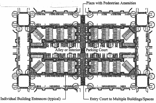
4.
In the GC district, the building orientation standard may be met with vehicle areas allowed between the street right-of-way and a building's primary entrance when the approval body finds that the following criteria are met:
a.
Placing vehicle areas between the street right-of-way and building's primary entrance will not adversely affect pedestrian safety and convenience, based on the distance from the street sidewalk to the building entrance, projected vehicle traffic volumes, and available pedestrian walkways;
b.
The proposed vehicle areas are limited to one driveway of not more than twenty-four (24) feet in width with not more than one row of parking spaces on both sides of the drive aisle (including ADA accessible spaces), divided by landscape areas into bays of not more than eight parking spaces each. The intent is to create a drive aisle that is street-like, and break up parking into small bays with landscaping; and
c.
The building's primary entrance is connected to an adjoining street by a pedestrian walkway that meets the standards for pedestrian walkways under Section 17.60.030.
5.
Where a development contains multiple buildings and there is insufficient street frontage to which buildings can be oriented, a primary entrance may be oriented to plaza, courtyard, or similar pedestrian space containing pedestrian amenities, subject to site design review. When oriented in this way, the primary entrance(s), plaza, or courtyard shall be connected to the street by a pedestrian walkway meeting the standards in Section 17.60.030.
D.
Block Layout Standard. Commercial developments (office, or retail/wholesale/service) containing more than one building, with the sum total of buildings equal to or greater than forty thousand (40,000) square feet of floor area, shall meet all of the following standards:
1.
The site shall be configured into blocks that have frontage onto streets, interior parking courts (as generally shown in Figure 17.28.060(C)(2) above), or "shopping streets" (as generally shown in Figure 17.28.060(C)(3) below). All shopping streets shall contain on-street parking (parallel or angled parking), sidewalks, street trees, and pedestrian lighting; and all buildings shall orient their primary entrances to a street, plaza or courtyard. Additionally, buildings placed at a street/block corner shall have a primary entrance within forty (40) feet of the street/block corner.
2.
Where a subdivision or multi-building development is proposed, blocks shall be broken down into lengths of not more than four hundred (400) feet, and shall have a perimeter not exceeding one thousand four hundred (1,400) feet.
3.
Walkways shall connect the street right-of-way to building entrances and the interior parking bays between buildings, as necessary to ensure reasonably safe, direct, and convenient access to building entrances and off-street parking.
Figure 17.28.060(C)(3) Shopping Street Example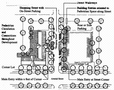
(Ord. 1471 § 2 (part), 2008)
17.28.070 - Commercial districts—Building and structure height—Mixed-use bonus.
A.
Height Standards. Building and structure heights shall conform to the standards in Table 17.28.030.
B.
Height Bonus for Housing. Additional building height may be permitted in the C-1 and C-3 districts, as provided in Table 17.28.030, when housing is provided aboveground floor commercial use(s), subject to approval of a conditional use permit. Off-street parking requirements shall be determined based on an analysis of parking demand prepared by the applicant and subject to review and approval by the city approval body. Where a second egress is required for fire safety, residences may have their entrances/egress oriented to any yard; such entrances need not be oriented to the street.
Figure 17.28.070(B) Building Height Bonus for Housing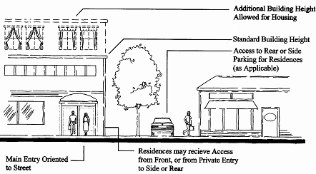
(Ord. 1471 § 2 (part), 2008)
17.28.080 - Commercial districts—Building design standards.
A.
Purpose and Applicability. This section is intended to provide detailed, pedestrian-oriented design that is characteristic of the city of Coquille while affording flexibility to use a variety of architectural building styles. All new buildings and major remodels shall meet the standards of subsections B through D of this section, which are applied through site design review. The applicant must demonstrate compliance with all criteria under each standard.
B.
Pedestrian-Orientation. The design of all buildings on a site shall support a safe and attractive pedestrian environment. This standard is met when the approval body finds that all of the criteria in subsections (B)(1) through (B)(7) of this section are met. Alternatively, the approval body may modify one or more of the criteria and approve an alternate design upon finding that the design contains an equally good or superior way of achieving the above purpose and intent.
1.
The building orientation standards under Section 17.28.060 shall be met.
2.
Primary building entrances shall open directly to the outside and, if not abutting a street, shall have walkways connecting them to the street sidewalk; every building shall have at least one primary entrance that does not require passage through a parking lot or garage to gain access.
3.
Corner buildings (i.e., buildings within twenty (20) feet of a corner as defined by the intersecting curbs) shall have corner entrances, or shall provide at least one entrance within twenty (20) feet of the street corner or corner plaza in the C-1 district, and within forty (40) feet of the street corner or corner plaza in the C-2 and C-3 districts.
4.
In the C-1 district, at least sixty (60) percent of the building's street-facing elevation (measured horizontally in linear feet) shall be located at the build-to line or closer to the street. In the C-2 and C-3 districts, at least forty (40) percent of the building's street-facing elevation shall be located at the build-to line or closer to the street. Build-to lines are prescribed by Section 17.28.030.
5.
In the C-1 district, ground floor windows or window displays shall be provided along at least forty (40) percent of the building's ground floor street-facing elevation(s). In the C-2 and C-3 districts, ground floor windows or window displays shall be provided along at least thirty (30) percent of the building's ground floor street-facing elevation. Windows and display boxes used to meet this standard shall be integral to the building design and not mounted to an exterior wall.
6.
In the C-1 district, all building entrance(s) and at least sixty (60) percent of the building's ground floor street-facing elevation(s) shall incorporate weather protection, such as awnings, canopies, overhangs, or similar features, extending at least five feet over adjacent sidewalks. In the C-2 and C-3 districts, this requirement applies to building entrances and thirty (30) percent of the ground floor street-facing elevation(s).
7.
Drive-up and drive-through facilities, when allowed, shall conform to Section 17.28.100; the provisions of which shall not be modified without a variance (Chapter 17.116).
C.
Compatibility. All new buildings and major remodels shall be designed consistent with the architectural context in which they are located. This standard is met when the approval body finds that all of the criteria in subsections (C)(1) through (C)(6) of this section are met. Alternatively, the approval body may modify one or more of the criteria and approve an alternate design upon finding that the design contains an equally good or superior way of achieving the above purpose and intent.
1.
There is continuity in building sizes between new and existing buildings, particularly where existing building are designated historic resources.
2.
The ground floor and upper floor elevations and architectural detailing, including windows, are compatible with one another and with adjacent historic resources, if any.
3.
Roof elevation is similar to commercial buildings in the vicinity (roof pitch, shape, projections).
4.
There is continuity of building sizes on the site, if more than one building is proposed.
5.
There is continuity in the rhythm of windows and doors on the proposed building(s).
6.
The relationship of buildings to public spaces, such as streets, plazas, other areas, and public parking, including on-street parking, is strengthened by the proposed building(s).
D.
Human Scale. The design of all buildings shall be to a human scale. This standard is met when the approval body finds that all of the criteria in subsections (D)(1) through (D)(8) of this section are met. Alternatively, the approval body may modify one or more of the criteria and approve an alternate design upon finding that the design contains an equally good or superior way of achieving the above purpose and intent. Figure 17.28.080(D) provides contrasting examples of building elevations that are consistent/inconsistent with human scale criteria.
1.
Regularly spaced and similarly shaped windows are provided on all building stories.
2.
Ground floor retail spaces have tall ceilings (i.e., twelve (12) through sixteen (16) feet) with display windows on the ground floor.
3.
Display windows are trimmed, recessed, or otherwise defined by wainscoting, sills, water tables, or similar architectural features.
4.
On multi-story buildings, ground floors are defined and separated from upper stories by appropriate architectural features (e.g., cornices, trim, awnings, canopies, arbors, trellises, overhangs, or other features) that visually identifies the transition from ground floor to upper story; such features should be compatible with the surrounding architecture.
5.
The tops of flat roofs are treated with appropriate detailing (i.e., cornice, pediment, flashing, trim, or other detailing) that is compatible with the surrounding architecture.
6.
Pitched roofs have eaves, brackets, gables with decorative vents, or other detailing that is consistent with the surrounding architecture.
7.
For remodels of historic resources, the design maintains the historic integrity of the building exterior as evidenced by proposed materials, colors and detailing.
8.
Where buildings with greater than twenty thousand (20,000) square feet of enclosed ground floor space are proposed, they shall provide articulated facades on all street-facing elevations. This criterion is met when an elevation contains at least three of the following features for every forty (40) feet of building (horizontal length): transparent windows; primary entrances; weather protection (awnings or canopies extending at least five feet over adjacent walks); building offsets, projections, or changes in elevation or horizontal direction of at least three feet; sheltering roofs or terraces; a distinct pattern of divisions in surface materials; screening trees; and/or small scale lighting (e.g., wall-mounted lighting, or up-lighting). Note: Figure 17.28.080(D) is intended to show how a variety of elements used to meet the articulation standard; it is not be interpreted as a required architectural style.
Figure 17.28.080(D) Examples of Large Commercial Design Elements
Large Commercial Massing—Acceptable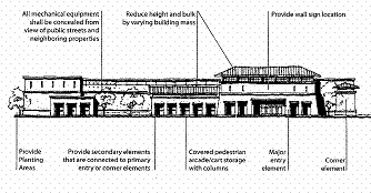
Large Commercial Massing—Unacceptable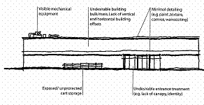
(Ord. 1471 § 2 (part), 2008)
17.28.090 - Commercial districts—Pedestrian amenities.
A.
Purpose and Applicability. Pedestrian amenities such as plazas, benches, and other sidewalk furnishings serve as informal gathering places for socializing, resting, and enjoyment along street frontages and contribute to a walkable commercial district. The standards in this section apply to new development and major remodels where site design review is required.
B.
Standards. New developments and major remodels in the C-1 district shall provide at least one pedestrian amenity, as described below and as generally illustrated in Figure 17.28.090(B). Other developments where pedestrian amenities are to be provided shall also conform to the criteria below. Pedestrian amenities may be provided within a street furnishing zone, building frontage zone, or plaza, or within the pedestrian through zone, as shown in Figure 17.28.090(B), and shall be physically accessible to the public. Use of the public right-of-way requires approval by the road authority. Design standards for pedestrian amenities follow:
1.
A plaza, courtyard, square or extra-wide sidewalk next to the building entrance (minimum sidewalk extension of four feet);
2.
Sitting space (i.e., dining area, benches, garden wall or ledges between the building entrance and sidewalk) with a minimum of sixteen (16) inches in height and thirty (30) inches in width;
3.
Building canopy, awning, pergola, or similar weather protection (minimum projection of five feet over a sidewalk, plaza or other pedestrian space);
4.
Public art that incorporates seating (e.g., fountain, memorial or sculpture with seating).
Figure 17.28.090(B) Examples of Pedestrian Amenities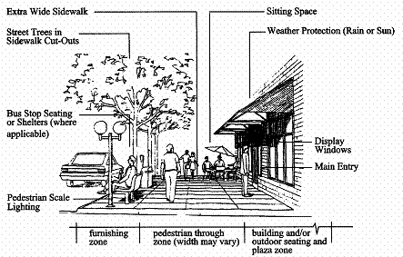
(Ord. 1471 § 2 (part), 2008)
17.28.100 - Commercial districts—Special use standards.
A.
This section supplements the standards contained in Sections 17.28.020 through 17.28.090. It provides standards for the following land uses to control the scale and compatibility of those uses:
1.
Drive-up and drive-through uses and facilities;
2.
(Reserved)
B.
Drive-Up/Drive-In/Drive-Through Uses and Facilities. When drive-up or drive-through uses and facilities are allowed, they shall conform to all of the following standards, which are intended to calm traffic, and protect pedestrian comfort and safety.
1.
The drive-up/drive-through facility shall orient to an alley, driveway, or interior parking area, and not a street. See Figure 17.28.100(B)(1).
Figure 17.28.100(B)(1)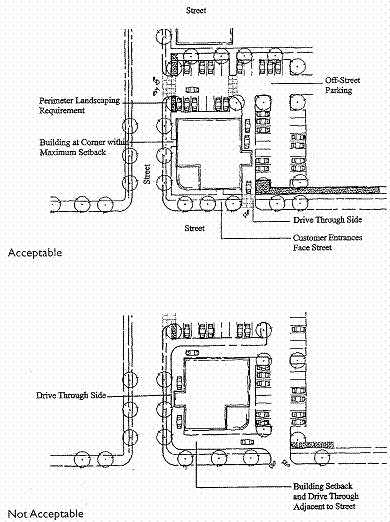
2.
None of the drive-up, drive-in or drive-through facilities (e.g., driveway queuing areas, windows, teller machines, service windows, kiosks, drop-boxes, or similar facilities) are located within twenty (20) feet of a street and shall not be oriented to a street corner. (Walk-up only teller machines and kiosks may be oriented to a street or placed adjacent to a corner.)
3.
Drive-up/in queuing areas shall be designed so that vehicles do not obstruct a driveway, fire access lane, walkway, or public right-of-way.
4.
In the C-1 district, no more than one drive-up, drive-in, or drive-through facility is allowed for a distance of four hundred (400) linear feet along the same block face (same side of street).
C.
Food Truck. When food trucks are allowed, they shall conform to all of the following standards, which are intended to ensure food trucks do not pose an impediment or hazard to vehicles, pedestrians, and bicyclists in the vicinity of the food truck.
1.
The food truck parking space shall allow for ten (10) feet of space on the serving side(s) of the truck and five (5) feet on each other side of the truck. These setbacks shall be from any parking space, drive aisle, property line, or other development which may endanger pedestrians and the operators of the food truck.
2.
The food truck shall have at least two (2) off-street parking spaces. Parking spaces which are currently used by a primary use on the property may be counted towards the required spaces, if the applicant can demonstrate that such an allowance will not result in parking and circulation issues in the vicinity.
3.
The food truck parking space shall not obstruct pedestrian or vehicle vision clearance. The food truck space shall comply with Section 17.60.020, Vehicular Access and Circulation N. Vision Clearance and with other vision clearance-related conditions imposed by the planning commission.
4.
Each food truck parking space requires a separate conditional use permit. Multiple food truck conditional use permits may be issued per property, provided the separation and parking requirements can be met, in addition to other conditions which may be imposed by the planning commission.
5.
Where a food truck parking space abuts a residential use or the residential zone, the planning commission may impose screening and buffering requirements.
6.
A food truck parking space may be considered either a primary or a secondary use of a property.
7.
The property owner is responsible for ensuring that all food trucks operating from their conditionally permitted food truck parking space:
a.
Are licensed by the local environmental health department, as required by state law;
b.
Are registered under Chapter 5.04 Registration of Businesses;
c.
Are mobile at all times during operation. The unit must be on wheels that are functional and appropriate for the type of unit at all times;
d.
Are designed and constructed to move as a single piece. Mobile units may not be designed to be assembled at the operating location; and
e.
Do not create adverse off-site impacts, including exceptional or extraordinary noise, odors, vibrations, glare or lights that affect an adjoining use in a manner which other uses allowed outright in the district do not affect the adjoining use.
(Ord. 1471 § 2 (part), 2008)
(Ord. No. 1526, 11-6-2023)
17.32.010 - Purpose.
This chapter accommodates a range of industrial land uses in one industrial (I) district. The district is intended to provide for land use compatibility while providing a high quality environment for businesses and employees. The I district is also intended to provide suitable locations for heavy industrial uses (e.g., raw materials processing; and manufacturing, assembly, packaging or distribution of heavy or large goods) that would not otherwise be compatible in other districts. This chapter guides the orderly development of industrial areas based on the following objectives:
A.
Provide for efficient use of land and public services;
B.
Provide appropriately zoned land with a range of parcel sizes for industry;
C.
Provide transportation options for employees and customers;
D.
Locate business services close to major employment centers;
E.
Ensure compatibility between industrial uses and nearby commercial and residential areas;
F.
Provide appropriate design standards to accommodate a range of industrial users; and
G.
Provide attractive locations for business to locate.
(Ord. 1471 § 2 (part), 2008)
17.32.020 - Land uses allowed in the industrial district.
Table 17.32.020 identifies the land uses that are allowed in the industrial district. The specific land use categories are described and uses are defined in Chapters 17.08 and 17.12.
Table 17.32.020 Land Uses Allowed in Industrial District
Key:
S = Permitted with standards (See cross-reference)
CU = CU permit required (Chapter 17.92)
N = Not permitted
(Ord. 1471 § 2 (part), 2008)
17.32.030 - Industrial district—Setback yards—Industrial buffers.
A.
Purpose. Setback yards and buffers provide separation between industrial and nonindustrial uses for fire protection/security, building maintenance, sunlight and air circulation, noise buffering, and visual separation.
B.
Applicability. The setback yard and buffer standards in subsections C through F of this section are minimum standards that apply to buildings, accessory structures, parking areas, mechanical equipment, and other development, but not buffers as required under subsection F of this section. In granting a conditional use permit, the approval body may increase the standard yards and/or buffers consistent with the criteria in Chapter 17.92. The approval body may also decrease the standard yards and/or buffers through the CUP process, provided that all applicable building and fire safety codes (subsection G of this section) are met.
C.
Front and Street Yard Setbacks. Minimum of twenty (20) feet.
D.
Rear Yard Setbacks.
1.
Minimum of twenty (20) feet where adjacent to a commercial or industrial district, except where common wall buildings with zero setback are permitted;
2.
Abutting a residential district: minimum of forty (40) feet, including a minimum landscaped yard of fifteen (15) feet, or as required by conditional use permit.
E.
Side Yard Setbacks. There are no required side yard setbacks, except a minimum of twenty (20) feet, including a minimum landscaped yard of ten (10) feet, is required when an industrial district abuts a residential district.
F.
Landscaping, Buffering and Other Yard Requirements.
1.
Buffering. A minimum of ten (10) percent of the site shall be landscaped in accordance with Chapter 17.64. The approval body may require additional landscaping, fences, walls or other buffering that exceed the landscaping standards in Chapter 17.64 upon finding that more or different buffering is necessary mitigate adverse noise, light, glare, and/or aesthetic impacts to adjacent properties.
2.
Pedestrian Access. The approval body may require the construction of pedestrian accessways through required buffers to ensure pedestrian connections are made between primary building entrances (e.g., for retail, service, institutional, or office uses) within large developments, between multiple development phases, or connecting to other streets or sidewalks. The design of accessways shall conform to Section 17.60.030.
G.
Setback Yards—Exceptions. Where existing lawfully established buildings have yard setbacks that are less than the minimum standards of this code, they are allowed to remain as legal, nonconforming structures.
(Ord. 1471 § 2 (part), 2008)
17.32.040 - Industrial district—Lot coverage.
Maximum lot coverage, including all impervious surfaces, ninety (90) percent.
(Ord. 1471 § 2 (part), 2008)
17.32.050 - Industrial district—Site layout and design.
A.
Development Compatibility. Industrial uses and developments shall be oriented on the site to minimize adverse impacts (e.g., noise, glare, smoke, dust, exhaust, vibration, etc.) and to provide compatibility with adjacent uses to the extent practicable. The following standards shall apply to all development in the industrial district:
1.
Mechanical equipment, lights, emissions, shipping/receiving areas, and other components of an industrial use that are outside enclosed buildings, shall be located away from residential areas, schools, parks and other nonindustrial areas to the maximum extent practicable; and
2.
The city may require a landscape buffer, or other visual or sound barrier (fence, wall, landscaping, or combination thereof), to mitigate adverse impacts that cannot be avoided, as provided in Section 17.32.030.
B.
Pedestrian Accessibility. Where development consists of more than one building, and contains a total floor area of forty thousand (40,000) square feet or more of retail, service, office, and/or institutional use(s), the development shall meet all of the following criteria:
1.
The commercial block layout standards in Section 17.28.060(D) must be met; and
2.
The commercial building setback and design standards in Sections 17.28.030 and 17.28.080 must be met. For the purpose of meeting the build-to line standards in Section 17.28.080(B)(4), the build-to line is parallel to all abutting street property lines at a distance of twenty (20) feet from the street property line.
(Ord. 1471 § 2 (part), 2008)
17.32.060 - Industrial district—Building and structure height.
The maximum allowable height of buildings and structures is thirty-five (35) feet, except that taller buildings and structures are allowed when approved as part of a conditional use permit.
(Ord. 1471 § 2 (part), 2008)
17.36.010 - Purpose.
Provides regulations for mobile homes and recreational vehicles in mobile home parks and/or recreational vehicle parks.
(Ord. 1471 § 2 (part), 2008)
17.36.020 - Applicability.
Applies to properties zoned MH/RV and applies to other properties where mobile homes and/or recreational vehicles are to be placed.
(Ord. 1471 § 2 (part), 2008)
17.36.030 - Uses permitted outright.
A.
Parks and open space;
B.
Mobile home park;
C.
Mobile home subdivision;
D.
Recreational vehicle park;
E.
Mobile homes meeting Oregon State mobile home standards;
F.
Recreational vehicles;
G.
Accessory uses related to the convenience needs of the people residing in the mobile home/recreational vehicle park or subdivision such as: playgrounds, RV and boat storage areas, small laundry facilities and grocery stores (not to exceed one thousand (1,000) square feet of floor area) to accommodate the park.
(Ord. 1471 § 2 (part), 2008)
17.36.040 - Conditional uses.
Public school facilities.
(Ord. 1471 § 2 (part), 2008)
17.36.050 - Property development standards.
A.
Mobile home parks shall conform to the standards in Section 17.24.110(G); lot coverage of mobile homes shall not exceed fifty (50) percent of the subject lot(s).
B.
Manufactured home subdivisions shall conform to the residential district development standards in Chapter 17.24, except that the maximum allowable lot coverage is fifty (50) percent and a minimum of forty (40) percent open space shall be required in new subdivisions.
C.
The siting of recreational vehicle parks shall meet Oregon State standards for recreational vehicle parks (Oregon Administrative Rules, Chapter 33, General Sanitation Division 31, Construction, Operation and Maintenance of Recreational Vehicle Parks), subject to enforcement by Oregon State Department of Human Resources, Health Division.
D.
A minimum of forty (40) percent open space shall be provided in new mobile home subdivisions and recreational vehicle parks.
E.
All dwellings other than temporary dwellings (i.e., to be occupied less than twenty-nine (29) consecutive days) in a mobile home park or recreational vehicle park shall be connected to an electric utility and have approved city sewer and water connections.
F.
Mobile homes and accessory structures shall not exceed one and one-half stories in height. Accessory roof or structures to house or cover the mobile home are not allowed.
G.
Where both mobile homes and recreational vehicles are allowed for residential purposes, separate areas shall be designated for mobile homes and recreational vehicles.
(Ord. 1471 § 2 (part), 2008)
17.36.060 - Additional requirements.
A.
Compliance with applicable provisions of the development code and county and state permit requirements is required prior to installing or placing mobile home or recreational vehicle on any site in the city, including relocation of a mobile home or recreational vehicle from one site to another site in the city.
B.
Trailers either without toilet facilities or with toilet facilities that are not connected to sanitary sewer line shall not be permitted in the MH/RV district.
C.
No accessory building shall be constructed as a permanent part of a trailer, nor shall any other structures or devices be attached to a trailer other than a cloth awning or similar temporary device.
D.
All entry ways to mobile homes shall be served by a permanent-type porch.
E.
Cabanas, armadas, and other similar permanent structures erected in conjunction with a trailer or mobile home space shall be deemed to be part of the trailer or mobile home use for purposes of lot coverage and setbacks even though it shall not be permitted to be attached thereto.
F.
The space between mobile home units shall be no less than ten (10) feet; where mobile homes are located near any permitted building other than another mobile home, regardless of the side or end relationship, the minimum space between the trailer and said building shall be fifteen (15) feet.
G.
Fences and Walls. No wall over six feet in height shall be located on any lot in a MH/RV district, and the same shall conform to the building codes of the city of Coquille and all ordinances relating to the same.
H.
Vision Clearance. Vision clearance areas shall be provided in accordance with the requirements of the city and/or other roadway authority as applicable.
I.
There is a six-month limitation on residential use of mobile home or recreational vehicle placed outside an approved mobile home park or recreational vehicle park in the city. Up to twelve (12) months residential occupancy may be allowed where a mobile home or recreational vehicle is placed on a property undergoing development, subject to review and approval by the planning official and compliance with other requirements of the development code.
J.
Concrete block foundations with skirting is required for all mobile home units where such units are permitted to be used as permanent dwellings.
(Ord. 1471 § 2 (part), 2008)
17.40.010 - Scope of regulations.
In any zone which is a GH geological hazard overlay, the requirements and standards of this chapter shall apply in addition to those herein specified for such zone previously; provided, that if a conflict in regulations or standards occurs, the provisions of this chapter shall govern.
(Ord. 1471 § 2 (part), 2008)
17.40.020 - Application of provisions.
The provisions of this chapter shall apply to all land, including any portion of a lot or parcel, containing an average slope of eighteen (18) percent or greater, and all other areas known to contain special geological hazards within the jurisdiction of the city, as determined by the city of Coquille. The areas of special geological hazard identified by the Oregon Department of Geology and Mineral Industries are incorporated by reference and declared to be a part of this code, and the provisions of this chapter shall apply to all geological hazard areas identified by DOGMI, the city of Coquille, or by a qualified professional as may be required through the city's land use review procedures.
(Ord. 1471 § 2 (part), 2008)
17.40.030 - Uses permitted outright in GH overlay.
In a zone with which the GH overlay applies, the following uses are the only uses permitted outright, and these uses are permitted only if such uses are permitted in the zone regulations for the primary zone:
A.
Use allowed by the underlying land use district that does not require alteration of the ground or site.
B.
Portions of a residential use that do not contain buildings such as a lawn, garden, parking area or play area, or a related use thereof that does not require alteration of the natural slope or geology, nor grading or excavation thereof.
C.
Other uses allowed by the underlying land use district, subject to review through a master planned development application under Chapter 17.96.
(Ord. 1471 § 2 (part), 2008)
17.40.040 - Conditional use permitted in the GH overlay.
In a zone with the GH overlay, those uses allowed as conditional uses by the underlying land use district are allowed as conditional uses, subject to this chapter, the provisions of the underlying district, and the conditional use procedures in Chapter 17.92.
(Ord. 1471 § 2 (part), 2008)
17.40.050 - Permit for use or development in GH overlay.
No person shall construct, reconstruct or install a development, install a mobile or manufactured home, or divide land in a GH overlay unless a permit has been received for the work and the use conforms to the provisions of this chapter. Except for improvement of an existing structure which is less than substantial as determined by the city of Coquille building official, no permit shall be issued unless the work will be reasonably safe from geological hazard and otherwise comply with this chapter and this code, and other applicable city regulations. Said permits shall be processed in the same manner as a conditional use permit under this code as set forth in Chapter 17.92 of this code.
(Ord. 1471 § 2 (part), 2008)
17.40.060 - Application requirements for use in GH overlay.
An application for a use or development in a GH overlay zone shall be accompanied by the following information prepared by a professional geotechnical engineer licensed in the state of Oregon:
A.
Site Investigation Report. An application for a use or development in a GH overlay zone requires a site investigation report for the subject area. The site investigation report shall provide information on the site of the development and adjacent land that is likely to be affected by a proposed development. Unless the city determines specific terms are not required, the report shall include the information described in this section together with appropriate identification of information sources and the date of the information. Before a development permit can be issued, the site investigation report must be approved as part of the land use and building permit approval processes. The approved site investigation report shall be referred to in the deed and other documents of sale and its recommendations shall be binding on the subject property and development thereof (conditions of approval). The report and all amendments and supplements thereto shall be recorded with the record of deeds, though failure to record shall not nullify the report.
B.
Background Data in Report. The site investigation report shall contain the following background information:
1.
A general analysis of the local and regional topography and geology, including the faults, folds, geologic and engineering geologic units and any soil, rock and structural details important to engineering or geologic interpretations and their relative activity;
2.
A history of problems on land adjacent to the site, which may be desired from discussions with local residents and officials and the study of old photographs, reports and newspaper files;
3.
The extent of the surface soil formation and its relationship to the vegetation of the site, the activity of the land form, and the location of the site;
4.
The following ground photographs of the site with information showing the scale and rate of the photographs and their relationship to the topographic map and profiles:
a.
A view of the general area,
b.
The site of the proposed development,
c.
Any features which are important to the interpretation of the hazard potential of the site, including all sites of erosion and accretion.
C.
Topography Map. A topography base map of one hundred (100) feet to one inch scale and with a contour interval of two feet or less, as determined by the reviewing city official, shall be prepared identifying the following features and shall be accompanied by references to the source and date of information used:
1.
The position of the lot line;
2.
The boundaries of the property;
3.
Each geological feature classification type;
4.
Areas of open ground and the boundaries and species identification of major plant communities;
5.
Any springs, streams, marshy areas, standing bodies of water or intermittent waterways;
6.
Cut terraces, erosion scarps and areas exhibiting significant surface erosion due to improper drainage and runoff concentration;
7.
Geological information, including lithologic and structural details important to engineering and geologic interpretation.
D.
Subsurface Analysis. If upon initial investigation it appears there are critical areas where the establishment of geologic conditions at depth is required, a subsurface analysis obtained by drill holes, well logs and other geophysical techniques shall be conducted by the person responsible for the site investigation report to include the following data, as appropriate:
1.
The lithology and compaction of all subsurface horizons to bedrock;
2.
The depth, width, slope and bearing of all horizons containing significant amounts of silt and clay and any other subsurface layers which could reduce surface water infiltration.
E.
Development Proposals. The site investigation report shall include the following information on the proposed development as applicable:
1.
Plans and profiles showing the position and height of each structure, paved area and area where cut and fill is required for the construction;
2.
The percent and location of the surface of the site which will be covered by impermeable surfaces;
3.
A stabilization program for the development describing:
a.
How much of the site will be exposed during construction and what measures will be taken to reduce wind erosion and soil movement during construction,
b.
A revegetation program designed to return open soil areas, both pre-existing and newly created, to a stable condition as soon as possible following construction and the period of time during which revegetated areas will receive revegetation maintenance.
F.
Conclusions in the Site Investigation.
1.
The site investigation report shall contain conclusions stating the following:
a.
How the intended use of the land, including proposed grading of lots, and installation of streets and other public improvements, is compatible with the conditions;
b.
Any existing or potential hazards noted during the investigation.
2.
Mitigating recommendations for specific areas of concern shall be included.
3.
Conclusions shall be based on data included in the report, and the sources of information and facts shall be specifically referenced.
(Ord. 1471 § 2 (part), 2008)
17.40.070 - Standards for building construction in GH overlay.
A.
Building construction shall only be approved under conditions that do not adversely affect geologically stability or vegetation. The grading of land and the orientation and design of a building shall avoid creating conditions that will cause erosion or accretion of soil. Where there is some risk of these conditions occurring, a "qualified geological expert" shall certify that the design and control measures will comply with this standard.
B.
Construction work shall be scheduled and constructed to avoid erosion and temporary stabilization measures may be needed until permanent installations are accomplished.
(Ord. 1471 § 2 (part), 2008)
17.40.080 - Standards for streets and accessways in GH overlay.
Streets and accessways serving a development within a GH overlay zone shall comply with the following:
A.
All roads, streets, and other public and private ways shall be stabilized in accordance with the recommendations of the site investigation report and any other specifications required as a condition of permit approval.
B.
All roads, streets, and other public and private ways shall be built without installation of excessive fill, diversion of water or excessive vegetation removal or slope cuts unless the site investigation determined that such conditions will not be detrimental to the area or create unwarranted maintenance problems or additional hazards.
(Ord. 1471 § 2 (part), 2008)
17.40.090 - Residential density and open space in GH overlay.
Residential density may be transferred from one portion of a site to another portion of the same site, in accordance with the provisions of Chapter 17.96, Master Planned Developments; provided the overall development shall contain not less than twenty-five (25) percent open space.
(Ord. 1471 § 2 (part), 2008)
17.40.100 - Lot coverage in the GH overlay.
The GH overlay lot coverage standards are intended to minimize grading on steeper slopes through clustering of developing and by scaling the building footprint according to lot size. Allowable lot coverage by structures shall be as follows:
A.
On portions of a site with slopes ranging from eighteen (18) percent to twenty-two (22) percent: lot coverage shall not exceed thirty (30) percent;
B.
On portions of a site with slopes ranging from greater than twenty-two (22) percent to twenty-six (26) percent: lot coverage shall not exceed twenty (20) percent;
C.
On portions of a site with slopes ranging from greater than twenty-six (26) percent to thirty (30) percent: lot coverage shall not exceed fifteen (15) percent; and
D.
On portions of a site with slopes exceeding thirty (30) percent: lot coverage shall not exceed ten (10) percent.
Additional limitations on lot coverage may be required subject to engineering feasibility and permitting requirements of this chapter.
(Ord. 1471 § 2 (part), 2008)
17.40.110 - Regulations not a guarantee.
The degree of geological hazard protection afforded by the provisions of this chapter is considered reasonable for regulatory purposes and is based upon engineering and scientific methods of study. Greater hazards than those anticipated by these provisions may occur on occasion or the natural hazard may be increased by human or natural causes. The identification of areas subject to geological hazards pursuant to the provisions of this code and other applicable city regulations does not imply that lands outside such areas will be free from such hazards. this code shall not create liability on the part of the city or any office or employee thereof for any damages that result from reliance of the provisions or designations of this code or any administrative decisions lawfully made thereunder.
(Ord. 1471 § 2 (part), 2008)
17.44.010 - Purpose.
The purpose of the OS district is to promote the public safety and welfare by preventing certain types of development in those areas which natural hazards or other factors pose threats to human occupancy safety, or to protect areas which are best suited or deemed necessary for public protection against development for open space or other natural resource qualities not protected by other zone designations.
(Ord. 1471 § 2 (part), 2008)
17.44.020 - Application.
The OS overlay zone shall be applied where development should be limited to either protect residents from natural hazards, such as flood or landslide hazards, or to protect an identified natural, open space or scenic resource that is either owned by a public agency has had its development rights removed (e.g., open space/conservation easement).
(Ord. 1471 § 2 (part), 2008)
17.44.030 - Uses permitted.
The following uses are permitted subject to land use review or site design review as applicable.
A.
Parks, open space;
B.
Playgrounds;
C.
Commercial timber management, subject compliance with state forest practices regulations;
D.
Aggregate and mineral, subject to city review and approval of erosion and sediment control plan and mining reclamation plan;
E.
Public utility easements, transportation corridor, and associated facilities;
F.
Agricultural uses;
G.
Open space may be used as a portion of a lot size requirement for residential use but no dwelling or accessory residential structure may be built on that portion of the lot zoned as open space.
(Ord. 1471 § 2 (part), 2008)
17.44.040 - Use application.
An application for a use in an OS district shall meet application requirements set forth in Chapter 17.104, Land Use District Map and Text Amendments.
(Ord. 1471 § 2 (part), 2008)
17.44.050 - Area.
Said OS district shall be applied to that area set forth on the zoning map.
(Ord. 1471 § 2 (part), 2008)
17.46.001 - Statutory authority; findings of fact.
(a)
Statutory Authority: The State of Oregon has in ORS 203.035 delegated the responsibility to local governmental units to adopt regulations designed to promote the public health, safety, and general welfare of its citizenry. Therefore, the city of Coquille, does ordain as follows:
(b)
Findings of Fact:
(1)
The flood hazard areas of the city of Coquille are subject to periodic inundation which results in loss of life and property, health, and safety hazards, disruption of commerce and governmental services, extraordinary public expenditures for flood protection and relief, and impairment of the tax base, all of which adversely affect the public health, safety, and general welfare.
(2)
These flood losses are caused by the cumulative effect of obstructions in areas of special flood hazards which increase flood heights and velocities, and when inadequately anchored, damage uses in other areas. Uses that are inadequately flood proofed, elevated, or otherwise protected from flood damage also contribute to the flood loss.
(Ord. No. 1510, § 1(Exh. 1), 11-3-2018)
17.46.010 - Statement of purpose.
It is the purpose of this chapter to promote the public health, safety, and general welfare, and to minimize public and private losses due to flood conditions in specific areas by provisions designed:
1.
To protect human life and health;
2.
To minimize expenditure of public money and costly flood control projects;
3.
To minimize the need for rescue and relief efforts associated with flooding and generally undertaken at the expense of the general public;
4.
To minimize prolonged business interruptions;
5.
To minimize damage to public facilities and utilities such as water and gas mains, electric, telephone and sewer lines, streets, and bridges located in areas of special flood hazard;
6.
To help maintain a stable tax base by providing for the sound use and development of areas of special flood hazard so as to minimize future flood blight areas;
7.
To ensure that potential buyers are notified that property is in an area of special flood hazard; and
8.
To ensure that those who occupy the areas of special flood hazard assume responsibility for their actions.
(Ord. No. 1510, § 1(Exh. 1), 11-3-2018)
17.46.020 - Definitions.
Unless specifically defined below, words or phrases used in this chapter shall be interpreted so as to give them the meaning they have in common usage and to give this chapter its most reasonable application:
"Appeal" means a request for a review of the interpretation of any provision of this chapter or a request for a variance.
"Area of special flood hazard" means the land in the flood plain within a community subject to a one percent or greater chance of flooding in any given year. The area may be designated as Zone A on the FHBM. After detailed ratemaking has been completed in preparation for publication of the flood insurance rate map, Zone A usually is refined into Zones A, AO, AH, A1-30, AE, A99, AR, AR/A1-30, AR/AE, AR/AO, AR/AH, AR/A, VO, or V1-30, VE, or V. For purposes of these regulations, the term "special flood hazard area" is synonymous in meaning with the phrase "area of special flood hazard".
"Base flood" means the flood having a one percent chance of being equaled or exceeded in any given year.
"Basement" means any area of the building having its floor subgrade (below ground level) on all sides.
"Existing manufactured dwelling park or subdivision" means a manufactured dwelling park subdivision for which the construction of facilities for servicing the lots on which the manufactured dwellings are to be affixed (including, at a minimum, the installation of utilities, the construction of streets, and either final site grading or the pouring of concrete pads) is completed before the effective date of the adopted floodplain management regulations.
"Expansion to an existing manufactured dwelling park or subdivision" means the preparation of additional sites by the construction of facilities for servicing the lots on which the manufactured dwellings are to be affixed (including the installation of utilities, the construction of streets, and either final site grading or the pouring of concrete pads).
"Flood" or "flooding" means:
(a)
A general and temporary condition of partial or complete inundation of normally dry land areas from:
1.
The overflow of inland or tidal waters;
2.
The unusual and rapid accumulation of runoff of surface waters from any source.
3.
Mudslides (i.e., mudflows) which are proximately caused by flooding as defined in paragraph (a)(2) of this definition and are akin to a river of liquid and flowing mud on the surfaces of normally dry land areas, as when earth is carried by a current of water and deposited along the path of the current.
(b)
The collapse or subsidence of land along the shore of a lake or other body of water as a result of erosion or undermining caused by waves or currents of water exceeding anticipated cyclical levels or suddenly caused by an unusually high water level in a natural body of water, accompanied by a severe storm, or by an unanticipated force of nature, such as flash flood or an abnormal tidal surge, or by some similarly unusual and unforeseeable event which results in flooding as defined in paragraph (a)(1) of this definition.
"Flood insurance rate map (FIRM)" means an official map of a community, on which the Federal Insurance and Mitigation Administration has delineated both the special flood hazard areas and the risk premium zones applicable to the community. A FIRM that has been made available digitally is called a digital flood insurance rate map (DFIRM).
"Flood insurance study" means an examination, evaluation and determination of flood hazards and, if appropriate, corresponding water surface elevations, or an examination, evaluation and determination of mudslide (i.e., mudflow) and/or flood-related erosion hazards.
"Floodway" means the channel of a river or other watercourse and the adjacent land areas that must be reserved in order to discharge the base flood without cumulatively increasing the water surface elevation more than one foot.
"Functionally dependent use" means a use which cannot perform its intended purpose unless it is located or carried out in close proximity to water. The term includes only docking facilities, port facilities that are necessary for the loading and unloading of cargo or passengers, and ship building and ship repair facilities, but does not include long-term storage or related manufacturing facilities.
"Lowest floor" means the lowest floor of the lowest enclosed area (including basement). An unfinished or flood resistant enclosure, usable solely for parking of vehicles, building access or storage, in an area other than a basement area, is not considered a building's lowest floor, provided that such enclosure is not built so as to render the structure in violation of the applicable non-elevation design requirements of this chapter found at Section 17.46.070(B)(1)(b).
"Manufactured dwelling" means a structure, transportable in one or more sections, which is built on a permanent chassis and is designed for use with or without a permanent foundation when attached to the required utilities. The term "manufactured dwelling" does not include a "recreational vehicle."
"Manufactured dwelling park or subdivision" means a parcel (or contiguous parcels) of land divided into two or more manufactured dwelling lots for rent or sale.
"New construction" means structures for which the "start of construction" commenced on or after the effective date of a floodplain management regulation (this ordinance) adopted by a community (the city of Coquille) and includes any subsequent improvements to such structures.
"New manufactured dwelling park or subdivision" means a manufactured dwelling park or subdivision for which the construction of facilities for servicing the lots on which the manufactured dwellings are to be affixed (including at a minimum, the installation of utilities, the construction of streets, and either final site grading or the pouring of concrete pads) is completed on or after the effective date of adopted floodplain management regulations.
"Recreational vehicle" means a vehicle which is:
1.
Built on a single chassis;
2.
Four hundred (400) square feet or less when measured at the largest horizontal projection;
3.
Designed to be self-propelled or permanently tow-able by a light duty truck; and
4.
Designed primarily not for use as a permanent dwelling but as temporary living quarters for recreational, camping, travel, or seasonal use.
"Start of construction" means and includes substantial improvement, and means the date the building permit was issued, provided the actual start of construction, repair, reconstruction, rehabilitation, addition placement, or other improvement was within one hundred eighty (180) days of the permit date. The actual start means either the first placement of permanent construction of a structure on a site, such as the pouring of slab or footings, the installation of piles, the construction of columns, or any work beyond the stage of excavation; or the placement of a manufactured dwelling on a foundation. Permanent construction does not include land preparation, such as clearing, grading and filling; nor does it include the installation of streets and/or walkways; nor does it include excavation for a basement, footings, piers, or foundations or the erection of temporary forms; nor does it include the installation on the property of accessory buildings, such as garages or sheds not occupied as dwelling units or not part of the main structure. For a substantial improvement, the actual start of construction means the first alteration of any wall, ceiling, floor, or other structural part of a building, whether or not that alteration affects the external dimensions of the building.
"State building code" means the State of Oregon combined specialty codes.
"Structure" means, for floodplain management purposes, a walled and roofed building, including a gas or liquid storage tank, that is principally above ground, as well as a manufactured dwelling.
"Substantial damage" means damage of any origin sustained by a structure whereby the cost of restoring the structure to its before damaged condition would equal or exceed fifty (50) percent of the market value of the structure before the damage occurred.
"Substantial improvement" means any reconstruction, rehabilitation, addition, or other improvement of a structure, the cost of which equals or exceeds fifty (50) percent of the market value of the structure before the "start of construction" of the improvement. This term includes structures which have incurred "substantial damage", regardless of the actual repair work performed.
The term does not, however, include either:
1.
Any project for improvement of a structure to correct existing violations of state or local health, sanitary, or safety code specifications which have been identified by the local code enforcement official and which are the minimum necessary to assure safe living conditions; or
2.
Any alteration of a "historic structure", provided that the alteration will not preclude the structure's continued designation as a "historic structure".
"Variance" means a grant of relief by a community from the terms of a floodplain management regulation.
"Water dependent" means a structure for commerce or industry which cannot exist in any other location and is dependent on the water by reason of the intrinsic nature of its operations.
(Ord. No. 1510, § 1(Exh. 1), 11-3-2018)
17.46.030 - Methods of reducing flood losses.
In order to accomplish its purposes, this chapter includes methods and provisions for:
1.
Restricting or prohibiting uses which are dangerous to health, safety, and property due to water or erosion hazards, or which result in damaging increases in erosion or in flood heights or velocities;
2.
Requiring that uses vulnerable to floods, including facilities which serve such uses, be protected against flood damage at the time of initial construction;
3.
Controlling the alteration of natural floodplains, stream channels, and natural protective barriers, which help accommodate or channel flood waters;
4.
Controlling filling, grading, dredging, and other development which may increase flood damage; and
5.
Preventing or regulating the construction of flood barriers which will unnaturally divert flood waters or may increase flood hazards in other areas.
(Ord. No. 1510, § 1(Exh. 1), 11-3-2018)
17.46.040 - General provisions.
A.
Lands to Which This Chapter Applies. This chapter shall apply to all areas of special flood hazards within the jurisdiction of the city of Coquille.
B.
Basis for Establishing the Areas of Special Flood Hazard. The areas of special flood hazard identified by the Federal Insurance Administration in a scientific and engineering report entitled "The Flood Insurance Study for Coos County, Oregon and Incorporated Areas," dated December 7, 2018, with accompanying flood insurance maps (FIRM) is hereby adopted by reference and declared to be a part of this code. The flood insurance study and FIRM are on file at City Hall, located at 851 N. Central Blvd., Coquille, Oregon.
C.
Penalties for Non-compliance. No structure or land shall hereafter be constructed, located, extended, converted, or altered without full compliance with the terms of this title and other applicable regulations. Violation of the provisions of this chapter by failure to comply with any of its requirements (including violations of conditions and safeguards established in connection with conditions) shall constitute a misdemeanor. Any person who violates this chapter or fails to comply with any of its requirements shall upon conviction thereof, be fined not more than two hundred fifty dollars ($250.00) for each day of the violation, and in addition shall pay all costs and expenses involved in the case. Nothing herein contained shall prevent the city of Coquille from taking such other lawful action as is necessary to prevent or remedy any violation.
D.
Abrogation, Greater Restrictions, and Severability. This chapter is not intended to repeal, abrogate, or impair any existing easements, covenants, or deed restrictions. However, where this code and another ordinance, easement, covenant, or deed restriction conflict or overlap, whichever imposes the more stringent restrictions shall prevail.
If any section clause, sentence, or phrase of the ordinance is held to be invalid or unconstitutional by any court of competent jurisdiction, then said holding shall in no way effect the validity of the remaining portions of this Ordinance [chapter].
E.
Interpretation. In the interpretation and application of this chapter, all provisions shall be:
1.
Considered as minimum requirements;
2.
Liberally construed in favor of the governing body; and
3.
Deemed neither to limit nor repeal any other powers granted under state statutes.
F.
Warning and Disclaimer of Liability. The degree of flood protection required by this chapter is considered reasonable for regulatory purposes and is based on scientific and engineering considerations. Larger floods can and will occur on rare occasions. Flood heights may be increased by manmade or natural causes. This chapter does not imply that land outside the areas of special flood hazards or uses permitted within such areas will be free from flooding or flood damages. This chapter shall not create liability on the part of the city of Coquille, any officer or employee thereof, or the Federal Insurance Administration, for any flood damages that result from reliance on this chapter or any administrative decision lawfully made hereunder.
(Ord. No. 1510, § 1(Exh. 1), 11-3-2018)
17.46.050 - Administration.
A.
Development Permit Required. A development permit shall be obtained before construction or development begins within any area of special flood hazard established in Section 17.46.040(B). The permit shall be for all structures including manufactured dwellings, as set forth in the "definitions," and for all development including fill and other activities, also as set forth in the "definitions."
B.
Application for Development Permit. Application for a development permit shall be made on forms furnished by the city of Coquille and may include, but not be limited to: plans in duplicate drawn to scale showing the nature, location, dimensions and elevations of the area in question; existing or proposed structures, fill storage of materials, drainage facilities, and the location of the foregoing. Specifically, the following information is required:
1.
Elevation in relation to mean sea level of the lowest floor (including basement) of all structures;
2.
Elevation in relation to mean sea level of flood proofing in any structure;
3.
Certification by a registered professional engineer or architect that the flood proofing methods for any nonresidential structure meet the flood proofing criteria in Section 17.46.070(B)(2); and
4.
Description of the extent to which a watercourse will be altered or relocated as a result of proposed development.
C.
Designation of the Floodplain Administrator. The Planning Director of the city of Coquille is hereby appointed to administer and implement this chapter by granting or denying development permit applications in accordance with its provisions.
D.
Duties and Responsibilities of the Floodplain Administrator. Duties shall include, but are not limited to:
1.
Permit Review.
a.
Review all development permits to determine that the permit requirements of this chapter have been satisfied.
b.
Review all development permits to determine that all necessary permits have been obtained from those federal, state, or local governmental agencies from which prior approval is required.
c.
Review all development permits to determine if the proposed development is located in the floodway. If located in the floodway, assure that the encroachment provisions of Section 17.46.070(C)(1) are met.
d.
Review all development permit applications to determine if the proposed development qualifies as a substantial improvement, as set forth in the "definitions".
e.
Provide to building officials the base flood elevation and freeboard applicable to any building requiring a building permit.
2.
Use of Other Base Flood Data. When base flood elevation data has not been provided in accordance with Section 17.46.040(B), basis for establishing the areas of special flood hazard, the floodplain administrator will obtain, review, and reasonably utilize any base flood elevation and floodway data available from a federal, state or other source, in order to administer Sections 17.46.070(A), general standards, 17.46.070(B), specific standards, and 17.46.070(C), floodways.
3.
Information to be Obtained and Maintained.
a.
Where base flood elevation data is provided through the flood insurance study or required as in Sections 17.46.050(B)(1)(a), (B)(3), (A)(2)(c) obtain and record the actual elevation (in relation to mean sea level) of the lowest floor (including basement), of all new or substantially improved structures, whether or not the structure contains a basement.
b.
For all new or substantially improved flood proofed structures:
i.
Verify and record the actual elevation (in relation to mean sea level);
ii.
Maintain the floodproofing certifications required in Section 17.46.050(B)(3);
iii.
Maintain all other certifications required under Sections 17.46.070(A) thru (C);
iv.
Record all variance actions, including justification for their issuance;
v.
Record all "substantial improvement" and "substantial damage" calculations; and
vi.
Maintain for public inspection all records pertaining to the provisions of this chapter.
4.
Alteration of Watercourses.
a.
Notify adjacent communities and the Oregon Department of Land Conservation and Development and other State and Federal Agencies prior to any alteration or relocation of a watercourse, and submit evidence of such notification to the Federal Insurance and Mitigation Administration.
b.
Require that maintenance is provided within the altered or relocated portion of said watercourse so that the flood-carrying capacity is not diminished.
5.
Requirement to Submit New Technical Data.
(1)
Notify FEMA within six months of any physical changes associated with project completion such as when an applicant had obtained a Conditional Letter of Map Revision (CLOMR) from FEMA, or when development altered a watercourse, modified floodplain boundaries, or modified Base Flood Elevations. This notification shall be provided as a Letter of Map Revision (LOMR).
(2)
Notify the Federal Insurance and Mitigation Administration of acquisition of additional areas of jurisdiction by means of annexation, incorporation, or otherwise.
6.
Interpretation of FIRM Boundaries. Make interpretations where needed, as to exact location of the boundaries of the areas of special flood hazards (for example, where there appears to be a conflict between a mapped boundary and actual field conditions). The person contesting the location of the boundary shall be given a reasonable opportunity to appeal the interpretation as provided in Section 17.46.060.
7.
Critical Facilities. Construction of new critical facilities shall be, to the extent possible, located outside the limits of the Special Flood Hazard Area (SFHA) (one-hundred-year floodplain). Construction of new critical facilities shall be permissible within the SFHA if no feasible alternative site is available. Critical facilities constructed within the SFHA shall have the lowest floor elevated three feet above BFE or to the height of the five-hundred-year flood, whichever is higher. Access to and from the critical facility should also be protected to the height utilized above. Floodproofing and sealing measures must be taken to ensure that toxic substances will not be displaced by or released into floodwaters. Access routes elevated to or above the level of the base flood elevation shall be provided to all critical facilities to the extent possible.
(Ord. No. 1510, § 1(Exh. 1), 11-3-2018)
17.46.060 - Variance procedure.
A.
Appeal Board.
1.
The planning commission as established by the city of Coquille shall bear and decide appeals and requests for variances from the requirements of this chapter.
2.
The planning commission shall hear and decide appeals when it is alleged there is an error in any requirement, decision, or determination made by the planning director in the enforcement or administration of this chapter.
3.
The applicant, if aggrieved by the decision of the planning commission, may appeal such decision to the city council. Appeals following council decision will follow the applicable State of Oregon laws.
4.
In passing upon such applications, the planning commission and council shall consider all technical evaluations, all relevant factors, standards specified in other sections of this chapter, and:
a.
The danger that materials may be swept onto other lands to the injury of others;
b.
The danger to life and property due to flooding or erosion damage;
c.
The susceptibility of the proposed facility and its contents to flood damage and the effect of such damage on the individual owner;
d.
The importance of the services provided by the proposed facility to the community;
e.
The necessity to the facility of a waterfront location, where applicable;
f.
The availability of alternative locations for the proposed use which are not subject to flooding and erosion damage;
g.
The compatibility of the proposed use with existing and anticipated development;
h.
The relationship of the proposed use to the comprehensive plan and floodplain management program for that area;
i.
The safety of access to the property in times of flood for ordinary and emergency vehicles;
j.
The expected heights, velocity, duration, rate of rise, and sediment transport of the flood waters and the effects of wave action, if applicable, expected at the site; and
k.
The costs of providing governmental services during and after flood conditions, including maintenance and repair of public utilities and facilities such as sewer, gas, electrical, and water systems, and streets and bridges. Upon consideration of the factors of Section 17.46.060(A)(4) and the purposes of this chapter, the planning commission and council may attach such conditions to the granting of variances as it deems necessary to further the purposes of this chapter.
5.
The city recorder shall maintain the records of all appeal actions and report any variances to the Federal Insurance Administration upon request.
B.
Conditions for Variances.
1.
Generally, variances may be issued for new construction and substantial improvements to be erected on a lot of one-half acre or less in size contiguous to and surrounded by lots with existing structures constructed below the base flood level, providing items (a)—(k) in Section 17.46.060(A)(4) have been fully considered. As the lot size increases the technical justification required for issuing the variance increases.
2.
Variances may be issued for the reconstruction, rehabilitation, or restoration of historic structures upon a determination that the proposed repair or rehabilitation will not preclude the structure's continued designation as a historic structure and the variance is the minimum necessary to preserve the historic character and design of the structure.
3.
Variances shall not be issued within a designated floodway if any increase in flood levels during the base flood discharge would result. Variances may be issued upon a showing that the use cannot perform its intended purposes unless it is located or carried out in close proximity to water. This includes only facilities defined in Section 17.46.020 of this Ordinance [chapter] in the definition of "functionally dependent use".
4.
Variances shall only be issued upon a determination that the variance is the minimum necessary, considering the flood hazard, to afford relief.
5.
Variances shall only be issued upon:
a.
A showing of good and sufficient cause;
b.
A determination that failure to grant the variance would result in exceptional hardship to the applicant;
c.
A determination that the granting of a variance will not result in increased flood heights, additional threats to public safety, extraordinary public expense, create nuisances, cause fraud on or victimization of the public as identified in Section 17.46.010, statement of purpose, [subsection] 17.46.060(A)(4), appeal board, or conflict with existing local laws or ordinances.
6.
Variances as interpreted in the National Flood Insurance Program are based on the general zoning law principle that they pertain to a physical piece of property; they are not personal in nature and do not pertain to the structure, its inhabitants, economic or financial circumstances. They primarily address small lots in densely populated residential neighborhoods. As such, variances from the flood elevations should be quite rare.
7.
Variances may be issued for nonresidential buildings in very limited circumstances to allow a lesser degree of flood proofing than watertight or dry flood proofing, where it can be determined that such action will have low damage potential, complies with all other variance criteria except Section 17.46.060(B)(1), and otherwise complies with Section 17.46.070(A)(1) and (2) of the general standards.
8.
Any applicant to whom a variance is granted shall be given written notice that the structure will be permitted to be built with a lowest floor elevation below the base flood elevation and that the cost of flood insurance will be commensurate with the increased risk resulting from the reduced lowest floor elevation.
(Ord. No. 1510, § 1(Exh. 1), 11-3-2018)
17.46.070 - Provisions for flood hazard reduction.
A.
General Standards. In all areas of special flood hazards, the following standards are required:
1.
Anchoring.
a.
All new construction and substantial improvements shall be anchored to prevent flotation, collapse, or lateral movement of the structure resulting from hydrodynamic and hydrostatic loads, including the effect of buoyancy.
b.
All manufactured dwellings must likewise be anchored to prevent flotation, collapse or lateral movement, and shall be installed using methods and practices that minimize flood damage. Anchoring methods may include, but are not limited to, use of over-the-top or frame ties to ground anchors (Reference FEMA's "Manufactured Home Installation in Flood Hazard Areas" guidebook for additional techniques).
2.
Construction Materials and Methods.
a.
All new construction and substantial improvements shall be constructed with materials and utility equipment resistant to flood damage.
b.
All new construction and substantial improvements shall be constructed using methods and practices that minimize flood damage.
c.
Electrical, heating, ventilation, plumbing, and air conditioning equipment and other service facilities shall be designed and/or otherwise elevated or located so as to prevent water from entering or accumulating within the components during conditions of flooding.
3.
Utilities.
a.
All new and replacement water supply systems shall be designed to minimize or eliminate infiltration of flood waters into the system;
b.
New and replacement sanitary sewage systems shall be designed to minimize or eliminate infiltration of flood waters into the systems and discharge from the systems into floodwaters; and
c.
On-site waste disposal systems shall be located to avoid impairment to them or contamination from them during flooding.
4.
Subdivision Proposals.
a.
All subdivision proposals shall be consistent with the need to minimize flood damage;
b.
All subdivision proposals shall have public utilities and facilities such as sewer, gas, electrical, and water systems located and constructed to minimize flood damage;
c.
All subdivision proposals shall have adequate drainage provided to reduce exposure to flood damage; and
d.
Where base flood elevation data has not been provided or is not available from another authoritative source, it shall be generated for subdivision proposals and other proposed developments which contain at least fifty (50) lots or five acres (whichever is less).
5.
Review of Building Permits. Where elevation data is not available either through the Flood Insurance Study or from another authoritative source (Section 17.48.050(D)(2), applications for building permits shall be reviewed to assure that proposed construction will be reasonably safe from flooding. The test of reasonableness is a local judgment and includes use of historical data, high water marks, photographs of past flooding, etc., where available. Failure to elevate the lowest floor at least two feet above grade in these zones may result in higher insurance rates.
B.
Specific Standards. In all areas of special flood hazards where base flood elevation data has been provided as set forth in Section 17.46.040(B), basis for establishing the areas of special flood hazard or Section 17.46.050(D)(2), use of other base flood data, the following provisions are required:
1.
Residential Construction.
a.
New construction and substantial improvement of any residential structure shall have the lowest floor, including basement, elevated to a minimum of one foot above base flood elevation.
b.
Fully enclosed areas below the lowest floor that are subject to flooding are prohibited, or shall be designed to automatically equalize hydrostatic flood forces on exterior walls by allowing for the entry and exit of floodwater. Designs for meeting this requirement must either be certified by a registered professional engineer or architect or must meet or exceed the following minimum criteria:
i.
A minimum of two openings having a total net area of not less than one square inch for every square foot of enclosed area subject to flooding shall be provided.
ii.
The bottom of all openings shall be no higher than one foot above grade.
iii.
Openings may be equipped with screens, louvers, or other coverings or devices provided that they permit the automatic entry and exit of floodwater.
c.
The area below the lowest floor shall be used solely for parking, access, or storage.
2.
Nonresidential Construction. New construction and substantial improvement of any commercial, industrial or other nonresidential structure shall either have the lowest floor, including basement, elevated to the level of the base flood elevation; or, together with attendant utility and sanitary facilities, shall:
a.
Be floodproofed so that below the base flood level the structure is watertight with walls substantially impermeable to the passage of water;
b.
Have structural components capable of resisting hydrostatic and hydrodynamic loads and effects of buoyancy;
c.
Be certified by a registered professional engineer or architect that the design and methods of construction are in accordance with accepted standards of practice for meeting provisions of this subsection based on their development and/or review of the structural design, specifications and plans. Such certifications shall be provided to the official as set forth in Section 17.46.050(D)(3)(b).
d.
Nonresidential structures that are elevated, not floodproofed, must meet the same standards for space below the lowest floor as described in 17.46.070(B)(1)(b).
e.
Applicants floodproofing nonresidential buildings shall be notified that flood insurance premiums will be based on rates that are one foot below the floodproofed level (e.g. a building constructed to the base flood level will be rated as one foot below that level).
f.
Applicants shall supply a Maintenance Plan for the entire structure to include, but not limited to: exterior envelope of structure; all penetrations to the exterior of the structure; all shields, gates, barriers, or components designed to provide floodproofing protection to the structure; all seals or gaskets for shields, gates, barriers, or components; and, the location of all shields, gates, barriers, and components as well as all associated hardware, and any materials or specialized tools necessary to seal the structure.
g.
Applicants shall supply an Emergency Action Plan (EAP) for the installation and sealing of the structure prior to a flooding event that clearly identifies what triggers the EAP and who is responsible for enacting the EAP.
3.
Manufactured Dwellings. All manufactured dwellings to be placed or substantially improved within zones A1-30, AH, and AE shall meet the following standards:
a.
Manufactured dwellings supported on solid foundation walls shall be constructed with flood openings that comply with [subsection] 17.46.070(B)(1) above;
b.
The bottom of the longitudinal chassis frame beam in A zones (excluding coastal A zones), shall be at or above BFE;
c.
The manufactured dwelling shall be anchored to prevent flotation, collapse, and lateral movement during the base flood. Anchoring methods may include, but are not limited to, use of over-the-top or frame ties to ground anchors as consistent with the provisions of Section 17.48.070(A)(1)(b) and;
d.
Electrical crossover connections shall be a minimum of twelve (12) inches above BFE.
4.
Recreational Vehicles. Recreational vehicles placed on sites are required to:
a.
Be on the site for fewer than one hundred eighty (180) consecutive days, and;
b.
Be fully licensed and ready for highway use, on its wheels or jacking system, is attached to the site only by quick disconnect type utilities and security devices, and has no permanently attached additions; or
c.
Meet the requirements of Section 17.46.070(A)(1)(b) above and the elevation and anchoring requirements for manufactured dwellings.
C.
Floodways. Located within areas of special flood hazard established in Section 17.46.040(B) are areas designated as floodways. Since the floodway is an extremely hazardous area due to the velocity of flood waters which carry debris, potential projectile, and erosion potential, the following provisions apply:
1.
Prohibit encroachments, including fill, new construction, substantial improvements, and other development unless certification by a registered professional engineer is provided demonstrating through hydrologic and hydraulic analyses performed in accordance with standard engineering practice that encroachments shall not result in any increase in base flood or floodway elevations when compared to pre-project conditions.
2.
If Section 17.46.070(C)(1) is satisfied, all new construction and substantial improvements shall comply with all applicable flood hazard reduction provisions of Section 17.46.070, provisions for flood hazard reduction.
(Ord. No. 1510, § 1(Exh. 1), 11-3-2018)
17.48.010 - Purpose.
The purpose of the historic-cultural (/HC) overlay is to promote the historic, educational, cultural, economic, general welfare of the public through the preservation, restoration, and protection of buildings, structures and appurtenances, sites, places and elements of historic value to the city of Coquille.
(Ord. 1471 § 2 (part), 2008)
17.48.020 - Applicability—Overlay process.
The provisions of this chapter apply to properties with the historic-cultural (/HC) overlay, as designated by the city of Coquille, and those proposed for such designation as follows: as a part of the duties delegated to the Coquille planning commission, the reviewing of all applications for /HC overlay zoning (application or removal of /HC), a land use district amendment, shall be based on the following criteria, in addition to those provided in Chapter 17.104, Land Use District Map and Text Amendments:
A.
The structure or site is recognized as a historic site by the Oregon Historic Preservation Office or is listed on the National Register of Historic Places;
B.
The structure or site is recognized by a local or statewide organization as having historic value and is in the process of being designated as such by the state of Oregon or the federal government (i.e., pending nomination is acceptable); or
C.
The site has been shown to be of archeological importance by a recognized state or federal agency;
D.
In applying or removing an /HC overlay, the planning commission shall consider whether the proposed action or change will have any substantial economic, social, environmental, or energy consequences and the effect of such consequences on the public and private interests involved;
E.
Upon approval, or repeal, of an /HC overlay, the city of Coquille zoning map shall be amended accordingly.
(Ord. 1471 § 2 (part), 2008)
17.48.030 - Uses permitted.
Uses permitted and conditionally allowed in the /HC overlay are the same as those permitted or conditionally allowed by the underlying land use district.
(Ord. 1471 § 2 (part), 2008)
17.48.040 - Alterations—Permit required.
Before any permit shall be issued for alteration, moving, demolition, renovation, or change of use of any site, structure or object that is designated /HC, approval of an application for alteration of a historic-cultural landmark is required.
(Ord. 1471 § 2 (part), 2008)
17.48.050 - Exempt from /HC review.
The following activities shall be exempt from /HC review:
A.
Normal repair and maintenance other than change of facade color where exterior material or color is specifically listed by the Oregon Historic Preservation Office or in the National Register nomination as an attribute that contributes to the resource's historic value;
B.
Changes that do not require a building permit and will not alter the exterior material of a historic resource;
C.
Changes to exterior paint color unless the exterior color was specifically listed by the Oregon Historic Preservation Office or in the National Register nomination as an attribute that contributes to the resource's historic value;
D.
Changes in landscaping unless the landscaping is identified by the Oregon Historic Preservation Office or in the National Register of Historic Places nomination as an attribute that contributes to the resource's historic value;
E.
Parking lot landscaping that meets the city of Coquille parking standards and does not involve the installation of a wall or fence.
(Ord. 1471 § 2 (part), 2008)
17.48.060 - Alterations—Approval criteria.
The planning commission or, on appeal, the city council may approve an application for alteration of a historic-cultural landmark upon finding that the application complies with all of the following criteria:
A.
The proposed alteration maintains the historic significance of the subject site, structure or object, including all historically significant elements thereof; except as provided in subsections B and C of this section;
B.
Alterations that do not conform to subsection A of this section may be allowed where a hazard to the public exists, where the alteration is necessary to abate the hazard and is the minimum practicable to protect the public health, safety and welfare;
C.
Alterations that do not conform to subsection A of this section may be allowed where the public interest in preserving historic value is outweighed by the financial hardship to the owner in preserving the historic significance of the subject site, structure or object, as applicable;
D.
In considering criteria in subsections A through C of this section, the reviewing body shall consider whether the site, structure, or object has maintained its historic significance since being designated /HC; whether the site, structure or object has deteriorated so as to become a public hazard; whether historic significance will be negatively effected by the proposed alteration; whether the financial hardship to the owner in maintaining historic significance is any greater than the financial obligation of other property owners in the same land use district in maintaining their properties; whether there are sources of compensation or financial assistance reasonably available to compensate the owner in the event that preservation is required; and whether there are alternative ways in which historic values may be preserved if the proposed action is carried out.
(Ord. 1471 § 2 (part), 2008)
17.52.010 - Purpose.
The purpose of the estuarine/coastal shorelands resource overlay zone is to recognize and protect the unique environmental, economic, and social values of the Coquille River Estuary. For the purpose of this chapter, the lands and aquatic area subject to the requirements of this overlay zone are those areas within the coastal shoreland boundary and the water area within the city limits. It is further noted that the estuarine management unit classification is conservation, with adjacent industrial and commercial shoreland designations not suitable for water-dependent/water-related activities.
(Ord. 1471 § 2 (part), 2008)
17.52.020 - Conservation—Aquatic.
A.
Permitted uses:
1.
Docks;
2.
Utilities (low and high);
3.
Navigation (aides, structures);
4.
Piling/dolphin installation;
5.
Vegetative shoreline stabilization;
6.
Mitigation;
7.
Passive restoration;
8.
Research and educational observations;
9.
Protection of habitat, nutrient, fish, wildlife and aesthetics.
B.
Conditional uses:
1.
Aquaculture;
2.
Commercial;
3.
Recreation facilities (low and high);
4.
Bridge crossing support structures and dredging necessary for installation;
5.
Bridge crossing;
6.
Installation of tidegates in existing functional dikes;
7.
Dredging (new or maintenance of existing facilities);
8.
Fill;
9.
Shoreline stabilization (riprap, bulkheads);
10.
Active restoration;
11.
Temporary alterations;
12.
Waste water/storm water discharge;
13.
Research and educational observation structure.
(Ord. 1471 § 2 (part), 2008)
17.52.030 - Conservation—Shoreland.
A.
Permitted uses:
1.
Agriculture;
2.
Aquaculture;
3.
Land transportation facilities;
4.
Mining/mineral extraction;
5.
Utilities (low);
6.
Dikes (maintenance/repair);
7.
Excavation to create new water surface;
8.
Vegetative shoreline stabilization;
9.
Mitigation;
10.
Passive restoration.
B.
Conditional uses:
1.
Shoreline stabilization (riprap, retaining wall);
2.
Active restoration.
C.
Lot Size. All lot size requirements shall be the same as either the adjacent upland zone or in the event the proposed use is inconsistent with the adjacent upland zone, yet allowed in the ER zone, the minimum lot size for the same use in another zone shall be used.
D.
Setback. Setbacks shall meet the underlying zone requirements.
E.
Height of Buildings. All structures shall meet the underlying zone district requirement.
F.
Supplementary Requirements.
1.
In no instance shall a use permitted outright or conditionally be allowed if the proposed use does not meet state and/or federal permit requirements.
2.
In no instance will riparian vegetation be removed if it cannot be demonstrated that there will be no adverse effect on water quality or will not cause further sedimentation in the estuary.
3.
Fill activities are allowed as part of maintenance and protection of man-made structures existing as of October 7, 1977.
4.
Special conditions in addition to conditional use requirements. In general, conditional uses will be allowed only if the use is found to be consistent with the resource capabilities of the area and the purposes of the management unit as defined in the comprehensive plan.
a.
The following activities requiring dredge, fill, or other degradation of natural estuarine values; aquaculture, high intensity water dependant reaction, minor navigational improvements and bridge crossings must make the following findings:
i.
An estuarine location is required;
ii.
A public need is demonstrated;
iii.
No alternative upland locations exist for the portion requiring fill; and
iv.
Adverse impacts are minimized as much as feasible.
b.
Bridge crossings must make a finding that no alternative locations are available in a "shallow draft development" location.
c.
Active restoration where a public need is demonstrated, and will meet the requirements of Oregon Administrative Rules adopted by Division of State Lands and only upon findings which demonstrate the following:
i.
Factual assessment of the nature and extent of the estuarine resource believed to have existed at the proposed restoration site at some time in the past;
ii.
Factual assessment of how the estuarine resource at the site was lost;
iii.
Comparison of the resource enhancement expected to result from the proposed restoration project, together with a determination that the proposed project will, in fact, restore all or some of the resource values lost at the site; and
iv.
Fill/removal findings at ORS 196.
d.
All activities shall be reviewed and the appropriateness established by the following:
i.
Identify total projected needs for the activity;
ii.
Identify all areas suitable for activity;
iii.
Analyze all suitable areas for compatibility with adjacent uses and characteristics, energy costs and commitment of the water surface area;
iv.
Determination of why proposed site is best area to meet the needs based on subsections (F)(4)(d)(i) through (iii) of this section.
e.
No use will degrade:
i.
Major marsh;
ii.
Significant wildlife habitat;
iii.
Exceptional aesthetic resource;
iv.
Historic or archeological site.
5.
Land use management practices and nonstructural solutions of stream bank stabilization shall be preferred to structural solutions unless nonstructural solutions are demonstrated to be inadequate.
6.
The city shall restrict the proliferation of single purpose docks and piers by encouraging community facilities common to several uses and interests. Docks and piers shall be the minimum size necessary.
(Ord. 1471 § 2 (part), 2008)
17.54.010 - Riparian.
A.
The purpose of this chapter is to protect and restore water bodies and their associated riparian areas, thereby protecting and restoring the hydrologic, ecological and land conservation functions these areas provide. Specifically, this chapter is intended to protect habitat for fish and other aquatic life, protect habitat for wildlife, protect water quality for human uses and aquatic life, control erosion and limit sedimentation and reduce the effects of flooding. This chapter attempts to meet these goals by excluding structures from buffer areas around fish-bearing lakes, streams and associated wetlands, and by prohibiting vegetation removal or other alteration in those buffers. For cases of hardship, this chapter provides a procedure to reduce the riparian buffer. Alteration of the riparian area in some cases shall be offset by appropriate restoration or mitigation, as stipulated in this chapter.
B.
Riparian Corridor Boundaries.
1.
Along all lakes and streams with average annual stream flow less than one thousand (1,000) cfs, the riparian corridor boundary shall be fifty (50) feet from the top of the bank, except as identified in subsection (B)(3) of this section. These corridors in Coquille are, but not limited to: Calloway Creek, Cunningham Creek, Crystal Creek, Dutch John Ravine, Fourth Street Creek and Logged Creek (unmapped tributary to Fourth Street Creek);
2.
Along all streams with average annual flow greater than one thousand (1,000) cfs, the riparian boundary shall be seventy-five (75) feet upland from the top of each bank. This corridor is the Coquille River;
3.
Where the riparian corridor includes all or portions of a significant wetland as identified in the Goal 5 or Goal 17 elements of the comprehensive plan, the standard distance to the riparian corridor boundary shall be measured from and include the upland edge of the wetland;
4.
Except as provided for in subsection (B)(3) of this section, the measurement of distance to the riparian corridor boundary shall be from the top of the bank. The measurement shall be a slope distance. In areas where the top of the bank is not clearly defined, the riparian corridor boundary shall be from the ordinary high water level or the line of nonaquatic vegetation, whichever is most landward.
(Ord. 1471 § 2 (part), 2008)
17.54.020 - Activities within the riparian area.
A.
The permanent alteration of the riparian area by grading or by the placement of structures or impervious surfaces is prohibited, except for the following uses provided they are designed to minimize intrusion into the riparian area and no other options or locations are feasible:
1.
Streets, roads and paths;
2.
Drainage facilities, utilities and irrigation pumps;
3.
Water-related and water-dependent uses;
4.
Replacement of existing structures with structures in the same location that do not disturb additional riparian surface area;
5.
Structures or other nonconforming alterations existing fully or partially within the riparian area may be expanded, provided the expansion does not occur within the riparian area. Substantial improvement of a nonconforming structure in the riparian area shall require compliance with the standards of this chapter;
6.
Existing lawn within the riparian may be maintained, but not expanded within the riparian area. Development activities on the property shall not justify replacement of riparian area with lawn;
7.
Existing shoreline stabilization and flood control structures may be maintained. Any expansion of existing structures or development of new structures shall be evaluated by the city and appropriate natural resource agency staff. Such alteration of the riparian area shall be approved only if less invasive or nonstructural methods will not adequately meet the stabilization or flood control needs.
B.
Removal of riparian vegetation is prohibited, except for:
1.
Removal of nonnative vegetation and replacement with native plant species. The replacement vegetation shall cover, at a minimum, the area from which vegetation was removed and shall maintain or exceed the density of the removed vegetation;
2.
Removal of vegetation necessary for the development of approved water-related or water-dependent uses. Vegetation removal shall be kept to the minimum necessary to allow the water-dependent or water-related use;
3.
Trees in danger of falling and thereby posing a hazard to life or property may be removed, following consultation and approval from the city or their designate. Hilo hazard will be created, the city may require these trees, once felled, to be left in place in the riparian area.
C.
Exceptions. The following activities are not required to meet the standards of this section:
1.
Commercial forest practices regulated by the Oregon Forest Practices Act;
2.
Normal and accepted farming practices other than buildings or structures, occurring on land zoned for exclusive farm use and existing in the riparian area since prior to the date of adoption of the ordinance codified in this chapter.
(Ord. 1471 § 2 (part), 2008)
17.54.030 - Alteration requiring mitigation.
A.
Permanent alteration of the riparian area by placement of structures or impervious surface is allowed under the following procedures, subject to the mitigation requirements of subsection B of this section:
1.
A variance to the riparian setback approved through the procedures of subsection C of this section;
2.
On streams having average annual stream flow exceeding one thousand (1,000) cfs, and having a seventy-five (75) feet riparian buffer established under this chapter. The riparian setback may be reduced as allowed under subsection D of this section.
B.
Proposals for development activities within the riparian area allowed in subsection A of this section shall be reviewed by the Oregon Department of Fish and Wildlife (ODFW), as per OAR 635-415, Fish and Wildlife Habitat Mitigation Policy. A mitigation recommendation shall be obtained from ODFW. Approval of the development shall be conditional, requiring compliance with the mitigation recommendations of ODFW and be based upon findings that there will not be any "net loss" to wildlife habitat.
C.
Variance.
1.
A property owner may request a variance, to be approved by the city of Coquille planning commission, to the riparian setback. Variances to the provisions of this chapter are processed under Chapter 17.116 and require findings that:
a.
The proposed development requires deviation from the riparian standards;
b.
Strict adherence to the riparian setback and other applicable standards would effectively preclude a use of the parcel that could be reasonably expected to occur in the zone, and that the property owner would be precluded a substantial property right enjoyed by the majority of landowners in the vicinity; and
c.
The variance requested is the minimum amount necessary to accommodate the proposed use.
D.
Large stream riparian reduction shall be approved by the city of Coquille planning commission. On streams having average annual stream flow exceeding one thousand (1,000) cfs and having a seventy-five (75) feet riparian buffer established under this chapter, structures and impervious surfaces may be placed within the riparian setback as follows:
1.
The removal of vegetation shall be limited to the minimum amount necessary to accommodate the use. Any vegetation removed in excess of this standard shall be nonnative species, and the proposal shall specify replacement of that vegetation with native species.
2.
The applicant shall provide sufficient information regarding the proposed development and potential impacts to riparian resources to allow the staff, in consultation with the Oregon Department of Fish and Wildlife, to determine whether the proposal will provide equal or better protection of riparian resources. This information includes, but is not limited to: a plot plan showing the top of the stream or waterway bank, the extent of development within the setbacks, uses that will occur within the riparian setback and potential impacts (for example: chemical runoff, noise, etc.), the types, density of any proposed alteration of topography or drainage patterns, existing uses on the property and any potential impacts they could have on riparian resources.
3.
In no case shall such alterations occupy more than fifty (50) percent of the width of the riparian area measured from the upland edge of the corridor.
(Ord. 1471 § 2 (part), 2008)
17.55.010 - Purpose and definitions.
A.
The RMU overlay facilitates an integrated mix of land uses to create a dynamic, seven-day-a-week environment for commercial, retail, employment, service, craft industrial, and ancillary residential development. The RMU overlay establishes design criteria to ensure that projects that will be built in the Coquille riverfront mixed use overlay district by different developers over several years all will meet a high design standard that respects the relationship to the Coquille River and results in complementary styles of architecture throughout. The RMU overlay will:
1.
Encourage a variety of employment opportunities and subsidiary housing types, including residential over ground-floor retail and commercial uses.
2.
Promote opportunities for community commercial and small scale businesses that are compatible with mixed-use residential development.
3.
Promote pedestrian access within the Coquille riverfront area.
4.
Promote pedestrian connections to the Riverwalk, a public pathway to be constructed in a corridor along the western boundary of the riverfront mixed use district.
B.
Residential Development. The RMU overlay accommodates a mix of residential densities and a wide variety of housing types, including attached housing, multiple-family housing, cottage cluster, and senior housing. The RMU overlay also allows commercial uses in residential developments.
1.
Townhouses. Townhouses are allowed along major streets, adjacent to open spaces, commercial, or multifamily development. Townhouses are single-family dwellings with common walls on one or both side lot lines and continuous front facades. They are the highest density housing type in the riverfront mixed use overlay district that allows fee simple ownership. Alleys may be provided to the rear of the building for parking and service access.
2.
Cottage Cluster. Cottage clusters are allowed on minor streets, adjacent to other residential development. Cottage cluster housing responds to changing household sizes and ages (e.g., retirees, small families, single person households) and provides opportunities for ownership of small, detached dwelling units. Cottage cluster housing will:
a.
Encourage the creation of more usable open space for residents through flexibility in density and lot standards.
b.
Support more efficient use of urban residential land.
c.
Support commercial or craft industrial uses in the district.
4.
Multifamily Housing. Multifamily housing is allowed along major streets, adjacent to open spaces, townhouses, or commercial development. Multifamily housing includes senior housing and assisted living facilities.
5.
Residential Mixed Use. Residential mixed use housing is allowed adjacent to major streets and commercial development to accommodate higher density residential uses and community commercial uses in the riverfront mixed use overlay district. Residential mixed use housing includes live/work townhouses and live/work apartments. The purpose is to create small areas of mixed use at specific locations in the riverfront mixed use overlay district.
C.
Commercial Development. The RMU overlay zone accommodates retail sales and services and a mix of other commercial uses.
D.
Craft Industrial Development. The RMU overlay zone accommodates craft industrial businesses such as microbreweries, furniture manufacturing, woodworking, artisan crafts, specialty foods, small metalworking, and glass blowing, which may combine production and studio space with retail sales. The RMU overlay zone also accommodates a range of light industrial and heavy commercial uses. It is intended to buffer industrial development from other types of development in the riverfront mixed use overlay district, while providing a high-quality environment for businesses, customers, pedestrians, and employees.
(Ord. No. 1488, § 1(Exh. A), 7-1-2013)
17.55.020 - Area.
The RMU overlay shall be applied to those portions of the area between State Route 42 and the Coquille River that are shown on the zoning map and on Figure 17.55.020(A).
Figure 17.55.020(A) Riverfront Mixed Use Overlay District Map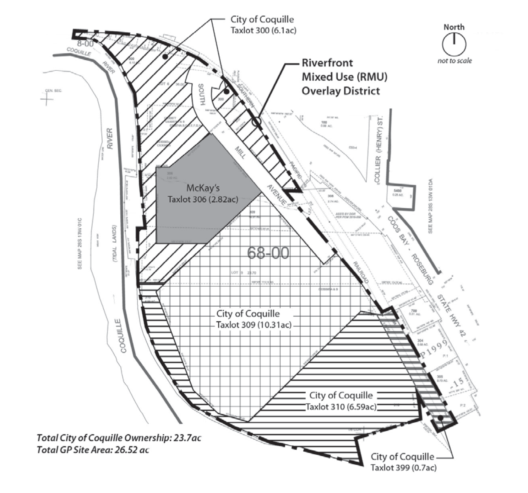
(Ord. No. 1488, § 1(Exh. A), 7-1-2013)
17.55.030 - Riverfront mixed use overlay district—Allowed land uses.
Table 17.55.030 identifies the land uses that are allowed in the riverfront mixed use overlay district.
Table 17.55.030 Land Uses Allowed in Riverfront Mixed Use Overlay District
Key:
P = Permitted, subject to site/development review
S = Permitted with standards
CU = Conditional use permit required (Chapter 17.92)
N = Not permitted
(Ord. No. 1488, § 1(Exh. A), 7-1-2013)
17.55.040 - Riverfront mixed use overlay district—Development standards.
The development standards in Table 17.55.040 apply to all uses, structures, buildings, and development, and major remodels, in the riverfront mixed use overlay district.
Table 17.55.040 Development Standards for Riverfront Mixed Use Overlay District
(Ord. No. 1488, § 1(Exh. A), 7-1-2013)
17.55.050 - Riverfront mixed use overlay district—Setbacks.
A.
Residential Yard Setbacks—Purpose. Residential setback yards provide space for private yards and building separation for fire protection/security, building maintenance, sunlight and air circulation. The setback yard standards contained in Table 17.55.040 encourage the orientation of buildings with street visibility for public safety and neighborhood security. The standards also promote human-scale design and traffic calming by diminishing the visual presence of garages along the street and encouraging the use of front porches and house entrances oriented to street sidewalks, as is commonplace in Coquille's neighborhoods.
B.
Zero Setbacks and Build-To Line—Purpose, Fire Code and Clear Vision. Zero setbacks and build-to lines, as provided in Table 17.55.040, are intended to encourage pedestrian-oriented development, while providing more flexibility in site design than what is possible with large setbacks. With buildings placed close to the street, a development can afford good access for emergency service providers in the case of a fire or other emergency. Where no minimum setback is required, all structures and buildings shall conform to the vision clearance standards in Chapter 17.60 and the applicable fire and building codes (e.g., for attached structures, fire walls, and related requirements).
C.
Setback Yards—Exceptions. The following architectural features may encroach into the setback yards by no more than thirty-six (36) inches, provided that a setback of not less than thirty-six (36) inches is preserved, all applicable building and fire codes are met, and the clear vision standards in Section 17.060.030 are met. Eaves, chimneys, bay windows, overhangs, and similar architectural features may encroach into a setback yard by not more than thirty-six (36) inches. Porches, decks and similar unenclosed structures may extend into front yard setbacks. Walls and fences built on property lines are subject to the height standards in Table 17.55.040 and the provisions of Sections 17.60.020(N), Vision clearance, and 17.64.050, Fences and walls.
D.
Industrial Buffers.
1.
Purpose. Industrial buffers provide separation between industrial and nonindustrial uses for fire protection/security, building maintenance, sunlight and air circulation, noise buffering, and visual separation.
2.
Applicability. The buffer standards in subsection 3 apply to buildings, accessory structures, parking areas, mechanical equipment and other development. In granting a conditional use permit, the approval body may increase the standard yards and/or buffers consistent with the criteria in Chapter 17.92. The approval body may also decrease the standard yards and/or buffers through the CUP process, provided that all applicable building and fire safety codes are met.
3.
Landscaping, Buffering and Other Yard Requirements.
a.
Buffering. A minimum of ten (10) percent of the site shall be landscaped in accordance with Chapter 17.64. The approval body may require additional landscaping, fences, walls or other buffering that exceeds the landscaping standards in Chapter 17.64 upon finding that more or different buffering is necessary to mitigate adverse noise, light, glare, and/or aesthetic impacts to adjacent properties.
b.
Pedestrian Access. The approval body may require the construction of pedestrian access ways through required buffers to ensure pedestrian connections are made between primary building entrances (e.g., for retail, service, institutional, or office uses) within large developments, between multiple development phases, or connecting to other streets or sidewalks. The design of access ways shall conform to Section 17.60.030.
(Ord. No. 1488, § 1(Exh. A), 7-1-2013)
17.55.060 - Riverfront mixed use overlay district—Housing density.
A.
Minimum Housing Density.
1.
Townhouse and cottage cluster development in the riverfront mixed use overlay district shall have a minimum density of twenty (20) dwelling units per acre.
2.
Multi-family development in the riverfront mixed use overlay district shall have a minimum density of twenty-eight (28) dwelling units per acre.
3.
Housing density is calculated as provided in Section 17.24.060.
B.
Housing Density Encouraged. Dense residential development is encouraged in the riverfront mixed use overlay district to help support commercial, retail, and craft industrial development, and to enhance the pedestrian orientation of the district.
1.
Because of different setback and lot coverage standards for commercial development, additional residential density, beyond what is allowed for townhouse, cottage cluster, and multi-family development, may be achieved by projects that include housing over commercial uses, as provided in Sections 17.55.040 and 17.55.090.
(Ord. No. 1488, § 1(Exh. A), 7-1-2013)
17.55.070 - Riverfront mixed use overlay district—Lot coverage and impervious surfaces.
The maximum allowable lot coverage shall be as provided in Table 17.55.040. Lot coverage is calculated as the percentage of a lot or parcel covered by impervious surfaces (e.g., asphalt, concrete, and similar impervious paving). It does not include planted areas, and other areas allowing storm water infiltration, as approved by the city.
(Ord. No. 1488, § 1(Exh. A), 7-1-2013)
17.55.080 - Riverfront mixed use overlay district—Industrial site layout and design.
A.
Development Compatibility. Industrial uses and developments shall be oriented on the site to minimize adverse impacts (e.g., noise, glare, smoke, dust, exhaust, vibration, etc.) and to provide compatibility with adjacent uses to the extent practicable. The following standards shall apply to all industrial development in the riverfront mixed use overlay district:
1.
Mechanical equipment, lights, emissions, shipping/receiving areas, and other components of an industrial use that are outside enclosed buildings, shall be located away from residential areas, open spaces and other nonindustrial areas to the maximum extent practicable; and
2.
The city may require a landscape buffer, or other visual or sound barrier (fence, wall, landscaping, or combination thereof), to mitigate adverse impacts that cannot be avoided, as provided in Section 17.55.050(D).
B.
Pedestrian Accessibility. Where the development consists of more than one building, and contains a total floor area of forty thousand (40,000) square feet or more of retail, service, office, and/or institutional use(s), the development shall meet all of the following criteria:
1.
The commercial block layout standards in Section 17.55.100 must be met; and
2.
The commercial setback and design standards in Sections 17.55.040 and 17.55.110 must be met. For the purpose of meeting the build-to line standards in Section 17.55.110, the build-to line is parallel to all abutting street property lines at a distance of ten (10) feet from the street property line.
(Ord. No. 1488, § 1(Exh. A), 7-1-2013)
17.55.090 - Riverfront mixed use overlay district—Structure height.
Building and structure heights shall conform to the standards in Table 17.55.040 and subsections B., C. and D. of this section.
A.
Building/Structure Height Measurement. Building height for the purposes of this code is measured as the vertical distance above a reference point datum (grade plane) to the highest point (peak) of a roof. The height of a stepped or terraced building is the maximum height of any segment of the building.
B.
Exclusions from Maximum Building Height Standards. Chimneys, bell towers, steeples, roof equipment, flag poles, and similar features not for human occupancy are exempt from the maximum building heights, provided that all applicable fire and building codes are met.
Figure 17.55.090(C) Building Height Bonus for Housing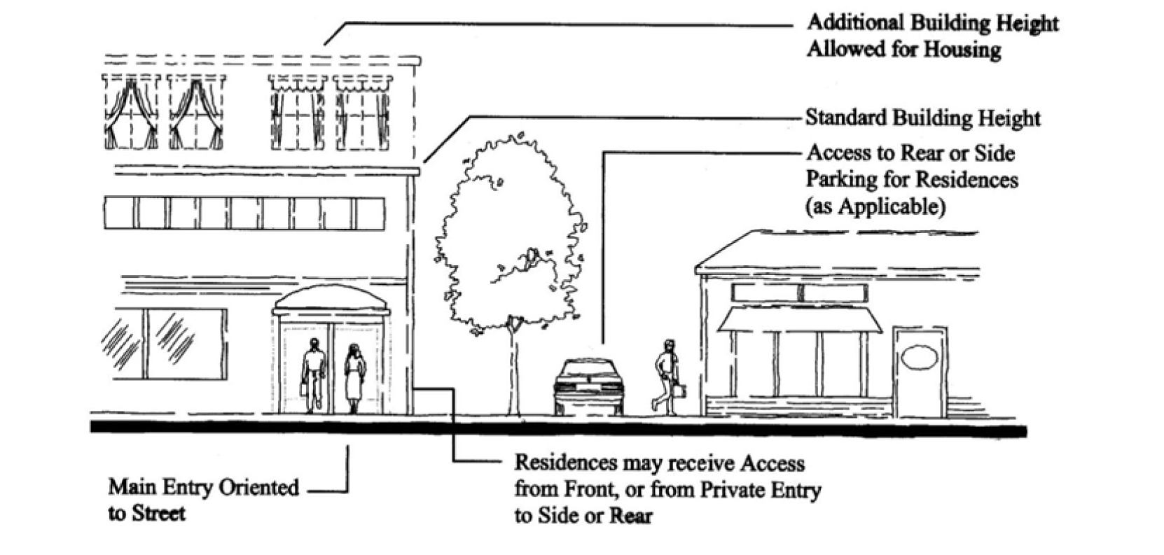
C.
Height Bonus for Housing. Additional building height may be permitted in mixed use buildings, as provided in Table 17.55.040, when housing is provided above ground-floor commercial uses(s), subject to approval of a conditional use permit. Off-street parking requirements shall be determined based on an analysis of parking demand prepared by the applicant and subject to review and approval by the city approval body. Where a second egress is required for fire safety, residences may have their entrances/egress oriented to any yard; such entrances need not be oriented to the street.
D.
Structures taller than thirty-five (35) feet are allowed when approved as part of a conditional use permit.
(Ord. No. 1488, § 1(Exh. A), 7-1-2013)
17.55.100 - Riverfront mixed use overlay district—Building orientation, block layout, street spacing and Riverwalk access.
A.
Purpose. This section orients buildings and building entrances close to streets to promote pedestrian-oriented development where walking is encouraged, and to discourage automobile-oriented development. Placing residences and other buildings close to the street also encourages crime prevention, natural surveillance or security, and safety by having more "eyes-on-the-street." This section also encourages developments adjacent to the Coquille Riverwalk to orient open spaces and buildings to the Riverwalk.
B.
Applicability. This section applies to all projects in the riverfront mixed use overlay district.
C.
Residential Building Orientation Standards. Residential developments shall have their buildings oriented to a street as generally shown in Figure 17.55.100(C)(1).
1.
Off-street parking, driveways, and other vehicle areas shall not be placed between buildings and the street(s) to which they are oriented, as per this subsection and Figure 17.55.100(C)(1); except the following areas are allowed where the approval body finds that they will not adversely affect pedestrian safety and convenience:
a.
Assisted living facilities and similar institutional uses may have one driveway located between the street and the primary building entrance, provided that the building's primary entrance is connected to an adjacent street by a pedestrian walkway and the driveway/parking area is crossed by a clearly defined pedestrian walkway as required by Section 17.60.030. The intent of this exception is to provide for one drop-off/loading zone where necessary to serve building occupants with special needs.
Figure 17.55.100(C)(1) Residential Building Orientation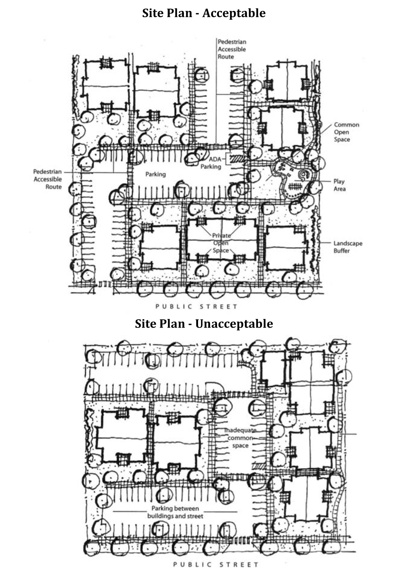
b.
Attached single-family housing developments (townhouses) with street-facing garages may have one combined driveway access located between the street and the primary building entrance for every two attached dwelling units, provided the driveway meets the following criteria, as generally shown in Figure 17.55.100(C)(2).
i.
Where two abutting townhouses have street-facing garages, they shall share one driveway access that does not exceed sixteen (16) feet in width where it crosses the sidewalk and where it intersects the street (excluding driveway apron);
ii.
All primary building entrances shall be connected to the driveway (and sidewalk) via a pedestrian walkway that is not less than three feet wide;
iii.
The maximum number of consecutively attached townhouses with garages facing the same street is four (two driveways); and
iv.
All garage openings and carport openings shall be setback at least twenty (20) feet from the street, and shall be recessed at least six feet behind the front building elevation closest to the subject street.
2.
Where a site contains multiple buildings and there is insufficient street frontage to which buildings can be oriented, a primary entrance may be oriented to common green, open space, plaza, or courtyard (e.g., cottage cluster). When oriented in this way, the primary entrance(s) and green, plaza, or courtyard shall be connected to the street by a pedestrian walkway meeting the standards in Section 17.60.030. See example in Figure 17.55.100(C)(1), "Site Plan—Acceptable."
Figure 17.55.100(C)(2) Townhouse Building Orientation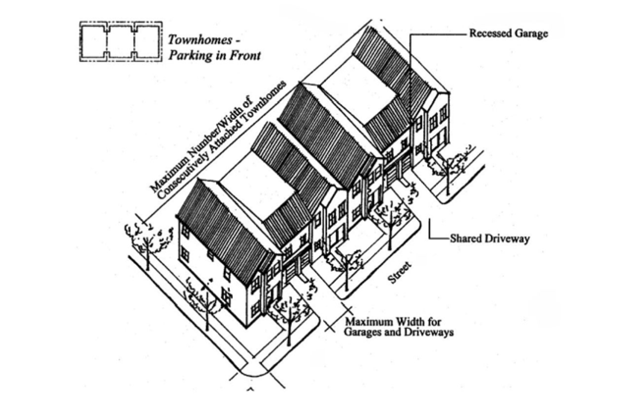
D.
Commercial and Mixed Use Building Orientation Standards. Commercial and mixed use buildings shall have their buildings oriented to a street, as generally shown in Figure 17.55.100(D)(1). This standard is met when all of the following criteria are met:
Figure 17.55.100(D)(1) Commercial and Mixed Use Building Orientation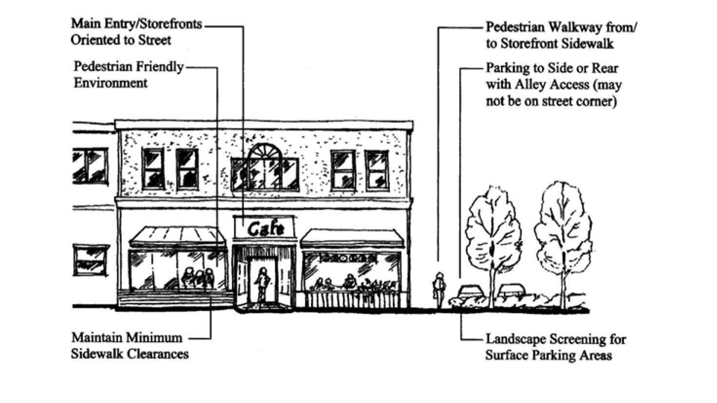
1.
Compliance with the setback and build-to line standards in Section 17.55.040, where applicable. The build-to line may be set back to provide pedestrian amenities between a building and its adjoining street.
2.
Except as provided in subsection D.4. of this section, all buildings shall have at least one primary building entrance (i.e., dwelling entrance, a tenant entrance, lobby entrance, or breezeway/courtyard entrance) facing an adjoining street (i.e., within forty-five (45) degrees of the street property line), or if the building entrance is turned more than forty-five (45) degrees from the street (i.e., front door is on a side elevation), the primary entrance shall not be more than twenty (20) feet from a street sidewalk, except where pedestrian amenities are provided, in which case a walkway shall connect the primary entrance to the sidewalk.
3.
Off-street parking, trash pick-up, and aboveground utilities (e.g., utility vaults) shall not be placed between building entrances and the street(s) to which they are oriented, but shall be oriented internally to the block and accessed by alleys to the extent practicable. Off-street parking shall be oriented internally to the site to the extent practicable, and shall be divided by landscape areas into bays of not more than twenty-four (24) parking spaces per bay, as generally shown in Figure 17.55.100(D)(1) and Figure 17.55.100(D)(2); incidental breaks in the building wall to accommodate pedestrian and vehicle access into the block are encouraged.
Figure 17.55.100(D)(2) Commercial and Mixed Use Building Orientation with Internal
Parking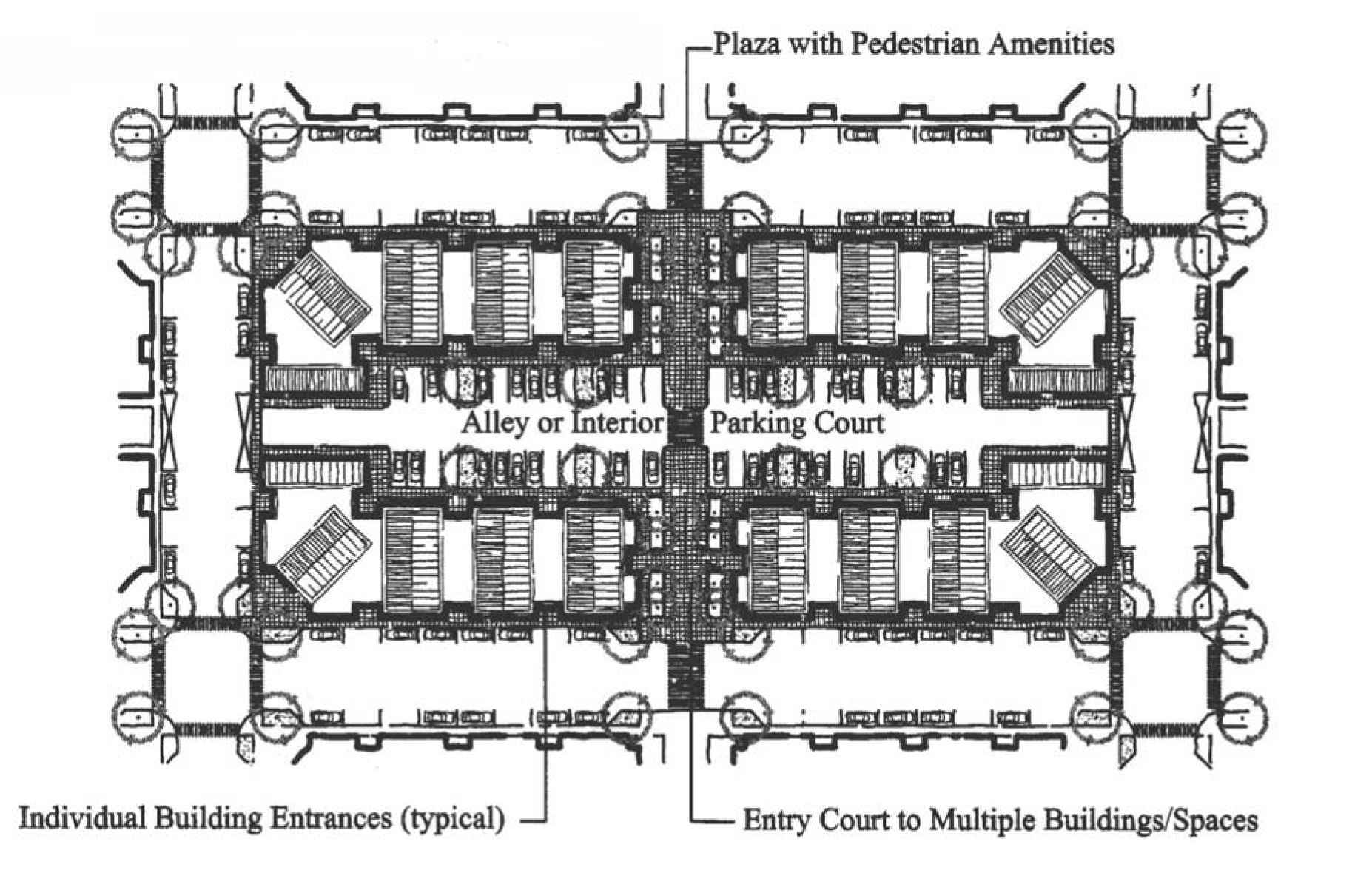
4.
Where a development contains multiple buildings and there is insufficient street frontage to which buildings can be oriented, a primary entrance may be oriented to plaza, courtyard, or similar pedestrian space containing pedestrian amenities, subject to site design review. When oriented in this way, the primary entrance(s), plaza, or courtyard shall be connected to the street by a pedestrian walkway meeting the standards in Section 17.60.030.
E.
Block Layout Standard. Commercial developments containing more than one building, with the sum total of buildings equal to or greater than forty thousand (40,000) square feet of floor area, shall meet all of the following standards:
1.
The site shall be configured into blocks that have frontage onto streets, interior parking courts (as generally shown in Figure 17.55.100(D)(2), above), or "shopping streets" (as generally shown in Figure 17.55.100(E), below). All shopping streets shall contain on-street parking (parallel or angled parking), sidewalks, street trees, and pedestrian lighting; and all buildings shall orient their primary entrances to a street, plaza or courtyard. Additionally, buildings placed at a street/block corner shall have a primary entrance within twenty (20) feet of the street/block corner.
2.
Walkways shall connect the street right-of-way to building entrances and the interior parking bays between buildings, as necessary to ensure reasonably safe, direct, and convenient access to building entrances and off-street parking.
Figure 17.55.100(E) Shopping Street Example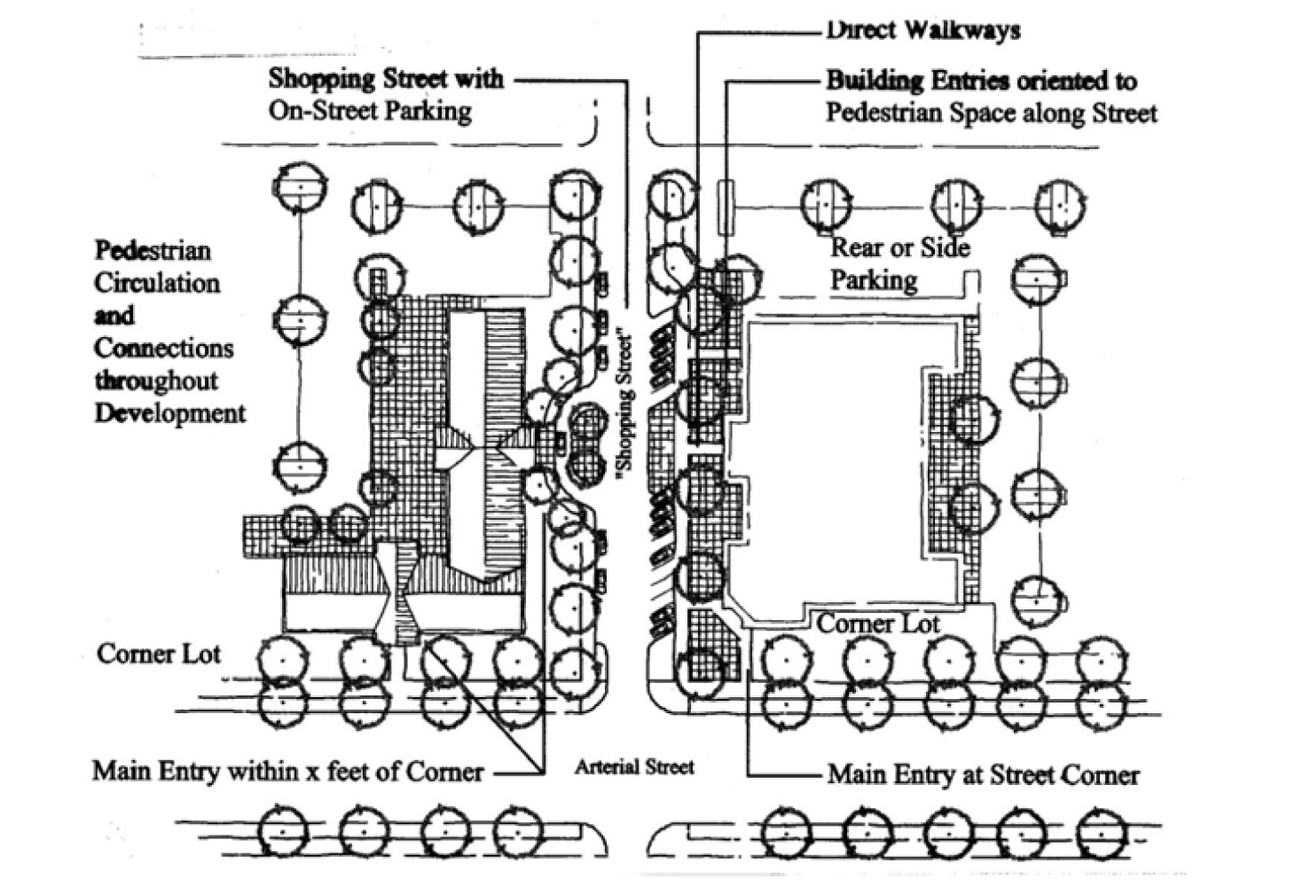
F.
Block Length and Street Spacing Standard. As generally shown in Figure 17.55.100(F), blocks shall be broken down into lengths of not more than four hundred (400) feet and shall have a perimeter not exceeding one thousand six hundred (1,600) feet.
1.
Street intersections shall be located a maximum of four hundred (400) feet apart.
2.
Where applicable, subdivisions and site developments shall be designed to accommodate a loop street alignment that intersects the west side of Mill Avenue in at least two locations (as generally shown in Figure 17.40.100(F)). The extent of the loop road each development is required to construct will be determined by the reviewing authority.
G.
Orientation and Access to the Coquille Riverwalk. This standard applies to development adjacent to the Coquille Riverwalk and encourages access to and enjoyment of the Riverwalk.
1.
Off-street parking, blank walls, service areas, loading areas and the like shall not be located adjacent to the Riverwalk.
2.
Developments adjacent to the Riverwalk are encouraged to provide internal pedestrian connections to the Riverwalk and to orient windows and outdoor seating areas to the Riverwalk.
3.
Where applicable, subdivisions and site developments shall be designed to provide public pedestrian access to the Riverwalk at a maximum spacing of four hundred (400) feet, as measured along the Riverwalk (as generally shown in Figure 17.55.100(F)). Public pedestrian access shall be provided either through public streets or public pedestrian easements. Pedestrian easements shall have a minimum width of fifteen (15) feet. Paved walkways with a minimum width of ten (10) feet shall be provided in pedestrian easements. The extent of pedestrian walkway each development is required to construct will be determined by the reviewing authority.
Figure 17.55.100(F) Block Length, Street Spacing and Riverwalk Access
(Ord. No. 1488, § 1(Exh. A), 7-1-2013)
17.55.110 - Riverfront mixed use overlay district—Commercial building design standards.
A.
Purpose and Applicability. This section is intended to provide detailed, pedestrian-oriented design that is characteristic of the city of Coquille while affording flexibility to use a variety of architectural building styles. All buildings shall meet the standards of subsections B.—D. of this section, which are applied through design review. The applicant must demonstrate compliance with all criteria under each standard.
B.
Pedestrian Orientation. The design of all buildings on a site shall support a safe and attractive pedestrian environment. This standard is met when the approval body finds that all of the criteria in subsections B.1.—B.6. of this section are met. Alternatively, the approval body may modify one or more of the criteria and approve an alternate design upon finding that the design contains an equally good or superior way of achieving the above purpose and intent.
1.
The building orientation standards under Section 17.55.100 shall be met.
2.
Primary building entrances shall open directly to the outside and, if not abutting a street, shall have walkways connecting them to the street sidewalk; every building shall have at least one primary entrance that does not require passage through a parking lot or garage to gain access.
3.
Corner buildings (i.e. buildings within twenty (20) feet of a corner as defined by the intersecting curbs) shall have corner entrances, or shall provide at least one entrance within twenty (20) feet of the street corner.
4.
At least forty (40) percent of the building's street-facing elevation (measured horizontally in linear feet) shall be located at the build-to line or closer to the street. Build-to lines are prescribed by Section 17.55.040.
5.
Ground floor windows or window displays shall be provided along at least thirty (30) percent of the building's ground floor street-facing elevation. Windows and display boxes used to meet this standard shall be integral to the building design and not mounted to an exterior wall.
6.
All building entrances and, for buildings with zero front yard setback, at least thirty (30) percent of the building's ground floor street-facing elevations shall incorporate weather protection, such as awnings, canopies, overhangs, or similar features, extending at least five feet over adjacent sidewalks.
C.
Compatibility. All buildings shall be designed consistent with the architectural context in which they are located. This standard is met when the approval body finds that all of the criteria in subsections C.1.—C.6. of this section are met. Alternatively, the approval body may modify one or more of the criteria and approve an alternate design upon finding that the design contains an equally good or superior way of achieving the above purpose and intent.
1.
There is continuity in building sizes between new and existing buildings.
2.
The ground floor and upper floor elevations and architectural detailing, including windows, are compatible with one another.
3.
Roof elevation is similar to or compatible with buildings in the vicinity (roof pitch, shape, projections).
4.
There is continuity of building sizes on the site, if more than one building is proposed.
5.
There is continuity in the rhythm of windows and doors on the proposed building(s).
6.
The relationship of buildings to public spaces, such as streets, plazas, other areas, and public parking, including on-street parking, is strengthened by the proposed building(s).
D.
Human Scale. The design of all buildings shall be to a human scale. This standard is met when the approval body finds that all of the criteria in subsections D.1.—D.7. of this section are met. Alternatively, the approval body may modify one or more of the criteria and approve an alternative design upon finding that the design contains an equally good or superior way of achieving the above purpose and intent. Figure 17.55.110(D) provides contrasting examples of building elevations that are consistent/inconsistent with human scale criteria.
1.
Regularly spaced and similarly shaped windows are provided on all building stories.
2.
Ground floor retail spaces have tall ceilings (i.e. twelve (12) through sixteen (16) feet) with display windows on the ground floor.
3.
Display windows are trimmed, recessed, or otherwise defined by wainscoting, sills, water tables, or similar architectural features.
4.
On multi-story buildings, ground floors are defined and separated from upper stories by appropriate architectural features (e.g., cornices, trim, awnings, canopies, arbors, trellises, overhangs, or other features) that visually identify the transition from ground floor to upper story; such features should be compatible with the surrounding architecture.
5.
The tops of flat roofs are treated with appropriate detailing (i.e., cornice, pediment, flashing, trim, or other detailing) that is compatible with the surrounding architecture.
6.
Pitched roofs have eaves, brackets, gables with decorative vents, or other detailing that is consistent with the surrounding architecture.
7.
Where buildings with greater than twenty thousand (20,000) square feet of enclosed ground floor space are proposed, they shall provide articulated facades on all street-facing elevations. This criterion is met when an elevation contains at least three of the following features for every forty (40) feet of building (horizontal length): transparent windows; primary entrances; weather protection (awnings or canopies extending at least five feet over adjacent walks); building offsets, projections, or changes in elevation or horizontal direction of at least three feet; sheltering roofs or terraces; a distinct pattern of divisions in surface materials; screening trees; and/or small scale lighting (e.g., wall-mounted lighting, or up-lighting). Note: Figure 17.55.110(D) is intended to show how a variety of elements are used to meet the articulation standard; it is not to be interpreted as a required architectural style.
Figure 17.55.110(D) Examples of Large Commercial Design Elements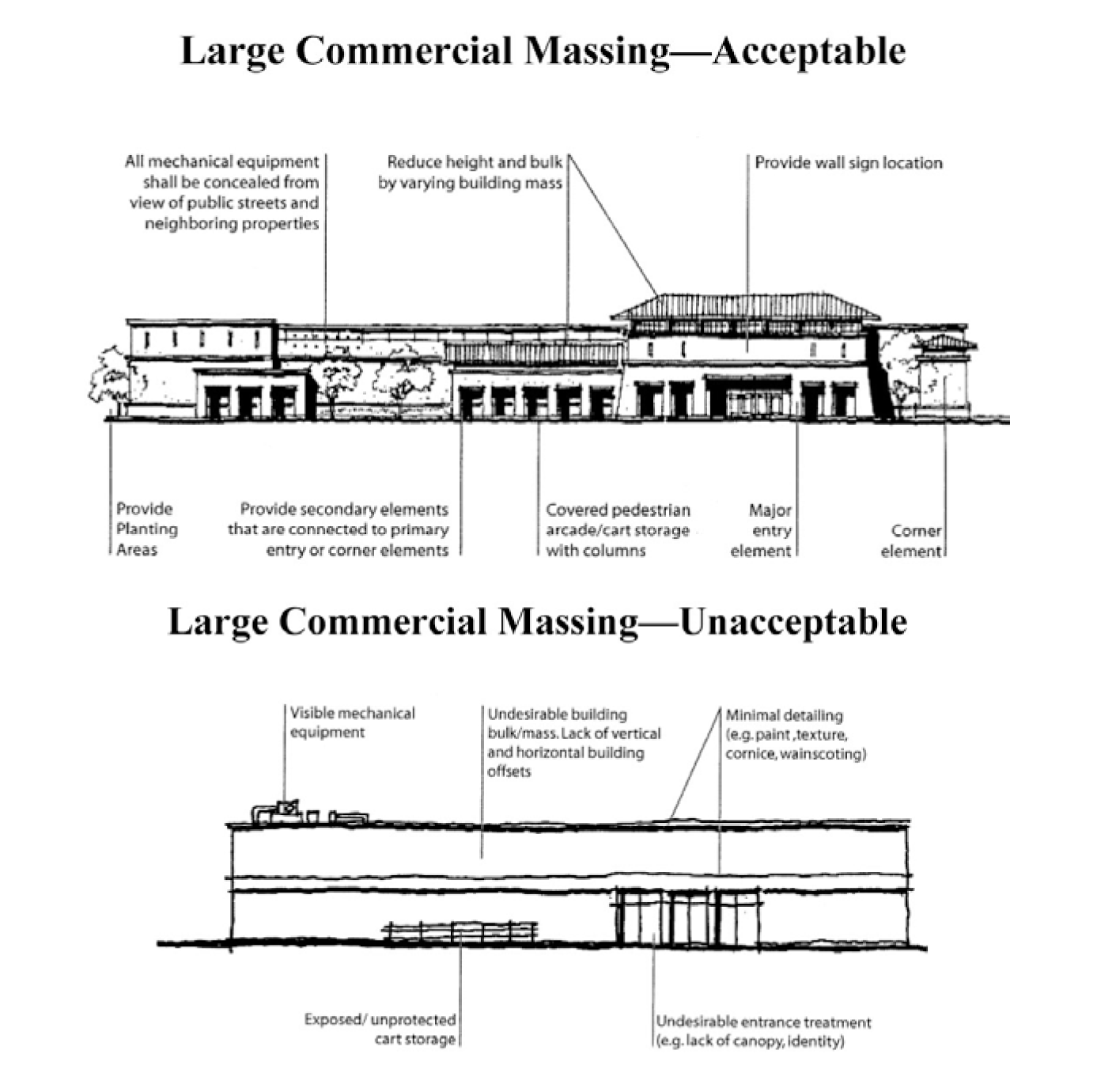
(Ord. No. 1488, § 1(Exh. A), 7-1-2013)
17.55.120 - Riverfront mixed use overlay district—Special residential use standards.
This section provides standards for the allowed residential land uses and building types identified in Table 17.55.030. The standards are intended to control the scale and compatibility of those uses within the riverfront mixed use overlay district.
A.
Attached Single-Family (Townhouses) and Cottage Clusters. Single-family attached housing with three or more dwellings (lots), and cottage cluster housing shall comply with the standards in subsections A.1. and A.2. of this section, which are intended to control development scale; avoid or minimize impacts associated with traffic, parking, and design compatibility; and ensure management and maintenance of common areas.
1.
Alley Access Required for Subdivisions Principally Containing Townhouses, or Cottage Clusters. Subdivisions, or phases of subdivision, proposed to contain three or more consecutively attached single-family dwellings on any block, and cottage cluster developments shall provide vehicle access to all such lots and units from an alley or interior parking court, as described in Section 17.60.020. Alley(s) and parking court(s) shall be created at the time of subdivision approval, and may be contained in private tracts or, if approved by the city, in public right-of-way, in accordance with Section 17.72.020, Transportation standards, and Chapter 17.88, Land Divisions and Property Line Adjustments.
a.
As an alternative to the alley access requirements of subsection 17.55.120 A.1., above, townhouse developments may provide vehicle access through street-facing garages, in compliance with subsection 17.55.100 C.1.b.
2.
Common Areas. Any common areas (e.g., landscaping, private tracts, common driveways, private alleys, building exteriors, and/or similar common areas shall be owned and maintained by a homeowner's association or other legal entity as approved by the city. A copy of any applicable covenants, restrictions and conditions shall be recorded and provided to the city prior to building permit approval.
B.
Private Open Space. Townhouse developments shall provide each dwelling with a street-facing porch, deck, or patio having a minimum depth of six feet and a minimum area of forty-eight (48) square feet.
Figure 17.55.120(C)(3) Examples of Multifamily Open Space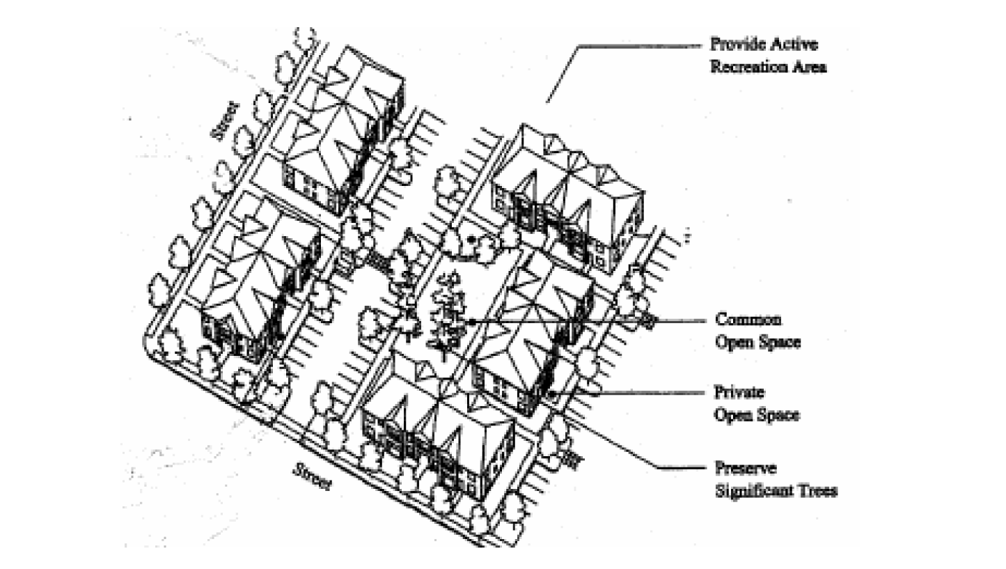
C.
The following uses and development types shall comply with relevant standards of Section 17.24.110, Residential district—Special use standards:
1.
Bed and breakfast inns.
2.
Home occupations.
3.
Multiple-family housing.
4.
Short-term vacation rentals.
5.
Assisted living facilities.
(Ord. No. 1488, § 1(Exh. A), 7-1-2013)
17.55.130 - Riverfront mixed use overlay district—Pedestrian amenities.
A.
Purpose and Applicability. Pedestrian amenities such as plazas, benches, and other sidewalk furnishings serve as informal gathering places for socializing, resting and enjoyment along street frontages and contribute to a walkable neighborhood. The standards in the section apply to all development in the riverfront mixed use overlay district.
B.
Standards. Developments in the mixed use overlay district shall provide at least one pedestrian amenity, as described below and as generally illustrated in Figure 17.55.130(B). Pedestrian amenities may be provided within a street furnishing zone, building frontage zone, or plaza, or within the pedestrian through zone, as shown in Figure 17.55.130(B), and shall be physically accessible to the public. Use of the public right-of-way requires approval by the road authority. Design standards for pedestrian amenities follow:
1.
A plaza, courtyard, square or extra-wide sidewalk next to the building entrance (minimum sidewalk extension of four feet);
2.
Sitting space (i.e., dining area, benches, garden wall or ledges between the building entrance and sidewalk) with a minimum of sixteen (16) inches in height and thirty (30) inches in width;
3.
Building canopy, awning, pergola, or similar weather protection (minimum projection of five over a sidewalk, plaza or other pedestrian space);
4.
Public art that incorporates seating (e.g., fountain, memorial or sculpture with seating).
Figure 17.55.130(B) Examples of Pedestrian Amenities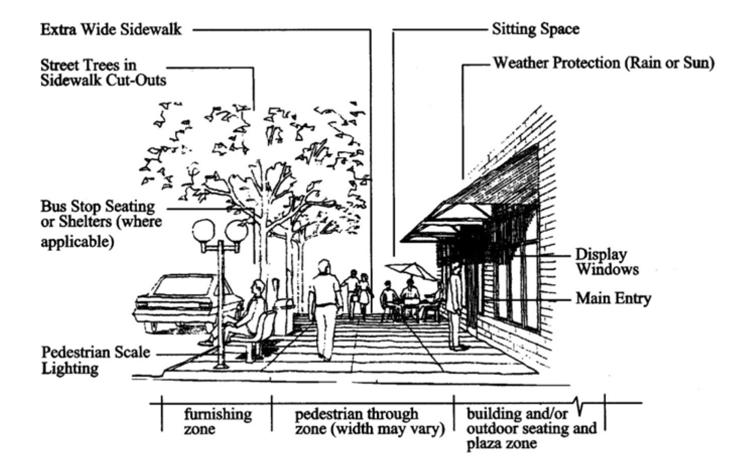
(Ord. No. 1488, § 1(Exh. A), 7-1-2013)
17.55.140 - Riverfront mixed use overlay district—Stormwater management.
A.
Purpose. In order to reduce the impacts of development in the RMU overlay district on the quality of surface water and groundwater, this section establishes requirements for management and treatment of stormwater runoff on private property before it can be discharged from the site, into a watercourse, into a public storm drain system, or into the ground.
1.
Pollutants of concern include but are not limited to the following:
a.
Suspended solids (sediment).
b.
Heavy metals (dissolved and particulate, such as lead, copper, zinc, and cadmium).
c.
Nutrients (such as nitrogen and phosphorus).
d.
Bacteria and viruses.
e.
Organics (such as oil, grease, hydrocarbons, pesticides, and fertilizers).
f.
Floatable debris.
g.
Increased thermal load (temperature).
B.
Applicability. The requirements of this section apply to all land use and development applications in the RMU overlay district. Applications also shall comply with Section 17.72.050 storm drainage improvements.
1.
Exemptions. The reviewing authority may, at its sole discretion, determine that certain development applications are exempt from the requirements of this section. Examples may include:
a.
An application that will result in the construction or creation of less than one thousand (1,000) square feet of new or replaced impervious surface.
b.
An application for development of a lot or parcel included in an application that previously was determined to comply with this section.
C.
Requirements. All developments and projects on private property in the RMU overlay district shall include pollution reduction facilities to treat all stormwater runoff from the development site, including pervious as well as impervious surfaces.
1.
Pollution reduction facilities are defined as any structure or drainage device that is designed, constructed, and maintained to collect and filter surface water runoff during and after a storm event for the purpose of protecting, maintaining, or improving surface and/or groundwater quality.
2.
Pollution reduction facilities may include but are not limited to the following, which are listed solely as examples; actual facility selection and design shall be based on site characteristics and pollutant removal capabilities of specific systems, as well as stormwater management objectives identified by the reviewing authority:
a.
Vegetated filter strip (a gently sloping, densely vegetated area used to filter, slow, and infiltrate stormwater).
b.
Swale (grassy vegetated, or street swale: a long, narrow, trapezoidal or parabolic-shaped channel, planted with a dense grass mix or other suitable vegetation).
c.
Rain garden (vegetated surface facility that collects runoff from impervious surfaces, allowing the uptake of pollutants through contact with vegetation and filtration through a sand medium).
d.
Manufactured filtration device (proprietary structure or device).
e.
Stormwater planter (a facility filled with topsoil and gravel, then planted with vegetation).
f.
Eco-roof (lightweight, low-maintenance vegetated roof system).
3.
All pollution reduction facilities shall be sited, designed, constructed, operated, and maintained in accordance with criteria and methodologies approved by the reviewing authority.
4.
District Stormwater Filtration and Retention Facility. The city of Coquille plans to construct an engineered stormwater biofiltration swale and linear retention facility along the river frontage of the riverfront mixed use overlay district. In addition to protecting the Coquille River from increased stormwater discharges, the bioswale/retention basin will allow for individual developments in the RMU overlay district to avoid on-site impoundment by directing runoff to that structure, even if still required to implement approved stormwater treatment methods.
(Ord. No. 1488, § 1(Exh. A), 7-1-2013)