
Coquille City Zoning Code
Division III
Community Design Standards
17.56.010 - Design standards—Purpose.
The following provisions describe how the community design standards (Division III) are intended to be applied, and the relationship between this division and the supplemental design standards for specific land uses and building types contained in Division II.
(Ord. 1471 § 2 (part), 2008)
17.56.020 - Design standards—Applicability.
The standards in this division are applied based on whether a project is classified as a major project or a minor project. In addition, each chapter of this division contains "applicability directions." In general, the chapters are applied as follows:
A.
Major Project. Major projects, including developments that require site design review (Chapter 17.84), land division approval (Chapter 17.88), master planned development (Chapter 17.96), and amendments to the comprehensive plan or zoning map (Chapter 17.104), must conform to the applicable sections of:
1.
Access and Circulation (Chapter 17.60);
2.
Landscaping, Street Trees, Fences and Walls (Chapter 17.64);
3.
Parking and Loading (Chapter 17.68);
4.
Public Facilities (Chapter 17.72);
5.
Surface Water Management (Chapter 17.76).
B.
Minor Project. Minor projects are small developments and land use actions that require only land use review or conditional use approval where no site design review is required. The following chapters generally apply; however, individual sections will not apply to some projects.
1.
Access and Circulation (Chapter 17.60);
2.
Landscaping, Street Trees, Fences and Walls (Chapter 17.64);
3.
Parking and Loading (Chapter 17.68);
4.
Surface Water Management (Chapter 17.76).
C.
Nonconforming Situations. Where an existing, lawfully established structure or development does not comply with the standards of this code, the structure/development is allowed to continue as a legal nonconforming use, subject to the provisions of Chapter 17.120, Nonconforming Uses and Developments.
(Ord. 1471 § 2 (part), 2008)
17.60.010 - Purpose.
The purpose of this chapter is to ensure that developments provide safe and efficient access and circulation for pedestrians and vehicles. Section 17.60.020 provides standards for vehicular access and circulation. Section 17.60.030 provides standards for pedestrian access and circulation. Standards for streets and other transportation system improvements are provided in Section 17.72.020.
(Ord. 1471 § 2 (part), 2008)
17.60.020 - Vehicular access and circulation.
A.
Intent and Purpose. The intent of this section is to manage access to land uses and on-site circulation, and to preserve the transportation system in terms of safety, capacity, and function. This section applies to all public streets within the city of Coquille, and to all properties that abut these roadways. This section implements the transportation policies of the city of Coquille comprehensive plan.
B.
Applicability. This chapter applies to all public streets within the city and to all properties that abut these streets. The standards apply when lots are created, consolidated, or modified through a land division, partition, lot line adjustment, lot consolidation, or street vacation; and when properties are subject to land use review or site design review.
C.
Access Permit Required. Access to a public street (e.g., a new curb cut or driveway approach) requires an access permit. An access permit may be in the form of a letter to the applicant, or it may be attached to a land use decision notice as a condition of approval. In either case, approval of an access permit shall follow the procedures and requirements of the applicable roadway authority, as determined through the review procedures in Division IV.
D.
Traffic Study Requirements. The city may require a traffic study prepared by a qualified professional to determine access, circulation, and other transportation requirements in conformance with Section 17.80.090, Traffic Impact Analysis.
E.
Conditions of Approval. The city or other roadway authority, as applicable, may require the closing or consolidation of existing curb cuts or other vehicle access points, recording of reciprocal access easements (i.e., for shared driveways), development of a frontage street, installation of traffic control devices, and/or other mitigation as a condition of granting an access permit, to ensure the safe and efficient operation of the street and highway system.
F.
Corner and Intersection Separation—Backing onto Public Streets. New and modified accesses shall conform to the following standards:
1.
Except as provided under subsection (F)(4) of this section, the distance from a street intersection to a driveway or other street access shall meet the minimum spacing requirements as required by the city engineer, or comply with the requirements of other roadway authorities, as applicable.
2.
New property access shall not be permitted within fifty (50) feet of a street intersection unless no other reasonable access to the property is available. Where no other alternatives exist, the city may allow construction of an access connection at a point less than fifty (50) feet from an intersection, provided the access is as far away from the intersection as possible and sight distance requirements are met.
3.
The city may impose turning restrictions (i.e., right in/out, right in only, or right out only) where a driveway opens onto a collector or arterial street.
4.
Access to and from off-street parking areas shall not permit backing onto a public street, except for single-family dwellings.
5.
The city may reduce required separation distance of access points where they prove impractical due to lot dimensions, existing development, other physical features, or conflicting code requirements, provided all of the following requirements are met:
a.
Joint-use driveways and cross-access easements are provided in accordance with subsection H of this section;
b.
The site plan incorporates a unified access and circulation system in accordance with this section; and
c.
The property owner(s) enter in a written agreement with the city, recorded with the deed, that pre-existing connections on the site will be closed and eliminated after construction of each side of the joint-use driveway.
G.
Site Circulation. New developments shall be required to provide a circulation system that accommodates expected traffic on the site. Pedestrian connections on the site, including connections through large sites, and connections between sites (as applicable) and adjacent sidewalks, must conform to the provisions in Section 17.60.030.
H.
Joint and Cross-Access—Requirement. The number of driveway and private street intersections with public streets should be minimized by the use of shared driveways for adjoining lots where feasible. When necessary for traffic safety and access management purposes, or to access flag lots, the city may require joint access and/or shared driveways in the following situations as follows:
1.
For shared parking areas;
2.
For adjacent developments, where access onto an arterial is limited;
3.
For multi-tenant developments, and developments on multiple lots or parcels. Such joint accesses and shared driveways shall incorporate all of the following:
a.
A continuous service drive or cross-access corridor that provides for driveway separation consistent with the applicable transportation authority's access management classification system and standards,
b.
A design speed of ten (10) miles per hour and a maximum width of twenty-two (22) feet, in addition to any parking alongside the driveway; additional driveway width or fire lanes may be approved when necessary to accommodate specific types of service vehicles, loading vehicles, or emergency service provider vehicles,
c.
Driveway stubs to property lines (for future extension) and other design features to make it easy to see that the abutting properties may be required with future development to connect to the cross-access driveway.
I.
Joint and Cross-Access—Reduction in Required Parking Allowed. When a shared driveway is provided or required as a condition of approval, the land uses adjacent to the shared driveway may have their minimum parking standards reduced in accordance with the shared parking provisions of Section 17.68.030.
J.
Joint and Cross-Access—Easement and Use and Maintenance Agreement. Pursuant to this section, property owners shall:
1.
Record an easement with the deed allowing cross-access to and from other properties served by the joint-use driveways and cross-access or service drive;
2.
Record an agreement with the deed that remaining access rights along the roadway for the subject property shall be dedicated to the city and pre-existing driveways will be closed and eliminated after construction of the joint-use driveway;
3.
Record a joint maintenance agreement with the deed defining maintenance responsibilities of property owners.
K.
Access Connections and Driveway Design. All driveway connections to a public right-of-way (access) and driveways shall conform to all of the following design standards:
1.
Driveway Width. Driveways shall meet the following standards:
a.
One-way driveways (one way in or out) shall have a minimum driveway width of ten (10) feet, and a maximum width of twelve (12) feet, and shall have appropriate signage designating the driveway as a one-way connection.
b.
For two-way access, each lane shall have a minimum width of nine feet and a maximum width of eleven (11) feet.
2.
Driveway Approaches. Driveway approaches shall be designed and located to provide exiting vehicles with an unobstructed view of other vehicles and pedestrians, and to prevent vehicles from backing into the flow of traffic on the public street or causing conflicts with on-site circulation. Construction of driveway accesses along acceleration or deceleration lanes or tapers should be avoided due to the potential for vehicular conflicts. Driveways should be located to allow for safe maneuvering in and around loading areas. See also Chapter 17.68, Parking and Loading.
3.
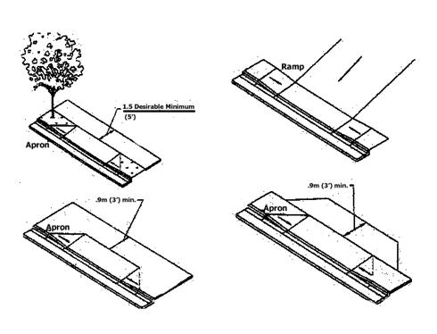
Driveway Construction. Driveway aprons (when required) shall be constructed of concrete and shall be installed between the street right-of-way and the private drive, as shown in Figure 17.60.020(K). Driveway aprons shall conform to Americans With Disability Act requirements for sidewalks and walkways, which generally require a continuous unobstructed route of travel that is not less than three feet in width, with a cross slope not exceeding two percent, and providing for landing areas and ramps at intersections.
Figure 17.60.020(K) Examples of Acceptable Driveway Openings Next to Sidewalks/Walkways
L.
Fire Access and Turnarounds. When required by applicable fire codes, fire access lanes with turnarounds shall be provided. Except as waived in writing by the fire marshal, a fire equipment access drive shall be provided for any portion of an exterior wall of the first story of a building that is located more than one hundred fifty (150) feet from an existing public street or approved fire equipment access drive. The drive shall contain unobstructed adequate aisle width (fourteen (14) through twenty (20) feet) and turnaround area for emergency vehicles. The fire marshal may require that fire lanes be marked as "No Stopping/No Parking." For requirements related to cul-de-sacs or dead-end streets, please refer to Section 17.72.020(N).
M.
Vertical Clearances. Driveways, private streets, aisles, turnaround areas and ramps shall have a minimum vertical clearance of thirteen (13) feet six (6) inches for their entire length and width.
N.
Vision Clearance. No visual obstruction (e.g., sign, structure, solid fence, or shrub vegetation) between three feet and eight feet in height shall be placed in "vision clearance areas" on streets, driveways, alleys, or mid-block lanes where no traffic control stop sign or signal is provided, as shown in Figure 17.60.020(N). The minimum vision clearance area may be modified by the city engineer upon finding that more or less sight distance is required (i.e., due to traffic speeds, roadway alignment, etc.). Light standards, utility poles, tree trunks and similar objects may be allowed, subject to approval by the city engineer.
Figure 17.60.020(N) Vision Clearance Areas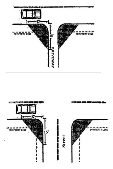
O.
Construction. The following development and maintenance standards shall apply to all driveways and private streets, except that the standards do not apply to driveways serving one single-family detached dwelling:
1.
Surface Options. Driveways, parking areas, aisles, and turnarounds may be paved with asphalt, concrete, or comparable surfacing, or a durable nonpaving or porous paving material may be used, subject to review and approval by the city engineer, to manage surface water runoff. All paving materials shall be subject to review and approval by the city engineer.
2.
Surface Water Management. All driveways, parking areas, aisles, and turnarounds shall have on-site collection of surface waters to eliminate sheet flow of such waters onto public rights-of-way and abutting property. Surface water facilities shall be constructed in conformance with Chapter 17.76 and applicable engineering standards.
3.
Driveway Aprons. When driveway approaches or "aprons" are required to connect driveways to the public right-of-way, they shall be paved with concrete surfacing and conform to the city's engineering design criteria and standard specifications. (See general illustrations in Section 17.60.020(K).)
(Ord. 1471 § 2 (part), 2008)
17.60.030 - Pedestrian access and circulation.
A.
Site Layout and Design. To provide safe, direct, and convenient pedestrian circulation, all developments, except single-family and duplex dwellings shall provide a continuous pedestrian system within the development site that connects to the public right-of-way, regardless of whether a public sidewalk currently exists. The pedestrian system shall be based on the standards in subsections (A)(1) through (A)(4) of this section:
1.
Continuous Walkway System. The pedestrian walkway system shall extend throughout the development site and connect to all future phases of development, if any, and to existing or planned off-site adjacent trails, public parks, and open space areas to the greatest extent practicable. The developer may also be required to connect or stub walkway(s) to adjacent streets and to private property with a previously reserved public access easement for this purpose, in accordance with the provisions of Section 17.60.020, Vehicular access and circulation, and Section 17.72.020, Transportation standards.
2.
Safe, Direct and Convenient. Walkways within developments shall provide safe, reasonably direct, and convenient connections between primary building entrances and all adjacent streets, based on the following definitions:
a.
Reasonably Direct. A route that does not deviate unnecessarily from a straight line or a route that does not involve a significant amount of out-of-direction travel for likely users.
b.
Safe and Convenient. Routes that are reasonably free from hazards and provide a reasonably direct route of travel between destinations.
c.
"Primary entrance" is the main public entrance to the building. In the case where no public entrance exists, street connections shall be provided to the main employee entrance, as applicable.
3.
Connections Within Development. Connections within developments shall be provided as required in subsections (A)(3)(a) through (c) of this section:
a.
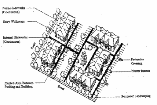
Walkways shall connect all building entrances to one another to the extent practicable, as generally shown in Figure 17.60.030(A)(1);
b.
Walkways shall connect all on-site parking areas, storage areas, recreational facilities and common areas, and shall connect off-site adjacent uses to the site to the extent practicable. Topographic or existing development constraints may be cause for not making certain walkway connections, as generally shown in Figure 17.60.030(A)(1); and
Figure 17.60.030(A)(1) Pedestrian Pathway System (Typical)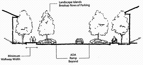
c.
Parking areas containing twenty-four (24) or more parking spaces shall be broken up so that parking bays do not exceed twelve (12) contiguous parking spaces without a break. Parking areas may be broken up with landscape islands of not less than four feet in width and six feet in length, handicap-accessible walkways, plazas, large landscape areas (e.g., parking lot or site perimeter landscape buffers, or landscape areas intended to protect significant trees), streets, or driveways with street-like features. Street-like features, for the purpose of this section, means a raised sidewalk that is at least four feet wide for residential projects and at least six feet wide in all other projects, with six-inch raised curbs, accessible curb ramps, street trees in planter strips or tree wells, and pedestrian-oriented lighting.
B.
Walkway Design and Construction. Walkways, including those provided with accessways through a block, shall conform to all of the standards in subsections (B)(1) through (B)(4) of this section, as generally illustrated in Figure 17.60.030(B):
1.
Vehicle/Walkway Separation. Except for crosswalks (subsection (B)(2) of this section), where a walkway abuts a driveway or street, it shall be raised six inches and curbed along the edge of the driveway/street. Alternatively, the decision body may approve a walkway abutting a driveway at the same grade as the driveway if the walkway is protected from all vehicle maneuvering areas. An example of such protection is a row of decorative metal or masonry bollards designed to withstand a vehicle's impact, with adequate minimum spacing between them to protect pedestrians.
2.
Crosswalks. Where a walkway crosses a parking area, driveway, or street ("crosswalk"), it shall be clearly marked with contrasting paving materials (e.g., light-color concrete or pavers inlayed between asphalt), which may be part of a raised/hump crossing area. The reviewing body may approve painted or thermo-plastic striping and similar types of nonpermanent applications may be approved for crosswalks not exceeding twenty-four (24) feet in length.
3.
Walkway Width and Surface. Walkway and accessway surfaces shall be concrete, asphalt, brick/masonry pavers, or other durable surface, as approved by the city engineer, at least four feet wide in residential projects and at least six feet wide in all other projects. Multi-use paths (i.e., for bicycles and pedestrians) shall be concrete or asphalt, at least ten (10) feet wide, or as required by the roadway authority or park district, as applicable.
4.
Accessible Routes. Walkways shall comply with applicable Americans with Disabilities Act (ADA) requirements. The ends of all raised walkways, where the walkway intersects a driveway or street shall provide ramps that are ADA accessible, and walkways shall provide direct routes to primary building entrances.
Figure 17.60.030(B) Pedestrian Walkway Detail (Typical)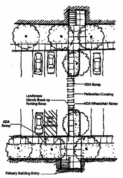
(Ord. 1471 § 2 (part), 2008)
17.64.010 - Purpose.
The purpose of this chapter is to promote community health, safety, and welfare by protecting natural vegetation and setting development standards for the design, installation, and maintenance of landscaping, street trees, fences, and walls; and for alterations to the same. Together, these elements of the natural and built environment contribute to the visual quality, environmental health, and character of the community. Trees provide climate control through shading during summer months and wind screening during winter. Trees and other plants can also buffer pedestrians from traffic. Walls, fences, trees, and other landscape materials also provide vital screening and buffering between land uses. Landscaped areas help to control surface water drainage and can improve water quality, as compared to paved or built surfaces. Likewise, proper maintenance of landscape features is necessary to protect the public health and safety. The chapter is organized into the following sections:
A.
Section 17.64.020, Landscape conservation, prevents the indiscriminate removal of significant trees and other vegetation, including vegetation associated with streams, wetlands, and other protected natural resource areas. Landscape conservation helps prevent soil erosion and landslide hazards, while protecting natural resource values (e.g., stream flow and water quality) and community aesthetics. Conservation of native, noninvasive plant and tree species is a high priority in areas subject to natural hazards, such as hillsides and riparian areas. Regulation of tree removal in other areas of the city is intended to balance residential privacy with the desire for views from, and solar access to, individual residences.
B.
Section 17.64.030, Landscaping, sets standards for and requires landscaping of all development sites that require site design review. This section also requires buffering for parking and vehicle maneuvering areas, and in some instances between different land uses. Section 17.64.030 is to be applied in conjunction with Division II, Land Use Districts.
C.
Section 17.64.040, Street trees, sets standards for and requires planting of trees where landscape park strips are designated. Street trees add to property values and community livability by providing summer shade along walks, comfort and safety to pedestrians, improved air quality along major streets, and improved community aesthetics.
D.
Section 17.64.050, Fences and walls, sets standards for new fences and walls, including allowable height and materials, to promote security, personal safety, privacy, and aesthetics.
(Ord. 1471 § 2 (part), 2008)
17.64.020 - Landscape conservation.
A.
Applicability. All development sites containing significant vegetation, as defined by subsection B of this section, shall comply with the standards of this section. The purpose of this section is to incorporate significant native vegetation into the landscapes of development to the greatest extent practicable. The retention of mature, native vegetation within developments is a preferred alternative to removal of vegetation and replanting, particularly on steep slopes and areas prone to landslide or susceptible to soil erosion. Mature landscaping provides summer shade and wind breaks, controls erosion, and allows for water conservation due to larger plants having established root systems.
B.
Significant Vegetation. "Significant vegetation" means individual trees and shrubs within an open space district, any existing or proposed open space area within a development, geological hazard areas, floodplains, and jurisdictional wetlands, as determined by a natural resource agency with jurisdiction, except that protection shall not be required for plants listed as nonnative, invasive plants by the Oregon State University (OSU) Extension Service, Coos County, or other government agency, where removal of vegetation is necessary to protect the public health, safety or welfare as determined by the city approval body.
C.
Mapping and Protection Required. Significant vegetation shall be mapped as required by Chapter 17.84, Land Use Review and Site Design Review. Significant trees shall be mapped individually and identified by species and diameter or caliper at four feet above grade. A "protection" area shall be defined around the edge of all branches (drip line) of each tree. Drip lines may overlap between trees. The city also may require an inventory, survey, or assessment prepared by a qualified professional when necessary to determine construction boundaries, building setbacks, and other protection or mitigation requirements.
D.
Protection Standards. Significant trees and shrubs identified as meeting the criteria in subsection B of this section, shall be retained to the extent practicable to minimize the risk of erosion, landslide, and storm water runoff. Where protection is impracticable because it would prevent reasonable development of public streets, utilities, or land uses permitted by the applicable land use district, the city may allow removal of significant vegetation to provide for a reasonable building envelope (area exclusive of required yard setbacks), and areas for access and utilities. Where other areas must be disturbed to provide for construction staging areas, the applicant shall be required to restore such areas after construction with landscaping to prevent erosion and to protect the public health, safety, and welfare. With the owner's consent, the city may accept a land dedication or become a party to a conservation easement on private property for conservation purposes.
E.
Construction—Erosion and Sediment Control. An erosion and sediment control plan is required for all new construction. All significant vegetation on a site that is not otherwise designated and approved by the city for removal shall be protected prior to, during, and after construction in accordance with a limit-of-clearing and grading plan approved by the city. The city may limit grading activities and operation of vehicles and heavy equipment in and around significant vegetation areas, streams and other water bodies to prevent erosion, pollution, or landslide hazards. See also Chapter 17.52, Estuarine/Coastal Shorelands (/EC) Resource Overlay.
F.
Exemptions. The protection standards in subsections D and E of this section shall not apply to:
1.
Dead or Diseased Vegetation. Dead or diseased vegetation may be removed from an area containing significant vegetation, as defined by subsection B of this section, provided the burden is on the property owner to demonstrate to the planning official that said vegetation is in fact diseased or dead before it is removed.
2.
Hazardous Vegetation and Other Emergencies. Significant vegetation may be removed without land use approval pursuant to Division IV when the vegetation poses an immediate threat to life or safety, or the vegetation must be removed for other reasons of emergency (e.g., fallen over road or power line, blocked drainage way, or similar circumstance), as determined by the city planning official or emergency service provider.
(Ord. 1471 § 2 (part), 2008)
17.64.030 - Landscaping.
A.
Applicability. This section shall apply to all new developments requiring site design review.
B.
Landscaping Plan Required. A landscape plan is required. All landscape plans shall conform to the requirements in Section 17.84.050(B)(5) (Landscape Plan).
C.
Landscape Area Standards. The minimum percentage of required landscaping equals:
1.
Residential District. Ten (10) percent of the site, except not required for single-family and duplex lots.
2.
Downtown District (C-1). Five percent of the site.
3.
General Commercial and Commercial Retail Districts (C-2; CR). Ten (10) percent of the site.
4.
Mixed-Use Commercial District (C-3). Ten (10) percent of the site.
5.
Industrial District. Ten (10) percent of the site.
6.
Geologic Hazards Overlay. Twenty-five (25) percent of the site must be open space with existing natural vegetation and/or replanted with suitable noninvasive species.
D.
Landscape Materials. Permitted landscape materials include trees, shrubs, ground cover plants, nonplant ground covers, and outdoor hardscape features, as described below. "Coverage" is based on the projected canopy cover of all plants upon maturity, i.e., typically three or more years after planting.
1.
Existing Vegetation. Existing noninvasive vegetation may be used in meeting landscape requirements. When existing mature trees with a trunk diameter greater than ten (10) inches are protected on a development site (e.g., within or adjacent to parking areas), the decision making body may reduce the number of new trees required by a ratio of one-inch caliper of new tree(s) for every one-inch caliper of existing tree(s) protected. This provision does not waive the requirement for landscape areas or "breaks" between parking bays under Sections 17.60.030 and subsection E of this section; it only reduces the number of new trees that may be required where existing mature trees are preserved.
2.
Plant Selection. A combination of deciduous and evergreen trees, shrubs, and ground covers shall be used for all planted areas, the selection of which shall be based on local climate, exposure, water availability, and drainage conditions. When new vegetation is planted, soils shall be amended, as necessary, to allow for healthy plant growth.
3.
"Nonnative, invasive" plants, as per Section 17.64.020(B), shall be removed during site development, to the extent practicable, to prevent their spreading; and the planting of new invasive species is prohibited.
4.
Hardscape Features. In meeting the landscape area requirements of this chapter, and where soil and drainage conditions allow, areas covered by unenclosed patios, decks, plazas, and similar hardscape features may count toward up to fifty (50) percent of the required landscape area, provided that such surfaces allow for storm water infiltration to the aquifer. Swimming pools, sports courts, and similar active recreation facilities may not be counted toward fulfilling the landscape requirement.
5.
Ground Cover Standard. All landscaped area, whether or not required, that is not planted with trees and shrubs, shall have ground cover plants that are sized and spaced as follows: a minimum of one plant per twelve (12) inches on center in triangular spacing, or other planting pattern that is designed to achieve at least fifty (50) percent coverage of all landscape surface areas.
6.
Tree Size. Trees shall have a minimum diameter or caliper four feet above grade of two inches or greater at time of planting.
7.
Shrub Size. Shrubs shall be planted from five-gallon containers or larger.
8.
Nonplant Ground Covers. Bark dust, chips, or similar mulch shall be used to cover all landscape surfaces not otherwise planted or covered with hardscape surfaces. Stone, aggregate and similar materials may be used as ground cover, but shall cover no more than fifty (50) percent of the area to be landscaped and shall be limited to footpaths, landscape bed borders, or structures providing erosion control or storm water management. Nonplant ground covers cannot be a substitute for ground cover plants.
9.
Significant Vegetation. Significant vegetation protected in accordance with Section 17.64.020 may be credited toward meeting the minimum landscape area standards. Credit shall be granted on a per square foot basis. The street tree standards of Section 17.64.040 may be waived by the city when existing mature trees protected within the front yard provide the same or better shading, visual quality, and compatibility with adjacent structures and utilities as would otherwise be provided by standard street trees.
10.
Storm Water Facilities. Surface storm water treatment facilities (e.g., detention/retention ponds and swales designed for water quality treatment), when required under Section 17.72.040, shall be landscaped with water tolerant, native plants.
E.
Landscape Design Standards. All yards, parking lots, and required street tree planter strips shall be landscaped to achieve the following criteria:
1.
Yard Setback Landscaping. Landscaping in yards shall:
a.
Provide visual screening and privacy within side and rear yards; while leaving front yards and building entrances mostly visible for security purposes and maintaining opportunities for solar access and territorial views;
b.
Use shrubs and trees as wind breaks;
c.
Consider the root and canopy growth characteristics of trees and avoid conflicts with utilities;
d.
Retain natural vegetation where it does not conflict with clear vision requirements and utilities;
e.
Define pedestrian pathways and open space areas with landscape materials;
f.
Provide focal points within a development, for example, by preserving large or unique trees or groves, hedges, and flowering plants;
g.
Use trees to provide summer shading within common open space areas and within front yards when street trees cannot be provided;
h.
Use a combination of plants for year-long color and interest;
i.
Use landscaping to screen outdoor storage and mechanical equipment areas, and to enhance graded areas such as berms, swales, and detention/retention ponds.
Figure 17.64.030(E) General Landscape Areas (Typical)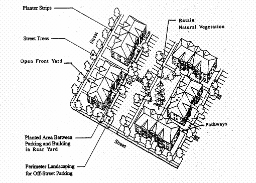
2.
Parking Areas. A minimum of ten (10) percent of the total surface area of all parking areas, as measured around the perimeter of all parking spaces and maneuvering areas, shall be landscaped. Such landscaping shall consist of "evenly distributed" shade trees with shrubs and/or ground cover plants that conform to the criteria in subsections (E)(1)(a) through (h) of this section. "Evenly distributed" means that the trees and other plants are distributed around the parking lot perimeter and between parking bays to provide a partial canopy. At a minimum, one tree per twelve (12) parking spaces on average shall be planted to create a partial tree canopy over and around the parking area. All parking areas with more than twenty-four (24) spaces shall include landscape islands with trees to break up the parking area into rows of not more than twelve (12) contiguous parking spaces. All parking area landscapes shall have dimensions of not less than twenty-four (24) square feet of area, or not less than four feet in width by six feet in length, to ensure adequate soil, water, and space for healthy plant growth. (See figures in Section 17.60.030.)
3.
Buffering and Screening Required. Buffering and screening are required under the following conditions:
a.
Parking/Maneuvering Area Adjacent to Streets and Drives. Where a parking or maneuvering area is adjacent and parallel to a street or driveway, an evergreen hedge; decorative wall (masonry or similar quality material) with openings; arcade, trellis, or similar partially opaque structure between three and four feet in height shall be established between street and driveway. The required screening shall have breaks, where necessary, to allow pedestrian access to the site. The design of the wall or screening shall also provide breaks or openings for visual surveillance of the site and security. Evergreen hedges used to comply with this standard shall be a minimum of thirty-six (36) inches in height at maturity, and shall be of such species, number, and spacing to provide the required screening within one year after planting. Any areas between the wall/hedge and the street/driveway line shall be landscaped with plants or other vegetative ground cover.
b.
Parking/Maneuvering Area Adjacent to Building. Where a parking or maneuvering area, or driveway, is adjacent to a building, the area shall be separated from the building by a curb and a raised walkway, plaza, or landscaped buffer not less than five feet in width. Raised curbs, bollards, wheel stops, or other design features shall be used to protect pedestrians, landscaping, and buildings from being damaged by vehicles. Where parking areas are located adjacent to residential groundfloor living space, a four-foot wide landscape buffer with a curbed edge may fulfill this requirement.
c.
Screening of Mechanical Equipment, Outdoor Storage, Service and Delivery Areas, and Other Screening When Required. All mechanical equipment, outdoor storage and manufacturing, and service and delivery areas, shall be screened from view from all public streets and adjacent residential districts. When these or other areas are required to be screened, such screening shall be provided by:
1.
A decorative wall (i.e., masonry or similar quality material);
2.
Evergreen hedge;
3.
Opaque fence complying with Section 17.64.050; or
4.
A similar feature that provides an opaque barrier.
Walls, fences, and hedges shall comply with the vision clearance requirements and provide for pedestrian circulation, in accordance with Chapter 17.60, Access and Circulation. (See Section 17.64.050 for standards specific to fences and walls.)
d.
Flag Lot Screen. In approving a flag lot, as regulated under Chapter 17.88, Land Divisions and Property Line Adjustments, the city may require a landscape screen and/or fence be installed along property line(s) of the flag lot, for privacy of adjoining residents, in accordance with the provisions of Section 17.88.040. A flag lot screen shall not be required if the abutting property owner(s) indicate in writing that they do not want a screen or fence, however, the owner may install one at his or her discretion.
F.
Maintenance and Irrigation. All yards and landscape areas, regardless of whether such areas are required by this code, shall be maintained in good health, with sufficient irrigation and care. Irrigation shall be required through site design review for new landscaping; temporary irrigation for a period of two years may be permitted where proposed species are drought tolerant. If the plantings fail to survive, the property owner shall replace them with an equivalent specimen (i.e., evergreen shrub replaces evergreen shrub, deciduous tree replaces deciduous tree, etc.). All plants and nonplant materials, including man-made features, on a site shall be maintained in good condition, or otherwise be replaced by the owner upon being notified by the city of such code violation.
(Ord. 1471 § 2 (part), 2008)
17.64.040 - Street trees.
Street trees shall be planted for all developments that are subject to land division or site design review where landscape park strips exist or are required with the development. Requirements for street tree planting strips are provided in Section 17.72.020, Transportation standards. Planting of street trees shall generally follow construction of curbs and sidewalks, however, the city may defer tree planting until final inspection of completed dwellings to avoid damage to trees during construction. The planting and maintenance of street trees shall conform to the following standards and guidelines and any applicable road authority requirements:
A.
Growth Characteristics. Trees shall be selected based on climate zone, growth characteristics and site conditions, including available space, overhead clearance, soil conditions, exposure, and desired color and appearance. The following should guide tree selection by developers and approval by the city:
1.
Provide a broad canopy where shade is desired, except where limited by overhead utilities or other space limitations;
2.
Use low-growing trees for spaces under low utility wires;
3.
Select trees which can be "limbed-up" to comply with vision clearance requirements;
4.
Use narrow or "columnar" trees where awnings or other building features limit growth, where view protection is desired, or where greater visibility is desired between buildings and the street;
5.
Use species with similar growth characteristics on the same block for design continuity;
6.
Avoid using trees that are susceptible to insect or pest damage and trees that produce excessive shoots (suckers), seeds or fruit;
7.
Select trees that are well adapted to the environment, including soil, wind, sun exposure, temperature tolerance, and exhaust. Drought-resistant trees should be chosen where they suit the specific soil type;
8.
Select trees for their seasonal color if desired;
9.
Use deciduous trees for summer shade and winter sun, unless unsuited to the location due to soil, wind, sun exposure, annual precipitation, or exhaust;
10.
The diameter of the tree trunk at maturity shall not exceed the width and size of the planter strip or tree well.
B.
Tree Size at Planting. The minimum tree size at planting is two-inch caliper measured four feet above grove for deciduous trees, and six-foot height for evergreen trees.
C.
Spacing and Location. Street trees shall be planted within existing or proposed planting strips or in sidewalk tree wells on streets without planting strips, except where root system conflicts with utilities are unavoidable, in which case the city may approve trees planted in front yards of lots. Street tree spacing shall be based upon the type of tree(s) selected and the canopy size at maturity and, at a minimum, the planting area shall contain at least sixteen (16) square feet, or typically, four feet by four feet; trees shall be centered in the planter strip between sidewalk and curb. In general, trees should be spaced between thirty (30) feet and sixty (60) feet apart, except where planting a tree would conflict with existing trees, retaining walls, utilities and similar physical barriers. Actual spacing should be based on the trees' growth characteristics and provide for a mostly continuous tree canopy cover over adjacent sidewalks when the trees mature.
D.
Soil Preparation, Planting and Care. The developer of subdivision or new site development with street frontage improvements shall be responsible for planting street trees, including soil preparation, ground cover material, staking, and temporary irrigation for two years after planting. The developer shall also be responsible for tree care (pruning, watering, fertilization, and replacement as necessary) during the first two years after planting, after which the adjacent property owners shall maintain the trees.
E.
Assurances. The city shall require developers of subdivisions (four or more lots), including those within master planned developments, to provide a performance and maintenance bond in an amount determined by the city engineer, to ensure the maintenance, care and, if necessary, the replacement of required street trees during the first two years after planting.
F.
Tree Maintenance. Maintenance of street trees, whether located in a public right-of-way or private property, is the ongoing responsibility of the adjoining property owner.
G.
Street Tree List. (Reserved)
(Ord. 1471 § 2 (part), 2008)
17.64.050 - Fences and walls.
A.
General Requirements. All fences and walls shall comply with the height limitations of the respective land use district (Division II) and the standards of this section. The city may require installation of walls and/or fences as a condition of development approval, in accordance with land division approval (e.g., flag lots), approval of a conditional use permit, or site design review approval. When required through one of these types of approvals, no further land use review is required. If not part of a prior land use approval, new fences and walls require land use review (Type I) approval; if greater than six feet in height, a building permit is also required. (See also Section 17.64.030 for screening requirements.)
B.
Dimensions.
1.
Except as provided under subsections (B)(2) and (B)(3) of this section, the height of fences and walls within a front yard setback shall not exceed four feet as measured from the grade closest to the street right-of-way.
2.
A retaining wall exceeding four feet in height within a front yard setback, which is necessary for site grading and development, may be approved through a land division or site development review.
3.
One arbor, gate, or similar garden structures not exceeding eight feet in height and six feet in width is allowed within a front yard, outside required clear vision areas.
4.
Walls and fences to be built for required buffers shall comply with Section 17.64.030.
5.
Fences and walls shall comply with the vision clearance standards of Section 17.60.020.
C.
Maintenance. For safety and for compliance with the purpose of this chapter, walls and fences required as a condition of development approval shall be maintained in good condition, or otherwise replaced by the property owner.
D.
Materials.
1.
Permitted fence and wall materials: weather-treated wood; untreated cedar and redwood; metal (e.g., chain link, wrought iron, and similar fences); bricks, stone, masonry block, formed-in-place concrete, or similar masonry; vinyl and composite (e.g., recycled) materials designed for use as fencing; and noninvasive evergreen plants kept to a height of no more than eight feet, except single-trunk trees may exceed eight feet.
2.
Prohibited fence and wall materials: straw bales, barbed or razor wire; scrap lumber, untreated wood, metal (except chain link), scrap materials, and plant hedges taller than eight feet above grade within a required yard.
3.
Fences or walls constructed of brick or masonry exceeding four feet in height shall be subject to review and approval by the city engineer.
(Ord. 1471 § 2 (part), 2008)
17.68.010 - Purpose.
The purpose of this chapter is to provide basic and flexible standards for development of vehicle and bicycle parking. The design of parking areas is critically important to the economic viability of some commercial areas, pedestrian and driver safety, the efficient and safe operation of adjoining streets, and community image and livability. Historically, some communities have required more parking than is necessary for some land uses, paving extensive areas of land that could be put to better use. Because vehicle parking facilities occupy large amounts of land, they must be planned and designed carefully to use the land efficiently, minimize storm water runoff, and maintain the visual character of the community. This chapter recognizes that each development has unique parking needs and provides a flexible approach for determining parking space requirements (i.e., "minimum" and "performance-based" standards). This chapter also provides standards for bicycle parking because many people use bicycles for recreation, commuting, and general transportation. Children as well as adults need safe and adequate spaces to park their bicycles throughout the community.
(Ord. 1471 § 2 (part), 2008)
17.68.020 - Applicability.
All developments subject to site design review (Chapter 17.84), including development of parking facilities, shall comply with the provisions of this chapter.
(Ord. 1471 § 2 (part), 2008)
17.68.030 - Automobile parking standards.
A.
Vehicle Parking—Minimum Standards by Use. The number of required off-street vehicle parking spaces shall be determined in accordance with the standards in Table 17.68.030(A), or alternatively, through a separate parking demand analysis prepared by the applicant and subject to a Type II land use review (or Type III review if the request is part of an application that is already subject to Type III review). Where a use is not specifically listed in this table, parking requirements are determined by finding that a use is similar to one of those listed in terms of parking needs, or by estimating parking needs individually using the demand analysis option described above. Parking that counts toward the minimum requirement is parking in garages, carports, parking lots, bays along driveways, city-approved shared parking, and designated on-street parking when approved by the city.
There is no minimum number of off-street parking required in the C-1 (downtown) district; however, new development and changes in use in the downtown may be subject to a downtown parking district fee. If adopted by city council under separate ordinance, the fee shall be calculated using the minimum parking ratios in Table 17.68.030(A) below.
Table 17.68.030(A) Minimum Required Parking by Use
B.
Vehicle Parking—Minimum Accessible Parking.
1.
Accessible (ADA) parking shall be provided for all uses in accordance with the standards in Table 17.68.030(B); parking spaces used to meet the standards in Table 17.68.030(B) shall be counted toward meeting applicable off-street parking requirements;
2.
Such parking shall be located in close proximity to building entrances and shall be designed to permit occupants of vehicles to reach the entrance on an unobstructed path or walkway;
3.
Accessible spaces shall be grouped in pairs where possible;
4.
Where covered parking is provided, covered accessible spaces shall be provided in the same ratio as covered nonaccessible spaces;
5.
Required accessible parking spaces shall be identified with signs and pavement markings identifying them as reserved for persons with disabilities; signs shall be posted directly in front of the parking space at a height of no less than forty-two (42) inches and no more than seventy-two (72) inches above pavement level. Van spaces shall be specifically identified as such.
Table 17.68.030(B) Minimum Number of Accessible Parking Spaces
Source: ADA Standards for Accessible Design 4.1.2(5)
1 Vans and cars may share access aisles.
3 Seven out of every eight accessible parking spaces.
C.
On-Street Parking. On-street parking shall conform to the following standards:
1.
Dimensions. The following constitutes one on-street parking space:
a.
Parallel parking, each twenty-two (22) feet of uninterrupted curb;
b.
Diagonal parking, each with twelve (12) feet of curb;
c.
Ninety (90) degree (perpendicular) parking, each with twelve (12) feet of curb.
2.
Location. Parking may be counted toward the minimum standards in Table 17.68.030(A) when it is on the block face abutting the subject land use. An on-street parking space must not obstruct a required clear vision area and it must not violate any law or street standard.
3.
Public Use Required for Credit. On-street parking spaces counted toward meeting the parking requirements of a specific use may not be used exclusively by that use, but shall be available for general public use at all times. Signs or other actions that limit general public use of on-street spaces are prohibited.
D.
Shared Parking. Required parking facilities for two or more uses, structures, or parcels of land may be satisfied by the same parking facilities used jointly, to the extent that the owners or operators show that the need for parking facilities does not materially overlap (e.g., uses primarily of a daytime versus nighttime nature; weekday uses versus weekend uses), and provided that the right of joint use is evidenced by a recorded deed, lease, contract, or similar written instrument establishing the joint use. The city may approve owner requests for shared parking through land use review.
E.
Off-Site Parking. Except for single-family dwellings, the vehicle parking spaces required by this chapter may be located on another parcel of land, provided the parcel is within three hundred (300) feet of the use it serves and the city has approved the off-site parking through land use review. The distance from the parking area to the use shall be measured from the nearest parking space to a building entrance, following a sidewalk or other pedestrian route. The right to use the off-site parking must be evidenced by a recorded deed, lease, easement, or similar written instrument.
F.
General Parking Standards.
1.
Location. Parking is allowed only on streets, within garages, carports, and other structures, or on driveways or parking lots that have been developed in conformance with this code. Division II, Land Use Districts, prescribes parking location for some land uses (e.g., the requirement that parking for some multiple-family and commercial developments be located to side or rear of buildings), and Chapter 17.60, Access and Circulation, provides design standards for driveways. Street parking spaces shall not include space in a vehicle travel lane (including emergency or fire access lanes), public right-of-way, pedestrian accessway, landscape, or other undesignated area.
2.
Mixed Uses. If more than one type of land use occupies a single structure or parcel of land, the total requirements for off-street automobile parking shall be the sum of the requirements for all uses, unless it can be shown that the peak parking demands are actually less (i.e., the uses operate on different days or at different times of the day). The city may reduce the total parking required accordingly through land use review.
4.
Availability of Facilities. Owners of off-street parking facilities may post a sign indicating that all parking on the site is available only for residents, customers, and/or employees. Signs shall conform to the standards of Chapter 17.72.
5.
Lighting. Parking areas shall have lighting to provide at least two footcandles of illumination over parking spaces and walkways. Light standards shall be directed downward only and shielded to prevent lighting spillover into any adjacent residential district or use.
6.
Screening of Parking Areas. Parking spaces shall be located or screened so that headlights do not shine onto adjacent residential uses, per Section 17.64.030(E).
G.
Parking Stall Design and Minimum Dimensions. All off-street parking spaces shall be improved to conform to city standards for surfacing, storm water management, and striping. Standard parking spaces shall conform to the following standards and the dimensions in Figures 17.68.030(F)(1) through (2), and Table 17.68.030(F).
1.
Parking area dimensions and layout shall conform to the dimensions in Figures 17.68.030(F)(1) and (2), and Table 17.68.030(F) below;
2.
Additional parking dimensions shall be provided in accordance to Americans with Disabilities Act (ADA) standards for required ADA parking spaces (van-accessible parking spaces). Parking structure vertical clearance, van-accessible parking spaces, should refer to federal ADA guidelines. See Figure 17.68.030(F)(2).
Figure 17.68.030(F)(1) Parking Area Layout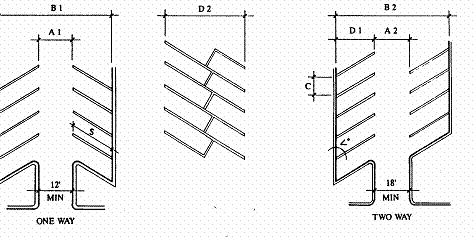
Figure 17.68.030(F)(2) Disabled Person Parking Requirements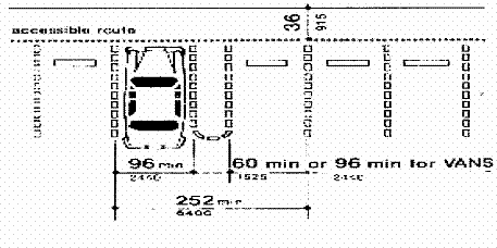
Important cross-references:
See also Division II, Land Use Districts, standards, for parking location requirements for some multifamily and commercial land uses; Chapter 17.60, Access and Circulation, for driveway standards; Chapter 17.64, Landscaping, Street Trees, Fences and Walls.
(Ord. 1471 § 2 (part), 2008)
17.68.040 - Bicycle parking standards.
All uses that are subject to site design review shall provide bicycle parking, in conformance with the standards in Table 17.68.040, and subsections A through G of this section.
A.
Minimum Required Bicycle Parking Spaces. Uses shall provide bicycle parking spaces, as designated in Table 17.68.040.
Table 17.68.040
Minimum Required Bicycle Parking Spaces
B.
Exemptions. This section does not apply to single-family and two-family housing (attached, detached, or manufactured housing), home occupations, agriculture and livestock uses.
C.
Location and Design. Bicycle parking should be no farther from the main building entrance than the distance to the closest vehicle space, or fifty (50) feet, whichever is less. Covered bicycle parking should be incorporated whenever possible into building design. When allowed within a public right-of-way, bicycle parking should be coordinated with the design of street furniture, as applicable.
D.
Visibility and Security. Bicycle parking for customers and visitors of a use shall be visible from street sidewalks or building entrances, so that it provides sufficient security from theft and damage.
E.
Lighting. For security, bicycle parking shall be at least as well lit as vehicle parking.
F.
Reserved Areas. Areas set aside for bicycle parking shall be clearly marked and reserved for bicycle parking only.
G.
Hazards. Bicycle parking shall not impede or create a hazard to pedestrians. Parking areas shall be located so as to not conflict with vision clearance standards (Chapter 17.60, Access and Circulation).
(Ord. 1471 § 2 (part), 2008)
17.68.050 - Loading areas.
A.
Purpose. The purpose of this section of the code is to provide standards: (1) for a minimum number of off-street loading spaces that will ensure adequate loading areas for large uses and developments; and (2) to ensure that the appearance of loading areas is consistent with that of parking areas.
B.
Applicability. This section applies to residential projects with fifty (50) or more dwelling units, and nonresidential and mixed-use buildings with twenty thousand (20,000) square feet or more total floor area.
C.
Number of Loading Spaces.
1.
Residential Buildings. Buildings where all of the floor area is in residential use shall meet the following standards:
a.
Fewer than fifty (50) dwelling units on a site that abuts a local street: no loading spaces are required.
b.
All other buildings: one space.
2.
Nonresidential and Mixed-Use Buildings. Buildings where any floor area is in nonresidential uses shall meet the following standards:
a.
Less than twenty thousand (20,000) square feet total floor area: no loading spaces required.
b.
Twenty thousand (20,000) to fifty thousand (50,000) square feet of total floor area: one loading space.
c.
More than fifty thousand (50,000) square feet of total floor area: two loading spaces.
D.
Size of Spaces. Required loading spaces shall be at least thirty-five (35) feet long and ten (10) feet wide, and shall have a height clearance of at least thirteen (13) feet.
E.
Placement, Setbacks and Landscaping. Loading areas shall conform to the setback and perimeter landscaping standards in Divisions II and III. Where parking areas are prohibited between a building and the street, loading areas are also prohibited. The decision body may approve a loading area adjacent to or within the street right-of-way through site design review or conditional use permit review, as applicable, where it finds that loading and unloading operations are short in duration (i.e., less than one hour), do not obstruct traffic during peak traffic hours, and do not interfere with emergency response services.
(Ord. 1471 § 2 (part), 2008)
17.72.010 - Purpose and applicability.
A.
Purpose. The purpose of this chapter is to provide planning and general design standards for public and private transportation facilities and utilities. Streets serve both transportation and infrastructure needs and are the most common public spaces, touching virtually every parcel of land. Therefore, one of the primary purposes of this chapter is to provide standards for functional, attractive and safe streets that can accommodate underground utilities and traffic from planned growth and provide a range of transportation options, including options for driving, walking, and bicycling. This chapter implements the policies of the city of Coquille comprehensive plan.
B.
When Standards Apply. Unless otherwise provided, the standards of this chapter apply when a land use application is filed for a major project under Section 17.56.020. All public improvements within the city shall occur in accordance with the standards and procedures of this chapter.
C.
Engineering Design Criteria, Standard Specifications and Details. All public improvements are subject to compliance with engineering criteria and requirements, as determined by the city engineer. The design criteria, standard construction specifications and details maintained by the city engineer, or any other road authority with jurisdiction, are a part of this code. The city's specifications, standards, and details are incorporated into this code by reference.
D.
Conditions of Development Approval. No development may occur unless required public improvements are in place or guaranteed, in conformance with the provisions of this code. Improvements required as a condition of development approval, when not voluntarily accepted by the applicant, shall be roughly proportional to the impact of the development on public facilities. Findings in the development approval shall indicate how the required improvements are directly related and roughly proportional to the impact.
(Ord. 1471 § 2 (part), 2008)
17.72.020 - Transportation standards.
A.
Development Standards. The following standards shall be met for all major projects, as provided under Section 17.56.020:
1.
All new lots created, consolidated, or modified through a land division, including replats, shall have frontage on, or approved access to, a public street meeting city standards.
2.
Streets within or adjacent to a development shall be improved in accordance with the provisions of this chapter.
3.
Development of new streets, including sidewalks, curbs, gutters, bicycle lanes, vehicle travel lanes, traffic control devices, and park strips, and additional right-of-way or street width or improvements planned as a portion of an existing street, shall be improved in accordance with this chapter; and all public streets shall be dedicated to the applicable road authority upon the city engineer's acceptance of said improvements.
4.
All new streets, and driveways connecting to streets, shall be paved; driveways and driveway aprons shall be improved as required under Section 17.68.030 and subject to approval by the city engineer.
B.
Guarantee. The city may accept a future improvement guarantee (e.g., owner agrees not to object to the formation of a local improvement district in the future) in lieu of street improvements if one or more of the following conditions exist:
1.
A partial improvement may create a potential safety hazard to motorists or pedestrians;
2.
Due to the developed condition of adjacent properties, it is unlikely that street improvements would be extended in the foreseeable future and the improvement associated with the project under review does not, by itself, provide increased street safety or capacity, or improved pedestrian circulation;
3.
The improvement would be in conflict with an adopted capital improvement plan; or
4.
The improvement is associated with an approved land partition and the proposed land partition does not create any new streets.
C.
Creation of Rights-of-Way for Streets and Related Purposes. Streets shall be created through the approval and recording of a final subdivision or partition plat; except the city may approve the creation of a street by acceptance of a deed, provided that the street is deemed in the public interest by the city council for the purpose of implementing the Coquille comprehensive plan, and the deeded right-of-way and improvements conform to the standards of this code.
D.
Creation of Access Easements. The city may approve an access easement connecting to a public street only when the easement is necessary to provide for access and circulation in conformance with Chapter 17.60, Access and Circulation. Access easements shall be created and maintained in accordance with the Uniform Fire Code Section 10.207.
E.
Street Location, Width and Grade. Except as noted below, the location, width and grade of all streets shall conform to an approved street plan or subdivision plat, and be subject to review and approval by the city engineer. Street location, width, and grade shall be determined in relation to existing and planned streets, topographic conditions, public convenience and safety, and in appropriate relation to the proposed use of the land to be served by such streets. Where the location of a street is not shown on an adopted city street plan, the location of streets in a development shall provide for the reasonable continuation and connection of existing streets to adjacent developable properties, conforming to the street standards of this chapter.
F.
Minimum Rights-of-Way and Street Sections. Street rights-of-way and improvements shall be the widths in Table 17.72.020(F). Variances to street design standards are subject to review and approval by the city engineer. Where a range of width is indicated, the width shall be the narrower in the range unless unique and specific conditions exists as determined by the city engineer based upon the following factors:
1.
Transportation policies of comprehensive plan and development code;
2.
Anticipated traffic generation;
3.
On-street parking needs;
4.
Sidewalk and bikeway requirements, including the extension of and connection to existing sidewalks;
5.
Requirements for placement of utilities;
6.
Street lighting;
7.
Minimize drainage, slope, and sensitive lands impacts;
8.
Street tree location, as provided in Chapter 17.64;
9.
Protection of significant vegetation, as provided in Chapter 17.64;
10.
Safety, comfort, and convenience of motorists, bicyclists, and pedestrians;
11.
Placement of street furnishings (e.g., benches, lighting, bus shelters, etc.), as applicable;
12.
Access needs for emergency vehicles and for emergency evacuation; and
13.
Transition between different street widths (i.e., existing streets and new streets).
Table 17.72.020(F) Street Standards
G.
Subdivision Street Connectivity. All subdivisions, including those within master planned developments, shall conform to all the following access and circulation design standards:
1.
Connectivity to Abutting Lands. The street system of proposed subdivisions shall be designed to connect with existing, proposed, and planned streets outside of the subdivision as provided in this section. Wherever a proposed development abuts unplatted land or a future development phase of the same development, street stubs shall be provided to allow access to future abutting subdivisions and to logically extend the street system into the surrounding area. All street stubs shall be provided with a temporary turnaround unless specifically exempted by the fire marshal, and the restoration and extension of the street shall be the responsibility of any future developer of the abutting land.
2.
When Abutting an Arterial Street. Property access to abutting arterials shall be minimized. Where such access is necessary, shared driveways may be required in conformance with Section 17.60.020. If vehicle access off a secondary street is possible, then the road authority may prohibit access to the arterial.
3.
Continuation of Streets. Planned streets shall connect with surrounding streets to permit the convenient movement of traffic between residential neighborhoods and to facilitate emergency access and evacuation. Connections shall be designed to meet or exceed the standards in subsection (G)(4) of this section, and to avoid or minimize through traffic on local streets. Appropriate design and traffic control and traffic calming measures, as provided in subsection H of this section, are the preferred means of discouraging through traffic.
4.
Street Connectivity and Formation of Blocks. In order to promote efficient vehicular and pedestrian circulation throughout the city, all subdivisions and site developments of more than two acres requiring the extension of public streets shall be served by a connecting network of public streets and/or accessways, in accordance with the following standards (minimum and maximum distances between two streets or a street and its nearest accessway:
a.
Residential districts, except projects within the geologic hazards overlay: minimum of one hundred (100) foot block length and maximum of six hundred (600) foot length; maximum one thousand four hundred (1,400) foot block perimeter measured from the right-of-way edge;
b.
Downtown (C-1): conform to existing platted blocks;
c.
General commercial, commercial retail and mixed-use commercial (C-2, CR, and C-3) districts: minimum of one hundred (100) foot length and maximum of six hundred (600) foot length; maximum one thousand four hundred (1,400) foot perimeter;
d.
Not applicable to the industrial districts or projects within the geologic hazards overlay.
5.
Accessway Standards. Where a street connection in conformance with the maximum block length standards in subsection (G)(4) of this section is impracticable, an accessway shall be provided at or near the middle of a block in lieu of the street connection, as generally shown in Figure 17.72.020(G). The city may also require developers to provide an accessway where the creation of a cul-de-sac or dead-end street is unavoidable and the accessway would connect the ends of the street to another street or public accessway. Such accessways shall conform to all of the following standards, which may be modified by the decision body without a variance when the modification affords greater convenience or comfort for, and does not compromise the safety of, pedestrians or bicyclists:
a.
Accessways shall be no less than ten (10) feet wide and contain a minimum six-foot wide paved walkway surface within a right-of-way or easement allowing public access; where emergency vehicle access is required, the accessway shall be no less than twenty (20) feet wide and contain an all-weather driving surface with the required weight-bearing capacity;
b.
If the streets within the subdivision or neighborhood are illuminated, all accessways in the subdivision shall be lighted. Accessway lighting shall provide at least two footcandles of illumination of the walkway surface;
c.
A right-of-way or public access easement provided in accordance with subsection (G)(5)(b) of this section that is less than ten (10) feet wide may be allowed on steep slopes where the decision body finds that stairs, ramps, or switch-back paths are required;
d.
All public walkways shall conform to applicable ADA requirements (exception allowed for hillsides); and
e.
The city may require landscaping as part of the required accessway improvement to buffer pedestrians from adjacent vehicles, or to screen the accessway for the privacy of adjoining residents.
H.
Traffic Signals and Traffic Calming Features.
1.
Traffic signals shall be required with development when traffic signal warrants are met, in conformance with the Federal Highway Administration approved guidelines, including, but not limited to: Highway Capacity Manual and Manual of Uniform Traffic Control Devices. The location of traffic signals shall be noted on approved street plans. Where a proposed street intersection will result in an immediate need for a traffic signal, a signal meeting approved specifications shall be installed in conformance with the road authority's requirements. The developer's cost and the timing of improvements shall be included as a condition of development approval.
2.
When an intersection meets or is projected to meet traffic signal warrants, the city may accept alternative mitigation, such as a traffic roundabout, in lieu of a traffic signal, if approved by the city engineer and applicable road authority.
3.
The city may require the installation of traffic calming features such as traffic circles, curb extensions, reduced street width (parking on one side), medians with pedestrian crossing refuges, and/or special paving surfaces to slow traffic in neighborhoods or commercial areas with high pedestrian traffic.
I.
Future Street Plan and Extension of Streets.
1.
Where a subdivision is proposed adjacent to other developable land, a future street plan shall be filed by the applicant in conjunction with an application for a subdivision in order to facilitate orderly development of the street system. The plan shall show the pattern of existing and proposed future streets from the boundaries of the proposed land division and shall include other divisible parcels within six hundred (600) feet surrounding and adjacent to the proposed subdivision. The street plan is not binding; rather it is intended to show potential future street extensions with future development and ensure that the proposed development does not preclude future street connections to adjacent development land.
2.
Streets shall be extended to the boundary lines of the parcel or tract to be developed when the city determines that the extension is necessary to give street access to, or permit a satisfactory future division of, adjoining land. The point where the streets temporarily end shall conform to the following:
a.
These extended streets or street stubs to adjoining properties are not considered to be cul-de-sacs since they are intended to continue as through streets when the adjoining property is developed.
b.
A barricade (e.g., fence, bollards, boulders or similar vehicle barrier) shall be constructed at the end of the street by the subdivider and shall not be removed until authorized by the city or other applicable agency with jurisdiction over the street. The cost of the barricade shall be included in the street construction cost.
c.
Temporary street ends shall provide turnarounds constructed to Uniform Fire Code standards for streets over one hundred fifty (150) feet in length. See also Section 17.60.020.
J.
Street Alignment, Radii and Connections.
1.
The creation of new streets making "T" intersections at collectors and arterials shall provide for intersection spacing of not less than three hundred (300) feet, as measured from the centerlines of the offset streets.
2.
Spacing between local street intersections shall have a minimum separation of one hundred twenty-five (125) feet, except where the city engineer approves closer spacing due to topographic constraints or as necessary to provide a traffic calming feature, such as an open space, roundabout, or similar amenity. This standard applies to four-way and three-way (offset) intersections.
3.
All local and collector streets that stub into a development site shall be extended within the site to provide through circulation unless prevented by environmental or topographical constraints, existing development patterns, or compliance with other standards in this code. This exception applies when it is not possible to redesign or reconfigure the street pattern to provide required extensions. Land is considered topographically constrained if it falls within the geological hazards overlay or it contains a stream or other natural drainageway. In the case of environmental or topographical constraints, the mere presence of a constraint is not sufficient to show that a street connection is not possible. The applicant must show why the environmental or topographic constraint precludes some reasonable street connection.
4.
Proposed streets or street extensions shall be located to allow continuity in street alignments and to facilitate future development of vacant or redevelopable lands.
5.
In order to promote efficient vehicular and pedestrian circulation throughout the city, the design of subdivisions and alignment of new streets shall conform to block length standards in Section 17.60.020.
K.
Sidewalks, Planter Strips, Bicycle Lanes. As provided under Section 17.72.010(D), the city may require the improvement and/or extension of sidewalks, planter strips, and bicycle lanes with new major projects, in conformance with the standards in Table 17.72.020, as required by the city engineer, or applicable provisions of city's comprehensive plan, or the requirements of any other applicable roadway authority. Maintenance of sidewalks and planter strips in the right-of-way is the continuing obligation of the adjacent property owner.
L.
Intersection Angles. Streets shall be laid out so as to intersect at an angle as near to a right angle as practicable, except where the city engineer approves closer spacing due to topographic constraints or as necessary to provide a traffic calming feature, such as an open space, roundabout, or similar amenity.
M.
Existing Rights-of-Way. Whenever existing rights-of-way adjacent to a proposed development are less than standard width, additional rights-of-way shall be provided at the time of subdivision or development, subject to the provision of this section.
N.
Cul-de-Sacs. Streets shall be planned to continue to and through abutting properties, consistent with the connectivity standards in subsection G of this section. A cul-de-sac street shall only be used when environmental or topographical constraints, existing development patterns, or compliance with other standards in this code preclude street extension and through circulation. For example, the city engineer may approve a cul-de-sac where a street extension would otherwise exceed allowable street grades or negatively impact a natural drainageway or jurisdictional wetland. When cul-de-sacs are allowed, all of the following shall be met:
1.
The cul-de-sac shall not exceed a length of six hundred (600) feet; the length of the cul-de-sac shall be measured along the centerline of the roadway from the near side of the intersecting street to the farthest point of the cul-de-sac;
2.
The cul-de-sac shall terminate with a circular or hammer-head turnaround meeting the Uniform Fire Code. Circular turnarounds shall have a radius of no less than forty (40) feet, and not more than a radius of forty-five (45) feet (i.e., from center to edge of pavement); except that turnarounds shall be larger when they contain a landscaped island or parking bay at their center. When an island or parking bay is provided, there shall be a fire apparatus lane of twenty (20) feet in width; and
3.
The cul-de-sac shall provide, or not preclude the opportunity to later install, a pedestrian and bicycle accessway connection between it an adjacent streets accessways, parks, or other right-of-way. Such accessways shall conform to Section 17.60.030.
O.
Grades and Curves. Except as approved by the city engineer, grades shall not exceed ten (10) percent on arterials, twelve (12) percent on collector streets, or twelve (12) percent on any other street. The city engineer may approve steeper grades for short street segments, provided the street grade does not exceed fifteen (15) percent for a distance greater than two hundred fifty (250) feet, and:
1.
Centerline curve radii shall not be less than seven hundred (700) feet on arterials, five hundred (500) feet on major collectors, three hundred fifty (350) feet on minor collectors, or one hundred (100) feet on other streets; and
2.
Streets intersecting with a minor collector or greater functional classification street, or streets intended to be posted with a stop sign or signalization, shall provide a landing averaging five percent or less. Landings are that portion of the street within twenty (20) feet of the edge of the intersecting street at full improvement.
P.
Curbs, Curb Cuts, Ramps and Driveway Approaches. Concrete curbs, curb cuts, wheelchair ramps, bicycle ramps, and driveway approaches shall be constructed in accordance with standards specified in Chapter 17.60, Access and Circulation.
Q.
Streets Adjacent to Railroad Right-of-Way. When a transportation improvement is proposed within three hundred (300) feet of a public railroad crossing, or a modification is proposed to an existing public crossing, the Oregon Department of Transportation and the rail service provider shall be notified and given an opportunity to comment, in conformance with the provisions of Division IV. Private crossing improvements are subject to review and licensing by the rail service provider.
R.
Development Adjoining Arterial Streets. Where a development adjoins or is crossed by an existing or proposed arterial street, the development design shall separate residential access from through traffic and minimize traffic conflicts. (See also the access requirements under Section 17.60.020.) The development design shall include one or more of the following:
1.
A parallel access street (frontage road) along the arterial with a landscape median with raised curbs of not less than ten (10) feet in width separating the two streets;
2.
Deep lots (one hundred twenty (120) feet or greater) abutting the arterial or major collector to provide adequate arterial buffering with access taken from the subordinate street;
3.
Screen planting within a nonaccess reservation (e.g., public easement or tract) of not less than five feet in width at the rear or side property line along the arterial; or
4.
Other treatment approved by the city engineer that is consistent with the purpose of this chapter.
S.
Alleys, Public or Private. Alleys shall conform to the standards in Table 17.72.020. Alley intersections and sharp changes in alignment shall be avoided. The corners of necessary alley intersections shall have a radius of not less than twelve (12) feet and allow access to utilities, as applicable.
T.
Private Streets and Gated Streets. Private streets, including gated drives serving more than two dwellings (i.e., where a gate limits access to a development from a public street), are not permitted.
U.
Street Names. No new street name shall be used which will duplicate or be confused with the names of existing streets in Coquille or vicinity. Street names, signs, and numbers shall conform to the established pattern in the surrounding area, except as requested by emergency service providers.
V.
Survey Monuments. Upon completion of a street improvement and prior to acceptance by the city, it shall be the responsibility of the developer's registered professional land surveyor to provide certification to the city that all boundary and interior monuments have been reestablished and protected.
W.
Street Signs. The city, county, or state with jurisdiction shall install all signs for traffic control and street names. The cost of signs required for new development shall be the responsibility of the developer. Street name signs shall be installed at all street intersections. Stop signs and other signs may be required.
X.
Mail Boxes. Mail box locations shall be as approved by the United States Postal Service.
Y.
Street Light Standards. Street lights shall be installed in accordance with city standards. At a minimum, street lights shall be installed at street intersections; additional street lights or lighting of pedestrian accessways may be required by the city to provide for public safety and welfare.
Z.
Street Cross-Sections. The final lift of asphalt or concrete pavement shall be placed on all new constructed public roadways prior to final city acceptance of the roadway unless otherwise approved by the city engineer. The final lift shall also be placed no later than one year from the commencement of initial construction of the development.
(Ord. 1471 § 2 (part), 2008)
17.72.030 - Public use areas.
A.
Dedication of Public Use Areas.
1.
Where a proposed open space, park, playground, or other public use shown in a plan adopted by the city is located in whole or in part in a subdivision, the city may require the public dedication or reservation of this area on the final plat for the subdivision, provided that the impact of the development on the city park system is roughly proportionate to the dedication or reservation being made.
2.
The city may purchase or accept voluntary dedication or reservation of areas within the subdivision that are suitable for the development of parks and other public uses; however, the city is under no obligation to accept such areas offered for dedication or sale.
3.
Alternatively, the city may impose conditions of approval providing for reservation and ongoing ownership, improvement and maintenance of open space areas (e.g., through master planned development approvals under Chapter 17.96), including payment of property taxes for said property, by a private entity such as a homeowner's association.
B.
System Development Charge Credit. Dedication of land to the city for public use areas, voluntary or otherwise, shall be eligible as a credit toward any required system development charge for parks.
(Ord. 1471 § 2 (part), 2008)
17.72.040 - Sanitary sewer and water service improvements.
A.
Sewers and Water Mains Required. Sanitary sewers and water mains shall be installed to serve each new development and to connect developments to existing mains in accordance with the city's sanitary sewer master plan, water system master plan, and the applicable engineering requirements. When streets are required to be stubbed to the edge of the subdivision, sewer and water system improvements shall also be stubbed with the streets, except as may be waived by the city engineer when alternate alignment(s) are provided.
B.
Sewer and Water Plan Approval. Development permits for sewer and water improvements shall not be issued until the city engineer has approved all sanitary sewer and water plans in conformance with city standards.
C.
Oversizing. The city may require as a condition of development approval that sewer, water, and/or storm drainage systems serving new development be sized to accommodate future development within the area as projected by the applicable water, sewer, and/or storm drainage master plan, provided that the city may grant the developer credit toward any required system development charge for the same, or the city may authorize other cost-recovery or cost-sharing methods, in conformance with Section 17.72.010(D).
D.
Inadequate Facilities. Development permits may be restricted or rationed by the city where a deficiency exists in the existing water or sewer system that cannot be rectified by the development and which if not rectified will result in a threat to public health or safety, surcharging of existing mains, or violations of state or federal standards pertaining to operation of domestic water and sewerage treatment systems.
(Ord. 1471 § 2 (part), 2008)
17.72.050 - Storm drainage improvements.
A.
General Provisions. A development permit may be granted only when adequate provisions for storm water and flood water runoff have been assured (i.e., through plans and/or bonding approved by the city).
B.
Accommodation of Upstream Drainage. Culverts and other drainage facilities shall be large enough to accommodate existing and potential future runoff from the entire upstream drainage area, whether inside or outside the development. Such facilities shall be subject to review and approval by the city engineer.
C.
Effect on Downstream Drainage. The rate of storm water runoff leaving a development site during and after development (post-development) shall not exceed the rate of storm water runoff leaving the site before development (pre-development).
D.
Storm Drainage Analysis and Mitigation Required. The city engineer may require an applicant for development to provide a storm drainage analysis prepared by a qualified professional engineer registered in the state of Oregon to examine pre- and post-development storm water runoff conditions and any required mitigation, consistent with the purpose and intent of this title. Such analysis, at a minimum, shall quantify pre- and post-development runoff volumes and rates and propose mitigation based on storm water management best practices, as specified by the city engineer. Such mitigation shall ensure that post-development runoff rates do not exceed pre-development rates and necessary facilities are provided to protect public health, safety, and welfare. If upon reviewing the applicant's storm drainage analysis, the city engineer determines that the storm water runoff resulting from the development will overload any existing and/or proposed drainage facility, the city shall withhold approval of the development until provisions have been made for improvement of the potential adverse impacts.
D.
Oversizing. The city may require as a condition of development approval that any public storm drainage system serving new development be sized to accommodate future development upstream, provided that the city may grant the developer credit toward any required system development charge for the same, or the city may authorize other cost-recovery or cost-sharing methods, in conformance with Section 17.72.010(D).
E.
Existing Watercourse. Where a proposed development is traversed by a watercourse, drainage way, channel, or stream, there shall be provided a storm water easement or drainage right-of-way conforming substantially with the lines of such watercourse and such further width as will be adequate for conveyance and maintenance to protect the public health and safety. See also Coquille's floodplain ordinance (Ordinance No. 1226, March 16, 1987; amended by Ordinance No. 1351A, November 1, 1993).
(Ord. 1471 § 2 (part), 2008)
17.72.060 - Utilities.
A.
Underground Utilities.
1.
Generally. All new utility lines, including, but not limited to, those required for electric, communication, lighting, and cable television services and related facilities shall be placed underground, except for surface-mounted transformers, surface-mounted connection boxes and meter cabinets which may be placed above ground, temporary utility service facilities during construction, and high capacity electric lines operating at fifty thousand (50,000) volts or above. The city may require screening and buffering of aboveground facilities to protect the public health, safety or welfare through site development review.
2.
Subdivisions and Master Planned Developments. The following additional standards apply to all new subdivisions, including those within master planned developments, in order to facilitate underground placement of utilities:
a.
The developer shall make all necessary arrangements with the serving utility to provide the underground services. Care shall be taken to ensure that all aboveground equipment does not obstruct vision clearance areas for vehicular traffic (Chapter 17.60);
b.
The city reserves the right to approve the location of all surface-mounted facilities;
c.
All underground utilities, including sanitary sewers and storm drains installed in streets by the developer, shall be constructed prior to the surfacing of the streets; and
d.
Stubs for service connections shall be long enough to avoid disturbing the street improvements when service connections are made.
B.
Exception to Undergrounding Requirement. An exception to the undergrounding requirement may be granted where existing physical constraints, such as steep topography, natural resource constraints (e.g., geologic conditions, rivers and streams), or existing development conditions make underground placement impractical.
(Ord. 1471 § 2 (part), 2008)
17.72.070 - Easements.
A.
Provision. The developer or applicant shall make arrangements with the city, the applicable district, and each utility franchise for the provision and dedication of utility easements necessary to provide full services to the development. The city's standard width for public main line utility easements shall be determined by the city engineer.
B.
Recordation. As determined by the city engineer, all easements for sewers, storm drainage and water quality facilities, water mains, electric lines, or other public utilities shall be recorded with the final plat. See Chapter 17.84, Land Use Review and Site Design Review, and Chapter 17.88, Land Divisions and Property Line Adjustments.
(Ord. 1471 § 2 (part), 2008)
17.72.080 - Construction plan approval and assurances.
A.
Plan Approval and Permit. No public improvements, including sanitary sewers, storm sewers, streets, sidewalks, curbs, lighting, parks, or other requirements shall be undertaken except after the plans have been approved by the city, permit fee paid, and permit issued. The permit fee is required to defray the cost and expenses incurred by the city for construction and other services in connection with the improvement. The permit fee shall be set by city council.
B.
Performance Guarantee. The city may require the developer or subdivider to provide bonding or other performance guarantees to ensure completion of required public improvements. See Section 17.84.040, Site design review—Application review procedure, and Section 17.88.110, Performance guarantee.
(Ord. 1471 § 2 (part), 2008)
17.72.090 - Installation.
A.
Conformance Required. Improvements installed by the developer either as a requirement of these regulations or at his or her own option, shall conform to the requirements of this chapter, approved construction plans, and to improvement standards and specifications adopted by the city.
B.
Adopted Installation Standards. The city of Coquille may adopt design standards, criteria and specifications for public improvements as well as private utility installation within the public right-of-way; until such standards are adopted, project designs shall conform to the recommendations of the city engineer.
C.
Commencement. Work in a public right-of-way shall not begin until all applicable agency permits have been approved and issued.
D.
Resumption. If work is discontinued for more than one month, it shall not be resumed until the city is notified in writing.
E.
City Inspection. Improvements shall be constructed under the inspection and to the satisfaction of the city. The city may require minor changes in typical sections and details if unusual conditions arising during construction warrant such changes in the public interest. Modifications to the approved design requested by the developer may be subject to review under Chapter 17.100, Modifications to Approved Plans and Conditions of Approval. Any monuments that are disturbed before all improvements are completed by the subdivider shall be replaced prior to final acceptance of the improvements.
F.
Engineer's Certification and As-Built Plans. A registered civil engineer shall provide written certification in a form required by the city that all improvements, workmanship, and materials are in accord with current and standard engineering and construction practices, conform to approved plans and conditions of approval, and are of high grade, prior to city acceptance of the public improvements, or any portion thereof, for operation and maintenance. The developer's engineer shall also provide two set(s) of "as-built" plans, in conformance with the city engineer's specifications, for permanent filing with the city.
(Ord. 1471 § 2 (part), 2008)
17.78.010 - Required—Signs.
That all the dwelling and business houses and places of business within the corporate limits of the city of Coquille shall be numbered as hereinafter provided, and the streets shall be designated by suitable signs at the crossings of each street, unless, in the discretion of the street committee, such crossing, not being used or improved, such signs shall not be placed until the said crossings shall be improved or, used.
(Ord. 1438 (part), 2003)
17.78.020 - Numbering designated.
The numbering of all houses and places of business on streets running north and south shall commence at the street originally named First Street in the plat of the town [City] of Coquille and thereafter changed to Front Street and the extensions thereof east and west, numbering north and south therefrom. All numbering on streets running east and west shall commence on the street originally named Taylor Street in Elliott Addition to the city of Coquille and originally named B Street on the plat of the town of Coquille and the extension thereof north to Tenth Street and a line running north from the center of the intersection of said street at Tenth.
(Ord. 1438 (part), 2003)
17.78.030 - Numbering to be done under the direction of the city engineer.
The numbering herein provided for shall be done under the direction of the city engineer of the city of Coquille and the letters and figures of all numbers shall be not less than two and one-half inches in height and of suitable width, and shall be furnished upon request by the city of Coquille at the office of the city engineer, at the rate of five dollars per set which shall include supervision for installation thereof.
(Ord. 1438 (part), 2003)
17.78.040 - City blocks—Numbering designated.
The numbering shall be done by providing one hundred (100) numbers to the block. The number to be given a building shall be determined by the city engineer by the following formula: the number equals 100 times D; in which formula L equals the length of the block, 100 equals a constant (the number of numbers per block) and D equals to the distance from the block corner to the front door of the building. For numbering purposes in any area or place where a distance in excess of four hundred fifty (450) exits between existing parallel streets, each three hundred (300) feet from the last street shall be considered a block; such distance shall be measured west from the north and south running streets and north from east and west running streets. On streets running north and south, odd numbers shall be designated on the west side and even numbers on the east side; and on streets running east and west, odd numbers shall be designated on the south side and even numbers on the north side.
(Ord. 1438 (part), 2003)
17.78.050 - New construction.
It shall be the obligation of each and every owner or agent having control of any dwelling or other building within the city of Coquille, to obtain from the city engineer, the proper number designation or designations for such building and to obtain and install the proper number thereon within forty-five (45) days from the effective date of the ordinance codified in this title; and it shall be the obligation of the owner or agent applying for a building permit for the construction of new building, to obtain the number designation for such building at the time of obtaining the building permit therefor and to install the proper number thereon within five days from the completion or occupancy of such new building, whichever shall be first. All such numbers shall be placed on the building at a location satisfactory to the city engineer.
(Ord. 1438 (part), 2003)
17.78.060 - Violation—Penalty.
Any person who shall violate any provision of this title shall, upon conviction before the city recorder, be fined in the sum of not more than ten dollars ($10.00). Each week of continued violation of this title shall constitute a separate offense hereunder.
(Ord. 1438 (part), 2003)