
Coupeville City Zoning Code
CHAPTER 16
30 - SHORELINE MASTER PROGRAM5
Editor's note— Ord. No. 773, § 2(Exh. A), adopted Mar. 22, 2022, amended Ch. 16.30 in its entirety to read as herein set out. Former Ch. 16.30, §§ 16.30.010—16.30.740, pertained to similar subject matter, and derived from Ord. No. 671, § 3(Exh. C), adopted Mar. 25, 2008; and Ord. No. 692, § 21, adopted Oct. 3, 2011.
APPENDIX A - SHORELINE ENVIRONMENT DESIGNATIONS
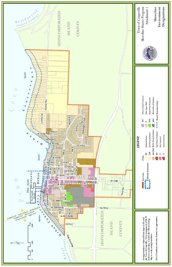
(Ord. No. 773, § 2(Exh. A), 3-22-2022)
APPENDIX B - USE TABLE
P=Shoreline Permitted Use X=Shoreline Prohibited Use C=Shoreline Conditional Use V=Shoreline Variance
Footnotes:
1. Except within critical areas.
2. Prohibited except for public access/recreation, beach restoration, beach nourishment, habitat enhancement.
3. Except for temporary parking and vehicle access to water-dependent uses.
4. Except for water-dependent uses and public access.
(Ord. No. 773, § 2(Exh. A), 3-22-2022)
16.30.010 - Title.
This document shall be known and may be cited as the Shoreline Master Program for the Town of Coupeville, Washington.
(Ord. No. 773, § 2(Exh. A), 3-22-2022)
16.30.020 - Short title.
This document may be referred to internally as the master program.
(Ord. No. 773, § 2(Exh. A), 3-22-2022)
16.30.030 - Official map.
A.
There is hereby made a part of this master program a map which shall be known officially as the Town of Coupeville shoreline designated environments map, but which for purposes of brevity, may be referred to as the map. The map shall show all areas of Coupeville which fall under the jurisdiction of this master program and the official designated environments for all affected lands and water. The map is attached to the ordinance from which this chapter is derived as Attachment 1.
B.
There shall be two official copies of the map, one of which shall reside in the custody of the Town of Coupeville, and the other at the Washington State Department of Ecology. Whenever any portion of either map is legally amended, the official copies shall be altered promptly to reflect that amendment.
C.
As the map is an inseparable part of this master program, no part of the map may be altered or amended without the approval of the Washington State Department of Ecology, as provided in RCW 90.58.090.
D.
When questions arise as to the precise boundaries of any designated environment, the shoreline administrator shall make the final determination.
E.
Unofficial copies of the map may be included herein and prepared for administrative purposes as needed.
(Ord. No. 773, § 2(Exh. A), 3-22-2022)
16.30.040 - Mandate, plan development, purpose, general applicability, background and analysis/inventory, and restoration.
A.
Mandate. In November 1972, the people of the State of Washington enacted the Shoreline Management Act (RCW 90.58) referred to herein as the Act. The primary purpose of the Act is to provide for the management and protection of the state's shoreline resources by planning for reasonable and appropriate uses. The law provides a two-tier planning effort by the state and local government.
B.
Plan Development. In order to protect the public interest in the preservation of the shorelines of the state, the Act establishes a planning program coordinated between the state and local jurisdictions to address the types and effects of development occurring along the state's shorelines. By law, the Town is responsible for the following:
1.
Development of an inventory of the natural characteristics and land use patterns along shorelines covered by the Act. This inventory provides the foundation for development of a system that classifies the shoreline into distinct environments. These environments provide the framework for implementing shoreline policies and regulatory measures.
2.
Preparation of a master program to determine the future of shoreline development. This future is defined through the goals developed for the following land and water use elements: economic development, public access, circulation, recreation, shoreline use, conservation, historical/cultural protection, and floodplain management. The Town may adopt goals for any other elements, which, because of present uses or future needs, are deemed appropriate and necessary to implement the intent of the Act. In addition, policy statements are developed to provide a bridge between the goals of the master program and the use activity regulations developed to address different types of development along the shoreline. Master program regulations are developed and adopted, as appropriate, for various types of shoreline development, including the following: agriculture, aquaculture, forest management, commercial development, marinas, mining, outdoor advertising and signs, residential development, utilities, ports and water-related industries, bulkheads, breakwaters, jetties and groins, landfills, solid waste disposal, dredging, shoreline protection, road and railroad design, piers, and recreation.
3.
Development of a permit system to further the goals and policies of both the Act and the local master program.
C.
Purpose. This master program implements the Act and the master program requirements of WAC Chapter 173-26. It establishes the policies and regulations for the protection and development of the shoreline of the Town of Coupeville. Its purpose is to identify the specific legal requirements that future development along Coupeville's shoreline must follow. The master program is intended to implement the Act by planning for and guiding orderly development of the shoreline, protecting shoreline resources, and promoting public access, all consistent with the Town's comprehensive plan, as required by WAC 365-196-500, and consistent with the Town's development regulations adopted under RCW 36.70A.
D.
General Applicability. This master program shall apply to all land and waters in or under the jurisdiction of the Town of Coupeville as the same may fall under jurisdiction of RCW Chapter 90.58, the Act. The master program provides goals, policies and regulations that are additional to all other ordinances of the Town of Coupeville. If the provisions of the master program conflict with other applicable local ordinances, policies, and regulations, the most restrictive shall apply. Changes to the comprehensive plans and associated ordinances shall be consistent with the policies of the Act and this master program pursuant to RCW 90.58.340.
E.
Background. The Town of Coupeville has a 2.4-mile long shoreline along Penn Cove, which forms the Town's north boundary. Historically, much of Coupeville's growth and development has been linked to and influenced by its waterfront. The historic shoreline area along Front Street in the Town's commercial waterfront core is a major focal point for the Town. The older buildings that line this street were once the center of commerce for the Town and Central Whidbey. The Town's master program allows uses within the historic town site that are historical in nature, environmentally suitable, economically sustainable, and supportive and consistent with the Town's comprehensive plan. The master program and its associated implementing regulations support the continued use of existing over-water historic structures for such uses as well as the rehabilitation, repair, and reconstruction of such structures. The conclusion of the Town's shoreline analysis was that water-dependent uses were not a significant component of the Town's historical fabric; not consistent with the Town's comprehensive land use goals and objectives; and not culturally or environmentally suitable for Town's commercial waterfront. While early on the Town did rely on marine transportation for commerce (at least three wharfs supporting commerce previously existed), the actual historical use of the shoreline area has never been water-related. While the historic Port of Coupeville Wharf partially supports a water-dependent recreational use, it relies on non-water dependent uses for its economic base. Only the Town's Captain Coupe Park boat launch and recreational dock and the co-located wastewater treatment plant remain as water-dependent uses. As a result, the Town's master program, while allowing limited water-related uses, guides and directs development consistent with the Town comprehensive plan and with historical and existing uses. The master program also protects the historically significant [structures] existing over-water structures and categorizes them as pre-existing structures under RCW 90.58.270, which specifically recognizes this class of pre-existing use, declaring that "Nothing in this statute shall constitute authority for requiring or ordering the removal of any structures, improvements, docks, fills, or developments placed in navigable waters prior to December 4, 1969."
Most of these buildings house businesses that serve tourism and are not water-oriented or water-dependent uses. Many of these private property ownerships extend waterward to the meander line and therefore include a portion of the tidelands. The historic town commercial waterfront core includes waterfront structures that were constructed, in part, on pilings over privately owned tidelands and also include some parcels containing bulkheads used to contain fill which extends into what was previously an intertidal area. Vacant or partially vacant parcels were occupied in the past by a combination of over-water structures, i.e. small wharves and buildings. A floating pedestrian way (which at low tide rested on the intertidal area) previously connected town core uplands to the Coupeville wharf.
Outside of the historic business district, Coupeville's shoreline is primarily low density residential. Near the center of town, the lots are small and the homes are older. Further to the east and west, the homes are more dispersed and the shoreline takes on a rural appearance. Unlike other shoreline towns where the waterfront acts as a magnet for intense development activity, Coupeville's shoreline is not densely developed. The location of the Town Park and Coupe Park, which includes a boat launch with day use moorage, at either end of the downtown core contribute to the open character of the shoreline, as do the narrow, undeveloped bluff edges next to the road along much of the shore. The town's wastewater treatment plant is incorporated into Coupe Park.
Coupeville's historic importance has been recognized by designation as a National Historic District in 1973 and by inclusion in the Ebey's Landing National Historical Reserve in 1978. The Town maintains a list of fifty-two (52) historic structures within the town limits. Eighteen (18) of the fifty-two (52) structures lie within the shoreline jurisdiction. Fifteen (15) of the eighteen (18) structures lie along Front Street in the town's commercial waterfront core. It is of paramount importance to the Town, state, and National Park Service that these historic structures have a viable economic use and be allowed to be repaired, rehabilitated, and even reconstructed. In addition, there are forty (40) structures in the area surrounding the town that are National Register listed properties.
The Coupeville Wharf property is owned by the Port of Coupeville, and offers a combination of retail/commercial space with facilities for transient moorage and limited water-dependent services. The current floating dock moorage extends one hundred seventy (170) feet off the east side of the wharf. There is also an existing ten-foot by ninety-foot floating dock on the north side (sometimes referred to as the fueling float). A "Pump-A-Head" station is located near the middle of the fueling float, and connects with the existing sanitary system which serves the wharf businesses. The port leases land from the State of Washington pursuant to an aquatic lands lease managed by the Department of Natural Resources (DNR). The parcels leased from DNR total approximately seven acres in size and include unplatted tidelands of the first class and bedlands below the line of mean low tide. The port facilities include a marine fueling operation with an underground two-compartment, monitored fuel storage tank adjacent to the port's upland business office. In addition, the port owns tidelands along the historic town waterfront, waterward of the meanderline.
F.
Inventory/Analysis. The Town's master program incorporates all pertinent and available information, existing inventory/analysis data and materials from state agencies, affected Indian tribes, watershed management planning, port districts and other appropriate sources. The Town of Coupeville Shoreline Master Program Phase 1 Shoreline Analysis Report, adopted by reference, discusses and illustrates the significant natural and man-made features of the town's shoreline including:
1.
Shoreline and adjacent land use patterns and transportation and utility facilities, including the extent of existing structures.
2.
Critical areas, including wetlands, aquifer recharge areas, fish and wildlife conservation areas, geologically hazardous areas, and frequently flooded areas.
3.
Areas of special interest, such as priority habitats, previously identified toxic or hazardous material clean-up sites, or eroding shorelines.
4.
Conditions and regulations in shorelands and adjacent areas that affect shorelines, such as zoning regulations.
5.
Existing and potential shoreline public access sites, including public rights-of-way.
In addition, the Town prepared a second use analysis which focused on the historical uses of the town's commercial core. This document, Town of Coupeville Shoreline Master Program Shoreline Use—Historical and Future Uses is also adopted by reference.
G.
Restoration. Consistent with WAC 173-26-186(8)(c), this master program includes goals, policies, incentives, and actions for restoration of impaired shoreline ecological functions. These master program provisions are designed to achieve overall improvements in shoreline ecological functions over time, when compared to the status upon adoption of the master program. The Town of Coupeville Shoreline Master Program Phase 1 Restoration Plan is adopted by reference. Certain priority, but illustrative, restoration projects are identified herein.
(Ord. No. 773, § 2(Exh. A), 3-22-2022)
16.30.050 - Applicability to persons.
This master program shall apply to every person, individual, firm, partnership, association, corporation, local or state governmental agency, public or municipal corporation, or other nonfederal entity which develops, owns, leases or administers lands, shorelands or waters which fall under jurisdiction of the Act.
(Ord. No. 773, § 2(Exh. A), 3-22-2022)
16.30.060 - Applicability to federal agencies.
A.
Federal agencies shall not be required to obtain permits for substantial developments undertaken by the federal government on lands owned in fee simple by the federal government, except in those cases where the federal government grants or reserves to the Town substantial jurisdiction over activities on those lands; provided, that if and when the Washington State Shoreline Management Program is approved under the Federal Coastal Zone Management Act (16 U.S.C. § 1451 et seq.), the federal government shall be subject to the State Shoreline Management Act, as provided by the Coastal Zone Management Act.
B.
The substantial development permit system shall apply to nonfederal activities constituting substantial developments undertaken on lands subject to nonfederal ownership, lease or easement even though such land may fall within the external boundaries of federally-owned lands.
C.
The substantial development permit system shall apply to substantial development undertaken on lands not federally owned but under lease, easement, license, or other similar property right short of fee ownership, to the federal government.
D.
See 16.13 CTC Ebey's Landing National Historical Reserve Design Review and Community Design Standards for the historical preservation district design regulations and procedures.
(Ord. No. 773, § 2(Exh. A), 3-22-2022)
16.30.070 - Applicability to development.
A.
This master program shall apply to all development as defined in herein. No development shall be undertaken on the local shoreline except development that is consistent with the policies of the master program.
B.
As provided under RCW 90.58.900, the Act is exempted from the rule of strict construction; the Act and this master program shall, therefore, be liberally construed to give full effect to the purposes, goals, policies, and standards for which the Act and this master program were enacted. On the other hand, exemptions from the Act or master program are to be narrowly construed.
(Ord. No. 773, § 2(Exh. A), 3-22-2022)
16.30.080 - Requirement for permit.
A.
No development shall be undertaken on the local shoreline until a permit for such development has been approved in accordance with this master program, except development which falls within the exemptions stated herein. All work undertaken pursuant to a substantial development permit shall proceed in compliance with the permit and with the applicable local and state regulations.
B.
Whenever a development falls within the exemptions stated herein, and the development is subject to a U.S. Corps of Engineers Section 10 permit under the Rivers and Harbors Act of 1899, or a Section 404 permit under the federal Water Pollution Control Act of 1972, the Town shall prepare a letter addressed to the applicant and the regional office of the Department of Ecology, exempting the development from the shoreline substantial development permit requirements of RCW Chapter 90.58.
(Ord. No. 773, § 2(Exh. A), 3-22-2022)
16.30.090 - Exemptions from substantial development.
A.
Exempt developments, which are outlined below, shall not require a substantial development permit, but shall require a written exemption approval from the Town. A project that qualifies as "exempt development" may nevertheless require a conditional permit, and/or a variance from master program provisions. The request for the permit exemption shall be in writing, on forms provided by the Town, and include the information required by the Town. Exempt development must be consistent with the policy and provisions of the Act pursuant to WAC 173-27-140(1) which states:
"No authorization to undertake use or development on shorelines of the state shall be granted by local government unless upon review the use or development is determined to be consistent with the policy and provisions of the Shoreline Management Act and the master program." (Bold emphasis added.)
B.
Incremental Exemptions. Exemptions shall not be issued for a series of inter-dependent activities that in sum would require a permit (i.e., a project cannot be submitted in a piece-meal fashion to avoid the requirement for a substantial development permit).
C.
The following developments shall not require substantial development permits. This list of exemptions is amplified and supplemented by provisions of WAC 173-27-040, as amended from time to time.
1.
Work or activities which are not substantial development, as defined herein.
2.
Normal maintenance and repair of existing structures or developments, including repair of damage by accident, fire or the elements.
3.
Construction of the normal protective bulkhead common to single-family residences; provided, that such bulkheads are entirely located at or landward of the ordinary high water mark (OHWM).
4.
Construction of a single-family residence, including normal appurtenances, on shorelands by an owner, lessee or contract purchaser, for his or her own use or the use of his or her family, which residence does not exceed a height of twenty-eight (28) feet above average grade level (see also definition of vertical datum) and which meets all requirements of the state agency or local government having jurisdiction.
5.
Construction of a dock, including a community dock, designed for pleasure craft only, for the private noncommercial use of the owner, lessee, or contract purchaser of single- and multiple-family residences. This exception applies if the fair market value of the dock does not exceed two thousand five hundred dollars ($2,500.00); but if subsequent construction having a fair market value exceeding two thousand five hundred dollars ($2,500.00) occurs within five years of completion of the prior construction, the subsequent construction shall be considered a substantial development.
6.
Construction or modification of navigational aids such as channel markers.
7.
Watershed restoration projects as defined in WAC 173-27-040. The Town shall review the projects for consistency with the shoreline master program in an expeditious manner and shall issue its decision along with any conditions within forty-five (45) days of receiving all materials necessary to review the request for exemption from the applicant. No fee may be charged for accepting and processing requests for exemption for watershed restoration.
8.
Site exploration and investigation activities that are prerequisite to preparation of an application for development authorization under this chapter, if:
a.
The activity does not interfere with the normal public use of the surface waters;
b.
The activity will have no significant adverse impact on the environment including, but not limited to, fish, wildlife, fish or wildlife habitat, water quality, and aesthetic values;
c.
The activity does not involve the installation of any structure, and upon completion of the activity the vegetation and land configuration of the site are restored to conditions existing before the activity; and
d.
A private entity seeking development authorization under this section first posts a performance bond or provides other evidence of financial responsibility to the local jurisdiction to ensure that the site is restored to preexisting conditions.
9.
The external or internal retrofitting of an existing structure with the exclusive purpose of compliance with the Americans with Disabilities Act of 1990 (42 U.S.C. § 12101 et seq.) or to otherwise provide physical access to the structure by individuals with disabilities.
10.
Consistent with WAC 173-27-040, a public or private project designed to improve fish or wildlife habitat or fish passage, which conforms to the provisions of RCW 77.55.181.
In addition, those exemptions listed under RCW 90.58.030(3) as now exist or as hereinafter amended.
(Ord. No. 773, § 2(Exh. A), 3-22-2022)
16.30.100 - Exceptions to local review.
Developments not required to obtain shoreline permits or other local reviews under the SMA are listed under WAC 173-27-044 and WAC 173-27-045. Such developments include certain remedial actions; boatyard improvements related to NPDES compliance; WSDOT facility improvements; projects consistent with an environmental excellence program agreement; and projects authorized through the Energy Facility Site Evaluation Council process.
(Ord. No. 773, § 2(Exh. A), 3-22-2022)
16.30.110 - Application for shoreline substantial development, shoreline conditional use, or shoreline variance permits.
Any person desiring to apply for a shoreline substantial development, shoreline conditional use permit, or shoreline variance on any part of the shorelines of the state within the town, shall apply to the town planning department, using forms supplied by that office.
(Ord. No. 773, § 2(Exh. A), 3-22-2022)
16.30.120 - Definitions.
For the purpose of this chapter, the terms set out in this section shall have the meanings indicated. Unless stated to the contrary, the definitions contained in WAC 173-27-030, as amended from time to time, shall also apply. Finally, in instances where a definition is not shown below, refer to [Chapter] 16.04 CTC, General Provisions and Definitions.
"Act" means the Shoreline Management Act of 1971, Chapter 90.58 RCW, as amended from time to time.
"Adoption by rule" means an official action by the department to make a local government shoreline master program effective through rule consistent with the requirements of the Administrative Procedure Act, RCW Chapter 34.05, thereby incorporating the adopted shoreline master program or amendment into the state master program.
"AKART" means an acronym for "all known, available, and reasonable methods of prevention, control, and treatment" (WAC 173-201A-020). AKART shall represent the most current methodology that can be reasonably required for preventing, controlling, or abating the pollutants associated with a discharge. The concept of AKART applies to both point and nonpoint sources of pollution.
"Approval" means an official action by a local government legislative body agreeing to submit a proposed shoreline master program or amendments to the department for review and official action pursuant to this chapter; or an official action by the department to make a local government shoreline master program effective, thereby incorporating the approved shoreline master program or amendment into the state master program.
"Appurtenance" means a structure or development that is necessarily connected to the use and enjoyment of a single-family residence or other use and is located landward of the ordinary high water mark and the perimeter of a wetland. On a statewide basis, normal appurtenances include a garage; deck; driveway; utilities; fences; installation of a septic tank and drainfield and grading which does not exceed two hundred fifty (250) cubic yards and which does not involve placement of fill in any wetland or waterward of the ordinary high water mark.
"Aquaculture" means the culture or farming of fish, shellfish, or other aquatic plants and animals. Aquaculture does not include the harvest of wild geoduck associated with the state managed wildstock geoduck fishery.
"Aquatic" means all water bodies, including marine waters, lakes, rivers, and streams and their respective water columns and underlying lands, which are defined as shoreline of the state.
"Archaeological object" means an object that comprises the physical evidence of an indigenous and subsequent culture including material remains of past human life including monuments, symbols, tools, facilities, graves, skeletal remains and technological by-products.
"Archaeological resource/site" means a geographic locality in Washington, including, but not limited to, submerged and submersible lands and the bed of the sea within the state's jurisdiction, that contains archaeological objects. "Significant" is that quality in American history, architecture, archaeology, engineering, and culture that is present in districts, sites, buildings, structures, and objects that possess integrity of location, design, setting, materials, workmanship, feeling, and association, and:
1.
That are associated with events that have made a significant contribution to the broad patterns of our history; or
2.
That are associated with the lives of significant persons in our past; or
3.
That embody the distinctive characteristics of a type, period or method of construction, or that represent the work of a master, or that possess high artistic values, or that represent a significant and distinguishable entity whose components may lack individual distinction; or
4.
That have yielded, or may be likely to yield, information important in history or prehistory.
"Archaeology" means systematic, scientific study of the human past through material remains.
"Average grade level." See definition of "vertical datum."
"Bioengineering/biotechnical measures" means the practice of using natural vegetative materials to stabilize shorelines and prevent erosion. This may include use of bundles for stems, root systems, or other living plant material; soft gabions, fabric or other soil stabilization techniques; and limited rock toe protection where appropriate. The use of bioengineering as a shoreline stabilization technique is seen as an alternative to riprap, concrete and other structural solutions.
"Council" means the town council of Coupeville.
"Cumulative impact" means the impact on the environment which results from the incremental impact of the action when added to other past, present, and reasonably foreseeable future actions regardless of what agency or person undertakes such other actions. Cumulative impacts can result from individually minor but collectively significant actions taking place over a period of time.
"Department" means the Washington State Department of Ecology.
"Development" means a use involving the construction or exterior alteration of structures; dredging; drilling; dumping; filling; removal of sand, gravel or minerals; bulkheading; pile driving; placement of obstructions; or any project of a permanent or temporary nature which interferes with normal public use of the surface of waters at any water level and/or on lands subject to the Act. "Development" does not include dismantling or removing structures if there is no other associated development or re-development.
"Development regulations" means the controls placed on development or land uses by a county or town, including, but not limited to, zoning ordinances, critical areas ordinances, all portions of a shoreline master program other than goals and policies approved or adopted under RCW Chapter 90.58, planned unit development ordinances, subdivision ordinances, and binding site plan ordinances together with any amendments thereto.
"Drift cell," "drift sector," or "littoral cell" means a particular reach of marine shore in which littoral drift may occur without significant interruption and which contains any natural sources of such drift and also accretion shore forms created by such drift.
"Ecological functions" or "shoreline functions" means the work performed or role played by the physical, chemical, and biological processes that contribute to the maintenance of the aquatic and terrestrial environments that constitute the shoreline's natural ecosystem.
"Ecosystem-wide processes" means the suite of naturally-occurring physical and geologic processes of erosion, transport, and deposition; and specific chemical processes that shape landforms within a specific shoreline ecosystem and determine both the types of habitat and the associated ecological functions.
"Enhancement" means an action approved by the shoreline administrator and taken with the intention and probable effect of improving the condition and function of a shoreline area, such as improving environmental functions in an existing, viable, shoreline habitat by means of increasing plant diversity, increasing wildlife habitat, installing environmentally compatible erosion controls, or removing non-indigenous plant and/or animal species. Enhancement includes the alteration of an existing resource to improve or increase its characteristics and processes without degrading other existing functions. Enhancements are to be distinguished from resource creation or restoration projects.
"Feasible" means, for the purpose of this chapter, that an action, such as a development project, mitigation, or preservation requirement, meets all of the following conditions:
1.
The action can be accomplished with technologies and methods that have been used in the past in similar circumstances, or studies or tests have demonstrated in similar circumstances that such approaches are currently available and likely to achieve the intended results;
2.
The action provides a reasonable likelihood of achieving its intended purpose; and
3.
The action does not physically preclude achieving the project's primary intended legal use.
In cases where these guidelines require certain actions, unless they are infeasible, the burden of proving infeasibility is on the applicant. In determining an action's infeasibility, the reviewing agency may weigh the action's relative public costs and public benefits, considered in the short- and long-term time frames.
"Fair market value" means the open market bid price, of a development, for conducting the work, using the equipment and facilities, and purchase of the goods, services and materials necessary to accomplish the development. This would normally equate to the cost of hiring a contractor to undertake the development from start to finish, including the cost of labor, materials, equipment and facility usage, transportation and contractor overhead and profit. The fair market value of the development shall include the fair market value of any donated, contributed or found labor, equipment or materials.
"Fairway" means a navigable part of a river or bay through which boats enter or depart; a part of a harbor or channel that is kept open and unobstructed.
"Fill" means the addition of soil, sand, rock, gravel, sediment, earth retaining structure, or other material to an area waterward of the OHWM, in wetlands, or on shorelands in a manner that raises the elevation or creates dry land.
"Floating home" means a structure on water that is designed substantially as a permanently located structure by means of permanent utilities, anchoring design, and lack of adequate self-propulsion to operate as a vessel.
"Geotechnical report" or "geotechnical analysis" means a scientific study or evaluation conducted by a qualified expert that includes a description of the ground and surface hydrology and geology, the affected land form and its susceptibility to mass wasting, erosion, and other geologic hazards or processes, conclusions and recommendations regarding the effect of the proposed development on geologic conditions, the adequacy of the site to be developed, the impacts of the proposed development, alternative approaches to the proposed development, and measures to mitigate potential site-specific and cumulative geological and hydrological impacts of the proposed development, including the potential adverse impacts to adjacent and down-current properties. Geotechnical reports shall conform to accepted technical standards and must be prepared by qualified professional engineers (or geologists) who have professional expertise about the regional and local shoreline geology and processes.
"Grading" means the movement or redistribution of the soil, sand, rock, gravel, sediment, or other material on a site in a manner that alters the natural contour of the land.
"Habitat" means the place or type of site in which a plant or animal naturally or normally lives and grows.
"Height" means the measurement from the vertical datum to the highest point of the roof line. On any building constructed seaward of ordinary high water, the height shall be the measured from ordinary high water elevation. (See definition of "vertical datum".)
"Historic preservation professional" means those individuals who hold a graduate degree in architectural history, art history, historic preservation, or closely related field, with coursework in American architectural history, or a bachelor's degree in architectural history, art history, historic preservation or closely related field plus one of the following:
1.
At least two years of full-time experience in research, writing, or teaching in American architectural history or restoration architecture with an academic institution, historical organization or agency, museum, or other professional institution; or
2.
Substantial contribution through research and publication to the body of scholarly knowledge in the field of American architectural history.
"Historic sites" means any historic structure and the property on which it is situated and an area one hundred (100) feet from any historic structure or building. If at any future time, the property on which an historic building or structure is situated is subdivided, this section shall apply to the historic building or structure and that portion of the subdivision on which it sits and an area one hundred (100) feet from the historic structure or building.
"Historic structure" means any building or other construction which has been placed on the National Register of Historic Places and/or which has been designated as historically important by the Town.
"Houseboat" means a vessel used as a residence but designed substantially as a mobile structure by means of detachable self contained utilities or facilities, anchoring, and the presence of adequate self-propulsion to operate as a vessel.
"Letter of exemption" means a letter or other official certificate issued by the Town to indicate that a proposed development is exempted from the requirement to obtain a shoreline substantial development permit as provided in WAC 173-27-050. Letters of exemption may include conditions or other provisions placed on the proposal in order to ensure consistency with the Shoreline Management Act, this chapter, and the applicable master program.
"Littoral drift (or longshore drift)" means the natural movement of sediments along shorelines as a result of wave and wind action.
"Live-aboard vessel" means a vessel on which one or more people live for more than ninety (90) days, whether consecutive or not, in any calendar year. Also see "vessel" below.
"Local shoreline" means the shorelands located within the Town of Coupeville and all of the saltwater areas lying within the Town's jurisdiction.
"Manufactured home park" means any tract of land that is divided into rental spaces under common ownership or management for the purpose of locating two or more manufactured homes for dwelling purposes.
"Marine" means pertaining to tidally influenced waters, including oceans, sounds, straits, marine channels, and estuaries, including the Pacific Ocean, Puget Sound, Straits of Georgia and Juan de Fuca, and the bays, estuaries and inlets associated therewith.
"May" means the action is acceptable, provided it conforms to the provisions of this master program and SMA.
"Mean high water (MHW)"means the average height of the high waters over a nineteen-year period.
"Mean higher high water (MHHW)" means the arithmetic average of the elevations of the higher high waters of a mixed tide over a specific nineteen-year period. For shorter periods of observation, corrections are applied to eliminate known variations and reduce the result to the equivalent of a mean nineteen-year interval.
"Mean lower low water" or "MLLW" means the 0.0 tidal elevation. It is determined by averaging each day's lowest tide at a particular location over a period of nineteen (19) years. It is the tidal datum for vertical tidal references in the saltwater area.
"Mitigation" or "mitigation sequencing" means the process necessary to avoid, minimize or reduce, or compensate for the environmental impact(s) of a proposal (see WAC 197-11-768 and WAC 173-26-201(2)(e)). Mitigation or mitigation sequencing means the following sequence of steps listed in order of priority, with 1. of this subsection being top priority:
1.
Avoiding the impact altogether by not taking a certain action or parts of an action;
2.
Minimizing impacts by limiting the degree or magnitude of the action and its implementation by using appropriate technology or by taking affirmative steps to avoid or reduce impacts;
3.
Rectifying the impact by repairing, rehabilitating, or restoring the affected environment;
4.
Reducing or eliminating the impact over time by preservation and maintenance operations;
5.
Compensating for the impact by replacing, enhancing, or providing substitute resources or environments; and
6.
Monitoring the impact and the compensation projects and taking appropriate corrective measures.
"Mixed-use project" means projects that include water-dependent uses combined with water-related uses, water-enjoyment uses and/or non-water-oriented uses. Water-dependent uses must comprise more than fifty (50) percent of the development. Mixed-use developments can be a tool for increased water-dependent activities, civic revitalization, and public access to the shoreline.
"Mooring space" means thirty (30) lineal feet of dock space located entirely seaward of the minus four-foot line at MLLW.
"Must" means a mandate; the action is required.
"Natural system" means a group of related objects and/or forces existing in nature.
"Nonconforming lot" means a lot that met dimensional requirements of the applicable master program at the time of its establishment but now contains less than the required width, depth or area due to subsequent changes to the master program.
"Nonconforming structure" means an existing structure that was lawfully constructed at the time it was built but is no longer fully consistent with present regulations such as setbacks, buffers or yards; area; bulk; height or density standards due to subsequent changes to the master program.
"Nonconforming use" means an existing shoreline use that was lawfully established prior to the effective date of the Act or the applicable master program, but does not conform to present use regulations due to subsequent changes to the master program.
"Non-water-oriented uses" means those uses that are not water-dependent, water-related, or water-enjoyment.
"Normal appurtenances to a single-family residence." See appurtenances.
"Ordinary high water mark (OHWM)" means the mark on all tidal water that will be found by examining the banks and determining where the presence and action of water are so common and usual and so long continued in all ordinary years, as to mark on the soil a character distinct from that of the abutting upland in respect to vegetation, as it existed on the effective date of the Act or as it may have changed naturally thereafter, or as it may have changed thereafter in accordance with permits issued by the Town or the Department of Ecology. In any location where the ordinary high water mark cannot be found, OHWM shall be the line of mean higher high tide.
"Priority habitat" means those habitat types or elements with unique or significant value to one or more species. A priority habitat may consist of a unique vegetation type or dominant plant species, a described successional stage, or a specific structural element. Priority habitats and species are identified by the state Department of Fish and Wildlife.
"Priority species" means any fish or wildlife species requiring protective measures and/or management guidelines to ensure their persistence as genetically viable population levels as classified by the Washington Department of Fish and Wildlife, including endangered, threatened, sensitive, candidate and monitor species, and those of recreational, commercial, or tribal importance. Priority habitats and species are identified by the state Department of Fish and Wildlife.
"Priority use" means preferred shoreline uses under the Act and this master program, including uses that are water-dependent or water-related, provide public access and recreational use of the shoreline, as well as other uses which provide an opportunity for substantial numbers of people to enjoy the shoreline and to single-family residences. (See RCW 90.58.020.)
"Public access" is an unobstructed access available to the general public to enjoy the local shoreline. Primary public access is a means of physical approach to and along the water's edge. Views to the water are considered a secondary type of public access. Public access may combine visual and physical elements in a variety of ways and generally means access without charge or cost to the public. Whenever public access is made available only in exchange for payment of some cost or charge, whether direct or indirect, it shall not be deemed to satisfy the public access requirements of this program unless, under all of the circumstances, it is clear that large numbers of the public will be likely to enjoy the access on a regular basis at a cost that would not be unreasonable, or prohibitive to any segment of the public.
"Public shoreline view" means a view of the local shoreline and all saltwater and all territorial views beyond the saltwater, or any significant portion thereof, that is consistently available to general members of the public from any street, park, or other publicly owned area, or any such view that is consistently available to substantial numbers of people from privately-owned property that is open to use by general members of the public on a regular basis.
"Restore," "restoration" or "ecological restoration" means the significant reestablishment or upgrading of impaired ecological shoreline processes or functions. This may be accomplished through measures including, but not limited to, re-vegetation, removal of intrusive shoreline structures and removal or treatment of toxic materials. Restoration does not necessarily imply a requirement for returning the shoreline area to aboriginal or pre-European settlement conditions.
"Sedimentation" means the process by which material is transported and deposited by water or wind.
"Shall" means a mandate; the action must be done.
"Shorelands" means those lands extending landward for two hundred (200) feet in all directions as measured on a horizontal plane from the ordinary high water mark.
"Shoreline administrator" means the town planner of the Town of Coupeville or his or her designated representative.
"Shoreline permit" means a substantial development permit, conditional use permit, variance, or any combination thereof.
"Shorelines" means all the water areas of the state and underlying land, including associated shorelands, except shorelines of statewide significance.
"Shorelines of statewide significance" means those areas of Puget Sound and the Strait of Juan de Fuca and adjacent saltwater north to the Canadian line and lying seaward from the line of extreme low tide.
"Shorelines of the state" are the total of all "shorelines" and "shorelines of statewide significance" within the state.
"Should" means that the particular action is required unless there is a demonstrated, compelling reason, based on policy of the Shoreline Management Act and WAC Chapter 173-26, against taking the action.
"Significant vegetation removal" means the removal or alteration of trees, shrubs, and/or ground cover by clearing, grading, cutting, burning, chemical means, or other activity that causes significant ecological impacts to functions provided by such vegetation. The removal of invasive or noxious weeds does not constitute significant vegetation removal. Tree pruning, not including tree topping, where it does not affect ecological functions, does not constitute significant vegetation removal.
"Slip" means the developed space, in the aquatic environment, occupied or capable of being occupied by one vessel, regardless of length.
"Structure, over-water" means any device or structure located waterward of the ordinary high water mark, including, but not limited to, piers, docks, floats, and moorage or anchor buoys and buildings constructed on piers or perimeter rock foundations. Existing legally-established buildings constructed on fill are not considered over-water structures under this master program.
"Substantial development" means any development of which the total cost or fair market value, whichever is higher, exceeds seven thousand forty-seven dollars ($7,047.00) adjusted for inflation by the office of financial management every five years, beginning July 1, 2007, based upon changes in the consumer price index during that time period, or any development which materially interferes with normal public use of the water or shorelines, except as provided herein.
"Transient residential" means the rental of any building or portion thereof for the purpose of providing lodging for compensation for periods of thirty (30) days or less.
"Use" means the purpose which land or buildings or structures now serve, or for which they are occupied, maintained, arranged, designed or intended.
"Use, accessory" means a use of property or of a building or portion thereof customarily incidental and subordinate to the principal use of the land or building, and located on the same lot with the principal use.
"Use, principal" means the primary or predominant use to which the property or building is or may be devoted, and to which all other uses on the same lot are accessory.
"Utility, accessory" includes on-site utility features serving a primary use, such as water, sewer, or a gas line to a residence, and shall be considered part of the primary use.
"Utility, major" includes substations, new treatment plants, sanitary sewer outfalls, electrical transmission lines greater than fifty-five thousand (55,000) volts, water, sewer or storm drainage mains greater than eight inches in diameter, gas and petroleum transmission lines, and submarine telecommunications cables.
"Utility, minor" includes minor expansions to existing treatment plants, local public water, electric, natural gas distribution, public sewer collection or treated wastewater distribution lines, cable and telephone service and appurtenances.
"Vertical datum" means the base elevation used for measuring height. It is calculated by adding the lowest elevation within five feet of an exterior wall to the highest elevation within five feet of an exterior wall on the same building, then dividing the result by two. The highest and lowest points shall be located on the historical or original grade, as determined by the building official.
"Vessel" means a ship, boat, barge, or any other floating craft which is designed and used for navigation and which does not interfere with the normal public use of the water.
"Water-dependent use" means a use or portion of a use that cannot exist in a location that is not adjacent to the water but is dependent on the water by reason of the intrinsic nature of its operations. Examples of water-dependent uses include ship cargo terminal loading areas, fishing, ferry and passenger terminals, barge loading facilities, ship building and dry docking, marinas, aquaculture, float plane facilities, hydroelectric dams, surface water intake, and sewer outfalls.
"Water-enjoyment use" means a recreational use or other use that facilitates public access to the shoreline as a primary characteristic of the use; or a use that provides for recreational use or aesthetic enjoyment of the shoreline for a substantial number of people as a general characteristic of the use and that through location, design, and operation ensures the public's ability to enjoy the physical and aesthetic qualities of the shoreline. In order to qualify as a water-enjoyment use, the use must be open to the general public and the shoreline-oriented space within the project must be devoted to the specific aspects of the use that fosters shoreline enjoyment. Primary water-enjoyment uses may include, but are not limited to:
1.
Parks with activities enhanced by proximity to the water;
2.
Piers and other improvements that facilitate public access to shorelines of the state;
3.
Restaurants meeting the requirements of this definition;
4.
Public access improvements, including visual access, that are dedicated to the general public;
5.
Museums with an orientation to shoreline topics;
6.
Aquariums;
7.
Scientific/ecological reserves;
8.
Retail businesses housed in mixed use projects designed to take advantage of a waterfront location and that display and sell merchandise oriented to marine uses.
"Water-oriented use" means any one or a combination of water-dependent, water-related or water-enjoyment uses.
"Water-related use" means a use or portion of a use that is not intrinsically dependent on a waterfront location but whose economic viability is dependent upon a waterfront location because:
1.
The use has a functional requirement for a waterfront location such as the arrival or shipment of materials by water or the need for large quantities of water; or
2.
The use provides a necessary service supportive of the water-dependent uses and the proximity of the use to its customers makes its services less expensive and/or more convenient.
"Waterfront" means those portions of the shoreline area that are not separated from the water by a public street or road.
"Water quality" means the physical characteristics of water within shoreline jurisdiction, including water quantity, hydrological, physical, chemical, aesthetic, recreation-related, and biological characteristics. Where used in this chapter, the term "water quantity" refers only to development and uses regulated under this chapter and affecting water quantity, such as impermeable surfaces and stormwater handling practices. Water quantity, for purposes of this chapter, does not mean the withdrawal of ground water or diversion of surface water pursuant to RCW 90.03.250 through 90.03.340.
(Ord. No. 773, § 2(Exh. A), 3-22-2022)
16.30.130 - General.
The Act designates certain water areas of the state as shorelines of statewide significance. Water areas so designated are important to the entire state. Because these areas are resources from which all people in the state benefit, the Town's master program gives preference to uses of such areas which favor public and long-range goals.
(Ord. No. 773, § 2(Exh. A), 3-22-2022)
16.30.140 - Designation of shorelines of statewide significance.
The state Legislature has designated all salt waters surrounding the islands of Island County, seaward from the line of extreme low tide, as shorelines of statewide significance.
(Ord. No. 773, § 2(Exh. A), 3-22-2022)
16.30.150 - Policies governing the use of shorelines of statewide significance.
A.
Introduction. The Act establishes policies which govern the use of shorelines of statewide significance. All proposed activities within shorelines of statewide significance must first be consistent with the policies of this section before meeting the other provisions of this master program. Uses which are consistent with the following policies, cited in order of descending preference, shall be given preference by local government. Uses which are not generally consistent with these policies should not be permitted on shorelines of statewide significance.
B.
Policies.
1.
The statewide interest should be recognized and protected over the local interest on shorelines of statewide significance.
2.
The natural character of shorelines of statewide significance should be preserved. Shorelines of statewide significance should be used in ways which will produce long-term benefits as opposed to short-term benefits or conveniences.
3.
Actions that would commit resources to irreversible uses or would detrimentally alter natural conditions characteristic of such shorelines should be severely limited.
4.
The short-term economic gain or convenience associated with a proposed development should be evaluated in relationship to long-term and potentially costly impairments to the natural environment.
5.
The visual impact of every proposed project should be thoroughly evaluated and adverse impacts should be minimized.
6.
The natural resources and natural systems of shorelines of statewide significance should be protected. Areas containing unusual or fragile natural resources or natural systems should be left undeveloped.
7.
Public access to publicly owned areas of the shorelines of statewide significance should be increased.
8.
Recreational opportunities for the public in shorelines of statewide significance should be increased.
(Ord. No. 773, § 2(Exh. A), 3-22-2022)
16.30.160 - General.
A.
The Act establishes eight land and water use elements to be incorporated into every master program when appropriate. These are shoreline use, economic development, public access, circulation, recreation, conservation, flood damage prevention, and historic and cultural preservation.
The Coastal Zone Management Act (CZMA) requires participating states to give priority consideration to water-dependent uses when planning major facilities in the coastal zone. It encourages states to develop policies to balance the competing demands on finite coastal resources, such as sites suitable for water-dependent uses, and to implement these policies by:
1.
Preserving existing water-dependent uses;
2.
Reserving appropriate vacant lands for water-dependent uses; and
3.
Designating lands for redevelopment with water-dependent uses.
The Act establishes the concept of preferred uses of shoreline areas. According to RCW 90.58.020, "uses shall be preferred which are consistent with control of pollution and prevention of damage to the natural environment, or are unique to or dependent upon use of the state's shorelines." If alteration of the natural condition of the shorelines is allowed, priority is given to the following uses:
1.
Single family residences;
2.
Ports;
3.
Shoreline recreational uses;
4.
Industrial and commercial developments that are particularly dependent upon their location on, or use of, the shorelines; and
5.
Other developments which will provide an opportunity for substantial numbers of people to enjoy the shorelines.
While the Act does not categorically prohibit all non-water-dependent uses, water-dependent uses are nevertheless preferred. The concept of use preferences is particularly applicable to shorelines under intense development pressure for port and harbor-related industrial activity where shorelines are limited and extremely valuable.
RCW 90.58.020 states, that "coordinated planning is necessary in order to protect the public interest associated with the shorelines of the state while, at the same time, recognizing and protecting private property rights consistent with the public interest. There is, therefore, a clear and urgent demand for a planned, rational, and concerted effort, jointly performed by federal, state, and local governments, to prevent the inherent harm in an uncoordinated and piecemeal development of the state's shorelines. It is the policy of the state to provide for the management of the shorelines of the state by planning for and fostering all reasonable and appropriate uses. This policy is designed to insure the development of these shorelines in a manner which, while allowing for limited reduction of rights of the public in the navigable waters, will promote and enhance the public interest. This policy contemplates protecting against adverse effects to the public health, the land and its vegetation and wildlife, and the waters of the state and their aquatic life, while protecting generally public rights of navigation and corollary rights incidental thereto."
Comprehensive planning under the Growth Management Act (GMA) and the implementing land use controls are the most widely-used tools to guide, control and assure water-dependent uses of appropriate waterfront lands, i.e. what mix of water-dependent uses best fits the "community vision" for its waterfront. Water-dependent uses and businesses include international shipping facilities, marinas, mooring areas, yacht clubs, boat yards, commercial and recreational fishing operations, facilities for shipping petroleum products and aggregates, ferry landings, and various support facilities for waterborne commerce and recreation. Together these uses generate billions of dollars for the state's economy and are vital to the economic health and character of most waterfront communities.
The preservation of land for water-dependent uses must be viewed on a statewide basis and not limited to local communities. Any program to preserve water-dependent uses needs to be based on a scientifically sound inventory of sites and their suitability for such purposes. Information on the quality, quantity and location of this limited resource needs to be specific enough to identify conflicting uses so that rational policy choices can be made. The program is complete only when zoning or other appropriate measures are in place which assures that the appropriate policy choices will be carried out. Accurate determination of resource capabilities within the planning area and a credible analysis of the benefits and adverse impacts of possible uses, both public and private, carefully considered in an open process should lead to results the community can accept. Unique historic, environmentally sensitive, and scenic waterfront communities like the Town should allow non-water-dependent uses consistent with the history of the town and the adopted plans of a community.
The Coastal Zone Management Act (CZMA) requires the reservation of vacant lands appropriate for water-dependent uses. Town officials do not consider development of water-dependent uses, beyond the limited expansion of the Port of Coupeville's transient boat moorage to be an economically nor environmentally viable endeavor, as such would necessitate the dredging of the low-tide terrace and/or the construction of additional potentially multiple pier systems. Each of these would come with significant environmental impacts to nearshore habitats. In addition such uses do not represent the documented historical uses. As a result the master program allows more economically viable, non-water-dependent upland uses in the Historic Urban designation.
B.
The following goals and policies provide the foundation on which this entire master program rests.
(Ord. No. 773, § 2(Exh. A), 3-22-2022)
16.30.170 - Shoreline use.
A.
Goals.
1.
To meet the requirement of RCW 90.58.100(2)(e) and address the proposed general distribution and general location and extent of uses on shorelines and adjacent land areas for housing, business, industry, transportation, agriculture, natural resources, recreation, education, public buildings and grounds, and other categories of public and private uses of the land.
2.
The Town seeks to establish and implement policies and regulations for land uses that are consistent with the requirements of the Act, the Shoreline Guidelines, and the GMA, and that promote a mixture of reasonable and appropriate shoreline uses that enhances the town's character, emphasizes the town's economic base, fosters and protects its historic and cultural identity, protects environmental resources and achieves a net ecosystem improvement over time.
3.
To assure the optimum opportunity for participation by local residents in the decision-making processes that may affect the unique character of the town's shoreline.
B.
Policies.
1.
As most of the factors that create the unique character of the town depend upon the type of development that occurs within the local shoreline, preservation of Coupeville's uniqueness requires that all such development be essentially consistent with the pattern, scale, and character of existing development within the local shoreline and its adjacent land areas. Evaluation of proposed development shall include consideration of the impact upon the town's character defining features when viewed from the water, as well as from the land. Uses which protect the potential long term benefits to the public against compromise for reasons of short-term economic gain or convenience should be fostered.
2.
Allow non-water oriented uses within existing historic over-water structures in the historic urban and urban aquatic environments as a means of promoting preservation/rehabilitation of historic buildings and revitalization of the town as a whole.
3.
In regulating uses in the historic urban and urban aquatic environments, first priority should be given to water-dependent uses. Second priority should be given to water-related and water-enjoyment uses. However, the analysis of water-dependent use needs as described in WAC 173-26-201(3)(d)(ii) demonstrated that the needs of existing and envisioned water-dependent and water-related uses for the planning period have been met. Therefore, provisions allowing for a mix of water-dependent with water-oriented and/or non-water-oriented uses in new over-water structures have been established herein.
4.
Allow uses that are consistent with the Town's comprehensive plan within the historic urban environment upland of ordinary high water. Allow restoration and minor expansions of existing historic structures, as a means of maintaining the economic base of the town and fostering preservation/rehabilitation of historic structures and revitalization of the district as a whole.
5.
Shoreline areas outside of the historic urban environment should be reserved for low density residential uses, public infrastructure, or recreational uses.
6.
New residential development should be designed to protect existing shoreline and water views, promote public safety, and avoid adverse impacts to marine bluffs and nearshore habitat.
7.
All activities, development, and redevelopment should be located, designed and operated to ensure public safety, enhance public access, and achieve no net loss of shoreline ecological functions.
8.
Continuing studies of the physical and economic aspects of shoreline systems should be encouraged in order to provide a continuously updated information base against which the impact of any proposed shoreline or water use can be measured.
9.
All known, available and reasonable methods of prevention, control and treatment (AKART) are required for all developments and redevelopments to prevent, control, or abate the pollutants associated with any discharge. This requirement applies to both point and nonpoint sources of pollution.
10.
The goals and policies of this master program should be considered in all land use decisions that affect uplands adjacent to the shoreline.
(Ord. No. 773, § 2(Exh. A), 3-22-2022)
16.30.180 - Economic development.
A.
Goals.
1.
To foster a balanced, diversified and sustainable local economy that contributes to Coupeville's high quality of life, through the protection and enhancement of the community's natural, historical, and cultural amenities, and the improvement of the financial well-being of its residents.
2.
Protect and preserve existing historic waterfront buildings which are defining features of the town and the Ebey's Landing National Historical Reserve.
3.
To acknowledge the critical importance of a balanced local economy for the long-range well-being of the Town and the island community, by evaluating proposals for economic development along the shoreline with regard to the degree to which physical, economic, and social qualities of the town will be enhanced.
4.
To support the initiation of passenger-only ferry services from the Town to other Island County and Puget Sound urban areas.
5.
To assist the Port of Coupeville in the development and implementation of master programs for port properties that are consistent with the GMA and the master program.
B.
Policies.
1.
In recognition of the fact that the economic foundation of the Ebey's Landing National Historical Reserve and the town's waterfront businesses is tourism based and not water-dependent, development within the local shoreline areas that is consistent with historical development patterns is a priority of this master program.
2.
Continued use of existing, over-water historic structures for most uses allowed under the Town comprehensive plan and zoning ordinances is allowed under the master program as a means of promoting preservation/rehabilitation of the historic buildings and revitalization of the town as a whole.
3.
New and rehabilitated structures within the historic urban and urban aquatic shoreline should be designed consistent with the pattern, scale, and character of existing development and be consistent with the Secretary of the Interior's Standards for Rehabilitation & Illustrated Guidelines for Rehabilitating Historic Buildings.
4.
Mixed-use projects that promote economic stability and long-term protection of the town's historic and environmental resources are encouraged. Over-water residential uses are prohibited in new construction.
5.
Industrial development and water-dependent uses, other than public access, recreation, boating, infrastructure developments, and navigation, are not historically appropriate for the Town, nor are they environmentally acceptable in view of the restrictions to navigation presented by the low-tide beach terrace.
6.
All development within shoreline jurisdiction should be designed and constructed:
a.
In a manner appropriate to the site and vicinity;
b.
To minimize adverse effects on the land and water environments;
c.
To protect ecosystem wide functions and ensure no net loss of system-wide ecological functions.
7.
Development and use of public lands should conform to the same limitations and standards imposed on development and use of private lands.
(Ord. No. 773, § 2(Exh. A), 3-22-2022)
16.30.190 - Public access and public shoreline views.
A.
Goals.
1.
To make provisions for public access to the shoreline as required by RCW 90.58.100(2)(b).
2.
To provide, maintain and enhance a safe, convenient, and balanced system of public access, both physical and visual.
3.
To provide a system that increases the amount and diversity of opportunity for the public to enjoy the shorelines of the state, including access for people with disabilities to the extent feasible, while respecting the rights of private ownership; a system that is respectful of the fragile natural system.
4.
To protect the economic base of Coupeville and the surrounding community by preserving, among other unique characteristics, the quality and scope of existing public shoreline views.
5.
To emphasize the right of the general public to enjoy the physical and aesthetic qualities of the shoreline and water areas, while allowing for controlled development consistent with the public interest. Public access can include activities ranging from shellfish harvesting to simple appreciation of a water view. Access can be to uplands adjacent to the shoreline, to tidelands, beaches, and to the water itself.
6.
To plan, provide and maintain a comprehensive system of public access. Such a system should be designed to provide safe and abundant access to water and shoreline recreational areas while discouraging trespass onto private properties. Water-oriented uses and activities are encouraged that provide an opportunity for substantial numbers of the public to enjoy the local shoreline.
7.
To promote a coordinated system of connected pathways, sidewalks, passageways between buildings, beach walks, and shoreline access points that increase the amount and diversity of opportunities for walking and chances for personal discoveries.
8.
To vary public access opportunities, by providing a range from urban water walks to viewing platforms of natural and shoreline areas.
9.
To expand the amount and diversity of shoreline public access opportunities consistent with the character, functions and values of the shoreline, private property rights, and public safety.
B.
Policies.
1.
Within its available resources, the Town should improve public access to shorelines consistent with the Town's non-motorized trails plan.
2.
Public views of the shoreline should be protected. View protection can include preventing view blockage through height limitations or requiring aesthetic enhancement with landscaping. The excessive removal of vegetation to create views or enhance partial existing views should not be permitted.
3.
Where appropriate, public rights-of-way extending to the shoreline should be made available for public access or shoreline view access.
4.
Public access should be designed with provisions for physically impaired persons where possible.
5.
Buffers or other appropriate design features should be provided in public access areas where necessary to protect private property and to clearly separate public and private use areas.
6.
Public access provisions should be designed to provide for public safety and to alleviate potential impacts to private property and individual privacy.
7.
The nature and time of use of public access areas should be regulated by specific permit conditions where potential hazards for injury exist.
8.
Public access to and along local shorelines should be required in association with most proposed private and public developments within shoreline jurisdiction.
9.
Park impact fees should be used to finance public access trails and pedestrian easements along the intertidal area.
10.
Public access as close as possible to the water's edge should be provided.
11.
Public access to local shorelines should be appropriately marked and maintained.
12.
Public access areas to the beach should be connected by upland trails and paths where appropriate.
13.
Substantial development within the local shoreline should not impair or detract from the public's physical access to the water.
14.
Public shoreline views should be preserved to the maximum extent consistent with the rights of the owner whose property is proposed for development.
(Ord. No. 773, § 2(Exh. A), 3-22-2022)
16.30.200 - Circulation.
A.
Goals.
1.
To develop sure, safe, economical transportation systems to assure efficient movement of people, with minimum disruption of the shoreline environment and minimum conflict between different types of users.
2.
To achieve safe, convenient non-motorized-friendly, and diversified circulation systems to provide public access to the shoreline, efficient movement of people and goods, with minimum disruption to the shoreline environment and minimum conflict among shoreline uses and between shoreline users and abutting upland areas.
B.
Policies.
1.
The capacity of the local shoreline to absorb circulation impacts should be considered when reviewing proposals for development within the local shoreline.
2.
Pedestrian and bicycle routes to and along the shoreline should be encouraged and integrated into adopted land use and capital improvement plans.
3.
Provide and/or enhance physical and visual public access along shoreline public roads (i.e., turnouts, viewpoints and rest areas) where appropriate given topography, views and natural features.
4.
Motorized vehicles, except for maintenance, repair, and construction of shoreline developments/structures and as authorized by the Washington State Department of Fish and Wildlife, are prohibited along the shoreline except on roads and in specifically designated areas.
5.
Roads within the shoreline jurisdiction should be maintained at minimum widths consistent with safety standards for limited speed roadways.
6.
When building, improving or maintaining roads, the Town should consider the ecological function of and ecological impacts to the shoreline.
7.
Roads should follow the natural terrain as much as possible in maintaining reasonable levels of safety.
8.
Land that is scarred or stripped of natural cover as part of transportation projects should be replanted with native species.
9.
Wherever practical, new roads proposed near shorelines, other than those providing access to water-dependent/enjoyment uses, should be set back at least two hundred (200) feet from the OHWM.
(Ord. No. 773, § 2(Exh. A), 3-22-2022)
16.30.210 - Recreation.
A.
Goals.
1.
To provide, as required by RCW 90.58.100(2)(c), for the preservation and enlargement of recreational opportunities, including, but not limited to, parks, tidelands, beaches, and recreational areas.
2.
To encourage diverse, appropriate and adequate water-oriented recreational opportunities which are compatible with over-water or shoreline locations and natural site conditions.
3.
To develop and maintain appropriate public and private recreational opportunities that are compatible with adjacent uses and that minimize disruption and degradation of the shoreline environment, recognizing the importance of existing park, trail and recreation areas.
B.
Policies.
1.
Recreational uses, including both commercial and private uses, of local shoreline areas, must be given priority.
2.
Recreational use of public local shorelines should be encouraged for local residents, and visitors, consistent with environmental limitations.
3.
Privately and publicly owned recreational facilities should provide adequate water supply, fire protection and waste control, and otherwise meet public health, safety and general welfare standards.
4.
The Town and Port of Coupeville should coordinate review of public and private recreational developments on the local shoreline to ensure consistency and compatibility with adopted plans and policies.
5.
Recreational uses which are not water-oriented should be required to locate outside the local shoreline. Recreational uses which are not water-dependent should not be allowed over water.
6.
Prohibit recreational facilities and activities that adversely affect the integrity and character of the shoreline, or which threaten fragile shoreline ecosystems and ecological functions.
7.
Beach access and a beach trail system acquisitions should be incorporated into the Town non-motorized trail and capital improvement plans.
8.
The Town should consider imposing park impact fees on all new development in order to assist in the acquisition of beach access rights for the general public.
9.
New developments along the shoreline should dedicate public access areas and public beach corridors.
(Ord. No. 773, § 2(Exh. A), 3-22-2022)
16.30.220 - Conservation.
A.
Goal.
1.
To preserve shoreline natural resources including scenic vistas, aesthetics, estuaries, beaches, shorelines, fragile ecological areas, fish and wildlife habitats, native vegetation and landforms, water and air as required by RCW 90.58.100(2)(f).
B.
Policies.
1.
Protect critical areas and shoreline ecological processes and functions through regulatory and non-regulatory means that may include acquisition of key properties, regulation of development, and incentives to encourage ecologically sound design.
2.
Aesthetic and ecological qualities of the local shoreline should be recognized as valuable resources and shall be protected.
3.
Locate, design, construct, and operate development so as not to degrade water quality as measured by state water quality standards.
4.
The natural, dynamic processes of shoreline formation and change should not be interfered with except for urgent reasons of public necessity or benefit.
5.
Public shoreline views and public access to the local shoreline should be preserved.
6.
While the renovation and restoration of existing historic over-water structures is encouraged, it should be accomplished with a reduction in existing environmental impacts.
7.
Removal of flora and fauna from shorelines shall be in compliance with applicable state and local laws and regulations.
8.
Native vegetation on shorelines should be retained/restored to the extent possible in new shoreline development.
9.
Sand, gravel and mineral extraction is incompatible with existing and planned shoreline use. When grading and/or excavation are necessary for site preparation for development, all available practical methods to control erosion, siltation and other impacts on adjoining properties and water quality should be provided.
10.
Commercial harvesting of timber is incompatible with existing and planned use of the shoreline. When noncommercial timber cutting occurs on shorelines in conjunction with other development, aesthetic effects shall be considered and protection against erosion, slope failure, and siltation shall be required.
11.
The Town may accept appropriate conservation easements.
12.
The Town should encourage shoreline stewardship and education for landowners.
(Ord. No. 773, § 2(Exh. A), 3-22-2022)
16.30.230 - Historic and cultural preservation.
A.
Goals.
1.
Shoreline features of historic, cultural, archaeological, or scientific value or significance should be protected to prevent their destruction or damage. The Town should coordinate and consult with the appropriate local, state and federal authorities, including affected Indian tribes.
2.
Protect historic resources and provide for continued commercial uses that are consistent with the historic character of the area, including those that are not water-oriented, while protecting existing ecological functions, restoring ecological functions in areas that have been previously degraded, and enhancing public access to the shoreline.
B.
Policies.
1.
Archaeological or historic resources have been identified in shoreline jurisdiction, based upon information provided by the Washington Department of Archaeology and Historic Preservation (DAHP), Ebey's Landing National Historical Reserve, the National Park Service, and local affected Indian tribes. Undeveloped historic sites having significant value shall be kept free of development until their value for preservation and/or removal is determined by the appropriate authorities consistent with Chapter 15.16 and Section 16.08.070 of the Coupeville Town Code.
2.
Protect the historic resources of the town while minimizing the impact to critical areas and natural shoreline processes.
3.
Accommodate the functional re-use of historic structures.
4.
Ensure that the impacts associated with the continued use or restoration of historic structures on the shoreline results in no net loss of ecological functions.
5.
Ensure that new development is compatible with existing historic structures and cultural areas and maintains the town's legacy for the future generations.
6.
All shoreline permits shall contain a provision requiring all activity in the immediate area of the site to stop and the shoreline administrator notified immediately if, during excavation or site development, any area of potential archaeological significance is uncovered. Activities authorized by the permit shall be delayed until the shoreline administrator receives notice that the find has been managed consistent with governing law.
7.
Encourage the rehabilitation, renovation, and adaptive reuse of existing historic buildings, including those over water, in order to contribute to the vitality of the historic waterfront and preserve it for posterity.
8.
Development and redevelopment within historic sites should be subject to the approval of the design review board, which must consider such actions consistent with Secretary of the Interior's Guidelines and Standards for Rehabilitation.
9.
Design review board will consider the appearance of projects from the perspective of views from marine waters as such is a character defining feature of the town.
10.
When applying for a development permit, developers shall provide for a site inspection and a report by a professional archaeologist if the proposed development is in areas indicated on maps maintained by the Town or Washington State Department of Archaeological and Historic Preservation (DAHP) to be archaeologically significant.
11.
Historical, cultural and archaeological site development should be planned and carried out so as to prevent or minimize impacts to the resource.
12.
Owners of property containing identified historic, cultural or archaeological sites are encouraged to make substantial development plans known well in advance of application, so that appropriate agencies such as, the affected tribe, DAHP, and others may have ample time to assess the site and make arrangements to preserve historical, cultural and archaeological values as applicable.
13.
If development is proposed adjacent to an identified historic, cultural or archaeological site, then the proposed development should be designed and operated so as to be compatible with continued protection of the historic, cultural or archaeological site.
(Ord. No. 773, § 2(Exh. A), 3-22-2022)
16.30.240 - Shoreline restoration.
A.
Goals.
1.
To achieve overall improvements in shoreline ecological functions over time, when compared to the status upon adoption of the master program. The Town's approach to restoration planning reflects the Town's size; the extent and condition of shorelines as represented in the analysis report; and the availability of grants, volunteer programs or other tools for restoration. The definition of restoration is the "reestablishment or upgrading of impaired ecological shoreline processes or functions." For the purposes of shoreline management, the term restoration does not imply returning shoreline areas to aboriginal or pre-European settlement conditions.
2.
The following goal statement establishes the overarching idea of the future restored ecosystem and provides a basis for the framework, including the restoration goals and objectives.
Restoration Goal. Degraded ecological processes and habitats of the town shoreline are restored so that, when combined with protection of existing resources, a net improvement to the shoreline ecosystem is obtained to benefit native fish and wildlife and the people of the town. Restoration occurs over time through a combination of public and private ventures and leverages opportunities presented by shoreline development in a way that enhances the environment and is compatible with planned shoreline uses.
3.
To protect and restore natural processes that are needed to support ecosystem and habitat functions. Conservation and preservation should be the highest priority, followed by avoidance, followed by restoration, then enhancement and monitoring.
4.
To achieve "no net loss" of ecological functions necessary to sustain shoreline natural resources" and to provide for the restoration of impaired ecological functions consistent with the Act's policy on protection and restoration of environmental resources of the shoreline.
5.
To protect sediment sources feeding beaches, retain native marine riparian vegetation and enhance existing ecological conditions.
B.
Policies.
1.
Establish a town shoreline restoration fund.
2.
Developers of any new or restored/renovated over-water structure within the historic urban and urban aquatic environments should financially participate in shoreline restoration projects by paying into the Town shoreline restoration fund or providing restoration on site, at the discretion of the shoreline administrator. The funds should be earmarked for projects that address shoreline functions affected by over-water development.
3.
Restoration Projects. The restoration plan, which has been adopted by reference, identifies various restoration projects which will be updated from time to time. The following projects are illustrative of those identified as existing and ongoing projects and programs that are currently being implemented, or are reasonably assured of being implemented (based on an evaluation of funding likely in the foreseeable future), which are designed to contribute to local restoration goals:
a.
Remove rubble and eastern bulkhead from the perimeter of Thomas Coupe Park.
b.
Re-grade low bank and nourish eastern pocket beach at the Thomas Coupe Park and enhance by establishing native riparian vegetation.
c.
Eliminate storage of dock floats from intertidal area.
d.
Ensure that all new and existing stormwater systems include energy dissipation and water quality treatment prior to discharge to marine waters, to prevent adverse impacts to eelgrass, shellfish beds and forage fish spawning areas.
e.
Eradicate invasive species Spartina anglica.
f.
Restore marine riparian vegetation along the shoreline, including uplands.
(Ord. No. 773, § 2(Exh. A), 3-22-2022)
16.30.250 - Environmental protection.
A.
Goals.
1.
To protect the environment through implementation of this master program in concert with the Town's critical areas ordinance and through the use of the AMRRC mitigation sequence (avoid, minimize, rectify, reduce, compensate) (WAC 173-26-201(2)(e)).
2.
To preserve the ecological functions of the shoreline by preventing impacts that would harm the fragile shorelines of the state. When impacts cannot be avoided, impacts must be mitigated to assure no-net-loss of ecological function necessary to sustain shoreline resources.
B.
Policies.
1.
The adverse impacts of shoreline developments and activities on the natural environment should be minimized during all phases of development (e.g., design, construction, operation, and management).
2.
Development and use within, and management of, the shoreline areas should result in no net loss of ecological functions. At the plan level, restoration plans should be implemented to offset cumulative impacts that cannot be anticipated, avoided or fully mitigated at the time of development. Subject to the availability of funds the cumulative impacts of developments within the shoreline jurisdiction should be evaluated every ten (10) years following the effective date of the master program.
3.
Protect critical saltwater habitats in recognition of their importance to the marine ecosystem of the town and the State of Washington. These habitats provide critical reproduction, rearing and migratory nursery areas for valuable recreational and commercial species. They provide habitat for many marine plants, fish and animals.
4.
Shoreline developments or activities that serve to enhance ecological functions and/or values and those that protect and/or contribute to the long-term restoration of properly functioning conditions (PFCs) for proposed, threatened and endangered (PTE) species are consistent with the fundamental goals of this master program and should be encouraged.
5.
All shoreline and over-water development and use activities, including construction of commercial, residential and recreational uses, should be required to use all available and practical methods to minimize erosion, siltation and interference with natural water and sand circulation.
6.
Minimize the adverse impacts of shoreline developments and activities on the natural environment during all phases of development (e.g., design, construction, operation, and management).
7.
Encourage shoreline developments or activities that serve to enhance ecological functions and/or values and those that protect and/or contribute to the long-term restoration of properly functioning conditions for proposed, threatened and endangered species consistent with the fundamental goals of this master program.
8.
Ensure, through appropriate monitoring and enforcement measures, that all required conditions are met and improvements are installed, and properly maintained.
9.
Ensure that low impact development concepts are utilized in association with new development within the shoreline.
(Ord. No. 773, § 2(Exh. A), 3-22-2022)
16.30.260 - Frequently flooded areas.
A.
Goals.
1.
To protect people and structures from periodic flooding that may result from factors including, but not limited to, unusual amount of rainfall over a short period of time, high tides, and wind driven waves. Tsunamis also pose a less frequent, but potentially more hazardous, type of flooding event.
2.
The Town's flood damage prevention standards, as are codified in Chapter 16.45.
B.
Policies.
1.
Ensure that new development in areas prone to periodic flooding comply with the Town's flood damage prevention standards (Chapter 16.45 CTC) to minimize health hazards and property damage due to flooding.
2.
Develop, enhance, and implement education programs aimed at mitigating natural hazards, and reducing the risk to citizens, public agencies, private property owners, businesses and schools.
3.
Encourage development of acquisition and management strategies to preserve open space for flood mitigation, fish habitat, and water quality in frequently flooded areas.
(Ord. No. 773, § 2(Exh. A), 3-22-2022)
16.30.270 - Critical areas.
A.
Goals.
1.
To protect critical areas within shoreline jurisdiction consistent with the critical areas regulations adopted under 16.34 CTC. Critical areas include wetlands, critical aquifer recharge areas, frequently flooded areas (as designated in 16.45 CTC), geologically hazardous areas and fish and wildlife habitat conservation areas. The Town critical area regulations, as codified in Chapter 16.34 CTC (Ordinance No. 733, adopted March 22, 2022) and Chapter 16.45 CTC are herein incorporated into this master program except as noted herein below.
2.
To assure, at a minimum, that development and use within the shoreline's jurisdiction result in no net loss of ecological functions necessary to sustain shoreline natural resources. Development activities shall protect existing ecological functions and ecosystem wide processes. At the plan level, restoration should be implemented to offset cumulative impacts that cannot be anticipated, avoided or fully mitigated at the time of development.
B.
Policies.
1.
Protect unique, rare, and fragile environments, including wetlands and fish and wildlife habitats conservation areas from impacts associated with development.
2.
Locate and design development to minimize risks to people, property and other critical areas associated with geologic and flood hazard areas.
3.
Provide a level of protection to critical areas that is equal to or greater than the level of protection provided by the adopted Town critical areas regulations.
4.
Encourage shoreline developments or activities that serve to enhance ecological functions and/or values and those that protect and/or contribute to the long-term restoration of properly functioning conditions for proposed, threatened and endangered species consistent with the fundamental goals of this master program.
5.
Ensure, through appropriate monitoring and enforcement measures, that all required conditions are met, improvements installed, and properly maintained.
C.
Exceptions to the applicability of Town critical areas regulations in shoreline jurisdiction are listed below.
1.
If provisions of the critical areas regulations and other parts of the master program conflict, the provisions most protective of the ecological resource shall apply, as determined by the Town.
2.
Provisions of the critical areas regulations that are not consistent with the Shoreline Management Act, RCW Chapter 90.85, and supporting Washington Administrative Code chapters shall not apply in shoreline jurisdiction. Regulations that do not apply include [Section] 16.34.140 CTC, reasonable use, and 16.34.130 CTC, exception—public agency and utility; 16.34.120 CTC, exemptions, and 16.34.330.C CTC, wetland size thresholds.
3.
Allowed activities under 16.34.150.C CTC are still subject to the review and permit requirements under the master program.
4.
The provisions of Town's critical areas regulations do not extend shoreline jurisdiction beyond the limits specified in this SMP. For regulations addressing critical area buffer areas that are outside shoreline jurisdiction, see the Town critical areas regulations.
5.
Provisions of [the] Town's critical area regulations that include a "reasonable use determination" shall not apply within shoreline jurisdiction. Within shoreline jurisdiction, a variance permit is the method established for granting relief from specific bulk, dimensional or performance standards set forth in the applicable master program where there are extraordinary circumstances relating to the physical character or configuration of property such that the strict implementation of the master program will impose unnecessary hardships on the applicant or thwart the policies set forth in RCW 90.58.020.
(Ord. No. 773, § 2(Exh. A), 3-22-2022)
16.30.280 - General.
A.
Pursuant to WAC 173-26-211(2)(a), master programs shall contain a system to classify shoreline areas into specific environment designations. This classification system shall be based on the existing use pattern, the biological and physical character of the shoreline, and the goals and aspirations of the community as expressed through comprehensive plans as well as the criteria in this section.
B.
In order to employ the goals and policies of this master program effectively, the local shoreline areas are assigned environment designations and are shown on the Town of Coupeville shoreline designated environments map Attachment 1. The designations are applied to each area based on existing development patterns, the known biological and physical limitations of the area and the goals and desires of the public. The specific uses that are permitted, conditionally allowed, or not permitted are shown in Attachment 21.
C.
The system of environment categories is intended to encourage uses that will enhance the character of the environment in which they occur and to provide reasonable restrictions on development to prevent degradation of that character.
D.
The classification system consists of four shoreline environments that are consistent with, and implement the Washington State Shorelines Management Act (RCW Chapter 90.58), the Shoreline Master Program Guidelines (WAC Chapter 173-26), and the Town of Coupeville Comprehensive Plan. These environment designations have been assigned consistent with the corresponding designation criteria provided for each environment. In delineating environment designations the Town aims to assure that existing shoreline ecological functions are protected with the proposed pattern and intensity of development. Such designations should also be consistent with policies for restoration of degraded shorelines. The four shoreline environments are:
1.
Historic urban.
2.
Urban conservancy.
3.
Urban aquatic.
4.
Aquatic.
(Ord. No. 773, § 2(Exh. A), 3-22-2022)
16.30.290 - Historic urban environment.
A.
Statement of Purpose. The historic urban environment is an area of intensive and diverse land use. The historic shoreline area along Front Street in the Town's commercial core is a major focal point for the town. The older buildings that line this street were once the center of commerce for the town. Now many of these buildings house businesses that serve tourism. This environment is reserved for the historic Front Street area, including the Coupeville Wharf, and is intended to accommodate water-oriented uses, along with small-scale commercial uses which are compatible in size, scale and visual character with the district's historic character. Mixed use, adaptive reuse and preservation within a pedestrian scale environment are hallmarks of this environment.
The purpose of this environment is to ensure full use of an already urbanized historic shoreline by providing for and maintaining a variety of uses consistent with the existing scale and the Town's adopted land use plan, particularly those that are water-dependent, water-related, or water-enjoyment. Furthermore the historic urban environment designation's purpose is to protect historic resources, provide for continued commercial uses that are consistent with the historic character of the area, including those that are not water-oriented, while protecting existing ecological functions, restoring ecological functions in areas that have been previously degraded, and enhancing public access to the shoreline.
This shoreline has been heavily modified and shoreline functions are impaired. Restoration efforts should be encouraged through various incentives.
Approximately ninety (90) percent of the historic urban environment has been modified from its original form. Several different types of modifications can be found in this designation including over-water structures, a wharf with adjoining docks, shoreline armoring in the form of riprap and the likely filling of backshore areas. Several of the buildings along the Coupeville waterfront including the Coupeville Wharf were built ninety (90) to one hundred twenty (120) years ago.
B.
Designation Criteria. Areas to be designated historic urban shall meet one or more of the following criteria:
1.
Shorelines used or planned for high intensity commercial, port, public recreational and/or high density residential development; or
2.
Shorelines designated for expansion of urban uses based on adopted town plans for utilities, roads and other services.
C.
Management Policies.
1.
Because of the historic development of the waterfront, new urban development shall continue to be located in already developed areas which are consistent with the provisions of this master program and the Town's comprehensive plan.
2.
Protect the historic resources of Coupeville while minimizing the impact to environmentally sensitive areas and natural shoreline processes.
3.
Accommodate the functional re-use of historic structures.
4.
Ensure that the impacts associated with the continued use of historic structures on the shoreline results in no net loss of ecological functions.
5.
Ensure that development and redevelopment support and reinforce the design and architectural qualities of the Ebey's Landing National Historical Reserve. Rehabilitation, renovation, and adaptive reuse of historic buildings, including those over water, that is consistent with Secretary of the Interior's Guidelines and Standards for Rehabilitation, should be encouraged so as to contribute to the vitality of the area.
6.
Except for water-enjoyment and water-dependent uses, no new development should be allowed east of North Main Street and north of Northeast Front Street.
7.
General commercial development may be allowed between Alexander and North Main Streets, including those properties lying northerly of Front Street. Projects north of Front Street, between Alexander and North Main Streets, may also include mixed uses, provided that all over-water components are consistent with the urban aquatic standards.
8.
Public physical and visual access to the local shoreline shall be considered wherever possible. Planning for acquisition and development of public access areas should be pursued. New and expanded development should be designed to consider opportunities for public access.
9.
New development north of Front Street should provide dedicated public visual access platforms/decks, if an analysis shows the development would have an impact on public views. Buildings constructed over water should also dedicate pedestrian access along the intertidal area as part of a beach trail system. Such visual access improvements may also be appropriate in the renovation or restoration of existing over-water historic structures.
10.
The character and appearance of urban development shall be enhanced through the application of sign, landscaping and site planning standards.
11.
All shoreline development within the historic urban environment shall be regulated in a manner designed to minimize adverse impacts on adjacent shoreline and upland areas.
(Ord. No. 773, § 2(Exh. A), 3-22-2022)
16.30.300 - Urban conservancy environment.
A.
Statement of Purpose. The purpose of the urban conservancy designation is to recognize and provide for residential areas and other uses, such as recreation, that are compatible with residential use, while protecting ecological functions and restoring ecological functions to degraded areas. This environment is intended to provide for low density lifestyles, promote open space, and minimize impervious surfaces. Such shoreline areas include largely undisturbed portions of shoreline areas such as unstable bluffs and ecologically intact shoreline habitats. Ecologically intact shorelines, as used here, means those shoreline areas that retain the majority of their natural shoreline functions, as evidenced by the shoreline configuration and the presence of native vegetation. Generally, but not necessarily, ecologically intact shorelines are free of structural shoreline modifications, structures, and intensive human uses. This environment is able to tolerate limited or carefully planned development or resource use.
B.
Designation Criteria. Areas to be designated urban conservancy shall meet one or more of the following criteria:
1.
Areas designated for public use; or
2.
Areas planned for single-family residential use, in terms of utilities, access, and amenities, and where bluff edges and shorelines are relatively undeveloped;
3.
Any areas that are not mapped and or designated will automatically be assigned an urban conservancy designation per WAC 173-26-211(2)(e).
C.
Management Policies.
1.
Give preference to those residential, public, and recreational uses which do not impact the physical and biological resources of the urban conservancy environment.
2.
Allow public infrastructure projects, such as improvements to the existing wastewater treatment plant, to include the facilities necessary to support the beneficial use of treated wastewater.
3.
Maintain the urban conservancy environment by encouraging recreational activities which will not be detrimental to the shoreline character or the forces which create and maintain the shoreline area.
4.
Restrict new residential development to those which are compatible with the natural and biological limitations of the land and water and will not require extensive alteration of the land-water interface.
5.
Prohibit development which would be hazardous to public health and safety, or which significantly interferes with natural processes.
6.
Within the jurisdiction of the Act, strictly regulate residential development, to maintain an overall density of less than two dwelling units per acre of land.
7.
Allow beach enrichment projects when it can be shown that other portions of the shoreline will not be adversely affected.
8.
Prohibit development which would remove shoreline vegetative cover or cause substantial landslide, erosion, sedimentation or impairment of fish and aquatic life.
9.
Limited access to natural areas should be permitted for scientific, historic, educational and low-intensity recreational purposes; provided, that no significant adverse impact on the area will result.
10.
Uses which consume physical and biological resources shall be prohibited.
11.
Require that new developments be designed to preclude the need to provide them with structural flood control and shoreline erosion protection.
12.
Accessory uses permitted on urban conservancy shorelines shall protect the residential character of the area. Such uses shall not generate traffic, noise or pollutants at a level greater than that generated by existing residential uses and should not detract from the aesthetic quality of the area.
13.
Commercial and industrial development should be prohibited.
(Ord. No. 773, § 2(Exh. A), 3-22-2022)
16.30.310 - Aquatic environment.
A.
Statement of Purpose. The aquatic environment is designed to protect the quality and quantity of surface water, to preserve water areas for limited water-dependent uses such as navigation and recreation, and to preserve natural features and resources of Penn Cove from degradation.
B.
Designation Criteria. Areas designated aquatic shall include all water bodies under jurisdiction of the Act and within the boundaries or under the jurisdiction of the town of Coupeville, including the water surface and underlying lands, seaward from the OHWM, and adjacent to the upland area designated urban conservancy.
C.
Management Policies.
1.
Development in the aquatic environment shall be compatible with the adjacent upland environment designation.
2.
In the aquatic environment, uses which are not water-dependent or water-related shall be prohibited; however water-enjoyment uses which provide recreational use and public access to the local shoreline should be allowed subject to applicable use policies and regulations.
3.
Activities and uses which will degrade the ecological or aesthetic values of the area shall be prohibited.
4.
Allow public infrastructure projects, such as improvements to the existing wastewater treatment plant, to include the facilities necessary to support the beneficial use of treated wastewater.
5.
Developments and activities using aquatic areas shall be located and designed to minimize interference with navigation, minimize adverse visual impacts, allow for passage of fish and other aquatic animals, and minimize adverse effects on water quality, geohydraulic shoreline processes, and biological resources.
6.
Collaborate with other entities that have management responsibilities in the aquatic and urban aquatic environments. For example, the Port of Coupeville operates a designated lease area within Penn Cove in Coupeville. Additionally, the Washington Department of Natural Resources operates a program to address derelict or abandoned vessels.
(Ord. No. 773, § 2(Exh. A), 3-22-2022)
16.30.320 - Urban aquatic environment.
A.
Statement of Purpose. The urban aquatic environment is designed to protect the quality and quantity of surface water and system-wide ecological functions, to preserve, where appropriate, water areas for water-dependent uses such as navigation and recreation, and to preserve natural features and resources of Penn Cove from degradation. With the exception of the Port of Coupeville's recreational pier, general public access for recreational purposes, and the potential future construction of a marina and passenger ferry service by the port, the Town has determined that its shoreline is not appropriate for general water-dependent uses. The development pattern of Coupeville's historic downtown was oriented along the shoreline towards Front Street and extending over water into Penn Cove. Projects north of Front Street, between Alexander and North Main Streets, may include over-water components that are compatible with associated permitted or existing historic urban development.
The Town is committed to maintaining the continued viability of historic buildings along the shoreline. Walkways that allow for emergency egress are key components of maintaining this viability. In addition, the establishment of these walkways may, in appropriate circumstances, provide an added benefit by enhancing opportunities for public access.
B.
Designation Criteria. The areas designated urban aquatic adjoin the high density, town commercial, and the historic limited commercial zoning districts and the historic urban shoreline designation. The urban aquatic environment also includes the marine waters leased by the Port of Coupeville from the State of Washington.
C.
Management Policies.
1.
Within that section of the shoreline bounded by the waterward extension of Alexander and North Main Streets, new over-water commercial structures that include a majority of the gross floor area dedicated to water-dependent uses may be allowed provided that the seaward extent of the structure is no greater than twenty (20) feet from the OHWM, consistent with the requirements specified herein. A stand-alone water-dependent use or the water-dependent use portion of a mixed use may exceed the twenty-foot limitation upon the approval of a variance.
2.
Retail, eating/drinking establishments, and offices together with appropriate water-oriented commercial uses are permitted uses at the Port of Coupeville wharf building and allowed under the lease between the Port of Coupeville and the Washington State Department of Natural Resources. New or expanded residential uses are prohibited in the wharf building.
3.
Existing over-water historic structures in the urban aquatic environment (listed in Section 16.30.460) may contain those uses allowed under the Town comprehensive plan and zoning ordinance, as permitted uses under the master program. These include retail sales and service, professional offices, restaurants, personal services, transient commercial residential, residential as an accessory use, marine-related sales and service, moorage facilities operated by the port, marine repair and sales; and marine fueling station operated by the port.
4.
Permit water-oriented uses along the town's historic waterfront as part of a new mixed use over-water development where such uses are clearly auxiliary to a water-dependent use or uses, provided that more than fifty (50) percent of the gross floor area of the development is dedicated to and continues to be dedicated to water-dependent use(s).
5.
Permit minor expansions of existing historic over-water structures when such provides public access, facilitates environmental restoration, or is needed to meet building safety codes.
6.
All shoreline and over-water development should be designed and constructed:
a.
In a manner appropriate to the site and vicinity;
b.
To minimize adverse effects on the land and water environments;
c.
To protect ecosystem wide functions and ensure no net loss of system-wide ecological functions.
7.
Water-dependent uses are allowed subject to the specific use regulations.
8.
Collaborate with other entities that have management responsibilities in the aquatic and urban aquatic environments. For example, the Port of Coupeville operates a designated lease area within Penn Cove in Coupeville. Additionally, the Washington Department of Natural Resources operates a program to address derelict or abandoned vessels.
(Ord. No. 773, § 2(Exh. A), 3-22-2022)
16.30.330 - Introduction.
A.
WAC Chapter 173-26-241 establishes categories of use to be addressed in local master programs to carry out the intent and purposes of the Shoreline Management Act. The policies and regulations for each category are the criteria to be used for evaluating proposals for any permit under this master program or for any development within any area which is under the shoreline jurisdiction of the Town.
B.
Policies were developed for each use category based on the goals and general shoreline use and development policies of this chapter. The use policies are followed by regulations which specify how the policies will be put into effect. Regulations for location of each use within a specific shoreline environment are also included.
(Ord. No. 773, § 2(Exh. A), 3-22-2022)
16.30.340 - General regulations.
The following general regulations are based on the goals and general shoreline use and development policies of this master program, and shall apply to all use activities in all shoreline environments in which they are permitted.
A.
Environmental Protection.
1.
All uses and developments within the local shoreline shall be located, designed and constructed to avoid disturbance of and detrimental effects on aquatic habitats, water circulation and erosion-accretion processes.
2.
All shoreline development and activity shall be located, designed, constructed, and managed in a manner that avoids, minimizes and/or mitigates adverse impacts to the environment. The preferred mitigation sequence (avoid, minimize, rectify, reduce, or compensate for the environmental impact) shall follow that listed in WAC 173-26-0201(2)(e), see also definition of "mitigation," listed in this master program).
3.
In approving shoreline developments, the Town shall ensure that shoreline development, use, and/or activities will result in no net loss of ecological functions necessary to sustain shoreline resources. Such loss includes loss that may result from the cumulative impacts of similar developments over time to the extent consistent with constitutional and statutory limitations on the regulation of private property. The Town may require modifications to the site plan and/or adjust or prescribe project dimensions, intensity of use, and screening as deemed appropriate. If impacts cannot be avoided through design modifications, the Town shall require mitigation commensurate with the project's adverse impacts.
4.
Where mitigation for loss of or impact to shoreline ecological functions is required, a mitigation plan shall be required. Mitigation plans shall be prepared by a qualified professional as determined appropriate by the shoreline administrator. In addition to the requirements for any critical areas special reports, the mitigation plan shall contain the following:
a.
An inventory of existing shoreline environment, including the physical, chemical and biological elements and provide an assessment of their condition.
b.
A discussion of the project's impacts and their effect on the ecological functions necessary to support existing shoreline resources.
c.
A discussion of any federal, state, or local special management recommendations which have been developed for wetlands or nearshore species or habitats located on the site.
d.
An assessment of habitat recommendations proposed by resource agencies and their applicability to the proposal.
e.
A discussion of measures to preserve existing habitats and opportunities to restore habitats that were degraded prior to the proposed land use activity.
f.
Planting and soil specifications; success standards; and contingency plans.
g.
A discussion of proposed measures which mitigate the impacts of the project to ensure no net loss of shoreline ecological functions and proposed success criteria.
h.
An evaluation of the anticipated effectiveness of the proposed mitigation measures to ensure no net loss of ecological functions.
i.
A discussion of proposed management practices which will protect fish and wildlife habitat both during construction, and, after the project site has been fully developed, including proposed monitoring and maintenance programs.
j.
Contingency plan if the mitigation fails to meet established success criteria.
k.
Any additional information necessary to determine the impacts of a proposal and mitigation of the impacts. Mitigation plans and/or any critical areas reports shall be forwarded to the appropriate state and/or federal resource agencies for review and comment.
5.
If off-site mitigation is implemented, the applicant must demonstrate, to the satisfaction of the shoreline administrator, that that the mitigation site will be protected in perpetuity. This may be accomplished through various means including, but not limited to, dedication of a permanent easement to the Town or approved nonprofit entity, participation in a publicly-sponsored restoration or enhancement program, or purchase of credits from a state-certified mitigation bank in accordance with RCW Chapter 90.84 (Wetlands Mitigation Banking). Credits from a certified mitigation bank may be used to compensate for unavoidable impacts.
6.
Where feasible, replacement mitigation shall be required prior to occurrence of shoreline impact and, at a minimum, prior to occupancy.
7.
Performance or maintenance bonds or other security may be required by the Town to assure that work is completed, monitored and maintained.
8.
As a condition of approval, the Town may require periodic monitoring for up to five years from the date of completed development to ensure the success of required mitigation. The monitoring period may be extended if the success criteria set forth in the approved mitigation plan fail to be accomplished, or the mitigation plan has a longer horizon.
9.
All local shoreline developments shall use measures to minimize increases in surface runoff and shall control runoff so that adjacent properties and water bodies are not degraded by sedimentation or pollutants.
10.
The release of oil, chemicals and other hazardous materials into the water is prohibited.
11.
All uses and developments within the local shoreline shall use effective best management practices for control of erosion during construction and operation.
12.
Clearing, grading and filling for site preparation shall be limited to the minimum amount necessary for development.
13.
New structures, developments, and uses, including marinas, docks, piers, mooring areas, underwater parks, utilities, and shoreline modifications, shall not intrude into or be built over critical saltwater habitat unless the applicant can show that all of the following criteria can be met:
a.
The project is designed to minimize its impacts on critical saltwater habitats and the shoreline environment.
b.
Impacts to critical saltwater habitat functions are mitigated to result in equal or better ecological function.
14.
Derelict vessels are reported to and managed by the Washington Department of Natural Resources, as authorized under RCW 79.100. For additional information, and to report derelict vessels, see https://www.dnr.wa.gov/programs-and-services/aquatics/derelict-vessels/derelict-vessel-inventory-and-funding.
B.
Critical Areas.
1.
Policies.
a.
Protect unique, rare, and fragile environments, including wetlands and fish and wildlife habitat conservation areas from impacts associated with development. Locate and design development to minimize risks to people, property and other critical areas associated with geologic and flood hazard areas.
b.
Provide a level of protection to critical areas that is equal to or greater than the level of protection provided by the adopted Coupeville critical areas regulations. Recognizing this, the Town explicitly elects to make its critical areas regulations as adopted by Ordinance No. 773 dated March 22, 2022, and codified in Chapter 16.34 CTC applicable to critical areas within shoreline jurisdiction. Reasonable use exceptions will not be allowed within shoreline jurisdiction, but applicants may seek a shoreline variance. Furthermore, in cases where definitions, procedures, or standards of this shoreline master program are inconsistent with related provisions in Chapter 16.34, provisions of the Coupeville shoreline master program shall prevail. (Note: A shoreline master program amendment will be required for any future amendments to critical areas provisions incorporated by reference into the SMP.)
2.
Critical Saltwater Habitats (Fish and Wildlife Habitat Conservation Areas).
a.
This section provides policies and regulations that apply to critical saltwater habitats as defined by WAC 173-26-221(2)(c)(iii). These policies and regulations apply in addition to the critical areas protection standards for fish and wildlife habitat conservation areas found in Chapter 16.34 CTC.
b.
Kelp beds, eelgrass beds, herring spawning areas, smelt and sand lance spawning areas and other critical saltwater habitats are classified as fish and wildlife habitat conservation areas and are designated as "critical areas" in WAC 365-190-080(5)(a)(6). The guidelines for classifying critical areas also include commercial and recreational shellfish areas.
c.
The department of fish and wildlife has identified the following habitats of special concern: kelp beds, eelgrass beds, herring spawning areas, sand lance spawning areas, smelt spawning areas, juvenile salmonid migration corridors, rock sole spawning beds, rockfish settlement and nursery areas, and lingcod settlement and nursery areas. In addition, it's important to give special consideration to conservation or protection measures necessary to preserve or enhance anadromous fisheries (RCW 36.70A.172), some of which are classified as "threatened" under the Endangered Species Act. Critical fish and wildlife habitat conservation areas include, but are not limited to, areas with which endangered, threatened, and sensitive species have a "primary association" (see WAC 365-190-080(5)(a)(i)). Critical saltwater habitats include these "primary association" areas. Examples of "primary association" areas include, but are not limited to, the following:
i.
Shallow water/low gradient habitats along shorelines.
ii.
Migratory corridors that allow juvenile salmon to move within and between habitats (e.g., beaches, as well as eelgrass, kelp, etc.).
In addition, a diversity of shoreline habitats is essential for providing adequate functions for juvenile salmon. Those that are known to occur along the shores of Coupeville were mapped in conjunction with the Town's shoreline inventory prepared in conformance with WAC 173-26-201.
iv.
Regulations.
v.
Protect critical saltwater habitats in recognition of their importance to the marine ecosystem of the Town of Coupeville and the State of Washington. These habitats provide critical reproduction, rearing and migratory nursery areas for valuable recreational and commercial species. They provide habitat for many marine plants, fish and animals.
vi.
Prohibit, with limited exceptions, uses, activities and structures in critical saltwater habitats. Exceptions may be allowed for public or semipublic facilities (e.g. water-dependent recreational or transportation facilities or utilities) where no alternative location is available or limited new over-water construction is allowed as provided for in this master program.
vii.
Protect the composition of the beach and bottom substrate.
viii.
Developments within or adjacent to the shoreline jurisdiction where critical saltwater habitats exist, should not directly or indirectly change the composition of the beach and bottom substrate. Habitat enhancement and restoration projects should change beach or bottom substrata only when appropriate to restore or enhance these habitats.
ix.
Avoid indirect impacts on critical saltwater habitats by appropriately locating and designing developments beyond the standard setback.
x.
Structures, developments, and uses, including marinas, docks, piers, mooring areas, underwater parks, utilities, and shoreline modifications, shall not intrude into or be built over critical saltwater habitat unless the applicant can show that all of the following criteria can be met:
(a)
An alternative is not feasible.
(b)
The project is designed to minimize its impacts on critical saltwater habitats and the shoreline environment; no net loss of ecological functions will occur.
(c)
Impacts to critical saltwater habitat functions are mitigated to result in equal or better ecological function.
(d)
The facility is a public or semipublic facility (e.g., water-dependent recreational or transportation facility or utility) and is in the public interest.
(e)
The public's need for such an action or structure is clearly demonstrated and the proposal is consistent with protection of the public trust, as embodied in RCW 90.58.020.
(f)
The project is consistent with the state's interest in resource protection and species recovery.
(g)
In areas not previously identified as critical saltwater habitat, the project proponent shall submit appropriate reconnaissance-level studies of the site and adjacent beach sections to determine whether critical saltwater habitats exist.
xi.
Except as a habitat improvement or restoration measure, aquatic herbicide treatments, mechanical removal of vegetation and aquatic pesticide treatments shall not be used on critical saltwater habitats.
xii.
Sand, gravel or other materials shall neither be added nor removed from critical saltwater habitats, except when part of an approved restoration effort.
xiii.
New outfalls (including stormwater and sewer outfalls) and discharge pipes shall not be located in critical saltwater habitats or areas where outfall or discharge will adversely affect critical saltwater habitats unless the applicant can show that all of the following can be met:
(a)
There is no alternative location for the outfall or pipe.
(b)
The outfall or pipe is placed below the surface of the beach or bed of the water body.
(c)
The outfall discharges waterward of the subtidal zone or upland of OHWM with pretreatment and energy dissipation.
(d)
The disturbed area will be revegetated with native plants.
(e)
The discharge point(s) on the outfall or discharge pipe is located so the discharges, including nutrients in the discharge and currents, do not adversely affect critical saltwater habitats.
(f)
No net loss of shoreline ecological functions will occur.
3.
Frequently Flooded Areas and Tsunami Inundation Areas. Portions of Coupeville's shoreline are subject to periodic flooding that may result from factors including, but not limited to, unusual amount of rainfall over a short period of time, high tides, and wind driven waves. Tsunamis also pose a less frequent, but potentially more hazardous, type of flooding event.
a.
Policies.
i.
Ensure that new development in areas prone to periodic flooding comply with the Town's flood damage prevention standards (Chapter 16.45 CTC) to minimize health hazards and property damage due to flooding.
ii.
Develop, enhance, and implement education programs aimed at mitigating natural hazards, and reducing the risk to citizens, public agencies, private property owners, businesses and schools.
iii.
Encourage development of acquisition and management strategies to preserve open space for flood mitigation, fish habitat, and water quality in frequently flooded areas.
4.
Geologically Hazardous Areas. Geologically hazardous areas are areas susceptible to severe erosion, slide activity, or other geologic events. In the Coupeville shoreline, high marine bluffs are the most visible type of geologically hazardous area, although seismic, tsunami and erosion hazards have also been mapped. The more severe hazard areas are not suitable for placing structures or locating intense activities or uses due to the inherent threat to public health and safety. Vegetation removal during construction and development of adjacent properties alters surface runoff and ground water infiltration patterns that can lead to increased slope instability.
A certain level of erosion of shorelines and marine bluffs is natural to the Puget Sound area. Erosion from "feeder bluffs" is the primary source of sand and gravel found on beaches including accretion beaches (gravel bars, sand pits and barrier beaches). Extensive "hardening" of feeder bluff areas can eventually starve beaches down drift of the bluff, resulting in lowered beach profiles and the potential for increased erosion. Changes in the beach substrate resulting from reduced sediment deposition may result in negative habitat impacts. Erosion and accretion are natural processes that provide ecological functions and thereby contribute to sustaining the natural resource and ecology of the shoreline.
a.
Policies.
i.
Ensure that new development or the creation of new lots does not cause any foreseeable risk from geological conditions to people or improvements during the life of the development.
ii.
Permit development in such a manner and only in locations where no slope protection (e.g. bulkheads, rip-rap, retaining walls, etc.) is necessary or where nonstructural protection (e.g., vegetated buffers) is sufficient for the life of the project (seventy-five (75) years).
iii.
Ensure that proposals are designed and constructed in a manner that does not increase or result in slope instability or sloughing.
iv.
Allow shoreline modifications or other measures to protect existing primary structures only when they are demonstrated to be necessary, when no alternatives including relocation or reconstruction of existing primary structures are found to be feasible, and when the modifications are found to comply with the policies and regulations of this master program for modifications as well as the requirements of WAC 173-26-231 (shoreline modification requirements). Preference should be given to those types of shoreline modifications that have a lesser impact on ecological functions. Assure that modifications individually and cumulatively will result in no net loss of ecological functions.
v.
Pursuant to the critical areas ordinance, surface drainage shall be directed away from marine bluffs and low impact development techniques shall be used. When no other solution is feasible, surface drainage piping may be located on the face of a steep slope when contained in a tight line (closed, non-leaking pipe) and in such a way that erosion will not be exacerbated and that physical access along the shoreline is not degraded. Furthermore, conditions may be applied to mitigate for aesthetic impacts of drainage systems as viewed from public areas. Maintenance and inspection procedures must be established.
5.
Wetlands. Wetlands are those areas that are inundated or saturated by ground or surface water at a frequency and duration sufficient to support, and that under normal circumstances do support, a prevalence of vegetation typically adapted for life in saturated soil conditions. A wetland directly impacts water quality and stormwater control by trapping and filtering surface and ground water. Wetlands also provide valuable habitat for fish and wildlife. Because of the difficulty in replacing these rare and valuable areas, these regulations control development adjacent to and within wetlands, and limit the amount of wetlands, which may be altered. The purpose of these regulations is to protect the public from harm by preserving the functions of wetlands and streams as recharge for ground water, flood storage, floodwater conveyance, habitat for fish and wildlife, sediment control, pollution control, surface water supply, aquifer recharge and recreation. Wetlands in Coupeville are characterized by hydric soils, water-tolerant plants (hydrophytes), and surfaces that are either saturated or inundated with water for a specified period of time.
a.
Policies.
i.
Preserve and protect wetland ecosystems, and mitigate impacts, so that there is no net loss of wetland acreage and functions. Where feasible, improve wetland quality. Maintaining or restoring vegetated buffers is the preferred method for protecting/improving wetland functions.
ii.
Prevent adverse impacts to wetland functions by controlling all activities that could potentially affect wetland ecosystems whether the activity is located within or adjacent to shorelines jurisdictional wetlands or their buffers.
iii.
Encourage in-kind replacement of functional wetland values as the preferred mitigation. Where in-kind replacement is not feasible or practical due to the characteristics of the existing wetland, provide ecological resources of equal or greater value, preferably within the same hydrologic sub-basin.
iv.
Coordinate proposals for mitigation, creation, or enhancement with appropriate resource agencies to ensure adequate design and consistency with local, state and federal regulatory requirements.
v.
Develop wetland education programs to increase awareness of the importance of wetlands and to inform the citizenry of protective wetland regulations. The Town of Coupeville should distribute wetland education materials to the public, including schools, landowners, and developers in the Coupeville area.
vi.
Seek regional solutions to wetland mitigation through coordinated planning with state and federal agencies, Island County, port authorities and the public.
vii.
In those limited circumstances where alteration of a wetland or its buffer is allowed, the proponent shall provide mitigation to achieve no net loss of wetland function or acreage, according to an approved mitigation plan prepared consistent with this master program and Chapter 16.34 CTC.
C.
Public Access.
1.
Policy.
a.
The Town should seek to provide a continuous public pedestrian nonmotorized walkway system along the waterfront utilizing a combination of natural beaches, pathways, wharves, street-ends, sidewalks, stairways, or other improvements. Although it may not be feasible for the walkway system to be continuous throughout the entire area, it should promote quality pedestrian access to and along major portions of the waterfront. Linkage between street-ends should be determined by the physical characteristics of the shorelines, existing development patterns, potential for structural improvements, and other factors relevant to developing a continuous pedestrian system.
2.
Regulations.
a.
Developments, uses, and activities shall be designed and operated to avoid blocking, reducing, or adversely interfering with the public's visual or physical access to the water and the shorelines consistent with the rights of the owner whose property is proposed for development.
b.
Except in the historic urban environment, preservation of public shoreline views shall be accomplished by maintaining open space between buildings, by clustering buildings and by minimizing building height and total lot coverage by buildings.
c.
Developments requiring a shoreline substantial development permit and/or conditional use permit shall provide public access where any of the following conditions are present:
i.
Where a development or use will create increased demand for public access to the shoreline.
ii.
Where a development or use will interfere with an existing public access way. Development's interference could include blocking existing access or discouraging use of existing on-site or nearby access.
iii.
Where this master program permits a use that is not a priority shoreline use under the Act (see definition of "priority use") on a shoreline of the state. Project participation in park impact fees shall be required.
iv.
Where a use or development will interfere with a public use of lands or waters subject to the public trust doctrine.
d.
Required public access may include the preservation of shoreline views, the establishment of public access easements to and along the shoreline, enhancement of an adjacent street-end or park or other consideration commensurate with the degree of impact caused by the development.
e.
Alternative shoreline access may include, but is not limited to:
i.
Publicly accessible decks/platforms.
ii.
Off-site public access, such as improvements to a nearby street-end, an offsite viewpoint, or a trail system, purchase of land or an easement at a location appropriate for future access improvements.
iii.
A payment in lieu agreement with the Town in accordance with RCW 82.02.020 (relating to fees associated with development).
f.
Public access shall be designed to achieve no net loss of ecological functions. Where impacts are identified, mitigation shall be required.
g.
New development, uses and activities shall locate and screen trash and recycling receptacles, utility boxes, HVAC systems, electrical transformers, fences and other appurtenances to minimize interference with public views. Exceptions may be permitted for security fencing.
h.
Public access shall be required for all local shoreline development except for individual single-family residential development; provided, that public access may not be required where it is demonstrated by the applicant and determined by the Town in its findings that one or more of the following provisions apply:
i.
Unavoidable hazards to the public exist which cannot be controlled by any practical means;
ii.
Inherent security requirements of the use cannot be satisfied through the use of alternative design features or other solutions;
iii.
The cost of providing the access, easement, or an alternative amenity is unreasonably disproportionate to the total cost of the proposed development;
iv.
Unacceptable environmental harm will result which cannot be mitigated; or
v.
Significant undue and unavoidable conflict between the proposed use and adjacent uses would occur and cannot be mitigated; and provided further, that the applicant has first demonstrated and the Town has determined in its findings that all reasonable alternatives have been exhausted, including, but not limited to:
(a)
Regulating access by such means as a gate and/or limiting hours of use;
(b)
Designed separation of uses and activities, i.e., fences, terracing, use of one-way glazing, hedges, landscaping, etc.; and
(c)
Provisions of or contribution to an access site geographically separated from the proposal such as a trails system.
i.
No development shall be permitted to obstruct or impede public access to publicly owned shorelines and water areas.
j.
Any public open space, access area or view corridor required or otherwise provided in association with new or expanded development shall be of a size, location and design appropriate to the site, proposed primary use, adjacent uses, and the existing and projected demand by the community.
k.
To the extent possible, public access locations shall have direct access from public roads.
l.
Public access signs, such as the standard state-approved logo or equivalent, shall be constructed, installed and maintained by the applicant. If the Town determines that use limitations are appropriate for reasons of public safety or to avoid use conflicts, such limitations shall be specified in permit conditions and posted on an on-premises sign.
m.
Required public access sites shall be fully developed and available for public use at the time of occupancy or use of the development.
n.
Provisions for physically impaired persons shall be included, where feasible.
o.
Where public access is required, dedication of a public access easement shall be recorded on property deeds and, in the case of a subdivision, on the face of a plat as a condition running in perpetuity with the land. The required easement and/or conditions shall be recorded with the county auditor's office at the time of permit approval. The use of park impact fees may be considered as a means of financially supporting the acquisition of access rights from existing development.
p.
Future actions shall not diminish the usefulness or value of the public access.
D.
Public Shoreline View Protection.
1.
Private views of the shoreline, although considered during the review process, are not expressly protected. Property owners concerned with the protection of views from private property are encouraged to obtain view easements, purchase intervening property and/or seek other similar private means of minimizing view obstruction.
2.
In recognition of the fact that nearly all development projects will include some increase in the extent to which structures will occupy a given site, the amount of acceptable public shoreline view loss, if any, shall be determined by giving due regard to the following factors:
a.
The nature, significance, and extent of existing public shoreline views across the property to include:
i.
The number of points from which such views exist, and the size and location of each;
ii.
The content and quality of the particular view available from each such point, to include any territorial components that may be an integral part of the view; and
iii.
The extent to which any such views might be obscured or lost by seasonal or other changes in existing or reasonably anticipated vegetation or by reasonably likely new development on other property, both shoreline and nonshoreline, in the immediate area.
b.
The nature, significance, and extent of public shoreline view loss or gain that would likely result from the proposed development to include:
i.
The number of existing view points which would be impacted and the extent of view loss reasonably anticipated for each;
ii.
Whether or not any existing views will be enhanced or new view points created by the project; and
iii.
Whether or not it appears that there will be a net gain or net loss of public shoreline views.
c.
The extent to which public shoreline views are already being preserved or enhanced by the owner's election, for whatever reason, to propose less than the full measure of development rights available to the subject.
d.
The extent to which additional public shoreline view preservation limitations on the development, beyond those contained in the proposal, would reduce the value of the subject property.
e.
The extent to which development on other properties in the immediate area has already degraded or preserved public shoreline views.
3.
In evaluating the significance of existing public shoreline views, under subsections C.2.a. and C.2.b. of this section:
a.
Public shoreline views from streets, sidewalks, parks or other public property shall be presumed of greater value than public shoreline views from privately owned property;
b.
Public shoreline views of greater expanse shall be presumed of more value than those of significantly lesser expanse; and
c.
Public shoreline views from traveled portions of streets, not including sidewalks, shall be presumed of lesser value than those from other public areas.
4.
New developments that cause full loss of public views shall be required to provide publicly accessible viewing decks that may extend over water as a water-enjoyment use. The public's right of use shall be supported by recorded easement document. Viewing decks may be jointly used by the tenants of the new development as long as the right of public access is not impeded.
E.
Parking.
1.
Minimize impacts from parking facilities in shoreline areas including those related to stormwater runoff, water quality, visual qualities, public access, and vegetation and habitat maintenance, through appropriate location and design.
2.
In addition to parking requirements imposed by other Town ordinances, the following regulations shall also apply:
a.
Minimize parking in shoreline areas.
b.
Parking areas serving shoreline and over-water uses shall be located off the street and landward of OHWM and may be incorporated into that portion of a structure lying landward of OHWM.
c.
Wherever adequate on-site parking cannot be provided, an upland parking site shall be required. Upland sites outside of the jurisdiction of the Act are preferred and may be used to serve individual uses or preferably be used cooperatively, subject to applicable local regulations.
d.
For new water-dependent, public access and recreational uses, where there is no off-site area available, parking areas shall be located no closer than fifty (50) feet from the OHWM and shall be entirely screened from view from the water by planting or providing a solid fence of natural materials and of a design consistent with other applicable ordinances. In no case shall a fence or other screen block views of the water from public roads or public access areas.
e.
Minimize impacts from parking facilities in shoreline areas including those related to stormwater runoff, water quality, visual qualities, public access, and vegetation and habitat maintenance, through appropriate location and design.
3.
Parking facilities waterward of the ordinary high water mark are prohibited, provided that temporary parking and vehicular access may be allowed on over-water structures when they are a component of an approved water-dependent use.
4.
The Town may require applicants to participate in a fee in lieu of parking program to avoid parking within the shoreline area.
5.
Where public access is included as a part of a development proposal, additional parking spaces to serve the general public may be required.
F.
Archaeological and Resource Sites.
1.
Upon receipt of application for a shoreline permit or request for a statement of exemption for development on properties within five hundred (500) feet of a site known to contain a historic, cultural or archaeological resource(s), the Town shall require a cultural resource site assessment. The site assessment shall be conducted by a professional archaeologist or historic preservation professional, as applicable, to determine the presence of historic or significant archaeological resources. The fee for the services of the professional archaeologist or historic preservation professional shall be paid by the landowner or responsible party.
2.
If the cultural resource site assessment identifies the presence of historic or significant archaeological resources, a cultural resource management plan (CRMP) shall be prepared by a professional archaeologist or historic preservation professional, as applicable. The fee for the services of the professional archaeologist or historic preservation professional shall be paid by the landowner or responsible party. In the preparation of such plans, the professional archaeologist or historic preservation professional shall solicit comments from the Washington State Department of Archaeology and Historic Preservation, the Swinomish Indian Tribal Community, and other affected tribes. Comments received shall be incorporated into the conclusions and recommended conditions of the CRMP to the maximum extent practicable. A CRMP shall contain the following minimum elements:
a.
The purpose of the project; a site plan for proposed on-site development; depth and location of all ground disturbing activities including, but not limited to, utilities, driveways, clearing and grading; an examination of project on-site design alternatives; and an explanation of why the proposed activity requires a location on, or access across and/or through, an historic or significant archaeological resource; and
b.
A description of the historic/archaeological resources affected by the proposal; and
c.
An assessment of the historic/archaeological resource and an analysis of the potential adverse impacts as a result of the activity; and
d.
An analysis of how these impacts have been avoided; or
e.
Where avoidance is not possible, how these impacts have been mitigated/minimized; and
f.
A recommendation of appropriate mitigation measures, which may include, but are not limited to, the following:
i.
Recording the site with the State Department of Archaeology and Historic Preservation, or listing the site in the National Register of Historic Places, Washington Heritage Register, as applicable, or any locally developed historic registry formally adopted by the town council;
ii.
Preservation in place;
iii.
Reinternment in the case of grave sites;
iv.
Covering an archaeological site with a nonstructural surface to discourage pilferage (e.g., maintained grass or pavement);
v.
Excavation and recovery of archaeological resources;
vi.
Inventorying prior to covering of archaeological resources with structures or development; and
vii.
Monitoring of construction excavation.
3.
The recommendations and conclusions of the CRMP shall be used to assist the administrator in making final administrative decisions concerning the presence and extent of historic/archaeological resources and appropriate mitigating measures. The administrator shall consult with the Washington State Department of Archaeology and Historic Preservation, Swinomish Indian Tribal Community, and other affected tribes prior to approval of the CRMP.
4.
The administrator may reject or request revision of the conclusions reached in a CRMP when the administrator can demonstrate that the assessment is inaccurate or does not fully address the historic/archaeological resource management concerns involved.
5.
Within fifteen (15) days of receipt of a complete development permit application in an area of known historic/archaeological resources, the Town shall notify and request a recommendation from appropriate agencies such as the Washington State Department of Archaeology and Historic Preservation and the affected tribes. Recommendations of such agencies and other affected persons shall be duly considered and adhered to whenever possible and reasonable. Notification shall include the following information:
a.
A description of the proposed project action and a list of the project permits included in the application, and, if applicable, a list of any studies requested by the Town;
b.
A site map including the street address, tax parcel number, township, range, and section of the proposed project area;
c.
A statement of the limits of the comment period, the right of each agency to comment on the application within a fifteen-day time period, receive notice of and participate in any hearings, request a copy of the decision once made, and to appeal a decision when allowed by law. In addition, the statement shall indicate that any agency wishing to receive personal notice of any hearings must notify the hearing examiner's office within fifteen (15) days of the date of the notice of application.
6.
In granting shoreline permits or statements of exemption for such development, the Town may attach conditions to provide sufficient time and/or conditions for consultation with the Washington State Department of Archaeology and Historic Preservation and affected tribes, and to assure that historic/archaeological resources are properly protected, or for appropriate agencies to contact property owners regarding purchase or other long-term arrangements. Provision for the protection and preservation of historic/archaeological sites shall be incorporated to the maximum extent practicable.
7.
All shoreline permits and shoreline exemptions shall contain the provision that if, during excavation or site development, any area of potential archaeological significance is uncovered, all activity in the immediate area of the site shall be stopped and the shoreline administrator notified immediately. Activities authorized by the permit shall be delayed until the shoreline administrator receives notice that the find has been managed consistent with governing law. The administrator shall then notify the Washington State Department of Archaeology and Historic Preservation, affected tribes, and other appropriate agencies and shall require that an immediate site assessment be conducted by a professional archaeologist or historic preservation professional, as applicable to determine the significance of the discovery and the extent of damage to the resource. The site assessment shall be distributed to the DAHP, the affected tribes, for a fifteen-day review period or, in the case of inadvertent discovery of human remains, a thirty-day review period to determine the significance of the discovery. If the site has been determined not to be significant by the above listed agencies or governments, or if the above listed agencies or governments have failed to respond within the applicable review period following receipt of the site assessment, such stopped work may resume. Upon receipt of a positive determination of a site's significance, the administrator may require a CRMP if such action is reasonable and necessary to implement related program objectives.
8.
No permit for an application requiring an archaeologist's report will be issued prior to the receipt by the Town of the required archaeological report. Once received, the report will be conveyed to the affected Indian tribe(s), DAHP, the Trust Board of Ebey's Landing and/or the Island County Historical Society. Based on the information contained in the written report of the qualified professional archaeologist, including the recommendations of any affected Indian tribe on avoidance or mitigation of the proposed project's impacts obtained during the consultation process, the Town will condition project approval in a manner to avoid or minimize impacts to the site consistent with federal and state law.
9.
No development or substantial development shall be undertaken with regard to a site or structure that has probable historical, scientific, or archaeological significance until an evaluation of the site or structure has been made by an authority judged competent in such matters by the shoreline administrator.
10.
All feasible means shall be employed to ensure that data, structures, and sites having historical, scientific, educational, or archaeological significance are extracted, preserved, or used in a manner commensurate with their importance.
11.
Consistent with constitutional and statutory limitations, public and private developments shall be located and designed to prevent destruction and alteration of sites having historic, cultural, scientific, or educational value as identified by appropriate authorities.
G.
Water Quality.
1.
The bulk storage of oil, fuel, chemicals, or hazardous materials, on either a temporary or a permanent basis, shall not occur in shorelines without adequate secondary containment and an emergency spill response plan in place.
2.
All development activities approved under this master program shall be designed and maintained consistent with the Town's stormwater management plan and engineering design standards. In addition, the Town encourages utilization of low impact development (LID) principles and practices such as setbacks, retaining land cover, and reducing impervious areas, and special caution to avoid infiltration of stormwater in shoreline areas along marine bluffs.
3.
The Town should consider the beneficial use of treated wastewater versus discharge to Penn Cove, in promotion of agriculture in Ebey's Landing National Historical Reserve.
4.
As a condition of approval of a permit issued in accordance with this master program, the shoreline administrator may apply the following conditions to protect water quality:
a.
The development, use or activity shall utilize best management practices (BMPs), to include LID principles and practices, to minimize any increase in surface runoff and to control, treat and release surface water runoff to protect the quality and quantity of surface and ground water. Such measures may include, but are not limited to, catch basins or settling ponds, installation and required maintenance of oil/water separators, biofiltration swales, interceptor drains, energy dissipation, and landscaped buffers.
b.
The release of oil, chemicals (including pesticides and herbicides), fertilizer or hazardous materials onto land or into the water is prohibited within the shoreline jurisdiction.
c.
Equipment for the transportation, storage, handling, or application of such materials shall be maintained in a safe and leak-proof condition. If there is evidence of leakage, the further use of such equipment shall be suspended until the deficiency has been satisfactorily corrected.
(Ord. No. 773, § 2(Exh. A), 3-22-2022)
16.30.350 - Agriculture.
A.
Introduction. Agricultural practices are those methods used in vegetation and soil management, such as tilling, control of weeds, plant diseases and insect pests, soil maintenance and fertilization. Many of these practices require use of agricultural chemicals, most of which are water-soluble and may wash into contiguous land or water areas, causing significant alteration and damage to plant and animal habitats, particularly in shoreline areas. Also, when proper land management techniques are not observed, large quantities of mineral and organic sediments enter water bodies through surface erosion. Consistent with the Town's comprehensive plan and implementing development regulations, agricultural activities are currently only allowed within the low density and residential reserve zoning districts. Only the low density zoning district falls within the jurisdiction of this master program; however, the shorelands consists of unstable slopes not suitable for agriculture. In the event that agricultural activities are proposed within shoreline jurisdiction, the following policies and regulations apply.
B.
Agriculture is an important cultural and economic element of the Ebey's Landing National Historical Reserve.
C.
Policies.
1.
Agricultural practices typically require extensive land area and therefore should not be encouraged in areas intended for residential and commercial uses.
2.
The Town should consider the beneficial use of treated wastewater in promotion of agriculture in Ebey's Landing National Historical Reserve.
D.
Regulations by Environment.
1.
Agricultural activities are prohibited in the historic urban and urban conservancy environments.
2.
Agriculture in the aquatic and urban aquatic environments is considered to be aquaculture and is subject to the aquaculture provisions of the master program.
(Ord. No. 773, § 2(Exh. A), 3-22-2022)
16.30.360 - Aquaculture.
A.
Introduction. Aquaculture is the farming or culturing of aquatic organisms. Aquaculture encompasses a wide variety of activities including hatching, seeding, planting, cultivating, feeding, raising, and harvesting of plants and animals. These activities may have widely differing impacts on the aquatic and shoreline environment.
B.
Those activities that do not meet the definition of development in this master program, such as limited beach culturing and hand harvesting (unless such interferes with normal public use of the surface of the waters), are not subject to the shoreline permit requirements of the Shoreline Management Act and this master program. Additionally, harvesting by tribal entities is exempt from compliance with the Town's shoreline master program pursuant to state-tribe treaties.
C.
Aquaculture can be carried out in subtidal, intertidal, upland, and freshwater areas. The subtidal area is seaward of the line of extreme low tide. The intertidal area is seaward of the ordinary high water mark and landward of the line of extreme low tide. The upland area is landward of the ordinary high water mark.
D.
Potential locations for aquaculture are relatively restricted because of specific water quality, temperature, oxygen content, flow, salinity and other requirements. Aquaculture operations can impede surface navigation, and can have adverse visual and environmental impacts if not properly sited and operated. WAC 246-282-005 establishes the minimum performance standards that apply in classifying shellfish growing areas (and certifying shellfish companies) for harvest. Part (a) of this WAC stipulates that the classification program must comply with the National Shellfish Sanitation Program, which requires sanitary lines (shellfish boundaries) around the outfalls of wastewater treatment plants. Within the shoreline area of the Town of Coupeville aquaculture is currently prohibited east of the northerly waterward extension of Northwest Broadway Street.
E.
Policies.
1.
Aquaculture should not be allowed in the following areas:
a.
Areas that have little natural potential for the type(s) of aquaculture under consideration;
b.
Areas prohibited by WAC 246-282-005;
c.
Areas that have water quality problems that make the areas unsuitable for the type(s) of aquaculture under consideration;
d.
Areas devoted to established uses of the aquatic environment with which the proposed aquacultural methods(s) would substantially and materially conflict. Such uses would include, but are not limited to, navigation, mooring, sport or commercial fishing, log rafting, underwater utilities, and active scientific research;
e.
Areas where the design or placement of the facilities would substantially degrade the aesthetic qualities of the shoreline or the water area; or
f.
Areas where navigation by recreational boaters and commercial traffic will be significantly restricted.
g.
Areas where an aquacultural proposal will result in any significant adverse environmental impacts that cannot be eliminated or adequately mitigated through enforceable conditions of approval.
2.
The Town should consider the beneficial use of treated wastewater and stormwater in promotion of agriculture in Ebey's Landing National Historical Reserve.
F.
Regulation.
1.
Aquaculture, not involving the construction or placement of permanent facilities/structures, is permitted provided that the natural ecosystems of the environment shall not be significantly altered.
2.
Aquaculture within the town's shoreline jurisdiction should be limited to recovery of a native population, consistent with WAC 173-26-241(3)(b).
a.
Floating aquacultural structures are not permitted.
G.
Regulations by Environment.
1.
Aquaculture operations are prohibited in the urban conservancy and urban aquatic, and that portion of the aquatic environment lying easterly of the northerly waterward extension of Northwest Broadway Street.
2.
Aquaculture is a conditional use in the historic urban environment.
3.
Aquaculture is a conditional use in that portion of the aquatic environment lying westerly of the northerly waterward extension of Northwest Broadway Street.
(Ord. No. 773, § 2(Exh. A), 3-22-2022)
16.30.370 - Shoreline modification policies and development regulations.
A.
Introduction. Shoreline modifications are structures or actions that change the physical configuration or quality of the shoreline. Shoreline modifications include, but are not limited to, structures such as bulkheads and piers and actions such as dredging, clearing, grading, removing vegetation, and applying chemicals. Generally, shoreline modifications are undertaken for the following reasons:
1.
To prepare for a shoreline use;
2.
To support an upland use; or
3.
To provide shoreline stabilization or defense from erosion.
A single shoreline use may require several different shoreline modification activities.
Under this master program, speculative shoreline modifications not tied to or required as part of a specific permitted use, an existing legal development or necessary to ensure the public's health and safety are prohibited. Permitted uses include restoration and habitat enhancement. Proposals for shoreline modifications are to be reviewed for compliance with the applicable "use" policies and regulations and the applicable "modification" policies and regulations.
Shoreline modifications listed as "prohibited" are not eligible for consideration as a shoreline variance. Deviations from the minimum performance standards may be approved under a shoreline variance if the proposal meets the variance criteria, unless specifically stated otherwise.
B.
General Policies Applicable to All Shoreline Modifications.
1.
Locate and design all new development in a manner that prevents or minimizes the need for shoreline modifications.
2.
Ensure that shoreline modifications, where permitted, are compatible with natural shoreline processes and character.
3.
Regulate shoreline modifications to assure that the modifications individually and cumulatively do not result in a net loss of ecological functions. Mitigation of shoreline impacts will be required to meet the no net loss standard.
4.
Incorporate all feasible measures to protect ecological shoreline functions and ecosystem-wide processes in the placement and design of shoreline modifications. To avoid and reduce ecological impacts, the mitigation sequence specified in the Town's critical area regulations should be followed.
C.
Regulations Applicable to All Shoreline Modifications.
1.
Shoreline modification activities that do not support a permitted shoreline use are considered "speculative" and are prohibited by this master program, unless it can be demonstrated, to the satisfaction of the shoreline administrator that such activities are necessary and in the public interest for the maintenance of shoreline environmental resource values or necessary to protect public health and safety.
2.
Structural shoreline modification measures shall be permitted only if nonstructural measures are unable to achieve the same purpose. Nonstructural measures considered shall include alternative site designs, increased setbacks, relocation, and bioengineering.
3.
Shoreline modification activities, with the exception of shoreline restoration or enhancement efforts, are prohibited in wetlands or accretion shore forms.
4.
Proponents of shoreline modification projects shall obtain all applicable federal and state permits and shall meet all permit requirements.
D.
Specific Alterations.
1.
Alteration of Natural Landscape—Clearing, Grading and Vegetation Removal. For vegetation removal in shoreline jurisdiction, refer to 16.30.490 CTC, Vegetation Conservation.
2.
Breakwaters.
a.
Introduction. Breakwaters are protective structures built offshore to protect harbor areas, moorings or beaches from wave action. Breakwaters can be of rigid (rock or rubble), open-pile or floating construction. All types reduce or eliminate wave action but rigid breakwaters also obstruct the flow of sand and can starve beaches. Floating breakwaters do not generally have this effect.
Rigid breakwaters cover and eliminate aquatic habitats and create a different habitat. Water circulation may be impeded by rigid breakwaters. Pile driving in construction of open-pile or floating breakwaters temporarily damages aquatic habitats and may, depending on location and time of activity, damage spawning areas. Breakwaters can serve to provide public access to shorelines.
b.
Policies.
i.
Rigid breakwaters should not be allowed.
ii.
Floating breakwaters should be constructed only where water-dependent uses are located seaward of the OHWM and where protection from strong wave action is essential.
iii.
Floating breakwaters should be permitted only where design features will eliminate significant detrimental effects on water circulation, sand movement and aquatic life.
iv.
Location, design and use of floating breakwaters should minimize navigational restrictions on public use of the water.
v.
Floating breakwaters should be designed to allow public access to the water.
c.
Regulations.
i.
Rigid breakwaters are prohibited.
ii.
Floating breakwaters shall conform to all design requirements of the Washington State Department of Fish and Wildlife and U.S. Army Corps of Engineers.
iii.
Floating breakwaters may be designed in a manner which will not impede water circulation, navigation or visual access to the water.
iv.
Shoreline permit applications for floating breakwaters shall include at least the following information:
(a)
Purpose of breakwater and use to be protected;
(b)
Direction of net longshore drift;
(c)
Direction of strongest prevailing winds and tidal current;
(d)
Proposed construction materials and construction method; and
(e)
Public pedestrian access points.
d.
Regulations by Environment.
i.
Rigid breakwaters are prohibited in all environments.
ii.
Floating breakwaters are prohibited in the aquatic environment.
iii.
Floating breakwaters may be permitted as a conditional use permit in the urban aquatic environment subject to the policies and regulations of this master program.
3.
Bulkheads.
a.
Introduction. Bulkheads are walls constructed parallel to shore, usually at or near the OHWM to prevent bank erosion by waves or currents. They may also be used as retaining walls to protect edges of a fill.
Bulkheads are usually constructed of timber piling, concrete, steel or rock and may be solid or of open-pile construction. Generally bulkheads do not provide permanent erosion protection because waves continue to erode the foreshore and gradually undermine the bulkhead and/or subject it to more forceful waves. While bulkheads protect adjacent uplands temporarily they may accelerate beach erosion. Other principal effects of bulkheads are aesthetic impacts and potential displacement or destruction of fish and shellfish habitats.
b.
Policies.
i.
Bulkheads and seawalls shall be located and constructed in such a manner which will not result in adverse effects in nearby beaches, aquatic habitats, and existing shoreline processes. Open-piling construction is preferable in lieu of the solid type.
ii.
Bulkheads shall be designed and constructed to minimize adverse effects on aesthetic qualities of the shoreline and the water.
iii.
Bulkheads shall not be constructed seaward of OHWM and should not exceed the minimum height necessary to stabilize the bank.
iv.
Use of erosion-resistant native vegetation or other nonstructural methods is preferred over the use of a bulkhead wherever possible.
v.
Bulkheads and seawalls should be designed to blend in with the surroundings and not to detract from the aesthetic qualities of the shorelines.
vi.
The construction of bulkheads should be permitted only where they provide protection to existing structure or facilities, shoreline restoration or hazardous substance remediation projects, and are not for the indirect purpose of creating land by filling behind the bulkhead.
vii.
The construction of bulkheads should adhere to provisions set forth in the Washington State Department of Fish and Wildlife guidelines concerning the construction of bulkheads.
viii.
Non-structural shore defense works, bioengineered methods, beach enhancement/restoration and other measures, are preferred in lieu of using bulkheads or other "armored" shore defense works. Non-structural alternatives may include:
(a)
Increased setbacks.
(b)
Drift logs.
(c)
Gravel berms.
(d)
Vegetative stabilization.
(e)
Beach enhancement (nourishment).
(f)
Slope stabilization.
c.
Regulations.
i.
Bulkheads which are exempt from shoreline substantial development permit requirements shall not be constructed until the shoreline administrator has reviewed the proposal and determined that the project is consistent with the policies and regulations of this master program.
ii.
Bulkheads shall be authorized only where the proponent demonstrates that one of the following conditions exists:
(a)
Erosion is threatening an established use and structures on adjacent uplands as documented by a geotechnical analysis;
(b)
A bulkhead is necessary in connection with a water-dependent use permitted by this master program; or
(c)
A bulkhead is the most feasible means to stabilize a landfill permitted by this master program.
iii.
Bulkheads shall not be constructed seaward of OHWM and shall not exceed the minimum height necessary to stabilize the bank.
iv.
Bulkheads shall not be constructed in conjunction with new developments when practical alternatives exist.
v.
Bulkheads shall comply with all design requirements of the State Department of Fisheries and U.S. Army Corps of Engineers.
vi.
Shoreline permit applications for bulkheads shall provide at least the following information:
(a)
Purpose of bulkhead;
(b)
Demonstration and evidence of serious erosion problem;
(c)
Extreme low tide, mean lower tide, mean tide, mean higher tide, ordinary high water, and extreme high tide elevations;
(d)
Direction of net longshore drift;
(e)
Materials and method of construction;
(f)
Elevations of the toe and crest of the proposed bulkhead with respect to water levels; and
(g)
A planting plan using erosion resistant native vegetation.
d.
Regulations by Environment.
i.
In the historic urban and urban conservancy environments, bulkheads may be permitted at or landward of the OHWM if they are in conjunction with stabilizing a permitted landfill or repair and maintenance of an existing structure; provided all upland and nonstructural alternatives have been demonstrated to be infeasible. All construction must be in conformance to the flood damage prevention ordinance and the associated base flood elevation. Bulkheads, where permitted, shall be subject to the provisions of this master program.
ii.
Bulkheads are prohibited in the aquatic and urban aquatic environments.
4.
Dredging.
a.
Introduction. Dredging is the removal or displacement of earth (sand, gravel, mud, silt and/or other materials) from the bottom of a water body or wetland. Dredging is normally done for specific purposes, and in this master program must be associated with a specific authorized purpose or use such as constructing or maintaining navigation channels, marinas, submarine pipelines or cables or to obtain fill material for construction.
Dredge spoil is material removed by dredging. Disposal of dredge spoils is also subject to policies and regulations for landfills.
Dredging usually occurs in shallow areas and may disturb aquatic life and water quality by causing a temporary increase in turbidity, altering nutrient and dissolved oxygen levels in the water and suspending toxic materials from sediments. It may cause loss of aquatic plants and animals by removal or from effects of suspended sediments. Dredge spoil disposal in water or shoreline areas can affect water quality by sedimentation or introduction of pollutants. Disposal sites are less damaged by depositing spoils in areas with like particle size and composition.
b.
Policies.
i.
Dredging operations should be located and conducted in a manner that will minimize damage to the natural resources and systems of the dredge area, surrounding bedlands and the area in which dredge spoils are to be deposited.
ii.
Dredge spoil disposal in water areas should not be allowed except for habitat improvement or where deposition on uplands would be more detrimental to shoreline resources than deposition in water.
iii.
Dredge spoil disposal sites should be identified with assistance of the State Department of Fisheries and Wildlife, State Department of Natural Resources, State Department of Ecology, and U.S. Army Corps of Engineers.
iv.
Dredging solely to obtain fill material should not be allowed.
c.
Regulations.
i.
Dredging may be permitted as a conditional use for any of the following purposes only and only where other alternatives are impractical:
(a)
To improve water quality or aquatic habitat;
(b)
To maintain or improve navigability or water flow;
(c)
To mitigate conditions which could endanger public safety;
(d)
To create or improve public recreational opportunities; or
(e)
To construct or maintain marinas or public boat launches.
ii.
All dredge spoils shall be deposited at disposal sites which are consistent with the policies and regulations of this master program. Deposit of dredge spoils in the shoreline area is a conditional use.
iii.
Allow dredge spoil disposal:
(a)
In water areas only for habitat improvement to correct problems of material distribution adversely affecting fish and shellfish resources, or where the alternatives of depositing material on land is more detrimental to shoreline resources than depositing it in water areas.
(b)
On land in areas where environmental impacts will not be significant.
iv.
Encourage beneficial use of dredge materials (e.g. beach nourishment) as an alternative to deep water disposal.
v.
If dredging disrupts a drift cell, dredge spoils should be placed back in the drift cell if they are not contaminated.
vi.
Applications for shoreline permits for dredging shall include at least the following information:
(a)
Location, size and physical, chemical and biological characteristics of proposed dredge site;
(b)
Information on stability of bedlands adjacent to proposed dredge site;
(c)
Total initial spoils volume and composition;
(d)
Hydraulic analysis;
(e)
Assessment of water quality impacts and fish and aquatic habitat impacts;
(f)
Analysis of drift cells in the proposed area of dredging;
(g)
Plan for returning dredge spoils to the drift cell;
(h)
Location, size, capacity and physical characteristics of proposed spoils disposal site; and
(i)
Plan for disposal of maintenance spoils for life of project or period of twenty-five (25) years, whichever is shorter.
d.
Regulations by Environment.
i.
Dredging may be permitted in the urban aquatic environment as a conditional use subject to the policies and regulations of this master program.
ii.
Dredging is prohibited in the aquatic environment and also prohibited in associated wetlands in the historic urban and urban conservancy environments.
iii.
Dredge spoils may be deposited in the urban aquatic and aquatic environments in association with an approved habitat restoration project.
iv.
Dredge spoils may not be deposited in the urban conservancy and historic urban environments.
5.
Jetties and Groins.
a.
Introduction. The basic nature of jetties and groins is to alter the natural beach-forming process. They can have a significant effect upon sand movement, and on the habitat, propagation and movement of fish and wildlife.
Jetties are built perpendicular to shore at harbor entrances to prevent creation of sand bars that impede navigation. They are normally built of steel, rock or concrete, depending on foundation, wave and economic conditions. A jetty must be high enough to obstruct sand movement entirely; this prevents sand buildup but also impounds sand that would otherwise supply down-drift beaches, starving them and contributing to beach erosion.
Groins are barrier structures built seaward from shore, sometimes in series, to preserve or create a beach by trapping sand. This is achieved at the expense of down-drift shores unless the groin system is filled to capacity with sand.
Since Coupeville does not experience littoral drift of a magnitude requiring a jetty, nor have a beach which a groin system would enhance, the adverse effects of such structures are likely to outweigh benefits.
b.
Policies.
i.
Jetties and groins should not be permitted unless the applicant demonstrates that the project would result in long-term public benefit which outweighs adverse impacts on natural shoreline processes.
ii.
In reviewing applications for jetties or groins the town should consider carefully the ecological and aesthetic effects on the shoreline and the water.
c.
Regulations.
i.
Jetties and groins in association with a water-dependent use may be permitted only as conditional uses.
ii.
Applicants for shoreline permits for jetties or groins shall have the burden of proving consistency with subsection b.i. of this section.
d.
Regulations by Environment.
i.
Jetties and groins may be permitted in the urban aquatic environment in association with a water-dependent use as a conditional use subject to the policies and regulations of this master program.
ii.
Jetties and groins are prohibited in the aquatic environment.
6.
Landfills.
a.
Introduction. Landfill or fill is placement of soil, sand and/or gravel in water areas to create new land area in water, or on shorelines to raise the elevation of the land. Fill commonly eliminates natural vegetation and covers and destroys plant and animal life. It may also alter or destroy natural shoreline features, create erosion and siltation problems and reduce water surface area.
b.
Policies.
i.
Landfills may be appropriate for:
(a)
Water-dependent uses;
(b)
Public access and public recreation;
(c)
Cleanup and disposal of contaminated sediments as part of an interagency environmental clean-up plan;
(d)
Disposal of dredged material considered suitable under, and conducted in accordance with the dredged material management program of the department of natural resources;
(e)
Expansion or alteration of transportation facilities of statewide significance currently located on the shoreline and then only upon a demonstration that alternatives to fill are not feasible; and
(f)
Mitigation action, environmental restoration, beach nourishment or enhancement projects.
ii.
Several factors should be considered in evaluating fill proposals, and in designating areas appropriate for fill. These factors include the total water surface area reduction, impacts on water flow, circulation and quality, impacts on natural resources and systems, potential destruction of habitats, potential erosion problems and potential restrictions of navigation.
c.
Regulations.
i.
Landfills located seaward of the OHWM are prohibited except for the purposes of restoration, enhancement and/or mitigation.
ii.
Pile or pier supported structures shall be used instead of landfills in water areas and where such structures are feasible. Support structures and landfills shall conform to the Town's flood hazard standards.
iii.
Applications for shoreline permits which include landfilling, including the placement of support piling seaward of OHWM shall include at least the following information:
(a)
Source, volume and physical composition of fill material;
(b)
Purpose and proposed use of fill area;
(c)
Documentation of authorized use or proposed use;
(d)
Method and schedule of placement and compaction;
(e)
Surfacing and runoff treatment controls;
(f)
Methods to contain materials on the fill site;
(g)
Perimeter erosion controls; and
(h)
Location of fill relative to the OHWM, mean high water and mean higher high water.
iv.
Where fills are permitted the amount of material used shall be the minimum necessary for the proposed uses.
v.
Landfills for the sole purpose of creating additional land area are prohibited.
d.
Regulations by Environment.
i.
Landfills above OHWM shall be permitted in the historic urban and urban conservancy environments, subject to the policies and regulations of this master program; provided, that landfills are prohibited for the sole purpose of creating additional land area.
ii.
Landfills above OHWM shall be permitted in the historic urban and urban conservancy environments provided that the applicant demonstrates that landfill will not require a bulkhead or other shore defense structure.
iii.
Landfills are prohibited in the aquatic and urban aquatic environments except for public access/recreation, the deposition of material for beach restoration, beach nourishment mitigation, and/or habitat enhancement, and non-structural bioengineered shore defense works which are allowed subject to the policies and regulations of this master program.
iv.
Landfills for uses not listed above are prohibited.
7.
Mineral Extraction.
a.
Introduction. Mineral extraction is the removal of naturally occurring materials from the earth for economic use. The Puget Sound region is rich in nonmetallic minerals including sand, gravel, clay, coal and various types of stone. The dollar value of these is comparatively high but the processes of extraction frequently result in erosion and siltation, water quality problems, degradation of fish and shellfish habitats and those of other bottom-dwelling marine animals. Removal of sand and gravel can deplete resources which may not be restored through natural processes.
b.
Policy. Coupeville shorelines are used for or are planned for conversion to uses which are incompatible with mineral extraction.
c.
Regulation. Mineral extraction is prohibited in all environment designations.
8.
Shoreline Protection and Stabilization.
a.
Introduction. Shorelines are by nature unstable, although in varying degrees. Erosion and accretion are natural processes that provide ecological functions and thereby contribute to sustaining the natural resources and ecology of the shoreline. Human use of the shoreline has typically led to hardening of the shoreline for various reasons including reduction of erosion, providing useful space at the shore, or providing access to docks and piers. The impacts of hardening any one property may be minimal but cumulatively the impact of this shoreline modification is significant. Shoreline hardening typically results in adverse impacts to shoreline ecological functions such as:
i.
Sediment supply to nearby beaches is cut off, leading to "starvation" of the beaches for the gravel, sand, and other fine-grained materials that typically constitute a beach.
ii.
Vegetation that shades the upper beach or bank is eliminated, thus degrading the value of the shoreline for many ecological functions, including spawning habitat for salmonids and forage fish.
As a result of shoreline hardening, the sources of sediment on beaches (eroding "feeder" bluffs) are progressively lost and longshore transport is diminished. This leads to lowering of down-drift beaches, the narrowing of the high tide beach, and the coarsening of beach sediment. As beaches become more coarse, less prey for juvenile fish is produced. Sediment starvation may lead to accelerated erosion in down-drift areas.
The hard face of shoreline armoring, particularly concrete bulkheads reflects wave energy back onto the beach, exacerbating erosion.
Erosion control structures often raise the water table on the landward side, which leads to higher pore pressures in the beach itself. In some cases, this may lead to accelerated erosion of sand-sized material from the beach.
Shoreline armoring generally increases the reflectivity of the shoreline and redirects wave energy back onto the beach. This leads to scouring and lowering of the beach, to coarsening of the beach, and to ultimate failure of the structure.
Vegetation provides important "softer" erosion control functions. Vegetation is also critical in maintaining ecological functions.
Changed hydraulic regimes and the loss of the high tide beach, along with the prevention of natural erosion of vegetated shorelines, lead to the loss of beached organic material. This material can increase biological diversity, can serve as a stabilizing influence on natural shorelines, and is habitat for many aquatic-based organisms, which are, in turn, important prey for larger organisms.
Additionally, hard structures, especially vertical walls, often create conditions that lead to failure of the structure. In time, the substrate of the beach coarsens and scours down to bedrock or hard clay. The footings of bulkheads are exposed, leading to undermining and failure. This process is exacerbated when the original cause of the erosion and "need" for the bulkhead was from upland water drainage problems. Failed bulkheads and walls adversely impact beach aesthetics, may be a safety or navigational hazard, and may adversely impact shoreline ecological functions.
b.
Policies.
i.
For purposes of this section, "replacement" means the construction of a new structure to perform a shoreline stabilization function of an existing structure which can no longer adequately serve its purpose. Additions to or increases in size of existing shoreline stabilization measures shall be considered new structures.
ii.
Riprapping and other bank stabilization measures shall be located, designed and constructed so as to avoid the need for steep slope reinforcements and to protect the natural character of the shoreline.
iii.
Shoreline protection measures such as bulkheads, dikes, jetties or groins shall not be permitted on spits, hooks, bars, barrier beaches or similar accretion shoreforms; except when it can be demonstrated that construction of the above shore protection measures are necessary for the protection of existing structures.
c.
Regulations.
i.
Shore protection measures shall not be permitted on marine feeder bluffs; except when it can be demonstrated by a professional engineer or geologist that construction will not disrupt the upland feeding action or the littoral drift or is necessary for the protection of existing structures.
ii.
New development that would require shoreline stabilization which would cause significant impacts to adjacent or down-current properties and shoreline areas is prohibited.
iii.
Shore protection measures shall be designed and constructed so as to dissipate wave energy and minimize interruption to naturally occurring shoreline processes, including marine and wildlife habitats and fish movements, and to avoid disruption of drift cells.
iv.
New development on steep slopes or bluffs shall be set back sufficiently to ensure that shoreline stabilization is unlikely to be necessary during the life of the structure, as demonstrated by a geotechnical analysis.
d.
Regulations by Environment.
i.
In all environments, new structural stabilization measures shall not be allowed except when necessity is demonstrated in the following manner:
(a)
To protect existing primary structures:
(i)
New or enlarged structural shoreline stabilization measures for an existing primary structure, including residences, should not be allowed unless there is conclusive evidence, documented by a geotechnical analysis that the structure is in danger from shoreline erosion caused by tidal action, currents, or waves. Normal sloughing, erosion of steep bluffs, or shoreline erosion itself, without a scientific or geotechnical analysis, is not demonstration of need. The geotechnical analysis should evaluate on-site drainage issues and address drainage problems away from the shoreline edge before considering structural shoreline stabilization.
(ii)
The erosion control structure will not result in a net loss of shoreline ecological functions.
(b)
In support of new non-water-dependent development, including single-family residences, when all of the conditions below apply:
(i)
The erosion is not being caused by upland conditions, such as the loss of vegetation and drainage.
(ii)
Nonstructural measures, such as placing the development further from the shoreline, planting vegetation, or installing on-site drainage improvements, are not feasible or not sufficient.
(iii)
The need to protect primary structures from damage due to erosion is demonstrated through a geotechnical report. The damage must be caused by natural processes, such as tidal action, currents, and waves.
(iv)
The erosion control structure will not result in a net loss of shoreline ecological functions.
(c)
In support of water-dependent development when all of the conditions below apply:
(i)
The erosion is not being caused by upland conditions, such as the loss of vegetation and drainage.
(ii)
Nonstructural measures, planting vegetation, or installing on-site drainage improvements, are not feasible or not sufficient.
(iii)
The need to protect primary structures from damage due to erosion is demonstrated through a geotechnical report.
(iv)
The erosion control structure will not result in a net loss of shoreline ecological functions.
(d)
To protect projects for the restoration of ecological functions or hazardous substance remediation projects pursuant to chapter 70.105D RCW when all of the conditions below apply:
(i)
Nonstructural measures, planting vegetation, or installing on-site drainage improvements, are not feasible or not sufficient.
(ii)
The erosion control structure will not result in a net loss of shoreline ecological functions.
ii.
An existing shoreline stabilization structure may be replaced with a similar structure if there is a demonstrated need to protect principal uses or structures from erosion caused by currents, tidal action, or waves.
(a)
The replacement structure shall be designed, located, sized, and constructed to assure no net loss of ecological functions.
(b)
Replacement walls or bulkheads shall not encroach waterward of the ordinary high water mark or existing structure unless the residence was occupied prior to January 1, 1992, and there are overriding safety or environmental concerns. In such cases, the replacement structure shall abut the existing shoreline stabilization structure.
(c)
Where a net loss of ecological functions associated with critical saltwater habitats would occur by leaving the existing structure, the existing structure shall be removed as part of the replacement measure.
(d)
Soft shoreline stabilization measures that provide restoration of shoreline ecological functions may be permitted waterward of the ordinary high water mark.
(e)
For purposes of this section, "replacement" means the construction of a new structure to perform a shoreline stabilization function of an existing structure which can no longer adequately serve its purpose. Additions to or increase in size of existing shoreline stabilization measures shall be considered new structures.
iii.
Geotechnical reports pursuant to this section that address the need to prevent potential damage to a primary structure shall address the necessity for shoreline stabilization by estimating time frames and rates of erosion and report on the urgency associated with the specific situation. As a general matter, hard armoring solutions should not be authorized except when a report confirms that there is a significant possibility that such a structure will be damaged within three years as a result of shoreline erosion in the absence of such hard armoring measures, or where waiting until the need is that immediate, would foreclose the opportunity to use measures that avoid impacts on ecological functions. Thus, where the geotechnical report confirms a need to prevent potential damage to a primary structure, but the need is not as immediate as the three years, that report may still be used to justify more immediate authorization to protect against erosion using soft measures.
iv.
When any structural shoreline stabilization measures are demonstrated to be necessary, pursuant to above provisions, the project shall be designed to:
(a)
Limit the size of stabilization measures to the minimum necessary. Use measures designed to assure no net loss of shoreline ecological functions. Soft approaches shall be used unless demonstrated not to be sufficient to protect primary structures, dwellings, and businesses.
(b)
Ensure that publicly financed or subsidized shoreline erosion control measures do not restrict appropriate public access to the shoreline, except where such access is determined to be infeasible because of incompatible uses, safety, security, or harm to ecological functions. Where feasible, incorporate ecological restoration and public access improvements into the project.
(c)
Mitigate new erosion control measures, including replacement structures, on feeder bluffs or other actions that affect beach sediment-producing areas to avoid and, if that is not possible, to minimize adverse impacts to sediment conveyance systems. Beach nourishment should be considered as a potential mitigation measure. Where sediment conveyance systems cross jurisdictional boundaries, the Town should coordinate shoreline management efforts.
9.
Piers and Docks.
a.
Introduction. Piers and docks are structures extending from shore over the water, used for landing places or mooring for vessels. Piers are built as platforms above the water, while docks float on the water surface.
New piers and docks shall be allowed only for water-dependent uses or public access.
Piers and docks can be used for recreational or commercial purposes but not for residential purposes. Those containing more than four mooring spaces are considered marinas. "Boating facilities" excludes docks serving four or fewer single-family residences.
Docks generally have less visual impact than piers but can alter sand movement and water circulation in areas where tides and littoral drift are significant. Piers do not obstruct sand movement and can provide diverse marine habitat. Both types can impede navigation, cause loss of marine vegetation and disruption of juvenile salmonid migration routes through shading, increase cluttered look of the harbor, reduce usable water surface area and increase local levels of pollutants (e.g., fuel, oil, heavy metals, organic wastes) associated with boat use. Pile driving for dock or pier construction can temporarily disrupt water quality and may, depending on location and time of construction, harm spawning areas.
b.
Policies.
i.
Ensure that piers and docks are:
(a)
Compatible with the shoreline area where they are located. Consideration should be given to shoreline characteristics, tidal action, aesthetics, ecological functions, and adjacent land and water uses.
(b)
Discouraged at locations where critical physical limitations exist, such as shallow, sloping bottoms; areas of frequent high wind, wave, or current exposure; high littoral drift areas; or slide prone and/or feeder bluffs.
(c)
Designed and maintained to avoid adverse impacts of the environment and shoreline aesthetics and minimize interference with the public use of the water.
(d)
Designed, constructed, and maintained to provide a reasonable level of safety to users.
(e)
Prohibited from being used for permanent moorage of occupied boats (live-aboards) outside of a permitted marina.
ii.
Piers and docks should be limited to the minimum length and size necessary to obtain adequate mooring depth at low tide.
iii.
New pier or dock construction should be permitted only when the applicant has demonstrated that a specific need exists to support the intended water-dependent uses.
iv.
Piers and docks should be designed to provide adequate navigational access to and from the proposed development and existing and future development on adjacent properties.
v.
In evaluating applications for piers or docks, the capacity of the site to absorb effects of waste discharges and gas and oil spills should be considered.
c.
Regulations.
i.
All shoreline permit applications for piers or docks shall be evaluated on the basis of multiple considerations, including, but not limited to, potential impacts on littoral drift, sand movement, water circulation and quality, fish and wildlife, navigation, scenic values and public access to the shoreline and the water.
ii.
The following dock, pier, and float developments are prohibited in the shoreline jurisdiction:
(a)
Piers, docks, boat houses, and floats used for residential purposes.
(b)
Private piers, docks, and floats in order to reduce the proliferation of structures on the shoreline, except those required in support of a permitted commercial water-dependent use, or those developed primarily to provide public access to the shoreline.
(c)
Covered moorage and over-water boathouses.
(d)
Fill waterward of the ordinary high water mark or within a marsh, bog or swamp to accommodate a dock, pier, or float.
iii.
All docks shall have stops to keep floats off the tidelands at low tide.
iv.
Docks shall not extend more than one hundred (100) feet seaward of the OHWM.
v.
Pier and dock moorings shall be designed to:
(a)
Maintain a minimum setback of thirty (30) feet from the preferential rights line as established by survey; and
(b)
Maintain a minimum setback of fifty (50) feet from existing development in the aquatic environment; and
vi.
Mooring of floating homes shall be prohibited at piers and docks.
vii.
Docks and any associated floats shall not extend more than three feet in height above the water, nor exceed six feet in width.
d.
Regulations by Environment.
i.
Piers and docks shall be permitted in the historic urban and urban aquatic environments for port and commercial water-dependent uses and public access uses only subject to the policies and regulations of this master program.
ii.
Docks and floats are conditional uses in the urban conservancy and aquatic environments, subject to the policies and regulations of this master program.
iii.
Piers are prohibited in the urban conservancy and aquatic environments.
iv.
Piers, docks, and floats shall:
(a)
Avoid, or if that is not possible, mitigate aesthetic impacts;
(b)
Not result in a net loss of shoreline ecological functions or other significant adverse impacts;
(c)
Protect the rights of navigation; and
(d)
Prohibit extended mooring on waters of the state except as allowed by applicable state regulations and unless a lease or permission is obtained from the state and impacts to navigation and public access are mitigated.
(Ord. No. 773, § 2(Exh. A), 3-22-2022)
16.30.380 - Commercial development.
A.
Introduction.
1.
Commercial development means those uses and facilities that are involved in wholesale or retail trade or business activities and includes professional services. Examples include, but are not limited to, transient accommodations, restaurants, shops, and offices. This is a broad category that mostly applies to the historic urban shoreline designation where most of the detailed development regulations are addressed by the underlying zoning. Proposals lying within the historic limited commercial and historic restoration overlay zoning districts must comply with the Town's community design standards.
2.
Because of the national historic significance of the town's waterfront, industrial uses are not allowed under the Town's comprehensive plan and this master program.
3.
Commercial development frequently requires extensive space for normal operation and parking. The principal impacts on shorelines from commercial development are aesthetic effects, erosion and introduction of pollutants (e.g., sedimentation, wastes). Pollutants are generated from surface runoff, oil and fuel spills and from poorly contained organic wastes. Intensive commercial use also affects traffic volumes and circulation patterns.
4.
In many cases, commercial development will include associated uses which are identified as separate use categories in this master program. Associated signs, utilities, landfills, transportation facilities and ports and water-dependent industry are subject to policies and regulations established for those uses in addition to the provisions of this section.
B.
Policies.
1.
Design commercial uses contiguous to the ordinary high water mark in a manner that provides for landscaping and environmental restoration at the water's edge consistent with constitutional and other limitations on the regulation of private property.
2.
Commercial development should occur only where such development already exists when it is consistent with the provisions of this master program and the Town comprehensive plan. General commercial development may be allowed upland of ordinary high water or over water as part of a mixed use development consistent with the requirements of this master program. Allowed uses include retail sales and service, professional offices, restaurants, personal services, transient commercial residential, marine-related sales and service, moorage facilities operated by the port, marine repair and sales; and marine fueling station operated by the port.
3.
Priority should be given to new shoreline commercial development that that provides a significant public benefit in the form of restoration of ecological functions, enhancement of public access, and/or revitalization of historic resources.
4.
The continued occupation of existing, over-water historic structures by allowed uses shall be permitted to facilitate reuse, preservation, restoration, and rehabilitation of these structures in the historic urban and urban aquatic environments.
5.
Commercial developments should be subject to the Town's community design standards.
C.
Regulations.
1.
Off-premise commercial signs should be prohibited within the local shoreline consistent with the Town's general sign regulation.
2.
When required by zoning and the Town's implementing development regulations, shoreline permit applications for commercial development shall include a parking plan, showing the location, dimensions and capacity of the proposed parking area and the proposed landscaping or screening. Payment in lieu of parking is deemed appropriate for development within the historic urban and urban aquatic environments.
D.
Regulations by Environment.
1.
In the historic urban environment the following uses are permitted:
a.
Retail sales and service, professional offices, restaurants, personal services, transient commercial residential, residential (mixed use), marine-related sales and service, moorage facilities operated by the port, marine repair and sales; and marine fueling station operated by the port.
2.
Water-dependent and/or mixed use development shall be permitted to locate over water in the urban aquatic environment subject to regulations of this master program.
3.
In the historic urban or urban aquatic environments, new structures or exterior alterations of existing structures shall not detract from the design and architectural integrity of historic sites. Plans for development shall include exterior elevations with specific design details for evaluation by appropriate historic preservation agencies.
4.
In the urban aquatic environment, whenever redevelopment is proposed, the redeveloped structure shall reduce existing environmental impacts. The historic footprint may be altered provided that the revised footprint reduces associated environmental impacts (e.g., a reduced footprint, a design incorporating grates to allow light to penetrate). Minor expansion of existing over-water structures may be permitted in the urban aquatic environment when necessary to provide public access, where such is currently lacking, for environmental restoration, to preserve historic elements of the structure, or to meet building safety codes.
5.
Transient residential accommodations (hotel) are allowed uses and may be allowed as a permitted use in the historic urban environment or permitted as part of a mixed use development in the urban aquatic environments, provided that each of the following conditions is met.
a.
Transient accommodations west of North Main Street shall not occupy any portion of the ground floor (street level) of any buildings and must comply with the mixed use requirements of this master program if over water.
b.
Accessory uses, such as lobbies, which provide services or access to transient accommodations are allowed on the ground floor.
c.
The ground floor (street level) within the historic urban environment west of North Main Street shall be reserved on a continuous basis for retail sales and service, professional offices, restaurants, personal services, marine-related sales and service open to the general public and permitted by the underlying zoning.
6.
Minor commercial uses that are accessory and clearly incidental to an allowed use may be provided on publicly owned docks and piers (e.g., espresso stand at a ferry terminal; authorized ticket sales for a temporary, marine-oriented event).
7.
Within that section of the shoreline bounded by the waterward extension of Alexander and North Main Streets, new over-water commercial structures that include a majority of the gross floor area dedicated to water-dependent uses may be allowed in the urban aquatic environment provided that:
a.
The seaward extent of the structure is no greater than twenty (20) feet from the OHWM;
b.
The structure conforms to the construction standards and requirements of the flood damage prevention ordinance, Chapter 16.45 CTC;
c.
The structural supports are minimized and spaced to the maximum extent practicable and are not located waterward of mean higher high water;
d.
No portion of the structure is located waterward of mean high water;
e.
Non-water-dependent commercial uses over water must be auxiliary to and in support of water-dependent uses;
f.
The cumulative impacts of such proposals have been evaluated in association with the project application and the project results in no net loss to shoreline ecological processes and functions. All shoreline impacts, including minor impacts, shall be mitigated by financial contributions to identified beach restorations projects in town; and
g.
Based upon an analysis of visual impacts, developers of new buildings should be required to provide publicly dedicated public visual access platforms/decks and if constructed over water should also require the dedication of pedestrian access along the intertidal area in implementation of a beach trail system.
Note that on any lot that contains landfill protected and supported by a pre-existing bulkhead, OHWM will be measured from its natural location and not from the line of the existing bulkhead. Building extensions beyond twenty (20) feet may be allowed for water-dependent uses under the variance provisions of the master program.
8.
Substantial development permits issued for any new mixed use over-water building issued under the terms and conditions of this master program shall be recorded against the title of the property. Pursuant to the requirements of the master program, no person shall sell, lease, or offer for sale or lease any property/floor space within an over-water mixed use commercial structure conditionally permitted and constructed under the terms and conditions of this master program or a pre-existing nonconforming over-water historic structure, unless the prospective buyer or lessee has been given notice substantially as follows:
"To: _____
The property at
_____
is permitted
under Shoreline Substantial Development Permit # SDP
_____
, recorded
under Auditor File Number _______, records of Island County, Washington.
Occupation and use of the structure is governed by the conditions of referenced Shoreline
Substantial Development Permit.
Before purchasing or leasing the above property, you should consult the shoreline substantial development permit to determine restrictions which have been placed on the use and occupation of subject property. Failure to maintain the water-dependent use(s) of a majority of the gross floor area of the structure shall be cause to issue a shoreline enforcement order, with financial penalties, and may be cause to revoke the SDP, affecting the continued occupation of the structure by any other non-water-dependent use. Occupation and use of all areas of the building must be in conformance with the requirements of the authorizing Shoreline Permit. A signed copy of this disclosure shall accompany all occupancy permit applications.
As a condition of issuance of each and every occupancy permit for new mixed use over-water building approved under the master program or pre-existing historic over-water building, the building owner shall provide the Town with an accounting of the existing and/or proposed uses, to include the gross floor area of all existing and/or proposed uses, differentiating between those areas of the building that are upland or over water.
9.
The height of new structures in the historic urban and urban aquatic environments lying north of Front Street and lying between Alexander and North Main Streets and the extensions thereof, shall not exceed thirty-five (35) feet or twenty-eight (28) feet above street grade, whichever is less. The thirty-five (35) feet is measured from vertical datum which in this case is the average height between the street level and the toe of the bluff at the water's edge. The height of structures within other portions of the historic urban and urban aquatic environments shall be limited to twenty-eight (28) feet.
10.
Development must comply with the base flood elevation and construction requirements established in the flood damage prevention ordinance.
11.
New structures or exterior alterations of existing structures shall not detract from the design and architectural integrity of the historic sites. Plans for new development, including the alteration or renovation of existing historic sites, shall include exterior elevations with enough design details to be evaluated by appropriate historic preservation agencies.
12.
Commercial and industrial development is prohibited in the urban conservancy environment.
13.
There are no prescribed buffers or setbacks from the ordinary high water mark in the historic urban environment.
14.
Shoreline permit applications for commercial development shall include a detailed statement explaining the nature and intensity of the relationship of the proposed development to the local shoreline, i.e., water-dependent, water-related or water-enjoyment per WAC 173-26-020(36), (37) and (40); and the Town comprehensive plan. Such statements shall include at least the following:
a.
Nature of the commercial activity;
b.
Need for shoreline or over-water location;
c.
Relationship to historic preservation/restoration goals;
d.
Proposed measures to enhance the relationship of the activity to the shoreline or water; and
e.
Proposed provisions for public physical and visual access to the local shoreline.
(Ord. No. 773, § 2(Exh. A), 3-22-2022)
16.30.390 - Industry.
A.
Introduction. The Washington State Legislature provided a limited exception for jurisdictions like Coupeville that lie entirely within a national historical reserve from some urban development requirements of the GMA where determined "necessary and appropriate to protect the physical, cultural, or historic integrity of the reserve," giving Coupeville greater control over the amount and type of growth it must plan to accommodate compared with other jurisdictions required to plan under the GMA.
Under this legislation, the Town does not have to plan for or accommodate all forms of urban development, including industrial development. Industrial uses are determined generally inconsistent with physical, cultural, and historic integrity of Ebey's Landing National Historical Reserve.
The town's historic waterfront and the historic urban shoreline environment are primarily zoned historic/limited commercial district (HLC). The HLC zone is intended to accommodate water-oriented uses, along with small-scale commercial uses which are compatible in size, scale and visual character with the district's historic character. Mixed use, adaptive reuse and preservation within a pedestrian scale environment are hallmarks of this district. Industrial uses are not allowed in this commercial zone.
B.
Policy—Industrial development shall not be permitted.
C.
Regulation—Industry is prohibited in all environments.
(Ord. No. 773, § 2(Exh. A), 3-22-2022)
16.30.400 - Forest management practices.
A.
Introduction. Forest management practices are those methods used for the protection, production and harvesting of timber for commercial purposes.
B.
Policy. Commercial forest management practices are not an appropriate use of town shorelines.
C.
Regulation. Commercial forest management practices within shoreline jurisdiction are prohibited. Windowing and limbing for view enhancement is allowed only in association with a permitted use. Removal of trees that are diseased, dying, or represent a hazard to public or private property may be authorized by the shoreline administrator as a shoreline exemption.
D.
A clearing and grading permit shall be required for clearing activities associated with proposed development.
(Ord. No. 773, § 2(Exh. A), 3-22-2022)
16.30.410 - Marinas.
A.
Introduction.
1.
Marinas are facilities that provide wet mooring and/or dry storage and services for pleasure craft and commercial craft. Marinas are located over intertidal and subtidal areas and may extend landward from the OHWM, or a marina may be an upland based facility with water access via a travel lift, hoist or marine railway. They are usually of open construction (floating breakwater, buoys, piers and floats). Marinas are sometimes associated with other uses such as fuel and public launching facilities, boat rental, repair services, equipment sales and parking.
2.
Activity generated by marinas varies with their size and range of services offered. They generate boat and vehicular traffic and related noise. Construction and operation of marinas affect water quality and fish and shellfish habitats by introducing pollutants (fuel, oil, heavy metals and human wastes; erosion and siltation). Temporary circulation and sand movement may be impeded and affect beaches or alter aquatic habitats. Marinas with several associated uses may require extensive land area and larger parking areas. Activities including, but not limited to, dredging, landfill, bulkheads, utilities, and commercial development associated with marina development are subject to the policies and regulations for those categories.
B.
Policies.
1.
Marinas should be located and designed so their structures and operations will be aesthetically compatible with the area visually affected, and will not unreasonably impair public shoreline views.
2.
Marinas should be located and designed so their structures and operations will be at a scale compatible with the purposes of the historic limited commercial zone and the town's designation as a National Historic District and its inclusion in the Ebey's Landing National Historical Reserve.
3.
Marinas should be designed to provide adequate navigational access to and from the proposed development and existing and future development on adjacent properties.
4.
Marina facilities should be designed to accommodate public access and enjoyment of the shoreline, including provisions for walkways, view points, restroom facilities, and other recreational uses according to the scale of the facility.
5.
Marinas, wherever possible, should use open-type construction to prevent degradation of fish and/or shellfish resources and habitat.
6.
Installation and maintenance of sewage disposal (pump-out) facilities or services should be required and conveniently available to all users of marina facilities.
7.
Floating homes, houseboats and live-aboard vessels should be prohibited.
C.
General Regulations.
1.
The town shall require the following information in its review of marina proposals:
a.
Existing natural shoreline and backshore features and uses and bathymetric contours (one-foot increments);
b.
Geohydraulic processes and flushing characteristics, volume, rates, and frequencies;
c.
Biological resources and habitats for the local shoreline;
d.
Existing and proposed aquatic land leases in the immediate area;
e.
Site orientation; exposure to wind, waves, flooding or tidal/storm surges; and type and extent of shore defense works or shoreline stabilization and flood protection necessary;
f.
Impact upon existing and created demand for shoreline and water uses including physical access, recreation, and public shoreline views;
g.
The need for additional facilities;
h.
The design of the facilities including, but not limited to, sewage disposal, restrooms, solid waste disposal, proposed signage, proposed exterior lighting, a proposed landscaping plan, and proposed use of noise generating equipment;
i.
Management and operations including accommodation of live-aboard vessels, including houseboats, provisions for the prevention and control of fuel spillage, and restrictions related to disposal of wastes and toxic materials; and
j.
Other information that may be requested by the shoreline administrator.
2.
Marina development shall comply with all applicable federal, state and local agency policies and regulations.
3.
In order to maintain compatibility with the town's historic character, marina projects shall be limited to no more than fifty (50) moorage slips whether transient, seasonal, or permanent.
4.
Public and private marinas shall be equipped to contain and clean up oil, gasoline and other hazardous substance spills.
D.
Regulations—Design/Renovation/Expansion.
1.
Marinas shall be designed to:
a.
Maintain a minimum setback of thirty (30) feet from the preferential rights line as established by survey; and
b.
Maintain a minimum setback of fifty (50) feet from existing development in the urban aquatic environment; and
c.
Provide access to every mooring slip by a fairway that has a width that equals or exceeds one and one-half times the length of that slip.
d.
Marinas shall not extend seaward farther than the seaward boundary of the preferential lease right area as set forth in WAC 332-30-122(1)(A)(ii) or its successor and WAC 332-30-142(8)(d) or its successor.
2.
Marina design shall provide thorough flushing of all enclosed water areas and shall not restrict the movement of aquatic life requiring shallow water.
3.
The marina design shall minimize interference with geohydraulic processes and disruption of existing shore forms.
4.
Marinas shall be designed so their structures and operations will be aesthetically compatible with or will enhance existing shoreline features and uses. Marinas shall mitigate for adverse development impacts on-site and to adjacent properties.
5.
Shoreline embankments of all marinas shall be stabilized both above and below the water's edge both during and after construction.
6.
Long-term dry mooring (for six or more vessels except kayaks or similar nonmotorized vessels) and all other storage areas shall be set back not less than one hundred (100) feet from the OHWM. This restriction does not apply to hand launched vessels which may be stored over water or in association with water-oriented use.
7.
Unless native vegetation on the perimeter of parking, dry mooring, and other storage areas is retained, these perimeter areas shall be landscaped with native plants or other approved materials. The permit application shall identify the size, location, and species of landscaping materials stressing native vegetation.
8.
Marinas may include specific areas restricted for security reasons. The incorporation of reasonable public access facilities into the design shall be required.
9.
Marina development shall require the installation of vessel pump-out and onshore sewage and waste disposal facilities.
10.
New marinas and expansion areas in existing marinas shall not have covered mooring.
E.
Regulations—Parking and Circulation.
1.
Parking facilities shall be provided according to the following schedule:
a.
One vehicle space per two slips; and
b.
One additional parking space shall be provided for every three hundred (300) square feet of interior floor space devoted to accessory retail sales or services.
2.
Parking and outdoor storage areas associated with marinas shall be landscaped in a manner which provides a visual buffer between these uses and the top of the bank.
3.
Short-term loading areas may be located at ramps or near berthing areas. Long-term parking and paved storage areas shall be separated from the OHWM by a vegetated native vegetation zone of at least fifty (50) feet.
F.
Regulations—Utilities.
1.
All marinas shall have accessible boat sewage disposal systems on-site or other pump-out services.
2.
All marinas shall provide facilities for the adequate collection and dumping of marina-originated materials including, but not limited to, sewage, solid waste, and petroleum waste.
3.
All marinas shall provide restrooms for boaters' use. They shall be located within seventy-five (75) feet of the landward end of the dock or pier, be identified by signs and be accessible to tenants twenty-four (24) hours a day. Marinas with fewer than ten (10) slips shall provide one toilet and hand washing facility. Marinas with ten (10) to fifty (50) slips shall provide one toilet and hand washing facility for each gender.
4.
Marinas in public ports may, by conditional use permit, install public floating restrooms; provided, that restrooms are no more than six hundred (600) feet by direct walkable route from vessel mooring spaces, said restrooms are connected to shoreside utility systems, and said restrooms do not block views more than vessels moored in the vicinity.
5.
Distribution systems for plumbing and wiring at a marina site shall be placed at or below ground and dock levels.
6.
Public boat launch facilities shall provide and maintain dump stations and restrooms or portable toilets.
G.
Regulations—Management and Operations.
1.
The discharge of sewage and/or toxic material from boats and/or shore installations shall be prohibited.
2.
No commercial fish or shellfish processing discharge or discarding of unused bait, scrapfish, or viscera shall be permitted.
3.
Marinas which dispense fuel shall have adequate facilities and establish posted operational procedures for fuel handling and storage in order to prevent/minimize accidental spillage.
4.
Marinas shall have facilities, equipment, and established posted procedures for containment, recovery, and mitigation of spilled petroleum, sewage, and toxic products.
5.
Signs shall be posted where they are readily visible to all marina users describing regulations:
a.
Pertaining to handling and disposal of waste, wastewater, toxic materials, and recycling;
b.
Prohibiting the use of marine toilets (i.e., no untreated sewage discharge);
c.
Describing best management practices (BMPs) for boat maintenance and repairs on-site.
6.
Refuse or litter receptacles shall be provided and maintained at several locations convenient to users in sufficient numbers to properly store all solid waste generated onsite.
7.
Marina docks shall be equipped with adequate lifesaving equipment such as liferings, hooks, and ropes.
8.
Current best management practices to control environmental pollution shall be applied to boat construction, repair and maintenance activities and, where applicable, shall be made a condition to shoreline permits.
9.
Mooring of floating homes shall be prohibited in marinas.
H.
Regulations by Environment.
I.
Marinas shall be conditional uses in the historic urban environment subject to the policies and regulations of this master program.
J.
Marinas are prohibited in the urban conservancy and aquatic environments.
K.
Marinas shall be conditional uses in the urban aquatic environment subject to the policies and regulations of this master program.
(Ord. No. 773, § 2(Exh. A), 3-22-2022)
16.30.420 - Mooring buoys.
A.
Introduction. Mooring buoys are anchored devices in water bodies used for the mooring of watercraft. If six or more buoys are proposed, the proposal must also comply with polices and regulations under "marinas."
B.
Policies.
1.
Mooring buoys should be located only where they will not materially interfere with navigation and tribal fisheries.
2.
Mooring buoys should be located and designed to minimize adverse impacts on the bedland and aquatic environments and water quality.
C.
Regulations.
1.
A permit from both Washington State Department of Natural Resources (WDNR) and the Army Corps of Engineers is required and prior to permit issuance.
2.
Mooring buoys are a permitted use subject to reauthorization at five-year intervals from the date of issuance.
3.
Mooring buoys shall be located, designed, constructed and operated in a manner that will minimize damage to sensitive ecological areas such as eelgrass beds, or aquaculture resources or facilities.
4.
Mooring buoys shall be clearly marked and labeled with the owner's name and contact information and permit number.
5.
Mooring buoys shall not be located within two hundred (200) feet of the OHWM without the written consent of the upland property owner and vessels moored to mooring buoys shall not swing within two hundred (200) feet of OHWM without written consent of all affected upland property owners.
6.
Buoys located within two hundred (200) feet of OHWM shall lie between preferential rights lines, as established by survey, extended beyond the shoreline and vessels moored to the buoys shall not swing across the preferential rights lines without the written consent of the adjoining upland property owner.
7.
Vessels moored to buoys shall not swing within fifty (50) feet of existing piers, docks, or floats or within one hundred (100) feet of Port of Coupeville facilities, or within one hundred (100) feet of the Town's boat launch.
8.
Mooring buoys shall be used only for the mooring of vessels that are in navigable condition.
9.
Mooring buoys shall use neutral buoyancy rope, mid-line float, helical anchors, or other state-approved designs that have minimal adverse effects on aquatic ecosystems.
D.
Regulations by Environment.
1.
Mooring buoys may be permitted in the aquatic and urban aquatic environments, offshore from the historic urban and urban conservancy environments as a permitted use subject to the policies and the provisions of this chapter.
(Ord. No. 773, § 2(Exh. A), 3-22-2022)
16.30.430 - Pipelines and petroleum operations.
A.
Introduction. These provisions apply to the production and storage of petroleum products and the conveyance of gas, oil, and the like.
B.
Policies.
1.
Development of pipelines on tidelands, particularly those running roughly parallel to the shoreline, and development of petroleum facilities that may require maintenance which disrupt shoreline ecological functions should be discouraged.
C.
Regulations by Environment.
1.
The production and storage of bulk petroleum products and the conveyance of gas, oil, and the like are prohibited in all shoreline environments.
2.
Marina fuel storage and dispensing are conditional uses in the historic urban and urban aquatic environments.
(Ord. No. 773, § 2(Exh. A), 3-22-2022)
16.30.440 - Port district.
A.
Introduction.
1.
Port districts are formed under RCW Chapter 53.04 to provide harbor improvements, facilities and services for waterborne commerce and other commerce and transfer facilities. The Port of Coupeville manages land in the downtown core waterfront and manages the adjoining harbor area under a DNR port management agreement. The port provides marina facilities, office and retail space, a waterfront park and significant public access. The port owns the Coupeville wharf property, which offers a combination of retail/commercial space with facilities for transient moorage and limited water-dependent services.
2.
As centers of waterborne traffic, ports attract various commercial activities.
3.
The principal effects on shorelines and the water from port development are the introduction of pollutants, erosion, alteration of natural habitats, aesthetic effects, increased traffic volumes and changes to circulation patterns. Intensive uses associated with ports may also result in indirect impacts on public services and safety. Activities, including, but not limited to, marinas, dredging, landfill, bulkheads, utilities, and piers and docks are subject to the policies and regulations for those use categories.
B.
Policies.
1.
Proposed Port of Coupeville developments should be consistent with an adopted, long-range port district development plan.
2.
Port docks and facilities should be designed to minimize potential adverse effects on other water-oriented uses and on shoreline resources.
3.
Port development decisions should be based on community needs and should be consistent with adopted port and Town comprehensive plans.
4.
Port facilities in support of aquaculture operations are conditional uses in the urban aquatic environment.
5.
Cooperative, multiple-use of docking, storage and parking facilities should be encouraged.
6.
New and or expanded port facilities should include public access to the local shoreline.
C.
Regulations.
1.
All proposed port development activities shall be consistent with an adopted comprehensive port district development plan.
2.
Port developments consistent with the Town's comprehensive plan which are not water-dependent shall be limited in scale and scope as an accessory use to water-dependent and water-related uses in order to support the economic functions of the port.
3.
Marinas, utilities, roads, parking areas, docks and other facilities which are installed or constructed to serve the port shall be subject to the appropriate sections of this master program.
4.
Physical and visual public access to the water and shoreline shall be provided in new port developments, except that access shall not be required in port areas where public safety would be endangered or port operations would be prevented by public access.
5.
New port development shall protect water quality, minimize erosion and provide a visual buffer between the bank and structures; provided that this shall not apply to new developments which require location over the water.
6.
Parking associated with ports shall be subject to the requirements of the master program and the Town Code.
D.
Regulations by Environment.
1.
Port developments shall be permitted in the historic urban environment subject to the policies and regulations of this master program.
2.
Services and support for aquaculture are permitted.
3.
Port developments are prohibited in the urban conservancy and aquatic environment.
4.
Port developments and water-dependent commercial uses shall be permitted in the urban aquatic environment subject to the policies and regulations of this master program.
(Ord. No. 773, § 2(Exh. A), 3-22-2022)
16.30.450 - Recreation.
A.
Introduction.
1.
Recreational developments that depend on or use the water or the shorelines include various boating activities, swimming, fishing, viewing of water-dependent commercial and port activities, walkways and parks. Piers and docks and marinas are separate land uses categories with policies and regulations in other sections of this master program.
2.
Impacts associated with recreational developments depend on the intensity and variety of uses, type and scale of construction and sensitivity of the site.
B.
Policies.
1.
Preference should be given to developments which provide for recreational activities and improvements facilitating public access to the local shoreline.
2.
A variety of water-oriented recreational activities should be encouraged to locate on shorelines to satisfy diverse needs and interests of residents and visitors.
3.
Linkages such as sidewalks, walking and/or bicycle paths, should be provided between shoreline recreational and public access areas.
4.
Recreational developments should be located, designed and operated to be compatible with adjacent uses and to minimize adverse effects on ecological and aesthetic qualities of the local shoreline.
5.
Recreational developments should be designed to preserve or create open space and public shoreline views, consistent with this master program
6.
The Town may adjust or require changes to project dimensions, use intensity, parking provisions or landscaping in approving recreational developments, to ensure that public shoreline views and ecological qualities of the site are protected.
7.
In efforts to meet recreational demands of visitors, the Town shall seek to protect the rights and property of residents from adverse impacts.
C.
Regulations.
1.
Recreational developments shall be designed to protect public shoreline views and shoreline ecological processes and functions and to be compatible with adjacent shoreline uses.
2.
Safe pedestrian walkways shall be provided between parking areas and recreational facilities they serve.
3.
Recreational development shall be permitted only where adequate water supply, sewage disposal, solid waste disposal and off site parking can be assured.
4.
Recreational facilities which normally require the use of large quantities of chemical fertilizers and herbicides, such as playing fields, shall not be located over water. Such recreational facilities shall be allowed as a conditional use in shoreline areas only if adequate provisions can be made for protection of water areas from drainage and surface runoff.
5.
Shoreline permit applications for recreational development shall include a parking and landscaping plan.
D.
Regulations by Environment.
1.
Recreational development consistent with the Town's comprehensive plan and development regulations shall be permitted in the historic urban and urban conservancy environments subject to the policies and regulations of this master program, provided, that new roads and new parking areas shall not be located within two hundred (200) feet of the OHWM. Use of chemical fertilizers, pesticides and herbicides shall not be permitted. Any permitted landscaping shall consist solely of native vegetation.
2.
Recreational and public access development consistent with the Town's comprehensive plan and development regulations shall be permitted in the aquatic and urban aquatic environments subject to the policies and regulations of this master program.
(Ord. No. 773, § 2(Exh. A), 3-22-2022)
16.30.460 - Residential development.
A.
Introduction.
1.
"Residential development" means one or more buildings or portions of buildings in the case of a mixed use, short plats, or subdivisions, designed and/or used for dwellings. Residential development includes single-family homes and accessory dwelling units, as defined in the Town's development regulations, mixed use development and multifamily dwellings together with common or normal appurtenances to residential uses such as driveways, utilities, garages, small sheds, and fences. Incline trams, bluff stairways and bulkheads, are not considered common or normal appurtenances. Live-aboard vessels and houseboats are not considered residential development. Residential development also does not include hotels, motels, camping facilities, or recreational vehicle parks. Hotels, motels, camping facilities, and recreational vehicle parks are considered commercial development.
2.
Single-family residences are a priority use when sited and constructed to control pollution and prevent damage to the natural environment.
3.
Landfills, bulkheads, utilities and docks associated with residential development are subject to policies and regulations for those use categories. Parking areas for developments other than detached, single-family units are subject to the requirements of the master program.
4.
The primary impacts from residential development are aesthetic effects, view blockage, associated impacts from intensified human activities, increased surface water runoff, erosion and effects on traffic volumes and circulation patterns. Multifamily development generally involves more land area and more intensive use and impact than individual single-family developments.
5.
Residential development must comply with the base flood elevation and construction requirements established in the flood damage prevention ordinance.
B.
Policies.
1.
Residential development is not a water-dependent use and shall not be permitted to locate over the water.
2.
The scenic qualities of the shoreline and the water should be considered in every application for residential development.
3.
To protect the scenic qualities, all structures should be located where they will blend into their surroundings as much as possible. On wooded shorelines this can be accomplished by locating structures at or behind the tree line.
4.
Residential development should not be permitted on shorelines where bulkheading or other structural fortification would be necessary at the time of construction or in the foreseeable future to protect the development.
5.
New residential development should occur where residential uses are planned consistent with the Town comprehensive plan and which are consistent with the provisions of the master program.
6.
Residential development is not a water-dependent use and residential units shall not be permitted in any new over-water structures. In order to promote the retention, refurbishment, and adaptive reuse of existing over-water historic structures in the historic urban and urban aquatic environments, limited residential use may be allowed, consistent with this master program.
C.
Regulations.
1.
New and/or expanded residential development shall be located and designed to preclude the need for shoreline stabilization structures. Stabilization structures shall not be allowed for new development.
2.
Multifamily residential development which will require bulkheads or other structural fortification at the time of construction or in the foreseeable future is prohibited.
3.
Single-family residences and appurtenant structures, including driveways, shall be located at least seventy-five (75) feet landward from the OHWM unless existing dwellings within two hundred (200) feet of side property lines have a lesser average shoreline setback. In such cases the minimum setback required shall be the average established by existing dwellings within two hundred (200) feet, with a minimum fifty-foot setback. A reduction below fifty (50) feet shall require a shoreline variance. Setbacks are measured landward, on a horizontal plane, perpendicular to the shoreline. Multifamily development shall be located at least seventy-five (75) feet landward of the OHWM and the public access requirements as set forth in the master program shall apply. Additional setbacks or buffers may be required for both single family and multifamily residential development, in conformance with the Town's critical area ordinance and or the critical area regulations of the master program. In all cases the setback/buffer that provides the greater protection takes precedence.
4.
For all single-family residential development within shoreline jurisdiction, the maximum total percentage of lot area that can be covered by impervious surfaces (including parking areas but excluding required right-of-way improvements) shall be limited by the slope of the lot as specified in the following table. In no case shall total impervious area exceed five thousand (5,000) square feet for any one single-family detached dwelling and accessory structures (i.e., when a single-family home is proposed over multiple lots, the total impervious area must not exceed five thousand (5,000) square feet). Areas waterward of the ordinary high water mark and areas of marine bluffs, steep slopes, and wetlands shall not be included to calculate land area. For example, only the buildable area landward of the marine bluff edge shall be used in the calculation.
5.
Residential development and accessory uses shall also meet standards provided in other appropriate Town ordinances.
6.
Mixed use residential and transient residential development may be integrated into upland commercial development proposals.
7.
Residential and appurtenant structures which will exceed the physical capability of the site to absorb impacts of development or which will significantly and adversely alter aesthetic qualities of the site shall not be approved.
8.
Creation of landfills in water bodies for the purpose of residential development is prohibited.
9.
Appurtenant uses shall be designed and located to be compatible with adjacent uses and to avoid obstruction of water and shoreline views from neighboring properties.
10.
Barriers, signs or impediments to public access of publicly-owned tidelands shall not be allowed.
11.
Allow residential use as an accessory use in the historic buildings listed below in order to help maintain a vibrant waterfront area. These buildings currently include or have included residential use in the past.
a.
The buildings are:
b.
For these existing historic over-water structures, a residential use is an accessory use. Accessory residential use of existing historic over-water structures is only allowed in association with a principal permitted or conditional use.
c.
Accessory residential use shall be limited to one residence per floor in these existing historic over-water structures.
d.
Residential dwelling units in these existing historic over-water structures shall not occur at street level. The street level of historic structures shall be reserved for principal permitted and approved conditional uses.
e.
As conditions of establishing a new residential use in these existing historic over-water structures, the building owner shall:
i.
Provide pedestrian access along the intertidal ownership of the property through use of a dedicated public easement;
ii.
Provide a one-time payment of one thousand dollars ($1,000.00) to the Town for financial support for the community parking lot. The payment amount will be adjusted for inflation every five years, based upon changes in the consumer price index, per RCW 90.58.030;
iii.
Provide an evaluation of the opportunities for shoreline restoration within their ownership and determine consistency with the Town restoration plan. The Town shall consult with the department of fish and wildlife and require restoration onsite when determined to be reasonable and beneficial, or require a contribution to the shoreline restoration fund.
D.
Regulations by Environment.
1.
As authorized pursuant to the Town's zoning ordinance, residential development shall be permitted in the historic urban and urban conservancy environments subject to the policies and regulations of this master program.
2.
Residential development is prohibited in new construction in the aquatic and urban aquatic environments.
3.
In the urban conservancy environment, the maximum height of a residential structure is twenty-eight (28) feet per the adopted Town development standards.
(Ord. No. 773, § 2(Exh. A), 3-22-2022)
16.30.470 - Signs.
A.
Introduction. The effects of signs may be pleasing or distracting depending on their number, location and design. Proliferation of signs can reduce effectiveness of individual signs, and make traffic-control signs and signals less visible. Uncontrolled use of signs can degrade property values and detract from the natural beauty and enjoyment of the shoreline.
B.
Policy. Local shorelines should be kept free of all unnecessary signs.
C.
Regulation. All signs shall be subject to the provisions of the Town's sign regulations.
D.
Regulations by Environment.
1.
Signs and outdoor advertising shall be permitted in the historic urban environment subject to the policies and regulations of this master program and the Town's adopted sign standards.
2.
Signs and outdoor advertising are prohibited in the urban conservancy environment, except official warning signs, signs associated with approved home occupations, or signs required by law.
3.
Signs and outdoor advertising shall be permitted in the urban aquatic and aquatic environments only in conjunction with water-dependent uses and only if they could not be located effectively on land.
(Ord. No. 773, § 2(Exh. A), 3-22-2022)
16.30.480 - Transportation facilities.
A.
Introduction.
1.
Transportation facilities that provide service to the general public and depend on or serve Coupeville shorelines include roads, paths, and public and private parking areas. Excluded are marina and other mooring developments regulated by other sections of this master program. Airports are also excluded as they are infeasible and impractical for development on town shorelines.
2.
The impact of existing roads and parking facilities, and seaplane operations on shorelines has been substantial. Many were constructed with little assessment of effects on aesthetics, public shoreline access and water quality. Planning for new facilities requires more awareness of their relationships to other shoreline uses and of the impacts of their construction and use.
B.
Policies.
1.
Except for foot passenger ferry facilities, transportation facilities should not be located over water or on shorelines if they could feasibly and practically be located elsewhere.
2.
When transportation facilities are located over water or on shorelines, they should be designed and constructed to minimize their impacts on shoreline resources and natural systems.
3.
Old roads, rights-of-way and other facilities that provide public shoreline views or access to the water should be retained in public ownership and kept open whenever possible.
4.
Transportation facilities and utilities should be built in the same rights-of-way in order to reduce adverse impacts of installation on shorelines.
5.
Inter-island transportation should be confined to air and waterborne craft.
6.
Nonmotorized trails along shorelines should be provided and pedestrian access over privately-owned tidelands should be acquired in association with new development. Park impact fees should be used to acquire easements from existing development.
C.
Regulations.
1.
New arterial or collector roads shall be located outside the shoreline area if an upland location is feasible and practical.
2.
New transportation facilities shall be located and designed to minimize need for landfill, vegetation removal, bank stabilization and grading.
3.
New transportation facilities shall not adversely affect shoreline ecological functions and shall not result in a net loss of ecological functions.
4.
Cut and fill slopes shall be stabilized and, where appropriate, planted with native vegetation.
5.
Roadside brush shall be controlled by mechanical rather than chemical means.
6.
Provisions for pedestrian access shall be included in new public transportation facilities to and along the shoreline.
D.
Regulations by Environment.
1.
Transportation facilities shall be permitted in the historic urban and urban conservancy environments subject to the policies and regulations of this master program. Parking facilities shall be allowed only as necessary to support an authorized use.
2.
Transportation facilities are prohibited in the aquatic environment.
3.
Only ferry and port terminal facilities, where shoreline crossings are essential, shall be permitted in the urban aquatic environment, subject to the policies and regulations of this master program.
(Ord. No. 773, § 2(Exh. A), 3-22-2022)
16.30.490 - Utilities.
A.
Introduction. Utilities are services and facilities that produce, store, transmit or process electrical power, natural gas, water, sewage, or communications. Utility development includes installation of pipes or wires, structures and utilities apparatus. Disruption to soil and vegetation are the primary effects of installations on shorelines. In water areas, dredging or trenching temporarily affects aquatic life by removal or by suspension of sediments. Visual impacts may result from clearing rights-of-way, placement of structures and design and location of signs.
The provisions in this section apply to primary use and activities such as sewage treatment plants, sewer lift pumps, stormwater outfalls and fuel storage facilities. On-site utility features serving a primary use, such as water, sewer or gas line to a residence, are "accessory utilities" and shall be considered a part of the primary use.
Utilities are further described as major and minor to allow for a simplified permit process for minor utility improvements. As used in this master program, major utilities include substations, new treatment plants, sanitary sewer outfalls, electrical transmission lines greater than fifty-five thousand (55,000) volts, water, sewer or storm drainage mains greater than eight inches in diameter, gas and petroleum transmission lines, and submarine telecommunications cables. Minor utilities include minor expansions to existing treatment plants, local public water, electric, natural gas distribution, public sewer collection or treated wastewater distribution lines, cable and telephone service and appurtenances.
B.
Policies.
1.
Utilities and transportation facilities should be installed in the same rights-of-way in order to reduce adverse impacts on the shoreline.
2.
Disturbance of the shoreline resulting from installation and/or maintenance of utilities should be minimized.
3.
New utility facilities should be located underground to prevent adverse effects on public shoreline views, consistent with this master program.
C.
Regulations.
1.
Major utility lines, pipes, stations, plants and other apparatus shall not be installed in shoreline areas unless there is no feasible alternative.
2.
Utility lines shall be installed underground.
3.
Underwater cables which must cross shorelines shall be installed underground.
4.
Where utility installation in shoreline areas is approved, clearing shall be confined to the minimum necessary for installation and to prevent interference with operation by vegetation.
5.
Minor utilities are allowed as a permitted use.
6.
Major utilities are a conditional use.
7.
Where utility lines or similar apparatus must cross shorelines they shall be located within the route which will cause the least ecological and aesthetic damage to the shoreline.
8.
Utilities shall be located, designed, constructed, and operated so as to assure no net loss of shoreline ecological functions, preserve the natural landscape, and minimize conflicts with present and planned land and shoreline uses.
9.
Utility developments shall be located and designated so as to avoid the need for any structural or artificial shore modification works for the life of the project.
10.
Upon completion of installation/maintenance of utilities in shorelines, the land/substrate shall be restored to its pre-project configuration, replanted with native species, and be provided with maintenance care until the newly planted vegetation is established.
11.
New outfalls (including stormwater and sewer outfalls) and discharge pipes shall not be located in critical saltwater habitats or areas where outfall or discharge will adversely affect critical saltwater habitats unless the applicant can show that all of the following can be met:
a.
There is no alternative location for the outfall or pipe.
b.
The outfall or pipe is placed below the surface of the beach or bed of the water body.
c.
The outfall discharges waterward of the subtidal zone.
d.
The disturbed area will be revegetated with native plants.
e.
The discharge point(s) on the outfall or discharge pipe is located so the discharges, including nutrients in the discharge and currents, do not adversely affect critical saltwater habitats.
D.
Regulations by Environment.
1.
Utility development shall be permitted in the historic urban and urban conservancy environments subject to the policies and regulations of this master program. Major utilities are a conditional use.
2.
Through-put petroleum pipelines are prohibited in all shoreline environments.
3.
Development of minor utilities in the urban aquatic and aquatic environments is a permitted use; development of major utilities is a conditional use.
(Ord. No. 773, § 2(Exh. A), 3-22-2022)
16.30.500 - Vegetation conservation.
A.
Introduction. Protection of the shoreline resources is an overarching goal of the Shoreline Management Act and this master program. Alteration of the natural landscape can cause changes in the structure and functioning of shoreline habitats and alter use of the habitats by fish, shellfish, birds, marine mammals and other organisms. It can destabilize bluffs, increase erosion, siltation, runoff/flooding, change drainage patterns, reduce flood storage capacity and damage habitat. To minimize impacts to shoreline resources, this master program regulates alteration of the landscape (including, but not limited to, clearing, grading, and vegetation removal). Although clearing may not always be considered "development" that triggers a substantial development permit, clearing and vegetation removal as activities that impact shoreline resources are regulated in order to achieve the goals and objectives of the Shoreline Management Act.
Clearing and grading are activities associated with developing property for a particular use including commercial, residential, or public use. Specifically, "clearing" involves the destruction or removal of vegetation, including, but not limited to, root material removal and/or topsoil removal. "Grading" involves the physical alteration of the earth's surface and/or surface drainage pattern by either recontouring, excavating or filling. Landfill is defined as placement of dry fill on existing dry or existing wet areas to create new land or raise the elevation.
Vegetation removal means the removal or alteration of trees, shrubs, and/or ground cover by clearing, grading, cutting, burning, chemical means, or other activity that causes significant ecological impacts to functions provided by such vegetation. Trees, shrubs and groundcovers can maintain slopes and reduce erosion from surface water, shallow groundwater and, to some extent, coastal processes. Field and laboratory studies have demonstrated the cause-and-effect relationship of vegetation removal and either increased rates of erosion or higher frequencies of slope failure. Vegetation removal is typically associated with "landscaping" improvements or limbing to create or enhance views.
B.
Policies.
1.
Prohibit speculative clearing, grading or vegetation removal.
2.
Allow alteration of the natural landscape only in association with existing legal uses or a new permitted shoreline use or development. Vegetation removal in association with an inhabited legal, conforming or nonconforming structure, noxious weed abatement maintenance/restoration of historic view sheds within Ebey's Landing National Historic Reserve may be permitted upon review and approval of the shoreline administrator.
3.
Limit alteration of the natural landscape to the minimum necessary to accommodate the shoreline development or a landscape scheme developed in conjunction with the shoreline development.
4.
Do not permit clearing and grading within areas classified by the Town's CAO as critical fish and wildlife habitat, wetland, or geologically hazardous areas or their buffers, except for approved restoration, or when no other feasible alternative exists, and then only when the proposal is authorized under a variance issued under the terms and conditions of this master program.
5.
Restrict clearing and grading within shoreline setbacks in order to maintain the functions and values of the shoreline environment, including protection of habitat and shoreline bluffs.
6.
Place priority on retention of snags and live trees that provide nesting or perching for eagles, other raptors, or priority species.
7.
Use best management practices (BMPs) during clearing and grading to control erosion.
C.
Regulations.
1.
Alteration of the natural landscape shall only be allowed as set forth below:
a.
A clearing and grading permit shall be required for clearing activities associated with proposed development.
b.
Landscaping or maintenance associated with an existing legal use or new permitted shoreline use or development.
c.
Removal of noxious weeds as listed by the state in WAC Chapter 16-750, provided such activity shall be conducted in a manner consistent with best management practices and the Town's engineering design standards and native vegetation is promptly reestablished in the disturbed area. (Note that removal of noxious weeds within critical areas may require prior authorization.)
d.
Modification of vegetation in association with a legal, nonconforming use provided that said modification is conducted in a manner consistent with this master program and results in no net loss to ecological functions or critical fish and wildlife conservation areas.
e.
Maintenance or restoration of historic view sheds within the Ebey's Landing National Historical Reserve, provided that said activity is conducted in a manner consistent with this master program, is acknowledged by the Ebey's Landing National Historical Reserve, and results in no net loss to ecological functions or critical fish and wildlife conservation areas.
2.
All clearing and grading activities shall be limited to the minimum necessary for the intended development.
3.
Exposed soils shall be covered immediately to prevent erosion; development or revegetation shall occur as soon as is practicable after clearing.
4.
Revegetation must be planted such that complete coverage of exposed soils is attained within one growing season.
5.
In all cases where clearing is followed by revegetation, native plants shall be preferred. Lawns are discouraged due to their limited erosion control value, limited water retention capacity and associated chemical and fertilizer applications.
6.
Clearing and grading within required shoreline setbacks shall only be permitted upon approval of a detailed landscape plan for revegetation. The landscape plan shall include:
a.
A map illustrating the distribution of existing plant communities in the area proposed for landscaping. The map must be accompanied by a description of the vegetative condition of the site, including plant species, plant density, any natural or manmade disturbances, overhanging vegetation, and the functions served by the existing plant community (e.g., fish and wildlife habitat values, slope stabilization).
b.
A description of the shade conditions created by existing vegetation. This description shall include an inventory of overhanging vegetation as well as a determination of how much shade is created by standing trees, during midday at midsummer.
c.
A detailed landscape map indicating which areas will be preserved and which will be cleared, including tree removal.
d.
Drawings illustrating the proposed landscape scheme, including the type, distribution, and density of plants. Any pathways or non-vegetated portions should be noted.
e.
A description of any vegetation introduced for the purposes of fish and wildlife habitat protection/enhancement.
f.
Loss of wildlife habitat shall be mitigated on-site. If on-site mitigation habitat is not possible, off-site mitigation shall be permitted at a minimum replacement ratio as specified in the Town's CAO.
g.
The revegetation landscaping required by this regulation shall meet the following standards:
i.
At the time of planting, shrubs must be at least eighteen (18) inches high. Shrubs should be planted such that within two years the shrubs will cover at least sixty (60) percent of the area that would be covered when the shrubs have attained a mature size.
ii.
At the time of planting, deciduous trees must be at least two inches in caliper as measured one foot above grade, and coniferous trees must be at least five feet in height.
iii.
The applicant may be required to install and implement an irrigation system to insure survival of vegetation planted. For remote areas lacking access to a water system, an alternative method (e.g., hand watering) may be approved.
iv.
For a period of two years after initial planting, the applicant shall replace any unhealthy or dead vegetation planted as part of an approved landscape plan.
7.
Trimming of trees and vegetation is allowed within shoreline setback areas without a landscape plan, provided:
a.
This provision is not interpreted to allow clearing of vegetation;
b.
Trimming does not include topping, stripping or imbalances; a minimum of sixty (60) percent of the original crown shall be retained to maintain tree health;
c.
Trimming does not directly impact the nearshore functions and values including fish and wildlife habitat;
d.
Trimming is not within a wetland or wetland buffer;
e.
Trimming in landslide and erosion hazard areas does not impact soil stability; and
f.
Windowing and limbing for view enhancement is allowed only in association with a permitted use. Removal of trees that are diseased, dying, or represent a hazard to public or private property may be authorized by the shoreline administrator as a shoreline exemption.
8.
Stabilization of exposed erosional surfaces along shorelines shall, whenever feasible, utilize soil bioengineering techniques.
9.
All shoreline development and activity shall use effective measures to minimize increases in surface water run off that may result from clearing and grading activity.
10.
The Town may require a performance bond as a condition of permit approval, to ensure compliance with this master program.
(Ord. No. 773, § 2(Exh. A), 3-22-2022)
16.30.510 - General.
A.
The purpose of a variance permit is strictly limited to granting relief from specific bulk, dimensional or performance standards set forth in this master program where there are extraordinary or unique circumstances relating to the property such that the strict implementation of this master program will impose unnecessary hardships on the applicant or thwart the policies set forth in RCW 90.58.020.
B.
In all applications for a variance permit, the applicant must show that extraordinary circumstances exist and that the public interest shall suffer no substantial detrimental effect if the variance is granted.
C.
An applicant for a variance must show that if he or she complies with these regulations he or she cannot make a reasonable use of his or her property. The fact that he or she might make a greater profit by using his or her property in a manner contrary to the intent of this master program is not sufficient reason for granting a variance.
(Ord. No. 773, § 2(Exh. A), 3-22-2022)
16.30.520 - Authority.
The hearing examiner shall have the authority to issue variances from the standards of this master program subject to the review and approval of the department of ecology.
(Ord. No. 773, § 2(Exh. A), 3-22-2022)
16.30.530 - Criteria.
A.
Variance permits for development that will be located landward of the ordinary high water mark (OHWM) as defined in RCW 90.58.030(2)(b), except within those areas designated by the department as wetlands pursuant to WAC Chapter 173-22, may be authorized provided the applicant can demonstrate all of the following:
1.
That the strict application of the bulk, dimensional or performance standards set forth in the applicable master program precludes or significantly interferes with a reasonable use of the property not otherwise prohibited by the master program;
2.
That the hardship described in subsection A.1. of this section is specifically related to the property, and is the result of unique conditions such as irregular lot shape, size, or natural features and the application of the master program, and not, for example, from deed restrictions or the applicant's own actions;
3.
That the design of the project is compatible with other permitted activities in the area and with uses planned for the area under the comprehensive plan and shoreline master program and will not cause adverse effects to adjacent properties or the shoreline environment;
4.
That the requested variance does not constitute a grant of special privilege not enjoyed by the other properties in the area, and is the minimum necessary to afford relief;
5.
That the public interest will suffer no substantial detrimental effect; and
B.
Variance permits for development and/or uses that will be located waterward of the ordinary high water mark (OHWM), as defined in RCW 90.58.030(2)(b), or within any wetland as defined in RCW 90.58.030(2)(h), may be authorized provided the applicant can demonstrate all of the following:
1.
That the strict application of the bulk, dimensional or performance standards set forth in the applicable master program precludes all reasonable use of the property;
2.
That the proposal is consistent with the criteria established under subsection A.2. through 5. of this section; and
3.
That the public rights of navigation and use of the shorelines will not be adversely affected.
C.
In the granting of all variance permits, consideration shall be given to the cumulative impact of additional requests for like actions in the area. For example if variances were granted to other developments and/or uses in the area where similar circumstances exist the total of the variances shall also remain consistent with the policies of RCW 90.58.020 and shall not cause substantial adverse effects to the shoreline environment.
D.
Variances from the use regulations of the master program are prohibited.
(Ord. No. 773, § 2(Exh. A), 3-22-2022)
16.30.540 - Procedure.
Applications for variances shall be made in a form prescribed by the shoreline administrator and must contain the information required under WAC 173-27-180. Application, notice and Town review procedures shall be identical to those required for substantial development permits. If a variance application is directly related to a project for which a substantial development permit is required the two shall be treated as one application and all notices shall identify the nature of the variance requested.
(Ord. No. 773, § 2(Exh. A), 3-22-2022)
16.30.550 - Department review.
A.
After the hearing examiner has made a final decision on a variance application, the administrator shall submit the variance to the department of ecology for its approval, approval with conditions, or denial. If the project also requires a conditional use permit and/or substantial development permit, said permits shall be mailed simultaneously with the variance. A permit data sheet in the form provided under WAC 173-27-190 shall be submitted to the department of ecology with each variance. The department of ecology will issue its decision on a variance permit within thirty (30) days of submittal of the variance. Submittal is complete when all the required documents have been received by the department of ecology and the attorney general.
B.
Upon receipt of the department of ecology's decision, the administrator shall notify those interested persons who requested notification of such decision.
C.
Development authorized by a variance or by a substantial development permit mailed simultaneously with a variance shall not begin until twenty-one (21) days from the date the department of ecology renders a decision on the variance and transmits that decision to the administrator (date of filing). The department of ecology shall notify the administrator of the date of filing on an individual variance. In the event of an appeal, refer to the provisions of RCW 90.58.140 for when construction work may begin.
(Ord. No. 773, § 2(Exh. A), 3-22-2022)
16.30.560 - Conditional uses distinguished.
Requests for varying the use to which a shoreline area is to be put are not requests for variances, but rather requests for conditional uses. Such requests shall be evaluated using the criteria set forth in Article VIII of this chapter.
(Ord. No. 773, § 2(Exh. A), 3-22-2022)
16.30.570 - Relationship to other local regulations.
Variances granted from the provisions of other local regulations shall not be construed to constitute variances from the provisions of this master program.
(Ord. No. 773, § 2(Exh. A), 3-22-2022)
16.30.580 - General.
The purpose of a conditional use permit is to allow greater flexibility in the application of the use regulations of this master program in a manner consistent with the policies of RCW 90.58.020. In authorizing a conditional use, special conditions may be attached to the permit to prevent undesirable effects of the proposed use.
(Ord. No. 773, § 2(Exh. A), 3-22-2022)
16.30.590 - Authority.
A.
Permitted. The hearing examiner shall have the authority to issue conditional use permits, subject to the review and approval of the department of ecology, in the following cases:
1.
Uses expressly classified as conditional uses in the provisions of this master program;
2.
Uses not classified or set forth in this master program;
3.
A change of use from a permitted use to a conditional use;
4.
Addition of normal appurtenances to a nonconforming single-family residence located landward of OHWM.
B.
Prohibited. Uses which are specifically prohibited by this master program may not be authorized by conditional use permit.
(Ord. No. 773, § 2(Exh. A), 3-22-2022)
16.30.600 - Criteria.
A.
Classified Uses. Uses which are expressly classified as conditional uses in this master program shall be approved only when the applicant can demonstrate that all of the following criteria are met:
1.
That the proposed use is consistent with the policies of RCW 90.58.020 and the policies of this master program; and
2.
That the proposed use will not interfere with the normal public use of public shorelines or water; and
3.
That the proposed use of the site and design of the project are compatible with other permitted uses within the area and with uses planned for the area under the comprehensive plan and shoreline master program; and
4.
That the proposed use will cause no significant adverse effects to the shoreline environment in which it is to be located; and
5.
That the public interest suffers no substantial detrimental effect.
6.
That the Town has given consideration to the cumulative impact of additional requests for like actions in the area. For example, if conditional use permits were granted for other developments in the area where similar circumstances exist, the total impacts from the conditional uses shall also remain consistent with the policies of RCW 90.58.020 and shall not produce substantial adverse effects to the shoreline environment.
B.
Unclassified Uses. With respect to uses which are not expressly classified or set forth in this master program, the applicant must demonstrate, in addition to the criteria set forth in subsection A. of this section, that extraordinary circumstances preclude reasonable use of the property in a manner consistent with the use regulations of this master program.
(Ord. No. 773, § 2(Exh. A), 3-22-2022)
16.30.610 - Procedure.
Applications for conditional uses shall be made in a form prescribed by the shoreline administrator and must contain the information required under WAC 173-27-180. Notice and Town review procedures for conditional use permit applications shall be identical to those required for substantial development permit applications.
(Ord. No. 773, § 2(Exh. A), 3-22-2022)
16.30.620 - Department review.
A.
Conditional use permits shall be subject to review by the department of ecology as required by RCW 90.58.140(10) and WAC 173-27-200.
B.
After the hearing examiner has made a final decision on a conditional use permit application, the administrator shall submit the permit to the department of ecology for its approval, approval with conditions, or denial. If the project also requires a variance and/or substantial development permit, said permits shall be mailed simultaneously with the conditional use permit. A permit data sheet in the form provided by under WAC 173-27-190 shall be submitted to the department of ecology with each conditional use permit. The department of ecology will issue its decision on a conditional use permit within thirty (30) days of submittal. Submittal is complete when all the required documents have been received by the department of ecology and the attorney general.
C.
Upon receipt of the department of ecology's decision, the administrator shall notify those interested persons who requested notification of such decision.
D.
Development authorized by a conditional use permit or by a substantial development permit mailed simultaneously with a conditional use permit shall not begin until twenty-one (21) days from the date the department of ecology renders a decision on the conditional use permit and transmits that decision to the administrator (date of filing). The department of ecology shall notify the administrator of the date of filing on an individual conditional use permit. In the event of an appeal refer to the provisions of RCW 90.58.140 for when construction work may begin.
(Ord. No. 773, § 2(Exh. A), 3-22-2022)
16.30.630 - Relationship to other local regulations.
Approval of conditional uses granted under other local regulations shall not be construed to constitute approval of a shoreline conditional use.
(Ord. No. 773, § 2(Exh. A), 3-22-2022)
16.30.640 - General.
A permit revision is required whenever a permit holder proposes substantive changes to the design, terms or conditions of a project from that which is approved in the permit. No change shall be made until the administrator has first determined if the proposed change is substantive. Changes are substantive if they materially alter the project in a manner that relates to its conformance to the terms and conditions of the permit, this master program or the policies and provisions of the Act.
(Ord. No. 773, § 2(Exh. A), 3-22-2022)
16.30.650 - Authority.
The administrator shall have the authority to issue permit revisions.
(Ord. No. 773, § 2(Exh. A), 3-22-2022)
16.30.660 - Criteria.
A.
Scope and Intent. Applications for revisions shall only be approved if the proposed changes are within the scope and intent of the original permit and are consistent with this master program and the Act. For purposes of this article, "within the scope and intent of the original permit" means all of the following:
1.
No additional over-water construction is involved, except that pier, dock, or float construction may be increased by five hundred (500) square feet or ten (10) percent from provisions of the original permit, whichever is less; and
2.
Ground area coverage and height of each structure may be increased a maximum of ten (10) percent from the provisions of the original permit; and
3.
Additional separate structures may not exceed a total of two hundred fifty (250) square feet; and
4.
The revised permit does not authorize development to exceed height, lot coverage, setback, or any other under requirements of the master program; and
5.
Additional or revised landscaping is consistent with conditions attached to the original permit and with the master program; and
6.
The use authorized pursuant to the original permit is not changed; and
7.
No adverse environmental impacts will be caused by the project revision; and
8.
That all the original permit conditions and improvements have been met; and
9.
That the permit has not expired.
B.
Time Limitation. If the permit time frame has expired, as defined in WAC 173-27-090, proposed changes may not be approved as a revision even if they are within the scope and intent of the original permit. In such cases, the proposed changes require a new permit.
C.
Cumulative Impacts. If the sum of the revision and any previously approved revisions would violate the provisions of subsection A. of this section, no revision may be issued. In such cases, the proposed changes require a new permit.
(Ord. No. 773, § 2(Exh. A), 3-22-2022)
16.30.670 - Procedure.
A.
When an applicant proposes substantive changes to the design, terms, or conditions of an approved permit, the applicant must submit a request for permit revision. Changes are "substantive" if they materially alter the project in a manner that relates to its conformance to the terms and conditions of the permit, this master program, or the Act. Changes which the administrator determines are not substantive do not require approval of a revision.
1.
When a permit revision is required, the applicant shall submit detailed plans and text describing the proposed changes. If the administrator determines that the revisions proposed are within the scope and intent of the original permit, consistent with WAC 173-27, the administrator may approve the revision.
B.
Notice of Revisions and Decisions. Parties of record shall be provided notice of any proposed revision as well as the final decision on any revision application.
(Ord. No. 773, § 2(Exh. A), 3-22-2022)
16.30.680 - Effective date.
The revised permit shall become effective immediately upon final action by the Town or, when appropriate, by the department.
(Ord. No. 773, § 2(Exh. A), 3-22-2022)
16.30.690 - Appeals.
A.
Appeals shall be in accordance with RCW 90.58.180 and shall be filed within twenty-one (21) days from the date of receipt of the Town's action by the department or, when appropriate, the date the department's final decision is transmitted to the Town and the applicant.
B.
Construction undertaken pursuant to that portion of any revised permit not authorized under the original permit is at the applicant's own risk until the expiration of the appeals deadline. If an appeal is successful in proving that a revision is not within the scope and intent of the original permit, the decision shall have no bearing on the original permit.
(Ord. No. 773, § 2(Exh. A), 3-22-2022)
16.30.700 - Relationship to other local regulations.
Approval of a revision granted under other local regulations shall not be construed to constitute approval of a shoreline revision.
(Ord. No. 773, § 2(Exh. A), 3-22-2022)
16.30.710 - General.
A.
"Nonconforming use or development" means a shoreline use or development which was lawfully constructed or established prior to the effective date of the act or the applicable master program, or amendments thereto, but which does not conform to present regulations or standards of the program.
B.
Historic structures that were legally established and are nonconforming with regard to setbacks, buffers or yards, area; bulk, height, location over water, or density may be maintained and repaired and may be enlarged or expanded provided that said enlargement does not increase the extent of nonconformity by further encroaching upon or extending into areas where construction or use would not be allowed for new development or uses.
C.
Uses and structures that were legally established and are nonconforming with regard to the use regulations of the master program may continue as legal nonconforming uses and structures in accordance with the following sections. Such uses shall not be enlarged or expanded, except that nonconforming single-family residences that are located landward of the ordinary high water mark may be enlarged or expanded in conformance with applicable bulk and dimensional standards by the addition of space to the main structure or by the addition of normal appurtenances.
D.
With the exception of a water-dependent use, a use which is listed as a conditional use or requires a variance under this master program, but which existed prior to adoption of the master program or any relevant amendment and for which a conditional use/variance permit has not been obtained shall be considered a nonconforming use. A water-dependent use which existed prior to adoption of the master program or any relevant amendment and for which a conditional use/variance permit is required under the master program but was not obtained shall be considered a conforming use. A use which is listed as a conditional use but which existed prior to the applicability of the master program to the site and for which a conditional use permit has not been obtained shall be considered a nonconforming use.
E.
A structure for which a variance has been issued shall be considered a legal nonconforming structure and the requirements of this section shall apply as they apply to preexisting nonconformities.
F.
A structure which is being used for a nonconforming use may be used for a different nonconforming use only upon the approval of a conditional use permit. However, a conditional use permit shall not be required for a change in use consistent with the requirements of this master program for existing over-water historic structures.
G.
Historic sites and structures damaged to an extent exceeding seventy-five (75) percent of the replacement cost of the original development may be reconstructed to those configurations existing immediately prior to the time the development was damaged consistent with Secretary of the Interior's Guidelines and Standards for Rehabilitation, provided that application is made for the permits necessary to restore the development within six months of the date the damage occurred, all permits are obtained and the restoration is completed within two years of permit issuance. Except in the above cases, if a nonconforming structure is damaged to an extent not exceeding seventy-five (75) percent of the replacement cost of the original development, it may be reconstructed to those configurations existing immediately prior to the time the development was damaged, provided that application is made for the permits necessary to restore the development within six months of the date the damage occurred, all permits are obtained and the restoration is completed within two years of permit issuance.
1.
In extenuating circumstances, the shoreline administrator will consider extension requests to the standard two years for completing restoration work for a damaged building. The applicant will need to prepare an anticipated timeline to complete remaining work in their request.
H.
If a nonconforming use is discontinued for twenty-four (24) consecutive months or for twenty-four (24) months during any four-year time period, the nonconforming rights shall expire and any subsequent use shall be conforming.
I.
An undeveloped lot, tract, parcel, site, or division of land located landward of the ordinary high water mark which was established in accordance with local and state subdivision requirements prior to the effective date of the Act or the applicable master program but which does not conform to the present lot size standards may be developed if permitted by other land use regulations of the local government and so long as such development conforms to all other requirements of the applicable master program and the Act.
J.
Where two or more contiguous lots of record are under one ownership and one or more of the lots is nonconforming, they are considered to be consolidated and may not be sold separately or otherwise separated so as to create any resulting nonconforming lots except as follows:
K.
Any transfer, sale or conveyance of a nonconforming lot or lots for the purpose of acquisition of property to preserve environmentally sensitive areas;
L.
Any transfer, sale or conveyance of a nonconforming lot or lots to the Town;
M.
Any transfer, sale or conveyance of a fully developed nonconforming lot that is contiguous with another fully developed lot under the same ownership, conforming or nonconforming; provided, that both lots were fully developed prior to the effective date of this program; and provided further, that before any such transfer, sale or conveyance, the improvements serving both lots must be found to be consistent with the Town's engineering design standards, as those standards may be amended.
(Ord. No. 773, § 2(Exh. A), 3-22-2022)
16.30.720 - General.
A.
The administration of the provisions of this master program shall be governed by the provisions of RCW Chapter 90.58, WAC Chapter 173-27, and Title 16 CTC, as amended from time to time.
B.
All proposed uses and development occurring within the shoreline jurisdiction must conform to RCW Chapter 90.58, the Shoreline Management Act, and this master program whether or not a permit is required.
C.
Enforcement and permit procedures shall be periodically reviewed for consistency with the current version of the "Administrative Actions to Avoid Unconstitutional Takings of Private Property" (Section I) and the "Recommended Process" (Section II). The advisory memorandum prepared by the attorney general's office.
(Ord. No. 773, § 2(Exh. A), 3-22-2022)
16.30.730 - State Environmental Policy Act compliance.
Proposals for shoreline developments which are not categorically exempt from review requirements of the State Environmental Policy Act (SEPA), as provided in WAC 197-11-305, shall be subject to RCW Chapter 43.21C, WAC Chapter 197-11, and Chapter 16.36 CTC, as amended from time to time.
(Ord. No. 773, § 2(Exh. A), 3-22-2022)
16.30.740 - Application fees.
The nonrefundable application fee for all shoreline use permits governed by this chapter shall be required consistent with Chapter 16.44 CTC.
(Ord. No. 773, § 2(Exh. A), 3-22-2022)
16.30.750 - Enforcement and penalties.
A.
Use or occupancy of any land, building or structure in violation of any provision of this chapter shall be and hereby is declared both a public nuisance and a civil infraction, as specified in Chapter 1.08 CTC. Each day that a violation of this chapter exists may be treated as a separate infraction. In addition, a violation of the provisions of this chapter shall be and hereby is declared subject to the provisions of RCW 90.58.210 through 90.58.230 and WAC Chapter 173-27.
B.
Except in circumstances where there is a serious and imminent threat to public health or safety, prior to filing a public nuisance abatement action in Island County superior court, the town shall attempt to gain compliance by use of the civil infraction procedures set forth in Title 16 CTC.
C.
The penalty for committing a civil infraction under this chapter shall be as set forth in Chapter 1.08 CTC.
D.
Any unpermitted nonconforming uses of structures must immediately be brought into conformance with this chapter. The Town may use the enforcement provisions of WAC Chapter 173.
(Ord. No. 773, § 2(Exh. A), 3-22-2022)
16.30.760 - Relationship to other plans.
In addition to compliance with the provisions of the Shoreline Management Act of 1971, the Coupeville Shoreline Master Program must be consistent with local plans and policy documents, specifically, the Coupeville comprehensive plan and the Town's critical areas regulations. Consistent with RCW 36.70A.480, the goals and policies of this master program approved under RCW Chapter 90.58 shall be considered an element of the Coupeville comprehensive plan. The master program must be consistent with the regulations developed by the Town to implement its plans, such as the zoning code and subdivision code, as well as regulations relating to building construction and safety.
Uses, developments and activities regulated by this shoreline master program may also be subject to the Washington State Environmental Policy Act ("SEPA", RCW Chapter 43.21C and WAC Chapter 197-11), the Coupeville Town Code, and various other provisions of local, state, and federal law, as may be amended. This includes the Final Ebey's Landing General Management Plan, as amended. Project proponents shall comply with all applicable laws prior to commencing any use, development, or activity.
In the event of a conflict between the provisions of this master program and the laws, regulations, codes, or rules of any other authority having jurisdiction within the town, the regulations that provide more protection to the shoreline area shall apply, except when constrained by federal or state law, or where specifically provided otherwise in this master program.
At the time of and initial inquiry or when a permit application is submitted, the shoreline administrator should inform an applicant of those regulations and statutes that may also be applicable to the proposed project to the best of the administrator's knowledge, provided that the final responsibility for determining the applicability and complying with such other statutes and regulations shall rest with the applicant.
(Ord. No. 773, § 2(Exh. A), 3-22-2022)