
Covington City Zoning Code
PART 3
- USE DISTRICTS
Sec. 3.1. - District classifications.
3.101. In order to classify, regulate and restrict the locations of uses and locations of buildings designated for specific areas; and to regulate and determine the areas of yards, courts and other open spaces within or surrounding such buildings, property is hereby classified into districts as prescribed in this chapter.
(Ord. No. 2010-30, Exh. 1, 1-4-2011)
Sec. 3.2. - Rules for interpretation of district boundaries.
3.201. Where uncertainties exist, such as approximately following the centerlines of streets, highways, or alleys, the boundaries shall be construed to follow such centerlines.
3.202. Boundaries indicated as approximately following platted lot lines shall be construed to follow such lot lines.
3.203. Boundaries indicated as approximately following city limits shall be construed as following town limits.
3.204. Boundaries indicated as approximately following city limits shall be construed as following city limits.
3.205. Boundaries indicated as following railroad lines shall be construed to be midway between the tracks.
3.206. Boundaries indicated as following shorelines shall be construed to follow such shoreline and, in the event of change in the shoreline, shall be construed as moving with the actual shoreline.
3.207. Boundaries indicated as parallel to or extensions of features indicated in subsections 1 through 5 above [3.201 through 3.205], shall be so construed. The scale of the map shall determine distances not specifically indicated on the official zoning map.
3.208. Boundaries indicated following other boundary lines, watercourses, and other natural topographical features, such lines shall be construed to be such boundaries.
3.209. Where street or property layout existing on the ground is at variance with that shown on the official zoning map, or in other circumstances not covered by subsections 3.201 through 3.208, the building official or his/her duly authorized representative shall interpret the district boundaries, provided such adjustment does not exceed one acre in area.
(Ord. No. 2010-30, Exh. 1, 1-4-2011)
Sec. 3.3. - Applications of district regulations.
3.301. No building, structure, or land shall hereafter be used or occupied and no building or structure or part thereof shall hereafter be erected, constructed, reconstructed, moved, or structurally altered unless in conformity with all of the regulations herein specified for the district in which it is located.
3.302. No building or other structure shall hereafter be erected or altered:
1.
To exceed the height;
2.
To accommodate or house a greater number of families;
3.
To occupy a greater percentage of lot area;
4.
To have narrower or smaller rear yards, front yards, side yards, or other open spaces than herein required, or in any other manner contrary to the provisions of this ordinance.
3.303. No part of a yard or other open space or off-street parking or loading space required about or in connection with any building for the purpose of complying with this ordinance shall be included as part of a yard, open space, or off-street parking or loading space similarly required for any other building.
3.304. No yard or lot existing at the time of passage of this ordinance shall be reduced in size or area below the minimum requirements set forth herein except where to do so would lead to lots that are less nonconforming than prior to the resubdivision. Yards or lots created after the effective date of this ordinance shall meet at least the minimum requirements established by this ordinance.
3.305. Regulations of land under water. All lands within the city, which are under water and are not shown as included within any district shall be subject to all the regulations of the district adjacent to the water area. If the water area adjoins two or more districts, the boundaries of each district shall be construed to extend into the water area in a straight line.
3.306. Location of streets and public ways. Whenever any street, alley, or other public way is vacated by official action of the governing body of the city, the zoning district adjoining each side of such street, alley, or public way shall automatically extend to the center of same and all area included therein shall then become subject to all appropriate regulations of the extended districts.
(Ord. No. 2010-30, Exh. 1, 1-4-2011)
Sec. 3.4. - Establishment of districts.
3.401. All land within the corporate limits of the City of Covington is hereby divided into the following five base zoning districts, and portions of land within the corporate limits of the City of Covington which are included in the following overlay districts:
1.
Base zoning districts.
R Districts - residential.
C Districts - commercial.
I Districts - institutional.
O Districts - open space/recreation.
M Districts - industrial/manufacturing.
A base district designation shall apply to each lot, site or parcel within the city. Portions of a site may be classified within different base districts, provided only one base district designation shall apply to the same portion of any site.
2.
Overlay zoning districts.
MUOD - mixed use overlay district.
PD - planned development overlay district.
F - floodplain overlay district.
An overlay district designation may be applied to any lot or site or to any portion of a lot or site, in addition to its base district designation.
3.402. The five types of districts are further divided into the following specific base districts:
RSL - Single-family residential - existing small lots district
RS-1 - Single-family residential district
RS-2 - Single-family residential district
RLL - Single-family residential - existing large lots district
RS-3 - Two-family residential district
RM-1 - Three- and four-family residential district
RM-2 - Multifamily residential district
CO - Commercial, service and professional office district
CN - Neighborhood commercial district
CBD - Community business district
CR - Regional commercial district
ID - Institutional district
IH - Medical service district
OS - Open space/recreation
ML - Light industrial/manufacturing
3.403. If, in accordance with the provisions of this ordinance and statutes, changes are made in district boundaries or other matter portrayed on the official zoning map, such changes shall be made on this official zoning map quarterly after the amendment has been approved by the city council, and attached to this ordinance. Each such quarterly change of the map shall be dated, signed, and certified. However, amendments shall become effective when adopted by the council.
No change of any nature shall be made in this official zoning map or matter shown thereon except in conformity with the procedure set forth in this ordinance. Any unauthorized changes of whatever kind, by any person or persons, shall be considered a violation of the ordinance and punishable under section 1.9 of this ordinance.
The official zoning map, which shall be located in Covington at the city hall shall be the final authority as to the current zoning status of land, buildings, and other structure in the city. The city planner shall keep the map.
3.404. Classification of annexed territory. All areas taken into the city limits of the City of Covington shall be classified in the zoning district of the City of Covington that most closely corresponds to the zoning district of the Parish of St. Tammany that the property is zoned at the time of annexation.
The petition for annexation shall set forth the current parish zoning of the property. The appropriate city zoning shall be determined by the City Planner of the City of Covington and verified in writing by the city engineer before adoption of an annexation ordinance by the City Council of the City of Covington.
However, the said areas taken into the city may be classified as any district set forth in section 3.402 provided that:
1.
Application be made to the planning and zoning commission by an owner with the area to be annexed for whatever other classification or classifications that may be desired, and
2.
A public hearing shall have been held by the planning and zoning commission meeting the requirements of section 1.8 hereof, and
3.
The planning and zoning commission approves a district classification or classifications requested, and
4.
The city council approves by majority vote the district classification approved by the planning and zoning commission.
5.
If the planning and zoning commission and city council do not act upon the application within 90 days from date of the application, it shall be deemed denied.
(Ord. No. 2010-30, Exh. 1, 1-4-2011)
Sec. 3.5. - Minimum area for base zoning districts.
3.501. The minimum areas that may constitute a separate or detached part of any of the following zoning districts on the zoning map or subsequent amendments to said zoning map shall be as shown on table 35.1. When a nonresidential district is directly across the street from or abuts a district with the same or less restrictive classification, the area of the land directly across the street or abutting the property may be included in the calculations in meeting the minimum district size requirements.
TABLE 35.1
Minimum Areas for Zoning Districts
1 Except for those properties outlined in Section 3.910 of this appendix.
(Ord. No. 2010-30, Exh. 1, 1-4-2011)
Sec. 3.6. - Zoning map.
3.601. The boundaries of each zoning district are to be indicated upon the official zoning map as approved by the City Council of the City of Covington. Said map and subsequent amendments thereto shall be considered as a part of this Code.
(Ord. No. 2010-30, Exh. 1, 1-4-2011)
Sec. 3.7. - Conditional uses.
3.701. Purpose and intent. The principal objective of this zoning code is to provide for an orderly arrangement of compatible buildings and land uses, and for the property location of all types of uses required for the social and economic welfare of the community. To accomplish this objective, each type and kind of use is classified as permitted in one or more of the various use districts established by this Code. However, in addition to those uses specifically classified and permitted in each district, there are certain additional uses that may be necessary to allow because of the unusual characteristics of the service they provide the public. These conditional uses require particular considerations as to their proper location to adjacent, established or intended uses, or to the planned growth of the community. The applicable sections of this Code establish the conditions controlling the location and operation of such special uses.
3.702. Approval. The zoning commission shall have the authority to approve the conditional use of land or structures listed in each zoning district. However, if a formal appeal is lodged with the clerk of the city council within ten working days of the zoning commission's decision, the decision on any request for such approval or denial made by the zoning commission shall not become effective until the decision is rendered by the city council.
3.703. Procedures.
1.
When a person applies for a conditional use, the zoning commission shall hold a public hearing on the proposal.
2.
The public hearing shall be published as set forth in this ordinance.
3.
The petitioner shall submit in writing a request for a conditional use indicating the section of these zoning regulations under which the conditional use is sought and stating the grounds on which it is requested. The petition shall include material necessary to demonstrate that the grant of a conditional use will be in harmony with the general intent and purpose of these zoning regulations, will not be injurious to the neighborhood or to adjoining properties, or otherwise detrimental to the public welfare. Such material may include but is not limited to the following, when applicable:
a.
Site and development plans at an appropriate scale showing proposed placement of structures on the property; provisions for ingress and egress, off-street parking and off-street loading access, refuse and service areas, and required yards and open spaces.
b.
Plans showing proposed locations for utilities hook-ups.
c.
Plans for screening, buffering and landscaping.
d.
Proposed signs and lighting, including type, dimensions and character.
4.
A schedule of filing fees for conditional use application shall be established by the city council pursuant to section 1.501 of this ordinance. This schedule of fees shall be available from the City of Covington Planning Department and may be altered or amended only by the city council.
5.
The zoning commission shall then make its findings and the permit decision shall not become effective for ten working days, during which time an appeal can be made in written form to the clerk of the city council. Should the next scheduled city council meeting occur prior to the expiration of the appeal period, the appeal must be filed in time for placement on the regular agenda. Upon appeal, the city council may sustain the zoning commission's decision on conditional use by majority vote or may overturn the decision of the zoning commission by a vote of three-fifths of the city council.
6.
Where conditional use has been granted but no substantial construction other than clearing and grubbing has been executed, or a building permit has not been obtained within 12 months from date of such conditional use, the property shall revert to its original state prior to such conditional use.
7.
Except as where otherwise provided for in this ordinance, if a property with a conditional use remains vacant for a period of 12 consecutive months, the conditional use permission becomes null and void. The property owner and/or business must apply for a new conditional use, or upgrade to meet all requirements of this ordinance before occupancy, except buildings which are actively available for lease and occupancy, or are being remodeled pursuant to permit are not considered vacant.
3.704. Any change involving major structural alterations, enlargements, intensification of use, or similar change must be approved in the same manner as the original conditional use.
3.705. Criteria for hearing appeals on conditional uses. on conditional use appeals, the city council shall consider the advice and recommendation of the zoning commission and the effect of the proposed use upon the health, safety and general welfare of occupants of surrounding areas, existing and anticipated traffic conditions including parking facilities on adjacent streets and land, and the effect of the proposed use on the comprehensive plan. In granting a new conditional use or the alteration of an existing conditional use, the city council and the zoning commission shall consider certain necessary conditions to protect the best interest of the surrounding area or the community as a whole. These conditions may include, but are not limited to, the following:
1.
Stipulate the exact location as a means of minimizing hazards to life, limb, property damage, erosion or traffic;
2.
Increase the required lot size or yard dimension;
3.
Limit the height, size or location of buildings, structures and facilities;
4.
Control the location and number of vehicle access points;
5.
Increase the street width;
6.
Increase the number of required off-street parking spaces;
7.
Limit the number, size, location or lighting of signs;
8.
Require diking, fencing, screening, landscaping or other facilities to protect adjacent or nearby property;
9.
Designate sites for open space;
10.
Provide ease of access to major roadways;
11.
Assure that the degree of compatibility to the surrounding land use shall be maintained with respect to the particular use on the particular site and in consideration of other existing and potential uses within the general area in which the use is proposed to be located.
(Ord. No. 2010-30, Exh. 1, 1-4-2011)
Sec. 3.8. - RSL single-family residential - existing small lots.
3.801. Purpose and intent. The purpose and intent of the RSL single-family-existing small lots district shall be for bringing predominantly single-family neighborhoods existing at the time of adoption of these regulations, which are (a) zoned for multifamily uses, or (b) zoned RS-1 but in which the majority of the home sites are on legally nonconforming substandard lots of record, into legally conforming status while protecting the character of the neighborhood as a single-family residential area and providing low- to medium-density neighborhoods for single-family detached dwelling units on individual lots where the predominant existing development consists of single-family residences on parcels of land less than 60 feet in width in separate ownership from adjacent parcels, and which were subdivided into lots smaller than the minimum required RS-1 lot size prior to the adoption of this land use regulations ordinance. From this point forward, no new RSL districts will be created. In general the maximum density in RSL districts shall be in accordance with the predominant density of the existing development in the area.
3.802. Permitted Uses.
1.
Single-family detached dwellings, including modular and manufactured homes;
2.
All permitted residential uses in RM-1 Three- and four-family residential as per section 3.13 given the development site can meet the minimum lot requirements of the RM-1 district;
3.
Agricultural uses excluding aircraft landing strips;
4.
House of worship, provided the building or buildings for use does not exceed 4,000 square feet;
5.
Telephone, telegraph and power distribution poles and lines and necessary appurtenant equipment and structures such as transformers, unit substations and equipment houses (see section 5.11 for standards);
6.
Forestry.
3.803. Accessory uses.
1.
Incidental home occupations (see section 5.3 for standards);
2.
Swimming and wading pools;
3.
Accessory buildings or structures, including conservatories, greenhouses and structures for plants and flowers, not intended for commercial use (see section 4.3 for standards);
4.
Private noncommercial piers, wharves and boathouses.
3.804. Conditional uses.
None.
3.805. Prohibited uses. All uses not specifically permitted or authorized shall be prohibited including, but not limited to, the following:
1.
Commercial uses;
2.
Industrial uses;
3.
Mobile homes.
3.806. Performance standards. Each development site in the RSL single-family-existing small lots district shall be subject to the following site development regulations. The minimum lot area and width requirement within each specific RSL district shall be noted on the official zoning district map within the specific RSL district and determined as provided herein but under no circumstances shall the minimum lot width requirement be less than 30 feet or the minimum lot area requirement be less than 2,700 square feet. For purposes of the creation of RSL districts, the minimum lot area and widths shall be determined by the size of the predominant number of parcels of land under separate ownership from adjacent property within the area defined as the RSL zoning district. A parcel of land under the same ownership, whether consisting of one or more lots of record, shall be considered a parcel of land in separate ownership from adjacent property owned by another individual or entity. Tax rolls shall determine ownership unless more recent information, recorded in the St. Tammany Parish Courthouse, is provided.
1.
Lot area:
a.
Every single-family residential lot shall contain a minimum lot area of 2,700 square feet or as noted on the official zoning map for the district where the lot is located.
b.
Duplexes and two-family units shall have a minimum lot size of 14,000 square feet.
c.
Townhouse developments of no more than four units shall have a minimum lot area of 4,550 square feet per unit.
d.
Three-plex unit shall have a minimum lot size of 16,800 square feet.
e.
Each four-plex unit shall have a minimum lot size of 19,600 square feet.
2.
Lot width:
a.
There shall be a minimum lot width of 30 feet at the building line or the width of the predominant number of parcels of land under separate ownership from adjacent property within the zoning district (usually derived from the width of the existing subdivided parcels or a multiple thereof), whichever is the greater.
b.
Two-family residences or duplexes shall have a minimum lot width of 100 feet at the building line.
c.
Townhouses shall have a minimum lot width of 32.5 feet at the building line.
d.
Three-plex lots shall have a minimum lot width of 120 feet at the building line.
e.
Four-plex lots shall have a minimum lot width of 140 feet at the building line.
3.
Lot depth:
a.
A minimum lot depth of 90 feet is required for all single-family residential lots.
b.
A minimum lot depth of 140 feet is required for all other residential uses.
4.
Front yard:
a.
Front building lines shall be no closer than 15 feet from the property line for single-family residential lots;
b.
Front building lines shall be no closer than 20 feet from the property line for duplexes, three- and four-plexes.
c.
Front building lines shall be no closer than ten feet from the property line on lots that contain townhouses.
5.
Side yard:
a.
A combined total of a minimum of ten feet shall be required for single-family side yards, but in no case shall any building be located any closer than eight feet from the street side property line and five feet from the interior side property line. See buffer requirements in section 4.210(6).
b.
All uses other than townhouses shall have a minimum side yard of seven and one-half feet for a combined total of 15 feet. On corner lots the minimum side yard abutting the street shall be ten feet.
c.
There shall be no minimum side yard requirement between lots that contain townhouses provided that in no case shall any townhouse structure be located any closer than ten feet from the street side property line, and a five-foot setback shall be provided where a lot containing a townhouse abuts a lot which contains a separate residential structure.
6.
Rear yard:
a.
For all residential uses other than townhouses, there shall be a rear yard having a minimum depth of not less than 20 percent of the depth of the lot or 18 feet, whichever is greater. The rear yard need not exceed 50 feet in any case.
b.
For lots that contain townhouses, there shall be a rear yard having a minimum depth of not less than 15 feet if the lot abut other townhouse lot; and 20 percent of the depth of the lot or 18 feet, whichever is greater, if the townhouse lot abuts another lot containing a single-family residential structure.
7.
Maximum building coverage: There shall be no more that 60 percent impervious building coverage.
3.807. Parking requirements. As provided for in section 4.1.
3.808. Height requirements. No main or principal building or structure shall exceed 35 feet above the finished grade of the property or base flood elevation as established in the current FEMA FIRMs and guidelines, whichever is higher.
Table 38.1
RSL Performance Standards
2 See section 4.5 of this ordinance for additional setback regulations.
3 There shall be a minimum lot width of 30 feet or the width of the predominant number of parcels of land under separate ownership from adjacent property within the zoning district (usually derived from the width of the existing subdivided parcels or a multiple thereof), whichever is the greater.
4 There shall be a minimum lot depth of 90 feet or the depth of the predominant number of parcels of land under separate ownership from adjacent property within this zoning district (usually derived from the depth of the existing subdivided parcels or a multiple thereof), whichever is greater.
5 A combined total of a minimum of ten feet shall be required for side yards, but in no case shall any building be located any closer than eight feet from the street side property line and five feet from the interior side property line.
6 Minimum lot area per unit for three-family dwellings is 5,600 square feet.
7 Minimum lot area per unit for four-family dwellings is 4,900 square feet.
*For side setbacks involving townhouses, refer to sections 3.806(5)(c) and 3.806(6)(b).
(Ord. No. 2010-30, Exh. 1, 1-4-2011; Ord. No. 2014-23, 10-24-2014; Ord. No. 2014-30, 11-20-2014; Ord. No. 2019-02, 1-16-2019)
Sec. 3.9. - RS-1 single-family residential.
3.901. Purpose and intent. The purpose and intent of the RS-1 single-family residential district is to provide for the location and grouping of low-density, single-family residences with accompanying accessory uses that are protected from the adverse impacts of incompatible nonresidential land uses.
3.902. Permitted uses.
1.
Single-family detached dwellings, including modular homes;
2.
Small group or community home (see sections 3.906 and 5.7 for standards);
3.
Agricultural uses excluding aircraft landing strips;
4.
House of worship, provided the building or buildings for use does not exceed 4,000 square feet;
5.
Telephone, telegraph and power distribution poles and lines and necessary appurtenant equipment and structures such as transformers, unit substations and equipment houses (see section 5.11 for standards);
6.
Forestry;
7.
Bed and breakfasts provided that:
a.
There are a maximum of three guest rooms;
b.
All pertinent provisions as set forth in section 5.8 of this ordinance are met;
c.
The property is situated in the Historic District as described in section 54.4 of the Covington Code of Ordinances.
3.903. Accessory uses.
1.
Incidental home occupations (see section 5.3 for standards);
2.
Swimming and wading pools;
3.
Accessory buildings or structures, including conservatories, greenhouses and structures for plants and flowers, not intended for commercial use (see section 4.3 for standards);
4.
Private noncommercial piers, wharves and boathouses.
3.904. Conditional uses
1.
Bed and breakfasts provided that:
a.
There are a maximum of three guest rooms;
b.
The lot shall contain a minimum lot area of 14,000 square feet.
c.
There shall be a minimum lot width of 100 feet.
d.
There shall be a minimum lot depth of 140 feet.
e.
All pertinent provisions, as set forth in section 5.8 of this ordinance, are met.
Conditional uses are prohibited unless application for the use has been processed by the City of Covington, and the zoning commission has favorably approved such use. For all conditional uses the plan approval process is that as set forth in section 3.7 Conditional uses, regardless of lot size or conditional uses.
3.905. Prohibited uses. All uses not specifically permitted or authorized shall be prohibited including, but not limited to, the following:
1.
Commercial uses;
2.
Industrial uses;
3.
Manufactured and mobile homes.
3.906. Performance standards.
1.
Lot area:
a.
Every lot shall contain an area of not less than 8,400 square feet.
b.
Every small group/community home shall have an area of not less than 16,800 square feet.
2.
Lot width:
a.
There shall be a minimum lot width of 60 feet at the building line for single-family lots.
b.
There shall be a minimum lot width of 120 feet at the building line for small group/community homes.
3.
Lot depth: A minimum lot depth of 140 feet is required for all residential lots including small group/community homes.
4.
Front yard: Front building lines shall be no closer than 20 feet from the property line;
5.
Side yard:
a.
A combined total of a minimum of ten feet shall be required for side yards, but in no case shall any building be located any closer than five feet from the side property line, except in the case of the side yard abutting the street right-of-way the required side yard shall be a minimum of eight feet. See buffer requirements in section 4.210(6).
b.
A combined total of 20 feet shall be required for side yard of a small group/community home, but in no case shall the building be located closer than ten feet from the side property line.
6.
Rear yard: There shall be a rear yard having a minimum depth of not less than 20 percent of the depth of the lot, and shall be no less than 25 feet and need not exceed 50 feet.
7.
Maximum building coverage: There shall be no more that 40 percent impervious building coverage.
3.907. Site and structure regulations for group/residential care homes.
1.
To ensure safety and compatibility with surrounding use, site plan approval is required for any board, care and/or community home in this district.
2.
For these uses, no more than four automobiles, vans, trucks, etc., shall be parked outside of home, and these must be parked in off-street parking spaces.
3.
Lot size requirements as per zoning district for these uses.
4.
All requirements for certification, licensing and monitoring established by the laws of the State of Louisiana including, but not limited to, R.S. 40:2151 et seq., relative to board and care homes must be complied with and maintained pursuant to this section.
5.
All requirements for certification, licensing, and monitoring established by the laws of the State of Louisiana, including but not limited to R.S. 28:475 et seq. relative to group homes for handicapped persons must be complied with and maintained pursuant to this section.
3.908. Parking requirements. As provided for in section 4.1.
3.909. Height requirements. No main or principal building or structure shall exceed 35 feet above the finished grade of the property or base flood elevation as established in the current FEMA FIRMs and guidelines, whichever is higher.
3.910. Exception. Those lots located in the division of spring and summer shall only be required to have a 120-foot depth and a 20-foot rear yard setback for all permitted uses. All parking requirements must still be met for bed and breakfast and group home establishments.
Table 39.1
RS-1 Performance Standards
8 See section 4.5 of this ordinance for additional setback regulations.
9 A combined total of a minimum of ten feet shall be required for side yards, but in no case shall any building be located any closer than five feet from the side property line, except in the case of the side yard abutting the street right-of-way the required side yard shall be a minimum of eight feet.
10 No new group home shall be located closer than 1,320 feet from any other existing group home, as measured from a point of the lot line on which such use is proposed to be located to the nearest point on the lot line on which any other existing similar use is located.
*For side setbacks involving townhouses, refer to sections 3.806(5)(c) and 3.806(6)(b).
(Ord. No. 2010-30, Exh. 1, 1-4-2011; Ord. No. 2014-23, 10-24-2014; Ord. No. 2014-30, 11-20-2014; Ord. No. 2019-03, 1-16-2019)
Sec. 3.10. - RS-2 single-family residential.
3.1001. Purpose and intent. The purpose and intent of the RS-2 single-family residential district is to provide for the location and grouping of low-density, single-family residences with accompanying accessory uses that are protected from the adverse impacts of incompatible nonresidential land uses.
3.1002. Permitted uses.
1.
Single-family detached dwellings, including modular homes;
2.
Small group or community home (see sections 3.1007 and 5.7 for standards);
3.
Agricultural uses excluding aircraft landing strips;
4.
House of worship, provided the building or buildings for use does not exceed 4,000 square feet;
5.
Telephone, telegraph and power distribution poles and lines and necessary appurtenant equipment and structures such as transformers, unit substations and equipment houses (see section 5.11 for standards);
6.
Forestry;
7.
Bed and breakfasts provided that:
a.
There are a maximum of three guest rooms;
b.
All pertinent provisions as set forth in section 5.8 of this ordinance are met;
c.
The property is situated in the Historic District as described in section 54.4 of the Covington Code of Ordinances.
3.1003. Accessory uses.
1.
Incidental home occupations (see section 5.3 for standards);
2.
Swimming and wading pools;
3.
Accessory buildings or structures, including conservatories, greenhouses and structures for plants and flowers, not intended for commercial use (see section 4.3 for standards);
4.
Private noncommercial piers, wharves and boathouses.
3.1004. Conditional uses.
1.
Bed and breakfasts provided that:
a.
There are a maximum of three guest rooms;
b.
The lot shall contain a minimum lot area of 14,000 square feet.
c.
There shall be a minimum lot width of 100 feet.
d.
There shall be a minimum lot depth of 140 feet.
e.
All pertinent provisions, as set forth in section 5.8 of this ordinance, are met.
Conditional uses are prohibited unless application for the use has been processed by the City of Covington, and the zoning commission has favorably approved such use. For all conditional uses the plan approval process is that as set forth in section 3.7 conditional uses, regardless of lot size or conditional uses.
3.1005. Prohibited uses. All uses not specifically permitted or authorized shall be prohibited including, but not limited to, the following:
1.
Commercial uses;
2.
Industrial uses;
3.
Manufactured and mobile homes.
3.1006. Performance standards.
1.
Lot area:
a.
Every residential lot shall contain an area of not less than 10,500 square feet.
b.
Every small group/community home lot shall have an area of not less than 14,000 square feet.
2.
Lot width:
a.
There shall be a minimum lot width of 75 feet at the building line for single-family lots.
b.
There shall be a minimum lot width of 100 feet at the building line for small group/community homes.
3.
Lot depth: A minimum lot depth of 140 feet is required for all residential lots including small group/community homes.
4.
Front yard: Front building lines shall be no closer than 20 feet from the property line.
5.
Side yard:
a.
A combined total of a minimum of 15 feet shall be required for side yards, but in no case shall any building be located any closer than seven and one-half feet from the side property line, except in the case of the side yard abutting the street right-of-way the required side yard shall be a minimum of ten feet. See buffer requirements in section 4.210(6).
b.
A combined total of 20 feet shall be required for side yard of a small group/community home, but in no case shall the building be located closer than ten feet from the side property line.
6.
Rear yard: There shall be a rear yard having a minimum depth of not less than 20 percent of the depth of the lot, and shall be no less than 25 feet and need not exceed 50 feet.
7.
Maximum building coverage: There shall be no more that 40 percent impervious building coverage.
3.1007. Site and structure regulations for group/residential care homes.
1.
To ensure safety and compatibility with surrounding use, site plan approval is required for any board, care and/or community home in this district.
2.
For these uses, no more than four automobiles, vans, trucks, etc., shall be parked outside of home, and these must be parked in off-street parking spaces.
3.
Lot size requirements as per zoning district for these uses.
4.
All requirements for certification, licensing and monitoring established by the laws of the State of Louisiana, including but not limited to R.S. 40:2151 et seq., relative to board and care homes must be complied with and maintained pursuant to this section.
5.
All requirements for certification, licensing, and monitoring established by the laws of the State of Louisiana, including but not limited to R.S. 28:475 et seq. relative to group homes for handicapped persons must be complied with and maintained pursuant to this section.
3.1008. Parking requirements. As provided for in section 4.1.
3.1009. Height requirements. No main or principal building or structure shall exceed 35 feet above the finished grade of the property or base flood elevation as established in the current FEMA FIRMs and guidelines, whichever is higher.
Table 310.1
RS-2 Performance Standards
11 See section 4.5 of this ordinance for additional setback regulations.
12 A combined total of 15 feet shall be required for side yards, but in no case shall any building be located any closer than seven and one-half feet from the side property line, except in the case of the side yard abutting the street right-of-way the required side yard shall be a minimum of ten feet. In the case of group homes, the side yard shall be at least ten feet in all cases.
13 No new group home shall be located closer than 1,320 feet from any other existing group home, as measured from a point of the lot line on which such use is proposed to be located to the nearest point on the lot line on which any other existing similar use is located.
* For side setbacks involving townhouses, refer to sections 3.806(5)(c) and 3.806(6)(b).
(Ord. No. 2010-30, Exh. 1, 1-4-2011; Ord. No. 2014-23, 10-24-2014; Ord. No. 2014-30, 11-20-2014; Ord. No. 2019-03, 1-16-2019)
Sec. 3.11. - RLL single-family residential—Large lots.
3.1101. Purpose and intent. The purpose and intent of the RLL single-family large lots district shall be to maintain the character of very low-density single-family neighborhoods in the city, which are zoned residential but in which the majority of the home sites are historically larger than RS-2 performance standards require.
3.1102. Permitted uses.
1.
Single-family detached dwellings, including modular homes;
2.
Agricultural uses excluding aircraft landing strips;
3.
Small group or community home (see sections 3.1107 and 5.7 for standards);
4.
House of worship, provided the building or buildings for use does not exceed 4,000 square feet;
5.
Telephone, telegraph and power distribution poles and lines and necessary appurtenant equipment and structures such as transformers, unit substations and equipment houses (see section 5.11 for standards);
6.
Forestry.
3.1103. Accessory uses.
1.
Incidental home occupations (see section 5.3 for standards);
2.
Swimming and wading pools;
3.
Accessory buildings or structures, including conservatories, greenhouses and structures for plants and flowers, not intended for commercial use (see section 4.3 for standards);
4.
Private noncommercial piers, wharves and boathouses.
3.1104. Conditional uses.
None.
3.1105. Prohibited uses. All uses not specifically permitted or authorized shall be prohibited including, but not limited to, the following:
1.
Commercial uses;
2.
Industrial uses;
3.
Manufactured and mobile homes.
3.1106. Performance standards.
1.
Lot area: Every lot shall contain an area of not less than 19,600 square feet for all uses.
2.
Lot width: There shall be a minimum lot width of 140 feet at the building line for all lots.
3.
Lot depth: A minimum lot depth of 140 feet is required for all lots.
4.
Front yard: Front building lines shall be no closer than 35 feet from the property line;
5.
Side yard: A combined total of 20 feet shall be required for side yards, but in no case shall any building be located any closer than ten feet from the side property line, except in the case of the side yard abutting the street right-of-way the required side yard shall be a minimum of 15 feet.
6.
Rear yard: There shall be a rear yard having a minimum depth of not less than 20 percent of the depth of the lot, and shall be no less than 25 feet and need not exceed 50 feet.
7.
Maximum building coverage: There shall be no more that 40 percent impervious building coverage.
3.1107. Site and structure regulations for group/residential care homes.
1.
To ensure safety and compatibility with surrounding use, site plan approval is required for any board, care and/or community home in this district.
2.
For these uses, no more than two automobiles, vans, trucks, etc., shall be parked outside of home, and these must be parked in off-street parking spaces.
3.
Lot size requirements as per zoning district for these uses.
4.
All requirements for certification, licensing and monitoring established by the laws of the State of Louisiana including, but not limited to, R.S. 40:2151 et seq., relative to board and care homes must be complied with and maintained pursuant to this section.
5.
All requirements for certification, licensing, and monitoring established by the laws of the State of Louisiana, including but not limited to R.S. 28:475 et seq. relative to group homes for handicapped persons must be complied with and maintained pursuant to this section.
3.1108. Parking requirements. As provided for in section 4.1.
3.1109. Height requirements. No main or principal building or structure shall exceed 35 feet above the finished grade of the property or base flood elevation as established in the current FEMA FIRMs and guidelines, whichever is higher.
Table 311.1
RLL Performance Standards.
14 See section 4.5 of this ordinance for additional setback regulations.
15 A combined total of 20 feet shall be required for side yards, but in no case shall any building be located any closer than 15 feet from the street side property line and ten feet from the interior side property line.
16 No new group home shall be located closer than 1,320 feet from any other existing group home, as measured from a point of the lot line on which such use is proposed to be located to the nearest point on the lot line on which any other existing similar use is located.
(Ord. No. 2010-30, Exh. 1, 1-4-2011; Ord. No. 2014-23, 10-24-2014; Ord. No. 2019-02, 1-16-2019)
Sec. 3.12. - RS-3 two-family residential.
3.1201. Purpose and intent. The purpose and intent of the RS-3 two-family residential district is to provide for the location and grouping of a variety of medium density, single-family housing types and two-family residences while maintaining a single-family character.
3.1202. Permitted uses.
1.
Uses permitted in the RS-2 single-family residential district;
2.
Two-family residences and/or duplexes;
3.
Townhouse developments of no more than three attached dwelling units.
3.1203. Accessory uses. All buildings and structures are those customarily accessory and clearly subordinate and incidental to permitted uses including, but not limited to, the following:
1.
Uses permitted in the RS-2 single-family residential district.
3.1204. Conditional uses.
None.
3.1205. Prohibited uses. All uses not specifically permitted or authorized shall be prohibited including, but not limited to, the following:
1.
Commercial uses;
2.
Industrial uses;
3.
Manufactured and mobile homes.
3.1206. Performance standards.
1.
Lot area:
a.
Every lot shall contain an area of not less than 10,500 square feet per single-family residences.
b.
Duplexes and two-family units shall have a minimum lot size of 14,000 square feet.
c.
Townhouse developments shall have a minimum total lot area of 5,250 square feet per unit.
2.
Lot width:
a.
There shall be a minimum lot width of 75 feet at the building line for single-family residences.
b.
Two-family residences or duplexes shall have a minimum lot width of 100 feet at the building line.
c.
Townhouse developments shall have a minimum total lot width of 37.5 feet at the building line per unit.
3.
Lot depth: A minimum lot depth of 140 feet is required.
4.
Front yard:
a.
Front building lines shall be no closer than 20 feet from the property line for single-family, two-family/duplex residences, and small group or community homes.
b.
Front building lines shall be no closer than ten feet from the property line on lots that contain townhouses.
5.
Side yard:
a.
For residential uses other than townhouses, a minimum of seven and one-half feet is required for side yards. On corner lots, the minimum side yard abutting the street shall be ten feet.
b.
There shall be no minimum side yard requirement between lots that contain townhouses provided that in no case shall any townhouse structure be located any closer than ten feet from the street side property line, and a five-foot setback shall be provided where a lot containing a townhouse abuts a lot which contains a separate residential structure.
6.
Rear yard:
a.
For all residential uses other than townhouses, there shall be a rear yard having a depth of not less than 20 percent of the depth; provided, however, that the depth of the required rear yard shall not be less than 25 feet and need not exceed 50 feet.
b.
For lots that contain townhouses, there shall be a rear yard having a minimum depth of not less than 15 feet if the lot abut other townhouse lot; and 20 percent of the depth of the lot or 20 feet, whichever is greater, if the townhouse lot abuts another lot containing a single-family residential structure.
7.
Maximum building coverage:
a.
There shall be no more than 40 percent impervious building coverage for single-family homes and accessory structures.
b.
There shall be no more than 50 percent impervious building coverage for two-family homes and duplexes.
c.
There shall be no more than 65 percent impervious building coverage for townhouses.
d.
There shall be no more than 40 percent impervious building coverage for small group or community homes.
3.1207. Site and structure regulations for group/residential care homes.
1.
To ensure safety and compatibility with surrounding use, site plan approval is required for any board, care and/or community home in this district.
2.
For these uses, no more than four automobiles, vans, trucks, etc., shall be parked outside of home, and these must be parked in off-street parking spaces.
3.
Lot size requirements as per zoning district for these uses.
4.
All requirements for certification, licensing and monitoring established by the laws of the State of Louisiana including, but not limited to, R.S. 40:2151 et seq., relative to board and care homes must be complied with and maintained pursuant to this section.
5.
All requirements for certification, licensing, and monitoring established by the laws of the State of Louisiana including, but not limited to, R.S. 28:475 et seq. relative to group homes for handicapped persons must be complied with and maintained pursuant to this section.
3.1208. Parking requirements. As provided for in section 4.1.
3.1209. Height requirements. No main or principal building or structure shall exceed 35 feet above the finished grade of the property or base flood elevation as established in the current FEMA FIRMs and guidelines, whichever is higher.
Table 312.1
RS-3 Performance Standards.
17 See section 4.5 of this ordinance for additional setback regulations.
18 Minimum lot area per unit for two-family/duplexes is 7,000 square feet.
19 No side yard shall be required between lots that contain townhouses. However, in no case shall any townhouse structure be located any closer than ten feet from the street side property line, and a five-foot setback shall be provided where a lot containing a townhouse abuts a lot which contains a separate residential structure.
20 Minimum lot area per unit for townhouses is 5,250 square feet.
21 No new group home shall be located closer than 1,320 feet from any other existing group home, as measured from a point of the lot line on which such use is proposed to be located to the nearest point on the lot line on which any other existing similar use is located.
(Ord. No. 2010-30, Exh. 1, 1-4-2011; Ord. No. 2014-23, 10-24-2014; Ord. No. 2013-30, 11-20-2014; Ord. No. 2019-02, 1-16-2019)
Sec. 3.13. - RM-1 three- and four-family residential.
3.1301. Purpose and intent. The purpose and intent of the RM-1 three- and four-family residential district is to provide for the location and grouping of medium-to-high density residential developments that have access to arterial streets, shopping, recreation, schools and the like.
3.1302. Permitted uses.
1.
Uses permitted in the RS-3 two-family residential district;
2.
Townhouse developments of no more than four attached dwelling units;
3.
Three-plexes, four-plexes;
4.
Large group or community homes (see sections 3.1307 and 5.7 for standards);
5.
Small day care centers, adult (see section 5.9 for standards);
6.
Small day care centers, child (see section 5.9 for standards).
3.1303. Accessory uses. All buildings and structures permitted are those customarily accessory and clearly incidental and subordinate to permitted uses including, but not limited to, the following:
1.
Uses permitted in the RS-3 two-family residential district.
3.1304. Conditional uses.
None.
3.1305. Prohibited uses. All uses not specifically permitted or authorized shall be prohibited including, but not limited to, the following:
1.
Commercial uses;
2.
Industrial uses;
3.
Manufactured and mobile homes.
3.1306. Performance standards.
1.
Lot area:
a.
Every lot shall contain an area of not less than 10,500 square feet per single-family residences.
b.
Duplexes and two-family units shall have a minimum lot size of 14,000 square feet.
c.
Townhouse developments of no more than four units shall have a minimum lot area of 4,550 square feet per unit.
d.
Three-plex unit shall have a minimum lot size of 16,800 square feet.
e.
Each four-plex unit shall have a minimum lot size of 19,600 square feet.
2.
Lot width:
a.
There shall be a minimum lot width of 75 feet at the building line for single-family residences.
b.
Two-family residences or duplexes shall have a minimum lot width of 100 feet at the building line.
c.
Townhouses shall have a minimum lot width of 32.5 feet at the building line.
d.
Three-plex lots shall have a minimum lot width of 120 feet at the building line.
e.
Four-plex lots shall have a minimum lot width of 140 feet at the building line.
3.
Lot depth: A minimum lot depth of 140 feet is required.
4.
Front yard:
a.
Front building lines shall be no closer than 20 feet from the property line.
b.
Front building lines shall be no closer than ten feet from the property line on lots that contain townhouses.
5.
Side yard:
a.
A minimum of seven and one-half feet is required for single-family side yards. On corner lots the minimum side yard abutting the street shall be ten feet.
b.
There shall be no minimum side yard requirement between lots that contain townhouses provided that in no case shall any townhouse structure be located any closer than ten feet from the street side property line, and a five-foot setback shall be provided where a lot containing a townhouse abuts a lot which contains a separate residential structure.
c.
All other uses shall have a minimum side yard of ten feet.
6.
Rear yard:
a.
For all residential uses other than townhouses, there shall be a rear yard having a depth of not less than 20 percent of the depth; provided, however, that the depth of the required rear yard shall not be less than 25 feet and need not exceed 50 feet.
b.
For lots that contain townhouses, there shall be a rear yard having a minimum depth of not less than 15 feet if the lot abut other townhouse lot; and 20 percent of the depth of the lot or 20 feet, whichever is greater, if the townhouse lot abuts another lot containing a single-family residential structure.
7.
Maximum building coverage:
a.
There shall be no more than 40 percent impervious building coverage for single-family homes and accessory structures.
b.
There shall be no more than 50 percent impervious building coverage for two-family homes and duplexes, three- and four-plexes.
c.
There shall be no more than 65 percent impervious building coverage for townhouses.
d.
There shall be no more than 40 percent impervious building coverage for small group homes, small child day care centers, and small adult day care centers.
e.
There shall be no more than 50 percent impervious building coverage for large group or community homes.
3.1307. Site and structure regulations for large group/community homes.
1.
To ensure safety and compatibility with surrounding use, site plan approval is required for any board, care and/or community home in this district.
2.
For these uses, no more than six automobiles, vans, trucks, etc., shall be parked outside of home, and these must be parked in off-street parking spaces.
3.
Lot size requirements as per zoning district for these uses.
4.
All requirements for certification, licensing and monitoring established by the laws of the State of Louisiana including, but not limited to, R.S. 40:2151 et seq., relative to board and care homes must be complied with and maintained pursuant to this section.
5.
All requirements for certification, licensing, and monitoring established by the laws of the State of Louisiana including, but not limited to, R.S. 28:475 et seq., relative to group homes for handicapped persons must be complied with and maintained pursuant to this section.
3.1308. Parking requirements. As provided for in section 4.1.
3.1309. Height requirements. No main or principal building or structure shall exceed 35 feet above the finished grade of the property or base flood elevation as established in the current FEMA FIRMs and guidelines, whichever is higher.
3.1310. Fire marshal approval. As provided for in chapter 18 of the City of Covington Code of Ordinances.
3.1311. Landscape requirements. Where a RM-1 district abuts any adjacent existing residential or nonresidential district, buffer zones shall be provided as per section 4.210. All other landscaping requirements for this district shall be in accordance with the provisions of sections 4.2 of this land use regulations ordinance.
Table 313.1
RM-1 Performance Standards.
22 See section 4.5 of this ordinance for additional setback regulations.
23 Townhouse development of up to four units are permitted provided that in no case shall any townhouse structure be located any closer than ten feet from the street side property line, and a five-foot setback shall be provided where a lot containing a townhouse abuts a lot which contains a separate residential structure. There shall be a rear yard having a minimum depth of not less than 15 feet if the lot abut other townhouse lot; and 20 percent of the depth of the lot or 20 feet, whichever is greater, if the townhouse lot abuts another lot containing a single-family residential structure.
24 Minimum lot area per unit for townhouses is 4,550 square feet.
25 Minimum lot area per unit for three-family dwellings is 5,600 square feet.
26 Minimum lot area per unit for four-family dwellings is 4,900 square feet.
27 No new group home shall be located closer than 1,320 feet from any other existing group home, as measured from a point of the lot line on which such use is proposed to be located to the nearest point on the lot line on which any other existing similar use is located.
28 A child day care facility may not be located within 300 feet of another child day care facility, excluding any child day care facility that is an accessory use.
29 The size of an individual child day care facility shall be determined according to the square footage of available indoor and outdoor play/instruction area, up to the maximum allowable for the zoning classification (see section 5.9 for standards).
30 An adult day care facility may not be located within 300 feet of another adult day care facility, excluding any adult day care facility that is an accessory use.
(Ord. No. 2010-30, Exh. 1, 1-4-2011; Ord. No. 2014-23, 10-24-2014; Ord. No. 2013-30, 11-20-2014; Ord. No. 2019-02, 1-16-2019)
Sec. 3.14. - RM-2 multifamily residential.
3.1401. Purpose and intent. The purpose and intent of the RM-2 multifamily residential district shall be to provide moderate to high-density residential neighborhoods for individual buildings on individual lots or for more than one building on one lot. The RM-2 district shall accommodate single-family attached dwellings that have common walls, including town houses, condominiums, congregate and cluster developments as well as multifamily structures ranging in type from triplexes to apartment buildings.
3.1402. Permitted uses.
1.
Uses permitted in the RM-1 three- and four-family residential district;
2.
Townhouse developments of up to six attached dwelling units;
3.
Multifamily developments with a maximum density of one unit per 3,500 square feet of area;
4.
Residential care centers (see sections 3.1407 and 5.7 for standards);
5.
Large day care centers, adult (see section 5.9 for standards);
6.
Large day care centers, child (see section 5.9 for standards).
3.1403. Accessory uses. All buildings and structures permitted are those customarily accessory and clearly incidental and subordinate to permitted uses including, but not limited to, the following:
1.
Uses permitted in the RM-1 three- and four-family residential district.
3.1404. Conditional uses.
None.
3.1405. Prohibited uses. All uses not specifically permitted or authorized shall be prohibited including, but not limited to, the following:
1.
Commercial uses;
2.
Industrial uses;
3.
Manufactured and mobile homes.
3.1406. Performance standards.
1.
Lot area:
a.
Every lot shall contain an area of not less than 10,500 square feet per single-family residences.
b.
Duplexes and two-family units shall have a minimum lot size of 14,000 square feet.
c.
Townhouse units shall have a minimum lot area of 4,550 square feet.
d.
Three-plex unit shall have a minimum lot size of 16,800 square feet.
e.
Each four-plex unit shall have a minimum lot size of 19,600 square feet.
f.
Minimum lot area per unit for multiple-family dwellings is 3,500 square feet.
2.
Lot width:
a.
There shall be a minimum lot width of 75 feet at the building line for single-family residences.
b.
Two-family residences or duplexes shall have a minimum lot width of 100 feet at the building line.
c.
Townhouses shall have a minimum lot width of 32.5 feet at the building line.
d.
Three-plex lots shall have a minimum lot width of 120 feet at the building line.
e.
Four-plex lots shall have a minimum lot width of 140 feet at the building line.
f.
Minimum lot width for a multiple-family development is 125 feet at the building line.
3.
Lot depth: A minimum lot depth of 140 feet is required.
4.
Front yard:
a.
For residential uses other than townhouses, front building lines shall be no closer than 20 feet from the property line.
b.
Front building lines shall be no closer than ten feet from the property line on lots that contain townhouses.
c.
Multiple-family developments shall be placed at least 30 feet from the right-of-way of any public street.
5.
Side yard:
a.
All residential uses other than townhouses and multifamily developments shall have a minimum of seven and one-half feet for side yards. On corner lots the minimum side yard abutting the street shall be ten feet.
b.
There shall be no minimum side yard requirement between lots that contain townhouses provided that in no case shall any townhouse structure be located any closer than ten feet from the street side property line, and a five-foot setback shall be provided where a lot containing a townhouse abuts a lot which contains a separate residential structure.
c.
Multiple-family developments, residential care facilities, large day care centers (child), and large day care centers (adult) shall have a minimum side yard of 15 feet.
d.
All other uses shall have a minimum side yard of ten feet.
6.
Rear yard:
a.
For all residential uses other than townhouses, there shall be a rear yard having a depth of not less than 20 percent of the depth; provided, however, that the depth of the required rear yard shall not be less than 25 feet and need not exceed 50 feet.
b.
For lots that contain townhouses, there shall be a rear yard having a minimum depth of not less than 15 feet if the lot abut other townhouse lot; and 20 percent of the depth of the lot or 20 feet, whichever is greater, if the townhouse lot abuts another lot containing a single-family residential structure.
7.
Maximum building coverage:
a.
There shall be no more than 40 percent impervious building coverage for single-family homes and accessory structures.
b.
There shall be no more than 50 percent impervious building coverage for two-family homes and duplexes, three- and four-plexes.
c.
There shall be no more than 60 percent impervious building coverage for multiple-family dwellings.
d.
There shall be no more that 65 percent impervious building coverage for townhouses.
e.
There shall be no more that 40 percent impervious building coverage for small group homes, small child day care centers, and small adult day care centers.
f.
There shall be no more than 50 percent impervious building coverage for large group or community homes and residential care centers.
3.1407. Site and structure regulations for group homes and residential care centers.
1.
To ensure safety and compatibility with surrounding use, site plan approval is required for any board, care and/or community home in this district.
2.
For these uses, no more than four or six automobiles, vans, trucks, etc., depending on the size of the facility, shall be parked outside of home, and these must be parked in off-street parking spaces.
3.
Lot size requirements as per zoning district for these uses.
4.
All requirements for certification, licensing and monitoring established by the laws of the State of Louisiana including, but not limited to, R.S. 40:2151 et seq., relative to board and care homes must be complied with and maintained pursuant to this section.
5.
All requirements for certification, licensing, and monitoring established by the laws of the State of Louisiana including, but not limited to, R.S. 28:475 et seq., relative to group homes for handicapped persons must be complied with and maintained pursuant to this section.
3.1408. Parking requirements. Parking requirements for this district shall be in accordance with the provisions of section 4.1 of this land use regulations ordinance.
3.1409. Height requirements. No main or principal building or structure shall exceed 35 feet above the finished grade of the property or base flood elevation as established in the current FEMA FIRMs and guidelines, whichever is higher.
3.1410. Fire marshal approval. As provided for in chapter 18 of the City of Covington Code of Ordinances.
3.1411. Landscape requirements. Where a RM-2 district abuts any adjacent existing residential or nonresidential district, buffer zones shall be provided as per section 4.210. All other landscaping requirements for this district shall be in accordance with the provisions of sections 4.2 of this land use regulations ordinance.
3.1412. Traffic impact study. Those developments that meet or exceed the criteria outlined in section 4.6 of this Code shall be required to complete a traffic impact study (TIS).
Table 314.1
RM-2 Performance Standards
31 See section 4.5 of this ordinance for additional setback regulations.
32 Townhouse development of up to six units are permitted provided that in no case shall any townhouse structure be located any closer than ten feet from the street side property line, and a five-foot setback shall be provided where a lot containing a townhouse abuts a lot which contains a separate residential structure. For lots that contain townhouses, there shall be a rear yard having a minimum depth of not less than 15 feet if the lot abut other townhouse lot; and 20 percent of the depth of the lot or 20 feet, whichever is greater, if the townhouse lot abuts another lot containing a single-family residential structure.
33 Minimum lot area per unit for townhouses is 4,550 square feet.
34 No multiple-family building, or any part thereof, shall be placed less than 30 feet from the right-of-way of any public street.
35 Minimum lot area per unit for multiple-family dwellings is 3,500 square feet.
36 No new residential care center shall be located closer than 1,320 feet from any other existing residential care center, as measured from a point of the lot line on which such use is proposed to be located to the nearest point on the lot line on which any other existing similar use is located.
37 A day care facility (child or adult) may not be located within 300 feet of another day care facility (child or adult) regardless of size, excluding any day care facility that is an accessory use.
38 The size of an individual child care facility shall be determined according to the square footage of available indoor and outdoor play/instruction area, up to the maximum allowable for the zoning classification (see section 5.9 for standards).
(Ord. No. 2010-30, Exh. 1, 1-4-2011; Ord. No. 2014-23, 10-24-2014; Ord. No. 2013-30, 11-20-2014; Ord. No. 2019-02, 1-16-2019)
Sec. 3.15. - CO commercial office/professional.
3.1501. Purpose and intent. This district is intended for limited-sized professional and business offices in close proximity to purely residential uses and shall support adjacent residential neighborhoods. This district shall contain personal services and retail or office establishments which do not present any adverse impact on the peace, appearance or value of adjacent residential areas. Moderate density multiple-family residential is permitted. The district is not commercial in character; however, certain limited commercial uses are permitted.
3.1502. Permitted uses.
1.
Professional and business offices;
2.
Medical and dental clinics;
3.
All permitted uses in RS-3, two-family residential district as per section 3.12;
4.
Bed and breakfast establishments of up to five rooms (see section 5.8 for standards);
5.
Art galleries, museums and libraries;
6.
Visual art and photographic studios, including the sale of cameras, photographic supplies and photo processing;
7.
Specialty retail outlets for the sale of books and stationery, educational supplies, arts and craft supplies, antiques, clothing, shoes, flowers (florist), gifts, and other similar boutique, cultural and/or artistic endeavors. Also, permitted uses include salons, spas, barber shops, beauty parlors, dance or music studios (with soundproof walls if required), dressmaking, millinery, tailor shops and hobby shops. The building area of any of the permitted uses contained in this paragraph (7) shall not exceed 2,500 square feet in area.
8.
Accessory uses customarily incidental to the above permitted uses.
9.
Snowball stands.
3.1503. Prohibited uses. All uses not specifically permitted or authorized shall be prohibited including, but not limited to, the following:
1.
Warehouse/wholesaling;
2.
Industrial uses.
3.1504. Performance standards.
1.
Lot area:
a.
The minimum lot area requirement in the CO zone for nonresidential lots is 8,400 square feet.
b.
Residential uses shall meet all minimum area requirements in the RS-3, two-family residential district as per section 3.12.
c.
Bed and breakfasts shall contain an area of not less than 14,000 square feet.
2.
Lot width:
a.
There shall be a minimum lot width of 60 feet at the building line for nonresidential lots.
b.
There shall be a minimum lot width of 100 feet at the building line for bed and breakfasts.
3.
Lot depth: A minimum lot depth of 140 feet is required for all lots.
4.
Front yard:
a.
Front building lines shall be no closer than ten feet from the property line.
b.
On corner or through lots, the required front yard will be provided on both streets.
5.
Side yard: All buildings and structures shall be set back at least seven and one-half feet from the side lot lines. Off-street parking lots and loading areas shall be set back at least ten feet from the side lot lines, unless joint parking facilities are shared by adjoining uses. In such instances, one of the side yard setbacks can be waived solely for parking facilities. On corner lots the minimum side yard abutting the street shall be ten feet.
6.
Rear yard: A minimum of five feet is the required rear yard for nonresidential uses.
7.
Building area: Nonresidential structures shall not exceed 4,000 square feet in area.
3.1505. Parking requirements. Parking requirements for this district shall be in accordance with the provisions of section 4.1 of this land use regulations ordinance.
3.1506. Height requirements. No main or principal building or structure shall exceed 35 feet above the finished grade of the property or base flood elevation as established in the current FEMA FIRMs and guidelines, whichever is higher.
3.1507. Fire marshal approval. As provided for in chapter 18 of the City of Covington Code of Ordinances.
3.1508. Off-street loading requirements. Off-street loading requirements for this district shall be in accordance with the provisions of section 4.108 of this ordinance.
(Ord. No. 2010-30, Exh. 1, 1-4-2011; Ord. No. 2013-26, 12-11-2013; Ord. No. 2014-23, 10-24-2014; Ord. No. 2014-31, 11-20-2014; Ord. No. 2020-10, 7-8-2020)
Sec. 3.16. - CN neighborhood commercial.
3.1601. Purpose and intent. The purpose of a neighborhood commercial district is to provide for the location and grouping of sites for small-scale office, professional services, and retail establishments to support adjacent residential neighborhoods. This district includes establishments that conduct all business operations within an enclosed facility, and which have a limited impact on adjacent residential areas especially in terms of lighting, signage, traffic, odor, noise, and hours of operation.
3.1602. Permitted uses. Permitted uses in this district shall be as follows, and shall be no larger than 5,000 square feet in gross floor area:
1.
All permitted uses in CO, Commercial office/professional as per section 3.15;
2.
Animal hospitals providing boarding of animals in completely enclosed and soundproof building;
3.
Antiques;
4.
Apparel and shoe stores;
5.
Art, book and stationary stores;
6.
Automotive fuel station:
a.
If the parcel is 40,000 square feet or less, each automotive fuel station shall contain no more than two islands with a maximum of four multiple product dispensers (MPD); or
b.
If the parcel is greater than 40,000 square feet and more than four multiple product dispensers are requested, then conditional use approval shall be required.
Conditional uses are prohibited unless application for the use has been processed by the City of Covington and the zoning commission has favorably approved such use. For all conditional uses, the plan approval process is that as set forth in section 3.7 conditional uses, regardless of lot size or conditional uses.
7.
Automobile wash;
8.
Bakeries [employing not more than five persons on premises];
9.
Banks and financial institutions;
10.
Barber shop or beauty parlor;
11.
Boarding house;
12.
Camera, photographic supplies, and photo processing outlets;
13.
Commercial child care centers;
14.
Convenience stores;
15.
Dance or music studio;
16.
Dressmaking, millinery, or tailor shop [employing not more than five persons on premises];
17.
Drug store or pharmacy;
18.
Dry cleaning/laundries;
19.
Florist or gift shop;
20.
Grocery store, meat market/delicatessen, or supermarket;
21.
Hardware or garden supply store;
22.
Hobby and sporting goods shops/stores;
23.
House of worship;
24.
Jewelry (not pawnshops) including clock and watch repair;
25.
Private clubs and lodges;
26.
Radio broadcasting stations (without transmitter tower);
27.
Residential permitted uses in RM-1, three- and four-family residential district as per section 3.13;
28.
Restaurant, full-service and limited-service;
29.
Small appliance sales, including televisions and radios;
30.
U.S. Post Office substation;
31.
Accessory uses customarily incidental to the above permitted uses.
3.1603. Prohibited uses. All uses not specifically permitted or authorized shall be prohibited including, but not limited to, the following:
1.
Industrial or uses;
2.
The parking of any vehicles that are designed or intended for the storage or transport of hazardous or flammable materials.
3.1604. Performance standards.
1.
Lot area:
a.
Every nonresidential lot shall contain an area of not less than 7,200 square feet.
b.
Residential uses shall meet the minimum area requirements in the RM-1, three-and four-family residential district as per section 3.13.
c.
Bed and breakfasts shall contain an area of not less than 14,000 square feet.
2.
Lot width:
a.
There shall be a minimum lot width of 60 feet at the building line for nonresidential lots.
b.
There shall be a minimum lot width of 100 feet at the building line for bed and breakfasts.
3.
Lot depth: A minimum lot depth of 140 feet is required for all lots.
4.
Front yard:
a.
Front building lines shall be no closer than ten feet from the street right-of-way line.
b.
On corner or through lots, the required front yard will be provided on both streets.
5.
Side yard: No side yard is required for nonresidential uses except on the side(s) of a lot abutting any adjacent existing dwelling or residential area or district in which case there shall be a side yard of not less than five feet in depth.
6.
Rear yard: No rear yard is required for nonresidential uses except where a lot abuts an existing dwelling or residential area or district, in which case there shall be a rear yard of not less than five feet in depth.
7.
Building area: Nonresidential structures shall not exceed 5,000 square feet in area.
3.1606. Parking requirements. Parking requirements for this district shall be in accordance with the provisions of section 4.1 of this land use regulations ordinance.
3.1607. Height requirements. No main or principal building or structure shall exceed 35 feet above the finished grade of the property or base flood elevation as established in the current FEMA FIRMs and guidelines, whichever is higher.
3.1608. Fire marshal approval. As provided for in chapter 18 of the City of Covington Code of Ordinances.
3.1609. Landscape requirements. Where a CN district abuts any adjacent existing residential or nonresidential district, buffer zones shall be provided as per section 4.210. All other landscaping requirements for this district shall be in accordance with the provisions of section 4.2 of this land use regulations ordinance.
3.1610. Screening. Any use that requires the outside storage of materials (i.e., sand, pipe, gravel, concrete products, iron, steel, septic tanks, or fiberglass products) shall be screened with a six foot, 100 percent sight-obscuring fence. Not more than 50 percent of the total lot area shall be used for storage. The storage of material is not to exceed six feet in height.
3.1611. Off-street loading requirements. Off-street loading requirements for this district shall be in accordance with the provisions of section 4.108 of this ordinance.
3.1612. Traffic impact study. Those developments that meet or exceed the criteria outlined in section 4.6 of this Code shall be required to complete a traffic impact study (TIS).
(Ord. No. 2010-30, Exh. 1, 1-4-2011; Ord. No. 2013-08, 4-17-2013; Ord. No. 2014-23, 10-24-2014; Ord. No. 2014-31, 11-20-2014)
Sec. 3.17. - CBD—Community business.
3.1701. Purpose and intent. The community business district is representative of the core downtown business and retail area. The intent of the district is to recognize the unique and historic character of the downtown area and the pedestrian orientation of the neighborhood by combining residential uses with small-scale commercial, service and office establishments that are relatively compatible with residential uses. Lot sizes, setbacks, parking and landscaping requirements shall be more flexible to address the unique characteristics of an area substantially developed as a commercial district with smaller lots and greater development densities than newer areas of the city, prior to the regulation of such elements of site development by local codes.
3.1702. Permitted uses.
1.
All permitted uses in CN neighborhood commercial with a gross floor area of less than 10,000 square feet;
2.
Auction houses;
3.
Auditoriums;
4.
Automotive repair, minor;
5.
Bars or nightclubs;
6.
Funeral homes;
7.
Hotels and motels;
8.
Marina;
9.
Nursing homes, convalescent homes and extended care facilities;
10.
Passenger transportation terminal;
11.
Recreation facilities, indoor;
12.
Repair shops, including radio and television repair; furniture and upholstery finishing; and electronics repair, provided all activities are conducted in completely enclosed buildings;
13.
All residential permitted uses in RM-2, multifamily residential district as per section 3.14;
14.
Restaurants, including fast food stores;
15.
Retail and wholesale business and service establishments providing home furnishings; nursery supplies; tack and feed; retail lumber, paint and wallpaper; plumbing, heating and electrical sales; drapery, floor covering and tile sales;
16.
Social club or lodge hall;
17.
Tattoo establishments (see section 5.5 for standards);
18.
U.S. Post Office;
19.
Public administrative offices and public service buildings, including fire and police stations;
20.
Public and semi-public utility buildings and facilities necessary to serve surrounding neighborhoods (not including service or storage yards);
21.
Vocational trade and business schools, provided all activities are conducted in completely enclosed buildings;
22.
Accessory uses customarily incidental to the above permitted uses.
3.1703. Prohibited uses. All uses not specifically permitted or authorized shall be prohibited including, but not limited to, the following:
1.
Drive-through uses for food service in the Division of St. John;
2.
Industrial or manufacturing activities, except as specifically permitted or permissible;
3.
Large-scale repair and heavy equipment repair and related service facilities;
4.
The parking of any vehicles that are designed or intended for the storage or transport of hazardous or flammable materials;
5.
Automotive fuel stations shall not be permitted in the Division of St. John.
3.1704. Conditional uses.
1.
Drive-through uses for food service.
Conditional uses are prohibited unless application for the use has been processed by the City of Covington and the zoning commission has favorably approved such use. For all conditional uses, the plan approval process is that as set forth in section 3.7. conditional uses, regardless of lot size or conditional uses.
When a drive-through use for food service is proposed in the CBD-Community business district, the zoning commission shall consider certain conditions to protect the best interest of the surrounding area. These conditions may include, but are not limited to, the following:
a.
Assure that the degree of compatibility to the surrounding land use shall be maintained.
b.
The architectural character defining exterior elements of the building is maintained.
c.
The drive-through area of service shall be limited to a separate traffic lane which is separately designated for use by drive-through service patrons.
d.
Each drive-through lane shall be a minimum of ten feet in width. The lane shall be independent of any on-site parking, parking maneuvering areas, public streets, alleys or traffic ways.
e.
The drive-through service lane shall be located in an area where it will not unduly interfere with the orderly flow of traffic generated by non-drive-through patrons.
f.
Adequate queuing for vehicles approaching the drive-through service facility shall be provided.
3.1705. Performance standards.
1.
Lot area:
a.
No minimum lot area is required for nonresidential lots or bed and breakfasts.
b.
Residential units shall meet the minimum area requirements set forth in RM-2, multifamily residential district as per section 3.14.
2.
Lot width: No minimum lot width shall be required for nonresidential lots or bed and breakfasts.
3.
Lot depth: No minimum lot depth shall be required for nonresidential lots or bed and breakfasts.
4.
Front yard:
a.
Front building lines shall be no closer than ten feet from the street right-of-way line.
b.
On corner or through lots, the required front yard will be provided on both streets.
5.
Side yard: No side yard is required for nonresidential lots except on the side(s) of a lot abutting any adjacent existing dwelling or residential area or district in which case there shall be a side yard of not less than five feet in depth.
6.
Rear yard: No rear yard is required for nonresidential lots except where a lot abuts an existing dwelling or residential area or district, in which case there shall be a rear yard of not less than five feet in depth.
7.
Building area: Nonresidential structures shall not exceed 10,000 square feet in area.
3.1706. Parking requirements. Parking requirements for this district shall be in accordance with the provisions of section 4.1 of this land use regulations ordinance.
3.1707. Height requirements. No main or principal building or structure shall exceed 45 feet above the finished grade of the property or base flood elevation as established in the current FEMA FIRMs and guidelines, whichever is higher.
3.1708. Fire marshal approval. As provided for in chapter 18 of the City of Covington Code of Ordinances.
3.1709. Landscape requirements. Where a CBD district abuts any adjacent existing residential or nonresidential district, buffer zones shall be provided as per section 4.210. All other landscaping requirements for this district shall be in accordance with the provisions of section 4.2 of this land use regulations ordinance.
3.1710. Screening. Any use that requires the outside storage of materials (i.e., sand, pipe, gravel, concrete products, iron, steel, septic tanks, or fiberglass products) shall be screened with a six-foot, 100 percent sight-obscuring fence. Not more than 50 percent of the total lot area shall be used for storage. The storage of material is not to exceed six feet in height.
3.1711. Off-street loading requirements. Off-street loading requirements for this district shall be in accordance with the provisions of section 4.108 of this ordinance.
3.1712. Traffic impact study. Those developments that meet or exceed the criteria outlined in section 4.6 of this Code shall be required to complete a traffic impact study (TIS).
(Ord. No. 2010-30, Exh. 1, 1-4-2011; Ord. No. 2013-08, 4-17-2013; Ord. No. 2014-03, 2-21-2014; Ord. No. 2014-23, 10-24-2014; Ord. No. 2014-31, 11-20-2014)
Sec. 3.18. - CR—Regional commercial.
3.1801. Purpose and intent. The regional commercial district is intended to accommodate a wide variety of commercial and retail uses, as well as offices, businesses and personal services that serve the needs of the community and the region. The intent is to provide for large-scale commercial uses that are typically land intensive and are not well suited to being located in neighborhoods or the central business district. These districts are best located along major arterial streets and highway intersections.
3.1802. Permitted uses.
1.
All permitted uses in CBD community business district unless specifically prohibited herein with no gross floor area requirements;
2.
Adult uses (see section 5.4 for standards);
3.
Automotive, boat, trailer and motorcycle sales;
4.
Automotive repair, major;
5.
Bail bonds office;
6.
Crematory;
7.
Equipment sales, service, rental and repair;
8.
Fairgrounds and fairground activities;
9.
Food service establishments with drive-through facilities;
10.
Parking garages to accommodate vehicles owned by employees, customers, residents, clients or guests of the principle use (see section 5.10 for standards);
11.
Pawnshops;
12.
Recreation facilities;
13.
Residential permitted uses in RM-2, multi-family residential district as per Section 3-14, except multi-family developments with a maximum density of one unit per 3,500 square feet of area;
14.
Revival and gospel establishments under temporary use permits;
15.
Seasonal stands, including produce and food under temporary use permit;
16.
Television and radio broadcasting transmitter tower;
17.
Truck stop facilities;
18.
Trucking and parcel delivery service;
19.
Warehousing and mini-storage for household goods and private vehicles;
20.
Accessory uses customarily incidental to the above permitted uses.
3.1803. Conditional uses.
1.
Multi-family developments with a maximum density of one unit per 3,500 square feet of area.
3.1804. Prohibited uses. All uses not specifically permitted or authorized shall be prohibited including, but not limited to, the following:
1.
Industrial or manufacturing activities, except as specifically permitted or permissible.
3.1805. Performance standards.
1.
Lot area:
a.
No minimum lot area is required for nonresidential lots or bed and breakfasts.
b.
Residential uses shall meet the minimum area requirements in the RM-2, multifamily residential district as per section 3.14.
2.
Lot width: No minimum lot width shall be required for nonresidential lots or bed and breakfasts.
3.
Lot depth: No minimum lot depth shall be required for nonresidential lots and bed and breakfasts.
4.
Front yard:
a.
Front building lines shall be no closer than ten feet from the street right-of-way line.
b.
On corner or through lots, the required front yard will be provided on both streets.
5.
Side yard: No side yard is required for nonresidential lots except on the side(s) of a lot abutting any adjacent existing dwelling or residential area or district in which case there shall be a side yard of not less than ten feet in depth.
6.
Rear yard: No rear yard is required for nonresidential lots except where a lot abuts an existing dwelling or residential area or district, in which case there shall be a rear yard of not less than ten feet in depth.
7.
Building area: Nonresidential structures have no minimum and/or maximum square footage requirements.
3.1806. Parking requirements. Parking requirements for this district shall be in accordance with the provisions of Part 4.1 of this land use regulations ordinance.
3.1807. Height requirements. No main or principal building or structure shall exceed 45 feet above the finished grade of the property or base flood elevation as established in the current FEMA FIRMs and guidelines, whichever is higher.
3.1808. Fire marshal approval. As provided for in chapter 18 of the City of Covington Code of Ordinances.
3.1809. Landscape requirements. Where a CR district abuts any adjacent existing residential or nonresidential district, buffer zones shall be provided as per section 4.210. All other landscaping requirements for this district shall be in accordance with the provisions of section 4.2 of this land use regulations ordinance.
3.1810. Screening. Any use that requires the outside storage of materials (i.e., sand, pipe, gravel, concrete products, iron, steel, septic tanks, or fiberglass products) shall be screened with a six foot, 100 percent sight-obscuring fence. Not more than 50 percent of the total lot area shall be used for storage. The storage of material is not to exceed six feet in height.
3.1811. Off-street loading requirements. Off-street loading requirements for this district shall be in accordance with the provisions of section 4.108 of this ordinance.
3.1812. Traffic impact study. Those developments that meet or exceed the criteria outlined in section 4.6 of this Code shall be required to complete a traffic impact study (TIS).
(Ord. No. 2010-30, Exh. 1, 1-4-2011; Ord. No. 2014-23, 10-24-2014; Ord. No. 2014-31, 11-20-2014; Ord. No. 2022-04, 5-3-2022)
Sec. 3.19. - ID institutional.
3.1901. Purpose and intent. The purpose of the institutional district shall be to accommodate uses of a civic, religious, educational, institutional or public nature in areas that provide maximum accessibility for the public to utilize the facilities, and to eliminate the ambiguity of maintaining public uses in unrelated use districts.
3.1902. Permitted uses.
1.
Commercial adult and child care centers;
2.
Clinics and nursing homes;
3.
Cultural associations and theaters (arts, music, drama);
4.
Fairgrounds;
5.
Funeral homes, cemeteries and crematories;
6.
Military reservations;
7.
Libraries, community centers, museums and public art galleries;
8.
Nursery schools;
9.
U.S. Post office and postal substations;
10.
Public administrative offices and public service buildings, including fire and police stations;
11.
Public or private schools, colleges and universities;
12.
Public utility offices;
13.
Recreational facilities, including parks and playgrounds;
14.
Religious facilities, including houses of worship and educational classrooms;
15.
Residential quarters, including houses for faculty, caretakers or clergy and dormitories;
16.
Revival and gospel establishments under temporary use permits;
17.
Social club or lodge hall;
18.
Accessory uses customarily incidental to the above permitted uses.
3.1903. Conditional uses.
1.
Residential permitted uses in RS-2, single-family residential district as per section 3.10;
2.
Penal and correctional institutions provided that the site area is not less than five acres in area and does not abut upon a residential district;
3.
Parking garages to accommodate vehicles owned by employees, customers, residents, clients or guests of the principle use;
4.
Health care facilities, including psychiatric centers; alcohol and drug treatment centers; rehabilitative care centers; and hospices.
Conditional uses are prohibited unless application for the use has been processed by the City of Covington, and the Zoning Commission has favorably approved such use. For all conditional uses the plan approval process is that as set forth in section 3.7 conditional uses, regardless of lot size or conditional uses.
3.1904. Prohibited uses. All uses not specifically permitted or authorized shall be prohibited including, but not limited to, the following:
1.
Industrial uses;
2.
Commercial and retail sales and service not associated with an institutional use;
3.
Hospitals.
3.1905. Performance standards.
1.
Lot area: Unless otherwise required in table 319.1, the minimum lot area for each zoning lot shall be 10,500 square feet.
2.
Lot width: Unless otherwise required in table 319.1, there shall be a minimum lot width of 75 feet at the building line.
3.
Lot depth: Unless otherwise required in table 319.1, a minimum lot depth of 140 feet is required.
4.
Front yard: Front building lines shall be no closer than ten feet from the property line.
5.
Side yard:
a.
A minimum of five feet is required for side yards except on the side(s) of a lot abutting any adjacent existing dwelling or residential area or district in which case there shall be a side yard of not less than ten feet in depth.
b.
On corner or through lots the required side yard shall be at least 15 feet.
6.
Rear yard: There shall be a rear yard having a depth of not less than ten feet.
7.
Maximum lot coverage: The lot coverage of all principal and accessory buildings on a zoning lot shall not exceed 60 percent of the total area of the lot.
3.1906. Site plan submission.
1.
Site plan approval. To insure safety and compatibility with surround uses, site plan approval is required for any new ID building or addition to an existing building (but not for renovations to existing buildings unless the renovation increases the intensity of use ) containing 20,000 or more, gross square feet of floor area. If construction is to take place in phases, a general schematic plan shall be submitted.
2.
When site plan approval is required, the following plan approval process is required by the zoning commission:
a.
When a person applies for the permit, the zoning commission shall hold a public hearing on the proposal.
b.
The site of the proposal shall be posted at least ten days prior to the public hearing.
c.
The petitioner shall submit the following:
i.
Site and development plans at an appropriate scale showing proposed placement of structures on the property; provisions of ingress and egress, off-street parking and off-street loading access, refuse and service areas, and required yards and open space.
ii.
Plans showing proposed locations for utility hook ups.
iii.
Plans for proposed screening, buffering, and landscaping.
iv.
Proposed signs and lighting, including type, dimensions and character.
v.
Architectural drawings depicting front and side elevations for proposed buildings and the exterior renovation of existing structures.
3.1907. Height requirements. No main or principal building or structure shall exceed 35 feet above the finished grade of the property or base flood elevation as established in the current FEMA FIRMs and guidelines, whichever is higher, subject to the provisions of section 5.12 of this land use regulations ordinance.
3.1908. Parking requirements. Parking requirements for this district shall be in accordance with the provisions of section 4.1 of this land use regulations ordinance.
3.1909. District standards. All uses of land structures in the ID institutional district are subject to the general standards and regulations on this ordinance. In addition, all uses located in this district shall be subject to the following standards:
1.
Environmental quality:
a.
Flood zones: Construction of any structures or alteration of land which occurs in the 100-year flood zone as established by the Federal Emergency Management Agency shall require approval from the Flood Plain Manager or his/her duly authorized representative prior to issuance of a building permit.
b.
Wetlands permit.
2.
Signs and lighting:
a.
Signs may not be flashing or internally illuminated and may be a maximum of six square feet in size at any lot line. For each one additional foot of setback, an additional two square feet of sign surface area is allowed. A maximum of 36 square feet is allowed.
3.1910. Fire marshal approval. As provided for in chapter 18 of the City of Covington Code of Ordinances.
3.1911. Landscape requirements. Where an ID district abuts any adjacent existing residential or nonresidential district, buffer zones shall be provided as per section 4.210. All other landscaping requirements for this district shall be in accordance with the provisions of section 4.2 of this land use regulations ordinance.
3.1912. Off-street loading requirements. Off-street loading requirements for this district shall be in accordance with the provisions of section 4.108 of this ordinance.
3.1913. Traffic impact study. Those developments that meet or exceed the criteria outlined in section 4.6 of this Code shall be required to complete a traffic impact study (TIS).
Table 319.1
ID Nonresidential Performance Standards
41 See section 4.5 of this ordinance for additional setback regulations.
42 Church meeting halls shall have a minimum side dimension of 140 feet, or half the length of the square of record.
43 Colleges and vocational schools shall have a minimum side dimension of 120 feet.
44 An adult day care facility may not be located within 300 feet of another adult day care facility, excluding any child-care facility that is an accessory use.
45 Cultural association and theaters (arts, music, drama) shall have a minimum side dimension of 120 feet.
46 No new residential care center shall be located closer than 1,320 feet from any other existing residential care center, as measured from a point of the lot line on which such use is proposed to be located to the nearest point on the lot line on which any other existing similar use is located.
(Ord. No. 2010-30, Exh. 1, 1-4-2011; Ord. No. 2011-19, 9-9-2011; Ord. No. 2014-23, 10-24-2014; Ord. No. 2014-31, 11-20-2014)
Sec. 3.20. - IH medical services.
3.2001. Purpose and intent. This district is intended to provide space for the harmonious development of medical facilities, services, and related support uses. The medical services district protects medical use development from encroachment by land uses adverse to the location, operation, and expansion of said development.
3.2002. Permitted uses.
1.
Apothecaries, drug stores, and pharmacies;
2.
Artificial limb and brace, therapeutic establishments including the manufacturing, wholesale, and retail sales of products;
3.
Clinics: medical, dental, chiropractic, optical, osteopathic and similar operations, but not including methadone treatment clinics and the practice of veterinary medicine;
4.
Day-care centers and adult day-care centers, subject to requirements of section 5.9;
5.
Florist shops;
6.
Funeral homes;
7.
General office uses and office buildings, including professional and governmental;
8.
Group homes, subject to the requirements of section 5.7;
9.
Hospitals for the treatment of human ailments, including psychiatric hospitals;
10.
Laboratories; medical, dental, optical, pharmaceutical and related;
11.
Medical, surgical, and dental supply businesses, both wholesale and retail;
12.
Municipal, parish, state or federal buildings or land uses;
13.
Nursing homes, rest homes, and convalescent homes;
14.
Retail sales and service pertaining to any medically-oriented product or service;
15.
Heliports subject to compliance with the most recent edition of Federal Aviation Administration Circular 150/5390-2A;
16.
Accessory uses customarily incidental to the above permitted uses.
3.2003. Conditional uses.
1.
Methadone treatment clinic provided:
a.
The facility shall be fully licensed/certified by the appropriate regulating agencies;
b.
A certificate of need shall be obtained from the appropriate state agency prior to review by the zoning commission;
c.
The facility shall not be located within 400 feet of a school, daycare facility, or park as measured from property line to property line;
d.
The facility shall not be located within 400 feet of any establishment that sells either on-premises or off-premises alcoholic beverages as measured from property line to property line;
e.
The hours of operation shall be between 7:00 a.m. and 8:00 p.m.;
f.
The facility shall be located on, and primary access shall be from an arterial street.
2.
Parking garages to accommodate vehicles owned by employees, customers, residents, clients or guests of the principle use.
Conditional uses are prohibited unless application for the use has been processed by the City of Covington, and the zoning commission has favorably approved such use. For all conditional uses the plan approval process is that as set forth in section 3.7 conditional uses, regardless of lot size or conditional uses.
3.2004. Prohibited uses. All uses not specifically permitted or authorized shall be prohibited including, but not limited to, the following:
1.
Industrial uses.
3.2005. Performance standards.
1.
Lot area:
a.
Hospitals shall have a minimum lot size of five acres.
b.
Nursing and convalescent homes shall have a minimum lot size of three acres.
c.
No minimum lot area is required for other nonresidential lots.
2.
Lot width:
a.
Hospitals shall have a minimum lot width of 300 feet at the building line.
b.
Nursing and convalescent homes shall have a minimum lot width of 200 feet at the building line.
c.
No minimum lot width shall be required for other nonresidential uses.
3.
Front yard:
a.
Front building lines shall be at least ten feet from the street right-of-way line.
b.
On corner or through lots, the required front yard will be provided on both streets.
4.
Side yard: No side yard is required for nonresidential uses except on the side(s) of a lot abutting any adjacent existing dwelling or residential area or district in which case there shall be a side yard of not less than ten feet in depth.
5.
Rear yard: No rear yard is required for nonresidential uses except where a lot abuts an existing dwelling or residential area or district, in which case there shall be a rear yard of not less than ten feet in depth.
6.
Building area: Nonresidential structures have no minimum and/or maximum square footage requirements.
3.2006. Site plan submission.
1.
Site plan approval. To insure safety and compatibility with surround uses, site plan approval is required for any new IH building or addition to an existing building (but not for renovations to existing buildings unless the renovation increases the intensity of use ) containing 20,000 or more, gross square feet of floor area. If construction is to take place in phases, a general schematic plan shall be submitted.
2.
When site plan approval is required, the following plan approval process is required by the zoning commission:
a.
When a person applies for the permit, the zoning commission shall hold a public hearing on the proposal.
b.
The site of the proposal shall be posted at least ten days prior to the public hearing.
c.
The petitioner shall submit the following:
i.
Site and development plans at a scale not less than one-eighth inch to one foot showing proposed placement of structures on the property; provisions of ingress and egress, off-street parking and off-street loading access, refuse and service areas, and required yards and open space.
ii.
Plans showing proposed locations for utility hook ups.
iii.
Plans for proposed screening, buffering, and landscaping.
iv.
Proposed signs and lighting, including type, dimensions and character.
v.
Architectural drawings depicting front and side elevations for proposed buildings and the exterior renovation of existing structures.
3.2007. Height requirements. No main or principal building or structure shall exceed 45 feet above the finished grade of the property or base flood elevation as established in the current FEMA FIRMs and guidelines, whichever is higher, subject to the provisions of section 5.12 of this land use regulations ordinance.
3.2008. Parking requirements. Parking requirements for this district shall be in accordance with the provisions of section 4.1 of this land use regulations ordinance.
3.2009. District standards. All uses of land structures in the ID institutional district are subject to the general standards and regulations on this ordinance. In addition, all uses located in this district shall be subject to the following standards:
1.
Environmental quality:
a.
Flood zones: Construction of any structures or alteration of land which occurs in the 100-year flood zone as established by the Federal Emergency Management Agency shall require approval from the flood plain manager or his/her duly authorized representative prior to issuance of a building permit.
b.
Wetlands permit.
2.
Signs and lighting:
a.
Signs may not be flashing or internally illuminated and may be a maximum of six square feet in size at any lot line. For each one additional foot of setback, an additional two square feet of sign surface area is allowed. A maximum of 36 square feet is allowed.
3.2010. Fire marshal approval. As provided for in chapter 18 of the City of Covington Code of Ordinances.
3.2011. Landscape requirements. Where an IH district abuts any adjacent existing residential or nonresidential district, buffer zones shall be provided as per section 4.210. All other landscaping requirements for this district shall be in accordance with the provisions of section 4.2 of this land use regulations ordinance.
3.2012. Off-street loading requirements. Off-street loading requirements for this district shall be in accordance with the provisions of section 4.108 of this ordinance.
3.2013. Traffic impact study. Those developments that meet or exceed the criteria outlined in section 4.6 of this Code shall be required to complete a traffic impact study (TIS).
Table 320.1
IH Performance Standards.
47 See section 4.5 of this ordinance for additional setback regulations.
48 No rear yard is required for nonresidential uses. Where a lot abuts an existing dwelling or residential area or district, a rear yard of not less than ten feet in depth is required.
49 No side yard is required for nonresidential uses except on the side(s) of a lot abutting any adjacent existing dwelling or residential area or district in which case there shall be a side yard of not less than ten feet in depth. Off-street parking lots and loading areas shall be set back at least ten feet from the side lot lines, unless joint parking facilities are shared by adjoining uses. In such instances, one of the side yard setbacks can be waived solely for parking facilities. On corner lots the minimum side yard abutting the street shall be ten feet.
(Ord. No. 2010-30, Exh. 1, 1-4-2011; Ord. No. 2014-23, 10-24-2014; Ord. No. 2014-31, 11-20-2014)
Sec. 3.21. - OS open space/recreation.
3.2101. Purpose and intent. The open space/recreation district is intended to preserve and enhance public and private open, natural, and improved park and recreational areas, as well as certain facilities generally associated with recreational uses. This includes providing opportunities for outdoor recreation, protecting sensitive or fragile environmental areas, preserving scenic qualities, and providing pedestrian and bicycle transportation connections.
3.2102. Permitted uses.
1.
Agricultural uses;
2.
Accessory food service use for uses permitted in OS open space/recreation district;
3.
Cellular towers;
4.
Conservation uses, including forestry, reforestation and other activities connected with the conservation of soil and nature;
5.
Boat ramps or launches;
6.
Equestrian centers;
7.
Public or private golf course, including clubhouse and driving range located thereon, but not including miniature golf courses or stand-alone practice driving ranges, operating for commercial purposes, when not associated with a golf course;
8.
Park land including, but not limited to: Picnic grounds, playgrounds, playing fields, and fairgrounds;
9.
Paved or unpaved trails or pathways systems for use by hikers, bicyclists, pedestrians and equestrians, including trailheads for such uses;
10.
Public or private arboretums, wildlife reserves or sanctuaries;
11.
Utility services, but not including offices, treatment plants, generating stations, substations, switching or splitting stations;
12.
Bodies of water including major floodplains, natural drainage corridors; manmade features and watercourses, canals, dams, and retention areas;
13.
Accessory uses customarily incidental to the above permitted uses.
3.2103. Prohibited uses. All uses not specifically permitted or authorized shall be prohibited including, but not limited to, the following:
1.
Residential land uses;
2.
Industrial land uses;
3.
Commercial and retail sales and service not associated with a park or open space;
4.
Churches or places of worship, excluding revival and gospel establishments under temporary use permits;
5.
Public, private or parochial schools;
6.
Offices, treatment plants, generating stations, substations, switching or splitting stations associated with public utilities.
3.2104. Performance standards.
1.
Lot area:
a.
Every open space lot shall contain an area of not less than 2,000 square feet.
b.
Every buildable open space/recreation lot shall contain an area of not less than 10,000 square feet.
2.
Lot width: There shall be a minimum lot width of 100 feet for buildable open space/recreation lots at the building line.
3.
Lot depth: A minimum lot depth of 100 feet is required for buildable open space/recreation lots.
4.
Building setbacks: All buildings must be set back from all property lines one foot for each foot of building height.
5.
Facility setbacks: All outdoor activity facilities, such as playgrounds, swimming pools, basketball courts, tennis courts, or baseball fields must be set back 50 feet from any residentially-zoned property.
3.2105. Parking requirements. Parking requirements for this district shall be in accordance with the provisions of section 4.1 of this land use regulations ordinance.
3.2106. Height requirements. No main or principal building or structure shall exceed 35 feet above the finished grade of the property or base flood elevation as established in the current FEMA FIRMs and guidelines, whichever is higher.
3.2107. Fire marshal approval. As provided for in chapter 18 of the City of Covington Code of Ordinances.
3.2108. Landscape requirements. Landscaping requirements for this district shall be in accordance with the provisions of section 4.2 of this land use regulations ordinance.
3.2109. Off-street loading requirements. Off-street loading requirements for this district shall be in accordance with the provisions of section 4.108 of this ordinance.
Table 321.1
OS Performance Standards.
50 See section 4.5 of this ordinance for additional setback regulations.
51 All buildings must be set back from all property lines one foot for each foot of building height.
52 All outdoor activity facilities, such as playgrounds, swimming pools, basketball courts, tennis courts, or baseball fields must be set back 50 feet from any residentially zoned property.
(Ord. No. 2010-30, Exh. 1, 1-4-2011; Ord. No. 2014-23, 10-24-2014)
Sec. 3.22. - ML light industrial/manufacturing.
3.2201. Purpose and intent. The purpose of the light industrial/manufacturing district shall be to accommodate a wide range of enterprises, including those engaged in the manufacturing, processing, creating, repairing, renovating, painting, cleaning or assembling of goods, merchandise or equipment, all within an enclosed structure and excluding residential dwellings.
3.2202. Permitted uses.
1.
Adult uses (see section 5.4 for standards);
2.
All uses permitted in CR regional commercial district, except residential dwellings;
3.
Business parks;
4.
Construction companies and equipment storage;
5.
Express and shipment facilities;
6.
Junkyards or auto wrecking yards;
7.
Laboratories; research and testing;
8.
Major utility transmission including, but not limited to, electrical distribution centers and transformer stations; radio and television broadcasting tower facilities; telecommunication facilities; and the like;
9.
Manufacturers supply and wholesale trade establishments;
10.
Radio, television and/or cellular transmission towers;
11.
Warehousing, storage and distribution facilities, including wholesaling;
12.
Welding and machine shops;
13.
Wholesales, workhouse or storage of petroleum products and gas, provided that all aboveground storage tanks shall be located a minimum of 150 feet from all property lines. Storage tanks below ground shall be located no closer to the property line than a distance equal to the greatest dimensions (diameter, length, height) of the buried tank. Also, this storage must meet all state fire marshal regulations.
3.2203. Prohibited uses. All uses not specifically permitted or authorized shall be prohibited including, but not limited to, the following:
1.
Churches or places of worship;
2.
Institutional uses other than government uses compatible with other industrial uses;
3.
Manufacture, processing, storage or warehousing of any product, equipment or material which is obnoxious or offensive by reason of odor, dust, smoke, gas or noise, and/or extent and range of uses are highly intensive;
4.
Residential dwellings other than housing for a caretaker or watchman.
3.2204. Performance standards.
1.
Lot area: No minimum lot area is required for industrial lots.
2.
Lot width: No minimum lot width shall be required for nonresidential use.
3.
Lot depth: No minimum lot depth shall be required for nonresidential use.
4.
Front yard:
a.
Front building lines shall be no closer than ten feet from the street right-of-way line.
b.
On corner or through lots, the required front yard will be provided on both streets.
5.
Side yard: The width of the side yard shall be a minimum of 25 feet.
6.
Rear yard: Where a rear yard lot abuts any residential or nonresidential area or district, excluding ML light industrial/manufacturing, the rear yard setback shall be a minimum of 25 feet.
7.
Maximum site coverage: The lot coverage of all principal and accessory buildings on a zoning lot shall not exceed 60 percent of the total area of the lot.
3.2205. Parking requirements. Parking requirements for this district shall be in accordance with the provisions of section 4.1 of this land use regulations ordinance.
3.2206. Height requirements. No main or principal building or structure shall exceed 60 feet above the finished grade of the property or base flood elevation as established in the current FEMA FIRMs and guidelines, whichever is higher, except when a building abuts a residential district, in which case it shall not exceed the maximum height permitted in the residential district unless it is set back from all yard lines (abutting residential areas) by one foot for each foot of additional height in excess of the height so permitted.
3.2207. Fire marshal approval. As provided for in chapter 18 of the City of Covington Code of Ordinances.
3.2208. Landscape requirements. Where an ML district abuts any adjacent existing residential or nonresidential district, buffer zones shall be provided as per section 4.210. All other landscaping requirements for this district shall be in accordance with the provisions of sections 4.2 of this land use regulations ordinance.
3.2209. Off-street loading requirements. Off-street loading zone requirements for this district shall be in accordance with the provisions of section 4.112 of this ordinance.
3.2210. Traffic impact study. Those developments that meet or exceed the criteria outlined in section 4.6 of this Code shall be required to complete a traffic impact study (TIS).
3.2211. Additional ML light manufacturing requirements.
1.
Access. ML districts shall be located on lots with street frontage on major arterial or collector streets only and shall not require travel through existing or proposed residential districts to access the ML district. Given the potential for traffic congestion created by uses within ML districts, traffic impact analysis may be required by the City of Covington prior to the issuance of permits for major industrial/commercial developments.
2.
Special requirements adjacent to residential zones. When a nonresidential use abuts a lot or parcel in an RS-1, RS-2, RM-1, or RM-2 district, hereafter referred to as a residentially zoned lot or parcel, the following provisions shall apply:
a.
Outdoor speakers for drive-through goods or services shall not face a residentially zoned lot or parcel located within 150 feet of the speaker unless the speaker is screened by a solid masonry wall measuring at least 12 feet long by eight feet tall and located within 12 feet of the speaker;
b.
Other outdoor speakers are prohibited within 150 feet of a residentially zoned lot or parcel;
c.
Dumpsters shall be screened on all sides facing residentially zoned property in accordance with section 4.209(3) and shall not be located within 30 feet of a residentially zoned lot or parcel;
d.
All outdoor lighting must be in accordance with section 4.4 supplemental regulations for outdoor lighting.
3.
Outside storage or display. There shall be no display or storage of goods outside of the principal structure or any accessory structures on the site except as specifically provided by these regulations for such uses as auto trailer and boat sales or storage.
4.
Storage of waste materials. No waste materials that are the product of any research, testing or manufacturing activity may be stored onsite.
(Ord. No. 2010-30, Exh. 1, 1-4-2011; Ord. No. 2014-23, 10-24-2014; Ord. No. 2014-31, 11-20-2014)
Sec. 3.30. - MU mixed use overlay district.
3.3001. Purpose and intent.
1.
The purpose of the mixed use overlay district is to provide a mechanism to accommodate development reuse and redevelopment in specified locations, which is in the public interest and may not otherwise be permitted pursuant to this Code. A mixed use overlay district may overlay several base districts. However, the uses permitted in each underlying district are limited to the boundaries of that district, and the regulations of the underlying district shall govern, except where additional uses are expressly allowed under this section.
2.
The mixed use overlay district requirements and regulations allow for more flexibility than those pertaining to other base zoning classifications. A mixed use overlay district may be mapped in an area where the proposed use changes certain character and features otherwise limited by the underlying zoning only if it has been determined that the current and anticipated future uses in the immediate vicinity will be compatible with the mixed uses proposed and that such uses are consistent with the comprehensive plan. Therefore, the city shall consider mixed use overlay developments and districts on a case-by-case basis.
3.
A mixed use overlay district should offer one or more of the following advantages:
a.
Designs in residential and commercial areas that reflect the city's development and planning policies as set forth in this Code and that are consistent with the comprehensive plan.
b.
Designs that are intended to encourage flexibility, innovation, and creativity in site and development design by allowing the mixing of permitted uses and/or modification or variation from otherwise applicable base zoning district and development standards.
c.
Designs which encourage a mix of retail, service, office, housing, live-work units, and public activities to coexist in a manner that reflects human scale and emphasizes pedestrian orientation, taking advantage of the vitality that mixed uses can bring to the community.
d.
Designs that provide substantial buffers and transitions between areas of different land uses and development densities.
e.
Designs that enhance the appearance of neighborhoods by conserving areas of natural beauty and natural green spaces.
f.
Designs which provide a choice in the type of environment available to the public by allowing development that would not be possible under the strict application of other sections of this Code.
g.
Development and/or permanent reservation of open space, recreational areas and facilities.
h.
A creative approach to the use of land and related physical facilities that result in better urban design, higher quality construction and the provision of aesthetic amenities.
i.
The efficient use of land, so as to promote certain economies in the provision of utilities, streets, schools, public grounds and buildings, and other facilities.
3.3002. Limitations on the flexibility of mixed-use overlay districts. It is not the intention of this ordinance to automatically grant exceptions or maximum density increases for mixed use overlay districts, but it is expected that mixed-use developments shall be permitted only for such increases or uses that are consistent with the benefits resulting from the mixed use overlay. Therefore, the city may require as a condition of approval any reasonable condition, limitation or design factor, pursuant that will promote proper development of a mixed use overlay development.
3.3003. Designation of a mixed-use overlay district.
1.
Relationship to base districts. The mixed use overlay district is an overlay zone, which may be applied to existing base zoning districts. When such a district is established, the mixed use overlay district shall be shown as an overlay to the underlying base districts by the designation of MUOD (mixed use overlay district) on the zoning map. An MUOD may overlay several base districts, however, the uses permitted in each base district are limited to the boundaries of that base district, except as otherwise provided herein.
2.
Development standards. The development standards, including, but not limited to, the yard and setback requirements, the height limitations, parking requirements, open space areas, and signage shall be established as a function of the process and application to establish a mixed use overlay district and subsequent approval of development applications.
3.3004. Location of mixed-use overlay district. Subject to city council approval of an overlay district, MUODs are limited to RM-2 multifamily residential, CO commercial and professional office, CN neighborhood commercial, CBD community business, CR regional commercial, ID institutional, IH medical service, OS open/space/recreation, and ML light industrial/manufacturing districts by right. Residential neighborhoods may petition to be included in adjacent MUODs, provided that notification has been circulated among all 100 percent households within the proposed overlay area. A minimum of two-thirds (66.7%) of the households must be in favor of the change. Those households not in favor of being included in the overlay district may, through petition, choose to opt out of the overlay district. If a total of one-third (33.3%) of the households in the proposed overlay district opt out, then the residential district shall not be included in the overlay. Only one petition signature per household (see definition) will be considered. Multifamily properties of more than six units may be considered one household; in such cases only the owner or manager of the property shall be allowed to sign the petition.
3.3005. Minimum project area and ownership.
1.
The gross area of a tract of land proposed to be developed or redeveloped as a MUOD shall be at least 30 acres. However, the zoning commission may waive this standard when it determines that, because of unique circumstances, this minimum standard cannot be achieved, and the development of the property at a lesser standard will not have any material adverse impact on adjacent property or the city, provided that in no case shall the area of the MUOD be less than ten acres. Unique circumstances shall be limited to the following:
a.
The proposed MUOD is adjacent to, and thus becomes and extension of an existing or separately proposed MUOD; or
b.
Because of existing uses, natural features or ownership patterns there is little likelihood that contiguous land area can be acquired and consolidated to achieve the requisite 30 acres.
3.3006. Eligibility.
1.
To be eligible to be developed or redeveloped as a mixed use overlay district, a tract of land may be owned, leased or controlled by either a single person or business entity, or by a group of individuals or business entities.
2.
The application for an overlay district may be filed by a single person or business entity, by a group of individuals or business entities acting on behalf of a geographic area (e.g., a development corporation or neighborhood association), or the City of Covington itself.
3.
The application must be filed by all owners, and the approved final overlay regulations and conditions, including the phasing of development if applicable, shall be binding to all owners.
3.3007. Pre-application process. Prior to filing an application for approval of an overlay district, the applicant(s) shall make a request to the planning department for a pre-application conference. The city planner shall conduct the pre-application conference to discuss the overlay district guidelines and procedures with the applicant(s).
3.3008. Application.
1.
Contents: Each application for approval of an overlay district shall be filed in writing with the planning department and shall contain the applicant's name, address, and interest in the application; shall contain the names and addresses of all owners of land and structures within the proposed overlay district, keyed to the map required in subsection (b)(2)a. below; shall identify which owners are represented by the applicant; shall contain such information and representations required by this chapter or deemed necessary for proper review and evaluation of the application; and shall include at least the following details:
a.
A legal description of the area proposed for designation as an overlay district.
b.
A map, drawn to a scale of not less than one inch per 200 feet, showing the following:
i.
The proposed boundaries of the overlay district;
ii.
The present zone district classifications and uses within the proposed overlay district boundaries and within 200 feet of those boundaries;
iii.
All public rights-of-way within the proposed overlay district boundaries and within 200 feet of those boundaries; and
iv.
Other information as necessary to determine how the proposed overlay district affects the existing uses within the overlay district boundaries and within 200 feet of those boundaries.
c.
A written description of the specific restrictions, standards or guidelines to be implemented by the overlay district and the effect of those restrictions, standards or guidelines on the development or redevelopment of properties within the overlay district. If the purpose of the overlay district is to implement a plan that has been developed for the specific area covered by the overlay district and has been adopted by the zoning commission and the city council, a copy of such plan may be substituted for the written description.
d.
A written statement generally describing how the proposed overlay district will promote or implement the goals and objectives of the comprehensive plan.
e.
If the area proposed for designation as an overlay district includes a PUD district that, at the time of application for the overlay district, has vested property rights under section 3.40, such application must contain the written consent of the owners of land and structures within the PUD district. If such written consent cannot be obtained, the PUD district must be deleted from the boundaries of the proposed overlay district.
f.
Evidence that all owners of land and structures within the proposed district who are not represented by the applicant have been notified by mail of: the applicant's intent to request overlay district zoning; the application, review and approval process for overlay district designation; and the specific effects of overlay district zoning on properties within the proposed overlay district. For purposes of notification, owners are to be determined from the tax roll for the preceding tax year in the office of the Parish Assessor. In the case of a structure containing individual units owned by different owners, a copy of the notification shall be sent by mail to the individual unit owner, or to the corporation, organization or association that either owns or controls the common areas.
g.
Other information deemed necessary to evaluate the application as the planning department, the zoning commission or a member of the city council may, within 30 days after the submission of the application, request in writing of the applicant.
2.
Review.
a.
Upon receipt of a completed application, the city planner shall transmit a copy of such application to the zoning commission, the city council, department of public works and to such other agencies, either public or private, as may be deemed by the department to have an interest.
b.
Within 45 days following the date on which such completed application was received by the planning department, other agencies to which the application was submitted shall transmit to the planning department recommendations or comments, including recommendations for approval, approval with stipulations, or denial, copies of which shall be forwarded by the planning department to the applicant. The failure of the planning department and other agencies to act within the time herein prescribed shall not be deemed a recommendation of the overlay district as submitted.
c.
Within 45 days following the date on which such completed application was received by the planning department, the zoning commission shall hold a public hearing on the proposal.
d.
The public hearing shall be published as set forth in this ordinance.
e.
The zoning commission shall have the authority to approve the mixed-use overlay district, however the permit decision shall not become effective for ten working days. If a formal appeal is lodged with the clerk of the city council within ten working days of the zoning commission's decision, the decision on any request for such approval or denial made by the zoning commission shall not become effective until the decision is rendered by the city council. Should the next scheduled city council meeting occur prior to the expiration of the appeal period, the appeal must be filed in time for placement on the regular agenda.
f.
Upon appeal, the city council may sustain the zoning commission's decision on the overlay district by majority vote or may overturn the decision of the zoning commission by a vote of three-fifths of the entire city council.
g.
Designation on official maps. Once an overlay district is approved by the city council, the planning department shall amend the official maps so as to identify the overlay district boundaries and designation, together with the underlying zoning designation.
3.3009. Permitted uses. Uses listed as permitted in the underlying base zone unless specifically, provisionally, or by reasonable implication permitted.
3.3010. Prohibited uses. Uses listed as prohibited in the underlying "base" zone unless otherwise specifically, provisionally, or by reasonable implication prohibited.
3.3011. Conditional uses. Conditional uses are those uses having some special impact or uniqueness that requires a careful review of their location, design, configuration, and special impact to determine the desirability of permitting their establishment on any given site. A conditional use may be granted pursuant to the requirements of section 3.7, conditional uses, or elsewhere as referenced herein.
3.3012. Accessory uses. Uses listed as accessory in the underlying "base" zone.
3.3013. Area requirements. Standards related to minimum lot area, lot width/depth, lot coverage and maximum heights shall be as required in the base zone for each lot unless otherwise noted. However, such standards may be relaxed without triggering the requirement to apply for a variance if the proposed standard is determined to be consistent with the surrounding properties, both within and outside of limits of the mixed used overlay district.
3.3014. Additional MUOD requirements. In addition to the required yard, landscaped buffers, signage and screening, an enhanced landscape plan shall be required of all mixed-use developments, consistent with section 4.2 of this ordinance. However, landscaping requirements may be relaxed if the proposed standard is determined to be consistent with the surrounding properties, both within and outside the limits of the mixed use overlay district.
3.3015. Fees. The schedule of fees for a MUOD application shall be established by the city council pursuant to section 1.501 of this ordinance. This schedule of fees shall be available from the City of Covington Planning Department and may be altered or amended only by the city council.
(Ord. No. 2010-30, Exh. 1, 1-4-2011)
Sec. 3.31. - HDC-MUOD Historic Downtown Covington mixed-use overlay district.
3.3101. Purpose and intent. The purpose of the Historic Downtown Covington mixed-use overlay district (HDC-MUOD) shall be to provide a district that acknowledges the historic character of the area and the pedestrian orientation of the neighborhood by continuing to combine residential uses with small-scale commercial, service and office establishments which are relatively compatible with residential uses. Lot sizes, setbacks, parking and landscaping requirements shall be more flexible to address the unique characteristics of an area substantially developed as a commercial district with smaller lots and greater development densities than newer areas of the city.
3.3102. "Historic Downtown Covington" defined. The HDC-MUOD is comprised of the majority of the historic core of the City of Covington. The district encompasses approximately 45 square blocks and is generally bounded to the west by North and South Jefferson Avenue between East 20th Avenue and North Columbia Street; to the south by East 20th Avenue between South Jefferson Avenue and South America Street; to the east by the Bogue Falaya River; and to the north by North Collins Boulevard, Village Walk Way and Theard Street extension (see figure 31.1). This boundary encompasses the city's National Register of Historic Places designated historic district, hereafter known as the Division of St. John, which has been identified separately in figure 31.2, as well as significant properties surrounding the National Register district.
Figure 31.1 Historic Downtown Covington MUOD Boundaries
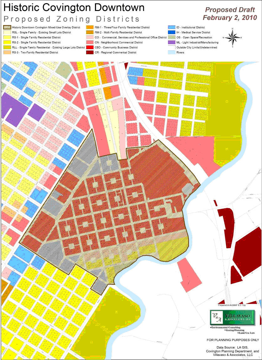
Figure 31.2 Historic St. John National Register District
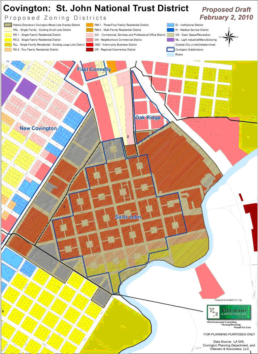
3.3103. Permitted uses.
1.
All uses permitted in base district (RS-1, RS-2, CO, ID and CBD);
2.
Accessory uses customarily incidental to the above permitted uses.
3.3104. Prohibited uses. All uses not specifically permitted or authorized shall be prohibited including, but not limited to, the following:
1.
Industrial or manufacturing activities, except as specifically permitted or permissible;
2.
Large-scale repair and heavy equipment repair and related service facilities;
3.
The parking of any vehicles that are designed or intended for the storage or transport of hazardous or flammable materials.
4.
Drive-through uses for food service in the Division of St. John.
3.3105. Conditional uses.
1.
Drive-through uses for food service.
Conditional uses are prohibited unless application for the use has been processed by the City of Covington and the zoning commission has favorably approved such use. For all conditional uses, the plan approval process is that as set forth in section 3.7 conditional uses, regardless of lot size or conditional uses.
When a drive-through use for food service is proposed in the HDC-MUOD (Historic Downtown Covington mixed-use district), the zoning commission shall consider certain conditions to protect the best interest of the surrounding area. These conditions may include, but are not limited to, the following:
a.
Assure that the degree of compatibility to the surrounding land use shall be maintained.
b.
The architectural character defining exterior elements of the building is maintained.
c.
The drive-through area of service shall be limited to a separate traffic lane which is separately designated for use by drive-through service patrons.
d.
Each drive-through lane shall be a minimum of ten feet in width. The lane shall be independent of any on-site parking, parking maneuvering areas, public streets, alleys or traffic ways.
e.
The drive-through service lane shall be located in an area where it will not unduly interfere with the orderly flow of traffic generated by non-drive-through patrons.
f.
Adequate queuing for vehicles approaching the drive-through service facility shall be provided.
3.3106. Area requirements. Each development site in the HDC-MUOD shall be subject to the following site development regulations in addition to any other applicable regulations under the provisions of these land use regulations or any other laws of the city, state or federal government.
1.
Lot area:
a.
No minimum lot area is required for nonresidential lots, including mixed-use developments.
b.
All residential uses and bed and breakfasts shall have a minimum lot area of 1,000 square feet.
2.
Lot width:
a.
No minimum lot width shall be required for nonresidential use.
b.
Residential and bed and breakfasts are required to have a minimum lot width of 25 feet at the building line.
3.
Lot depth: There shall be no minimum lot depth requirements.
4.
Front yard: There shall be no front yard requirements, except for accessory structures, which shall comply with the front yard setback indicated in the underlying zoning.
5.
Side yard: There shall be no side yard requirements.
6.
Rear yard: There shall be no rear yard requirements.
7.
Building area:
a.
Retail establishments shall not exceed 5,000 square feet in gross floor area.
3.3107. Parking requirements. Parking requirements for this district shall be in accordance with the provisions of section 4.1 of this land use regulations ordinance, except for the following exceptions:
1.
Commercial establishments in the Division of St. John shall have no off-street parking requirements.
2.
Residential uses in the Division of St. John shall be required to have one off-street parking space per dwelling unit.
3.
Bed and breakfast establishments shall be required to meet the parking requirements in accordance with section 4.1 and section 5.8 of this ordinance.
3.3108. Fire marshal approval. As provided for in chapter 18 of the City of Covington Code of Ordinances.
3.3109. Landscape requirements. There shall be no minimum landscape requirements in the Division of St. John. All other areas of the HDC-MUOD shall meet the minimum landscape requirements for the base district.
3.3110. Architectural and signage review. Architectural review and all signage requests shall be performed by the historic district commission, which shall determine if a certificate of appropriateness shall be granted prior to permits being issued. All other building permit requests shall be processed by the city planner and/or building official as outlined in the base zoning classification.
3.3111. Signage. In addition to other regulations applicable to signs within this Part 6 of this appendix B, the following limitations/regulations shall apply to all properties within the HDC-MUOD.
1.
General provisions:
a.
The following general provisions for signs in the HDC-MUOD:
i.
Light colored letters on a dark background or as approved by the Covington Historic District Commission (CHDC).
ii.
The use of nationally distributed signs that are not compatible with the character of the building is not allowed unless approved by the CHDC.
iii.
Window and door signage should complement other façade signage and should not obscure visibility into the business. Signage other than business identification and operating hours must be approved by the CHDC.
b.
No signs shall be displayed or placed in any manner whatsoever so as to disfigure or conceal any significant architectural feature or detail of any building.
c.
What signs may advertise. No sign of any character shall be displayed in the historic district unless such sign advertises a bona fide business conducted in or on the premises and, if it does do so, not exceeding 50 percent of the area of such sign may be used to advertise products or commodities actually sold on the premises.
d.
Computation of frontage. If a building has frontage on more than one public right-of-way, the sign area(s) for each building wall or property frontage will be computed separately. The sign area(s) thus calculated shall be permitted to then be applied to permitted signs placed on each separate wall or property line frontage.
2.
Primary signs:
a.
Number of primary signs. In general, one primary sign is allowed to each store, shop, or bona fide place of business, and this sign shall be no larger than the maximum stipulated in this section. In the case of a business operated on a corner lot that has frontage on two public rights-of-way, one primary sign facing each right-of way is allowed and shall be regulated as if each side were a separate storefront.
b.
Surface area of signs. The surface area of any sign shall be in direct proportion to the amount of front footage of each ownership and shall be as follows:
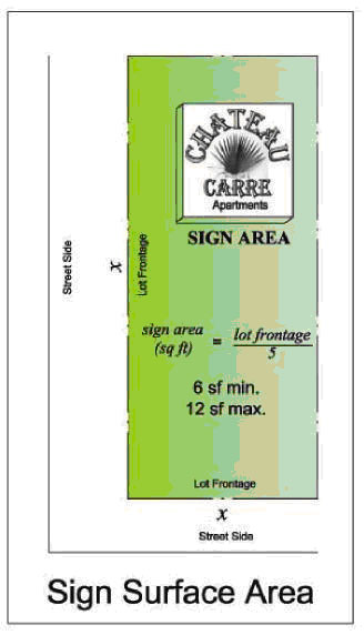
i.
Single-faced signs attached flat against the wall and including painted wall signs, there shall be allowed one square foot of sign surface area to each five feet of lot frontage. No sign is required to be less than six square feet. In no case shall the maximum allowable square footage exceed 12.
ii.
Double-faced signs, suspended by brackets or arms perpendicularly from the wall of the building, the surface area shall be the sum of the areas of each face not to exceed a total of 16 square feet. In case of multiple businesses operating at a single location, the total face area of signage may be increased to one and one-half times the maximum stipulated in this section.
iii.
No sign of any description shall be hung less than ten feet above the sidewalk unless it is above or an integral upper part of a marquee; or suspended below a marquee not lower than the lowest edge of such marquee.
iv.
Monument signs shall be limited to 12 square feet in size, but in all cases must be approved by the CHDC.
Table 331.1
3.
Prohibited signs: In addition to the prohibited signs listed in Part 6 sign regulations, the following signs are prohibited in the HDC-MUOD:
a.
Inflatable signs.
b.
Internally illuminated signs.
c.
Pole or post-mounted signs unless approved by the city.
4.
Procedures; application and fees for sign permits:
a.
Requirement to obtain a sign permit. It shall be unlawful to construct, erect, alter, relocate or display any sign without first obtaining a sign permit from the building official or code enforcement official and paying the fee required herein, unless specifically excluded from the requirement of a permit by section 6.105 provided that no permit shall be required for (i) the repair of a sign, or (ii) change in addition of tenants, occupants, activities or messages on ground signs.
b.
The certificate of appropriateness for a sign permit in the HDC-MUOD may be issued administratively providing the following conditions are met:
i.
The proposed sign meets all of the general provisions outlined in section 3.31 and Part 6 of this appendix B; and
ii.
The proposed sign complies with all of the square footage, location, height and material requirements set forth in section 3.3112.
If the above conditions are met, the city planner or his designee may issue a certificate of appropriateness. If the above conditions are not met or the city planner or his designee determines that the sign change is not minor, the application will be referred to the CHDC for a public hearing on the issuance of the certificate of appropriateness.
c.
Application requirements. All applications for permits to display, replace or continue signs within the historic district shall be submitted to the historic district commission for approval before a permit may be issued by the city building official. All signs under this section shall be further governed by the existing regulations of the building code and all sign ordinances of the city not in conflict with this section.
d.
In applying to the city for the issuance of a sign permit the following shall be required:
i.
All applications for permits to display signs within the historic district shall be submitted to the commission for approval on forms furnished by the historic district commission. Sketches and drawings in triplicate showing details of construction and foundation when required by the building code of the city and shall delineate size, shape, design, coloring, lighting, and position in relation to the building for or upon which it is displayed shall accompany such application. In the design and erection of all signs, the effect of wind shall be carefully considered.
ii.
Written consent of the owner of the property or his agent granting permission for the construction, maintenance and display of the sign or sign structure;
iii.
Name, address and telephone number of the property owner, the sign owner, the sign contractor and any designated contact person; and
iv.
A description of the size and location of all existing signs owned, leased or otherwise being used on the same property by the entity making application for a sign permit.
e.
Required fees for sign permits. The schedule of fees shall be established by the city council pursuant to section 1.501 of this ordinance. This schedule of fees shall be available from the City of Covington Planning Department and may be altered or amended only by the city council.
f.
Duration of permit. A sign permit shall remain in effect for six months from issuance of the permit, and if the sign is not completed within such six-month period, the permit shall expire.
5.
Special sign permits:
a.
Authority to issue. Upon application by the owner, occupant, tenant or other appropriate party, the Covington Historic District Commission has the authority to issue special sign permits for signs not in conformity with this overlay sign code.
b.
Criteria for special sign permit. In granting a special sign permit, the historic district commission shall consider the effect of the proposed sign on the safety and general welfare of the HDC-MUOD. The historic district commission shall consider certain necessary criteria when issuing a special sign permit. These criteria may include but are not limited to the following:
i.
Such sign would not substantially deviate from the character of the historic district.
ii.
Other conditions are placed on the issuance of the sign permit that mitigate its nonconformity.
iii.
Traffic, landscaping, parking, access, unique design, lighting, location and sight visibility shall be considered.
6.
Enforcement and penalty:
a.
Maintenance of signs, compliance, penalties. Each sign that has been erected in accordance with the provisions of this overlay sign code shall be maintained in substantially the same condition as when constructed. Failure to properly maintain any sign, including exterior painting, shall constitute a violation of this HDC-MUOD and thereto shall be subject to those fines and penalties as may be provided for in [this] appendix B, zoning, of [to] the City of Covington Code of Ordinances.
b.
Officials responsible for administration. The city planner shall administer the provisions of this HDC-MUOD. In the absence of a city planner, this ordinance shall be administered by the building official or code enforcement officials. The city planner and/or the building official or code enforcement officials shall have the power and authority to make inspections of signs or property necessary to carry out their duties in the coordination and the enforcement of the provisions of this HDC-MUOD.
3.3112. Screening. Any use that requires the outside storage of materials (i.e., sand, pipe, gravel, concrete products, iron, steel, septic tanks, or fiberglass products) shall be screened with a six-foot, 100 percent sight-obscuring fence. Not more than 50 percent of the total lot area shall be used for storage. The storage of material is not to exceed six feet in height.
3.3113. Off-street loading requirements. There shall be no off-street loading requirements in the Division of St. John.
(Ord. No. 2010-30, Exh. 1, 1-4-2011; Ord. No. 2013-17, 9-19-2013; Ord. No. 2014-03, 2-21-2014; Ord. No. 2014-23, 10-24-2014; Ord. No. 2017-15, 9-20-2017)
Sec. 3.40. - PD planned unit development overlay district.
3.4001. Purpose and intent.
1.
The purpose of the planned district shall be to provide for an improved level of aesthetics; safety and environmental sensitivity; and design flexibility in conjunction with a site plan for one unified development site by ordinance of the city council subsequent to the recommendation of the zoning commission. Development sites approved by the ordinance under the site plan review procedures of [the] planned district shall be approved as a planned residential district (PRD), a planned commercial district (PCD), a planned industrial district (PID) or a planned combined use district (PCUD) in accordance with the classification of use or uses proposed and/or existing. Planned district applications shall contain a statement by the developer as to how the submitted plan departs from the existing requirements of this zoning ordinance and any other regulations applicable to the proposed use or uses for the district in which the proposed use could be established of right and how each departure improved what otherwise would be required under these regulations. Upon approval, if any planned district contains land to be subdivided, the tentative, preliminary and final subdivision process must be undertaken according to the regulations set forth in appendix A, subdivisions.
2.
The following criteria represent the objectives of the planned district:
a.
Environmentally sensitive design that is of a higher quality than would be possible under the regulations otherwise applicable to the property.
b.
Diversification in the uses permitted and variation in the relationship of uses, open space and the setbacks in developments intended as cohesive, unified projects.
c.
Functional and beneficial uses of open space areas.
d.
Preservation of natural features of a development site such as ponds, lakes, creeks, streams, wetlands, animal habitats, etc.
e.
Creation of a safe and desirable living environment for residential areas characterized by a unified building and site development program.
f.
Rational and economically sound development in relation to public services.
g.
Efficient and effective traffic circulation, both within and adjacent to the development site.
h.
Creation of an architectural variety of housing compatible with surrounding neighborhoods to provide a greater choice of types of environmental and living units.
3.4002. Plan approval.
1.
Prior to submitting an application for approval of a planned district, the applicant(s) shall make a request to the planning department for a pre-application conference. The city planner shall conduct the pre-application conference to discuss the planned district parameters with the applicant and to bring the overall application as nearly as possible into conformity with city regulations.
2.
Following the PD pre-application conference, a conceptual plan shall be submitted with the rezoning application. This plan shall provide the following information:
a.
The title of the project and the names of the project applicant and developer.
b.
Address, legal description and boundary survey of the property.
c.
If the applicant is not the legal owner of the property, a sworn statement by the owner that the applicant is the authorized agent of the owner of the property.
d.
Plat indicating scale, date, north arrow, and general vicinity map indicating existing land uses within 500 feet of all boundaries of the proposed PD shall be designated. This plat shall include all existing physical features such as streets, buildings, watercourses, easements, soil conditions, vegetative cover and topography.
e.
Site information including the following criteria shall be provided:
i.
Boundaries of the project involved;
ii.
Average size and maximum number of lots;
iii.
Parcels or sites to be developed or occupied by buildings. Exact building locations need not be dimensioned on the site plan for a planned development so long as all areas within which buildings may be constructed or maintained are specifically delineated by building setback lines;
iv.
The general location and maximum amount of area to be developed for parking;
v.
The general location of areas to be devoted to open space, including those areas dedicated or conveyed for parks, playgrounds or school sites;
vi.
Public buildings and other common use areas;
vii.
The approximate location of ingress, egress and access streets;
viii.
The approximate location of pedestrian and vehicular ways;
ix.
The extent of landscaping and planting;
x.
Location and/or source of water and sewer facilities;
xi.
Front, side and rear yard setback lines.
f.
Tabulation of the maximum square footage of each use.
g.
The proposed maximum height of any building or structure.
h.
Maximum total land area, minimum public and private open space, streets, off-street parking and loading areas.
i.
Maximum total land area devoted to each land use including, but not limited to, residential, commercial, industrial, active and passive recreation, and open space uses; access parking and loading areas; and location of existing and proposed easements.
i.
A minimum of 15 percent open space shall be required for all planned districts containing a land area of ten acres or less and 25 percent open space for planned districts greater than ten acres provided that no more than 50 percent of the required open space shall be satisfied using limited use land (herein defined). Limited use land shall be defined as land that is inundated by water for a period of greater than four months within each calendar year. Two acres of limited use land are required to satisfy one acre of required open space.
j.
If the PD is proposed to be constructed in phases, indicate proposed development scheduling in detail, including:
i.
The approximate date when construction of each phase of the project can be expected to begin; and
ii.
The order in which the phases of the project will be built.
k.
Circulation element indicating the proposed principal movement of vehicles, goods and pedestrians.
l.
Initial wetland delineation as determined by a qualified wetlands consultant.
m.
Flood zone demarcation lines (indicate FIRM and panel number).
n.
An approved drainage plan and any additional documents indicating ultimate disposal of surface drainage.
o.
Those developments that meet or exceed the criteria outlined in section 4.6 of this Code shall be required to complete a traffic impact study (TIS).
p.
The planning department, planning or zoning commission, or city council may require additional material such as plans, maps, aerial photographs, studies and reports that may be needed in order to make the necessary findings and determinations that the applicable standards and guidelines have been achieved.
3.4003. General standards and evaluation criteria. The city planner, the zoning commission and the city council shall review and evaluate and make the following findings before granting a planned district zoning using the following criteria:
1.
Comparison with applicable regulations and standards established by the comprehensive land use regulations applicable to the proposed use and site.
2.
Compatibility with existing or permitted uses on abutting sites, in terms of building height, bulk and scale, setbacks and open spaces, landscaping and site development, and access and circulation features.
3.
Potentially unfavorable effects or impacts on other existing conforming or permitted uses on abutting sites, to the extent such impacts exceed these which reasonably may result from use of the site by a permitted use.
4.
Modifications to the site plan which would result in increased compatibility, or would mitigate potentially unfavorable impacts, or would be necessary to conform to applicable regulations and standards and to protect the public health, safety, morals, and general welfare.
5.
Safety and convenience of vehicular and pedestrian circulation in the vicinity, including traffic reasonably expected to be generated by the proposed use and other uses reasonable and anticipated in the area considering existing zoning and land uses in the area.
6.
Protection of persons and property from erosion, flood or water damage, fire, noise, glare, and similar hazards or impacts.
7.
Location, lighting, and type of signs; and relation of signs to traffic control and adverse effect on adjacent properties.
8.
Adequacy and convenience of off-street parking and loading facilities and protection of adjacent property from glare of site lighting.
9.
Conformity with the objectives of these regulations and the purposes of the zone in which the site is located.
10.
Compatibility of the proposed use and site development, together with any modifications applicable thereto, with existing or permitted uses in the vicinity.
11.
That any conditions applicable to approval are the minimum necessary to minimize unfavorable impacts on nearby uses and to ensure compatibility of the proposed use with existing or permitted uses in the same district and the surrounding area.
12.
That the proposed use, together with the conditions applicable thereto, will not be detrimental to the public health, safety, or welfare, or community aesthetics, or materially injurious to properties or improvements in the vicinity.
3.4004. Conditions of approval. The zoning commission may recommend, and the city council may establish conditions of approval. Conditions may include, but shall not be limited to, requirements for special yards, open spaces, buffers, fences, walls, and screening; requirements for installation and maintenance of landscaping and erosion control measures; requirements for street improvements and dedications, regulation of vehicular ingress and egress, and traffic circulation; regulation of signs; regulation of hours or other characteristics of operation; requirements for maintenance of landscaping and other improvements; establishment of development schedules or time limits for performance or completion; and such other conditions as the zoning commission or city council may deem necessary to insure compatibility with surrounding uses to preserve the public health, safety, and welfare, and to enable the zoning commission to make the findings required by the preceding section.
3.4005. Amendment of a planned district. Amendments to a PD shall be classified as either major or minor in character.
1.
Major amendments.
a.
Major amendments to the PD shall require the developer to submit revised plans to the planning department. Upon review of the proposed amendments to the PD by the city planner, a public hearing shall be established for the review of the changes by the zoning commission. The zoning commission shall have the authority to review and approve all major changes to the PD.
b.
The developer shall pay any additional fees for procurement of the proposed changes to the PD. The additional fees shall be determined by the planning department upon initial review of the proposed amendments.
c.
Major changes to the plan include, but are not limited to, the following:
i.
The use of the land;
ii.
The use, bulk and location of significant buildings and structures;
iii.
The quantity, quality and location of open spaces; and
iv.
Intensity of use and/or an increase in density.
2.
Minor amendments to the PD shall be construed as all other changes not considered major amendments. Minor amendments change shall be submitted for review by the planning department and may be put into effect only after a letter of no objection is filed and submitted from the planning department to the chairman of the zoning commission.
3.4006. Fees. The schedule of fees for a PUD application shall be established by the city council pursuant to section 1.501 of this ordinance. This schedule of fees shall be available from the City of Covington Planning Department and may be altered or amended only by the city council.
(Ord. No. 2010-30, Exh. 1, 1-4-2011)
Sec. 3.41. - LA Highway 21 Planned Corridor overlay zoning district.
3.4101. Purpose and intent. The purpose of this district is to provide for the protection of the scenic benefits of this area and to create an environment of continuity of land uses with other adjacent areas and zoning classifications. Permitted uses, lot area requirements, off street parking requirements, loading requirements and building height are determined by the underlying zoning classification upon which the overlay rests. Building setbacks, landscape, sign and lighting requirements are hereby set forth for the LA Highway 21 Planned Corridor overlay.
3.4102. District location. The LA Highway 21 Planned Corridor overlay zoning district shall be located on LA Highway 21 beginning at the intersection of Interstate 12 and continue [continuing] northward to the Tchefuncte River. Such corridor shall extend for 400 feet to either side of the LA Highway 21 right-of-way.
3.4103. General standards. The zoning commission shall have the authority to grant site plan approval in the planned corridor with the recommendations of the planning department. Site plan approval applications shall include a plot plan indicating the location of any structure on the site; front, rear and side setbacks; accessways; easements; landscape plan, showing required street planting area, buffer areas, trees to be removed, preserved and/or planted; off street parking and loading; screening and location of trash containers and parking lots; drainage and stormwater detention plan and north arrow.
1.
The zoning commission may attach such conditions on the plan review permit as are necessary to insure the continuous conformance to all applicable standards and the integrity of the district.
3.4104. Permitted uses. The permitted uses for this district shall be the same as for the underlying district in which it is located.
3.4105. Conditional uses. The conditional uses for this district shall be the same as for the underlying zoning district in which it is located.
3.4106. Performance standards.
1.
Lot area: The minimum lot area for this district shall be the same as for the underlying zoning district in which it is located.
2.
Lot width and depth: The minimum lot width and depth shall be the same as for the underlying district in which it is located.
3.
Minimum setbacks for principal and accessory buildings shall as specified below. The setback requirements along the planned corridor shall at a minimum conform to the following:
a.
Front setback. One hundred feet.
b.
Side setback. Ten feet (25 feet if abutting street right-of-way).
c.
Rear setback. Twenty-five feet plus five feet for every 150 feet of lot depth, and need not exceed 40 feet.
3.4107. Parking requirements. Parking requirements for this district shall be in accordance with the provisions of section 4.1 of this land use regulations ordinance.
3.4108. Height requirements. No main or principal building or structure shall exceed 45 feet above the finished grade of the property or base flood elevation as established in the current FEMA FIRMs and guidelines, whichever is higher, subject to the provisions of section 5.12 of this land use regulations ordinance.
3.4109. Fire marshal approval. As provided for in chapter 18 of the City of Covington Code of Ordinances.
3.4110. Landscape requirements. The minimum landscape requirements for the LA Highway 21 Planned Corridor zoning district shall be the same as the criteria set forth in section 4.2 of this Appendix B, "Landscaping" except as specified below. Additional criteria for buffers are as follows:
1.
The street planting area shall be a minimum of 25 feet plus one foot in depth for each ten feet in depth over 100 feet for all property. Side street planting areas shall be a minimum of 25 feet in depth.
2.
Street planting area requirements are:
a.
One Class A tree for every 15 linear feet plus two Class B trees for every 15 linear feet of street frontage.
3.
Buffer planting area requirements are as follows:
a.
Where property abuts residential zoning classes - One Class A tree for every ten feet plus a 70 percent sight-obscuring screen of living plant material.
b.
Where property abuts commercial or industrial zoning classes - One Class A tree plus two Class B trees for every 40 feet of length.
4.
Pedestrian access planting area requirements: Landscaped areas shall be provided between the building face and the parking area subject to the following conditions:
a.
A minimum of four square feet of area shall be provided for every linear foot of the building face exposed to the parking area.
b.
A minimum of one Class B tree shall be provided for every 25 linear feet of the building face exposed to the parking area.
c.
The pedestrian access planting area shall be planted with the required number of trees and surfaced with shrubs, ground cover, mulch and/or grass, exclusive of paving.
d.
No side of the pedestrian access planting area shall be less than five feet in width.
e.
All trees six inches or greater DBH (diameter [at] breast height) shall be preserved in the street planting areas and buffer areas, except those that may be removed for accessways or through site plan review approval.
f.
Preserved trees may be substituted for required street and parking area landscape requirements at the rate of 1:1 for Class A trees and 1:2 for Class B trees, if approved through site plan review process.
5.
Unless otherwise specified, street planting areas shall be inclusive of required yards.
6.
The only uses permitted by right in the street planting area shall be landscaping and screening as permitted herein; however, signs, security fencing, utilities which run generally perpendicular through the area, pedestrian walkways, or similar uses may be permitted through schematic or site plan review.
3.4111. Off-street loading requirements. Off-street loading zone requirements for this district shall be in accordance with the provisions of section 4.108 of this ordinance.
3.4112. Additional LA Highway 21 Planned Corridor overlay zoning district requirements.
1.
Sign regulations: The following are the minimum signage regulations for the LA Highway 21 Planned Corridor zoning district. Each shall meet the criteria set forth below, unless otherwise amended by specific ordinance for a particular corridor.
a.
Purpose and intent. The purpose of this section is to facilitate the location and choice of signs to ensure better communication of information about land uses and their locations and to avoid visual clutter that is potentially harmful to traffic and pedestrian safety, property values, business opportunities, and community appearance. With these purposes in mind, it is the intent of this section to authorize the use of street signs which are compatible with the unique environment of the City of Covington, appropriate to the activity that displays them, creative and expressive of the identity of both individual activities and the community as a whole, and legible in the environment in which they are seen.
b.
Definition. The following definition relates to the landscaping regulations contained herein.
Illumination. Wall signs may be illuminated, but such illumination shall not exceed 4,000 lumens per side per sign or otherwise unreasonably intrude on a residence located in a district zoned residential, and such illumination shall not constitute a traffic hazard.
(Ord. No. 2010-30, Exh. 1, 1-4-2011; Ord. No. 2014-23, 10-24-2014)
Sec. 3.50. - Statutory authority, findings of fact, purpose and methods of flood hazard prevention.
3.5001. Statutory authorization. The Legislature of the State of Louisiana has, in R.S. 38:84, delegated the responsibility to local governmental units to adopt regulations designed to minimize flood losses.
3.5002. Finding of fact. Therefore, the City Council of Covington, Louisiana, does ordain as follows:
1.
The flood hazard areas of Covington, Louisiana, are subject to periodic inundation that results in loss of life and property, health and safety hazards, disruption of commerce and governmental services, and extraordinary public expenditures for flood protection and relief, all of which adversely affect the public health, safety and general welfare.
2.
These flood losses are created by the cumulative effect of obstructions in floodplains that cause an increase in flood heights and velocities and by the occupancy of flood hazard areas by uses vulnerable to floods and hazardous to other lands because they are inadequately elevated, floodproofed or otherwise protected from flood damage.
3.5003. Purpose and intent. It is the purpose of this Section to promote the public health, safety and general welfare and to minimize public and private losses due to flood conditions in specific areas by provisions designed to:
1.
Protect human life and health;
2.
Minimize expenditure of public money for costly flood control projects;
3.
Minimize the need for rescue and relief efforts associated with flooding and generally undertaken at the expense of the general public;
4.
Minimize prolonged business interruptions;
5.
Minimize damage to public facilities and utilities, such as water and gas mains, electric, telephone and sewer lines, streets and bridges, located in floodplains;
6.
Help maintain a stable tax base by providing for the sound use and development of floodprone areas in such a manner as to minimize future flood blight areas; and
7.
Ensure that potential buyers are notified that property is in a flood area.
3.5004. Method of reducing flood losses. In order to accomplish its purposes, this section uses the following methods:
1.
Restricts or prohibits uses that are dangerous to health, safety or property in times of flood or cause excessive increases in flood heights or velocities;
2.
Requires that uses vulnerable to floods, including facilities that serve such uses, be protected against flood damage at the time of initial construction;
3.
Controls the alteration of natural floodplains, stream channels and natural protective barriers that are involved in the accommodation of floodwaters;
4.
Controls filling, grading, dredging and other development that may increase flood damage;
5.
Prevents or regulates the construction of flood barriers which will unnaturally divert floodwaters or which may increase flood hazards to other lands.
3.5005. Definitions. Unless specifically defined below, words or phrases used in this section shall be interpreted to give them the meanings they have in common usage and to give this section its most reasonable application.
Appeal. A request for a review of the floodplain administrator's interpretation of any provision of this Section, or a request for a variance.
Area of shallow flooding. A designated AO, AH or VO zone on a community's flood insurance rate map (FIRM) with a one-percent or greater annual chance of flooding to an average depth of one to three feet where a clearly defined channel does not exist, where the path of flooding is unpredictable and where velocity flow may be evident. Such flooding is characterized by ponding or sheet flow.
Area of special flood hazard. The land in the floodplain within a community subject to a one-percent or greater chance of flooding in any given year. The area may be designated as zone A on the flood hazard boundary map (FHBM). After detailed ratemaking has been completed in preparation for publication of the FIRM, zone A usually is refined into Zones A, AE, AH, AO, A1-99, VO, V1-30, VE or V.
Base flood. The flood having a one-percent chance of being equaled or exceeded in any given year.
Critical feature. An integral and readily identifiable part of a flood-protection system, without which the flood protection provided by the entire system would be compromised.
Development. Any manmade change in improved and unimproved real estate including, but not limited to, buildings or other structures, mining, dredging, filling, grading, paving, excavating or drilling operations.
Elevated building. A nonbasement building:
1.
Built, in the case of a building in zones A1-30, AE, A, A99, AO, AH, B, C, X and D, to have the top of the elevated floor or, in the case of a building in zones V1-30, VE or V, to have the bottom of the lowest horizontal structural member of the elevated floor elevated above the ground level by means of pilings, columns (posts and piers), or shear walls parallel to the flow of the water; and
2.
Adequately anchored so as not to impair the structural integrity of the building during a flood of up to the magnitude of the base flood. In the case of zones A1-30, AE, A, A99, AO, AH, B, C, X, D.
3.
"Elevated building" also includes a building elevated by means of fill or solid foundation perimeter walls with openings sufficient to facilitate the unimpeded movement of floodwaters.
4.
In the case of zones V1 -30, VE or V, "elevated building" also includes a building otherwise meeting the definition of "elevated building," even though the lower area is enclosed by means of breakaway walls, if the breakaway walls meet the standards of Section 60.3(e)(5) of the National Flood Insurance Program Regulations.
Existing construction. Structures for which the "start of construction" commenced before the effective date of the FIRM or before January 1, 1975, for FIRMs effective before that date. "Existing construction" may also be referred to as "existing structures."
Flood or flooding. A general and temporary condition of partial or complete inundation of normally dry land areas from:
1.
The overflow of inland or tidal waters;
2.
The unusual and rapid accumulation or runoff of surface waters from any source.
Flood insurance rate map (FIRM). An official map of the community, on which the administrator of the National Flood Insurance Program (NFIP) has delineated both the special hazard areas and the risk premium zones applicable to the community.
Flood insurance study. The official report provided by the Federal Emergency Management Agency. The report contains flood profiles, water surface elevation of the base flood, as well as the flood boundary-floodway map.
Floodplain or floodprone area. Any land area susceptible to being inundated by water from any source (see definition of flooding).
Flood-protection system. The structural system, for which funds have been authorized, appropriated and expended and which have been constructed specifically to modify flooding in order to reduce the extent of the areas within a community subject to a "special flood hazard" and the extent of the depths of associated flooding. Such a system typically includes hurricane tidal barriers, dams, reservoirs, levees or dikes. These specialized flood-modifying works are those constructed in conformance with sound engineering standards.
Functionally dependent use. A use that cannot perform its intended purpose unless it is located or carried out in close proximity to water. The term includes only docking facilities, port facilities that are necessary for the loading and unloading of cargo or passengers, and ship building and ship repair facilities but does not include long-term storage or related manufacturing facilities.
Habitable floor. Any floor usable for the following purposes: Which include working, sleeping, eating, cooking or recreation, or a combination thereof. A floor used for storage purposes only is not a "habitable floor."
Highest adjacent grade. The highest natural elevation of the ground surface prior to construction next to the proposed walls of a structure.
Levee. A manmade structure, usually an earthen embankment, designed and constructed in accordance with sound engineering practices to contain, control or divert the flow of water so as to provide protection from temporary flooding.
Levee system. A flood-protection system that consists of a levee or levees and associated structures, such as closure and drainage devices, which are constructed and operated in accordance with sound engineering practices.
Low cost small accessory structure. A structure which is located on the same parcel of property as the principle structure and the use of which is incidental to the use of the principle structure, used solely for vehicle parking (two-car detached garages or smaller) or limited storage (small, low cost sheds). In A, A1-30, or AE flood zones, low cost small accessory structure is defined as being 500 square feet or less.
Lowest floor. The lowest floor of the lowest enclosed area (including basement). An unfinished or flood-resistant enclosure, usable solely for parking of vehicles, building access or storage in an area other than a basement area, is not considered a building's lowest floor; provided that such enclosure is not built so as to render the structure in violation of the applicable nonelevation design requirement of section 60.3 of the National Flood Insurance Program Regulations.
Mobile home. A pre-fabricated trailer-type structure, transportable in one or more sections, which is built on a permanent chassis and is designed for use with or without a permanent foundation when connected to the required utilities. For floodplain management purposes, the term "mobile home" also includes park trailers, travel trailers, and other similar vehicles placed on a site for greater than 180 consecutive days. For insurance purposes, the term "mobile home" does not include park trailers, travel trailers, and other similar vehicles.
Mean sea level. For purposes of the national flood insurance program, the National Geodetic vertical Datum (NGVD) of 1929 or other datum to which base flood elevations shown on a community's flood insurance rate map) are referenced.
New construction. For floodplain management purposes, structures for which the start of construction commenced on or after the effective date of a floodplain management regulations adopted by a community.
Start of construction. For other than new construction or substantial improvements under the Coastal Barrier Resources Act (Public Law 97-348), includes substantial improvement and means the date the building permit was issued, provided the actual start of construction, repair, reconstruction, placement or other improvement was within 180 days of the permit date. The actual start means either the first placement of permanent construction of a structure on a site, such as, the pouring of slab or footings, the installation of piles, the construction of columns, or any work beyond the stage of excavation, or the placement of a manufactured home on a foundation. Permanent construction does not include land preparation, such as clearing, grading and filling; nor does it include the installation of streets and/or walkways; nor does it include excavation for basement, footings, piers or foundations or the erection of temporary forms; nor does it include the installation on the property of accessory buildings, such as garages or sheds not occupied as dwelling units or not part of the main structure.
Structure. A walled and roofed building, including a gas or liquid storage tank that is principally above ground, as well as a mobile home.
Substantial improvement. Any repair, reconstruction or improvement of a structure, the cost of which equals or exceeds 50 percent of the market value of the structure either:
1.
Before the improvement or repair is started; or
2.
If the structure has been damaged and is being restored, before the damage occurred. For the purpose of this definition, "substantial improvement" is considered to occur when the first alteration of any wall, ceiling, floor or other structural part of the building commences, whether or not that alteration affects the external dimensions of the structure.
The term does not, however, include either:
1.
Any project for improvement of a structure to comply with existing state or local health, sanitary or safety code specifications which are solely necessary to assure safe living conditions; or
2.
Any alteration of a structure listed on the National Register of Historic Places or a state inventory of historic places.
Variance. A grant of relief to a person from the requirements of this section when specific enforcement would result in unnecessary hardship. A variance, therefore, permits construction or development in a manner otherwise prohibited by this section. (For full requirements, see section 60.6 of the National Flood Insurance Program Regulations.)
Violation. The failure of a structure or other development to be fully compliant with the community's floodplain management regulations. A structure or other development without the elevation certificate, other certifications or other evidence of compliance required in section 60.3(b)(5), (c)(4), (c)(10), (d)(3), (e)(2), (e)(4) or (e)(5) [of the National Flood Insurance Program Regulations] is presumed to be in violation until such time as that documentation is provided.
Water surface elevation. The height, in relation to the National Geodetic Vertical Datum (NGVD) of 1929 (or other datum, where specified), of floods of various magnitudes and frequencies in the floodplains of coastal or riverine areas.
3.5006. General provisions.
1.
Applicability. This section shall apply to all areas of special flood hazard within the jurisdiction of the City of Covington, State of Louisiana.
2.
Basis for establishing the areas of special flood hazard. The areas of special flood hazard identified by the Federal Emergency Management Agency in a scientific and engineering report entitled "The Flood Insurance Study for the City of Covington," with accompanying flood insurance rate maps and flood boundary-floodway maps (FIRMs and FBFMs), and any revisions thereto are hereby adopted by reference and declared to be a part of this section.
3.
Establishment of a development permit. A development permit shall be required to ensure conformance with the provisions of this section.
4.
Compliance. No structure or land shall hereafter be located, altered, or have its use changed without full compliance with the terms of this section and other applicable regulations.
5.
Abrogation and greater restrictions. This section is not intended to repeal, abrogate or impair any existing easements, covenants or deed restrictions. However, where this section and another conflict or overlap, whichever imposes the more stringent restrictions shall prevail.
6.
Interpretation. In the interpretation and application of this section, all provisions shall be:
a.
Considered as minimum requirements;
b.
Liberally construed in favor of the governing body; and
c.
Deemed neither to limit nor repeal any other powers granted under state statutes.
7.
Warning and disclaimer of liability. The degree of flood protection required by this section is considered reasonable for regulatory purposes and is based on scientific and engineering considerations. On rare occasions, greater floods can and will occur, and flood heights may be increased by manmade or natural causes. This ordinance Section does not imply that land outside the areas of special flood hazards or uses permitted within such areas will be free from flooding or flood damages. This section shall not create liability on the part of the community or any official or employee thereof for any flood damages that result from reliance on this section or any administrative decision lawfully made thereunder.
3.5007. Administration.
1.
Designation of the floodplain administrator. The Building Official of the City of Covington is hereby appointed the floodplain administrator to administer and implement the provisions of this section and other appropriate sections of 44 CFR (National Flood Insurance Program Regulations) pertaining to floodplain management.
2.
Duties and responsibilities of the floodplain administrator. Duties and responsibilities of the floodplain administrator shall include, but not be limited to, the following:
a.
Maintaining and holding open for public inspection all records pertaining to the provisions of this section.
b.
Reviewing permit applications to determine whether proposed building sites will be reasonably safe from flooding.
c.
Reviewing, approving or denying all applications for development permits required by adoption of this section.
d.
Reviewing permits for proposed development to assure that all necessary permits have been obtained from those federal, state or local governmental agencies (including Section 404 of the Federal Water Pollution Control Act Amendments of 1972, 33 USC 1334) from which prior approval is required.
e.
Where interpretation is needed as to the exact location of the boundaries of the areas of special flood hazards (for example, where there appears to be a conflict between a mapped boundary and actual field conditions), making the necessary interpretation.
f.
Notifying, in riverine situations, adjacent communities and the state agency, which is the Louisiana Department of Urban and Community Affairs, prior to any alteration or relocation of a watercourse and submitting evidence of such notification to the Federal Emergency Management Agency.
g.
Assuring that the flood-carrying capacity within the altered or relocated portion of any watercourse is maintained.
h.
When base flood elevation data has not been provided in accordance with 3.5006.2 [of this section 3.50], obtaining, reviewing and reasonably utilizing any base flood elevation data and floodway data available from a federal, state or other source in order to administer the provisions of 3.5008 [of this section 3.50],
i.
When a regulatory floodway has not been designated, requiring that no new construction, substantial improvements or other development (including fill) shall be permitted within zones A1-30 and AE on the community's FIRM, unless it is demonstrated that the cumulative effect of the proposed development, when combined with all other existing and anticipated development, will not increase the water surface elevation of the base flood more than one foot at any point within the community.
3.
Permit procedures.
a.
Application for a development permit shall be presented to the floodplain administrator on forms furnished by him/her and may include, but not be limited to, plans in duplicate drawn to scale showing the location, dimensions and elevation of proposed landscape alterations, existing and proposed structures, and the location of the foregoing in relation to areas of special flood hazard. Additionally, the following information is required:
i.
Elevation, in relation to mean sea level, of the lowest floor (including basement) of all new and substantially improved structures;
ii.
Elevation, in relation to mean sea level, to which any nonresidential structure shall be floodproofed;
iii.
A certificate from a registered professional engineer or architect that the nonresidential floodproofed structure shall meet the floodproofing criteria of 3.5008.2.b [of this section 3.50];
iv.
Description of the extent to which any watercourse or natural drainage will be altered or relocated as a result of proposed development;
v.
Maintain a record of all such information in accordance with 3.5007.2.a [of this section 3.50].
b.
Approval or denial of a development permit by the floodplain administrator shall be based on all of the provisions of this section and the following relevant factors:
i.
The danger to life and property due to flooding or erosion damage;
ii.
The susceptibility of the proposed facility and its contents to flood damage and the effect of such damage on the individual owner;
iii.
The danger that materials may be swept onto other lands to the injury of others;
iv.
The compatibility of the proposed use with existing and anticipated development;
v.
The safety of access to the property in times of flood for ordinary and emergency vehicles;
vi.
The costs of providing governmental services during and after flood conditions, including maintenance and repair of streets and bridges, and public utilities and facilities such as sewer, gas, electrical and water systems;
vii.
The expected heights, velocity, duration, rate of rise and sediment transport of the floodwaters and the effects of wave action, if applicable, expected at the site;
viii.
The necessity to the facility of a waterfront location, where applicable;
ix.
The availability of alternative locations, not subject to flooding or erosion damage, for the proposed use;
x.
The relationship of the proposed use to the comprehensive plan for that area.
4.
Variance procedures.
a.
The board of adjustment as established by the community shall hear and render judgment on requests for variances from the requirements of this section.
b.
The board of adjustment shall hear and render judgment on an appeal only when it is alleged there is an error in any requirement, decision or determination made by the floodplain administrator in the enforcement or administration of this section.
c.
Any person or persons aggrieved by the decision of the board of adjustment may appeal such decision in the courts of competent jurisdiction.
d.
The floodplain administrator shall maintain a record of all actions involving an appeal and shall report variances to the Federal Emergency Management Agency upon request.
e.
Variances may be issued for the reconstruction, rehabilitation or restoration of structures listed on the National Register of Historic Places or the state inventory of historic places, without regard to the procedures set forth in the remainder of this section.
f.
Variances may be issued for new construction and substantial improvements to be erected on a lot of one-half acre or less in size contiguous to and surrounded by lots with existing structures constructed below the base flood level, providing the relevant factors in 3.5007.3.b [of this section 3.50] have been fully considered. As the lot size increases beyond the one-half acre, the technical justification required for issuing the variance increases.
g.
Upon consideration of the factors noted above and the intent of this section, the appeal board may attach such conditions to the granting of variances as it deems necessary to further the purpose and objectives of section 3.5003 [of this section 3.50].
h.
Variances shall not be issued within any designated floodway if any increase in flood levels during the base flood discharge would result.
i.
Prerequisites for granting variances:
i.
Variances shall only be issued upon a determination that the variance is the minimum necessary, considering the flood hazard, to afford relief.
ii.
Variances shall only be issued upon (i) a showing of good and sufficient cause; (ii) a determination that failure to grant the variance would result in exceptional hardship to the applicant; and (iii) a determination that the granting of a variance will not result in increased flood heights, additional threats to public safety, extraordinary public expense, create nuisances, cause fraud on or victimization of the public, or conflict with existing local laws or ordinances.
iii.
Any applicant to whom a variance is granted shall be given written notice that the structure will be permitted to be built with the lowest floor elevation below the base flood elevation and that the cost of flood insurance will be commensurate with the increased risk resulting from the reduced lowest floor elevation.
j.
Variances may be issued by a community for new construction and substantial improvements and for other development necessary for the conduct of a functionally dependent use, provided that:
i.
The criteria outlined in section 3.5007.4 a—i [of this section 3.50] are met; and
ii.
The structure or other development is protected by methods that minimize flood damages during the base flood and create no additional threats to public safety.
3.5008. Provisions for flood hazard reduction.
1.
General standards. In all areas of special flood hazards, the following provisions are required for all new construction and substantial improvements:
a.
All new construction or substantial improvements shall be designed (or modified) and adequately anchored to prevent flotation, collapse or lateral movement of the structure resulting from hydrodynamic and hydrostatic loads, including the effects of buoyancy;
b.
All new construction or substantial improvements shall be constructed by methods and practices that minimize flood damage;
c.
All new construction or substantial improvements shall be constructed with materials resistant to flood damage;
d.
All new and replacement electrical, heating, ventilation, plumbing, air conditioning equipment and other service facilities shall be designed and/or located so as to prevent water from entering or accumulating within the components during conditions of flooding, such facilities shall be located a minimum of 12 inches above the base flood elevation;
e.
All new and replacement water supply systems shall be designed to minimize or eliminate infiltration of floodwaters into the systems;
f.
New and replacement sanitary sewage systems shall be designed to minimize or eliminate infiltration of floodwaters into the systems and discharge from the systems into floodwaters; and
g.
On-site waste disposal systems shall be located to avoid impairment to them or contamination from them during flooding.
2.
Specific standards. In all areas of special flood hazards where base flood elevation data has been provided as set forth in (i) 3.5006.2; (ii) 3.5007.2.g; or (iii) 3.5008.3.c [of this section 3.50] the following provisions are required:
a.
Residential construction: New construction or substantial improvement of any residential structure shall have the lowest floor, including basement, elevated 12 inches or one foot above the base flood elevation. A registered professional engineer architect, or land surveyor shall submit a certification to the administrative official that the standard of this subsection, as proposed in 3.5007.3.a.i [of this section 3.50] is satisfied.
b.
Nonresidential construction: New construction and substantial improvements of any commercial, industrial or other nonresidential structure shall have the lowest floor (including basement) elevated 12 inches or one foot above the base flood level A registered professional engineer or architect shall develop and/or review structural design, specifications and plans for the construction and shall certify that the design and methods of construction are in accordance with accepted standards of practice as outlined in this subsection.
c.
Enclosures: New construction and substantial improvement, with fully enclosed areas below the lowest floor that are subject to flooding, shall be designed to automatically equalize hydrostatic flood forces on exterior walls by allowing for the entry and exit of floodwaters. Designs for meeting this requirement must either be certified by a registered professional engineer or architect or meet or exceed the following minimum criteria:
i.
A minimum of two openings, having a total net area of not less than one square inch of every square foot of enclosed area subject to flooding, shall be provided.
ii.
The bottoms of all openings shall be no higher than one foot above grade.
iii.
Openings may be equipped with screens, louvers, valves or other coverings or devices provided that they permit the automatic entry and exit of floodwaters.
d.
Mobile homes:
i.
Require that all manufactured homes to be placed within zone A shall be installed using methods and practices that minimize flood damage. For the purpose of this requirement, mobile homes must be elevated and anchored to resist flotation, collapse or lateral movement. Methods of anchoring may include, but are not limited to, use of over-the-top or frame ties to ground anchors. This requirement is in addition to applicable state and local anchoring requirements for resisting wind forces.
ii.
All mobile homes shall be in compliance with 3.5008.2.a. that requires that all mobile homes, including in existing mobile home parks, to be placed or substantially improved within zones A1-30, AH and AE on the community's FIRM be elevated on a permanent foundation such that the lowest point of the lowest horizontal structural member of the manufactured home is at or above 12 inches or one foot above the base flood elevation and be securely anchored to an adequately anchored foundation system in accordance with the provision 3.5008.2.d [of this section 3.50].
e.
Low cost small accessory structures:
i.
The construction of accessory structures in flood zones designated A, A1-30, or AE must satisfy the following standards:
a.
May be constructed with the floor below the design flood elevation (DFE). The DFE is the base flood elevation (BFE) for the site plus freeboard of one foot or 12 inches as required in section 18-55(b).
b.
Shall be anchored to resist flotation, collapse, and lateral movement.
c.
Portions of structure located below the DFE shall be constructed of flood-resistant materials.
d.
Shall be designed for the automatic entry and exit of floodwaters.
e.
Mechanical and utility equipment must be elevated or flood-proofed to or above the DFE.
f.
Shall comply with the floodway encroachment provisions of the NFIP regulations.
g.
Use shall be limited to parking and/or limited storage.
h.
Structure shall not be used for human habitation (including work, sleeping, living, cooking, or restroom facilities.
i.
Structure cannot be modified for a different use after permitting.
3.
Standards for subdivision proposals.
a.
All subdivision proposals, including mobile home parks and subdivisions, shall be consistent with sections 3.5001, 3.5002 or 3.5003 [of this section 3.50].
b.
All proposals for the development of subdivisions, including mobile home parks and subdivisions, shall meet development permit requirements of 3.5006.3, 3.5007.3, and the provisions of 3.5008 [of this section 3.50].
c.
Base flood elevation data shall be generated for subdivision proposals and other proposed development, including mobile home parks and subdivisions, which is greater than 50 lots or five acres, whichever is lesser, if not otherwise provided pursuant to 3.5006.2 or 3.5007.2.h of this ordinance [of this section 3.50].
d.
All subdivision proposals, including mobile home parks and subdivisions, shall have adequate drainage provided to reduce exposure to flood hazards.
e.
All subdivision proposals, including mobile home parks and subdivisions, shall have public utilities and facilities, such as sewer, gas, electrical and water systems, located and constructed to minimize or eliminate flood damage.
4.
Standards for areas of shallow flooding (AO/AH zones). Located within the areas of special flood hazard established in 3.5006.2 [of this section 3.50] are areas designated as shallow flooding. These areas have special flood hazards associated with base flood depths of one to three feet where a clearly defined channel does not exist and where the path of flooding is unpredictable and where velocity flows may be evident. Such flooding is characterized by ponding or sheet flow; therefore, the following provisions apply:
a.
All new construction and substantial improvements of residential structures [shall] have the lowest floor (including basement) elevated above the highest adjacent grade at least as high as the depth number specified in feet on the community's FIRM (at least two feet if no depth number is specified).
b.
All new construction and substantial improvements of nonresidential structures [shall]:
i.
Have the lowest floor (including basement) elevated above the highest adjacent grade at least as high as the depth number specified in feet on the community's FIRM (at least two feet if no depth number is specified); or
ii.
Together with attendant utility and sanitary facilities, be designed so that below the base flood level the structure is watertight with walls substantially impermeable to the passage of water and with structural components having the capability of resisting hydrostatic and hydrodynamic loads and effects of buoyancy.
c.
A registered professional engineer or architect shall submit a certification to the floodplain administrator that the standards of this section 3.5008.4, as proposed in section 3.5007.3.a.i are satisfied.
d.
Require within zones AH or AO adequate drainage paths around structures on slopes to guide floodwaters around and away from proposed structures.
3.5009. Separability. Should any section or provision of this section be declared by the courts to be unconstitutional or invalid, such decision shall not affect the validity of the section as a whole or any part thereof other than the part so declared to be unconstitutional or invalid.
3.5010. Short title. This section 3.50 may be cited and otherwise referred to as the "flood hazard prevention ordinance."
(Ord. No. 2010-30, Exh. 1, 1-4-2011; Ord. No. 2020-09, 7-8-2020; Ord. No. 2021-06, 6-9-2021)
Sec. 3.51. - F-OD floodplain overlay district.
3.5101. Purpose and intent. The legislature of the State of Louisiana has, in R.S. 38:84, delegated the responsibility to local governmental units to adopt regulations designed to minimize flood losses. Therefore, it is the purpose of the inundation district to apply special regulations to the use of land in those areas which are subject to severe inundation at frequent intervals as determined by proper authority, which while permitting reasonable economic use of such property will help to protect human life, prevent or minimize material losses, and reduce the cost to the public of rescue and relief efforts occasioned by the occupancy of such flood areas.
3.5102. The "F" district is established to require elevation of main floor levels of all buildings to a height of not less than one foot above base flood elevation.
In any areas shown on the district map as inundation areas, floor levels of all buildings shall be not less than indicated and levels may be amended as necessary by a report of the city engineer based on later information. The flood level in Covington is ten feet above mean sea level.
3.5103. Other districts classified with a suffix "F" on the district map shall establish the land use practices but will be subject to the minimum floor level requirements as established by the "F" district.
(Ord. No. 2010-30, Exh. 1, 1-4-2011)