
Cullman City Zoning Code
ARTICLE VI
SPECIAL DISTRICTS
Sec. 62-81.- AG-1 Agriculture District.
(a)
Purpose. The purpose of the AG-1 District is to preserve the rural character of areas outside the urbanized portion of the city by promoting agriculture-related uses which, by their nature, are not obnoxious, offensive or detrimental to any surrounding properties by reason of noise, smoke, gas, vibration, fumes, dust, fire, and explosive hazard or nuisance.
(b)
Use regulations. See Table 6-1 and the following:
(1)
Permitted uses. The following, in addition to those shown in Table 6-1, are permitted in the AG-1 District:
a.
Accessory structures used in the production and storage of farm products.
(2)
Conditional uses. In addition to those uses shown in Table 6-1, other uses determined by the commission to be within the spirit or intent of the district may be permitted as conditional uses.
(3)
Prohibited uses. The following are prohibited:
a.
Off-street parking and loading areas for uses not permitted in the district.
b.
Other uses that are not within the spirit or intent of the zoning district as determined by the commission.
(c)
Area and dimensional regulations.
(1)
Livestock and poultry housing. Structures for the housing of livestock of any kind must be set back at least 100 feet and structures for the housing of poultry must be set back at least 200 feet from any property line or any line of any district other than AG-1 or AG-2.
(2)
The construction, modification, expansion or relocation of a structure on a lot of record under five acres but at least 15,000 square feet in size does not require ZBA approval provided it meets all other applicable requirements.
(Ord. No. 2020-16, § 6.01, 3-16-2020)
Sec. 62-82. - AG-2 Agriculture District.
(a)
Purpose. The purpose of the AG-2 District is to preserve the rural character of the areas outside the urbanized portion of the city by promoting agriculture-related uses which, by their nature, are not obnoxious, offensive or detrimental to any surrounding properties by reason of noise, smoke, gas, vibration, fumes, dust, fire, and explosive hazard or nuisance.
(b)
Use regulations. See Table 6-1 and the following:
(1)
Permitted uses. The following, in addition to those shown in Table 6-1, are permitted:
a.
Accessory structures used in the production and storage of farm products.
b.
Hunting with shotguns using bird shot only.
(2)
Conditional uses. In addition to those uses shown in Table 6-1, other uses determined by the commission to be within the spirit or intent of the district may be permitted as conditional uses.
Table 6-1: Uses Permitted in Agricultural Districts
P — The use is permitted by right.
E — The use is permitted by right, if existing as of the effective date of the ordinance from which this chapter is derived. New construction of the use is prohibited.
SE — Special exception, requires approval by the board of adjustments per section 62-184.
C — Conditional use, requires approval by the planning commission per section 62-172.
A blank cell indicates the use is prohibited in the district.
(3)
Prohibited uses. The following are prohibited uses in the AG-2 District:
a.
Off-street parking and loading areas for uses not permitted in the district.
b.
Other uses not within the spirit or intent of the zoning district as determined by the commission.
(c)
Area and dimensional requirements.
(1)
Livestock and poultry housing. Structures for the housing of livestock of any kind must be set back at least 100 feet and structures for the housing of poultry must be set back at least 200 feet from any property line or any line of any district other than AG-1 or AG-2.
Table 6-2: Agricultural District Area and Dimensional Requirements
1 Lots of record at least 15,000 square feet, but less than one acre, do not require ZBA approval for any new construction or building additions for a permitted use provided all other requirements are complied with.
(Ord. No. 2020-16, § 6.02, 3-16-2020; Ord. No. 2021-20, § VIII, 2-8-2021)
Sec. 62-83. - E-1 Entertainment District.
(a)
Purpose. The E-1 District is designed for indoor and outdoor entertainment and other businesses compatible with and supportive of entertainment activities, all of which together tend to require more parking, loading space, lighting and walkways than required in other districts.
(b)
Minimum district size. Five acres.
(c)
Use regulations.
(1)
Permitted uses. Residential structures, along with accessory buildings, existing on the effective date of the ordinance from which this chapter is derived; general retail (provided not over 40 percent of the floor space is used for warehousing); personal services; standard restaurants; movie theaters; hotels; public utility facilities; adult entertainment; indoor entertainment; outdoor entertainment; lounge II; club II; specialty wine and beer stores; upper-story dwellings.
(2)
Conditional uses. Banks; public buildings; manufacturing of any kind; places of amusement and assembly that cater to minors; and other uses determined by the commission to be within the intent of the district.
(3)
Special exception uses. None.
(4)
Prohibited uses. New residential uses except those expressly permitted, off-street parking and loading areas for uses not permitted in the district; manufactured homes and manufactured home parks; campgrounds; curb side selling of any type; unenclosed retail; fast food restaurants; motels; and other uses that are not within the spirit or intent of the district, as determined by the commission.
(5)
Adult entertainment regulations. Because of their very nature, adult entertainment businesses are recognized to have deleterious effects upon adjacent areas, detract from property values and can have adverse effects on the general welfare. No adult entertainment use may be located closer than 500 feet to the nearest boundary of any residential district, child day care center or learning center, place of assembly, any business catering primarily to minors or any public or private school offering pre-kindergarten through high school education programs, as measured from the nearest property line of the proposed adult entertainment use.
(d)
Area and dimensional requirements. See Table 6-3 and the following:
(1)
Maximum height. The maximum height of any building shall comply with the provisions of the building and fire code adopted by the City of Cullman.
Table 6-3: E-1 District Area and Dimensional Requirements
(e)
Off-street parking. Parking areas must be curbed with sidewalks at least six feet wide against the building line. Parking areas must be lighted from dark until dawn seven days per week. No additional parking is required for upper-story dwellings.
(f)
Outside storage.
(1)
No storage of any type is permitted forward of the front building line.
(2)
Existing outdoor storage of permitted materials must be located as approved by the commission and screened in accordance with section 62-123, screening. Materials may not be stored in such a manner as to create a public nuisance. Any outdoor storage creating a public nuisance or health hazard is subject to abatement in accordance with section 62-185, abatement of hazard or nuisance.
(Ord. No. 2020-16, § 6.03, 3-16-2020)
Sec. 62-84. - TND Traditional Neighborhood Development District.
(a)
Purpose. The purpose of the Traditional Neighborhood Development District is to enable development that features the following:
(1)
The development has a central focus such as a mixed-use center or common open space.
(2)
The development is compact; separation between buildings and from streets is minimal.
(3)
The development is "walkable."
(4)
The development features a mix of:
a.
Residential and nonresidential uses;
b.
A mixture of housing and lot types;
c.
Both.
(5)
An interconnected street system assures route options, reduces congestion and supports walkability.
(b)
General provisions.
(1)
Applicability. The TND zoning designation may only be applied to sites meeting the following criteria:
a.
New development of 15 acres or more.
b.
Infill development of ten acres or more adjacent to developed high density residential, commercial or mixed use areas.
(2)
Definitions.
a.
Front facade. That building elevation along which the primary entrance to the building is located.
b.
Multi-use path. A hard-surfaced path at least eight feet in width intended for use by pedestrians and bicyclists.
c.
Neighborhood center. That portion of a TND development containing nonresidential uses or a combination of nonresidential uses and dwellings.
d.
Net acre. Area of land excluding rights of way and common open spaces.
e.
Walkable. Designed to encourage walking through some combination of the following: Compactness, a mix of uses in close proximity to one another, provision of sidewalks and other pedestrian facilities, short block lengths, traffic-calmed streets and alignment of buildings (rather than parking facilities) near front lot lines.
(3)
Procedure.
a.
Pre-application conference. Before submitting an application for TND development, including rezoning, the applicant must meet with the building official to discuss procedures, submittal requirements and design standards.
b.
The applicant must submit a concept plan together with an application to rezone the proposed site to the TND District.
c.
In accordance with the procedures in section 62-203, amendments, the commission will conduct a hearing to consider the rezoning and concept plan and make one of the following recommendations to the council:
1.
Approve the concept plan and rezoning.
2.
Approve the concept plan and rezoning with conditions.
3.
Deny the concept plan and rezoning.
d.
After receiving the commission's recommendation, the council will consider the rezoning and concept plan and either approve the plan and rezoning, approve the plan and rezoning with conditions or deny the plan and rezoning.
e.
Upon council approval of the concept plan and rezoning, the applicant must submit a master plan to the commission. The commission will conduct a public hearing to consider the master plan, determine its conformance with the approved concept plan and make one of the following decisions:
1.
Approve the master plan.
2.
Approve the master plan with conditions.
3.
Deny the master plan.
f.
After commission approval of the master plan, the applicant may proceed with securing any required subdivision approvals and building and other permits. The commission may consider a preliminary plat for the proposed TND only after it has approved the master plan, although this may be during the same commission meeting.
(4)
Concept plan submittal requirements. Fifteen copies of the following information must be submitted as part of the TND concept plan:
a.
Location map of suitable scale, which shows the site in context, including public streets, railroads, major watercourses or other natural features within 1,000 feet of the site.
b.
One or more site analysis maps indicating any designated floodplains, floodways, wetlands, soils limitations, slopes greater than 15 percent and high tension transmission lines.
c.
A conceptual site plan, at a scale of no less than one inch = 100 feet, indicating topography in two-foot contours, natural or built features to remain and the following proposed features:
1.
Building outlines.
2.
Streets and alleys.
3.
Parking areas and access points.
4.
Any off-street pedestrian and bicycle paths.
5.
Loading and service areas for any nonresidential uses.
d.
Conceptual stormwater management plan identifying proposed patterns of stormwater runoff, infiltration areas and other proposed stormwater management strategies.
e.
A written summary of the TND concept including information about site conditions, proposed covenants, conservation easements (if any) and any agreements affecting the use and maintenance of the proposed development.
(5)
Master plan submittal requirements. Fifteen copies of the following information must be submitted as part of the TND master plan:
a.
Location and site analysis maps (as described in section 62-84(b)(4) above).
b.
Site plan, indicating proposed topography in two-foot contours and the following:
1.
Location of proposed and existing structures to remain, with height, gross floor area and number of dwellings in each building noted.
2.
Location and area (sf) of proposed open spaces.
3.
Circulation system indicating the proposed street networks; existing and proposed rights-of-way and lane assemblies; easements or other land reservations; location and dimensions of curb cuts; parking and loading spaces; location, width and surface material of on- and off-street pedestrian and bicycle facilities.
c.
Stormwater management plan showing existing and proposed ground elevations and spot elevations, ground floor elevations of all buildings, locations of all stormwater drainage sewers and structures, infiltration or detention/retention structures and wetlands.
d.
Utilities plan showing underground and above ground lines and structures for sanitary sewers, electricity, gas, telecommunications, etc.
e.
Architectural pattern book specifying design standards for all proposed building types.
f.
Location and height of street and pedestrian lighting, including pole/fixture type.
g.
Landscape plan indicating all existing and proposed trees and landscaped areas, including location, height and material for any required or proposed screening.
h.
Phasing plans, if any.
i.
A written report that completely describes proposed covenants, conservation easements (if any) and any agreements affecting the use and maintenance of the proposed development, including ownership and long-term maintenance of any common open spaces and facilities.
j.
Any other information deemed necessary by the commission to evaluate the proposed TND.
(6)
Amendments. Minor amendments to an approved master plan may be approved by the building official, provided that the changes do not involve:
a.
Changes of more than ten percent in floor area of buildings, area of open spaces or number of dwelling units.
b.
Alteration of any conditions attached to the master plan by the commission.
c.
A conditional use not approved as part of the original master plan.
Major amendments require commission approval following the procedure in section 62-84(b)(3).
(c)
Development standards.
(1)
Block standards. No block may have a perimeter greater than 2,400 feet other than those blocks along the perimeter of the TND. Block lengths may not exceed 800 feet.
(2)
Circulation standards.
a.
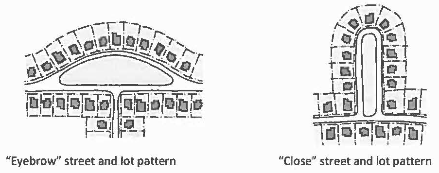
The circulation system must provide connections between residential areas, any neighborhood centers, common open spaces and external development areas. Cul-de-sacs are prohibited; however, "eyebrow" and "close" designs are permissible.
b.
On-street parking, either diagonal or parallel, is permitted on all TND streets.
c.
Street hierarchy. TND streets are classified as follows:
1.
Collector streets provide access to commercial and mixed-use buildings and are part of the city's major street network.
2.
Sub-collector streets provide access to individual residential properties. Design speed is 25 mph.
3.
Local streets provide access to individual residential properties. Design speed is 20 mph.
d.
Pedestrian circulation. Convenient pedestrian circulation systems must be provided throughout the TND as follows:
1.
All streets must include sidewalks on both sides. Sidewalk width must be at least five feet on residential blocks and at least eight feet (exclusive of the planting strip) on mixed-use and nonresidential blocks.
2.
Clear, well-lighted walkways of at least three feet in width must connect residential building entrances to the nearest sidewalk.
3.
Clear, well-lighted walkways of at least five feet in width must connect nonresidential building entrances to the nearest sidewalk and to associated parking areas.
e.
Bicycle circulation. Bicycle circulation must be accommodated on TND streets or on dedicated bicycle or multi-use paths.
(3)
Open space.
a.
At least ten percent of the gross acreage must be open space. At least 25 percent of that must be common open space improved for use by residents of the TND. Driveways, parking areas and yards of residential lots may not be counted toward the amount of required open space.
b.
Ownership and maintenance must be in accordance with section 62-37, common open spaces and facilities.
(4)
Permitted uses in residential areas.
a.
Uses permitted by right: Detached, zero lot line and attached single-family dwellings, duplexes and accessory dwellings, parks and playgrounds, residential day care facilities, recreational facilities available only to residents of the TND.
b.
The following conditional uses may be approved by the commission as part of the master plan, however, if not included in the approved master plan, conditional use approval in accordance with section 62-172 and an amendment to the master plan are required: Multifamily dwellings; assisted and independent living facilities; bed and breakfast, places of assembly; day care centers; private recreational facilities; educational facilities; fire stations, libraries and other public facilities.
(5)
Permitted uses in neighborhood centers. For TNDs larger than 30 acres, at least ten percent of the gross acreage must be designated neighborhood center, which must include a combination of residential and nonresidential uses. A designated neighborhood center is optional for all other TNDs. However, in no case may a neighborhood center exceed 25 percent of the TND gross acreage.
a.
Uses permitted by right: Any conditional use or use permitted by right in TND residential area; live-work buildings, retail stores, personal services, art galleries and studios, restaurants and offices no larger than 10,000 square feet per tenant space.
b.
The following conditional uses may be approved by the commission as part of the master plan, however, if not included in the approved master plan, conditional use approval in accordance with section 62-172 and an amendment to the master plan are required: Retail stores, personal services, restaurants and offices larger than 10,000 square feet per tenant space; other nonresidential uses expressly approved by the commission.
(6)
Area and dimensional standards.
a.
Multifamily development may not exceed 15 dwelling units per net acre. All other residential development may not exceed eight dwelling units per net acre. In addition, each detached single-family dwelling is permitted one accessory dwelling subject to section 62-94.
b.
See Table 6-4 for required setbacks for principal buildings. A reciprocal access easement must be provided on any dwelling lot with a zero lot line side setback and on the lot abutting the same side lot line. For other than attached dwellings and nonresidential uses, pedestrian access to the rear yard must be possible through means other than the principal building.
c.
The maximum building height in residential areas is three stories. The maximum building height in neighborhood centers is five stories.
Table 6-4: TND Setback Requirements
1 Measured from back of sidewalk or front lot line, as determined during master plan approval.
2 Where the rear lot line abuts an alley, the lower value is the setback. In all other cases, the higher value is the setback.
3 Greater separation may be required for fire separation based on construction type.
4 Zero lot line dwellings are set back zero feet from one side lot line and must be at least five feet from the opposite side lot line. Unattached side of attached dwellings must be set back at least five feet from the associated side lot line. Multifamily dwellings must be set back at least five feet from any side lot line.
(7)
Parking and loading.
a.
Off-street parking and loading areas must be provided in accordance with article VIII, Parking and Loading Standards. On-street parking may be counted toward parking requirements for nonresidential and mixed-use buildings within the TND and within 400 feet of the spaces. On-street parking spaces may be counted toward the parking requirements of only one use or building.
b.
Residential garages must be oriented away from street view, which may be accomplished by placing garages along alleys or otherwise placing them toward the rear of the lot.
c.
On corner lots, driveways must be located as far from the intersection as practicable.
d.
Parking for attached dwellings may be designed as a common parking area, whether or not parking spaces are on separate lots.
(8)
Architectural standards.
a.
The front facade of principal buildings must be oriented toward the street.
b.
Accessory buildings must be of the same materials and color scheme of the principal building.
c.
Vinyl siding is prohibited.
d.
Front porches, where provided, must be at least six feet deep.
(9)
Landscaping standards.
a.
Parking lots containing ten or more spaces must be screened from street view by buildings, opaque fences or walls, hedges or a combination of these. Otherwise, landscaping for vehicular use areas must be in accordance with section 62-124, landscaping for vehicular areas.
b.
Screening must be provided as required in section 62-123, screening unless other standards are approved as part of the master plan.
c.
Buffers required by section 62-122, buffers only apply along the perimeter of the TND. Buffers between uses within the TND, if any, are as established by the approved master plan.
(Ord. No. 2020-16, § 6.04, 3-16-2020)
Sec. 62-85. - Planned unit development district.
(a)
Purpose. This district is intended to allow flexibility in the development of large tracts of land and/or of multiple uses or tenants on one tract in accordance with an approved master development plan (MDP). The intent is to enable more innovative development and redevelopment options, the purpose of which is:
(1)
To permit flexibility in zoning standards to allow more creative and harmonious designs to accommodate planned associations of uses such as industrial or commercial uses, residential developments, or any appropriate combination of uses which may be planned, developed or operated as integral land use units;
(2)
To permit higher densities of land in conjunction with provisions for usable open space, amenities and community services;
(3)
To promote economy in the arrangement of uses, buildings, circulation systems and utilities;
(4)
To coordinate uses, building forms and relationships and architectural styles;
(5)
To promote the preservation and enhancement of existing natural features, their scenic qualities and amenities to the greatest extent possible and to utilize such features in a harmonious fashion.
(b)
Definitions. The following definitions apply whenever they are used in relation to a PUD. If the following definitions contradict definitions in any other section of this chapter, the definitions in this section apply as related to a PUD district:
(1)
Common open space. Open space held in common ownership and maintained by the developer or by an association of all residents or owners for recreation, protection of natural features, amenities or buffers; is freely accessible to all residents of the development; and is protected by the provisions of this chapter to ensure that it remains in such use.
(2)
Development. The construction, reconstruction, remodeling, conversion, structural alteration, relocation, enlargement or demolition of any structure, portion of a structure, or sign; any change in use of a property, building, structure or material change in the appearance of any structure; any increase in the number of dwelling units, businesses, manufacturing establishments, or offices; any mining, excavation, filling, grading, paving or land disturbance; and any act of subdivision of land.
(3)
Gross site area. The total land area to be classified as the planned unit development.
(c)
Minimum requirements for establishing a PUD district. The tract must be a minimum of five contiguous acres, have a minimum street frontage of 200 feet, and not encompass any land which is not part of the PUD. A smaller site may be considered provided evidence that:
(1)
The project is consistent with the developmental goals of the comprehensive plan for the particular location;
(2)
The minimum acreage requirement is impractical due to ownership, existing development patterns and similar constraints;
(3)
The design concept fully integrates the development into the surrounding neighborhood or business area;
(4)
The arrangement of uses, buildings, streets, parking, open spaces and amenities could not be reproduced on the site subject to the regulations of other available zoning districts.
(d)
Applicability. All properties in an approved PUD are bound by the standards in an approved MDP, even if subsequently sold, unless and until the MDP is voided by the city on request of the owner. However, to maintain continuity of the MDP, in no case will any portion of a PUD district become nonconforming solely as a result of a portion of the tract being rezoned.
(e)
Procedure.
(1)
Pre-application conference. Before filing an application for a PUD district, the prospective applicant must present a concept plan to the building official. All information listed below must be submitted to the building official at least ten working days prior to the conference:
a.
Relationship between the proposed development and adjacent, existing development.
b.
Proposed land use arrangement for the development.
c.
Concept for provision of open spaces.
d.
Total acreage devoted to each of the following: Detached single-family, attached single-family, multifamily, commercial, institutional, industrial and open space uses.
e.
Number of dwelling units and density for each land use district or smaller division of the development containing residential uses.
(2)
Application. After the pre-application conference, the applicant may file a rezoning application with the proposed MDP. If the property is already zoned PUD, the applicant must submit the proposed MDP for review by the commission. The MDP includes a written document, which may include supporting graphic materials, and a plan set illustrating the intents of the development. The applicant must submit 15 copies of the written document, 15 copies of the plan set, and an electronic version of said materials in a format approved by the building official.
(3)
Review and approval.
a.
After holding a public hearing on the application for rezoning and/or approval of the MDP, the commission will make a recommendation for approval, approval with changes, or denial to the council; or, with consent of the applicant, table its recommendation to allow time for further review or for the applicant to make requested changes.
b.
If the proposal is deemed by the commission to be unacceptable, the reasons for such determination will be set forth in its recommendation to the council.
c.
Any changes approved by the commission are considered binding on all subsequent development, unless otherwise modified or waived in writing by the council.
d.
Once the commission has rendered its decision, the MDP and all related materials, including any changes made thereto, are forwarded to the council. The council will approve, approve with changes, or disapprove the rezoning following a public hearing on the matter.
e.
No excavation, demolition or construction is permitted until the MDP has been approved by council. Upon approval of the MDP, the applicant may then apply for any subdivision approvals or other development permits.
(4)
Fees. An application fee, as set from time to time by the council, must be submitted at the time of application to cover administrative and public notice costs.
(f)
Additional provisions.
(1)
Amendments. To facilitate minor adjustments to the approved MDP as may be necessary, the building official may approve changes that are incidental or minor in scope. The following changes must be referred to the commission; changes greater in scope require approval by the commission and council:
a.
A change in land use district boundaries, provided the effect on the number of dwelling units or amount of open space, commercial or multifamily areas does not exceed the limits in items b. or c. below.
b.
An increase in the overall number of dwelling units or land devoted to multifamily development greater than five percent but less than ten percent.
c.
A reduction in the amount of open space or land designated for commercial use by more than five percent but less than ten percent but in no case shall be less than the minimum amount defined in Table 6-5 of PUD development standards.
d.
Rearrangement of streets, or reduction in the number of pedestrian or bicycle facilities.
e.
Changes to the development schedule.
Any deviation from the MDP, which is not approved as provided herein, constitutes a violation of this chapter.
(2)
Construction must commence within 365 calendar days from the date of approval by the council. Construction is deemed to have started with the actual construction of a principal building and does not mean site preparation or excavation of the site. Failure to begin construction within this time period, unless an extension is granted by the commission, voids the MDP. No building permit may be issued without a valid MDP.
(3)
The board may not grant variances that would have the effect of amending an approved MDP.
(4)
No amendment of this chapter affects a PUD approved prior to such amendment. The PUD may continue in accordance with the zoning ordinance in effect at the time of such prior approval. Should the PUD approval expire or be voided, any newly submitted MDP must conform to the regulations in effect at the time of the new submittal.
(g)
Development standards. Property development standards must be proposed in the MDP and must be consistent with the developmental policies of the Cullman Comprehensive Plan. All provisions of the zoning ordinance and subdivision regulations apply except where specifically addressed in this section or within the approved MDP. No use of the property, nor construction, modification or alteration of any use or structure is permitted in conflict with the MDP.
(1)
Development must be compatible with site topography. Scenic assets and natural features must be protected and preserved to the extent possible.
(2)
Structures and open space must be arranged in such a way as best to serve the needs of residents and to minimize any adverse effects on neighboring properties.
(3)
Harmonious design, incorporating a variety of building types and variations in building styles, is encouraged.
(4)
Density, building height, building spacing and setbacks must be as provided in Table 6-5.
(5)
The development may not adversely affect property in the vicinity and must be compatible with adjacent properties with regard to density, scale, character and use. Buffers, landscaping, setbacks for buildings along the perimeter of the site, or a combination of these may be required for the protection of adjoining properties.
(6)
Adequate water, sewer, streets and other facilities and utilities must be available to the PUD or there must be a definite proposal for making them available at the expense of a party other than the city. The commission may impose such reasonable conditions that it finds necessary to protect and promote the public health, safety, and welfare of the city.
Table 6-5: PUD Development Standards
(h)
Uses. A planned unit development must comprise one or more PUD land use districts. Uses in each land use district are subject to Table 6-6. Final approval of uses is contingent on approval of the MDP. Any conditional use not specifically approved as part of the MDP requires approval by the commission in accordance with section 62-172, conditional uses.
(i)
Circulation standards.
(1)
Vehicular access must be from streets capable of supporting existing traffic and traffic to be generated by the development. Access points must be located and designed in accordance with accepted access management practices to separate through and local traffic, maintain capacity, and enhance safety of motorists, pedestrians and bicyclists. Streets, driveways and parking, loading and service areas must be designed to provide safe access to all uses and facilities.
(2)
Pedestrian facilities must be arranged to provide safe and convenient routes to, from and within a PUD. Recreational facilities, schools, libraries and similar community destinations must be accessible to residential areas with a minimum of street crossings. Where possible, such uses must be accessible from a common, interconnected pedestrian system.
(3)
Bicycle and bridle paths, where provided, must be coordinated with the pedestrian system.
(j)
Open space standards. Common open space must be provided in each PUD land use district in the amounts shown in Table 6-5. No designated common open space may be subdivided in the future, nor may it be reduced in area or used for any purpose other than those permitted as listed above unless approved through an amendment to the MDP.
(1)
The following are excluded from calculation of common open space:
a.
Land within individual lots.
b.
Land encumbered by any substantial structure, enclosure or parking facility.
c.
Land within eight feet of any building.
d.
Land within a roadway, except a median that is at least 50 feet wide at its narrowest point and is designed for use as a recreational space.
e.
Land to be used as or be in any required drainage area or easement.
(2)
Maintenance provisions must be included in the PUD's declaration of covenants, conditions and restrictions, consistent with section 62-37, common open spaces and facilities, for all common open spaces not left in a natural state. This includes, but is not limited to, circumstances where the developer no longer has ownership or an association of homeowners has disbanded. Common open space dedicated to the city or other governmental agency for operation and maintenance may not be for the exclusive use of the residents or patrons of the PUD.
(3)
The area of common open spaces in each development phase must meet the requirements in Table 6-5 unless otherwise expressly approved as part of the MDP.
(k)
Exterior materials. An architectural review committee representing the interests of property owners within a PUD is recommended. Standards for exterior building materials must be incorporated into the MDP consistent with the following guidelines and Table 6-7 to govern the design of buildings. The commission may require as part of the MDP that design plans for multifamily and nonresidential buildings be reviewed by the commission prior to approval of building permits.
(1)
Area of window and door openings are not included in calculation of exterior building requirements.
(2)
Cement block may only be used on residential building exteriors at the foundation up to a height of three feet. Cement block foundations along front facades must be screened with shrubs or other landscaping. Cement block may only be used on nonresidential building exteriors along rear and side elevations.
(3)
Vinyl siding is prohibited as an exterior material.
(4)
Metal siding is discouraged but may be used in combination with other exterior materials for multifamily and nonresidential buildings upon express approval of the commission.
Table 6-7: Materials Guidelines
(l)
Signage. A signage plan must be submitted as part of the MDP and must generally conform to article X, Signs and this subsection. The commission uses the most compatible sign height, size and location requirements in article X as a guide in reviewing proposed signage plans. All permitting and building code requirements apply to signs in a PUD.
(1)
Off-premise signs are prohibited.
(2)
Street signs must be uniform in design throughout a PUD. If a standard other than that of the city is used, the developer or property owners' association will be responsible for maintenance.
(m)
Landscaping. The standards of article IX, Landscaping, apply unless standards are approved with the MDP to address buffering, screening and landscaping for vehicular areas.
(Ord. No. 2020-16, § 6.05, 3-16-2020; Ord. No. 2021-20, §§ IX—XI, 2-8-2021)