
Cumberland City Zoning Code
ARTICLE VI
ZONING DISTRICT REGULATIONS
Sec. 25-131.- Generally.
(a)
Uses permitted within the various zoning districts are listed in a table entitled "Use Regulations" which is section 25-132 of this chapter. Minimum lot area, area per dwelling, minimum lot width, required yards, and maximum height requirements for permitted building uses or structures in the various districts are listed in a table entitled "Development Regulations" which is section 25-133 of this chapter. Supplemental requirements/regulations that apply to several or all districts are set forth in sections 25-134 through 25-141 related to the following:
Supplemental requirements that apply to specific districts are set forth in Sections 6.12 through 6.17 related to the following:
(b)
In addition to the zoning district regulations contained in this section, all developments must comply with the requirements of articles VIII (site plan review), XI (historic area regulations), XII (off-street parking and loading), XIII (buffer strips), XIV (sign control provisions), and other parts of this chapter, where applicable.
Sec. 25-132. - Use regulations.
(a)
Uses permitted within the various zoning districts are listed in the table entitled "Use Regulations" on the following pages.
(b)
Any use which is not included in the table shall be considered as prohibited, except pursuant to subsection 25-22(d).
USE REGULATIONS TABLE
NOTES:
1. Permitted and prohibited uses in the Conservation District are presented in section 25-142.
2. Permitted and prohibited uses in the Rehabilitation and Redevelopment Floating
Zone District are presented in section 25-144.
3. All public, professional, commercial, industrial, or other non-residential uses;
all multi-family dwelling uses; all temporary structures; and certain other uses designated
in sections 25-139 (steep slope development), 25-140 (development within floodplains, streams, and buffer areas), 25-141 (preservation of habitats of threatened and endangered species), 25-143 (gateway districts), and article X (Viewshed Protection Overlay District) are subject
to the provisions of article VIII (site plan review).
* Adult businesses may not be located within 1,500 linear feet of any public library,
public park, public playground, school, church or similar place of worship, child
care center, community center, or residence.
(Ord. No. 3796, § 2, 6-7-16; Ord. No. 3828, § 1, 1-2-18; Ord. No. 3860, § 1(Att.), 10-15-19; Ord. No. 3922, § 2, 8-16-22; Ord. No. 3913, § 2, 5-17-22; Ord. No. 3965, § 2, 9-5-23)
Sec. 25-133. - Development regulations.
(a)
Development regulations table.
(1)
Minimum lot area, area per dwelling, minimum lot width, required yards, and maximum height requirements for permitted building uses or structures in the various districts are listed in the table entitled "Development Regulations" on the following pages.
(2)
The regulations listed for each zone as designated, reading from left to right across the table, are hereby prescribed for such zones, subject to the other provisions of this chapter and shall be deemed to be the minimum requirements in every instance of their application, unless otherwise stated.
(3)
Whenever any currently existing dwelling unit is converted into a multi-family dwelling unit, the area requirement as set forth in the development regulations table shall be considered to remain that which would be required had said unit not been so converted.
(4)
Where a proposed development site consists of more than one (1) lot of record, the applicable zoning requirements and standards shall be fully satisfied for each individual lot of record, unless and until the individual lots comprising the development site shall be consolidated into one (1) undivided lot of record in the county land records. In the event the lots are consolidated, the instrument effecting the consolidation shall include the following statement: "In accordance with Sections 25-133(a)(4) and 25-205(a) of the City of Cumberland Zoning Ordinance, the property described herein shall be treated as one lot of record."
DEVELOPMENT REGULATIONS TABLE
[1] Fifteen (15) feet from adjacent property not within cluster development.
[2] Thirty-one (31) feet for corner/end lot (minimum 16-foot dwelling width and fifteen (15) feet from adjacent lot line).
[3] One hundred (100) feet for corner lot.
[4] The lesser of the prevalent front yard setback of existing buildings on the block or twenty (20) feet, provided that the provisions of section 25-135 (traffic visibility across corners) are met.
[5] The lesser of the side yard setback of the existing principal building on the lot or six (6) feet, provided that the provisions of section 25-135 (traffic visibility across corners) are met.
[6] Twenty-two (22) feet for corner/end lot (minimum 16-foot dwelling width and six (6) feet from adjacent lot line).
[7] The lesser of the side yard setback of the existing principal building on the lot or ten (10) feet, provided that the provisions of section 25-135 (traffic visibility across corners) are met.
[8] Unless the standard in note [4] applies, the front and rear yards and building coverage shall not be less than the minimum distance of setback or coverage of the nearest building or buildings, within one hundred (100) feet on each side of the said building and fronting on the same side of the street.
(b)
General regulations.
(1)
Every principal building shall be built upon a lot with frontage upon a public street improved to meet city standards or for which such improvements have been ensured by the posting of a performance guarantee pursuant to the subdivision regulations of the city or shall have access to a private street approved by the fire department, the engineering department, and the planning commission.
(2)
No yard or other open space provided about any buildings for the purpose of complying with the provisions of this chapter shall be considered as providing a yard or open space for any other building, and no yard or other open space or another lot shall be considered as providing a yard or open space for a building on any other lot.
(3)
Where two (2) or more main buildings for other than residential uses are proposed to be built upon property in one (1) ownership, front, side, and rear yards are required only at lot lines abutting other property.
(4)
No soil, mineral, or similar material may be removed from any lot unless a zoning permit is first secured. Site and street grading, but not including excavations for construction purposes, may be initiated prior to obtaining a permit. The deposit of soils, detritus, or other debris which would be unsightly or detrimental to surrounding properties, streets, sewers, and natural waterways as a result of site preparation, grading, and/or excavating shall be prohibited.
(c)
Exceptions to general regulations.
(1)
The height limitations of this chapter shall not apply to church spires, belfries, cupolas, penthouses, and domes not used for human occupancy; nor to chimneys, ventilators, skylights, water tanks, bulkheads, similar features, and necessary mechanical appurtenances usually carried above roof level.
(2)
Nothing herein contained shall prevent the projection of an emergency exit (open fireproof fire escape) or handicapped access structure into a required rear or side yard for a distance not to exceed eight (8) feet, but in no case to project beyond the property line.
(3)
Any parcel of land with an area or width less than that prescribed for a lot in the zone in which such parcel is located at the date of the adoption of this chapter, when the owner thereof owns no adjoining land, may be used as a lot for any purpose permitted in the zone, provided that all other regulations prescribed for the zone by this chapter are complied with.
(4)
Where there is, at the time of the enactment of this chapter, a lot whose width and area are less than that required for the zone in which said lot is located, flanked by buildings existing on the two (2) lots adjoining at the sides, both being in other ownership:
a.
The lot shall be permitted to be built or rebuilt upon in any zone, without requirement of side yards wider than the respective adjacent side yards existing on the adjoining lots.
b.
The front and rear yards shall not be less than the minimum distance of setback of the nearest building or buildings, within one hundred (100) feet on each side of the said building and fronting on the same side of the street. See also subsection 25-133(a), development regulations table, note [8].
c.
No requirement for rear yards, side yards, or yard area contained in this chapter shall prevent the construction of a private garage or other customary accessory uses, as approved by the zoning administrator, within the required rear yard of a lot not meeting the requirements of this chapter upon which a dwelling has been erected previous to the time of enactment of this chapter. Accessory uses located in side or rear yards shall meet the setback requirements of the development regulations table.
(d)
General yard requirements.
(1)
Where a street or a highway shown on the adopted city thoroughfare plan has a proposed right-of-way greater than that existing, the front yard requirement shall be measured in accordance with the proposed right-of-way.
(2)
Ground story bays and porches not over one-half (1/2) the length of the front wall may project into any front yard five (5) feet. Chimneys, flues, columns, sills, and ornamental features, cornices, and gutters may project not more than two (2) feet.
(3)
Bays, balconies, chimneys, and flues may project into a required side yard not more than one-third (1/3) of its width, and not more than four (4) feet in any case. Ground story bays and porches not over one-half (1/2) the length of the side wall may project into any side yard three (3) feet.
(4)
In residential districts, the following features may project not more than ten (10) feet into any required front or rear setback area: open porches and decks and exterior stairways or ramps, whether above or below ground level. Where an open porch or deck extends or will extend into the required minimum front yard setback of a building, said porch or deck shall not be enclosed (sealed from the elements) by walls, windows, or other materials that would further obstruct required site visibility as specified in subsection (d)(5)a. or would impede safe access/egress site visibility from any side yard driveway on the property under the requirements of section 25-135 without prior variance approval by the zoning board of appeals.
(5)
Fences, walls, and hedges shall comply with the following provisions:
a.
In any required front yard, no fence or wall shall be permitted which materially impedes vision across such yard above the height of forty-eight (48) inches, and no hedge or other vegetation shall be permitted which materially impedes vision across such yard between the heights of forty-eight (48) inches and nine (9) feet. Fences, hedges, or walls less than seven (7) feet high above the preexisting grade and terraces, steps, uncovered porches, or other similar features not over three (3) feet high may be permitted in the required side and rear yards, providing that subsection 25-135(a) (traffic visibility across corners) does not apply.
b.
Fences may be constructed in the front or street side yards of any lots which are approved for a housing type which have no backyards (i.e., back to back townhouses, quadraplexes and other similar housing types). To obtain approval of such fences, the applicant shall submit an overall fencing plan for all such lots which front on a particular street to the zoning administrator.
c.
A fence, wall, or hedge not exceeding eight (8) feet in height may be located in any yard of any commercial, industrial, or institutional lot in a business commercial or industrial/employment district not abutting a residential district. Fence along a lot line abutting a residential lot shall comply with (4)a. above.
d.
Barbed wire fences shall not be permitted except in the B-C and I-G Districts.
e.
Electric fences shall not be permitted in any zone.
(6)
All commercial surface parking lots shall be subject to a minimum setback of six (6) feet. Subsurface parking structures may extend to the property lines.
(7)
If the zoning administrator determines that the required amount of parking cannot be met under the setback requirement, off-street parking may be permitted in all required yard areas providing there is no encroachment into required sight triangles, that no more than fifty (50) percent of the affected required yard area is utilized, that it is not possible to place the required off-street parking elsewhere on the lot, and provided all other requirements of this chapter are met.
(8)
Corner lots fronting on two (2) intersecting streets shall be considered to have two (2) front yards, two (2) side yards, and no rear yards. One (1) front yard shall meet the yard requirements for the applicable zone and the other shall be not less than fifteen (15) feet.
(9)
There shall be no rear yard requirements for triangular lots.
(10)
In the case of irregularly shaped lots, the minimal lot width specified in the development regulations table shall be measured at the rear line of the required front yard, provided that in no case shall the lot frontage measured at the street right-of-way line be less than seventy (70) percent of the minimum lot width as specified in the table. In measuring the depth of rear yards, average dimensions may be used where the rear lot line is not parallel with the street line.
(e)
Maximum height of buildings.
(1)
No building shall exceed the maximum height of buildings specified in the development regulations table.
(2)
Height shall be measured from the average elevation of the proposed finished grade at the front of the building to the highest point of the roof for flat roofs; to the deck lines of mansard roofs; and to the average height between eaves and ridge for gable, hip, and gambrel roofs.
(3)
Municipal buildings and municipal uses, including civic centers, libraries, museums, memorial buildings, or galleries and community center buildings, and/or civic service agency buildings may be increased in height up to, but not exceeding, eight (8) stories or one hundred (100) feet, providing that such building shall not be closer to any street than twice the depth of the required front yard for the respective residential district in which such building is located and such setback from any street shall be increased by not less than one (1) foot for each one (1) foot in height of the building over thirty-five (35) feet, except that in districts such setback from any street shall be increased by not less than one (1) foot for each six (6) feet or portion thereof in height of the building over thirty-five (35) feet.
Sec. 25-134. - Accessory uses and structures.
(a)
General requirements for accessory uses and structures.
(1)
Accessory uses and structures which are customarily incidental to the permitted principal use or structure, which are clearly subordinate to the permitted principal use or structure, and which do not significantly alter the character of the permitted principal use or structure are themselves permitted subject to the following requirements:
a.
Accessory uses and structures shall be located on the same parcel as the permitted principal use or structure.
b.
No accessory building, unless it is structurally a part of the principal building, shall be erected, altered, or moved to a location within five (5) feet of the nearest wall of the principal building.
c.
Except as provided in subsection 25-134(c)(2), no accessory use or structure shall be located within any required front yard.
d.
Accessory structures may be located within a required rear or side yard unless otherwise specified herein, provided such structure shall not exceed twenty (20) feet in height.
e.
The lot coverage of accessory uses or structures shall not exceed thirty (30) percent of the yard area where they are being placed.
f.
Except as provided elsewhere in this chapter, no accessory structure shall exceed fifty (50) percent of the maximum height allowed for the permitted use, except in conjunction with agricultural or industrial use.
g.
Accessory structures associated with two-family and apartment uses shall not exceed twenty (20) feet in height.
(2)
Accessory buildings, structures or uses include, but are not limited to, a private garage, garden shed or barn, guesthouse, private playhouse, private greenhouse, private swimming pool, home garden, nursery or greenhouse, home occupation, residential accessory structure or use (garage, shed), solar energy system, temporary structure or use, tennis court, windmill, antenna (including dish or tower), and the like.
(3)
In residential districts open decks (i.e., decks without roof or walls) shall not be considered structures for lot coverage purposes when constructed onto a single-family dwelling.
(b)
Antenna accessory to residences.
(1)
In any residential district or other district adjacent to any residential district, antennas, including satellite dish antennas serving residential units, shall not exceed three (3) feet in diameter nor extend above the maximum allowed height for a principal use or structure. Antennas more than fifteen (15) feet in height shall be regulated as communications towers.
(2)
No amateur radio transmission antenna shall be constructed until plans for the same have been submitted to and approved by the zoning administrator. The plan shall show location, height, and configuration of the equipment and, if approved, shall be constructed so as to be structurally sound and not to present any electrical hazard to any person around, near, or upon the antenna. The applicant shall also present affidavits from all property owners within one hundred (100) feet of his dwelling stating that they have no objection to such installation. This provision does not obligate the zoning administrator to approve any amateur radio transmission antenna, however.
(c)
Accessory structures for domestic or farm animals.
(1)
Accessory structures housing farm animals or farm equipment (not for sale) shall be located at least fifty (50) feet from a street right of way and from any adjacent property in a residential district and may be constructed to a height not greater than fifty (50) feet.
(2)
Accessory structures in front yards of residential districts shall be limited to the following:
a.
Driveways and parking areas for the principal use,
b.
Permitted signs under this chapter, and
c.
Fences permitted under this chapter.
(d)
Corner lots. In all districts allowing residential uses, including all applicable end townhouse units, where any dwelling or structure is located on a corner lot or reverse corner lot, no accessory structure shall be located within the street side yard specified in section 25-133 (development regulations). On a corner lot in any district, areas free of all structures, parking areas or landscape materials shall be maintained in accordance with section 25-135 (traffic visibility across corners).
(e)
Automatic teller machine (ATM). A freestanding ATM shall not exceed two hundred (200) square feet in footprint (outside measurements), shall not exceed eleven (11) feet in height, shall provide sufficient parking as may be required by the zoning administrator, shall be limited to signage only as a part of the structure, shall be located no closer than thirty (30) feet to any exterior property line of the lot upon which it is located, and shall provide screening designed in such a way as to be appropriate under the circumstances of the request. A non-freestanding ATM shall be an accessory structure subject to approval by the zoning administrator who shall require such information for submission by the applicant as shall be sufficient to determine the acceptability of the ATM at the location proposed including location, size, parking, building materials, accessibility, visibility and lighting, and other safety considerations and signage.
(f)
Public art. Outside of the Canal Place Preservation District, public art may be permitted on public or private property with the consent of the property owner and after review and approval by the municipal planning commission. The commission may regulate the location, size, lighting, and general appearance of the artwork. Within the Canal Place Preservation District, the historic preservation commission shall govern public art in accordance with the historic preservation guidelines.
(g)
Small wind energy systems. Small wind energy systems, as defined in section 25-23, shall be permitted as a conditional accessory use to any permitted principal use (excluding non-conforming uses) in any zoning district, with the exception of the Conservation and Viewshed Protection Overlay Zones, subject to a determination by the zoning board of appeals of compliance with all of the following requirements:
(1)
No more than one (1) free-standing small wind energy system with a rated maximum output of not more than fifteen (15) kilowatts of electricity shall be permitted on any individual property. No roof-mounted wind energy systems shall be permitted.
(2)
The minimum setback from any property line for a small wind energy system shall be:
a.
One and one-tenth (1-1/10) foot from the base of the structure to each property line for every one (1) foot in structure height (as measured from the lowest point along the base to the highest point of the support tower, the top of either the turbine device or the area swept by the rotor blades, whichever is greatest).
b.
In the event that the maximum permitted height for a small wind energy system cannot be achieved on a specific property by virtue of setback constraints, the maximum permitted height shall be controlled by the setback constraints. The zoning board of appeals shall not issue a variance to the minimum required setbacks for a small wind energy system.
(3)
No small wind energy system shall have a rated maximum output in excess of fifteen (15) kilowatts of electricity. No variance to this electric generating capacity limit shall be granted by the zoning board of appeals.
(4)
No support tower for a small wind energy system shall be taller than thirty (30) meters (approximately one hundred (100) feet) in height. The zoning board of appeals may issue a variance to the height limit for a ground-mounted small wind energy system only, subject to compliance with all of the following requirements:
a.
The applicant shall provide wind speed measurements taken during the peak wind season documenting that the average wind speed from the prevailing wind direction at the maximum permitted height of thirty (30) meters does not exceed six (6) miles per hour and that the average wind speed from the prevailing wind direction at the requested height does exceed six (6) miles per hour.
b.
That the proposed small wind energy system will be sited on the property in a location where an additional one and one-tenth (1-1/10) foot in setback distance from all property lines shall be provided for each additional one (1) foot in supporting tower height over and above the minimum setback required for the permitted height in subsection (2)a.
c.
The maximum height variance that the zoning board of appeals may grant, based on the applicant's evidence and justification, shall not exceed one hundred fifty (150) feet.
d.
The proposed device shall satisfy all other applicable requirements of this chapter.
e.
In granting a height variance for a small wind energy system, the zoning board of appeals may impose additional landscaping requirements along the boundaries of the property as may be warranted and reasonably effective to offset or minimize the visual impacts of the system on neighboring residences.
f.
The zoning board of appeals shall not vary the minimum setback requirements for a small wind energy system in the granting of a height variance.
(5)
All wind energy systems shall be designed such that the lowest point of the area that may be swept by the rotor blades shall have a clearance of not less than fifteen (15) feet above the base of the supporting structure. The supporting tower shall not be climbable more than twelve (12) feet above the base of the structure. Any access doors to wind energy towers and electrical equipment shall be secured by safety locks.
(6)
The applicant shall document that the proposed small wind energy system shall not generate noise levels at all property boundaries in excess of the residential use noise standards specified in subsection 25-138(f)(2). When measuring noise levels or determining compliance with the requirements of subsection 25-138(f)(2), the zoning board of appeals may require that all decibel levels and readings shall be measured using a C-weighted filter, rather than or in addition to an A-weighted filter, due to the predominance of low frequency noise emissions typically generated by wind turbines.
(7)
Guy wires used to support a small wind energy system structure shall be set back at least ten (10) feet from all property lines and shall be secured to stationary anchors properly and securely mounted into the ground, not a tree or other structure on the property. Appropriate, but not excessive, reflective or visible painting or colored objects (such as flags, reflectors, or tapes) shall be placed on all guy wires within ten (10) feet of the ground in sufficient quantities or spacing to make them visible.
(8)
All small wind energy systems shall be designed with braking, governing, or feathering systems to prevent uncontrolled rotation, over-speeding, and excessive pressure on the tower structure, rotor blades, and system components.
(9)
Where required, small wind energy systems must provide complete and appropriate documentation and approvals to show compliance with all applicable Federal Aviation Administration regulations, including any necessary approvals for systems that may be located near airport runways or may encroach upon protected approach/departure or accident potential zones around an airport. The applicant also shall provide documentation that the proposed small wind energy system shall not create interference with telecommunication signals and reception in the immediate area.
(10)
To the maximum extent practicable under the applicable regulatory requirements, rotor blades for all small wind energy systems shall be designed with non-reflective (non-gloss) paints and materials to minimize the potential "flicker" or "strobing" effect of reflected sunlight on adjoining properties. The system also shall be designed or sited to minimize the potential impacts of rotor blade shadow strobing on nearby residential dwellings, where such siting flexibility exists.
(11)
No small wind energy system shall be lighted or illuminated in any way that is not otherwise specifically required by the Federal Aviation Administration.
(12)
No small wind energy system shall contain any lettering, advertisement, or signage of any kind, with the exception of any required or standard warning signage and not more than one (1) manufacturer label bonded to or painted upon the wind turbine device.
(13)
Small wind energy systems shall be designed and painted in a manner that is appropriate to minimize visual impacts on the area and setting.
(14)
All supporting towers for a small wind energy device shall be specifically engineered to support a wind turbine. Steel lattice support towers shall be prohibited in all residential zones. The use or modification of a supporting tower originally designed for a telecommunication antenna as a supporting tower for a small wind energy system shall be prohibited. Supporting towers constructed of aluminum also shall be prohibited.
(15)
To the maximum extent practicable, all on-site wiring or power lines necessary to control or transmit power from the wind energy device shall be undergrounded or hidden from public view, except where necessary to connect the system with an above-ground power line.
(16)
Where a small wind energy system will be connected to the electric power grid to permit "net-metering," the applicant also shall provide an affidavit signed by the owner documenting that "[t]he owner will comply with all applicable utility notification requirements contained in the Maryland net metering law, and the system will comply with the Institute of Electrical and Electronics Engineers (IEEE) 1547 Standard for Interconnecting Distributed Resources with Electric Power Systems, as may be amended, and the applicable requirements promulgated by the Maryland Small Generator Interconnection Standards by the Maryland Public Service Commission."
(17)
When an approved small wind energy system has ceased active production of electricity for a period of at least twelve (12) consecutive months, the owner of said property shall remove the device and supporting structure from the property.
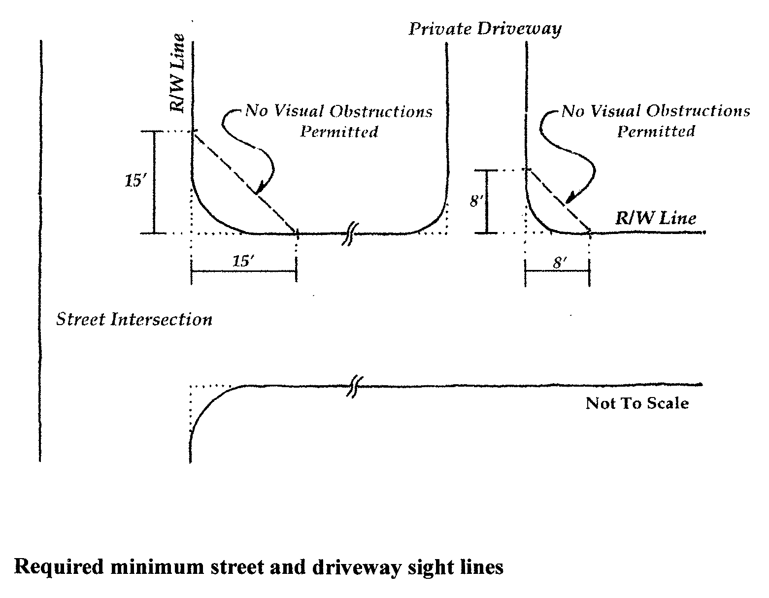
Sec. 25-135. - Traffic visibility across corners.
(a)
In order to provide a clear view of intersecting rights-of-way to motorists, an area free of fences, walls, hedges, shrubs, planting, or other visual obstruction shall be maintained. This area shall extend from thirty (30) inches to ten (10) feet above the curb level within the triangular area formed by the right-of-way lines of two (2) intersecting streets and a line connecting them at points fifteen (15) feet from the intersection of the right-of-way lines, or in the case of a rounded property corner, from the intersection of the right-of-way lines extended. The same sight line limitations shall apply on any lot within ten (10) feet from the intersection of a street right-of-way line and an alley right-of-way line.
(b)
On any lot where a private driveway enters a street, no visual obstruction shall be maintained between thirty (30) inches and ten (10) feet above curb level within the triangular area formed by the street right-of-way line, the private driveway line, and a line connecting them at points eight (8) feet from their intersection.
(c)
In any zone where signs are permitted, a pole(s) or standard(s) may be located at any point within a required yard if, between the level of thirty (30) inches above curb level and the level of ten (10) feet above curb level, the diameter or greatest dimensions of the supporting pole(s) or standard(s) does not exceed twenty (20) inches.
Sec. 25-136. - Home occupations.
(a)
Definitions.
Home office of convenience means an office within a dwelling or accessory structure used for the purpose of sending and receiving communications, maintaining records, and other similar functions, but where no business is conducted other than by phone, mail, or electronically, and no persons are employed on the site other than the occupants of the residence in question.
Home occupation means any occupation or business use, other than a home occupation of convenience, conducted entirely within a dwelling or an accessory structure or both by a resident of the property, and which is clearly incidental to the residential use of the property, excluding: antique shops; boarding or rooming houses or tourist homes; commercial repair or storage of automobiles, watercraft, or other motor vehicles; commercial stables, kennels, and nurseries; mortuary establishments; and restaurants or tea rooms.
(b)
Where permitted.
(1)
Home offices of convenience are permitted as accessory uses in all zoning districts where residences are allowed.
(2)
Home occupations are permitted as accessory uses in all zoning districts where residences are allowed, with the exception of the R-S District.
(c)
General standards. Home offices of convenience and home occupations shall comply with the following standards:
(1)
No noise, odor, vibration, light, smoke, or electromagnetic interference shall be produced that can be detected at or beyond the property line.
(2)
There shall not be outside storage of equipment, material, or stock.
(3)
There shall be no storage on the premises of explosives or highly flammable or extremely hazardous materials as defined by the U.S. Environmental Protection Agency.
(4)
Delivery of materials to and from the premises shall not involve the use of vehicles over two (2) ton capacity, with the exception of parcel delivery services that normally serve residential areas.
(5)
Any interior structural alterations to accommodate the home occupation shall require the issuance of a building permit.
(d)
Additional standards for home offices of convenience.
(1)
The maximum area devoted to a home office of convenience shall be thirty (30) percent of the gross area of the dwelling or accessory structure that is used for the HOC.
(2)
There shall be no changes to the exterior of the building nor visible evidence that the residence contains a HOC.
(3)
There shall be no outside employees.
(4)
There shall be no retail sales or services conducted on the premises.
(5)
Traffic generation for the dwelling with a HOC shall not exceed that normally generated without a HOC.
(e)
Additional standards for home occupations.
(1)
The maximum area devoted to the home occupations shall not exceed thirty (30) percent of the square footage of the dwelling or accessory structure that is used for the home occupation. However, a maximum of fifty (50) percent of the square footage of the dwelling unit or accessory structure may be used for a home occupation in an Arts Overlay District.
(2)
There shall be no exterior evidence, other than a permitted sign in accordance with article XIV, to indicate that the building is being used for any other purpose other than that of a dwelling or an accessory structure.
(3)
No more than one (1) person shall be employed who is not a member of the family residing on the premises.
(4)
Retail sales of goods grown, produced or assembled on the premises shall be permitted. Retail sales of products not produced on the premises shall be permitted only when these sales are incidental to and part of the primary function of the business.
(5)
Adequate space shall be provided for off-street parking and loading.
(6)
A home occupation located on a local street shown in the comprehensive plan shall not generate more than five (5) business-related trips per day, excluding delivery vehicles, from off the premises.
(f)
Permit/approval required.
(1)
A permit from the zoning administrator's office is not required for a home office of convenience.
(2)
Application for a home occupation permit shall be made to the zoning administrator on a form provided by the administrator's office and shall be accompanied by a filing fee that is established by mayor and city council. The zoning administrator, or his/her authorized designee, shall review and approve, approve with conditions, or deny the permit request within fifteen (15) days of receipt of a complete submission. The zoning administrator's decision shall be based upon conformance with the standards contained in subsections (c) and (e).
Sec. 25-137. - Multi-family and single-family attached housing standards.
(a)
Building requirements.
(1)
Each dwelling unit shall contain complete kitchen, toilet, bathing, and washing facilities, and shall have a minimum habitable floor area in accordance with the following:
(2)
In multiple dwellings two and one-half (2-1/2) stories or less in height, maximum building size shall be restricted to no more than sixteen (16) dwelling units in one (1) continuous structure.
(3)
Single-family attached dwelling units shall not be less than sixteen (16) feet in width.
(4)
The distance between multi-family dwelling unit buildings on the same lot shall not be less than twenty (20) feet. No interior yards, as such, shall be required but all buildings shall be located in relation one to another that the angle off horizontal from the sill of the lowest window in the habitable area in one (1) building to the highest point of another building (excluding towers, chimneys, and similar fixtures) does not exceed forty-five (45) degrees. Where possible, the design layout of dwelling structures shall be such that the front of one (1) structure does not face the rear of another.
(5)
The distance at the closest point in all districts except the R-O District, between any two (2) buildings of a group of elevator type multiple dwellings shall not be less than thirty-five (35) feet and for each two (2) feet such height is increased beyond a height of thirty-five (35) feet the distance between such buildings shall be increased by not less than one (1) foot. In the R-O District, the distance at the closest point, between any two (2) buildings of a group of elevator type multiple dwellings shall not be less than twenty-five (25) feet and for each two (2) feet such height is increased beyond a height of the building over thirty-five (35) feet the distance between such buildings shall be increased by not less than one (1) foot.
(6)
No multi-family dwelling unit building shall be closer than twenty (20) feet from any access driveway or closer than ten (10) feet from any parking area.
(7)
Courtyards. Courtyards bounded on three (3) or more sides by the wings of the same building or by the walls of separate buildings shall have a minimum court width of two (2) feet for each one (1) foot in height of the highest building.
(8)
Storage space. In addition to any storage area contained inside the multi-family building dwelling units, there shall be provided for each dwelling unit thirty-five (35) square feet of storage area in a convenient centrally located area in the basement or ground floor of the dwelling structure or elsewhere where personal belongings and effects may be kept locked and separated from belongings of other occupants. There shall be a minimum of readily accessible common storage area in each building for bicycles, perambulators, and similar types of equipment of six (6) square feet per dwelling unit.
(9)
All multi-family building stairwells, stairways, and landings shall be architecturally integrated into the building.
(10)
No more than one (1) external master television antenna shall be permitted on each principal multi-family building.
(b)
Site requirements.
(1)
Interior roads shall be so designed as to minimize hazards to pedestrians and to vehicles on roads within the development and on roads in adjacent areas.
(2)
Off-street parking areas shall not open directly on to a public street but shall be provided with access drives or other controlled access. Access drives shall not serve as part of a specified parking area and shall be kept clear of parked vehicles.
(3)
Pedestrian walks shall be not less than four (4) feet in width and shall be provided wherever normal pedestrian traffic will occur. All walks shall meet the engineering standards specified by the city engineer.
(4)
Bicycle facilities shall be provided as required by the zoning administrator.
(5)
Garbage and refuse pickup and other multi-family utility areas shall be located so as not to detract from the aesthetic character of the development and shall be enclosed and shielded from view by fencing, walls, or shrubbery of at least five (5) feet in height around the perimeter.
(6)
All telephone and electric service utilities shall be underground in all multi-family developments.
(7)
All multi-family developments shall be served by public water and sanitary sewer facilities in compliance with applicable state and city requirements.
(8)
All multi-family developments shall be appropriately landscaped. Interior roads, parking areas, bicycle facilities, and pedestrian walks shall be provided with shade trees which are of an appropriate size and character. Open space adjacent to buildings and malls between buildings to be utilized by residents and border strips along the sides of pedestrian walks shall be graded and seeded to provide a thick stand of grass or other plant material. Approaches to multi-family dwelling structures and entrance areas shall be provided with trees and attractively planted with shrubs. Areas not used for buildings, drives, and parking spaces shall be seeded or landscaped and shall be kept in an attractive condition.
(9)
Topsoil shall not be removed from the site during construction, but shall be stored and redistributed to areas most exposed to view by occupants and the public and such areas shall be stabilized by seeding or planting.
(10)
Interior development roads, parking areas, dwelling entranceways, and pedestrian walks shall be provided with sufficient illumination to minimize hazards to pedestrians and vehicles utilizing the same and shall, where necessary, be shielded to avoid disturbing glares to occupants of buildings. Lighting shall be so arranged as to reflect away from adjoining properties.
(11)
The land shall be so graded, paved areas so pitched, and storm drains and catch basins so located and sized as to provide rapid runoff of storm waters and avoid undue accumulations of water under the normal range of weather conditions.
(c)
Residential conversions. The conversion of single-family or twin (duplex) dwellings to two (2) or more family dwelling units may be permitted in the specified district, provided:
(1)
Each dwelling unit, after conversion, shall contain within the unit complete kitchen, toilet, and bathing facilities.
(2)
The area of the lot upon which the conversion is located contains at least two thousand (2,000) square feet for each dwelling unit after conversion.
(3)
One (1) dwelling unit shall have a minimum of seven hundred (700) square feet of habitable floor area and all additional dwelling units shall have a minimum habitable floor area according to the following standards:
(4)
No exterior structural alteration of the structure may be made except as may be necessary for safety or for improved access.
(5)
Adequate off-street parking shall be provided.
Sec. 25-138. - General performance standards and environmental preservation.
(a)
All uses and activities established after the effective date of the ordinance from which this chapter is derived, unless otherwise indicated, shall comply with the following standards.
(1)
All uses shall be developed in a manner consistent with the preservation of the quality of the existing environment and of any natural amenities present on the site.
(2)
All uses shall provide for the preservation and the minimum destruction of natural drainage areas, minimum grading and destruction of the ground surface, the preservation of substantial stands of trees and forested areas and the preservation of attractive views, and any other natural features existing on the site.
(b)
Smoke, dust, fumes, gases, odors, mists, vapors, and pollens. The emission of smoke, dust, fumes, gases, odors, mists, vapors, pollens, and similar matter, or any combination thereof, which can cause any damage to human or animal health, or vegetation or to property, or which can cause any soiling or staining of persons or property at the point beyond the lot line of the use creating the emission, is prohibited. Standards concerning such emissions shall be in accord with the rules and regulations of the state or any applicable municipal ordinance, whichever is more restrictive.
(c)
Heat and glare. Any operation producing glare and/or heat shall be performed within an enclosed building or in such a manner as not to be visible or to produce any effect beyond the property line of the lot on which the operation is located.
(d)
Vibrations. No use shall cause earth vibrations or concussions detectable beyond its lot lines without the aid of instruments, with the exception of that vibration produced as a result of construction activity.
(e)
Lighting. Exterior lighting shall not adversely affect adjacent properties, as determined by the following:
(1)
Exposed sources of lights, including bare bulbs and tubes and immediately adjacent reflecting surfaces, shall be shielded so as not to create a nuisance across lot lines.
(2)
Any light or combination of lights that casts light on a public street or a residential property located within any business or industrial zoning district (B-L, B-H, B-CBD, B-C, or I-G) where that specific residential use is prohibited shall not exceed one (1) foot-candle (meter reading) as measured from the centerline of such street. Any light or combination of lights that cast light on any other lot zoned or used for residential purposes (excluding those specified above) shall not exceed 0.4 foot-candles (meter reading) as measured no more than three (3) feet inside the lot line.
(f)
Noise. No use shall generate noise that tends to have an annoying or disruptive effect upon uses located on adjacent lot, as determined by the following:
(1)
A decibel is a unit of measure of sound pressure. Since sound waves having the same decibel level "sound" louder or softer to the human ear depending upon the frequency of the sound wave in cycles-per-second (i.e., whether the pitch of the sound is high or low), an A-weighted filter constructed in accordance with the specifications of the American National Standards Institute, which automatically takes into account the varying effect of different pitches on the human ear, shall be used on any sound level meter taking measurements required by this section. Accordingly, all measurements are expressed in dB(A) to reflect the use of this A-weighted filter.
(2)
Except as provided in subsection (f)(3), the maximum noise levels permitted at the property line shall be fifty (50) decibels (db(A)) for adjacent residential uses during the hours of 7:00 a.m. to 7:00 p.m., forty-five (45) db(A) for adjacent residential uses during the hours of 7:00 p.m. to 7:00 a.m., and sixty-five (65) db(A) for adjacent commercial uses. To determine compliance with these standards, noise levels shall be measured in terms of equivalent sound level (LEQ).
(3)
Impact noises are sounds that occur intermittently rather than continuously. Impact noises generated by sources that do not operate more than one (1) minute in any one-hour period are permissible up to a level of ten (10) db(A) in excess of the standards contained in subsection (f)(2), except that this higher level of permissible noise shall not apply from 7:00 p.m. to 7:00 a.m. when the adjacent use is residential. The impact noise shall be measured using the fast response of the sound level meter.
(4)
Noise resulting from temporary construction activity that occurs between 7:00 a.m. and 7:00 p.m. shall be exempt from the requirements of this section.
(g)
Electric, diesel, gas, or other power. Every use requiring power shall be so operated that the service lines, substation, or other facilities shall conform to the highest safety requirements and shall be so constructed and installed as to be an integral part of the architectural features of the plant and, except for essential poles and wires, shall not extend into any yard and shall be suitably screened from streets or any adjacent property which would be deleteriously affected by such installations.
(h)
Storage and waste disposal. The following regulations shall apply to the storage of materials and the disposal of materials:
(1)
No highly flammable or explosive liquids, solids, or gases shall be stored in bulk above ground, except tanks or drums of fuel directly connecting with energy devices, heating devices, or appliances located and operated on the same lot as the tanks or drums of fuel.
(2)
All outdoor storage facilities for fuel, raw materials, and products, and all fuel, raw materials, and products stored outdoors shall be enclosed by an approved safety fence.
(3)
No materials or wastes shall be deposited upon a lot in such form or manner that they may be transferred off the lot by natural causes or forces; nor shall any substance which can contaminate a stream or water course or otherwise render such stream or water course undesirable as a source of water supply or recreation, or which will destroy aquatic life, be allowed to enter any stream or water course.
(4)
All materials or wastes which might cause fumes or dust or which constitute a fire hazard or which may be edible or otherwise attractive to rodents or insects shall be stored outdoors only if enclosed in containers which are adequate to eliminate such hazards.
(i)
Nuisances prohibited. No land or structure in any zoning district shall be used or occupied in any manner contrary to the laws of the city and/or the state.
(j)
Steep slopes in excess of twenty-five (25) percent (twenty-five (25) feet vertical distance over one hundred (100) feet horizontal distance). Development on slopes in excess of twenty-five (25) percent shall comply with the requirements of section 25-139 (steep slope development).
(Ord. No. 3815, § 1, 12-6-16)
Sec. 25-139. - Steep slope development.
(a)
Purpose. The purpose of the steep slope development guidelines is to provide supplementary development standards to underlying zones to ensure that development occurs in such a manner as to protect the topographic character of steep slope areas by minimizing required earthwork, and the public health, safety, and welfare by insuring that development does not result in soil erosion, silting of lower slopes, slide damage, flooding, and severe cutting or scarring.
(b)
Applicability. The guidelines contained in subsection (e) apply to all development proposed on slopes which exceed twenty-five (25) percent, calculated according to the method described in subsection (d).
(c)
Permit/approval required. Prior to the issuance of any building or grading permits, approval of a subdivision, or the commencement of any construction or enlargement of any building or structure on a lot or parcel which is located on a slope of twenty-five (25) percent or greater, as defined in subsection (d), the proposed development shall be subject to site plan review in accordance with article VIII. The planning commission/zoning administrator shall review the development application for conformance with the steep slope guidelines contained in subsection (e).
(d)
Calculation of slope. Slope calculation shall be based on contour intervals of five (5) feet in accordance with standard engineering procedures.
(e)
Steep slope guidelines.
(1)
Site design. The site design of the proposed development shall conform with the following guidelines:
(2)
Grading (earthwork). The grading and excavation proposed in connection with the development shall not result in soil erosion, silting of lower slopes, slide damage, flooding, severe scarring, or any other geological instability that would affect the public health, safety, and welfare as determined by the zoning administrator. The grading design shall conform with the following guidelines:
(3)
Circulation. Design of roadways, driveways, and other circulation elements shall conform with the following guidelines:
(4)
Vegetation. Existing vegetation shall be preserved to the maximum extent practicable and disturbed areas revegetated in conformance with the following guidelines:
Sec. 25-140. - Development within floodplains, streams, and buffer areas.
(a)
Purpose. The purposes of this section and chapter 8, article II (floodplain management) is to protect human life and health, minimize property damage, encourage appropriate construction practices to minimize future damage, protect individuals from unwittingly buying land subject to flood hazards, and to protect water supply, sanitary sewerage disposal, and natural drainage. Further, it is the purpose of this section and chapter 8, article II, to establish measures to minimize flood damage to public and private property and to establish procedures by which these measures are to be administered and enforced.
(b)
Applicability. Any person or entity proposing to develop within the floodplain zone regulated by this section and chapter 8, article II (floodplain management) of this Code, must first obtain a permit for the development from the department of community development, and must comply with all provisions of this section and chapter 8, article II. Such development shall be subject to site plan review in accordance with article VIII of this chapter.
(c)
Guidelines, regulations, and permit process. See chapter 8, article II (floodplain management).
Sec. 25-141. - Preservation of habitats of threatened and endangered species.
(a)
Purpose. The purpose of this section is to encourage growth away from and when necessary, minimize adverse impact on recognized threatened and endangered species.
(b)
Applicability. Any person or entity proposing to develop within locations identified as potentially containing threatened or endangered habitats and/or species must first obtain a permit for the development through the department of community development which may be subject to review by the department of natural resources and other appropriate agencies. Such development shall be subject to site plan review in accordance with article VIII.
(c)
Identified habitats of threatened and endangered species. At publication, no species listed as threatened or endangered have been documented to occur within the municipal limits. One (1) animal and two (2) plant species of concern are recorded as occurring within the city associated with limestone or forested ridges:
Porcupine (Erethizon dorsatum)
Harebell (Campanula rotundifolia)
Shaved sedge (Carex tonsa)
The fish, heritage, and wildlife administration also has current records for four (4) plant species of concern at the Narrows just northwest of the municipal boundary. These records include one (1) endangered, one (1) threatened, and two (2) special concern species.
(d)
Permit/approval required. The planning commission/zoning administrator shall review development applications for conformance to the Maryland Department of Natural Resources Natural Heritage Program and other relevant programs, at the time of any application, designed to protect habitats of threatened and endangered species.
Sec. 25-142. - Conservation District (prohibited/permitted uses).
Within this district, no structure shall be erected, nor shall any material or equipment be stored, nor shall any fill be placed, nor shall the elevation of any land be substantially changed, except that the following uses are permitted:
(1)
Agricultural, horticultural, and forestry uses.
(2)
Public and private parks, recreation areas, historic areas, conservation areas, and other similar uses employing open land with open structures.
(3)
Forestry, excluding buildings, structures, and open storage.
(4)
Flower and vegetable gardening, outdoor plant nurseries, with no buildings or structures.
(5)
Surface parking areas covered with natural materials such as wood chips, loose stones, etc.
(6)
Bridges, roads, utility installations, and the like pursuant to article VIII (site plan review).
(7)
Governmental uses pursuant to article VIII (site plan review).
(8)
Temporary storage of materials or equipment pursuant to article VIII (site plan review).
(9)
Paved surface parking areas pursuant to article VIII (site plan review).
Sec. 25-143. - Gateway districts.
(a)
Applicability. The provisions contained in this section apply to all development proposed within the Gateway-Commercial (G-C) and Gateway-Industrial (G-I) Districts, together referred to as the gateway districts, as shown on the official zoning map for the city.
(b)
Permit/approval required. Prior to the issuance of any building or grading permits, approval of a subdivision, or the commencement of any construction or enlargement of any building or structure on a lot or parcel located within the gateway districts, the proposed development shall be subject to site plan review in accordance with article VIII. The planning commission/zoning administrator shall review the development application for conformance with the design guidelines contained in subsection (c).
(c)
Design guidelines.
(1)
Parking. The following guidelines are to supplement the parking and loading regulations contained in article XII for developments within the gateway districts:
(2)
Signage. The following guidelines are to supplement the sign control provisions contained in article XIV for developments within the gateway districts:
(3)
Site design. The site design of the proposed development shall conform with the following guidelines:
(4)
Architectural design. The architectural design of the proposed development shall conform with the following guidelines:
a.
Preservation of existing structures.
b.
Rehabilitation of existing structures.
c.
Additions.
d.
New residential construction.
e.
New commercial construction.
(5)
Encouraged building materials. Building materials for residential and commercial construction should be original to or compatible with the historic character of the gateway districts.
Sec. 25-144. - Rehabilitation and Redevelopment Floating Zone District.
(a)
Applicability. The Rehabilitation and Redevelopment (RR) District shall be a floating zone which may be established: (1) where specifically designated in the comprehensive plan as appropriate; and (2) within the R-U, R-O, G-C, or G-I Districts upon petition by a property owner and approval by mayor and city council.
(b)
Permitted/prohibited uses. The use regulations table in section 25-132 lists certain uses as not permitted within the R-U, R-O, G-C, and G-I Districts. Through approval of a floating zone application for a property within one (1) of these districts, such uses may be allowed if in conformance with the performance standards in subsection (d), except that the following uses shall not be allowed in the RR Zone:
(1)
Heavy manufacturing.
(2)
Incinerators.
(3)
Bulk plants.
(4)
Bars and nightclubs.
(5)
Uses listed as motor vehicle related sales and service in the use regulations table (R-U and R-O Districts only).
(6)
Auto impoundment areas.
(7)
Motor freight terminals.
(8)
Adult entertainment establishments.
(9)
Adult retail establishments.
(c)
Permit/approval.
(1)
The applicant shall submit to the following information to the zoning administrator:
a.
Floating zone application;
b.
Site plan;
c.
Engineering report as to the structural soundness of the structure;
d.
Justification statement as to why the structure should be converted to a non-residential land use and how the application satisfies the purpose and intent of the RR Zone;
e.
Proposed exterior plan of the structure including architectural modifications, changes or additions to the facade, landscaping, screening, and other such information as the zoning administrator may require.
(2)
The application shall be filed and processed in the same manner as a zoning map amendment. The application may be granted if the mayor and city council finds that the proposed use is compatible with neighborhood uses, is consistent with the comprehensive plan for the city and the area of the city where the structure is located, and satisfies the development standards and criteria set forth in this section.
(d)
Performance standards. All uses shall comply with the following performance standards:
(1)
The general performance standards listed in section 25-138.
(2)
The parking and loading standards contained in article XII.
(3)
The buffer strip standards contained in article XIII.
(4)
Signs shall be limited to one (1) freestanding occupant sign in conformance with subsection 25-402(b) and one (1) nonlighted wall sign in conformance with subsection 25-406(a). Freestanding signs shall not exceed four (4) square feet in area and wall signs shall not exceed sixteen (16) square feet in area.
(5)
If a use with primary access from a local street shown in the Comprehensive Plan will generate more than twenty-five (25) vehicular trips on the local street during the a.m. or p.m. peak hour, a traffic impact analysis shall be required to demonstrate that the level of service at intersection(s) will not be reduced below level D.
(6)
No loading or unloading of vehicles defined as "commercial motor vehicles" in article II (definitions, interpretations, and rules of construction) shall be allowed for uses with primary access from a local street shown in the comprehensive plan.
(7)
No outdoor storage of materials or products shall be allowed.
(8)
Light manufacturing uses shall be performed in an entirely enclosed space.
(9)
The use shall not operate between the hours of 10:00 p.m. and 6:00 a.m.
Sec. 25-145. - Viewshed Protection Overlay District (guidelines).
The guidelines contained in this section apply to all development proposed within the Viewshed Protection Overlay District as shown on the official zoning map for the city. Applicants shall make every reasonable and appropriate effort to apply these guidelines to proposed development plans. Procedural requirements pertaining to the Viewshed Protection Overlay District are contained in article X.
(a)
General considerations.
(1)
The design of developments within the Viewshed Protection Overlay District shall address the following elements:
a.
Maximum feasible preservation of existing topographical forms;
b.
Vehicular circulation and how it relates to existing contours; and
c.
Maximum preservation of existing vegetation.
(2)
Disturbance to existing topographical features and vegetation should be minimized. Development should be designed to fit into the hillside rather than altering the existing topography to create a "flatland" type of development. This latter type of development results in greater loss of existing vegetation and increased earthwork.
(3)
Roads and driveways should be sensitive to existing contours and their length and width minimized to the greatest extent possible without affecting the health, safety, and welfare of residents.
(4)
Large and small wind energy systems, as defined in section 25-23, shall not be permitted on any property subject to the Viewshed Protection Overlay Zone.
(b)
Construction techniques (earthwork). Grading should minimize disturbance to the natural landform; not destroy visual quality; and not create conditions which may result in landslides, flooding or erosion. All earthwork required for proposed developments shall conform with the following guidelines:
(c)
Circulation. Design of roadways, driveways, and other circulation elements shall conform with the following guidelines:
(d)
Vegetation. Existing vegetation shall be preserved to the maximum extent practicable and disturbed areas revegetated in conformance with the following guidelines:
Sec. 25-146. - Planned Development Floating Zone District.
(a)
Siting eligibility criteria. The Planned Development Floating Zone may be applied in three (3) specific residential base zoning districts (R-S: Suburban Residential Zone, R-U: Urban Residential Zone, and R-O: Office/Residential Zone) by approval of the mayor and council to properties that satisfy the following criteria:
(1)
The proposed development site (regardless of the number of recorded parcels involved) contains a gross area of not less than one and one-half (1-1/2) acres. For proposed development sites with a gross area of less than three (3) acres, not more than ten (10) percent of the gross site area shall consist of lands within a 100-year floodplain and slopes greater than ten (10) percent grade as measured at two-foot contour intervals.
(2)
The proposed development site shall have frontage on not less than three (3) public streets or two (2) public streets where at least one (1) of the two (2) streets is functionally classified as a collector or arterial.
(3)
No portion of the proposed project site will be concurrently zoned RR—Rehabilitation and Redevelopment Floating Zone.
(b)
Permitted uses. Any uses allowed in the R-O Office/Residential Zoning District shall be permitted within the PD Planned Development Floating Zone regardless of the underlying base residential zoning district within which it is applied, provided that the uses are laid out and buffered to minimize potential noise, traffic, and aesthetic conflicts with existing uses surrounding the development site and the overall development scheme is generally consistent with the desired future land use patterns contained in the comprehensive plan. Proposed land uses along the boundaries of the development site shall be compatible and consistent in intensity, character, and design with the land uses allowed in the immediately adjoining base zoning district(s). All proposed land uses shall be shown and designated clearly in the master plan of the development. All proposed buildings and lots within the planned development shall comply with the applicable lot and setback requirements for the R-O Zone as specified in the development regulations table (subsection 25-133(a)).
(c)
Master plan submission and approval.
(1)
An application for a zoning map amendment to apply the Planned Development Floating Zone to a specific property shall be accompanied by a comprehensive master plan of development or redevelopment (in one (1) or more documents) detailing compliance with the performance standards specified in subsection (d) and containing the following information, as may be specifically applicable to the proposed project:
a.
A title page specifying the name of the project, the date of the plan, and the identity of the development company, developer, and/or all principals or investors in the project.
b.
A statement summarizing the nature of the proposed development/redevelopment project and addressing the proposed project's compliance with each of the siting eligibility criteria listed in subsection (a).
c.
A detailed and comprehensive listing of the land use classifications, as specified in the use regulations table of section 25-132, that are proposed to be permitted within the project and a map and/or narrative to explain how these uses would be arranged in the project and how they would relate to and be made compatible or consistent with existing uses and zoning classifications of the areas immediately surrounding the project site, including any buffer strips that may be required under article XIII. The listing shall specify the square footage of floor space and/or land area that is to be dedicated to each land use within the project.
d.
An overall site development plan for the project identifying the boundaries of all existing or proposed lots of record within the project to be conveyed or transferred, all buildings to be demolished and/or rehabilitated, any new buildings to be constructed on the property, and all existing and proposed streets, alleys, and off-street parking facilities within the project. The overall site development plan shall also clearly depict all public and/or common land easements (including the proposed use and provisions for perpetual maintenance of all common areas) within the project and any streets or other lands proposed to be dedicated to the city. Said site plan shall be prepared in accordance with the applicable requirements specified in article VIII for a "major site plan." The site plan may refer to appropriate sections of the proposed development's master plan for information to satisfy specific submission requirements. Where new lots of record or adjustments to the boundaries of existing lots of record are proposed, the overall site development plan shall include all pertinent and essential subdivision preliminary plat submission specifications required by section 23-19 or section 23-60 of the subdivision regulations.
e.
A statement or table identifying the specific off-street parking and loading/unloading area requirements (including handicapped parking provisions in compliance with the Americans with Disabilities Act) for the project by proposed land use classification as required by article XII (off-street parking) for the proposed mix of uses/dwelling unit types. The overall development site plan shall show how and where the required off-street parking spaces and loading areas will be provided.
f.
A master signage plan for the property depicting the location of all proposed directional and advertising signage within the development and diagrams for each proposed sign type depicting the materials, sign height, and sign area. The master signage plan shall identify and justify any and all specific proposed changes or deviations from the applicable requirements in article XIV that are requested for the project.
g.
A trip generation assessment of the proposed uses in the project based on the Institute of Traffic Engineers Trip Generation Manual, as amended. The projected trip generation rate for the proposed project shall be compared to the trip generation rate for the previous abandoned or discontinued use of the site. The assessment shall convey in tabular and/or narrative form for both the proposed and previous site uses, the specific use classifications that were utilized for traffic generation, the square footage or area factors used for each use classification, the appropriate trip generation factor applied from the Trip Generation Manual, and the total number of peak hour trips calculated. The director of engineering may require a comprehensive project traffic study if the project buildout trip generation exceeds the trip generation of the prior use of the site by ten (10) percent or more, and/or if the potential traffic impacts of the project on adjoining public streets and intersections could reduce the level of service to a "D" or lower, the project adjoins a public street or intersection that has been identified as "unsafe" or a "high accident location," the project site lacks adequate access to distribute the projected traffic in a safe manner, or the project has a potentially significant impact on a highway owned and maintained by the state. If the director of engineering determines that a comprehensive traffic study is necessary, such study and associated recommendations shall be prepared and appended to the comprehensive master redevelopment plan and reviewed by the director of engineering prior to a formal recommendation of approval or denial from the planning commission.
h.
Any specific infrastructure (water, sewer, street, or other utility) details and specifications that may be required by the director of engineering. Every planned development shall include a management agreement provisions for the control and maintenance of all areas within the development under common ownership, a draft copy of which shall be included in the master plan of development.
i.
An engineering report regarding the structural soundness of any existing buildings on the property that will be reused or rehabilitated, unless such report is waived by a building/zoning official based on a visual inspection of the building(s).
j.
Any proposed architectural renderings and/or elevations that may be desired to depict the design of the project and/or specific improvements.
k.
Verification of conceptual stormwater management plan approval for the project by the director of engineering.
l.
A determination of any and all areas within the project site that are located within the one hundred year (base) flood elevation and/or a floodway as depicted on the applicable flood insurance rate map and/or flood insurance study prepared by the Federal Emergency Management Agency.
m.
A map of the site depicting the location of any non-tidal wetland areas within the project site that may require a special permit from the U.S. Army Corps of Engineers and/or the state department of environment. A determination letter from the U.S. Army Corps of Engineers and the state department of environment verifying that no such non-tidal wetland areas exist on the project site may be provided in lieu of the required wetlands map.
n.
If the proposed project is located within a local historic district or is subject to Section 106 review and approval, a listing of and map depicting all eligible historic structures on the site and their proposed disposition (removal, rehabilitation, or expansion) shall be included in the comprehensive master redevelopment plan.
o.
Additional technical appendices, as may be warranted by the special nature of the project or project site conditions.
(2)
An application and comprehensive master plan of development shall be filed, reviewed, approved, and amended in the same manner as a zoning map amendment, as governed by article XV. An applicant may present to staff and/or the planning commission a preliminary conceptual proposal of the project prior to the filing of a formal zoning map amendment. The purpose of said preliminary conceptual plan shall be to engage in non-binding discussions about the project concept and the formal review process, special staff or outside approvals that may be required by the planning commission as part of the application, and the need for special information or project details to be included in the comprehensive master plan of development. The zoning map amendment may be approved by the mayor and council, based on findings that the proposed project will be compatible with neighboring uses and the area of the city where it will be located, consistent with the general spirit and intent of the comprehensive plan, and satisfies both the applicability requirements and performance standards specified in subsections (a) and (d), respectively.
(3)
If a proposed project is located within a locally-zoned historic district and the demolition of any historic structure on the site is proposed, the planning commission shall not recommend approval or denial to the mayor and council of a planned development floating zone petition until the historic preservation commission has approved or denied the project.
(4)
The planning commission shall not recommend approval or denial to the mayor and council of a planned development floating zone petition until the director of engineering has determined that a special traffic impact study for the project is either not required or, if required, has been approved, a conceptual stormwater management plan for the project has been approved, and the manner of connection to municipal utilities has been approved.
(5)
The planning commission shall not recommend approval to the mayor and council of a planned development floating zone petition until the overall site development plan for the project (including any proposed subdivision or resubdivision of the development site) has been approved or conditionally approved by the planning commission—in the case of a major site plan and/or subdivision/resubdivision—or by the zoning administrator—in the case of a minor site plan and/or subdivision/resubdivision.
(6)
Where the subdivision or resubdivision of the project site has been proposed, the approval of the rezoning petition and comprehensive master plan of development by the mayor and city council shall authorize the applicant to proceed with the preparation of a final plat of subdivision for approval by the planning commission.
(d)
Performance standards. All proposed uses within the development shall comply with the following:
(1)
The general performance standards specified in section 25-138.
(2)
The off-street parking and loading/unloading requirements specified in article XII. The provision of the required parking areas shall be depicted on the overall site development plan or verified through a draft transferable perpetual parking agreement to be signed by the owner of the project and the parking facility. Any and all proposed public transit improvements within or adjacent to the development site shall be depicted on the overall site development plan.
(3)
The buffer strip requirements of article XIII. Where practicable (taking into consideration existing site constraints and elevation changes), buffers shall be designed to afford the most attractive and effective transitions between the project and neighboring residential areas surrounding the project.
(4)
All proposed signage shall be consistent with the specific requirements in article XIV, based on the general zoning district classifications for the land uses proposed within the project. The signage plan shall be designed to effectively direct traffic from the project entrances and surrounding streets to destinations within the site with a reasonable amount of advertising for individual businesses in a comprehensive form and pattern that will effectively prevent sign competition and visual clutter.
a.
When the project includes non-residential (institutional and/or commercial business) buildings or principal uses, entrances to the site should feature signs identifying the project name with directional signage to specific non-residential use areas or buildings within the project. Individual and special business identification signage shall be confined to the internal areas of the project as may be necessary to announce arrival of the traveling public to specific business destinations.
b.
In all projects, sign types, frequency, size (sign area), and height shall be appropriate, readable, and not excessive for the functional classification and posted travel speeds of the streets within and adjacent to the project site. The height, location, size (sign area), and amount of visual information contained on each sign should be designed and placed so that it is legible from the adjoining streets, clearly visible within the standard field of view of approaching vehicles (without compromising or interfering with required intersection site distances and traffic regulatory, warning, and guide signs), and able to be discerned and comprehended within eight (8) seconds at an average or normal reading speed.
c.
Signage shall be arranged and located in manner that will minimize visual clutter and driver confusion.
d.
Freestanding pedestrian directory signs may be provided within parking lots containing fifty (50) or more parking spaces and/or at the main entrances to each building containing multiple uses or tenants.
e.
Off-premise signs or outdoor advertising shall not be permitted within the Planned Development Floating Zone.
f.
All proposed signage within a local historic district shall be approved by the historic preservation commission prior to any recommendation of approval of the comprehensive master redevelopment plan by the planning commission.
(5)
The proposed project shall provide adequate access/egress points and internal streets to safely distribute and accommodate the traffic generated by the site and provide for essential emergency access and services, as determined by the director of engineering.
(6)
No outdoor storage of materials or products shall be permitted within the project.
(7)
The project shall be connected to and served by basic municipal utilities owned and operated by the city.
(8)
When a Planned Development Floating Zone is proposed within an R-S (Suburban Residential Zone) the applicable cluster development provisions specified in article IX also may be applied.
(9)
Density bonus. For planned development projects proposed within the R-O (Office/Residential) base zone with a gross site area of three (3) or more acres, an overall maximum development density bonus of up to and including ten (10) percent, along with a corresponding percentage decrease in the applicable lot, side and rear yard setback requirements and a corresponding percentage increase in the applicable maximum building coverage requirements shall be permitted.
Sec. 25-147. - Adaptive Reuse Floating Zone District.
(a)
Applicability. The Adaptive Reuse Floating Zone may be applied in any zoning district by approval of the mayor and council to properties that satisfy the following criteria, as supported by and/or specifically designated within the comprehensive plan:
(1)
The property contains a gross area of not less than two (2) acres.
(2)
The property contains one (1) or more enclosed structures containing not less than fifty thousand (50,000) square feet of floor area either individually or in combination. Not less than seventy-five (75) percent of the principal use structure on the property must be retained and integrated into the project design.
(3)
The principal or primary use or occupation of the subject property has been discontinued or abandoned.
(4)
The nature of the property, building design, former use, or the potential return on investment for comprehensive redevelopment of the site make it impractical or infeasible for successful redevelopment to occur under a single principal land use classification.
(5)
No portion of the proposed project site will be concurrently zoned RR-Rehabilitation and Redevelopment Floating Zone.
(b)
Master plan submission and approval.
(1)
An application for a zoning map amendment to apply the Adaptive Reuse Floating Zone to a specific property shall be accompanied by a comprehensive master redevelopment plan (in one (1) or more documents) detailing compliance with the performance standards specified in subsection (c) and containing the following information, as may be specifically applicable to the proposed project:
a.
A title page specifying the name of the project, the date of the plan, and the identity of the development company, developer, and/or all principals or investors in the project.
b.
A statement summarizing the nature of the proposed redevelopment/revitalization project and addressing the proposed project's compliance with each of the applicability criteria listed in subsection (a).
c.
A detailed and comprehensive listing of the land use classifications, as specified in the use regulations table of section 25-132, that are proposed to be permitted within the project and a map and/or narrative to explain how these uses would be arranged in the project and how they would relate to and be made compatible or consistent with existing uses and zoning classifications of the areas surrounding the project site, including any buffer strips that may be required under article XIII. The listing shall specify the square footage of floor space and/or land area that is to be dedicated to each land use within the project.
d.
An overall site development plan for the project identifying the boundaries of all existing or proposed lots of record within the project to be conveyed or transferred, all buildings to be demolished and/or rehabilitated, any new buildings to be constructed on the property, and all existing and proposed streets, alleys, and off-street parking facilities within the project. The overall site development plan shall also clearly depict all public and/or common land easements (including the proposed use and provisions for perpetual maintenance of all common areas) within the project and any streets or other lands proposed to be dedicated to the city. Said site plan shall be prepared in accordance with the applicable requirements specified in article VIII for a "major site plan." The site plan may refer to appropriate sections of the comprehensive master redevelopment plan for information to satisfy specific submission requirements. Where new lots of record or adjustments to the boundaries of existing lots of record are proposed, the overall site development plan shall include all pertinent and essential subdivision preliminary plat submission specifications required by section 23-19 or section 23-60 of the subdivision regulations.
e.
A statement or table identifying the specific off-street parking and loading/unloading area requirements (including handicapped parking provisions in compliance with the Americans with Disabilities Act) for the project by proposed land use classification.
f.
A master signage plan for the property depicting the location of all proposed directional and advertising signage within the development and diagrams for each proposed sign type depicting the materials, sign height, and sign area. The master signage plan shall identify and justify any and all specific changes or deviations from the applicable requirements in article XIV that are proposed for the project.
g.
A trip generation assessment of the proposed uses in the project based on the Institute of Traffic Engineers' Trip Generation Manual, as amended. The projected trip generation rate for the proposed project shall be compared to the trip generation rate for the previous abandoned or discontinued use of the site. The assessment shall convey in tabular and/or narrative form for both the proposed and previous site uses, the specific use classifications that were utilized for traffic generation, the square footage or area factors used for each use classification, the appropriate trip generation factor applied from the Trip Generation Manual, and the total number of peak hour trips calculated. The director of engineering may require a comprehensive project traffic study if the project buildout trip generation exceeds the trip generation of the prior use of the site, and/or if the potential traffic impacts of the project on adjoining public streets and intersections could reduce the level of service to a "D" or lower, the project adjoins a public street or intersection that has been identified as "unsafe" or a "high accident location," the project site lacks adequate access to distribute the projected traffic in a safe manner, or the project has a potentially significant impact on a highway owned and maintained by the state. If the director of engineering determines that a comprehensive traffic study is necessary, such study and associated recommendations shall be prepared and appended to the comprehensive master redevelopment plan and reviewed by the director of engineering prior to a formal recommendation of approval or denial from the planning commission.
h.
Any specific infrastructure (water, sewer, street, or other utility) details and specifications that may be required by the director of engineering.
i.
An engineering report regarding the structural soundness of the buildings on the property for the proposed uses, unless such report is waived by a building/zoning official based on a visual inspection of the building(s).
j.
Any proposed architectural renderings and/or elevations that may be desired to depict the design of the project and/or specific improvements.
k.
Verification of conceptual stormwater management plan approval for the project by the director of engineering.
l.
A determination of any and all areas within the project site that are located within the one hundred year (base) flood elevation and/or a floodway as depicted on the applicable flood insurance rate map and/or flood insurance study prepared by the Federal Emergency Management Agency.
m.
A map of the site depicting the location of any non-tidal wetland areas within the project site that may require a special permit from the U.S. Army Corps of Engineers and/or the state department of environment. A determination letter from the U.S. Army Corps of Engineers and the state department of environment verifying that no such non-tidal wetland areas exist on the project site may be provided in lieu of the required wetlands map.
n.
If the proposed project is located within a local historic district or is subject to Section 106 review and approval, a listing of and map depicting all eligible historic structures on the site and their proposed disposition (removal, rehabilitation, or expansion) shall be included in the comprehensive master redevelopment plan.
o.
Additional technical appendices, as may be warranted.
(2)
An application and comprehensive master redevelopment plan shall be filed, reviewed, approved, and amended in the same manner as a zoning map amendment, as governed by article IV. An applicant may present to staff and/or the planning commission a preliminary conceptual proposal of the project prior to the filing of a formal zoning map amendment. The purpose of said preliminary conceptual plan shall be to engage in non-binding discussions about the project concept and the formal review process, special staff or outside approvals that may be required by the planning commission as part of the application, and the need for special information or project details to be included in the comprehensive master redevelopment plan. The zoning map amendment may be approved by the mayor and council, based on findings that the proposed project will be compatible with neighboring uses and the area of the city where it will be located, consistent with the general spirit and intent of the comprehensive plan, and satisfies both the applicability requirements and performance standards specified in sections (a) and (c), respectively.
(3)
If a proposed project is located within a locally-zoned historic district and the demolition of any structure on the site is proposed, the planning commission shall not recommend approval or denial to the mayor and council of an Adaptive Reuse Floating Zone petition until the historic preservation commission has approved or denied the project.
(4)
The planning commission shall not recommend approval or denial to the mayor and council of an Adaptive Reuse Floating Zone petition until the director of engineering has determined that a special traffic impact study for the project is either not required or, if required, has been approved, a conceptual stormwater management plan for the project has been approved, and the manner of connection to municipal utilities has been approved.
(5)
The planning commission shall not recommend approval to the mayor and council of an Adaptive Reuse Floating Zone petition until the overall site development plan for the project (including any proposed subdivision or resubdivision of the development site) has been approved or conditionally approved by the planning commission—in the case of a major site plan and/or subdivision/resubdivision—or by the zoning administrator—in the case of a minor site plan and/or subdivision/resubdivision.
(6)
Where the subdivision or resubdivision of the project site has been proposed, the approval of the rezoning petition and comprehensive master redevelopment plan by the mayor and city council shall authorize the applicant to proceed with the preparation of a final plat of subdivision for approval by the planning commission.
(c)
Performance standards. All proposed uses shall comply with the following:
(1)
The general performance standards specified in section 25-138.
(2)
The off-street parking and loading/unloading requirements specified in article XII. The provision of the required parking areas shall be depicted on the overall site development plan or verified through a draft transferable perpetual parking agreement to be signed by the owner of the project and the parking facility. Any and all public transit improvements shall be depicted on the overall site development plan.
(3)
The buffer strip requirements of article XIII. Where practicable (taking into consideration existing site constraints and elevation changes), buffers shall be designed to afford the most attractive and effective transitions between the project and neighboring residential areas surrounding the project.
(4)
All proposed signage shall be consistent with the specific requirements in article XIV, based on the general zoning district classifications for the land uses proposed within the project. The signage plan shall be designed to effectively direct traffic from the project entrances and surrounding streets to destinations within the site with a reasonable amount of advertising for individual businesses in a comprehensive form and pattern that will effectively prevent sign competition and visual clutter.
a.
When the project consists of multiple buildings or principal uses, entrances to the site should feature signs identifying the project name with directional signage to specific use areas or buildings within the project. Individual and special business identification signage shall be confined to the internal areas of the project as may be necessary to announce arrival of the traveling public to specific business destinations.
b.
In all projects, sign types, frequency, size (sign area), and height shall be appropriate, readable, and not excessive for the functional classification and posted travel speeds of the streets within and adjacent to the project site. The height, location, size (sign area), and amount of visual information contained on each sign should be designed and placed so that it is legible from the adjoining streets, clearly visible within the standard field of view of approaching vehicles (without compromising or interfering with required intersection site distances and traffic regulatory, warning, and guide signs), and able to be discerned and comprehended within eight (8) seconds at an average or normal reading speed.
c.
Signage shall be arranged and located in manner that will minimize visual clutter and driver confusion.
d.
Freestanding pedestrian directory signs may be provided within parking lots containing fifty (50) or more parking spaces and/or at the main entrances to each building containing multiple uses or tenants.
e.
Off-premise signs or outdoor advertising shall not be permitted within the Adaptive Reuse Floating Zone.
f.
All proposed signage within a local historic district shall be approved by the historic preservation commission prior to any recommendation of approval of the comprehensive master redevelopment plan by the planning commission.
(5)
The proposed project shall provide adequate access/egress points and internal streets to safely distribute and accommodate the traffic generated by the site and provide for essential emergency access and services, as determined by the director of engineering.
(6)
Any and all proposed manufacturing uses shall be conducted in buildings that are enclosed on all sides.
(7)
No outdoor storage of materials or products shall be permitted within the project.
(8)
The project shall be connected to and served by basic municipal utilities owned and operated by the city.