
Daytona Beach City Zoning Code
ARTICLE 4
- ZONING DISTRICTS
Sec. 4.1. - General Provisions.
A.
Compliance with District Standards. No land within the City shall be developed except in accordance with the zoning district regulations of this article and all other regulations of this Code, including but not limited to, Article 5: Use Standards, Article 6: Development Standards, and Article 7: Subdivision Standards.
B.
Types of Zoning Districts. Land within the City is generally classified by this Code to be within one of a number of base zoning districts. Land may be reclassified to one of several Planned Development zoning districts or additionally classified to one or more other types of overlay zoning districts.
C.
Establishment of Zoning Districts. Table 4.1.C, Zoning Districts Established, sets out the zoning districts established by this Code.
D.
Classification of Zoning Districts. Land shall be classified or reclassified into a zoning district only in accordance with the procedures and requirements set forth in Section 3.4.C, General Zoning District Map Amendment, 3.4.D, Site-Specific Zoning District Map Amendment, 3.4.E, Historic Overlay Zoning District Map Amendment, or 3.4.F, Planned Development.
E.
Relationships Among Base and Overlay Zoning Districts. Regulations governing development in an overlay zoning district shall apply in addition to or instead of the regulations governing development in the underlying base zoning district. Overlay zoning districts may also provide a more flexible alternative to base zoning district standards. If the standards governing an overlay zoning district expressly conflict with those governing an underlying base zoning district, the standards governing the overlay zoning district shall control. If land is classified into multiple overlay zoning districts and the standards governing one overlay zoning district expressly conflict with those governing another overlay zoning district, the more restrictive standard shall apply.
F.
Organization of Zoning District Regulations.
1.
Base Zoning Districts.
a.
Sections 4.2 through 4.7 describe those zoning districts within a particular category of base district (Residential, Business, Tourist, Industrial, Specialty, Redevelopment, and Planned Development). The description of each base district consists of: a Subsection 1 that states the purpose of the district; a Subsection 2 that references the use tables and use-specific standards in Article 5 and any district-specific modifications of those standards; a Subsection 3 that sets out the intensity and dimensional standards applicable in the district; a Subsection 4 that references the development standards in Article 6 and any district-specific modifications of those standards; and photograph(s) of a building form typical in the district; a depiction of a lot pattern typical in the district; and an illustration showing how the district's intensity and dimensional standards apply to typical lot patterns and building forms. Section 4.8, Planned Development Districts, begins with general standards applicable to all Planned Development districts.
b.
The graphics are intended to illustrate the general character of the district and do not necessarily reflect all the standards that may apply to a particular development. All development is subject to Article 5: Use Standards, Article 6: Development Standards, and Article 7, Subdivision Standards.
2.
Overlay Zoning Districts.Section 4.9 sets forth the purpose and standards specific to each of the established overlay zoning districts. Overlay district standards generally supplement standards applied by the underlying base district. Some overlay districts include standards that modify or supersede standards otherwise applied by the underlying base district.
(Ord. No. 18-409, § 2, 12-5-2018)
Sec. 4.2. - Residential Base Zoning Districts.
A.
General Purposes of Residential Base Zoning Districts. The Residential (R) base zoning districts established in this section are intended to provide a comfortable, healthy, safe, and pleasant environment in which to live and recreate. More specifically, they are intended to:
1.
Provide appropriately located lands for residential development that are consistent with the goals, objectives, and policies of the comprehensive plan and any small area plans adopted by the City.
2.
Ensure adequate light, air, privacy, and open space areas for each dwelling, and protect residents from the negative effects of noise, excessive population density, traffic congestion, flooding, and other significant adverse environmental impacts;
3.
Protect residential areas from fires, explosions, toxic fumes and substances, and other public safety hazards;
4.
Provide for residential housing choice, affordability, and diversity with varying housing densities, types, and designs, including accessory apartments;
5.
Provide for safe and efficient vehicular access and circulation and promote bicycle-, pedestrian-, and transit-friendly neighborhoods;
6.
Provide for public services and facilities needed to serve residential areas and accommodate public and semi-public land uses that complement residential development or require a residential environment while protecting residential areas from incompatible nonresidential development;
7.
Create neighborhoods and preserve existing community character while accommodating new infill development and redevelopment consistent with the goals, objectives, and policies in the comprehensive plan;
8.
Preserve the unique character and historic resources of the traditional neighborhoods and the community; and
9.
Promote sustainable development in terms of energy efficiency and conservation, greenhouse gas reductions, food security, materials recycling, and similar sustainability goals.
B.
Single-Family Residential-5 (SFR-5).
Typical Building Types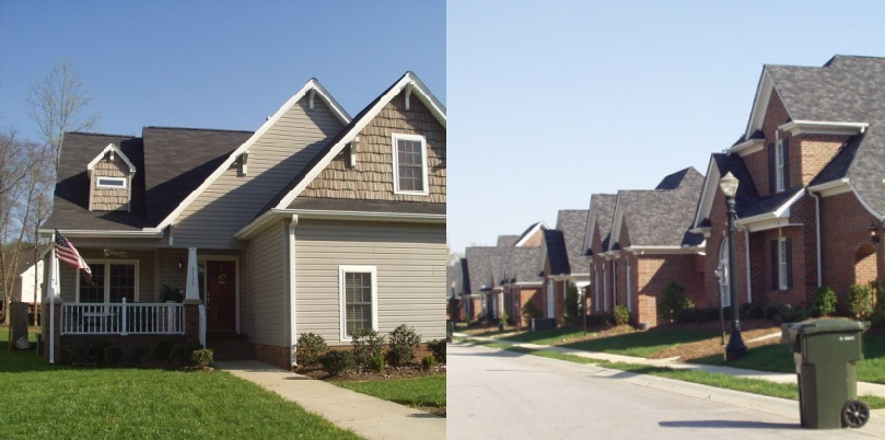
1.
Purpose. The purpose of the Single-Family Residential-5 (SFR-5) district is to accommodate primarily single-family detached dwellings at moderate densities on lots greater than 5,000 square feet in area. The district also accommodates limited group living, institutional, and open space uses, generally as special uses or public or semi-public uses.
2.
Use Standards. See use tables and use-specific standards in Article 5 and any modified use standards for any overlay districts (Section 4.9), subject to the following modification:
1. Outdoor facilities for field sports, swimming, or court games that are operated
for profit are prohibited.
3.
Intensity and Dimensional Standards1.
4.
Development Standards. See development standards in Article 6 and any modified development standards for any overlay districts (Section 4.9).
Typical Development Configuration (Example Only)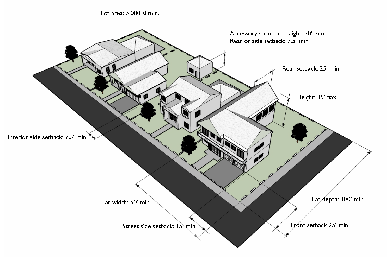
C.
Multifamily Residential-12 (MFR-12).
1.
Purpose. The purpose of the Multifamily Residential-12 (MFR-12) district is established and intended to accommodate primarily multifamily dwellings and multifamily complexes at low to moderate densities. It also accommodates single-family dwellings, duplexes, and duplex and townhouse subdivisions, as well as limited group living, institutional, and open space uses, generally as special uses or public or semi-public uses.
2.
Use Standards. See use tables and use-specific standards in Article 5 and any modified use standards for any overlay districts (Section 4.9).
3.
Intensity and Dimensional Standards1.
4.
Development Standards. See development standards in Article 6 and any modified development standards for any overlay districts (Section 4.9).
Typical Development Configuration (Example Only)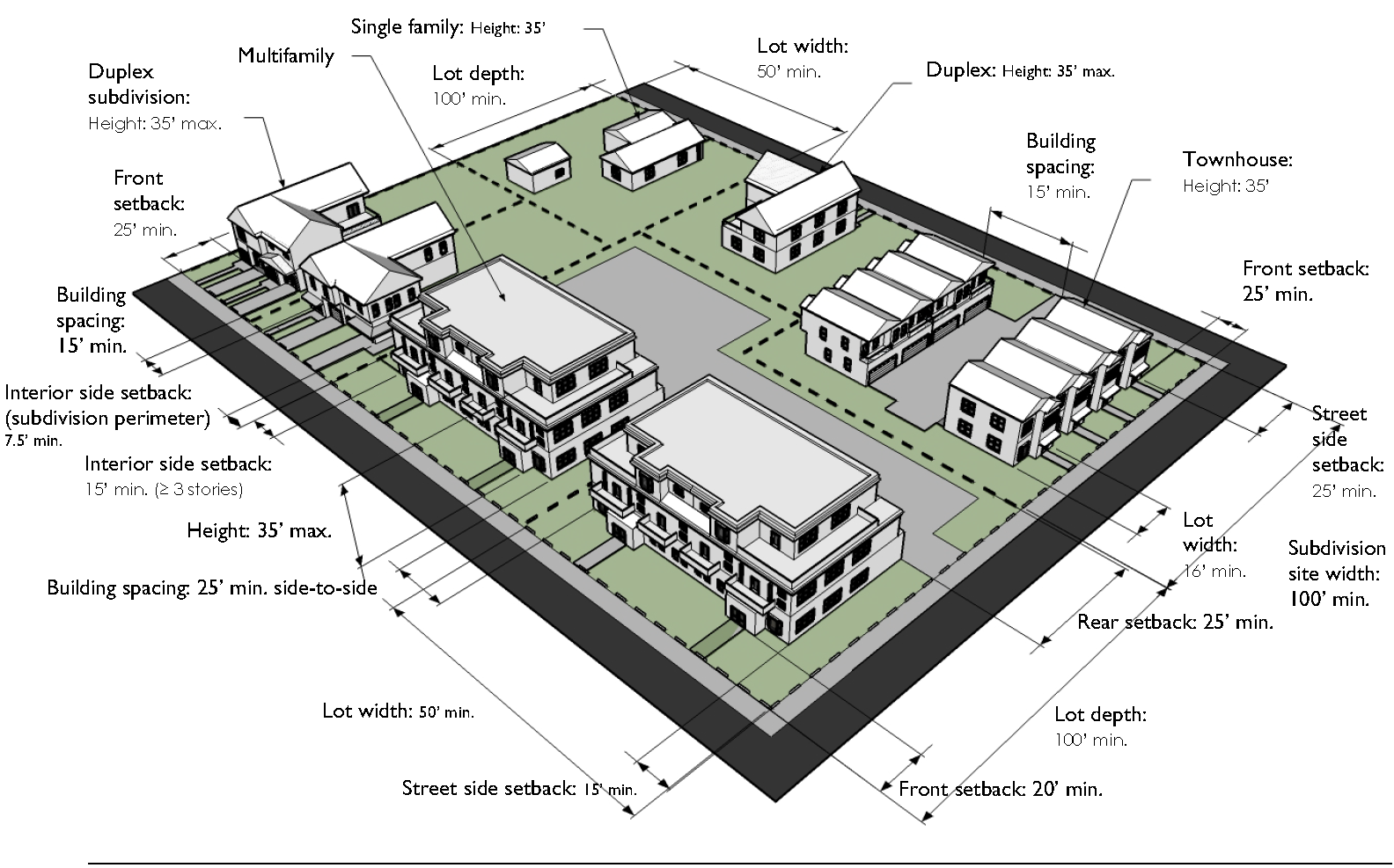
D.
Multifamily Residential-20 (MFR-20).
Typical Building Types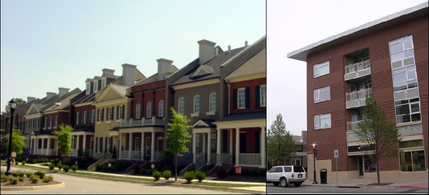
1.
Purpose. The purpose of the Residential Multifamily-20 (RMF-20) district is to accommodate primarily multifamily dwellings and multifamily complexes at moderate to high densities. It also accommodates single-family dwellings, duplexes, and duplex and townhouse subdivisions, as well as limited group living, institutional, and open space uses, generally as special uses or public or semi-public uses.
2.
Use Standards. See use tables and use-specific standards in Article 5 and any modified use standards for any overlay districts (Section 4.9).
3.
Intensity and Dimensional Standards1
4.
Development Standards. See development standards in Article 6 and any modified development standards for any overlay districts (Section 4.9).
Typical Development Configuration (Example Only)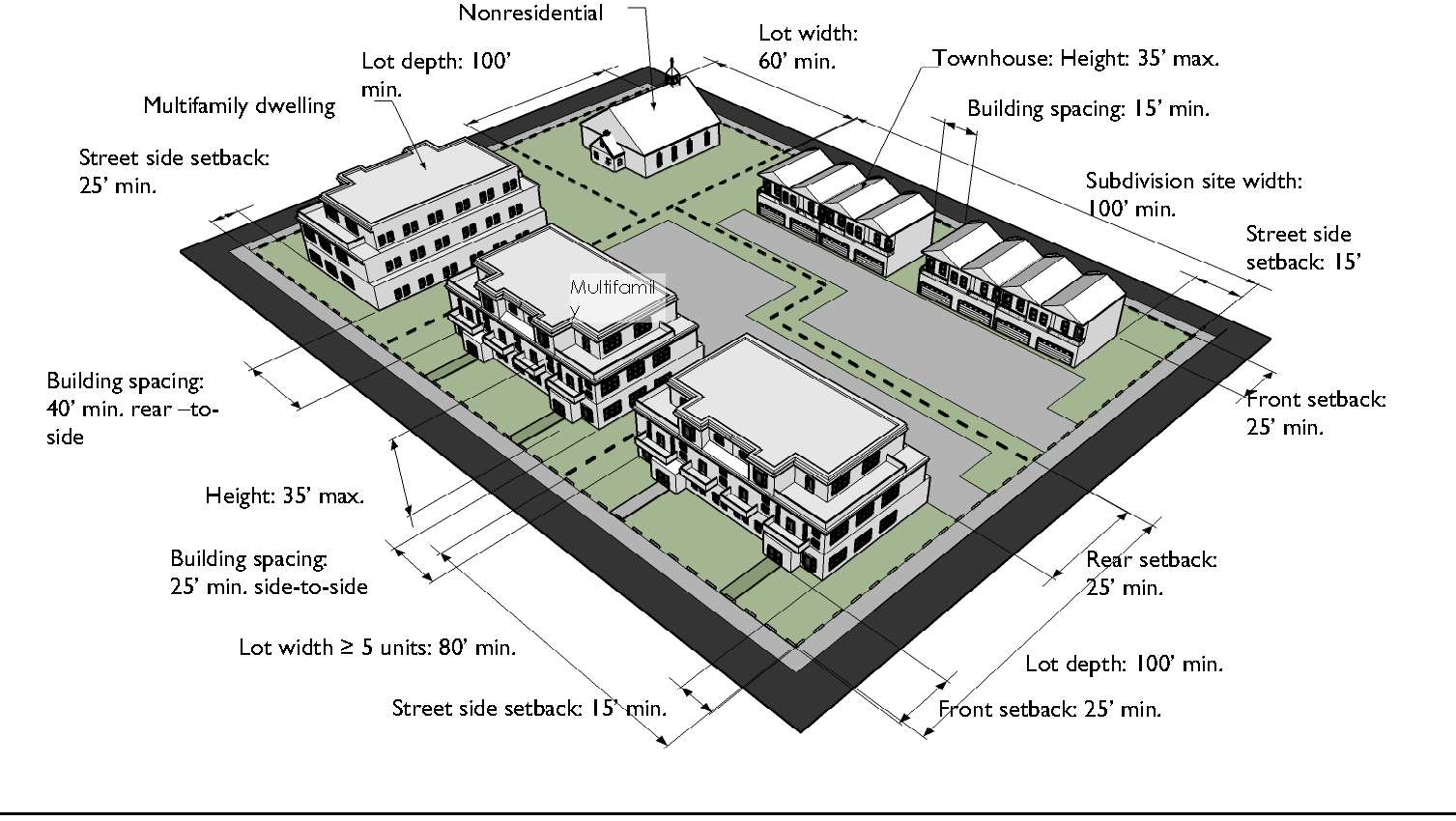
E.
Multifamily Residential-40 (MFR-40).
Typical Building Types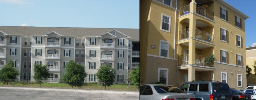
1.
Purpose. The purpose of the Residential Multifamily-40 (RMF-40) district is to accommodate primarily multifamily residential development at high densities. It also accommodates townhouse subdivisions, duplex subdivisions, and single-family homes, as well as limited group living, institutional, and open space uses, generally as special uses or public or semi-public uses.
2.
Use Standards. See use tables and use-specific standards in Article 5 and any modified use standards for any overlay districts (Section 4.9).
3.
Intensity and Dimensional Standards1.
4.
Development Standards. See development standards in Article 6 and any modified development standards for any overlay districts (Section 4.9).
Typical Development Configuration (Example Only)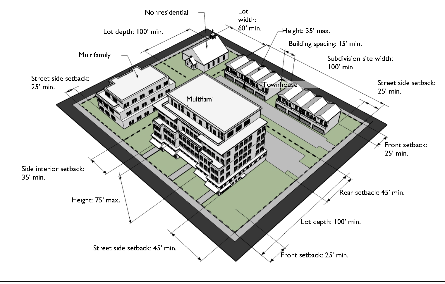
F.
Residential/Professional (R/P).
1.
Purpose. The purpose of the Residential/Professional (RP) district is to provide for transitional uses that serve as a buffer between single-family residential neighborhoods and commercial uses, including single-family dwellings, duplexes and duplex subdivisions, townhouse subdivisions, and multifamily dwellings and complexes, as well as small-scale office development for business and professional services. It also accommodates limited group living, institutional, and open space uses, generally as special uses or public or semi-pubic uses.
2.
Use Standards. See use tables and use-specific standards in Article 5 and any modified use standards for any overlay districts (Section 4.9).
3.
Intensity and Dimensional Standards1.
4.
Development Standards. See development standards in Article 6 and any modified development standards for any overlay districts (Section 4.9).
Typical Development Configuration (Example Only)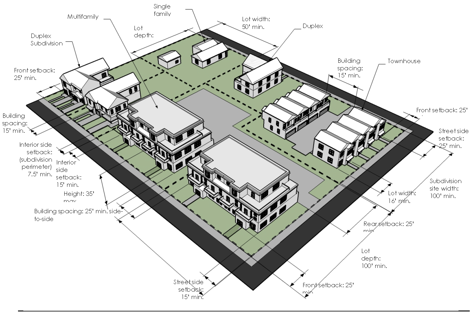
(Ord. No. 16-26, § 1(Exh. A), 1-20-2016; Ord. No. 17-322, § 2, 9-20-2017; Ord. No. 2022-486, § 2, 12-21-2022)
Sec. 4.3. - Business Base Zoning Districts.
General Purposes of Business Base Zoning Districts. The Business (B) base zoning districts are established for the general purpose of ensuring there are lands in the City that provide a wide range of office, retail, service, institutional, and related uses to meet household and business needs, and more specifically to:
1.
Provide appropriately located lands for the full range of business uses needed by the City's residents, businesses, and workers, consistent with the goals, objectives, and policies of the comprehensive plan and any small area plans adopted by the City;
2.
Strengthen the City's economic base, and provide employment opportunities close to home for residents of the City and surrounding communities;
3.
Create suitable environments for various types of business uses, and protect them from the adverse effects of incompatible uses;
4.
Create suitable environments for various types of mixed-use development, where business, office, retail, and residential uses are designed and integrated in compatible ways;
5.
Support the governmental activities taking place in the City;
6.
Preserve the unique character of the downtown and historic districts, landmarks, and landmark sites;
7.
Minimize the impact of business development on residential districts and uses; and
8.
Promote sustainable development in terms of energy efficiency and conservation, greenhouse gas reductions, food security, materials recycling, and similar sustainability goals.
A.
Office/Professional (OP).
Typical Building Types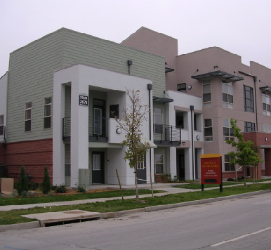
1.
Purpose. The purpose of the Office/Professional (OP) district is to accommodate primarily small-scale office development for professional services. It also accommodates limited institutional uses as special uses or public or semi-public uses.
2.
Use Standards. See use tables and use-specific standards in Article 5 and any modified use standards for any overlay districts (Section 4.9)—particularly the E-Zone Overlay district.
3.
Intensity and Dimensional Standards1.
4.
Development Standards. See development standards in Article 6 and any modified development standards for any overlay districts (Section 4.9).
Typical Development Configuration (Example Only)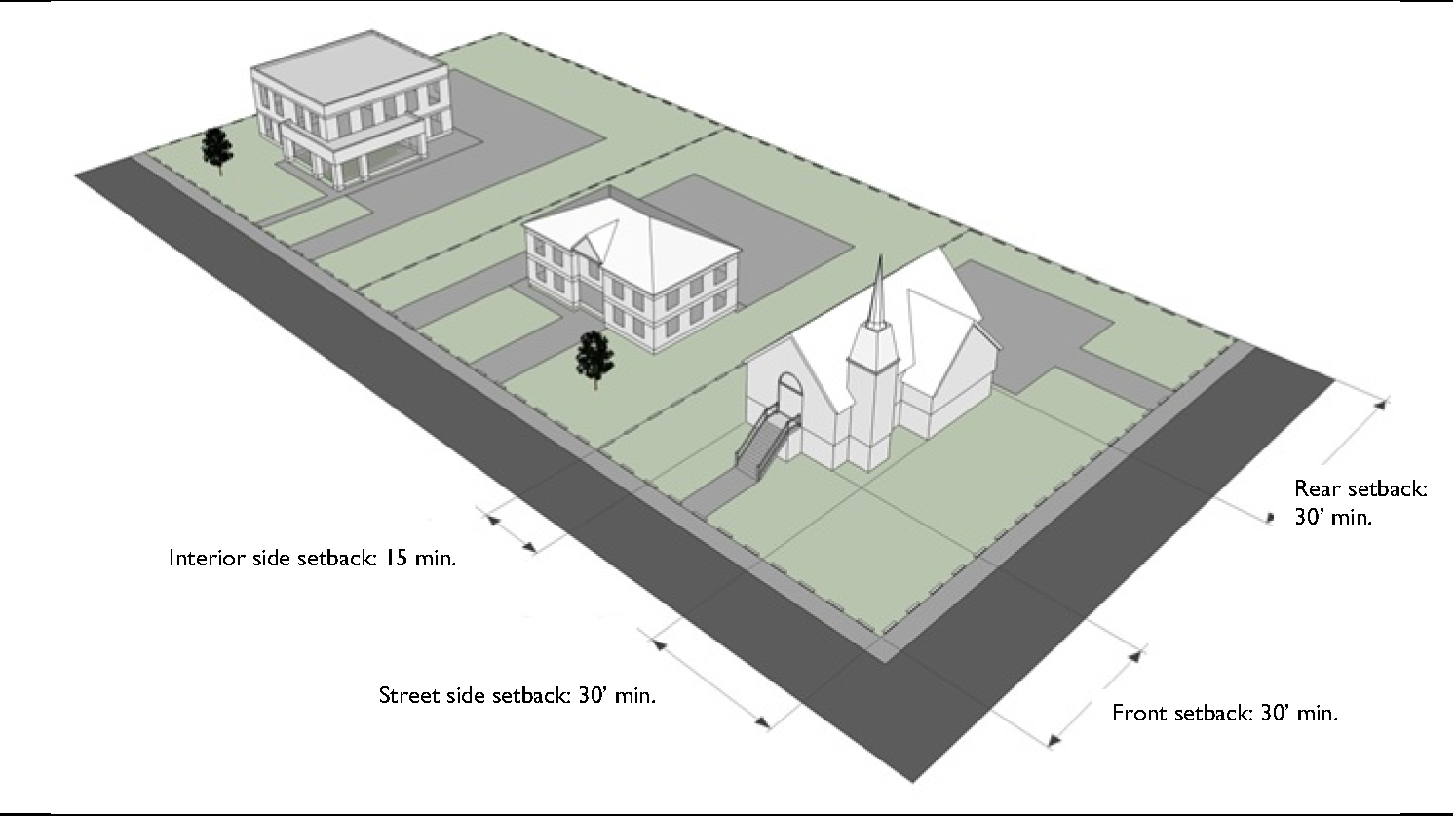
B.
Business Professional (BP).
Typical Building Types
1.
Purpose. The purpose of the Business Professional (BP) district is to accommodate primarily small-scale office development for business and professional services. It also accommodates small sit-down restaurants and personal service establishments, limited institutional uses, and residential development. Other institutional and open area uses may be allowed as special uses or public or semi-public uses.
2.
Use Standards. See use tables and use-specific standards in Article 5 and any modified use standards for any overlay districts (Section 4.9)—particularly the E-Zone Overlay district.
3.
Intensity and Dimensional Standards1.
4.
Development Standards. See development standards in Article 6 and any modified development standards for any overlay districts (Section 4.9).
Typical Development Configuration (Example Only)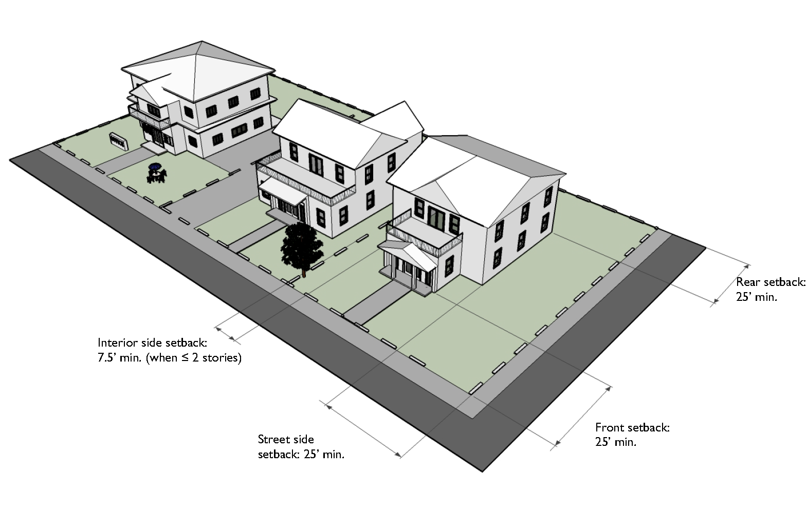
C.
Business Retail-1 (BR-1).
Typical Building Type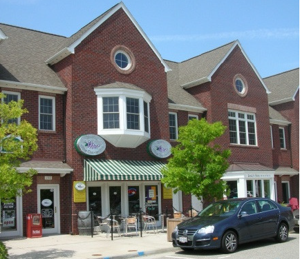
1.
Purpose. The purpose of the Business Retail-1 (BR-1) district is to accommodate a wide range of retail sales and service uses (from florists, jewelry stores, and gift shops to department and variety stores, furniture stores, and home and building supply centers), but excluding auto oriented uses (gas stations, vehicle repair and servicing, drive-in or drive-through businesses). It also accommodates multifamily residential development and limited institutional and commercial uses, generally as special uses or public or semi-public uses.
2.
Use Standards. See use tables and use-specific standards in Article 5 and any modified use standards for any overlay districts (Section 4.9).
3.
Intensity and Dimensional Standards1.
4.
Development Standards. See development standards in Article 6 and any modified development standards for any overlay districts (Section 4.9), subject to the following modifications:
a. Off-street parking is not required.
Typical Development Configuration (Example Only)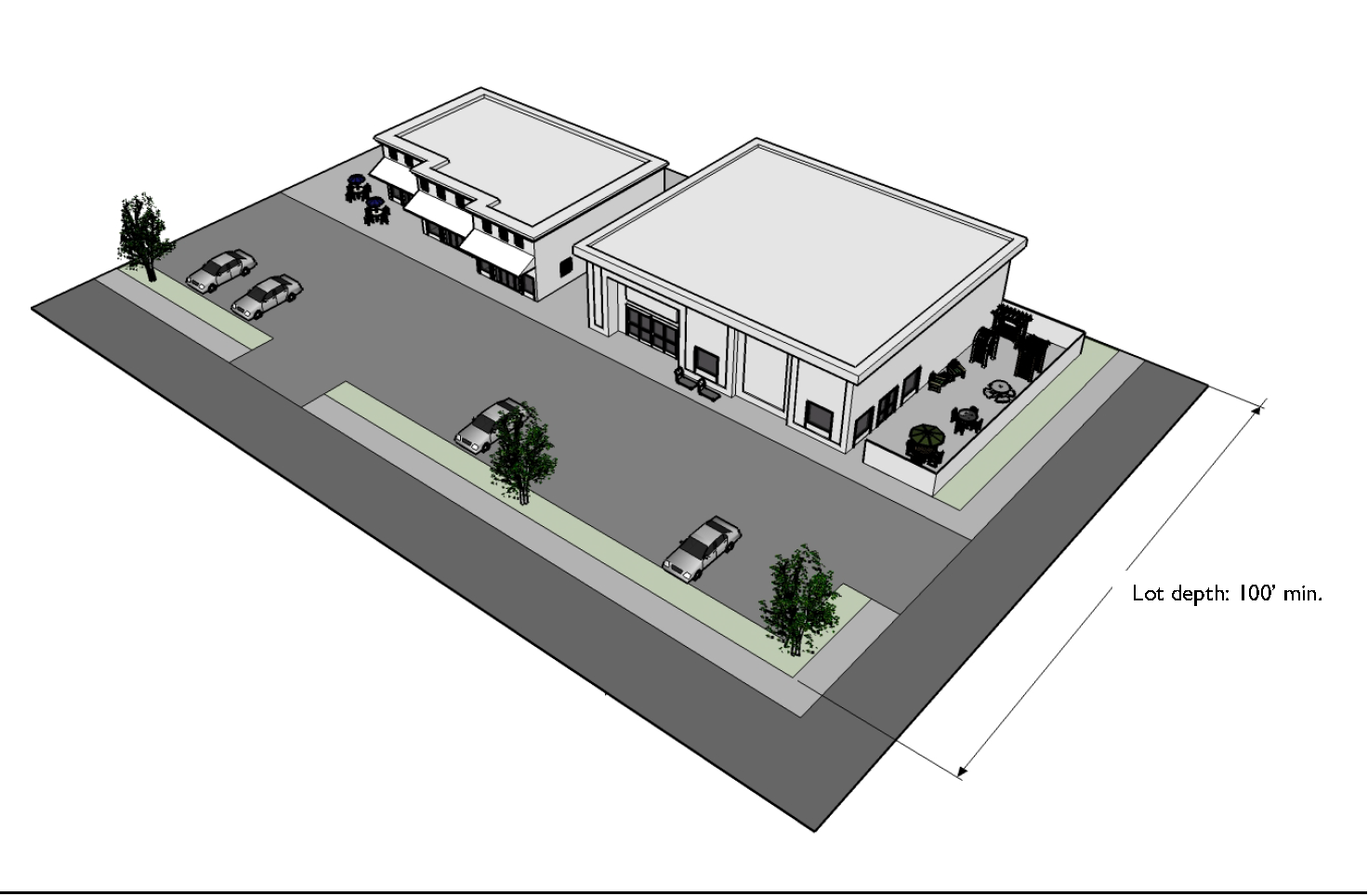
D.
Business Retail-2 (BR-2).
Typical Building Type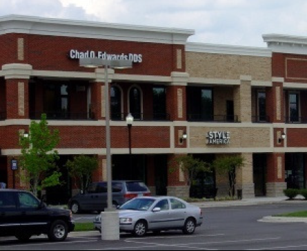
1.
Purpose. The purpose of the Business Retail-2 (BR-2) district is to accommodate a wide range of retail sales and service uses (from florists, jewelry stores, and gift shops to department and variety stores, furniture stores, and home and building supply centers), but excluding auto oriented uses (gas stations, vehicle repair and servicing). It also accommodates commercial docking facilities, multifamily residential development, and limited institutional and commercial uses, generally as special uses or public or semi-public uses.
2.
Use Standards. See use tables and use-specific standards in Article 5 and any modified use standards for any overlay districts (Section 4.9).
3.
Intensity and Dimensional Standards1.
4.
Development Standards. See development standards in Article 6 and any modified development standards for any overlay districts (Section 4.9).
Typical Development Configuration (Example Only)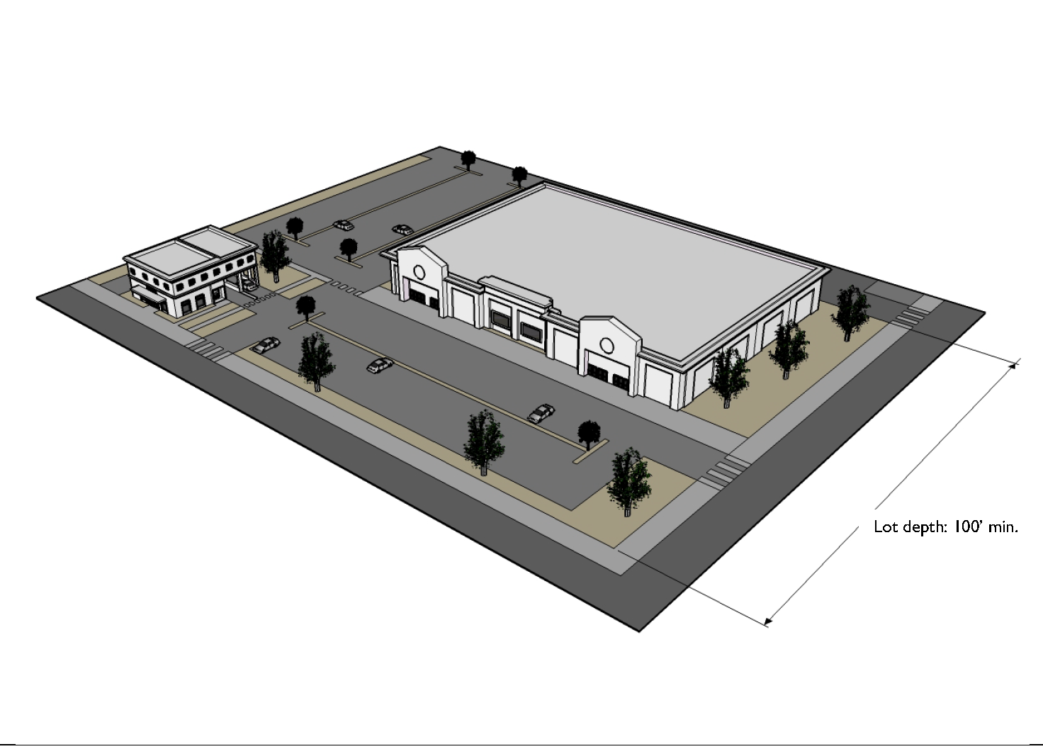
E.
Business Automotive (BA).
Typical Building Type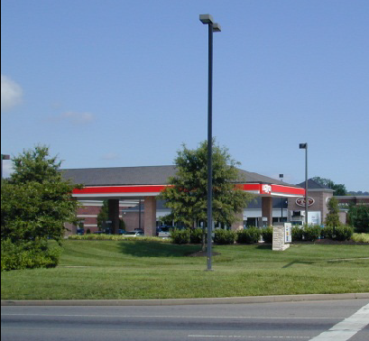
1.
Purpose. The purpose of the Business Automotive (BA) district is to accommodate a wide range of retail sales and service uses (from florists, jewelry stores, and gift shops to department and variety stores, furniture stores, and home and building supply centers)—and including auto-oriented uses (gas stations, vehicle repair and servicing, vehicle sales or rental, taxi or limousine service facilities, drive-in or drive-through businesses). The district also accommodates adult uses, commercial docking facilities, multifamily residential development, and institutional uses, as well as limited commercial uses, generally as special uses.
2.
Use Standards. See use tables and use-specific standards in Article 5 and any modified use standards for any overlay districts (Section 4.9).
3.
Intensity and Dimensional Standards1.
4.
Development Standards. See development standards in Article 6 and any modified development standards for any overlay districts (Section 4.9).
Typical Development Configuration (Example Only)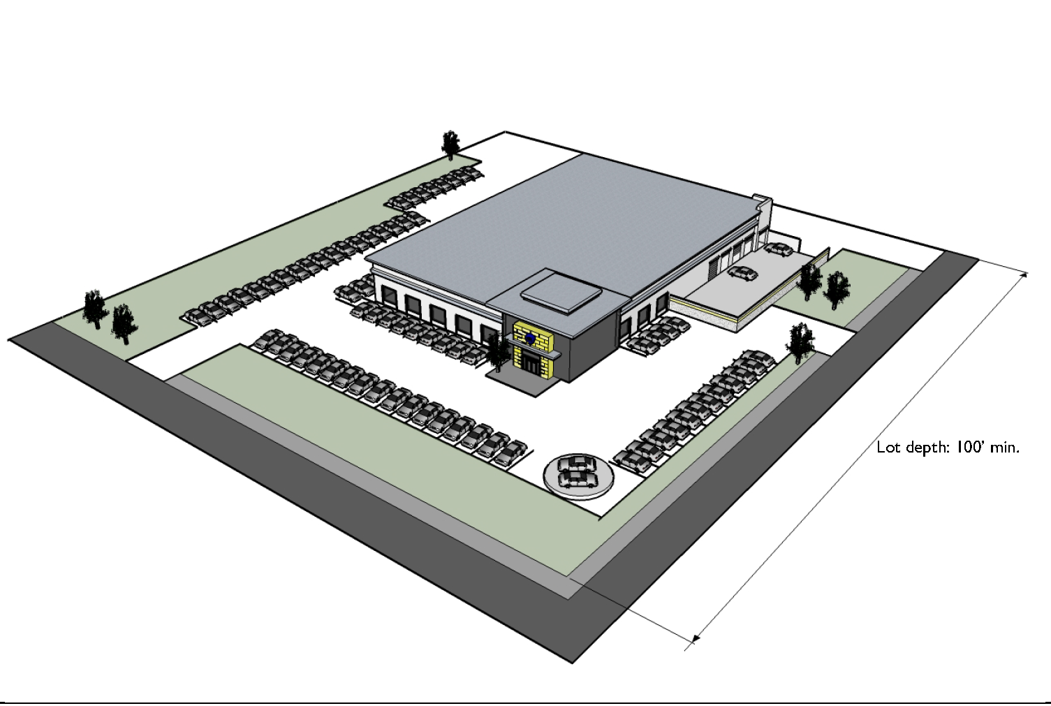
(Ord. No. 16-26, § 1(Exh. A), 1-20-2016)
Sec. 4.4. - Industrial Base Zoning Districts.
A.
General Purposes of Industrial Base Zoning Districts. The Industrial (I) base zoning districts are established for the general purpose of ensuring there are lands in the City that provide a wide range of manufacturing, storage, and related uses to meet household and business needs, and more specifically to:
1.
Provide appropriately located lands for the full range of industrial uses needed by the City's residents, businesses, and workers, consistent with the goals, objectives, and policies of the comprehensive plan and any small area plans adopted by the City;
2.
Strengthen the City's economic base, and provide employment opportunities close to home for residents of the City and surrounding communities;
3.
Create suitable environments for various types of industrial uses, and protect them from the adverse effects of incompatible uses;
4.
Minimize the impact of industrial development on residential and commercial districts and uses;
5.
Promote sustainable development in terms of energy efficiency and conservation, greenhouse gas reductions, food security, materials recycling, and similar sustainability goals; and
6.
Provide a place to locate uses that are generally incompatible with other uses or in other zoning districts.
B.
Local Industry (M-1).
Typical Building Type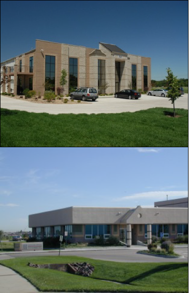
1.
Purpose. The purpose of the Local Industry (M-1) district is to accommodate industrial and related service uses that cater to local markets. It allows industrial service uses (heavy equipment sales or rental, laundry or dry-cleaning facilities, metal-working and pipe fitting uses, and moving and storage establishments), limited manufacturing and production uses (light manufacturing, assembly, and fabrication), warehouse and freight movement uses, and wholesale uses. The district also accommodates salvage/recycling facilities, day labor services, retail sales and service uses, and limited institutional uses.
2.
Use Standards. See use tables and use-specific standards in Article 5 and any modified use standards for any overlay districts (Section 4.9).
3.
Intensity and Dimensional Standards1.
4.
Development Standards. See development standards in Article 6 and any modified development standards for any overlay districts (Section 4.9).
Typical Development Configuration (Example Only)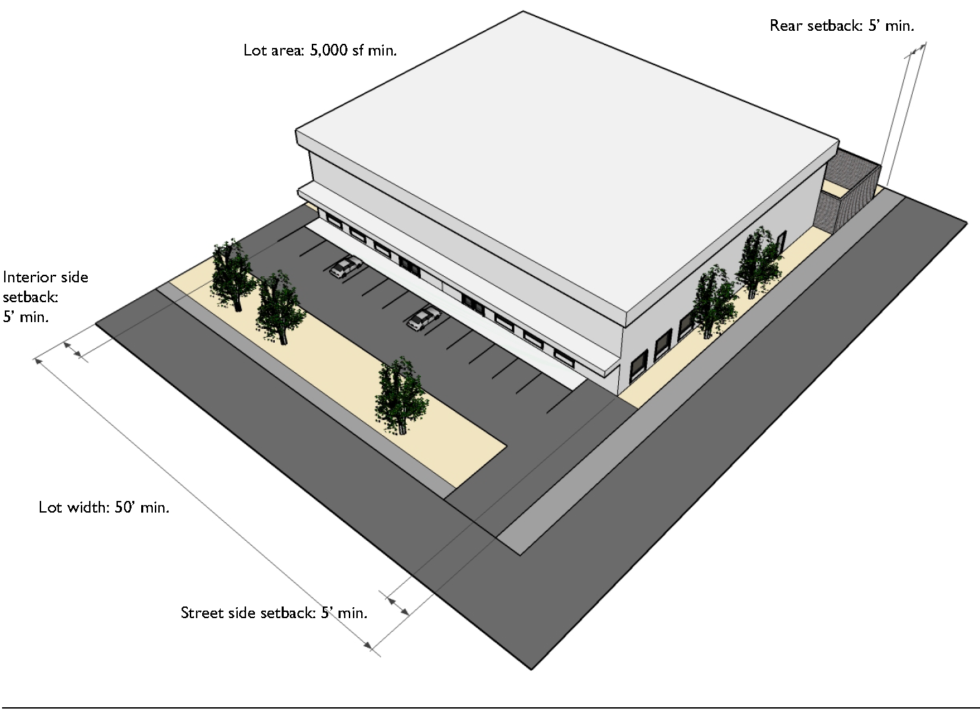
C.
General Industrial (M-3).
Typical Building Type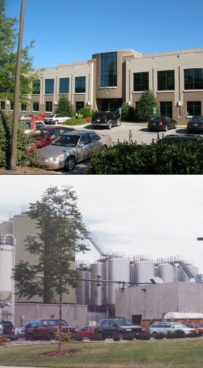
1.
Purpose. The purpose of the General Industrial (M-3) district is to accommodate industrial and related service and office uses of a larger scale than accommodated by the Local Industry (M-1) district and that serve regional and national markets. It allows a wide range of industrial service uses, light manufacturing, assembly, and fabrication uses, warehouse and freight movement uses, and wholesale uses.
2.
Use Standards. See use tables and use-specific standards in Article 5 and any modified use standards for any overlay districts (Section 4.9), subject to the following modifications:
a. A sport shooting and training range is prohibited outside an enclosed structure.
b. Outdoor storage as an accessory use (Section 5.3.D.17.g.vii) is prohibited in the
front yard and any street side yard or rear yard abutting an arterial or collector
street.
3.
Intensity and Dimensional Standards 1 .
4.
Development Standards. See development standards in Article 6 and any modified development standards for any overlay districts (Section 4.9), subject to the following modifications:
a. Off-street parking shall be set back at least 35 feet from the front lot line.
Typical Development Configuration (Example Only)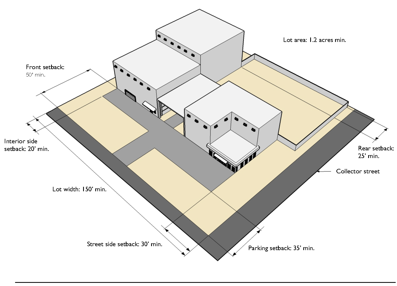
D.
Industrial Park (M-4).
Typical Building Type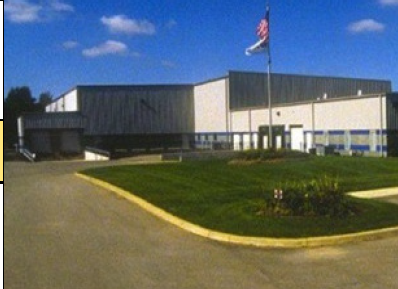
1.
Purpose. The purpose of the Industrial Park (M-4) district is to accommodate industrial park development that includes limited industrial service uses, light and heavy manufacturing, assembly, and fabrication uses, and warehouse uses.
2.
Use Standards. See use tables and use-specific standards in Article 5 and any modified use standards for any overlay districts (Section 4.9), subject to the following modifications:
a.
Outdoor storage as an accessory use (Section 5.3.D.17.g.vii) is allowed only in rear yards.
3.
Intensity and Dimensional Standards. 1
4.
Development Standards. See development standards in Article 6 and any modified development standards for any overlay districts (Section 4.9), subject to the following modifications:
a.
Off-street parking shall occupy no more than ten percent of the area of the front yard.
Typical Development Configuration (Example Only)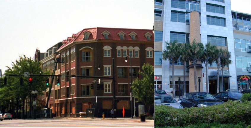
E.
Heavy Industrial (M-5).
Typical Building Type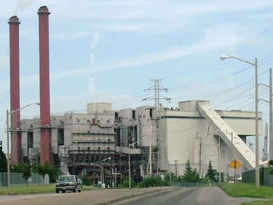
1.
Purpose. The purpose of the Heavy Industrial (M-5) district is to accommodate industrial and related service and office uses that serve regional and national markets—including heavy manufacturing, assembly, and fabrication uses, as well as other high-impact industrial and industrial service uses (asphalt plants, concrete plants, paving operations, heavy equipment repair and servicing). It also accommodates day labor services, warehousing, outdoor storage as a principal use, and waste-related uses. The district also provides a place for uses that are generally incompatible with other uses or in other zoning districts (e.g., adult uses, body piercing establishments, tattoo establishments, and sport shooting and training ranges).
2.
Use Standards. See use tables and use-specific standards in Article 5 and any modified use standards for any overlay districts (Section 4.9), subject to the following modifications:
a. Outdoor storage as an accessory use (Section 5.3.D.17.g.vii) is prohibited in the
front yard and any street side yard or rear yard abutting an arterial or collector
street.
3.
Intensity and Dimensional Standards. 1
4.
Development Standards. See development standards in Article 6 and any modified development standards for any overlay districts (Section 4.9), subject to the following modifications:
a.
Off-street parking shall occupy no more than ten percent of the area of the front yard.
Typical Development Configuration (Example Only)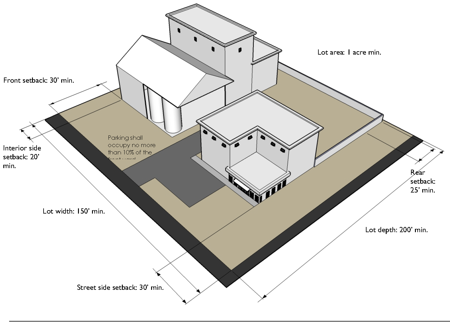
Sec. 4.5. - Tourist Base Zoning Districts.
A.
General Purposes of Tourist Base Zoning Districts. The Tourist (T) base zoning districts are established for the general purpose of providing quality tourist destinations and enhancing the experience of tourists to Daytona Beach, and more specifically to:
1.
Promote the development of quality hotels, attractions, convention centers, and meeting spaces;
2.
Facilitate the development of family-friendly establishments and entertainment centers;
3.
Promote the development of motor sports and car-related events such as antique auto shows, boat shows, and related events;
4.
Enhance the quality of life for City residents by promoting development of quality sports, entertainment, and recreational facilities;
5.
Encourage the clustering of heritage and cultural resources relating to history, culture, food, and music; and
6.
Ensure property owners' investment by strengthening standards relating to the appearance and signage along major corridors.
B.
Tourist Accommodations (T-1).
1.
Purpose. The purpose of the Tourist Accommodations (T-1) district is to accommodate primarily visitor accommodation uses (including accessory snack bars, guest recreation sales and service, florists, gift shops, beach apparel shops, ticket and auto rental offices), plus restaurants (other than drive-in or drive-through) and bars and lounges that serve visiting tourists. It also accommodates personal service establishments, residential development, and limited institutional and open area uses.
2.
Use Standards. See use tables and use-specific standards in Article 5 and any modified use standards for any overlay districts (Section 4.9), subject to the modifications in Section 4.5.B.5, Modified Use Standards.
3.
Intensity and Dimensional Standards. 1
4.
Development Standards.See development standards in Article 6 and any modified development standards for any overlay districts (Section 4.9), subject to the modifications in Section 4.5.B. 6, Modified Development Standards.
Typical Development Configuration (Example Only)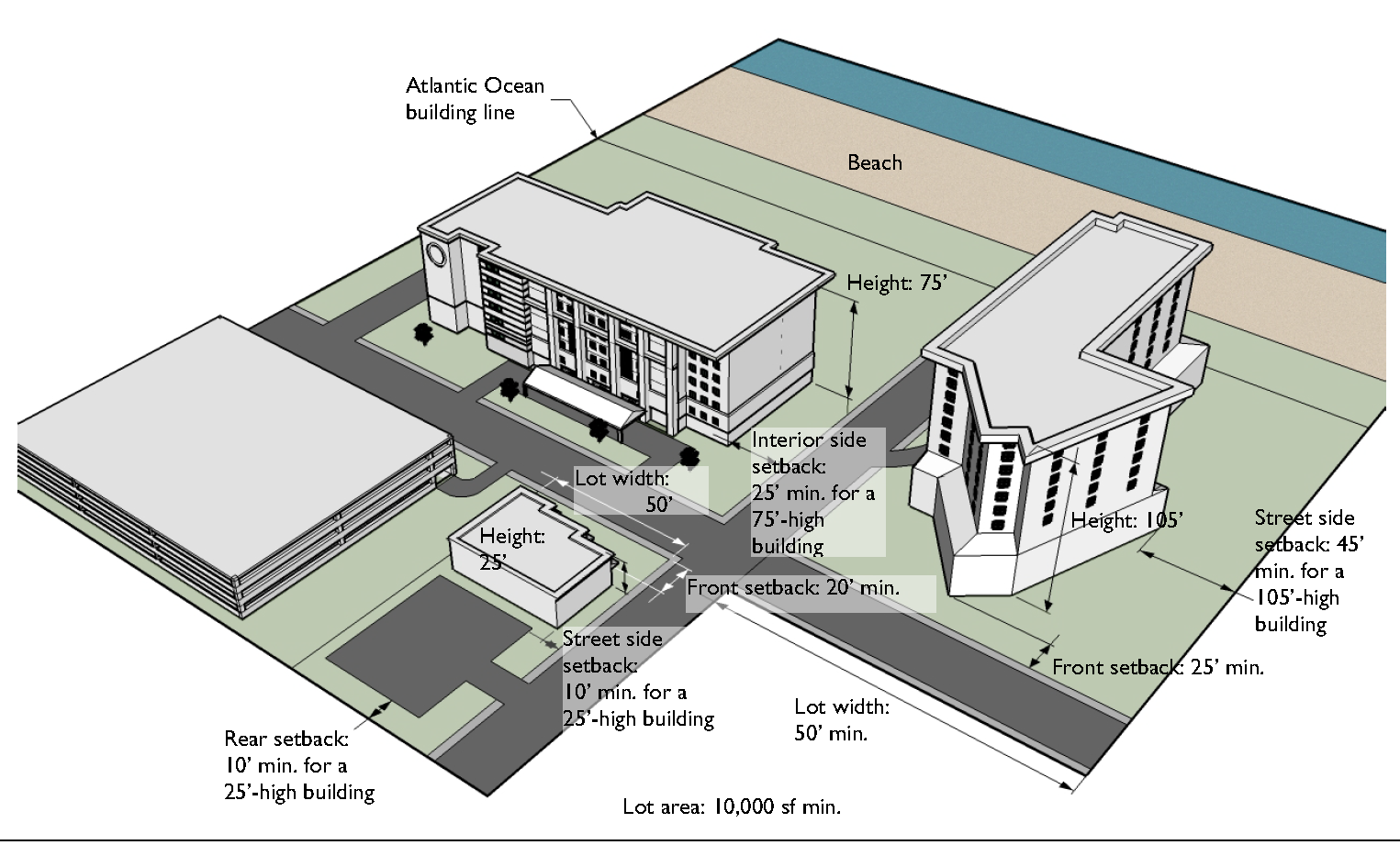
5.
Modified Use Standards. The following standards shall apply to development within the Tourist - Accommodations (T-1) district in addition to the generally-applicable use-specific standards in Article 5: Use Standards.
a.
Parking Deck or Garage Incorporated in an Oceanfront Multifamily Residential or Hotel or Motel Development.
i.
Where any portion or floor of a multifamily residential or hotel or motel development located on an oceanfront lot is used for a parking deck or garage and is visible from Atlantic Avenue:
(a)
The parking deck or garage, including ramps accessing the parking deck or garage, shall not be constructed in whole or in part within a required front, side or rear yard.
(b)
Multifamily dwelling units or hotel or motel lodging units may be located on the perimeter of any floor of the parking deck or garage provided the total gross floor area of these units does not exceed 50 percent of the total gross floor area of the parking deck or garage floor.
ii.
Where any portion or floor of a multifamily residential or hotel or motel development is used for a parking deck or garage and is not visible from Atlantic Avenue (including an underground parking garage):
(a)
The parking deck or garage, including ramps accessing the parking deck or garage, shall be constructed in a manner that does not hamper the installation or maintenance of required landscaping or associated irrigation.
(b)
The parking deck or garage, including ramps accessing the parking deck or garage, shall not extend beyond the bulkhead, or if no bulkhead exists, the bulkhead line established by Section 4.9.E.3.c, Atlantic Ocean Building and Bulkhead Lines.
(c)
The maximum elevation of the parking deck or garage shall not extend more than 20 feet above mean sea level.
b.
Other Indoor Recreation/Entertainment Uses Prohibited on Oceanfront Lots. Uses constituting an Other Indoor Recreation/Entertainment Use (see Section 11.5, Terms and Uses Defined) are prohibited on oceanfront lots.
6.
Modified Development Standards. The following standards shall apply to development within the Tourist - Accommodations (T-1) district in addition to the generally-applicable development standards in Article 6: Development Standards.
a.
Off-Site Parking for Visitor Accommodation Uses. A visitor accommodation use located on the east side of Atlantic Avenue may provide off-site parking on the west side of Atlantic Avenue, subject to the following:
i.
No more than 15 percent of the site of the visitor accommodation use shall be covered by surface parking and associated driveways (excluding fire lanes). The balance of the site uncovered by buildings shall be landscaped. No aboveground parking garage or deck shall be located on sites abutting the Atlantic Ocean.
ii.
The site of the off-site parking facility shall have at least 30 feet of frontage on Atlantic Avenue directly across from the site of the visitor accommodation use.
iii.
Access to the off-site parking facility shall be from Atlantic Avenue or from a side street provided such access is not across from a residential district.
iv.
The off-site parking facility shall be set back at least 50 feet from a residential district. The setback area shall be landscaped and an eight -foot screening wall or landscape screening shall be provided between the parking facility and the residential district.
v.
If the off-site parking facility contains a structure, the architectural design of the structure shall complement and be consistent with the design features of the visitor accommodation building(s) so as to maintain a continuity of exterior design and materials between the off-site parking structure and the visitor accommodation use. Walls of painted concrete block are prohibited.
vi.
Any structure on the off-site parking facility site shall be used exclusively for parking above the ground floor. The ground floor may include any use permitted in the district except a visitor accommodation use or a residential use—provided off-street parking requirements applicable to such uses are met.
b.
Site Design and Architectural Standards for Oceanfront Multifamily and Hotel/Motel Developments. In recognition that high standards of site design and architectural quality are essential to the success of the City's tourism industry, any new multifamily dwelling or complex or hotel or motel development on an oceanfront lot shall comply with the following standards:
i.
Building materials shall be resistant to the effects of the sun and salt water.
ii.
Each building facade shall have multiple surface planes such that provide relief from flat, boxy surfaces.
iii.
Windows shall make up at least 25 percent of the facade area per floor on the front and rear building facades and at least 15 percent of the facade area per floor on the side building facades.
iv.
All windows shall have exterior ornamentation (sills, frames, awnings, shutters, louvers, balconies, false balconies, etc.) that provide relief from a flat building surface.
v.
Each building facade shall have a color scheme consisting of three complementary colors; one of which shall be the principal (base) color and the others used as highlights and accents.
vi.
All buildings shall have multiple or pitched rooflines that provide relief from a flat roof. Mansards, parapet walls, fascia, or other ornamentation may be used to satisfy this requirement, but elevator shafts and mechanical rooms may not.
vii.
Pedestrian level lighting shall be provided between the building and the sidewalk along Atlantic Avenue, consistent with any applicable federal, State, and local environmental requirements relating to protected or endangered species.
viii.
Attractive, non-glare exterior lighting in the landscape areas is encouraged.
ix.
Water features such as reflecting pools and lighted fountains are encouraged.
x.
Signage shall be limited to monument signs that are appropriately integrated into the project architecture or landscaping plans. Signage shall not be permitted on seawalls.
xi.
The front yard of the site and the first ten feet inside the site from the bulkhead/seawall shall be heavily landscaped so that the predominant view toward the site from Atlantic Avenue and from the beach is one of noticeable and dense landscaping and not of hard surfaces or features. No pavement shall encroach into this landscaped area except for permitted driveways entering and exiting the site in an east-west direction and pathways to the beach.
xii.
Landscaping along the Atlantic Avenue frontage, ocean frontage, at the building corners, and within side yard setbacks shall consist of Palm tree groves meeting the following standards:
(a)
Palm tree groves shall consist of at least five palms per cluster, the trunks being in close proximity to each other.
(b)
The palms shall be a minimum clear trunk height of ten feet with varying heights within the cluster.
(c)
The palm groves shall be placed 50 feet on center along the perimeter of the site and at the corners of the building.
(d)
Sabal Palms shall be mixed with date palms and included along the Atlantic Avenue frontage.
xiii.
Architectural placement, parking design, and project ground signs shall be subordinate to and coordinated with the landscaping. Flowering plants shall be incorporated into the design.
xiv.
Driveways and at-grade surface parking areas to the north and south of the site's principal structure(s) shall be constructed of colored interlocking pavers.
xv.
All utilities shall be installed underground.
C.
Tourist/Office/Restaurant (T-2).
Typical Building Type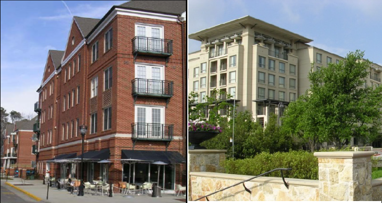
1.
Purpose. The purpose of the Tourist/Office/Restaurant (T-2) district is to accommodate primarily visitor accommodation uses (including accessory snack bars, guest recreation sales and service, florists, gift shops, beach apparel shops, ticket and auto rental offices), plus restaurants (other than drive-in or drive-through) and bars and lounges that serve visiting tourists, as well as office uses. It also accommodates residential development and limited institutional and open area uses.
2.
Use Standards. See use tables and use-specific standards in Article 5 and any modified use standards for any overlay districts (Section 4.9).
3.
Intensity and Dimensional Standards. 1
4.
Development Standards. See development standards in Article 6 and any modified development standards for any overlay districts (Section 4.9).
Typical Development Configuration (Example Only)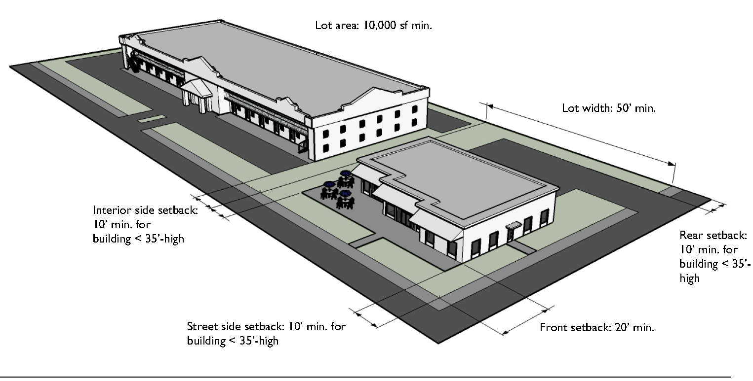
D.
Tourist/Office/Retail (T-4).
Typical Building Type
1.
Purpose. The Tourist/Office/Retail (T-4) district is established and intended to accommodate primarily visitor accommodation uses (including accessory snack bars, guest recreation sales and service, florists, gift shops, beach apparel shops, ticket and auto rental offices), plus restaurants (other than drive-in or drive-through) and bars and lounges that serve visiting tourists, as well as office and retail sales and service uses. It also accommodates single-family dwellings, duplexes, multifamily dwellings and complexes, townhouse subdivisions, family care homes, community residential homes, limited institutional and open area uses (clubs and lodges child care facilities, schools, places of worship, nursing home facilities, cemeteries, country clubs, golf courses), personal service establishments, parking lots and garages (as a principal use), gas stations, and car washes. The district allows funeral homes with a Special Use Permit.
2.
Use Standards. See use tables and use-specific standards in Article 5 and any modified use standards for any overlay districts (Section 4.9), subject to the modifications in Section 4.5.D.5, Modified Use Standards.
3.
Intensity and Dimensional Standards. 1
4.
Development Standards. See development standards in Article 6 and any modified development standards for any overlay districts (Section 4.9).
Typical Development Configuration (Example Only)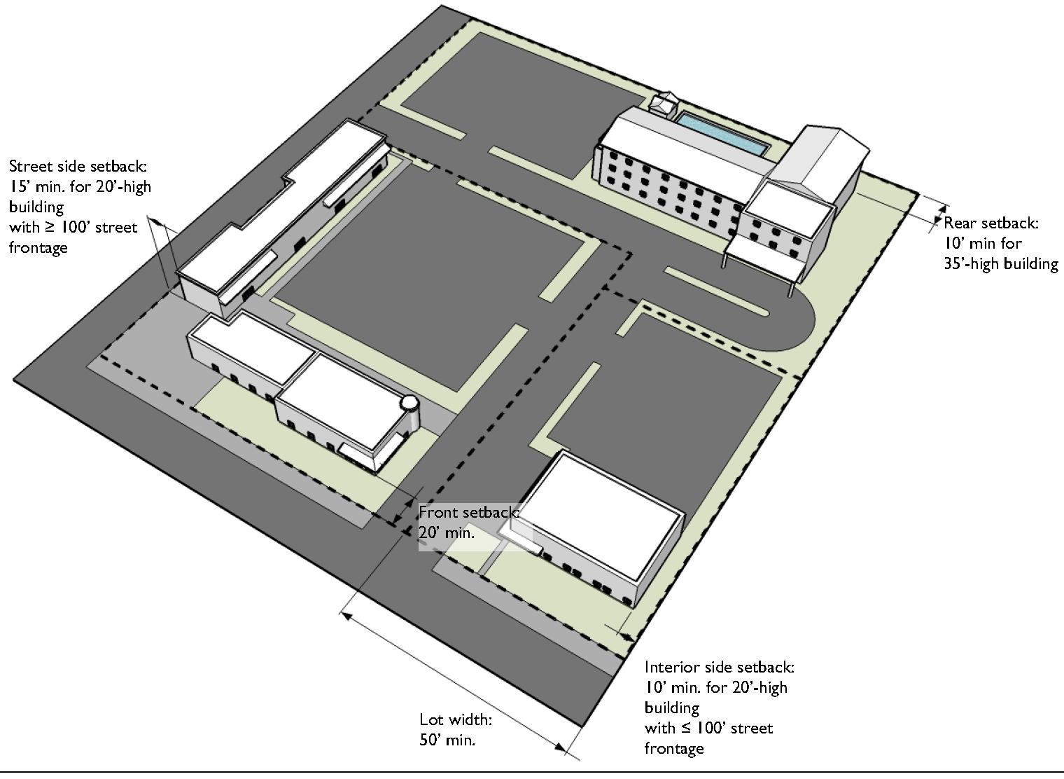
5.
Modified Use Standards. The following standards shall apply to development within the Tourist/Office/Retail (T-4) district in addition to the generally-applicable use-specific standards in Article 5: Use Standards.
a.
Light Recreation Vehicle Rental.
i.
The use shall be located only on lots fronting Atlantic Avenue.
ii.
Light recreation vehicles offered for rent may not be displayed, parked, or stored within ten feet of any public right-of-way.
iii.
Light recreation vehicles offered for rent may not be displayed, parked, or stored in such a manner as to interfere with traffic safety, required parking, or landscaped areas.
iv.
The area used for the display, parking, or storage of light recreation vehicles offered for rent, when combined with the area covered by buildings on the site, shall not exceed 60 percent of the gross area of the site.
b.
Light Motor Vehicle Rental. The rental of light motor vehicles is allowed as an accessory use to a motor vehicle sales and service use, subject to the following standards:
i.
Only one portion of the lot, not exceeding 50 percent of its area, shall be used for the accessory light motor vehicle rental use.
ii.
No more than 25 light motor vehicles offered for rent may be parked on the site.
iii.
Light motor vehicles offered for rent shall not be displayed, parked, or stored closer to any public right-of-way than the principal building, or within 25 feet of any right-of-way.
iv.
Light motor vehicles offered for rent shall not be displayed, parked, or stored in such a manner as to interfere with access, circulation, and parking for the principal use.
Addition of light motor vehicle rentals as an accessory use to a motor vehicle sales and service use does not entitle the owner or occupant to additional signage.
c.
Other Indoor Recreation/Entertainment Uses Prohibited on Oceanfront Lots. Uses constituting an Other Indoor Recreation/Entertainment Use (see Section 11.5, Terms and Uses Defined) are prohibited on oceanfront lots.
E.
Tourist/Highway Interchange (T-5).
Typical Building Type
1.
Purpose. The purpose of the Tourist /Highway Interchange (T-5) district is to provide for tourist-serving development near highway interchanges. It is intended to accommodate primarily visitor accommodation uses (including accessory snack bars, guest recreation sales and service, florists, gift shops, beach apparel shops, ticket and auto rental offices), plus restaurants and bars and lounges that serve visiting tourists, as well as office and retail sales and service uses, personal service establishments, and limited auto-oriented uses (gas stations and car washes). It also accommodates multifamily and townhouse residential development, and limited institutional and open area uses (clubs and lodges child care facilities, schools, places of worship, cemeteries, country clubs, golf courses).
2.
Use Standards. See use tables and use-specific standards in Article 5 and any modified use standards for any overlay districts (Section 4.9).
3.
Intensity and Dimensional Standards. 1
4.
Development Standards. See development standards in Article 6 and any modified development standards for any overlay districts (Section 4.9).
Typical Development Configuration (Example Only)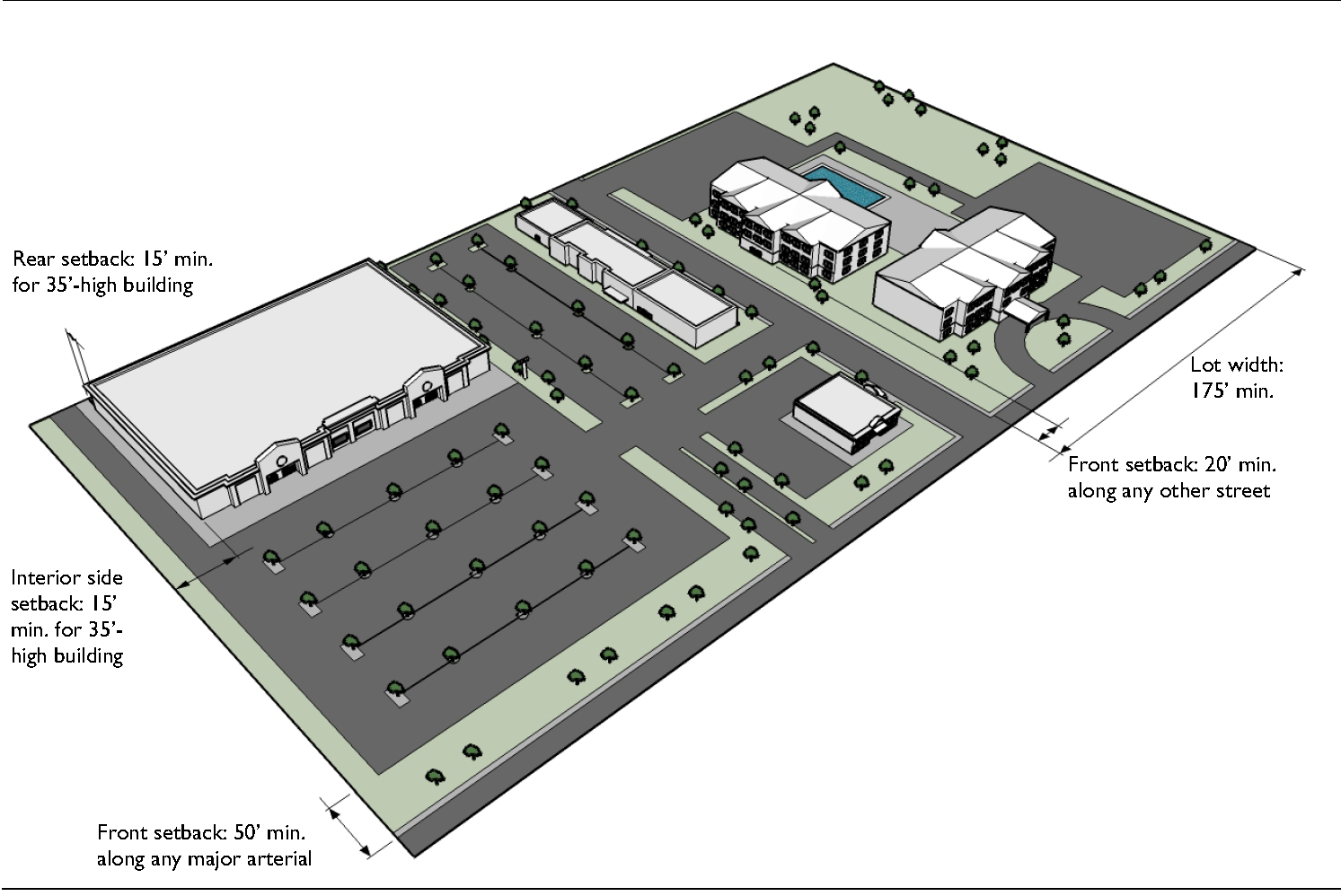
(Ord. No. 18-409, § 3, 12-5-2018)
Sec. 4.6. - Specialty Base Zoning Districts.
A.
Agricultural (AG).
Typical Building Type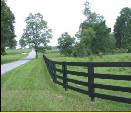
1.
Purpose. The purpose of the Agricultural (AG) district is to accommodate the current use of land in the City for agricultural activities (farming, Silviculture, plant nurseries, greenhouse operations, feeding stations) and conservation uses (parks, game preserves, historic sites). It may also be used as a holding zone for lands that may be suitable for urban development in the future. The district also allows single-family detached dwellings, and allows limited institutional and open area uses (child care facilities, schools, places of worship, country clubs, golf courses, outdoor recreation areas) with a Special Use Permit—but does not allow commercial facilities for the sale of animals or agricultural products.
2.
Use Standards. See use tables and use-specific standards in Article 5 and any modified use standards for any overlay districts (Section 4.9).
3.
Intensity and Dimensional Standards. 1
4.
Development Standards. See development standards in Article 6 and any modified development standards for any overlay districts (Section 4.9).
Typical Development Configuration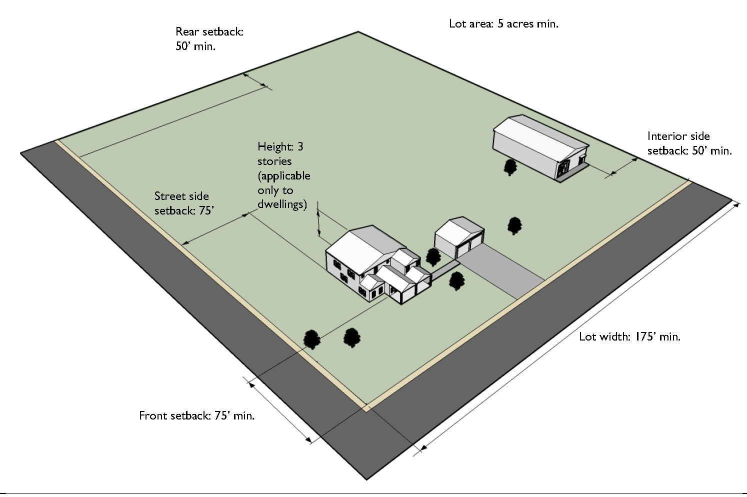
B.
Hospital/Medical (HM).
Typical Building Type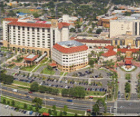
1.
Purpose. The purpose of the Hospital/Medical (HM) district is to accommodate primarily health care uses such as hospitals, medical clinics, medical labs, and medical treatment facilities. It also accommodates group living uses (assisted living facilities, community residential homes, hospice residential facilities).
2.
Use Standards. See use tables and use-specific standards in Article 5.
3.
Intensity and Dimensional Standards. 1
4.
Development Standards. See development standards in Article 6 and any modified development standards for any overlay districts (Section 4.9), subject to the following modification:
a.
Where the development site abuts two streets and a residential district, vehicular access to the site shall be provided from the street not abutting the residential district.
Typical Development Configuration (Example Only)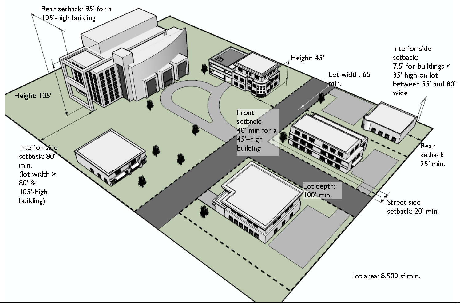
C.
Major Sports (MS).
1.
Purpose. The purpose of the Major Sports (MS) district is to accommodate primarily arenas, stadiums, and racetracks used for major sports events (including accessory food and beverage concessions, retail sales, hospitality and related entertainment uses, training facilities), plus business and professional services offices.
2.
Use Standards. See use tables and use-specific standards in Article 5 and any modified use standards for any overlay districts (Section 4.9).
3.
Intensity and Dimensional Standards. 1
4.
Development Standards. See development standards in Article 6 and any modified development standards for any overlay districts (Section 4.9), subject to the following modification:
a.
The height limits for fences and walls in Section 6.7.C.4, Height, shall not apply to arenas, stadiums, or racetracks.
Sec. 4.7. - Redevelopment Base Zoning Districts.
A.
General Purposes of Redevelopment Base Zoning Districts. The Redevelopment (RD) base zoning districts are established for the general purpose of implementing the goals, objectives, and policies of the comprehensive plan's redevelopment element and the redevelopment plan for each Redevelopment Area, as relevant to the various Redevelopment Areas established in accordance with the Community Redevelopment Act. More specifically, the districts are intended to:
1.
Encourage public and private cooperative efforts to create environmentally and economically sound and aesthetically pleasing new development and rehabilitated development;
2.
Stimulate and attract private investment in Redevelopment Areas;
3.
Increase employment opportunities;
4.
Ensure better service to residents and tourists;
5.
Improve property values;
6.
Recruit and enhance development that is consistent with redevelopment plans and neighborhood policies; and
7.
Apply architectural design and appearance standards to improve the quality of development.
B.
General Standards for All Redevelopment Districts. [Reserved]
C.
Redevelopment Beachside - Hotel/Mixed Use (RDB-1).
1.
Purpose. The purpose of the Redevelopment Beachside - Hotel Mixed Use (RDB-1) district is to: promote development of a high quality tourist entertainment area that will strengthen the employment and tax base and remove blighting influences; encourage assembly of lots for large scale redevelopment projects; create strong functional relationships between public uses, such as the Ocean Center and Boardwalk Park, and redevelopment projects; encourage development of plazas and pedestrian activities; encourage a mixture of uses that facilitate high quality shopping and pedestrian activities and increased use of public facilities; and encourage high quality architecture, materials, and landscaping by flexible design standards, regulatory incentives, and expeditious review of high quality redevelopment projects.
2.
Use Standards. See use tables and use-specific standards in Article 5 and any modified use standards for any overlay districts (Section 4.9), subject to the modifications in Section 4.7.C.5, Modified Use Standards.
3.
Intensity and Dimensional Standards. 1
4.
Development Standards. See development standards in Article 6 and any modified development standards for any overlay districts (Section 4.9), subject to the modifications in Section 4.7.C.6, Modified Development Standards.
5.
Modified Use Standards. The following standards shall apply to development within the Redevelopment Beachside - Hotel Mixed Use (RDB-1) district in addition to the generally-applicable use-specific standards in Article 5: Use Standards.
a.
Mixed-Use Development.
i.
Mixed-use development shall be limited to business support service uses, eating and drinking establishments, offices, retail sales and service uses, and recreation/entertainment uses providing one or more high-quality passive or interactive entertainment experiences (e.g., water park, amusement ride, miniature golf, museum, multiscreen cinema, cinema technology, music theater).
ii.
The development shall provide space for high quality retail and service establishments that contribute to the creation of evening activity centers accessible to pedestrians.
iii.
The development may include one business establishment devoted principally to games of skill, which shall be designed to provide for the passage of light and air.
iv.
Minimum lot size shall be 32,000 square feet north of Main Street and 15,000 square feet south of Main Street.
v.
Minimum lot depth shall be 150 feet.
vi.
Structures facing commercially-oriented streets or open spaces shall have a mix of tenants or be designed to generate uses providing a range of activities and services for day and evening hours.
vii.
The development shall include a large plaza on at least one quadrant of the site, which at a minimum includes a triangle with sides at least 25 feet long at each corner of the site.
viii.
The development is encouraged to construct a 20-foot-wide boardwalk along ocean frontage to City specifications and convey the boardwalk to the City upon completion of connecting boardwalk segments on adjoining properties.
b.
Multifamily Dwellings. Multifamily dwellings are only allowed in the South Atlantic Redevelopment Area.
c.
Business Support Service Uses. The business service support uses listed as permitted in Table 5.2.A.3, Principal Use Table for Redevelopment Districts, shall be permitted only as a principal use within a mixed use development in accordance with the mixed-use development standards in subparagraph [a] above. (They also may be allowed as an accessory use to a hotel or motel in accordance with Section 5.2.B.24.b, Hotel or Motel.)
d.
Eating and Drinking Establishments. The eating and drinking establishments listed as permitted in Table 5.2.A.3, Principal Use Table for Redevelopment Districts, shall be permitted only as a principal use within a mixed use development in accordance with the mixed-use development standards in subparagraph [a] above. (They also may be allowed as an accessory use to a hotel or motel in accordance with Section 5.2.B.24.b Hotel or Motel.)
e.
Parking Deck or Garage, or Parking Lot (as a principal use).
i.
Up to 35 percent of the total area devoted to long-term parking in parking lots, decks, or garages may be designed for compact cars.
ii.
A landscaped strip at least 15 feet wide shall be provided between a parking deck or garage and any adjacent major arterial street except for any portion of the deck or garage facade that incorporates ground floor commercial uses.
iii.
The development is encouraged to construct a 20-foot-wide boardwalk along ocean frontage.
iv.
An underground parking garage shall:
(a)
Not extend beyond the bulkhead line;
(b)
Not exceed a height of 20 feet above mean sea level; and
(c)
Be constructed only within required side or rear yards that do not abut a public street.
f.
Office Uses. The office uses listed as permitted in Table 5.2.A.3, Principal Use Table for Redevelopment Districts, shall be permitted only as a principal use within a mixed use development in accordance with the mixed-use development standards in subparagraph [a] above. (They also may be allowed as an accessory use to a hotel or motel in accordance with Section 5.2.B.24.b, Hotel or Motel.)
g.
Recreation/Entertainment Uses. The recreation and entertainment uses listed as permitted in Table 5.2.A.3, Principal Use Table for Redevelopment Districts, shall be permitted only as a principal use within a mixed use development in accordance with the mixed-use development standards in subparagraph [a] above. (They also may be allowed as an accessory use to a hotel or motel in accordance with Section 5.2.B.24.b, Hotel or Motel.)
h.
Retail Sales and Service Uses. The retail sales and service uses listed as permitted in Table 5.2.A.3, Principal Use Table for Redevelopment Districts, shall be permitted only as a principal use within a mixed use development in accordance with the mixed-use development standards in subparagraph [a] above. (They also may be allowed as an accessory use to a hotel or motel in accordance with Section 5.2.B.24.b, Hotel or Motel.)
6.
Modified Development Standards. The following standards shall apply to development within the Redevelopment Beachside - Hotel Mixed Use (RDB-1) district in addition to the generally-applicable development standards in Article 6: Development Standards.
a.
Off-Site Parking. A use located on the east side of Atlantic Avenue may provide off-site parking on the west side of Atlantic Avenue subject to the following:
i.
Public and private pedestrian areas shall link the development and the off-site parking facility and incorporate textured surface treatment of outdoor pedestrian areas using brick or other materials consistent with City standards.
ii.
If the off-site parking facility contains a structure, the architectural design of the structure shall complement and be consistent with the design features of the use's principal building(s) so as to maintain a continuity of exterior design and materials between the off-site parking structure and the principal use.
iii.
Valet parking shall be provided during time periods specified by the City.
D.
Redevelopment Beachside - Specialty Retail (RDB-2).
1.
Purpose. The purpose of the Redevelopment Beachside - Specialty Retail (RDB-2) district is to: promote and improve pedestrian circulation among retail uses, public facilities and off-street parking areas; maintain and promote compactness and continuity of prime retail frontage; reduce automobile congestion through controlling the uses of land and the location of major off-street parking facilities; limit the use of land to activities that promote an improved, safe, attractive, entertaining atmosphere; and eliminate blighting influences.
2.
Use Standards. See use tables and use-specific standards in Article 5 and any modified use standards for any overlay districts (Section 4.9)—particularly the E-Zone Overlay district—subject to the modifications in Section 4.7.D.5, Modified Use Standards.
3.
Intensity and Dimensional Standards. 1
4.
Development Standards. See development standards in Article 6 and any modified development standards for any overlay districts (Section 4.9)—particularly the E-Zone Overlay district—subject to the modifications in Section 4.7.D.6, Modified Development Standards.
5.
Modified Use Standards. The following standards shall apply to development within the Redevelopment Beachside - Specialty Retail (RDB-2) district in addition to the generally-applicable use-specific standards in Article 5: Use Standards.
a.
Mixed-Use Development with Motor Vehicle Sales and Service Uses. A mixed-use development with one or more motor vehicle sales and service uses shall comply with the following standards:
i.
The development may include only the following motor vehicle sales and service uses:
(a)
Retail sales of electric vehicles;
(b)
Wholesale or retail sales of motor vehicle parts, assembly of such parts, and installation of any such parts sold on the premises;
(c)
Vehicle repair and servicing.
ii.
The development shall provide space for high quality retail and service establishments that contribute to the creation of evening activity centers accessible to pedestrians.
iii.
The development shall:
(a)
Include at least 20,000 square feet of floor area;
(b)
Abut an east-west street and a north-south street; and
(c)
Not cover so much of a block as to leave an uncovered portion that is too small to accommodate quality redevelopment.
iv.
Any structures facing commercially-oriented streets or open spaces shall be designed to generate uses providing a range of activities and services for day and evening hours.
v.
The development shall include a large plaza on at least one quadrant of the site that at a minimum includes a triangle with sides at least 25 feet long at each corner of the site.
vi.
All vehicle repairs shall occur within an enclosed structure.
vii.
Outdoor service or storage or display of supplies or materials is prohibited.
viii.
All entry doors for vehicles to be serviced shall be screened from all public rights-of-way.
ix.
Parking areas visible from a public right-of-way shall make up not more than 35 percent of the gross area of the site. Vehicles parked in such areas shall be parked only in striped parking spaces.
b.
Parking Deck or Garage, or Parking Lot (as a principal use). A parking deck or garage, or parking lot, shall comply with the following standards:
i.
The parking deck or garage shall abut a north-south street.
ii.
Up to 35 percent of the total area devoted to long-term parking in parking lots, decks, or garages may be designed for compact cars.
iii.
A landscaped strip at least 15 feet wide shall be provided between a parking deck or garage and any adjacent major arterial street except for any portion of the deck or garage facade that incorporates ground floor commercial uses.
c.
Parking Lot (as a principal or accessory use). No parking lot with more than ten spaces shall be located within 50 feet of any street right-of-way.
d.
Retail Sales and Service Uses—Accessory Motorcycle Parts Sales. The sale of new motorcycle parts and accessories is allowed as an accessory use of an allowed retail sales and service establishment.
6.
Modified Development Standards.
a.
Structures with access from north and south streets adjoining Main Street shall provide space for high quality retail and service establishments that contribute to the creation of evening activity centers accessible to pedestrians. Any such structures facing commercially-oriented streets or open spaces shall be designed to generate uses providing a range of activities and services for day and evening hours.
b.
No off-street parking is required.
c.
Up to 35 percent of the total area designated for long-term parking in a surface parking lot or in a parking deck or garage may be designed for the parking of compact cars.
d.
Temporary surface parking lots located where the City or a private entity intends to construct a parking deck or garage may be allowed a partial waiver of landscaping requirements for up to five years from the date of Site Plan approval provided the perimeter landscaping adjacent to public rights-of-way exceeds the landscaping requirements of this Code.
e.
Balconies extending over sidewalks shall be at least nine feet above the sidewalk level, be designed to be consistent with the period and style of the original construction of the building or surrounding buildings, and have a location and size that is proportional to the building's facade, does not adversely affect or infringe on adjacent buildings, and does not interfere with pedestrian flow. Liability insurance for such balconies shall be provided in a form approved by the City Attorney.
f.
Where the development is adjacent to a residential use, buildings shall be oriented towards Main Street, and a landscaped buffer at least ten feet wide shall be provided.
g.
Where mixed-use development in the RDB-2 district encroaches into an adjacent RDB-6 district, the encroaching development is subject to Section 4.7.H, Encroachment of Mixed-Use Development from an Adjacent RDB-2 or RDB-3 District.
E.
Redevelopment Beachside - Gateway Residential/Mixed-Use (RDB-3).
1.
Purpose. The purpose of the Redevelopment Beachside - Gateway Residential/Mixed-Use (RDB-3) district is to establish an attractive gateway to Main Street and the Main Street Redevelopment Area by taking advantage of its waterfront location and encouraging waterfront uses; to generate pedestrian traffic within the Main Street area; to anchor the west end of the Main Street Redevelopment Area with major mixed-use developments and associated neighborhood retail activities; and to allow a mixture of intensive commercial and residential land uses in a manner that promotes an improved, safe, attractive atmosphere for residents and visitors to the area.
2.
Use Standards. See use tables and use-specific standards in Article 5 and any modified use standards for any overlay districts (Section 4.9)—particularly the E-Zone Overlay district—subject to the modifications in Section 4.7.E.5, Modified Use Standards.
3.
Intensity and Dimensional Standards. 1
4.
Development Standards. See development standards in Article 6 and any modified development standards for any overlay districts (Section 4.9)—particularly the E-Zone Overlay district, subject to the following modifications:
a.
Where the development is adjacent to a residential use, buildings shall be oriented towards Main Street, and a landscaped buffer at least ten feet wide and with a wall shall be provided.
b.
Where mixed-use development in the RDB-1 district encroaches into an adjacent RDB-6 district, the encroaching development is subject to Section 4.7.H, Encroachment of Mixed-Use Development from an Adjacent RDB-2 or RDB-3 District.
5.
Modified Use Standards. The following standards shall apply to development within the Redevelopment Beachside - Gateway Residential/Mixed-Use (RDB-3) district in addition to the generally-applicable use-specific standards in Article 5: Use Standards.
a.
Marina. A marina shall comply with the following standards:
i.
The development shall incorporate brick or other textured treatment in pedestrian areas, using materials consistent or compatible with City standards.
ii.
Structures facing commercially-oriented streets or open spaces shall have a mix of tenants or be designed to generate uses providing a range of activities and services for day and evening hours.
iii.
The development shall have access to Main Street and have direct access to its required off-street parking area(s).
iv.
The development may be a mixed use development utilizing the waterfront and containing water-oriented activities.
b.
Motor Vehicle Sales and Service Uses. A motor vehicle sales and service use listed as permitted in Table 5.2.A.3, Principal Use Table for Redevelopment Districts, shall comply with the following standards:
i.
The development shall have access to Main Street and have direct access to its required off-street parking area(s).
ii.
Outdoor service or storage or display of supplies or materials is prohibited except for pumping gas or similar minor service.
iii.
Any automotive parts sales and installation use shall be for light vehicles only.
iv.
All entry doors for vehicles to be serviced shall be screened from all public rights-of-way.
v.
Areas devoted to storage of vehicles to be serviced shall be screened from all public rights-of-way.
c.
Restaurant with Drive-Through Service. The minimum lot area for a restaurant with drive-through service shall be 30,000 square feet.
d.
Laundromat. A laundromat is allowed only as an accessory use to a marina.
e.
Liquor or Package Store. A liquor or package store is allowed only as an accessory use to a marina.
f.
Temporary Outdoor Activity Standards. Temporary outside activities located on a lot where a structure was demolished after Sept. 1, 1997 and the lot remains vacant or has been developed as a parking lot shall be subject to the following additional standards:
i.
Onsite stormwater retention shall be provided on vacant lots, and no credit shall be given for pre-existing impervious surfaces.
ii.
All portions of a vacant lot not used for stormwater or landscaping shall be paved with concrete unit pavers, brick, or approved equivalent on a minimum four-inch concrete base.
iii.
Palm trees with a minimum 12-foot clear trunk shall be installed, with metal street grates, at least ten feet apart along all street frontages of a vacant lot.
iv.
Vacant lots shall be fenced in ornamental or vinyl picket fencing.
v.
Parking lots, excluding temporary parking lots, shall be landscaped and irrigated to meet or exceed the requirements for parking in Section 6.2, Off-Street Parking and Loading.
vi.
Parking lots permitted on or after October 1, 2002 shall provide on-site stormwater retention and shall be paved with concrete unit pavers, brick, or an equivalent material on a minimum four-inch concrete base.
F.
Redevelopment Beachside Boardwalk Amusement (RDB-4).
1.
Purpose. The purpose of the Redevelopment Beachside - Boardwalk Amusement (RDB-4) district is to provide a safe, attractive, and unique amusement area for pedestrians that is distinctively different from other redevelopment districts. District regulations are designed to encourage redevelopment and expansion of the amusement area in a manner that establishes an overall theme with functionally interdependent elements.
2.
Use Standards. See use tables and use-specific standards in Article 5 and any modified use standards for any overlay districts (Section 4.9)—particularly the E-Zone Overlay district—subject to the modifications in Section 4.7.F.5, Modified Use Standards.
3.
Intensity and Dimensional Standards. 1
4.
Development Standards. See development standards in Article 6 and any modified development standards for any overlay districts (Section 4.9)—particularly the E-Zone Overlay district—subject to the following modifications:
a.
No off-street parking is required.
b.
Balconies extending over sidewalks shall be at least nine feet above the sidewalk level, be designed to be consistent with the period and style of the original construction of the building or surrounding buildings, and have a location and size that is proportional to the building's facade, does not adversely affect or infringe on adjacent buildings, and does not interfere with pedestrian flow. Liability insurance for such balconies shall be provided in a form approved by the City Attorney.
5.
Modified Use Standards. The following standards shall apply to development within the Redevelopment Beachside - Boardwalk Amusement (RDB-4) district in addition to the generally-applicable use-specific standards in Article 5: Use Standards.
a.
Entertainment and Amusement Center. Where an entertainment and amusement center includes amusement rides, any ride higher than 27 feet above mean sea level shall be compatible with the intent of the district, based on consideration of:
i.
The ride's appearance;
ii.
Whether the ride contributes to an image of an upgraded district;
iii.
The safety record of the ride or similar rides; and
iv.
The effect of the ride on the view of the ocean from other lands in the area.
G.
Redevelopment Beachside - Atlantic Avenue Retail (RDB-5).
1.
Purpose. The purpose of the Redevelopment Beachside - Atlantic Avenue Retail (RDB-5) district is to encourage relatively large-scale commercial development with a retail emphasis and a high quality of design.
2.
Use Standards. See use tables and use-specific standards in Article 5 and any modified use standards for any overlay districts (Section 4.9)—particularly the E-Zone Overlay district—subject to the modifications in Section 4.7.G.5, Modified Use Standards.
3.
Intensity and Dimensional Standards. 1
4.
Development Standards. See development standards in Article 6 and any modified development standards for any overlay districts (Section 4.9)—particularly the E-Zone Overlay district, subject to the following modifications:
a. Parking spaces are not required for a change in use involving no new construction
or expansion of an existing structure where the new use will occupy existing commercial
space in a building for which a Certificate of Occupancy was issued before January
1, 2012—provided that unless renewed by the City Commission, this exemption shall
expire on December 31, 2016, and generally applicable parking standards shall apply
to changes in use proposed thereafter.
5.
Modified Use Standards. The following standards shall apply to development within the Redevelopment Beachside - Atlantic Avenue Retail (RDB-5) district in addition to the generally-applicable use-specific standards in Article 5: Use Standards.
a.
Parking Garage or Deck (as a principal or accessory use). An underground parking garage shall:
i.
Not extend beyond the bulkhead line;
ii.
Not exceed a height of 20 feet above mean sea level; and
iii.
Be constructed only within required side or rear yards that do not abut a public street.
H.
Redevelopment Beachside - Surfside Village (RDB-6).
1.
Purpose. The purpose of the Redevelopment Beachside - Surfside Residential (RDB-6) district is to implement the Surfside Village neighborhood goals and objectives in the comprehensive plan, designed to promote neighborhood preservation and enhancement techniques.
2.
Use Standards. See use tables and use-specific standards in Article 5 and any modified use standards for any overlay districts (Section 4.9)—particularly the E-Zone Overlay district—subject to the modifications in Section 4.7.H.5, Modified Use Standards.
3.
Intensity and Dimensional Standards. 1
4.
Development Standards. See development standards in Article 6 and any modified development standards for any overlay districts (Section 4.9)—particularly the E-Zone Overlay district.
5.
Modified Use Standards. The following standards shall apply to development within the Redevelopment Beachside - Surfside Residential (RDB-6) district in addition to the generally-applicable use-specific standards in Article 5: Use Standards.
a.
Multifamily Dwelling or Complex. A multifamily dwelling or complex is allowed only if the site was originally designed for a multifamily dwelling or complex, with the same number of dwelling units.
b.
Place of Worship. A place of worship is allowed only if it:
i.
Is located on land fronting on Harvey Avenue or Grandview Avenue; and
ii.
Complies with the district dimensional standards applicable to professional services offices.
c.
Professional Services Office. A professional services office use is allowed only if it is located on land fronting Harvey Avenue or Grandview Avenue or is located in a structure that contained a professional service office use at some time since 1994.
d.
Encroachment of Mixed-Use Development from an Adjacent RDB-2 or RDB-3 District. An existing mixed-use development located in an adjacent RDB-2 or RDB-3 district may be expanded onto adjacent property within the RDB-6 district, upon approval by the City Commission, subject to the following standards:
i.
The encroaching development shall provide space for high quality retail and service establishments that contribute to the creation of evening activity centers accessible to pedestrians.
ii.
The encroaching development shall comply with the intensity and dimensional standards applicable in the RDB-6 district.
iii.
Structures within the encroaching development that face a commercially-oriented street or open space shall be designed to generate uses providing a range of activities and services for day and evening hours.
iv.
The encroaching development shall have access to Main Street and direct access to its required off-street parking area(s).
v.
Off-street parking shall be provided for the encroaching development in accordance with Section 6.2, Off-Street Parking and Loading,
I.
Redevelopment Beachside - Riverfront Lodging (RDB-7).
1.
Purpose. The purpose of the Redevelopment Beachside - Riverfront Lodging (RDB-7) district is to implement the historic lodging goals and objectives in the comprehensive plan, designed to promote neighborhood preservation and enhancement techniques.
2.
Use Standards. See use tables and use-specific standards in Article 5 and any modified use standards for any overlay districts (Section 4.9).
3.
Intensity and Dimensional Standards 1
4.
Development Standards. See development standards in Article 6 and any modified development standards for any overlay districts (Section 4.9).
J.
Redevelopment Beachside - Entertainment/Mixed-Use (RDB-8).
1.
Purpose. The purpose of the Redevelopment Beachside - Entertainment/Mixed-Use (RDB-8) district is to provide for major entertainment, cultural, and convention center uses; increase tourism; improve the overall economy of the Redevelopment Area; and provide services to the residents of the community.
2.
Use Standards. See use tables and use-specific standards in Article 5 and any modified use standards for any overlay districts (Section 4.9), subject to the modifications in Section 4.7.J.5, Modified Use Standards.
3.
Intensity and Dimensional Standards. 1
4.
Development Standards. See development standards in Article 6 and any modified development standards for any overlay districts (Section 4.9), subject to the following modifications:
a. At least six percent of the total lot area shall be landscaped, with at least ten
percent of required landscaping located within each yard.
5.
Modified Use Standards. The following standards shall apply to development within the Redevelopment Beachside -Entertainment/Mixed-Use (RDB-8) district in addition to the generally-applicable use-specific standards in Article 5: Use Standards.
a.
Mixed-Use Development.
i.
The development may include recreation/entertainment uses providing one or more high-quality passive or interactive entertainment experiences (e.g., water park, amusement ride, miniature golf, museum, multiscreen cinema, cinema technology, music theater).
ii.
The development shall provide space for high quality retail and service establishments that contribute to the creation of evening activity centers accessible to pedestrians.
iii.
The development may include one business establishment devoted principally to games of skill, which shall be designed to provide for the passage of light and air.
iv.
Minimum lot area shall be 32,000 square feet north of Main Street and 15,000 square feet south of Main Street, provided that the minimum lot area for a mixed-use development with family amusement and entertainment uses shall be one acre.
v.
Minimum lot depth shall be 150 feet.
vi.
The development site shall abut a north-south street.
vii.
The development shall not cover so much of a block as to leave an uncovered portion that is too small to accommodate quality redevelopment.
viii.
Structures facing a commercially-oriented street or open space shall have a mix of tenants or be designed to generate uses providing a range of activities and services for day and evening hours.
ix.
The development shall include a large plaza on at least one quadrant of the site, which at a minimum includes a triangle with sides at least 25 feet long at each corner of the site.
b.
Civic Center (Public). A public civic center shall comply with the following additional standards:
i.
The development site shall abut a north-south street.
ii.
The development site shall not cover so much of a block as to leave an uncovered portion that is too small to accommodate quality redevelopment.
iii.
Minimum lot size shall be 32,000 square feet north of Main Street and 15,000 square feet south of Main Street.
iv.
Minimum lot depth shall be 150 feet.
v.
The development shall include a large plaza on at least one quadrant of the site, which at a minimum includes a triangle with sides at least 25 feet long at each corner of the site.
vi.
Outside retail sales are prohibited, though outside static displays are allowed on the grass or on concrete aprons leading up to the walkway to the center.
c.
Business Support Service Uses. The business support service uses listed as permitted in Table 5.2.A.3, Principal Use Table for Redevelopment Districts, shall be permitted only as a principal use within a mixed use development in accordance with the mixed-use development standards in subparagraph [a] above. (They also may be allowed as an accessory use to a hotel or motel in accordance with Section 5.2.B.24.b, Hotel or Motel.)
d.
Eating and Drinking Establishments. The eating and drinking establishments listed as permitted in Table 5.2.A.3, Principal Use Table for Redevelopment Districts, shall be permitted only as a principal use within a mixed use development in accordance with the mixed-use development standards in subparagraph [a] above. (They also may be allowed as an accessory use to a hotel or motel in accordance with Section 5.2.B.24.b, Hotel or Motel.)
e.
Parking Deck or Garage, or Parking Lot (as a principal use). A parking deck or garage, or parking lot, shall comply with the following standards;
i.
The development site shall abut a north-south street.
ii.
The development site shall not cover so much of a block as to leave an uncovered portion that is too small to accommodate quality redevelopment.
iii.
Up to 35 percent of the total area devoted to long-term parking in parking lots, decks, or garages may be designed for compact cars.
iv.
A landscaped strip at least 15 feet wide shall be provided between a parking deck or garage and any adjacent major arterial street except for any portion of the deck or garage facade that incorporates ground floor commercial uses.
f.
Office Uses. The office uses listed as permitted in Table 5.2.A.3, Principal Use Table for Redevelopment Districts, shall be permitted only as a principal use within a mixed use development in accordance with the mixed-use development standards in subparagraph [a] above. (They also may be allowed as an accessory use to a hotel or motel in accordance with Section 5.2.B.24.b Hotel or Motel.)
g.
Recreation/Entertainment Uses.
i.
The recreation and entertainment uses listed as permitted in Table 5.2.A.3, Principal Use Table for Redevelopment Districts, shall be permitted only as a principal use within a mixed use development in accordance with the mixed-use development standards in subparagraph [a] above. (They also may be allowed as an accessory use to a hotel or motel in accordance with Section 5.2.B.24.b, Hotel or Motel.)
ii.
Any recreation/entertainment use shall comply with the following standards:
(a)
The lot area shall be at least 32,000 square feet.
(b)
The development shall provide space for high quality retail and service establishments that contribute to the creation of evening activity centers and are accessible to pedestrians.
(c)
The development may include one business establishment devoted principally to games of skill, which shall be designed to provide for the passage of light and air.
(d)
Recreation/entertainment uses that provide leisure time or recreational activities for families and children (e.g., miniature golf courses, human mazes, batting cages, water slides, amusement rides, animal and other exhibits, shows, and similar entertainment activities with special characteristics) shall be located on a site with a minimum lot size of one acre.
(e)
The development site shall abut a north-south street.
(f)
The development site shall not cover so much of a block as to leave an uncovered portion that is too small to accommodate quality redevelopment.
(g)
Structures facing commercially-oriented streets or open spaces shall have a mix of tenants or be designed to generate uses providing a range of activities and services for day and evening hours.
(h)
The development shall include a large plaza on at least one quadrant of the site, which at a minimum includes a triangle with sides at least 25 feet long at each corner of the site.
(i)
The elements of the architectural design shall not function as signage for the development, and signage materials shall not dominate the architectural design. Unusual outdoor features such as replicas of animals, miniature buildings, models, or animated characters, and features commonly associated with sideshows, carnivals, and rides are prohibited.
(j)
Buildings and architectural elements shall be proportional to each other in terms of light, air, height, shadow, spacing, bulk and scale.
(k)
Building masses and related architectural features shall be located to enhance the ability of the general public to find their way into and around the building and open spaces.
(l)
The architectural forms and open spaces around them shall be integrated to enhance the quality of the pedestrian environment, including such factors as sunlight, weather protection, noise, air quality, seating arrangement, landscaping, street furniture, and artistic embellishments.
iii.
Architectural features and details such as balconies, decks, covered porches, decorative shingles, bracketed eaves, columns, balustrades, towers, turrets, skylights and arches, and awnings shall improve the functional and visual enjoyment of the development.
iv.
High quality and durable materials shall be used.
v.
Colors shall be neutral, subdued, or earth tones. Special features may include brighter colors. Fluorescent colors are prohibited.
h.
Retail Sales and Service Uses. The retail sales and service uses listed as permitted in Table 5.2.A.3, Principal Use Table for Redevelopment Districts, shall be permitted only as a principal use within a mixed use development in accordance with the mixed-use development standards in subparagraph [a] above. (They also may be allowed as an accessory use to a hotel or motel in accordance with Section 5.2.B.24.b Hotel or Motel.)
K.
Redevelopment Beachside - International Speedway Boulevard Corridor (RDB-9).
1.
Purpose. The purpose of the Redevelopment Beachside - International Speedway Boulevard Corridor (RDB-9) district is to encourage appropriately scaled commercial or multifamily residential development with a high quality of design along the East International Speedway Boulevard corridor, the main entry to the City's primary tourist area.
2.
Use Standards. See use tables and use-specific standards in Article 5 and any modified use standards for any overlay districts (Section 4.9), subject to the modifications in Section 4.7.K.5, Modified Use Standards.
3.
Intensity and Dimensional Standards. 1
4.
Development Standards. See development standards in Article 6 and any modified development standards for any overlay districts (Section 4.9), subject to the following modifications:
a. Where the development is adjacent to a residential use, buildings shall be oriented
towards Main Street, and a landscaped buffer at least ten feet wide and with a wall
shall be provided.
5.
Modified Use Standards. The following standards shall apply to development within the Redevelopment Beachside - International Speedway Boulevard Corridor (RDB-9) district in addition to the generally-applicable use-specific standards in Article 5: Use Standards.
a.
Mixed-Use Development. Mixed-use development shall comply with the following standards:
i.
The development shall abut Atlantic Avenue;
ii.
Structures facing Atlantic Boulevard or East International Speedway Boulevard shall have a mix of retail or restaurant uses to generate pedestrian activity;
iii.
Pedestrian-oriented storefronts shall be included in the project;
iv.
The development shall include a public plaza.
b.
Residential Uses.
i.
The use shall be oriented towards a north-south street.
ii.
No driveway shall access East International Speedway Boulevard.
L.
Redevelopment Beachside - Residential (RDB-10).
1.
Purpose. The purpose of the Redevelopment Beachside - Residential (RDB-10) district is to provide areas within the Main Street Redevelopment Area for residential and compatible uses in a historic residential neighborhood adjacent to the City's primary tourist area.
2.
Use Standards. See use tables and use-specific standards in Article 5 and any modified use standards for any overlay districts (Section 4.9).
3.
Intensity and Dimensional Standards. 1
4.
Development Standards. See development standards in Article 6 and any modified development standards for any overlay districts (Section 4.9).
M.
Redevelopment Beachside - Multifamily Residential (RDB-11).
1.
Purpose. The purpose of the Redevelopment Beachside - Multifamily Residential (RDB-11) district is to provide areas within the Main Street Redevelopment Area for multifamily residential uses in conformance with goals and objectives of the comprehensive plan.
2.
Use Standards. See use tables and use-specific standards in Article 5 and any modified use standards for any overlay districts (Section 4.9).
3.
Intensity and Dimensional Standards. 1
4.
Development Standards. See development standards in Article 6 and any modified development standards for any overlay districts (Section 4.9).
N.
Redevelopment Downtown - Beach Street Retail (RDD-1).
1.
Purpose. The purpose of the Redevelopment Downtown - Beach Street Retail (RDD-1) district is to: promote, preserve, and enhance pedestrian circulation among retail uses, the Riverfront Park, other public facilities, and off-street parking areas; ensure and promote compactness and continuity of prime retail uses in the street level of buildings that abut Beach Street; and control building height to preserve scenic vistas of the Halifax River, Riverfront Park, and City Island.
2.
Use Standards. See use tables and use-specific standards in Article 5 and any modified use standards for any overlay districts (Section 4.9), subject to the modifications in Section 4.7.N.5, Modified Use Standards.
3.
Intensity and Dimensional Standards. 1
4.
Development Standards. See development standards in Article 6 and any modified development standards for any overlay districts (Section 4.9), subject to the following modifications:
a.
No off-street parking is required.
b.
Balconies extending over sidewalks shall be at least nine feet above the sidewalk level, be designed to be consistent with the period and style of the original construction of the building or surrounding buildings, and have a location and size that is proportional to the building's facade, does not adversely affect or infringe on adjacent buildings, and does not interfere with pedestrian flow. Liability insurance for such balconies shall be provided in a form approved by the City Attorney.
5.
Modified Use Standards. The following standards shall apply to development within the Redevelopment Downtown - Beach Street Retail (RDD-1) district in addition to the generally-applicable use-specific standards in Article 5: Use Standards.
a.
Multifamily Dwelling or Complex. A multifamily dwelling is allowed only if located above the ground floor.
b.
Animal Grooming and Veterinary Clinic. An animal grooming use or veterinary hospital clinic is allowed in combination with, or an accessory to, a pet retail store.
c.
Business Support Service Uses.
i.
Only one business support use per block may be located on the ground floor of a building. Such uses shall otherwise be located above the ground floor of a building.
ii.
Business support uses shall not have drive-through service with vehicular access from Beach Street.
d.
Business Services Offices; Professional Services Offices. Business services offices and professional services offices shall be located above the ground floor. Lobbies for such uses may be located on the ground floor in accordance with the following standards:
i.
At least 75 percent of the building's frontage on Beach Street shall be devoted to uses other than business services offices and professional services offices.
ii.
Any entrance along Beach Street to a business services offices use or professional services offices use shall be no more than ten feet wide.
iii.
A lobby area for a business services offices use or professional services offices use shall be set back no more than 20 feet from the building's frontage along Beach Street.
iv.
The limitations in provisions [i]-[iii] above shall not apply to real estate offices and travel agencies provided such uses are not located on a corner lot and no more than one such use exists along the same block face of Beach Street.
e.
Medical or Dental Clinics/Offices or Labs. A medical or dental clinic/office or lab shall be located only above the ground floor of a building.
f.
A hotel shall be located only above the ground floor of a building.
6.
Modified Intensity and Dimensional Standards. The maximum floor area ratio (FAR) for nonresidential development and the maximum structure height for any development may be exceeded, provided the following standards are met:
a.
Structures facing a commercially-oriented street or open space shall have a mix of tenants or be designed to generate uses providing a range of activities and services for day and evening hours.
b.
Significant views of the Halifax River shall be provided or maintained, and the impact on views of the river from existing buildings shall be minimized.
c.
Pedestrian plaza spaces shall be provided at intersections on corner lots, or adjacent to public rights-of-way on other lots. The design and materials used shall vary from, but complement, the design features of public streetscapes or proposed streetscapes. The minimum land area devoted to pedestrian plazas shall exceed a percentage of the development site area, depending on the development's floor area ratio (FAR), as follows:
i.
Where FAR is greater than 1.0, but less than 2.0: five percent of site area.
ii.
Where FAR is at least 2.0, but less than 3.0: ten percent of site area.
iii.
Where FAR is at least 3.0, but less than 4.0: 15 percent of site area.
d.
Urban design elements shall be provided that include textured materials for paving and walls, landscaping, lighting, water features such as fountains and ponds, and site furniture such as benches, trash receptacles, and drinking fountains.
e.
The development shall be located at an intersection of Beach Street and an east-west street or shall encompass a land area from Beach Street to Palmetto Avenue.
f.
In order to maintain the pedestrian scale along Beach Street, the building height along Beach Street shall not exceed the RDD-1 height requirement for a setback distance of 40 feet.
g.
The project width measured north/south must average 200 feet with a minimum width of 100 feet along Beach Street.
O.
Redevelopment Downtown - Central Business District (RDD-2).
1.
Purpose. The purpose of the Redevelopment Downtown - Central Business District (RDD-2) district is to: promote and enhance pedestrian circulation between commercial uses and public facilities within this district and the RDD-1 district, to provide flexible design controls and encourage the creation of plazas and pedestrian linkages, to ensure a viable central business district by strengthening the downtown employment base, and to allow activities and development designs appropriate to a central business district.
2.
Use Standards. See use tables and use-specific standards in Article 5 and any modified use standards for any overlay districts (Section 4.9), subject to the modifications in Section 4.7.O.5, Modified Use Standards.
3.
Intensity and Dimensional Standards. 1
4.
Development Standards. See development standards in Article 6 and any modified development standards for any overlay districts (Section 4.9), subject to the following modifications:
a.
Off-street parking is required for residential uses only.
b.
Balconies extending over sidewalks shall be at least nine feet above the sidewalk level, be designed to be consistent with the period and style of the original construction of the building or surrounding buildings, and have a location and size that is proportional to the building's facade, does not adversely affect or infringe on adjacent buildings, and does not interfere with pedestrian flow. Liability insurance for such balconies shall be provided in a form approved by the City Attorney.
5.
Modified Use Standards. The following standards shall apply to development within the Redevelopment Downtown - Central Business District (RDD-2) district in addition to the generally-applicable use-specific standards in Article 5: Use Standards.
a.
Community Service Uses. A community service use shall be located within an established government administration building.
b.
Club or Lodge. A club or lodge shall maintain a fully equipped and operational kitchen facility capable of providing restaurant food service to at least 150 patrons at a time.
c.
Place of Worship. A place of worship shall comply with the following standards:
i.
The minimum lot area of the site shall be 25,000 square feet.
ii.
The place of worship shall not be part of a mixed use development with retail sales or service uses or restaurants.
d.
Parking Deck or Garage, or Parking Lot (as a principal use). A parking deck or garage, or parking lot, shall comply with the following standards
i.
Up to 35 percent of the total area devoted to long-term parking in parking lots, decks, or garages may be designed for compact cars, subject to approval by the City Manager.
ii.
A landscaped strip at least 15 feet wide shall be provided between a parking deck or garage and any adjacent major arterial street except for any portion of the deck or garage facade that incorporates ground floor commercial uses.
e.
Animal Grooming and Veterinary Clinic. An animal grooming use or veterinary hospital clinic is allowed in combination with, or an accessory to, a pet retail store.
f.
Motor Vehicle Sales and Service Uses. A motor vehicle sales and service use listed as permitted in Table 5.2.A.2, Principal Use Table for Residential, Business, Industrial, Tourist, and Specialty Districts, shall comply with the following standards:
i.
Car wash or auto detailing uses, gas stations, and vehicular repair and service uses may be located only at the northeast and southeast corners of the intersection of Palmetto Avenue and Orange Avenue.
ii.
All vehicle repairs shall occur within an enclosed structure.
iii.
Parking areas visible from a public right-of-way shall make up no more than 35 percent of the gross area of the site. Vehicles parked in such areas shall be parked only in striped parking spaces.
g.
Child Care as an Accessory Use. Child care is allowed as an accessory use only to a place of worship or an office use.
6.
Modified Intensity and Dimensional Standards.
a.
The maximum density may be exceeded in accordance with the density bonus provisions in the comprehensive plan's redevelopment element.
b.
The maximum floor area ratio (FAR) for nonresidential development and the maximum structure height for any development may be exceeded, provided the following standards are met:
i.
Structures facing a commercially-oriented street or open space shall have a mix of tenants or be designed to generate uses providing a range of activities and services for day and evening hours.
ii.
Significant views of the Halifax River shall be provided or maintained, and the impact on views of the river from existing buildings shall be minimized.
iii.
Pedestrian plaza spaces shall be provided at intersections on corner lots, or adjacent to public rights-of-way on other lots. The design and materials used shall vary from, but complement, the design features of public streetscapes or proposed streetscapes. The minimum land area devoted to pedestrian plazas shall exceed a percentage of the development site area, depending on the development's floor area ratio (FAR), as follows:
(a)
Where FAR is greater than 1.0, but less than 2.0: five percent of site area.
(b)
Where FAR is at least 2.0, but less than 3.0: ten percent of site area.
(c)
Where FAR is at least 3.0, but less than 4.0: 15 percent of site area.
iv.
Urban design elements shall be provided that include textured materials for paving and walls, landscaping, lighting, water features such as fountains and ponds, and site furniture such as benches, trash receptacles, and drinking fountains.
v.
The development shall be located at an intersection of Beach Street and an east-west street or shall encompass a land area from Beach Street to Palmetto Avenue.
vi.
In order to maintain the pedestrian scale along Beach Street, the building height along Beach Street shall not exceed the RDD-1 height requirement for a setback distance of 40 feet.
vii.
The development site width measured north/south must average 200 feet with a minimum width of 100 feet along Beach Street.
P.
Redevelopment Downtown - Commercial (RDD-3).
1.
Purpose. The purpose of the Redevelopment Downtown - Commercial (RDD-3) district is to accommodate a range of commercial uses, particularly large-scale mixed-use developments, and to achieve a high quality of design and signage.
2.
Use Standards. See use tables and use-specific standards in Article 5 and any modified use standards for any overlay districts (Section 4.9), subject to the modifications in Section 4.7.P.5, Modified Use Standards
3.
Intensity and Dimensional Standards. 1
4.
Development Standards. See development standards in Article 6 and any modified development standards for any overlay districts (Section 4.9)6, subject to the following modifications:
a.
Off-street parking is required for residential uses only.
b.
Balconies extending over sidewalks shall be at least nine feet above the sidewalk level, be designed to be consistent with the period and style of the original construction of the building or surrounding buildings, and have a location and size that is proportional to the building's facade, does not adversely affect or infringe on adjacent buildings, and does not interfere with pedestrian flow. Liability insurance for such balconies shall be provided in a form approved by the City Attorney.
5.
Modified Use Standards. The following standards shall apply to development within the Redevelopment Downtown - Commercial (RDD-3) district in addition to the generally-applicable use-specific standards in Article 5: Use Standards.
a.
Restaurant with Drive-Through Service.
i.
The minimum lot area for a restaurant with drive-through service shall be 30,000 square feet.
ii.
The restaurant shall be located on Ridgewood Avenue.
b.
Motor Vehicle Sales and Service Uses. A motor vehicle sales and service use may be located only on a corner lot along U.S. Highway 1.
c.
Bank or Financial Institution with Drive-Through Service. The minimum lot area for a bank or financial institution with drive-through service shall be 30,000 square feet.
d.
Drug Store or Pharmacy with Drive-Through Service. The minimum lot area for a drug store or pharmacy with drive-through service shall be 30,000 square feet.
e.
Child Care (as an accessory use). Child care is allowed as an accessory use only to an office use.
f.
Place of Worship. A place of worship shall comply with the following standards:
i.
The minimum lot area of the site shall be 25,000 square feet.
ii.
The place of worship shall not be part of a mixed use development with retail sales or service uses or restaurants.
Q.
Redevelopment Downtown - Riverfront Mixed Use (RDD-4).
1.
Purpose. The purpose of the Redevelopment Downtown - Riverfront Mixed Use (RDD-4) district is to encourage the development of mixed-use projects with primarily high intensity residential uses compatible with the waterfront area with special emphasis for pedestrian-oriented development at the street level.
2.
Use Standards. See use tables and use-specific standards in Article 5 and any modified use standards for any overlay districts (Section 4.9), subject to the modifications in Section 4.7.Q.5, Modified Use Standards.
3.
Intensity and Dimensional Standards. 1
4.
Development Standards. See development standards in Article 6 and any modified development standards for any overlay districts (Section 4.9), subject to the following modifications:
a.
Where the development is adjacent to a residential use, buildings shall be oriented towards a major thoroughfare, and a landscaped buffer at least ten feet wide and with a wall shall be provided.
5.
Modified Use Standards. The following standards shall apply to development within the Redevelopment Downtown - Riverfront Mixed Use (RDD-4) district in addition to the generally-applicable use-specific standards in Article 5: Use Standards.
a.
Residential Uses. Residential uses shall comply with the following standards:
i.
The use shall be oriented to Beach Street.
ii.
No driveway shall access the rear of the site.
R.
Redevelopment Downtown - Ridgewood Corridor Mixed Use (RDD-5).
1.
Purpose. The purpose of the Redevelopment Downtown - Ridgewood Corridor Mixed Use (RDD-5) district is to encourage mixed-use development, including townhomes, multifamily residential and professional offices, along Ridgewood Avenue that is compatible with the adjacent single-family areas. The district allows for the adaptive reuse of the historic residential structures on Ridgewood Avenue for professional or personal services. The district encourages infill development that is compatible with the historic district.
2.
Use Standards. See use tables and use-specific standards in Article 5 and any modified use standards for any overlay districts (Section 4.9), subject to the modifications in Section 4.7.R.5, Modified Use Standards.
3.
Intensity and Dimensional Standards. 1
4.
Development Standards. See development standards in Article 6 and any modified development standards for any overlay districts (Section 4.9), subject to the following modifications:
a.
Where the development is adjacent to a single-family residential use, buildings shall be oriented towards a major thoroughfare, and a landscaped buffer at least ten feet wide and with a wall shall be provided.
5.
Modified Use Standards. The following standards shall apply to development within the Redevelopment Downtown - Ridgewood Corridor Mixed Use District (RDD-5) in addition to the generally-applicable use-specific standards in Article 5: Use Standards.
a.
Residential Uses.
i.
Residential uses shall comply with the following standards:
(a)
The use shall be oriented to Ridgewood Avenue.
(b)
No driveway shall access the rear of the site.
ii.
A fraternity or sorority house shall comply with the following standards:
(a)
The site shall be located on Ridgewood Avenue.
(b)
The minimum lot area of the site shall be 35,000 square feet.
(c)
The house shall not be part of a mixed use development with retail sales or service uses or restaurants.
iii.
The following properties located in the Old Daytona Historic District that were in multifamily use on August 8, 2007, are permitted to maintain their multifamily use status:
b.
Club or Lodge. A club or lodge shall comply with the following standards:
i.
The site shall be located on Ridgewood Avenue.
ii.
The minimum lot area of the site shall be 35,000 square feet.
iii.
The club or lodge shall not be part of a mixed use development with retail sales or service uses or restaurants.
c.
Place of Worship. A place of worship shall comply with the following standards:
i.
The site shall be located on Ridgewood Avenue.
ii.
The minimum lot area of the site shall be 35,000 square feet.
iii.
The place of worship shall not be part of a mixed use development with retail sales or service uses or restaurants.
S.
Redevelopment Downtown - Residential (RDD-6).
1.
Purpose. The purpose of the Redevelopment Downtown - Residential (RDD-6) district is to provide a low-intensity residential area with primarily single-family homes and other compatible uses. The primary objective is to preserve the historic residential character of the area. The adaptive reuse of residential structures with compatible commercial uses along major thoroughfares is permitted.
2.
Use Standards. See use tables and use-specific standards in Article 5 and any modified use standards for any overlay districts (Section 4.9), subject to the modifications in Section 4.7.S.5, Modified Use Standards.
3.
Intensity and Dimensional Standards. 1
4.
Development Standards. See development standards in Article 6 and any modified development standards for any overlay districts (Section 4.9).
5.
Modified Use Standards. The following standards shall apply to development within the Redevelopment Downtown - Residential District (RDD-6) in addition to the generally-applicable use-specific standards in Article 5: Use Standards.
a.
Multifamily Dwelling. The following properties located in the Old Daytona Historic District that were in multifamily use on August 8, 2007, are permitted to maintain their multifamily use status:
b.
Office Uses. An office use may be located only on Beach Street.
T.
Redevelopment Downtown - Local Business Services (RDD-7).
1.
Purpose. The purpose of the Redevelopment Downtown - Local Business Services (RDD-7) district is to provide appropriate areas for the location of offices, business services, and low-intensity industrial uses, and to promote functional groupings of commercial and industrial uses for the convenience of the public.
2.
Use Standards. See use tables and use-specific standards in Article 5 and any modified use standards for any overlay districts (Section 4.9).
3.
Intensity and Dimensional Standards. 1
4.
Development Standards. See development standards in Article 6 and any modified development standards for any overlay districts (Section 4.9).
U.
Redevelopment Midtown - Midtown Center Mixed Use (RDM-1).
1.
Purpose. The purpose of the Redevelopment Midtown - Midtown Center Mixed Use (RDM-1) district is to encourage land assembly for mixed-use development centered at the intersection of International Speedway Boulevard and Dr. Martin Luther King, Jr. Boulevard that creates a vibrant urban center in the heart of Midtown. The Midtown Center is intended to include a public square and enhance pedestrian circulation between residential and commercial uses, Bethune Cookman University, and public facilities, and to encourage the creation of plazas and pedestrian linkages. Residential uses are encouraged on the upper floors of nonresidential establishments.
2.
Use Standards. See use tables and use-specific standards in Article 5 and any modified use standards for any overlay districts (Section 4.9), subject to the modifications in Section 4.7.U. 5, Modified Use Standards.
3.
Intensity and Dimensional Standards. 1
4.
Development Standards. See development standards in Article 6 and any modified development standards for any overlay districts (Section 4.9).
Design Guideline Illustration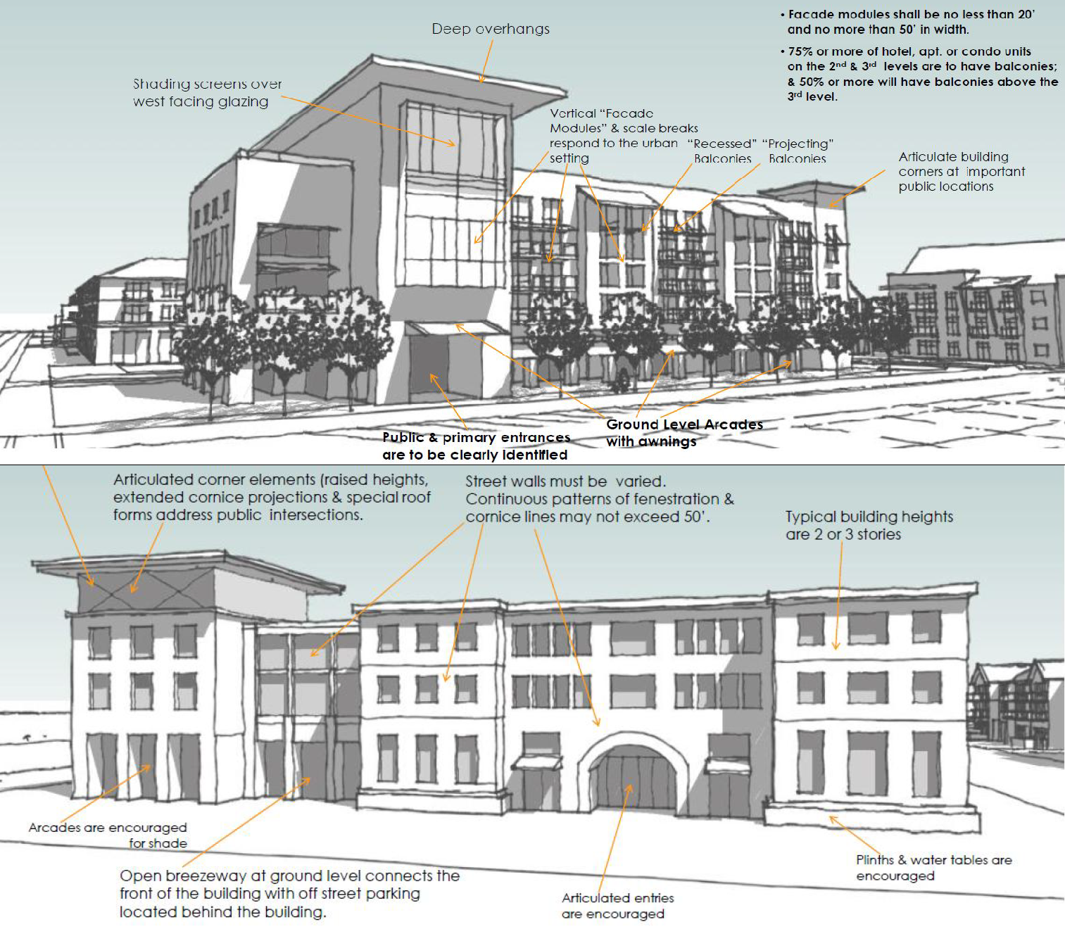
Typical Building Type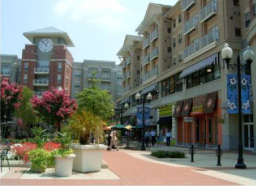
Typical Lot Pattern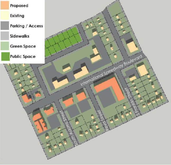
5.
Modified Use Standards. The following standards shall apply to development within the Redevelopment Midtown - Midtown Center Mixed Use (RDM-1) district in addition to the generally-applicable use-specific standards in Article 5: Use Standards.
a.
Child Care (as an accessory use). Child care is allowed as an accessory use only to an office use.
V.
Redevelopment Midtown - Neighborhood Center Mixed Use (RDM-2).
1.
Purpose. The purpose of the Redevelopment Midtown - Neighborhood Center Mixed Use (RDM-1) district is to encourage the development of several neighborhood centers that will accommodate a compact mix of residential and small-scale, low-intensity retail and service uses that are convenient to the immediately surrounding neighborhood and consistent with neighborhood scale and architectural character of an urban mixed use district.
2.
Use Standards. See use tables and use-specific standards in Article 5 and any modified use standards for any overlay districts (Section 4.9), subject to the modifications in Section 4.7.V.5, Modified Use Standards.
3.
Intensity and Dimensional Standards. 1
4.
Development Standards. See development standards in Article 6 and any modified development standards for any overlay districts (Section 4.9).
Design Guideline Illustration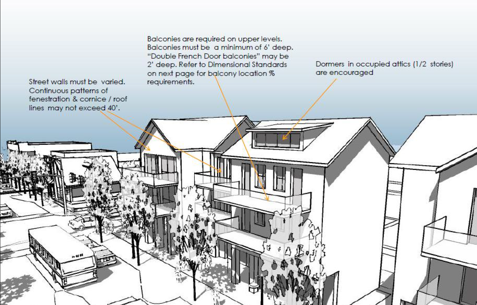
Typical Building Type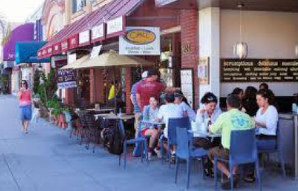
Typical Lot Pattern
5.
Modified Use Standards. The following standards shall apply to development within the Redevelopment Midtown - Neighborhood Center Mixed Use (RDM-2) district in addition to the generally-applicable use-specific standards in Article 5: Use Standards.
a.
Medical or Dental Clinic/Office. A medical or dental clinic/office shall be located only above the ground floor of a building.
W.
Redevelopment Midtown - Activity Center Mixed Use (RDM-3).
1.
Purpose. The purpose of the Redevelopment Midtown - Activity Center Mixed Use (RDM-3) district is to provide for a mix of medium- and large-scale commercial uses and public gathering spaces that capitalize on the high-volume traffic at the corner of Nova Road and International Speedway Boulevard and in close proximity to college campuses. Residential uses are encouraged on the upper floors of nonresidential establishments.
2.
Use Standards. See use tables and use-specific standards in Article 5 and any modified use standards for any overlay districts (Section 4.9).
3.
Intensity and Dimensional Standards. 1
4.
Development Standards. See development standards in Article 6 and any modified development standards for any overlay districts (Section 4.9).
Design Guideline Illustration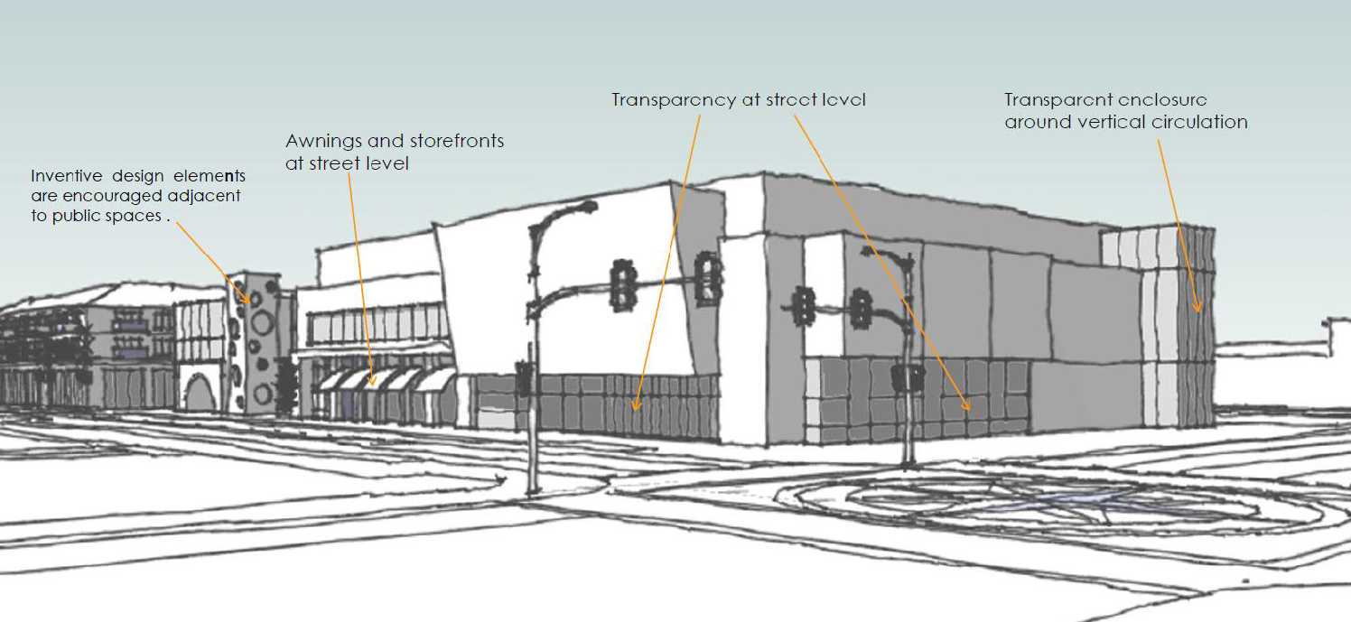
Typical Building Type
Typical Lot Pattern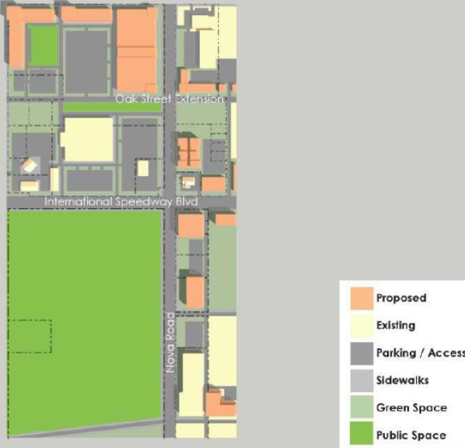
X.
Redevelopment Midtown - University Transition (RDM-4).
1.
Purpose. The purpose of the Redevelopment Midtown - University Transition (RDM-4) district is to provide for major institutional, education, and small-scale, low-intensity retail and service uses that support and complement Bethune Cookman University and accommodates the growth of the BCU campus. Residential uses are encouraged on the upper floors of nonresidential establishments.
2.
Use Standards. See use tables and use-specific standards in Article 5 and any modified use standards for any overlay districts (Section 4.9).
3.
Intensity and Dimensional Standards. 1
4.
Development Standards. See development standards in Article 6 and any modified development standards for any overlay districts (Section 4.9).
Design Guideline Illustration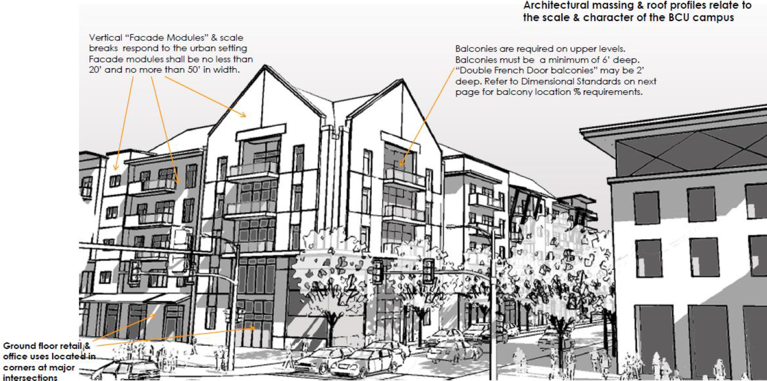
Typical Building Type
Typical Lot Pattern
Reserved
Y.
Redevelopment Midtown - Neighborhood Transition Mixed Use (RDM-5).
1.
Purpose. The purpose of the Redevelopment Midtown - Neighborhood Transition Mixed Use (RDM-5) district is to provide a mix of residential, institutional, and small-scale, low-intensity, and "convenience" retail and service uses for the surrounding neighborhoods. The district serves as a transition between residential areas that abut a primary or secondary street. Residential uses are encouraged on the upper floors of nonresidential establishments.
2.
Use Standards. See use tables and use-specific standards in Article 5 and any modified use standards for any overlay districts (Section 4.9).
3.
Intensity and Dimensional Standards. 1
4.
Development Standards. See development standards in Article 6 and any modified development standards for any overlay districts (Section 4.9).
Design Guideline Illustration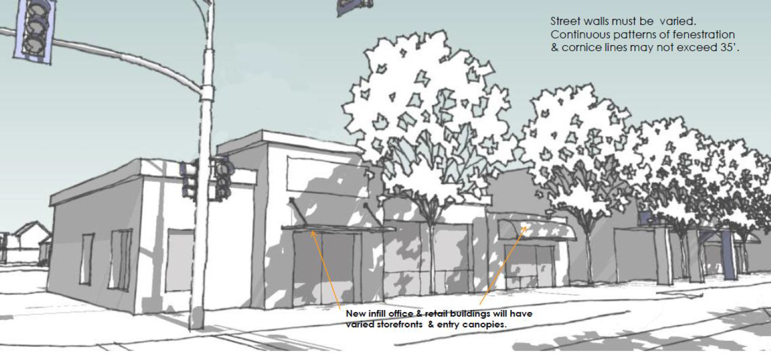
Typical Building Type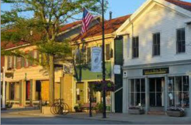
Z.
Redevelopment Midtown - Residential Preservation (RDM-6).
1.
Purpose. The purpose of the Redevelopment Midtown - Residential Preservation (RDM-6) district is to preserve the historic residential use and small-scale character of the areas and encourage the infill of compatible residential buildings. A mix of residential building types is encouraged.
2.
Use Standards. See use tables and use-specific standards in Article 5 and any modified use standards for any overlay districts (Section 4.9).
3.
Intensity and Dimensional Standards. 1
4.
Development Standards. See development standards in Article 6 and any modified development standards for any overlay districts (Section 4.9).
Design Guideline Illustration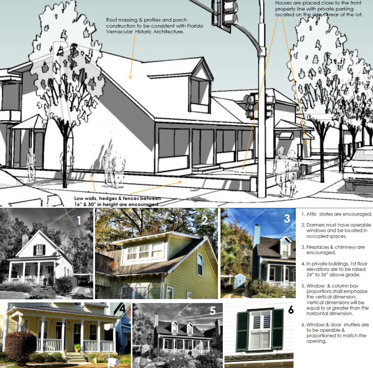
Typical Building Type
Typical Lot Pattern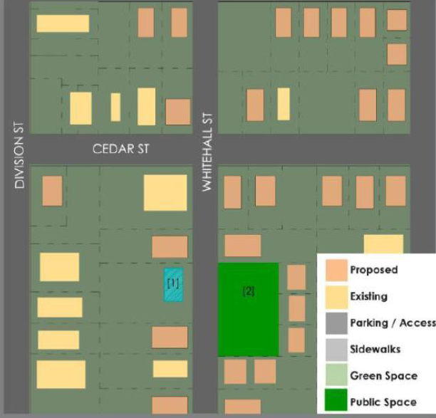
(Ord. No. 16-26, § 1(Exh. A), 1-20-2016; Ord. No. 16-354, § 1(Exh. A), 12-21-2016; Ord. No. 2020-153, § 1, 6-3-2020; Ord. No. 2022-414, § 1, 10-19-2022; Ord. No. 2024-08, § 3, 1-3-2024)
Sec. 4.8. - Planned Development Zoning Districts.
A.
General.
1.
General Planned Development District Purposes. The Planned Development (PD) districts are established and intended to encourage innovative land planning and site design concepts that support a high quality of life and achieve a high quality of development, environmental sensitivity, energy efficiency, and other City goals and objectives by:
a.
Reducing or diminishing the inflexibility or uniform design that sometimes results from strict application of zoning and development standards designed primarily for individual lots;
b.
Allowing greater freedom in selecting the means of providing access, open space, and design amenities;
c.
Allowing greater freedom in providing a well-integrated mix of residential and nonresidential land uses in the same development, including a mix of housing types, lot sizes, and densities;
d.
Providing for efficient use of land resulting in smaller networks of utilities and streets and thereby lowering development and housing costs; and
e.
Promoting quality design and environmentally sensitive development that respects surrounding established land use character and respects and takes advantage of a site's natural and man-made features, such as trees, wetlands, surface waters, floodplains, and historic features.
2.
Classification of Planned Development Zoning Districts. Land shall be classified into a Planned Development zoning district only in accordance with the procedures and requirements set forth in Section 3.4.F, Planned Development, and this section.
3.
Relationship to Existing Planned Districts. Lands designated as Residential Planned Unit District (RPUD), Planned Mobile Home (PMH), Planned Commercial Development (PCD), Planned Amusement/Entertainment (PAE), Public Waterfront (PW), Planned Redevelopment (PR), Planned Master Development (PMD), or Planned Recreational Vehicle Park (PRV) as of March 1, 2015 (for purposes herein, "Existing Planned Districts"), are subject to the standards and conditions included within the previously adopted development agreements (including for purposes herein amendments thereto), and other requirements related to their approval. Development of Existing Planned Districts may proceed subject to the previously adopted development agreement in accordance with Section 1.8, Transitional Provisions. The provisions of this Code regulating lapses and extensions (Subsection 3.4.F.8), and establishing review procedures and standards for amendments (Subsection 4.8.B.11) shall apply to such Existing Planned Districts, even where these provisions conflict with the previously-adopted development agreement. The previously-approved development agreement shall control in the event of other conflicts with the provisions of this Code, unless the Existing Planned District authorization expires.
4.
Organization of Planned Development Zoning District Regulations. Section 4.8.B, General Standards for All Planned Development Districts, sets out general standards applicable to all types of Planned Development districts. Sections 4.8.C and 4.8.D set out the purpose statements and standards for each of the two specific types of Planned Development districts. These subsections have a common structure consisting of a purpose statement and applicable development standards. PD districts may also include additional district-specific standards. Article 5: Use Standards, includes a summary use table specifying the allowable uses for each of the PD districts (See the Principal Use Tables in Section 5.2.A.), subject to inclusion in an approved PD Plan/Agreement for the district.
B.
General Standards for All Planned Development Districts. Before approving a PD zoning district classification, the City Commission shall find that the application for the PD zoning district classification, as well as the PD Plan/Agreement included as part of the application, comply with the following standards:
1.
PD Plan/Agreement. The PD Plan/Agreement shall:
a.
Include a statement of planning objectives for the district;
b.
Identify the general location of individual development areas, identified by land use(s) and/or development density or intensity;
c.
Identify for the entire PD district and each development area the acreage, types and mix of land uses, number of residential units (by use type), nonresidential floor area (by use type), residential density, and nonresidential intensity;
d.
Identify the general location, amount, and type (whether designated for active or passive recreation) of open space;
e.
Identify the location of environmentally sensitive lands, wildlife habitat, and waterway corridors;
f.
Identify the on-site transportation circulation system, including the general location of all public and private streets, existing or projected transit corridors, and pedestrian and bicycle pathways, and how they will connect with existing and planned City systems;
g.
Identify the general location of on-site potable water and wastewater facilities, and how they will connect to City systems;
h.
Identify the general location of on-site stormwater management facilities, and how they will connect to City systems;
i.
Identify the general location of all other on-site public facilities serving the development, including but not limited to parks, schools, and facilities for fire protection, police protection, EMS, stormwater management, and solid waste management;
j.
Include any conditions related to the form and design of development;
k.
Include provisions addressing how transportation, potable water, wastewater, stormwater management, and other public facilities will be provided to accommodate the proposed development;
l.
Include provisions related to environmental protection and monitoring;
m.
Include each of the following provisions concerning amendments to the PD Agreement:
i.
Proposed amendments will be subject to the review procedures and standards set forth in Section 4.8.B.11.
ii.
The City, and the owner of every lot within the Planned District that is directly impacted by the amendment, are necessary parties to the amendment.
iii.
The owners of all other lots within the Planned District that are not directly impacted by the amendment, are not necessary parties to the amendment.
iv.
If the PD Agreement requires the creation of a property owners' association or homeowners' association, and the association is in existence at the time of the amendment, the association will be deemed to be an affected party with respect to the amendment as provided in Section 3.4.F.10.
v.
A lot is "directly impacted" for purposes of the provisions above, only when the amendment would revise the listed uses, dimensional requirements, architectural requirements, sign requirements, or other development or use requirements for that lot; and
n.
Include any other provisions the City Commission determines are relevant and necessary to the development of the PD in accordance with applicable standards and regulations.
2.
Consistency with City Plans. The PD zoning district designation and the PD Plan/Agreement shall be consistent with the comprehensive plan, redevelopment plans adopted for any Redevelopment Area in which the PD district is located, and any functional plans and small area plans adopted by the City.
3.
Compatibility with Surrounding Areas. Development along the perimeter of a PD district shall be compatible with adjacent existing or proposed development. Where there are issues of compatibility, the PD Plan/Agreement shall provide for transition areas at the edges of the PD district that provide for appropriate buffering and/or ensure a complementary character of uses. Determination of complementary character shall be based on densities/intensities, lot size and dimensions, building height, building mass and scale, hours of operation, exterior lighting, and siting of service areas.
4.
Development Phasing Plan. If development in the PD district is proposed to be phased, the PD Plan/Agreement shall include a development phasing plan that identifies the general sequence or phases in which the district is proposed to be developed, including how residential and nonresidential development will be timed, how infrastructure (public and private) and open space will be provided and timed, and how development will be coordinated with the City's capital improvements program.
5.
Conversion Schedule. The PD Plan/Agreement may include a conversion schedule that identifies the extent to which one type of residential use may be converted to another type of residential use and one type of nonresidential use may be converted to another type of nonresidential use. Such conversions may occur within development areas and between development areas as long as they occur within the same development phase, as identified by the approved development phasing plan, and are consistent with established extents of conversion set down in the conversion schedule.
6.
On-Site Public Facilities.
a.
Design and Construction. The PD Plan/Agreement shall establish the responsibility of the developer/landowner to design and construct or install required and proposed on-site public facilities in compliance with applicable City, State, and federal regulations.
b.
Dedication. The PD Plan/Agreement shall establish the responsibility of the developer/landowner to dedicate to the public the rights-of-way and easements necessary for the construction or installation of required and proposed on-site public facilities in compliance with applicable City, State, and federal regulations.
c.
Modification to Street Standards. In approving a PD Plan/Agreement, the City Commission may approve modifications or reductions of private street design standards—including those for right-of-way widths, pavement widths, required materials, and turning radii—on finding that:
i.
The PD Plan/Agreement provides for separation of vehicular, pedestrian, and bicycle traffic;
ii.
Access for emergency service vehicles is not substantially impaired;
iii.
Adequate off-street parking is provided for the uses proposed; and
iv.
Adequate space for public utilities is provided within the street right-of-way.
7.
Uses. The principal, accessory, and temporary uses allowed in each type of PD district are identified in the use tables in Article 5: Use Standards. Allowed principal uses in a particular PD district shall be established in the PD Plan/Agreement, subject to conversion in accordance with a schedule incorporated in the PD Plan/Agreement in accordance with Section 4.8.B.5, Conversion Schedule. Allowed uses shall be consistent with City plans and the purpose of the particular type of PD district, and subject to applicable use-specific standards in Article 5: Use Standards and any additional limitations or requirements set forth in Sections 4.8.C and 4.8.D for the particular type of PD district.
8.
Densities/Intensities. The densities for residential development and the intensities for nonresidential development applicable in each development area of a PD district shall be as established in the PD Plan/Agreement, and shall be consistent with the comprehensive plan, other adopted special area and City plans, and the purpose of the particular type of PD district.
9.
Dimensional Standards. The dimensional standards applicable in each development area of a PD district shall be as established in the PD Plan/Agreement, and shall be consistent with the purpose of the particular type of PD district. The PD Plan/Agreement shall include at least the following types of dimensional standards, unless the PD Plan/Agreement expressly states otherwise:
a.
Maximum dwelling units per acre and/or maximum floor area ratio;
b.
Minimum lot area;
c.
Minimum lot width;
d.
Maximum impervious surface area;
e.
Maximum building height;
f.
Maximum individual building size;
g.
Minimum and maximum setbacks; and
h.
Minimum setbacks from adjoining residential development or residential zoning districts.
10.
Development Standards. All development in a PD district shall comply with the development standards of Article 6: Development Standards, and Article 7: Subdivision Standards, or any modifications of those standards established in the PD Plan/Agreement as consistent with City plans, the objective of the particular type of development standard, the purpose of the particular PD district, and any additional limitations or requirements set forth in Sections 4.8.C and 4.8.D for the particular type of PD district.
11.
Amendments to Approved PD Plan/Agreement. Amendments or modifications to a PD Plan/Agreement shall be submitted and reviewed in accordance with the procedures and standards set forth in Section 3.4.F.10.
C.
Planned Development - General (PD-G).
1.
Purpose. The purpose of the Planned Development - General (PD-G) District is to accommodate urban infill and high-intensity mixed-use developments that are in accordance with policies in the comprehensive plan and that will achieve a high quality of design and signage.
2.
Use Standards. Principal uses allowed in a PD-G district shall be established in the PD Plan/Agreement. Uses shall be consistent with the comprehensive plan, other City-adopted plans, and the purpose of the PD-G district, and shall comply with the use tables and the use-specific standards in Article 5: Use Standards.
3.
Intensity and Dimensional Standards.
4.
Development Standards. The development standards in Article 6 shall apply to all development in PD-G districts, but some development standards may be modified as part of the PD Plan/Agreement if consistent with the general purposes of the PD-G district and the comprehensive plan, and in accordance with the means of modification noted below.
5.
Subdivision and Infrastructure Standards. The subdivision and infrastructure standards in Article 7 shall apply to all development in PD-G districts, but some development standards may be modified as part of the PD Plan/Agreement if consistent with the general purposes of the PD-G district and the comprehensive plan.
D.
Planned Development - Redevelopment (PD-RD).
1.
Purpose. The Planned Development - Redevelopment (PD-RD) District is established and intended to provide the planning and design flexibility needed to accommodate urban infill and high-intensity mixed-use development and encourage the use of innovative and creative design that will achieve high quality urban design and a high level of energy efficiency and environmental sensitivity, and otherwise contribute to the City's goals and objectives for its Redevelopment Areas.
2.
Use Standards. Principal uses allowed in a PD-RD district shall be established in the PD Plan/Agreement. Uses shall be consistent with the comprehensive plan, other City-adopted plans, and the purpose of the PD-RD district, and shall comply with the use tables and the use-specific standards in Article 5: Use Standards.
3.
Intensity and Dimensional Standards.
4.
Development Standards. The development standards in Article 6 (including those in Section 6.13, Redevelopment Area Standards) shall apply to all development in PD-RD districts, but some development standards may be modified as part of the PD Plan/Agreement if consistent with the general purposes of the PD-RD district and the comprehensive plan, and in accordance with the means of modification noted below.
5.
Subdivision and Infrastructure Standards. The subdivision and infrastructure standards in Article 7 shall apply to all development in PD-RD districts, but some development standards may be modified as part of the PD Plan/Agreement if consistent with the general purposes of the PD-RD district and the comprehensive plan.
(Ord. No. 16-26, § 1(Exh. A), 1-20-2016; Ord. No. 2020-197, § 3, 7-15-2020)
Sec. 4.9. - Overlay Zoning Districts.
A.
General.
1.
General Purpose of Overlay Zoning Districts. Overlay zoning districts are superimposed over portions of one or more underlying base zoning districts with the intent of supplementing generally applicable development regulations with additional development regulations that address special area-specific conditions, features, or plans while maintaining the character and purposes of the underlying zoning districts. Some overlay zoning districts include standards that modify or supersede standards applied by the underlying base zoning district.
2.
Classification of Overlay Zoning Districts. Land shall be classified or reclassified into an overlay zoning district only in accordance with the procedures and requirements set forth in Section 3.4.C, General Zoning District Map Amendment, Section 3.4.D, Site-Specific Zoning District Map Amendment, or Section 3.4.E, Historic Overlay Zoning District Map Amendment, as appropriate, and this section.
B.
Historic Overlay (HO) District.
1.
Purpose. The City of Daytona Beach has various historic neighborhoods, sites, structures, and objects of historic significance. Rehabilitation and preservation of these historic neighborhoods, sites, structures and objects is beneficial to the community as a whole in that they provide the community with a singular identity and sense of place, establish social continuity by linking the present community with its origins, and contribute variety to the physical environment. The purpose of the Historic Overlay district provisions is to serve the best interest of the health, safety, prosperity, and welfare of the citizens of Daytona Beach by:
a.
Enhancing public awareness of the City's historic resources and promote civic pride in the beauty and accomplishments of the past.
b.
Fostering social stability, strengthening the economy of the City, and enhancing the attractiveness of the City for visitors and potential residents.
c.
Revitalizing and preserving the City's unique older neighborhoods, and stabilizing and improving property values in such neighborhoods.
d.
Protecting the City's historic sites, structures, and social heritage.
e.
Conserving existing housing stock and extending its economic life through rehabilitation of said properties.
f.
Discouraging the deterioration and eventual loss of historic neighborhoods, sites, structures, and objects through demolition, neglect, or destruction.
g.
Allowing additional revenue-generating uses in the historic areas of the City and providing appropriate and creative uses for historic structures while protecting residential districts.
2.
Procedures for Historic Overlay Zoning District Classification. Except as modified in accordance with this subsection, classification of land to the Historic Overlay zoning district shall occur in accordance with the procedures and requirements of Section 3.4.E, Historic Overlay Zoning District Map Amendment.
3.
Requirement for Certificate of Appropriateness.
a.
Any application for a demolition permit or for a building permit affecting the exterior architectural appearance of a building, structure, or object located on a designated historic site or within a designated historic district shall be reviewed in accordance with Section 3.4.J.2, Applicability, to determine whether a Certificate of Appropriateness is required. If no Certificate of Appropriateness is required, review of the permit application shall proceed as usual.
b.
If a Certificate of Appropriateness is required, the applicant shall be notified in writing, and shall promptly submit an application for a Certificate of Appropriateness in accordance with Section 3.4.J.3, Major Certificate of Appropriateness Procedure. The original application for a demolition permit or a building permit shall not be acted upon until a Certificate of Appropriateness is approved and issued in accordance with Section 3.4.J, Certificate of Appropriateness.
c.
If a Certificate of Appropriateness is required, it shall be obtained before issuance of any other permits necessary for the activities causing the requirement for a Certificate of Appropriateness. Issuance of a Certificate of Appropriateness shall not relieve the applicant from obtaining other permits or approvals required by the City. A building permit or other municipal permit shall be invalid if it is obtained without a Certificate of Appropriateness required for the proposed work.
4.
Markers Designating Historic Sites and Districts. The City Manager or the Historic Preservation Board is authorized to issue and place official markers identifying designated historic properties and districts.
5.
Designated Buildings and Structures Entitled to Modified Enforcement of Building Code. Buildings and structures listed individually on the local register of historic places, or located within a historic district listed on the local register of historic places and classified as contributing to that district, shall be deemed historic and entitled to modified enforcement of the adopted Florida Building Code - Existing Buildings.
6.
Modified Use Standards. Irrespective of the use standards applicable in the underlying base district, the following use standards shall apply in a Historic Overlay district.
a.
Offices as Special Uses in HO Districts. Except on land designated as HO-R as described in Section 3.4.E.2.h.ii (residential use only, unless professional services offices use permitted pursuant to 4.9.B.6.d), business services offices or professional services offices may be permitted as a special use in Historic Overlay (HO) districts—subject to the following standards:
i.
The offices shall be located only in buildings listed on the local or National Register of Historic Places
ii.
All renovation work on the building shall be designed and performed in a manner which reasonably preserves the historic integrity of the structure and site.
iii.
Off-street parking requirements may be modified by the City Commission where appropriate to meet the purpose of the Historic Overlay district.
iv.
Signage shall be limited to one ground monument sign.
b.
Bed and Breakfast Inns as Special Uses in HO Districts. A bed and breakfast inn shall be permitted a special use in Historic Overlay (HO) overlay districts subject to compliance with the following standards in addition to the use-specific standards in Section 5.2.B.24.a, Bed and Breakfast Inn:
i.
The inn shall be located only in buildings listed on the local or National Register of Historic Places.
ii.
All renovation work to a historic structure shall be designed and performed in a manner which reasonably preserves the historic integrity of the structure and site.
iii.
Any accessory restaurant use shall be compatible with existing land uses and not adversely impact the historical integrity of the structure's interior.
c.
Bar or Lounge as Accessory Uses to Hotels or Motels in HO Districts Overlying a Redevelopment Base District. A hotel or motel located in a Historic Overlay (HO) district overlying a Redevelopment base district may include a bar or lounge as an accessory use irrespective of the size of the hotel or motel provided the bar or lounge complies with the following standards;
i.
The accessory bar or lounge shall not be accessible from the exterior of the building.
ii.
Required off-street parking shall include parking spaces separately calculated for the accessory bar or lounge.
iii.
Exterior signage for the accessory bar or lounge shall be limited 20 percent of the area of any exterior wall or ground sign.
d.
Offices as Permitted Use in HO-R Districts. A professional services office may be permitted through a planned development rezoning in a HO-R District so long as the following standards are met:
i.
The site is located along the north side of Glenview Boulevard and within 150 feet west of Peninsula Drive.
ii.
The site subject to the planned development must be a minimum of 0.33 acre.
iii.
The site must meet the standards outlined in 4.9.B.6.a, Offices as Special Uses in HO Districts.
iv.
The City Commission must find that the use would not be detrimental to the historic character of the HO-R District.
C.
Transitional Overlay Districts.
1.
Purpose.
a.
The Transitional Overlay zoning districts are provided to allow for the gradual redevelopment of selected single-family districts to multifamily, business, or professional uses by establishment as special uses; and to establish strict controls for areas which have been subject to such redevelopment, while maintaining a primarily single-family character.
b.
The special use criteria are intended to insure that a site is of sufficient size to successfully accommodate all necessary elements of a development, and discourage the conversion of single-family homes when the building and site are insufficient to accommodate safe and orderly redevelopment; insure that before redevelopment, the applicant assembles sufficient land and commits to a specific development plan meeting minimum redevelopment standards; provide for proper ingress and egress from office developments; and ensure compatibility between new developments and adjacent existing single-family uses.
2.
Transitional Overlay A (TA) District Standards. In addition to uses permitted by the underlying base district, multifamily dwellings and complexes shall be permitted as special uses in Transitional Overlay A (TA) districts, subject to the following standards:
a.
The development complies with the intensity and dimensional standards for the MFR-20 district, except that the minimum lot area shall be 16,000 square feet and the minimum lot width and street frontage shall be 70 feet.
b.
The size, layout, and features of the development shall ensure that neighboring single-family detached dwellings will be reasonably protected from any potential adverse impact generated by the development.
3.
Transitional Overlay B (TB) and Transitional Overlay C (TC) Districts. In addition to uses permitted by the underlying base district, business services offices and professional services offices shall be permitted in Transitional Overlay B (TB) and Transitional Overlay C (TC) districts, subject to the following standards:
a.
The development complies with the minimum lot and building standards in Table 4.9.C.3 below.
b.
The size, layout, and features of the development shall ensure that neighboring residential uses will be reasonably protected from any potential adverse impact generated by the development.
c.
The use of highly reflective surfaces such as reflective glass and reflective metal roofs with a pitch ratio of more than 7:12 shall be prohibited. This restriction shall not apply to solar panels, or copper or painted metal roofs.
d.
Vehicular access points shall be located on West International Speedway Boulevard. Additional or alternate access may be provided on intersecting side streets if there is a median opening on West International Speedway Boulevard at the access intersection and it is determined that adjacent residential areas will not be adversely affected.
e.
Signage shall be as permitted in RP districts.
4.
Transitional Overlay D (TD) District.
a.
In addition to uses permitted by the underlying base district, duplexes shall be permitted in Transitional Overlay D (TD) districts, subject to compliance with the intensity and dimensional standards for the MFR-12 district, except that the minimum lot area shall be 7,260 square feet.
b.
A single-family detached dwelling shall be permitted one accessory dwelling unit provided the total minimum lot area is 7,260 square feet and adequate paved parking is provided behind the front building line. The unit may be attached or detached from the principal structure.
c.
In addition to uses permitted by the underlying base district, multifamily dwellings and complexes shall be permitted as a special use in Transitional Overlay D (TD) districts, subject to the following standards:
i.
The development shall comply with the intensity and dimensional standards for the MFR-12 district, except that a maximum of four units per building and eight units per development is allowed.
ii.
The special use permit application shall include building elevation drawings proposing a similar architectural style to those in the neighborhood, with sensitivity to buildings currently existing along the street.
d.
All developments that existed prior to application of TD zoning and that comply with the intensity and dimensional standards for the MFR-12 district shall be considered conforming with respect to TD district regulations.
D.
Scenic Thoroughfare Overlay (STO) District.
1.
Purpose. The purpose of the Scenic Thoroughfare Overlay (STO) district is to provide for continuous, neat, aesthetically pleasing landscaped frontages along the City's main travel routes.
2.
Applicability.
a.
Area. The Scenic Thoroughfare Overlay district shall apply to all lands abutting those street segments identified in Table 4.9.D.3.a, Minimum Landscape Yard Depth in STO District.
b.
Development Activities. The standards of this subsection shall apply to any of the following development that occurs or is proposed within a Scenic Thoroughfare Overlay district:
i.
Development of unimproved land;
ii.
Any change in use;
iii.
Reestablishment of a previously existing use of land after a vacancy of three months or more in a redevelopment district, or six months or more in any other district; and
iv.
Renovation or improvement of an existing developed site or building where the proposed renovation or improvements costs exceed $5,000 or the cumulative renovation or improvement costs during any five-year period equal or exceed 20 percent of the total assessed value of the principal structure.
3.
Modified Landscaping Standards. In addition to the generally applicable landscaping standards in Section 6.3, Landscaping, the following landscaping standards shall apply in the STO district.
a.
Landscape Yard Required. A landscape yard shall be provided along the street segments designated in Table 4.9.D.3.a below in accordance with the minimum depth (from the right-of-way) set forth in the table.
b.
Minimum Vegetation Preservation and Coverage Requirements.
i.
Residential Development.
(a)
All healthy trees and native vegetation within the landscape yard shall be preserved.
(b)
If the quantity of existing healthy trees is insufficient to comply with the minimum coverage standards set forth in Table 4.9.D.3.b below, then new tree plantings shall be installed as necessary to comply with the minimum coverage standards.
(c)
If the quantity of shrubs and understory vegetation does not provide a minimum coverage of one-third of the landscape yard or does not satisfy any screening or buffer requirement, then new shrub plantings will be required as necessary to do so.
ii.
Nonresidential Development.
(a)
Existing healthy trees shall be preserved as necessary to comply with the minimum coverage standards set forth in Table 4.9.D.3.b below.
(b)
If the quantity of existing healthy trees is insufficient to comply with the minimum coverage standards set forth in Table 4.9.D.3.b, new tree plantings shall be installed as necessary to comply with the minimum coverage standards.
(c)
If the quantity of existing trees exceeds that required to comply with the minimum coverage standards, the excess trees may be removed in accordance with a Tree Removal Permit granted in accordance with Section 3.4.L, Tree Removal Permit.
(d)
Priority shall be placed on preserving healthy tree species that are well shaped and spaced to provide the best aesthetic and balanced look within the landscape yard.
(e)
At least one-third of the landscape yard shall be covered with preserved understory vegetation or with planted shrubs. Sufficient quantities and distribution of shrubs or native vegetation shall be added where necessary to satisfy any buffer or screening requirements set forth in this Code. The remainder of the landscape yard shall be covered with preserved or planted ground cover suitable to provide a neat and clean appearance. Sod, flowers, and other ground covers shall be used singly or in combination to provide continuous coverage throughout the landscape yard.
iii.
Design Criteria.
(a)
The preserved and installed plant materials shall present an integrated natural, yet neat and kept appearance. Curvilinear and massing arrangements shall be used, simulating natural growth patterns while still providing a balanced overall scheme. The landscape plan shall show the location of all existing and proposed plant material integrated with the overall landscape and preservation design.
(b)
Trees shall be preserved and planted to create a balanced and continuous appearance of trees across the frontage with a maximum spacing of 40 feet as viewed from the street and a maximum distance of 25 feet from any side lot line to a tree, except to provide a visibility zone for permitted signs as described in Section 6.9.F, Sign Design and Construction, and a required clear zone in accordance with Section 6.2.G.9, Obstruction to Vision at Intersections.
(c)
Decisions on which trees may be removed shall conform to the requirements noted in this Code and to the following criteria:
(1)
Save the minimum number of trees based on the quantity table;
(2)
Save hardwood species as priority before pines;
(3)
Save large trees over small trees;
(4)
Save trees that are healthy and well-shaped;
(5)
Allow the removal of pines in favor of planting new hardwood species.
(d)
Existing healthy four-inch-caliper hardwood trees may be preserved to satisfy the tree requirements as long as they conform to the spacing requirements and design intent.
(e)
Any new trees required to be planted to meet the requirements of this subsection shall have a minimum caliper of four inches and a minimum height of 16 feet and shall be selected for the U.S. Department of Agriculture, Florida 9a/9b Hardiness Zone. The material shall provide a year-round density of screening consistent with the purposes of this district. Cypress trees shall be restricted to no more than ten percent in the tree material mix and shall only be located on the interior sites within STO buffers.
(f)
Stormwater retention areas, ponds, berms, swales, ditches, easements, driveways, walkways, paths, fountains, landscape lighting, and permitted signage may occupy the landscape yard provided their design and location does not conflict with the purpose of this subsection.
(g)
Special pavement treatments, such as textured and earth-tone colored brick, pavers, and concrete, are encouraged at permitted entrances provided they meet roadway construction and safety standards. Patios, decks, balconies, projections, playfields, ornaments, banners, balloons, structures, and like uses are prohibited in landscape yards. Permitted fences, retaining walls, and freestanding walls may be located along the interior edge of the landscape yard.
iv.
Maintenance. Foliage within the lower one-third of a tree's overall height may be pruned to provide visibility of nonresidential structures.
v.
Modification. Modification of the landscape yard standards may be granted as follows:
(a)
Where the location of existing facilities to remain prohibit strict adherence to these requirements, the required landscape yard and planting materials may be reduced, reconfigured, relocated, or clustered—provided, however, that the developer shall make every reasonable effort in project design and construction to accommodate the required landscaping, and the design shall fulfill the intent of this subsection.
(b)
The use of innovative designs and landscaping techniques not contemplated herein that clearly fulfill the purpose of this subsection may be grounds for modification of these standards.
E.
Reserved.
F.
Airport Overlay Zoning Districts.
1.
Purpose. The Airport Height Overlay (AHO) and Airport Noise Overlay (ANO) districts are intended to ensure that property surrounding the Daytona Beach International Airport is developed and used in a manner that will not create hazards for air traffic, and to allow appropriate uses to be established in existing residential areas impacted by airport noise.
2.
Applicability.
a.
Airport Height Overlay (AHO) District. The Airport Height Overlay District applies to all land designated as Airport Hazard Area on the most recent Florida Department of Transportation, Part 77, FAA, Daytona Beach International Airport Hazard Area Map.
b.
Airport Noise Overlay (ANO) District. The Airport Noise Overlay District applies to all land located within the 65 LDN and greater noise contour for the Daytona Beach International Airport, as shown in the Airport Noise Report, exhibit F. Where the 65 LDN noise contour crosses a lot and at least 50 percent of the lot is within the 65 LDN noise contour, the entire lot shall be considered within the Airport Noise Overlay District.
3.
Airport Height Overlay (AHO) District Standards.
a.
No structure shall be constructed and no tree shall be permitted to grow higher than the maximum height limitation established by the Airport Hazard Area Map, or exceed the obstruction standards contained in 14 CFR 77.21, 77.23, and 77.25, or any amendment thereto.
b.
Proposed development of any aboveground structure within one nautical mile of the ASR-9 radar site, as shown on the ASR-9 Operational Area Map prepared by the County of Volusia, shall be reviewed and approved by the FAA prior to issuance of a permit. Proposed development of any structure over 100 feet above mean sea level within four nautical miles of the ASR-9 site shall be reviewed and approved by the FAA prior to issuance of a permit.
c.
The Board of Adjustment may grant a variance from the height restrictions in accordance with the procedures in Section 3.4.V, Variance. A variance may be conditioned on installation, at the owner's expense, of markers and lights as necessary to indicate the presence of an airport hazard. All applications for a variance shall be reviewed by the State of Florida, Department of Transportation, Bureau of Aviation, to determine effects the proposed structure or tree would have on safe airport operations.
4.
Airport Noise Overlay (ANO) District Standards.
a.
Plant nurseries, florist shops, greenhouse operations, and business services offices, and professional services offices are permitted as special uses where the Airport Noise Overlay District overlays a residential base district. To protect nearby residential properties from obnoxious, detrimental, or adverse effects, such uses are subject to the following standards:
i.
The use shall comply with all intensity and dimensional standards applicable in the underlying base district unless stricter or lesser requirements are determined necessary or sufficient to protect neighboring residential areas and ensure consistency with the comprehensive plan.
ii.
No outside storage or business activities shall be allowed, except in the case of nurseries or greenhouse operations.
iii.
Signage shall comply with signage standards applicable in the underlying base district unless a different signage allotment would not adversely impact the area and would be consistent with the comprehensive plan.
G.
Enterprise Overlay (EPO) Zoning District.
1.
Purpose.
a.
The City of Daytona Beach has identified an "enterprise zone" pursuant to applicable provisions of State law for the purpose of creating and expanding economic activities benefiting unemployed and underemployed people, particularly those residing in the enterprise zone.
b.
Activities which benefit unemployed and underemployed people include, but are not limited to, employment opportunities, vocational and general training opportunities, employment counseling, support for business enterprises, and increased commercial and business opportunities. This section establishes standards which can facilitate development and redevelopment activities within the enterprise zone, and particularly facilitate the development of light manufacturing employment which usually offers higher wages.
c.
Where there is a conflict between these provisions and other generally applicable provisions, the provision or interpretation which facilitates development of employment opportunities shall prevail.
2.
Applicability. The Enterprise Overlay (EPO) zoning district includes those areas identified in Ordinance No. 95-231.
3.
Modified Use Standards. In addition to uses provided by the underlying district regulations, the following uses shall be permitted in the Enterprise Overlay (EPO) district, subject to the additional standards applicable to each:
a.
Games of skill, where the underlying base zoning district is a BR, BA, or M-1 district and the site fronts on Martin Luther King Boulevard, Dr. Mary McLeod Bethune Boulevard, or Orange Avenue.
b.
Industrial uses, where the underlying base zoning district is a BR-2, BA, or M-1 district and the following standards are met:
i.
The use may be established only in buildings designed and constructed for non-residential use.
ii.
The use shall comply with all other requirements of this Code and the underlying zoning district, except that where an existing building is non-conforming, City staff may reduce requirements for parking and loading areas based on the size and nature of the proposed use.
c.
Auto detailing, where the underlying base zoning district is a BR district and the site fronts on Orange Avenue, Dr. Martin Luther King, Jr., Boulevard, or Dr. Mary McLeod Bethune Boulevard.
d.
Personal service establishments, where the underlying base zoning district is a BP district.
H.
North Ridgewood Overlay (NRO) District.
1.
Purpose. The North Ridgewood area, adjacent to some of the City's Redevelopment Areas, is a gateway to the City and currently does not project that image. The area has developed indications of economic regression. The North Ridgewood classification is intended to protect this depressed area from migration of uses that may be located or relocated to the area as a result of Redevelopment Area restrictions.
2.
Prohibited Uses.
a.
The following principal or accessory uses are found to be detrimental to the economic sustainability of the North Ridgewood area and, except as otherwise provided in subparagraph [c] below, are prohibited in the North Ridgewood Overlay (NRO) District irrespective of whether they are listed in Article 5, Use Standards, or elsewhere as a permitted or allowed use in the underlying base district.
i.
Community residential home or similar facility
ii.
Blood/tissue collection center
iii.
Congregate meal facility
iv.
Food pantry or feeding program
v.
Homeless shelter or service facility
vi.
Recovery home or treatment facility
vii.
Adult bookstore or adult theater
viii.
Day labor service
ix.
Check cashing service
x.
Flea market
xi.
Pawn shop
xii.
[Reserved.]
xiii.
Any visitor accommodation use except a hotel or motel or a historic bed and breakfast inn
xiv.
Outdoor storage for properties fronting Ridgewood Avenue
b.
The prohibited uses listed in subparagraph [a] above shall not be permitted through the Planned Development rezoning process, a Special Use Permit, or a Public or Semipublic Use Permit.
c.
Any use listed in subparagraph [a] above that was legally established as an accessory use prior to January 18, 2012, shall not be subject to the Section 8.2.D, Discontinuance of Use.
I.
E-Zone Overlay District (E-Zone). Reserved.
J.
Arts Overlay (AO) District.
1.
Purpose. The Arts Overlay (AO) District is established to encourage development in the City that supports retail, arts, entertainment, and if appropriate, residential uses, and an increased presence and integration of the arts and related cultural and arts-related support uses. The AO district is a flexible tool that may be applied to multiple districts, each of which might have its own unique cultural, architectural, and physical attributes.
2.
Establishment of Individual Arts Overlay (AO) Districts. The City Commission may establish individual Arts Overlay (AO) Districts in accordance with this section and Section 3.4.D, Site-Specific Zoning District Map Amendment, after approving an area plan for the land to be designated an AO District specifying the additional or prohibited uses in the district, if different from the underlying base zoning district. In establishing a new AO District, the City Commission may also establish a unique set of development standards applicable to all development in the particular district. Each district shall comply with the standards in 4.9.J.5, General Development Standards for All AO Districts.
3.
Underlying Base Zoning District. The regulations governing uses of land and structures shall be as established in the underlying base zoning district(s), other applicable overlay districts, except as expressly modified by the AO District. Where there is a conflict the provisions in the AO District shall control.
4.
Minimum Standards for Designation of an AO District. The City Commission may approve an application for designation of an AO District only if:
a.
The owners of at least 65 percent of the land in the proposed AO District request the designation to AO District;
b.
An area plan is prepared by City staff, working in conjunction with residents of the proposed AO District, which is reviewed and approved by the City Commission;
c.
Development patterns in the district demonstrate an on-going effort to maintain or rehabilitate the character and physical features of existing structures in the district;
d.
There is existing or potential pressure for new development, redevelopment, or infill development within the district;
e.
The area possesses one or more of the following distinctive features that create a cohesive identifiable setting, character, or association:
i.
Scale, size, type of construction, or distinctive building materials;
ii.
Lot layouts, setbacks, street layouts, alleys, or sidewalks;
iii.
Streetscape characteristics; or
iv.
Land use patterns, including mixed or unique uses or activities; and
f.
The uses and development standards proposed to be applied to the district will encourage and support revitalization and the establishment of an increased presence and integration of the arts and related cultural and arts-related support uses with retail and residential development.
5.
General Development Standards for All AO Districts.
a.
Compliance with Underlying Zoning District Standards. These standards supplement the applicable development and district-specific standards found in the underlying base zoning district and do not affect the use regulations applicable in the underlying zoning, unless expressly stated otherwise.
b.
Compliance with Approved Design and Development Standards. No development approval or permit for any new construction or expansion of an existing structure resulting in an increase in building footprint area of ten percent or more may be issued until City staff determines that the development proposal complies with all the standards established for the AO District where the land is located, the requirements of the underlying base zoning district (as appropriate), and all other provisions of this Code.
6.
AO District-Specific Use and Development Standards.
a.
All lands designated as an AO District shall identify, with specificity, the use and development standards to be applied to all new construction and expansion of existing structures.
b.
The types of uses that the standards may address and encourage include, but are not limited to:
i.
Accessory dwelling units for artists that work on the site;
ii.
Art galleries, including sales;
iii.
Art and craft retail sales;
iv.
Artist housing;
v.
Artist studios;
vi.
Art services, including set design and restoration of art work;
vii.
Book stores, except for adult book stores;
viii.
Coffee shops;
ix.
Craftsman or artisan studios or workspace;
x.
Live/work units;
xi.
Mixed uses, if the uses include single-family units and arts and craft retail sales made on the site;
xii.
Outdoor retail sales of arts and crafts;
xiii.
Outdoor cultural events and performances on Fridays, Saturdays, and Sundays only;
xiv.
Outdoor crafting of art associated with the business on the premises, and storage of materials associated with the crafting area;
xv.
Photographic studios;
xvi.
Small-scale restaurants, with limited outdoor dining;
xvii.
Temporary arts shows and festivals; and
xviii.
Teaching of visual and performing arts.
c.
Aspects of development that the standards may address include, but are not be limited to, the following:
i.
Bonuses for preferred uses;
ii.
Building height;
iii.
Building size (for principal and accessory structures);
iv.
Building orientation;
v.
Building roof line and pitch;
vi.
Demolition of structures;
vii.
Exterior building materials and colors;
viii.
Exterior lighting;
ix.
Landscaping and screening;
x.
Location of proposed buildings or additions;
xi.
Lot size;
xii.
Neighborhood character and compatibility;
xiii.
Parking;
xiv.
Paving requirements or limitations;
xv.
Required features on a front façade;
xvi.
Setbacks or required yards;
xvii.
Sidewalks;
xviii.
Signage; and
xix.
Streetscape.
d.
The City Commission may approve additional development standards addressing aspects of development not listed above.
7.
Specific Arts Overlay Districts. Reserved.
K.
International Speedway Boulevard Gateway Overlay (ISBGO) District. [Reserved.]
(Ord. No. 17-07, § 1, 1-4-2017; Ord. No. 17-116, § 1(Exh. A), 4-19-2017; Ord. No. 18-409, § 4, 12-5-2018; Ord. No. 19-97, § 1, 4-17-2019; Ord. No. 2021-384, § 1, 12-1-2021)