
Daytona Beach City Zoning Code
ARTICLE 6
- DEVELOPMENT STANDARDS
Sec. 6.1. - Restrictions on Outside Activities and Uses.
A.
Purpose. The City of Daytona Beach has an economy that is strongly dependent on tourism. The value of property is in part dependent on its appearance. Outside activities including sales, display, preparation, service, and storage can adversely affect the appearance of a community and its public image. It is within the public interest and contributes to the general welfare to project an attractive community image.
B.
Outside Activities and Uses Prohibited Generally. Except as specifically provided otherwise in this Code, all activities, storage, and displays shall be conducted entirely within an enclosed structure in all districts of the City.
C.
Outside Activities and Uses Specifically Permitted. In addition to specifically listed activities, the following activities and uses shall be permitted outside where the activity or use is permitted in the district, any applicable use-specific standards are met, and any additional standards set forth or referenced below are met:
1.
All activities and uses in the Local Industry (M-1) district.
2.
Storage and sale of vehicles (see Section 5.2.B.19.g).
3.
Gift shop shell displays not greater than 80 square feet.
4.
Retail displays of garden supplies and products, lawn ornaments, swimming pools, and newspapers.
5.
Off-premises soliciting conducted in accordance with applicable provisions of the Code of Ordinances, in any commercial district.
6.
Special events (see Section 5.4.C.4).
7.
Sale and display of fresh Florida citrus fruit, provided:
a.
Display shall be under a roof or a canopy. One edge of the roof or canopy shall be within 30 feet of the principal building on the lot. The canopy or roof shall comply with all setback requirements for the principal building and shall not infringe on a public right-of-way or easement open to public travel.
b.
The display area shall not be greater than ten percent of the lot or parcel and not greater than 500 square feet.
c.
All displays shall meet regulations of the State Department of Health.
8.
Food and beverage service and sales, provided:
a.
The outside service area shall be screened from residential uses or districts.
b.
If within 500 feet of a residential zoning district, the outside service area shall be closed between the hours of 3:00 a.m. and 7:00 a.m.
9.
Children's outdoor residential play equipment in the BA district, provided:
a.
The play equipment shall not be located in any parking spaces, driveways, drive aisles or landscaped areas.
b.
The play equipment shall not be located within ten feet of a public right-of-way.
c.
The play equipment shall be newly manufactured and in good working order.
d.
The play equipment display area shall not exceed 60 percent of the site.
(Ord. No. 16-26, § 1(Exh. A), 1-20-2016)
Sec. 6.2. - Off-Street Parking and Loading.
A.
Purpose and Intent. The purpose of this section is to ensure provision of off-street parking and loading facilities in proportion to the generalized parking and loading demand of the different uses allowed by this Code. The standards in this section are intended to provide for adequate off-street parking and loading while allowing the flexibility needed to accommodate alternative solutions. The standards are also intended to achieve City policies of supporting development and redevelopment in the redevelopment districts and along commercial corridors, accommodating appropriate infill development, and encouraging pedestrian-oriented development (where appropriate) while avoiding excessive paved surface areas, promoting low impact development, and safeguarding historic resources.
B.
Applicability.
1.
New Development. All new development shall provide off-street parking and loading areas in accordance with the standards of this section, unless exempted in accordance with paragraph 4 below.
2.
Existing Development.
a.
Change in Use. Any change in use of an existing development shall be accompanied by provision of any additional off-street parking and loading spaces required for the change in use to comply with this section to the maximum extent practicable unless otherwise specified in this Code.
b.
Expansion. If an existing structure or use is expanded or enlarged (in terms of the number of dwelling units, floor area, seating capacity, or other size unit used in this section to determine the minimum number of off-street parking spaces or loading berths required for the applicable use), additional off-street parking and loading spaces shall be provided in accordance with the requirements of this section as applied to only the expanded or enlarged part of the structure or use.
c.
Upgrading of Nonconforming Parking. Nonconforming parking facilities on the site of a remodeled structure or expanded structure or use area shall comply with the requirements of this section in accordance with the standards of Article 8: Nonconformities.
3.
Specific Parking Standards. Parking standards identified in specific zoning districts in Article 4: Zoning Districts, shall be applicable to uses within those districts in-lieu of the standards in this Section 6.1.
4.
Exemptions. The parking standards in this section are not applicable as follows:
a.
Parking spaces are not required in BR-1, RDB-2, RDB-4, and RDD-1 districts.
b.
Parking spaces are required only for residential uses in RDD-2 districts.
c.
Parking space requirements in Planned Development (PD) districts shall be established in the Master Parking Plan and PD Plan/Agreement approved for the district.
d.
Parking spaces are not required for lots abutting Dr. Mary McLeod Bethune Boulevard on the north and south side of the street between Ridgewood Avenue and Dr. Martin Luther King, Jr. Boulevard and lots within 150 feet west of Dr. Martin Luther King, Jr. Boulevard on the north side of Dr. Mary McLeod Bethune Boulevard.
e.
Parking spaces are not required for properties abutting Dr. Martin Luther King, Jr. Blvd. between a point 400 feet south of Loomis Avenue and a point 225 feet south of West International Speedway Boulevard.
5.
Use of Parking and Loading Areas.
a.
Nonresidential Districts. Off-street parking areas required by this section shall be used solely for the parking of licensed motorized vehicles in operating condition. Required parking spaces and loading berths may not be used for the display of goods for sale, or the sale, lease, storage, dismantling, or service of any vehicles, boats, motor homes, campers, mobile homes, building materials, equipment, or supplies.
b.
Residential Districts. Unless otherwise specified in this Code, required off-street parking areas are to be used solely for the parking of licensed motor vehicles in operating condition.
C.
Off-Street Parking Space Standards.
1.
Minimum Number of Off-Street Parking Spaces.
a.
Except as expressly exempted elsewhere in this Code, new development shall provide the minimum number of off-street parking spaces in accordance with Table 6.2.C.1, Minimum Number of Off-Street Parking Spaces, based on the principal use(s) involved and the extent of development. Interpretation of the off-street parking space standards for uses with variable parking demands or unlisted uses is provided in Section 6.2.C.3, Uses with Variable Parking Demand Characteristics and Unlisted Uses.
b.
Uses with drive-through facilities or other automobile-oriented features may also be required to provide stacking spaces in accordance with Section 6.2.F, Vehicle Drop-Off/Pick-Up Zones, Stacking Spaces.
2.
Computation of Parking Space Requirements.
a.
When computation of the number of required parking spaces results in a fraction, any fraction shall be rounded up to the next higher whole number.
b.
Where the minimum off-street parking space requirement is based on the number of seats, all computations shall be based on the design capacity of the areas used for seating.
c.
Except as otherwise provided in this section, where the minimum off-street parking space requirement is based on square footage, all computations shall be based on gross floor area, and any structured parking shall not be counted in such computations.
d.
Except as otherwise provided in this section, where the minimum off-street parking space requirement is based on the number of employees, students, or residents, all computations shall be based on the largest number of persons working on any single shift (for employees) or the maximum enrollment (for students), whichever is greater.
3.
Uses with Variable Parking Demand Characteristics and Unlisted Uses. For some listed uses, Table 6.2.C.1, Minimum Number of Off-Street Parking Spaces, refers to this paragraph because the use has widely varying parking and loading demand characteristics, making it difficult to establish a single appropriate off-street parking or loading standard. On receiving an application proposing such a use, or proposing a use not expressly listed in Table 6.2.C.1, City staff is authorized to:
a.
Apply the minimum off-street parking space requirement specified in Table 6.2.C.1 for the listed use that is deemed most similar to the proposed use; or
b.
Establish the minimum off-street parking space requirement by reference to standard parking resources published by the National Parking Association or the American Planning Association; or
c.
Establish the minimum off-street parking space requirement based on a parking demand study prepared by the applicant that estimates parking demand based on the recommendations of the Institute of Traffic Engineers (ITE) or other acceptable source of parking demand data, and that includes relevant data collected from uses or combinations of uses that are the same or comparable to the proposed use in terms of density, scale, bulk, area, type of activity, and location.
4.
Maximum Number of Off-Street Parking Spaces. For any use listed under the commercial use classification in Table 6.2.C.1, Minimum Number of Off-Street Parking Spaces, the number of off-street parking spaces shall not exceed 125 percent of the minimum number of parking spaces required, except as may be allowed through approval of an alternative parking plan in accordance with Section 6.2.F.1.b, Provision over Maximum Allowed. Any additional parking spaces approved in accordance with Section 6.1.F.1.b shall be pervious.
5.
Multiple Use Developments. Except as otherwise provided in this section, developments containing more than one principal use shall provide parking spaces in an amount equal to the total of the requirements applied to all individual principal uses. This provision shall not limit the opportunity to reduce the minimum number of required off-street parking spaces through approval of an alternative parking plan that justifies the feasibility of shared parking (see Section 6.2.F, Off-Street Parking Alternatives).
6.
Reduction for Mixed-Use Development in Redevelopment Areas. The minimum number of off-street parking spaces required for mixed-use development in Redevelopment Areas may be reduced by 20 percent.
7.
Reduction for Group Living Facilities for the Elderly or Disabled. For assisted living facilities and other group living facilities for the elderly or disabled where at least 80 percent of the population is 65 years or older or disabled, or other facilities where residents do not normally have automobiles and public transportation and neighborhood services are accessible, the parking space requirement may be modified to at least one visitor space for each six beds.
8.
Reductions to Accommodate Tree Planting and Preservation.
a.
The City may require, or an applicant may request, the elimination of up to 20 percent of the required parking spaces in order to preserve specimen or historic trees. The site plan shall show the location of all required parking and the spaces eliminated to preserve the trees.
b.
A reduced number of required parking spaces may be permitted for lands adjacent to North or South Atlantic Avenue by eliminating spaces adjacent to and fronting on Atlantic Avenue for the placement of palm trees and associated plantings.
9.
Loading and Stacking Spaces Not Counted. Required off-street loading spaces shall not be counted as off-street parking spaces in computation of required off-street parking space. Parking spaces located in buildings used for repair garages or car washes, and stacking spaces in drive-through lanes shall not be counted as meeting the required parking.
10.
Driveways Used to Satisfy Requirements. For single-family detached dwellings, duplexes, multifamily, and mobile/manufactured homes, driveways may be used to satisfy minimum off-street parking space requirements, provided sufficient space is available to satisfy the standards of this section and this Code.
11.
Compact Automobile Spaces. No more than 20 percent of the total required number of parking spaces may be designated as Compact. All Compact spaces shall be prominently marked and posted. Compact parking spaces shall be a minimum 8½ feet wide and 17 feet long.
12.
Bicycle Parking Requirements. One bicycle parking space shall be required for every ten automobile parking spaces required. Development with less than ten required automobile parking spaces are encouraged but not required to install bicycle parking. When computation of the number of required bicycle parking spaces results in a fraction, any fraction shall be rounded up to the next higher whole number.
13.
Motorcycle Parking. Developments with more than 100 spaces may substitute motorcycle parking for automobile parking at a rate of three percent of required parking. Areas delineated for use by motorcycles shall meet standards consisting of an area of four feet by ten feet and shall be identified as a motorcycle parking area by signs or pavement delineation.
D.
Accessible Parking Spaces for Physically Disabled Persons. In each off-street parking area, a portion of the total number of off-street parking spaces shall be spaces specifically designated, located, and reserved for use by persons with physical disabilities ("accessible parking spaces"), in accordance with the standards of the Florida Accessibility Code for Building Construction.
E.
Vehicle Drop-Off/Pick-Up Zones, Stacking Spaces, and stacking Lanes.
1.
Drop-Off/Pick-Up Zone.
a.
Required Number of Spaces. In addition to meeting the off-street parking standards in Table 6.2.C.1, Minimum Number of Off-Street Parking Spaces, uses that involve the regular use of vehicles to drop off and pick up significant numbers of passengers at the use (e.g., child care facilities, schools) shall provide a drop-off/pick-up zone or lane containing at least the minimum number of spaces established in Table 6.2.E.1, Minimum Drop-Off/Pick-Up Spaces for Child Care Facilities, Schools, and Related Uses.
b.
Design. The drop-off/pick-up zone shall located adjacent to the use or facility being served in such a way that passengers being dropped off or picked up do not have to cross vehicular accessways to travel between the drop-off/pick-up zone and a principal pedestrian entrance to the use or facility.
2.
Stacking Spaces.
a.
Required Number of Stacking Spaces. In addition to meeting the off-street parking standards in Table 6.2.C.1, Minimum Number of Off-Street Parking Spaces, uses with drive-through facilities and other auto-oriented uses where vehicles queue up to access a use or service facility shall provide at least the minimum number of stacking spaces established in Table 6.2.E.1, Minimum Stacking Spaces for Drive-Through and Related Uses.
3.
Design and Layout. Required stacking spaces are subject to the following design and layout standards:
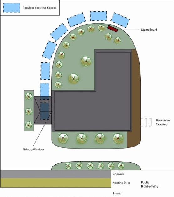
Figure 6.2.E.3 Stacking spaces for a drive-through restaurant.
i.
Stacking spaces shall be a minimum of ten feet wide and 20 feet long.
ii.
Stacking spaces shall not impede onsite or offsite vehicular traffic movements or movements into or out of off-street parking spaces.
iii.
Stacking spaces shall not impede onsite or offsite bicycle or pedestrian traffic movements.
iv.
Stacking spaces shall be separated from other internal driveways by raised medians if deemed necessary by City staff for traffic movement and safety.
v.
A by-pass lane at least ten feet wide shall be provided.
4.
Parking Lot Entrance Driveways. Nonresidential uses shall provide stacking lanes between the edge of the street right-of-way and entrances into off-street parking areas in accordance with the minimum stacking lane distance established in Table 6.2.E.4: Minimum Stacking Lane Distance for Parking Lot Entrance Driveways, or any stacking lane distance recommended by a transportation impact analysis prepared for the development in accordance with Section 6.17, Transportation Impact Analysis. If the parking area is served by more than one entrance driveway, the City may reduce the stacking distance for any one entrance driveway in accordance with the number of vehicles likely to use the other driveway(s). The City Engineer shall review for compliance with this standard on a case by case basis. (See Figure 6.2.E.4: Stacking lane for a parking lot entrance driveway.)
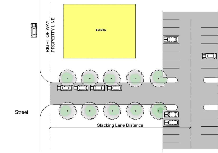
Figure 6.2.E.4: Example showing how a stacking lane for a parking lot entrance driveway
is measured.
F.
Off-Street Parking Alternatives.
1.
General.
a.
Alternative Parking Plan. The City staff is authorized to approve an alternative parking plan that proposes alternatives to providing the minimum number of off-street parking spaces required by Table 6.2.C.1, Minimum Number of Off-Street Parking Spaces, in accordance with the standards identified below. The alternative parking plan shall be submitted with an application for Special Use Permit (Section 3.4.G), Public or Semi-Public Use Permit (Section 3.4.H), or Site Plan (Major or Minor) (Section 3.4.I), as appropriate.
b.
Provision over Maximum Allowed. An alternative parking plan may propose to exceed the maximum number of off-street parking spaces allowed by Section 6.2.C.4, Maximum Number of Off-Street Parking Spaces, in accordance with the following standards:
i.
Parking Demand Study. The alternative parking plan shall include a parking demand study demonstrating how the maximum number of parking spaces specified by Table 6.2.C.1, Minimum Number of Off-Street Parking Spaces, is insufficient for the proposed development.
ii.
Minimum Amount Required. The maximum number of off-street spaces allowed by 6.2.C.4, Maximum Number of Off-Street Parking Spaces, shall be limited to the minimum number of additional spaces recommended as needed by the required parking demand study.
2.
Shared Parking. An alternative parking plan may propose to meet a portion of the minimum number of off-street parking spaces required for a use with shared parking—i.e., use of parking spaces used or proposed to be used to meet the minimum number of off-street parking spaces required for one or more other uses—in accordance with the following standards:
a.
Maximum Shared Spaces. Up to 50 percent of the number of parking spaces required for a use may be used to satisfy the number of parking spaces required for other uses that generate parking demands during different times of the day or different days of the week.
b.
Location.
i.
Shared parking spaces shall be located within 400 feet walking distance of the primary pedestrian entrances to the uses served by the parking—provided, however, that off-site parking for MS district facilities and publicly owned places of assembly may exceed the 400-foot requirement as long as the parking area is within reasonable walking access of the facility of place of assembly.
ii.
Shared parking spaces shall not be separated from the use they serve by an arterial or collector street unless pedestrian access across the arterial or collector street is provided by a grade-separated pedestrian walkway or appropriate traffic controls (e.g., signalized crosswalk).
c.
Pedestrian Access. Adequate and safe pedestrian access via a grade-separated walkway shall be provided between the shared parking areas and the primary pedestrian entrances to the uses served by the parking.
d.
Signage Directing Public to Parking Spaces. Signage complying with the standards of Section 6.10, Signage, shall be provided to direct the public to the shared parking spaces.
e.
Justification. The alternative parking plan shall include justification of the feasibility of shared parking among the proposed uses. Such justification shall address, at a minimum, the size and type of the uses proposed to share off-street parking spaces, the composition of their tenants, the types and hours of their operations, the anticipated peak parking and traffic demands they generate, and the anticipated rate of turnover in parking space use.
f.
Shared Parking Agreement. An approved shared parking arrangement shall be enforced through written agreement among all the owners or long-term lessees of lands containing the uses proposed to share off-street parking spaces. The agreement shall provide all parties the right to joint use of the shared parking area for at least five years except in Redevelopment Areas, where the City may allow the term to be 12 months if the shared parking is limited to that necessary to serve accessory uses and renewal of the agreement is subject to City approval.
3.
Off-Site Parking. Where consistent with the requirements in Section 6.2.H.7, Location of Off-Street Parking Spaces, an alternative parking plan may propose to meet the minimum number of off-street parking spaces required for a use with off-site parking—i.e., off-street parking spaces located on a lot separate from the lot containing the use—in accordance with the following standards.
a.
Zoning District Classification. The zoning district classification of the off-site parking area shall be one that allows the use served by off-site parking (and thus off-street parking accessory to such use) or that allows parking as a principal use.
b.
Location.
i.
Off-site parking spaces shall be located within 1,000 feet walking distance of the primary pedestrian entrances to the uses served by the parking—provided, however, that off-site parking for MS district facilities and publicly owned places of assembly may exceed the 1,000-foot requirement as long as the parking area is within reasonable walking access of the facility of place of assembly.
ii.
Off-site parking spaces shall not be separated from the use they serve by a principal arterial street or minor arterial street unless safe pedestrian access across the street is provided by a grade-separated pedestrian walkway or appropriate traffic controls (e.g., signalized crosswalk).
c.
Pedestrian Access. Adequate and safe pedestrian access must be provided between the off-site parking areas and the primary pedestrian entrances to the use served by the parking.
d.
Off-Site Parking Agreement.
i.
For purposes of this section, the applicant may establish control of an off-site parking facility with the following kinds of documentation in a form which is satisfactory to the City Attorney:
(a)
The deed of the additional facility, showing legal ownership, or an easement providing the right to park, either of which is to be recorded in the public records of Volusia County, Florida; or
(b)
An executed agreement, to be recorded in the public records of Volusia County, Florida, giving the land owner the irrevocable right to use the additional facility for parking for a period of not less than five years, requiring notice to be given to the City upon any cancellation, revocation, or other change in terms of the agreement, and including provisions making the agreement binding upon successors in interest in the additional facility; or
(c)
In the Main Street and South Atlantic Redevelopment Areas, the Main Street/South Atlantic Redevelopment Area Board may approve use of the additional facility if it is solely required to satisfy the parking requirements for an accessory and subordinate customer service area and the time period in the executed agreement is for a period of at least 12 months, provided the land owner applies to the Main Street/South Atlantic Redevelopment Board and is granted approval on an annual basis. Use of the accessory and subordinate customer service area shall be permitted only so long as the agreement remains in effect.
ii.
The existing use of the additional facility may not be in conflict with the parking needs of the land owner desiring to establish control. Where the additional facility consists of parking spaces serving the needs of another business, the hours of operation of the two businesses shall not be in conflict, and the documentation required in the preceding paragraph shall reflect this requirement.
iii.
Any termination of the agreement does not negate the landowner's obligation to comply with parking requirements and thus shall constitute a violation of this Code. No use served by the off-site parking may be continued if the off-site parking becomes unavailable unless substitute off-street parking spaces are provided in accordance with this section.
4.
Deferred Parking. An alternative parking plan may propose to defer construction of up to 30 percent of the number of off-street parking spaces required by Table 6.2.C.1, Minimum Number of Off-Street Parking Spaces, in accordance with the following standards:
a.
Justification. The alternative parking plan shall include a study demonstrating that because of the location, nature, or mix of uses, there is a reasonable probability the number of parking spaces actually needed to serve the development is less than the minimum required by Table 6.2.C.1, Minimum Number of Off-Street Parking Spaces.
b.
Reserve Parking Plan. The alternative parking plan shall include a reserve parking plan identifying: (a) the amount of off-street parking being deferred, and (b) the location of the area to be reserved for future parking, if future parking is needed.
c.
Parking Demand Study.
i.
The alternative parking plan shall provide assurance that within 18 months after the initial Certificate of Occupancy is issued for the proposed development, an off-street parking demand study evaluating the adequacy of the existing parking spaces in meeting the off-street parking demand generated by the development will be submitted to the City staff.
ii.
If the City staff determines that the study indicates the existing parking is adequate, then construction of the remaining number of parking spaces shall not be required. If the City staff determines that the study indicates additional parking is needed, such parking shall be provided consistent with the reserve parking plan and the standards of this section.
d.
Limitations on Reserve Areas. Areas reserved for future parking shall be brought to the finished grade, be pervious, and shall not be used for buildings, storage, loading, or other purposes. Such area may be used for temporary overflow parking, provided such use is sufficiently infrequent to ensure maintenance of its ground cover in a healthy condition.
e.
Landscaping of Reserve Areas Required. Areas reserved for future off-street parking shall be landscaped with an appropriate ground cover, and if ultimately developed for off-street parking, shall be landscaped in accordance with Section 6.4, Landscaping.
5.
Valet and Tandem Parking. An alternative parking plan may propose to use valet and tandem parking to meet a portion of the minimum number of off-street parking spaces required for a development with commercial uses in accordance with the following standards:
a.
Number of Valet or Tandem Spaces.
i.
The development served by the valet or tandem parking shall provide a total of 75 or more off-street parking spaces.
ii.
No more than 30 percent of the total number of parking spaces provided shall be designated for valet or tandem spaces except for hotels, where up to 100 percent of parking spaces may be designated for valet parking.
b.
Drop-Off and Pick-Up Areas. The development shall provide a designated drop-off and pick-up area. The drop-off and pick-up area may be located adjacent to the building served, but may not be located in a fire lane or where its use would impede vehicular and/or pedestrian circulation or cause queuing in a public street or internal drive aisle serving the development.
c.
Valet Parking Agreement. Valet parking may be established and managed only in accordance with a valet agreement. The agreement shall include provisions ensuring that a valet parking attendant will be on duty during hours of operation of the uses served by the valet parking. The agreement shall be submitted to the City staff who shall forward it to the City Attorney for review and approval before execution. An attested copy of an approved and executed agreement shall be recorded with the Volusia County Records Division before issuance of a Building Permit or Certificate of Occupancy for any use to be served by the valet parking. The agreement shall be considered a restriction running with the land and shall bind the heirs, successors, and assigns of the landowner.
G.
Reduced Parking Requirements for Parking Demand Reduction Strategies.
1.
Transit Accessibility. The City staff may authorize up to a ten percent reduction in the minimum number of off-street parking spaces required by Table 6.2.C.1, Minimum Number of Off-Street Parking Spaces, for uses located within 1,000 feet of a bus or rapid transit stop.
2.
Transportation Demand Management. City staff may, through approval of a Transportation Demand Management (TDM) plan, authorize up to a 15 percent reduction in the minimum number of off-street parking spaces required by Table 6.2.C.1, Minimum Number of Off-Street Parking Spaces, for nonresidential or mixed-use developments having a floor area of at least 25,000 square feet, in accordance with the standards below.
a.
TDM Plan Requirements. The TDM plan shall include facts and/or projections (e.g., type of development, proximity to transit and/or other multi-modal systems, anticipated number of employees and/or patrons, minimum parking requirements) and indicate the types of transportation demand management activities that will be instituted to reduce single-occupant vehicle use and reduce traffic congestion.
b.
Transportation Demand Management Activities. The TDM plan shall provide at least three of the following transportation demand management activities:
i.
Establishment of a development-specific website that provides multi-modal transportation information such as real-time travel/traffic information, bus schedules and maps, and logging of alternative commutes (e.g., bicycle, pedestrian, carpool, and vanpool).
ii.
Written disclosure of transportation information and educational materials to all employees.
iii.
Formation of transportation demand reduction programs such as carpooling, vanpooling, ridesharing, guaranteed ride home, teleworking, and shuttle service programs.
iv.
Creation of a Preferential Parking Management Plan that specifically marks spaces for registered carpool and/or vanpool vehicles that are located near building entrances or in other preferential locations.
v.
Institution of off-peak work schedules that allow employees to arrive and depart at times other than the peak morning commute period (defined as 7:00 a.m. to 9:00 a.m.) and peak evening commute period (defined as 5:00 p.m. to 7:00 p.m.).
vi.
Establishment of an office, staffed by a transportation coordinator, that makes transportation and ride-sharing information available to employees, residents, and nonresidents.
vii.
Any other transportation demand management activity as may be approved by the City staff as a means of complying with the parking reduction provisions of this subsection.
c.
TDM Program Coordinator.
i.
The applicant shall appoint a TDM program coordinator to oversee transportation demand management activities.
ii.
The TDM program coordinator shall be a licensed engineer or a traffic consultant that is also qualified or trained TDM professional.
iii.
The TDM program coordinator shall be appointed prior to issuance of a Building Permit or Certificate of Occupancy for the buildings to be served by the transportation demand management program.
d.
TDM Annual Report. The TDM program coordinator shall submit to the City staff an annual report that details implementation of the approved TDM plan. The report may include, but is not limited to, the following:
i.
A description of transportation demand management activities undertaken;
ii.
An analysis of parking demand reductions based on employee and/or resident use of ridership programs or alternative transportation options;
iii.
Changes to the TDM plan to increase transit ridership and other commuting alternatives; and
iv.
The results of an employee transportation survey.
e.
TDM Plan to Be Recorded. A copy of the approved TDM plan shall be recorded with the Volusia County Records Division before issuance of a Building Permit or Certificate of Occupancy for the development to be served by the plan. The TDM plan shall be recorded against the property, and the applicant and/or successors of interest in the property shall be responsible for implementing the plan in perpetuity.
f.
Amendments. The City staff may approve amendments to an approved TDM plan following the same process required for the initial approval.
g.
Parking Required if TDM Terminated. If the applicant and/or successors in interest in the property covered by the TDM plan stop implementing the plan or fail to submit a TDM annual report to the City staff in a timely fashion, the TDM plan shall be considered terminated. Any such termination of the TDM plan does not negate the obligations of the land owner/developer to comply with parking requirements and thus shall constitute a violation of this Code. No use served by the TDM plan may be continued unless another TDM plan is approved or all required off-street parking spaces are provided in full in accordance with this section.
3.
Special Facilities for Bicycle Commuters. The City staff may authorize up to a five percent reduction in the minimum number of off-street parking spaces required by Table 6.2.C.1, Minimum Number of Off-Street Parking Spaces, for developments that provide both of the following:
a.
A proportionate percentage reduction in vehicle spaces for bicycle parking spaces provided up to a five percent maximum. The additional bicycle parking provided to qualify for the vehicle spaces reduction is in addition to the minimum bicycle parking required by this Code. For example, if 50 vehicle spaces are required, a four percent reduction in vehicle spaces (two spaces) is permitted if two additional bicycle spaces are provided; and
b.
Shower and dressing areas for employees.
4.
Other Eligible Alternatives. The City staff may authorize up to a ten percent reduction in the minimum number of off-street parking spaces required by Table 6.2.C.1, Minimum Number of Off-Street Parking Spaces, in exchange for any other strategy that an applicant demonstrates will effectively reduce parking demand on the site of the subject development, provided the applicant also demonstrates that the proposed development plan will do at least as good a job in protecting surrounding neighborhoods, maintaining traffic-circulation patterns, and promoting quality urban design as would strict compliance with the otherwise applicable off-street parking standards.
H.
General Design Standards for Off-Street Parking and Loading Areas.
1.
Dimensional Standards for Parking Spaces and Aisles.
a.
Except as otherwise provided below, standard vehicle parking spaces and parking lot aisles shall comply with the minimum dimensional standards established in Table 6.2.H.1, Dimensional Standards for Parking Spaces and Aisles.
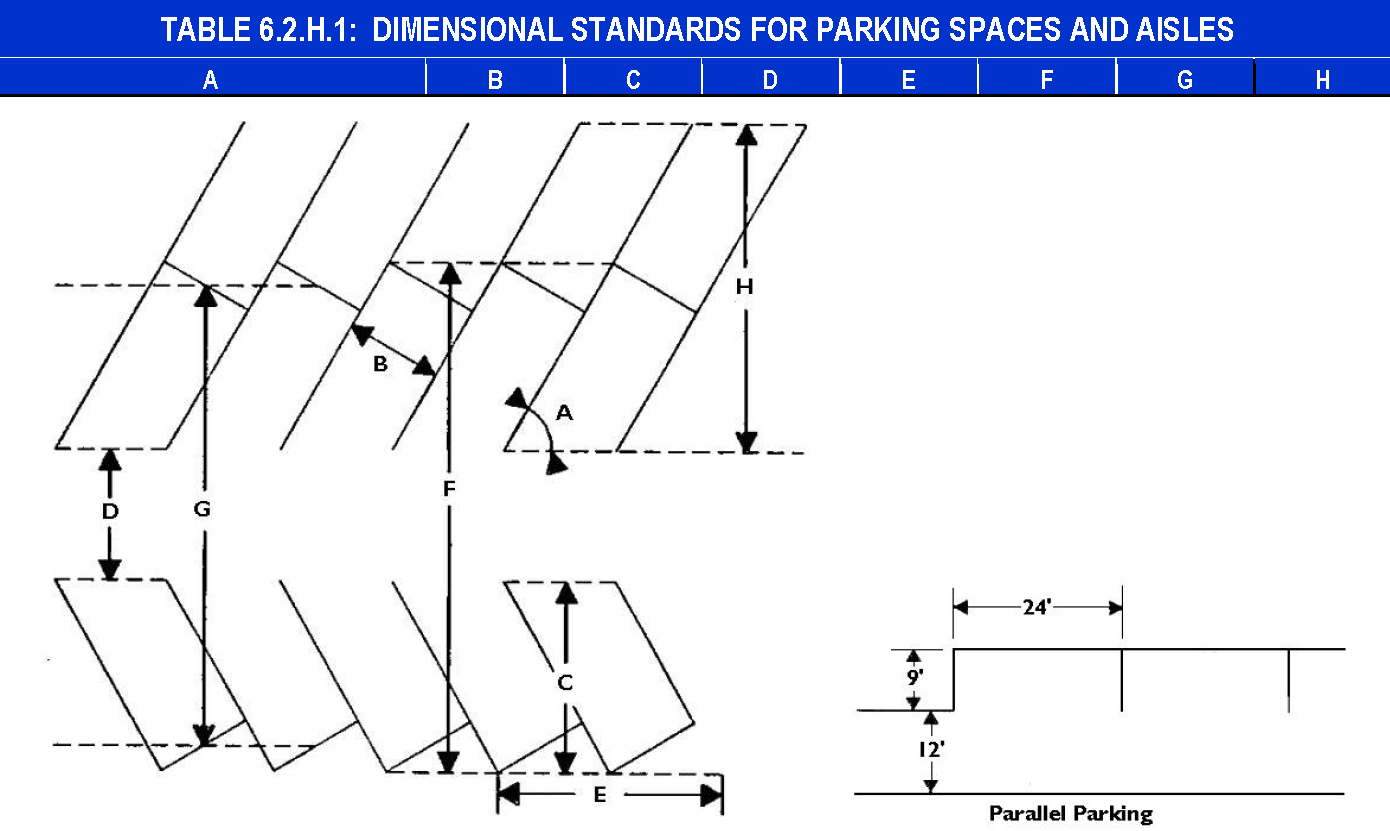
Figure 6.1.F.1.a: Dimensional Standards for Parking Spaces and Aisles
b.
Developments with one- to two-story buildings shall provide major aisleways with a minimum of 33-foot outside radius curves. Developments with three- or more-story buildings shall provide major aisleways with a minimum of 42-foot outside radius curves. Along major aisleways a 13.5-foot minimum clearance shall be maintained. Dead-end parking areas or roadways shall be a maximum length of 300 feet from a turnaround or intersection, unless an 80-foot minimum diameter turnaround is provided at the end. If a parking lot has 200 feet or less between the entry and the back of the lot, aisleways may be provided with a 24 foot wide by six foot deep backup maneuvering area extending out from the last stalls.
c.
Standard parking stalls shall be nine feet wide by 19 feet long. Stalls required for accessible parking shall be as required by the Florida Accessibility Code for Building Construction.
2.
Required Off-Street Loading.
a.
The following uses and structures shall provide sufficient on-site space for loading and unloading operations to insure the free movement of vehicles and pedestrians on the site without interference from the loading operations:
i.
All hospitals and institutions with a floor area of 10,000 square feet or more;
ii.
All hotels and motels with 20 or more units; and
iii.
All retail, wholesale, commercial, and industrial uses.
b.
The maneuver length shall be at least twice the overall length of the longest vehicle using the facility.
c.
Individual berths shall be between 12 and 14 feet in width.
d.
These dimensions may be modified if the City Engineer or a Florida-registered engineer determines that site or traffic conditions necessitate modifications and no hazard would be created thereby.
3.
Design. Parking lots and loading areas shall be designed to allow the free flow of all anticipated traffic and to provide for all related appurtenances such as stormwater areas, landscaping, tree preservation, refuse containers, lights, traffic control devices, and signs. Access to refuse containers shall be unimpeded, lights shall be oriented inward to avoid impacting neighboring lands, and sign locations shall be coordinated with landscaping and tree preservation.
a.
Parking Areas.
i.
Access to each parking space shall be available from a circulation aisleway system entirely on site.
ii.
Dead-end parking areas are discouraged. When dictated by site conditions, they shall be designed with a 24-foot-wide by six-foot-deep backup maneuvering area extending out from the last stalls.
iii.
Off-street parking areas for other than single-family detached dwellings and duplexes shall be designed to prevent vehicles, including refuse and other service vehicles, from backing into or out of a public right-of-way.
iv.
Parking lot aisleway systems shall be designed to accommodate firefighting and emergency vehicles.
v.
Parking lots shall be designed to maximize sight distance between intersecting aisleways.
vi.
Combined stormwater management areas are allowed for parking lots under multiple ownership, provided the stormwater area complies with the requirements calculated for the individual parcels.
b.
Loading Areas.
i.
Access to loading areas shall be available to a street or alley either directly or through the parking lot for the project without interfering with parking stalls, dumpster locations, or aisleways.
ii.
The truck traffic flow pattern shall be designed for counterclockwise circulation.
c.
Vertical Clearance.
i.
All off-street parking spaces must have a minimum overhead clearance of seven feet.
ii.
Minimum overhead clearance for loading areas shall be at least 14 feet.
d.
Identified as to Purpose and Location. Off-street parking areas of three or more spaces and all off-street loading areas shall include painted lines, wheel stops, or other methods of identifying individual parking spaces and loading berths and distinguishing such spaces or berths from aisles.
4.
Surfacing.
a.
General. Except as provided for in subparagraphs [b] and [c] below, all off-street parking and loading areas shall be surfaced with asphalt, concrete, brick, stone, pavers, or an equivalent hard, dustless, and bonded surface material. Use of surfacing that includes recycled materials (e.g., glass, rubber, used asphalt, brick, block, and concrete) is encouraged. These surfaces shall be maintained in a smooth, well-graded, clean, orderly, and dust-free condition.
b.
Parking Ribbons. Parking areas serving single-family detached dwellings, duplexes, and mobile/manufactured homes may consist of two ribbons of hard surface that are each at least two feet wide and are separated by no more than three feet. The remaining required area for each parking space shall be covered with grass, groundcover, or other porous landscape material.
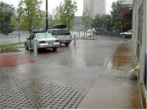
Figure 6.2.H.4.b: Use of pervious materials in a parking lot.
c.
Pervious or Semipervious Surfacing. The use of pervious or semipervious parking area surfacing materials—including, but not limited to—pervious asphalt and concrete, open joint pavers, and reinforced grass/gravel/shell grids may be approved for off-street paving and loading areas, provided such surfacing is subject to an on-going maintenance program (e.g., sweeping, annual vacuuming). Any pervious or semipervious surfacing used for aisles within or driveways to parking and loading areas shall be certified as capable of accommodating anticipated traffic loading stresses and maintenance impacts. Where possible, such materials should be used in areas proximate to and in combination with on-site stormwater control devices. (See Figure 6.2.H.4.b, Use of pervious materials in a parking lot.)
5.
Bicycle Parking. Bicycle parking racks shall be solid metal or PVC stationary racks or structures of similar quality and function that are anchored with a concrete base, and designed to allow securing of the frame and wheel of the bicycle.
6.
Drainage. All off-street parking and loading areas shall be properly drained so as to eliminate standing water and prevent damage to abutting land and public streets and alleys.
7.
Location of Off-Street Parking Spaces.
a.
Residential Uses.
i.
There shall be no off-street parking in the front yards or street side yards of any lot in a residential district, except as customary in the driveways of single-family detached dwellings and duplexes. Recreational vehicles, boats, boat trailers, and utility trailers may be parked temporarily on driveways for a period not exceeding 24 hours for purposes of loading and unloading and minor maintenance. At all other times, they shall be parked in the interior side yard behind the front wall of the dwelling or in the rear yard.
ii.
Parking spaces for all dwellings, including apartments, townhouses, and condominiums, shall be located on the same lot as the main building. Parking spaces for all other uses shall be located on the same site as the use, except where specifically provided in this section.
b.
Accommodation Uses. For all accommodation uses, at least one parking space for each rental unit shall be provided on the same lot as the main building, except as otherwise permitted in T-1 districts. Parking spaces for employees and accessory uses may be provided off site in accordance with Section 6.2.F.3, Off-Site Parking.
c.
No Right-of-Way Encroachment. Parking spaces, stacking spaces, and loading areas shall not encroach upon, and no portion of any vehicle shall overhang, the right-of-way of any road, street, alley, or walkway.
8.
Exterior Lighting. Lighted off-street parking and loading areas shall comply with the standards of Section 6.9, Exterior Lighting.
9.
Landscaping. Except for off-street parking areas serving single-family detached dwellings and duplexes, all off-street parking and loading areas shall comply with the standards of Section 6.4, Landscaping.
10.
Maintained In Good Repair.
a.
Maintained at All Times. All off-street parking and loading areas shall be maintained in safe condition and good repair at all times so as not to constitute a hazard to public safety or a visual or aesthetic nuisance to surrounding land.
b.
Periodically Restored. All off-street parking and loading areas shall be periodically painted or otherwise restored to maintain a clear identification of separate parking spaces or loading berths.
11.
Completion. All off-street parking and loading areas shall be completed prior to the issuance of a Certificate of Occupancy for the development they serve. In the case of phased development, off-street parking and loading areas should only be provided for the phase being developed.
(Ord. No. 16-26, § 1(Exh. A), 1-20-2016; Ord. No. 19-149, § 3, 7-3-2019; Ord. No. 2020-27, § 1, 1-22-2020; Ord. No. 2021-384, § 3, 12-1-2021; Ord. No. 2025-109, § 1, 3-19-2025; Ord. No. 2025-202, § 1, 5-21-2025)
Sec. 6.3. - Mobility and Access.
A.
Purpose. The purpose of this section is to ensure that development is served by a coordinated multimodal transportation system that, to the extent practicable, permits the safe and efficient movement of motor vehicles, emergency vehicles, transit, bicyclists, and pedestrians within the development and between the development and external transportation systems, neighboring development, and local destination points such as places of employment, schools, parks, and shopping areas. Such a multimodal transportation system is intended to provide transportation options, increase the effectiveness of local service delivery, reduce emergency response times, promote healthy walking and bicycling, facilitate use of public transportation, contribute to the attractiveness of the development and community, connect neighborhoods and increase opportunities for interaction between neighbors, reduce vehicle miles of travel and travel times and greenhouse gas emissions, improve air quality, minimize congestion and traffic conflicts, and preserve the safety and capacity of community transportation systems.
B.
Applicability.
1.
General. Except where expressly exempted in accordance with paragraph 3 below or elsewhere in this section, the standards and requirements of this section shall apply to all development in the City.
2.
Review for Compliance. Review for compliance with the standards of this section shall occur during review of an application for approval of a Special Use Permit (Section 3.4.G), Public or Semipublic Use Permit (Section 3.4.H), Site Plan (Section 3.4.I), Major Subdivision Preliminary Plat (Section 3.4.K), Minor Subdivision Plat (Section 3.4.K), or Building Permit (Section 3.4.R), as appropriate.
3.
Exemptions. The following development is exempt from the requirements of this section:
a.
Single-Family. Detached single-family dwellings.
b.
Duplexes. Duplexes.
C.
Consistency With Plans. The design and construction of access and circulation systems associated with a development shall be consistent with the transportation goals, objectives, and actions in the Daytona Beach Comprehensive Plan, and other City-adopted plans addressing transportation (including transportation plans, transit plans, corridor plans, and small area plans).
D.
Multimodal Transportation System. Access and circulation systems associated with a development shall provide for multiple travel modes (vehicular, transit, bicycle, and pedestrian), as appropriate to the development's size, character, and relationship to existing and planned community transportation systems. Vehicular, transit, bicycle, and pedestrian access and circulation systems shall be coordinated and integrated as necessary to offer the development's occupants and visitors improved transportation choices while enhancing safe and efficient mobility throughout the development and the community.
E.
Circulation Plan Required.
1.
Applications for Major Site Plan (Section 3.4.I) and Major Subdivision Preliminary Plat (Section 3.4.K) shall include a circulation plan that addresses street connectivity, emergency and service vehicle access, parking movements, accommodation of loading operations, turning radii, traffic calming measures where future "cut-through" traffic is likely, and similar issues.
2.
City staff may waive the requirement for a circulation plan on determining that a proposed development is expected to have no impact on circulation or proposes no change in existing circulation patterns. This provision shall not be construed to exempt development that includes additional parking, driveways, or substantial modifications to the existing pedestrian network.
F.
Developer Responsibility for Street Improvements.
1.
On-Site.
a.
If a street is proposed within a development site, the developer shall provide roadway, sidewalk, and other access and circulation improvements in accordance with the standards in this section, and shall dedicate any required rights-of-way or easements.
b.
If a development site includes the proposed corridor of a street designated on the Plan as an arterial street, the development shall incorporate provision of the arterial street into the design of the development. The developer shall be responsible for constructing roadway, sidewalk, and other access and circulation improvements that meet at least those standards in this section applicable to collector streets, and shall dedicate right-of-way that meets the right-of-way width standards for the arterial street, as appropriate.
2.
Off-Site. If a development site fronts on and obtains vehicular access from an existing street, the developer may be required to dedicate additional right-of-way along the street frontage or in the vicinity of the development and to provide roadway, sidewalk, and other access and circulation improvements within the street right-of-way that are reasonably necessary to ensure the safe, convenient, efficient, and orderly accommodation of vehicular and pedestrian traffic demands and impacts generated by the proposed development. Such improvements may include, but are not limited to, turn lanes, deceleration and acceleration lanes, widening or paving of substandard roadways, medians, sidewalks, sidewalk ramps and crossings, and the relocation or improvement of utility lines and facilities needed to accommodate street improvements. The extent of required dedications and improvements related to the abutting street shall be roughly proportional to the traffic demands and impacts generated to and along that street by the proposed development.
G.
Vehicular Access and Connectivity.
1.
Purpose. The purpose of the following vehicular access and connectivity standards is to enhance safe and convenient mobility within and between neighborhoods and development that helps integrate and connect neighborhoods, allow residents to conveniently visit neighbors and nearby activity centers without compromising the capacity of the City's arterial streets to accommodate through traffic, improve opportunities for comprehensive and convenient transit service, enhance efficient provision of public services, and improve the speed and effectiveness with which emergency services and police and fire protection can be provided to City residents and land.
2.
Approval Required. No curb, parkway, or sidewalk shall be cut or altered, and no point of access or opening for vehicles onto a public street shall be established without City approval. Permits or other approvals shall also be required from the State or county for access points onto State or county roads within the City limits, in addition to the required City approval.
3.
Roadway Layout and Design. Except as otherwise provided in this section, the design and construction of:
a.
Roadways for State roads shall be approved by the Florida Department of Transportation in accordance with its roadway design standards;
b.
Roadways for county roads shall be approved by Volusia County in accordance with its roadway design standards; and
c.
Roadways for City streets shall be approved by the Director of Public Works in accordance with the standards in Section 7.2.D, Streets.
4.
Number of Access Points.
a.
The maximum number of access points for a single-family, duplex, or multifamily residential development with less than three units shall be as follows:
i.
Corner lots with less than 95 feet of frontage shall be permitted one access point on each street frontage.
ii.
Interior lots with less than 75 feet of frontage shall be permitted one access point.
iii.
One additional access point shall be permitted for each additional 100 feet of frontage or fraction thereof.
b.
The maximum number of access points for any property other than residential with less than three units shall be one for the first 134 feet of frontage, and one additional access point for each additional 150 feet of frontage or fraction thereof.
5.
Accessway Layout and Design.
a.
Coordination with Access for Other Uses. Vehicular access points for multifamily residential development shall not be located across the street from single-family residential districts. Vehicular access points for nonresidential development shall not be located across from residential districts. Where these requirements would prevent any vehicular access to the development, access shall be permitted from one street.
b.
Coordination with Transit, Bicycle, and Pedestrian Access and Circulation
i.
The vehicular access and circulation system of a development located on a site abutting an existing or planned transit route shall accommodate a transit stop and other associated facilities unless the City staff determines that adequate transit facilities already exist to serve the needs of the development.
ii.
The vehicular access and circulation system of a development shall be coordinated with the bicycle and pedestrian access and circulation systems within and adjacent to the development to minimize conflicts.
c.
Traffic Control and Calming Measures. Traffic-calming measures—such as, but not limited to, diverters, street gardens, and curvilinear alignments—shall be integrated into a development's vehicular circulation system where necessary to mitigate the impact of potential future cut-through traffic.
d.
Abandoned or Unpermitted Curb Cuts. Any abandoned or unpermitted curb cuts or access points shall be removed and replaced with standard curbing and sod.
6.
Driveway Location and Dimensions.
a.
Location.
i.
Driveways shall be located at least five feet away from any interior side property line.
ii.
Multiple driveway entrances shall be separated as follows:
(a)
The minimum distance permitted between the closest edges of access points for a residential development with fewer than three units on the same street is 28 feet.
(b)
The minimum distance permitted between the closest edges of all other use access points for a single property on the same street shall be twice the driveway transition radii. Greater distances may be required because of project size, density, adjacent street design, proximity to signalized intersections, high activity land uses, or vehicle characteristics.
iii.
Driveways on corner lots shall be located as follows:
(a)
For residential development with fewer than three units and for all development permitted more than one access point, driveways shall be a minimum of 25 feet from the corner formed by the intersection of the right-of-way lines. Where the right-of-way lines intersect in the form of an arc, the required 25 feet shall be established from the point of tangency.
(b)
Driveways for all other developments permitted only one access point shall be located a distance from the adjacent property lines equal to the transition radius.
(c)
Greater corner clearance may be required because of project size, density, adjacent street design, proximity to signalized intersections, high activity land uses, or vehicle characteristics.
b.
Design and Dimensions.
i.
All measurements established in this section for the location and width of driveways shall be taken along the right-of-way line.
ii.
Width and radii standards for driveway areas are as follows:
(a)
Two-way driveways for development other than residential with fewer than three units shall be designed with sufficient width and transition radii to permit simultaneous use by entering and exiting vehicles without conflict between the vehicles, and shall not encroach on opposing lanes of traffic on the adjacent street.
(b)
One-way driveways for development other than residential with fewer than three units shall be designed with sufficient width and transition radii that turning movements shall be contained within the driveway area and shall not encroach on opposing lanes of traffic on the adjacent street.
(c)
Driveways shall have the following entrance widths unless a traffic engineering study demonstrates a different width will not adversely impact traffic conditions:
(d)
Driveway entrances shall have the following minimum transition radii for connections to adjacent streets unless a traffic engineering study demonstrates a different radius will not adversely impact traffic conditions. The driveway transition radii shall not extend into the area in front of adjacent properties or into the area of the street curb return radius of an intersection.
(e)
Driveways shall be designed to accommodate the minimum turning paths of the largest vehicle expected to use the property. The minimum turning paths shall be as defined in the latest edition of AASHTO's A Policy on Geometric Design of Highways and Streets.
(f)
Wider driveways or larger transition radii may be required for additional ingress or egress lanes if necessary due to project size, density, adjacent street design, or usage.
(g)
Driveway widths shall comply with Fire Department requirements.
iii.
Reservoir space shall be provided as follows:
(a)
Inbound reservoir space between the adjacent street and the first point of entry to parking aisles at signalized driveways shall be sufficient to prevent inbound traffic from queuing into the adjacent street.
(b)
Exit reservoir space between the first point of exit from the parking aisles and the adjacent street at signalized driveways shall be a distance in feet equal to the peak hour volume of left turning exit traffic.
7.
Cross Access Between Adjoining Development. To encourage shared parking and minimize access points along roads, new multifamily residential, nonresidential, and mixed-use development other than industrial development shall comply with the following standards:
a.
The internal vehicular circulation system shall be designed to allow for vehicular cross-access between the development's vehicular use areas (parking lots) and those on adjoining lots containing a multifamily residential, nonresidential, or mixed-use development, or to the boundary of adjoining vacant land zoned to allow multifamily residential, nonresidential, or mixed-use development. (See Figure 6.2.G.7: Cross-access between parking areas of adjoining developments.)
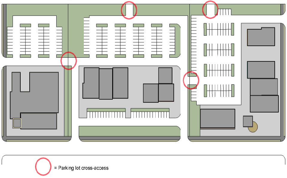
Figure 6.3.G.7: Cross-access between parking areas of adjoining developments.
b.
Cross-accessways shall provide for two-way vehicular traffic between the vehicular use areas on the adjoining lots through the use of a single driveway or drive aisle that is at least 24 feet wide or through two one-way driveways or aisles that are each at least 14 feet wide.
c.
City staff may waive or modify the requirement for vehicular cross-access on determining that such cross-access is impractical or undesirable due to the presence of natural features or vehicular safety factors.
d.
Easements allowing cross-access to and from properties served by a vehicular cross-access, along with agreements defining maintenance responsibilities of property owners, shall be recorded with the Volusia County Records Division before issuance of a Building Permit or Certificate of Occupancy for the development.
8.
Traffic Control Devices and Signs. All traffic control devices located in any area available to the public shall conform to the latest edition of the Florida Department of Transportation's Manual on Uniform Traffic Control Devices. All traffic systems shall be clearly marked by signs and pavement markings.
9.
Obstruction to Vision at Intersections.
a.
At all street intersections and driveway access points, a clear zone with no visual obstruction between the heights of two and ten feet above the average grade of each street or driveway centerline shall be required in accordance with Table 6.3.G.9 below. All measurements for intersecting streets are along the right-of-way lines. All measurements for driveway exits are along the centerline of the exit lane and along the right-of-way line from its point of intersection with the centerline.
b.
The required clear zone is the area formed by the two legs of the triangle, A and B or C, and a connecting line between the ends of the legs.
c.
A larger clear zone may be required, or a reduced clear zone may be permitted, where necessary or appropriate because of roadway alignments or design, traffic patterns and volume, traffic control devices, site features, or project design features.
d.
Trees shall be permitted in the clear zone provided all foliage below ten feet is cut away and maintained in that condition.
e.
These requirements shall not be deemed to prohibit any necessary retaining wall, but may limit its height, design, or manner of construction.
H.
Pedestrian Access and Circulation.
1.
Applicability. This section is applicable to all new development except:
a.
Single-family subdivisions approved prior to March 1, 2015;
b.
Individual lot development of single-family detached dwellings in a subdivision;
c.
Duplexes; and
d.
Planned Developments approved prior to March 1, 2015.
2.
Required Pedestrian Access.
a.
General Pedestrian Access. All new development subject to this section shall be served by an internal pedestrian circulation system of walkways (including sidewalks, pedestrian paths, and/or trails) that permits safe, convenient, efficient, and orderly movement of pedestrians among the following origin and destination points within the development, as well as between the internal pedestrian circulation system and adjoining parts of an existing or planned external, community-wide pedestrian circulation system and any adjoining public parks, greenways, schools, community centers, and shopping areas:
i.
The primary entrance(s) of principal buildings (or the buildable area of lots, for subdivisions);
ii.
Off-street parking bays;
iii.
Any designated or planned bus stops and shelters (on-site or on an adjacent street); and
iv.
Recreation facilities and other common use area and amenities.
b.
Sidewalks Required. All new development subject to this section shall install sidewalks or approved pedestrian paths in accordance with Section 7.2.E, Sidewalks.
3.
Pedestrian Connectivity. All new multifamily residential, nonresidential, and mixed-use development shall comply with the following standards:
a.
The internal pedestrian circulation system shall be designed to allow for pedestrian walkway cross-access between the development's buildings and parking areas and those on adjoining lots containing a multifamily residential, nonresidential, or mixed-use development, or to the boundary of adjoining vacant land zoned to allow multifamily residential, nonresidential, or mixed-use development.
b.
City staff may waive or modify the requirement for pedestrian cross-access on determining that such cross-access is impractical or undesirable due to the presence of natural features, safety factors, or unusual lot configuration.
c.
Easements allowing cross-access to and from properties served by a pedestrian cross-access, along with agreements defining maintenance responsibilities of property owners, shall be recorded with the Volusia County Records Division before issuance of a Building Permit of Certificate of Occupancy for the development.
4.
General Walkway Layout and Design. Pedestrian walkways shall:
a.
Have a minimum width as follows:
i.
At least seven feet, when the site of the walkway is a commercial property exceeding 20,000 square feet in gross floor area, and the walkway is intended for customer use and is located within 25 feet of any commercial building; or
ii.
At least five feet, in all other instances;
b.
Be distinguishable from vehicular traffic lanes they cross by painted markings, a change in pavement material or color, raised paving height, decorative bollards, and/or flashing caution signals;
c.
Have adequate lighting for security and safety;
d.
Meet the accessibility standards of the Florida Accessibility Code for Building Construction; and
e.
Be constructed in accordance with sidewalk standards in Section 7.2.E, Sidewalks.
I.
Encroachments into Right-of-Way.
1.
Encroachments Prohibited. Encroachments in the public right-of-way are not permitted, except as specifically provided in paragraph 2 below and elsewhere in this Code.
2.
Allowed Encroachments.
a.
Building Features and Awnings.
i.
Projection of sills, belt courses, ornamental features, or eaves over a public right-of-way is permitted up to a maximum of six inches.
ii.
In any B, T, M-1, or RDB-4 district, fixed marquees or canopies shall be permitted to overhang the public right-of-way not more than two-thirds of the width of the sidewalk or no closer than two feet to a vertical projection of the curbline. The lowest portion of the marquee or canopy shall be at least ten feet above the sidewalk elevation. In RDB-4 districts, the maximum overhang shall be ten feet.
iii.
Awnings, electric awnings, or covered walkways of canvas or other nonpermanent material not structurally tied into the principal building other than by framework supporting the nonpermanent structure shall be permitted to extend outward a maximum of two-thirds of the width of the sidewalk, but shall be no closer than two feet to a vertical projection of the curbline. Such structures shall have a minimum vertical height of seven feet above the sidewalk elevation.
b.
Outdoor seating areas for eating or drinking establishments. Temporary encroachments, consisting of outdoor seating areas, on public sidewalks abutting an eating or drinking establishment may be administratively approved by the City Manager in accordance with the provisions of this Section and Section 5.3.C.17.
c.
Other Encroachments. Other private encroachments that extend over, across, or under any street, sidewalk, or right-of-way may be permitted upon approval of the City Commission. Except where specifically provided otherwise, encroachments over any street, sidewalk, or right-of-way shall be at least nine feet above the level of the ground.
d.
Insurance. The City may require insurance for encroachments. The insurance shall be liability insurance protecting against damage occasioned to any person or property as a result of the encroachment. Every insurance policy shall be in a form and with companies satisfactory to the City and shall be in the sum of no less than $500,000.00 per person and $1,000,000.00 per occurrence for bodily injury, and $150,000.00 per occurrence for property damage or a combined single limit of $1,000,000.00 for bodily injury and property damage. If insurance is provided with a general aggregate, then the aggregate shall be in an amount of no less than $1,000,000.00. Evidence of insurance shall be furnished in the form of a certificate of insurance and shall contain a provision obligating the insurer to notify the City Clerk in writing at least 30 days before any alteration, modification, or cancellation of such policy is to become effective.
e.
Other Requirements. Additional requirements, may be imposed, including any encroachment fees adopted by City Commission resolution.
3.
No Title or Interest Granted to Public Property. Any encroachment permitted under this or under any other section shall not grant to the licensee any right, title, or interest on public property other than to allow the licensee to use said space at the pleasure of the City of Daytona Beach.
(Ord. No. 2020-153, § 4, 6-3-2020; Ord. No. 2022-282, § 3, 7-20-2022; Ord. No. 2024-233, § 2, 6-19-2024)
Sec. 6.4. - Landscaping.
A.
Purpose and Intent. It is the purpose and intent of this section to promote the health, safety, and welfare of existing and future residents and visitors of the City by establishing minimum standards for the design, installation, and maintenance of landscaping within the corporate limits of the City. The requirements of this section are designed to:
1.
Improve the aesthetic appearance of the City and maintain and increase land values by requiring development to include landscaping and existing vegetation which complements the scale, color, texture, and materials used in the development.
2.
Promote public safety by using landscaping as an integral element of site design to define and reinforce circulation patterns and to separate vehicular and pedestrian traffic areas.
3.
Improve environmental quality by requiring landscape materials and areas which: improve air and water quality through photosynthesis and the uptake of minerals and dust; maintain permeable land areas essential to surface water management and aquifer recharge; reduce air, noise, heat, and chemical pollution through the biological filtering capacities of trees and other vegetation; promote energy conservation through the shading of buildings and paved areas, and reduce temperatures through the process of evapotranspiration; and conserve limited freshwater resources through the use of drought resistant plants, mulches, soil amendments, and efficient irrigation systems.
4.
Promote economic efficiency in the development of limited land resources by using landscaping to provide screening and separation of land uses of differing character and intensity which are otherwise incompatible in close proximity to one another due to visual or physical intrusions.
5.
Provide direct and increasingly important physical and psychological benefits to human beings through the use of landscaping to reduce noise and glare, to break up the monotony of expansive walls and paved areas, and to soften the harsher aspects of urban development by creating landscape transitions between architectural elements.
6.
Provide for sound ecological site design which preserves and incorporates native vegetation in the project design and which responds to site-specific environmental factors, thus insuring preservation of the native character of the City and creating landscapes which are less demanding on energy and water resources.
B.
Applicability.
1.
General. Except where expressly exempted in accordance with paragraph 4 below or elsewhere in this section, the standards and requirements of this section shall apply to all development in the City.
2.
Review for Compliance. Review for compliance with the standards of this section shall occur during review of an application for approval of a Special Use Permit (Section 3.4.G), Public or Semipublic Use Permit (Section 3.4.H), Site Plan (Section 3.4.I), Major Subdivision Preliminary Plat (Section 3.4.K), Minor Subdivision Plat (Section 3.4.K), or Building Permit (Section 3.4.R), as appropriate.
3.
Existing Development.
a.
Change in Use. Any change in use of an existing development shall provide any additional landscaping required for the new use to comply with this section.
b.
Expansion and Enlargement. If an existing structure or use is expanded or enlarged (in terms of the number of dwelling units, floor area, number of employees, seating capacity, or other size unit), additional landscaping shall be provided in accordance with the requirements of this section to serve the expanded or enlarged part of the structure or use.
c.
Upgrading of Nonconforming Landscaping. Nonconforming landscaping on the site of a remodeled structure or expanded structure, or a structure that changes use shall comply with the requirements of this section in accordance with the standards of Section 8.6, Nonconforming Site Features.
4.
Exemptions. The following development is exempt from the requirements of this section:
a.
Single-Family. Single-family detached dwellings.
b.
Duplexes. Duplexes.
c.
Development in Certain Redevelopment Districts from Property and Building Perimeter Standards. Development in Redevelopment Districts that do not require building setbacks (e.g., RDB-2, -3, and -5, RDD-1 and -2, and RDM-2) from Section 6.4.C, Property and Building Perimeters.
d.
Developed Site Adjacent to Streets in Redevelopment Area or Historic Overlay District.
i.
A developed site adjacent to an arterial street, collector street, or street in an Historic Overlay (HO) district or Redevelopment Area—instead, it shall be brought into compliance with these requirements (when they apply) to the greatest extent possible based on the physical constraints of the site, when:
(a)
A previously existing use of the property is reestablished after a vacancy of six months; or
(b)
The site or building is renovated or improved, and the proposed improvements exceed 50 percent of the total assessed value of the principal structure.
ii.
In reviewing compliance with this subparagraph, City staff will evaluate the existing site layout for landscape upgrade requirements. Landscape upgrades shall be in the following order of priority: first, improving treatments along rights-of-way including modifying nonconforming driveway openings; second, providing treatments along property boundaries; third, reducing expansive paved areas and defining circulation patterns with planting islands; fourth, framing and accenting buildings in accordance with this section. As part of this review, the City may require excavation of pavement, development of "dead" areas or extra parking space areas for planters, reconfiguration and restriping of parking areas, and any other reasonable and necessary physical improvements to meet the landscape requirements to the greatest extent practicable.
5.
Landscape Plan Required. To ensure compliance with the standards of this section, a landscape plan demonstrating how landscaping will be planted on a development site shall be included as a part of any application for approval of a Special Use Permit (Section 3.4.G), Public or Semipublic Use Permit (Section 3.4.H), Site Plan (Section 3.4.I), Major Subdivision Preliminary Plat (Section 3.4.K), Minor Subdivision Plat (Section 3.4.K), or Building Permit (Section 3.4.R), as appropriate. Landscape plans shall be signed and sealed by a landscape architect who is licensed to practice in the State of Florida, and in good standing.
C.
Property and Building Perimeters. Development subject to this section shall comply with the following property and building perimeter standards.
1.
Property Perimeters.
a.
Perimeter Bounded by Building of Structure. A property perimeter bounded by a building or structure shall be a landscape area, with a minimum depth of five feet.
b.
Perimeter Bounded by Open Space. A property perimeter bounded by open space shall be a landscape area, with a minimum depth on the outside of five feet.
c.
Perimeter Bounded by Vehicular Use Area. A property perimeter bounded by a vehicular use area shall comply with the vehicular use area perimeter landscaping standards in Section 6.4.D.2, Perimeter Landscaping Strips.
d.
Landscape Area Adjacent to Public ROW. A maximum of 15 percent of the landscape area adjacent to public rights-of-way, excluding permitted driveways, may be used for walks, signs, fountains, or other hardscape amenities. At least 25 percent of the area shall use flowering plants located around signage, flanking driveways, at property and building corners, under trees, or elsewhere to present a balanced and colorful accent to the remaining landscaped area.
e.
Nonconforming Driveways and Driveways Being Abandoned as part of Redevelopment. On sites that are being renovated, existing nonconforming driveway widths shall be rebuilt to meet current landscape area standards. Curb cuts and driveway aprons in the adjacent right-of-way which are to be abandoned as part of the redevelopment of the property shall be removed and replaced with standard curbing and landscape materials.
f.
Side or Rear Perimeter Landscape Areas Abutting Conforming Nonresidential Development or Districts. Side or rear perimeter landscape areas which abut existing conforming nonresidential development or districts may be transferred to an alternative location on the site if the design would be better served.
2.
Building Perimeters. Except for building perimeter landscape areas in nonresidential development that would not be visible from any street, vehicular use area, or neighboring property, all other development subject to this section shall comply with the following:
a.
General. Continuous landscape areas shall be located adjacent to all building perimeters. For parking garages and decks, the minimum landscape depth shall be ten feet. For all other buildings the minimum depth shall be five feet. The depth of the building perimeter landscape areas shall be measured clear of any building or roof overhangs.
b.
Walkways. Walkways not over six feet wide may be located adjacent and parallel to the building. The building perimeter landscape area shall be located adjacent to the outside of the walkway.
D.
Vehicular Use Area Landscaping. Except where exempted by Section 6.4.B.4, Exemptions, all vehicular use areas shall include landscaping both within the interior of the vehicular use area and around its perimeter, as a means of mitigating the parking area's microclimate and visual impacts.
1.
Interior landscaping standards. The vehicular use area shall provide and maintain landscape areas within the interior of the vehicular use area in accordance with the standards in this paragraph. These standards shall not apply to parking structures or vehicle display areas.
a.
Configuration. Interior landscape areas shall be designed in accordance with the following standards:
i.
They shall cover an area equivalent to at least ten percent of the paved area of the vehicular use area, and in addition comply with the other requirements of this paragraph.
ii.
Islands shall be located at the end of parking bays and have an area of at least the size of a single parking space for single-loaded parking bays, and the size of two parking spaces for double-loaded bays.
iii.
Landscape areas shall be distributed so that rows of parking between any two landscaped islands contain an average of 15 or fewer contiguous spaces.
iv.
Interior aisleway intersections shall be defined by planters.
v.
The minimum area for interior landscape areas shall be 140 square feet, with a minimum dimension of nine feet. Planters shall be designed without any sharp corners by using a minimum three-foot transition radius between any two sides. The end of planters next to parking stalls shall be set back two feet from the driving aisles.
vi.
Interior planters shall be designed at the same elevation as the adjacent vehicular use area, except as necessary to save existing trees.
vii.
Interior planters for nonpublic, specialized vehicular use areas where large machinery or large vehicles are stored, serviced, or used, may be relocated to perimeter areas as additional buffers, screening, or beautification.
viii.
Off-street surface parking areas with 400 or more spaces shall be organized into a series of smaller modules of 25,000 square feet or less per module, and be visually separated by continuous landscaped islands at least 11 feet wide that contain pedestrian pathways located at least every six parking bays.
ix.
Driveway medians without shrubs shall be at least four feet wide and driveway medians with shrubs or trees shall be at least six feet wide.
x.
At least 90 percent of the parking spaces shall be within 80 feet of the trunk of a tree. Perimeter vehicular use area landscaping or other required landscaping may be used to meet this requirement.
See Figure 6.4.D.1.a, Vehicular Use Area Configuration.
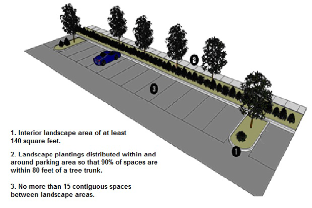
Figure 6.4.D.1.a: Vehicular use area configuration.
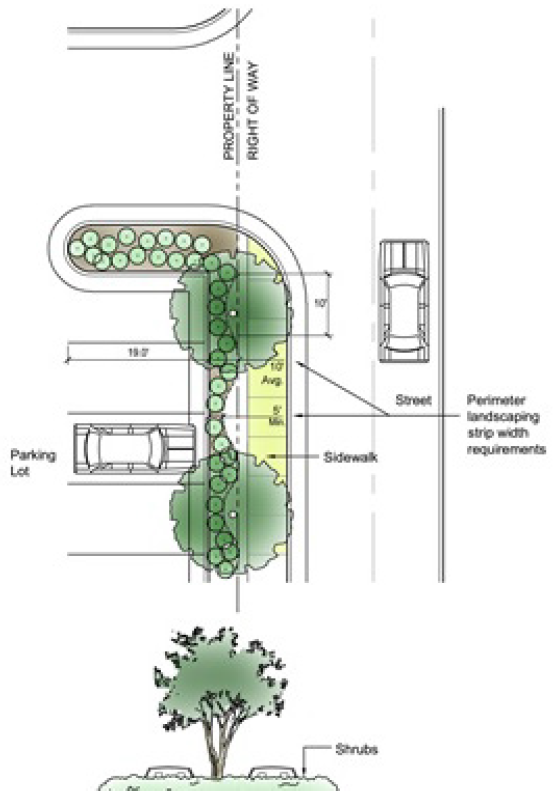
Figure 6.4.D.2,: Perimeter Landscaping Strip
b.
Protection of Planting Areas. All planting areas shall be protected from vehicle damage by the installation of curbing, wheel stops, or other comparable methods. This standard shall not prohibit the use of planting areas as on-site stormwater management devices.
2.
Perimeter Landscaping Strips. Where the vehicular use area abuts a street right-of-way, vacant land, or any other development (except another vehicular use area), perimeter landscaping strips shall be provided and maintained between the vehicle use area and the abutting right-of-way or property line in accordance with the following standards. (See Figure 6.4.D.2, Perimeter Landscaping Strip.)
a.
Location.
i.
Perimeter landscaping strips shall be located on the same land as the vehicular use area, and shall be placed to assure visibility and safety of pedestrians on the public street and within the vehicular use area.
ii.
Perimeter landscaping strips may not be placed within future street rights-of-way.
b.
Minimum Width. When a vehicular use area is located within 50 feet of a street right-of-way, the perimeter landscaping shall be located within a planting strip at least eight feet wide. In all other instances, the strip shall be the minimum width necessary to assure required landscaping is not damaged by vehicles or other on-site activity. In no instance shall the strip be less than three feet wide.
c.
Continuous, Opaque Visual Screen Required. Perimeter landscaping strips shall form a continuous, opaque visual screen, excluding required sight clearances at driveways.
d.
Protection from Vehicular Damage.
i.
Continuous, non-mountable, six-inch-high reinforced concrete curbing shall be designed to standard specifications and installed along the edge of all landscape areas adjacent to vehicular use areas.
ii.
At the head of parking stalls facing a landscape area, curbing or standard size precast concrete wheel stops shall be placed and secured to prevent vehicular encroachment or overhang more than 1.5 feet into the required perimeter landscape area. The 1.5-feet area may be credited toward the required depth of the parking stall and shall be developed as a landscape area. The wheel side face of the curbing or wheel stop shall be at least one foot from the required landscape area. The parking stall depth from the back of stall to the face of the curbing or wheel stop shall be 16.5 feet. When continuous curbing is used, the area behind the curb shall be developed as additional landscape area with low plant materials. When wheel stops are used, one foot of pavement shall extend beyond the face of the wheel stop.
e.
Planting Height.
i.
Shrubs associated with the perimeter landscaping strip shall be maintained at a minimum height of three feet above the surface elevation of the adjacent vehicular use area within four years of planting. To allow security surveillance of parking areas, the maximum height of shrubs in the perimeter landscaping strip shall be five feet.
ii.
The perimeter landscaping strip shall allow compliance with all City, State, and federal highway sight distance standards.
f.
Required Materials.
i.
Evergreen plantings shall be used to form the continuous, year-round, opaque visual screen in the perimeter landscaping strip.
ii.
In addition to the evergreen plantings, each perimeter landscaping strip shall include at least five shade trees per 100 linear feet of landscaping strip. Small trees may be used beneath overhead utilities.
g.
Adjacent to Perimeter Buffers. Perimeter landscaping strips associated with a vehicle use area may be credited towards perimeter buffer standards (see Section 6.6, Perimeter Buffers), provided the minimum buffer standards of this section are met.
E.
Other General Requirements for Landscaping.
1.
Planting Standards, Irrigation, and Installation.
a.
Plant Selection.
i.
The City shall maintain a plant list identifying plants compatible with local soils and climatic conditions including salt tolerance, sun and heat exposure, and mean low temperature. All required landscape plants must be selected from the plant list which may be obtained in the Planning Department. Plant material shall be selected that is best suited to withstand the soil and physical growing conditions on the project site. Plant species that are freeze and drought tolerant are preferred. Protection and preservation of native species and natural areas is encouraged.
ii.
Only salt tolerant plants as identified on the plant list shall be used on sites adjacent to and east of the intracoastal waterway.
b.
Planting Design and Distribution.
i.
Landscape areas shall be designed with an emphasis on aesthetic appeal, function, safety, appropriateness to site conditions, and water conservation. The grouping of plants with similar water requirements is encouraged.
ii.
All landscape areas shall have at least three plant species per area, one of which shall be a tree.
iii.
The number of trees on a site shall meet the minimums established in the following table:
iv.
Trees shall be preserved and planted as necessary to create a continuous appearance of trees across the property frontage, except as follows:
(a)
Tree trunks shall be kept out of a visibility zone for permitted ground signs. The visibility zone is that area within the triangle created by connecting a point on each side and 50 feet from the center of the sign along the front property line, to the rear of the sign panel. Within this area additional shrubbery plantings shall be used if the tree(s) cannot reasonably be shifted and fit elsewhere in the front landscape area.
(b)
Properties that have only wall or projecting signs on the building may use additional shrubbery plantings in front of the wall or projecting sign for a distance of 50 feet in either direction as measured from the middle of the sign.
(c)
Properties with both ground and wall or projecting signs must follow the rules for the ground sign, with no visibility zone permitted for the wall or projecting signs.
v.
A variety of tree species shall be provided in accordance with the following table:
vi.
Palm trees may satisfy no more than 25 percent of the required tree count, except that palms may be used exclusively on sites subject to salt spray exposure. When used to satisfy any portion of the tree requirement, palms shall be planted in pairs, and one pair of palm trees shall be equivalent to one shade tree.
vii.
Trees shall be placed in the building perimeter landscape area at the corners of the building and along the building facade so that there is at least one tree per building side and no more than 50 lineal feet of wall between trees.
viii.
At least 25 percent of the site's total required landscape area shall be covered by shrubs, ground covers, or vines. The cross slope of mulched planting beds shall not exceed one foot vertical to four feet horizontal.
ix.
All landscape areas shall be designed with plant spacings to achieve coverage of 80 percent of the landscape areas with living organic plant materials within two years. Required tree and native preservation areas shall be incorporated into the overall landscape design.
x.
Accent plantings of shrubs, ground covers, vines and/or flowers shall be provided in property perimeter landscape areas, spaced no more than 40 feet apart. They shall be placed along the outside of any permitted or required fences, walls, hedges, and berms, and adjacent to driveway entrances. Accent plantings shall also be placed at building corners and along pedestrian entrance walks. Each group shall be a minimum of 20 square feet in area.
xi.
The minimum size planting area for grass shall be 400 square feet with a minimum dimension of ten feet. Small, narrow, or odd-shaped areas for grass are prohibited due to high water demand and difficulty of maintenance. Turf shall not be used as a fill-in material but rather as a major planned element of the landscape. Slopes for lawn grasses shall not exceed one foot vertical to three feet horizontal.
xii.
No Spanish bayonet, century plant, or similar plant with sharp thorns or spikes shall extend or grow to within three feet of the right-of-way.
xiii.
When trees exceeding the minimum size at time of planting standard are proposed, the minimum calipers of such trees shall be clearly noted on the landscaping plan, as appropriate.
2.
Materials Specifications.
a.
The planting soil throughout the full depth and width of the planter areas shall be free of weeds, debris, and noxious materials and shall consist of a friable, well-drained soil which contains enough organic material and nutrients to promote and sustain plant health and growth. Compacted and deleterious materials such as but not limited to shell, limerock, and stone shall be excavated and removed from the planting areas. A soil analysis may be required to determine if soil amendments such as peat, topsoil, compost, sand, lime, sulfur, or fertilizers will be required.
b.
All plant materials to be installed shall be nursery grown and root pruned stock free of insects, disease, and defects and shall satisfy the requirements of Florida grade no. 1 quality or better as defined in the most current edition of Grades and Standards for Nursery Plants, Florida Department of Agriculture and Consumer Services.
c.
Shade trees shall have a minimum two and one-half inches caliper and a minimum height of ten feet at the time of planting, and shall be species capable of reaching a minimum height of 30 feet and a minimum crown spread of 35 feet at maturity.
d.
Small trees shall have a minimum one and one-half inches caliper and a minimum height of eight feet at the time of planting. Palm trees shall have a minimum clear trunk of six feet at the time of planting.
e.
Shrubs shall be a minimum of one foot high at the time of planting. Shrubs used as required screening for vehicular use areas shall be a minimum of two feet high at the time of planting and be species capable of reaching a height of three feet within two years. Shrubs used for the required screening of properties, uses, or vehicular use areas shall be a minimum of three feet in height at the time of planting and be species capable of reaching a height of six feet within four years.
f.
Ground covers shall be species which attain a maximum average height of one foot at maturity and shall be spaced no greater than one and one-half feet on center. Vines shall be a minimum of two and one-half feet in height at the time of planting and physically supported to allow normal growth.
g.
Grass may be sodded, plugged, sprigged, or seeded, except that solid sod shall be used in swales or other areas subject to erosion. Slopes steeper than 10:1 shall be sodded.
h.
All shrubbery, ground cover, and vine planting beds shall be mulched with standard mulch materials such as shredded cypress bark, pine bark chips, pine straw, or decorative stone to prevent invasion of other plant species and weeds, to absorb and retain moisture for the benefit of the plants, to prevent erosion, to enrich the soil, to provide protection from maintenance equipment, and to present a neat and orderly appearance of the landscaped area.
i.
The irrigation system shall be a complete unit produced by acceptable manufacturer's materials and standard procedures.
j.
All hardscape improvements such as pavement, curbing, sidewalks, walls, and fences shall be constructed with the highest quality materials and workmanship. The top of curbing shall run parallel to the adjacent pavement, and the sides shall run straight and true except for allowable smooth radii. All surfaces of the curbing shall be smooth and all corners eased to prevent chipping.
3.
Installation Specifications and Requirements.
a.
All materials installed shall conform to the approved landscape plan. If any changes of materials are desired, amended plans must be submitted and approved before installation.
b.
Planting soil shall be placed throughout the planting hole for each plant in an area at least twice as wide as the plant ball and one and one-half times the depth of the plant ball. Backfill shall be thoroughly watered in as it is placed around the roots.
c.
All plant materials shall be installed plumb and at their original soil level in accordance with accepted planting procedures. All plant materials shall be properly fertilized at the time of installation.
d.
Any wrapping materials around root balls shall be slit after placement in the planting hole to allow the roots to grow and expand. After backfilling, all wire, straps, and wrapping shall be removed from the top one-third of the plant ball.
e.
All newly planted trees shall be staked and guyed immediately after installation and shall remain supported until the root systems and the trunk have established themselves to adequately support the tree. Trees in lawn areas shall be protected from lawn equipment by a mulch bed around the base of the tree.
f.
Sod shall be placed with staggered and closely butted joints. Grass areas that are installed by methods other than sod shall attain a full grass coverage within three months of the date of installation.
g.
Mulch beds shall have a uniform coverage and a minimum depth of three inches to retain moisture and keep down weeds.
h.
Areas of native vegetation to be preserved shall not be encroached upon or damaged during construction by any activities above or below ground. Visible barricades shall be placed around these areas and they shall be kept clear of all construction materials, traffic, and debris.
i.
Curb cuts and driveway aprons which are abandoned shall be removed and replaced with standard curbing and sod.
j.
Main irrigation pipelines shall be buried with a minimum cover of one and one-half feet. All other lines shall have a minimum cover of one foot. All pipe and wiring under paving shall be placed in schedule 40 PVC sleeves or the equivalent and shall be placed at least one and one-half feet below finished grade for the full length of the pavement. All heads shall be set plumb and securely in place. Heads on risers of one foot or greater above grade shall be rigidly secured using an angle iron stake and two stainless steel clamps. Risers shall not exceed the height of the adjacent plants and shall be schedule 40 PVC or equivalent material painted a permanent flat green or black color. All risers shall be set six inches in from adjacent curbs or paved areas.
k.
During installation of landscaping, grassed areas off-site or within the public rights-of-way which have been disturbed by construction activity shall be cleaned of all debris, re-graded to the proper elevations, and re-sodded. Any preserved vegetation areas that have been damaged or removed shall be replanted and refurbished to restore the area as much as possible to its original condition.
4.
Irrigation.
a.
Permanent underground irrigation systems shall be provided for all landscape areas, except preserved areas of existing vegetation. The City may allow a temporary irrigation system for landscape areas that utilize drought tolerant plant materials as identified in the plant list which may be obtained in the development services department.
b.
The irrigation system shall supply appropriate amounts of water for all plant materials according to their water needs without overwatering or undue water loss. Overspraying onto vehicular or pedestrian areas is prohibited. Separate zones shall be provided for turf and nonturf areas. A moisture or rain sensor to automatically shut off the system shall be provided to prevent unnecessary watering.
c.
Sprinkler heads on the same circuits shall have matched precipitation rates. Pressure compensating devices or heads shall be used to prevent excessive loss of water from dissipation by winds where anticipated. Sprinkler heads shall be spaced so that spray patterns overlap by at least 75 percent.
d.
Micro-irrigation systems are encouraged to efficiently water plant materials while reducing the demand on water resources.
5.
Existing Vegetation. Existing healthy, well-formed shade, small, and specimen trees as well as healthy shrubs shall be credited toward the requirements of this section, provided the vegetation meets the minimum size standards of this section, and is protected before and during development of the site, and maintained thereafter in a healthy growing condition.
6.
Stabilization. All required landscape planting areas shall be stabilized and maintained with lawn, ground covers, mulches, or other approved materials to prevent soil erosion and allow rainwater infiltration.
7.
Berms. All berms shall comply with the following design standards:
a.
Berms shall have a slope not exceeding a horizontal to vertical ratio of two to one, a top width at least one-half the berm height, and a height at least eight feet above the toe of the berm.
b.
All berms, regardless of size, shall be stabilized with a ground cover or other suitable vegetation.
c.
Berms proposed to be placed along street rights-of-way shall be designed and constructed to provide adequate sight distances at intersections and shall not impair safe operation of vehicles.
d.
In no case shall berms damage the roots or trunks of existing healthy vegetation designated to be preserved.
8.
Easements. Nothing except groundcover shall be planted or installed within any underground or overhead utility, drainage, or gas easement, or within three feet of a fire protection system, without the consent of the utility provider, easement holder, or the City, as appropriate.
9.
Landscape Installation Seal and Affidavit. Prior to issuance of a Certificate of Occupancy, the landscape architect or designer of record must submit a sealed and signed affidavit that verifies the landscaping has been installed according to the plan. The affidavit shall specifically indicate that plants were installed as specified by the landscape plan, that irrigation system was installed as designed, and that an irrigation audit has been performed.
F.
Landscape Maintenance.
1.
Responsibility for Maintenance. The land owner and tenant shall be jointly and severally responsible for maintenance of all required landscape, irrigation, and hardscape improvements as originally approved. This maintenance requirement shall run with the land and shall be the responsibility of any subsequent owners and tenants of the land. It is the responsibility of the owner to notify any subsequent owners of the land of this responsibility.

Figure 6.4.F.2: Example of hat-racking.
2.
General Requirements. Landscape areas and site improvements shall be maintained in good condition for a healthy, neat, and orderly appearance and shall be kept free from weeds and debris. All plant materials shall be maintained in a healthy and vigorous condition through proper irrigation, fertilization, pruning, weeding, mowing, and other standard horticultural practices so as to grow to their normal shape, color, and height, and to fulfill the required functions of screening, shading, buffering, and aesthetic appeal set forth by the City. The hat-racking of trees is prohibited. All dead plants shall be replaced. All damaged plants including lawn grass shall be replaced or restored. Mulch shall be at the proper coverage and depth.
3.
Irrigation System. The irrigation system shall be fully operational and shall be operated on a regular basis to provide the appropriate amount of water to the plant materials to maintain adequate plant health and growth without overwatering. In situations where drought tolerant plant materials have not been properly maintained primarily due to lack of sufficient watering, the City may require the installation of a permanent irrigation system meeting the specification of this section.
4.
Pavement, Curbing, Wheel Stops, and Other Hardscape. Pavement, curbing, wheel stops, and other hardscape improvements shall be sound and in place. If it is determined by maintenance inspections that such curbs are insufficient to prevent vehicular encroachment, then installation of bollards or similar devices substantial enough to prohibit encroachment may be required. Any such fixtures shall be architecturally consistent with other site fixtures and structures for materials and colors.
5.
Maintenance Violations. The City shall notify the land owner and tenant in writing of any maintenance violations. Upon notification of a maintenance violation, the land owner, tenant, or authorized agent shall correct the violation within 30 days. Where immediate attention and care may restore damaged plants, the landowner or tenant shall submit a treatment narrative and schedule prepared by a registered landscape architect or a local nursery professional. If the treatment plan and procedures fail to restore the plants to vigorous growth to meet their normal growth habit and the original design intent within 90 days, then the plants must be replaced.
G.
Encroachment Prohibited. Buildings, vehicles, poles, fixtures, signs, walkways, dumpster pads, fences, walls, utility lines and pipes, easements, stormwater retention areas, ponds, slopes and other appurtenances shall not encroach upon or conflict with the location and function of the required landscape and native vegetation preservation areas. Site elements shall be designed away from existing utility lines and easements to provide the required landscape areas. Stormwater retention areas, signs, and other permitted features within street yards shall be designed as attractive integral parts of the overall design. Walled retention areas shall not be visible from public streets.
(Ord. No. 2022-282, § 4, 7-20-2022)
Sec. 6.5. - Wildfire Protection Zone.
A.
Purpose. The standards in this section are intended to create a low-fuel zone along those perimeters of new development that face heavily-wooded or vegetated areas posing a threat of wildfire impacts for areas within the municipal boundaries west of Interstate 95. The purpose of the zone is to provide space for fire suppression equipment and reduce exposure to radiant heat from wildfire.
B.
Wildfire Hazard Assessment. The Fire Chief shall perform a wildfire hazard assessment in conjunction with the City's review of a proposed development project west of I-95, if the proposed development site or any abutting property consists of or contains heavily wooded or vegetated areas. The assessment shall be based on the local area fire history; the size, location, and other relevant physical characteristics of the site and abutting properties; expected characteristics of the project development site after development; prevailing wind patterns and seasonal weather conditions; and any other factors that the Fire Chief may determine to be relevant.
C.
Creation of Wildfire Protection Zone. If the Fire Chief determines based on the assessment above that there exists a heightened hazard of wildfire, the Fire Chief may designate all or a portion of the proposed development site as a Wildfire Protection Zone. Within the Wildfire Protection Zone, the City may adjust certain development standards otherwise applicable under this Code, as provided below.
D.
Firewise Standards. The following firewise standards apply to any proposed development that is in whole or in part within the Wildfire Protection Zones:
1.
The site plan shall include a firewise landscaping plan that addresses the firewise development standards referenced herein.
2.
To the extent reasonably necessary to enable the City to respond to wildfires should they arise, the development shall include a path of sufficient width, cleared of all trees and other significant obstructions, to allow for access for emergency vehicles. The path shall generally be a minimum of 14 feet in width. Other than the clearance requirements above, there shall be no restrictions on the owner's use of the property and no requirement for conveyance of an easement or other dedication.
3.
If the Fire Chief determines that there is a particularly elevated risk of wildfire, the City may require the project developer to undertake the following activities at the developer's cost, in order to reduce fuel material for wildfires:
a.
Tree canopies within 50 feet of any existing or proposed structure shall be thinned by tree removal or by pruning of branches such that there is no more than 75 percent crown closure.
b.
A prescribed burn shall be conducted, in compliance with procedures prescribed by the Fire Chief, as part of the clearing and grading of the project site. The developer shall be responsible for all costs to have City fire department staff and equipment present if determined necessary by the Fire Chief. If a prescribed burn is not feasible because of climatic conditions, smoke limitations, proximity of existing development, or other constraints, alternative fuel mitigation strategies shall be determined by the Fire Chief.
Such activities shall be completed prior to issuance of building permits for the project; unless waived by the City, in which instance such activities shall be completed prior to issuance of certificates of occupancy.
4.
Development projects are encouraged to meet the following development standards:
a.
Required trees should be planted at least 30 feet from any building, as measured from the trunk of the tree to the nearest point of the structure.
b.
Required planted trees should be located at least 30 feet from other trees, where possible. If not possible, trees should be spaced apart instead of clustered.
c.
Landscape plants within a Wildfire Protection Zone should be strategically placed within and adjacent to the Zone to create separation between plants or plant cluster for the purpose of retarding the spread of fire and reducing radiant heat generated from highly concentrated vegetated areas.
d.
Trees and landscaping should be fire resistant species, as determined with reference to professionally acceptable sources such as the U.S. Department of Forestry and the Florida Department of Agriculture.
e.
Irrigation systems shall be encouraged within the Wildfire Protection Zone, even where drought tolerant landscaping is proposed.
f.
Wooden fences are discouraged within the Wildfire Protection Zone, except where a sufficient clear zone occurs between the fence and the adjacent wooded or vegetated area to mitigate the potential wildfire threat posed by the wooded or vegetated area.
E.
Adjustment to Tree and Landscaping Standards.
1.
In conjunction with the development of a proposed project wholly or partially within a Wildfire Protection Zone, or with the use of an existing developed property located west of I-95 and adjacent to or near heavily wooded or vegetated areas that in the Fire Chief's view create an elevated risk of the spread of wildfire, the tree and landscaping requirements of the standards of this Code may be waived or reduced as follows:
a.
Existing trees may be removed to implement the firewise standards of this section, and except for historic trees the tree replacement requirements set forth in this Code shall be administratively waived. Removal of historic trees will still require City Commission approval in accordance with this Code.
b.
The City may administratively waive or reduce landscaping standards to the extent reasonably necessary to meet the firewise standards referenced above.
2.
The waivers and reductions granted pursuant to this Section 6.5.E are subject to the developer's or property owner's compliance with Section 6.5.F, below.
F.
Maintenance Plan.
1.
The provisions of this Section 6.5.F apply to:
a.
Any developer required to provide a cleared path as referenced in Section 6.5.D.2;
b.
Any developer required to comply with the firewise standards referenced in Section 6.5.D.3; and
c.
Any developer or homeowner who has received an adjustment to tree or landscaping standards pursuant to Section 6.5.E, in consideration of voluntarily complying with the suggested firewise standards of Section 6.5.D.
2.
The developer, or as applicable the homeowner, shall submit for City approval a maintenance plan that provides for continued compliance with the applicable firewise standards of this Section. The plan shall specify the type of maintenance activities required, and their location. The plan shall also identify the minimum maintenance schedule.
3.
For subdivisions, the maintenance plan shall be incorporated into the conditions and restrictions of the recorded plat. For individual lots, the maintenance plan shall be incorporated into the approved site plan.
4.
The developer, property owner's association, or homeowner responsible for compliance with the maintenance plan shall conduct vegetation maintenance within 14 days from the receipt of written notice of insufficient maintenance from the City.
5.
Failure to comply with the provisions of a maintenance plan shall be a violation of this Code.
(Ord. No. 16-26, § 1(Exh. A), 1-20-2016)
Sec. 6.6. - Perimeter Buffers.
A.
Purpose and Intent. Perimeter landscape buffers are intended to mitigate potential negative effects of contiguous uses in different zoning districts.
B.
Applicability. Except for single-family detached dwellings and development in the E-Zone and Redevelopment Areas, all development shall provide a perimeter landscape buffer to separate it from a different existing use on abutting land, or from vacant abutting land in a different zoning district, in accordance with Table 6.6.C, Buffer Types, and Table 6.6.D, Buffer Type Application, or any modification of perimeter buffer standards that may apply in a specific zoning district (see Article 4: Zoning Districts).
C.
Buffer Types. Table 6.6.C, Buffer Types, describes four different types of perimeter buffers in terms of their function, opacity, width, and planting requirements. Where a particular buffer type is required in Table 6.6.D, Buffer Type Application, the requirement may be met with the combination of minimum buffer width and minimum screening requirements specified under either Option 1, Option 2, or Option 3, as appropriate. The option used shall be designated on the plan for development. Where an option utilizing a berm or fence is selected, the berm or fence shall comply with the standards of Section 6.4.E.7, Berms, or Section 6.8, Fences, Walls, and Hedges, as appropriate.
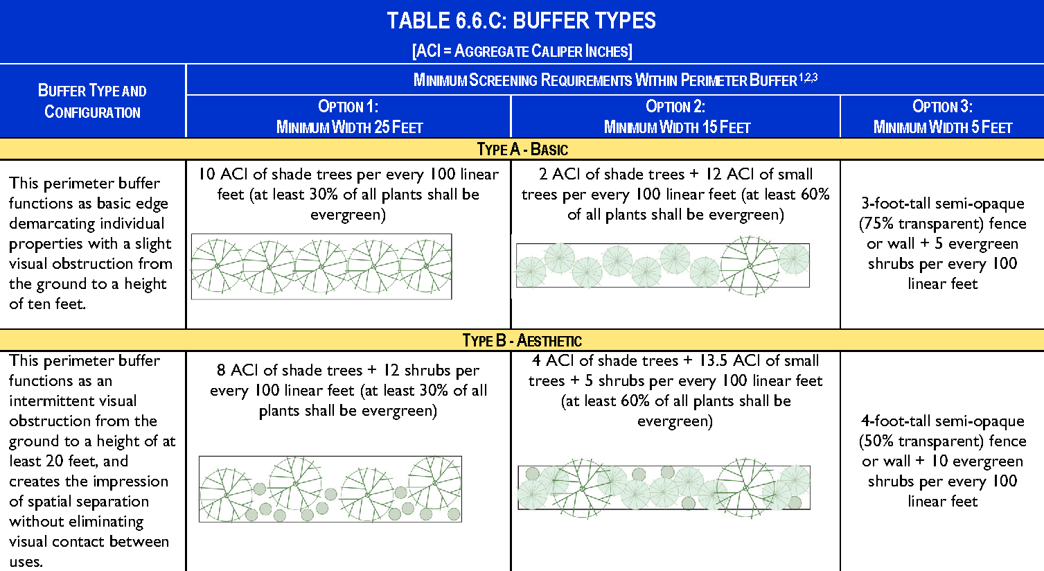
NOTES:
1. Perimeter buffer widths (but not vegetation amounts) may be reduced in accordance
with Section 3.4.W, Administrative Adjustment.
2. Where an adjacent use is designed for solar access, small trees shall be substituted
for shade trees.
3. Berms shall comply with the standards in Section 6.3.F.7, Berms. Fences and walls
shall comply with the standards in Section 6.8, Fences, Walls, and Hedges.
Figure 6.6.C - A: Example of a Type A (Basic) Buffer
Figure 6.6.C - B: Example of a Type B (Aesthetic) Buffer
Figure 6.6.C - C: Example of a Type C (Semi-Opaque) Buffer
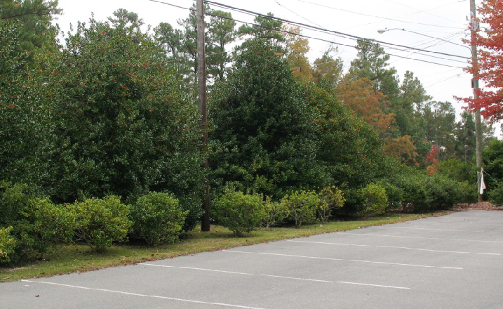
Figure 6.6.C - D: Example of a Type D (Opaque) Buffer
D.
Buffer Type Application. Table 6.6.D, Buffer Type Application, specifies the type of perimeter landscape buffer that new development shall provide between it and adjacent property, based on the proposed use type on the development site and the existing use type on the abutting property or the zoning district in which abutting vacant property is located. The buffer type is indicated by a letter corresponding to one of the four buffer types depicted in Table 6.6.C, Buffer Types.
E.
Development Abutting Existing Buffer. Where a developing parcel abuts an existing use and application of a perimeter buffer is required by Table 6.6.D, Buffer Type Application, the developing parcel shall provide the entire minimum perimeter buffer width and screening required by Table 6.6.C, Buffer Types, unless a portion or all of a perimeter buffer that complies with the standards of this section already exists between the parcels. Where such an existing buffer does not fully comply with the width and screening standards for the required buffer type, the developing parcel shall be responsible for providing all the additional buffer width and planting material necessary to meet the standards of this section.
F.
Location of Buffers. Perimeter buffers required by this section shall be located along the outer perimeter of the parcel and shall extend to the parcel boundary line or right-of-way line; however, the perimeter buffer may be located along shared access easements between parcels in nonresidential developments.
G.
Development within Required Buffers.
1.
The required buffer shall not contain any development, impervious surfaces, or site features (except fences or walls) that do not function to meet the standards of this section or that require removal of existing vegetation, unless otherwise permitted in this Code.
2.
Sidewalks, trails, and other elements associated with passive recreation may be placed in perimeter buffers if all required landscaping is provided and damage to existing vegetation is minimized to the maximum extent practicable.
3.
Overhead and underground utilities required or allowed by the City are permitted in buffers, but shall minimize the impact to vegetation, to the maximum extent practicable. Where required landscaping material is damaged or removed due to utility activity within a required buffer, the landowner shall be responsible for replanting all damaged or removed vegetation as necessary to ensure the buffer meets the standards in this Code.
H.
Sight Triangles. No fencing, berms, walls, or other landscaping features may exceed a height of three feet above grade within required sight triangles for streets, alleys, or driveways.
I.
Credit for Existing Vegetation. Existing vegetation located within ten feet of a required perimeter buffer area that meets the size standards of Section 6.4, Landscaping, may be preserved and credited toward the perimeter buffer standards provided it is retained during and after the development process.
J.
Credit for Required Landscaping. Required landscaping associated with perimeter landscaping around a vehicular use area, or building may be credited towards the perimeter buffer requirements of this section.
Sec. 6.7. - Open Space Set-Asides.
A.
Purpose and Intent. Open space set-asides are intended for the use and enjoyment of a development's residents, employees, or users. Open space set-asides serve numerous purposes, including preserving natural resources, ensuring resident access to open areas and recreation, reducing the heat island effect of developed areas, enhancing stormwater management, and providing other public health benefits.
B.
Applicability.
1.
General. Unless exempted in accordance with paragraph 3 below, the standards in this section shall apply to all new development west of Interstate 95.
2.
Time of Review. Review for compliance with these standards shall occur at the time of review for any of the following applications for a development permit (as appropriate):
a.
Planned Development (see Section 3.4.F);
b.
Special Use Permit (see Section 3.4.G);
c.
Public or Semipublic Use Permit (See Section 3.4.H);
d.
Site Plan (see Section 3.4.I);
e.
Certificate of Appropriateness (see Section 3.4.J); or
f.
Building Permit (see Section 3.4.R).
3.
Exemptions. The following forms of development are exempt from the standards in this section:
a.
Agricultural uses;
b.
Single-family detached dwellings, duplexes, or mobile/manufactured homes on a lot in existence on March 1, 2015; and
c.
Development in Historic Overlay districts.
C.
Amount of Open Space Set Aside Required. Development subject to the standards in this section shall provide the minimum amounts of open space set-aside identified in Table 6.7.C: Required Open Space Set-Aside, based on the use classification.
D.
Areas Counted as Open Space Set-Aside. The features and areas identified in Table 6.7.D, Open Space Set-Aside Features, shall be credited towards compliance with the open space set-aside standards of this section:
| Table 6.7.D: Open Space Set-Aside Features | ||
|---|---|---|
| Area Counted as Common Open Space Set-Asides | Description | Design and Maintenance Requirements |
| Natural Features | ||
 | Natural water features (including lakes, ponds, rivers, streams, rivers, wetlands, and drainageways), flood hazard areas, and important wildlife habitat areas |
Preservation of any existing natural features shall have highest priority for locating
open space set-asides.
Maintenance is limited to the minimum removal and avoidance of hazards, nuisances, or unhealthy conditions. |
| Active Recreational Areas | ||
 | Land occupied by areas and facilities used for active recreational purposes, such as pools, playgrounds, tennis courts, jogging trails, ball fields, and clubhouses |
Active recreational areas may occupy up to 100 percent of the open space set-aside
(if no natural features exist on the site), and shall occupy no less than 40 percent
of the total open space set-aside area within a residential development.
And shall be compact and contiguous unless used to link or continue an existing or planned open space resource. Areas shall abut at least one street, if reasonably practical. |
| Formal Plantings and Gardens | ||
 | Formally planned and regularly maintained open areas that provide passive recreation opportunities, including arranged plantings, gardens, gazebos, and similar structures, as well as roof gardens | Formal plantings and gardens shall have at least one direct access street, and be oriented to surrounding development. |
| Squares, Forecourts, Plazas, and Parks | ||
 | Squares, forecourts, plazas, and parks that provide active and passive recreational opportunities and help create special places |
Such features shall be at least 200 square feet, but no more than one acre, in area.
Such features shall have at least one direct access street. Surrounding buildings shall be oriented toward the square, forecourt, plaza, or park when possible and a connection shall be made to surrounding development. |
| Required Landscape Areas | ||
 | All areas occupied by required landscaping, perimeter buffers, and tree protection areas, except landscaped area within parking lots | See landscaping standards (Section 6.4, Landscaping), perimeter buffer standards (Section 6.5), and tree preservation standards (Section 6.15.A). |
| Stormwater Management Devices | ||
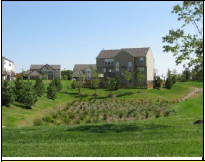 | Up to 75 percent of the land area occupied by stormwater management devices (including retention and detention ponds and other bioretention devices), when such features are treated as an open space site amenity | To qualify, stormwater management devices shall support passive recreation uses by providing access and pedestrian elements such as paths and benches |
| Public Access Easements | ||
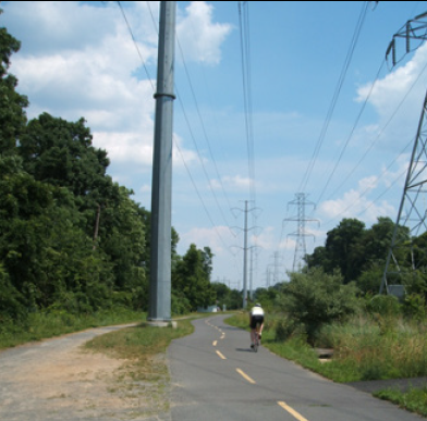 | Public access easements (which often combine utility easements with paths or trails) that are available for passive recreational activities such as walking, running, and biking | Such public access easements shall include at least one improved access from a public sidewalk, street, trail, or easement that includes signage designating the access point. |
E.
Areas Not Counted as Open Space Set-Aside. The following areas shall not be counted as open space set-aside:
1.
Private yards not subject to an open space or conservation easement;
2.
Street rights-of-way or private access easements, including sidewalks located within those rights-of-way or easements;
3.
Open parking areas and driveways for dwellings;
4.
Land covered by structures not designated for active recreational uses;
5.
Designated outdoor storage areas; and
6.
Stormwater ponds, unless located and designed as a site amenity (e.g., with low fencing, vegetative landscaping, gentle slopes, fountain or other visible water circulation device, and pedestrian access or seating).
F.
Design Standards for Open Space Set-Asides. Land used as an open space set-aside shall meet the following design standards:
1.
Location. Open space shall be located so as to be readily accessible and useable by occupants and users of the development. Where possible, a portion of the open space set-aside should provide focal points for the development through prominent placement or easy visual access from streets.
2.
Configuration.
a.
Open space lands shall be compact and contiguous unless a different configuration is needed to continue an existing trail or accommodate preservation of natural features.
b.
If the development site is adjacent to existing or planned trails, parks, or other public open area land, the open space set-aside shall, to the maximum extent practicable, be located to adjoin, extend, and enlarge the trail, park, or other open area land.
c.
If a passive recreation open space set-aside area with a minimum width of twenty feet or more abuts an existing or planned open space area, no perimeter buffer (Section 6.6, Perimeter Buffers) shall be required between the two open space areas.
3.
Orientation of Adjacent Buildings. Buildings adjacent to required open space set-asides shall have at least one entrance facing the open space set-aside.
4.
Prioritization of Open Space Set-Aside. To the maximum extent practicable, open space set-asides shall be located and organized to include, protect, or enhance as many of the following open areas and features as possible:
a.
Natural features such as riparian areas, flood hazard areas, and important wildlife habitat areas;
b.
Water features such as drainages, canals, ditches, lakes, natural ponds, and retention and detention ponds;
c.
Protected trees and other mature trees;
d.
Perimeter buffers or visual transitions between different types or intensities of uses;
e.
Natural or geologic hazard areas or soil conditions, such as or floodplains and expansive soils; and
f.
Areas that accommodate multiple compatible open space uses rather than a single use.
5.
Development in Open Space Set-Asides. Development within open space set-asides shall be limited to that appropriate to the purposes of the type(s) of area set aside as open space (see Table 6.7.D: Open Space Set-Aside Features). Where appropriate, such development may include, but is not limited to, walking, jogging, and biking paths or trails; benches or other seating areas; tables, shelters, grills, and other picnicking facilities; docks and other facilities for fishing; environmental education guides and exhibits; gazebos and other decorative structures; fountains or other water features; play structures for children; gardens or seasonal planting areas; pools; athletic fields and courts; and associated clubhouses.
G.
Ownership, Management, and Maintenance of Open Space Set-Asides.
1.
Open space set-asides shall be managed and maintained as permanent open space through one or more of the following options:
a.
Conveyance of open space set-aside areas to a property owners' or homeowners' association that holds the land in common ownership and will be responsible for managing and maintaining the land for its intended open space purposes; or
b.
Conveyance of open space set-aside areas to a third party beneficiary such as an environmental or civic organization that is organized for, capable of, and willing to accept responsibility for managing and maintaining the land for its intended open space purposes; or
c.
Establishment of easements on those parts of individually-owned lots including open space set-aside areas that require the areas to be managed consistent with the land's intended open space purposes and prohibit any inconsistent future development.
2.
All options involving private ownership of open space set-aside area shall include deed restrictions, covenants, or other legal instruments that ensure continued use of the land for its intended open space purposes and provide for the continued and effective management, operation, and maintenance of the land and facilities.
3.
Responsibility for managing and maintaining open space set-aside areas lies with the owner of the land comprising the areas. Failure to maintain open space set-aside areas in accordance with the approved development shall be a violation of this Code.
Sec. 6.8. - Fences, Walls, and Hedges.
A.
Purpose and Intent. The purpose and intent of this section is to regulate the location, height, and appearance of fences and walls to maintain visual harmony within neighborhoods and throughout the City, protect adjacent land from the indiscriminate placement and unsightliness of fences and walls, and ensure the safety, security, and privacy of properties.
B.
Applicability.
1.
General.
a.
Unless exempted in accordance with paragraph 2 below, the provisions of this section shall apply to all fences or walls not required for support of a principal or accessory structure, and to any other linear barrier intended to delineate different portions of a lot.
b.
Fences to control windblown particles required by Section 6.15.E, Pollution, Hazard, and Nuisance Controls, shall comply with the standards in that section.
2.
Exemptions. Temporary fences for construction sites, sand fencing in beachfront areas, tree protection fencing, or major sports, promotional, or entertainment events are exempted from these standards, but shall comply with any building Code or other applicable City standards.
C.
General Standards. All fences, walls, and hedges subject to the standards in this section shall comply with the following:
1.
Configuration. All fences and walls shall be constructed with quality materials and workmanship. Fences and walls shall be built plumb and sturdy enough to withstand typical wind loads and stresses.
2.
Location.
a.
Except to the extent specifically provided otherwise, fences, walls, and hedges shall be permitted in any required yard.
b.
Chain link fences are prohibited between the front lot line and the front of the structure in all districts.
c.
Fences or walls serving multifamily or nonresidential development and adjacent to public rights-of-way shall be located behind any required landscape or buffer yard area. Fences or walls located along interior side or rear lot lines may be placed atop the property line with required plantings located inside the fence or wall.
d.
Walls shall not be allowed above any City public utility infrastructure, or where their foundation might impact such infrastructure. Fences shall not be located above the City's public utility infrastructure where they might prevent the operation and maintenance of the City's public utility main, or where their foundations might impact such mains.
3.
Barbed Wire Fencing.
a.
Barbed wired fencing is prohibited in all zoning districts except industrial districts.
b.
In industrial districts, barbed wire fencing is not permitted along arterial or collector streets, and shall be set back at least three feet from the right-of-way.
4.
Height.
a.
Except as specifically provided otherwise in this Code, fences and walls shall not exceed four feet in height along and between the front lot line and the front of the structure, and shall not exceed eight feet in height elsewhere on the lot.
b.
In the Industrial districts, a six-foot-high masonry wall is permitted in the front yard for site screening, provided that there are no negative impacts as determined by City staff.
c.
Chain link fences located behind the front of the structure shall not exceed eight feet in height in the Industrial districts, and shall not exceed six feet in height in all other districts.
d.
Only tennis courts, basketball courts, and similar recreational facilities may be enclosed in vinyl coated chain link fence exceeding six feet in height.
e.
Wrought iron fences in any zoning district shall not exceed six feet in height except for columns, which may extend up to 12 inches above the fence height.
f.
Hedges shall not exceed six feet in height along and between the front lot line and the front of the structure, and shall not exceed eight feet in height elsewhere on the lot.
5.
Temporary fencing. Except for fencing associated with an active construction site, or security fencing for an undeveloped lot, temporary fencing shall not remain in place for longer than 60 days. Fencing associated with active construction sites must be screened to minimize visual impact and maintained in good condition. The screening shall consist of materials that obscure the construction site, such as mesh, tarps, or other solid barriers, ensuring the safety and privacy of surrounding properties. The fencing must be regularly inspected and repaired as needed to prevent deterioration and ensure it remains secure throughout the duration of the construction project.
6.
Security fencing on undeveloped lot. Security fencing shall be permitted on an undeveloped lot, subject to the following standards, which shall apply in case of conflict with other provisions of these General Standards:
a.
The maximum fence height shall be six feet along all lot boundaries, including right-of-way frontage, except as provided in Section 6.8.C.7.
b.
Security fencing must be placed on the entire perimeter of the undeveloped lot. The maximum setback shall be five feet from the property line, except as follows:
i.
Where solid fencing is used, the maximum setback shall be 20 feet, or the setback applicable in the zoning district, whichever is greater.
ii.
Staff may require an increased setback as referenced in Section 6.8.C.7.
c.
Within the area located between the front lot line to the building setback, and for any portion of the security fence fronting on a right-of-way, materials shall be restricted to vinyl coated chain link, vinyl picket, industrial aluminum, or wrought iron. All other materials, including non-coated chain link, are prohibited in these areas.
d.
Any portion of the security fencing fronting on a right-of-way must allow a reasonably unrestricted view of the grounds of the undeveloped lot from the right-of-way. Picket-style materials fronting a right-of-way shall have minimum spacing of four inches between each picket with a maximum picket width of one inch. Staff may impose other conditions with respect to fencing materials or manner of construction to ensure that this requirement is met.
e.
A pedestrian access gate is required. The gate must swing into the undeveloped lot.
f.
At all times, the ground cover of the undeveloped lot shall be maintained, and the lot shall be kept free of trash and debris.
g.
Upon development of the lot, all security fencing must be removed or brought into compliance with all applicable regulations of the LDC relating to fencing on developed properties.
7.
Additional requirements may be imposed. Additional restrictions on the height or location of fences, walls, or hedges may be imposed by City staff where necessary for purposes of vehicular and pedestrian safety, or for the purpose of avoiding conflicts between such structures and platted or recorded utility easements.
D.
Additional Standards Along Major City Thoroughfares. In addition to the standards in Section 6.8.C, General Standards, fences and walls located within a front yard abutting or within 25 feet of a principal arterial street right-of-way shall comply with the following standards:
1.
Fences and walls shall be located a minimum of five feet from the front property line and behind any required setback or landscaping. The area between the right-of-way and the fence or wall shall be landscaped in accordance with Section 6.4, Landscaping.
2.
Fences and walls shall be a maximum of six feet high.
3.
Fences and walls shall be of a design consistent with the architectural theme of the site as developed, and shall be compatible with adjacent land and the neighborhood. Materials may be wood, masonry, wrought iron, aluminum, concrete, or durable plastic.
4.
Wooden fences shall be constructed of pressure treated pine, cedar, or cypress. Plywood, particle board, or similar wood materials are prohibited. The finished side shall face outward, and stringers and posts shall not be visible from the outside.
5.
Walls shall be masonry, stone, or brick construction. Masonry walls shall have a stucco finish or a textured manufactured finish such as "fluted" block. Plexiglas panels may be used for walls around pool decks.
6.
Fence or wall colors shall be matte finish earth tones, matte black, matte white, or pastels with a minimum matte white content of 90 percent. Colors shall complement the primary color of the development and shall not be so extreme in contrast or intensity that the color competes with the building for attention or acts as a sign.
E.
Retaining Wall Standards.
1.
Nothing in this section or this Code shall be construed to prohibit or prevent the erection of a retaining wall on any property where the wall does not adversely affect the natural flow of surface water or create any other adverse effect on adjacent or adjoining land or development.
2.
If a six-foot-high screening wall is required where it would be atop a retaining wall, the screening wall may be modified or waived to allow an alternative size or type of screen to be installed above the retaining wall which satisfies the screening function.
3.
A retaining wall along a property perimeter adjacent to a public right-of-way shall be constructed of stone, brick, or other decorative surface, or shall be screened by landscaping.
F.
Screening Wall and Hedge Specifications.
1.
Required screening walls shall be six feet high. The lower four feet shall be solid-faced construction; the upper two feet may be solid-faced, open-faced, or ornamental construction with at least 50 percent opacity. The exterior surface of the wall shall be painted or stuccoed to industry standards to protect the wall from moisture absorption and to enhance appearance. The exterior color of the wall shall be an earth tone.
2.
Required screening fences shall be solid face construction of pressure treated pine, cedar, concrete, or cypress materials. Plywood, particle board, or similar materials are prohibited. Fences required by Section 6.15.E, Pollution, Hazard, and Nuisance Controls, shall be constructed with a stockade-style solid face. The color of the fence shall be natural wood or an earth tone stain or paint.
3.
Required screening hedges for nonresidential uses adjacent to residential uses shall be at least three feet high at the time of planting, and shall be of a species capable of attaining a six-foot-high dense screen at maturity.
4.
The top of all fences and walls shall be level, and all posts shall be set perpendicular to the top. On sloping sites, the top of the fence or wall shall be stepped with a maximum step height of 24 inches, and the maximum height shall not be exceeded.
G.
Maintenance. Walls and fences shall be maintained at the proper height and density in a plumb and upright position free of any discoloration (other than from normal weathering), damage, and defects.
H.
Construction Within Easements.
1.
Permission to build a fence upon a utility easement does not remove the obligation of the owner of the fence to remove the fence upon demand of the utility company. The owner of the fence shall remove and rebuild the fence at the owner's expense.
2.
The owner of a fence shall be responsible for the design, construction, and maintenance of the fence, and the fence shall not interfere with utility lines or normal drainage.
3.
Where a fence is to be placed in an easement containing underground utilities, the owner or occupant shall sign a release indemnifying the City from any damages for removal of the fence and damage to the fence as a result of the need to repair or replace said utilities.
4.
Walls are not permitted in any public utility easement without the written permission of the Utilities Department.
(Ord. No. 16-26, § 1(Exh. A), 1-20-2016; Ord. No. 19-265, § 1, 10-2-2019; Ord. No. 2022-413, § 1, 10-19-2022; Ord. No. 2023-386, § 1, 10-4-2023; Ord. No. 2025-202, § 2, 5-21-2025)
Sec. 6.9. - Exterior Lighting.
A.
Purpose and Intent. The purpose of this section is to regulate light spillage and glare to ensure the safety of motorists and pedestrians, and to ensure lighting does not adversely affect land uses on adjacent lands. More specifically, this section is intended to:
1.
Regulate lighting to assure that excessive light spillage and glare are not directed at adjacent lands, neighboring areas, and motorists;
2.
Ensure that all site lighting is designed and installed to maintain adequate lighting levels on site;
3.
Avoid negative impacts from exterior lighting on coastal wildlife habitat; and
4.
Provide security for persons and land.
B.
Applicability.
1.
General. The provisions of this section shall apply to all development in the City unless exempted in accordance with paragraph 2 below.
2.
Exemptions. The following development is exempted from this section:
a.
FAA-mandated lighting associated with a utility tower or airport;
b.
Lighting associated with the Daytona International Speedway;
c.
Lighting associated with navigational beacons, the United States Flag, Florida Flag, or City of Daytona Beach Flag;
d.
Holiday lighting during the months of November, December, and January, provided the lighting does not create unsafe glare on street rights-of-way;
e.
Battery-powered emergency lighting; and
f.
Architectural lighting of 40 watts or less.
3.
Time of Review. Review for compliance with the standards of this section shall occur during review of an application for approval of a Special Use Permit (Section 3.4.G), Public or Semipublic Use Permit (Section 3.4.H), Site Plan (Section 3.4.I), Certificate of Appropriateness (Section 3.4.J), or Building Permit (Section 3.4.R), as appropriate.
4.
Existing Development. Compliance with these standards, to the maximum extent practicable, shall also apply to redevelopment of an existing structure, building, or use when it is expanded, enlarged, or otherwise increased in intensity or floor area equivalent to or beyond 50 percent.
C.
Lighting Plan. To ensure compliance with the standards of this section, a lighting plan demonstrating how exterior lighting will comply with the standards of this section shall be included as part of any application included in 6.9.B.3, Time of Review, as appropriate.
D.
Prohibited Lighting. The following exterior lighting is prohibited:
1.
Light fixtures that imitate an official highway or traffic control light or sign;
2.
Light fixtures in the direct line of vision with any traffic control light or sign;
3.
Light fixtures that have a flashing or intermittent pattern of illumination, except electronic message center signage permitted in accordance with Section 6.10.J.7, Electronic Message Center Signs;
4.
Privately-owned light fixtures located in the public right-of-way; and
5.
Searchlights, except when used by Federal, State or local authorities.
E.
Street Lighting.
1.
Public and private streets, sidewalks, and other common areas or facilities in developments may be illuminated to ensure the security of land and the safety of persons using such streets, sidewalks, and other common areas or facilities. When provided, illumination shall be in accordance with a plan designed by the appropriate utility company.
2.
All street lights shall be located inside full cut-off fixtures mounted on non-corrosive poles served by underground wiring.
3.
The light structure and light color of street lights in an individual subdivision or development shall be consistent throughout the subdivision or development.
4.
All street lights are to be light-emitting diode (LED) equivalent to 100 watts meeting the requirements of the Manual of Uniform Minimum Standards for Design, Construction and Maintenance for Streets and Highways (also referred to as The Florida Greenbook) latest edition. Illumination standards must be met prior to final plat approval, or prior to occupancy when final plat approval is not required.
F.
General Standards for On-Site Exterior Lighting. Development subject to this section shall comply with the following standards:
1.
Hours of Illumination. Institutional uses, commercial uses, and industrial uses that are adjacent to existing residential development shall extinguish all exterior lighting—except lighting necessary for security or emergency purposes—by 10:00 P.M. or within one hour of closing, whichever occurs first. For the purposes of this paragraph, lighting "necessary for security or emergency purposes" shall be construed to mean the minimum amount of exterior lighting necessary to illuminate possible points of entry or exit into a structure, to illuminate exterior walkways, or to illuminate outdoor storage areas. Lighting activated by motion sensor devices is strongly encouraged.
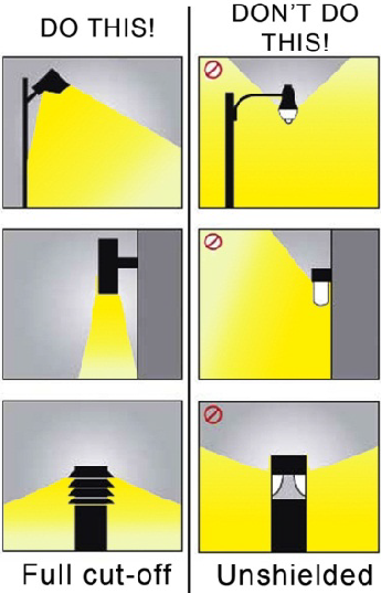
Figure 6.9.F.2: Full cut-off fixtures.
2.
Shielding. Except for single-family detached and duplex dwellings, all exterior luminaries, including security lighting, shall be full cut-off fixtures and directed downward, consistent with Figure 6.9.F.2: Full cut-off fixtures. In no case shall lighting be directed above a horizontal plane through the lighting fixture.
3.
Maximum Height. Except for athletic fields or performance areas, the height of outdoor lighting, whether mounted on poles, walls, or by other means, shall be no greater than 40 feet above grade, or 25 feet above grade for properties in, or adjacent to, residential districts.
4.
Maximum Illumination Levels.
a.
All outdoor lighting and indoor lighting visible from outside shall be designed and located so that the maximum illumination measured in foot-candles at ground level at a lot line shall not exceed the standards in Table 6.9.F.4 Maximum Illumination Levels, and Figure 6.9.F.4, Maximum Illumination Levels.
b.
In no instance shall illumination levels within a site or development exceed 30 foot-candles.
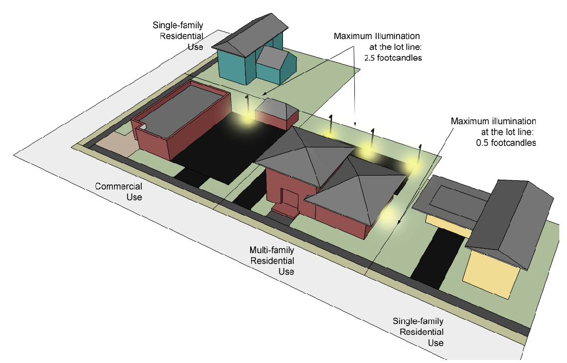
Figure 6.9.F.4: Maximum illumination levels.
G.
Lighting Design Standards for Specific Uses and Site Features.
1.
Awnings. Awnings or canopies used for building accents over doors and windows shall not be internally illuminated (i.e., from underneath or behind the awning) unless the awning material is entirely opaque.
2.
Sports and Performance Venues. Lighting fixtures for outdoor sports areas, athletic fields, and performance areas shall be equipped with an existing glare control package (e.g., louvers, shields, or similar devices) and aimed so that their beams are directed and fall within the primary playing or performance area.
3.
Wall Pack Lights.
a.
Wall packs on the exterior of the building shall be fully shielded (e.g., true cut-off type bulb or light source not visible from off-site) to direct the light vertically downward and be of low wattage (100 watts or lower).
b.
Wall pack light sources visible from any location off the site are prohibited.
4.
Canopies. Areas under a canopy shall be designed so as not to create glare off-site. Acceptable methods include one or both of the following:
a.
A recessed fixture incorporating a lens cover that is either recessed or flush with the bottom surface (ceiling) of the canopy that provides a full cutoff or fully-shielded light distribution.
b.
A surface mounted fixture incorporating a flat glass that provides a full cutoff or fully-shielded light distribution.
H.
Measurement.
1.
Light level measurements shall be made at the lot line of the land upon which light to be measured is being generated. If measurement on private property is not possible or practical, light level measurements may be made at the boundary of the public street right-of-way that adjoins the land.
2.
Measurements shall be made at finished grade (ground level), with the light-registering portion of the meter held parallel to the ground pointing up. The meter shall have cosine and color correction and have an accuracy tolerance of no greater than plus or minus five percent.
3.
Measurements shall be taken with a light meter that has been calibrated within two years.
I.
Exemptions for a Security Plan. Government facilities, parks and open areas, public safety, and other development where sensitive or dangerous materials are stored may submit a security plan to City staff proposing exterior lighting that deviates from the standards in this section. City staff shall approve or approve with conditions the security plan and its proposed deviation from the standards of this section, upon finding that:
1.
The proposed deviation from the standards is necessary for the adequate protection of the subject land, development, and the public;
2.
The condition, location, or use of the land, or the history of activity in the area, indicates the land or any materials stored or used on it are in significantly greater danger of theft or damage, or members of the public are at greater risk for harm than on surrounding land without the additional lighting; and
3.
The proposed deviation from the standards is the minimum required, and will not have a significant adverse effect on neighboring lands.
(Ord. No. 18-321, § 1, 9-19-2018; Ord. No. 2020-153, § 5, 6-3-2020)
Sec. 6.10. - Signage.
A.
Purpose. The purpose of these sign regulations is to:
1.
Enable the identification of places of residence and business.
2.
Allow for the communication of information necessary for the conduct of commerce.
3.
Reduce hazardous situations, confusion, and visual clutter caused by the unchecked proliferation, improper placement, illumination, animation, or excessive height, area, and bulk of signs, which compete for the attention of pedestrian and vehicular traffic.
4.
Enhance the attractiveness and economic wellbeing of the City as a place to live, vacation and conduct business.
5.
Protect the public from the dangers of signs that are unsafe due to poor construction or anchoring, use of substandard materials, or failure to maintain structural elements.
6.
Permit signs that (i) are compatible with their surroundings, (ii) aid orientation, and (iii) preclude placement of signs in a manner that conceals or obstructs adjacent land uses or signs.
7.
Encourage signs that are appropriate to the zoning district in which they are located and consistent with the category of use to which they pertain.
8.
Curtail the size and number of signs and sign messages to the minimum reasonably necessary to identify a residential or business location and the nature of any such business.
9.
Establish sign size in relationship to the scale of the lot and building on which the sign is to be placed or to which it pertains.
10.
Preclude signs from conflicting with the principal permitted use of the site or adjoining sites.
11.
Regulate signs in a manner so as to not interfere with, obstruct vision of or restrict motorists, bicyclists or pedestrians.
12.
Require signs to be constructed, installed, and maintained in a safe and satisfactory manner.
13.
Preserve and enhance the natural and scenic characteristics of the City, and in particular, the City's redevelopment districts.
B.
Sign and Components; Limitations of Regulations.
1.
A sign is any device or display consisting of lights, letters, numbers, symbols, pictures, illustrations, announcements, cutouts, insignia, trademarks, or demonstrations—including all trim and borders—that is designed to advertise, inform, identify, or attract the attention of persons not on the premises on which the device or display is located, and that is visible from a public street.
2.
Any person or animal stationed at or close to a business site for the purpose of attracting attention to the business by actions or attire is a sign.
3.
Sign structure is that material which supports or is capable of supporting a sign, including decorative cover.
4.
Advertising message is any copy, logos, or graphic elements of a sign which convey a message, identify a business, or describe products or services offered to the public.
5.
Any sign allowed by either a permit or as a matter of right, whether an on-site sign or an off-site sign, except those exempt signs necessary to protect public safety or satisfy legal requirements listed in Section 3.4.Q.2.b.iii may contain noncommercial speech in lieu of any other type of speech.
6.
City informational, directional, and other public signage for City buildings, City parks and other City facilities are exempt from the requirements of this Section.
C.
Sign Area. The area of a sign is determined as follows:
1.
Sign area of a wall sign or awning is the entire area within a single continuous square, rectangular, or circular perimeter enclosing the extreme limits of the advertising message.
2.
Sign area for other signs includes all features, decorative glass, plastic, masonry, or other materials. Where material is displayed in a random or unconnected manner without organized relationship of the components, each component or element shall be considered to be a single sign.
3.
A roof, projecting, or ground sign with sign face on two sides with no more than a three-foot separation between faces shall be a single sign, and the total sign area shall be the area on a single face.
4.
Pole covers shall be included as sign area to the extent that they exceed twice the diameter of the support, except that in Redevelopment Areas, the Redevelopment Board may approve pole covers that exceed twice the diameter of the supporting pole without it being included as sign area, provided the design standards and guidelines in Section 6.10.F, Sign Design and Construction, are met.
5.
The finished constructed base of a monument sign up to 22 square feet shall be excluded from the sign area.
6.
No permit shall be issued for any sign if a nonconforming billboard, roof, projecting, or pole sign exists at the business location.
D.
Sign Permit.
1.
A Sign Permit shall be required in accordance with the applicability standards and procedure in Section 3.4.Q, Sign Permit.
2.
All signs for which a permit is required are subject to inspection. All ground signs shall be subject to a footing inspection, and all signs to a final electrical inspection. Inspections must be made to the main frame prior to installation of decorative panels or skirting. Following an inspection, if corrections of defects are not made within ten days after notification, no permits for any sign work will be issued to the delinquent contractor.
E.
Prohibited Signs.
1.
All Districts. Except to the extent specifically provided otherwise, the following signs or sign characteristics are prohibited in all districts, and no permit shall be issued authorizing erection of any of the following:
a.
Animated or moving parts on any sign.
b.
Beacon lights with one or more beams capable of being directed in any direction or directions, or capable of being revolved automatically, or having any part thereof capable of being revolved automatically, and fixed or flashing high intensity lights such as a spotlight or floodlight.
c.
Signs allowing different copy to be shown on the same lamp bank, including electronically or electrically controlled public service, time, temperature, and date signs, and message centers, except as provided in Section 6.10.J.6, Electronic Message Center Signs.
d.
Flashing signs containing any intermittent or flashing light source, or which include the illusion of intermittent or flashing light, or any externally mounted intermittent light source.
e.
Inflatable air signs or balloons which retain shape from the use of air, helium, or other gaseous elements.
f.
Mobile or portable signs or sign structures that are not securely attached to the ground or to any other structure, including trailer signs, A-frame signs, and sandwich signs, except temporary traffic control signs necessary to safely direct traffic due to temporary or recently discovered hazardous conditions.
g.
Off-site signs that contain commercial messages not related to the site, or advertise goods, products, services, or facilities not available or located on the site, or direct persons to a different location from where the sign is installed. Signs not located on the subject property related to the sign message, but located within the same master development area, shall not be considered off-site signage. Signs located on a property for purposes of offering the property for sale or lease are deemed to be on-site signs with a commercial message.
h.
Pennants, twirling signs, swinging signs, and other signs which move in the wind.
i.
Vehicles for which the primary purpose is advertising—that is, vehicles, trailers, or boats that are parked on public or private property so as to be clearly visible from a street and that have attached thereto or located thereon any sign or advertising device for the primary purpose of providing advertisement of products or directing people to a business or activity located on the same or nearby property or any other premises. This provision is not intended to prohibit public vehicular signage such as a sign attached to a bus or identifying signs on business vehicles, or signs lettered on or attached to a motor vehicle in a manner to primarily identify the vehicle with the business it serves.
2.
Redevelopment Areas.
a.
In all Redevelopment Areas, the following signs and sign characteristics shall also be prohibited:
i.
Signs which substitute for or cover integral architectural parts such as fascia cornice or band courses.
ii.
Live window displays or demonstrations which are not related to the nature of the business.
iii.
Glow-in-the-dark or fluorescent paint.
iv.
Any sign exceeding the height of the building or buildings to which it relates.
b.
In RDB-1, RDB-2, RDD-1, and RDD-2 districts, changeable copy signs shall also be prohibited.
F.
Sign Design and Construction.
1.
All Districts. All signs in all districts shall meet the following minimum design and construction standards:
a.
All signs shall comply with the minimum requirements provided in the Building Code relating to design, structural members, and connections. Specifically:
i.
All ground, roof, and projecting signs more than 40 square feet in area or over 20 feet in height shall be certified by an engineer or architect registered in the State of Florida as meeting the requirements of the Building Code.
ii.
All electrical signs shall be erected and installed by a licensed sign contractor in accordance with listing and labeling requirements and shall be certified by the contractor as meeting the requirements of the electrical code. The application and sign shall bear the testing laboratory number. Electrical connection to a power source shall be performed by a licensed electrical contractor.
b.
Metal supports or braces shall be adequate for wind loadings. Specifically:
i.
Wire or cable supports shall be four times the required strength.
ii.
All metal, wire cable supports and braces and all bolts used to attach sign or bracket or brackets and signs to the supporting building or structure shall be of galvanized steel or of an equivalent corrosive-resistant material.
iii.
All such sign supports shall be an integral part of the sign.
c.
Signs shall maintain a clearance of ten feet from all overhead electrical conductors, and three feet from all secondary voltage service drops.
d.
No sign shall be attached in a manner which will interfere with an opening required for ventilation, except that signs may be erected in front of or may cover transom windows when not in violation of the Building Code or Fire Code.
e.
No sign shall be erected in a manner that would impede ingress and egress through any door or emergency exit, or on a fire escape or any other public safety device.
f.
No sign shall interfere with cross visibility at intersections, or create a traffic hazard or other condition that adversely affects the public safety.
g.
All permanent ground sign structures shall be self-supporting and erected on and permanently attached to concrete foundations. Structures shall be fabricated only from galvanized steel or an equivalent corrosive-resistant material.
h.
No sign shall be attached to a wall that lacks sufficient strength to support it, or nailed or attached in any way to trees, telephone poles, or other objects.
i.
No sign shall be suspended by chains or other devices that will allow the sign to swing due to wind action. Signs shall be anchored to prevent any lateral movement that would cause wear on supporting members or connections.
j.
Illuminated signs shall provide shielding of any source of illumination other than neon. No glare exceeding two foot-candles shall be directly visible from any point along the paving or curb of a street or any residential zoning district.
k.
Signs on properties in commercial or industrial districts shall not be erected within 25 feet of any residential district boundary.
l.
No sign shall interfere with any required landscaping, screening, or vegetation preservation areas or functions. A visibility zone may be provided around a sign as described in Section 6.4.E.1, Planting Standards, Irrigation, and Installation.
m.
Where landscaping is required around the base of a sign, the sign footer shall be lowered at least 24 inches from finished grade to provide adequate planting soil depth and drainage for the landscaping.
2.
Redevelopment Areas. All signs in Redevelopment Areas shall meet the following additional design standards and guidelines. These standards and guidelines are more fully explained and illustrated in the City's booklet Redevelopment Area Design Guidelines, which is hereby incorporated into this Code by reference.
a.
Every sign shall have appropriate scale and proportion in its design and in its visual relationship to buildings and surroundings.
b.
Every sign shall be designed as an integral architectural element of the building and site to which it principally relates.
c.
The colors, materials, and lighting of every sign shall be harmonious with the building and site to which it principally relates.
d.
The number of graphic elements on a sign shall be held to the minimum needed to convey the sign's major message and shall be composed in proportion to the area of the sign face.
e.
Each sign shall be compatible with signs on adjoining premises.
f.
Identification signs of a prototype design and corporation logos shall conform to the criteria for all other signs.
g.
Architectural accent lighting shall accent significant architectural aspects of a building, and be harmonious with the site.
h.
Two sign types are recommended for each property.
i.
Each business should have individual signage, even if more than one business occupies a store.
j.
One sign should be visible throughout the night.
k.
Windows should be uncluttered and allow a view of the store. Merchandise should not be directly on the window or otherwise obstruct the window.
G.
Sign Maintenance and Removal.
1.
All signs—including all supports, braces, guys, and anchors—shall be kept in good repair.
2.
A sign that no longer correctly directs or exhorts any person or advertises an operating business, lessor, owner, product, or activity conducted or product available on the premises where the sign is displayed shall be removed. The property owner is responsible for the removal of the signs, including all brackets, poles, and structural elements.
3.
If any sign is unsafe or insecure or is a menace to the public health or safety, or has been constructed or erected—or is being maintained—in violation of these requirements, the City shall provide written notice of such finding to the contractor, owner, agent, or lessee of the property on which the sign is located. If the contractor, owner, agent, or lessee fails to remove or correct the violation, the City may remove or alter the sign to comply with these requirements at the expense of the contractor, owner, agent, or lessee. The City may immediately remove any sign or advertising structure that poses an immediate peril to persons or property.
H.
Types of Signs Allowed. The following types of signs are permitted for any use or parcel:
1.
Signs specifically permitted in all districts.
2.
Signs identified as permitted in the sign schedule for the district in which the parcel is located.
I.
Number of Signs Allowed. The number of signs permitted for any use or parcel shall be determined by reference to the sign schedule for the district in which the parcel is located. The following signs shall be excluded when determining the maximum number of permitted signs:
1.
Architectural accent lighting;
2.
Architectural embellishments;
3.
Riverfront and waterway signs;
4.
Seawall signs;
5.
Signs for which a permit is not required;
6.
Temporary signs; and
7.
Wall graphics.
J.
Sign Types and General Standards. The following types of signs are permitted in various zoning districts. Wherever permitted, a sign shall meet these general standards and any additional standards or restrictions established in the sign schedule for the district in which it is located.
1.
Awning Signs.
a.
An awning sign is a permanent sign that is affixed to or part of an awning supported entirely from the exterior wall of a building and composed of nonrigid materials except for the supporting framework.
b.
Electric awnings may be erected for the principal purpose and use of the awning as a sign, in accordance with the following requirements:
i.
The structure shall be internally illuminated by fluorescent or other light sources in fixtures approved under national and local electrical codes. All electrical components shall be labeled and rated for protected outdoor use.
ii.
All frames shall be manufactured from tubular or structurally shaped steel or aluminum with finish or coatings to insure against corrosion. Fastenings and structural attachments to buildings must be to structural members only, and be of sufficient size and strength to meet Building Code standards.
iii.
Vinyl fabric coverings shall be 14 ounces per yard minimum weight and be certified as to tensile strength and flame resistance to meet industry and local Building Code and Fire Code standards. All fabric shall be factory dyed. If a ceiling is used, it shall consist of egg crate, mesh, or solid plastic material. Removal panels or sections must be provided for service and cleaning access.
iv.
The minimum vertical height shall be seven feet above the sidewalk. Where projecting over a vehicular use area, minimum vertical height shall be 14 feet to avoid damage by truck or other high vehicles. Overall height of the awning may not exceed the established roofline, parapet wall, or mechanical components of the building to which it is attached.
c.
Advertising messages are permitted on awnings as follows:
i.
Letter copy and graphics shall be applied with manufacturer-approved processes.
ii.
Advertising messages shall be placed at the bottom of the perimeter of the awning only. No messages are permitted in the upper angled or upper curved face of the awning.
iii.
When an awning covers multiple storefronts, individual business signage shall be on that portion of the awning adjacent to the business.
d.
The maximum sign area permitted on any awning shall be one-half of a square foot for each linear foot of awning, including returns, provided:
i.
The sign area shall not exceed a height of 1.5 feet for awnings that are no more than 62 feet in length, and two feet for awnings more than 62 feet long.
ii.
In lieu of a permitted wall sign, the flat area of an entrance or walkway awning parallel to the wall may be used for signage with 0.5 square feet of sign area per foot of frontage, up to a maximum of 60 square feet.
2.
Billboards Permitted Only Along Certain Arterial Streets.
a.
Billboards are outdoor signs which advertise firms, organizations, goods, products, or services which are not located on the same premises as the sign, and that are sold, rented, owned, or leased for the display of advertising messages. Billboards shall be of the following types:
i.
Poster panels or bulletins mounted on a freestanding structure with advertising copy applied in the form of pasted paper.
ii.
Indexing signs made with a series of triangular vertical sections that turn and stop, or index, to show three pictures or messages in the same area.
iii.
Painted bulletins where the advertiser's message is painted directly on the background of a freestanding display area.
iv.
Printed vinyl fabric that is applied to the billboard panel or is stretched over the billboard panel and held in place with ratchet straps or similar fasteners.
v.
Digital billboards.
b.
Billboards are prohibited in all redevelopment areas. In other areas of the city, billboards are prohibited except within 100 feet of the right-of-way line of Interstate 95. Billboards, are subject to the following standards, except as modified by Section 6.10.J.2.c for digital billboards:
i.
All billboards shall have a minimum setback of 15 feet from the right-of-way line.
ii.
No billboards shall be located on the roof of any building.
iii.
No billboard shall be located within 1,500 feet of any other billboard on the same side of Interstate 95.
iv.
Side-by-side billboards and vertically stacked or double-tier billboards are prohibited.
v.
V-shaped or back-to-back billboards shall be counted as one sign for spacing purposes, provided that the sign structures are located not more than 15 feet apart at their widest point.
vi.
Billboards shall have a maximum height of 26 feet above the crown of the adjacent interstate travel lane.
vii.
The sign area shall be at least eight feet above ground.
viii.
A billboard shall have a maximum sign area of 450 square feet per sign face, including any embellishments.
ix.
Billboards shall be graded, landscaped, and irrigated in conformity with the master interstate billboard landscape details that have been adopted, and may be revised from time to time, by resolution of the City Commission, and subject to the following:
(a)
No copy shall be allowed on a new billboard along Interstate 95 until the City has approved the sign location, size, height, and final grading and the installation of the landscape materials and irrigation system.
(b)
The City may require a certified land survey indicating the elevation of the adjacent crown of road, height of sign, and height of berm for City review and approval prior to the installation of irrigation and landscape materials.
(c)
The landowner and billboard owner shall be jointly and severally liable for maintaining required irrigation and landscaping materials.
c.
Digital billboards shall be permitted in accordance with the following conditions, and shall comply with the standards set forth in Section 6.10.J.2.b, except as modified below:
i.
Exchange Requirement. A digital billboard shall be permitted only in exchange for the removal of four existing billboards within the city. This exchange is subject to conditions as follows:
(a)
Each digital billboard face shall be treated as one digital billboard for purposes of this exchange requirement. A digital billboard structure with two digital faces shall be treated as two digital billboards.
(b)
At least four billboard faces must be removed in exchange for one digital billboard. Except where the removed billboard is being replaced with a digital billboard, a billboard must be nonconforming as to location in order to count toward the exchange.
(c)
The entire billboard structure on which a billboard face being removed is located shall be removed unless the digital billboard will be installed on the existing structure.
(d)
Removal of all billboard structures and billboard faces required for the exchange shall be completed within 45 days after construction of the digital billboard. The digital billboard shall not be operated until removal of all billboard structures and billboard faces required for the exchange is complete.
ii.
Application and Development Permit. An application for approval of a digital billboard shall include:
(a)
Detailed plans setting forth the locations, sizes, heights, and number of faces of each billboard to be removed, and the proposed location, size, and height of the digital billboard to be constructed;
(b)
Sufficient documentation as to the applicant's right to remove the billboard if the application is approved, such as a signed lease or written consent of the property owner; and
(c)
Any additional information necessary for the City to verify that the requirements of this section are met.
(d)
The digital billboard development permit will specify the billboard structures and billboard faces to be removed. Separate permits will be required for the removal of each billboard.
iii.
Location. Digital billboards permitted in accordance with the exchange provisions of Section 6.10.J.2.c.i may be constructed only in the following locations:
(a)
Digital billboards may be located anywhere billboards are permitted in accordance with Section 6.10.J.2.b.
(b)
An existing billboard along I-95 which is non-conforming due to setbacks or spacing may be removed and replaced with a digital billboard in the same location.
(c)
An existing non-conforming billboard located along West International Speedway Boulevard and within 500 feet of the centerline of Nova Road, Fentress Boulevard, Bayless Boulevard, or Williamson Boulevard may be removed and replaced with a digital billboard in the same location.
iv.
Site and construction standards. Digital billboards shall comply with the following standards:
(a)
The maximum display area for a digital billboard face shall not exceed 382 square feet. The maximum display area shall be exclusive of embellishments, which shall not exceed ten percent of the sign face.
(b)
A digital billboard may exceed 26 feet in height if it is constructed in the same location as a billboard removed in exchange for the digital billboard, and the height does not exceed that of the removed billboard.
(c)
Except as otherwise permitted by Section 6.10.J.2.c.iii.(b) or (c), digital billboards shall be setback a minimum of 200 feet from any parcel zoned residential and ten feet from any property line. Setbacks shall be measured from the nearest point of the digital billboard to the edge of the property line.
v.
Operational standards. Digital billboards shall comply with the following operational standards:
(a)
Digital billboard copy may change only at intervals of not less than eight seconds. The maximum transition time between messages shall not exceed one second.
(b)
Messages shall not display any illumination that moves, appears to move, flashes, scrolls, or changes in intensity during the static display period, but static graphic pictures may be displayed with no limitations on color.
(c)
The display screen area shall provide a high-resolution picture quality with pixel spacing of 20 millimeters or less.
(d)
Messages on digital billboards shall not operate at a brightness level of more than 5,000 nits during the day and 500 nits from dusk to dawn.
(e)
Each digital billboard display shall have a light sensing device to adjust the brightness of the billboard display as ambient light conditions change.
(f)
A malfunctioning display screen must be turned off or display a blank screen.
(g)
Digital billboard permittees shall display emergency announcements or alerts (e.g. Amber Alerts, Silver Alerts and Evacuation Alerts) on the digital billboard at no charge on an as-needed basis as determined by the City.
vi.
A digital billboard which replaces a nonconforming billboard and continues the nonconformity shall be deemed to be a non-conforming structure and shall be subject to the applicable provisions of Article 8.
3.
Canopy Signs.
a.
A canopy sign is a sign that is attached to or suspended below a canopy extending from part or all of a building face and constructed of some durable material.
b.
Canopy signs shall meet the following minimum standards:
i.
No sign shall project over the roof edge of the building to which it is attached.
ii.
Maximum height shall be 35 feet.
4.
Changeable Copy Signs.
a.
A changeable copy sign is a sign on which copy is changed manually in the field, such as a reader board with changeable letters or changeable pictorial panels.
b.
Except where specifically prohibited, any permitted sign may be a changeable copy sign.
5.
Easel Signs.
a.
An easel sign is a one-sided sign displayed outside a business by placement on a three- or four-legged easel-type supporting structure.
b.
Where permitted, easel signs shall meet the following standards:
i.
The sign area shall not exceed eight square feet.
ii.
The sign shall be placed on private property, such as within a recessed building entrance or foyer.
iii.
The sign shall have a professional, finished appearance; and shall be maintained in good condition. The sign may contain a chalk or white board area for daily changeable copy.
c.
Denial of a Sign Permit for an easel sign in a Redevelopment Area may be appealed to the applicable Redevelopment Board.
6.
Electronic Message Center Signs.
a.
An electronic message center sign is a sign that is capable of displaying electronic images, including text, where the rate of change is electronically programmed and can be modified by electronic processes.
b.
A permitted ground or wall sign may be an electronic message center sign provided the following criteria are met:
i.
Landscaping shall be provided in accordance with requirements in Section 6.10.J.7, Ground Signs.
ii.
A ground sign with sign face on two sides and no more than 4.5 feet of separation between faces shall be considered a single sign, and the total sign area shall be the area on a single face.
iii.
Sign copy may change only at intervals of not less than 60 seconds. Continuous scrolling, animation, or flashing of lights is prohibited.
iv.
Graphics shall not be displayed at any time on the display screen area.
v.
The display screen area shall provide a high-resolution picture quality with pixel spacing of 16 millimeters or less.
vi.
Maximum brightness is 5,000 nits during the day and 500 nits from dusk to dawn.
vii.
A malfunctioning sign must be turned off or display a blank screen.
viii.
Electronic message center signs shall not be used to change or expand any nonconforming sign.
ix.
No off-site advertising is permitted.
xx.
These criteria may be waived or altered by the City Commission in a Comprehensive Sign Plan, Planned Development Agreement, or Public or Semi-Public Use Permit.
c.
In addition to the enforcement and penalties provided in Article 10: Enforcement, failure to adhere to the operating standards in Sections 6.10.J.6.b.iii through 6.10.J.6.b.ix above shall result in suspension or revocation of the sign permit, as follows:
i.
For a first violation within any continuous 12-month period, the sign permit shall be suspended for a period of 24 continuous hours.
ii.
For a second violation within any continuous 12-month period, the sign permit shall be suspended for a one-week period.
iii.
For a third violation within any continuous 12-month period, the sign permit shall be revoked, the sign must be removed from the property, and no permit for an electronic message center at the site shall be issued for a period of one year.
iv.
Finding of violation:
(a)
City staff shall personally deliver written notice of the violation, including a hearing date and time, to the permit holder or responsible person at the premises where the sign is located. If the recipient at the premises is not the permit holder, a copy shall also be sent to the permit holder by certified mail.
(b)
The hearing shall be held before a Special Magistrate appointed by the City Commission. The Special Magistrate shall consider all relevant evidence presented by the parties. All parties shall have an opportunity to respond, to present evidence and argument, to conduct cross-examination and submit rebuttal evidence, and to be represented by counsel or other qualified representative. The lack of actual knowledge of, acquiescence to, participation in, or responsibility for, a violation on the part of the permit holder shall not be a defense.
(c)
If the Special Magistrate finds that a violation has occurred, the special magistrate shall suspend or revoke the sign permit and provide written notice of the decision and suspension period or revocation date within ten days of the date of the hearing. The Special Magistrate's final order is subject to review in a court of competent jurisdiction in Volusia County, Florida, as provided by State law.
7.
Ground Signs.
a.
Ground signs shall be either monument signs or pole signs as follows:
i.
A monument sign is a sign that is erected directly upon the existing or artificially created grade and supported by a constructed finished base or two or more posts, with a maximum height of eight feet, as measured from the natural grade, and has a maximum open area below the base of the sign of two feet.
ii.
A pole sign is a detached freestanding sign that is supported by one or more poles, and is over eight feet high.
b.
All ground signs shall meet the following standards:
i.
All ground signs shall be permanently anchored in a concrete foundation.
ii.
Signs shall not exceed 35 feet in height, unless specifically provided otherwise. Heights are calculated from natural grade. Signs in Redevelopment Areas shall not exceed the height of the building to which the sign relates.
iii.
The maximum sign area for signs located on side or rear property lines shall be reduced to 50 percent of the maximum size. For each foot the sign is set back from a side or rear property line, the sign area may be increased by one square foot, up to the maximum size permitted.
iv.
All ground sign design and placement shall be coordinated with requirements for traffic safety, landscaping, screening, or vegetation preservation areas.
c.
The following additional standards shall apply to ground signs along both sides of Clyde Morris Boulevard, along all streets west of Clyde Morris Boulevard excluding West International Speedway Boulevard east of I-95, and along all streets or portions thereof west of a line that is aligned with the centerline of Clyde Morris Boulevard as established south of Mason Avenue extended to the north City limits:
i.
Maximum height for shopping center signs shall be 20 feet. Maximum height for all other uses shall be 15 feet.
ii.
Signs more than eight feet in height shall be restricted to 50 percent of the maximum permitted sign area.
iii.
Signs shall be landscaped. The landscape area shall be a minimum of five feet wide on each side of the base of the sign, and shall consist of living plant materials that completely cover the area.
iv.
An automatic irrigation system for full coverage of the landscaping shall be provided.
v.
Sign structure and panel colors shall be coordinated with and consistent with the allowable architectural colors for the use.
d.
Maximum height and sign area of ground signs may be increased through approval of a Public or Semipublic Use Permit (Section 3.4.H) upon a determination that the increase is necessary to properly identify the use, and that the sign will have no detrimental impact on the adjacent neighborhood.
e.
The Planning Board may, following a public hearing, approve an increase in the height or sign area of a ground sign within a 0.5-mile radius of the center of an interstate highway interchange in accordance with the following:
i.
The maximum sign height may be increased up to a maximum of 85 feet provided the increased height is found necessary for the sign's visibility from an interstate highway.
ii.
Sign area may be increased up to a maximum of 720 square feet provided the increased sign area is found necessary for the sign's visibility from an interstate highway.
8.
Projecting Signs.
a.
A projecting sign is a sign that is affixed to any building, wall, or structure and that extends more than 12 inches beyond the building, wall, or structure.
b.
All projecting signs shall meet the following standards:
i.
Projecting signs shall be permitted only for uses with at least 25 feet of frontage, except that in RDB-2 districts, only eight feet of frontage shall be required.
ii.
Every sign shall be at least nine feet above the ground and shall not project more than eight feet from the building to which it is attached.
iii.
Unless specifically permitted, projecting signs may not project over the public right-of-way. Where projecting signs are permitted over the public right-of-way, the sign shall be no closer than two feet to the inside curb edge of the abutting street.
9.
Roof Signs.
a.
A roof sign is any sign erected, constructed, or maintained upon, against, or directly above a roof, or on top of or above the parapet of a building.
b.
All roof signs shall meet the following minimum standards:
i.
A roof sign shall be permitted only for uses with at least 50 feet of frontage.
ii.
A roof sign shall not extend beyond the roof edge.
iii.
Sign area shall not exceed two square feet for each linear foot of frontage.
10.
Sandwich Board Signs.
a.
A sandwich board sign is a two-sided "A" frame sign displayed outside a business storefront.
b.
Where permitted, sandwich board signs shall meet the following standards:
i.
The sign structure shall be a maximum height of four feet above the sidewalk and a maximum width of three feet.
ii.
The sign area and structure shall not exceed eight square feet per single side.
iii.
A sandwich board sign is permitted for each ground floor storefront. The sign may be placed on the public sidewalk directly in front of the business storefront in accordance with Section 6.10.L, Signs On or Over Public Property.
iv.
The sign frame shall be constructed of durable materials such as decorative metal, wrought iron, wood with treated edges, or durable plastic; shall have a professional, finished appearance; and shall be maintained in good condition. The sign may contain a chalk or white board area for daily changeable copy. The use of cardboard, plywood, paper, canvas or similar impermanent material for the sign frame is prohibited.
c.
Denial of a Sign Permit for a sandwich board sign in a Redevelopment Area may be appealed to the applicable Redevelopment Board.
11.
Subdivision and Multifamily Complex Signs. Subdivision or multifamily complex signs designed as permanent signage may be permitted in any district in accordance with the following standards:
a.
Two wall or ground signs may be permitted for each subdivision or multifamily complex.
b.
The combined sign area for each subdivision or multifamily complex shall not exceed 32 square feet—provided, however, that the Planning Board may approve an increase in combined sign area up to 64 square feet on finding that signage for the subdivision or multifamily complex is part of a landscaped entrance feature, and that the entrance feature is in keeping with the overall character of the area.
c.
Subdivision signs shall be constructed of low maintenance materials, and a homeowners' association or entity shall exist or be created to assume all maintenance responsibilities.
12.
Temporary Signs. Banner signs of cloth, paper, or fabric of any kind, or signs of other nonpermanent construction, may be erected for temporary periods as follows:
a.
In General.
i.
Temporary signs, whether one or the maximum size and number permitted, may not be displayed on any parcel for more than 100 days in any 12-month period.
ii.
In residential districts, a maximum of ten temporary signs, each sign not to exceed three square feet in sign area, may be displayed on each parcel of land developed or available for development as a single residential use.
iii.
In nonresidential districts, temporary signs with total sign area not exceeding 32 square feet for each 100 feet of street frontage or part thereof shall be permitted on each parcel of land developed or available for development as a single use, and may include otherwise prohibited balloons, twirling signs, flags, pennants, pennant ropes, and inflatable air signs, provided:
(a)
No sign shall be larger than 32 square feet in sign area.
(b)
Inflatable air signs must be securely attached to the ground.
(c)
Balloons, twirling signs, flags, pennants, pennant ropes, and inflatable air signs shall not be permitted for more than ten consecutive days.
(d)
Balloons, twirling signs, flags, pennants, pennant ropes, and inflatable air signs shall not be permitted for more than ten days in any consecutive 30-day period.
iv.
Temporary signs visible only from the beach, including otherwise prohibited balloons, twirling signs, flags, pennants, pennant ropes, and inflatable air signs shall be permitted on oceanfront properties, provided:
(a)
Inflatable air signs must be securely attached to the ground.
(b)
Balloons, twirling signs, flags, pennants, pennant ropes, and inflatable air signs shall not be permitted for more than ten consecutive days.
(c)
Balloons, twirling signs, flags, pennants, pennant ropes, and inflatable air signs shall not be permitted for more than ten days in any consecutive 30-day period.
b.
Construction Site Signs. A sign may be erected at a construction site in any district subject to the following standards:
i.
One construction site sign shall be permitted per construction project, with a sign area not exceeding 32 square feet.
ii.
The sign shall be erected no more than five days prior to the beginning of construction for which a building permit has been issued, shall be confined to the site of construction, and shall be removed five days after completion of construction and prior to occupancy.
13.
Wall Graphics and Architectural Embellishments.
a.
A wall graphic is a wall decoration that depicts a scene, picture, illustration, or design. Any written message, word, insignia, arrow, or logo contained within or superimposed on a wall graphic shall be deemed to be signage and subject to all other signage regulations set forth in this code, including, but not limited to, restrictions on overall sign number, area, and height.
b.
An architectural embellishment is a three-dimensional architectural decoration added to a building for aesthetic purposes.
c.
Wall graphics and architectural embellishments may be permitted in any district, subject to the review and approval as follows:
i.
In Redevelopment Areas, wall graphics and architectural embellishments may be permitted by the Redevelopment Board for the area.
ii.
In other areas of the City, wall graphics are subject to review and approval by the Planning Board and architectural embellishments are subject to review and approval by City staff.
d.
Wall graphics and architectural embellishments shall comply with the following standards:
i.
The wall graphic or architectural embellishment shall be applied to a prepared wall surface free of cracks, peeling paint, or stucco, and shall be covered with a protective coat to minimize deterioration.
ii.
Wall graphics and embellishments shall be for the aesthetic enhancement of the building. Scale, design, intensity, and character shall be consistent with the design of the building, and compatible with the building and surrounding structures.
iii.
No written messages, logos, arrows, or bare bulbs shall be part of the wall graphic or embellishment except that signs otherwise permitted by this section may be superimposed on a wall graphic or embellishment and a wall graphic may surround an existing sign otherwise allowed under this section. Any such signage shall count toward any maximums applicable with respect to numbers of signs and sign areas, and shall in all other respects be compliant with all other signage restrictions set forth in this code.
iv.
Wall graphics or embellishments shall be applied and constructed strictly in accordance with the approved application. Any deviation from the approved plan or rendering, in materials or style, shall require removal of the wall graphic or embellishment within five days of notice.
e.
Any variance from these standards or appeal from a determination made pursuant to this paragraph shall be reviewed by the Planning Board, whose decision shall be final administrative action.
14.
Wall Signs.
a.
A wall sign is an outdoor single-face sign affixed to the wall of any building or seawall which does not project more than 12 inches.
b.
All wall signs shall meet the following minimum standards:
i.
No more than 200 square feet of sign area shall be permitted on any single wall.
ii.
A wall sign affixed to a seawall shall meet the following additional standards:
(a)
The sign shall be painted on a white or beige background.
(b)
The sign area shall not exceed 120 square feet.
15.
Window Signs.
a.
A window sign is a sign located inside a structure which is attached to or visible from a window.
b.
Window signs may be erected in any district without a permit except signs attached to or hung from windows of commercial buildings in redevelopment districts.
16.
Commercial Flags.
a.
A commercial flag is a flag bearing any commercial advertising message, including commercial logos or graphics depicting products or services.
b.
Commercial uses may obtain a permit to display a maximum of two commercial flags, in addition to other permitted signs. Flags must be displayed from a permanent structure or flagpole. Flagpoles must meet wind load standards contained in the Building Code.
K.
District Sign Schedules. In addition to signage permitted by other provisions of this section, the following types, numbers, and sizes of signs shall be permitted in the various zoning districts.
1.
Residential Districts.
a.
One non-electric sign not exceeding three square feet in sign area is allowed without a permit pursuant to Section 3.4.Q.2.b.ii(a).
b.
A special use shall permit two ground or wall signs. Maximum sign area of each sign shall be 32 square feet. Ground signs shall not exceed six feet in height and shall be set back 25 feet from residential properties.
c.
For institutional uses only, one externally-illuminated monument sign shall be permitted, with a maximum height of six feet; and a maximum sign area of one square foot per three linear feet of lot frontage, up to 32 square feet.
2.
Business Districts.
3.
Industrial Districts.
4.
Tourist Districts.
a.
General Sign Standards.
b.
Additional Signs. In Tourist districts, the following signs may be permitted in addition to the maximum number of signs permitted in accordance with Table 6.10.K.4.a:
i.
Seawall sign for properties with ocean frontage.
ii.
Approved wall graphic.
iii.
If the use has frontage on more than one street, one ground or wall sign visible only from the secondary street.
iv.
If the use has more than 200 feet of frontage on one street, one ground sign.
v.
An accessory use to a hotel or motel of 100 units or more with required off-street parking shall be permitted one wall sign advertising the accessory use, with a maximum sign area of 60 square feet.
5.
Specialty Districts.
a.
Hospital/Medical District.
b.
Major Sports District.
6.
Redevelopment Districts.
a.
Beachside Redevelopment (RDB-) Districts.
i.
General Sign Standards.
ii.
Additional Signs Allowed in RDB-1 District.
(a)
Awning signs (see Section 6.10.J.1, Awning Signs).
(b)
If frontage on more than one street, one wall or monument sign visible only from the secondary right-of-way.
(c)
An accessory use to a hotel or motel with 100 units or more and required off-street parking, one monument or wall sign.
(d)
Mixed-use signs permitted above, two per business use.
iii.
Modifications of Sign Standards Allowed in RDB-1 District. In the RDB-1 district, the Redevelopment Board may approve wall signs in mixed-use development with a sign area that exceeds the above maximum sign area standards, and may approve additional signs for accessory uses, provided:
(a)
Every sign shall have appropriate scale and proportion in its design and in its visual relationship to buildings and surroundings.
(b)
The colors, materials, and lighting of every sign shall be harmonious with the building and site to which it principally relates.
(c)
In lieu of a wall sign on the building side with street frontage, a principal use may be permitted a wall sign up to 90 square feet on a building side without street frontage, provided the sign is composed of channel letters.
(d)
No more than two mixed uses, each with interior square footage greater than 5,000 square feet, may have one ground monument sign located on Atlantic Avenue. The signs shall have a maximum sign area of 60 square feet, be located a minimum of 200 feet apart, and be incorporated into architectural and landscaped features.
iv.
Additional Signs Allowed in RDB-2 District.
(a)
Awning signs (see Section 6.10.J.1, Awning Signs).
v.
Additional Signs Allowed in RDB-3 District.
(a)
Awning signs (see Section 6.10.J.1, Awning Signs).
vi.
Additional Signs Allowed in RDB-4 District.
(a)
Awning signs (see Section 6.10.J.1, Awning Signs).
vii.
Additional Signs Allowed in RDB-5 District.
(a)
Awning signs (see Section 6.10.J.1, Awning Signs).
(b)
Seawall signs permitted with ocean frontage.
(c)
Approved wall graphic.
(d)
If frontage on more than one street, one ground or wall sign visible only from secondary right-of-way.
(e)
An accessory use to a hotel with greater than 100 units with required off-street parking, one 60 square foot wall sign.
viii.
Additional Signs Allowed in RDB-8 District.
(a)
Awning signs (see Section 6.10.J.1, Awning Signs).
(b)
Approved wall graphic.
(c)
If frontage on more than one street, one ground or wall sign visible only from secondary right-of-way.
(d)
If the use has more than 200 feet of frontage on one street, one ground sign.
b.
Downtown Redevelopment (RDD-) Districts.
i.
General Sign Standards.
ii.
Additional Signs Allowed in RDD-1, RDD-2, and RDD-3 Districts.
(a)
Awning signs (see Section 6.10.J.1, Awning Signs).
iii.
Modifications of Sign Standards Allowed in RDD-1 and RDD-2 District.
(a)
In the RDD-1 and RDD-2 districts, the Redevelopment Board may approve existing individually lettered wall signs, including logos, that exceed the above maximum sign area standards, provided:
(1)
All parts of the wall sign and logo shall be maintained in good condition, fully readable, with no rusted metal or broken parts.
(2)
The sign shall be in scale with the existing facade, and have been in place prior to the adoption of the RDD-1 sign standards on October 19, 1988.
(3)
If the sign is damaged and replaced, or renovations materially alter the facade of the building such as the addition of fenestration or modulation of the wall surface, all sign requirements for the district must be met.
(b)
In the RDD-1 district, the Redevelopment Board may approve marquee signs provided the design standards and guidelines in Section 6.10.F.2, Redevelopment Areas, are met.
c.
Midtown Redevelopment Districts.
7.
Planned Development Districts (PD-G, PD-RD). Signage for planned districts will be provided in the development agreement, in accordance with the nature of the uses and similarity of the uses to those permitted in other districts.
L.
Signs On or Over Public Property.
1.
No sign shall extend on or over a right-of-way or other public property except as follows:
a.
Canopy or awning signs may be attached to canopies or awnings permitted to extend over the right-of-way or other public property (see Section 6.3.I.2, Allowed Encroachments).
b.
Canopy and projecting signs may extend over the right-of-way in the RDB-2 district, and on Dr. Mary McLeod Bethune Boulevard between U.S. 1 and Lincoln Street, provided they shall not extend closer than two feet from the curb edge.
c.
Permitted marquee signs may extend over the right-of-way in the RDD-1 district.
d.
Permitted sandwich board signs on the public sidewalk shall only be erected during hours of business operation and shall be removed in case of an emergency. The signs should be placed so that a minimum six-foot wide continuously unobstructed walking path is maintained.
e.
No other signs shall extend over the right-of-way or other public property, unless specifically authorized by the City Commission.
2.
As a condition of approval, the applicant shall be required to post a cash bond or secure public liability insurance to protect the City against damage occasioned to any person or property as a result of any defective or falling sign. Every insurance policy shall be executed by an insurance company or companies authorized to do business in the State and acceptable to the City Commission, and shall be in the sum of $100,000.00 for injury or death to any one person, in the sum of $300,000.00 for injury or death to all persons caused by any one accident, and in the sum of $25,000.00 for damage to property resulting from any one accident. Each of the sums shall remain in full force and be undiminished during the effective period of the insurance. Every insurance policy shall contain a provision whereby every company executing the same shall obligate itself to notify the City Manager in writing at least 30 days before any alteration, modification, or cancellation of the policy is to become effective.
M.
Architectural Accent Lighting.
1.
Architectural accent lighting is nonblinking fiber optic, neon, or incandescent light applied as an architectural enhancement to accent the roof edge or details of a commercial building. Fiber optics may change color but not so rapidly as to simulate blinking lights.
2.
All architectural accent lighting shall meet the following requirements.
a.
The lighting shall be designed as an integral architectural element of the building and accent significant architectural aspects of the building.
b.
The color of the accent lighting shall be harmonious with the building, surrounding buildings, and the site.
3.
In Redevelopment Areas, architectural accent lighting shall be subject to approval of the Redevelopment Board for the area. In all other areas of the City, architectural accent lighting shall be subject to review and approval by City staff.
N.
Signs Along Halifax Riverfront. In addition to all other signs permitted by this Code, a use located adjacent to the Halifax River shall be permitted the following signs provided the signs are oriented toward the river for the benefit of the boating public.
1.
A maximum of two signs per property shall be permitted on docks and piers waterward of the mean high water line, subject to the following standards:
a.
The total sign area for these signs per property shall not exceed 60 square feet.
b.
No sign shall extend more than 15 feet above mean high sea level.
2.
Properties with 50 feet of waterway frontage shall be allowed one ground sign, subject to the following standards:
a.
One square foot of sign area shall be permitted for each two linear feet of river frontage, up to a maximum of 120 square feet.
b.
Properties with more than 500 feet of frontage shall be permitted two ground signs.
3.
Awning signs shall be permitted if not otherwise permitted in the district.
4.
One wall or awning sign shall be permitted on the wall of the principal building, provided its sign area does not exceed ten percent of the total wall or awning area, up to a maximum sign area of 140 square feet.
O.
Comprehensive Sign Plans.
1.
A comprehensive sign plan (CSP) may be approved for a development that:
a.
Is located in a MS district; or
b.
Consists of at least 35 contiguous acres, is located in an HM district, and contains a mix of uses, including parking garage, emergency room, medical office, and other hospital uses; or
c.
Consists of at least 35 acres and contains a college or university; or
d.
Is a retail center located along International Speedway Boulevard on sites exceeding 35 acres or located along the west side of Atlantic Avenue (A1A) on sites exceeding 25 acres; or
e.
Is located in a T-1 or PD-RD district and is located on the east side of Atlantic Avenue (A1A) south of International Speedway Boulevard, on a site consisting of at least six acres.
2.
For purposes of paragraph 1 above, property is contiguous where it is separated only by a public road.
3.
The CSP shall:
a.
Identify all existing and proposed signs by general location and size; and
b.
Be consistent with the comprehensive plan; and
c.
Comply with the intent and purpose of Section 6.10, Signage and, if applicable, Section 4.6.B, Hospital/Medical (HM), or Section 4.6.C, Major Sports (MS).
4.
To the extent the CSP includes standards different from those in this Code, the CSP shall control development of signs on the property subject to the CSP. To the extent the CSP does not address a particular subject, this Code shall control.
5.
CSPs shall be subject to review and recommendation by the Planning Board and approval by resolutions of the City Commission at a public hearing. CSPs applying to a development within a Redevelopment Area shall be submitted for review and recommendation by the Redevelopment Board for that area prior to Planning Board or City Commission.
6.
To the extent the CSP applies to a PD-RD district, the CSP shall reference the recorded Planned District Agreement by Book and Page and be recorded by the applicant in the Volusia County Public Records.
(Ord. No. 15-24, § 3, 1-21-2015; Ord. No. 15-133, § 1, 5-20-2015; Ord. No. 15-313, § 3(Exh. B), 12-16-2015; Ord. No. 15-314, § 1, 12-16-2015; Ord. No. 16-26, § 1(Exh. A), 1-20-2016; Ord. No. 17-357, § 1, 11-1-2017; Ord. No. 18-179, §§ 1—4, 5-16-2018; Ord. No. 19-98, § 1, 4-17-2019; Ord. No. 19-99, § 1, 4-17-2019; Ord. No. 19-210, § 1, 8-21-2019; Ord. No. 2020-226, § 1, 8-5-2020; Ord. No. 2023-267, § 1, 7-5-2023; Ord. No. 2023-451, § 1, 11-15-2023; Ord. No. 2024-308, § 1, 8-21-2024; Ord. No. 2024-498, § 1, 12-18-2024; Ord. No. 2025-109, § 1, 3-19-2025)
Sec. 6.11. - Neighborhood Compatibility Standards.
A.
Purpose and Intent. The purpose of these neighborhood protection standards is to provide a proper transition and ensure compatibility between single-family detached dwelling, duplex, and townhouse subdivision development and other more intense forms of development. More specifically, it is the intent of these standards to:
1.
Protect the character of existing neighborhoods consisting of single-family detached dwelling, duplex, or townhouse subdivision development from potentially-adverse impacts resulting from more intense and incompatible adjacent forms of development;
2.
Limit interruptions in vehicular and pedestrian connections created by efforts to segregate uses through deep setbacks and excessively wide perimeter landscaping buffers; and
3.
Establish or maintain vibrant pedestrian-oriented areas where differing uses can operate in close proximity to one another.
B.
Applicability.
1.
General.
a.
Except as otherwise provided in paragraph 2 below, these standards apply to new multifamily and nonresidential development when located on land adjacent to, or across a street or alley from, existing single-family detached dwelling, duplex, or townhouse subdivision development.
b.
For the purposes of this section, "multifamily and nonresidential development" shall include the following:
i.
Mixed-use development;
ii.
Live/work units;
iii.
Multifamily (dwellings and complexes);
iv.
Uses in the Group Living Uses, Government Uses, and Health Care Uses Categories;
v.
Uses in the Commercial Use and Industrial Use Classifications.
2.
Exemptions.
a.
These neighborhood compatibility standards shall not apply when the adjacent single-family detached dwelling, duplex, or townhouse subdivision development is located on a lot within a nonresidential district or a Transitional Overlay zoning district.
b.
These neighborhood compatibility standards shall not apply to hospice residential facilities.
3.
Existing Development. Expansions of or structural alterations to multifamily and nonresidential development made after March 1, 2015 shall be subject to these standards if the total cost of expansions and structural alterations made during any five-year period exceeds 20 percent or more of assessed value of the principal structure at the time of the latest expansion or alteration.
4.
Timing of Review. Review for compliance with these standards shall occur at the time of review for any of the following applications for a development permit (as appropriate):
a.
Planned Development (see Section 3.4.F);
b.
Special Use Permit (see Section 3.4.G);
c.
Public or Semipublic Use Permit (See Section 3.4.H);
d.
Site Plan (see Section 3.4.I);
e.
Certificate of Appropriateness (see Section 3.4.J); or
f.
Building Permit (see Section 3.4.R);
5.
Conflict. In the case of conflict between these standards and other standards in this Code, the more restrictive standard shall control. The more restrictive standard shall be the one that further limits development potential, seeks to provide a greater measure of compatibility protection, or retains or protects existing native vegetation or natural resources.
C.
Compatibility Standards. Development subject to this section shall comply with the following standards:
1.
Off-Street Parking.
a.
The total amount of off-street parking shall not exceed 1.1 times the required minimum specified in Table 6.2.C, Off-Street Parking Space Standards, and may be reduced through an alternative parking plan (see Section 6.2.F, Off-Street Parking Alternatives) that demonstrates such reduction will not have an adverse impact on the adjacent single-family detached dwelling, duplex, or townhouse subdivision development.
b.
When required, off-street parking shall be established in one or more of the following locations, listed in priority order:
i.
Adjacent to off-street parking lots serving nonresidential uses on abutting lots;
ii.
Adjacent to lot lines abutting nonresidential development;
iii.
Adjacent to lot lines abutting mixed-use development; or
iv.
Adjacent to lot lines abutting single-family detached dwellings, duplexes, or townhouse subdivisions.
c.
Parking structure facades adjacent to single-family detached dwellings, duplexes, or townhouse subdivisions shall be configured to appear as articulated or landscaped building walls, to soften their visual impact.
d.
Off-street surface parking areas located adjacent to single-family detached dwellings, duplexes, or townhouse subdivisions shall be screened by a Type D perimeter buffer (see Section 6.4.D.2, Perimeter Landscaping Strips).
2.
Building Placement. Multifamily and nonresidential development shall be oriented to face similar forms of development on adjacent or opposing lots rather than single-family detached dwelling, duplex, or townhouse subdivision development, to the maximum extent practicable.
3.
Building Height.
a.
Buildings subject to these standards shall maintain a maximum height in accordance with Table 6.11.C.3, Maximum Height in Transitional Areas:
b.
Buildings over three stories in height shall be broken up into modules or wings with the smaller and shorter portions of the structure located adjacent to single-family detached dwelling, duplex, or townhouse subdivision development (see Figure 6.11.C.3:, Building height modulation.).
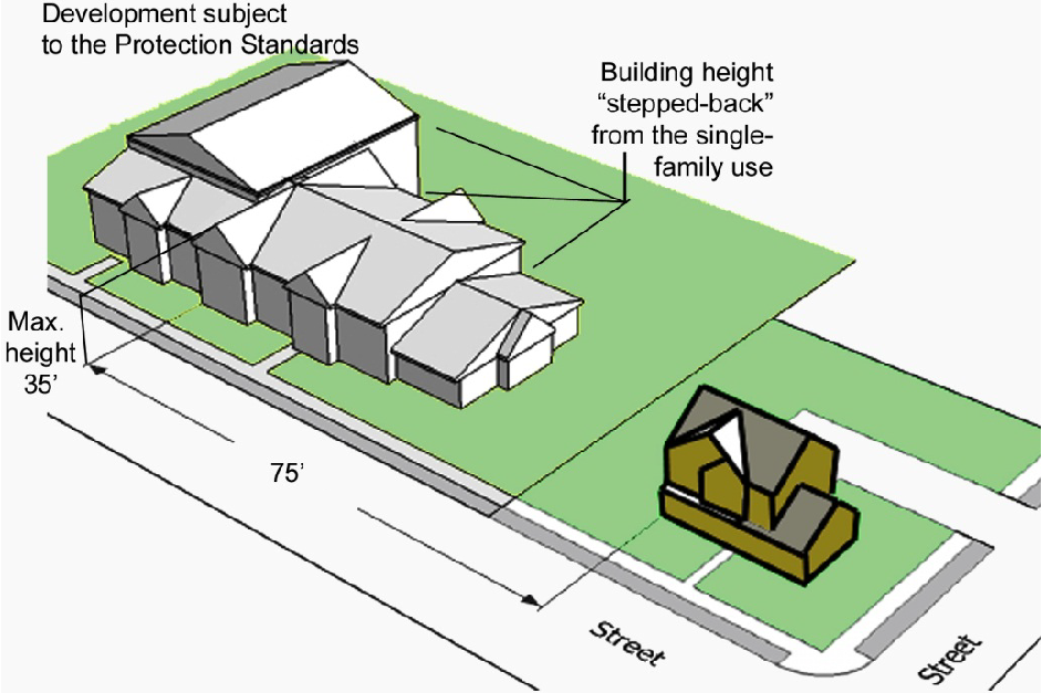
Figure 6.11.C.3: Building height modulation.
4.
Building Massing and Articulation.
a.
Massing.
i.
Building facades facing single-family detached dwelling, duplex, or townhouse subdivision shall be configured to appear as a series of distinct building modules, storefronts, wings, projections, or recesses meeting the following standards:
(a)
Each individual module, storefront, wing, projection, or recess shall maintain a minimum width of at least 20 feet and a maximum width of 40 feet (see Figure 6.11.C.4.a: Building massing.).
(b)
Projections or recesses shall maintain a minimum offset of two feet from the primary building façade wall plane.
ii.
Exterior, open corridors facing a single-family detached dwelling, duplex, or townhouse subdivision are prohibited on multifamily and visitor accommodation building facades.
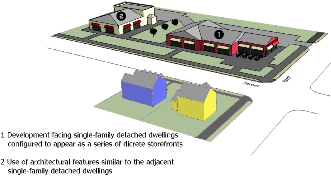
Figure 6.11.C.4.a: Building massing.
b.
Architectural Features. Buildings subject to these standards shall use similarly sized and patterned architectural features such as windows, doors, awnings, arcades, pilasters, cornices, and other building features found on adjacent single-family detached dwelling, duplex, or townhouse subdivision development.
5.
Building Roof Form.
a.
Buildings subject to these standards shall include roof forms that incorporate changes in roof plane or slope with at least a three-foot projection, recess, ridge or valley no less than every 30 feet, overhanging eaves at least five feet wide, or parapet walls with three-dimensional cornices.
b.
Structures on lots abutting a single-family detached dwelling, duplex, or townhouse subdivision shall maintain a pitched roof within 100 feet of the lot line shared with such development.
c.
All roof-mounted equipment shall be configured so as to avoid or minimize its view from adjacent streets and single-family detached dwellings, duplexes, or townhouse subdivisions to the maximum extent practicable.
6.
Building Materials.
a.
Glazing. Building facades facing single-family detached dwelling, duplex, or townhouse subdivision development shall incorporate glazing in accordance with Table 6.11.C.6.a, Glazing Standards:
b.
Colors.
i.
Building facades shall incorporate a coordinated color scheme consisting primarily of matte finishes.
ii.
Glossy paint finishes may be used for trim and accents; fluorescent or metallic paint is prohibited.
iii.
Colors and finishes shall be consistent throughout an individual development.
c.
Exterior Materials. Facades facing single-family detached dwelling, duplex, or townhouse subdivision development shall comply with the following exterior materials standards:
i.
Materials and material configurations shall be consistent with those commonly used on single-family detached dwellings, duplexes, and townhouse subdivisions in the City.
ii.
Plywood, concrete block, and corrugated metal are prohibited as exterior materials.
iii.
Split-face masonry unit and vinyl siding shall not exceed 25 percent of a building façade.
7.
Site Features.
a.
Loading, Service, and Refuse Collection Areas. Loading, service, and refuse collection areas shall be:
i.
Screened from view of single-family detached dwellings, duplexes, and townhouse subdivisions using materials that are the same as, or of equal quality to, the materials used for the principal building; or
ii.
Incorporated into the overall design of the site so that the visual and acoustic impacts of these functions are fully contained within an enclosure or are otherwise out of view from adjacent properties and public streets.
b.
Drive-Through Service Facilities.
i.
In no instance shall a drive through or pick-up window be located on a building façade that faces a single-family detached dwelling, duplex, or townhouse subdivision.
ii.
Order boxes associated with a drive through or pick-up window shall be at least 300 feet from a lot containing a single-family detached dwelling, duplex, or townhouse subdivision.
c.
Exterior Lighting. Exterior lighting shall:
i.
Have a maximum height of 15 feet if within 50 feet of a lot containing a single-family detached dwelling, duplex, or townhouse subdivision development and 25 feet if within between 50 and 100 feet of such lot; and
ii.
Be configured so that the source of illumination is not visible from public street right-of-way or an adjacent single-family detached dwelling, duplex, or townhouse subdivision development.
d.
Signage Standards.
i.
To the maximum extent practicable, signage shall be located a minimum of 50 feet from lot lines shared with a single-family detached dwelling, duplex, or townhouse subdivision.
ii.
Within 50 feet of lot lines shared with a single-family detached dwelling, duplex, or townhouse subdivision, the maximum sign copy area for freestanding, ground, and wall signs shall be reduced by 25 percent.
iii.
Signage within 20 feet of a lot line shared with a single-family detached dwelling, duplex, or townhouse subdivision shall be limited to directional or incidental signage.
e.
Open Space Set-Asides.
i.
Required open space set-asides shall be located between a proposed development and an adjacent single-family detached dwelling, duplex, or townhouse subdivision to the maximum extent practicable.
ii.
Outdoor recreation features such as swimming pools, tennis courts, playgrounds, and similar features shall be at least 50 feet from any lot line shared with a single-family detached dwelling, duplex, or townhouse subdivision.
f.
Utilities. All utilities serving individual buildings or developments shall be located underground.
8.
Perimeter Fence or Wall.
a.
Where a multifamily residential or institutional development abuts a single-family detached dwelling, duplex, or townhouse subdivision, an opaque fence six feet high shall be provided along the perimeter of the development site to help screen the development from view of the single-family detached dwelling duplex, or townhouse subdivision, in addition to the perimeter buffer standards of Section 6.6, Perimeter Buffers.
b.
Where a commercial, industrial, or mixed-use development abuts a single-family detached dwelling, duplex, or townhouse subdivision, an opaque wall six feet high shall be provided along the perimeter of the development site to help screen the development from view of the single-family detached dwelling, duplex, or townhouse subdivision, in addition to the perimeter buffer standards of Section 6.6, Perimeter Buffers.
9.
Operational Standards. Development subject to these standards shall:
a.
Prohibit outdoor dining or other outdoor activities within 100 feet of single-family detached dwellings, duplexes, and townhouse subdivisions after 10:00 p.m. Sunday through Thursday nights and midnight on Friday and Saturday nights;
b.
Limit trash collection or other service functions to only between the hours of 7:00 a.m. and 7:00 p.m.; and
c.
Extinguish amplified music, singing, or other forms of noise audible at lot lines shared with single-family detached dwellings, duplexes, and townhouse subdivisions after 10:00 p.m. Sunday through Thursday nights, and 12:00 p.m. Friday and Saturday nights.
(Ord. No. 2025-109, § 1, 3-19-2025)
Sec. 6.12. - Building Design and Maintenance Standards.
A.
Purpose. The purpose of these standards is to protect the City's appearance for residents, tourists, and visitors; enhance desirability of property investment; foster civic pride and community spirit; and stabilize and improve property values and prevent potentially blighting influences.
B.
Graffiti. All buildings, structures, and walls in the City shall be maintained in a secure and attractive condition, free from graffiti. No letters, symbols, or other markings shall appear on exterior surfaces unless permitted in accordance with Section 6.10, Signage.
C.
Exterior Color and Design Standards on Major City Thoroughfares.
1.
Applicability. All new development on land abutting a major City thoroughfare—except single-family detached and duplex dwellings, buildings in Redevelopment Areas and Historic Overly (HO) districts, and walls or roofs that are not visible from major City thoroughfares—shall conform to the requirements of this section.
2.
Modifications of Certain Design Requirements.
a.
City staff may authorize minor modifications of numerical standards in Sections 6.12.C.4.b—d, e, g, and h below through an Administrative Adjustment (see Section 3.4.W).
b.
City staff may authorize minor modifications of non-numerical standards in Sections 6.12.C.4.b, d, e, g, and h below only on determining that:
i.
Application of the standard creates practical difficulties in allowing development that otherwise advances the purposes served by the standards; or
ii.
Approval of the modification allows alternative design that is equal to or better than that afforded by strict adherence to the dimensional or design standards of this section; or
iii.
There is some unusual aspect of the development site or the proposed development that is not shared by landowners generally which necessitates the modification.
c.
City staff decisions on whether to authorize minor modifications of standards in Sections 6.12.C.4.b, d, e, g, and h below are appealable to the Planning Board in accordance with Section 3.4.Y, Appeal.
d.
In deciding such an appeal, the Planning Board may waive or modify the standard to the extent necessary.
3.
Building Elevations Required. For all new development, color drawings of the building elevations shall be submitted with color chips for all walls, awnings, and accent colors proposed, as part of the site plan submitted for review. Where only repainting of an existing structure is proposed, photographs may be submitted in lieu of building elevations.
4.
Design Requirements.
a.
Walls and roofs shall be staggered by changes in surface planes and architectural features to avoid a monolithic "box" appearance.
b.
The sides of buildings which are less than 200 feet wide shall comply with the following:
i.
Walls shall have changes of planes with at least a three-foot projection or recess no less than every 30 horizontal feet. If columns or pairs of columns, constructed in front of a wall, make up a width of at least three feet wide, such architectural features shall count toward satisfying the changes of wall planes; and
ii.
Walls shall have at least one of the following architectural features integrated no less than every 30 horizontal feet:
(a)
Porches;
(b)
Awnings;
(c)
Covered stairwells;
(d)
Doors;
(e)
Windows;
(f)
Chimneys;
(g)
Columns or pilasters;
(h)
Changes in construction materials;
(i)
Sun-shading devices, such as walls, canopies, and similar devices, which extend a minimum of three feet beyond the wall of adjacent walls, are acceptable.
iii.
Architectural features that are not acceptable as a means to comply with the features listed above include, but are not limited to: gutter downspouts; garage doors; retaining walls; changes in paint color, color bands or small (less than two square feet) accent colors or materials; narrow trim; shutters; and narrow extensions (less than three feet wide) of fire walls.
c.
The sides of buildings which are 200 feet or more wide shall comply with the following:
i.
Walls shall have changes of planes with at least a three-foot projection or recess no less than every 50 horizontal feet. If columns or pairs of columns, constructed in front of a wall, make up a width of at least three feet wide, such architectural features shall count toward satisfying the changes of wall planes; and
ii.
Walls shall have at least one of the architectural features listed in Section 6.12.C.4.b.ii above integrated no less than every 50 horizontal feet.
d.
Walls shall not be comprised of aluminum, metal, or flat-faced concrete block, unless such materials are used for minor accents comprising less than ten percent of the wall.
e.
Walls shall have windows that make up at least 15 percent of the wall.
f.
Highly reflective surfaces such as reflective glass and reflective metal roofs with a pitch more than a run of seven feet to a rise of 12 feet shall not be used. Solar panels and copper or painted metal roofs shall be permitted.
g.
Roofs shall have multiple rooflines if the building is more than 30 feet wide.
h.
Roofs which are less than 200 feet wide shall have changes of planes with at least a three-foot projection, recess, ridge, or valley no less than every 30 feet. Roofs which are 200 feet or more wide shall have changes of roof planes with at least a three-foot projection, recess, ridge, or valley no less than every 50 feet. Elevator shafts and mechanical rooms shall not satisfy this requirement.
i.
Except as specifically permitted herein, architecture as signage is prohibited. Buildings shall not be designed in a way in which the building's wall surface, through color or appearance, is a sign. All areas for signage shall be part of the site or building design.
j.
Dumpsters and mechanical equipment such as air conditioners and compressors shall be screened from public view. The screening design shall be compatible with and part of the building design.
k.
The ground floor level of buildings where pedestrian activity may occur shall include elements of pedestrian interest. Display windows for retail shops and courtyards are suggested. Uses which visually disrupt the continuity of pedestrian movement such as open parking lots, parking structures, and rear or delivery portions of buildings shall be avoided.
l.
Building color should reinforce the style of the building. The color shall complement the design and not be so extreme that the color competes with the building for attention. Colors shall be earth tones or pastels having a minimum light reflectance value (LRV) of 70. Other colors may be permitted as accent, not to exceed 20 percent of the surface area of any one elevation. Fluorescent colors are prohibited.
m.
Building entrances shall be protected from the elements and give clear identity to the entrance.
n.
If the use requires loading docks, garage doors, or mini-storage buildings and site conditions require them to be located along a major City thoroughfare, then they shall be screened using landscaping or architectural features.
D.
Minimum Maintenance Standards for Commercial, Multifamily, and Oceanfront Property. Commercial and multifamily developments abutting major City thoroughfares and oceanfront lots shall comply with the maintenance requirements of this subsection.
1.
All parts of a building, fencing, or other structures that are visible from a public right-of-way or the beach shall be structurally sound. Rotten or weakened portions and portions that have been vandalized shall be removed, repaired, or replaced in a manner compatible with the rest of the structure and any applicable adopted design guidelines.
2.
Buildings will present a neat and fresh appearance and be free of all peeling paint, mildew, graffiti, or dirt.
3.
Nonfunctional elements on the building fronts such as empty electrical conduit, unused sign brackets, etc., shall be removed, and the building surface shall be repaired or rebuilt to match adjacent surfaces and original condition. All loose wires shall be secured.
4.
Broken or missing windows shall be repaired or replaced with glass.
5.
Awnings that are torn, badly faded, or structurally compromised shall be repaired, replaced, or removed.
6.
Roofs and existing gutters and downspouts shall be maintained to prevent damage to the structure and adjoining properties and the public.
7.
Retaining walls, seawalls, nonstructural walls, dumpster enclosures, fences, lighting devices and support, outdoor service and seating areas, and signs and their supporting elements shall be structurally sound and kept free of graffiti, overgrowth, trash, and debris, and shall be maintained to present a painted, rust-free, neat, and fresh appearance.
8.
Parking areas, lawn and landscape areas, and vacant lots are to be kept free of overgrowth, weeds, trash, and debris. Potholes and cracked and broken pavement shall be repaired. Paving shall be properly sealed. Striping shall be maintained in a neat and clean appearance. All dead tree limbs and dead trees shall be removed. Sand barriers shall be provided using vinyl fencing or other approved materials.
9.
Landscaping shall be kept in a neat and well-maintained manner with a sufficient quantity and density of healthy plant materials to present a lush and well-designed appearance.
10.
A Certificate of Occupancy shall not be issued until the site is clear of construction equipment and materials, including piles of dirt and gravel, portable toilets, paint cans, concrete forms, construction debris, construction fencing, construction office trailers, and storage trailers.
(Ord. No. 2022-282, § 5, 7-20-2022)
Sec. 6.13. - Community Form Standards.
A.
Purpose and Intent. The purpose and intent of this section is to establish community form standards for development in the greenfield and under-developed portions of the City. More specifically, this section is intended to:
1.
Support street development as an integral component of community design;
2.
Provide safe, efficient, and convenient vehicular, bicycle, and pedestrian access and circulation patterns within and between developments;
3.
Maintain the carrying capacity of the county's major arterial streets;
4.
Foster a pedestrian-friendly distribution of land uses and street network;
5.
Assure safe access to and from streets by emergency vehicles; and
6.
Reduce interference with through traffic by other vehicles, bicycles, or pedestrians entering, leaving, and crossing streets.
B.
Applicability.
1.
General. Unless exempted in accordance with paragraph 4 below, or except where otherwise expressly stated, the standards in this section apply to all new development west of Interstate 95.
2.
Time of Review. Review for compliance with the standards in this section shall take place as part of the review of an application for:
a.
Planned Development (see Section 3.4.F);
b.
Special Use Permit (see Section 3.4.G);
c.
Public or Semipublic Use Permit (see Section 3.4.H);
d.
Site Plan (see Section 3.4.I);
e.
Certificate of Appropriateness (see Section 3.4.J); or
f.
Building Permit (see Section 3.4.R).
3.
Conflict. In the case of conflict between these standards and other standards in this Code, the more restrictive standard shall control. The more restrictive standard shall be the one that further limits development potential, seeks to provide a greater measure of compatibility protection, or retains or protects existing native vegetation or natural resources.
4.
Exemptions. The following forms of development are exempt from the standards in this section:
a.
Development on a single lot or tract where no new street rights-of-way are proposed; and
b.
Development where no modifications to existing street rights-of-way are proposed.
C.
Street Standards. All streets shall be developed in accordance with the standards in this section and the standards in Section 7.2.D, Streets.
D.
Internal Street Connectivity.
1.
Minimum Connectivity Index Score Required. All development subject to these standards shall achieve an internal street connectivity score in accordance with Table 6.13.D.1, Minimum Street Connectivity Index.
2.
Connectivity Index Score Calculation. The connectivity index for a development is calculated by dividing its links by its nodes. Figure 6.13.D.2 provides an example of how to calculate the connectivity index. Nodes (stars) exist at street intersections and cul-de-sac heads within the development. Links (circles) are stretches of road that connect nodes. Street stub-outs are considered as links, but temporary dead-end streets internal to a development or alleys are not counted as links. One link beyond every node that exists in the development and provides access to the street system outside the development shall be included in the index calculation. In the diagram, there are 36 links (circles) and 21 nodes (stars); therefore the connectivity index is 1.71 (36/21 = 1.71).
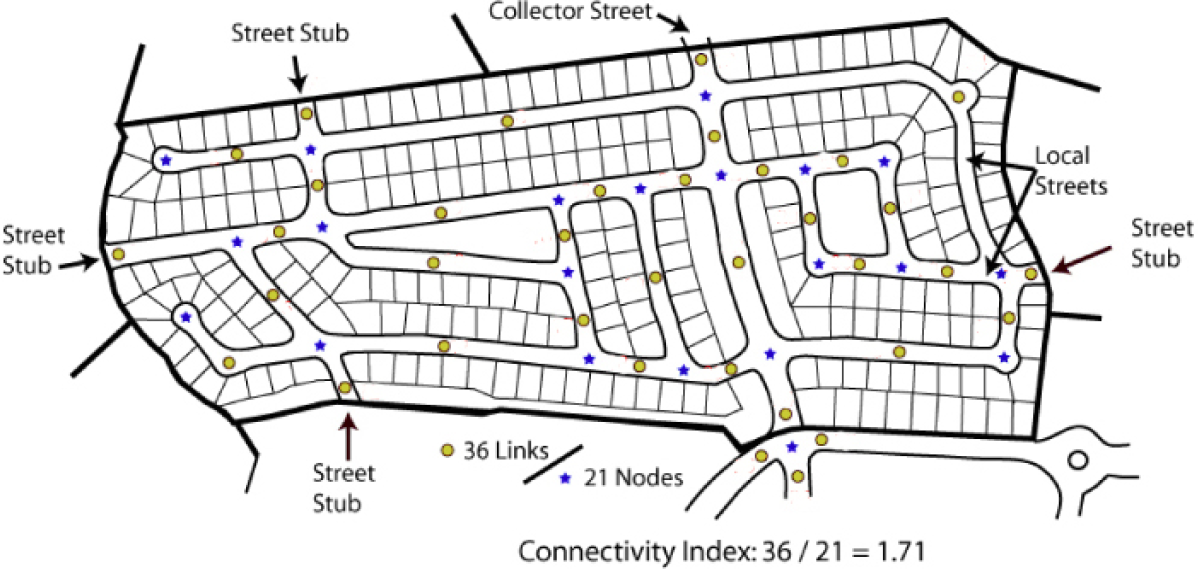
Figure 6.13.D.2: Street connectivity index.
3.
Reduction in Minimum Index Score. The minimum connectivity index score may be reduced if the owner/developer demonstrates it is not possible to achieve due to natural features, existing road configurations, or adjacent existing development patterns. In these instances, internal street design shall achieve as high a connectivity index score as reasonably practical.
4.
Pedestrian Connections Required.
a.
A right-of-way eight-feet-wide for pedestrian/bicycle access between a cul-de-sac head or street turnaround and the sidewalk system of the closest adjacent street or pedestrian pathway (as shown in Figure 6.13.D.4: Pedestrian connections.) shall be required whenever the City staff determines a proposed cul-de-sac or street turnaround:
i.
Is in close proximity with significant pedestrian generators or destinations such as schools, parks, trails, employment centers, or similar features; or
ii.
Creates an unreasonable impediment to pedestrian circulation.
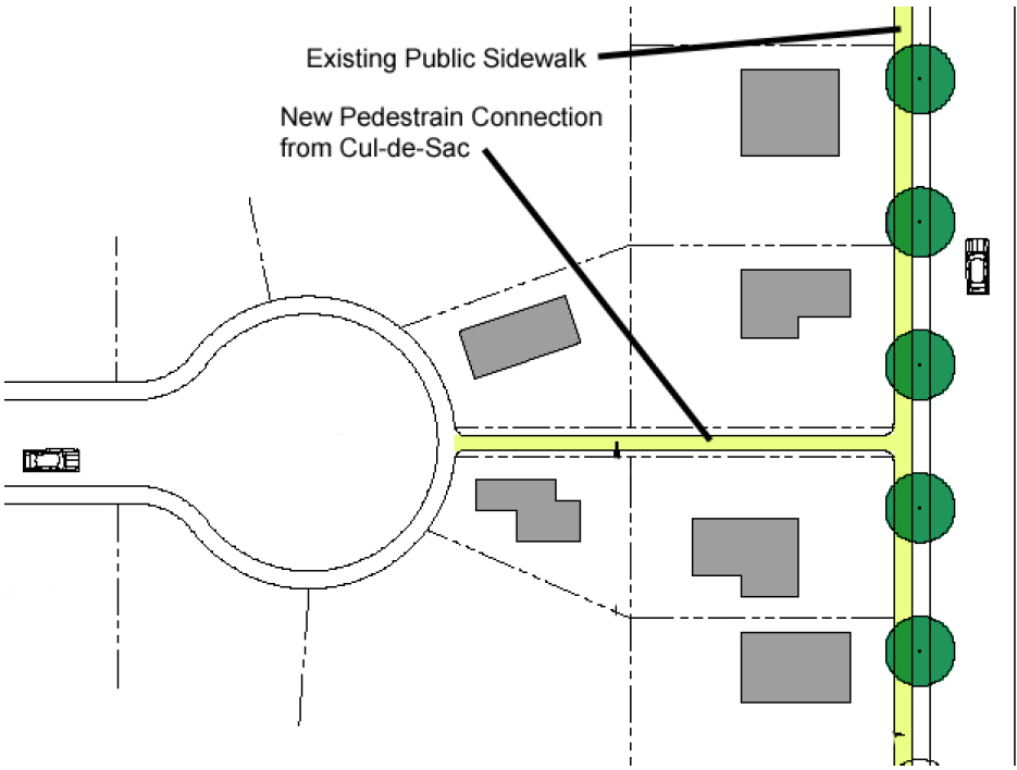
Figure 6.13.D.4: Pedestrian connections.
b.
This pedestrian connection shall count as a link for the purpose of calculating the connectivity index.
E.
External Street Connectivity.
1.
The arrangement of streets in a development shall provide for the alignment and continuation of existing or proposed streets into adjoining lands where the adjoining lands are undeveloped and deemed appropriate for future development in the comprehensive plan or are developed and include opportunities for such connections.
2.
Street rights-of-way shall be extended to or along adjoining property boundaries such that a roadway connection or street stub shall be provided for development where practicable and feasible in each direction (north, south, east, and west) for development that abuts vacant lands.
3.
At all locations where streets terminate with no street connection, but a future connection is planned or accommodated, a sign shall be installed with the words "FUTURE ROAD CONNECTION" to inform property owners.
4.
The final plat (see Section 3.4.K.5) shall identify all stub streets and include a notation that all street stubs are intended for connection with future streets on adjoining undeveloped or underdeveloped lands.
5.
Stub streets that exceed 150 feet in length shall include a turn-around.
F.
Continuation of Adjacent Streets. Proposed street layouts shall be coordinated with the existing street system in surrounding areas. Existing streets shall, to the maximum extent practicable, be extended to provide access to adjacent subdivisions and to provide for additional points of ingress and egress.
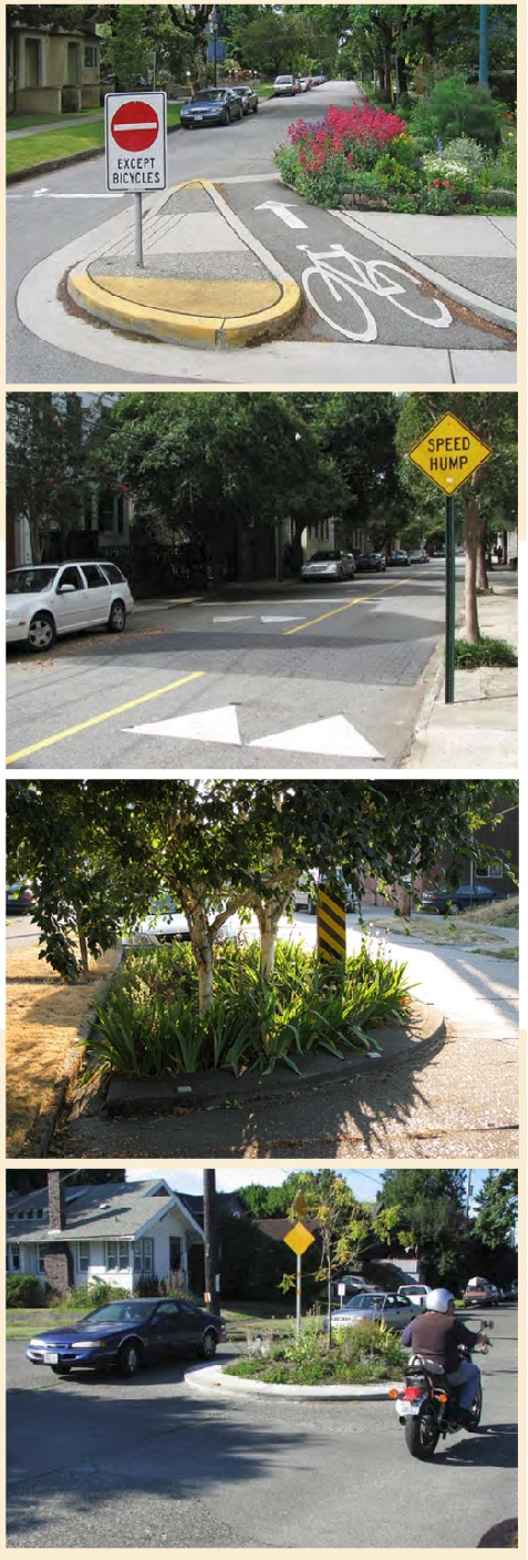
Figure 6.13.G, Traffic calming measures.
G.
Traffic Calming Measures.
1.
Minimal street widths, short block lengths, on-street parking, controlled intersections, roundabouts, and other traffic calming measures are encouraged on all local, and subcollector streets, provided they do not interfere with emergency vehicle access.
2.
Residential development organized around a grid street network shall employ measures to interrupt or terminate linear street segments over 800 linear feet long, to the maximum extent practicable (see Figure 6.13.G, Traffic calming measures.). Such measures shall include, but shall not be limited to:
a.
Stop signs at street intersections;
b.
Roundabouts, or traffic circles;
c.
Curvilinear street segments to slow traffic and interrupt monotonous streetscapes;
d.
Roadway striping to limit vehicular cartway widths or accommodate bike lanes; and
e.
Speed tables or elevated pedestrian street crossings.
3.
Sidewalk bulb-outs are discouraged on streets less than 28 feet wide, but are encouraged on wider streets as a traffic calming device and to reduce crossing distance for pedestrians, where practicable.
H.
Block Design.
1.
Block Length. Block length shall be at least 200 feet, but no more than 1,000 feet. City staff may allow deviations from these block length standards on determining that:
a.
Environmental or topographic constraints exist;
b.
The site has an irregular shape;
c.
A longer block will reduce the number of railroad grade or water body crossings; or
d.
Longer blocks will result in less traffic through residential subdivisions from adjoining businesses or areas.
2.
Block Width. To the maximum extent practicable, the width of any block shall be sufficient to permit at least two tiers of lots of appropriate depth for the zoning district exclusive of any public alleys, watercourses, or other right-of-way located outside platted lots.
3.
Mid-Block Access. In cases where a block length exceeds 800 feet, sidewalks or multi-use paths shall be provided mid-block to connect parallel sidewalks on the long side of the block.
I.
Development Entry Points.
1.
Unless exempted in accordance with paragraph 3 below, all subdivisions shall provide access from the development to the street system outside the development in accordance with Table 6.13.I, Required Subdivision Access:
2.
Nothing in this section shall limit the total number of streets providing access to the street system outside a development, or exempt a development from meeting all applicable external street connectivity standards.
3.
Development shall be exempted from these standards if it is demonstrated the following conditions apply:
a.
No other street access points can be located due to existing lot configurations, absence of connecting streets, environmental, or topographic constraints;
b.
FDOT will not authorize the required number of entrances; or
c.
Alternative access can be provided in a manner acceptable to the City that is supported by a transportation impact analysis.
J.
Sidewalks. Sidewalks shall be required along streets in accordance with Section 7.2.E, Sidewalks.
K.
Street Trees. Street trees shall be required to serve all development in the City in accordance with the following:
1.
Where Required. Except where exempted in paragraph 2 below, street trees shall be required along both sides of all streets with a service level of collector or above.
2.
Exemptions. Street trees shall not be required for:
a.
Agricultural uses in the AG district, except when agricultural land is subdivided for new residential development; or
b.
Lots for single-family detached dwellings.
3.
Location.
a.
All street trees shall be planted between the back of the curb and the sidewalk (see Figure 6.13.K.3, Street tree placement.).
Figure 6.13.K.3, Street tree placement.
b.
In cases where street trees cannot be planted between the curb and the sidewalk, applicants shall contact the City staff for approved street tree locations in the public right-of-way.
4.
Configuration.
a.
Street trees shall be shade trees except beneath overhead utilities or other projections into the public right-of-way, where small trees shall be used instead.
b.
All trees planted along FDOT rights-of-way shall conform to FDOT guidelines.
c.
A root barrier shall be installed around the roots of trees where adjacent to a curb or sidewalk.
5.
Maximum On-Center Spacing.
a.
Shade trees shall be spaced between 40 and 50 feet on center.
b.
Small trees shall be spaced between 20 and 30 feet on center.
6.
Street Trees as Private Encroachments. Upon the request of a subdivision developer, the City Commission may authorize the developer to plant street trees when not otherwise required above, as private encroachments into the public right-of-way in accordance with Section 6.3.I.
(Ord. No. 2022-282, § 6, 7-20-2022)
Sec. 6.14. - Redevelopment Area Standards.
A.
Purpose.
1.
The purpose of this section is to promote the public health, safety, and welfare by establishing minimum design and maintenance standards for structures in Redevelopment Areas included in the community redevelopment plans adopted by the Daytona Beach City Commission. The minimum standards are required to eliminate existing blight, preserve the economic value of property in the area, prevent the spread of blight into other areas of the City, and promote the general health, safety, and welfare of the City's citizens.
B.
Applicability.
1.
These standards shall be applicable to all commercial and residential structures—except structures scheduled for demolition—that are located within Redevelopment Areas or along an arterial road where at least one side of the road is within a Redevelopment Area.
2.
These standards shall apply to any new construction and any work, alteration, improvement, rehabilitation, renovation, or maintenance of such commercial and residential structures and to any change to the exterior appearance of such structures, or any portion thereof, that would affect the structure's color, exterior materials, height, or appearance—including any change in signage.
3.
Written City approval shall be required prior to commencement of any work, except emergency repairs necessary for safety purposes, subject to these regulations.
4.
Nothing herein shall be construed to permit any sign, construction, alteration, rehabilitation, renovation, or maintenance otherwise forbidden, restricted, controlled, or otherwise required by any other law.
C.
Design Guidelines.
1.
General Guidelines. When considering a request for development within any Redevelopment Area, the Redevelopment Board shall consider the extent to which the following design guidelines are implemented:
a.
The development should be designed with appropriate scale relationships between buildings and adjacent open space features—i.e., Boardwalk Park, Riverfront Park, marinas, ocean, plazas, etc.
b.
Structures should be designed to create transitions in form and scale between large buildings and adjacent smaller buildings that are not slated for redevelopment or areas of less intense development.
c.
Structures should be designed to provide significant views for occupants.
d.
Building materials and design features should promote a sense of permanence and diversity of style and detail.
e.
Rooftops should be useable outdoor space, designed to accommodate commercial or recreational activities.
f.
Structures should be designed with consideration for the effects of environmental factors such as sun, wind, noise, shadow, and reflection on the quality of outdoor space.
g.
Visual interest should be incorporated into the design of structures with large street-facing facades. Significant architectural features should provide appropriate scale by dividing the facade into parts or establishing a rhythmic pattern along the facade. Where pedestrian activity is a potential, elements of pedestrian interest such as display windows, retail shops, and courtyards are encouraged. Uses that visually disrupt the continuity of pedestrian movement—such as open parking lots, parking structures, rear or delivery areas of buildings—should be avoided.
h.
Structures should be designed to reduce barriers between indoor and outdoor activity spaces.
i.
The structure should be terraced to provide light and air passage, enhance the attractiveness of the building, and avoid development of a monolithic block structure.
j.
The development architecture, signage, and materials shall be high quality and not conflict with adjoining structures. Characteristics of surrounding architecture should be repeated or adapted in the design of new structures.
k.
Hard lines of the structure facing abutting public areas shall be softened through the use of awnings, canopies, landscaping, and architectural devices such as terracing or curved lines.
l.
Landscaped open space and plazas accessible to the public should be incorporated into the design of a functional group of buildings.
m.
In intensely commercial areas, structures should be designed to accommodate multiple levels of pedestrian activity.
n.
Installation of significant facade shutters, screens, blinds, security grills, and awnings shall be historically appropriate and not detract from the character of the building.
2.
Requirements for Temporary Activities. The following requirements shall apply to proposals for temporary outside activities on property where a structure was demolished after September 1, 1997, and the lot or parcel remains vacant or has been developed as a parking lot.
a.
For vacant lots or parcels:
i.
Onsite stormwater retention shall be provided, and no credit shall be given for pre-existing impervious surfaces;
ii.
All portions of the lot or parcel not used for stormwater or landscaping shall be paved with concrete unit pavers, brick or approved equivalent on a minimum four-inch concrete base;
iii.
Palm trees with a minimum 12 foot clear trunk must be installed along all street frontage, with metal street grates and spaced a minimum of ten feet apart; and
iv.
The entire lot or parcel shall be fenced in ornamental or vinyl picket fencing.
b.
Parking lots, excluding temporary parking lots, shall be landscaped, including required trees, and irrigated to meet or exceed the requirements for parking lots set forth in Section 6.1, Restrictions on Outside Activities and Uses. In addition, parking lots permitted on or after October 1, 2002, shall provide on-site stormwater retention and shall be paved as set forth in provisions [a.i] and [a.ii] above.
D.
Building Fronts and Sides Abutting Streets or Public Areas.
1.
All deteriorated structural and decorative elements visible from a public right-of-way shall be repaired or replaced to match as closely as possible the original materials and construction of that building. Changes shall be allowed where required or encouraged by the redevelopment program for the area.
2.
Every part of a structure visible from a public right-of-way or abutting a street shall be made structurally sound. Rotten or weakened portions shall be removed, repaired, or replaced in a manner compatible with the rest of the structure, or to match the original materials and construction techniques. All exposed wood shall be stained or painted. Every part shall be clean of graffiti, litter, dirt or other debris. Where surfaces are painted, once painted or normally painted, not more than ten percent of the surface may be free of paint.
3.
Existing miscellaneous nonfunctional elements on the building fronts, such as empty electrical conduits and unused sign brackets, shall be removed and the building surface shall be repaired or rebuilt as required to match adjacent surfaces and original condition.
4.
Mildew shall be cleaned from building fronts, and loose wires (such as TV cable) shall be secured.
5.
Any telephones placed outside must be approved in accordance with redevelopment guidelines. Telephones shall not encroach into the public right-of-way without approval of the City Commission. Telephones on building fronts are prohibited along Beach Street between Fairview Avenue and South Street, along Main Street between the ocean and the river, and along Dr. Mary McLeod Bethune Boulevard and Dr. Martin Luther King Boulevard within the Midtown Redevelopment Area.
E.
Rear and Side Walls.
1.
Rear and side walls shall be repaired and painted to present a neat and fresh appearance. Rear walls should be painted to cover evenly all miscellaneous patched and filled areas or be stuccoed to present an even, uniform surface.
2.
Side walls visible from the street shall be finished or painted so as to be harmonious with the front of the building.
F.
Windows.
1.
Every broken or missing window shall be repaired or replaced with glass.
2.
All windows must fit tightly and have sashes of proper size and design. Sashes with rotten wood, broken joints, or loose mullions or muntins shall be replaced.
3.
Window openings in upper floors of the front of the building shall not be filled or boarded up. Window panes shall not be painted.
G.
Show Windows.
1.
A show window shall include the building face, porches, and entrance area leading to the door, sidelights, transoms, display platform, devices, lighting, and signage designed to be viewed from the public right-of-way.
2.
Show windows, entrances, signs, lighting, sun protection, awnings, porches, security grills, etc., shall be compatible and harmonious with the original scale and character of the structure. All show window elements must be located within their original opening dimension.
3.
Show windows with aluminum trim, mullions, or muntins not consistent or compatible with the overall facade design shall be replaced or painted.
4.
The view of merchandise in show windows or through show windows into the interior of an occupied retail store or restaurant shall remain unobstructed between the hours of 9:00 a.m. and 11:00 p.m. every day. This paragraph shall not apply during a period of severe storms or severe storm warnings.
5.
The view into vacant buildings shall be of a broom swept, uncluttered, and well-maintained vacant building. Blinds or draped material may be installed behind the glass to limit the view inside the building.
H.
Awnings.
1.
Soft retractable flameproof awnings are permitted over the first floor and on upper floors above windows only. They shall not project more than six feet from the building front, shall not be lower than seven feet above grade and shall terminate against the building at a height not to exceed 14 feet above the pavement, except upon approval of the Redevelopment Board for the Redevelopment Area in which the structure is located.
2.
Rigid or fixed awnings or canopies are not permitted unless they are original or newly designed as an integral part of the structure, compatible and harmonious with the scale and character of the structure and adjacent structures, and pose no visual impediment to adjacent buildings. New rigid or fixed awnings or canopies may be added to existing structures subject to these restrictions upon approval of the Redevelopment Board for the Redevelopment Area in which the structure is located.
3.
Awnings that are torn, badly faded, or structurally compromised shall be repaired or replaced.
I.
Roofs.
1.
Chimneys and all other rooftop structures shall be repaired and cleaned as required for rear and side walls. Any construction visible from the street or from other buildings shall be finished so as to be harmonious with other visible building walls. Television and radio antennas, pipes, ductwork, and mechanical equipment such as air conditioning units shall be located to be as inconspicuous as possible.
2.
All roofs and existing gutters and downspouts shall be maintained to prevent damage to the structure, adjoining properties, and the public.
J.
Accessory Structures.
1.
Structures to the rear of the principal commercial structure, whether attached or unattached to the primary structure, that are structurally deficient shall be properly repaired or demolished.
2.
All fences, lighting devices and supports, retaining walls, nonstructural walls, outdoor service and seating areas, and signs and their supporting elements shall be made structurally sound; kept free of overgrowth, trash, and debris; and be repaired to present a neat and finished appearance.
3.
Repairs made to all painted fences and walls must be repainted to match the existing fence color to the closest extent possible.
4.
Only newspaper vending machines that are well maintained and stocked shall be allowed in the public right-of-way. Machines dispensing advertising circulars shall not be located in or within view of the public right-of-way.
K.
Vacant Lots. Where a vacant lot exists or is created through demolition, the owner shall landscape and screen the property from adjacent streets, alleys, and public improvement areas. All vacant lots shall be covered with grass or other suitable vegetation approved for the property by the staff. The ground cover shall be maintained and the property kept free of trash and debris.
L.
Temporary Coverings. No temporary covering of any part of a structure may remain for more than 15 days after ongoing construction has been completed, or for a total of 60 days, whichever is longer. An example of a temporary covering is a board covering a broken or missing window.
M.
Green Areas and Parking Areas.
1.
All green yard areas shall be kept free of overgrowth, weeds, trash, and debris. All dead tree limbs and dead trees shall be removed.
2.
All parking areas shall be kept free of overgrowth, weeds, trash, and debris. Paving and striping shall be maintained in a neat and clean appearance.
N.
Other Repairs. All other repairs to a building determined necessary to safeguard the health and safety of possible building occupants shall be made in accordance with applicable sections of the Building Code.
O.
Continued Inspections. All properties and structures shall remain in compliance with these requirements until the City of Daytona Beach declares the area to be no longer a community Redevelopment Area. The City's redevelopment staff shall periodically monitor affected properties and enforce these standards.
P.
Time Period for Compliance.
1.
If the total project cost to bring a structure into compliance is $5,000 or less based on contractor estimates, the owner of the structure or the owner's representative shall apply for a Building Permit within 30 days after the date of receipt of written notice of noncompliance from the City. All the work required to bring the structure into compliance shall be completed within 60 days after issuance of the Building Permit.
2.
If the total project cost to bring a structure into compliance will exceed $5,000 based on contractor estimates, the owner of the structure or the owner's representative shall submit plans for review by staff within 90 days after the date of receipt of written notice of noncompliance from the City. Repairs shall be completed within 180 days after approval of the plans.
3.
Any structure that is damaged by fire, accident, or act of God shall be repaired or demolished. The owner of such a structure shall, within 90 days after damage, present proposed construction plans to staff for review. Damaged structures shall be brought into compliance within one year after approval of construction plans.
Q.
Review Procedures.
1.
Plans shall be submitted for all proposed work subject to these requirements. Such plans shall include drawings, specifications, and sketch elevations indicating the appearance of the structure, height, mass, exterior building material type, location, size and type of all signs, and significations or examples showing the color scheme proposed for the exterior of the structure.
2.
Where the total project cost exceeds the assessed value of the building, plans for exterior rehabilitation or exterior changes shall be reviewed by the Redevelopment Board for the area.
3.
Where the total project cost is less the assessed value of the building, plans for exterior rehabilitation or exterior changes shall be submitted to the Redevelopment Board for the area if requested, in writing, by the applicant or if the project will have a major visible impact on the Redevelopment Area.
4.
No variances from the requirements of this section shall be granted.
(Ord. No. 2022-413, § 2, 10-19-2022)
Sec. 6.15. - Environmental Protection.
A.
Tree Preservation.
1.
Purpose and Intent. The purpose and intent of this section is to:
a.
Preserve the visual and aesthetic qualities of the City;
b.
Encourage site design techniques that preserve the natural environment and enhance the developed environment;
c.
Provide for a separation of uses and establish a sense of privacy;
d.
Minimize the impact of incompatible land uses;
e.
Reduce glare, dust, heat, and noise;
f.
Preserve and enhance air and water quality;
g.
Increase slope stability, and control erosion and sediment run-off into streams and waterways;
h.
Conserve energy by reducing heating and cooling costs; and
i.
Maintain and enhance the quality of life in the City.
2.
Applicability.
a.
General. Unless exempted in accordance with subparagraph [c] below, the standards in this section shall apply to all development in the City.
b.
Time of Review. Review for compliance with the standards in this section shall take place as part of the review of an application for the following (as appropriate):
i.
Tree Removal Permit (see Section 3.4.L);
ii.
Planned Development (see Section 3.4.F);
iii.
Special Use Permit (see Section 3.4.G);
iv.
Public or Semipublic Use Permit (See Section 3.4.H);
v.
Site Plan (see Section 3.4.I); or
vi.
Building Permit (see Section 3.4.R).
c.
Exemptions. The following tree removal activities are exempt from the requirements of this section:
i.
Land disturbing activities and tree removal, relocation, or substantial alteration in accordance with a Special Use Permit, Public or Semipublic Use Permit, Major or Minor Site Plan, Certificate of Appropriateness, Major Subdivision Preliminary Plat, Minor Subdivision Plat, Sign Permit, or Building Permit;
ii.
Removal of trees that have been planted and are being grown in a plant nursery or botanical garden for the purpose of sale to the general public as landscaping material;
iii.
Removal of destroyed or effectively destroyed trees when ordered by City staff;
iv.
Emergency removal of trees that pose an immediate danger to life, limb, or property due to an accident or a storm or other act of nature, as determined by City staff;
v.
Removal of a nuisance tree, as defined by this Code;
vi.
The removal of diseased or dying historic or specimen trees, as certified by a qualified arborist;
vii.
The selective and limited removal of trees or vegetation necessary to obtain clear visibility within sight distance triangles.
3.
Minimum Requirements. All new development subject to this section shall:
a.
Ensure that at least 15 percent of the development or site area is occupied by trees in accordance with Section 6.15.A.4, Minimum Tree Coverage;
b.
Retain existing historic trees in accordance with Section 6.15.A.7, Protection of Historic Trees;
c.
Retain a portion of existing specimen trees in accordance with Section 6.15.A.6, Retention of Specimen Trees; and
d.
Maintain a minimum tree canopy coverage in accordance with Section 6.15.A.5, Retention of Existing Tree Canopy.
4.
Minimum Tree Coverage.
a.
All development subject to this section shall be configured so that at least 15 percent of the development or site area is occupied by tree canopy cover.
b.
The tree canopy cover required by this section shall be comprised of any combination of the following:
i.
The canopy of existing specimen trees, retained in accordance with Section 6.15.A.6, Retention of Specimen Trees;
ii.
The canopy of existing trees retained in accordance with Section 6.15.A.5, Retention of Existing Tree Canopy; and/or
iii.
The canopy of replacement trees provided in accordance with Section 6.15.A.9, Replacement/Mitigation Standards
c.
Compliance with this section shall be achieved through the retention and protection of existing trees, to the extent practicable.
5.
Retention of Existing Tree Canopy.
a.
Multifamily, Mixed-Use, and Nonresidential Development. All multifamily, mixed-use, and nonresidential development shall retain existing tree canopy in accordance with the following standards:
i.
At least six diameter inches of existing trees shall be retained and preserved for every 2,500 square feet of the total development site or tract. All trees (except historic trees or nuisance trees) with a minimum DBH of two and one-half inches may be used in meeting this requirement.
ii.
Specimen trees retained in accordance with Section 6.15.A.6, Retention of Specimen Trees, shall be used to meet this standard, to the maximum extent practicable.
iii.
Existing trees retained to meet this standard shall be located within a tree protection zone established in accordance with Section 6.15.A.8.b, Establishment of Tree Protection Zone, and protected in accordance with the standards in Section 6.15.A.8.c, Protection During Construction.
b.
Single-Family and Duplex Development. All lots within single-family detached and duplex developments subject to these standards shall retain existing tree canopy in accordance with the following standards:
i.
At least one tree for every 40 linear feet of lot frontage shall be retained;
ii.
Each lot shall maintain a minimum of one tree in accordance with these standards;
iii.
Retained trees shall be located within front yard areas; and
iv.
Each retained tree shall have a minimum DBH of two and one half inches or greater.
c.
Insufficient Trees to Meet Requirements. In the event the lot lacks a sufficient number of existing trees to meet the standards in this paragraph, replacement trees meeting the standards in Section 6.15.A.9, Replacement/Mitigation Standards, may be used.
d.
Inclusion within a Tree Protection Zone. Trees on multifamily, mixed-use, and nonresidential sites retained or added to meet this standard shall be located within a tree protection zone established in accordance with Section 6.15.A.8.b, Establishment of Tree Protection Zone, and protected in accordance with the standards in Section 6.15.A.8.c, Protection During Construction.
e.
Replacement/Mitigation of Damaged or Removed Tree Canopy. Damage or removal of trees comprising required existing tree canopy shall require compliance with the standards in Section 6.15.A.9, Replacement/Mitigation Standards.
6.
Retention of Specimen Trees.
a.
Specimen Trees Defined. For the purposes of this Code, a "specimen tree" is defined as any existing, healthy trees (except nuisance trees and pine trees) with a DBH of 12 inches or greater.
b.
Specimen Trees to be Retained. Development subject to this section shall retain a portion of existing specimen trees on the development site in accordance with Table 6.15.A.6.b, Retention of Specimen Trees:
c.
Inclusion within a Tree Protection Zone. Specimen trees retained to meet this standard shall be located within a tree protection zone established in accordance with Section 6.15.A.8.b, Establishment of Tree Protection Zone, and protected in accordance with the standards in Section 6.15.A.8.c, Protection During Construction.
d.
Replacement/Mitigation of Damaged or Removed Specimen Trees. Damage or removal of required specimen trees shall require compliance with the standards in Section 6.15.A.9, Replacement/Mitigation Standards.
7.
Protection of Historic Trees.
a.
Historic Trees Defined. For the purposes of this Code, a "historic tree" is defined as:
i.
An existing live oak (Quercus virginiana) or a bald cypress (Taxodium distichum) with a DBH of 36 inches or greater; or
ii.
An existing tree of any species with a DBH of 36 inches or greater that the City Commission determines to be of unique and intrinsic value to the general public because of its size, age, historic association, or ecological value; or
iii.
Any existing "champion tree" selected and duly designated at the State, national, or world level by the American Forestry Association.
b.
Protection Required. Except where allowed in subparagraph [c] below, all historic trees subject to this section shall be retained, during and after development, within a tree protection zone established in accordance with Section 6.15.A.8 Tree Protection Zone.
c.
Removal of a Historic Tree.
i.
Removal of a Healthy Historic Tree. If a historic tree is in healthy condition, it may be removed only if approved by the City Commission after demonstration that all of the following standards are met:
(a)
The landowner is otherwise in compliance with this section;
(b)
The historic tree prevents development of a lot platted prior to March 1, 2015 in a way that limits building area to less than otherwise allowed, or hinders compliance with the standards in Article 4: Zoning Districts, Article 5: Use Standards, or Article 6: Development Standards.
(c)
Mitigation is provided in accordance with Section 6.15.A.9, Replacement/Mitigation Standards.
ii.
Removal of a Severely Diseased, High Risk, Damaged, or Dying Historic Tree.
(a)
City staff may approve the removal of a historic tree that is certified by an arborist or other qualified professional as severely diseased or damaged, dying, or posing an immediate hazard of falling. A City staff decision regarding removal of such a tree may be appealed to the City Commission.
(b)
Removal of a severely diseased, high risk, or dying historic tree shall not require mitigation in accordance with Section 6.15.A.9, Replacement/Mitigation Standards.
8.
Tree Protection Zone. Specimen or historic trees required to be retained by this section shall be located within a tree protection zone established in accordance with the following standards.
a.
Tree Inventory Required. Prior to any tree clearing, development work, or land disturbing activity, the owner of land subject to this section shall prepare and submit an inventory of historic and specimen trees on the development site, subject to the following requirements:
i.
General. The inventory shall identify all existing, healthy historic and specimen trees on the development site. Known dead or diseased historic and specimen trees shall be identified, where practical. Groups of specimen trees in close proximity (i.e., those within five feet of each other) may be designated as a clump of trees, with the predominant species, estimated number, and average diameter indicated.
ii.
Historic Trees. The inventory shall indicate the species, size (in DBH), health, and location of each historic tree on the subject lot or site.
iii.
Specimen Trees. In addition to providing the information in (i) above, the inventory shall indicate the average number of specimen trees per acre.
iv.
Professionally Prepared. Tree inventories for lots larger than two acres in size shall be prepared by a licensed landscape architect, surveyor under the direction of a licensed landscape architect, arborist, or registered forester, and shall have an accuracy of plus or minus three feet.
v.
Use of Aerial Photography. Current aerial photographs may be used in addition to or in lieu of a tree inventory in cases where a site is completely covered by existing tree canopy cover or where preparation of a tree inventory is impractical, as determined by City staff.
b.
Establishment of Tree Protection Zone. The owner of land subject to this section shall prepare and submit a tree protection zone diagram, subject to the following requirements:
i.
Timing. A tree protection zone shall be established prior to any development or land disturbance (other than surveying).
ii.
Location.
(a)
A designated tree protection zone shall be demarcated on the plan for development, as appropriate.
(b)
To the extent practicable, tree protection zones shall be located proximate to lot lines or site boundaries to ensure that retained trees will assist in limiting visual and auditory impacts from one form of development to another.
(c)
Tree protection zones associated with a single-family detached or duplex subdivision shall be located within an open space set-aside or other unbuildable area, if practicable, and shall remain outside of all buildable lots.
iii.
Area Within Tree Protection Zone. The tree protection zone shall incorporate the root zones and drip lines of all historic and specimen trees to be retained in accordance with this section. (See Figure 6.15.A.8, Tree Protection Zones.)
Figure 6.15.A.8: Tree protection zones.
c.
Protection During Construction. All trees in a tree protection zone shall be protected during construction in accordance with the standards of this section.
9.
Replacement/Mitigation Standards. Damage or removal of trees within a tree protection zone, or removal of trees required to be retained by this section, shall require reforestation of the lot or development site in accordance with these standards.
a.
Removal or Damage in Violation. If trees required to be protected by this section are damaged or removed without a permit or otherwise in violation of this Code, or when work is done contrary to the permit or this Code, the City shall notify those conducting the work, the landowner, or the agent, and work shall stop immediately. Following notification of violation, the landowner or agent shall have up to two weeks to submit a restoration plan in accordance with provision [b] below.
b.
Restoration Plan Required. A restoration plan—including a narrative describing the reforestation proposed and a schedule for restoration efforts—shall be completed prior to the final site inspection or 30 days from submittal of the restoration plan when no final site inspection is required.
c.
Replacement Requirements.
i.
For every caliper inch of specimen trees that is removed or damaged, two caliper inches of replacement trees are required.
ii.
For every caliper inch of trees comprising required existing tree canopy that is removed or damaged, one caliper inch of replacement trees is required.
d.
Extent of Removal Undetermined. In cases where the total caliper of trees removed in violation cannot be determined, eight replacement trees shall be provided per acre of disturbed area.
e.
Location of Replacement Trees.
i.
Replacement trees shall be located within tree protection zones proximate to the trees that were damaged or destroyed.
ii.
In cases where tree protection zones proximate to lot lines or site boundaries lack adequate space to ensure long term viability of replacement trees, alternative locations may be proposed, subject to approval by City staff.
f.
Irrigation Required. Replacement trees shall be served by an irrigation system. Nothing in these standards shall prevent hand-watering or other irrigation techniques, subject to approval by City staff.
g.
Establishment Period. Replacement trees shall be subject to a performance guarantee posted for a one-year establishment period. In the event the replacement trees do not survive the establishment period, the landowner or agent shall install new replacement trees.
h.
In-Lieu Fee Alternative.
i.
Where development is proposed in a heavily urbanized area (such as Redevelopment Areas, Tourist zoning districts, or the E-Zone), or where existing conditions make it impractical to comply with this section's requirements to retain existing tree canopy or specimen trees, the applicant may, at the discretion of City staff, pay the City in lieu of meeting the requirement for replacement of damaged or removed trees, in whole or in part. Except as provided in provision [ii] below, the in-lieu fee shall be $1,000.00 per replacement tree.
ii.
If tree replacement is required to mitigate damaged or removed trees in areas where water and electricity are not available and no development is under construction, the in-lieu fee shall be $2,000.00 per replacement tree.
iii.
In-lieu fees, if accepted by the City, shall be deposited in the City's tree reserve account for purchase and installation of trees and tree-related irrigation systems in City parks, rights-of-way, and other public open spaces.
10.
Tree Protection During Construction.
a.
Owner's Responsibility. During development, the landowner or developer shall be responsible for the erection of any and all barriers necessary to protect trees within a tree protection zone or other existing vegetation to be retained from damage both during and after construction.
b.
Tree Protection Fencing.
i.
Where Required. Historic trees, specimen trees, and other existing trees being used for credit towards landscaping requirements, shall be fenced with a sturdy and visible fence before grading or other development activity begins. Fencing shall be erected no closer than one linear foot to the tree's drip line. City staff shall consider the existing site conditions in determining the exact location of tree protection fencing. Northing shall prevent the use of alternative tree protection measures, as approved by City staff.
ii.
Inspection. All tree protection measures shall be inspected and approved by City staff prior to start of any land disturbing activities. Failure to have tree protection measures in place prior to land disturbance (other than surveying) is a violation of this Code.
iii.
When Required. No construction, grading, equipment or material storage, or any other activity shall be allowed within the fenced area. Fencing shall be maintained until after the final site inspection.
c.
Encroachments into Tree Protection Zones. Encroachments into tree protection zones shall occur only when no other alternative exists. If such an encroachment is anticipated, the following preventive measures shall be employed:
i.
Soil Compaction. Where compaction might occur due to construction traffic or materials delivery through a tree save area, the area must first be mulched with a minimum four inch layer of wood chips. Equipment or materials storage shall not be allowed within a tree save area.
ii.
Fill. No fill shall be placed within a tree protection zone without adequate venting to allow air and water to reach the roots.
iii.
Chemical Contamination. Trees located within a tree protection zone shall be protected from chemical contamination from liquids or other materials, including but not limited to paint, chemical solvents, gasoline, oil, diesel fuel, hydraulic fluid, concrete spoils, or rinse water from vehicle cleaning, including rinsing of concrete truck tanks and chutes.
iv.
Paving Limitations. Except for driveway access points, sidewalks, curb, and gutter, no paving shall occur within a protection zone unless authorized by City staff.
B.
Wetlands Protection. Development within the City's jurisdiction shall comply with wetland protection requirements of the State's Environmental Resource Permitting (ERP) Program (as authorized by Part IV, Chapter 373 of the Florida Statutes and contained in Chapters 62-330 of the Florida Administrative Code) and the Volusia County Wetland Ordinance (Code of Ordinances, Chapter 72, Article III, Division 11).
C.
Floodplain Management.
1.
Scope. The provisions of this subsection shall apply to all development that is wholly within or partially within any flood hazard area—including, but not limited to:
a.
The subdivision of land;
b.
Filling, grading, and other site improvements and utility installations;
c.
Construction, alteration, remodeling, enlargement, improvement, replacement, repair, relocation or demolition of buildings, structures, and facilities that are exempt from the Florida Building Code;
d.
Placement, installation, or replacement of manufactured homes and manufactured buildings;
e.
installation or replacement of tanks;
f.
Placement of recreational vehicles;
g.
Installation of swimming pools; and
h.
Any other development.
2.
Intent.
a.
In General. This subsection and the flood load and flood resistant construction requirements of the Florida Building Code are intended to establish minimum requirements to safeguard the public health, safety, and general welfare, and to minimize public and private losses due to flooding through regulation of development in flood hazard areas to:
i.
Minimize unnecessary disruption of commerce, access, and public service during times of flooding;
ii.
Require the use of appropriate construction practices in order to prevent or minimize future flood damage;
iii.
Manage filling, grading, dredging, mining, paving, excavation, drilling operations, storage of equipment or materials, and other development which may increase flood damage or erosion potential;
iv.
Manage the alteration of flood hazard areas, watercourses, and shorelines to minimize the impact of development on the natural and beneficial functions of the floodplain;
v.
Minimize damage to public and private facilities and utilities;
vi.
Help maintain a stable tax base by providing for the sound use and development of flood hazard areas;
vii.
Minimize the need for future expenditure of public funds for flood control projects and response to and recovery from flood events; and
viii.
Meet the requirements of the National Flood Insurance Program for community participation as set forth in the Title 44 Code of Federal Regulations, Section 59.22.
b.
Coordination with the Florida Building Code. This subsection is intended to be administered and enforced in conjunction with the Florida Building Code. Where cited, ASCE 24 refers to the edition of the standard that is referenced by the Florida Building Code.
c.
Warning; Disclaimer of Liability.
i.
The degree of flood protection required by this subsection and the Florida Building Code, as amended by the City, is considered the minimum reasonable for regulatory purposes and is based on scientific and engineering considerations. Larger floods can and will occur. Flood heights may be increased by manmade or natural causes. This subsection does not imply that land outside of mapped special flood hazard areas, or uses permitted within such flood hazard areas, will be free from flooding or flood damage. The flood hazard areas and base flood elevations contained in the Flood Insurance Study and shown on Flood Insurance Rate Maps and the requirements of Title 44 Code of Federal Regulations, Sections 59 and 60 may be revised by the Federal Emergency Management Agency, requiring the City to revise these regulations to remain eligible for participation in the National Flood Insurance Program. No guaranty of vested use, existing use, or future use is implied or expressed by compliance with this subsection.
ii.
This subsection shall not create liability on the part of the City or any officer, employee, or agent thereof for any flood damage that results from reliance on this subsection or any administrative decision lawfully made thereunder.
3.
Applicability.
a.
This subsection shall apply to all flood hazard areas within the City as established in Section 6.15.C.4 below.
b.
In the application of this subsection, where there is a conflict between a general requirement and a specific requirement, the specific requirement shall be applicable.
4.
Basis for Establishing Flood Hazard Areas.
a.
The Flood Insurance Study for Volusia County Florida and Incorporated Areas dated September 29, 2017, and all subsequent amendments and revisions, and the accompanying Flood Insurance Rate Maps (FIRM), and all subsequent amendments and revisions to such maps, are adopted by reference as a part of this Code and shall serve as the minimum basis for establishing flood hazard areas.
b.
Studies and maps that establish flood hazard areas shall generally be available for inspection at the City's planning and utilities departments.
5.
Submission of Additional Data to Establish Flood Hazard Areas.
a.
To establish flood hazard areas and base flood elevations pursuant to Section 6.15.C.11, Site Plans and Construction Documents, the Floodplain Administrator may require submission of additional data.
b.
Where field-surveyed topography prepared by a Florida licensed professional surveyor or digital topography accepted by the City indicates that ground elevations are below the closest applicable base flood elevation, even in areas not delineated as a special flood hazard area on a FIRM, the area shall be considered as flood hazard area and subject to the requirements of this subsection and, as applicable, the requirements of the Florida Building Code.
c.
Where field-surveyed topography prepared by a Florida licensed professional surveyor or digital topography accepted by the City indicates that ground elevations are above the closest applicable base flood elevation, the area shall be regulated as special flood hazard area unless the applicant obtains a Letter of Map Change that removes the area from the special flood hazard area.
6.
Abrogation and Greater Restrictions.
a.
The provisions of this subsection shall not be deemed to nullify any provisions of local, State, or federal law.
b.
This subsection supersedes any City ordinance in effect for the specific purpose of management of development in flood hazard areas. However, this subsection is not intended to repeal or abrogate any other existing City ordinance, including land development, zoning, and stormwater management regulations in this Code, or the Florida Building Code. In the event of a conflict between this subsection and any other regulations, the more restrictive shall govern.
c.
This subsection shall not impair any deed restriction, covenant, or easement, but any land that is subject to such interests shall also be governed by this subsection.
7.
Interpretation. In the interpretation and application of this subsection, all provisions shall be:
a.
Considered as minimum requirements;
b.
Liberally construed in favor of the governing body; and
c.
Deemed neither to limit nor repeal any other powers granted under State statutes.
8.
Designation and Responsibilities of Floodplain Administrator.
a.
Designation.
i.
The City Manager is designated as the Floodplain Administrator.
ii.
The Floodplain Administrator may delegate performance of certain duties to other employees.
b.
General.
i.
The Floodplain Administrator is authorized and directed to administer and enforce the provisions of this subsection.
ii.
The Floodplain Administrator shall have the authority to render interpretations of this subsection consistent with the intent and purpose of this subsection and may establish policies and procedures in order to clarify the application of its provisions. Such interpretations, policies, and procedures shall not have the effect of waiving requirements specifically provided in this subsection without the granting of a variance pursuant to Section 6.15.C.13, Variances and Appeals.
c.
Applications and Permits. The Floodplain Administrator, in coordination with other pertinent offices of the community, shall:
i.
Review applications and plans to determine whether proposed new development will be located in flood hazard areas;
ii.
Review applications for modification of any existing development in flood hazard areas for compliance with the requirements of this subsection;
iii.
Interpret flood hazard area boundaries where such interpretation is necessary to determine the exact location of boundaries—provided that a person contesting the determination shall have the opportunity to appeal the interpretation;
iv.
Provide available flood elevation and flood hazard information;
v.
Determine whether additional flood hazard data shall be obtained from other sources or shall be developed by an applicant;
vi.
Review applications to determine whether proposed development will be reasonably safe from flooding;
vii.
Issue floodplain development permits or approvals for development other than buildings and structures that are subject to the Florida Building Code—including buildings, structures, and facilities exempt from the Florida Building Code—when compliance with this subsection is demonstrated, or disapprove the same in the event of noncompliance; and
viii.
Coordinate with and provide comments to the Building Official to assure that applications, plan reviews, and inspections for buildings and structures in flood hazard areas comply with the applicable provisions of this subsection.
d.
Substantial Improvement and Substantial Damage Determinations. For applications for building permits to improve buildings and structures—including alterations, movement, enlargement, replacement, repair, change of occupancy, additions, rehabilitations, renovations, substantial improvements, repairs of substantial damage, and any other improvement of or work on such buildings and structures—the Floodplain Administrator, in coordination with the Building Official, shall:
i.
Estimate the market value, or require the applicant to obtain an appraisal of the market value prepared by a qualified independent appraiser, of the building or structure before the start of construction of the proposed work—provided that in the case of repair, the market value of the building or structure shall be the market value before the damage occurred and before any repairs are made;
ii.
Compare the cost to perform the improvement, the cost to repair a damaged building to its pre-damaged condition, or the combined costs of improvements and repairs, if applicable, to the market value of the building or structure;
iii.
Determine and document whether the proposed work constitutes substantial improvement or repair of substantial damage—provided that the determination shall require evaluation of previous permits issued for improvements and repairs as specified in the definition of "substantial Improvement," and that for proposed work to repair damage caused by flooding, the determination shall require evaluation of previous permits issued to repair flood-related damage as specified in the definition of "substantial damage"; and
iv.
Notify the applicant if it is determined that the work constitutes substantial improvement or repair of substantial damage and that compliance with the flood resistant construction requirements of the Florida Building Code and this subsection is required.
e.
Modifications of the Strict Application of the Requirements of the Florida Building Code. The Floodplain Administrator shall review requests submitted to the Building Official that seek approval to modify the strict application of the flood load and flood resistant construction requirements of the Florida Building Code to determine whether such requests require the granting of a variance pursuant to Section 6.15.C.13, Variances and Appeals.
f.
Notices and Orders. The Floodplain Administrator shall coordinate with appropriate local agencies for the issuance of all necessary notices or orders to ensure compliance with this subsection.
g.
Inspections.
i.
The Floodplain Administrator shall make the required inspections as specified in Section 6.15.C.12, Inspections, for development that is not subject to the Florida Building Code, including buildings, structures, and facilities exempt from the Florida Building Code.
ii.
The Floodplain Administrator shall inspect flood hazard areas to determine if development is undertaken without issuance of a permit.
h.
Other Duties. The Floodplain Administrator shall have other duties—including, but not limited to:
i.
Establish, in coordination with the Building Official, procedures for administering and documenting determinations of substantial improvement and substantial damage made pursuant to Section 6.15.C.8.d;
ii.
Require that applicants proposing alteration of a watercourse notify adjacent communities and the Florida Division of Emergency Management, State Floodplain Management Office, and submit copies of such notifications to FEMA;
iii.
Require applicants who submit hydrologic and hydraulic engineering analyses to support permit applications to submit to FEMA the data and information necessary to maintain the Flood Insurance Rate Maps if the analyses propose to change base flood elevations, flood hazard area boundaries, or floodway designations—provided that such submissions shall be made within six months of such data becoming available;
iv.
Review required design certifications and documentation of elevations specified by this subsection and the Florida Building Code to determine that such certifications and documentations are complete;
v.
Notify FEMA when the City's corporate boundaries are modified; and
vi.
Advise applicants for new buildings and structures—including substantial improvements—that are located in any unit of the Coastal Barrier Resources System established by the Coastal Barrier Resources Act (Pub. L. 97-348) and the Coastal Barrier Improvement Act of 1990 (Pub. L. 101-591) that federal flood insurance is not available on such construction (Areas subject to this limitation are identified on Flood Insurance Rate Maps as "Coastal Barrier Resource System Areas" and "Otherwise Protected Areas.");
9.
Floodplain Management Records.
a.
Regardless of any limitation on the period required for retention of public records, the Floodplain Administrator shall maintain and permanently keep and make available for public inspection all records that are necessary for the administration of this subsection and the flood resistant construction requirements of the Florida Building Code, including:
i.
Flood Insurance Rate Maps;
ii.
Letters of Change;
iii.
Records of issuance of permits and denial of permits; determinations of whether proposed work constitutes substantial improvement or repair of substantial damage;
iv.
Required design certifications and documentation of elevations specified by the Florida Building Code and this subsection;
v.
Notifications to adjacent communities, FEMA, and the State related to alterations of watercourses;
vi.
Assurances that the flood carrying capacity of altered watercourses will be maintained;
vii.
Documentation related to appeals and variances, including justification for issuance or denial; and
viii.
Records of enforcement actions taken pursuant to this subsection and the flood resistant construction requirements of the Florida Building Code.
b.
These records shall be generally available for public inspection at the City's permits and licensing and utilities department administrative offices.
10.
Permits.
a.
Permits Required.
i.
Any owner or owner's authorized agent (hereinafter "applicant") who intends to undertake any development activity within the scope of this subsection—including buildings, structures, and facilities exempt from the Florida Building Code—that is wholly within or partially within any flood hazard area shall first make application to the Floodplain Administrator, and the Building Official if applicable, and shall obtain the required permit(s) and approval(s).
ii.
No such permit or approval shall be issued until compliance with the requirements of this subsection and all other applicable Codes and regulations has been satisfied.
b.
Floodplain Development Permits or Approvals.
i.
Floodplain development permits or approvals shall be issued pursuant to this subsection for any development activities not subject to the requirements of the Florida Building Code, including buildings, structures, and facilities exempt from the Florida Building Code.
ii.
Depending on the nature and extent of proposed development that includes a building or structure, the Floodplain Administrator may determine that a floodplain development permit or approval is required in addition to a building permit.
c.
Buildings, Structures, and Facilities Exempt from the Florida Building Code. Pursuant to the requirements of federal regulation for participation in the National Flood Insurance Program (44 C.F.R. Sections 59 and 60), floodplain development permits or approvals shall be required for the following buildings, structures, and facilities that are exempt from the Florida Building Code and any further exemptions provided by law, which are subject to the requirements of this subsection:
i.
Railroads and ancillary facilities associated with the railroad;
ii.
Nonresidential farm buildings on farms, as provided in F.S. 604.50;
iii.
Temporary buildings or sheds used exclusively for construction purposes;
iv.
Mobile or modular structures used as temporary offices.
v.
Those structures or facilities of electric utilities, as defined in F.S. 366.02, that are directly involved in the generation, transmission, or distribution of electricity;
vi.
Chickees constructed by the Miccosukee Tribe of Indians of Florida or the Seminole Tribe of Florida—where the term "chickee" means an open-sided wooden hut that has a thatched roof of palm or palmetto or other traditional materials, and that does not incorporate any electrical, plumbing, or other non-wood features;
vii.
Family mausoleums not exceeding 250 square feet in area that are prefabricated and assembled on site or preassembled and delivered on site and have walls, roofs, and a floor constructed of granite, marble, or reinforced concrete;
viii.
Temporary housing provided by the Department of Corrections to any prisoner in the State correctional system; and
ix.
Structures identified in F.S. 553.73(10)(k), are not exempt from the Florida Building Code if such structures are located in flood hazard areas established on Flood Insurance Rate Maps.
d.
Application for a Floodplain Development Permit or Approval.
i.
To obtain a floodplain development permit or approval the applicant shall first file an application in writing on a form furnished by the City.
ii.
The information provided shall:
(a)
Identify and describe the development to be covered by the permit or approval;
(b)
Describe the land on which the proposed development is to be conducted by legal description, street address, or similar description that will readily identify and definitively locate the site;
(c)
Indicate the use and occupancy for which the proposed development is intended;
(d)
Be accompanied by a site plan or construction documents as specified in Section 6.15.C.11, Site Plans and Construction Documents;
(e)
State the valuation of the proposed work;
(f)
Be signed by the applicant or the applicant's authorized agent; and
(g)
Give such other data and information as required by the Floodplain Administrator.
e.
Validity of Floodplain Development Permit or Approval.
i.
The issuance of a floodplain development permit or approval pursuant to this subsection shall not be construed to be a permit for, or approval of, any violation of this subsection, the Florida Building Codes, or any other ordinance of the City.
ii.
The issuance of permits based on submitted applications, construction documents, and information shall not prevent the Floodplain Administrator from requiring the correction of errors and omissions.
f.
Expiration of Floodplain Development Permit or Approval.
i.
A floodplain development permit or approval shall become invalid unless the work authorized by such permit is commenced within 180 days after its issuance, or if the work authorized is suspended or abandoned for a period of 180 days after the work commences.
ii.
Extensions for periods of not more than 180 days each shall be requested in writing and justifiable cause shall be demonstrated.
g.
Suspension or Revocation. The Floodplain Administrator is authorized to suspend or revoke a floodplain development permit or approval if the permit was issued in error, on the basis of incorrect, inaccurate or incomplete information, or in violation of this subsection or any other ordinance, regulation, or requirement of the City.
h.
Other Permits Required. Floodplain development permits and building permits shall include a condition that all other applicable State or federal permits be obtained before commencement of the permitted development—including, but not limited to, permits and approvals from the following:
i.
The St. Johns River Water Management District (see F.S. 373.036);
ii.
Florida Department of Health, for onsite sewage treatment and disposal systems (see F.S. 381.0065 and F.A.C. 64E-6);
iii.
Florida Department of Environmental Protection, for construction, reconstruction, changes, or physical activities for shore protection or other activities seaward of the coastal construction control line (see F.S. 161.141);
iv.
Florida Department of Environmental Protection, for activities subject to the Joint Coastal Permit (see F.S. 161.055);
v.
Florida Department of Environmental Protection, for activities that affect wetlands and alter surface water flows, in conjunction with the U.S. Army Corps of Engineers (see Section 404 of the Clean Water Act); and
vi.
Federal permits and approvals.
11.
Site Plans and Construction Documents.
a.
Information for Development in Flood Hazard Areas.
i.
The site plan or construction documents for any development subject to the requirements of this subsection shall be drawn to scale and shall include, as applicable to the proposed development:
(a)
Delineation of flood hazard areas, floodway boundaries and flood zone(s), base flood elevation(s), and ground elevations if necessary for review of the proposed development;
(b)
Where base flood elevations, or floodway data are not included on the FIRM or in the Flood Insurance Study, they shall be established in accordance with Section 6.15.C.11.b.ii or 6.15.C.11.b.iii below;
(c)
Where the parcel on which the proposed development will take place will have more than 50 lots or is larger than five acres and the base flood elevations are not included on the FIRM or in the Flood Insurance Study, such elevations shall be established in accordance with Section 6.15.C.11.b.i below;
(d)
Location of the proposed activity and proposed structures, and locations of existing buildings and structures—provided that in coastal high hazard areas, new buildings shall be located landward of the reach of mean high tide;
(e)
Location, extent, amount, and proposed final grades of any filling, grading, or excavation;
(f)
Where the placement of fill is proposed:
(1)
The amount, type, and source of fill material;
(2)
Compaction specifications;
(3)
A description of the intended purpose of the fill areas; and
(4)
Evidence that the proposed fill areas are the minimum necessary to achieve the intended purpose;
(g)
Delineation of the Coastal Construction Control Line or notation that the site is seaward of the coastal construction control line, if applicable;
(h)
Extent of any proposed alteration of sand dunes or mangrove stands, provided such alteration is approved by the Florida Department of Environmental Protection; and
(i)
Existing and proposed alignment of any proposed alteration of a watercourse.
ii.
The Floodplain Administrator is authorized to waive the submission of site plans, construction documents, and other data that are required by this paragraph but that are not required to be prepared by a registered design professional if it is found that the nature of the proposed development is such that the review of such submissions is not necessary to ascertain compliance with this subsection.
b.
Information in Flood Hazard Areas Without Base Flood Elevations (Approximate Zone A). Where flood hazard areas are delineated on the FIRM and base flood elevation data have not been provided, the Floodplain Administrator shall:
i.
Require the applicant to include base flood elevation data prepared in accordance with currently accepted engineering practices;
ii.
Obtain, review, and provide to applicants base flood elevation and floodway data available from a federal or State agency or other source or require the applicant to obtain and use base flood elevation and floodway data available from a federal or State agency or other source;
iii.
Where base flood elevation and floodway data are not available from another source, where the available data are deemed by the Floodplain Administrator to not reasonably reflect flooding conditions, or where the available data are known to be scientifically or technically incorrect or otherwise inadequate:
(a)
Require the applicant to include base flood elevation data prepared in accordance with currently accepted engineering practices; or
(b)
Specify that the base flood elevation is two feet above the highest adjacent grade at the location of the development, provided there is no evidence indicating flood depths have been or may be greater than two feet; and
iv.
Where the base flood elevation data are to be used to support a Letter of Map Change from FEMA, advise the applicant that the analyses shall be prepared by a Florida licensed engineer in a format required by FEMA, and that it shall be the responsibility of the applicant to satisfy the submittal requirements and pay the processing fees.
c.
Additional Analyses and Certifications. As applicable to the location and nature of the proposed development activity, and in addition to the requirements of this section, the applicant shall have the following analyses signed and sealed by a Florida licensed engineer for submission with the site plan and construction documents:
i.
For development activities proposed to be located in a regulatory floodway, a floodway encroachment analysis that demonstrates that the encroachment of the proposed development will not cause any increase in base flood elevations—provided that where the applicant proposes to undertake development activities that do increase base flood elevations, the applicant shall submit such analysis to FEMA as specified in Section 6.15.C.11.d, Submission of Additional Data, and shall submit the Conditional Letter of Map Revision, if issued by FEMA, with the site plan and construction documents;
ii.
For development activities proposed to be located in a riverine flood hazard area for which base flood elevations are included in the Flood Insurance Study or on the FIRM and floodways have not been designated, hydrologic and hydraulic analyses that demonstrate that the cumulative effect of the proposed development, when combined with all other existing and anticipated flood hazard area encroachments, will not increase the base flood elevation more than one foot at any point within the community—provided that this requirement does not apply in isolated flood hazard areas not connected to a riverine flood hazard area or in flood hazard areas identified as Zone AO or Zone AH;
iii.
For alteration of a watercourse, an engineering analysis prepared in accordance with standard engineering practices that demonstrates that the flood-carrying capacity of the altered or relocated portion of the watercourse will not be decreased, and certification that the altered watercourse shall be maintained in a manner which preserves the channel's flood-carrying capacity—provided that the applicant shall submit the analysis to FEMA as specified in 6.15.C.11.d, Submission of Additional Data; and
iv.
For activities that propose to alter sand dunes or mangrove stands in coastal high hazard areas (Zone V), an engineering analysis that demonstrates that the proposed alteration will not increase the potential for flood damage.
d.
Submission of Additional Data.
i.
When additional hydrologic, hydraulic or other engineering data, studies, and additional analyses are submitted to support an application, the applicant has the right to seek a Letter of Map Change from FEMA to change the base flood elevations, change floodway boundaries, or change boundaries of flood hazard areas shown on FIRMs, and to submit such data to FEMA for such purposes.
ii.
The analyses shall be prepared by a Florida licensed engineer in a format required by FEMA. Submittal requirements and processing fees shall be the responsibility of the applicant.
12.
Inspections.
a.
General. Development for which a floodplain development permit or approval is required shall be subject to inspection.
b.
Development other than Buildings and Structures. The Floodplain Administrator shall inspect all development to determine compliance with the requirements of this subsection and the conditions of issued floodplain development permits or approvals.
c.
Buildings, Structures, and Facilities Exempt from the Florida Building Code. The Floodplain Administrator shall inspect buildings, structures, and facilities exempt from the Florida Building Code to determine compliance with the requirements of this subsection and the conditions of issued floodplain development permits or approvals.
d.
Buildings, Structures, and Facilities Exempt from the Florida Building Code, Lowest Floor Inspection. Upon placement of the lowest floor, including basement, and prior to further vertical construction, the owner of a building, structure or facility exempt from the Florida Building Code, or the owner's authorized agent, shall submit to the Floodplain Administrator:
i.
If a design flood elevation was used to determine the required elevation of the lowest floor, the certification of elevation of the lowest floor prepared and sealed by a Florida licensed professional surveyor; or
ii.
If the elevation used to determine the required elevation of the lowest floor was determined in accordance with Section 6.15.C.11.b.iii(b) above, the documentation of height of the lowest floor above highest adjacent grade, prepared by the owner or the owner's authorized agent.
e.
Buildings, Structures, and Facilities Exempt from the Florida Building Code, Final Inspection. As part of the final inspection, the owner or owner's authorized agent shall submit to the Floodplain Administrator a final certification of elevation of the lowest floor or final documentation of the height of the lowest floor above the highest adjacent grade—provided that such certifications and documentations shall be prepared as specified in 6.15.C.11.d, Submission of Additional Data.
f.
Manufactured Homes.
i.
The Building Official shall inspect manufactured homes that are installed or replaced in flood hazard areas to determine compliance with the requirements of this subsection and the conditions of the issued permit.
ii.
Upon placement of a manufactured home, certification of the elevation of the lowest floor shall be submitted to the Building Official.
13.
Variances and Appeals.
a.
General.
i.
The City Commission shall hear and decide on requests for appeals and requests for variances from the strict application of this subsection.
ii.
Pursuant to F.S. 553.73(5), the City Commission shall hear and decide on requests for appeals and requests for variances from the strict application of the flood resistant construction requirements of the Florida Building Code.
iii.
This section does not apply to Section 3109 of the Florida Building Code, Building.
b.
Appeals.
i.
The City Commission shall hear and decide appeals when it is alleged there is an error in any requirement, decision, or determination made by the Floodplain Administrator in the administration and enforcement of this subsection.
ii.
The City Commission's action will be final agency action.
c.
Variances.
i.
Limitations on Authority to Grant Variances.
(a)
The City Commission shall base its decisions on variances on technical justifications submitted by applicants, the considerations and conditions for issuance set forth below, and the comments and recommendations of the Floodplain Administrator and the Building Official.
(b)
The City Commission has the right to attach such conditions as it deems necessary to further the purposes and objectives of this Code.
ii.
Restrictions in Floodways. A variance shall not be issued for any proposed development in a floodway if any increase in base flood elevations would result, as evidenced by the applicable analyses and certifications required in Section 6.15.C.11.c, Additional Analyses and Certifications.
iii.
Historic Buildings.
(a)
A variance is authorized to be issued for the repair, improvement, or rehabilitation of a historic building that is determined eligible for the exception to the flood resistant construction requirements of the Florida Building Code, Existing Building, Chapter 11 Historic Buildings, upon a determination that the proposed repair, improvement, or rehabilitation will not preclude the building's continued designation as a historic building and the variance is the minimum necessary to preserve the historic character and design of the building.
(b)
If the proposed work precludes the building's continued designation as a historic building, a variance shall not be granted and the building and any repair, improvement, and rehabilitation shall be subject to the requirements of the Florida Building Code.
iv.
Functionally Dependent Uses. A variance is authorized to be issued for the construction or substantial improvement necessary for the conduct of a functionally dependent use, as defined in this Section 11.5, Terms and Uses Defined, provided the variance meets the requirements of subparagraph [ii] above, is the minimum necessary considering the flood hazard, and all due consideration has been given to use of methods and materials that minimize flood damage during occurrence of the base flood.
v.
Considerations for Issuance of Variances. In reviewing requests for variances, the City Commission shall consider all technical evaluations, all relevant factors, all other applicable provisions of the Florida Building Code, this Code, and the following:
(a)
The danger that materials and debris may be swept onto other lands resulting in further injury or damage;
(b)
The danger to life and property due to flooding or erosion damage;
(c)
The susceptibility of the proposed development, including contents, to flood damage and the effect of such damage on current and future owners;
(d)
The importance of the services provided by the proposed development to the community;
(e)
The availability of alternate locations for the proposed development that are subject to lower risk of flooding or erosion;
(f)
The compatibility of the proposed development with existing and anticipated development;
(g)
The relationship of the proposed development to the comprehensive plan and floodplain management program for the area;
(h)
The safety of access to the property in times of flooding for ordinary and emergency vehicles;
(i)
The expected heights, velocity, duration, rate of rise, and debris and sediment transport of the floodwaters and the effects of wave action, if applicable, expected at the site; and
(j)
The costs of providing governmental services during and after flood conditions—including maintenance and repair of public utilities and facilities such as sewer, gas, electrical and water systems, streets, and bridges.
vi.
Conditions for Issuance of Variances. Variances shall be issued only upon:
(a)
Submission by the applicant of a showing of good and sufficient cause that the unique characteristics of the size, configuration, or topography of the site limit compliance with any provision of this subsection or the required elevation standards;
(b)
Determination by the City Commission that:
(1)
Failure to grant the variance would result in exceptional hardship due to the physical characteristics of the land that render the lot undevelopable (increased costs to satisfy the requirements or inconvenience do not constitute hardship);
(2)
The granting of a variance will not result in increased flood heights, additional threats to public safety, or extraordinary public expense, nor create nuisances, cause fraud on or victimization of the public, or conflict with existing local laws and ordinances; and
(3)
The variance is the minimum necessary, considering the flood hazard, to afford relief;
(c)
Receipt of a signed statement by the applicant that the variance, if granted, shall be recorded in the Office of the Clerk of the Court in such a manner that it appears in the chain of title of the affected parcel of land; and
(d)
If the request is for a variance to allow construction of the lowest floor of a new building, or substantial improvement of a building, below the required elevation, a copy in the record of a written notice from the Floodplain Administrator to the applicant for the variance:
(1)
Specifying the difference between the base flood elevation and the proposed elevation of the lowest floor;
(2)
Stating that the cost of federal flood insurance will be commensurate with the increased risk resulting from the reduced floor elevation (up to amounts as high as $25.00 for $100.00 of insurance coverage); and
(3)
Stating that construction below the base flood elevation increases risks to life and property.
14.
Violations.
a.
Violations.
i.
Any development that is not within the scope of the Florida Building Code but that is regulated by this subsection that is performed without an issued permit, that is in conflict with an issued permit, or that does not fully comply with this subsection, shall be deemed a violation of this subsection.
ii.
A building or structure without the documentation of elevation of the lowest floor, other required design certifications, or other evidence of compliance required by this subsection or the Florida Building Code is presumed to be a violation until such time as that documentation is provided.
b.
Authority to Stop Work for Development Not Within Scope of Florida Building Code. For development that is not within the scope of the Florida Building Code but that is regulated by this subsection and that is determined to be a violation, the Floodplain Administrator is authorized to serve notices of violation or stop work orders to owners of the property involved, to the owner's agent, or to the person or persons performing the work.
c.
Unlawful Continuance. Any person who shall continue any work after having been served with a notice of violation or a stop work order, except such work as that person is directed to perform to remove or remedy a violation or unsafe condition, shall be subject to penalties as prescribed by law, including the provisions of Article 10: Enforcement.
15.
Buildings and Structures.
a.
Compliance with Florida Building Code Required. The design and construction of buildings, structures, and facilities must comply with the Florida Building Code, including the local amendments to the Florida Building Code contained in chapter 19 to the extent applicable.
b.
Design and Construction of Buildings, Structures, and Facilities Exempt from the Florida Building Code.
i.
Pursuant to 6.15.C.10.c, Buildings, Structures, and Facilities Exempt from the Florida Building Code, buildings, structures, and facilities that are exempt from the Florida Building Code—including substantial improvement or repair of substantial damage of such buildings, structures, and facilities—shall be designed and constructed in accordance with the flood load and flood resistant construction requirements of ASCE 24.
ii.
Structures exempt from the Florida Building Code that are not walled and roofed buildings shall comply with the requirements of 6.15.C.21, Other Development.
c.
Buildings and Structures Seaward of the Coastal Construction Control Line. If extending, in whole or in part, seaward of the Coastal Construction Control Line and also located, in whole or in part, in a flood hazard area:
i.
Buildings and structures shall be designed and constructed to comply with the more restrictive applicable requirements of the Florida Building Code, Building Sections 1612 and 3109, or Florida Building Code, Residential Section R322.
ii.
Minor structures and nonhabitable major structures as defined in F.S 161.54 shall be designed and constructed to comply with the intent and applicable provisions of this subsection and ASCE 24.
16.
Subdivisions.
a.
Minimum Requirements. Subdivision proposals, including proposals for manufactured home parks and subdivisions, shall be reviewed to determine that:
i.
Such proposals are consistent with the need to minimize flood damage and will be reasonably safe from flooding;
ii.
All public utilities and facilities such as sewer, gas, electric, communications, and water systems are located and constructed to minimize or eliminate flood damage; and
iii.
Adequate drainage is provided to reduce exposure to flood hazards—provided that in Zones AH and AO, adequate drainage paths shall be provided to guide floodwaters around and away from proposed structures.
b.
Subdivision Plats. Where any portion of proposed subdivisions, including manufactured home parks and subdivisions, lies within a flood hazard area, the following shall be required:
i.
Delineation of flood hazard areas, floodway boundaries and flood zones, and design flood elevations, as appropriate, shall be shown on preliminary plats and final plats;
ii.
Where the subdivision has more than 50 lots or is larger than five acres and base flood elevations are not included on the FIRM, the base flood elevations determined in accordance with Section 6.15.C.11.b.i; and
iii.
Compliance with the site improvement and utilities requirements of Section 6.15.C.17, Site Improvements, Utilities, and Limitations.
17.
Site Improvements, Utilities, and Limitations.
a.
Minimum Requirements. All proposed new development shall be reviewed to determine that:
i.
Such proposals are consistent with the need to minimize flood damage and will be reasonably safe from flooding;
ii.
All public utilities and facilities such as sewer, gas, electric, communications, and water systems are located and constructed to minimize or eliminate flood damage; and
iii.
Adequate drainage is provided to reduce exposure to flood hazards—provided that in Zones AH and AO, adequate drainage paths shall be provided to guide floodwaters around and away from proposed structures.
b.
Sanitary Sewage Facilities. All new and replacement sanitary sewage facilities, private sewage treatment plants (including all pumping stations and collector systems), and on-site waste disposal systems shall be designed in accordance with the standards for onsite sewage treatment and disposal systems in Fla. Admin Code R. 64E-6 and ASCE 24 Chapter 7 to minimize or eliminate infiltration of floodwaters into the facilities, discharge from the facilities into flood waters, and impairment of the facilities and systems.
c.
Water Supply Facilities. All new and replacement water supply facilities shall be designed in accordance with the water well construction standards in F.A.C. 62-532.500 and ASCE 24 Chapter 7 to minimize or eliminate infiltration of floodwaters into the systems.
d.
Limitations on Sites in Regulatory Floodways. No development, including but not limited to site improvements, and land disturbing activity involving fill or regrading, shall be authorized in the regulatory floodway unless the floodway encroachment analysis required in Section 6.15.C.11.c.i that the proposed development or land disturbing activity will not result in any increase in the base flood elevation.
e.
Limitations on Placement of Fill.
i.
Subject to the limitations of this subsection, fill shall be designed to be stable under conditions of flooding including rapid rise and rapid drawdown of floodwaters, prolonged inundation, and protection against flood-related erosion and scour.
ii.
In addition to these requirements, if intended to support buildings and structures (Zone A only), fill shall comply with the requirements of the Florida Building Code.
f.
Limitations on Sites in Coastal High Hazard Areas (Zone V).
i.
In coastal high hazard areas, alteration of sand dunes and mangrove stands shall be permitted only if such alteration is approved by the Florida Department of Environmental Protection and only if the engineering analysis required by Section 6.15.C.11.c.iv demonstrates that the proposed alteration will not increase the potential for flood damage.
ii.
Construction or restoration of dunes under or around elevated buildings and structures shall comply with Section 6.15.C.21.h.iii.
18.
Manufactured Homes.
a.
General.
i.
All manufactured homes installed in flood hazard areas shall be installed by an installer that is licensed pursuant to F.S. 320.8249 and shall comply with the requirements of F.A.C. 15C-1, and the requirements of this subsection.
ii.
If located seaward of the coastal construction control line, all manufactured homes shall comply with the more restrictive of the applicable requirements.
b.
Foundations. All new manufactured homes and replacement manufactured homes installed in flood hazard areas shall be installed on permanent, reinforced foundations that:
i.
In flood hazard areas (Zone A) other than coastal high hazard areas, are designed in accordance with the foundation requirements of the Florida Building Code, Residential Section R322.2 and this Code.
ii.
In coastal high hazard areas (Zone V), are designed in accordance with the foundation requirements of the Florida Building Code, Residential Section R322.3 and this Code.
c.
Anchoring.
i.
All new manufactured homes and replacement manufactured homes shall be installed using methods and practices that minimize flood damage, and shall be securely anchored to an adequately anchored foundation system to resist flotation, collapse, or lateral movement.
ii.
Methods of anchoring include, but are not limited to, use of over-the-top or frame ties to ground anchors.
iii.
This anchoring requirement is in addition to applicable State and local anchoring requirements for wind resistance.
d.
Elevation. Manufactured homes that are placed, replaced, or substantially improved shall comply with either of the following, as applicable:
i.
General Elevation Requirement. Unless subject to the requirements of provision [ii] below, all manufactured homes that are placed, replaced, or substantially improved on sites located
(a)
outside of a manufactured home park or subdivision,
(b)
in a new manufactured home park or subdivision,
(c)
in an expansion to an existing manufactured home park or subdivision, or
(d)
in an existing manufactured home park or subdivision upon which a manufactured home has incurred "substantial damage" as the result of a flood shall be elevated such that the bottom of the frame is at or above the elevation required, as applicable to the flood hazard area, in the Florida Building Code, Residential Section R322.2 (Zone A) or Section R322.3 (Zone V).
ii.
Elevation Requirement for Certain Existing Manufactured Home Parks and Subdivisions. Manufactured homes that are not subject to subparagraph [i] above—including manufactured homes that are placed, replaced, or substantially improved on sites located in an existing manufactured home park or subdivision, unless on a site where substantial damage as result of flooding has occurred—shall be elevated such that either the:
(a)
Bottom of the frame of the manufactured home is at or above the elevation required, as applicable to the flood hazard area, in the Florida Building Code, Residential Section R322.2 (Zone A) or Section R322.3 (Zone V); or
(b)
Bottom of the frame is supported by reinforced piers or other foundation elements of at least equivalent strength that are not less than 36 inches in height above grade.
e.
Enclosures. Enclosed areas below elevated manufactured homes shall comply with the requirements of the Florida Building Code, Residential Section R322 for such enclosed areas, as applicable to the flood hazard area.
f.
Utility Equipment. Utility equipment that serves manufactured homes—including electric, heating, ventilation, plumbing, and air conditioning equipment and other service facilities—shall comply with the requirements of the Florida Building Code, Residential Section R322, as applicable to the flood hazard area.
19.
Recreational Vehicles and Park Trailers.
a.
Temporary Placement. Recreational vehicles and park trailers placed temporarily in flood hazard areas shall be:
i.
On the site for fewer than 180 consecutive days; or
ii.
Fully licensed and ready for highway use—which means the recreational vehicle or park model is on wheels or jacking system, is attached to the site only by quick-disconnect type utilities and security devices, and has no permanent attachments such as additions, rooms, stairs, decks, and porches.
b.
Permanent Placement. Recreational vehicles and park trailers that do not meet the limitations in [a] above for temporary placement shall meet the requirements of Section 6.15.C.18 for manufactured homes.
20.
Tanks.
a.
Underground Tanks. Underground tanks in flood hazard areas shall be anchored to prevent flotation, collapse, or lateral movement resulting from hydrodynamic and hydrostatic loads during conditions of the design flood—including the effects of buoyancy, assuming the tank is empty.
b.
Above-Ground Tanks, Not Elevated. Above-ground tanks that do not meet the elevation requirements of subparagraph [c] below shall:
i.
Be permitted in flood hazard areas (Zone A) other than coastal high hazard areas, provided the tanks are anchored or otherwise designed and constructed to prevent flotation, collapse, or lateral movement resulting from hydrodynamic and hydrostatic loads during conditions of the design flood—including the effects of buoyancy, assuming the tank is empty—and the effects of flood-borne debris.
ii.
Not be permitted in coastal high hazard areas (Zone V).
c.
Above-Ground Tanks, Elevated.
i.
Above-ground tanks in flood hazard areas shall be attached to and elevated to or above the design flood elevation on a supporting structure that is designed to prevent flotation, collapse, or lateral movement during conditions of the design flood.
ii.
Tank-supporting structures shall meet the foundation requirements of the applicable flood hazard area.
d.
Tank Inlets and Vents. Tank inlets, fill openings, outlets, and vents shall be:
i.
At or above the design flood elevation or fitted with covers designed to prevent the inflow of floodwater or outflow of the contents of the tanks during conditions of the design flood; and
ii.
Anchored to prevent lateral movement resulting from hydrodynamic and hydrostatic loads—including the effects of buoyancy—during conditions of the design flood.
21.
Other Development.
a.
General Requirements for Other Development. All development—including man-made changes to improved or unimproved real estate for which specific provisions are not specified in this Code or the Florida Building Code—shall:
i.
Be located and constructed to minimize flood damage;
ii.
Meet the limitations of Section 6.15.C.17.d, Limitations on Sites in Regulatory Floodways, if located in a regulated floodway;
iii.
Be anchored to prevent flotation, collapse, or lateral movement resulting from hydrostatic loads—including the effects of buoyancy—during conditions of the design flood;
iv.
Be constructed of flood damage-resistant materials; and
v.
Have mechanical, plumbing, and electrical systems above the design flood elevation—except that minimum electric service required to address life safety and electric Code requirements is permitted below the design flood elevation provided it conforms to the provisions of the electrical part of building Code for wet locations.
b.
Fences in Regulated Floodways. Fences in regulated floodways that have the potential to block the passage of floodwaters, such as stockade fences and wire mesh fences, shall meet the limitations of Section 6.15.C.17.d, Limitations on Sites in Regulatory Floodways.
c.
Retaining Walls, Sidewalks, and Driveways in Regulated Floodways. Retaining walls and sidewalks and driveways that involve the placement of fill in regulated floodways shall meet the limitations of Section 6.15.C.17.d, Limitations on Sites in Regulatory Floodways.
d.
Roads and Watercourse Crossings in Regulated Floodways.
i.
Roads and watercourse crossings—including roads, bridges, culverts, low-water crossings, and similar means for vehicles or pedestrians to travel from one side of a watercourse to the other side—that encroach into regulated floodways shall meet the limitations of Section 6.15.C.17.d, Limitations on Sites in Regulatory Floodways.
ii.
Alteration of a watercourse that is part of a road or watercourse crossing shall meet the requirements of Section 6.15.C.11.c.iii.
e.
Concrete Slabs Used as Parking Pads, Enclosure Floors, Landings, Decks, Walkways, Patios, and Similar Nonstructural Uses in Coastal High Hazard Areas (Zone V). In coastal high hazard areas, concrete slabs used as parking pads, enclosure floors, landings, decks, walkways, patios, and similar nonstructural uses are permitted beneath or adjacent to buildings and structures provided the concrete slabs are designed and constructed to be:
i.
Structurally independent of the foundation system of the building or structure;
ii.
Frangible and not reinforced, so as to minimize debris during flooding that is capable of causing significant damage to any structure; and
iii.
Have a maximum slab thickness of not more than four inches.
f.
Decks and Patios in Coastal High Hazard Areas (Zone V). In addition to the requirements of the Florida Building Code, in coastal high hazard areas decks and patios shall be located, designed, and constructed in compliance with the following:
i.
A deck that is structurally attached to a building or structure shall have the bottom of the lowest horizontal structural member at or above the design flood elevation, and any supporting members that extend below the design flood elevation shall comply with the foundation requirements that apply to the building or structure, which shall be designed to accommodate any increased loads resulting from the attached deck.
ii.
A deck or patio that is located below the design flood elevation shall be structurally independent from buildings or structures and their foundation systems, and shall be designed and constructed either to remain intact and in place during design flood conditions or to break apart into small pieces to minimize debris during flooding that is capable of causing structural damage to the building or structure or to adjacent buildings and structures.
iii.
A deck or patio that has a vertical thickness of more than 12 inches or that is constructed with more than the minimum amount of fill necessary for site drainage shall not be approved unless an analysis prepared by a qualified registered design professional demonstrates no harmful diversion of floodwaters or wave runup and wave reflection that would increase damage to the building or structure or to adjacent buildings and structures.
iv.
A deck or patio that has a vertical thickness of 12 inches or less and that is at natural grade or on nonstructural fill material that is similar to and compatible with local soils, and is the minimum amount necessary for site drainage, may be approved without requiring analysis of the impact on diversion of floodwaters or wave runup and wave reflection.
g.
Other Development in Coastal High Hazard Areas (Zone V).
i.
In coastal high hazard areas, development activities other than buildings and structures shall be permitted only if:
(a)
Also authorized by the appropriate federal, State or local authority;
(b)
Located outside the footprint of, and not structurally attached to, buildings and structures; and
(c)
Analyses prepared by qualified registered design professionals demonstrate no harmful diversion of floodwaters or wave runup and wave reflection that would increase damage to adjacent buildings and structures.
ii.
Such other development activities include, but are not limited to:
(a)
Bulkheads, seawalls, retaining walls, revetments, and similar erosion control structures;
(b)
Solid fences and privacy walls, and fences prone to trapping debris, unless designed and constructed to fail under flood conditions less than the design flood or otherwise function to avoid obstruction of floodwaters; and
(c)
On-site sewage treatment and disposal systems defined in Fla. Admin Code R. 64E-6.002 as filled systems or mound systems.
h.
Nonstructural Fill in Coastal High Hazard Areas (Zone V). In coastal high hazard areas:
i.
Minor grading and the placement of minor quantities of nonstructural fill shall be permitted for landscaping and for drainage purposes under and around buildings;
ii.
Nonstructural fill with finished slopes that are steeper than one unit vertical to five units horizontal shall be permitted only if an analysis prepared by a qualified registered design professional demonstrates no harmful diversion of floodwaters or wave runup and wave reflection that would increase damage to adjacent buildings and structures;
iii.
Where authorized by the Florida Department of Environmental Protection or applicable local approval, sand dune construction and restoration of sand dunes under or around elevated buildings are permitted without additional engineering analysis or certification of the diversion of floodwater or wave runup and wave reflection if the scale and location of the dune work is consistent with local beach-dune morphology and the vertical clearance is maintained between the top of the sand dune and the lowest horizontal structural member of the building.
D.
Groundwater and Wellfield Protection.
1.
Purpose. The purpose of these regulations is to safeguard the public health, safety, and welfare of the people of the City and the water service area by providing for regulation of the storage, handling, use, and production of hazardous substances within zones of protection surrounding potable water supply wellfields, in order to protect the potable water supply from contamination.
2.
Establishment of Wellfield Protection Zones.
a.
The land area immediately surrounding any potable water supply well and extending a radial distance of 200 feet is hereby designated as a primary wellfield protection zone.
b.
The land area surrounding the primary wellfield protection zone, and extending a radial distance of 800 feet from the primary wellfield protection zone, is hereby designated as a secondary wellfield protection zone.
c.
The primary and secondary wellfield protection zones are shown on maps filed in the Engineering Division of the Public Works Department, including updates as necessary.
d.
Development and activity within the wellfield protection zones shall be subject to regulation as follows:
i.
Any property or portion thereof located within a protection zone shall be subject to the regulations of the zone in which the land or portion thereof is located.
ii.
Where two or more protection zones are located on a parcel of land, each part of the property shall be governed by the regulations of the zone in which it is located.
iii.
Where two or more protection zones bisect or overlap a building, the most restrictive regulations shall apply to the entire building.
iv.
Where protection zones of different wells or wellfields overlap on a parcel of land or a portion thereof, the most restrictive regulations shall apply in the area where the overlap exists.
3.
Hazardous Substances Regulated.
a.
The hazardous substances regulated by this section are as follows:
i.
F.A.C. ch. 38F-41, Florida Substance List.
ii.
Title 40 of the Code of Federal Regulations part 261, Identification and Listing of Hazardous Wastes.
iii.
Title 40 of the Code of Federal Regulations part 302.4, table 302.4, List of Hazardous Substances and Reportable Quantities.
iv.
Title 40 of the Code of Federal Regulations part 355, appendixes A and B, List of Extremely Hazardous Substances.
b.
A hazardous substance includes any solution, mixture, or formulation containing such materials, and also includes any other material which, due to its chemical or physical characteristics, poses a substantial threat to the life, health, or safety of persons or property or to the environment.
4.
Restrictions Within the Zones.
a.
Within the primary wellfield protection zone, except as otherwise provided herein, any new nonresidential use, handling, production, or storage of hazardous substances is prohibited. Any existing nonresidential use, handling, production, or storage of hazardous substances shall be permitted to remain as a nonconforming use, and shall be required to obtain a Wellfield Protection Permit in accordance with Section 3.4.N, Wellfield Protection Permit.
b.
Within the secondary wellfield protection zone, except as otherwise provided herein, any new nonresidential use, handling, production, or storage of hazardous substances shall be permitted only upon issuance of a Wellfield Protection Permit approved in accordance with Section 3.4.N, Wellfield Protection Permit and certifying compliance with these standards. Any existing nonresidential use, handling, production, or storage of hazardous substances shall be permitted to remain as a nonconforming use, and shall be required to obtain a permit Wellfield Protection Permit in accordance with Section 3.4.N, Wellfield Protection Permit.
5.
General Permit Requirements.
a.
The permit shall be in the name of the owner or operator, as applicable, which name may be that of an individual, firm, association, joint venture, corporation, partnership, governmental entity, or other legal entity. A permit shall specify the regulated facility covered by the permit. The permit may cover one or more hazardous substance storage systems located at the same facility. The permit may provide conditions necessary to ensure that these regulations are met. Commencement of construction of a regulated facility after issuance of a wellfield protection permit shall be deemed acceptance of all conditions specified in the permit. Each permittee shall submit the annual fee payable by October 1 of each year, in order to maintain the permit.
b.
The facility owner or operator shall notify the City of intention to close a storage system.
6.
Containment Standards.
a.
Primary and secondary levels of containment shall be required for all storage systems intended for the storage of hazardous substances, except as otherwise provided.
b.
Primary containment is the first level of containment, i.e., the inside portion of that container which comes into immediate contact on its inner surface with the hazardous substance being contained. All primary containment shall be product-tight if it is impervious to the hazardous substance which is or could be contained to prevent the seepage of the hazardous substance from the containment system. The containment system must be made of a material that is not subject to physical or chemical deterioration by the hazardous substance being contained.
c.
Secondary containment is the level of product-tight containment external to and separate from the primary containment. All secondary containment shall be constructed of materials of sufficient thickness, density, and composition so as not to be structurally weakened as a result of contact with the discharged hazardous substances. Leakproof trays under containers, floor curbing, or other containment systems to provide secondary liquid containment shall be installed. The secondary containment shall be adequate size to handle 110 percent of the volume of the largest container in order to contain all spills, leaks, overflows, and precipitation until appropriate action can be taken. The specific design and selection of materials shall be sufficient to preclude any hazardous substance loss to the external environment. Secondary containment systems shall be sheltered so that the intrusion of precipitation is inhibited. These requirements shall apply to all areas of use, production, and handling; to all storage areas; and to aboveground and underground storage areas.
d.
Except as otherwise provided, all storage systems intended for the storage of hazardous substances shall be designed with the capability of detecting that the hazardous substance stored in the primary containment has entered the secondary containment. Visual inspection of the primary containment is the preferred method; however, other means of monitoring may be required when determined necessary to insure effectiveness.
e.
Vacuum suction devices, absorbent scavenger materials, or other approved devices shall be present on site or available within a reasonable time. Devices or materials shall be available in sufficient magnitude to control and collect the total quantity of hazardous substances. To the degree feasible, emergency containers shall be present and of sufficient capacity to hold the total quantity of hazardous substances plus absorbent material.
f.
Procedures shall be established for periodic in-house inspection and maintenance of containment and emergency equipment. Such procedures shall be in writing. A regular checklist and schedule of maintenance shall be established and a log shall be kept of inspections and maintenance. Such logs and records shall be kept on site for inspection by the City.
7.
Out-of-Service Storage Systems.
a.
Storage systems which are temporarily out of service and are intended to be returned to use shall continue to be monitored and inspected.
b.
Any storage system which is out of service and not being monitored and inspected shall be enclosed or removed in a manner approved by the City.
c.
Whenever an abandoned storage system is located, a plan for the closing or removing or upgrading and permitting of such storage system shall be filed within 60 days of notification.
8.
Modification of Requirements.
a.
Any person affected by these regulations may petition for modification from the prohibitions and monitoring requirements. The applicant shall demonstrate by a preponderance of competent, substantial evidence that special or unusual circumstances apply and adequate technology exists to isolate the facility or activity from the potable water supply in the event of a spill. Any appropriate conditions and safeguards necessary to protect the wellfield may be attached to a modification.
b.
In granting or denying modification, the following criteria shall be considered:
i.
Hazardous substances inventory.
ii.
Containment.
iii.
Emergency collection devices.
iv.
Emergency plan.
v.
Daily monitoring.
vi.
Equipment maintenance.
vii.
Reporting of spills.
viii.
Potable water well monitoring.
ix.
Groundwater monitoring.
x.
Alterations/expansions.
xi.
Reconstruction after catastrophe (fire, vandalism, flood, explosion, collapse, wind, war, or other).
xii.
Other criteria, as applicable to groundwater protection issues.
9.
Hazardous Substance Inspection Program.
a.
The City shall inspect facilities as necessary to determine compliance with these provisions.
b.
The City of Daytona Beach will assist Volusia County in their program to administer a hazardous substance inspection and cleanup program for both the incorporated and unincorporated areas of the City's service area. Said inspection program shall insure compliance with 4 CFR 260.00—265.00. This regulatory program will be in addition to these requirements.
E.
Pollution, Hazard, and Nuisance Controls.
1.
Compliance Required. All uses shall comply with these environmental performance standards regulating the emission or existence of dangerous, detrimental, and objectionable elements. For purpose of determining compliance, measurements shall be taken at the point of emission.
2.
Airborne Particles.
a.
There shall be no emission of visible smoke, dust, dirt, fly ash, or other particulate matter from any pipes, vents, openings, or any other source, into the air. All fuel shall be either smokeless in nature or used in a manner which prevents any emission of visible smoke, fly ash, or cinders into the air.
b.
There shall be no emission of any fumes, vapors, or gases of a noxious, toxic, or corrosive nature which can cause any damage or irritation to health, animals, vegetation, or to any form of property.
c.
There shall be no emission of odorous gases or other odorous matter in such quantities as to be offensive at the property line of the lot on which the use is located. Any process which may involve the creation or emission of any such odor shall be provided with a primary safeguard system and secondary safeguard system so that control may be maintained in the event of failure of the primary system. In determining quantities of offensive odors, refer to "Air Pollution Abatement Manual," chapter 5, by Manufacturing Chemists Incorporated, or similar authority.
d.
Windblown sand or other particles shall be retained on the source site. Fencing is the preferred method of controlling windblown sand or particles, but other methods may be used upon approval. Fencing materials and workmanship shall conform to the requirements of Section 6.8, Fences, Walls, and Hedges.
3.
Storage of Flammable Liquids. No building, structure, or premises shall be used for storage, sale, or use of gasoline or any other liquid with a flashpoint of 60 degrees Fahrenheit or less where any of the boundaries of the lot upon which the gasoline or other liquid is stored, used, or sold are within 350 feet, measured in a straight line, of the nearest boundary line of any public park or public playground or to any building or structure used as a church, school, hospital, home for the aged, convalescent home, orphanage, auditorium, or theater except open air theaters.
4.
Vibration. No use shall be permitted to create perceptible earth vibrations. All stamping machines, punch presses, press brakes, hot forgings, steam board hammers, or similar devices shall be placed on shock absorption mountings and on suitable reinforced concrete footings. No machine shall be loaded beyond the capacity designated by the manufacturer.
5.
Hot, Cold, Dampness, or Movement of Air. Activities which produce any adverse effect on the temperature, motion, or humidity of the atmosphere beyond the lot line shall not be permitted.
6.
Glare. There shall be no direct or reflected glare from floodlights, high temperature processing, combustion, welding, or otherwise, visible beyond the lot line.
(Ord. No. 2022-238, § 3, 6-15-2022; Ord. No. 2025-109, § 1, 3-19-2025)
Sec. 6.16. - Concurrency Management.
A.
Purpose.
1.
The purpose of this section is to provide for growth and development in compliance with the comprehensive plan and the requirements of F.S. 163.3161 et seq.
2.
The City Commission has determined and recognized that new growth and development may necessitate expansions and improvements of infrastructure. In order to assure capacity in infrastructure systems for proposed growth, all new development will be reviewed to determine the effect of such development on the City's infrastructure systems. No new development will be permitted which would have the effect of degrading the level of service of any infrastructure system below that level established in the comprehensive plan.
3.
The City experiences numerous special events. Such events generate temporary peak demands on the infrastructure at various times during the year. It would be an unnecessary and unreasonable expense to the public to develop public infrastructure to support such temporary periods. It is not the purpose of these regulations to require unnecessary infrastructure.
B.
Concurrency Certificate Review Required. A Concurrency Certificate is required in accordance with Section 3.4.Z Concurrency Reviews.
C.
Scope of Review. A concurrency review shall determine the effect of the project on the capacity of public infrastructure systems. Level of service (LOS) standards for each infrastructure system are established in the comprehensive plan. The infrastructure systems and established LOS standards are summarized here as follows
1.
Traffic Circulation.
a.
Traffic circulation.
i.
LOS D, primary arterials.
ii.
LOS E, minor arterials and collectors.
iii.
LOS C, limited access highways.
iv.
Special considerations apply to backlogged and constrained roads.
b.
The effect on traffic circulation LOS shall be determined by review of all primary road sections functionally classified as arterials, collectors, or freeways within the review distance from project access points as measured along all roads. The review distance is to be determined based on the R2CTPO's Transportation Impact Analysis Guidelines, but shall extend, at a minimum, the distances included in Table 6.16.C.1.b, Minimum Linear Review Distance Table. Where a specific land use is not listed, the most similar use shall apply. Any applicant may submit a request for an alternative review distance with the concurrency application. The request shall be supported by origin and destination data for the type of development proposed prepared by a registered civil engineer with expertise in traffic engineering. The alternative review distance may be used upon determination that the results are more accurate as applied to the development than the data contained in Table 6.16.C.1.b, Minimum Linear Review Distance Table.
2.
Drainage.
a.
Roadways. Facilities shall accommodate runoff from a five-year frequency, 24-hour duration storm (6.5-inch rainfall). New developments shall meet class A standards, stormwater levels at or below edge of roadway pavement. The eastern urbanized area shall meet class B standards, more than one-half of roadway width above water. All storm sewer reconstruction in areas of type A soils shall include exfiltration pipes to reduce drainage flows into water bodies.
b.
On-site. Facilities shall accommodate the pre/post difference in runoff from a 25-year frequency, 24-hour duration storm (9.0-inch rainfall). Conformance with F.A.C. ch. 17-15 less the exemptions shall be achieved; the first one-half inch of runoff shall be detained with filtration on site.
c.
The effect on the level of service of any drainage facilities impacted shall be determined.
3.
Sanitary Sewer.
a.
LOS 150 gallons per capita per day.
b.
The effect on the level of service for sanitary sewer facilities in the wastewater treatment plant service area shall be determined.
4.
Potable Water.
a.
LOS 150 gallons per capita per day.
b.
The effect on the level of service of the potable water system in the water treatment plant service area shall be determined.
5.
Solid Waste.
a.
LOS 8.6 lbs. per capita per day.
6.
Parks and Recreation.
a.
LOS 3.5 acres/1,000 permanent population (0.0035 acres/capita).
b.
The effect on the level of service for parks and recreation and solid waste facilities throughout the City shall be determined.
7.
Mass Transit.
a.
Fixed route mass transit shall be provided when the demand is determined to be greater than 20 passenger trips per square mile. The level of service shall be a load factor (patrons per bus seat ratio) not to exceed 1.4 peak and 1.0 nonpeak hour. If the existing transit providers fail to maintain this nominal level of service, then the LOS shall be permitted to decline to 2.0 peak and 1.5 nonpeak hour patrons per bus seat, for a period of time not to exceed three years.
b.
The effect on the level of service for mass transit in all traffic zones within the City in which demand for transit ridership is greater than 20 passenger trips per square mile shall be determined.
D.
Capacity and Demand Standards. To measure the demands of development projects on the infrastructure capacity, the references or methods in Table 6.16.D, Capacity and Demand Standards, shall control:
E.
Credits.
1.
Where a project involves redevelopment of a currently developed site, the infrastructure impacts reviewed for concurrency shall be only those in excess of impacts attributable to the existing use, without regard to whether the site is currently occupied or operating. However, should a TIA be required to evaluate traffic impacts of such proposed development, then such TIA shall include in the background data 100 percent of the trips from the credited use at full occupancy/operation.
2.
Where a project involves redevelopment of a currently developed site located within a designated Redevelopment Area, whether or not the site is currently occupied or operating, the infrastructure impacts reviewed for concurrency shall be only those in excess of impacts attributable to the existing use or a retail use structure of equal size. However, should a TIA be required to evaluate traffic impacts of such proposed development, then such TIA shall include in the background data 100 percent of the trips from the credited use at full occupancy/operation.
3.
If an applicant proposes to demolish a building or part of a building as part of the redevelopment of a property and desires to receive demand credits for that portion of the property being demolished in accordance with this section, application shall be made and approved prior to demolition.
F.
Capacity Reservations in Furtherance of the Comprehensive Plan.
1.
Infrastructure capacity may be reserved to accommodate redevelopment activities in furtherance of the goals, objectives, and policies contained in the Redevelopment Element of the comprehensive plan. The actual percentage or amount of capacity reserved and the nature of development entitled to use the reserved capacity shall be established by the City Commission.
2.
Infrastructure capacity may be reserved as an economic development incentive for projects expected to significantly upgrade the median family income within the City, reduce unemployment, and diversify the local economy. The City Commission shall determine whether a development meets these criteria and establish the capacity reserved.
3.
Infrastructure capacity may be reserved to accommodate public facilities provided for in the Capital Improvement Element of the comprehensive plan. The actual percentage or amount of capacity reserved for a particular facility shall be established by the City Commission. Where all necessary infrastructure capacity does not currently exist, capacity improvements to accommodate such public facilities shall be provided for in the City's Capital Facilities Element of the comprehensive plan, and may be reserved in accordance with this provision.
Sec. 6.17. - Transportation Impact Analysis.
A.
Purpose. The purpose of this section is to provide a means of assessing the relationship between land uses and vehicular traffic generated by the uses on public streets, to address the traffic related impacts at the time significant land use decisions are made, and to require appropriate measures be taken by the developer to accommodate traffic impacts.
B.
Traffic Impact analysis (TIA).
1.
A traffic impact analysis (TIA) is a study that provides information concerning traffic likely to be generated by a proposed development or change of use, and assesses the impact of the proposed development on roadways.
2.
A TIA shall identify any potential operational problems or concerns and recommend appropriate actions to address such problems or concerns.
C.
Threshold Conditions Determining the Need for a TIA.
1.
It shall be the responsibility of the applicant to submit the data needed to determine whether or not a TIA is required.
2.
A TIA shall be required for applications for a zoning district map amendment in which the trip ends associated with the requested zoning district's most intensive use are greater than ten percent of the trip ends associated with the existing zoning district's most intensive use. Most intensive use shall be the use which generates the highest number of trips per day in accordance with the ITE Trip Generation Manual.
3.
A TIA will be required for developments generating 1,000 or more two-way daily external trips on a weekday or 100 or more peak hour two-way external trips on a weekday.
4.
Developments generating less than 1,000 two-way daily external trips or 100 peak hour two-way external trips may be required to submit a TIA if it is determined necessary by City staff due to possible impacts on traffic including:
a.
The likelihood that current or projected levels of service for the roadway system adjacent to the development will be significantly affected.
b.
The traffic conditions in the adjacent neighborhoods will be adversely impacted.
c.
The proximity of existing or proposed site driveways to other driveways or intersections.
d.
The ability of the adjacent, existing, or planned roadway system to handle increased traffic, or the feasibility of improving the roadway system to handle increased traffic.
e.
Other specific traffic problems or deficiencies that may be affected by the proposed development or affect the ability of the development to be satisfactorily accommodated.
5.
A TIA shall not be required for the following:
a.
Construction of single-family, duplex, triplex, or fourplex residences where only one such structure is constructed per lot.
b.
Substantial restoration within a period of six months of a building damaged by fire, explosion, flood, tornado, riot, or accident of any kind, and where there is no change of use.
c.
Restoration of buildings with a historic designation.
d.
Remodeling where all exterior walls of the building remain in the same location and there is no change in use.
6.
TIA requirements within a Redevelopment Area exempt from concurrency requirements may be waived or altered.
D.
Responsibility for TIA.
1.
Performance of the TIA shall be the responsibility of the applicant. The TIA must be performed under the supervision of a qualified traffic engineer. A TIA report must be prepared documenting the study, the data used, the findings, and the recommendations of the study consistent with these provisions.
2.
Where Planning Board review is required, the applicant shall submit five copies of the TIA report at least four weeks prior to the date on which the project is scheduled for consideration by the Board. The City shall have ten working days in which to review and make initial comments on the TIA report.
E.
Report and Data Requirements. The TIA shall be prepared in accordance with the R2CTPO Transportation Impact Analysis Guidelines, provided the requirements within the guidelines do not conflict with Florida Statutes and the Florida Administrative Code.
F.
Effect of TIA. The entity reviewing the TIA shall consider the information provided by the TIA in connection with an application for development permit for which it is submitted. The TIA may illustrate the need for modifications to the development proposed in the application, including:
1.
Reduction in the projected vehicle trips per day by lessening the intensity of the land use.
2.
Dedication of additional right-of-way.
3.
Rerouting of traffic and of proposed ingress and egress points serving the development.
4.
Funding of traffic signal, intersection, and roadway improvements.
Sec. 6.18. - Demolition.
A.
Purpose. These standards are intended to minimize the hazards associated with demolition activity, including the blighting impact of site demolitions on surrounding lands, and undesirable visual impacts demolitions may have on the view from surrounding lands or rights-of-way. They are also intended to provide increased scrutiny of proposed demolition of local historic sites and contributing structures in local historic districts.
B.
Site Demolition and Restoration Permit Required. No demolition activity shall take place except in compliance with a Site Demolition and Restoration Permit issued in accordance with Section 3.4.O, Site Demolition and Restoration Permit. Also, no demolition activity shall take place within a Historic Overlay (HO) district except in compliance with a Certificate of Appropriateness issued in accordance with Section 3.4.J, Certificate of Appropriateness.
C.
Demolition, Storage, and Removal of Structures and Materials.
1.
Unless specifically provided otherwise by the permit conditions, all manmade stationary features constructed above or below the ground surface, foundations, retaining walls, slabs, utilities, pavement/curbs, walks, swimming pools, and mechanical and electrical appurtenances, shall be demolished and removed from the site.
2.
All building materials, debris, and rubbish resulting from demolition shall be promptly transported to a licensed disposal site. Hazardous materials will be identified and disposed of as required by applicable environmental regulations and laws. For oceanfront lots, sand shall be sifted from all building materials in accordance with applicable State requirements.
3.
The demolition activity shall be conducted in a manner that minimizes, to the degree possible, adverse impacts on adjacent lands or public roadways from sedimentation, erosion, and windblown sand, dust, and debris. Any tree removal shall require separate Tree Removal Permit(s), and measures shall be taken to preserve trees not specifically authorized to be removed.
4.
Demolitions shall not be conducted on, nor shall demolition permits be issued for, buildings, structures, or objects on local historic sites, or for contributing structures in local historic districts, until the property owner has applied for and received a Certificate of Appropriateness for the proposed demolition in accordance with Section 3.4.J, Certificate of Appropriateness.
D.
Site Restoration.
1.
Upon completion of the demolition and removal of materials, debris, and rubbish, the site shall be restored in accordance with this section.
2.
The land shall be graded to a uniform level, free of irregular surface changes. Changes in grade between the subject property and adjoining lands shall be minimized.
3.
Bahia or St. Augustine grass shall be planted along the entire street frontage, including the area between the paved street and public sidewalks, to a depth of no less than 20 feet. The remainder of the site shall be seeded or sodded in sufficient quantity to ensure the growth of grass. During the first month, or until the grass is established, whichever is later, the grass shall be watered to ensure proper growth.
4.
Fencing may be installed in accordance with Section 6.8, Fences, Walls, and Hedges. On lands located east of Atlantic Avenue, front and rear fencing or walls must be installed, and shall comply with the following additional requirements:
a.
Fences and walls shall be solid face construction of pressure treated pine, cedar, cypress, PVC, or concrete with stucco finish. Plywood, particleboard, chain link, and similar materials are prohibited.
b.
The front fence or wall shall be set back a minimum of 20 feet from the Atlantic Avenue street frontage.
c.
Along the front and rear, the fence or wall shall be four feet in height. Fencing on the sides is permitted at a maximum height of six feet.
d.
A sand or dune fence with a maximum height of four feet is required for controlling sand drifting. This fence shall be constructed parallel to the ocean frontage no more than 40 feet from the bulkhead line.
e.
One access point is permitted to the property.
f.
All fences and walls must have a white surface.
5.
When the native or salt tolerant vegetation has been in place for six months or more, the property owner may apply to the City for removal of the fence or wall, if located east of Atlantic Avenue. If the vegetation has sufficiently taken root and at least 70 percent of the site surface is covered and stabilized, the City may authorize removal of the fence. If the application is denied, the applicant may appeal the decision to the Planning Board.
E.
Maintenance Required. After demolition, the property shall be maintained in accordance with the restoration requirements until a Building Permit for site construction is issued and work begins in accordance with the permit.
(Ord. No. 16-26, § 1(Exh. A), 1-20-2016)
Sec. 6.19. - Property Maintenance.
A.
Residential Property Maintenance.
1.
Purpose. These property appearance standards are intended to minimize the blight and loss in economic values which may otherwise result in residential areas from the proliferation of hazards, nuisances, unsanitary conditions, and other conditions visible from public view or adjoining lands, which may offend the visual sensibilities of the average person so as to materially and economically detract from the district or neighborhood in which the property is located.
2.
Applicability. These residential appearance standards shall apply in all zoning districts within the City, and to all new and existing residential uses within the City.
3.
Site Appearance Standards. All residential lands shall conform to the following site appearance standards:
a.
Storage. Storage of building materials, commercial and industrial equipment, materials, objects or waste relating to commercial or industrial uses, or any equipment, materials or objects that are not incidental to a residential use, shall be prohibited. In addition, storage of firewood, brush, logs or any other material intended to be used in fireplaces or other permitted burning facilities, shall be permitted only in side or rear yards and only when such materials are stored in such a manner so as not to constitute a fire hazard.
b.
Laundry Poles and Lines. All laundry poles or lines for the drying of clothes shall be constructed and maintained only in the rear yard.
c.
Landscaping. Lawns, grass, landscaping and ground covering shall be reasonably maintained. Lawns, grass or grass-like ground coverings, hedges and bushes shall be trimmed and kept from becoming overgrown and unsightly. The terms, "reasonably maintained" and "unsightly," shall be interpreted with reference to the visual sensibilities of the average person and the degree to which the condition may tend to materially and economically detract from the district or neighborhood in which the land is located.
4.
Structural Appearance Standards. The exterior of every structure or accessory structure, including fences, shall be maintained in good repair as set forth in this section. For purposes of this section, good repair shall be deemed to mean that:
a.
All exterior parts are weathertight and capable of resisting decay or deterioration from any cause;
b.
All surfaces are free of broken windows, crumbling brick or stone, peeling paint or any other condition reflective of deterioration or inadequate maintenance, including all exterior walls, parapet walls, chimneys and other exterior structures either above or below the roof line;
c.
Any buckled, rotted or decayed or deteriorated walls, doors, windows, porches, floors, steps, ceilings, posts, sills, trim, sidings and roofs and their missing members are promptly repaired and put in good condition, and all replacements match and conform to original design or are replaced completely;
d.
All exterior surfaces which have deteriorated, decayed, disintegrated, been weathered with dirt and grime, or impaired through peeling or flaking of the paint or other protective coating, shall be promptly repaired, repainted or resurfaced, and shall be repaired, repainted or resurfaced in preparation of any repainting or recoating;
e.
All bare exterior surfaces which are flaking or crumbling shall be promptly replaced or sealed in a good and workmanlike manner, and all new or repaired bare surfaces shall be painted or coated; and
f.
All gutters and downspouts shall be placed and maintained to collect surface water from roofs, and rusted, broken or damaged gutters and downspouts shall be promptly repaired or replaced.
5.
Enforcement. These residential property appearance standards may be enforced against any property owner, operator, or tenant.
B.
Commercial Property Maintenance. All commercial properties shall be maintained so as to conform to the approved site plan.
Sec. 6.20. - Sustainable Development Incentives.
A.
Purpose and Intent. In an effort to encourage sustainable development practices, the protection of natural resources, and ensure a high quality of life for future City residents, this Code provides the following sustainable development practice incentives:
B.
Type of Incentives.
1.
Development integrating sustainable development practices in accordance with the provisions of this section shall be eligible for the following incentives:
a.
A density bonus of up to one additional dwelling unit per acre beyond the maximum allowed in the base zoning district, subject to any limitations in the comprehensive plan;
b.
An increase in the maximum allowable height by up to one story or ten feet beyond the maximum allowed in the base zoning district, subject to the limits of the comprehensive plan, with approval of the Fire Marshal;
c.
An increase in the maximum allowable lot coverage by 10 percent beyond the maximum allowed in the base zoning district;
d.
A modification to the off-street parking requirements resulting in a reduction from the minimum requirements by 15 percent, or an increase to the maximum allowable number of spaces provided by 15 percent (without an alternative parking plan);
e.
An increase in the maximum allowable sign area or maximum height for wall or freestanding signs by 10 percent; or
f.
A reduction in the amount of required open space set-aside by 10 percent.
2.
Development may include a sufficient number of sustainable development practices to take advantage of more than one type of incentive, but in no instance shall the amount of an incentive be increased or decreased (as appropriate) beyond the maximum listed in this sub-section.
C.
Applicability. The incentives included in this section are available to new development in the multifamily, redevelopment, and planned development districts.
D.
Conflict with Neighborhood Compatibility Standards. In cases where bonuses in this section conflict with the neighborhood compatibility standards in Section 6.11, the neighborhood compatibility standards shall control.
E.
Procedure.
1.
Development seeking to use incentives shall include a written request with the development application that demonstrates how compliance with the standards will be achieved.
2.
Review for compliance with this section, and granting of requests in accordance with this section shall occur during review of a:
a.
Site Plan (see Section 3.4.I);
b.
Planned Development (see Section 3.4.F);
c.
Special Use Permit (see Section 3.4.G); or
d.
Public or Semipublic Use Permit (see Section 3.4.H).
The decision-making body responsible for review of the development application shall also be responsible for the review of sustainable development incentive request.
3.
The incentive shall be based on the number of sustainable development features provided, in accordance with Table 6.20.E.3, Sustainability Incentives, and Section 6.F, Menu of Sustainable Development Features. To obtain the right to a particular incentive, development shall provide the minimum number of associated sustainable development features from both schedule A and schedule B in the table.
F.
Menu of Sustainable Development Practices. One or more of the sustainable development practices in Table 6.20.F, Sustainable Development Practices, may be offered by an applicant for proposed development in accordance with Table 6.20.E.3, Sustainability Incentives.
Sec. 6.21. - Alcoholic Beverages.
A.
Purpose and Intent. This section is intended to supplement the use specific alcoholic beverage sales and service regulations.
B.
Compliance with State Alcoholic Beverage Regulations. All sales or service of alcoholic beverages in the City shall comply with all applicable State regulations and licensing requirements pertaining to the sale or service of alcoholic beverages.
C.
Spacing from Schools. Any establishment licensed under the Florida Beverage Law to sell or serve alcoholic beverages shall comply with the following spacing standards. Measurement shall be made between the nearest points of the property containing the establishment selling or serving alcoholic beverages and the property containing the school, except in shopping centers and mixed use developments. Compliance with these spacing standards shall not be affected by the subsequent establishment of a school at a location closer than the required spacing distance.
1.
Spacing from Schools.
a.
No business providing sales or service of alcoholic beverages for on-premises consumption shall be permitted within 500 feet of a school (pre-K—12th grade) except:
i.
A business that has, since July 1, 1999, been licensed by the State to serve alcoholic beverages for on-premise consumption; and
ii.
A restaurant that derives at least 51 percent of its gross revenue from the sale of food and non-alcoholic beverages.
b.
No business providing sales of alcoholic beverages for off-premises consumption, except beer and wine pursuant to a 1 or 2 APS liquor license, shall be permitted within 200 feet of a school (pre-K—12th grade).
(Ord. No. 16-25, § 8, 1-20-2016; Ord. No. 2020-333, § 1, 10-21-2020)
Sec. 6.22. - Affordable housing.
A.
Purpose. In order to further the goal of providing affordable housing for all City residents, the City adopted a local housing assistance program and plan pursuant to the William E. Sadowski Affordable Housing Act, the State Housing Initiatives Partnership (SHIP) Act, and related state laws and regulations. The purpose of this section is to encourage and facilitate development of new affordable housing units and subdivisions within the City by providing for the modification of certain development standards and requirements as an incentive for private developers to include affordable housing units and subdivisions in their development projects. The City encourages development of affordable housing in all areas of the City, and discourages concentrations of low-income or affordable housing. Further, the City strongly supports development of housing units that lead to home ownership.
B.
Definitions. Certain terms used in this section are defined as follows:
Adjusted median annual income. The median income for the local area, adjusted for family size, as determined by the U.S. Department of Housing and Urban Development and the Florida Housing Finance Corporation.
Affordability period. The period during which a dwelling unit is reserved for use in accordance with this section. The minimum affordability period will be ten years from the issuance of the certificate of occupancy, unless waived or modified by the city commission.
Affordable. A dwelling unit is affordable when the cost of homeownership (inclusive of mortgage, real estate taxes and insurance) or leasing (inclusive of rent and utilities) does not exceed 30 percent of a qualifying household's income level.
Affordable housing. A dwelling unit that is residentially occupied by a qualifying household, at a rate that is affordable.
Affordable housing deed restriction. A deed restriction, running with the land for the affordability period, requiring one or more dwelling units to be used as affordable housing.
Affordable housing development application. An application for a development permit or development order for a project that includes one or more affordable housing units.
Affordable housing unit. A dwelling unit that is reserved for use as affordable housing for the affordability period, through execution and recordation of an affordable housing deed restriction.
Affordable housing incentive agreement. An agreement pursuant to which the City agrees to provide one or more incentives, which may include one or more of the development incentives referenced herein, in consideration of the development and maintenance of an affordable housing unit.
Homeowner recovery program. A government-funded initiative that assists qualifying households in repairing, reconstructing, or replacing damaged housing units. These programs provide financial assistance and technical support to restore affordable, safe, and habitable homes. Homeowner recovery programs include those programs implemented by Volusia County.
Impact fee. Any impact fee assessed pursuant to City Ord. No. 06-263, as amended, and in addition water and wastewater capital facilities fees as referenced in Section 98-252 of the City Code of Ordinances. The term "impact fee" does not include connection fees as defined in City Code Section 98-252.
Qualifying household. Any of the following, as defined in F.S. § 420.9071:
1.
A low-income person or low-income family.
2.
A moderate-income person or moderate-income family.
3.
A very low-income person or very low-income family.
Qualifying household's income level. The maximum amount of annual income, adjusted for family size, that allows a person or family to meet the definition of low-income person or low-income household, or as applicable very-low-income person or very low-income household, as those terms are used in F.S. § 420.9071, and as determined for the local area by the U.S. Department of Housing and Urban Development and the Florida Housing Finance Corporation.
C.
Expediting of review for affordable housing development applications.
1.
All affordable housing development applications shall be reviewed in accordance with the applicable development standards of this Code, as modified by this section.
2.
All affordable housing development applications shall be reviewed in accordance with the applicable procedures of this Code; provided, however, that the city shall expedite and prioritize the review and permitting of such applications to a greater degree than other projects.
D.
Administratively-approved development incentives for affordable housing; conditions. The development of any proposed single-family detached, duplex or multi-family housing unit or units located within the City, other than accessory dwelling units, eligible for the incentives established below, which shall be approved administratively; provided, that all applicable conditions set forth below are met.
1.
General conditions. The following general conditions apply to all requests for administrative development incentives authorized by this subsection:
a.
Applications. Application for administrative incentives shall be made on forms provided by the City.
i.
Except as provided below, as part of the application process, the applicant shall be required to reasonably document that the applicant has the means to develop and convey the housing unit as an affordable housing unit, identify the end user, and provide documentation that the end user meets the definition of qualifying household.
ii.
The requirements of the preceding paragraph a may be waived for applicants who are already under contract with the City for affordable housing assistance under another affordable housing program, such as lot donation, down payment assistance, etc., where the contract reasonably ensures that the project is feasible and that the end user will be a qualifying household.
b.
Reservation of affordable housing unit. The housing unit must be reserved as an "affordable housing unit" during the "affordability period," as these terms are defined above, through the execution and recordation of an affordable housing deed restriction in a form provided by the City.
c.
Compliance monitoring. An applicant proposing to develop an affordable housing unit as part of a multifamily complex or multifamily building, or any rented affordable housing unit, shall also be required to execute an affordable housing incentive agreement. This incentive agreement shall provide for the monitoring and enforcement of compliance with the general condition above during the affordability period. The incentive agreement shall be in a form provided or approved by the City.
d.
Cost of recordation. Deed restrictions and affordable housing incentive agreements required by this subsection shall be recorded in the public records at the applicant's cost.
2.
Nonconforming lots of record—Modifications to lot standards. A single-family detached or duplex dwelling that is located on a nonconforming lot of record and that meets the definition of affordable housing unit in this section, will not be required to meet the lot-related dimensional standards otherwise required by this Code, provided that each of the following conditions is met:
a.
The use (e.g., single family detached or duplex dwelling) is a permitted as a principal use in the zoning district in which the lot is located.
b.
The lot is an infill project located in an existing partially or wholly developed subdivision, or in an area generally surrounded by developed properties in accordance with the compatibility standards of section 6.63 of this Code.
c.
The lot is at least 50 feet wide and 5,000 square feet in area.
d.
The minimum side yard setback shall be five feet. The minimum rear yard setback shall be 15 feet. The minimum front yard setback shall be as established for the zoning district in which the lot is located.
3.
Multifamily density bonus.
a.
Except as provided below, the maximum residential density permitted by this Code in any multifamily zoning district shall be increased in order to encourage construction of additional new affordable housing units pursuant to the following conditions:
i.
Small multifamily projects. If the property on which the multifamily project is proposed has a contiguous development area of less than one acre, the property must be an infill parcel located within an existing developed subdivision.
ii.
Density bonus cap. The maximum density resulting from the bonus shall not exceed 150 percent of the density otherwise permitted for the project by the future land use element of the comprehensive plan, or 40 units per acre, whichever is less.
iii.
Use of bonus dwelling units. A minimum of one-half of the bonus dwelling units (i.e., the additional multifamily dwelling units resulting from the density bonus awarded) shall be affordable housing units.
iv.
Maximum number of affordable housing unit. A maximum of 65 percent of the project's dwelling units (including bonus dwelling units) shall be affordable housing units.
b.
A density bonus shall not be administratively awarded for a multifamily development proposed to be located within one and one-half miles of an existing multifamily development that received a density bonus pursuant to this section during the affordability period for the existing multifamily development as stated in the affordable housing deed restriction.
4.
Development fee reimbursements/waivers. Subject to the conditions provided below, the following development fees, when otherwise due in connection with construction of a dwelling unit, shall be reimbursed, or alternatively waived, for development of an affordable housing unit:
Tree removal
Building permit
Electrical permit
Plumbing permit
Mechanical permit
Stormwater management
a.
Where a development permit fee referenced above is assessed for multiple dwelling units instead of on a per dwelling unit basis, the development permit fee reimbursement/waiver shall be pro-rated based on the percentage dwelling units that are affordable housing units.
b.
Development fees shall not be administratively reimbursed/waived for a multifamily development proposed to be located within one and one-half miles of an existing multifamily development that received development fee reimbursements or waivers pursuant to this section during the affordability period for the existing multifamily development as stated in the affordable housing deed restriction.
c.
The standard for determining whether development fees are to be waived or reimbursed are set forth in Section 6.22.D.6, below.
5.
Impact fee reimbursements/waivers. Subject to the conditions below, new affordable housing units developed within the City shall be eligible for impact fee reimbursement or waivers at the time of building permit issuance, subject to the following conditions:
a.
Sunset Provision. Impact fees shall only be reimbursed or waived for dwelling units that receive a building permit prior to September 30, 2027. This section authorizes impact fee waivers only. Reimbursement of impact fees previously paid is not authorized.
b.
Types of eligible housing. The types of housing eligible for impact fee reimbursements or waivers are:
i.
A new single-family detached dwelling unit or a dwelling unit within a new duplex or triplex development, provided that the unit is reserved during the affordability period solely for owner occupancy as an affordable housing unit. This condition shall be reflected in the affordable housing deed restriction required by this section.
ii.
A new multifamily development containing one or more affordable housing unit; provided, however, that the following multifamily housing developments are ineligible for impact fee waivers:
(a)
A new multifamily development that receives a City grant pursuant to a City Commission-approved affordable housing incentive agreement.
(b)
A new multifamily development located within 1.5 miles of an existing multifamily development that received a City grant as referenced above or affordable housing impact fee waivers, during the affordability period for the existing multifamily development.
c.
Proration of impact fees for duplexes, triplexes, and multifamily apartment projects. Where an affordable housing unit is located in a larger development, such as a duplex, triplex, or multifamily apartment development, and impact fees are to be paid on the entire development, the amount of the impact fee waiver will be prorated based on the number of affordable housing units in comparison to the total number of units developed.
d.
The standards for determining whether development fees are to be waived or reimbursed are set forth in Section 6.22.D.6, below.
6.
Standards for determination of fee waiver or reimbursement.
a.
Except as specifically provided in section 6.22.D.7.b below, the applicant shall pay all development fees and impact fees when due, and the City shall reimburse these fees to the applicant only after the housing unit has been substantially completed, the required deed covenant (and where applicable, affordable housing incentive agreement) have been executed and recorded, and City staff is satisfied that affordability and qualifying household status requirements are met. The applicant shall be responsible for providing the City with sufficient documentation that these requirements are met, at the applicant's sole cost.
b.
Development fees and impact fees will be waived in their entirety only when the applicant is under separate contract with the City for the provision of incentives, such as lot donation, down payment assistance, for the purpose of developing affordable housing, and the separate contract requires verification of affordability and qualifying household status.
7.
Single-family detached dwelling side-yard setbacks. A single-family detached dwelling on a parcel that is 50-feet wide is permitted to have a minimum side-yard setback of five-feet, regardless of the side-yard setback standards for zoning district in which the property is located, provided the single-family detached dwelling is a permitted use in that zoning district.
8.
Garage Requirement for New Single-Family Detached and Duplex Dwellings. Where the majority of improved lots on the same block face and within the same zoning district include a one-car garage as part of the principal structure, any new single-family detached or duplex dwelling on that block face shall also include, at minimum, a one-car garage.
E.
Development incentives requiring City Commission approval. On an individual project basis, the City Commission may, in its sole discretion, provide development incentives for affordable housing in addition to, or in lieu of, those specified in section 6.22.D.
F.
Affordable housing inventory. The City shall also prepare an inventory list, beginning July 2007 and every three years thereafter, of all real property within the jurisdiction to which it holds fee simple title that is appropriate for use as affordable housing. The inventory will be reviewed and may be modified by the City Commission. Subsequently, the remaining properties may be offered for sale, donation, or other, and the proceeds used to produce and preserve permanent affordable housing.
G.
Implementation of Live Local Act, SB 102 (2023). The following provisions are in implementation of the Act:
1.
For purposes of implementing certain zoning-related provisions of F.S. § 166.04151(7), with respect to multifamily and mixed-use residential affordable housing as further described therein, the following eligibility criteria, procedures, and standards shall apply:
a.
The development rights afforded by this statutory provision, including the right to city administrative approval and the imposition of restrictions on the application of city density and height limitations, apply only to properties zoned for commercial, industrial, or mixed use. No other properties are eligible. Among those properties excluded from eligibility are properties subject to a PD (planned development) or PD-RD (planned development-redevelopment), unless the PD or PD-RD agreement for the property specifically provides for such applicability; and properties zoned for or use primarily or solely as a golf course or developed as a golf course. For purposes herein, the term golf course includes driving ranges, practice putting greens, golf practice areas, clubhouses, associated restaurants and maintenance facilities whether developed as part of a golf course or as stand-alone facilities.
b.
An applicant seeking to avail itself of the rights afforded by this statutory provision, shall be required to execute and record a Declaration of Covenants and Restrictions/Land Use Restriction Agreement (the "LURA") documenting the project's affordability (and where applicable in the City's discretion, providing for verification of documentation at the applicant's cost), in a form provided by or acceptable to the City Attorney, recorded at the property owner's sole cost. The LURA shall have a 40-year term naming the City as a party whose release or authorization to modify the LURA shall be required to allow the cancellation or modification to be effective. Proof of recordation in the public records of Volusia County must be provided to the City and shall be a prerequisite to issuance of building permits.
c.
Except for height and density, a project eligible for the development rights provided by this statutory provision must comply with all other applicable development standards established in the Land Development Code, including, but not limited to, use specific standards, lot and dimensional standards, and all other regulations pertaining to site design, storm water retention, Base Floor Elevation (BFE) and compensating storage. Any project that would conflict with an applicable provision of the comprehensive plan, or with applicable development standards, is not eligible for the development rights provided by this statutory provision.
d.
For a proposed project that is eligible for the development rights under the Live Local Act or any successor legislation, upon issuance of building permits and for so long as the project is under construction, the developer will post notice on the property using a poster provided by the City that will include reference to the Live Local Act and affordable housing.
(Ord. No. 2021-304, § 1, 9-22-2021; Ord. No. 2022-239, § 1, 6-15-2022; Ord. No. 2024-110, § 1, 3-20-2024; Ord. No. 2024-334, § 1, 9-4-2024; Ord. No. 2024-403, § 1, 10-16-2024; Ord. No. 2025-377, § 2, 9-17-2025)
Sec. 6.23. - Minimum Floor Elevations.
A minimum finished floor elevation height of 12 inches above the crown of the road adjacent to the front of the lot or parcel shall be required unless the City's engineering division approves other elevations. In case of conflict between the foregoing elevation requirement and any elevation requirements contained in the Florida Building Code, the more stringent requirement shall apply. In determining the minimum finished floor elevation relative to crown of the road, the applicant shall evaluate existing stormwater topography and establish the minimum finished floor elevation sufficient to protect the structure from flooding. A signed and sealed as-built survey of the finished floor elevation must be submitted to the City's permitting authority within 20 days after the slab has been poured. The building official shall be authorized to issue a stop work order if the as-built survey is not submitted within the time required.
(Ord. No. 16-203, § 1(Exh. A), 7-20-2016; Ord. No. 2022-238, § 4, 6-15-2022)