
Dorr Township City Zoning Code
CHAPTER IV
300.190 - GENERAL PROVISIONS
These general provisions shall apply to all Zoning Districts.
300.191 - The effect of zoning.
Sec. 4.01. Except as otherwise provided in this Ordinance, no lot, site or other parcel of land or use and no existing building or new building, structure or parts thereof, shall hereafter be used; and no building or structure shall be located, erected, constructed, reconstructed, altered or moved for purposes other than in conformity with the provisions of this Ordinance.
300.192 - Restoration of unsafe building.
Sec. 4.02. Subject to the provisions of the nonconforming Uses chapter, nothing in this Ordinance shall prevent the strengthening, restoring or removal to a safe condition of any part of any building or structure which is unsafe.
300.193 - Required area or yard.
Sec. 4.03. A lot or lots in common ownership or a yard, court, parking area or other space shall not be divided, altered or reduced so as to make it not in conformance with the minimum requirements of this Ordinance. If already less than the minimum requirements of this Ordinance, a lot or lots in common ownership or a yard, court, parking area or other space shall not be divided, altered or reduced so as to increase its noncompliance with such minimum requirements. All lots, yards, courts, parking areas or other spaces created after the effective date of this Ordinance shall comply with the minimum requirements of the Zoning District in which they are located.
300.194 - Accessory buildings.
Sec. 4.04.
(a)
In any Zoning district, an accessory building may be erected detached from the permitted principal building. When erected as an integral part of the permitted principal building, it shall comply in all respects with the requirements of this Ordinance applicable to the permitted principal building.
(b)
An accessory building or accessory structure shall not be constructed on a lot before the principal building except that a farm building as defined herein may be constructed or established on a lot before a principal building or use is established.
(c)
Detached accessory buildings must be located at least ten feet from the principal building unless it is attached to the principal building by a covered walkway.
(d)
Detached accessory buildings in the A, B-1 and B-2 Residential Zoning Districts shall be located only in the side or rear yard of a lot. Accessory buildings shall be located at least eight (8) feet from side and rear lot lines.
(e)
Detached accessory buildings in the Agricultural, Rural Agricultural and Rural Estates Zoning Districts shall be located at least fifty feet from front lot lines. Accessory buildings closer to the front lot line than the principal dwelling must be located at least twenty (20) feet from side property lines. Accessory buildings located in the side or rear yard must be located at least ten (10) feet from side and rear lot lines.
(f)
Accessory buildings in the Rural Estate and Rural Agricultural Zoning Districts may be constructed in the front yard of a parcel (the area between the house and the street) if the building is located a minimum of 250 feet from the front lot line. Such buildings shall comply with all required setbacks and other applicable requirements of this Zoning Ordinance.
The Planning Commission, however, may approve a detached accessory building for non-farm use which is closer than 250 feet from the front lot line as a Special Land Use in accordance with the procedures and standards of Section 15A herein provided the Commission also finds that the proposed accessory building will have an architectural character and design which matches or is aesthetically similar to the dwelling unit on the same parcel.
(Ord. No. 17, 8-3-1989; Ord. No. 05-16O, § 1, 9-29-2016; Ord. No. 04-20O, Art. I.a., 10-29-2020)
300.195 - Accessory uses.
Sec. 4.05. In any zoning district, accessory uses, incidental only to a permitted use, are permitted when located on the same lot; provided, however, that such accessory uses shall not involve the conduct of any business, trade or industry.
300.196 - Enclosed porches and garages attached to a dwelling.
Sec. 4.06. Enclosed porches and garages attached to a dwelling or other main building shall be deemed a part of such building for the purpose of determining yard space, areas, and setback.
300.197 - Alleys as part of lot areas.
Sec. 4.07. Where any lot, site, or parcel of land abuts upon an alley, one-half of the width of said alley may be considered a part of the lot, site, or parcel for the purpose of computing the area of such lot, site, or parcel and for the purpose of computing the depth of any rear yard required under this Ordinance.
300.198 - Temporary dwellings.
Sec. 4.08.
(a)
A garage, cellar, basement or other excavation, tent, camper, recreational vehicle, motor vehicle or other similar temporary structure, whether of a fixed or moveable nature, shall not be used as a dwelling.
(b)
In the event that an existing single family dwelling is damaged or destroyed so that it is no longer habitable the Zoning Administrator may approve a permit for the installation of a modular dwelling or mobile home on the same parcel to serve as a temporary dwelling for the owner of the damaged dwelling while the damaged dwelling is being rebuilt or restored. The temporary dwelling need not comply with the requirements of Section 4.35 [300.225] but shall comply with the applicable requirements of the Allegan County Health Department, the Dorr Township Building Code and the setback, installation and other applicable requirements of the Zoning Ordinance.
The permit shall expire 12 months from the date of issuance. The Zoning Administrator may allow an additional six months for the use of the temporary dwelling if it is demonstrated that such additional time is necessary to complete the restoration of the damaged dwelling. Upon the expiration of the permit the temporary dwelling shall be removed and the site reasonably restored to the condition which existed prior to the installation of the temporary dwelling.
(Amend. of 3-6-1980; Ord. of 11-1-2001)
300.199 - Temporary non-residential uses in residential districts.
Sec. 4.09. The Planning Commission may grant a special use permit for a temporary building for a permitted commercial or industrial use in a residential district, provided the temporary use is incidental to the residential use of the district. In considering the special use permit, the Planning Commission shall utilize the same criteria as provided in Section 4.08. In no event shall a temporary use permitted under this Section continue longer than the time allowed in Section 4.08.
(Amend. of 3-6-1980)
300.200 - Materials used in dwellings.
Sec. 4.10 The following shall be considered minimum standards to the extent that they do not conflict with the BOCA Basic Building Code, as amended, as adopted by the Township:
(a)
In no instance shall any dwelling or other accessory building thereto, in any zone, be constructed of tar paper or any other material more flammable than the material commonly and generally used in the construction of frame buildings.
(b)
All materials, including those of which prefabricated and ready-cut dwellings and structures are made, shall be of good quality for the purpose intended, and shall conform to, in all respects, manufacturer's standards, and shall be free from imperfections which impair their strength and durability, and they shall be considered to be of good quality when such quality is not less than 90 percent of the average of their kind.
(c)
All lumber used in building and construction, except for temporary purposes, shall be free from rot, large or loose knots, shakes or imperfections whereby its strength or fitness may be impaired.
(d)
All brick, concrete, stone, concrete and cinder block and similar and comparable material used in the construction of dwellings, public and semi-public buildings, stores, shops and factories and all permanent and principal accessory buildings thereto, shall conform to the trade and manufacturer's standards.
(e)
Throughout the various Zoning Districts of the Township, no residential or other main buildings or accessory buildings thereto or other structures shall be made of or covered with scrap or waste material, material taken from packing cases, crates, or boxes, waste pieces of lumber, old and unfit lumber and unsightly and inferior objects of any kind.
300.201 - Essential service.
Sec. 4.11. The erection, construction, alteration or maintenance by public utilities or governmental units, boards or commissions of overhead or underground gas, electrical, steam, or water distribution, transmission, collection, communication, or supply systems including mains, drains, sewers, pipes, conduits, wire, cables, fire alarm boxes, police call boxes, traffic signals, hydrants, towers, poles, electrical substations, gas regulator stations, utility pump and metering stations, and other similar equipment and accessories in connection therewith which are reasonably necessary for the furnishing of adequate service by such public utility or municipal department or commission or for the public health, safety or general welfare is permitted in any Zoning District.
Notwithstanding the exceptions contained in the immediately preceding sentence:
(a)
Electrical substations and/or gas regulator stations shall be enclosed with a fence or wall six feet high and adequate to obstruct passage of persons or materials.
(b)
Public utility facilities in any zoning district are required to be constructed and maintained in a neat and orderly manner. Any building which is constructed shall be landscaped and shall conform with the general character of the architecture of the surrounding neighborhood.
300.202 - Height exceptions.
Sec. 4.12. The following buildings and structures shall be exempt from height regulations in all zoning districts: parapet walls not exceeding four feet in height, chimneys, cooling towers, elevator bulkheads, fire towers, grain elevators, silos, stacks, elevated water towers, stage towers, scenery lofts, monuments, cupolas, domes, spires, penthouses housing necessary mechanical appurtenances. Additions to existing buildings and structures which now exceed the height limitations of their zoning district up to the height of an existing building or structure on the same lot is permitted if the lot is large enough to encompass a circular area with a radius at least equal to the height of the structure or building.
(Ord. of 2-3-1999)
300.203 - Principal building on a lot.
Sec. 4.13. A lot or parcel shall not be devoted to more than one principal use except for groups of apartment, retail, or industrial buildings or other buildings which the Zoning Inspector deems to be a principal use collectively.
(Ord. 29, 9-2-1993)
300.204 - Double frontage lots.
Sec. 4.14. Buildings on lots having frontage on two intersecting or nonintersecting streets shall comply with front yard requirement on both such streets.
300.205 - Additional setbacks for structures adjacent to major streets.
Sec. 4.15. Notwithstanding any other provision of this Ordinance, no building or structure shall be hereafter constructed, erected or enlarged on a lot abutting a street designated as a major thoroughfare on the "Dorr Township General Development Plan," as the same shall be amended from time to time, unless the following minimum building setbacks measured from the street centerline are maintained.
(a)
Major County Primary—100 feet.
(b)
Minor County Primary—80 feet.
(c)
Collector Streets—66 feet.
300.206 - Private roads.
Sec. 4.16.
(a)
Applicability.
(1)
Private roads are permitted in all zoning districts except the "F" Agriculture zone.
(2)
The provisions of this section shall not apply to internal roads serving only one lot or parcel of land which has direct public or private street frontage and is under the control of one person, corporation, or association, and which is to be developed for uses subject to site plan review under this Ordinance. Such internal roads shall not provide the principal means of access to any abutting or adjacent lot or parcel of land. Examples of access roads that may be exempted from the provisions of this section include those serving multi-family dwellings, nursing homes, hospitals, factories, schools, mobile home parks, and shopping centers.
(b)
Existing private road. After the effective date of this Amendment, no existing private roads shall be reconstructed, extended, improved or relocated, nor shall an existing private road be used or extended to provide access to a lot or parcel of land, dwelling or building which was not provided access by the private road as of the effective date of this Amendment, unless the existing private road is reconstructed according to the minimum construction standards and other requirements of this section. Existing private roads, however, may be used to access lots or parcels of land which were of record as of the effective date of this Amendment and which have the required lot width on the private road.
For purposes of this subsection, repairs and maintenance to a private road, including significant repairs required by erosion, flooding or similar occurrences shall not be construed as improvements to or the reconstruction of a private road.
(c)
Procedure for permitting of private roads.
(1)
Application and fee. An application to establish, construct, extend, improve or relocate a private road shall require approval by the Planning Commission as a Special Land Use in accordance with the procedures contained in Chapter XVA of this Ordinance. However, the application and site plan submittal requirements for private roads in Section 4.16(c) shall apply. An application for a private road shall contain or be accompanied by the following information:
(a)
The name(s) of the owners and any other parties having any legal interest in the private road.
(b)
Permanent parcel number or legal description of the property over which the private road is to be constructed.
(c)
A site location map not to scale which shows the location of the parcel containing the road to surrounding properties and roadways within one-half mile of the site.
(d)
A drawing(s), with a scale not less than one inch—200 feet containing the following information unless specifically waived by the Zoning Administrator. The drawing must be prepared and sealed by an engineer or land surveyor, licensed by the State of Michigan, if the proposed private road is to be paved.
(i)
Location, route, elevations, dimensions of the private road in accordance with the standards of this Chapter.
(ii)
Proposed extensions of the private road.
(iii)
A layout including dimensions of the parcels to be served by the private road, including parcels to be accessed by future extensions.
(iv)
The location where the private road is to intersect with any public street.
(v)
The location of all public utilities including but not limited to water, sewer, telephone, gas, electricity and television cable to be located within the private road right-of-way or within 20 feet either side thereof.
(vi)
The location of any lakes, streams and drains within the proposed right-of-way or within 100 feet thereof.
(vii)
The location of any buildings and structures to be located within the private road right-of-way.
(viii)
A detail of the road cross-section.
(ix)
A drawing of the road profile.
(e)
A copy of the instruments describing and granting the private road easements.
(f)
A copy of a recordable private road maintenance or restrictive covenant agreement as described in Section 4.16(f) herein.
(g)
Evidence that the intersection of the private road with the public road is acceptable to the Allegan County Road Commission.
(2)
Review by Planning Commission.
(a)
The Planning Commission shall review this information in conjunction with the Township Fire Chief to determine compliance with the standards and requirements for private roads as contained herein and may consult with the Township Attorney, Engineer or Planner.
(b)
If the Planning Commission finds that the application meets the requirements of this section, the application shall be approved and a Construction Permit issued for the construction of the private road. This Construction Permit shall consist of either a written permit or a stamp noting approval and containing the signature of the Zoning Administrator and the date of approval. Two copies of the private road plans shall be stamped for approval or signed, one copy shall be kept by the applicant, and one by the Township.
This Construction Permit is not a private road permit and does not authorize construction of any buildings on the private road. The Construction Permit is valid for a period of one year from the date of approval. If construction of the private road has not commenced before this date, the permit shall expire. A new Construction Permit shall be required before construction can begin.
(c)
If the Planning Commission denies the application, the written reasons for denial shall be provided to the applicant within five working days of the date of denial.
(d)
Final Compliance Requirements. Upon completion of construction of the private road, the applicant shall provide to the Zoning Administrator:
(i)
If the road is paved, a letter from a registered professional engineer or surveyor that the road has been constructed in compliance with the approved private road plans.
(ii)
Documentation that the road maintenance agreement, access easement and deed restrictions have been recorded with the Allegan County Register of Deeds office.
(iii)
The Zoning Administrator shall also conduct an inspection of the private road to ensure that all other requirements of this section have been met.
(e)
Private road permit issuance. Upon approval of items required for final compliance, the Zoning Administrator shall issue a Private Road Permit.
(f)
Permits for buildings on private roads. A building permit shall not be issued for any building, dwelling or structure which derives its primary access from a private road unless (i) the private road has been completed in accordance with an approved Private Road Construction Permit, or (ii) the applicant for the building permit or the owner(s) of the private road right-of-way have provided the Township with an irrevocable letter of credit in an amount determined by the Township to ensure construction of the private road in accordance with the approved private road construction permit. The letter of credit shall be valid for a period of one year from the date of the issuance of the building permit. The Township shall have the right to draw on the funds for the purpose of completing the private road project if the private road is not completed to the satisfaction of the Township prior to the expiration of the letter of credit.
(d)
Minimum standards for private roads.
(1)
A private road shall be located within a private road easement. Such easement shall not be less than 66 feet in width at any point. At any dead-end of such easement, the easement shall widen such that there is a minimum radius of 60 feet.
(2)
A lot shall have frontage on the private road easement which is at least equal to the minimum lot width required for the zoning district in which the lot is located.
(3)
A private road shall intersect with or have direct connection to a public road, or to another private road or roads which intersect with or have direct connection to a public road.
(4)
The area in which the private road is to be located shall have a minimum cleared width of 28 feet. All overhead branches extending over the traveled surface of the road shall be trimmed to a height of 14 feet above the ground.
(5)
A three-feet wide road shoulder shall be provided on each side of the traveled road surface. The shoulder may be a three-feet wide grass strip provided there is a sufficient base to support a vehicle. Side ditches, if provided, shall be one on three front slope and one on two back slope.
(6)
The traveled road surface shall have a minimum subbase of 12 inches of sand and a minimum base of six inches of MDOT 22a compacted gravel.
(7)
The road surface shall have a minimum slope of two percent from the centerline of the road to the outside edge of the road shoulder.
(8)
Private roads shall be designed with a longitudinal road grade not exceeding five percent to the extent practical. A longitudinal road grade up to a ten percent grade may be provided if it is determined by the Planning Commission and the Township Fire Department, on a case by case basis, that an increase in the road grade will not adversely affect public safety.
(9)
Any private road which terminates at a dead end shall have a means for vehicle turn around acceptable to the Township Fire Department. The turn around may be in the form of a cul-de-sac, with a minimum radius of 40 feet and configured in accordance with the Road Commission's Detail of Residential Cul-De-Sac. Other turnaround designs may be approved by the Township Fire Chief. Temporary turnarounds may be considered when private roads are extended to property boundaries for future access to adjacent properties.
(10)
A private road or interconnected private road system shall not serve more than 50 residential lots, or dwelling units, unless a secondary means of egress is provided for the entire property served. This secondary access shall meet the minimum standards of this section.
(11)
The intersections of private roads with other public or private roads shall be such that clear vision, safe turning and travel in all directions at the posted speed limit is assured, as determined by the Road Commission and the Zoning Administrator. The minimum distance between intersections of public and/or private street rights-of-way shall be not less than 250 feet as measured along the right-of-way line thereof to the centerline of the intersecting streets.
(12)
A private road shall be constructed in a manner to provide effective storm water drainage and to prevent run-off onto adjacent property. If a private road crosses a natural drainage course, stream or other natural body of water, the method of crossing (by bridge, culvert or other structure) must be certified by a registered professional engineer that it complies with applicable Allegan County Road Commission and State of Michigan requirements. Such bridge, culvert or other structure must be able to safely support a weight of 40,000 pounds to ensure fire truck access.
The applicant shall also obtain any necessary approvals from the Michigan Department of Environmental Quality prior to issuance of a Private Road Construction Permit.
(13)
The private road shall be given a street name that is not the same or similar to any other street name in the County. A street sign bearing the street name of the private road meeting Allegan County Road Commission standards as to design, location, and maintenance shall be erected and maintained where such private road adjoins any public road.
(14)
A stop sign shall be provided at the intersection of the private road with the public road.
(15)
A dwelling unit which derives its primary access from a private road shall display a house number in a manner so that the number is at all times readily visible from the private road. The house numbers shall be a minimum of three inches in height.
(16)
The private road right of way shall be no closer than three feet from any property line abutting the parcel containing the private road unless the proposed private road is intended to provide access to the abutting property.
(17)
The travel lane of a proposed private road shall be no closer than 50 feet from any existing dwelling units which are located on parcels abutting the parcel containing the proposed private road.
(e)
Required Road Width and Paving Requirements.
(1)
For private roads which provide access to no more than ten lots or dwelling units the private road shall have minimum travel width of 24 feet but need not be paved.
(2)
For private roads which provide access to more than 10 lots or dwelling units the private road shall have minimum travel width of 24 feet and shall be paved.
(3)
All private roads which are to be paved shall have minimum travel width of 24 feet and shall meet the Allegan County Road Commission paving standards for a local road or paving standards for a valley gutter road.
(4)
For a private road which serves a commercial, office or industrial lot or building, the minimum width of the traveled portion of the road shall be 30 feet. The road shall, at a minimum, be paved in accordance with the requirements of the Allegan County Road Commission for industrial and commercial streets.
(f)
Private road maintenance agreement. The applicant(s) and/or owner(s) of the proposed private road shall provide to the Township a recordable or recorded road maintenance agreement, access easement agreement, and/or deed restrictions which shall provide for the perpetual private (non-public) maintenance of such roads and/or easements to a necessary and reasonable standard to serve the parties having an interest in the private road. These documents shall include provisions for the following:
(1)
A method of financing such road and/or easements in order to keep the road in a reasonably good and usable condition.
(2)
A statement that the private road shall be regularly maintained, repaired, and snowplowed so as to assure that the private road is safe for travel and will allow for unimpeded access to emergency vehicles at all times.
(3)
A method of apportioning the costs of maintenance and improvements and an enforcement mechanism to ensure that such maintenance and improvements are carried out.
(4)
A notification that no public funds of Dorr Township will be used to build, repair, or maintain the private road.
(5)
Easements to the public for purposes of emergency and other public vehicles for whatever public services are necessary.
(6)
Each of the owners of property utilizing the road shall refrain from prohibiting, restricting, limiting or in any manner interfering with normal ingress and egress and use of the road; such rights shall be enforceable by seeking injunctive relief in a court of competent jurisdiction. Normal ingress and egress and use of a private road shall include use by lot owners, and their families, guests, invitees, tradesmen, employees of public utilities, postal carriers, school bus drivers, operators of emergency vehicles, public safety officers, and others bound to or returning from any of the properties having the right to use the road.
(7)
If the private road entrance is secured by a locked gate or other similar mechanism the applicant shall arrange for emergency vehicle access with the Township Fire Chief.
(Amend. of 1-3-1985; Ord. No. 92-1, 12-3-1992; Ord. of 2-3-1999; Ord. of 9-2-1999; Ord. of 6-20-2002; Ord. of 12-20-2007; Ord. No. 08-16O, § 3, 9-29-2016)
300.206A - Lots without public road frontage.
Sec. 4.16A. A lot may be created which does not about a public street. Such lot shall not contain a dwelling unit but may contain farm buildings as defined herein as well as essential service buildings and structures and wireless communications towers and antennas.
(Ord. of 2-3-1999; Ord. No. 12-16O, § 3, 10-27-2016)
300.207 - Governmental improvements.
Sec. 4.17. The provisions of this Ordinance shall be applicable to and enforceable against the Township itself and all other governmental agencies and units, federal, state or local.
300.208 - Health department approval.
Sec. 4.18. No permit shall be issued for the construction of a building or structure which is to have drinking water and/or sanitary facilities located therein and which is to be located on a lot which is not served by both public water and sewer facilities if its water supply and/or sewage disposal facilities, as the case may be, does not comply with the rules and regulations governing water and sewage disposal of Allegan County.
300.209 - Control of heat, glare, fumes, dust, noise, vibration and odors.
Sec. 4.19. Every use shall be so conducted and operated that it is not obnoxious or dangerous by reason of heat, glare, fumes, odors, dust, noise or vibration beyond the lot on which the use is located.
300.210 - Dumping rubbish and waste matter and wastewater.
Sec. 4.20. It shall be unlawful throughout the Township to permit wastewater from sinks or other similar drains, and sewage to drain onto the land, yard, or other spaces from dwellings, business places of all types, and accessory buildings thereto, and to throw any such wastewater and sewage onto said land; and it shall be unlawful for any person or organization to throw or dump empty cans, food containers, broken or whole bottles, crockery, or utensils of any kind, automobile bodies or parts, old tires, old stoves, discarded furniture or household furnishings and utensils, junk, parts of any machinery or appliances or any litter, flammable matter or substances, offal, ashes, clinkers, cinders, night soil, or any other similar waste objects, used concrete, bricks, and other forms of masonry, either upon land owned, occupied or used by any individual or company or upon any land in any public place, or privately owned of another, unless such place has been designated as a public dumping ground by the Township; and it shall be unlawful to drain any wastewater, water containing waste or foreign substances or otherwise contaminated, or any sewage, raw or treated, from any dwelling or business place of any kind or from any accessory building, either by open ditch or by pipes or by throwing or dumping the same into any ditch, creek or stream of any kind in the Township.
Notwithstanding the foregoing provisions, however, it shall be lawful for the Township Board of Dorr Township to grant a permit to a person, firm or corporation engaged in draining septic tanks within the Township to deposit said matter, consisting of waste or sewage taken from said septic tanks as located solely within Dorr Township, upon such dumping ground within said Township as designated by the Township Board, and subject to the express conditions regarding said disposition as set forth by the Township Board. An annual permit fee of $25.00 shall be charged by the Township Board of any person, firm or corporation engaged in the aforesaid operation.
300.211 - Gasoline service stations.
Sec. 4.21. All gasoline service stations hereafter constructed shall be located on corner lots, provided, however, that upon the approval of the Planning Commission, a service station may be located on a parcel other than a corner lot.
In considering such alternate location, the Planning Commission shall consider the following criteria:
(a)
The proposed location of the gasoline service station;
(b)
The proximity of the proposed gasoline service station to nearby residentially zoned properties;
(c)
The potential adverse effect of the proposed gasoline service station upon adjacent properties;
(d)
The traffic that would be generated by the proposed gasoline service station in a location other than a corner lot unless provision is made for a minimum of 75 feet of street frontage.
(Amend. of 3-6-1980)
300.212 - Mixed occupancies.
Sec. 4.22. In the event that any building or structure is used in part for dwelling purposes, in connection with any business, industrial or professional enterprise, the part thereof used for dwelling purposes shall have a floor space for each dwelling unit thereof, exclusive of any part of said business, professional or industrial building or part thereof, of not less than 720 square feet; and in no instance shall the part of such building used for dwelling purposes be located in the basement or cellar thereof, and that in each such instance that part of said building used for dwelling purposes shall be separated from the rest of the building by sufficient and adequate fire walls.
300.213 - Home occupations.
Sec. 4.23. As defined, home occupations are permitted in all zoning districts which permit residential dwelling units, except, however for the A and B-1 residential district, where home occupations may be permitted only when authorized by the Planning Commission as a special use.
All home occupations shall be subject to the following conditions:
(a)
The use must be conducted entirely within the dwelling or an accessory building constructed as an integral part of the dwelling.
(b)
The use may not change the character of the residential building in which it is located.
(c)
The use may be carried on only by persons residing in the dwelling who are related to each other by blood or marriage.
(d)
The use may not occupy more than 50 percent of one story of a dwelling.
(e)
No signs advertising the home occupation may be erected on the premises unless otherwise permitted by right in the zoning district in which the use is located. In considering the issuance of a special use permit, the Planning Commission shall consider, the following standards:
(a)
The nature of home occupations.
(b)
The effect of the home occupation on the surrounding neighborhood.
(c)
The environmental effects of the home occupation.
(d)
The nature of the surrounding neighborhood.
(e)
Potential traffic congestion resulting from the home occupation.
(f)
Provision for parking for clientele which may result from the operation of the home occupation.
(Amend. of 1-3-1985)
300.214 - Grade levels.
Sec. 4.24. All dwellings and all business places shall observe all established and determined grade levels. In areas where there are two or more dwellings or other structures in any one block, the average of the grade level thereof shall determine the grade level for that area. In all areas where no grade level has been determined or established by buildings thereon, grade level shall first be determined by the Allegan County Road Commission for that area; and when so determined, it shall become the grade level thereof. It shall be unlawful to erect or construct any commercial, industrial or other building and place of business, or any main, principal and permanent building in any agricultural area, other than a residence, with the top of the foundation or basement walls, together with the plates thereon, more than 24 inches above the established or determined grade level.
(Amend. of 1-3-1985)
300.215 - Reserved.
Sec. 4.25. [Repealed January 3, 1985.]
300.216 - Reserved.
Sec. 4.26. [Repealed by Ord. No. 17, August 3, 1989.]
300.217 - Required road access.
Sec. 4.27. A building, dwelling unit, or structure shall be erected only on a lot, parcel of record, or condominium building site which abuts a public street or private road as required herein except that farm buildings in the Agricultural Zoning District and essential service buildings and structures, and wireless communication towers and antennas are exempt from this requirement.
(Amend. of 1-3-1985; Ord. of 9-2-1999; Ord. No. 12-16O, § 3, 10-27-2016)
300.218 - Reserved.
Sec. 4.28. [Deleted by an Ordinance adopted March 15, 2001.]
300.219 - Airports.
Sec. 4.29.
(a)
Definitions.
(1)
Airport. The term airport when used in this Ordinance means any privately owned location which is used for the landing or taking off of one or more aircraft, including helicopters, and which provides facilities for the shelter, supply or care of one or more aircraft, or for receiving or discharging passengers or cargo, and all appurtenant areas used or acquired for airport buildings or other airport facilities, and all appurtenant right-of-way either heretofore or hereafter established.
(2)
Airport Hazard. The term airport hazard when used in this Ordinance means any structure, building, tree or use of land or of appurtenances thereof, which obstructs the airspace required for the safe flight of aircraft in landing and taking off.
(b)
No existing airport which is located on a parcel zoned A, B-1, B-2, or C Local Business, may be increased in size, or in the number of aircraft regularly stored, sheltered or supplied thereon, or regularly landing on or taking off therefrom. An increase in size shall include the lengthening or widening of an airstrip, and any increase in the physical dimension of the structures or buildings located within the boundaries of the airport.
(c)
No existing airport shall be increased in size or expanded as provided in subsection (b) in areas zoned other than A, B-1, B-2, or C Local Business, except following the issuance of a special use permit by the Township Planning Commission. No such permit may be granted unless it is demonstrated that such expansion shall not 1) create an "airport hazard" or 2) constitute a nuisance which shall interfere with the enjoyment and use of neighboring residential, agricultural or C Local Business parcels, as provided in subsection (e) below.
(d)
No new airports shall be constructed or used in any zone other than I, F or E commercial. ln said zoning districts, new airports may be constructed or used following the issuance of a special use permit by the Township Planning Commission. No such permit allowing the construction or use of any new airports shall be granted unless it is demonstrated that: 1) No airport hazard will exist at said site, and 2) that the construction and/or use of the proposed airport will not constitute a nuisance, based upon the criteria set forth in subsection (e) below.
(e)
The agency of Township government which shall determine whether a new airport or the expansion of an existing airport shall create an airport hazard, or constitute a nuisance shall be the Township Planning Commission. Said agency, in making its determination shall consider the following factors:
1)
the character of present and proposed flying operations;
2)
the proximity of houses, domesticated fowl or livestock, and existing airports to the airport;
3)
increases in noise level created by increased use of the airport, or increased length of the landing strip;
4)
the probable effect of the airport or expansion thereof on the property value of neighboring parcels of land;
5)
the possibility of disruptive economic influence on the raising of livestock and domesticated fowl; and
6)
the danger to residents from the probability of accidents on landing or taking off of aircraft.
(Amend. of 3-6-1980)
300.220 - Reserved.
Sec. 4.30. [Repealed by Ord. No. 08-16O, September 29, 2016.]
300.221 - Reserved.
Sec. 4.31. [Repealed by Ord. No. 08-16O, September 29, 2016.]
300.222 - Reserved.
Sec. 4.32. [Repealed by Ord. No. 08-16O, September 29, 2016.]
300.223 - Reserved.
Sec. 4.33. [Repealed by Ord. No. 08-16O, September 29, 2016.]
300.224 - Reserved.
Sec. 4.34. [Repealed by Ord. No. 08-16O, September 29, 2016.]
300.224A - Reserved.
Sec. 4.34A. [Repealed by Ord. No. 08-16O, September 29, 2016.]
300.224B - Reserved.
Sec. 4.34B. [Repealed by Ord. No. 08-16O, September 29, 2016.]
300.224C - Reserved.
Sec. 4.34C. [Repealed by Ord. No. 08-16O, September 29, 2016.]
300.225 - Minimum standards for dwellings.
Sec. 4.35. All dwellings in Dorr Township located outside of designated mobile home parks shall comply with the following standards, in addition to those contained elsewhere in this Zoning Ordinance:
(a)
The minimum usable square footage for all dwellings, including mobile homes, shall be uniform in each zoning district, although such standards may vary from zoning district to zoning district.
(b)
All dwellings shall have a minimum width across any front, side or rear elevation of 24 feet, and shall comply in all respects with the Michigan State Construction Code as promulgated by the Michigan State Construction Code Commission under the provisions of 1972 P. A. 230, as amended, except that dwellings located in the B-3 residential zoning district shall have a minimum width across any front, side or rear elevation of 14 feet. Where a dwelling is required by law to comply with any Federal or State standards or regulations for construction, and where such standards or regulation for construction are different than those imposed by the Michigan State Construction Code, then and in that event such Federal or State standard or regulation shall apply.
(c)
All dwellings shall be firmly attached to a permanent foundation constructed on the site in accordance with the Michigan State Residential Construction Code and shall have a wall of the same perimeter dimensions as the dwelling extending a minimum 42" below finished grade and a minimum of 6" above finished grade. The foundation walls must be constructed of masonry, concrete, stone, or all weather wood that meets applicable building codes and is aesthetically compatible with design and appearance of other single family residences within the vicinity. The Zoning Administrator may seek the assistance of the Township Assessor in determining aesthetic compatibility of the foundation wall with those of other single family dwellings in the vicinity. Certain exceptions to these requirements regarding the depth of the foundation may be permitted in the event the residence is a mobile home which must be installed and secured to the foundation by anchoring systems or devices that comply with the regulations of the Michigan Mobile Home Commission and the manufacturer's specifications for securing of the mobile home to the foundation. The Zoning Administrator shall have the discretion to reduce the required minimum depth below finished grade in the amount necessary to comply with the rules and regulations of the Michigan Mobile Home Commission and/or the manufacturer's specification for the installation and securing of the mobile home to the foundation, but the Zoning Administrator shall not have the discretion to waive the requirement that the top of the foundation wall will be located a minimum of 6" above the finished grade.
(d)
No dwellings shall have any exposed towing mechanism, undercarriage or chassis. In the event that a dwelling is a mobile home, as defined herein, each mobile home shall be installed with the wheels removed.
(e)
All dwellings must have a storage area within a basement, closet areas, an attic, or in a separate fully enclosed structure constructed of equal or better quality than the principal dwelling not less in area than fifteen percent of the interior living area of the dwelling exclusive of storage space for automobiles.
(f)
All dwellings must be aesthetically compatible in design and appearance with other residences in the vicinity, including where appropriate, roof overhang, a front and rear or front and side exterior door, and permanently attached steps or porch areas where an elevation differential requires the same. The compatibility of design and appearance shall be determined in the first instance by the Township Zoning Inspector upon a review of the plans submitted for a particular dwelling, subject to appeal by an aggrieved party to the Zoning Board of Appeals within a period of fifteen days from the receipt of notice of the Zoning Inspector's decision. Any determination of compatibility shall be based upon the standards set forth in this Section, as well as the character, design and appearance of one or more residential dwellings located outside a mobile home park within 2,000 feet of the subject dwelling, where such area is developed with dwellings to the extent of not less than 20 percent of the lots situated within said area; or, where said area is not so developed, by the character, design and appearance of one or more residential dwellings located outside a mobile home park throughout the Township. The foregoing shall not be construed to prohibit innovative design concepts involving such matters as solar energy, view, unique land contour, or relief from the common or standard design home.
(g)
All room or other area additions to a dwelling must be of equivalent quality in workmanship and materials as the principal structure, including a foundation as for the principal structure and permanent attachment to said foundation.
(h)
All dwellings shall comply with all pertinent building and fire codes. In the case of a mobile home, all construction and all plumbing, electrical apparatus and insulation within and connected to said home shall be of a type and quality conforming to the "mobile home construction and safety standards" as promulgated by the United States Department of Housing and Urban Development, being 24 CFR 3280, and as from time to time such standards may be amended. Additionally, all dwellings shall meet or exceed all applicable snow load and roof strength requirements.
(i)
All dwellings must be properly maintained against deterioration and/or damage from the elements, or otherwise, by prompt and appropriate repairs, surface coating and other appropriate protective measures. The foregoing standards shall not apply to a mobile home located within a licensed mobile home park, except to the extent required by law.
(Amend. of 3-4-1982; Amend. of 1-3-1985; Ord. of 7-19-2007)
300.226 - Wireless communication towers and antennas.
Sec. 4.36.
(a)
Purpose. It is the intent of this section to regulate those wireless communication towers and antennas in accordance with the Federal Telecommunications Act of 1996, the Sequestration Act of 2012 and the Michigan Zoning Enabling Act, PA 110 of 2006, as amended. Within the general parameters of these laws, this Ordinance also intends to reduce the impact of these communication elements on adjacent land uses by reasonably regulating their location, height, safety, general appearance, and eventual removal. Additionally, this Section intends to promote and encourage the co-location of attached communication antennas on existing towers and support structures.
Newly installed wireless communications support structures and equipment which will serve amateur radio operators licensed by the Federal Communications Commission shall be subject to the requirements of this section. However, if such requirements would preclude or prevent the operation of the antenna, then such requirements shall only apply to that extent which allows the antenna to reasonably operate.
(b)
Wireless communication towers are permitted in all zoning districts subject to approval, except that wireless communication towers are not permitted in the Rabbit River Protection Overlay Zone.
(c)
Exemptions for antennas only. The following antennas which are installed on an existing wireless communications support structure are exempt from the requirements of this Section but are subject to the applicable building code requirements of Dorr Township:
(1)
Amateur radio antennas operating under a license issued by the Federal Communications Commission;
(2)
Television reception antennas;
(3)
Antennas used primarily for a farm operation;
(4)
Citizen band radio antennas;
(5)
Short wave antennas;
(6)
Satellite dishes;
(7)
Government wireless communications equipment and support structures which are subject to state and federal law or regulations that preempt municipal regulatory authority.
(d)
Definitions. As used in this section:
(1)
"Collocate" means to place or install wireless communications equipment on an existing wireless communications support structure or in an existing equipment compound. "Collocation" has a corresponding meaning.
(2)
"Equipment compound" means an area surrounding or adjacent to the base of a wireless communications support structure and within which wireless communications equipment is located.
(3)
"Wireless communications equipment" means the set of equipment and network components used in the provision of wireless communications services, including, but not limited to, antennas, transmitters, receivers, base stations, equipment shelters, cabinets, emergency generators, power supply cables, and coaxial and fiber optic cables, but excluding wireless communications support structures.
(4)
"Wireless communications support structure" means a structure that is designed to support, or is capable of supporting, wireless communications equipment, including a monopole, self-supporting lattice tower, guyed tower, water tower, utility pole, or building.
(5)
"Height" is measured from the top of the antenna to the average grade within 25 feet of the base of the support structure.
(e)
New towers and antennas not exceeding 100 feet in height and the co-location of new wireless communications equipment and modification of existing wireless communications equipment and support structures not exceeding 100 feet in height permitted by right.
New towers and antennas not exceeding 100 feet in height and the co-location of new or the replacement of existing wireless communications equipment as defined herein and the modification of existing wireless communications equipment and support structures not exceeding 100 feet in height shall be permitted by the Zoning Administrator subject to compliance with all of the following requirements and the issuance of the applicable Township building and electrical permits.
(1)
Application and Submittal Information The applicant shall file with the Township an application for wireless communications equipment and wireless communications support structures under subsection (c) that shall include the following information.
(i)
A complete written and graphic description of the proposed wireless communications equipment and wireless communications support structure. This shall include an illustration of the antenna and support structure to be installed and its design including cross section and elevation drawings and a diagram of how the tower/antenna will be anchored.
(ii)
A statement that the proposed wireless communications equipment and wireless communications support structure will be installed in accordance with the manufacturer's specifications and applicable Township codes. A set of drawings sealed by a professional engineer for the installation of the wireless communications equipment and wireless communications support structure shall also be provided.
[(iii)—(vi). Reserved.]
(vii)
A description of the tower maintenance program and any applicable maintenance agreement, prepared so as to ensure long-term continuous maintenance of the antenna and tower and any supporting structures.
(viii)
A decommissioning plan explaining the process to be undertaken by the applicant for tearing down the tower and removing all tower equipment, materials and structures and restoring the site so it can be used by a use permitted in that Zoning District.
(ix)
Security measures including emergency contact personnel.
(x)
The applicant shall provide documentation that indemnity and insurance coverage exist for the wireless communications equipment and wireless communications support structure in the event that damage or personal injury occurs or the provider abandons the structure. The specific dollar amount of the indemnity and insurance coverage shall be approved by the Township and the cancellation of such policy shall not be effective without the approval of the Township.
(xi)
All required fees shall be paid to the Township at the time of application.
(2)
Site Plan Requirements The applicant shall also file with the Township three copies of a site plan accurately drawn at a scale of not more than one inch equals 100 feet containing the following information unless specifically waived by the Zoning Administrator:
(i)
The date on which the site plan was prepared as well as the name of the preparer.
(ii)
A north arrow and legal description of the property.
(iii)
The area and dimensions of the parcel containing the tower and antenna including any area leased for the tower.
(iv)
A location map sufficient to show the character of the area surrounding the proposed antenna and the zoning and land use on adjacent properties.
(v)
The height of the tower and antenna and its distance to all property lines.
(vi)
Any buildings or structures existing on the parcel.
(vii)
The distance to the closest building on adjacent property.
(viii)
The location of any overhead transmission lines on the site or on adjacent property which might be affected by the tower.
(ix)
Any tower supporting structures or devices.
(x)
Type and height of fencing to be installed around the tower or an equipment building.
(xi)
Elevation drawings of any buildings designed to serve the tower.
(xii)
Access road, width and construction standards along with access easement.
(xiii)
Any lighting proposed to be located on the tower.
(xiv)
Visual impact - The applicant shall demonstrate how the visual impact of the proposed communication towers and attached communication antennas will be reduced through the use of color or other techniques.
(3)
Procedures:
(i)
The application materials shall be reviewed for completeness by the Zoning Administrator or their agent. An application shall be considered complete if it contains all of the information contained in Sections 3.54 E. 1. and 2.
(ii)
Upon approval of the application, the applicant may proceed to obtain the applicable building and electrical permits.
(4)
Review Standards In order to approve the application, the Zoning Administrator must find that the proposed project meets all of the following requirements:
(i)
The existing or proposed wireless communications support structure or antenna or existing equipment compound is in compliance with the Dorr Township Zoning Ordinance and applicable building and electrical codes.
(ii)
The proposed collocation complies with the terms and conditions of any previous final approvals of the existing wireless communications support structure or wireless communications equipment as previously approved by the Dorr Township Planning Commission or Zoning Administrator.
(iii)
The antenna or tower shall be permanently secured to a stable foundation.
(iv)
No part of the antenna or tower shall conduct or display any advertising, message or other graphic representation.
(v)
An antenna or tower shall be located only in the rear yard or the side yard and shall not be closer to a property line than its height or the depth of the required rear or side yard setback, whichever is the greater.
(vi)
An antenna may be mounted on the roof of a principal or accessory building, but it shall not exceed a height of ten feet, as measured from the base of the antenna.
(vii)
All antennas and towers must be grounded to protect against damage from lightning.
(viii)
Amateur radio antennas operating under a license issued by the Federal Communications Commission shall be subject to the provisions of this section, unless such provisions would preclude or prevent the operation of the antenna, then such provisions shall not apply.
(ix)
Satellite dish antenna less than one meter across (39.37 inches) shall be exempt from these regulations.
(x)
A building permit shall be required for all towers or antennas except those antennas operating under a license issued by the Federal Communications Commission and roof-mounted antennas.
(f)
Wireless Communications Equipment and Support Structure Allowed by Special Use Permit.
Wireless communications equipment which is proposed to be mounted or attached to a newly installed wireless communications support structure, and which exceeds a height of 100 feet, and which does not meet the criteria for exemption of Section 4.36 (g), may be allowed in all zoning districts if a Special Use Permit is approved by the Planning Commission subject to the regulations and requirements of this Section and also the general special land use review procedures and standards of Chapter XVA of this Zoning Ordinance.
(g)
Criteria for Exemption from Special Land Use Approval: In order to be exempt from the requirement to obtain approval as a special land use, the application must show that the proposed project meets all of the following requirements:
(1)
The wireless communications equipment will be collocated on an existing wireless communications support structure or in an existing equipment compound.
(2)
The existing wireless communications support structure or existing equipment compound is in compliance with the Dorr Township Zoning Ordinance and applicable building and electrical codes.
(3)
The proposed collocation and any subsequent collocations will not do any of the following:
(i)
Increase the overall height of the wireless communications support structure by more than 20 feet or 10% of its original height, whichever is greater. The height shall be measured from the top of the antenna to the average ground grade within 25 feet of the base of the wireless communications support structure;
(ii)
Increase the width of the original wireless communications support structure by more than the minimum necessary to permit collocation; or
(iii)
Increase the area of the existing equipment compound too greater than 2,500 square feet.
(iv)
The proposed collocation complies with the terms and conditions of any previous final approvals of the existing wireless communications support structure or wireless communications equipment as previously approved by the Dorr Township Planning Commission or Zoning Administrator; and
(v)
Any wireless communications equipment which meets the requirements of subsection (g) (3)(i) and (ii) but does not meet the requirements of subsection (g) (3)(iii) or (g) (3)(iv) shall only be approved if the co-location complies with the requirements of Section 4.36 (f).
(h)
Procedures:
(1)
An application for a Special Use Permit for wireless communications equipment and support structures shall be reviewed for completeness by the Zoning Administrator or their agent. An application shall be considered complete if it contains all of the information contained in Sections 4.36 (i) and (j) following. Within 14 days of receiving the application the Zoning Administrator shall notify the applicant in writing of any missing items. Failure to do so shall mean that the Special Use Permit application is considered complete (but not approved).
(2)
Once a completed application is received, a public hearing shall be scheduled in accordance with the requirements of Section 19.03 of this Ordinance.
(3)
The Planning Commission shall render a decision on a completed application within 90 days of its receipt or 60 days if the request is subject to 4.36 (g) (5). Failure to do so shall result in the approval of the application as submitted.
(4)
Any conditions imposed upon the approval of the Special Use Permit must relate directly to the requirements of this Zoning Ordinance and any applicable Township ordinances as well as applicable State of Michigan and federal laws.
(i)
Application Requirements: In addition to normal application requirements, an application for wireless communications equipment and wireless communications support structures which require a Special Use Permit shall include all of the following information. The fee paid by the applicant shall not exceed the actual cost to process the application or $1000.00, whichever is less.
(1)
Proposed Use - A graphic description of the proposed wireless communications equipment and wireless communications support structure. This shall include an illustration of the antenna and support structure to be installed and its design including cross section and elevation drawings and a diagram of how the tower/antenna will be anchored.
(2)
Location Justification — Written materials which document the need for the proposed location.
(3)
Ownership Interest -The nature and extent of the applicant's ownership or lease interest in the property, building or structure upon which the facilities are proposed for placement.
(4)
Other Tower Locations - A map depicting other locations of wireless communications support structures within three miles of the proposed site.
(5)
Co-Locations -Documentation that the applicant has investigated the potential of co-location with other wireless communication service providers or owners of wireless communications support structures located in Dorr Township or neighboring communities and which may meet the coverage needs of the applicant. The documentation must include written evidence that the applicant has had direct communication and response regarding the potential for co-location with the owners/operators of such other wireless communications support structures.
(6)
Any proposed commercial wireless communication tower and antenna shall be designed to accommodate both the applicant's equipment and that of at least two other users. Any developer of a tower site must have a firm commitment in the form of a lease agreement from the property owner and from at least one carrier to locate on the tower at the time of application.
(7)
Engineering Certification and Plans — A statement that the proposed wireless communications equipment and wireless communications support structure will be installed in accordance with the manufacturer's specifications and applicable Township codes. A set of drawings sealed by a professional engineer for the installation of the wireless communications equipment and wireless communications support structure shall also be provided.
(8)
A description of the tower maintenance program and any applicable maintenance agreement, prepared so as to ensure long-term continuous maintenance of the antenna and tower and any supporting structures.
(9)
A decommissioning plan explaining the process to be undertaken by the applicant for tearing down the tower and removing all tower equipment, materials and structures and restoring the site so it can be used by a use permitted in that Zoning District.
(10)
Security measures including emergency contact personnel.
(11)
Liability - The applicant shall provide documentation that indemnity and insurance coverage exist for the wireless communications equipment and wireless communications support structure in the event that damage or personal injury occurs or the provider abandons the structure. The specific dollar amount of the indemnity and insurance coverage shall be approved by the Township and the cancellation of such policy shall not be effective without the approval of the Township.
(j)
Site Plan Requirements: Eight copies of a site plan accurately drawn at a scale of not more than one inch equals 100 feet. However, a larger scale may be accepted by the Planning Commission depending upon the size of the parcel. The plan shall be prepared and sealed by a professional engineer. The site plan shall contain at a minimum the information required by Section 4.36 (2) and any information required by Chapter XVA Special Land Uses, of this Ordinance, or as may be required by the Planning Commission unless specifically waived by the Planning Commission.
(k)
Performance Standards: Wireless communications equipment and wireless communications support structures shall comply with all of the following requirements:
(1)
A new wireless communications support structure containing an antenna shall be set back from all property lines a distance of not less than the 100% of the height of the tower from any property line or road right of way as measured from the tower base. The Planning Commission may modify the required setback if the Township Engineer determines that the structural integrity of the structure will withstand high winds and impacts and that the likelihood of a structure failure is minimal and the Commission determines that a lesser setback will not threaten the safety of adjoining properties or roadways. The applicant shall incur all costs associated with the Township engineering review.
(2)
The tower and antenna shall comply with all applicable state construction and electrical codes and local building permit requirements as well as the manufacturer's installation requirements provided they do not conflict with the state and local requirements;
(3)
All tower lighting required by the FAA shall be shielded to the extent possible to reduce glare and visibility from the ground. The tower shaft shall not be illuminated unless required by the FAA, and the minimum FAA lighting standards shall not be exceeded;
(4)
The applicant shall provide written documentation of compliance with the Michigan Airport Zoning Act (Public Act 23 of 1950) and the Michigan Tall Structures Act (Public Act 259 of 1959);
(5)
The maximum height of a wireless communications support structure and any attached wireless communications equipment shall be 300 feet. A structure greater than 300 feet may be approved, if in the opinion of the Planning Commission, the applicant has sufficiently demonstrated that the proposed structure and attached equipment in excess of 300 feet will be safe and also reduce the total number of potential similar structures within Dorr Township and the surrounding areas;
(6)
A tower or similar structure which has been constructed to support an antenna which is unused or abandoned shall be removed, along with any associated buildings and structures, by the owner/operator within twelve months of the cessation of operations at the site unless a time extension is approved by the Dorr Township Zoning Board of Appeals. A copy of relevant documents (including a signed lease, deed, or land contract restrictions) which requires the applicant to remove the tower and associated facilities upon cessation of the operations shall be submitted at the time of application. In the event that the tower is not removed within twelve months of the cessation of operations at a site, the tower and associated facilities shall be removed by the township. A bond shall be posted to cover the removal cost of any abandoned towers, the amount as determined by the Dorr Township Board. The Township Clerk shall be notified of any change in the status of the tower, including a change in ownership, terms of the lease or removal of a carrier co-locating on that tower.
(7)
In removing the tower, the owner/operator shall comply with the decommissioning plan submitted by the applicant and as approved by the Planning Commission;
(8)
The antenna or tower shall be permanently secured to a stable foundation;
(9)
No part of the antenna or tower shall conduct or display any advertising, message or other graphic representation;
(10)
All antennas and towers must be grounded to protect against damage from lightning;
(11)
All towers shall be located so that they do not interfere with any reception in nearby residential areas. In the event a communication tower causes interference, the communication company shall take all steps necessary to correct and eliminate such interference;
(12)
Tower structures and communication facilities shall incorporate a color and design scheme which reduces visual impact to the surrounding area.
(13)
Unobstructed access shall be provided to the support structure, for operation, maintenance, repair and inspection purposes.
(14)
All towers shall be equipped with an anti-climbing device.
(15)
The Planning Commission may require that wireless telecommunications towers, or other related structures or buildings, be screened with landscaping, berms, walls or a combination of any of them. The Commission may require plantings to be placed on properties adjacent to the tower site in order to provide a more effective visual screen. Alternatively, the Planning Commission may require that a greenbelt be provided along perimeter lot lines if the landscaping would mitigate the visual impact of the tower for adjoining properties. Such landscaping shall comply with the requirements of Section 4.41 (b), (d), and (e) herein.
(n)
Approval Standards In order to approve the application, the Planning Commission shall find that:
(1)
The proposed use and structure meet the Special Land Use approval standards of Chapter 15A;
(2)
The proposed use and structure meet requirements of this Section 4.36;
(3)
Approval of the project will fill a significant gap in the service coverage of the applicant; and
(4)
That alternate sites or facilities for the wireless communications equipment and wireless communications support structure are not available or feasible.
(o)
Conditions of Approval Any conditions imposed on an approval must relate directly to this Ordinance, other applicable Township ordinances and codes and applicable State and federal laws.
(p)
Noncompliance with Section 4.36 (f) Requirements
If the Planning Commission determines to deny an application for Special Use Permit approval because the proposed project does not meet one or more of the requirements contained in Section 4.36 (f) or any of the special use or site plan standards found elsewhere in this Ordinance the Planning Commission shall nevertheless approve the proposed project if no other alternative tower sites or facilities are available or feasible and at least one of the following applies
(1)
A denial would prohibit (or have the effect of prohibiting) the providing of personal wireless services to the area in question;
(2)
There is not substantial evidence on the record justifying a denial; or
(3)
A significant gap in the existing service coverage exists in the area and the proposed project would close that gap.
Pursuant to any such approval by the Planning Commission, the wireless communication support structure and equipment shall still comply with all of the requirements of Section 4.36 (f) and other applicable provisions of this Ordinance except to the extent that the applicant demonstrates that compliance with a particular requirement or regulation would (a) prohibit or have the effect of prohibiting the providing of personal wireless services to the area, or (b) prohibit the applicant from closing a significant gap in existing service coverage to the area involved.
(Ord. No. 12-16O, § 1, 10-27-2016)
300.226A - Reserved.
Sec. 4.36A. [Repealed by Ord. No. 12-16O, October 27, 2016.]
300.227 - Permitted yard encroachments.
Sec. 4.37. The following yard encroachments shall be permitted under the provisions of this Ordinance:
(a)
Certain architectural features such as cornice, eaves, gutters, chimneys, pilasters, and similar features may project three feet into the required front setback areas, five feet into required rear setback areas, and two feet into the required side yard setback areas.
(b)
An unenclosed porch, deck, or awning may project into the required rear setback area for a distance not to exceed 15 feet; into a required front setback area for a distance not to exceed five feet; and into a required side setback area for a distance not to exceed three feet, but in no case shall a balcony, unenclosed porch, deck, or awning be placed closer than five feet to any lot line.
(c)
Fire escapes, outside stairways, and balconies, if of open construction, may project into the required yard to a maximum of five feet.
(Ord. No. 29, 9-2-1993)
300.228 - Fences, walls and screens.
Sec. 4.38.
(a)
Construction.
(1)
All fences and walls shall be of sound construction and shall be properly maintained.
(2)
Barbed wire, spire tips, sharp objects, or aboveground electrically charged fences shall not be erected in or abutting any residentially zoned district, except that farms, as defined herein, may use barbed wire or aboveground electrically charged fences.
(3)
Barbed wire and electrically charged fences which existed in or abutted residential zoning districts as of the date of adoption of this Section may be repaired or replaced if damaged or destroyed or for maintenance purposes.
(4)
Fences greater than six feet in height may not be of a solid or opaque construction except as permitted by Section 12.06 herein.
(b)
Location and height.
(1)
Residential zoning districts. All walls or fences in the required front yard shall be limited to a maximum height of four feet. The maximum fence or wall height in the side yard or rear yard shall be limited to six feet in height.
(2)
All other zoning districts. All walls or fences in these zoning districts shall be limited to a maximum height of ten feet. The use of barbed wire strands is permitted provided the strands be restricted to the uppermost portion of the fence and shall not extend lower than a height of six feet from the average grade.
(3)
It shall be unlawful to construct any wall or fence in any public right-of-way or within the right-of-way easement of private roads. In addition, fences, walls and screens shall be subject to the provisions of Section 4.39, Clear Vision Area.
(c)
In all zoning districts a fence or wall shall be erected so that the finished side of the fence or wall faces adjacent properties with any posts or supports located on the inside of the fence or wall.
(Ord. No. 29, 9-2-1993; Ord. of 5-18-1995; Ord. of 9-19-2002)
300.229 - Clear vision area (see figure 1).
Sec. 4.39.
(a)
Street intersection. No fence, wall screen or any planting shall be erected or maintained in such a way as to obstruct vision between a height of three and ten feet within the triangular area formed by the intersection of the street right-of-way lines and a line connecting two points which are located on those intersection right-of-way lines 25 feet from the point of intersection of the right-of-way lines.
(b)
Driveway; street intersection. No fence, wall, screen or any planting shall be erected or maintained in such a way as to obstruct vision between a height of three and ten feet within the triangular area formed by the intersection of a street right-of-way line and a driveway and a line connecting two points which are located on the right-of-way line and the driveway 15 feet from the point of intersection of the right-of-way line and driveway. The three-foot height limit shall be measured from the lowest elevation of the segment of the intersection road and driveway's centerlines which lies between the point of intersection of the centerlines and the extension of the line drawn through the points 20 feet from the intersection of the right-of-way line driveway.
(c)
Plantings existing as of the date of adoption of this Section which do not comply with Section 4.39(a) and (b) and which create sight obstructions for drivers or pedestrians shall be considered a violation of this Section.
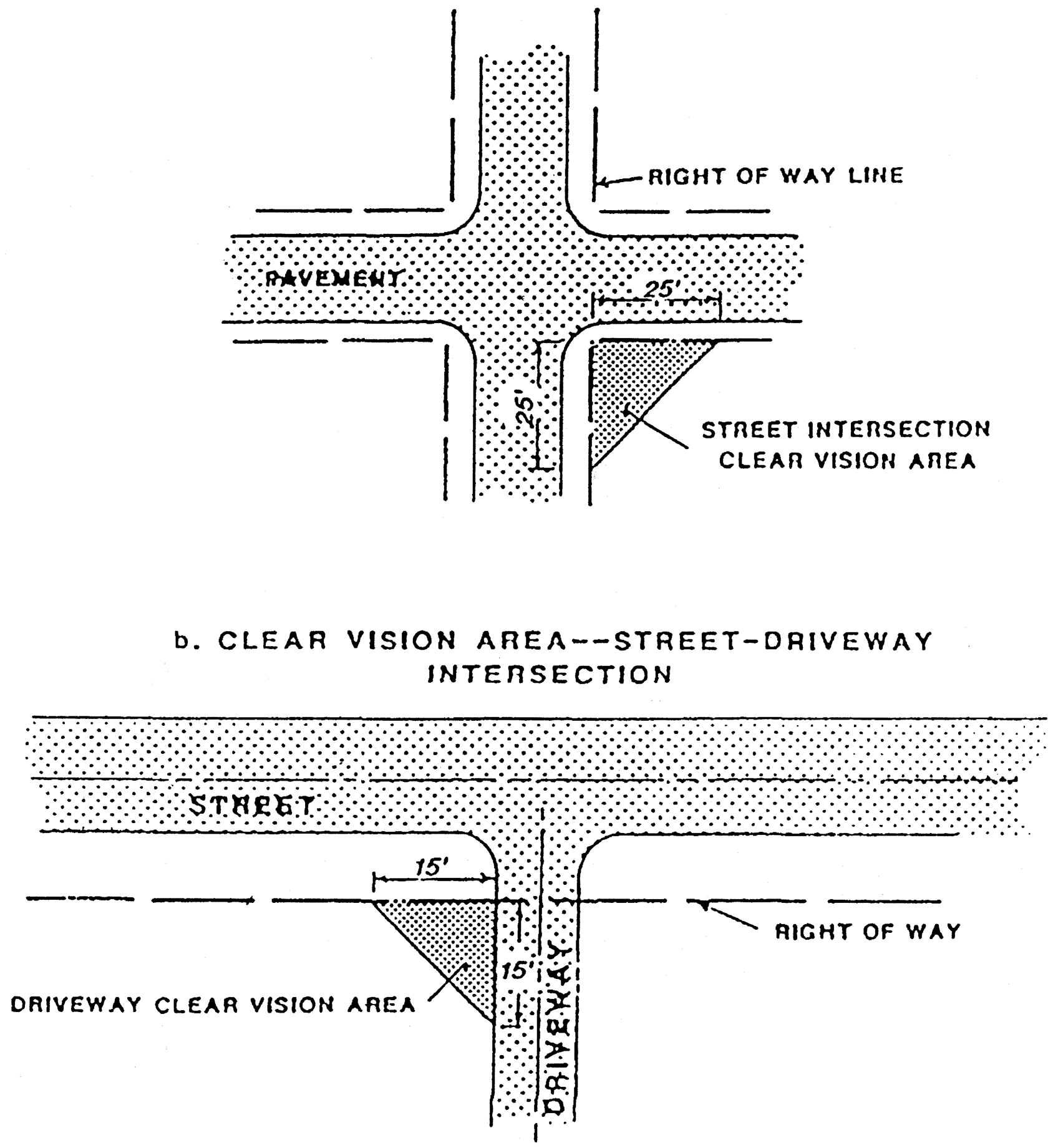
Clear Vision Area
(Ord. No. 29, 9-2-1993)
300.230 - Maximum lot width to depth ratio.
Sec. 4.40.
(a)
In all zoning districts, a building shall not be constructed or occupied on a lot or parcel if the depth of the lot or parcel exceeds four times its width, unless such nonconforming lot was created and of record prior to the effective date of this section.
(b)
The depth of lot shall be measured along a line located midway between the side lot lines and connected to the front and rear lines. The width of the lot shall be measured between the side lot lines parallel to the front lot line at the minimum required front setback line.
(c)
The Planning Commission may permit the creation of a lot or parcel which does not comply with this section to be used for the construction of a building as a special land use under Chapter XVA. An instrument giving notice of a special land use granted under this section shall be recorded in the office of the Register of Deeds. In determining whether to grant such special land use permit, the Planning Commission must find that the greater depth is necessitated by conditions of the land in question, such as topography, road access, soils, wetlands or flood plain, and that creation or use of such lot will not conflict with other Township ordinances and regulations, unless appropriate variance or waiver is received from such other ordinances or regulations.
(Ord. of 5-5-1994; Ord. No. 08-16O, § 3, 9-29-2016)
300.231 - Landscaping/greenbelt standards.
Sec. 4.41. The purpose of this article is to promote the public health, safety and welfare by establishing minimum standards for the design, installation and maintenance of landscaping in parking lots, as greenbelts between uses and along roadways. Landscaping is considered by the Township to be an important element of land development, which is a critical factor in maintaining an attractive community character and conserving the value of land and buildings in the Township.
The landscape standards of this article are considered the minimum necessary to achieve the objectives noted above. In several instances, the standards are intentionally flexible to encourage flexibility and creative design. Applicants are encouraged to provide additional landscaping to improve the function, appearance and value of their property.
(a)
Applicability.
(1)
The standards contained in this article shall be applicable to any site plan, special land use request, or PUD submitted for review and approval under this article, subject to the limitations given in subsection (b) of this section. The regulations of this article shall not apply to individual single-family and two-family dwelling units.
(2)
Modification of required landscaping. For existing and proposed uses that require site plan approval to either expand or be built, landscaping should be installed insofar as practical. The Planning Commission in its review of the site plan has the authority to increase, decrease or otherwise modify the landscaping and screening requirements of this article. In doing so, the Commission shall consider the following criteria:
(i)
The amount of space on the site available for landscaping.
(ii)
Existing landscaping on the site and on adjacent properties.
(iii)
The type of use on the site and size of the development.
(iv)
Existing and proposed adjacent land uses.
(v)
The effect the required landscaping would have on the operation of the existing or proposed land use.
(b)
General regulations.
(1)
Landscaping shall be installed within 180 days of occupancy of the building or structure unless a longer period is permitted in writing by the Zoning Administrator.
(2)
All landscaping shall be hardy plant materials and maintained thereafter in a neat, healthy and orderly manner. Withered and/or dead plant materials shall be replaced within a reasonable period of time but no longer than one growing season.
(3)
For the purpose of this article, a corner lot is considered as having a front yard along each street, and the appropriate landscaping shall be provided for both yards.
(c)
Landscaping requirements.
(1)
A landscape area or greenbelt as required herein shall be provided as follows:
(i)
Wherever a Commercial or Industrial zone abuts an A, B-1, I, B-2, B-3 or PUD zone.
(ii)
Whenever a Commercial or Industrial zone abuts a non-conforming residential use such as a house in a Commercial zone.
(iii)
Wherever a non-residential use such as a church, school, office, hospital or library which is allowed in a residential zone abuts a residential use or residential zone, a greenbelt shall be required; however, the amount of landscaping may be modified according to the criteria in Section 4.41(a)(2) [300.231(a)(2)].
(iv)
Whenever a Commercial or Industrial zone abuts an Agriculture, Rural Agriculture or Rural Estate zone, a greenbelt shall be provided if existing dwelling(s) exist in such abutting zones. The criteria of Section 4.41(a)(2) [300.231(a)(2)] herein shall be considered in determining the need for the greenbelt.
(2)
Landscaping requirements shall not apply where adjacent zoning districts are separated by a public street. In such case, the front yard landscaping requirements of this article shall apply.
(d)
Width and planting requirements for green belts.
(1)
A greenbelt shall be a minimum of 15 feet wide.
(2)
For each 25 linear feet abutting the adjacent property, three trees shall be planted within the greenbelt. Such trees shall be a mixture of evergreen, canopy and ornamental trees.
(e)
Plant spacing and size requirements.
(1)
Plant materials shall not be placed closer than four feet from the fence line or property line.
(2)
Evergreen trees shall be planted not more than 25 feet on centers, and shall be not less than five feet in height.
(3)
Ornamental trees or tree-like shrubs shall be planted not more than ten feet on centers, and shall not be less than four feet in height.
(4)
Large deciduous shrubs shall be planted not more than four feet on centers, and shall not be less than three feet in height.
(5)
Large deciduous trees shall be planted not more than 25 feet on centers, and shall be not less than three inch caliper.
(f)
Berms, walls and fences.
(1)
If a berm is used for all or part of the greenbelt, required plant material quantities may be reduced by 25 percent. The berm shall comply with minimum standards contained in this article. All plant materials shall be placed along the top and exterior side slope of the berm. The greenbelt width shall be increased as needed to accommodate maximum berm side slopes of one foot vertical rise to three feet horizontal.
(2)
A screen wall or fence may be used for all or part of the greenbelt. If a fence or screen wall is used, the following regulations shall apply.
(i)
Required quantities of plant materials may be reduced by 50 percent for that area abutting the fence or wall.
(ii)
The fence or wall shall comply with the applicable regulations of Section 4.38 [300.228] of this Ordinance.
(g)
Stormwater detention/retention areas shall be permitted within greenbelts provided they do not reduce the screening effect.
(h)
Solid waste dumpsters may be located in greenbelts, provided they are screened on three sides by a continuous opaque wall or fence six feet in height.
(i)
Front yard landscaping. Except for necessary driveways, frontage roads, service drives or walkways, the front yard shall be landscaped according to the following minimum requirements.
(1)
For each 75 feet in length of road frontage three trees shall be planted within the front yard. Such trees shall be a mixture of evergreen, canopy and ornamental trees.
(2)
Shrubs at a rate of one per each tree required.
(3)
Earthen berms may be permitted within the required front yard landscape area. Credit of up to 25 percent may be received against providing the required plantings through the use of berms three feet in height or greater.
(4)
Plantings and berms shall be located so as not to obstruct the vision of drivers entering or leaving a site.
(j)
Off-street parking area landscaping requirements. All parking areas having 20 or more parking spaces shall be landscaped according to the following minimum requirements:
(1)
One canopy tree for every 20 parking spaces, with a minimum of two trees, shall be planted adjacent to and within the parking area.
(2)
Trees shall be located to prevent damage by motor vehicles.
(3)
Landscaping islands shall be dispersed through the parking lot in order to break up large expanses of paved surfaces and improve traffic flow and line of sight for drivers. Each landscape island shall be a minimum of six feet wide and shall contain at least one canopy tree.
(4)
Landscaping shall be arranged so as not to obscure traffic signs or fire hydrants, or obstruct drivers' sight distance within the parking area and at driveway entrances.
(5)
All landscape areas shall be protected by raised curbs, parking blocks or other similar methods.
(6)
Where any parking area, excepting areas serving one-family or two-family dwellings, abuts or faces a public right-of-way, a three-foot-high continuous obscuring screen at least three but no more than four feet high may be required between the parking area and the public road right-of-way line. The screen may be comprised of natural or manmade material or any combination of these elements. Such screening may be required for parking lots across the street from residential uses where vehicle lights, noise or appearance may create a nuisance or safety hazard for residents.
(7)
Landscaping required for greenbelts and front yard landscaping that abuts off-street parking areas may substitute for up to 50 percent of the required parking lot landscaping.
(k)
Minimum standards for berms.
(1)
Wherever a berm is used to meet the minimum requirements of this article, it shall have a maximum height of five feet above grade.
(2)
Berms shall be constructed so as to maintain side slopes not to exceed a one-foot vertical rise to three feet horizontal ratio.
(3)
Berm areas shall be covered with grass or other living ground cover.
(4)
Berms shall be constructed so as not to alter drainage patterns on the site or on adjacent properties.
(Ord. of 4-4-2002)
300.232 - Open space preservation projects.
Sec. 4.42.
(a)
Purpose. Act No. 177 of the Public Acts of Michigan of 2001 ("Act 177") requires that zoned townships having a population of 1,800 or more and having undeveloped land zoned for residential purposes must adopt zoning regulations to permit "open space preservation" developments.
Under these regulations, a landowner has the option to retain at least 50 percent of the property as open space and placing dwellings on the remaining portion. The number of dwellings cannot be less than the number which would be permitted on the land without the open space preservation regulations.
The purpose of this section is to adopt open space preservation provisions consistent with the requirements of Act 177.
(b)
Definitions. Words and phrases used in this Section, if defined in Act 177, shall have the same meaning as provided in the Act.
(c)
Review procedure. An open space preservation project shall be reviewed by the Planning Commission in accordance with the requirements of site plan review contained in Chapter 14A [XIVA, 300.641] of this Ordinance and according to the requirements and standards contained in this Section.
(d)
Items submitted for review.
(1)
The applicant shall submit an application for an open space preservation project as required by Dorr Township.
(2)
Open Space Preservation Plan. The applicant shall submit ten sets of the Open Space Preservation Plan which shall include information required by Section 14A.06 [300.646] of this Ordinance and the following information:
(i)
The areas devoted to preserved open space.
(ii)
The site development plan shall illustrate the location of all proposed lots and proposed building envelopes and shall indicate the lot area and width of each lot, and the proposed front, side and rear yard building setbacks. The number of proposed lots on the site development plan shall not exceed the number of lots on the Existing Zoning Plan, as approved by the Planning Commission.
(iii)
The total number of acres of land that are proposed for preserved open space, the total number of acres of land that are proposed to be used for dwellings, and the percentage of each, as compared to the total site acreage.
(iv)
The site development plan shall illustrate the location and type of all proposed structures or improvements that are not dwellings.
(v)
If the open space development will not be served by public sanitary sewer, the applicant shall submit documentation from the Allegan County Health Department that the soils are suitable for on site septic systems.
(3)
If an open space preservation development is proposed as a platted subdivision or a site condominium, the applicant must also submit all information and follow the procedures required by the Dorr Township Subdivision Ordinance or the Dorr Township Site Condominium regulations, as applicable.
(4)
Existing Zoning Plan. In addition to the information required above, the applicant must also submit a separate Existing Zoning Plan.
This plan is to be prepared for the purpose of demonstrating the number of dwelling units that could be developed on the land under its existing zoning if the open space preservation option provided by this Section were not exercised. The Existing Zoning Plan may be conceptual in nature but shall include at least the following information:
(i)
Date, north arrow and scale, which shall not be more than 1" = 200'.
(ii)
Location of streets adjacent to and within the site.
(iii)
Location of all lots, illustrating lot area and width of each lot to demonstrate compliance with the minimum requirements of the applicable zoning district.
(iv)
Location of all utilities that would be necessary to serve a development under the Existing Zoning Plan.
(v)
If development under the Existing Zoning Plan would require the use of septic tanks and drain fields, the applicant shall submit written documentation from the Allegan County Health Department that at least 50 percent of the lots are suitable for on site disposal systems. Such lots shall be spread evenly over the site.
(vi)
The Existing Zoning Plan shall illustrate all unbuildable land, which shall include slopes of 20 percent or greater, regulated and unregulated wetlands, public utility easements, floodplains, and other similar features which limit or prevent construction of buildings or roads.
(e)
Determination of number of lots. The Planning Commission shall determine whether the Existing Zoning Plan accurately reflects the number of lots that could be developed on the land under its existing zoning if the clustering option provided by this Section were not exercised.
The Commission shall either approve the number of lots illustrated on the Existing Zoning Plan or require the Plan to be revised to accurately reflect the number of lots which could be developed on the land under the standards required for preparing the Existing Zoning Plan in this Section.
(f)
Open space requirements.
(1)
Required open space. Not less than 50 percent or more than 60 percent of the land proposed for development under the provisions of this Section shall remain in a perpetually undeveloped state(i.e., "open space") by means of a conservation easement, plat dedication, restrictive covenant, or other legal instrument that runs with the land, as approved by the Township Attorney.
(2)
Areas not counted as open space.
(i)
The area within all public or private road rights-of-way.
(ii)
Golf course.
(iii)
The area within a platted lot, site condominium unit or metes and bounds parcel occupied or to be occupied by a building or structure not permitted to be located in open space.
(iv)
Fifty percent of the area of wetlands, creeks, streams, existing ponds or lakes or other bodies of water.
(v)
Fifty percent of the area of floodplains and 50 percent of areas of slopes which are 20 percent or over.
(3)
Standards for open space. The following standards shall apply to the preserved open space required by this Section:
(i)
The open space may include a recreational trail, picnic area, children's play area, community building or other use which, as determined by the Planning Commission, is substantially similar to these uses.
(ii)
The open space shall be available for all residents of the development, subject to reasonable rules and regulations.
(iii)
If the land contains a lake, stream or other body of water, the Planning Commission may require that a portion of the open space abut the body of water.
(iv)
A portion of the open space shall be reasonably useable by the residents.
(v)
Open space shall be located so as to be reasonably accessible to the residents of the open space development. Safe and convenient pedestrian access points to the open space from the interior of the open space shall be provided.
(vi)
Wherever open space on the site proposed for an open space preservation project abuts an adjacent parcel, a fence shall be provided. The fence must be a minimum of four feet high and constructed with chain link, woven wire or similar sturdy material in order to deter trespassing from the open space onto adjacent property.
However, a fence need not be provided where open space abuts an existing public road right-of-way.
(4)
Methods to preserve open space. The applicant shall submit before final approval of the project a copy of the conservation easement, plat dedication, restrictive covenants, or other legal instrument that would run with the land, and that would have the legal effect of preserving in perpetuity the open space required by this Section in an undeveloped state. Such legal instrument shall be reviewed by the Township attorney prior to recording with the Allegan County Register of Deeds and shall be subject to the approval of the attorney, consistent with the terms of this Section. The legal instrument shall:
(i)
Indicate the proposed permitted use(s) of the open space.
(ii)
State the parties who have an ownership interest in the open space.
(iii)
Require that the open space be maintained in perpetuity in an undeveloped condition, without buildings, structures or other improvements, except such drainage improvements, utility lines, walking trails, picnic areas, park or playground equipment, or similar improvements that are approved by the Planning Commission.
(iv)
Require that the open space be maintained by parties who have an ownership interest in the open space.
(v)
Provide standards for scheduled maintenance of the open space, including necessary pruning and harvesting of trees and new plantings.
(g)
Development requirements.
(1)
Water and sanitary sewer. Open Space Preservation projects shall be served by either public or community water and sanitary sewer OR by private wells and septic systems subject to the approval of the Allegan County Health Department.
(2)
Minimum lot sizes and setbacks. In order to accommodate both the required open space and the number of lots permitted according to the Existing Zoning Plan the Planning Commission shall allow a reduction in the minimum lot size and building setback requirements of the zoning district in which the Open Space Preservation project is located.
(i)
For Open Space Preservation projects the minimum lot sizes shall not be less than the following:
(ii)
Each lot shall have a minimum lot width of 75 feet at the front lot line. This minimum lot width must then be expanded such that the lot width at the required minimum building setback line shall be the minimum width required in Section 4.42g[2)](i) [300.323(g)2)(i)] above.
(iii)
The minimum setback for buildings may be reduced to not less than 20 percent of the minimum required setbacks for the zoning district in which the Open Space Preservation project is located.
(iv)
The Planning Commission may allow a decrease in the above minimum lot sizes however, for the purpose of achieving the number of lots allowed by the Existing Zoning Plan.
(3)
Compliance with zoning district. The development of land under this Section shall comply with all requirements of this Ordinance applicable to the zoning district in which the land is located, except for the lot size and setback requirements.
(4)
Maximum number of lots. The Open Space Preservation project shall contain no more than the maximum number of lots as determined from the Existing Zoning Plan approved by the Planning Commission.
(5)
Perimeter lots. Notwithstanding any other provision of this Section, the Planning Commission may require that the Open Space Preservation development be designed and constructed with lot sizes and setbacks on the perimeter that will be reasonably consistent with the lot sizes and setbacks of adjacent uses(planned or existing). The Planning Commission may however, allow a decrease in the minimum lot sizes specified in Section 4.42(g)[2)](i) [300.323(g)2)(i)] for non-perimeter lots for the purpose of achieving the number of lots allowed by the Existing Zoning Plan.
(6)
Sidewalks. The Planning Commission may require sidewalks in accordance with the Township's Site Condominium regulations or Subdivision Ordinance.
(7)
Private roads. A private road which is part of an Open Space Preservation project shall comply with the requirements for private roads as contained in Section 4.16 [300.206] of this Ordinance.
(8)
Grading. Grading shall comply with the following requirements:
(i)
To preserve the natural appearance of the land, all graded areas, cuts and fills shall be kept to a minimum. Specific requirements may be placed on the area of land to be graded or to be used for building, and on the size, height, and angles of cut-and-fill slopes and the shape thereof.
(ii)
All areas indicated as open space on the approved development plan shall be undisturbed by grading or excavating, except as permitted by the Planning Commission.
(h)
Standards for approval. Prior to approving a site plan for an Open Space Preservation project, the Planning Commission shall require that the following standards be satisfied: If these standards and the other requirements noted in this section or in other Township ordinances are met, the site plan shall be approved.
(1)
The site plan complies with all open space requirements of this Chapter.
(2)
The houses are arranged to respect the natural features of the site and so residents can benefit from viewing or utilizing the required open space.
(3)
The landscape shall be preserved in its natural state, insofar as practical, by removing only those areas of vegetation or by making those alterations to the topography which are reasonably necessary to develop the site in accordance with the requirements of this Ordinance.
(4)
Areas of natural drainage such as swales, wetlands, ponds, or swamps shall be protected and preserved insofar as practical in their natural state to provide areas for natural habitat, preserve drainage patterns and maintain the natural characteristics of the land.
(5)
All buildings or groups of buildings shall be arranged so as to permit necessary emergency vehicle access as requested by the Township Fire Department.
(6)
All streets and driveways shall be developed in accordance with the Township's Private Road Ordinance or the Allegan County Road Commission standards.
(7)
Appropriate measures shall be taken to ensure that removal of surface waters will not adversely affect neighboring properties or the public stormwater drainage system. Provisions shall be made to accommodate stormwater, prevent erosion particularly during construction, and prevent the formation of dust. The use of detention/retention ponds may be required. Catch basins may be required to contain oil filters or traps to prevent contaminants from being discharged to the natural drainage system.
(8)
Site plans shall conform to all applicable requirements of county, state and federal statutes and approval may be conditioned on the applicant receiving necessary county, state and federal permits before final site plan approval or an occupancy permit is granted.
(i)
Conditions of approval. As part of an approval to an Open Space Preservation Plan, the Planning Commission may impose additional conditions that may be necessary for protection of the public interest. Such conditions shall be related to and ensure that the review standards of Section 4.42(h) [300.232(h)] are met.
(j)
Validity of approved site plans.
(1)
An approved Open Space Preservation Plan which is also approved under the Township's Site Condominium Ordinance or Subdivision Ordinance shall remain valid as prescribed in these Ordinances.
(2)
For all other approved Open Space Preservation Plans, the approval shall be valid for one year from the date of approval as regulations by Section 14A.07(b) [300.647(b)] of this Ordinance.
(k)
Performance guarantee. The Planning Commission may require reasonable performance guarantees in accordance with Section 14[A].07(a) [300.647(a)] of this Ordinance.
(l)
Amendments to approved site plan.
1)
Any person who has been granted site plan approval for an Open Space Preservation Project shall notify the Zoning Administrator of any proposed amendment to the approved site plan.
2)
A minor change in the site plan may be approved by the Zoning Administrator who shall notify the Planning Commission of the minor change and that such change does not substantially change the basic design or alter the conditions required for the plan by the Commission.
The following items shall be considered as minor changes:
(i)
Reduction in the number of dwellings.
(ii)
An alteration of the required open space which does not materially affect the approved intended use of the open space.
(iii)
Plantings approved in the site plan landscape plan being replaced by similar types of landscaping.
(iv)
Changes required or requested by the Township for safety reasons or to better accommodate stormwater management or other utilities.
(v)
Changes which will preserve the natural features of the site without changing the basic site layout.
(vi)
Other similar changes of a minor nature proposed to be made to the configuration, design, layout or topography of the site plan which are deemed by the Zoning Administrator to be not material or significant in relation to the entire site and which the Zoning Administrator determines would not have any significant adverse effect on adjacent or nearby lands or the public health, safety and welfare.
The Zoning Administrator may refer any decision regarding any proposed change to an approved site plan to the Planning Commission for review and approval(regardless of whether the change may qualify as a minor change). In making a determination whether a change is a minor change, or whether to refer a change to the Planning Commission for approval, the Zoning Administrator may consult with the Chairperson of the Planning Commission.
Should the Zoning Administrator determine that the requested modification to the approved site plan is not minor, re-submission to the Planning Commission for an amendment shall be required and conducted in the same manner as an original application.
(Ord. of 11-21-2002)
300.233 - Wind energy system (WES).
Sec. 4.43.
(a)
Purpose. The purpose of this section is to establish standards and procedures by which the installation and operation of a WES shall be regulated within the Township, in order to promote the safe, effective, and efficient use of wind energy.
(b)
Definitions.
(1)
Wind Energy System (WES) — shall mean any combination of the following:
i)
A mill or machine operated by wind acting on oblique vanes or sails that radiate from a horizontal shaft;
ii)
A surface area such as a blade, rotor, or similar device, either variable or fixed, for utilizing the wind for electrical or mechanical power;
iii)
A shaft, gearing, belt, or coupling utilized to convert the rotation of the surface area into a form suitable for driving a generator, alternator, or other electricity-producing device;
iv)
The generator, alternator, or other device to convert the mechanical energy of the surface area into electrical energy;
v)
The tower, pylon, or other structure upon which any, all, or some combination of the above are mounted.
(Note: For purposes of this section a windmill traditionally used to pump water shall not be considered a Wind Energy System.)
(2)
On Site Use Wind Energy System — A WES the purpose and use of which is to provide energy to only the property where the WES structure is located, or to adjacent properties under the same ownership or control as the property where the structure is located, or by the mutual consent of adjacent property owners.
(3)
Single WES for Commercial Purposes — A single WES placed upon a lot or parcel with the intent to sell or provide electricity to a site or location other than the premises upon which the WES is located. The WES may or may not be owned by the owner of the property upon which the WES is placed.
(4)
Wind Farm — Clusters of two or more WES placed upon a parcel or parcels with the intent to sell or provide electricity to a site or location other than the premises upon which the WES are located. The WES may or may not be owned by the owner of the property upon which the WES is placed.
(5)
Utility Grid Wind Energy Systems — A WES designed and constructed to provide electricity to the electric utility grid.
(6)
Structure Mounted WES — A WES mounted or attached to an existing structure or building.
(7)
Interconnected WES — A WES which is electrically connected to the local electrical power utility system and can provide power to the local electrical power utility system.
(8)
WES Height — The distance from the ground at normal grade and the highest point of the WES which is the tip of a rotor blade when the blade is in full vertical position.
(9)
WES Setback — The distance from the base of the tower or structure upon which the WES is mounted to the nearest lot line. In the case of multiple parcels utilized for multiple or single WES, the setbacks shall be taken from the outside boundary of the parcels utilized for the WES project.
(10)
Nacelle — In a wind turbine, the nacelle refers to the structure which houses all of the generating components, gearbox, drive train, and other components.
(11)
Shadow Flicker — Alternating changes in light intensity caused by the moving blade of a WES casting shadows on the ground and stationary objects such as dwellings.
(12)
Applicant — The person, firm, corporation, company, limited liability corporation or other entity which applies for Township approval under this section, as well as the applicant's successor(s), assign(s), and/or transferee(s) to any approved WES. An applicant must have the legal authority to represent and bind the landowner or lessee who will construct, own and operate the WES. The obligations regarding a zoning approval for any approved WES shall be with the land owner and the owner(s) of the WES and jointly and severally with the owner and operator or lessee of the WES if different than the owner.
(c)
Wind energy systems allowed as a permitted use.
Any On Site Use Wind Energy System including structure mounted WES which is 65 feet or less in total height shall be a permitted use in all zoning districts, subject to the following:
(1)
The height of the WES with the blade in vertical position shall not exceed 65 feet.
(2)
A WES shall be set back from all lot lines a distance which is at least equal to 1.1 times the height of the WES as measured from the lot line to the base of the tower and no portion of the WES, including the guy wire anchors, shall be located within or above the required front, side, or rear yard setback.
(3)
A structure mounted WES shall have a distance from the nearest property line which is at least equal to 1.1 times the height of the WES as measured from the point of attachment to the structure or building to the top of the WES with the blade in the vertical position.
The blade arcs created by a WES mounted on an existing structure shall have a minimum clearance of eight feet or be designed so the blade or other moving parts do not present a safety hazard.
(4)
A permit shall be required to be obtained from Dorr Township to construct and operate any WES, including structure mounted WES, 65 feet or less in total height. A permit shall be issued after an inspection of the WES by Dorr Township or an authorized agent of the Township, and where the inspection finds that the WES complies with all applicable state construction and electrical codes, local building permit requirements, and all manufacturers' installation instructions.
The WES shall not operate nor remain on the property unless a permit has been issued. A copy of the manufacturer's installation instructions and blueprints shall be provided to the Township.
(5)
An On Site Use WES may provide electrical power to more than one dwelling unit, provided the dwelling units are located on property or properties that are adjacent to the property or properties on which the WES is located.
(d)
Wind energy systems which require a special use permit. Any WES including a structure mounted WES which is greater than 65 feet in height, Wind Farms, Single WES for Commercial Purposes, and Utility Grid Wind Energy Systems may be allowed as a Special Use only within the F, RE, RA, E, and I Zoning Districts subject to the following regulations and requirements of this Section and also the general special land use review procedures and standards of Chapter XVA of this Zoning Ordinance:
(1)
Site Plan Requirements. For those WES for which a Special Use is required the following items shall be included with or on the site plan: federal building, structural and electrical codes.
(i)
All requirements for a site plan contained Chapter 14A herein.
(ii)
Dimensions of the area purchased or leased which is to contain the WES.
(iii)
Location and height of all existing and proposed buildings, structures, electrical lines, towers, guy wires, guy wire anchors, security fencing, and any other above-ground structures proposed or existing for the parcel or parcels containing the WES.
(iv)
Specific distances from the WES structures to all other buildings, structures, and above ground utilities on the parcel or parcels upon which the WES is proposed to be located.
(v)
Location of all existing and proposed overhead and underground electrical transmission or distribution lines, located on the lot or parcel(s) upon which the WES [is] or is proposed to be located, as well as within 300 feet of the boundaries of the parcel(s).
(vi)
Locations and height of all buildings and structures within 300 feet of the exterior boundaries of the lot or parcel where the WES is proposed to be located.
(vii)
Contour elevations of all WES buildings and structures and the elevations of all existing and proposed structures within 300 feet of the parcel(s) upon which the WES is proposed to be located.
(viii)
Land uses within 300 feet of the parcel.
(ix)
Access drives to the WES including dimensions and composition, with a narrative describing proposed maintenance of the drives.
(x)
All lighting proposed for the site, including diagrams of lighting fixtures proposed if requested by the Planning Commission.
(xi)
Security measures proposed to prevent unauthorized trespass and access.
(xii)
Standard drawings of the structural components of the WES, including structures, towers, bases, and footings. A registered engineer shall certify drawings and any necessary calculations that show that the system complies with all applicable local, state, and federal building, structural and electrical codes.
(xiii)
Additional information as required by Chapter XVA Special Land Uses of this Ordinance, or as may be required by the Planning Commission.
(xiv)
The Planning Commission may waive or modify the above requirements at the request of the applicant if it is determined that those items would not be needed to properly review the project.
(2)
Height — The height of a WES for which a Special Use is required shall be determined by compliance with the requirements of this Section 4.43(d).
(3)
Setbacks — The setback for a WES shall be at least equal to 1.1 times the height of the WES. No part of a WES including guy wire anchors shall be located within or above any required front, side, or rear yard setback. A reasonable setback shall be maintained from overhead electrical transmission lines.
(4)
Rotor or Blade Clearance — Blade arcs created by a WES shall have a minimum of 30 feet of clearance over and from any structure, adjoining property or tree.
(5)
Lighting — A WES shall provide lighting as may be required by the FAA.
(6)
Maintenance Program Required — The applicant shall provide a written description of the maintenance program to be used to maintain the WES, including a maintenance schedule of types of maintenance tasks to be performed.
(7)
Decommissioning Plan Required — The applicant shall provide a written description of the anticipated life of the system and facility; the estimated cost of decommissioning; the method of ensuring that funds will be available for decommissioning and restoration of the site; and removal and restoration procedures and schedules that will be employed if the WES become obsolete or abandoned.
(8)
Siting Standards and Visual Impact.
(i)
A WES shall be designed and placed in such a manner to minimize adverse visual and noise impacts on neighboring areas.
(ii)
A WES project with more than one WES structure or tower shall utilize similar design, size, color, operation, and appearance throughout the project as is practicable.
(9)
Insurance — The WES operator shall maintain a current insurance policy which will cover installation and operation of the WES. The amount of the policy shall be a condition of approval.
(10)
Performance Guarantee — If a Special Use is approved pursuant to this section, the Planning Commission may require a security in the form of a cash deposit, surety bond, or irrevocable letter of credit in a form, amount, time duration and with a financial institution deemed acceptable to the Township, which will be furnished by the applicant to the Township in order to ensure full compliance with this section and any conditions of approval.
(e)
Standards for all wind energy systems. All WES shall comply with the following:
(1)
Sound Pressure Level.
(i)
On Site Wind Energy systems shall not exceed 55 dB (A) at the property line closest to the WES. This sound pressure level may be exceeded during short-term events such as severe wind storms. If the ambient sound pressure level exceeds 55 dB (A), the standard shall be ambient dB (A) plus 5 dB (A).
(ii)
Utility Grid Systems and Wind Farms shall be subject to the requirements of Section 4.43(e)(i) above but the sound pressure level shall be measured at the property line closest to the WES at the outside boundary of all property used for the Utility Grid System. In addition, the applicant shall provide modeling and analysis that will demonstrate that the Utility Grid System or Wind Farm will not exceed the maximum permitted sound pressure.
(2)
Shadow Flicker. The Planning Commission or Zoning Administrator may request that the applicant perform an analysis of potential shadow flicker. The analysis shall identify locations of shadow flicker that may occur, and shall describe measures such as screening that shall be taken to eliminate or minimize the shadow flicker.
(3)
Construction Codes and Interconnection Standards.
(i)
All applicable state construction and electrical codes and local building permit requirements;
(ii)
Federal Aviation Administration requirements;
(iii)
The Michigan Airport Zoning Act, Public Act 23 of 1950, as amended;
(iv)
The Michigan Tall Structures Act, Public Act 259 of 1959, as amended;
(v)
Private landing strips in or adjacent to Dorr Township;
(vi)
The Michigan Public Service Commission and Federal Energy Regulatory Commission if the WES is an interconnected system.
(4)
Safety.
(i)
Each WES shall be equipped with both a manual and automatic braking device capable of stopping the WES operation in high winds so that the rotational speed of the rotor blade does not exceed the design limits of the rotor.
(ii)
To prevent unauthorized access, each WES must comply with at least one of the following provisions, and more than one if required by the Planning Commission:
(1)
Tower climbing apparatus shall not be located within 12 feet of the ground.
(2)
A locked anti-climb device shall be installed and maintained.
(3)
A tower capable of being climbed shall be enclosed by a locked, protective fence at least ten feet high with barbed wire fence.
(iii)
All WES shall have lightning protection.
(iv)
If a tower is supported by guy wires, the wires shall be clearly visible to height of at least 10 feet above the guy wire anchors.
(v)
The minimum height of the lowest position of the rotor or blade shall be at least 30 feet above the ground.
(5)
Signs.
(i)
Each WES shall have one sign not to exceed two square feet posted at the base of the tower, or, if the structure is fenced, on the fence. The sign shall include the following information:
(1)
The words "Warning: High Voltage"
(2)
Emergency phone numbers.
(ii)
A WES shall not include any advertising of any kind, except the nacelle may have lettering that exhibits the manufacturer's and/or owner's identification.
(6)
Electromagnetic Interference. WES shall be designed, constructed and operated so as not to cause radio and television interference.
(7)
Maintenance. WES must be kept and maintained in good repair and condition at all times and shall not pose a potential safety hazard.
(8)
All distribution lines from the WES shall be located and maintained underground, both on the property where the WES will be located and off-site. The Planning Commission may waive the requirement that distribution lines for the WES which are located off-site (i.e. are not located on or above the property where the WES will be located) be located and maintained underground if the Planning Commission determines that to install, place, or maintain such distribution lines underground would be impractical or unreasonably expensive.
(9)
A WES, except for structure mounted WES, may be located on a lawful parcel or parcels which do not have frontage on a public or private road.
(Ord. of 9-4-2008; Ord. No. 08-16O, § 3, 9-29-2016)
300.233A - Composting facilities.
Sec. 4.43
(a)
Purpose. The purpose of this section is to provide for permissible composting of yard clippings in all zoning districts, and to permit composting facilities in certain zoning districts as defined and regulated by Part 115 of the Natural Resources and Environmental Protection Act, Solid Waste Management, Act 451 of 1994 as amended. Composting is an activity which is valued by Dorr Township for its positive impact and should be properly regulated in order to minimize objectionable characteristics.
(b)
Definitions:
(1)
"Composting facility" shall mean a facility where composting of yard clippings or other organic materials occurs using mechanical handling techniques such as physical turning, windrowing, or aeration or using other management techniques as approved by the Michigan Department of Environmental Quality.
(2)
"Composting" shall mean the process by which yard clippings or other organic materials are converted to compost humus.
(3)
"Yard clippings" shall mean leaves, grass clippings, vegetables or other garden debris, shrubbery or brush or tree trimmings less than 4 feet in length and 2 inches diameter, that can be converted to compost humus. Yard clippings do not include stumps, agricultural wastes, animal wastes, roots, sewage sludge, or garbage.
(c)
Composting and composting facilities permitted.
(1)
Composting of yard clippings on the property where the yard clippings are generated is permitted by right in all zoning districts except the I-Industrial Zoning District and the E-Commercial Zoning District, subject to the following restrictions:
a.
Decomposition must not create a nuisance;
b.
The composting facility or other area where compost is located may not contain more than 200 cubic yards of yard clippings in the A, B-1, B-2 and B-3 Residential Zoning Districts and may not contain more than 100 cubic yards of yard clippings in the C & D Commercial Zoning Districts;
c.
No composting is permitted in the Rabbit River Overlay Zone.
(2)
A person may compost yard clippings on a farm, as that term is defined in section 2 of the Michigan Right to Farm Act, MCL 286.472, if composting does not otherwise result in a violation of state statutes and is done in accordance with generally accepted agricultural and management practices (GAAMPs) under the Michigan Right to Farm Act, and if one of more of the following apply:
a.
Only yard clippings generated on the farm are composted;
b.
There are not more than 5,000 cubic yards of yard clippings on the farm regardless of the source of those yard clippings. The owner or operator of the farm may receive compensation for receiving yard clippings to compost on the farm;
(3)
A person may compost yard clippings on a farm, as that term is defined in section 2 of the Michigan Right to Farm Act, MCL 286.472, if there are more than 5,000 cubic yards of yard clippings on the farm at any time, and all of the following requirements are met:
a.
The farm operation accepts yard clippings generated at locations other than the farm only to assist in management of waste material generated by the farm operation;
b.
The farm operation does not accept yard clippings generated at a location other than the farm for monetary or other valuable consideration;
c.
The owner or operator of the farm registers with the Department of Agriculture on a form provided by the Department of Agriculture and certifies that the farm operation meets and will continue to meet the requirements of subparagraphs a. and b., above.
(4)
Composting of yard clippings other than composting expressly permitted under subsection (c)(1), above, is not permitted in the A, B-1, B-2, C & D zoning districts, unless the composting facility or composting operation is on a farm as defined by the Right to Farm Act which may be lawfully operated in the zoning district in which it is located, has no more than 5,000 cubic yards of yard clippings on the farm at any one time, and is in compliance with the regulatory requirements of the Right to Farm Act and the Natural Resources and Environmental Protection Act.
(5)
Composting of yard clippings and other organic materials, whether or not such clippings and composting materials originate on the premises where the composting occurs, may be permitted in the I-Industrial and E-Commercial Zoning Districts only by special use permit, utilizing the standards contained in the Zoning Enabling Act and in the provisions of the Dorr Township Zoning Ordinance regarding approval of special land uses.
(6)
Failure of a composting facility or operation to register as a composting facility with the Michigan Department of Environmental Quality when required to do so under applicable state statutes shall be considered a violation of the Dorr Township Zoning Ordinance.
(d)
Wholesale and Retail Sale of Composted Yard Clippings. The owner or operator of a composting facility or other operation composting yard clippings may not sell the compost which results from the composting of yard clippings at retail or wholesale unless such sales are permitted in the zoning district in which the composting facility/operation is located.
(e)
Site Plan Review Required. All composting facilities and operations which contain over 200 cubic yards of yard clippings are subject to the requirements of Chapter 14A and the requirements of the zoning district in which the facility is located.
(f)
Composting Facility Operation and Management Plan. As part of site plan review, in addition to applicable State of Michigan, Allegan County, and local regulations, the operator of any proposed Composting Facility shall submit a proposed Operation and Management Plan containing the following information:
(1)
Type of organic material to be composted and the proposed use of the compost.
(2)
Hours of operation and access by the public or customers.
(3)
Type of equipment utilized on the site.
(4)
Security measures such as gates, fences, and lighting.
(5)
Techniques used to minimize odors.
(6)
Landscaping and buffer plans.
(7)
Measures to be taken in handling and disposing of inorganic materials such as plastic, concrete, glass and metal.
(8)
Any proposed accessory structure and uses.
(g)
The operator of any composting facility or composting operation which is not exempt under the provisions of Section 4.43[300.233A](c)(1) shall demonstrate to the satisfaction of the planning commission that all applicable State of Michigan and Allegan County permits have been obtained for such operation.
(Ord. of 9-3-2009)
300.234 - MET Tower.
Sec. 4.44.
(a)
A MET Tower may be permitted as a Special Use only within the F, RE, RA and I Districts, subject to the regulations and requirements of this section and also the special use review procedures and standards of Chapter XVA of this Zoning Ordinance.
(b)
For purposes of this Section a MET Tower is a meteorological tower used for the measurement of wind speed.
(c)
Application Requirements. An applicant for a MET Tower shall submit an application in accordance with the requirements of Chapter XVA of this Ordinance and shall also submit the following materials;
An applicant for a MET Tower shall submit an application in accordance with the requirements of Section 4.30 of this Ordinance and shall also submit the following materials;
(1)
A description of the number and type of MET tower(s) to be installed and the expected length of time that the MET tower will be operable.
(2)
A description of the height of the MET tower and its design including cross section and elevation drawings and a diagram of how the tower will be anchored to the ground.
(3)
An explanation of the purpose of the tower, the type, height and number of wind energy systems anticipated to be proposed for installation on the site or nearby.
(4)
A statement from the applicant that the MET tower will be installed in compliance with the manufacturer's specifications and a copy of the manufacturer's specifications.
(5)
A description of the tower maintenance program.
(6)
A decommissioning plan explaining the process to be undertaken by the applicant for tearing down the tower and removing all tower equipment, materials and structures and restoring the site so it can be used for a use permitted in that Zoning District.
(7)
Security measures including emergency contact personnel.
(8)
Ten copies of a site plan drawn at a scale of not more than one inch equals 100 feet however a larger scale may be accepted by the Planning Commission depending upon the size of the parcel. The site plan shall contain at a minimum the following information unless specifically waived by the Planning Commission.
(a)
The date on which the site plan was prepared.
(b)
A north arrow and legal description of the property.
(c)
Property lines and dimensions of the parcel containing the tower, as well as the area leased for the tower if applicable, the height of the MET tower and its distance to all property lines.
(d)
Any buildings or structures existing on the site and the use of the parcel.
(e)
The distance to the closest building on adjacent property.
(f)
The location of any overhead transmission lines on the site or on adjacent property which might be affected by the MET tower.
(g)
Guy wires, guy wire anchors and any other tower supporting structure or device.
(h)
Type and height of fencing to be installed around the tower or an equipment building.
(i)
Elevation drawings of any buildings designed to serve the tower.
(j)
Access road; width and construction standards.
(k)
Any lighting proposed to be located on the tower.
(d)
General Requirements. A MET tower shall comply with all of the following:
(1)
The tower shall be setback from all property lines a distance of not less than 1.1 times the height of the tower as measured from the base of the tower
(2)
All applicable state construction and electrical codes and local building permit requirements;
(3)
Federal Aviation Administration requirements. All tower lighting required by the FAA shall be shielded to the extent possible to reduce glare and visibility from the ground. The tower shaft shall not be illuminated unless required by the FAA, and the minimum FAA lighting standards shall not be exceeded.
(4)
The Michigan Airport Zoning Act (Public Act 23 of 1950);
(5)
The Michigan Tall Structures Act (Public Act 259 of 1959);
(6)
A MET tower which is unused or abandoned shall be removed, along with any associated buildings and structures, by the owner/operator within 90 days of the date of a written notice from the Township. An extension of 90 days may be granted by the Planning Commission upon a request from the owner/operator citing extenuating circumstances beyond their control in removing the tower within the initial 90-day period.
(7)
In removing the tower the owner/operator shall comply with the decommissioning plan submitted by the applicant and as approved by the Planning Commission.
(e)
Planning Commission Review. The Planning Commission shall review the proposed MET tower according to the standards for Special Uses contained in Section 4.32 herein. The Commission may approve a MET tower for a specified period of time subject to renewal by the Planning Commission.
The Commission may impose reasonable conditions in its approval of a MET tower in accordance with Section 4.34 herein including but not limited to a requirement that the applicant provide regular reports regarding the maintenance and condition of the tower.
In approving a MET Tower the Commission shall require that the applicant provide a performance guarantee in a form and amount acceptable to the Township for the cost of removing the MET tower and restoration of the site.
(Ord. of 9-4-2008; Ord. No. 08-16O, § 3, 9-29-2016)
300.235 - Medical marijuana dispensaries.
Sec. 4.45. A medical marijuana dispensary as defined herein shall not be commenced, conducted, operated, or utilized in any zoning district or on or from any property within Dorr Township.
(Ord. of 11-17-2011, § 2)
300.236 - Medical marijuana additional regulations.
Sec. 4.46.
(A)
A registered primary caregiver or any other person shall not distribute medical marijuana or possess medical marijuana with intent to deliver in any building or on any parcel which is within a 1,000-foot radius of any school or library, as defined by the Michigan Public Health Code, 1978 PA 368, as amended, MCL 333.7410, to insure community compliance with federal "Drug-Free School Zone" requirements.
(B)
All medical marijuana shall be contained within the dwelling unit occupied by the registered primary caregiver or qualifying patient, in an enclosed, locked facility inaccessible on all side and equipped with locks or other security devices that permit access only by the registered primary caregiver or qualifying patient.
(C)
The enclosed locked facility which is used for the growing, cultivating and processing of medical marijuana shall be properly vented and all electrical apparatus and equipment used for the growing, cultivating and processing of medical marijuana shall comply with the Michigan Building Code as well as all other applicable State of Michigan Codes.
(D)
If a room with windows is utilized as a growing location for medical marijuana, such windows shall be shielded without alteration to the exterior of the residence between the hours of 11:00 p.m. to 7:00 a.m. to prevent glare from such lights being a nuisance or distraction to nearby residents or property owners.
(Ord. of 11-17-2011, § 3)
300.237 - Front yard setback averaging.
Sec. 4.47. Where the front yard for existing buildings is less than the minimum required front yard of this chapter, the minimum front yard for a proposed building shall be the average of the front yards for those existing buildings on the same block and on the same side of the street. There shall be at least two existing buildings on the same block in order to establish an average front yard, otherwise the required minimum yard for the zoning district shall apply. In no case shall the front yard be less than 20 feet.
(Ord. No. 03-16O, § 2, 9-29-2016)
300.238 - Keeping of animals and livestock on non-farm parcels.
Sec. 4.48. In the RE, RA and AG zoning districts the raising and keeping of farm animals and livestock including cattle, swine, horses, sheep, goats, or fowl or similar animals where such activity is not a farm as defined herein is permitted. The area on which the animal(s) are kept shall be enclosed by a fence or similar barrier to prevent the animal(s) from trespassing onto adjoining property and the area shall be kept in a sanitary condition and free from odor.
(Ord. No. 07-16O, § 1, 9-29-2016)
300.239 - Regulations for keeping chickens in the B-1 zone.
Sec. 4.49. Chickens are permitted to be kept in the B-1 zoning district subject to the following regulations:
a)
No more than ten chickens shall be permitted on any lot.
b)
Roosters are not permitted.
c)
The applicant shall provide a covered, predator-proof chicken coop that is thoroughly ventilated, of sufficient size to admit free movement of the chickens, designed to be easily accessed, cleaned and maintained by the owners and provides at least four square feet of area per chicken.
d)
A sturdy outdoor enclosure for the keeping of the chickens shall also be provided which contains at least 10 sq. ft. per chicken. The enclosure shall be considered a fence and shall be subject to the applicable requirements of Sections 4.38 herein. The enclosure shall be constructed and kept in a condition so as to prevent rats, mice, or other rodents from getting inside.
e)
Chickens shall be kept in the coop or enclosure at all times.
f)
The coop and enclosure shall not be allowed to fall into disrepair and shall be kept in a clean and sanitary condition with manure removed on a regular basis so it does not produce an odor noticeable off site or attract flies or other insects.
g)
Disposal of waste must be off site or on site in a compost bin approved by the Zoning Administrator. The compost bin shall be maintained so it is odor free and does not attract flies or other insects.
h)
Feed for the chickens shall be kept in a predator-proof container.
i)
The chicken coop, enclosure, feed container, and compost bin shall only be located in the rear yard and shall be at least eight feet from the side and rear lot lines.
j)
It shall be unlawful for the owner, custodian, or keeper of any chicken to allow the animal(s) to be a nuisance to any neighbors, including but not limited to: noxious odors from the animals or their enclosure; and noise of a loud and persistent and habitual nature.
(Ord. No. 06-16O, § 1, 9-29-2016)
300.239A - Mineral extraction operations.
Sec. 4.50.
(a)
INTENT, PURPOSE, AND EXCEPTIONS. Prior to the approval by the Planning Commission of a special exception use for earth removal, quarrying, gravel processing, mining, and related mineral extraction businesses in any area of the Township, said Commission shall be satisfied that the following conditions and limitation are, or shall be, strictly complied with in addition to any other requirements contained in the Township Zoning Ordinance or in any other Township ordinance controlling such operation.
These provisions do not apply to grading operations that do not result in material being taken off premises. Earth removal/operations (material carried off site) carried out for the purposes of preparing land for cultivation or in preparation of building development may be exempted from these provisions provided that all of the following conditions are met.
(1)
No area is created which fills with water unless it is a farm watering pond or private recreational pond with bank gradients of no more than one (1) foot vertical to three (3) feet horizontal.
(2)
Operations do not involve on-site processing such as crushing, washing, or grinding.
(3)
The area of the removal operation is limited to a maximum of one (1) acre in size or, in the case of field grading and building development, to an area roughly equivalent in size to the site being prepared for development or cultivation.
(4)
The duration of operation is limited to a continuous twelve (12) month period of time, whereupon expiration of said period, no further operation of any scope shall be thereafter permitted at that site unless granted administrative approval by the Zoning Administrator for a discretionary length of time. The Zoning Administrator may also discretionarily defer approval to the Planning Commission by special use permit as specified below.
(5)
The reclamation requirements of Section 4.50(e) shall still apply.
Any operation that exceeds the above limits will be required to receive a special use permit under this Section and Chapter 15A. After preliminary review of applications for operations exceeding or likely to exceed one or more of the above limits, the Planning Commission may find such operations to be minor in nature and may waive, if found to be unnecessary, one or more of the application and plan content requirements itemized under Sections 4.50(f) and 4.50(g).
(b)
LOCATION.
(1)
All such operations shall be located on a primary road, as defined by the County, for ingress and egress thereto, or on a road, which does not create traffic through an area developed primarily for residential purposes. Where necessary, said Commission may require the applicant to construct and/or improve a road to accommodate the truck travel necessitated by the operations as a condition to such operations, and for the purpose of routing traffic around residential areas and preventing the breaking up of existing roads which are not "all weather" roads.
(2)
No such excavation operation shall be permitted to be closer than one hundred fifty (150) feet of all property lines and public or private rights-of-way. However, the Planning Commission may reduce this setback to as little as fifty (50) feet from adjacent properties if written authorization for the reduction by the owner of said adjacent property is submitted. Such reduction shall be in accordance with the reclamation plan approved by the Planning Commission and adequate lateral support shall be maintained at all times.
(3)
No such excavation operation approved with reduced setbacks as specified in Section 21.02(a) above shall be permitted within fifty (50) feet of an adjoining public right-of-way. However, the Planning Commission may further reduce this setback for the purpose of matching elevations of land adjoining said rights-of-way to the grade level of said rights-of-way for a temporary period of time to be determined by the Planning Commission at their discretion and only if written authorization for the reduction by the governing authority of said adjacent right-of-way is submitted.
(4)
A processing plant and its accessory structures shall not be located closer than two hundred fifty (250) feet from the interior property lines and adjoining public rights-of-way and shall, where practicable, be located at a lower level than the surrounding terrain to lessen visual and noise impact. In addition, the foregoing shall apply to the digging or excavating apparatus and to the stockpiling or loading of materials and to the location of transportation equipment.
(5)
No such excavation operation shall be located within one hundred (100) feet of the banks of any stream or waterway unless previously approved, in writing, by the Michigan Water Resources Commission, or such other state commission having jurisdiction thereof. No such mining operations shall interfere with the natural established flow of surface waters to the detriment or damage of adjoining public or private properties.
(c)
SIGHT BARRIERS. Sight barriers shall be provided along all boundaries of the site, which lack natural screening conditions through existing contours or evergreen growth. Such barriers shall consist of one or more of the following:
(1)
Earth berms constructed to a height of six (6) feet above the mean elevation of the centerline of the adjacent public highway or six (6) feet above the general level of terrain along interior property lines, as the case may be. Such berms shall have slopes that are not in excess of one foot vertical to three feet horizontal and shall be planted with grass, trees or shrubs that shall be maintained in healthy condition or replaced as necessary.
(2)
Plantings of evergreen trees or shrubbery in rows parallel to the boundaries of the property, not less than four (4) feet in height at the time of planting and which grow to not less than six (6) feet in height at maturity and sufficiently spaced to provide effective sight barriers when six (6) feet in height. All trees and/or shrubbery shall be maintained in healthy condition or replaced as necessary.
(3)
Masonry walls or attractive solid fences made of uniform new materials, constructed to a height of not less than six (6) feet and maintained in good repair.
(d)
NUISANCE ABATEMENT.
(1)
Noise and vibration shall be minimized in their effect upon adjacent properties by the utilization of modern equipment designed to accomplish such minimization and by the proper use of berms, walls, and natural planting screens. All equipment shall be maintained and operated in such a manner so as to eliminate, as far as practicable, excessive noise and vibrations which are not necessary in the operation of such equipment.
(2)
Air pollution in the form of dust and dirt shall also be kept to a minimum by the use of modern equipment and methods of operation designed to avoid any excessive dust or dirt or other air pollution injurious or substantially annoying to adjoining property owners. Interior and adjoining roads used in the operations shall have their surface treated to minimize any such nuisance.
(3)
Hours. The operation shall be restricted to the daylight hours between Monday through Friday. Hours shall be from dawn to noon on Saturdays and no operations shall be permitted on Sundays or Holidays. Emergency repair or maintenance work shall be permitted during these hours. Off hours operation for temporary or emergency support of local, county and state road construction/maintenance shall be permitted with advance written notice by operator and verification by the responsible public agency to the Zoning Administrator.
(4)
Fencing. All dangerous excavations, pits, pond areas, banks or slopes shall be fenced and posted with signs posted not more than 100 feet apart around the perimeter thereof and maintained to prevent injury to children or others and shall be eliminated as expeditiously as possible.
(e)
RECLAMATION OF MINED AREAS.
(1)
Reclamation and rehabilitation of mined areas shall be accomplished as soon as practicable following the mining or excavation of an area. Rehabilitation and reclamation shall be commenced immediately upon the termination of the mining or excavation operations unless part of a larger operation where the Planning Commission has specified the timing and sequencing of reclamation. Substantial completion of reclamation and rehabilitation shall be effected within one year after termination of mining or excavation activity. Inactivity for one twelve (12)-month consecutive period shall constitute justification for the Planning Commission to evaluate the operation for the purpose of determining whether the operator has terminated mining activity.
(2)
The following standards shall control reclamation and rehabilitation:
(a)
All excavation shall be either to a water-producing depth of not less than five (5) feet below the average summer level of water in the excavation, or shall be graded or backfilled with non-noxious, non-flammable and non-combustible solids to insure: (a) That the excavated area shall not collect stagnant water and not permit the same to remain therein; or (b) That the surface of such area which is not permanently submerged is graded or back-filled as necessary to produce a gently rolling surface that will minimize wind and water erosion, and which will be generally compatible with the adjoining land area.
(b)
The banks of all excavation shall be sloped to the waterline in a water-producing excavation, and to the pit floor in a dry operation at a slope which shall not be steeper than one (1) foot vertical to three (3) feet horizontal.
(c)
Topsoil of a quality equal to that occurring naturally in the area shall be replaced on excavated areas not covered by water, except where streets, beaches, or other planned improvements are to be completed within a one-year period. Where used, topsoil shall be applied to a minimum depth of four (4) inches sufficient to support vegetation.
(d)
Vegetation shall be restored by the appropriate seeding of grasses or the planting of trees and shrubs to establish a permanent vegetative cover on the land surface and to minimize erosion.
(e)
Upon cessation of mining operations by abandonment or otherwise as determined by the Planning Commission, the operating company, within a reasonable period of time not to exceed 12 months thereafter, shall remove all plant structures, foundations, buildings, stockpiles and equipment, provided that buildings and structures which have a function under the reclamation plan and which can be lawfully used under the requirements of the zoning district in which they will be located under such plan may be retained.
(3)
A performance bond or cash may be required to be furnished to the Township Clerk in an amount as determined by the Planning Commission. Said bond or cash shall be used to guarantee rehabilitation and reclamation of mining the operation. The Planning Commission shall base its decision on whether to require the posting of a bond or cash and the amount of bond or cash to be posted on the size and extent of the mining operation. Any financing guarantee shall be reviewed annually on or about the anniversary date of the excavation permit for adjustment and compliance with the foregoing requirements by the Township Zoning Administrator and, at his or her discretion, the Township Planning Commission.
(4)
This section shall apply to mining operations in existence prior to the effective date of this ordinance, however, only to the extent of reclamation required to prevent the existence of a nuisance condition.
(f)
SUBMISSION OF OPERATIONAL AND RECLAMATION PLANS. No earth removal, quarrying, gravel processing, mining and related mineral extraction businesses shall be allowed or commenced until a plan has been submitted to the Planning Commission showing compliance with all of the provisions of this Ordinance or the manner in which compliance will be secured by the applicant. Such plans shall include, among other things, the following:
(1)
A contour map of the tract of land involved in the operations, including dimensions of the same, access thereto abutting public streets, and whether or not the same are "all weather" roads, additional roads, if any, to be constructed, and the location and nature of abutting improvements on adjoining property.
(2)
The number of acres and the location of the same proposed to be operated upon within the following 12-month period after commencement of operations.
(3)
The type of mining or processing proposed to be conducted and the nature of the equipment to be used.
(4)
The location of the principal processing plant and the distance of any proposed excavation or mining from the boundaries of the site.
(5)
Soil tests shall be made around the perimeter of the excavation site in the event excavation or activities are to be conducted closer than one hundred fifty (150) feet from the boundaries of the site, said soil tests shall disclose conditions satisfactory for lateral support of adjacent premises as determined by an engineer acceptable to the Township. The written consent of the owners of adjoining premises and of the Planning Commission shall be required if mining operations shall be closer than specified in the within Ordinance to the boundaries of the site.
(6)
A map or plan disclosing the final grades and elevations to be established following the completion of the mining operations, including the proposed uses then contemplated for the land, future lakes and roads and such other matters as may evidence the bona fide nature of the reclamation and rehabilitation plans and the fact that the land will not be devastated and rendered unusable by the proposed mining activities.
(g)
HEARING AND REVIEW CRITERIA.
(1)
Preliminary Review. Prior to the formal application for a special use permit, the interested party may meet with the Planning Commission, should they so choose. The purpose of this meeting is to inform the Planning Commission of the applicant's intent to initiate a mineral extraction operation. On or before this meeting, the applicant shall submit the following to the Township Zoning Administrator (or appropriate designee) who shall distribute it to all relevant Township personnel including, but not limited to, Planning Commissioners, Township Board of Trustees, and authorized consultants or experts of record:
(a)
A sketch drawn to scale, indicating the general location and configuration of the property to be developed; the alignment of streets and building sites; and the relationship of the proposed project to adjacent streets and neighboring properties.
During the preliminary discussion meeting, the Planning Commission, based on the information available to it, shall inform the applicant about the following:
(b)
General requirements of this Section and other applicable provisions of the Zoning Ordinance.
(c)
Planned or anticipated public improvements, including streets, utility extensions, and the like.
(d)
Street plans and potential problems relative to the natural features of the area including, but not limited to, floodplains, soil conditions, topography, and groundwater tables.
(e)
Additional information which may assist the applicant in proceeding in a reasonable and sound manner toward final approval of the mineral extraction operation. Preliminary review is intended for information purposes only and does not constitute binding commitments on the part of the Township. Neither do they imply tentative approval of any proposed mineral extraction operation. Furthermore, such discussions shall not carry the authority to proceed with construction or to sell or transfer property.
(2)
After receiving an application for the grant of a special use permit for an earth removal, quarrying, gravel processing, mining, and related mineral extraction business accompanied by the required plans and specifications and permit fees, the Planning Commission shall hold a public hearing upon such application in the same manner preceded by the same notice as set forth in Section 15A.02 of this Ordinance.
(3)
Following such hearing, said Planning Commission shall recommend to the Township Board of Trustees approval or denial of the application and set forth its reasons for its decision. Such recommendation shall be based upon the criteria set forth within the Ordinance and shall be based, in addition, on a consideration of the following:
(a)
The most advantageous use of the land, resources and property
(b)
The character of the area in question and its peculiar suitability, if any, for particular uses
(c)
Conservation of property values, as well as natural resources and the general and appropriate trend and character of development in the subject area
(d)
The protection and preservation of the general health, safety and welfare of the township
(e)
The scarcity or value of the minerals sought to be mined as compared with the effect upon the adjacent community of the proposed operations
(f)
Whether or not the operations were previously in existence prior to the adoption of the text provision concerning the same and the extent and character of such previous operations
(g)
In making any decision, the Planning Commission shall have the right and authority to impose such additional conditions and safeguards, as it deems necessary for the protection of the health, safety and general welfare of the neighborhood and of the adjoining residents and property owners. It may also limit the length of time that the special exception permit is to be effective and may provide for a periodic review of the proposed operations to ascertain compliance with the conditions and limitations imposed upon the same. It shall be empowered to renew or extend a special exception permit where all standards and conditions are complied with and may revoke or refuse to renew the same where non-compliance exists. No revocation or failure to renew or extend a permit shall release the applicant from the duty of rehabilitation and reclamation of said mined or disturbed area. No permit shall be revoked or not renewed until the operator has been given written notice of any violation forming the basis of such revocation or denial or renewal and not less than 30 days have elapsed to correct the said violation. The Zoning Administrator shall review all permits annually, but may defer to the Planning Commission for cases requiring elevated scrutiny to be determined at his or her discretion.
(h)
The operator shall be required to pay to the Township an annual fee of not less than five hundred ($500) dollars to be deposited into an escrow account specific to the approved application for the purpose of covering the cost of additional meetings of the Planning Commission, additional studies, and inspections. Said fee may be increased at the discretion of the Township Board at the time of initial approval or as subsequently needed.
(i)
Liability Insurance shall be a pre-condition to commencement of operations, and maintenance in full force and effect of insurance shall be a pre-condition to the right to continue operations. The applicant shall provide binders for personal injury and property damage insurance for the project to be carried by an insurance company licensed to do business in the State of Michigan during all times which any reclamation is left to be done, and during all times any machinery and/or equipment remains on the site, or any structures, equipment or improvements to be removed remain on the site, said insurance to contain a hold-harmless clause regarding liability of the Township during any reclamation phase.
(j)
REVIEW PROCEDURES AND REQUIRED INFORMATION. Application for the issuance of a permit to operate a mining or soil removal operation under the standards of this Chapter shall be made under the provisions of Chapter 15 Special Land Uses. The site plan content requirements of Chapter 14A, Section 14A.04 as applicable shall be relied on as the minimum informational requirements for site plans submitted as part of such application. In addition to the content requirements of Section 14A.04, the Planning Commission may require the applicant to provide all or a portion of the following additional information and documentation prior to reaching its decision.
(1)
Documentation of Need for the Resource Material. The need for the material being excavated and/or processed shall be quantified and verified so that the Planning Commission can weigh the value of the material being made available against the potential negative impacts of the operation in the proposed location. The types of information may include:
(a)
A characterization as to the expected service area of the mining operation.
(b)
The type and quantity of material to be mined, as supported by soil borings.
(c)
The location, ownership and temporal (short and long-term) availability of existing mining operations that produce the same material within the same service area.
(d)
Projections as to the volume of material that will be needed in the service area as compared to the volume available.
(e)
A listing of known or existing "local" projects that will be in need of the material or 5 to 10 year projections based on past usage. If possible such estimates and projections should be supported by expert testimony or signed letters from third parties or published reports.
(f)
Any expert or third party opinions as to the financial or other positive negative impacts on the construction industry if the proposed operation is or is not allowed.
(2)
Existing and Projected Roadway Conditions and Traffic. A written and graphic characterization of the expected haul routes and the proposed access to the site should be presented. This shall include:
(a)
An identification of expected primary and secondary routes that truck traffic will use when traveling to and from the site.
(b)
A characterization of the routes including:
(1)
Types of surface
(2)
Number of lanes and typical roadway width
(3)
Typical roadway speeds or speed limits
(4)
Known or potential trouble spots for heavy truck traffic including street intersections, hills, and curves
(5)
Number and location of homes and other land uses alongthe routes including schools, day care operations, churches and businesses.
(c)
Existing traffic volumes along appropriate segments of the anticipated primary and secondary haul routes.
(d)
Projected traffic increases by type and route.
(e)
Characterization of projected truck traffic by size, type and weight of trucks and direction of travel, empty and full on average and extreme daily and average annual basis.
(f)
Expert analysis and testimony as to the adequacy of the routes in general for truck traffic including written approvals from the Allegan County Road Commission, Michigan Department of Transportation (MDOT), and other such agencies as determined by the Planning Commission.
(g)
Identification of documented or potential problems such as, inadequate clear vision, roadway width, steep grades, surface condition, maintenance or land use and traffic conflicts.
(h)
Expert analysis and identification of potential solutions to identified or documented problems in the form of roadway improvement, extra maintenance, traffic control devices, use or speed limitations or combinations of the above.
(1)
A performance bond or cash may be required to be furnished to the Township Clerk in an amount as determined by the Planning Commission. Said bond or cash shall be used to guarantee rehabilitation of damaged public roads by providing funds for Township contributions to maintenance agreements established between it and the Allegan County Road Commission where applicable. The Planning Commission shall base its decision on whether to require the posting of a bond or cash and the amount of bond or cash to be posted on the projected number and frequency of trucks, load sizes, total volume to be moved, and current road conditions. Any financing guarantee shall be reviewed annually on or about the anniversary date of the excavation permit for adjustment and compliance with the foregoing requirements by the Township Zoning Administrator and, at his or her discretion, the Township Planning Commission.
(2)
Characterization of the proposed operation and site access in relation to the public street and street right of way.
(a)
Indicate the proposed location of proposed access (driveway or driveways) and their width, type of surface and other design features such as surface, deceleration and acceleration tapers, culverts, etc.
(b)
Indicate minimum site distances.
(c)
Accurately depict the roadway conditions and width within 500 feet of each access drive including right of way width, roadway elevation and roadway location within the right of way.
(d)
A written statement from the County Road Commission officials as to whether the proposed access to the site will meet or exceed their standards and if extraction operations or other operations will be allowed to occur within the road right of way, if requested or proposed and under what types of limitations. The above informational needs are in addition to the information required to address the evaluation of the proposal's on-site operational and reclamation components.
(Ord. No. 01-24O, Art. I, 4-18-2024)

