
Dover City Zoning Code
ARTICLE 5
- SUPPLEMENTARY REGULATIONS
Section 1. - Supplementary regulations applying to residence zones.
1.1
Accessory buildings. An accessory building may be located in any required side or rear yard provided:
1.11 Such buildings shall not exceed 15 feet in height.
1.12 Such buildings shall be set back five feet from any lot line and shall not be located less than ten feet from an adjoining principal structure.
1.13 All such buildings in the aggregate shall not occupy more than 30 percent of the area of the required rear and side yard.
Accessory buildings constructed at the same time may be located in pairs or groups in the required rear or side yard along the common side lot line or rear lot line of contiguous lots.
1.2
Relation of accessory buildings to streets. No accessory building shall project nearer to the street on which the principal building fronts than such principal building. The board of adjustment may authorize the erection of garages under the following conditions: If the natural slope is from 12 percent to 20 percent within 25 feet of the street line, the board may permit a garage not closer than ten feet of the street line. If the slope is over 20 percent, a garage may be permitted not closer than five feet of the street line.
1.3
Corner lots.
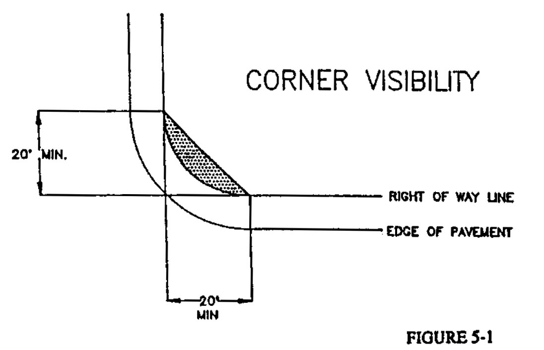
1.31 Corner visibility. In all zones within the city, no structure, fence, wall, landscaping, earthen berm, sign or any other form of obstruction to visibility, in excess of three feet in height above the adjacent street grade, shall be erected, placed or maintained on any corner lot within the triangular area formed by intersecting right-of-way lines. Two sides of the triangular area shall be 20 feet in length and measured from the point of intersection of the right-of-way lines as further illustrated in figure 5-1.
1.32 Yard requirements. Corner lots are considered to have two front yards. The rear yard for a corner lot shall be the yard that is opposite the street upon which the principal structure fronts. The side yard for a corner lot shall be the yard that is opposite the street adjacent to the side of the principal structure.
1.33 Fences. A fence on a corner lot shall comply with the front yard requirement for height along the street upon which the principal structure fronts. A fence on a corner lot shall comply with the side yard requirement for height along the street adjacent to the side of the principal structure.
1.4
Exceptions to lot depth requirements. The depth of any lot other than a corner lot may be decreased at any point to 75 percent of the minimum requirement if the average depth conforms with the minimum requirement.
1.5
Exceptions to yard requirements.
1.51 Permitted obstructions. Cornice or cantilevered roofs and chimneys may project not more than 2½ feet into a required yard. Belt courses, windowsills and other ornamental features may project not more than six inches into a required yard. Paved terraces, steps, and walks (other than such as are needed for access to the buildings on the lot) shall not project within 15 feet of a street line or four feet of a property line.
1.52 Entries and porticos. A roofed-over but unenclosed projection in the nature of an entry, portico or awning not more than eight feet wide and extending not more than six feet into the required front yard shall be exempt from the requirements of this section when the building otherwise complies with the regulations of this section. In computing the average setback, the presence of such entries and porticos shall be ignored.
1.53 Existing setback. No proposed one-family or two-family dwelling need have a setback greater than the average setback of the two existing dwellings with the greatest setbacks within 200 feet on each side of the said proposed dwelling, on the same side of the street and within the same block and the same zone.
1.54 Open decks. An open deck or patio extending to within ten feet of a rear lot line or within 20 feet of a rear lot for second story decks shall be exempt from rear yard setback requirements and lot coverage requirements so long as the principal structure complies with the regulations. Such open decks or patios shall not be enclosed and used as a part of the principal structure.
1.55 Fences. Fences or walls shall be limited to a maximum height of four feet above the ground when situated within front yard areas, and shall be limited to a maximum height of six and one-half feet above ground when situated within side and rear yard areas. Fences situated on corner lots shall be subject to the provisions of article 5, section 1.3. For the purposes of this provision, on lots with dual street frontage that are not corner lots, a fence situated to the rear of the principal structure shall be limited to a maximum height of six and one-half feet above ground. Fences or walls with a height in excess of six and one-half feet above ground shall conform to the setback requirements for dwelling buildings as set forth in article 4 of this appendix. Fence material commonly referred to as "barbed wire" and/or "razor wire," or any similar material, shall be prohibited in residential zones.
1.6
Existing small lots in all one-family residence zones. A lot owned individually and separately and separated from any adjoining tracts of land on November 27, 1971, which has a total area or width less than prescribed herein, may be used for a one-family residence, provided such lot shall be developed in conformity with all applicable zone regulations, other than the minimum lot area and lot width requirements, and with the minimum side yards set forth below:
1.7
Uniformity of design in all one-family residence zones. Except as provided in this ordinance, no building permit shall be issued for the erection of any building on land within any one-family residence zone, if it is like or substantially like any neighboring building existing or for which a building permit has been issued. To be deemed unlike any such building, a proposed building shall differ therefrom in the following respects:
1.71 Relative location of windows in the front elevation or in each of both side elevations with respect to each other and with respect to any door, chimney, porch or attached garage in the same elevation;
1.72 In the front elevation, both (a) relative location with respect to each other or garage, if attached, porch, if any, and the remainder of the building and (b) with the limits of the main roof, measured from the elevation of the first floor to the roof ridge, or, in case of a flat roof, the highest point of the roof beams, or (c) width of said portion of the building if it has a gable in the front elevation, otherwise the length of said roof ridge or said flat roof in the front elevation; and
1.73 One of the following:
a.
Height of the main roof edge, or, in the case of a building with a flat roof, the highest point of the roof beams above the elevation of the first floor;
b.
Height of the main roof ridge above the top of the plat (all flat roofs shall be deemed identical in dimension);
c.
Length of the main roof ridge, or, in the case of a building with a flat roof, length of the main roof;
d.
Width between outside walls at the ends of the building measured under the main roof at right angles of the length thereof.
Buildings shall be deemed to be like each other in any dimension with respect to which the difference between them is not more than two feet. Buildings between which the only difference in relative location of elements is side-to-side reversal of elements shall be deemed to be alike in relative location of such elements.
Except as provided hereinafter, in relation to the premises with respect to which the permit is sought, a building shall be deemed to be a neighboring building if such building is located on any lot fronting on the same street as the proposed building which is the first, second, or third lot next along said street in either direction from the said proposed buildings or which is any lot directly across the street from the proposed building lot or from any lot referred to hereinafter.
The planning commission may vary or waive in their entirety any or all requirements of this section wherever, in their opinion, the overall layout of the neighborhood, road pattern, setback variations, grading, observation of natural features, views and exposure and siting of individual structures is such as to prevent monotony of architectural design despite the similarity of the structures themselves.
1.8
Arterial street buffers. Where residential zoned property fronts on a principal arterial street, as designated by the comprehensive plan, a landscape buffer shall be required in addition to normal landscaping of the street right-of-way. This landscape buffer shall be required when the property is subject to site development plan review or site development master plan review by the planning commission according to appendix B, zoning, article 10, planning commission. Arterial street buffers shall be a minimum of 30 feet in depth, measured from the right-of-way line of the arterial street.
1.81 Landscaping of arterial street buffers. At the time of development of the property, the arterial street buffer shall be planted with a variety of trees, shrubs and ground cover. The landscape design and planting plan for these arterial street buffers shall be subject to the approval of the planning commission as an integral part of the site development plan.
1.82 Standards for arterial street buffer landscaping. Landscaping in arterial street buffers shall follow the landscape guidelines outlined in appendix B, zoning, article 5, supplementary regulations, section 15, landscape guidelines of this appendix. Landscaping shall be designed to enhance the appearance of the arterial street, complement the architecture of buildings on site, and integrate with adjacent landscape areas. Landscape designs and planting plans which would pose a hazard to traffic on the arterial street, obstruct underground or overhead utilities or infrastructure, or significantly impede visibility of properties from the street shall be prohibited.
1.83 Planning commission waiver. The planning commission may approve a buffer less than 30 feet in depth. In approving a lesser amount of buffering, the planning commission shall consider the following factors:
a)
Whether there are specific constraints related to existing lot size, lot configuration or the orientation of existing buildings on adjoining properties that would severely limit the development potential of the property if a deep buffer was required.
b)
Whether a deep or shallow buffer would cause the property to be out of character with the surrounding built environment.
c)
Whether there is significant landscape area within the right-of-way of the arterial street itself that can contribute to the buffer, and whether future road improvement activities are likely to reduce the depth of this area.
d)
Whether the landscape design and planting plan for the buffer achieve the standards of subsection 1.82—Standards for arterial street buffer landscaping.
1.9
Storage of furniture and appliances outdoors. The storage of any equipment, materials, furnishings or appliances that are not designed or manufactured for exterior placement is prohibited. Items such as lawn furniture, barbeque grills, garden tools, and children's outdoor play equipment may be stored outside in an orderly fashion.
1.10
Portable storage units. For the purpose of this section the following definitions shall apply:
a.
Portable storage unit means any container designed for the storage of personal property which is typically rented to owners or occupants of property for their temporary use and which is delivered and removed by truck.
1.101 Number, duration, and removal. There shall be no more than one portable storage unit per lot. No portable storage unit shall remain on a lot in a residential district in excess of 30 consecutive days, unless the lot is the subject of an active building permit, in which case it may remain as long as the building permit is active.
1.102 Cumulative time restriction. No portable storage unit as defined in section 1.10 of this article shall be placed at any one site in a residential district in excess of 60 days in any calendar year, unless the lot is the subject of an active building permit.
1.103 Location. The location of the portable storage unit shall not affect the health, safety and/or welfare of the neighborhood including, but not limited to, blocking access to a fire hydrant and obstructing the view of street intersections.
1.11
Swimming pools.
1.111 Definition. For the purposes of this section, swimming pools shall be defined as any pool, tank, depression, or excavation in or above ground, or other structure which shall cause retaining of water over a greater depth than 24 inches.
1.112 Safety. All swimming pools as defined in this section must conform to the requirements of Dover Code, Chapter 22—Buildings and Building Regulations.
1.113 Placement. Swimming pools shall be permitted to be established in the side and rear yard, but shall be prohibited from placement between the principal structure and the street.
1.114 Setback. The edge of the swimming pool, specifically referring to the edge of the water containment portion of the pool, shall be no less than 15 feet away from all property lines. All associated structures, buildings, and pavement related to the swimming pool shall be no less than five feet away from all property lines.
1.12
Infill standards. In locations where a lot or group of lots lies within a developed area, the following standards shall apply to the development of the infill lots:
(a)
Sidewalks. Standard City of Dover sidewalk, per chapter 98, shall be required to be installed along public street frontage of every infill property by the property owner or developer.
(b)
Landscaping. Infill structures shall be designed to minimize the impact on existing, mature trees when practical. All residential lots shall include landscaping to include plants and shrubs along the portions of the house that front a public street. No form of vegetation shall be planted on a property in a way that blocks more than half of the front façade(s) from public view.
(c)
Primary facade. All buildings shall include a primary entry along the property's street frontage, and shall also include a porch or other entry feature.
(Ord. No. 1-78, 1-24-1978; Ord. of 12-14-1992; Ord. of 4-25-1994; Ord. of 6-13-1994; Ord. of 1-10-1996; Ord. of 5-22-2000; Ord. of 10-23-2006; Ord. of 1-14-2008; Ord. No. 2011-21, 10-10-2011; Ord. No. 2011-26, 12-12-2011; Ord. No. 2015-13, 10-12-2015; Ord. No. 2017-12, 10-9-2017)
Section 2. - Supplementary regulations applying to general residence (RG-1, RG-2, RG-0, RG-3 and RG-4) zones.
2.1
Exceptions to yard requirements. Garages so designed as to allow the use of the roof thereof as part of the grounds may be erected in side or rear yards not nearer than four feet to any property line, provided the average height of such wall or walls thereof which face a side lot line is not in excess of 6½ feet above the average level of such lot line.
The side yard provisions may be eliminated, but not reduced, along any portion of a lot line where a building erected on an adjoining lot is built to the lot line, provided that the second side yard shall be increased to a minimum width of two times the width otherwise required.
2.2
Exceptions to maximum coverage regulations. Garages designed so that the roof is usable open space shall be exempt from any coverage limitation. The planning commission, in reviewing a site development plan, may issue a special permit for accessory garages covering ten percent more of the lot than would otherwise be permitted if they find that it is impractical to fulfill off-street parking requirements under the principal building and/or within a garage whose roof is usable open space.
2.3
Length of buildings. No building shall exceed a length of 220 feet.
2.4
Distance between buildings. The following minimum distances between buildings shall be observed:
2.41 Between a principal building (other than a one-family dwelling) and a one-story accessory building: 20 feet.
2.42 Between any two other buildings: A distance equal to the average height of such buildings at the points where such buildings are nearest one of the other.
2.43 Notwithstanding any other provisions, and except as provided hereinafter, no building on any lot shall intrude into the area enclosed by an arc of a circle with a radius of 60 feet extending 70 degrees on each side of a line perpendicular to the center of any legally required window (other than a bathroom or kitchen window), and the exterior radii of such arc. All measurements shall be performed in horizontal projection at the sill level of the subject window. This limitation shall not apply to any wall of the same building the plane of which intersects the plane of the wall in which the subject window is located at an exterior angle of more than 80 degrees. A minimum distance of 60 feet shall be maintained between the subject window and any wall parallel thereto, whether such wall is a part of the same or of another building on the same lot.

Illustration of 2.43
2.5
Courts.
2.51 Inner courts. An inner court is permitted if the minimum dimension of such court is not less than 1½ times the average height of all surrounding walls, but not less than 60 feet. The height of walls surrounding an inner court shall be measured from finished grade at the base thereof to the top of such wall, except that, in the case of roofs with a slope exceeding five inches vertical to 12 inches horizontal, the height shall be measured to the mean point between the top of the said wall and the highest point of the roof.
2.52 Outer courts. The minimum width of an outer court shall be 20 feet and the depth thereof not exceed its width.
Section 3. - Supplementary regulations applying to nonresidential buildings.
3.1
Supplementary height regulations in nonresidential zones.
3.11 Except for one- or two-family dwellings, where a lot has frontage on two or more streets or other public ways, the height limitation shall apply only as measured from the curb level along the street or way with a higher elevation above sea level.
3.12 When penthouses, bulkheads, roof structures housing stairways, elevators, skylights, cooling towers, air-conditioning units, or other equipment, etc., are over 12 feet high and cover more than 20 percent of the roof area, measurements must be taken to the top of such elements.
3.13 An ornamental or decorative part of a building which is not used as a living or storage area, such as steeples, spires and the like may not be greater in height than the maximum height of the building to which the same is attached.
3.14 All penthouses, bulkheads, roof structures housing stairways, elevators, skylights, cooling towers, air-conditioning units, or other equipment, etc., must be ten feet back of the sidewalls, except that walls of elevators and stair enclosures may be built on the sidewall when required by the plan of the building.
3.2
Courts for nonresidential buildings.
3.21 Inner courts. No inner court shall have a minimum dimension less than one-half of the average height of all surrounding walls.
3.22 Outer courts. The minimum width of an outer court shall be 20 feet and the depth thereof shall not exceed its width.
(Ord. No. 2021-19, 11-8-2021)
Section 4. - Supplementary sign regulations.
4.1
Purpose statement. The purpose of this section is to create a legal framework for a comprehensive and balanced system of signs and other street graphics to facilitate an easy and pleasant communication between people and their environment. The ordinance from which this section is derived is enacted to avoid the visual clutter that is potentially harmful to vehicular and pedestrian safety, property values, business environment and opportunities, and community appearance. With these purposes in mind, it is the intent of this section to authorize the use of signs which are compatible with their surroundings, appropriate to the activity that displays them, expressive of the identity of individual activities and the community as a whole, and legible in the circumstances in which they are seen, understanding that it is important for the economic vitality of the community as well as individual businesses and institutions that they are clearly identified and their services are understood by the traveling public.
All signs, which are regulated by this section, shall conform to the following general guidelines:
A.
The legibility of signs. Signs shall be legible under the circumstances in which they are primarily seen. Signs shall legibly convey their messages without being distracting or unsafe to motorists reading them. The legibility of signs is related to the speeds at which they are viewed; the context and surroundings in which they are seen; and the design, colors, and contrasts of the sign copy and sign face.
B.
The relationship of signs to the buildings and sites they identify. Signs shall be an integral architectural element of the buildings and sites that they identify and their design shall be consistent with, and not detract from, the overall architectural concept of the site. Signs should be of an appropriate size and scale in relation to the buildings on the lot.
4.2
General provisions.
A.
Permitting. No sign, advertising display or structure, poster or device shall be erected, moved, enlarged or reconstructed except in accordance with this section. All signs, except exempt signs, shall require a permit and fee as prescribed in Appendix F, Chapter 22—Buildings and Building Regulations.
B.
Administration. Administration, interpretation, and enforcement of the provisions of this section shall be under the authority of the city planner or their authorized designee. In administering the provisions of this section, the city planner shall evaluate signs and applications for sign permits for conformity with the design guidelines, standards, and specifications contained herein. Appeals from the application or interpretation of any provision of this section may be processed in accordance with the provisions of article 9 (board of adjustment) of the zoning ordinance.
C.
Unsafe, dilapidated and illegal signs. If it is determined by the city planner or his authorized designee that any sign is unsafe, presents a hazard to the safe operation and movement of motorized or nonmotorized vehicular traffic, or to pedestrians, or is in a dilapidated condition, or is in a state of disrepair, or is otherwise in violation of any provision of this section, the owner of such sign shall be responsible for removal of such sign and supporting structure within 14 days of receipt of written notification by the city planner. In cases where signs are determined to be unsafe or present a hazard, the city planner may order their removal in a shorter period of time. Responsibility for removal shall be in accordance with subsection 4.10—Nonconforming signs, B., and subsection 4.11—Abandoned and Damaged signs, of this section.
D.
Setback. All signs, including those which do not require a permit, shall be setback from the right-of-way in accordance with the provisions of Article 5, Section 4.7, unless otherwise specified, and shall not interfere with aboveground or underground utilities.
E.
Administrative waiver. For existing developed properties where placement of the sign in accordance with the required setback would interfere with existing required parking, fire lane, or other site improvements, the city planner shall have the authority to waive the setback requirement.
4.3
Sign definitions.
Abandoned sign: A sign relating to or identifying a business or activity which has not been conducted on the premises for 90 days, or seven days after an election or event that the sign is advertising.
Adjacent to residential: Property lines which are situated within 200 feet and which front on the same street as a parcel, or group of parcels containing residential uses, or that are zoned for residential uses, excluding residential uses and districts fronting on principal arterial roads.
Architectural feature: An exterior component of the architecture of a building, which has a structural, functional or decorative purpose. This term shall apply to elements such as windows, doors, entry porticos, porte-cocheres, colonnades, cornices, porch columns, railings and balusters, band courses, quoins, water tables, exterior vents and louvers, moldings and other trim.
Awning sign: A wall sign that is a part of a fabric or other non-structural awning.
Banner: A light-weight fabric or similar non-rigid material which is mounted to a pole or structure, either enclosed in a frame or mounted to allow movement caused by the atmosphere.
Canopy sign: A type of wall sign attached to a permanent, decorative porch or walkway cover, other than an awning, which is attached to a building or supported by columns, extending to the ground.
Changeable sign: A sign with the capability of content change by means of manual or remote input, includes the following types:
(1)
Manually activated: Changeable sign whose messages, copy or content can be changed manually on a display surface.
(2)
Electrically activated: Changeable sign whose message copy or content can be changed by means of remote electrically energized on-off switching combinations of alphabetic or pictographic components arranged on a display surface. Illumination may be integral to the components, such as characterized by lamps or other light-emitting devices; or it may be from an external light source designed to reflect off the changeable component display. See also "Electronic message center."
Clear height: The distance from the ground to the bottom of the sign. The minimum clear height shall be eight feet for pylon sign, projecting sign, and any other sign that may impact pedestrian traffic.
Comprehensive signage plan: A plan for all signs associated with a unified campus or complex.
Conforming sign: Any sign that conforms to the provisions of this section.
Construction sign: A sign which identifies architects, engineers, contractors and other individuals or firms involved with construction on the premises, the name of the building or development, the intended purpose of the building, and/or the expected completion date.
Directional sign: A freestanding sign whose primary function is to give aid to motorists or pedestrians in locating buildings or roads.
Electronic message center or sign (EMC): An electrically activated changeable sign whose variable message and/or graphic presentation capability can be electronically programmed by computer from a remote location. Also known as an EMC. EMC's typically use light emitting diodes (LEDs) as a lighting source.
Exclusion zone: The area adjacent to an existing or proposed freestanding sign within which no other freestanding sign of a similar sign type shall exist or be placed. The exclusion zone shall be measured outward in all directions from the extreme limits of the sign structure a prescribed distance.
Flag: A rectangular or pennant shaped piece of fabric or flexible material of distinctive design that is used as a symbol (as of a nation or state), as a signaling device, or as a decoration and is attached to a flag pole.
Freestanding sign: A sign that is not attached to a building and is permanently attached to the ground by one or more supports. Freestanding signs include monument, pylon, post and panel, and post signs.
Frontage: For the purposes of this section, the term "frontage" refers to a parcel's property line along a right-of-way, be it public or private, excluding alleys and service drives that are abutting residential properties. The parcel must be directly adjacent to the right-of-way for it to be considered to have frontage.
Historical or memorial sign: A sign or tablet attached to a building indicating the date of construction and/or the names of the building, the principals involved in its construction, or the history of the building or the site.
Illuminance: The amount of light falling upon a real or imaginary surface, commonly called "light level" or "illumination". Measured in foot candles (lumens/square foot) in the English system and lux (lumens/square meter) in the SI (metric) system.
Illuminated sign: A sign characterized by the use of artificial light, either projecting through its surface (s) internally or trans-illuminated; or reflecting off its surface(s).
Inflatable sign: A sign that is designed to be filled with air to form a three-dimensional shape which is designed to be anchored to the ground.
Luminance: The light that is emitted by or reflected from a surface. Measured in units of luminous intensity (candelas) per unit area (square meters in SI measurement units or square feet in English measurements units). Expressed in SI units as cd/m2, and in English units as foot lamberts. Sometimes also expressed as "nits", a colloquial reference to SI Units. Can be measured by means of a luminance meter.
Lux: The SI (metric) unit for illuminance. One lux equals 0.093 foot candles.
Monument sign: A low freestanding sign that is affixed to a base that is equal to or wider than the sign itself. The height of the sign is to be measured from the finished grade to the top of the sign. (See figure 5-3.)
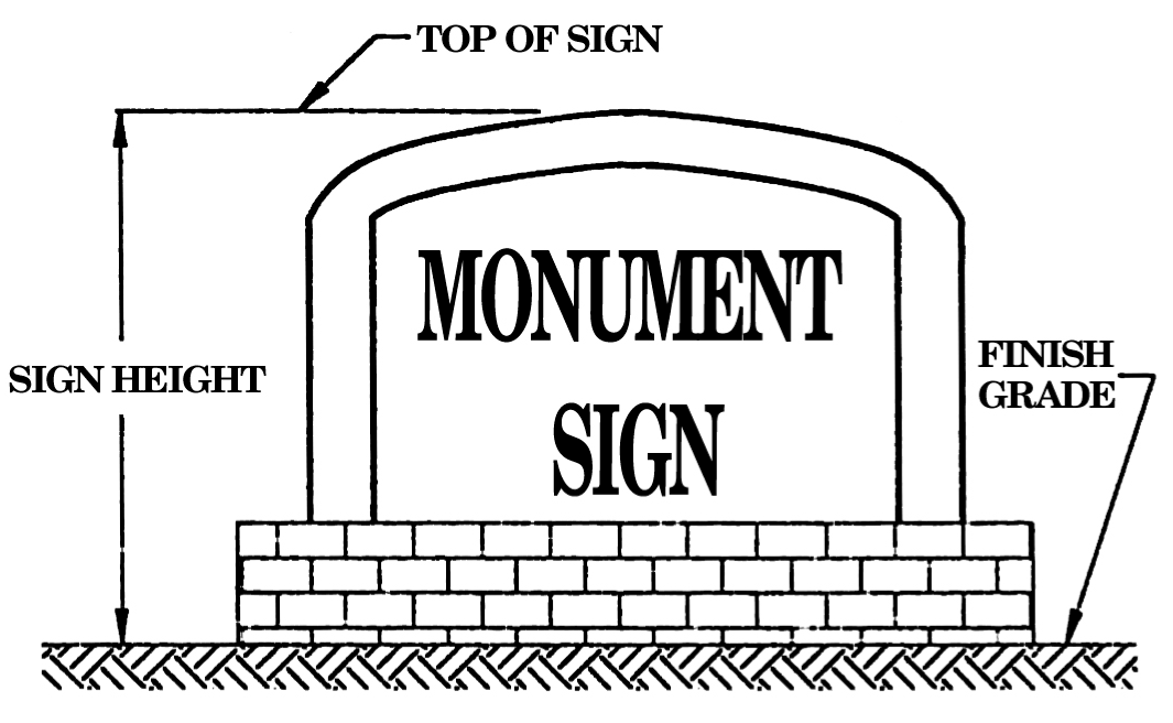
Figure 5-3: Monument Sign
Nit: A photometric unit of measurement referring to luminance. One nit is equal to one cdm2.
Nonconforming sign: Any sign which does not conform to the regulations of this ordinance, including any signs granted by variance where it can be demonstrated that the original hardship on which the variance was based no longer exists. This definition also includes the structure upon which the sign is erected, or the mounting hardware in the case of wall mounted signs.
Off-premises sign (billboard, etc.): A permanent or temporary sign erected, maintained, or used in the outdoor environment for the purpose of the display of commercial or noncommercial messages not appurtenant to the use of, products sold on, or the sale or lease of the property on which it is displaced. Also referenced as billboard or commercial outdoor advertising sign.
On-premises sign: A sign which advertises or directs attention to a business, commodity, or service conducted, offered, or sold on the premises, or directs attention to the business or activity conducted on the premises.
Political sign: A temporary sign intended to advance a political statement, cause, or candidate for office.
Portable sign: Any sign not permanently attached to the ground or other permanent structure, including but not limited to signs with attached wheels, A- or T-frame signs, and menu and sandwich board signs.
Post sign: A freestanding sign that is attached to the underside of a horizontal plane or arm and is supported by the horizontal plane. (See figure 5-4.)
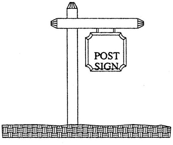
Figure 5-4: Post Sign
Post and panel sign: A freestanding sign that has a noninternally illuminated panel, not more than six inches in depth that is affixed to two posts and is not more than seven feet in total height. The sign shall not be higher than the supporting posts. (See figure 5-5.)
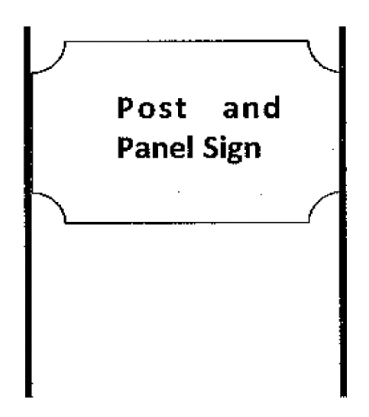
Figure 5-5: Post and Panel Sign
Projecting sign: A wall sign attached to a building with a bracket or other support projecting at a right angle from the building face. (See figure 5-6.)
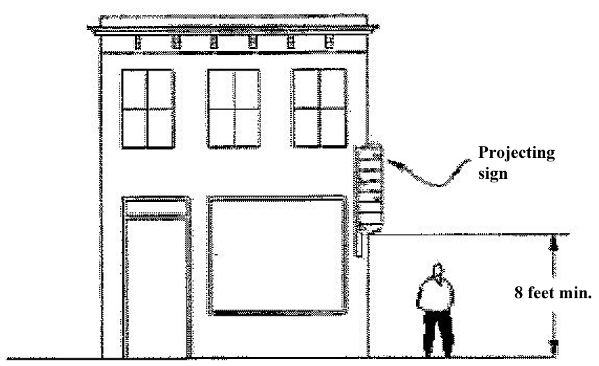
Figure 5-6: Projecting Sign
Public sign: A sign erected by or on behalf of a governmental body to post a legal notice, identify public property or public buildings, convey public information, and direct or regulate pedestrian or vehicular traffic.
Pylon sign: A tall freestanding sign that is held up by a pole or poles. The supporting structure must be equal to or narrower than the sign itself. (See figure 5-7.)
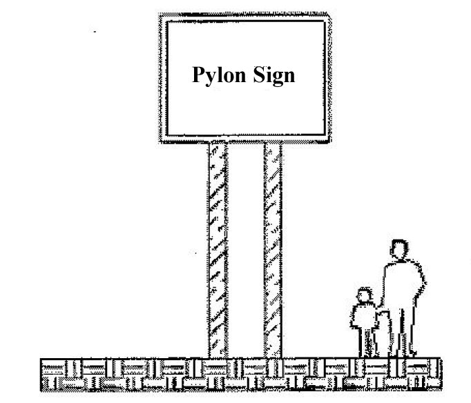
Figure 5-7: Pylon Sign
Race weekend sign: Any sign erected seven days prior to a sanctioned automobile race for the purpose of advertising products and services to race fans.
Real estate sign: A sign advertising the premises for sale, rent or lease.
Roof sign: A sign that is attached or painted on the roof, including porch roofs, dormer roofs, overhang roofs, canopy roofs or roofs of another architectural feature. Signs on the lower portion of a mansard or canopy are considered wall signs.
SI (International System of Units): The modern metric system of measurement.
Shared freestanding sign: A sign structure which is shared among multiple nonresidential properties or business interests for the purpose of displaying the name, logo type or other commercial message of multiple nonresidential occupants of said adjoining properties.
Sign: Any device visible from a public place whose essential purpose and design is to convey either commercial or noncommercial messages by means of graphic presentation of alphabetic or pictorial symbols or representations.
Sign area: The area of the smallest geometric figure, or the sum of the combination of regular geometric figures, which comprise the sign face. The area of any double-sided or "V" shaped sign shall be the area of the largest single face only. The area of a sphere shall be computed as the area of a circle. The area of all other multiple-sided signs shall be computed as 50 percent of the sum of the area of all faces of the sign.
Sign face: The surface upon, against or through which the sign copy is displayed or illustrated, not including structural supports, architectural features of a building or sign structure, nonstructural thematic or decorative trim, or any areas that are separated from the background surface upon which the sign copy is displayed by a distinct delineation, such as a reveal or border.
Sign height: The height of a sign shall be the vertical distance from normal grade to the highest point of the sign. Any berming, filling or excavating solely for the purpose of locating the sign shall be computed as a part of the sign height.
Sign setback: The straight line distance measured in linear feet between the street right-of-way line and the nearest element of a sign.
Temporary sign: A sign intended to display either commercial or noncommercial messages of a transitory or temporary nature. Any sign not permanently embedded in the ground, or not permanently affixed to a building or sign structure that is permanently embedded in the ground, is considered a temporary sign.
Unified campuses and complexes: The term "unified campuses and complexes" means:
(1)
Any "shopping center" as the term is defined in the zoning ordinance.
(2)
Or, any group of three or more principal structures under common management and operation, located on one or more contiguous properties;
(3)
Or, any single commercial or institutional parcel which has more than 400 linear feet of frontage on a principal arterial roadway which is occupied by a conforming commercial or institutional use. Unified campuses and complexes include, but are not limited to, shopping centers; entertainment, educational, medical, governmental, or religious campuses; office complexes; and industrial parks.
Urban collector and local streets: All streets or portion of streets within the corporate limits of the City of Dover which are not specifically classified as urban principal arterials or urban minor arterials under the provisions of this section.
Urban minor arterials: Delaware (DE) Route 8 (including all alternative names); McKee Road; Saulsbury Road; College Road; North Street (from Saulsbury Road to the western city limits); Kenton Road (from College Road to DE Route 8); State Street (from Walker Road north to US Route 13 and Wyoming Avenue south to the southern city limits); Loockerman Street; Leipsic Road; Webbs Lane, New Burton Road, Scarborough Road, Walker Road and Governors Avenue (from Division Street to the southern city limits) are considered to be urban minor arterials under the provisions of this section.
Urban principal arterial: US Route 13, Bay Road, and Court Street between 13 and Bay Road are considered to be urban principal arterials under the provisions of this ordinance. Delaware State Route 1 is not considered to be a road that will provide frontage for any parcel.
Vehicle sign: A sign displaying a name or names, logo types, graphics, commercial messages or any combination thereof, which is attached to, painted on, or otherwise applied to a motor vehicle or utility trailer.
Wall area: For purposes of calculating wall area, the calculations shall include the height of the wall from ground level to the roofline (mansard roofs also count as wall area), multiplied by the width of the wall (including all architectural features).
Wall sign: Any sign, other than a projecting sign, which is attached to or painted on any wall of any building and projects from the plane of the wall less than 18 inches. A sign attached to the lower slope or face of a mansard roof, canopy, or awning shall be considered a wall sign for purposes of this ordinance. For purposes of this section only, a "wall" shall include any permanent architectural extension of a wall, including parapets, even if such extension projects beyond or above the enclosed portions of the building. Canopy, marquee, and awning signs are all types of wall signs. (See figure 5-8).
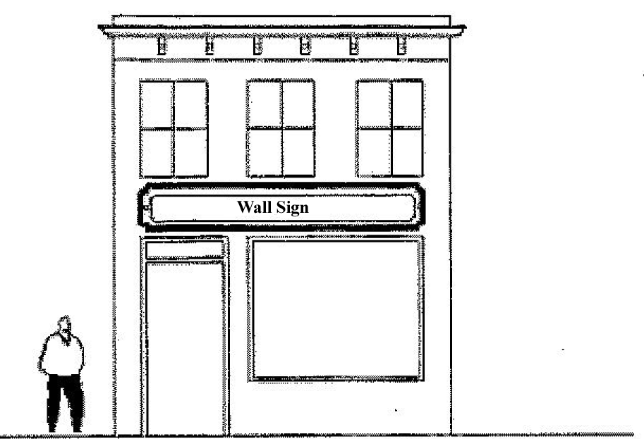
Figure 5-8: Wall Sign
Window sign: A sign affixed to the surface of a window with its message intended to be visible to the exterior environment.
4.4
Design requirements.
A.
Freestanding signs.
1.
Freestanding signs and attendant structures and bases shall be designed as an integral part of the site development and shall be coordinated and compatible with site grading, utility placements, landscaping and architectural elements.
2.
Freestanding signs and associated landscaping shall be situated and maintained so as not to impair or block visibility of motorists and/or pedestrians traveling within the public street right-of-way or entering, exiting or crossing vehicular site entrances. No sign or landscaping in excess of three feet in height above the adjacent street grade, shall be erected, placed or maintained on any corner within the triangular area formed by intersecting right-of-way lines. Two sides of the triangular area shall be 20 feet in length and measured from the point of intersection of the right-of-way lines.
3.
Freestanding signs shall be situated on the site and dimensioned so as not to substantially impair or block the visibility of adjacent buildings and/or existing signs.
4.
All freestanding signs shall respect the exclusion zone. When a sign is not permitted within the exclusion zone, one additional wall sign may be permitted in accordance with the wall sign regulations.
5.
When the presence of an existing freestanding sign on an adjoining property precludes a property from placing a freestanding sign due to exclusion zone provisions, the adjoining property owners and/or business interests may share a single freestanding sign structure in accordance with the provisions of subsection 4.9—Supplementary sign provisions, F—Shared freestanding signs, of this section.
6.
Location of monument signs and post and panel signs may be approved by the Planning Commission as part of a Site Development Plan Approval process.
B.
Materials and craftsmanship of signs. Signs shall be carefully crafted, durable, and consistent with the quality and permanence of the buildings and sites that they identify. Lettering shall be of a professional quality.
C.
Wall sign placement.
1.
When wall signs are planned, such signs shall be designed as an integral component of the building facade architectural composition.
2.
Wall signs shall be limited in area and number in accordance with the provisions of subsection 4.7—Permitted signs, of this section.
3.
Wall signs shall be situated so as not to cover or overlap decorative architectural elements such as cornices, belt courses, and window and doorframe moldings.
4.
In cases where only one wall sign is permitted because the lot has one frontage, the business may choose to locate the sign on any exterior wall of the building to afford the best possible visibility for the traveling public.
5.
In cases where more than one wall sign is permitted, the city planner or their authorized designee may allow the business to locate the additional wall sign on a different exterior wall of the building to afford the best possible visibility for the traveling public.
D.
Sign illumination standards.
1.
A sign may be illuminated at night. Signs that are illuminated at night may not exceed a maximum luminance level of 750 cd/m2 or Nits, regardless of the method of illumination.
2.
Signs that have external illumination, whether the lighting is mounted above or below the sign face or panel, shall have lighting fixtures or luminaries that are fully shielded.
3.
All illuminated signs must comply with the maximum luminance level of 750 cd/m2 or Nits at least one-half hour before Apparent Sunset. All illuminated signs must comply with this maximum luminance level throughout the night, if the sign is energized, until Apparent Sunrise.
E.
Changeable signs.
1.
Changeable signs may be incorporated into a sign face when the changeable component of the sign face occupies less than 70 percent of the total area of that sign face.
2.
Changeable sign area shall be integrated into the sign face and shall be enclosed by a border or similar enclosure so as to form one sign panel.
3.
Electronic message centers (EMC):
(a)
The following EMC display features and functions are permitted: scrolling, fading and dissolving while transitioning between messages.
(b)
EMC's shall have a minimum display time of eight seconds. The transition time between message and/or message frames is limited to one second.
(c)
The following EMC display features and functions are prohibited: traveling, flashing, spinning, rotating, any other moving effects, and all dynamic frame effects or patterns of illusionary movement or simulated movement.
4.5
Signs permitted in all districts and not requiring permits.
A.
Signs advertising the sale, lease, or rental of the premises upon which the sign is located, which sign shall not exceed six and one-fourth square feet in residential districts and 32 square feet in all other districts, and shall comply with setback regulations. One such sign shall be permitted for each 200 linear feet of street frontage for the parcel.
B.
Signs designating the name and address of the occupants, hours of operation, security notices, and business policy statements, and may not exceed four square feet.
C.
Signs denoting the architect, engineer, developer, or contractor placed on premises where construction, repair, or renovation is in progress, which signs shall not exceed 32 square feet in area. No more than two signs of any type are permitted for any one property or building project. Signs shall be 50 feet from other signs on the site, except where it is not physically possible, then the signs shall be as far away from the other sign as much as possible.
D.
Directional signs limited in area to no more than five square feet per sign, plus one square foot for each additional tenant. A permit is required for directional signs identifying the entrance or exit of a site if over five square feet in sign area. The sign area for these larger directional signs shall not exceed eight square feet and shall not be over four feet in height.
E.
Public signs.
F.
Historical and memorial signs.
G.
Any sign located in an internal location on a site, campus, or complex and that cannot be seen from any public right-of-way or adjacent property.
H.
People wearing costumes of the logo or character associated with the company as long as they are located on the business location.
I.
Political signs shall not be over six square feet in sign area in all Residential Zones and Districts and all other zoning districts shall comply with the size regulations in subsection 4.7 Permitted Signs, of this section. All election signs shall be removed no later than seven days after the election.
J.
Signs noting a tenant, store, building, etc. is "coming soon", which sign shall not exceed 32 square feet and only one sign is permitted on the site. The sign shall be 50 feet from other signs. The sign shall not be placed on the site for more than six months. After six months the sign shall be removed even if the tenant, store, building, etc. has not opened or been constructed.
K.
Portable signs designed to be transported, including, but not limited to, A-frames, sandwich boards, and umbrellas. These types of signs shall not obstruct pedestrian or vehicular access. No more than one sign is permitted per business, and shall not exceed four feet in height.]
L.
Signs required by federal or state law or by a municipal authority.
M.
Signs carved into a building or raised in integral relief on a building.
N.
Flags on flag poles.
O.
Public art.
P.
"Open" signs for business not to exceed two per business.
Q.
Vehicle signs subject to the provisions of subsection 4.9, supplementary sign regulations, H., of this section.
4.6
Sign prohibited in all districts.
A.
Signs which emit audible sound, vapor, smoke, odor, particles or gaseous matter.
B.
Any sign which competes for attention with, or may be mistaken for, traffic signals. Also, any sign that is determined by the city planner to constitute a traffic hazard by reason of size, location, content, color, or type of illumination.
C.
Off-premises signs of any type (billboards, temporary signs, directional signs for developments, etc.), except for shared freestanding signs as provided in subsection 4.4—Design requirements, A.5., and subsection 4.9—Supplementary sign provisions, F., of this section.
D.
Inflatable signs, except as specifically permitted in subsection 4.9—Supplementary sign provisions, D.3., of this section.
E.
Reserved.
F.
Signs painted on or attached to trees, fence posts, natural features, or telephone or utility poles.
G.
Signs that are flashing, rotating, or that give the appearance of movement, or are illuminated by flashing or intermittent lights, or lights of changing degrees or intensity, except as permitted under subsection 4.4—Design requirements, of this section.
H.
Temporary signs made of cardboard, paper, canvas or similar impermanent material, except those permitted in subsection 4.9—Supplementary sign provisions, of this section.
I.
Window signs covering more than 50 percent of a window or a door, or mounted above the first floor, except those permitted in subsection 4.9—Supplementary sign regulations, A.5., of this section.
J.
Pennants, balloons, streamers, flags, etc. except when permitted in subsection 4.5—Signs permitted in all districts and not requiring permits and in subsection 4.9—Supplementary sign regulations, D.1., of this section.
4.7
Permitted signs. Signs are permitted in all zones in accordance with the following table, which is a list of permitted sign types by use, proximity to residential uses and road classification.
*Denotes that an additional wall sign may be permitted/added in lieu of a freestanding pylon sign.
**Post sign would be in lieu of a monument sign or post and panel sign.
(Ord. of 2-12-2001; Ord. No. 2009-09, 6-22-2009; Ord. No. 2009-19, 10-12-2009; Ord. No. 2012-13, 8-13-2012; Ord. No. 2016-16, 8-8-2016)
4.8
Unified Comprehensive Signage Plan.
A.
Purpose statement. Recognizing that large campuses and complexes have signage needs that may not be adequately addressed by traditional sign regulations, this subsection of the ordinance is intended to allow a procedure for approval of a unified comprehensive signage plan for these Unified Campuses and Complexes.
1.
Campuses and complexes are required to follow all standard signage requirements, as embodied elsewhere in this section, unless they choose to apply to the planning commission for comprehensive signage plan approval. All such plans must embody a thorough review of all existing signs.
2.
Any proposed shopping center or group of three or more principal structures under common management and operation located on one or more contiguous properties is required to submit an application for comprehensive signage plan approval to the planning commission.
3.
Any business or institution which has more than 400 linear feet of frontage on a principal arterial may submit an application for comprehensive signage plan approval.
B.
Design guidelines for unified comprehensive signage plans.
1.
Unified campuses and complexes applying for a unified comprehensive signage plan may not be held to the height, size, number and area regulations for signs found in other subsections of this section. However, the number, type and size of signs proposed may not be excessive, and must be in proportion to the scale of the buildings and the uses on the site.
2.
All unified comprehensive signage plans must comply with all design guidelines found in subsection 4.4—Design requirements of this section, as well as all specific design guidelines found in this section.
3.
Building signs shall be in harmony with the overall architectural concept for the site, and be compatible with each other and the building facades.
4.
The freestanding signs identifying shopping centers and other unified campuses and complexes shall identify the name of the campus or complex and no more than three separate tenants within the campus or complex unless otherwise approved by the planning commission.
5.
There shall be architectural harmony and unity of signs within a unified campus or complex. Sign type, color scheme, size, and illumination within the site shall be coordinated and shall be compatible with the architecture of the center and the surrounding area.
C.
Planning commission duties. In reviewing and approving comprehensive signage plans, the planning commission shall take into consideration the public health, safety and welfare, the comfort and convenience of the public in general and of the residents, businesses, and property owners of the immediate neighborhood in particular, and shall ensure that unified campuses and complexes have adequate, but not excessive, signage. Specifically, the following objectives shall guide the commission when reviewing such plans:
1.
That the size and complexity of the campus or complex warrants the need for extra signage under the provisions of this section;
2.
That, in respect to the number and type of entrances, the placement of signage at or near those entrances provides superior visibility in order to ensure the safety of the driving public;
3.
That the proposed signs are adequate in number to safely direct the public to the use or uses on the site;
4.
The proposed signs must not have an adverse impact on the visibility of adjacent signs, and shall be consistent with, or an improvement over, the prevailing type and style of signage in the general area;
5.
That the proposed signs will be of a style and color which will complement the architecture of the site, and the area in general.
D.
Submission requirements.
1.
A pre-application meeting is required. No application will be accepted without a pre-application meeting.
2.
Copies of a sign plan, which details the signage proposal, including relevant application forms, will be due on the regularly scheduled submission deadline for planning commission review. The sign plan shall illustrate the physical location of all existing and proposed signs on the subject property and their relationship to existing and/or proposed buildings on the site. The submission plan shall include color renderings of each proposed sign (drawn to scale), along with architectural elevation drawings of the building depicting the placement of all wall mounted signs existing and proposed.
3.
Public notice is required, following the procedures set forth in article 10, section 2.43(C).
4.
The application fee as provided for in Appendix F—Fees and Fines, is due at time of application.
E.
Amendments to approved comprehensive signage plans. Any new or revised signs to be placed on a property with an approved comprehensive signage plan need not go back to the planning commission for re-approval if the sign area is not increased more than 15 percent, and the proposed signs conform to the overall design concept and colors as approved. The 15 percent increase shall be calculated cumulatively over the life of the project, based upon the originally approved sign area.
4.9
Supplementary sign provisions.
A.
Window signs.
1.
Three window signs shall be permitted as additional signage on walls fronting on the public right-of-way.
2.
Window signs shall not cover more than 50 percent of any window exclusive of window and/or door frame.
3.
Windows principally viewed from drive aisles and parking lots and not prominently visible from the public right-of-way shall be exempt from restrictions on the number of signs, and may be approved by the city planner for a window coverage area greater than 50 percent when the business elects to have less window signage than permitted on the windows fronting on, or prominently visible from, the public right-of-way.
4.
Window signs shall be permitted on windows on the first floor of a building only.
5.
The city planner may waive the provisions of this subsection when it has been demonstrated that the proposed window signs are of a unique or superior quality and style, and are intended to compliment the architectural design of the building, or when the business elects to use less wall signs than permitted for the purpose of complimenting the architectural design of the building. Signs granted this waiver are not exempt from the requirement to obtain a sign permit.
B.
Historic district signs.
1.
All signs in the historic district must meet the standards laid out in the Design Standards and Guidelines for the City of Dover Historic District Zone. Any and all standards found elsewhere in this section may be waived as part of the architectural review approval when proposed signs are determined to contribute to or improve the historic context of the building.
C.
Gas station signage.
1.
Canopy signs.
(a)
Canopy sign height shall not exceed 30 feet.
(b)
Canopy sign copy shall be directed toward a public street.
(c)
Canopy sign area shall be limited to no greater than 20 percent of the area of the canopy face to which the sign is applied.
2.
Exempt signs.
(a)
State or federal required price per gallon signage shall not count towards overall sign area for the site, unless they exceed 32 square feet in size.
(b)
Price per gallon signs not exceeding two square feet, located on the pump itself.
D.
Temporary signs.
1.
Temporary signs. Temporary signs for special events including inflatable signs with a surface area of less than 100 square feet and not more than 25 feet tall, may be erected on the premises of any establishment conducting a special event, provided that such signs do not exceed a total of two signs with a total of 100 square feet in sign area.. Temporary signage shall be displayed no longer than 90 days per calendar year. For grand openings, the maximum number, sign type, and allowable area may be waived by the city planner. Permits for such signs are required and shall be accompanied by a fee as provided for in Appendix F—Fees and Fines. The city planner may waive the time period, not to exceed an additional 30 days, if they determine that there are extenuating circumstances requiring further time for a temporary sign.
2.
Race weekend signs. During any seven-day period prior to the Saturday or Sunday that auto racing is occurring, temporary signs may be erected without a permit and with no restrictions on the number or size of the signs.
3.
Inflatable signs. Permits for such signs are required and shall be accompanied by a fee as provided for in Appendix F—Fees and Fines.
(a)
Inflatable signs with a surface area equal to or less than 100 square feet and not more than 25 feet tall are permitted in subsection 4.9—Supplementary Sign provisions, D.1., of this section and shall meet the following requirements:
i.
The inflatable sign shall be setback from the edge of the right-of-way a minimum of 25 feet.
ii.
The inflatable sign shall be securely anchored to the building or ground.
(b)
Inflatable signs with a surface area over 100 square feet and not more than 25 feet tall are permitted only during grand opening events, community festivals, and during race weekends in accordance with subsection 4.9 Supplementary Sign provisions, D.1. and D.2., of this section and shall meet the following requirements:
i.
The inflatable sign shall be setback from the edge of the right-of-way a minimum of 25 feet.
ii.
A plot plan/survey is required showing the placement of the inflatable sign in respect to utility lines and traffic.
iii.
The inflatable sign shall be securely anchored to the building or ground.
E.
Motor vehicle sales lots. This subsection allows motor vehicle sales lots to compensate for their likelihood to be mistaken for ordinary parking lots unless additional signs or other attention getting devices are placed in the sales area. It has also been demonstrated that these businesses tend to have smaller buildings relative to their land area diminishing their ability to effectively use wall signs.
1.
Banners are permitted on motor vehicle sales lots with a permit. Such banners may be permitted at a rate not to exceed one banner for each ten motor vehicle parking/storage spaces on the premises, and any such banner shall not be situated closer than 50 feet of any other banner on the premises. Parking spaces required for employees, customers, and service department uses shall not be counted to calculate the number of banners. The term "banner" does not include pennants, streamers, balloons, or other temporary or permanent signs.
2.
Banners shall not exceed a width of three feet.
3.
All banners must be securely attached to light standards, poles, or other substantial mounting hardware. Except for temporary signs permitted under the provisions of subsection 4.9—Supplementary sign provisions, D., of this section, all banners must be constructed of a permanent, weather resistant material.
F.
Shared freestanding signs.
1.
For adjoining nonresidential properties, a freestanding sign structure may be shared among adjoining property owners or businesses solely for the purpose of identification of the adjoining premises or businesses.
2.
Where multiple property owners have agreed to share a freestanding sign as referenced in subsection 4.4—Design requirements, of this section, the shared freestanding sign shall be entitled to a combined sign area bonus of not more than 50 percent over the freestanding sign area otherwise permitted for the property on which the shared freestanding sign would be placed.
3.
The permit application for a shared freestanding sign shall be accompanied by a binding legal agreement between the multiple adjoining property owners and/or businesses which describes the ownership and maintenance obligations for such shared sign.
G.
Single buildings with multiple commercial tenant spaces or facades.
1.
Structures, such as shopping centers, which contain multiple commercial tenant spaces, are permitted to have at least one wall sign on each unit. This provision shall only apply to units on the first floor of the structure.
2.
When a structure is designed so that there are distinctly different facades or sections of the building along a single frontage, at least one wall sign is permitted on each facade or section of the building.
3.
Multi story office buildings with multiple tenants are permitted one wall sign per tenant. Signs shall not be located above the second story.
H.
Vehicle and utility trailer signs. Vehicles or utility trailers shall be permitted to have vehicle signs attached to or painted on them, with no sign permit required. However, the city planner may require any vehicle or utility trailer with a vehicle sign to be moved if he/she determines that the vehicle is inoperable or being used for the sole purpose of displaying signage. Vehicles and utility trailers shall be moved to a location not visible from the public right-of-way, or, if no such location is available, as far away from the public right-of-way as possible. In making the determination, the city planner shall use the following criteria; at least two criteria shall be met before this section requires moving a vehicle:
1.
The sign is temporarily attached to the vehicle or utility trailer, rather than painted on or applied in a permanent manner.
2.
The sign includes directional copy or symbols that only function correctly when the vehicle or utility trailer is parked in one or more specific locations.
3.
The vehicle or utility trailer does not move during the normal business hours of operation of the business.
4.
The vehicle or utility trailer is regularly parked in a location or manner to be prominently displayed to the public, even though a more discrete parking area is available at the business location.
5.
The vehicle or utility trailer is inoperable, meaning it is not properly and currently registered and tagged; is damaged or disabled as to not immediately be movable; is raised off the ground; is missing required equipment enabling it to travel on a public roadway; is parked in a location where it cannot access a public roadway; or cannot be started and moved off its location.
4.10
Nonconforming signs.
A.
Exclusions. Nonconforming signs which are within ten percent of compliance of any height, area or location requirement and which conform to all other provisions of this ordinance [section] shall be considered legal signs for the purposes of these regulations, except as provided in subsection 4.10—Nonconforming signs, B.4, below.
B.
Removal or compliance required. Nonconforming signs shall be removed from the premises or otherwise made to comply with these regulations in the following instances:
1.
When there is renovation to more than 75 percent of the exterior of the principal building measured in square feet of exterior wall surface area, or expansion of more than 20 percent of the floor area of the principal building measured in square feet of floor area on the premises on which such nonconforming signs are present, except that freestanding signs that are nonconforming as specified shall not be required to conform; however, the degree of non-conformity shall not increase. When, within any given two-year period, individual renovation projects involving less than 75 percent of the building exterior and/or individual building additions involving less than 20 percent of the floor area of the principal building on the premises would in aggregate exceed the 75 percent renovation and/or 20 percent expansion thresholds set forth herein, all such nonconforming signs shall be brought into conformity with these regulations or shall be removed from the premises.
2.
Prior to the issuance of any permit for the placement of any additional signage on the property. No new signs of any type shall be added to the property until the nonconforming sign is removed.
3.
Nonconforming signs (including all supporting structures and mounting hardware) which have been abandoned shall be removed from the premises or otherwise made to conform within one year from the date of abandonment. Refacing the sign in accordance with other requirements of this section does not absolve an owner from complying with this subsection. In certain instances where it is evident that the reoccupation or reuse of a premises which contains an abandoned nonconforming sign is imminent, the city planner may grant an extension of time within which to reestablish the use of such nonconforming sign.
4.
Any nonconforming sign which has been removed from the premises shall be considered discarded, and replacement shall constitute a new sign, and require new permits.
C.
Notification and responsibility. It shall be the responsibility of the owner of record of such property to cause the removal of such nonconforming signs in accordance with these provisions. When any of the above-listed conditions exist, the city planner is authorized to issue written notice to the owner of record of such property, stating that such signs shall be removed within two calendar weeks of the date of receipt of the written notice. In cases where signs are determined to be unsafe or present a hazard, the city planner may order their removal in a shorter period of time. Failure to comply with these regulations, after due notice, shall be deemed a violation of this ordinance [section] and is punishable in accordance with the provisions of article 8, section 4 of this ordinance [section]. In addition, in the event that compliance is not achieved within the stated period, the city planner may remove or cause to be removed from the premises any such signs in violation of this section. All expenses incidental to such removal shall be charged to the owner of record of such property and shall constitute a lien upon such property.
4.11
Abandoned and damaged signs.
A.
Abandoned. All signs that conform to the current regulations which are deemed abandoned shall either be refaced with a blank or blacked out face or removed totally (including the supporting structure and/or mounting hardware) within 90 days of abandonment. Covering sign copy with tarps, paper, tape, cardboard or other nonpermanent materials is not an acceptable method of refacing.
B.
Removal. Any conforming sign, which has been removed from the premises, shall be considered discarded, and replacement shall constitute a new sign, and require new permits.
C.
Repair. All signs that are damaged (no longer working, cracked, missing pieces, etc.) shall be repaired within 30 days. A permit is not required as long as the sign will look exactly the same as it did before the sign was damaged. If there are any changes (color, script, etc.) to the sign a new permit will be required.
4.12
Historic or significant signs.
A.
Preservation of historic or significant signs. Signs that are at least 50 years old and considered historic or to have cultural/aesthetic significance shall be protected and preserved. If these signs are legally nonconforming they shall maintain their nonconforming status indefinitely. The determination of the historic or cultural/aesthetic significance of the sign shall be determined by the historic district commission.
1.
The owner of the premises on which these signs reside shall maintain the signs to ensure they work and are in good condition.
(Ord. of 2-12-2001; Ord. No. 2009-09, 6-22-2009; Ord. No. 2009-19, 10-12-2009; Ord. No. 2012-13, 8-13-2012; Ord. No. 2018-06, 8-27-2018)
Section 5. - Supplementary regulations applying to group housing zone (RG-3).
[(a)]
Number of dwelling units per group. The maximum number of dwelling units per group shall be eight.
[(b)]
Distance between building groups. No part of any building group shall be nearer than 30 feet to any other building group and no portion of the front or rear of any building group shall be nearer than 50 feet to any part of another building group. When the planning commission has reduced the side yard requirements through a waiver to eight feet in accordance with the supplementary minimum side yard requirement paragraph [in subsection (c)] of this section, then no part of any building group of four or less units shall be nearer than 16 feet to any other building group of four or less units and no portion of the front or rear of any building group of four or less units shall be nearer than 50 feet to any part of another building group of four or less units.
[(c)]
Supplementary minimum side yard requirements. The minimum side yard of 15 feet for group dwellings of four or less units may be waived to eight feet by the planning commission to allow for the separation of group dwelling buildings into two or more group buildings, provided that the total number of units permitted by the reduction of the minimum side yard requirement does not exceed the number of group dwelling units otherwise allowed within the same space by meeting the 15-foot side yard requirement. Such waiver shall only be granted by the planning commission after a determination that the reduction in side yard width affords a superior design and does not diminish safety.
[(d)]
Exception to front yard requirement. In developments where single-family dwellings are proposed adjacent to group dwellings (i.e., duplexes or townhouses), the minimum front yard requirement may be waived by the planning commission to 15 feet, conditioned that driveways are provided with a minimum 20-foot long driveway. Such waiver shall only be granted by the planning commission after a determination that the reduction in front yard width affords a superior design and does not diminish safety.
[(e)]
Minimum lot areas for single-family homes. The minimum lot area of the single-family detached dwelling may be waived by the planning commission to 6,000-foot developments where single-family dwellings are intermixed with group dwellings (i.e., duplexes or townhouses). Such waiver shall only be granted by the planning commission after a determination that the reduction in lot area affords a superior design and does not diminish safety.
(Ord. of 1-10-1996)
Section 6. - Dumpsters for trash and recycling.
6.1
Location of trash receptacles. In all zones of the City of Dover (except in residential zones where standard City of Dover 90-gallon trash containers are used), all trash receptacles and bulk recycling bins (excluding publicly operated recycling drop off centers), which shall be referred to collectively as "dumpsters" in this ordinance, are to be situated in order to allow safe and efficient access by trash collection vehicles, and shall be screened from public view. All dumpsters must comply with the following regulations:
6.11 Location and screening required. All dumpsters must be located in approved locations on the lot. Dumpsters must be placed on hard, paved, dust-free surfaces and may not be placed in designated parking spaces, fire lanes, or access ways. Outside storage of trash, cardboard, or shipping pallets is prohibited. A dumpster enclosure is required to screen the dumpster from view whenever these units are situated so that they will be visible from any public right-of-way or from an adjacent property.
6.12 Minimum dumpsters required.
6.13 Selection of trash service. Applicants for site development plan approval shall specify the proposed method of trash collection at the time of application. A change in the method of collection may require an alteration of the site plan, subject to approval of the city planner or the planning commission.
6.14 Maneuvering space. Adequate off-street truck maneuvering space shall be provided on-lot and not within any public street right-of-way or other public lands. Internal site circulation lanes are to be designed with adequate turning radii to accommodate the size and efficient maneuvering of trash collection vehicles.
6.15 Minimum dimensions for dumpster enclosures. All dumpster enclosures must be adequate to screen dumpsters from public view. Enclosures for private collection must be no less than seven feet in height. The height of enclosures for City of Dover collection may be no less than five feet high.
6.16 Enclosure construction. All dumpster enclosures shall be constructed of durable materials that will withstand the normal use and wear expected in trash removal operations. Whenever a dumpster, in its enclosure, will be visible from a public right-of-way, the appearance of the dumpster enclosures shall complement the architecture of the principal building on the lot, and be constructed with the same or similar exterior materials.
6.17 Gates. Gates are required whenever a dumpster, in its enclosure, will be visible from a public right-of-way. Gates must be designed to swing back behind the front of the enclosure and lock in the open position. If City of Dover trash service is provided, it is the responsibility of the property owner or occupant to open and securely lock back the gates to allow for trash pick up. The gates may be opened 12 hours prior to pick up, and must be closed within 12 hours after pick up.
6.18 Reduction of dumpster requirement. When a use is required to provide dumpsters as part of site development plan approval, the required number of dumpsters may be reduced under the following circumstances:
a)
Dumpster pads reserved for future use. An area of the site reserved for a dumpster may be substituted for an actual dumpster. The provided area must be large enough to accommodate a dumpster and must be accessible to trash collection services. The city planner may require that the owner of record of the property provide a dumpster in the reserved location, together with any enclosure required, upon determining there is need for the additional dumpster.
b)
Trash compactor substitution. Trash compactors may be substituted for ordinary dumpsters at a two to one ratio. The city planner may approve a higher substitution ratio if specifications are provided indicating the machine will achieve a correspondingly higher trash compaction ratio. Trash compactors must meet the same location and screening requirements as other dumpsters. Sites providing trash compactors must still provide separate receptacles for recycling.
c)
Alternative solutions. Alternative solutions for the storage of and collection methods for trash and recycling receptables may be considered. The city planner or planning commission may authorize alternative solutions.
6.2
Location and screening approval required. The locations of new dumpsters on a site and any screening necessary shall be approved through the site development plan approval process, according to the type of review required in article 10 of this appendix.
6.3
Unauthorized dumpsters. Any dumpster not previously approved through the site development plan approval process may be required by the city planner to be moved, removed, or screened if said dumpster is a nuisance to neighboring properties by virtue of its current location.
(Ord. of 9-13-1999; Ord. No. 2017-12, 10-9-2017; Ord. No. 2024-01, 3-11-2024)
Section 7. - Supplementary regulations applying to all non-residential zones.
7.1
Lighting. Lighting of commercial uses shall provide no less than 1½ footcandles at grade. Light shall be deflected away from adjacent residential areas and shall not be distracting to traffic on adjacent roads.
7.2
Opaque barrier. Visual and sound screening shall be provided on a non-residential use when abutting a residential use, except in front yard areas. The screening shall be required to be installed on site as part of planning commission or administrative site plan approval. Where required, screening shall consist of an opaque barrier at least six feet in height, accompanied by landscaping.
7.21 Opaque barrier options. The requirement for the opaque barrier may be met by choosing one of the following:
a)
An opaque fence made of durable materials such as wood, vinyl, composite, etc.
b)
A wall constructed of masonry materials, either stucco, brick, split-faced block, or decorative concrete. If the principal structure on the lot is of masonry construction, the wall shall match the exterior of the building.
c)
An earthen berm (3:1 slope maximum).
d)
An earthen berm (3:1 slope maximum) with either an opaque fence or wall constructed on top. Materials of the fence or wall shall be as specified in options a) and b). The total height of the barrier may be no less than six feet high.
7.22 Landscaping options. The required opaque barrier must be accompanied by one of the following:
a)
A durable and continuous evergreen planted screen, six feet in height at the time of planting. In the case of an earthen berm, the evergreen screen may be on the top of the berm.
b)
A hedge that will grow to a height of at least six feet at maturity. The hedge shall be interspersed with evergreen trees at least six feet high at the time of planting. The hedge shall be at least four feet high at the time of planting.
7.23 Parking lots. Whenever a parking lot is located across the street from a residential use, it shall be screened from view of such land by a thick hedge located along a line drawn parallel to the street, such hedge to be interrupted only at points of ingress and egress and to meet the corner visibility standards of appendix B, zoning, article 5, supplementary regulations, section 1.31. The open area between such hedge and the street shall be landscaped in harmony with the landscaping prevailing on neighboring properties fronting on the same street. The hedge shall be at least two feet in height at the time of planting and shall grow to no more than four feet in height at the time of maturity. While the hedge is growing to a suitable height, an adjacent four foot high fence may be required by either the planning commission or city planner, according to the type of review required by appendix B, zoning, article 10, planning commission.
7.24 Planning commission waiver. The planning commission may waive the requirement for the opaque barrier (wood fence, masonry wall, or earthen berm) and require only landscaping as required by section 7.22—Landscaping options in cases where noise is not a concern and the vegetation alone is considered a desirable aesthetic alternative.
7.3
Arterial street buffers. Where nonresidential zoned property fronts on a principal arterial street, as designated by the comprehensive plan, a landscape buffer shall be required in addition to normal landscaping of the street right-of-way. This landscape buffer shall be required when the property is subject to site development plan review or site development master plan review by the planning commission according to appendix B, zoning, article 10, planning commission. Arterial street buffers shall be a minimum of 30 feet in depth, measured from the right-of-way line of the arterial street.
7.31 Landscaping of arterial street buffers. At the time of development of the property, the arterial street buffer shall be planted with a variety of trees, shrubs and ground cover. The landscape design and planting plan for these arterial street buffers shall be subject to the approval of the planning commission as an integral part of the site development plan.
7.32 Standards for arterial street buffer landscaping. Landscaping in arterial street buffers shall follow the landscape guidelines outlined in appendix B, zoning, article 5, supplementary regulations, section 15, landscape guidelines. Landscaping shall be designed to enhance the appearance of the arterial street, complement the architecture of buildings on site, and integrate with adjacent landscape areas. Landscape designs and planting plans which would pose a hazard to traffic on the arterial street, obstruct underground or overhead utilities or infrastructure, or significantly impede visibility of properties from the street shall be prohibited.
7.33 Planning commission waiver. The planning commission may approve a buffer less than 30 feet in depth. In approving a lesser amount of buffering, the planning commission shall consider the following factors:
a)
Whether there are specific constraints related to existing lot size, lot configuration or the orientation of existing buildings on adjoining properties that would severely limit the development potential of the property if a deep buffer was required.
b)
Whether a deep or shallow buffer would cause the property to be out of character with the surrounding built environment.
c)
Whether there is significant landscape area within the right-of-way of the arterial street itself that can contribute to the buffer, and whether future road improvement activities are likely to reduce the depth of this area.
d)
Whether the landscape design and planting plan for the buffer achieve the standards of subsection 7.32—Standards for arterial street buffer landscaping.
7.4
Outdoor storage trailers. Storage trailers accessory to an approved use shall be prohibited on a site, except when meeting the following conditions:
1.
The total floor area of storage trailers shall be less than two percent of the gross floor area of the principal building.
2.
All storage trailers shall be placed in accordance with all zoning regulations regarding permanent structures, including setbacks, parking, and other bulk regulations.
3.
All such trailers shall be screened from public streets, and shall not be located between the principal building and the public road right-of-way.
4.
Trailers placed during approved construction phases or those used as collection facilities for non-profit, governmental or philanthropic organizations shall not be calculated into floor area totals used to determine parking requirements, but must conform to setbacks and all other bulk regulations.
5.
Storage trailers accessory to an approved use are to be temporary features on a site. No such trailer shall be in place for more than 18 months, except for those trailers to be used during construction or those used as collection facilities for non-profit, governmental or philanthropic organizations.
7.5
Fences. Fences or walls shall be limited to a maximum height of four feet above the ground when situated within front yard areas, and shall be limited to a maximum height of eight feet above the ground when situated within side and rear yard areas. Fences situated on corner lots shall be subject to the provisions of article 5, section 1.3. For the purposes of this provision, on lots with dual street frontage that are not corner lots, a fence situated to the rear of the principal structure shall be limited to a maximum height of eight feet above ground. Fences or walls with a height in excess of eight feet above the ground shall conform to the setback requirements for dwelling buildings as set forth in article 4 of this Appendix. Fence material commonly referred to as "barbed wire" and/or "razor wire," or any similar material shall be prohibited along property lines which adjoin residential zones.
(Ord. of 3-24-1986; Ord. of 12-14-1992; Ord. of 4-25-1994; Ord. of 9-13-1999; Ord. of 5-22-2000; Ord. No. 2011-26, 12-12-2011; Ord. No. 2017-12, 10-9-2017)
Section 8. - Performance standards.
8.1
Dangerous and objectionable elements. No land or building in any zone shall be used or occupied in any manner so as to cause any one or more of the following conditions to exist and to be dangerous, injurious, noxious or offensive beyond the boundaries of such premises in such a manner or in such amount as to adversely affect the reasonable use of the surrounding area or adjoining premises: Fire, explosive or other hazard; noise, or vibration; smoke, dust, odor or other form of air pollution; heat, cold, dampness or electromagnetic disturbance; glare, liquid or solid refuse or waste; traffic congestion causing roadways or intersections in the surrounding highway network to fall below acceptable levels of comfort and convenience; or other substance, condition or element (referred to hereinafter as "dangerous or objectionable elements"), provided that any use permitted or not expressly prohibited by this ordinance may be undertaken and maintained if it conforms to the regulations of this section limiting dangerous and objectionable elements at the point of the determination of their existence.
8.2
Uses requiring performance standards review procedure. Those uses in the C-3, IPM, IPM2, IPM3, and M zones and uses accessory thereto, which are specified as being subject to performance standards review procedure, are subject to the procedure specified in article 5, section 8.6 in obtaining a site plan approval. The city planner may require other uses, whether existing or proposed and regardless of the particular zoning district, to submit to the performance standards review procedure when there exists reasonable grounds to believe that a proposed use is in violation, or is likely to violate, the performance standards, in which event, the property owner shall comply with [the] performance standards review procedure.
8.3
Enforcement provisions applicable to other uses. Even though compliance with the performance standards procedure in obtaining a site plan approval is not required for some proposed uses, initial and continuing compliance with the performance standards themselves is required of every use, and provisions for enforcement to ensure continued compliance with the performance standards shall be invoked by the city planner against the property owner, tenant, or other responsible party if there are reasonable grounds to believe that performance standards are being violated by a particular activity or use.
8.4
Nonconforming uses. Certain uses established before the effective date of this ordinance and nonconforming as to performance standards shall be given a reasonable time in which to conform therewith, as provided in article 7, section 1.53.
8.5
Performance standards regulations. Where the following regulations overlap regulations of the Delaware Department of Natural Resources and Environmental Control or other state or local agencies, the more restrictive regulations shall apply in case of a conflict:
8.51 Fire and explosion hazards. All activities involving, and all storage of, inflammable and explosive materials shall be provided at any point with adequate safety devices against the hazard of fire and explosion and adequate firefighting and fire suppression equipment and devices standard in the industry. Burning of waste materials in open fires is prohibited at any point. The relevant provisions of the state and local laws and regulations shall also apply.
8.52 Radioactivity or electromagnetic disturbance. No activities shall be permitted which emit dangerous radioactivity at any point, or electromagnetic disturbance adversely affecting the operation at any point of any equipment other than that of the creator of such disturbance.
8.53 Noise. The maximum sound pressure level radiated by any use or facility (other than transportation facilities open to the public) at the property line shall not exceed the values in the designated octave bands given in [the following] table I, after applying the corrections shown in [the following] table II. The sound pressure level shall be measured with a sound level meter and associated octave band analyzer conforming to standards prescribed by the American Standards Association (American Standard Sound Level Meters for Measurement of Noise and Other Sounds, Z243-1944, American Standards Association, Inc., New York, N.Y., and American Standard Specification for an Octave Band Filter Set for the Analysis of Noise and Other Sounds, Z24.10-1953, American Standards Association, Inc., New York, N.Y., shall be used).
Table I
If the noise is not smooth and continuous and is not radiated between the hours of 10:00 p.m. and 7:00 a.m., one or more of the corrections in table II shall be applied to the decibel levels given in table I.
Table II
*Apply one of these corrections only.
8.54 Vibration. No vibration shall be permitted which is discernible without instruments at the property line.
8.55 Smoke. No emission shall be permitted at any point, from any chimney or otherwise, of visible grey smoke of a shade equal to or darker than No. 2 on the Power's Micro-Ringlemann Chart, published by McGraw-Hill Publishing Company, Inc., and copyrighted 1954 (being a direct facsimile reduction of the standard Ringlemann chart as issued by the United States Bureau of Mines), except that visible grey smoke of a shade equal to No. 2 on said chart may be emitted for four minutes in any 30 minutes. These provisions applicable to visible grey smoke shall also apply to visible smoke of a different color, but with an apparently equivalent opacity. Any emission shall be in conformance with air pollution regulations of the Delaware Department of Natural Resources and Environmental Control.
8.56 Odors. No emission shall be permitted of odorous gases or other offensive odorous matter in such quantities as to be readily detectable when diluted in the ratio of one volume of odorous air emitted to four volumes of clean air. Any process which may involve the creation or emission of any offensive odors shall be provided with a secondary safeguard system, so that control will be maintained if the primary safeguard system should fail. There is hereby established as a guide in determining such quantities of offensive odors Table III, Odor Thresholds, in chapter 5, "Air Pollution Abatement Manual," copyright 1951 by Manufacturing Chemists' Association, Inc., Washington D.C., and said manual and/or table as subsequently amended.
8.57 Fly ash, dust, fumes, vapors, gases, and other forms of air pollution. No emission shall be permitted which can cause any damage to health, to animals, vegetation, or other forms of property, or which can cause any excessive soiling, at any point, and/or which does not conform to air pollution regulations of the Delaware Department of Natural Resources and Environmental Control, and, in no event, any emission, from any chimney or otherwise, of any solid or liquid particles in concentrations exceeding 0.3 grain per cu. ft. of the conveying gas resulting from combustion. Standard corrections shall be applied to a stack temperature of 500 degrees Fahrenheit and 50 percent excess air.
8.58 Glare. No direct or sky-reflected glare, whether from floodlights or from high-temperature processes such as combustion or welding or otherwise, shall be permitted. This restriction shall not apply to signs otherwise permitted by the provisions of this ordinance.
8.59 Liquid or solid wastes. No discharge shall be permitted at any point into any public sewer, private sewage disposal system or stream, or into the ground, except in accord with standards approved by the Delaware Department of Natural Resources and Environmental Control, of any materials of such nature or temperature as can contaminate any water supply or otherwise cause the emission of dangerous or offensive elements.
8.60 Traffic congestion. When, in the surrounding highway network, operating conditions are at or near the design capacity level beyond which would result in functional failure of the surrounding highway network. All speeds are reduced to a low, but relatively uniform value. Freedom to maneuver within the traffic stream is extremely difficult, and it is generally accomplished by forcing a vehicle or pedestrian to "give way" to accommodate such maneuvers. Comfort and convenience levels are extremely poor, and driver or pedestrian frustration is generally high. Operations at this level are usually unstable, because small increases in flow or minor perturbations within the traffic stream will cause functional failures beyond acceptable levels. (The conditions described in this [sub]section are also used to describe "level of service E" as defined by the highway capacity manual developed by the transportation research board, dated 1985.)
8.6
Performance standard procedure.
8.61 Application. An application for a site plan approval shall be accompanied with a performance standard
review application when a use or occupancy is required, and shall be referred by the
city planner to the planning commission. The applicant shall also submit, in an amount
equal to the required number of site plan submissions, a plan of the proposed construction
or development, including a description of the proposed machinery, operations, and
products, and specifications for the mechanisms and techniques to be used in restricting
the emission of dangerous and objectionable elements referred to in article 5, section
8.1, in accordance with rules prescribed by the planning commission specifying the
type of information required in such plans and specifications, and an affidavit by
the applicant acknowledging his understanding of the applicable performance standards
and agreement to conform with same at all times.
No applicant will be required to reveal any secret processes, and any information
submitted will be treated as confidential if requested. The fee for such application
shall include the cost of the special reports required to process it, described below.
8.62 Report by expert consultants. The planning commission, if there is any reasonable doubt as to the likelihood of conformance, shall refer the application for investigation and report to one or more expert consultants qualified to advise as to whether a proposed use will conform to the applicable performance standards specified herein. Such consultant or consultants shall make such report within 30 days after his or their receipt of such application. A copy of such report shall be promptly furnished to the applicant.
8.63 Decision of the planning commission. At the next regular meeting of the planning commission, but in no event more than 30 days after the board has received the aforesaid report, or within such further period as agreed to by the applicant, the board shall decide whether the proposed use will conform to the applicable performance standards and, on such basis, shall authorize or refuse to authorize the issuance of a building permit or certificate of occupancy, or require a modification of the proposed plan of construction. Such decision of the commission shall be in the form of a written report. Any building permit or certificate of occupancy so authorized and issued shall be conditioned on, among other things:
(i)
The applicant's completed buildings and installations in operation conforming to the applicable performance standards, and
(ii)
The applicant's paying the fees for services of the expert consultant or consultants deemed reasonable and necessary by the planning commission for advice as to whether or not the applicant's completed buildings and installations will, in operation, conform to the applicable performance standards.
(Ord. of 4-25-1994; Ord. of 4-28-2008(2); Ord. No. 2018-06, 8-27-2018)
Section 9. - Development in stages.
Preliminary or final site plan approval may be granted in stages if the following criteria are met:
9.1 The development schedule must be approved by the planning commission.
9.2 Each stage submitted for site plan approval shall include not less than 20 percent of the total number of dwelling units for a residential development, or 20 percent of the total floor area, for a nonresidential development, which are proposed in the overall development plan.
9.3 The landscaping for each stage shall be 70 percent complete before final site plan approval is granted for the next stage.
9.4 In residential developments, the establishment of the common open space as detailed in the development plan must proceed concurrently with construction of the dwelling units, and must be completed no later than six months after the construction of all dwelling units.
9.5 In residential developments, the gross residential density for each stage, in addition to all preceding stages, may not exceed the approved gross density for the total development by more than 20 percent.
Section 10. - Open space, recreation and other public facilities.
The City of Dover shall require the reservation of open space, recreation and other public facilities in accordance with the provisions of this section as a condition of approval for all one-family dwelling, two-family dwelling and multiple-family dwelling residential developments requiring conditional use approval, site development plan approval, or land subdivision approval by the City of Dover Planning Commission.
10.1 Recreation areas.
10.11 Purpose. The purpose of this section is to ensure that active recreation areas are provided as an integral design element within residential developments and that such facilities are of an adequate scale in relation to the size of the residential development and which provide residents with a variety of active recreational pursuits.
10.12 Dedication required. The commission shall require the dedication or reservation of recreation areas, and the subsequent construction of recreation facilities of a character, extent and location suitable to the needs created by a development for recreation facilities as defined and in accordance with the design guidelines set forth.
10.13 Definition. The following are illustrative of the types of recreation areas and subsequent facilities that shall be deemed to serve active recreational needs and therefore to count toward satisfaction of the recreation area requirements of this section: tennis courts, handball courts, racquetball courts, swimming pools, saunas and exercise rooms, meeting or activity rooms within clubhouses, baseball and soccer fields, basketball courts, volleyball courts, swings, slides and play apparatus, and developed walking, jogging or biking trails.
10.14 Recreation area review.
10.141 Presubmission conference. Prior to the submission of a development plan, the applicant or his representative shall meet in person with the city manager or his appointee and the city planner to receive early advice and consultation on the proposed development and the proposed recreation facilities, including the size, type and layout.
10.142 Review with parks, recreation, and community enhancement committee. Upon receipt of the submitted development plan, the city manager or his appointee shall consult with the city council parks, recreation, and community enhancement committee.
10.143 Report to planning commission. Upon consultation with the committee, the city manager or his designee shall submit to the planning commission, through the development advisory committee, a report detailing the recommendations as to the active recreation facilities to be recommended and their location, related parking areas, and proposed landscaping.
10.15 Design guidelines.
10.151 Accessible. Recreation areas shall be accessible within the development and arranged in a manner which affords reasonable access to all residents within the development. When warranted, recreation areas can be dispersed throughout the development, provided that each remote location is accessible.
10.152 Pedestrian oriented. Recreation areas shall be pedestrian oriented and designed with linkages to existing and planned public walkways and with other existing or planned recreation areas.
10.153 Age oriented. The nature and scope of planned recreation areas shall reflect an awareness of, and sensitivity toward, the anticipated age groups that would reside within the proposed development.
10.154 Parking. Designs consider the need for parking facilities associated with recreation areas.
10.155 Walking, jogging and biking trails. Recreation trails shall only be counted toward the recreation area requirement when constructed as an accessory to central recreation facilities. The developed trail shall be the only area counted toward the area requirement.
10.156 Setbacks. No structure, equipment or game court surface required under this section shall be located nearer than 30 feet to any lot line of a lot to be used for residential purposes, nor nearer than 25 feet from any right-of-way line.
10.157 Landscaping. Such uses shall be landscaped in accordance with provisions of article 5, section 15, and where warranted, visual screening of parking areas, game courts, playground areas and other features as necessary to preserve and protect the interests of adjoining residential properties may be required.
10.158 Area. The minimum area of a remote recreation area shall be 2,000 square feet.
10.16 Area required. All residential developments shall provide recreational areas in a size equal to 275 square feet per dwelling unit or one-half acre of land, whichever is greater. In no case shall the commission require that more than ten percent of the gross area of the development be so dedicated or reserved when the gross area is greater than five acres.
10.17 Cash in lieu of recreation area construction.
10.171 Determination of suitability for cash donation. If the commission determines that the construction of recreation is not practical due to close proximity to existing available recreation facilities or infeasible due to natural characteristics of the land or will not benefit the residents of the development, the commission shall require a full or partial cash in lieu of areas of donation to be made by the developer in lieu of a full or partial dedication of land.
10.172 Separate recreation account. The cash donation shall be deposited in a separate account to be used for parks, playgrounds or recreational purposes.
10.173 Amount of cash donation. The cash donation shall be equivalent to the appraised value of land area required in section 10.16. The land area value shall be based on the appraisal prepared for the developer to secure construction financing. This submitted appraisal shall be a copy of the original supplied to the lending institution, with that institution identified, and shall conform in all ways to the Uniform Standards of Professional Appraisal practice and be performed by an appropriately qualified certified appraiser. If an appraisal prepared for construction financing is not available, then the developer shall have an appraisal done in accordance with the procedures set forth in [sub]section 10.174.
10.174 Appeal of appraised value. If the city does not accept the land value established by the appraisal detailed in [sub]section 10.173, the city may, at the developer's expense, require another appraisal be performed. This appraisal will be let on a bid basis between at least three appropriately qualified, certified appraisers selected by the city. The appraiser(s) who prepared the original appraisal in [sub]section 10.173 cannot be a party to this appeal appraisal.
10.175 Payment of cash donation. One hundred percent cash donation provided under this section shall be collected prior to issuing the first building permit for the development.
10.2 Open space.
10.21 Purpose. The purpose of this [sub]section [10.2] is to preserve areas of open space within residential developments which are designed to provide buffer spaces between developing areas, to preserve existing natural and historic features and to establish a network of open spaces within the built environment to provide a balance between developed and undeveloped lands, wildlife habitat conservation, the preservation of scenic view corridors, and to provide residents opportunities to engage in passive recreation activities.
10.22 Dedication required. The commission shall require the dedication of open space for the purpose of buffering, landscaping and preservation of natural features which add value to the residential development and to the surrounding community.
10.23 Definition. Open space shall include land or an area of water, or combination of land and water, within a development site, and designed and available for the use and enjoyment of residents of the development, not including off-street parking, areas set aside for public facilities and rights-of-way, and areas to be preserved as wetlands as required. The following are illustrative of the types of open space areas that shall be deemed to serve buffering and preservation of natural features to count toward satisfaction of the open space requirements of this [sub]section [10.2]: mature forests and groves, hedge rows, water courses, historic landmarks and resources, landscaped buffers and berming designed to promote privacy, open landscaped areas suitable for being used and enjoyed for purposes of informal and unstructured recreation and relaxation, stormwater detention ponds when suitably designed to emulate natural features by incorporating irregular shapes, gradual slopes (no greater than 1:4) and appropriate landscape plantings, and irreplaceable environmental assets with values that have been adequately documented.
10.24 Design guidelines.
10.241 Width. Land areas shall be at least 20 feet in width.
10.242 Clearing. Selective clearing of natural vegetation may be permitted to form trails and clearings within woodland areas in accordance with the provisions of article 5, section 16 (tree planting and preservation).
10.243 Linked. Open spaces shall attempt to be contiguous and designed with linkages to existing and planned public walkways and with other existing or planned recreation areas.
10.25 Area required. In no case shall the commission require that more than five percent of the gross area of the development be so dedicated or reserved.
10.3 Public facilities.
10.31 Purpose. The purpose of this [sub]section [10.3] is to afford the city the opportunity to reserve lands within developing areas which represent important and strategic locations for the distribution of essential public goods and services.
10.32 Dedication optional. Where public facilities are shown or proposed in the city comprehensive plan, or in any other plan or study accepted by the city council or other public body, and are located in whole or in part in a proposed subdivision or site plan, the commission may require the dedication or reservation of the area required in lieu of the requirements of [sub]section 10.1.
10.33 Definition. The following are illustrative of the types of public facilities that may be considered for reservation or dedication by this [sub]section [10.3]: schools, utility service lines, future road rights-of-way (other than those planned to serve the proposed development), public buildings, parks, public trails, and recreation facilities.
10.34 Area required. In no case shall the commission require that more than five percent of the gross area of the development be dedicated for the public facility. Area dedications shall only be allowed when the facility is to be dedicated to the City of Dover for facilities to be operated by the city.
10.35 Reservation. Any areas required by any other public bodies or any remaining areas beyond the five percent dedicated to the city under [sub]section 10.34 may be set aside by the commission for a period of one year to allow the proper authority the opportunity to purchase the area. Upon failure of the proper authorities to purchase such site within one year after the date of the final approval of the project, the developer, upon application, shall be relieved of the responsibility of reserving such land for public purposes.
10.4 Management and maintenance of common open space and recreational areas.
10.41 Management and maintenance required. There shall be provisions which ensure that the common open space land and all public facilities not dedicated to the City of Dover shall continue as such and be properly maintained. These provisions shall be in a form acceptable to the City of Dover. The developer shall either (a) retain ownership and responsibility for maintenance of such open land; or (b) provide for and establish one or more organizations for the ownership and maintenance of all common open space. In the case of (b) above, each organization shall be a nonprofit homeowners' corporation, unless the developer demonstrates that a community open space trust is a more appropriate form of organization.
10.42 Homeowners' association requirements. If a homeowners' association or open space trust is formed, it shall be governed according to the following:
10.421 Membership mandatory. Membership in the organization is mandatory for all purchasers of homes therein and their successors. The members of the organization shall share equitably the costs of maintaining and developing common open space and recreation areas, in accordance with procedures established by them.
10.422 Responsibilities. The organization shall be responsible for maintenance, insurance and taxes on common open space, recreation facilities and open public facilities, including but not limited to roads, gutters, sidewalks, curbs, drainage systems, water distribution systems and sewer facilities not dedicated to the City of Dover.
10.5 Exemption to recreation area and open space dedication.
10.51 Exemptions for small developments.
10.511 Residential developments with less than five acres of land and less than ten dwelling units. These developments shall be exempt from the land requirements set forth in [sub]sections 10.1 and 10.2, but shall require a full cash donation to be made by the developer in lieu of a dedication of land.
10.512 Residential developments with less than five acres of land and less than 20 dwelling units. These developments may be exempt from the one-half acre minimum requirement for recreation areas, but may be required to provide a lesser amount as recommended by the parks, recreation, and community enhancement committee. The commission shall require a full or partial donation in lieu of a full or partial dedication of land.
10.513 Residential phases. Phases or sections within developments that are commonly owned or commonly proposed for development shall not be considered as individual residential developments qualified for exemptions under this [sub]section [10.51].
10.514 Residential developments of ten (10) or fewer acres with a density over six units per acre. These developments shall be exempt from the area requirements set forth in section 10.16, but shall be required to provide 150 square feet of active recreation area per dwelling unit or 10,000 square feet of active recreation area, whichever is greater. If the commission determines that the construction of some or all of the required active recreation area is not practical or desirable, the commission shall require a cash in lieu donation for the active recreation area determined as not practical or desirable. Cash-in-lieu amount shall be in accordance with subsection 10.173 of this article.
10.515 Residential developments located within the Downtown Redevelopment Target Area as defined in Appendix C. These developments shall be exempt from the area requirements set forth in section 10.16, but shall be required to provide 75 square feet of active recreation area per dwelling unit with a minimum of 2,500 square feet provided on site. If the commission determines that the construction of the entirety of the required active recreation area is not practical or desirable, the commission shall require a cash in lieu donation for the active recreation area determined as not practical or desirable. Cash in lieu shall be calculated in accordance with subsection 10.173 of this article.
10.52 Amount of cash donation. This cash donation shall be equivalent to ten percent of the appraised value of gross land area. The land area value shall be based on the appraisal prepared for the developer to secure construction financing. This submitted appraisal shall be a copy of the original supplied to the lending institution, with that institution identified, and shall conform in all ways to the Uniform Standard of Professional Appraisal practice and be performed by an appropriately qualified certified appraiser. If an appraisal prepared for construction financing is not available, then the developer shall have an appraisal done in accordance with the procedures set forth in [sub]section 10.174.
10.53 Separate recreation account. The cash donation shall be deposited in a separate account to be used for parks, playgrounds or recreational purposes.
10.54 Appeal of appraised value. If the city does not accept the land value established by the appraisal detailed in [sub]section 10.52, the city may, at the developer's expense, require another appraisal be performed. This appraisal will be let on a bid basis between at least three qualified, certified and licensed appraisers selected by the city. The appraiser(s) who prepared the original appraisal in [sub]section 10.52 cannot be a party to this appeal appraisal.
10.55 Payment of cash donation. One hundred percent cash donation provided under this [sub]section [10.5] shall be collected prior to issuing the first building permit for the development.
10.6 Construction phasing. The recreation and open space areas shall be completed in a proportion equal to or greater than the proportion of residential dwelling units completed, except that 100 percent of the recreation and open space areas shall be completed prior to issuing building permits for the final 20 percent of the dwelling units proposed. Building permits shall not be issued for dwelling units unless the requirements of this section are met.
10.7 Council approval. Prior to acceptance by the planning commission, all areas planned for public dedication, or cash donations provided under this section must be submitted to, and approved by the parks, recreation, and community enhancement committee of the City of Dover, and shall be subject to final review and approval by [the] city council.
(Ord. of 3-13-1995; Ord. of 1-12-2009)
Section 11. - Environmental protection.
11.1
Purpose. The purpose of this section is to protect public health and safety by ensuring that environmental standards for water, air, and soil in the City of Dover adequately address current practices in the realm of environmental protection. Further, it is the intent of this section to protect environmentally sensitive land as well as the plants and animals that reside on that land.
11.2
Environmentally sensitive areas and scarce resources. All land areas which contain one of the following natural features or combination of these features shall be considered to be an environmentally sensitive area or an area of scarce resources subject to specific requirements for environmental protection and conservation: flood hazard areas, steep slopes, water bodies and wetlands, wet soils, woodlands, significant wildlife habitats, prime agricultural soils, designated scenic areas, and natural areas and nature preserves identified in the comprehensive plan.
11.21 Flood hazard areas. All flood hazard areas shall remain as natural open space, except for the construction of roads authorized by the City of Dover and/or the Delaware Department of Transportation.
a)
For the purposes of this section, natural open space is defined as an area of land that excludes buildings, structures, and impervious surface from being constructed on or located within the area. For evaluating flood hazard areas, patios, cement slabs, sidewalks, and other similar constructs are considered to be structures and are similarly prohibited.
11.211 Redevelopment. Existing uses or buildings located within a flood hazard area are considered to be nonconforming structures and are subject to the following requirements if redevelopment occurs on properties within the flood hazard area.
a)
Nonresidential uses existing in a flood hazard area seeking to redevelop a property under the requirements of Appendix B—Zoning, Article 10—Planning Commission, are required to reduce impervious surfaces for the lot by 15 percent from the preredevelopment conditions.
b)
For nonresidential uses where less than 33 percent of the total lot area is located within a flood hazard area, the planning commission may waive or reduce the amount of required reduction in impervious surfaces. For projects being reviewed under administrative site plan review, the city planner may waive or reduce the amount of required reduction in impervious surface for projects where less than 33 percent of the total lot area is located within a flood hazard area.
c)
New residential building construction or additions of impervious surface are not permitted in pervious areas of the flood hazard area.
11.22 Water bodies and wetlands. Water bodies and wetlands shall be left as permanent open space. No development, filling, piping or diverting shall be permitted, except for required roads, to be approved by the United States Army Corps of Engineers and/or the Delaware Department of Natural Resources and Environmental Control. Within these same areas, the clearing or removal of natural ground cover or vegetation, including the cultivation of the soil for agricultural purposes, is prohibited.
11.221 [Water bodies identified.] For the purposes of this section, the following, as depicted on the most recent USGS Topographic Maps, shall be defined as water bodies: Cahoon Branch, Dover Run, Fork Branch, Little River, Maidstone Branch, McKee Run, Morgan Branch, Muddy Branch, Puncheon Run, Silver Lake, and St. Jones River.
11.222 Setbacks. All buildings, structures, and impervious surfaces shall be set back at least 100 feet from the top of bank from wetland areas greater than 0.25 acres in size and from all water bodies. Patios, cement slabs, sidewalks, and other similar constructs are considered to be impervious surfaces. Within this 100-foot setback, vegetative ground cover is required. This setback may be reduced under the conditions set forth as follows:
a)
[Riparian buffer.] The setback may be reduced to 50 feet from the top of bank provided that a riparian buffer is established in the setback, consisting of native vegetation. (See figure 11-1)
b)
[Bank stabilization.] The setback may be reduced to 30 feet from the top of bank provided that a riparian buffer is established in the setback, consisting of native vegetation and provided that bank stabilization is implemented through the planting of native species. (See figure 11-1)
c)
[Single-family residential uses.] Single-family residential uses may reduce the setback requirement to 75 feet of the top of bank.
d)
Removal of buffer plantings without approval. The removal of native vegetation or plantings required for the purposes of riparian buffers for any purpose whatsoever, except the establishment of pathways (not greater than eight feet in width), shall be prohibited unless approved by the planning commission through the site plan, conditional use, or subdivision review process.
e)
[Replacement plantings.] Plantings in a riparian buffer that are removed without permission must be replaced with similar plantings within 30 days of removal. The City Planner may extend this time frame where and if weather conditions necessitate a delay.
f)
Exceptions to the setback requirements. Stairs, ramps, open decks, patios, fences, and docks necessary for access to natural features with a combined total of 200 square feet in size are exempt from the setback restrictions. Paved trails and sidewalks of up to six feet in width or less are exempt from the setback restrictions as defined in this section.
11.23 Wet soils. No construction shall be permitted where the seasonally high water table is within two and one-half feet of the surface unless crawl space, piles or slab on grade with provisions to prevent water seepage will be used to prevent water damage to the building. The proposed construction techniques must be approved by the building inspector in accordance with City of Dover Building Code and must meet or exceed the standards of the Federal Housing Administration.
No basements or cellars shall be permitted to be constructed below the seasonal high water table, unless special measures are taken to prevent water damage to the building. Such measures must be approved by the building inspector in accordance with City of Dover Building Code and must meet or exceed the standards of the Federal Housing Administration.
11.231 Requirements for development applications. Site development applications appearing before the planning commission must include either a wetland delineation prepared by a licensed/registered soil scientist, wetlands scientist, or professional engineer in accordance with U.S. Army Corps of Engineers standards; or provide a statement from the design professional that no wetlands are present on the site.
11.232 Requirements for major subdivision applications. Subdivision plans must identify the seasonal high water table on each lot if basements are proposed for those lots. A licensed Class D Soil Scientist is required to determine the seasonal high water table and this information must be displayed on the subdivision plat. This information must also be present in the deed and plot plan for each property. Basements may be prohibited where severe groundwater conditions exist.
a)
A lot specific study may be substituted for the recorded seasonal high water table as per the subdivision plan.
11.24 Significant wildlife habitat. Natural features that constitute significant wildlife habitats are considered to be environmentally sensitive features and a scarce resource deserving of protection. The natural features that typically provide significant wildlife habitat include wetlands and marsh areas that provide nesting and breeding grounds for waterfowl and support a wide variety of aquatic life; wooded areas in general, but most especially the edges of the wooded areas adjacent to open fields and along stream corridors; freshwater marsh and wetland areas, old fields and hedgerows; and natural areas of grasses and shrubs along the edges of open fields, drainage channels and wetlands. Applications for subdivision plan and site development plan approval shall include the identification of all areas and features which constitute significant wildlife habitat as part of the documentation of existing site conditions. The protection and preservation of wildlife habitat shall be considered by the planning commission in development review.
11.25 Scenic resources. Scenic resources shall consist of the following: mature woodlands and most especially the edges of wooded areas adjacent to open fields, wetlands or urbanized areas; other areas of mature natural vegetation such as marsh grasses; the historic district and areas listed on the National Register of Historic Places ; and freestanding historic buildings and sites and other buildings or districts of the city exhibiting particular architectural or visual merit buildings and places of special public or cultural significance, and significant views and view corridors to buildings or places of architectural, visual, public or cultural value and to attractive natural areas. Application for subdivision plan or site development plan approval shall include, as a part of the documentation of existing site conditions, the presence of and location of all scenic resources. The preservation and enhancement of the scenic resources potentially affected by the proposed development shall be considered by the planning commission in development review.
11.251 Silver Lake. All Site Plan, Conditional Use Site Plan, or Subdivision applications for parcels where any boundary of the parcel is abutting Silver Lake are required to go before the Silver Lake commission prior to appearing before the planning commission. The Silver Lake commission shall provide advisory comments for the planning commission on such applications.
11.26 Combinations of environmentally sensitive features and scarce resources. Wherever more than one environmentally sensitive feature or scarce resource is present on a site in combination, special care shall be taken in both the documentation of existing conditions on a site being considered for development and in the planning commission's review of a specific subdivision plan or site development plan application.
In general, the use of available development options such as planned neighborhood design and traditional neighborhood design is strongly encouraged to take advantage of the design and the planning feasibility in new development projects afforded by these options to preserve and protect environmentally sensitive features and the natural processes associated with these features to the maximum extent possible.
11.3
Stormwater management. All development must be designed, constructed, and maintained in accordance with State of Delaware Sediment and Stormwater regulations. The planning commission may require stormwater management in excess of the minimum regulations in areas with documented drainage problems upon concurrence with the Kent Conservation District, State of Delaware, or the City Engineer.
(Ord. of 3-24-1986; Ord. of 7-13-1992; Ord. of 6-13-1994; Ord. of 1-10-1996; Ord. No. 2010-25, 11-8-2010)
Section 12. - Reserved.
Editor's note— An ordinance adopted June 10, 1996, repealed § 12 of art. 5, app. B, in its entirety. Formerly, said section pertained to density bonus and derived unchanged from a zoning ordinance adopted April 21, 1975.
Section 13. - Adult entertainment establishment.
An adult entertainment establishment is permitted as a conditional use in the highway commercial zone (C-4) only and in no other zone and is subject to the following restrictions:
13.1
The building lot line upon which an adult entertainment establishment is to be located shall be at least 500 feet from any residential zone.
13.2
The lot line of the lot upon which an adult entertainment establishment is to be located shall be at least 1,500 feet from the lot line of any other adult entertainment establishment.
13.3
An application for a certificate of occupancy shall be accompanied by a photocopy of a valid license when such license is required by chapter 16, title 24, Del. C. (24 Del. C. § 1601 et seq.).
13.4
All building openings, entries and windows shall be located, covered or screened in such a manner as to prevent a view into the interior from any public or semipublic area.
(Ord. of 7-23-1979)
Section 14. - Child day care facilities.
14.1
General. In order to promote the development of quality child care outside of the home (day care facilities), the following two basic assumptions have been made:
14.11 The establishment of child day care services and facilities, wherever there is a need, is a necessary public objective; and
14.12 Day care programs for children shall be treated as community facilities and shall be permitted to locate in any zoning district, provided that need has been demonstrated, state licensing requirements have been met and no physical hazard to children can be reasonably anticipated.
14.2
Definitions.
Child day care facility. For the purposes of this ordinance, the facilities described furnishing care, supervision and guidance of a child or group of children unaccompanied by a parent or guardian, for periods of less than 24 hours per day shall be defined as follows:
14.21 Child day care center.
(a)
Any place, other than an occupied residence, which receives children for compensation for day care or large family day care home; and
(b)
Any occupied residence which receives 13 or more children for compensation for day care.
Child day care centers shall be required to obtain conditional use approval by the planning commission in accordance with the procedures and subject to the general conditions set forth in article 10 and to any specified requirement set forth in subsection 14.3 below, except in zoning districts where listed as a permitted use.
14.22 Family day care home—children. An occupied residence in which a person provides care for children other than his/her own family and the children of close relatives for compensation. Such care in a family day care home is limited to that care given to six or fewer children with a maximum of three children allowed for after school care. Such child care facility shall be permitted as an accessory use in all residential zones and shall be exempt from obtaining a conditional use permit and site plan approval.
14.23 Large family day care home—children. A facility which provides child care for more than six, but less than 13 children. This care may be offered in a private home or in a property converted to the purpose of providing child day care. This form of day care facility requires the submission of a site plan application in accordance with the procedures and subject to article 10, section 2 of the zoning ordinance. If a large family day care home is not to be located in an occupied residence, then a conditional use site plan application shall be required in accordance with article 10 section 1 of the zoning ordinance.
14.3
Zoning criteria.
14.31 Number of children. Day care centers shall be limited to a maximum of 50 children in all residential zones.
14.32 Outdoor play area. Must meet the state requirement for day care centers.
14.33 Off-street parking/loading. One space per each adult attendant, plus one space for every ten children.
14.34 Signage for child day care facilities.
(a)
Signs in residential zones.
i.
Family day care homes—children and large family day care homes—children. One wall-mounted sign limited to two square feet.
ii.
Child day care center. One sign, wall-mounted or freestanding, limited in area to 12 square feet. The planning commission shall consider the location of such sign as part of the conditional use review and may approve a lesser amount of sign area if deemed necessary by the commission to protect the general health, safety and welfare of the public in general and the residents of the immediate neighborhood in particular.
(b)
Signs in nonresidential zones. Child day care centers within nonresidential zoning districts shall be governed by the sign regulations in effect for the particular nonresidential zoning district in which the day care center is located.
14.35 Licensing requirements. Child day care facilities must meet state licensing standards and must be inspected by the City of Dover Fire Marshal's Office. A City of Dover Business License and a Public Occupancy Permit is required.
(Ord. of 5-14-1990; Ord. of 4-25-1994; Ord. of 4-23-2007(3); Ord. No. 2017-13, 12-11-2017)
Editor's note— The subsections of this section have been numbered by the editor to retain format.
Section 15. - Landscape guidelines.
The following guidelines shall be used in the design of site landscape as required in other sections of this ordinance and shall be followed unless it can be demonstrated through the site plan review process that such features would be impractical or incompatible with a particular land use or site development proposal. Failure to maintain required landscaping shall constitute a violation of this ordinance and is subject to, as specified in article 8, section 4, violations and penalties:
15.1 Trees of substantial size shall be provided to create a sense of scale and an overhead canopy. Where trees are set in paving, flush tree grates or open planters shall be used to protect root zones without interrupting the ground plane.
15.2 Large shrubs, small trees and evergreens are most effective for foundation planting around buildings, emphasizing major vehicular entrances and areas requiring visual screening. Avoid using large, dense plant material where maximum visibility is imperative.
15.3 Security and visibility are important considerations in landscape design along commercial corridors. Understory plant materials shall be confined to 36 inches or lower and trees shall be limbed to above 12 feet at maturity to allow for visual surveillance.
15.4 Color and specimen material shall be targeted to a few key locations. A few highly visible masses of color will be more effective than numerous small patches dispersed over the entire site.
15.5 Massing of plant material, or large groups of a single species is preferred over planting a large area with numerous species. Trees and shrubbery shall be used in scale with corridor development and large open spaces to create visual balance.
15.6 Grading shall be level, except to allow for necessary surface drainage and earth berms used for screening purposes.
15.7 Lawn areas shall be contained and separated from landscaped beds with defined edging such as concrete walks, steel edging or curbing.
15.8 Entrances shall be provided with landscaping to define the entrance location and to establish the site entrance as part of the overall landscape.
15.9 Landscape plantings shall be placed at least 10 feet away from all underground utilities and infrastructure, as measured from the trunk of the planting. Plantings located within 10 feet of overhead utilities or infrastructure shall be of a species that does not grow to the height of the lowest equipment overhead. Placement of all plantings must minimize conflict with required servicing of utilities and infrastructure.
(Ord. of 3-18-1992; Ord. No. 2017-12, 10-9-2017)
Section 16. - Tree planting and preservation.
16.1
Purpose. The purpose of this section is to establish standards and requirements for the protection and planting of trees and woodlands because it is recognized that woodlands and trees are not only desirable, but are essential to the health, safety, and welfare of the population in that they provide oxygen, reduce carbon dioxide, stabilize soil, cleanse the air by transpiring clean water into the atmosphere, cleanse water passing into the ground through the root system, provide protection for wildlife and their habitats, provide shade, reduce noise and glare, increase property values, and provide an important physical, aesthetic, and psychological balance to the built environment.
16.2
Definitions.
Caliper dimension. The term "caliper dimension" means an outside diameter measurement of the trunk of a tree measured at a vertical distance of three feet above grade.
Clearing. The removal of trees from an area of 5,000 square feet or greater, whether by cutting or other means. The term "clearing" shall not include the removal of trees for landscaping purposes by individual lot owners.
Development area. The area containing all new site features (buildings, parking and drive areas, pedestrian walks, stormwater management areas, buffer areas etc. but not underground utilities) proposed by a plan. The development area shall be delineated using property lines and lines run straight across the property from one property line to another without bending or curving.
Design professional. The term "design professional" shall be any person licensed as a landscape architect or architect, or Delaware certified nursery professional.
Dripline. A line on the ground established by a vertical plane extending from a tree's outermost branch tips to the ground, i.e., the line enclosing the area directly beneath the tree's crown, from which rainfall would drip.
Tree. Any self-supporting, woody perennial plant, usually having a main stem or trunk and many branches and at maturity normally attaining a trunk diameter greater than three inches at any point and height of over ten feet.
Tree protection area. Any portion of a site wherein are located existing trees which are proposed to be retained in order to comply with the requirements of this section. The tree protection area shall include no less than the total area beneath the tree canopy as defined by the dripline of the tree or group of trees collectively.
Woodland. An area of contiguous wooded vegetation (7,500 square feet or greater), where trees exist at a density of at least one tree with a caliper dimension of six inches or greater per 375 square feet of land and where the tree branches form a contiguous canopy.
16.3
Applicability. The terms and provisions of this section shall apply to any activity on real property which requires conditional use, site plan or subdivision approval of the planning commission as set forth in article 10, except the provisions in [sub]section 16.4 which shall apply to all real property.
16.4
Tree preservation.
16.41 Trees required by planning commission to be replaced. Trees required by the planning commission as a part of a conditional use, subdivision, or site plan approval shall not be removed unless they are diseased or infested, or present a danger to life and property. In cases where such trees are removed, they must be replaced with a tree planting in accordance with the table of trees standards kept in the office of the city planner.
16.42 Trees of special value. Trees having an historic value, as determined by the state historic preservation officer, or that are of an outstanding nature due to type or species, age, or other professional criteria, may be required by the planning commission to be preserved. Such trees may be prohibited from being removed by the city planner until such time that the planning commission has granted approval to remove such trees.
16.43 Tree preservation in wetlands. No portions of wetland areas shall be developed or cleared of vegetation unless granted permission under state and/or federal permit; and they shall remain as essentially undisturbed areas protected under the provisions set forth in subsection 16.7.
16.44 Clearing prohibited without approval. Clearing, as defined by this section, for any purpose whatsoever, except the establishment of trails and pathways (not greater than eight feet in width) and open yard areas, shall be prohibited unless approved by the planning commission through the site plan, conditional use, or subdivision review process.
16.5
Woodland preservation.
16.51 Tree preservation and selective clearing plan required. All site development proposals which involve the development of woodland areas and require planning commission approval shall include a tree preservation and selective clearing plan as part of the submission plan. The tree preservation and selective clearing plan shall be prepared in accordance with the provisions of subsection 16.5, subsection 16.7 and subsection 16.8 of this section.
16.52 Limited clearing for site development allowed. Generally, site development plans for the construction of a new building within existing woodland areas shall limit clearing of the land to those areas necessary to provide for the placement of the building or group of buildings, adequate access onto the property and to the proposed building or group of buildings, utility placement, off-street parking and yard areas to allow for daylight infiltration and building maintenance. When woodland areas are proposed to be cleared to allow for new construction, clearing within the area of the proposed construction shall be limited to an area of 30 feet from proposed building foundation, and 15 feet from off-street parking lots, and utility placement.
16.53 Maximum clearing requirement. Specifically, no more than 50 percent of a lot, parcel or tract of land occupied by woodland vegetation may be cleared for any purpose.
16.54 Reserved.
16.6
Tree preservation and planting in nonwoodlands.
16.61 Tree preservation and planting plan required. All developments requiring approval of the planning commission shall be required to submit, with its application and plans, a tree preservation and planting plan as set forth in subsection 16.8, and shall conform with the following provisions.
16.62 Tree density. For each property required to submit a tree preservation and planting plan, a development area as defined in this section shall be delineated within the nonwoodland area of the property. Within this development area, existing trees may be retained and new trees shall be planted such that the development area shall attain or exceed a tree density of one tree per 3,000 square feet or fraction thereof.
16.63 Minimum standards for new trees. For new trees to be counted toward the required tree density, they must be of a species and size as set forth in the table of trees approved by the planning commission and kept on file in the office of the city planner, or be of an alternate species found acceptable by the commission.
16.64 Minimum standards for existing trees. For existing trees to be counted toward the required tree density, the tree shall have a minimum caliper dimension of two inches. No trees over eight inches in caliper dimension shall be removed unless within an area of 30 feet from the proposed building foundation, off-street parking lot, and utility placement.
16.7
Tree protection and planting requirements.
16.71 Application. The following guidelines and standards shall apply to activities regulated under article 5, section 15 of this ordinance:
16.72 Protection required. To protect the required trees or woodland and their critical root zone, a tree protection area delineated by the dripline of a tree or group of trees to be retained, shall be established. The protection area shall not be disturbed by site utility and grading work, by construction activities such as parking, material storage, concrete washout, sedimentation intrusion or erosion, or other activity. Damage to trees or woodlands and their critical root zones shall require tree plans to be revised to compensate for the loss as determined by the building inspector.
16.73 Protection measures. Tree protection areas shall be protected by fencing, staking, or continuous ribbon and, where necessary, silt screens which shall be situated to coincide with the dripline of the tree or group of trees to be preserved. Protection measures shall be erected prior to construction, and must remain until final landscaping is installed.
16.74 Planting requirements. New trees proposed to be planted for credit toward the density requirement shall have spacing that is compatible with the spatial site limitations and with responsible consideration toward species size when mature. Species selected for planting must be ecologically compatible with the specifically intended growing site. Trees selected for planting shall be free from injury, pest, disease, and disorders.
16.8
Tree preservation, planting and selective clearing plans.
16.81 Plan specifications. A tree preservation and planting plan or a preservation and selective clearing plan, prepared by or in conjunction with a design professional, shall be shown on a copy of a preliminary plat, sketch, or site plan, as appropriate to the proposed development, drawn to the same scale and covering the same area as the other plan documents prepared for the planning commission hearing. The plan may be combined with a required buffer and landscape plan for the project, at the option of the developer. The plan shall provide sufficient information and detail to clearly demonstrate that all applicable requirements and standards of this section will be fully satisfied. The plan shall contain, but need not be limited to, the following:
a.
Project name, zone, parcel number, north arrow and scale.
b.
Developer's name, address and telephone number.
c.
Name, address, and telephone number of the design professional responsible for the preparation of the plan.
d.
Delineation of all lot lines, minimum yard areas, buffers, and landscape areas as required by the zoning ordinance [this appendix].
e.
Total acreage of the site and total lot area for each lot delineated.
f.
Delineation of all wetlands and woodlands.
g.
Designation and delineation of all lots in nonwoodland areas expected to retain existing trees to meet the tree density requirement.
h.
Approximate location and description of the protective tree fencing, staking, or continuous ribbon to be installed which, at a minimum, shall follow the dripline of all trees to be retained along adjoining areas of clearing, grading, or other construction activity.
i.
The location, spacing, caliper dimension, and species of new trees proposed to meet tree density requirements.
j.
Measures to be taken to avoid sedimentation intrusions and erosion in tree protection areas, and the location of such devices.
k.
A summary table of the number of new trees to be planted and minimum number of existing trees to be retained to meet the tree density requirement, if any, along with calculations showing that the tree density requirement has been achieved. Groupings of trees in the tree protection areas for new trees may be keyed to the summary table by area rather than having each tree individually labeled on the plan.
l.
There shall be a note on the plan indicating that a one-year full price replacement guarantee on all new trees planted is held by the applicant.
16.9
Tree mitigation.
16.91 Planning commission waiver. The planning commission may waive the provisions of subsections 16.52, 16.53, and 16.62, and require replacement planting for mitigation purposes should the planning commission determine, after demonstration by the applicant, that due to physical limitations of the land which would otherwise prohibit the reasonable use of the land, or for purposes of preserving, protecting and promoting the interest of public health, safety, welfare and/or public convenience. All tree mitigation plantings must occur within the corporate limits of the City of Dover. Tree mitigation may occur off-site in accordance with the provisions listed below in this ordinance:
(a)
If a waiver is sought from the provisions of subsection 16.62, new tree plantings are required at a rate of 1:1. All new tree plantings shall meet the minimum size at planting requirements of the City of Dover table of trees.
(b)
If a waiver is sought from the provisions of subsection 16.52 and/or subsection 16.53, then mitigation must be in the form of newly created woodland areas. New woodlands shall be created at a rate of 1.25 times the amount of woodlands to be removed. A woodland mitigation plan shall be prepared by a licensed forester, landscape architect, or certified nursery professional, for the consideration of the planning commission.
(c)
All tree mitigation must occur on-site unless an off-site location is specifically approved by the planning commission. When considering off-site locations for tree mitigation, the commission shall consider:
1)
A physical hardship related to the land which would otherwise prohibit compliance on the subject site;
2)
Whether the mitigation plan proposed by the applicant is superior in terms of environmental benefits, tree quantity, or aesthetic qualities compared to strict compliance with the ordinance on-site.
16.92 Tree mitigation required for unauthorized clearing. In the event that trees or woodland areas to be preserved under this ordinance or as a condition of a site plan, subdivision, or conditional use approval are illegally removed, tree mitigation shall be required. All tree mitigation plantings must be placed on the same lot, parcel, or tract on which the illegal clearing occurred, except as noted below. All replacement trees must be of the same or a similar variety as the trees illegally removed.
(a)
If trees have been removed from non-woodland areas, new tree plantings shall be provided in accordance with the table below:
* Note—All trees replanted must be guaranteed to survive a minimum of one year.
(b)
If trees have been removed from woodland areas, then mitigation must be in the form of newly created woodland areas. New woodlands shall be created at a rate of 1.75 times the amount of woodlands that were illegally removed. The woodland unlawfully removed must be replanted to satisfy a portion of this requirement. A woodland mitigation plan shall be prepared by a licensed forester, landscape architect, or certified nursery professional, for review and approval by the city planner.
(c)
If the applicant wishes to provide replacement plantings on any property other than the one on which illegal clearing occurred, the mitigation plan must be reviewed and approved by the planning commission. When considering off-site locations for tree mitigation, the commission shall consider:
1)
A physical hardship related to the land which would otherwise prohibit compliance on the subject site;
2)
Whether the mitigation plan proposed by the applicant is superior in terms of environmental benefits, tree quantity, or aesthetic qualities compared to strict compliance with the ordinance on-site.
(Ord. of 7-13-1992; Ord. of 7-12-1993, § 4; Ord. of 9-13-1999; Ord. of 4-28-2008(2); Ord. No. 2010-25, 11-8-2010; Ord. No. 2017-12, 10-9-2017)
Editor's note— An ordinance adopted July 13, 1992, added provisions designated as app. B, art. 5, § 15. In order to avoid duplicative section numbering, such provisions have been redesigned as app. B, art. 5, § 16, at the discretion of the editor.
Section 17. - Emergency access requirements.
(1)
General purpose. The purpose of this section is to establish standards and requirements for the fire protection of structures and inhabitants by providing emergency vehicle access to structures that enable the City of Dover Bureau of Fire to approach and attack fires in such a way that there is a reduced threat to the lives and safety of citizens.
(2)
Waiver. Should the planning commission determine, after demonstration by an applicant, that alternative means of fire protection can be provided which are equivalent to or greater than the public safety protection provided by this ordinance, then the planning commission may recommend to [the] city council to waive certain provisions of this ordinance that are not required under other city or state laws.
(3)
Fire lanes.
(a)
Primary and secondary fire lanes shall be provided with all new construction in accordance with the requirement of the State of Delaware Fire Protection Regulations and in accordance with the provisions of this ordinance. Where the State of Delaware Fire Protection Regulations conflict with the provisions of these regulations, the more stringent regulation shall prevail.
(b)
The owner of record of the property containing any primary or secondary fire lane shall be responsible for proper maintenance of such fire lanes in accordance with the provisions of the State of Delaware Fire Protection Regulations and all applicable regulations of the City of Dover.
(4)
Subgrade emergency access lanes.
(a)
A subgrade emergency access lane is designed to provide emergency vehicle accessibility in lieu of paved, hard-surfaced fire lanes where permitted under subsection 5 [(5)](a) of this section. A subgrade emergency access lane shall not be substituted for a required secondary fire lane.
(b)
All subgrade emergency access lanes shall be established at a minimum width of 18 feet and shall be set back from all building walls in accordance with the Delaware State Fire Protection Regulations. The planning commission may waive the 18-foot width requirement when demarcation is enhanced beyond the standards set forth in paragraph [subsection (4)](d) below.
(c)
All subgrade emergency access lanes shall be constructed on a level subgrade compacted to at least 2,000 pounds per square foot. The compacted subgrade shall be overlaid with three to four inches of compacted crusher run (CR1-2.5″) underneath four inches of compacted crusher run (CR6-1.5″) to form a compacted subbase. The compacted subbase shall be covered with at least four inches of topsoil and shall be graded and seeded or sodded. (See figure 17.1.)
(d)
All subgrade emergency access lanes shall be designated and identified by shrub plantings, fencing, signage or any combination of materials to adequately delineate such access way, subject to approval by the City of Dover Fire Marshal. When shrub plantings are to be used for lane demarcation, such plantings shall be evergreen and of a columnar, upright form, with [a] tight branching habit. Shrub planting selection shall be subject to final approval by the city planner. Demarcation shrub plantings shall be spaced no greater than 40 feet on center on straight sections of access lane and no greater than 20 feet on center on curved sections.
(e)
All subgrade emergency access lanes shall be maintained free of obstruction. The placement of fences, buildings, landscaping, gardens, play equipment or any other form of obstruction shall be prohibited from placement within the boundaries of subgrade emergency access lanes. The area reserved for [an] emergency access lane shall be subject to all property maintenance ordinances of the City of Dover, including those governing grass cutting, and landscape maintenance. Violations are punishable as misdemeanor offenses under the applicable ordinances of the City of Dover.
(f)
At points of access to subgrade emergency access lanes, there shall be provided an adequate curb depression of at least 24 feet in width. Such access points shall be designated as restricted use and controlled by signage, pavement marking, gates or fencing to prevent the use of such lane for purposes other than emergency vehicle access. The methods employed to ensure controlled access shall be reviewed, approved and inspected by the fire marshal on a case by case basis prior to the issuance of a certificate of occupancy for associated buildings.
(5)
Rear access requirements.
(a)
Emergency access to rear building areas shall be provided for various residential dwelling types in accordance with the following matrix:
REAR ACCESS REQUIREMENTS
1.
A "fire protected townhouse" means the individual units are separated by an NFPA-approved fire barrier and alternating pattern of noncombustible exterior siding separating combustible exterior siding.
2.
An "open rear yard" means as open yard area of at least 16 feet in width that must be maintained between townhouse buildings which back up to each other. Within this open rear yard, the placement of structures, fences, landscaping or any other obstruction shall be prohibited. Remaining yard areas may be enclosed by fencing and used for the placement of accessory structures, provided that such fencing shall be limited to four feet in height and structures limited to no more than one shed not greater than ten′ × ten′.
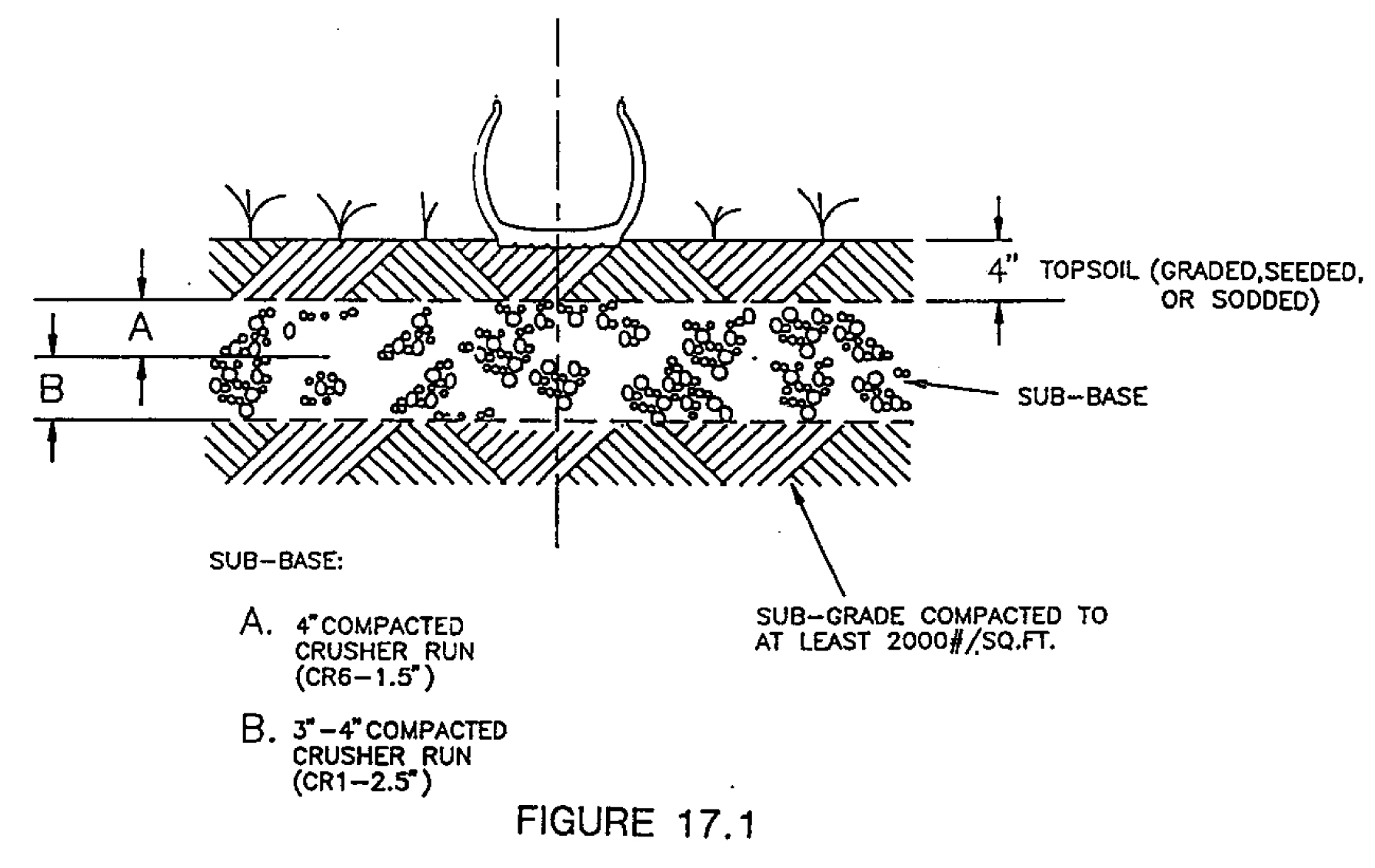
(Ord. of 12-12-1994; Ord. of 4-14-1997)
Section 18. - Pedestrian, bicycle, and multi-modal access requirements.
18.1
Purpose. The purpose of this section is to establish standards and requirements for the construction of transportation networks for pedestrians, bicyclists, and other users of non-motorized forms of transit, in order to ensure safe and convenient multi-modal access to all development within the City of Dover. Sidewalks, multi-use paths, and other hard paved trails, whether adjacent to a roadway or not, shall be referred to collectively as "pathways" within this section. It is the intent of this section that all new pathways installed shall be designed to a standard commensurate with existing and expected future multi-modal traffic volumes, recognizing that the convenience of a growing network of such pathways citywide will encourage residents and visitors to use non-motorized means of travel to reach their destinations.
18.2
Applicability. Sidewalks or other pathways according to the requirements of this section shall be installed on a property by the property owner or developer under the following circumstances:
a)
When the property is part of a development proposal which is subject to planning commission site development plan review.
b)
When the property is part of a development proposal which is subject to planning commission site development master plan review.
c)
When the property is part of a request for a conditional use permit which also requires site development plan review or site development master plan review.
d)
When the property is part of a development proposal which is subject to administrative site plan review, provided the proposal involves construction of an entire new building.
18.3
Pathway design standards and location requirements. Pathways shall meet the following minimum standards and requirements in order to allow for pedestrian access:
a)
Public street frontage. Standard City of Dover sidewalk, as per chapter 98, article IV of the Dover Code of Ordinances, shall be required to be installed along the entire public street frontage of a property. Where frontage sidewalk exists but does not meet the standards of chapter 98, article IV, the sidewalk shall be re-laid to meet the standards. Sidewalk shall include barrier-free access ramping at points of intersection with street crossings and at other locations so as to afford reasonable barrier-free pedestrian movement and site access.
b)
Private street frontage. Wherever a private road within a development is proposed, whether planned for future subdivision or not, standard City of Dover sidewalk, as per chapter 98, article IV of the Dover Code of Ordinances, shall be required to be installed on both sides of the cartway of the private road. Such sidewalk shall include barrier-free access ramping at points of intersection with street crossings and at other locations so as to afford reasonable barrier-free pedestrian movement and site access.
c)
On-site linkages. Within all nonresidential developments and all multifamily residential developments, sidewalk at least five feet wide, constructed of concrete or good paving brick laid substantially in concrete, shall be installed to make pathways between street frontages, parking areas, building entrances, and any other site features needing pedestrian access. Such pathways shall be designed to provide reasonable travel times between these features and disincentivize taking shortcuts across areas inappropriate for pedestrians. Where such pathways must cross drive lanes, standard City of Dover crosswalk shall be installed.
18.4
Alterations to pathway design standards. The planning commission or city planner, according to the type of plan review required by article 10 of this ordinance, may alter the minimum pathway design standards under the following circumstances in order to allow for multi-modal access:
a)
Where vehicular traffic on adjacent roadways is of sufficient speed and volume to pose a potential danger to bicyclists and other non-motorized forms of transport using the roadway, or where pedestrian and multi-modal traffic is expected in sufficient volumes to cause conflicts on a narrower sidewalk, a ten-foot wide multi-use path made of concrete or asphalt may be required instead of standard City of Dover sidewalk along the public street frontage.
b)
Where it is determined by evaluation of the characteristics of the nearby transportation networks including roadway classification type, the presence and type of existing pathways, and the general character of the area in terms of development, future development potential, and zoning district, a ten-foot wide multi-use path made of concrete or asphalt may be required instead of standard City of Dover sidewalk along the public street frontage.
c)
Where an adopted plan recommends installation of multi-modal facilities for a specific site, those facilities may be required to be constructed according to the standards of the agency implementing the plan.
d)
Where it can be shown that pathway materials alternate to those specified in this section would be more durable to multi-modal traffic, be more environmentally desirable, or be more in keeping with the overall design of the development, use of these alternate materials may be authorized.
18.5
Waiver of pathway location requirements. The property owner or developer may request a waiver from the planning commission or city planner, according to the type of plan review required by Appendix B—Zoning, Article 10—Planning Commission, under the following circumstances in order to reduce or eliminate the requirements for pathway installation:
a)
When the property is isolated from the existing pathway network, with no existing pathways within the immediate vicinity of the property.
b)
When the proposed use would not generate or attract additional pedestrian, bicycle, or other non-motorized trips.
c)
When physical characteristics of the property are such that pathway installation is impractical or impossible.
18.6
State law requirements. Where state laws or regulations of the Delaware Department of Transportation applying to right-of-way design conflict with the provisions of this section, the state laws and regulations shall prevail.
Editor's note— Ord. No. 2017-12, adopted October 9, 2017, in effect, repealed § 18 and enacted a new § 18 as set out herein. Former § 18 pertained to sidewalk requirements and derived from Ord. of 6-13-1994; and Ord. of 9-13-1999.
Section 19. - Building and architectural design guidelines.
The following guidelines shall be used in design of buildings and their architectural characteristics for the purposes of meeting the intent of appendix B, zoning, article 10, planning commission, section 2, subsection 2.27:
(1)
Physical orientation and facade.
(i)
The principal building facade of proposed buildings shall be oriented toward the primary street frontage, and in the same direction as the majority of existing buildings on the frontage street. Proposed buildings on corner properties shall reflect a public facade on both street frontages.
(ii)
Consideration shall be given to the dominant architectural features of existing buildings, but do not necessarily have to mimic those styles. Large expanses of blank walls are to be avoided, and consideration shall be given to windows and entrance ways along frontage, as well as projecting elements such as eaves, cornices, canopies, projecting bays, shadow lines and overhangs.
(2)
Architectural characteristics.
(i)
Building proportions. Consideration shall be given to proportional attributes, including overall height-to-width ratios, of existing building facades, doors, windows, projecting canopies, and other architectural features, found in adjacent existing buildings.
(ii)
Building mass. Facades of new buildings shall consider, but not mimic, the sense of lightness or weight of existing buildings on neighboring properties and consider similar proportions of solids (i.e., siding, blank walls, etc.) to voids (i.e., windows, door openings, etc.).
(iii)
Materials. Proposed buildings shall incorporate durable exterior surface materials similar to and complementary with the color, texture, size, and scale of exterior materials reflected on existing buildings in the immediate vicinity.
(iv)
Roofs. Consideration shall be given to general shape, ridge and eave heights, and material characteristics expressed in existing buildings along the subject street.
(v)
Visible utilities. Outside HVAC equipment and visible utility connections shall be designed to minimize impact on adjacent property owners, by reducing their overall visible presence and if necessary screening them from public view. Consideration must also be given to equipment placement in proximity to loading areas and public facades of the buildings.
(3)
Exemptions.
(i)
Building additions. Proposed building additions which will be designed to match the architectural characteristics and exterior material treatments of the existing building to which the addition is being made shall be exempt from the requirement to submit elevation drawings or other graphic representations.
(Ord. of 9-25-2000; Ord. No. 2017-12, 10-9-2017)
Section 20. - Solar and small wind energy systems.
Solar energy systems and small wind energy systems shall be permitted as accessory uses within all zones subject to the following requirements:
20.1 Residential zones.
20.11 Solar energy systems shall be subject to the following:
(a)
Ground-mounted solar energy systems shall be permitted only in the rear yard.
(b)
Ground-mounted solar energy systems shall be set back a minimum of five feet from side and rear property lines, or the height of the tallest point on the system, whichever is greater.
(c)
Ground-mounted solar energy systems shall not exceed 15 feet in height.
(d)
Ground-mounted solar energy systems shall be visually screened from adjacent properties to a height of six feet by either an opaque fence or a dense vegetative screen.
(e)
All exterior electrical and/or plumbing lines must be buried below the surface of the ground and placed in a conduit.
(f)
Roof-mounted solar energy systems must comply with all building height requirements for the zoning district where the system is to be installed.
20.12 Small wind energy systems in residential zones shall be subject to the following restrictions:
(a)
Small wind energy systems shall be set back 1.0 times the turbine height from adjoining property lines. Turbine height means the height of the tower plus the length of one blade.
(b)
The aggregate noise or audible sound of a small wind energy system shall not exceed five decibels above the existing average noise level of the surrounding area and shall be restricted to a maximum of 60 decibels measured at any location along the property line of the parcel where the small wind energy system is located.
(c)
Small wind energy systems shall be free from signage, advertising, flags, streamers, decorative items, or any item not related to the operation of the wind turbine. Electric wiring for the turbines shall be placed underground for nonbuilding integrated systems.
(d)
Small wind energy systems shall not be permitted within the H (Historic District) Zone.
(e)
Any small wind energy system shall be visually screened to a height of six feet by either an opaque fence or a dense vegetative screen from any properties or structures included on the National Register of Historic Places.
20.2 Nonresidential zones.
20.21 Solar energy systems shall be subject to the following:
(a)
For the purposes of this subsection, a use is considered accessory if it is located within a complex or campus that includes one or more contiguous lots under common ownership and management, where the principal use of the complex or campus is other than a solar energy system, and the energy generated by the solar energy system is intended to primarily reduce on-site consumption of utility-supplied energy.
(b)
Ground-mounted solar energy systems shall not occupy more than 30 percent of the lot area of the complex or campus for which the solar energy system is proposed.
(c)
If ground-mounted solar energy systems are proposed to occupy more than 30 percent of the lot area of the complex or campus, their placement shall be subject to conditional use approval by the Planning Commission.
(d)
Ground-mounted solar energy systems shall not be located between the principal structure and the street upon which the principal structure fronts.
(e)
All exterior electrical and/or plumbing lines must be buried below the surface of the ground and placed in a conduit.
(f)
Solar energy systems, whether roof-mounted or ground-mounted, must comply with all building setback and height requirements for the zoning district where the system is to be installed.
20.22 Small wind energy systems shall be subject to the following restrictions:
(a)
Small wind energy [systems] shall be set back 1.0 times the turbine height from adjoining property lines. Turbine height means the height of the tower plus the length of one blade.
(b)
The aggregate noise or audible sound of a wind system shall not exceed five decibels above the existing average noise level of the surrounding area and shall be restricted to a maximum of 60 decibels measured at any location along the property line to the parcel where the small wind energy system is located.
(c)
Small wind energy systems shall be free from signage, advertising, flags, streamers, decorative items, or any item not related to the operation of the wind turbine. Electric wiring for the turbines shall be placed underground for nonbuilding integrated systems.
(d)
Small wind energy systems shall not be permitted within the H (Historic District) Zone.
(e)
Any small wind energy system shall be visually screened to a height of six feet by either an opaque fence or a dense vegetative screen from any properties or structures included on the National Register of Historic Places.
20.3 Decommissioning. Solar energy systems and/or small wind energy systems must be maintained and kept in a state suitable for immediate operation. When it can be demonstrated that a solar energy system or small wind energy system, as approved in accordance with this section, is in a state of disrepair and is not suitable for immediate operation, that system shall be removed and the accessory use terminated.
(Ord. No. 2011-01, 4-11-2011)
Section 21. - Public utility infrastructure.
Public utility infrastructure shall be permitted in all zones and generally exempt from the requirements of Article 4—Zoning Bulk and Parking Regulations, except as provided in this section.
21.1 Setback. The minimum setback for public utility structures shall be equal to the setback of the zone in which the structure is located.
21.2 Fences. Fences shall be limited to a maximum height of eight feet above ground.
21.3 Site development plan required. Site development plan approval in accordance with article 10, section 2 hereof shall be required prior to the issuance of building permits for the erection or enlargement of all structures and related accessory structures.
21.4 Exceptions.
21.41 Electric power generation facilities shall be subject to all zoning requirements.
21.42 Wireless communication facilities as defined in Article 5, Section 23 shall not be considered public utility infrastructure under the provisions of this subsection, and shall be subject to the provisions of Article 5, Section 23.
(Ord. No. 2011-27, 12-12-2011; Ord. No. 2020-13, 11-9-2020)
Section 22. - Adult day care facilities.
Adult day care facilities shall be permitted to locate in any zoning district provided that state licensing requirements have been met and such facilities are subject to the following requirements:
22.1 Definitions
Adult day care facilities apply to any program that provides health, social and related support services for four or more functionally impaired adults who requires supervision due to cognitive or physical impairment or who cannot independently perform one or more activities of daily living. These services are provided to adults for a period of less than 12 hours during the day and are provided in a setting other than a participant's home or the residence of the facility operator.
Small adult day care facility. A facility that provides services for four adult participants but less than 16 adult participants.
Large adult day care facility. A facility that provides services for 16 or more adult participants.
22.2 Review process.
(a)
Adult day care facilities are permitted as accessory uses to existing facilities that provide services to adult participants.
(b)
Residential zones. A conditional use site plan application shall be required in accordance with Appendix B-Zoning, Article 10-Planning Commission section 1 for adult day care facilities in residential zones.
(c)
Non-residential zones.
i.
Site development plan approval in accordance with Appendix B-Zoning, article 10, section 2 hereof shall be required for small adult day care facilities.
ii.
A conditional use site plan application shall be required in accordance with Appendix B-Zoning, article 10 section 1 for large adult day care facilities.
22.3 Zoning criteria.
22.31 Off-street parking. One space per each adult attendant, plus one space for every four adult participants.
22.32 Signage for adult day care facilities
(a)
Signage in a residential zone. One sign, wall-mounted or freestanding, limited in area to 12 square feet. The planning commission shall consider the location of such sign as part of the conditional use review and may approve a lesser amount of sign area if deemed necessary by the commission to protect the general health, safety and welfare of the public in general and the residents of the immediate neighborhood in particular.
(b)
Signs in nonresidential zones. Adult day care facilities within nonresidential zoning districts shall be governed by the sign regulations in effect for the particular nonresidential zoning district in which the day care facility is located.
22.33 Licensing requirements. Adult day care facilities must meet state licensing standards and must be inspected by the City of Dover Fire Marshal's Office. A City of Dover Business License and a Public Occupancy Permit are required.
(Ord. No. 2017-13, 12-11-2017)
Section 23. - Wireless communications facilities.
23.1 Purpose and intent. The purpose of this section is to establish uniform standards for the siting, design, permitting, construction, maintenance, and use of wireless communications facilities (WCF) in the City of Dover (referred to herein as the "city"). While the city recognizes the importance of wireless communications facilities in providing high quality communications service to its residents, the city also recognizes that it has an obligation to protect public safety and to minimize the adverse effects of such facilities through the standards set forth in the following provisions and as referenced.
23.11 By enacting these provisions, the city intends to:
(a)
Promote the deployment of wireless communications facilities in the city while regulating their location and number to ensure the provision of necessary services;
(b)
Provide for the managed development of wireless communications facilities in a manner that enhances the benefits of wireless communication and accommodates the needs of both city residents and wireless carriers in accordance with federal and state laws and regulations;
(c)
Address new wireless technologies, including, but not limited to, distributed antenna systems, data collection units, small cells, cable Wi-Fi and other wireless communications facilities;
(d)
Establish procedures for the design, siting, construction, installation, maintenance and removal of small wireless communications facilities, non-tower based wireless communications facilities, and tower-based wireless communications facilities, in the city, including facilities both inside and outside the public rights-of-way;
(e)
Preserve the character of the city's neighborhoods and corridors;
(f)
Minimize the adverse visual effects and the number of such facilities through proper design, siting, screening, material, color and finish and by requiring that competing providers of wireless communications services collocate their commercial communications antennas and related facilities on existing wireless support structures where feasible;
(g)
Promote the health, safety and welfare of the city's residents.
23.2 Definitions.
Accessory equipment. Any equipment serving or being used in conjunction with a wireless communications facility or wireless support structure. The term "accessory equipment" includes but is not limited to utility or transmission equipment, power supplies, generators, batteries, cables, equipment buildings, cabinets and storage sheds, shelters or similar structures.
Antenna. An apparatus designed for the purpose of emitting radiofrequency (RF) radiation, to be operated or operating from a fixed location pursuant to Federal Communications Commission authorization, for the provision of wireless service and any commingled information services.
Changes in height. Changes in height is measured from the original wireless support structure in cases where deployments are or will be separated horizontally, such as on buildings' rooftops; in other circumstances, changes in height should be measured from the dimensions of the tower or base station, inclusive of originally approved appurtenances and any modifications that were approved prior to the passage of the Spectrum Act (47 CFR §1.4001(b)(7)(i)(A)).
Collocation. The mounting of one or more WCFs, including antennae, on a pre-existing structure, or modifying a structure for the purpose of mounting or installing a WCF on that structure.
Eligible facilities request. Any request for modification of an existing WCF that does not constitute a substantial change. Such request may involve: (i) collocation of new transmission equipment; (ii) removal of transmission equipment; or (iii) replacement of transmission equipment.
Emergency. A condition that (1) constitutes a clear and immediate danger to the health, welfare, or safety of the public, or (2) has caused or is likely to cause facilities in the rights-of-way to be unusable and result in loss of the services provided.
Equipment compound. An area surrounding or adjacent to a wireless support structure within which base stations, power supplies, or accessory equipment are located.
FCC. Federal Communications Commission.
Height of a tower-based WCF. The vertical distance measured from the ground level, including any base pad, to the highest point on a tower-based WCF, including antennae mounted on the tower and any other appurtenances.
Modification or modify. The improvement, upgrade or expansion of existing wireless communications facilities or base stations on an existing wireless support structure or the improvement, upgrade, or expansion of the wireless communications facilities located within an existing equipment compound, if the improvement, upgrade, expansion or replacement does not substantially change the physical dimensions of the wireless support structure.
Non-tower wireless communications facility (non-tower WCF). A wireless communications facility located or collocated on existing structures, such as, but not limited to, buildings, water towers, electrical transmission towers, utility poles, light poles, traffic signal poles, flag poles and other similar structures that do not require the installation of a new tower. This term includes the replacement of an existing structure with a similar structure that is required to support the weight of the proposed WCF. This definition excludes any installation constituting a small wireless communications facility.
Person. Individuals, corporations, companies, associations, joint stock companies, firms, partnerships, limited liability companies, corporations and other entities established pursuant to statutes of the State of Delaware, provided that "person" does not include or apply to the city, or to any department or agency of the city.
Replacement. The replacement of existing wireless communications facilities on an existing wireless support structure or within an existing equipment compound due to maintenance, repair or technological advancement with equipment that does not result in increased wind or structural loading, is substantially similar in size and weight as the wireless communications facilities initially installed, and that does not substantially change the physical dimensions of the existing wireless support structure.
Small wireless communications facility (small WCF). A wireless communications facility that meets the following criteria:
(1)
The structure on which antenna facilities are mounted
a)
Is 50 feet or less in height; or
b)
Is no more than ten percent taller than other adjacent structures; or
c)
Is not extended to a height of more than 50 feet or by more than ten percent above its preexisting height as a result of the collocation of new antenna facilities.
(2)
Each antenna associated with the deployment (excluding the associated equipment) is no more than three cubic feet in volume; and
(3)
All antenna equipment associated with the facility (excluding antennas) are cumulatively no more than 28 cubic feet in volume; and
(4)
The facilities do not require antenna structure registration under 47 CFR Part 17; and
(5)
The facilities are not located on Tribal lands, as defined under 36 CFR §800.16(x); and
(6)
The facilities do not result in human exposure to radiofrequency radiation in excess of the applicable safety standards specified in 47 CFR §1.1307(b).
Stealth technology. Camouflaging or screening methods applied to wireless communications facilities and accessory equipment which render them more visually appealing or blend the proposed facility into the existing structure or visual backdrop in a manner appropriate to the site's context and surrounding environment. Such methods include, but are not limited to, architecturally screened roof-mounted antennae, building-mounted antennae painted to match the existing structure and facilities constructed to resemble trees, shrubs, and light poles.
Substantial change. A modification to an existing WCF substantially changes the physical dimensions of a wireless support structure if it meets any of the criteria set forth in 47 CFR §1.6100, as amended.
Tower-based wireless communications facility (tower-based WCF). Any structure that is used for the primary purpose of supporting one or more antennae, including, but not limited to, self-supporting lattice towers, guy towers and monopoles. This definition excludes any installation meeting the definition of a small wireless communications facility.
Wireless. Transmissions through the airwaves including, but not limited to, infrared line of sight, cellular, PCS, microwave, satellite, or radio signals.
Wireless communications facility (WCF). An antenna facility or a wireless support structure that is used for the provision of wireless service, whether such service is provided on a stand-alone basis or commingled with other wireless communications services.
Wireless communications facility applicant (WCF Applicant). Any person that applies for a wireless communications facility building permit, zoning/conditional use approval, and/or permission to use the public right-of-way or other city owned land or property.
Wireless support structure. A freestanding structure, pole, tower, or other building, whether or not it has an existing antenna facility, that is used or to be used to support the placement or installation of a wireless communication facility for the provision of wireless service (whether on its own or comingled with other types of services).
23.3 Applicability. The terms and provisions of this section shall apply to wireless communication facilities in the city. As defined, each type of WCF has specific allowable locations, development regulations, and design standards as follows:
(a)
Small WCF described in Article 5, Section 23.6.
(b)
Non-tower WCF described in Article 5, Section 23.7.
(c)
Tower WCF described in Article 5, Section 23.8.
23.31 Exceptions. The activities by city residents to utilize satellite dishes, citizen and/or band radios, and antennae for the purpose of maintaining television, phone, and/or internet connections at their residences for non-commercial activity shall be exempt from the regulations enumerated in this Section 23.
23.32 Nonconforming uses. The following provisions shall apply to all buildings, support structures, and uses as related to wireless communication facilities:
(a)
All types of WCFs shall be permitted to collocate upon existing non-conforming WCFs, wireless support structures, and other non-conforming structures subject to the provisions of this Section 23.
(b)
Collocation of antennae is permitted on non-conforming structures.
(c)
Collocation of non-tower WCFs upon existing tower-based WCFs is encouraged even if the tower-based WCF is non-conforming as to use within a zoning district.
(d)
WCF which are hereafter damaged or destroyed due to any reason or cause may be repaired and restored at their former location but must otherwise comply with the terms and conditions of this Section 23.
23.4 Type of Activity determination. The following provisions outline the types of wireless communication facility applications.
23.41 Eligible facilities request. The WCF application type is classified as an eligible facilities request if the request for modification of an existing WCF that does not constitute a substantial change under 47 CFR §1.6100, as amended. The request may involve: (i) collocation of new transmission equipment; (ii) removal of transmission equipment; or (iii) replacement of transmission equipment.
23.42 Substantial change activity. The WCF application type is classified as a substantial change activity if the modification substantially changes the physical dimensions of a wireless support structure by meeting any of the criteria set forth in 47 CFR §1.6100, as amended, relating to height of the support structure or addition of new appurtenances or equipment cabinets.
23.43 New facility. The WCF application type is classified as a new facility if it involves the construction and placement of a new wireless support structure and does not meet the definition of small WCF.
23.44 Small WCF. The WCF application type is classified as a small WCF if the proposed antennas, accessory equipment and support structure (whether an existing, replacement or new structure) comply with the volume and height parameters set forth in the definition of small WCF.
23.5 Application procedures. The following provisions outline the procedures for wireless communication facility applications, policies and procedures for the administration of the WCF permitting and review process shall be developed by the city manager and city planner.
23.51 Location within public right-of-way. WCF applicants proposing a WCF to be located within the public right-of-way, shall be required to obtain application approvals as follows:
(a)
Pole attachment process. Compliance with the procedures found in Dover Code Ordinances, Chapter 110—Utilities, Section 110-32—Pole Attachment, for a WCF proposed for attachment to Dover Electric Department facilities.
(b)
Master license agreement required. Any WCF applicant for a WCF proposed for attachment to a utility pole owned or controlled by the City of Dover Electric Department shall first enter into a valid master license agreement with the city authorizing such attachment. No WCF shall be permitted to be attached to such utility poles without proof a valid master license agreement being provided as part of the permit application.
(c)
Permit—Use of rights-of-way. Obtain a right-of-way use permit from the city in accordance with permit policies and procedures pursuant to Dover Code of Ordinances, Chapter 98—Streets, Sidewalks, Storm Sewers and Other Public Spaces, for a WCF proposed with city rights-of-way.
(d)
Permit. Obtain a WCF building permit from the city in accordance with applicable permit policies and procedures pursuant to Appendix B, Article 8, Section 1—Building Permit of the City of Dover Code.
(e)
Documentation. WCF application shall also be accompanied by documentation demonstrating that the proposed WCF complies with all applicable provisions of this Section 23 for the type of WCF.
(f)
Fee. Each application to be approved under this section shall be accompanied by fees as provided for in Appendix F—Fees and Fines.
23.52 Compliance with zoning ordinance. The following section of the zoning ordinance shall be adhered to, as applicable, in the approval of a WCF application:
(a)
Architectural review certificate. WCF located within the Historic District (H) shall be required to obtain an architectural review certificate pursuant to Article 3, Section 21 and Article 10, Section 3 of this ordinance.
(b)
Airport environs. Locations within the Airport Environs Overlay Zone (AEOZ) shall document compliance pursuant to Article 3, Section 22 of this ordinance.
(c)
Environmentally sensitive areas. Location shall document compliance with the environmental protection measures for flood hazard areas and waterbodies and wetlands pursuant to Article 5, Section 11 of this ordinance.
23.53 Eligible facilities request. WCF applicants proposing an eligible facilities request shall be required to obtain application approvals as follows:
(a)
Type. WCF Applicant shall designate in writing that the application constitutes an eligible facilities request pursuant to 47 CFR §1.6100 and as defined by this Section 23.
(b)
Permit. Obtain a WCF building permit from the city in accordance with applicable permit policies and procedures pursuant to Appendix B, Article 8, Section 1—Building Permit of the City of Dover Code.
(c)
Documentation. WCF application shall also be accompanied by documentation demonstrating that the proposed WCF complies with all applicable provisions of this Section 23 for the type of WCF.
(d)
Fee. Each application to be approved under this section shall be accompanied by fees as provided for in Appendix F—Fees and Fines.
23.54 Substantial change activity. WCF applicants proposing a substantial change activity shall be required to obtain application approvals as follows:
(a)
Type. WCF Applicant shall designate in writing that the application constitutes a substantial change activity as defined by this Section 23.
(b)
Permit. Obtain a WCF building permit from the city in accordance with applicable permit policies and procedures pursuant to Appendix B, Article 8, Section 1—Building Permit of the City of Dover Code.
(c)
Documentation. WCF application shall also be accompanied by documentation demonstrating that the proposed WCF complies with all applicable provisions of this Section 23 based on the type of facility.
(d)
Fee. Each application to be approved under this section shall be accompanied by fees as provided for in Appendix F—Fees and Fines.
23.55 New facilities. WCF applicants proposing a new facility located in a public right-of-way shall be subject to the provisions of Section 23.51. WCF applicants proposing a new facility meeting the definition of tower-based WCF outside of a public right-of-way of shall be required to obtain application approvals as follows:
(a)
Conditional use authorization required. Any WCF applicant proposing the construction of a new facility shall first obtain conditional use authorization pursuant to Appendix B, Article 10 Section 1 of the Dover Code.
(b)
Documentation. The conditional use application shall demonstrate that the proposed WCF complies with all applicable provisions of Section 23 based on the type of facility.
(c)
Conditional use application requirements. The additional requirements for conditional use applications shall include the following:
i.
A description of the type and manufacturer of the proposed transmission/radio equipment, the power in watts at which the WCF applicant transmits, and any relevant related tests conducted by the WCF applicant in determining the need for the proposed site and installation.
ii.
Documentation demonstrating that the proposed tower-based WCF complies with all applicable state and federal laws and regulations concerning aviation safety.
iii.
Evidence that the owner of the property on which the tower-based WCF is proposed has granted authorization to construct and operate the tower-based WCF.
iv.
Written certification from a structural engineer licensed in the State of Delaware that the proposed WCF's ability to meet the structural standards offered by either the Electronic Industries Association or the Telecommunication Industry Association and certify the proper construction of the foundation and the erection of the structure.
v.
An application for a new tower-based WCF shall demonstrate that the proposed tower-based WCF cannot be accommodated on an existing or approved structure or building. The planning commission may deny an application to construct a new tower-based WCF if the WCF applicant has not made a good faith effort to mount the antenna(s) on an existing structure. The WCF applicant shall address the viability of any existing wireless support structures within a one quarter (¼) mile radius of the site proposed and demonstrate that such alternative candidates are inferior with respect to technical feasibility, cost, or terms of use.
(d)
Permit. Obtain a WCF building permit from the city in accordance with applicable permit policies and procedures pursuant to Appendix B, Article 8, Section 1—Building Permit of the City of Dover Code.
(e)
Documentation. WCF application shall also be accompanied by documentation demonstrating that the proposed WCF complies with all applicable provisions of this Section 23 based on the type of WCF.
(f)
Fee. Each application to be approved under this section shall be accompanied by fees as provided for in Appendix F—Fees and Fines.
23.56 New small WCF. WCF applicants proposing a new small WCF that does not qualify as an eligible facilities request shall be required to obtain application approval as follows:
(a)
Type. WCF applicant shall designate in writing that the application constitutes a small WCF as defined by this Section 23.
(b)
Permit. Obtain a WCF building permit from the city in accordance with applicable permit policies and procedures pursuant to Appendix B, Article 8, Section 1—Building Permit of the City of Dover Code.
(c)
Documentation. WCF application shall also be accompanied by documentation demonstrating that the proposed WCF complies with all applicable provisions of this Section 23 based on the type of facility.
(d)
Fee. Each application to be approved under this section shall be accompanied by fees as provided for in Appendix F—Fees and Fines.
(e)
New wireless support structures. An application involving installation of a new wireless support structure shall demonstrate that the proposed small WCF cannot be reasonably accommodated on an existing or approved structure or building within the right-of-way. The WCF applicant shall address the viability of any existing wireless support structures within 100 feet of the site proposed and demonstrate that such alternative candidates are inferior with respect to technical feasibility, cost, or terms of use.
23.57 Timing of approvals. Each specific type of WCF is subject to specific approval timeframes. Such timeframes shall be subject to the tolling procedures established by the FCC.
(a)
Small WCF: Timing of approval for all small WCF facilities that do not meet the definition of eligible facilities request. Once a WCF application is submitted these are the approval time lines:
i.
Notification of incomplete applications for small WCF. Within ten days of receipt of an application for a small WCF, the city shall notify the WCF applicant in writing of any additional information required to complete application.
ii.
Approval timeframe—Collocation. Within 60 days of receipt of an application for a collocation of a small WCF on a preexisting wireless support structure, the city shall make a final decision on whether to approve the application and the city shall notify the WCF applicant in writing of such decision.
iii.
Approval timeframe—New facility. Within 90 days of receipt of an application for a small WCF requiring the installation of a new wireless support structure, the city planning department shall make a final decision on whether to approve the application and shall notify the WCF applicant in writing of such decision.
(b)
Non-tower WCF: Timing of approval for all non-tower WCF facilities that do not meet the definition of eligible facilities request. Once a WCF application is submitted these are the approval time lines:
i.
Notification of incomplete applications for non-tower WCF. Within 30 days of receipt of an application for a WCF on a preexisting wireless support structure, the city shall notify the WCF applicant in writing of any additional information required to complete application.
ii.
Approval timeframe—Substantial change. Within 90 days of receipt of an application for a non-tower WCF on a preexisting wireless support structure that substantially changes the wireless support structure to which it is attached, the city shall make a final decision on whether to approve the application and the city shall notify the WCF applicant in writing of such decision.
iii.
Approval timeframe—Not substantial change. Within 60 days of receipt of an application for a non-tower WCF on a preexisting wireless support structure that does not substantially change the wireless support structure to which it is attached, the city planning department shall issue the required building permit authorizing construction of WCF.
(c)
Tower-based WCF: Timing of approval for all tower-based WCF facilities that do not meet the definition of eligible facilities request. Once a WCF application is submitted these are the approval time lines:
i.
Notification of incomplete applications for tower-based WCF. Within 30 days of receipt of an application for a tower-based WCF, the city shall notify the WCF applicant in writing of any additional information required to complete application.
ii.
Approval timeframe. All applications for tower-based WCFs shall be acted upon within 150 days of the receipt of a fully completed application for the approval of such tower-based WCF and the city shall advise the WCF applicant in writing of its decision. If additional information was requested by the city planning department to complete an application, the time required by the WCF applicant to provide the information shall not be counted toward the 150 day review period
23.58 Fees. Each application for permit or plan approval shall be accompanied by a fee as provided for in Appendix F—Fees and Fines.
(a)
Permit fees. The city may assess appropriate and reasonable permit fees directly related to the city's actual costs in reviewing and processing the application for approval of a WCF, as well as related inspection, monitoring and related costs. Such permit fees shall be established by Appendix F—Fees and Fines and shall comply with the applicable requirements of the FCC.
(b)
Reimbursement for WCF in right-of-way. In addition to permit fees as described in this section, every small WCF in the right-of-way is subject to the city's right to recover its actual costs incurred as a result of the small WCF's presence in the right-of-way, including, but not limited to, the costs of the administration and performance of all reviewing, inspecting, permitting, supervising and other right-of-way management activities by the city. The owner of each small WCF shall reimburse the city for the city's costs reasonably incurred in connection with the activities described above. All fees shall comply with applicable state and federal law and not exceed amounts presumed reasonable by the FCC.
23.6 Small wireless communication facilities (small WCF). The following regulations shall apply to all small WCF and associated wireless support structures as defined by this Section 23.
(a)
Location.
i.
Small WCF are permitted to be located in all city zoning districts subject to the application requirements of this Section 23.
ii.
Small WCF are subject to compliance with zoning ordinance provisions outlined in Section 23.52.
iii.
Small WCF are permitted to be located within the public right-of-way subject to application requirements of this Section 23.
(b)
Development regulations.
i.
Sizing. To be considered as small WCF, the WCF must comply with the criteria established in the definition of small wireless communications facility in Section 23.2.
ii.
Height. The total height of a small WCF shall comply with the maximum height permitted in the zoning district of the property to the extent technically feasible. In accordance with industry standards, small WCF applicants must submit documentation to the city justifying the total height of the WCF.
iii.
Height. The total height of a small WCF when located in the public right-of-way shall be no more than ten percent taller than the tallest existing utility pole or wireless support structure within a 250 radius of the proposed WCF or 50 feet above ground level, whichever is greater.
iv.
Placement. All small WCF shall comply with the applicable requirements of the Americans with Disabilities Act and all applicable requirements pertaining to streets and sidewalks, as codified in Chapter 98 of the Dover Code.
v.
Placement. Small WCF in the public right-of-way requiring the installation of a new wireless support structure shall not be located directly in front of any building entrance or exit such that it would interfere with ingress or egress.
vi.
Accessory equipment. Small WCF and accessory equipment shall be located so as not to cause any physical or visual obstruction to pedestrian or vehicular traffic, create safety hazards to pedestrians and/or motorists, or to otherwise inconvenience public use of the ROW as determined by the city.
(c)
Design standards. All small WCF shall be designed to meet applicable requirements of the city "Small Wireless Communications Facility Design Manual," a copy of which is kept on file at the city planning department.
23.7 Non-tower wireless communication facilities (non-tower WCF). The following regulations shall apply to all non-tower WCFs as defined by this Section 23 and that do not meet the definition of a small WCF.
(a)
Location.
i.
Non-tower WCF are permitted to locate in all city zoning districts subject to the application requirements of this Section 23.
ii.
Non-tower WCF are subject to compliance with zoning ordinance provisions outlined in Section 23.52.
iii.
Non-tower WCF are permitted to be located within the public right-of-way subject to application requirements of this Section 23.
iv.
Non-tower WCF shall be collocated on existing wireless support structures, such as poles, certain existing buildings or tower-based WCF.
v.
Historic buildings. Non-tower WCF may be located within 100 feet of any property, or on a building or structure that is listed on the National Register of Historic Places if an approved architectural review certification is obtained pursuant to Article 10, Section 3 of this ordinance.
(b)
Prohibitions on certain structures. Non-tower WCF shall not be located on one-family detached dwellings, one-family attached dwellings, semi-detached dwellings, duplexes, townhouses, manufactured homes, mobile homes, modular homes, or any residential accessory structure.
(c)
Development regulations.
i.
Sizing. To be considered as non-tower WCF, the WCF must comply with the criteria established in the definition of non-tower wireless communications facility in Section 23.2.
ii.
Height. The total height of a non-tower WCF shall not exceed the maximum height permitted in the zoning district. In accordance with industry standards, non-tower WCF applicants must submit documentation to the city justifying the total height of the WCF.
iii.
Replacement of existing support structure. The replacement of an existing support structure with a similar structure that is required to support the weight of the proposed WCF is allowed.
iv.
Accessory equipment buildings. If accessory equipment is to be located in a separate building, the building shall comply with the minimum requirements for accessory structure in the applicable zoning district.
v.
Fences. A security fence with a minimum height of six feet and a maximum height of eight feet shall surround any separate equipment compound located outside the right-of-way.
vi.
Access. Vehicular access to the accessory equipment building or equipment compound shall not interfere with the parking or vehicular circulations on the site for the principal use.
(d)
Design standards. Where appropriate, non-tower WCF shall employ stealth technology and be treated to match the wireless support structure in order to minimize aesthetic impact. The stealth technology utilized by the WCF applicant shall be subject to the application approval process.
23.8 Tower-based wireless communication facilities (tower-based WCF). The following regulations shall apply to all tower-based WCFs as defined by this Section 23 and that do not meet the definition of a small WCF.
(a)
Conditional uses. Tower-based WCF are permitted outside the public rights-of-way in certain zoning districts upon conditional use approval of the planning commission in accordance with the procedures and subject to the general conditions set forth in Article 10 Section 1 of this ordinance.
i.
In approving the conditional use, the planning commission may take into consideration the following:
a.
The aesthetic impact of the proposed facility, including, but not limited to, whether its decision upon the subject application will promote the harmonious and orderly development of the zoning district involved;
b.
Encourage compatibility with the character and type of development existing in the area;
c.
Prevent a negative impact on the aesthetic character of the community;
d.
Preserve woodlands and trees existing at the site to the greatest possible extent; and
e.
Encourage sound engineering and land development design and construction principles, practices and techniques.
ii.
Additional antennae. As a condition of approval for all tower-based WCF, the WCF applicant shall provide with a written commitment that it will allow a minimum of two other service providers the opportunity to collocate antennae on tower-based WCF where technically feasible.
(b)
Location.
i.
Tower-based WCF are conditionally permitted to locate in the nonresidential zones. Nonresidential zones are defined in Article 12—Definitions of this ordinance.
ii.
Exception. Tower-based WCF in the IPM3 (Industrial Park Manufacturing Zone—Industrial Aviation and Aeronautics Center) zoning district are only allowed in support of aviation, aeronautics, or related operation per Article 3, Section 20B of the ordinance.
iii.
Tower-based WCF are subject to the application requirements of this Section 23.
iv.
Tower-based WCF are subject to compliance with zoning ordinance provisions outlined in Section 23.52.
v.
Historic places. Tower-based WCF may be located within 100 feet of any building or structure that is listed on the National Register of Historic Places if an approved architectural review certification is obtained pursuant to Article 10, Section 3 of this ordinance.
(c)
Uses on property.
i.
Principal use. A tower-based WCF shall be permitted as a sole principal use on a lot.
ii.
Combined with another use. A tower-based WCF may be permitted on a property with an existing use, or on a vacant parcel in combination with another permitted use.
iii.
Existing uses. The existing use on the property may be any permitted use in the applicable zoning district and need not be affiliated with the WCF.
iv.
Ability to use. Where applicable, the WCF owner shall present documentation that the property owner has granted an easement or other property right for the proposed facility.
(d)
Development regulations.
i.
Minimum lot area. The minimum lot area shall comply with the requirements for the applicable zoning district and shall be the area needed to accommodate the tower-based WCF and guy wires, the equipment building, security fence, and buffer planting.
ii.
Height. Tower-based WCFs shall be designed and kept at the minimum functional height. The maximum total height of a tower-based WCF shall not exceed the 150 feet. No WCF applicant shall have the right under these regulations to erect a tower to the maximum height specified in this section unless it proves the necessity for such height.
iii.
Minimum setbacks. The minimum distance between the base of a tower-based WCF and any property line or street right-of-way line shall equal 110 percent of the proposed height of the tower-based WCF, unless the WCF applicant shows to the satisfaction of the planning commission that the proposed tower-based WCF has been designed in such a manner that a lesser setback will have no negative effects on public safety.
(e)
Design standards.
i.
Multiple antennae. Any proposed tower-based WCF shall be designed structurally to accommodate both the WCF applicant's antennae and at least two comparable antennae for future users.
ii.
Security. Any tower-based WCF shall be equipped with an anti-climbing device, as approved by the manufacturer.
iii.
Lighting. No tower-based WCF shall be artificially lighted, except as required by law. If lighting is required, the WCF applicant shall provide a detailed plan for sufficient lighting, demonstrating as unobtrusive and inoffensive an effect as is permissible under state and federal regulations.
iv.
Surrounding environs. Existing vegetation, trees and shrubs located within proximity to the tower-based WCF structure shall be preserved to the maximum extent possible.
v.
Fences. A security fence having a minimum height of six feet and a maximum height of eight feet shall surround any tower-based WCF, as well as guy wires, equipment compound or housing WCF equipment.
vi.
Screening. A screen of evergreen trees planted eight feet on center, each at least four feet in height, shall surround the tower-based WCF and security fence. Existing vegetation shall be preserved to the maximum extent possible and landscaping is not required where landscaping already exists
vii.
Accessory equipment. Where feasible, accessory equipment associated, or connected, with a tower-based WCF shall be placed underground. Any above-ground accessory equipment associated or connected with a tower-based WCF shall be screened from public view using stealth technology. All ground-mounted accessory equipment, utility buildings and accessory structures shall be architecturally designed to blend into the environment in which they are situated.
viii.
Accessory equipment buildings. If accessory equipment is to be located in a separate building, the building shall comply with the minimum requirements for accessory structures in the applicable zoning district.
ix.
Accessory equipment. Accessory equipment not exceeding 500 square feet in area shall be permitted for each unrelated company sharing space on the tower-based WCF.
x.
Access road. Where necessary, an access road, turnaround space and parking shall be provided to ensure adequate emergency and service access to tower-based WCF. Maximum use of existing roads, whether public or private, shall be made to the extent practicable. Road grades shall closely follow natural contours to assure minimal visual disturbance and minimize soil erosion.
xi.
Visual appearance. Tower-based WCF shall employ stealth technology which may include painting or finish of the tower portion. All tower-based WCF and accessory equipment shall be aesthetically and architecturally compatible with the surrounding environment and shall maximize the use of a like facade to blend with the existing surroundings and neighboring buildings to the greatest extent possible.
23.9 General requirements for wireless communication facilities. The following shall apply to all types of wireless communication facilities. Each application for a WCF shall require proof of compliance with the following.
23.91 Standards for wireless communication facilities.
(a)
Wind and ice. Each WCF shall be designed to withstand the effects of wind gusts and ice to the standard designed by the American National Standards Institute as prepared by the engineering departments of the Electronics Industry Association, and Telecommunications Industry Association (ANSI/TIA-222, as amended), or to the industry standard applicable to the structure.
(b)
Aviation safety. WCF shall comply with all federal and state laws and regulations concerning aviation safety.
(c)
Interference. WCF shall not interfere with public safety communications or the reception of broadband, television, radio or other communication services by occupants of nearby properties.
(d)
Radio frequency emissions. WCF shall not, by itself or in conjunction with other WCFs existing on the same structure at the time of installation, generate radio frequency emissions in excess of the standards and regulations of the FCC, including, but not limited to, the FCC Office of Engineering Technology Bulletin 65 entitled "Evaluating Compliance with FCC Guidelines for Human Exposure to Radio Frequency Electromagnetic Fields," as amended.
(e)
Signage. WCF owners shall post a sign in a readily visible location identifying the name, phone number of a party to contact in the event of an emergency, and permit number. The only other signage permitted on the WCF shall be those required by the FCC, or any other federal or state agency.
(f)
Noise. WCF shall be operated and maintained so as not to produce noise in excess of applicable noise standards under state law and the City Code, except in emergency situations requiring the use of a backup generator, where such noise standards may be exceeded on a temporary basis only.
(g)
Engineer seal and signature. All plans and drawings for a WCF shall contain a seal and signature of a professional structural engineer, licensed in the State of Delaware.
(h)
FCC license. Each person that owns or operates a tower-based WCF shall submit a copy of its current FCC license, including the name, address, and emergency telephone number for the operator of the facility.
23.92 Maintenance and care of wireless communications facilities.
(a)
Standard of care. Any WCF shall be designed, constructed, operated, maintained, repaired, modified and removed in strict compliance with all current applicable technical, safety and safety-related codes, including, but not limited to, the most recent editions of the American National Standards Institute (ANSI) Code, National Electrical Safety Code, National Electrical Code, National Association of Tower Erectors, or to the industry standard applicable to the structure.
(b)
Maintenance. Any WCF shall at all times be kept and maintained in good condition, order and repair by qualified maintenance and construction personnel, so that the same shall not endanger the life of any person or damage any property in the city. Such maintenance shall be performed to ensure the upkeep of the WCF in order to promote the safety and security of the city's residents and utilize industry standard technology for preventing failures and accidents. The following maintenance requirements shall apply:
i.
The WCF shall be fully automated and unattended on a daily basis and shall be visited only for maintenance or emergency repair.
ii.
Such maintenance shall be performed to ensure compliance with applicable structural safety standards and radio frequency emissions regulations.
iii.
All maintenance activities shall conform to industry maintenance standards.
(c)
Lighting. The WCF applicant shall promptly report any outage or malfunction of FAA-mandated lighting to the appropriate governmental authorities and to the city.
(d)
Graffiti. Any graffiti on the WCF or on any accessory equipment shall be removed at the sole expense of the owner within 30 days of notification by the city.
23.93 Inspection of wireless communication facilities. The city reserves the right to inspect any WCF to ensure compliance with the provisions of the Appendix B: Zoning and any other provisions found within the City Code or state or federal law. The city and/or its agents shall have the authority to enter the lease area of any property upon which a WCF is located at any time, upon reasonable notice to the operator, to ensure such compliance.
23.94 Construction and repairs in the right-of-way.
(a)
Work in right-of-way. The City of Dover Electric Department and the City of Dover Public Works Department, in consultation with the city planning department, shall determine the time, place and manner of construction, maintenance, repair and/or removal of all small WCF in the ROW based on public safety, traffic management, physical burden on the ROW, and related considerations. All construction, maintenance, repair and/or removal of small WCF shall comply with the applicable requirements of the City Code.
(b)
Pole repairs. In the event of damage to a small WCF attached to a utility pole owned or controlled by the City of Dover Electric Department, the owner of the small WCF shall be solely responsible for all costs associated with the repair of the small WCF, unless such damage was caused by the city's own negligence or willful misconduct.
(c)
Repairs of city property. In the event of damage to city property during installation of any WCF, including utility poles, streets, sidewalks, streetlights, signs, or other infrastructure, the company responsible for the damage shall make repairs accepted by the city or shall reimburse the city for the cost of such repairs.
(d)
Change or alteration required. Within 90 days following written notice from the city, or such longer period as the city determines is reasonably necessary or such shorter period in the case of an emergency, an owner of a small WCF in the ROW shall, at its own expense, temporarily or permanently remove, relocate, change or alter the position of any WCF when the city, consistent with its police powers and applicable public utility commission regulations, determines that such removal, relocation, change or alteration is reasonably necessary under the following circumstances:
i.
The construction, repair, maintenance or installation of any city or other public improvement in the right-of-way;
ii.
The operations of the city or other governmental entity in the right-of-Way;
iii.
Vacation of a street or road or the release of a utility easement; or
iv.
An emergency as determined by the city.
In such cases the city will make reasonable efforts to assist the WCF owner in identifying and permitting an alternate location for the WCF.
23.95 Removal. In the event that use of a WCF is to be discontinued, the owner shall provide written notice to the city of its intent to discontinue use and the date when the use shall be discontinued and removed. Unused or abandoned WCF, or portions of WCF, shall be removed as follows:
(a)
Complete removal of the structure of a tower-based WCF shall require a demolition permit in accordance with permit policies and procedures pursuant to Appendix B, Article 8, Section 1—Building Permit.
(b)
Any unused portions of tower-based WCF, including antennae, shall be removed within 90 days of the time of cessation of operations. All replacements of portions of a tower-based WCF previously removed are subject to the provisions of this Section 23.
(c)
All used or abandoned WCFs and accessory equipment shall be removed from the wireless support structure within 90 days of the cessation of operations at the site unless a time extension is approved by the city.
(d)
If the WCF or accessory equipment is not removed from the wireless support structure within 90 days of the cessation of operations at a site, or within any longer period approved by the city, the WCF and/or associated facilities and equipment may be removed by the city and the cost of removal assessed against the owner of the WCF.
(Ord. No. 2020-13, 11-9-2020)
Section 24. - Marijuana related businesses.
24.1 Purpose. The purpose of this section is to protect public health and safety by applying standards under which marijuana related businesses may operate within the City of Dover, Delaware.
24.2 A compassion center is classified as retail use and is permitted in all commercial zones where retail uses are permitted.
24.3 Where permitted in accordance with Article 3, marijuana cultivation facilities are subject to the following restrictions:
24.31 The building footprint within which a marijuana cultivation facility is to be located shall be at least 750 feet away from any residential zone, and any private or public K-12 school, hospital, college or university, child day care center, or State of Delaware licensed substance abuse disorder treatment facility.
24.32 All marijuana cultivation facilities shall install odor control technology, as necessary, to control ventilation at the establishment in such a manner that no odor from cannabis products can be detected outside the building on the same property or on adjacent properties or in public rights-of-way, or within any other unit located within the same building. The facility owner/operator shall properly maintain all odor mitigation equipment to ensure maximum efficiency. An application for a certificate of occupancy shall be accompanied by a certification by a Professional Engineer, Certified Industrial Hygienist, or other equivalently qualified professional that proposed odor control measures will effectively eliminate outdoor odors associated with the cultivation of marijuana.
24.33 An application for a certificate of occupancy shall be accompanied by a photocopy of a valid license as required by Chapter 13, Title 4 of the Delaware State Code.
24.34 All building openings, entries and windows shall be located, covered or screened in such a manner as to prevent a view into the interior from any public or semipublic area.
24.35 The applicant is responsible for complying with the Code of Ordinances of the City of Dover, Delaware, including all provisions in Chapter 110, Article II, Sec. 110-31 and Chapter 110, Article III, Sec. 110-63.
24.36 The applicant is responsible for all costs associated with infrastructure upgrades, alterations, changes, or extensions required to provide adequate water, wastewater, and electric utility service, including off-site upgrades required to support the demand for water, wastewater, and electric utility service.
24.4 Where permitted in accordance with Article 3, marijuana product manufacturing facilities are subject to the following restrictions:
24.41 The building footprint within which a marijuana product manufacturing facility is to be located shall be at least 750 feet away from any residential zone, and from the lot line of any private or public K-12 school, hospital, college or university, child day care center, or State of Delaware licensed substance abuse disorder treatment facility.
24.42 All marijuana product manufacturing facilities shall install odor control technology, as necessary, to control ventilation at the establishment in such a manner that no odor from cannabis products can be detected outside the building on the same property or on adjacent properties or in public rights-of-way, or within any other unit located within the same building. The facility owner/operator shall properly maintain all odor mitigation equipment to ensure maximum efficiency. An application for a certificate of occupancy shall be accompanied by a certification by a Professional Engineer, Certified Industrial Hygienist, or other equivalently qualified professional that proposed odor control measures will effectively eliminate outdoor odors associated with the manufacturing of marijuana.
24.43 An application for a certificate of occupancy shall be accompanied by a photocopy of a valid license as required by Chapter 13, Title 4 of the Delaware State Code.
24.44 All building openings, entries, and windows shall be located, covered, or screened in such a manner as to prevent a view into the interior from any public or semipublic area.
24.45 The applicant is responsible for complying with the Code of Ordinances of the City of Dover, Delaware, including all provisions in Chapter 110, Article II, Sec. 110-31 and Chapter 110, Article III, Sec. 110-63.
24.46 The applicant is responsible for all costs associated with infrastructure upgrades, alterations, changes, or extensions required to provide adequate water, wastewater, and electric utility service, including off-site upgrades required to support the demand for water, wastewater, and electric utility service.
24.5 Where permitted in accordance with Article 3, marijuana testing facilities are subject to the following restrictions:
24.51 The building footprint upon which a marijuana testing facility is to be located shall be at least 750 feet away from any residential zone, and from the lot line of any private or public K-12 school, hospital, child day care center, or State of Delaware licensed substance abuse disorder treatment facility.
24.52 An application for a certificate of occupancy shall be accompanied by a photocopy of a valid license as required by Chapter 13, Title 4 of the Delaware State Code.
24.6 Where permitted in accordance with Article 3, retail marijuana stores are subject to the following restrictions:
24.61 The building footprint upon which a retail marijuana store is to be located shall be at least 500 feet away from any private or public K-12 school, child daycare center, State of Delaware licensed substance abuse disorder treatment facility, hospital, and at least 250 feet away from any residential zone, and from the lot line of any college or university.
24.62 The building footprint within which a retail marijuana store is to be located shall be at least 500 feet away from the lot line of any other retail marijuana store within the City of Dover.
24.63 An application for a certificate of occupancy shall be accompanied by a photocopy of a valid license as required by Chapter 13, Title 4 of the Delaware State Code.
24.64 All building openings, entries, and windows shall be located, covered, or screened in such a manner as to prevent a view into the interior from any public or semipublic area.
24.7 A Compassion Center licensed by the State of Delaware on or before January 1, 2024, that obtains a conversion license under the State of Delaware Marijuana Regulations, must comply with the requirements of Article 3 District Regulations, and shall be exempt from distancing requirements detailed in Appendix B—Zoning, Article 5—Supplementary Regulations, 24.61 and 24.62.
(Ord. No. 2024-29, 1-2-2025; Ord. No. 2024-30, 1-2-2025)