
Duarte City Zoning Code
ARTICLE 3
REGULATIONS APPLICABLE TO ALL ZONES
Chapter 19.32 - SITE PLANNING AND GENERAL DEVELOPMENT STANDARDS
Sections:
Chapter 19.34 - ACCESSORY STRUCTURES
Sections:
Chapter 19.36 - FENCES, WALLS, AND HEDGES
Sections:
Chapter 19.38 - OFF-STREET PARKING REGULATIONS AND DESIGN
Sections:
Chapter 19.40 - LANDSCAPING[2]
Sections:
Editor's note— Ord. No. 862, § 1, adopted February 23, 2016, repealed the former Chapter 19.40, §§ 19.40.010—19.40.240, and enacted a new Chapter 19.40 as set out herein. The former Chapter 19.40 pertained to similar subject matter and derived from Ord. No. 822, Exhibit A, adopted November 23, 2010.
Chapter 19.42 - SIGNS
Sections:
Chapter 19.44 - ARCHITECTURAL AND DESIGN STANDARDS
Sections:
Chapter 19.46 - HILLSIDE DEVELOPMENT STANDARDS
Sections:
Chapter 19.48 - PROPERTY MAINTENANCE
Sections:
Chapter 19.50 - PERFORMANCE STANDARDS
Sections:
19.32.010 - Purpose and applicability.
A.
Purpose. The purpose of this Chapter is to ensure that all development produces an environment of stable and desirable character that is harmonious with existing and future development, and protects the use and enjoyment of neighboring properties, consistent with the General Plan.
B.
Applicability. The standards of this Chapter apply to all zones. These standards shall be considered in combination with the standards for each zone in Article 2 (Zones, Allowable Uses, and Development Standards), and Article 4 (Standards for Specific Land Uses and Activities). Where there may be a conflict, the standards specific to the zone or specific land use shall override these general standards. All structures, additions to structures, and uses shall conform to the standards of this Chapter, as determined applicable by the Director.
_____
19.32.020 - Permitted projections into required setback areas.
In all residential zones except the R-MH zone, the architectural and similar features identified in Table 3-1 may project into any required setback area.
Notes:
1.
In no case shall any projection extend more than two feet into the required front setback area, nor shall any projection extend closer than 30 inches to a side property line.
2.
Mechanisms and motor boxes associated with electric gates, irrigation systems or similar functional uses typical of front yards (as determined appropriate by the Director) shall be exempt for setback requirements, but in no case shall encroach into the public right-of-way.
_____
19.32.030 - Corner cutback areas.
A.
Visibility required. To safeguard against vehicular, bicycle, and pedestrian collisions caused by visual obstructions at street and alley intersections, and at any point where a driveway intersects a street or alley, there shall be no visual obstruction within the corner cutback area established in this Section. Such space shall be kept free of buildings, structures, and landscaping that constitutes a visual obstruction. In hillside areas, corner cutback treatment shall include such grading as may be necessary to provide for reasonable intersection visibility.
Figure 3-1. Corner Cutback
- Corner Lot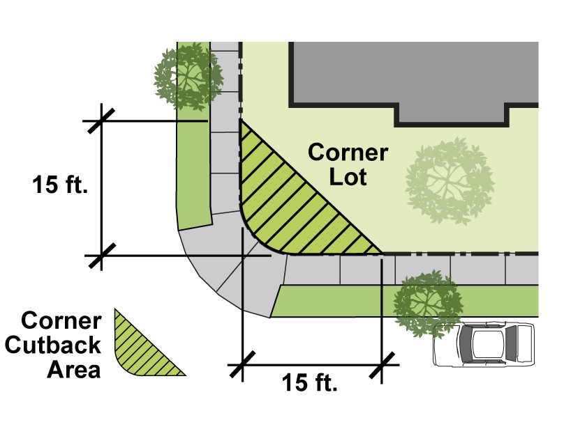
B.
Corner cutback area described. The corner cutback area is defined as:
1.
The triangular-shaped area on a corner lot, or at a point where driveway intersects a street, formed by measuring the prescribed distance from the intersection of the front (or rear) and street side property lines at an intersecting street or alley, and connecting the lines diagonally across the property making a 90-degree triangle; and
2.
The triangular-shaped area on each side of any driveway intersecting a street or alley.
C.
Corner cutback required dimensions. The following required dimensions for a corner cutback area shall be applied:
1.
15 feet from the intersection of a street right-of-way and an alley
2.
15 feet from the intersection of two alleys
3.
10 feet from the corner of an intersecting street right-of-way and a driveway
D.
Irregular lots. Where, due to an irregular lot shape, the corner cutback area does not provide for intersection visibility, the corner cutback required dimensions shall be increased to 17 feet.
E.
Limit on corner cutback obstructions. The following shall not be erected, placed, planted, or allowed to grow within the corner cutback area:
1.
Solid fences, walls, signs, structures, mounds of earth, solid post mail boxes, or other visual obstructions over 36 inches in height or over 24 inches in height in the M zone, and open work fences up to 42 inches in height.
2.
Hedges, shrubbery, and vegetation over or with a growth characteristic over 36 inches in height.
3.
The lower edge of tree canopies of a single trunk tree shall be maintained at a minimum height of seven feet above ground level, as measured from adjacent street curb elevation.
19.32.040 - Height measurement and exceptions.
A.
Height of structures and measurement.
1.
Structure height established. Structures shall not exceed the maximum allowable height for the zone in which the structure is located in compliance with Article 2 (Zones, Allowable Uses, and Development Standards), except as provided in Subsection B (Exceptions to Height Limits in all Zones), below.
2.
Height measurement.
a.
Structure height shall be measured as the vertical distance between the lowest ground elevation or finished grade and the highest point of the structure, exclusive of chimneys, ventilators and other exceptions allowed in the zone, see Figure 3-2.
b.
For sloped lots or structures with varied floor elevations, the height shall be measured as the vertical distance from the average ground level to the topmost point of the roof, as set forth in a, above. The average ground level shall be determined by adding the lowest and highest points on the lot and dividing by two.
_____
Figure 3-2. Measurement of Structure Height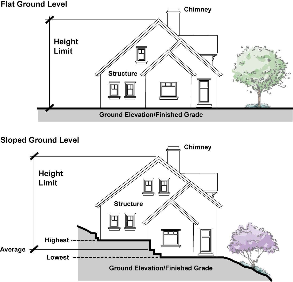
B.
Exceptions to height limits in residential zones. The following exceptions to height limits are allowed for residential buildings, provided compliance is achieved with all other applicable permit requirements and development standards of this Code.
1.
Architectural elements.
a.
Chimneys and vents. Chimneys and roof-mounted vents shall be allowed to exceed height limits to the minimum extent required by Title 16 (Buildings and Construction). Chimneys shall be allowed an additional 24 inches in height to provide a spark arrestor or a decorative architectural screen that do not exceed two feet in width by four feet in length.
b.
Skylights and roof windows. When mounted on a minimally pitched roof, skylights or roof windows shall be allowed to exceed the maximum height limit by up to six inches.
2.
Mechanical equipment—R-3 and R-4 zones. In the R-3 and R-4 zones, uninhabited penthouses or roof structures for the housing of elevators, stairways, tanks, ventilating fans or similar equipment required to operate and maintain the building shall be allowed to exceed the maximum building height limit by a maximum of 10 percent, except as allowed by subsection C.1 below. No such structures or any space above the height limit shall be allowed for the purpose of providing additional living or floor space.
C.
Exceptions to height limits in all zones.
1.
Architectural elements. Except as specifically provided in subsection B above, architectural elements that are approved through the Site Plan and Design Review per Article 7 (Permit Processing Procedures) may exceed the maximum height limit provided that no such structures shall be for the purpose of providing additional living or floor space. Roof-mounted mechanical that is entirely screened and incorporated into the design of approved architectural elements may exceed height limitations provided in subsection B.2 above.
2.
Flagpoles.
a.
Ground-mounted. Ground-mounted flagpoles shall be allowed in residential zones to a maximum height of 28 feet and in nonresidential zones to a maximum height of 35 feet.
b.
Roof-mounted. Flagpoles mounted on tops of buildings located in nonresidential zones shall be allowed to exceed the maximum height limit by more than 20 feet, but in no case shall be more than 20 feet taller than the final building height. Roof-mounted flagpoles shall not be allowed in residential zones.
3.
Antennas. Height exceptions for antennas and other wireless communications facilities are set forth in Section 19.60.190 (Wireless Communications Facilities).
4.
Fences, hedges and walls. Refer to Chapter 19.36 (Fences, Walls, and Hedges) for exceptions to height limits for these features.
5.
Places of religious assembly. Structures housing Places of Religious Assembly may be allowed to exceed the maximum height limit subject to the approval of a Site Plan and Design Review application in compliance with Chapter 19.122. Where more than one structure exists or is proposed for the site, only the primary structure shall be eligible for approval to exceed the maximum height limit.
19.32.050 - Yards—Measurement and requirements.
A.
General. This Section establishes standards for setback measurement and required yard areas. These provisions, in conjunction with other applicable provisions of this Code, are intended to provide for open areas around structures; access to natural light and ventilation, separation of incompatible land uses; space for privacy, landscaping, and recreation; and access to structures for function and safety.
B.
Setback areas to remain unobstructed. Except as provided in this Chapter, every required setback area creating a yard shall be open and unobstructed from the ground to the sky.
C.
Setback applies to one property only. No setback area provided around any structure for the purposes of complying with the provisions of this Code shall be considered as providing a setback area for any other structure, and no setback area on any adjoining property shall be considered as providing a setback area on a site upon which a structure is to be erected, except as may be specifically addressed through a Planned Development Permit or a Specific Plan.
D.
Modification of side setback requirement on combined lots. When the common property line separating two or more contiguous lots is covered by a structure or permitted group of structures, or when the placement of a structure or structures with respect to such common property line or lines does not fully conform to the required setback area on each side yard common property line or lines, such lots shall constitute a single site for the purposes of the requirements of this Code, and the required side setback area shall not apply to such common property line.
E.
Special setbacks may be established. The Council may, by Resolution, adopt a formula or establish standard practices by which to determine an appropriate and practical modification of required front or rear setback areas in any residential zone where geometric shape and dimensions and topography make the literal application of required setback impractical.
F.
Setback requirements for property abutting future street right-of-way. No structure shall be erected or maintained on any lot which abuts a street or private roadway having only a portion of its required width dedicated unless the setbacks provided and maintained in connection with that structure have a width or depth sufficient to accommodate completion of the public road width, plus the width or depth required to satisfy the setback requirements for the zone in which the property is located. However, this requirement does not require a setback of such width or depth as to reduce the buildable width of a corner lot to less than 40 feet.
G.
Side setback when a dwelling unit fronts the side yard. On any corner lot where a dwelling unit fronts upon a side yard, that yard shall be defined to be the front yard, and the front setback requirements for the applicable zone shall apply.
H.
Measurement of setbacks.
1.
All setback distances shall be measured at right angles from the designated property line, and the setback line shall be drawn parallel to the designated property line at the required setback distance (see Figure 3-4).
2.
Setbacks from private streets shall be measured from the curb line from the private street, even if the property line extends to the centerline of a private street, or as may otherwise be established in a Planned Development Permit or Specific Plan.
3.
For irregularly shaped lots, the setback shall be measured from each portion of the lot that comprises the front, side or rear lot line (see Figure 3-5).
4.
For sloped lots, the measurement shall be made as a straight, horizontal line from the property line to edge of the structure, not up or down the hill slope (see Figure 3-3).
5.
For flag lots, the pole portion of the lot shall not be used for defining setback lines.
Figure 3-3. Setback Measurement for Sloped Lots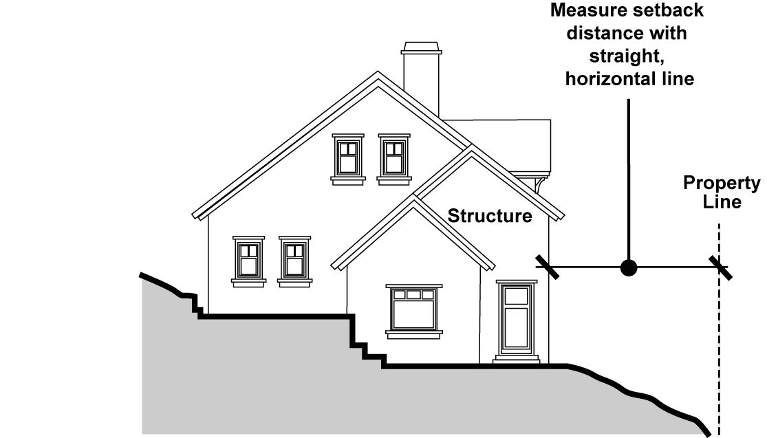
19.32.060 - Street improvements.
A.
Improvements required. If, when deemed necessary due to substantial changes in local traffic by reason of increased vehicular traffic, including truck traffic, increased pedestrian traffic, increased noise, and other activities associated with the proposed development, street improvements may be required by the Director to prevent congestion and the other hazards that are related to the intensified use of the land.
B.
Types of improvements. The improvements shall be to City standards and shall include curb, gutter, sidewalk, street and alley paving, street trees, street signs, street lights, fire hydrants, and all required utilities.
_____
Figure 3-4. Setback Measurement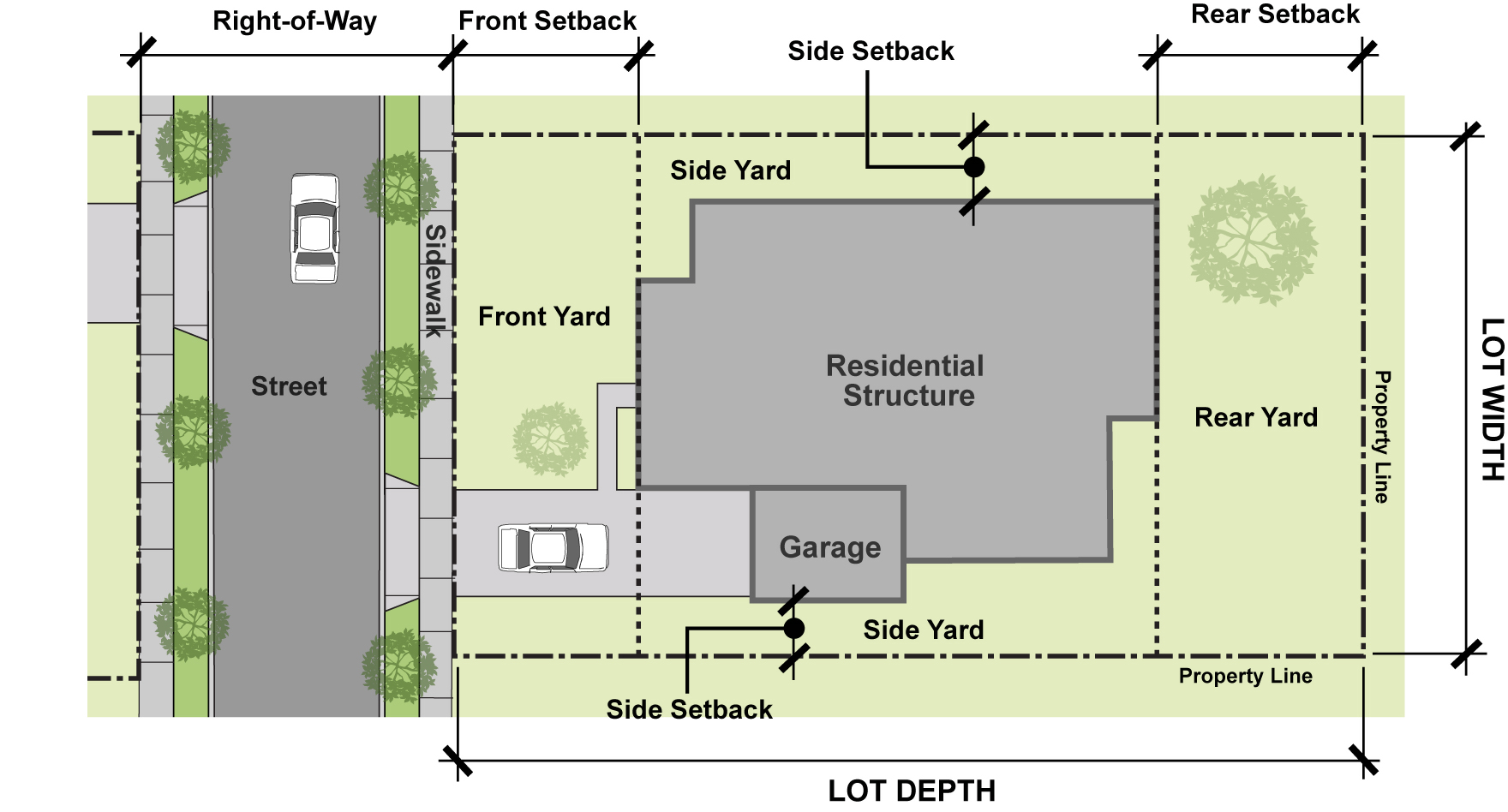
Figure 3-5. Setback Measurement for Irregularly Shaped Lots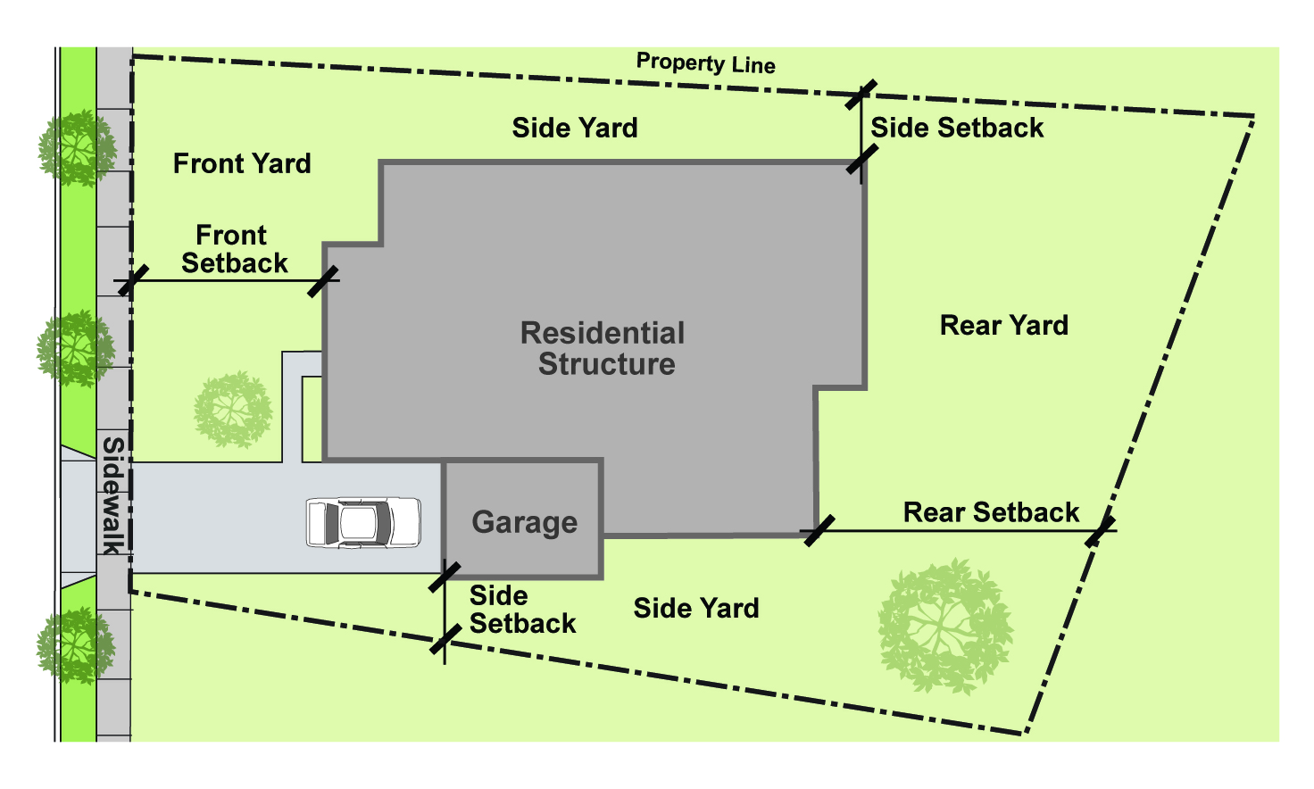
_____
19.34.010 - Purpose and applicability.
This Chapter establishes standards for the development and use of all accessory structures that are necessarily or customarily incidental to an allowed primary use. The development standards are intended to ensure that accessory structures located in any zone do not adversely impact either adjacent parcels or the surrounding neighborhood, and are developed in a manner which protects the integrity of the zone.
Any permitted accessory structure that does not require a Building Permit must meet the requirements of this Code for use, placement on the parcel, height, and size.
19.34.020 - Permit requirements.
The construction and/or relocation of an accessory structure shall require a Building Permit to ensure compliance with the regulations described in this Chapter and may require Site Plan and Design Review pursuant to Chapter 19.122 (Site Plan and Design Review).
_____
19.34.030 - Development standards.
A.
Height. The maximum allowed height of an accessory structure shall be limited as follows:
B.
Setbacks. The minimum required yard setbacks for an accessory structure shall be limited as follows in Table 3.2.2 (Accessory Building Setbacks) and as provided in Figure 3-6 (Accessory Structure Development Standards):
C.
Contribution toward lot coverage. The total square footage of all accessory structures on a lot shall contribute toward the calculation of total lot coverage for each specific zone.
Figure 3-6. Accessory Structure Development Standards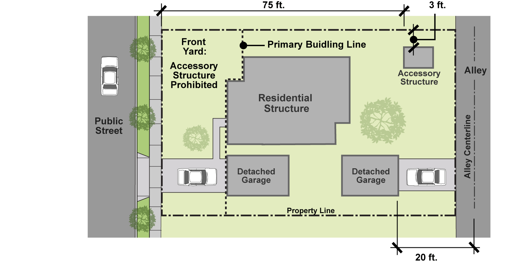
_____
D.
Projections. Projection of accessory structures into required setback areas shall be allowed pursuant to the provisions of Section 19.32.020 (Permitted Projections into Required Setback Areas).
E.
Architectural consistency. All accessory structures on a permanent foundation shall be consistent in exterior appearance with the primary structure through the use of similar/matching exterior paint colors, material types, and architectural styles.
19.34.040 - Canopy structures.
A.
Type permitted and allowed locations—Residential zones. The following canopies and canopy structures, as defined in Article 9 (Definitions), are allowed in al residential zones.
1.
Permanent canopy structures. Canopies and canopy structures shall be permitted only within rear yard areas. Such structures shall have a projected canopy area of no greater than 200 square feet, a height no greater than eight feet, and a length on any one side of no greater than 20 feet. Such canopies and canopy structures shall be screened from view from a public right-of-way and adjacent properties by fencing or shrubs at least six feet in height.
2.
Shade umbrellas. Shade umbrellas with a maximum diameter of 10 feet are allowed in all yard areas.
3.
Decorative canopies. Decorative canopies and awnings constructed as a component or feature of an overall architectural design are allowed as architectural projections, subject to the provisions of Section 19.32.020 (Permitted Projections into Required Setback Areas).
4.
Temporary tents and canopies. Temporary tents and canopies, of any size, may be erected in any location on a parcel or lot for a period of up to two consecutive days. Such tent and/or canopy may not be re-erected until a minimum 90-day period has elapsed. Any longer period of time shall required issuance of a Temporary Use Permit pursuant to Chapter 19.124 (Temporary Use Permits).
B.
Type permitted and allowed locations—All other zones. The following canopies and canopy structures, as defined in Article 9 (Definitions), are allowed in all nonresidential zones. Print content and logos on canopy or tent structures that may be construed (as determined by the Director) as a sign or advertising shall not be permitted except as otherwise permitted through an approved sign or temporary/special use permit.
1.
Permanent canopy structures. Canopies and canopy structures shall be permitted only within side and rear yard areas, except no permanent canopy shall be located within the street side yard on a corner lot. Such structures shall have a projected canopy area of no greater than 400 square feet, a height no greater than 12 feet, and a length on any one side of no greater than 20 feet.
2.
Shade umbrellas. Shade umbrellas with a maximum diameter of 10 feet are allowed in all yard areas.
3.
Decorative canopies. Decorative canopies and awnings constructed as a component or feature of an overall architectural design are allowed as architectural projections, subject to the provisions of Section 19.32.020 (Permitted Projections into Required Setback Areas).
4.
Temporary tents and canopies. Temporary tents and canopies, of any size, may be erected in any location on a parcel or lot for a period of up to three consecutive days. Such tent and/or canopy may not be re-erected until a minimum 90-day period has elapsed. Any longer period of time shall required issuance of a Temporary Use Permit pursuant to Chapter 19.124 (Temporary Use Permits).
19.34.050 - Solid waste and recyclable materials storage areas.
Design and construction of solid waste storage areas shall be subject to the approval of the Director and shall be:
1.
Enclosed on three sides by a solid screening wall or fence with a minimum height of five feet, designed to be architecturally compatible with the surrounding structures.
2.
Provided with an approved operable door or gate on the fourth side, properly secured to prevent access by unauthorized persons and minimize scavenging, while allowing authorized persons access for disposal and collection of materials.
3.
Provided with a covering or roof for security (to prevent scavenging and/or dumping). The roof should provide adequate clearance to allow complete access to the waste bins, but should not exceed eight feet in height. Open areas between the solid wall and the roof should also be secured.
4.
Provided with a concrete pad within the fenced or walled areas and a concrete apron that facilitates the handling of the individual bins or containers.
5.
Designed to accommodate individual bins or containers that protect contents from adverse environmental conditions that might render recyclable materials unmarketable.
19.36.010 - Purpose and applicability.
This Chapter establishes standards and regulations for the construction and maintenance of fences and walls, and the planting and maintenance of hedges used for screening or buffering purposes. The standards are intended to ensure that all fences, walls, and hedges provide desired privacy and safety but do not create a public safety hazard or nuisance, and that fences, walls, and hedges meet the City's standards for quality design and regular maintenance.
For Specific Plans and Planned Developments Permits, fence, hedge, and wall heights shall comply with the standards set forth in the applicable Specific Plan or Planned Development Permit. Where the Specific Plan or Planned Development Permit is silent with regard to fence, hedge, and wall height, the standards for the zone that most closely approximates the Specific Plan and the underlying zone for the Planned Development Permit shall apply, as determined by the Director.
19.36.020 - Permit requirements.
A.
Fences and walls. Fences and walls shall be subject to Site Plan and Design Review pursuant to Chapter 19.122 (Site Plan and Design Review).
B.
Hedges. No permit shall be required for hedges.
19.36.030 - Maximum permitted height.
A.
Fences and walls. The maximum allowed height for fences and walls shall be as indicated in Table 3-3.
B.
Hedges. No maximum height shall be established for hedges, except for hedges located within the required front yard shall conform to the standards for fences and walls, and for corner cutback areas, the standards set forth in 19.32.030 (Corner Cutback Area) shall apply. All hedges shall be kept trimmed in a neat condition and maintained pursuant to the landscape maintenance requirements of 19.40.220 (Landscape Irrigation and Maintenance).
Note:
1.
In the, R-1D, R-1E, and R-1F Zones, an additional one foot of non-view obscuring fence height may be added to the front yard fence and wall, but may not exceed five feet in height, or seven feet in height when used with a necessary retaining wall.
Figure 3-7. Maximum Fence and Wall Heights by Location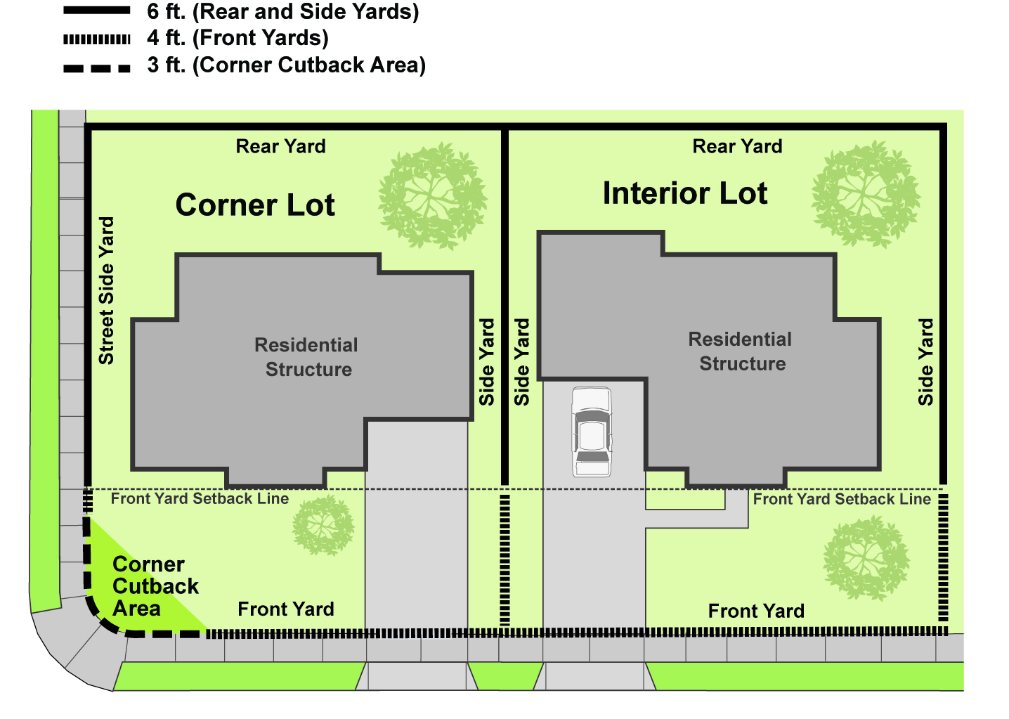
_____
C.
Retaining walls. Where there is a necessary retaining wall for a lot that is above a sidewalk or top of curb grade, additional wall height of up to three feet may be allowed, subject to site plan approval pursuant to Chapter 19.122 (Site Plan and Design Review). The maximum height for a combination retaining wall and fence shall be seven feet, subject to all of the following criteria:
1.
The non-retaining portion of the fence/wall combination cannot exceed four feet;
2.
The retaining portion of the fence/wall combination cannot exceed four feet;
3.
Extensions above four feet, as measured from sidewalk or top of curb, shall be constructed of wrought iron or other non-view obscuring materials determined to be acceptable, subject to site plan approval pursuant to Chapter 19.122 (Site Plan and Design Review).
Figure 3-8. Maximum Height for a Retaining Wall and Fence Combination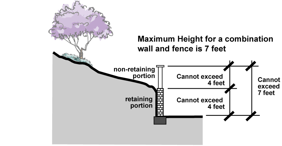
D.
Fencing for sports facilities. To enclose tennis courts or similar sports area located within the rear of the lot, fences over six feet in height shall be permitted, provided that any portion of the fence or structure which is higher than six feet shall be composed of wire mesh or other material whose vertical service is not more than 10 percent solid, unless safety necessitates otherwise. Such additional wire mesh or similar material shall be subject to site plan approval pursuant to Chapter 19.122 (Site Plan and Design Review).
E.
Fencing for horse enclosures, stables, and corrals. Fencing for horse enclosures, where they are permitted, shall conform to the requirements set forth in 19.60.080 (Horse Keeping).
F.
Fencing for pools and spas. Swimming pools, spas, and other similar features shall be fenced in compliance with Municipal Code Chapter 9.40 (Swimming Pools, Wading Pools and Fish Ponds).
19.36.040 - Measurement of fence, wall, and hedge height.
A.
General. For the purposes of Chapter 19.36, fence, wall, and hedge height shall be measured as the vertical distance from the ground elevation or finished grade of the property on which the fence or wall is erected to the highest point of the fence or wall. To allow for variation in topography on a parcel, the height of a fence or wall may vary intermittently up to six inches.
_____
Figure 3-9. Measurement of Fence, Wall, and Hedge Height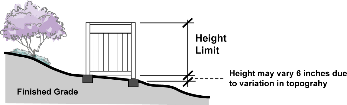
_____
B.
Difference in grade height between two parcels. Where there is a difference in the ground elevation or finished grade between two adjoining parcels of less than two feet, the height of any fence or wall constructed along the common property line shall be determined by using the finished grade of the highest contiguous parcel. When there is a difference in the ground level between two adjacent parcels of two feet or more, the height of a fence or wall shall be determined by the Director. The Director shall consider the physical and visual height impact on abutting properties.
19.36.050 - Prohibited fencing materials.
A.
Residential zones.
1.
Fencing in all residential zones shall be constructed without the use of barbs, razor wire, electrified wire, or other materials hazardous to wildlife. Also, the following fencing materials shall be prohibited: chicken wire and similar small-gauge wire or mesh product, barbed or razor wire, plastic, and chain link fencing (with or without wood, plastic, or other slats).
2.
Specifically in the R-1D and R-1E zones, no fencing shall contain spikes or points or other materials that have the potential to harm wildlife.
B.
All other zones. The following fencing materials are prohibited in all nonresidential zones: barbed or razor wire, electrified wire, chicken wire and similar small-gauge wire or mesh product, plastic, and chain-link fencing provided with wood, plastic, or other slats.
19.36.060 - Fencing of hazardous areas.
A fence or wall six feet or greater in height may be required along the perimeter of all areas which, by reasons of the conditions of the property or physical hazards, such as frequent inundation, erosion, excavation or grade separation, are considered by the Director to be dangerous to public health and safety.
19.36.070 - Buffer wall required.
Where a lot line of a commercial, industrial, or hospital zone abuts a property zoned for residential use, a minimum six-foot-high wall shall be required, except for any portion in a required yard abutting a street. Architectural and other treatment of the wall is required pursuant to Chapter 19.44 (Architectural and Design Standards).
19.38.010 - Purpose.
This Chapter establishes regulations to:
A.
Regulate off-street parking and loading to minimize traffic congestion and hazards to motorists, bicyclists, and pedestrians;
B.
Provide off-street parking in proportion to the needs generated by different land uses;
C.
Ensure access to projects by emergency response vehicles; and
D.
Ensure that parking areas are designed and operate efficiently and effectively and compatibly on-site and with surrounding land uses.
19.38.020 - Applicability.
A.
At the time of the erection of any building and/or structure or prior to the time any such building or structure is enlarged or increased in capacity by adding dwelling units, guest rooms, floor area or seats, or at such time that a usage requiring a higher number of parking spaces than an existing or previous use is applied, the following minimum off-street parking spaces shall be provided for such new construction or intensified use, enlargement or increased capacity and use of land, with adequate provisions for safe ingress and egress, and the parking space shall thereafter be maintained in connection with such building or structure and use of land.
B.
Nothing in this Chapter shall be deemed to limit the power of the Commission or Council, either acting on its own or on appeal, to require parking of increased numbers, alternative types and arrangements as part of the conditions required to be met for approval of a conditional use.
19.38.030 - Permit requirements.
A.
New parking lots. New parking lot design not otherwise exempt shall be reviewed in conjunction with the building permit and any other land use or development permit required for the project. A site plan of the premises shall be required for all new parking. The site plan shall be submitted to the Director in conjunction with the required permit(s) and shall include sufficient detail to determine compliance with the provisions of this Chapter. The site plan shall be approved, modified, and/or denied through the normal process of approving, modifying, and/or denying the permit causing the submission of the site plan.
B.
Modification of existing lots.
1.
Modification or improvement to an existing parking lot which impacts the parking space layout, configuration, and/or number of stalls shall require Zoning Clearance approved by the ARB pursuant to Chapter 19.128 (Zoning Clearances) of this Development Code to authorize the modification.
2.
In the event a parking lot is to be modified for the sole purpose of replacing compact spaces with standard spaces or to provide additional handicapped spaces, or to upgrade or provide additional landscaping, the modification may be approved by the Director. Such approval may include minor modifications to the provisions of this Chapter, including the reduction in the required number of spaces, as are deemed necessary by the Director.
19.38.040 - Exemptions.
The following parking lot improvements shall be considered minor in nature, provided that the number and/or configuration of parking stalls are not altered. Such improvements shall be exempt from permit requirements, except such permits as may be required by the Building Official.
A.
Repair of any defects in the surface of the parking area, including holes and cracks.
B.
Resurfacing, slurry coating, and restriping of a parking area with identical delineation of parking spaces.
C.
Repair or replacement of damaged planters and curbs in the same location.
19.38.050 - Off-street parking space requirements.
Off-street parking spaces shall be provided in compliance with Table 3-4 through 3-8. These standards shall be considered the minimum required to preserve the public health, safety, and welfare, and more extensive parking provisions may be required by the Approving Authority in particular circumstances as deemed necessary by the Approving Authority in its own discretion.
A.
Off-street parking requirements. Tables 3-4 through 3-8 set forth off-street parking requirements for number of spaces. Except as otherwise specifically stated, the following rules apply to Tables 3-4 through 3-8:
1.
"Square feet" (or "sf") means "gross square feet" and refers to total building floor area unless otherwise specified.
2.
Where parking spaces are required based on a per-employee ratio, this shall be construed to be the total number of employees on the largest working shift.
3.
For the purpose of calculating parking requirements, dens, studies, or other similar rooms that may be able to be used as bedrooms, as determined by the Director, shall be considered bedrooms.
4.
Where the number of seats is listed to determine required parking, seats shall be construed to be fixed seats. Where fixed seats provided are either benches or bleachers, each 20 linear inches of the bench or bleacher shall be considered a seat. If fixed seats are not provided, the total amount of seating shall be deemed to be the occupancy limit for the room in which the seating is provided as determined by the Building Department.
B.
Minimum parking requirements. Unless off-street parking reductions are allowed pursuant to provisions herein, the number of off-street parking spaces required by Tables 3-4 through 3-8 shall be considered the minimum necessary for each use. In conjunction with discretionary development permits, the Approving Authority may increase or decrease these parking requirements if it is determined through a parking study as outlined in this Chapter that these requirements are inadequate for a specific project.
C.
Uses not listed. The number of parking spaces required for uses not specifically listed in Tables 3-4 through 3-8 shall be determined by the Director based on common functional, product, or compatibility characteristics and activities with the uses listed in Tables 3-4 through 3-8. Such determination is considered an interpretation of this Development Code and shall be decided and recorded as such, pursuant to the procedures established in Chapter 19.04 for making formal interpretations of this Code. Such interpretations shall have the same force in law as the provisions of this Chapter.
D.
Parking requirement determined by parking study. In the event the proposed land use is for a multi-tenant and/or mixed use development or involves a Specific Plan or Planned Development Permit, the Director may authorize the preparation of a parking study to determine the required number of parking spaces as an alternative to the number of off-street parking as outlined in Tables 3-4 through 3-8and other applicable provisions of this Chapter, subject to the following conditions:
1.
Parking determined by a parking study shall be approved, modified and/or denied by the Commission pursuant to a conditional use permit as authorized and processed under the provisions of this Chapter.
2.
City has the right to select a consultant, which will be paid for by the applicant.
3.
The study shall have been undertaken and completed by a traffic engineer registered by the State of California and shall bear the stamp of that engineer.
4.
If the required parking is determined by such a parking study, future modification or improvement to the parking area which impacts the parking space layout, configuration, and/or number of stalls or if any such building or structure in the project is enlarged or increased in capacity by floor area or seats, or at such time that a usage requiring a higher number of parking spaces than an existing or previous use is applied, a new parking study pursuant to this Section shall be provided showing that the existing and/or proposed parking is adequate for such expansion and/or increased usage. Alternatively to a revised parking study, at the time of such expansion or increased usage, the applicant may comply with all provisions of this Chapter in effect at the time of the application.
E.
Calculation/rounding of quantities. When the calculation of the required number of off-street parking spaces results in a fraction greater than 0.50 of a space, the total number of spaces shall be rounded up to the nearest whole number. If the fraction is less than 0.49 of a space, the total number of spaces shall be rounded down to the nearest whole number.
F.
Additions to single-family residential with a garage containing fewer than two spaces. Additions to single-family dwelling units that have a garage or covered parking space containing fewer than two spaces shall comply with the parking requirements as found in Table 3-4, unless the Director finds:
1.
Since the adoption of this Ordinance, the total additions to the property do not exceed 250 feet of habitable space; and
2.
The single-family residence, prior to the construction of the addition, provided one covered parking space which complied with off-street parking requirements in effect at the time of construction of the residence; and
3.
Following the construction of the addition, the single-family residence will continue to provide at least one covered parking space and additional spaces per 19.38.050.I, below, plus adequate ingress and egress thereto.
G.
Mixed-use without residential/multiple tenants. Except as otherwise provided in this Chapter, for each separate use, a site with multi-tenants, or a combination of principal uses in any one facility, the development shall provide the aggregate number of parking spaces required for each separate use, unless a parking study has been prepared and approved pursuant to this Chapter or except as provided for in Section 19.38.140 (Off-site Shared Parking) or Section 19.38.150 (Joint Use Parking Facilities).
H.
Mixed-use with residential.
1.
The number of parking stalls shall be as outlined in Tables 3-4 through 3-8.
2.
Any required guest parking for the residential uses may be provided through the required commercial parking.
3.
The parking for the residential use which is required to be in a fully enclosed garage pursuant to Table 3-4 may be provided within an underground or aboveground parking structure rather than a garage.
4.
With the exception of the guest parking, parking for the residential uses shall be provided and maintained separate and secure from the on-site public parking.
I.
Residential use—When required garage parking cannot be provided. Notwithstanding the requirements for parking in a garage set forth in Table 3-4 for residential uses, wherever required garage parking cannot be provided due to physical limitations on a property, the Approving Authority may allow for an alternative parking arrangement for the remaining required spaces as follows:
1.
As covered parking not within the driveway that provides access to the garage, or
2.
As uncovered parking located behind the primary building line (see Article 9 for definition of primary building line) and not within the driveway that provides access to the garage, provided all requirements regarding front yard landscape coverage are met, or
3.
On the driveway behind the primary building line, provided the driveway is of adequate length to accommodate such parking.
4.
In cases where property limitations are present such that none of items 1, 2 or 3 above can be utilized, the approving authority may waive the garage parking requirement provided that: no more than 600 square feet of habitable building area has been added to the property since the adoption of this Ordinance; the house has no more than four bedrooms; and, all structures on the property are properly permitted.
(Ord. No. 874, § 2(Exh. A), 4-11-2017; Ord. No. 907, § 4.D., 3-8-2022)
19.38.060 - Elimination or reduction of parking spaces prohibited.
No existing required off-street parking space shall be eliminated or reduced and no existing garage or carport facility shall be eliminated, reduced, or converted to any other use unless such space or facility is fully replaced and brought into full compliance with current standards either prior to or concurrently with the deletion, reduction, or conversion of the existing facility or space.
19.38.070 - Waiver of parking requirements for lots with nonconforming parking.
Notwithstanding the other provisions of this Chapter, a waiver of parking requirements for lots which are legally nonconforming as to parking may be permitted through a Minor Use Permit, subject to the approval process for Minor Use Permits outlined in Chapter 19.114. In addition to the finding required for Minor Use Permits, the following findings must be made:
1.
The site is legally nonconforming as to parking as defined in this Chapter.
2.
The existing lot with the existing parking was in compliance with the appropriate City Code provisions concerning parking at the time it was originally developed.
3.
There has been no expansion nor intensification of use requiring additional parking for which additional parking was not provided since the original approval, which has created the legal non-conformance.
4.
No expansion nor intensification of use(s) is being proposed that would add to the lack of parking being waived.
19.38.080 - General use provisions for off-street parking spaces.
A.
Parking facilities shall be used for vehicle parking only. No sales, storage, repair work, dismantling, or servicing of any kind shall be allowed.
B.
Living or sleeping in any vehicle or trailer is prohibited.
C.
Any vehicle or trailer which is inoperable and/or without current registration shall not be in plain view of the street and shall be stored entirely within an enclosed structure. No such vehicle or trailer shall be parked or stored in any yard on residential property.
19.38.090 - Prohibition on commercial vehicle parking in residential zones.
A.
No commercial vehicle weighing 6,000 pounds or more gross shall be parked, stored, or kept on any lot in any residential zone in the City.
B.
One commercial vehicle weighing less than 6,000 pounds gross may be parked on a lot in a residential zoning district, but such parking shall be limited to a designated driveway or garage only.
19.38.100 - Parking space and drive aisle dimensions.
A.
Parking space dimensions. Table 3-9 sets forth minimum size requirements for individual parking spaces. Design standards for handicapped parking stalls shall be provided in compliance with current requirements of the Uniform Building Code.
Note:
1. See overhang standards in Section 19.38.180 (Design Standards for Parking Lots)
_____
B.
Driveway and drive aisle dimension.
1.
Driveway widths shall be a minimum of 10 feet and a maximum of 12 feet for one storage space.
2.
Driveway width shall be a minimum of 12 feet and a maximum of 20 feet for two to four storage spaces; provided, however, that where the driveway provides access through a side yard to a rear garage, and if 12 feet in width are not available, the driveway shall be of the width available, but in no event less than 10 feet. This width may be reduced to nine feet clear in the R-1 and R-1A zones.
3.
Driveway widths shall be a minimum of 16 feet and a maximum of 25 feet for five or more storage spaces, except that where the length of the driveway exceeds 125 feet, the minimum width for five or more storage spaces shall be 20 feet.
4.
Where separate driveways are provided for ingress and egress, the minimum width for each shall be 12 feet and the maximum width for each shall be 20 feet, and the direction of travel shall be clearly indicated on the site by permanent identification.
5.
All driveways shall be clear and unobstructed for a height of 12 feet above ground.
6.
The width of the driveway shall be based upon the full potential use of the property based upon zoning at time of construction.
7.
All driveways for private automobile storage spaces and the actual spaces shall be paved with Portland cement concrete or approved equivalent at least three inches thick.
8.
Driveways must lead to an approved off-street parking structure, garage or carport. Where driveways no longer lead to an off-street parking structure, garage or carport, the driveway approach, curb and gutter shall be replaced to the satisfaction of the City Engineer and the paved parking surface shall be replaced with landscaping. However, for properties that have an approved alley access to a garage, additional access from the front yard may be permitted when: the driveway provided leads to a side yard having a minimum width of nine feet; the driveway has a maximum width of 12 feet; and, there is no more than one front yard driveway.
9.
The minimum separation distance of any two driveways on the same property shall be 20 feet.
10.
All access shall be from a dedicated street or alley.
11.
On sites with less than 80 feet of frontage, no more than two driveways shall be permitted. On sites with 80 feet or more of frontage, additional driveways may be approved through the Site Plan and Design Review process (Chapter 19.122).
12.
The maximum distance between the outside edge on a driveway and the property line shall be five feet.
13.
Drive aisles serving four or more parking spaces shall have the minimum dimension listed in Table 3-10.
14.
Driveway widths associated with development of an urban lot split are provided under Chapter 19.88.
Note:
1. Measured perpendicular to aisle
Figure 3-10. Standard Vehicle Space Requirements
(Ord. No. 907, § 4.E., 3-8-2022)
19.38.110 - Compact and tandem parking spaces.
A.
Compact parking.
1.
Compact parking spaces may be allowed only for office and hospital developments exceeding 25,000 square feet of floor area. A maximum of 15 percent of all off-street parking spaces in excess of the first 20 spaces may be compact car parking spaces.
2.
Existing parking lots or properties with approved compact parking spaces are allowed to remain. Compact parking spaces may remain if the parking lot is restriped.
3.
The dimensions of each compact car parking space shall be as provided in Table 3-9.
4.
Compact parking spaces shall be distributed throughout the parking lot, with a maximum of four spaces in any one location. Where compact parking is provided strictly for employee parking, all such parking may be located in a single area of the parking lot.
5.
For developments characterized by distinct, segmented parking areas, the maximum allowed percentage of compact stalls shall apply to each area or segment of the parking lot. Compacts spaces shall not be located adjacent to retaining walls or other formidable barriers which prevent adequate vehicle overhang.
6.
Each compact space shall be clearly labeled "COMPACT." Signs may be painted on the pavement or curb and shall be a minimum of one-foot high letters when painted on the pavement or six-inch high letters when painted on the curb.
B.
Tandem parking.
1.
For multi-family development projects, tandem spaces shall not constitute more than 20 percent of all required spaces within a development and shall be allowed only for studio, one- and two-bedroom units.
2.
For single-family units, tandem parking may be provided within a garage, provided that such garage has an interior space measuring at least 20 feet by 20 feet adjacent to the garage door.
3.
The minimum dimensions for a tandem space shall be as provided in Table 3-9. Adequate maneuvering room for both vehicles and pedestrians shall be provided around the tandem spaces as necessary.
4.
Tandem spaces may be provided only where approved by the Review Authority in the review of the parking plan.
5.
See also Section 19.38.050(I) regarding allowance of tandem parking as an alternative parking approach where physical limitations exist on a property.
19.38.120 - Parking lot location requirements.
A.
Except as otherwise allowed herein, all required off-street parking spaces shall be accessible from a street at all times.
B.
All required off-street parking spaces shall be located on the same lot or within the same development as the use and/or development requiring such spaces.
C.
Required off-street parking spaces shall not be located within any required front yard or required street side yard setback of any parcel. However, parking spaces in addition to the minimum required may be allowed in the front and street-side side yards of single-family residential lots in compliance with all of the following conditions:
1.
Vehicle parking (and access thereto) shall be parked on a permanently paved surface.
2.
Parking is not allowed within any required landscape area or any area not designated as a driveway or vehicle parking area.
3.
Parking may not occur within any required clear site distance triangle area on a corner lot.
_____
Figure 3-11. Single Family Parking Location Requirements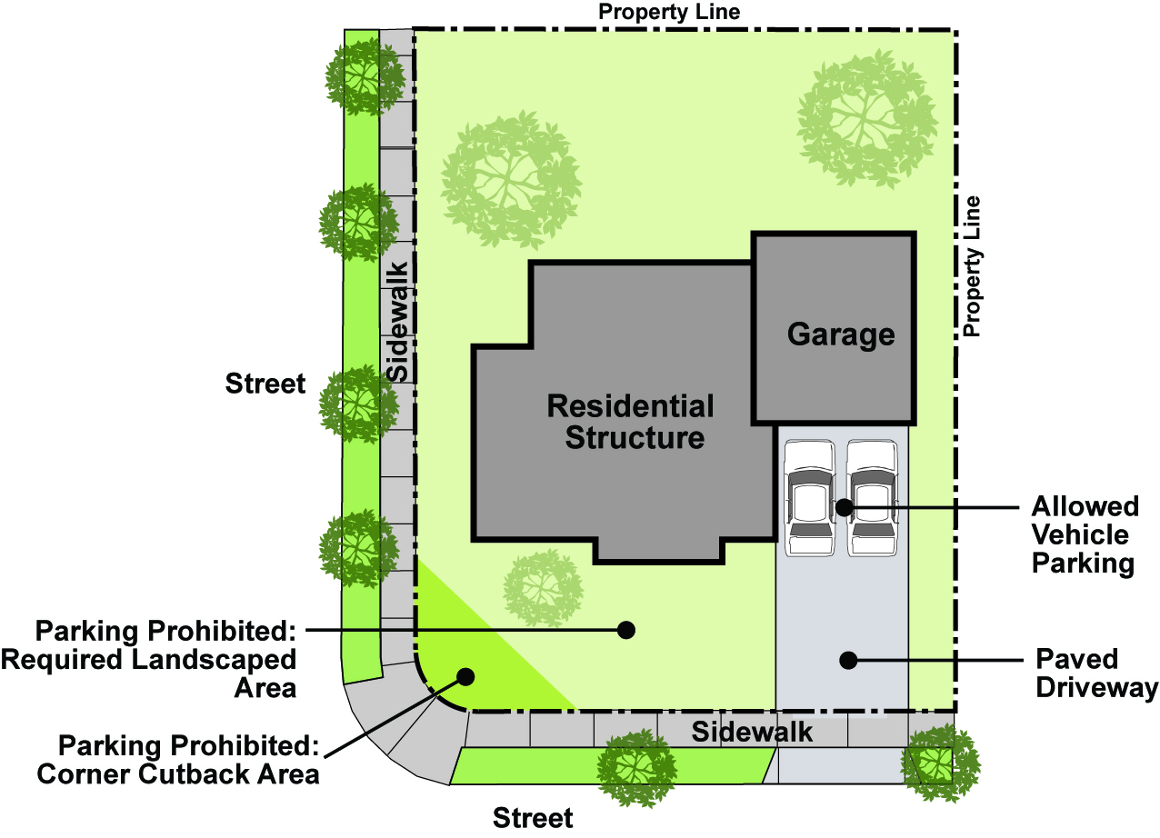
_____
D.
Parking spaces shall not preclude direct and free access to stairways, walkways, elevators, any pedestrian accessway or fire safety equipment. Such access shall be a clear minimum width of 44 inches, no part of which shall be within a parking space.
19.38.130 - Valet parking.
A.
Where permitted and approval process. Valet parking may be permitted in commercial zones subject to the approval of a Minor Use Permit, based on the approval process outlined this Section.
B.
Review criteria.
1.
Valet parking shall be subject to review of hours of operation, circulation and other pertinent impacts. All proposals for valet parking shall be accompanied by a parking study, prepared by a registered traffic engineer, that addresses circulation impacts, operational characteristics of the use, parking space size and configuration and other issues deemed necessary by the Director.
2.
Valet parking shall be provided on the same site as the business for which the valet parking is being approved. In the event the location for the valet parking is off-site of the business, the provisions in this Chapter regulating off-site parking shall also be applicable.
C.
Development standards for valet parking uses.
1.
Because of the unique characteristics of valet parking facilities, parking space size shall be determined on a case-by-case basis and not necessarily subject to the standards listed in this Chapter.
2.
Valet parking facilities shall not be permitted to use parking that is specifically set aside or required for another use, unless a shared parking or off-site parking agreement, as applicable, is approved by the City.
19.38.140 - Shared/joint use and off-site parking.
A.
Authority. The Director shall be the designated Review Authority for the review and approval of any proposal shared, joint use, or off-site parking arrangements, unless such parking is included in an application requiring approval of another Review Authority. In such cases, the ultimate Review Authority per Article 7 (Permit Processing Procedures) shall be the Review Authority for the shared, joint use, or off-site parking agreement.
B.
Circumstances and requirements for allowing shared parking arrangements.
1.
Where it can be demonstrated that two or more land uses can effectively share common parking facilities due to the nature of the uses and distinctly different demand for parking, or where off-site parking is proposed to meet parking requirements, then an application may be filed for such parking arrangement. Such application shall include a parking study that identifies the parking demand of all subject land uses and that clearly demonstrates how and why parking facilities can be shared.
2.
The applicant shall provide a parking study prepared by a registered traffic engineer that specifically analyzes the parking demand for each use proposing to share the parking, each use's hours of operation, and other related issues of all involved uses.
3.
The building or use for which an application is being made for authority to share and utilize the existing off-street parking facilities provided by another building or use shall be located within 300 feet of such parking facilities.
C.
Findings for granting shared/joint use and off-site parking arrangements. To grant a request for shared/joint use or off-site parking, the Review Authority shall make the following findings:
1.
There is clear and convincing evidence that peak-hour parking demand from all uses does not coincide and/or the uses are such that the hours of operation are different for the various businesses or uses.
2.
There is adequate parking provided for all participating users.
3.
Adjacent or nearby properties will not be adversely affected by the shared/joint use or off-site parking.
4.
The parking arrangement is consistent with the General Plan and all requirements of this Code.
D.
Legal agreement required. A legal agreement shall be signed by all parties using shared/joint use parking facilities. Such agreement shall be approved by the City Attorney and Director, shall be recorded with the Los Angeles County Recorder, and shall continue to be valid upon change of ownership.
E.
Change in use. In the event of a change in use, a new application shall be filed or the existing agreement amended to the satisfaction of the Director.
19.38.150 - Off-site designated parking: alternate parking location.
A.
Authority. Off-site parking shall require a Conditional Use Permit, approved by the Commission.
B.
Circumstances for allowing off-site parking. Off-street parking requirements for any new building or expansion of any existing use within a nonresidential district may be provided in one or more off-site parking lots which collects and combines such off-street parking requirements for one or more uses in the district. Such off-site parking lots shall be developed in accordance with the following requirements:
1.
All off-site parking facilities shall be located within 300 feet of the property where the use in question is located, unless a binding agreement is provided to provide transportation access from the parking facility to the use in question on a regular basis.
2.
Off-site parking, including parking in common parking lots, may be provided in lieu of the on-site individual requirements contained herein. Lots used for the off-site parking shall be approved by the Commission as to size, shape, and relationship to business sites to be served.
3.
All off-site parking lots shall comply with the landscaping requirements as set forth in this Chapter.
4.
All parking spaces and drive aisles contained in any such off-site parking lot shall be developed in accordance with the design standards and marking requirements set forth in this Chapter.
5.
If the owner of the lot being used for the off-site parking is not the owner of the business for which the off-site parking is granted, the owner of the property used for off-site parking shall provide for and record an easement deed granted the appropriate number of parking spaces to the business granted the Conditional Use Permit for the off-site parking.
6.
In lieu of an easement, if approved by the City Attorney and Director, a recorded legal instrument which achieves the same result as an easement may be used.
C.
Findings for granting off-site parking arrangements. In addition to those findings required for a Conditional Use Permit, the Commission shall make the following findings as they relate to the off-site parking.
1.
The lot to be used for the off-site parking has adequate excess parking, not required for nor allocated to another use either on site or off site.
2.
The business which is seeking the off-site parking does not have adequate parking on its own lot to meet the requirements of this Chapter.
3.
The adjacent or nearby properties will not be adversely affected by the proposed off-site parking.
4.
There is safe and adequate access from the off-site parking to the main use it is intended to serve.
19.38.160 - Recreational vehicle parking in residential zones.
A.
Zones permitted.
1.
Recreational vehicles, as defined in Article 9 (Definitions) and when not stored within a fully enclosed structure approved for that purpose, are allowed to be parked only in the R-1, R-1A, R-1B, R-1D, R-1E, R-1F, R-2, and R-MH zones, subject to the standards set forth in this Section.
2.
Recreational vehicle parking shall not be allowed in the R-3 or R-4 zones, unless stored within a fully enclosed structure approved for that purpose.
3.
Recreational vehicle parked in garages or within warehouse space is permitted in any zone.
4.
For the purposes of this Section, recreational vehicles shall mean motor homes not exceeding a maximum length of 40 feet and a maximum height of 12 feet, or any trailer (either with or without a vehicle thereon) of a maximum length of 30 feet. Any recreational vehicle exceeding these measurements may not be parked in any residential zone.
B.
Parking location; screening standards. The parking of recreational vehicles shall be restricted to the side and rear yards of a lot, unless the conditions in paragraph C, below, apply. The parked recreational vehicle shall be screened from view from the street and adjoining properties by a fence or wall (as permitted in the side and/or rear yards), which is at least six feet high.
C.
Alternative parking location. Recreational vehicles may be parked on the paved driveway and adjacent area in front of the primary building line, and only when the Director determines that the side and rear yards are either inaccessible or for other reasons, not adequate or available or suitable for recreational vehicle parking. A recreational vehicle may be parked on any legal paved driveway area within the front setback, as well as on a paved area between the driveway and the property line nearest to the driveway when conditions necessitating the alternative have been verified by the Director and further, provided that access to the garage spaces are maintained at all times.
D.
Conditions applicable to all parked recreational vehicles.
1.
All recreational vehicles shall be parked on a paved or similar surface acceptable to the Director.
2.
All recreational vehicles shall be maintained in a complete, serviceable, and operable condition, and shall be currently licensed for their intended use.
3.
No recreational vehicle shall be parked in a manner that blocks vehicular access to a garage or required fire safety access.
4.
No recreational vehicle or any trailer on which it may be mounted shall overhang any public right-of-way or adjacent private property.
5.
Where a tarp or canopy is used to cover the recreational vehicle, the tarp or canopy shall be of a neutral color and shall be maintained in good physical condition at all times.
19.38.180 - Design standards for parking lots.
A.
General design guidelines.
1.
Overhang of vehicles is allowed, provided no vehicle shall overhang a sidewalk by more than two feet and only when the sidewalk as a minimum width of at least seven feet. A vehicle is allowed to overhang into a landscaped area by two feet, provided that the required landscape area is extended by two feet or at least eight feet wide and is planted with suitable plant materials that accommodate the vehicular overhang.
_____
Figure 3-12. Vehicle Overhang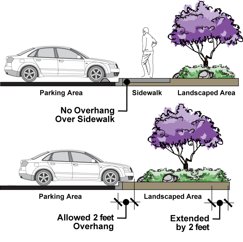
_____
2.
Motorcycle stalls may be used as an option to utilize areas that would otherwise not be of adequate size for conventional stalls. Unless otherwise determined by the designated Approving Authority for a particular project, motorcycle stalls shall not count toward the number of required parking spaces.
3.
Piers and pillars shall not encroach into parking stalls. Where a parking stall is located abutting a wall, pillar or similar structure, the stall width and/or length shall be increased by two feet, or as determined by the City Engineer for subterranean or structured parking lots.
4.
Where a 90-degree stall is the last stall on the end of a dead-end aisle, the aisle shall be extended three feet beyond the end of the stall.
B.
Surfacing of parking spaces and lots.
1.
Required parking and circulation areas shall be a non-eroding and all-weather surface that does not readily absorb or retain water. It shall be the responsibility of the property owner to ensure that the surface is maintained free from conspicuous cracks or holes. Surfacing required for temporary lots shall be as determined by Director.
2.
Pervious paving materials may be used in the design of parking lot if allowed by the Director subject to the following:
a.
Soil, gravel, mulch, shells, or similar materials used as the sole paving material are not allowed.
b.
All materials, including any base of substructure for such materials, shall be shown in engineering or other studies to be able to withstand the weight and/or movement of the vehicles for which the parking lot is intended, including trucks, without damage, alteration of the character and placement of the materials and/or grade of the parking lot.
C.
Grade of entrances, spaces and driveways.
1.
Entrance driveways. Driveways shall not exceed a maximum grade of plus 12 percent or minus six percent measured along the driveway centerline, unless approved by City Engineer. Where there is a change in the slope of the driveway, it shall be demonstrated that vehicles will be able to pass over the change in slope without interference with the vehicle's undercarriage.
2.
Parking spaces. Parking spaces and abutting access aisles shall have a maximum grade of five percent, measured in any direction.
D.
Marking and signs.
1.
All signing and striping installations shall be in conformance with the City's current standards or as otherwise deemed necessary by the City Engineer to ensure safe and efficient traffic flow in or about any parking facility. Painted curbs (i.e. loading, passenger drop-off), cannot constitute a required parking space.
2.
Drive aisles, approach lanes, and maneuvering areas shall be marked and maintained with directional arrows and striping to expedite traffic movement. Any area not intended for parking shall be signed as such, or in areas where curb exists, the curb may be painted red in lieu of signs.
3.
The City Engineer may require the installation of the traffic signs in addition to directional arrows to ensure the safe and efficient flow of vehicles in a parking facility.
4.
The exit from a parking area which provides parking for 40 or more vehicles shall be clearly marked with a vehicle "STOP" sign in conformance with the state Highway Manual for Uniform Traffic Control Devices.
5.
Vehicular parking spaces shall be clearly outlined with four-inch wide lines painted on the surface of the parking facility. Compact and car pool spaces shall be clearly identified for compact vehicle and car pool usage respectively.
6.
Parking spaces for the disabled shall be striped and marked according to the applicable state standards.
E.
Vehicle access/driveways/circulation—Multi-family residential.
1.
Accessibility and usability. Driveways shall not be used for any purpose that would prevent vehicle access to parking spaces, or inhibit circulation or emergency service response. Driveways shall provide for a minimum vehicle parking space of 10 feet by 20 feet, with no overhang into the required drive aisle or public right-of-way.
2.
Access to adjacent roadways. Parking spaces within a designated parking lot shall be designed to provide suitable maneuvering room so vehicles can enter an abutting street in a forward direction (alleys may be used for maneuvering space). Parking lots shall be designed to prevent access at any point other than at a designated driveway(s), subject to Director approval.
3.
Circulation.
a.
Within a parking lot, circulation shall be such that a vehicle entering the parking lot need not enter the street to reach another aisle and that a vehicle shall not enter a public street backwards.
b.
Speed bumps or similar devices designed to control vehicle speed within parking lots may be required as determined by the designated Approving Authority.
4.
Visibility at driveways. Driveways shall be designed and located in such a manner so as to ensure proper visibility to on-street traffic. Driveway design shall take into consideration slopes, curvature, other driveways and roads, vegetation, speed, conflicting turning movements in the area, and other visual impediments. Clear visibility shall be maintained from the driveway by keeping the designated clear vision triangle free of obstacles such as signs, landscaping, and structures. See 19.32.030.B for a description of the clear vision triangle.
F.
Vehicle access/driveways—Single-family residential and duplexes.
1.
Accessibility and usability. Driveways shall not be used for any purpose that would prevent vehicle access to garage or other parking spaces. Driveways shall provide for a minimum vehicle sparking space of 10 feet by 20 feet, without overhang into the public right-of-way.
2.
Visibility at driveways. Driveways shall be designed and located in such a manner so as to ensure proper visibility to on-street traffic. Driveway design shall take into consideration slopes, curvature, speed, and conflicting turning movements in the area. Clear visibility shall be maintained from the driveway by keeping the designated clear vision triangle free of obstacles such as signs, landscaping, and structures. See 19.32.030.B for a description of the clear vision triangle.
3.
Circular driveways—Single-family homes. Circular driveways may be allowed within R-1 zones subject to the approval of the Director. They shall meet the following minimum standards:
a.
Only lots 100 feet and wider at the public right-of-way are eligible for circular driveway.
b.
The maximum width of a circular drive is 18 feet, and the minimum width is 12 feet.
c.
There shall be a minimum distance of 22 feet between curb cuts.
d.
There shall be a minimum setback of 12 feet from the front curb to the closest arc of the circular driveway.
G.
Pedestrian access and circulation. All multi-family and nonresidential developments shall be designed with a minimum of one designated pedestrian path from each abutting street to the primary entrance(s) to such use. Access shall be distinct from the vehicle access, visibly delineated, and designed to be safe and convenient. Specifically, internal pedestrian walkways shall be distinguished from driving surfaces through the use of raised sidewalks, special pavers, bricks, or scored/stamped colored concrete or other approved hardscape material. See Chapter 19.44 (Architectural and Design Standards) for access and circulation design standards.
H.
Drainage.
1.
Drainage facilities shall be provided in all public parking areas capable of handling and maintaining the drainage requirements of the subject property and surrounding properties. Drainage facilities shall be designed to dispose of all surface water consistent with Regional Water Quality Control Board standards, and to alleviate the creation of flooding and drainage problems.
2.
Surface water from parking lots shall not drain over sidewalks or adjacent parcels.
I.
Shopping cart storage. Parking facilities shall contain shopping cart storage areas for appropriate uses (e.g., supermarkets, drugstores, etc.). The number, dimensions, design, appearance, and locations of storage areas shall be determined by the Director.
19.38.190 - Parking for electric and alternative fuel vehicles.
A.
Purpose and intent. The City recognizes the importance of encouraging and accommodating the use of electric and other alternative fuel vehicles as a means of reducing regional air pollutant emissions. Therefore, this Section establishes guidelines for providing parking facilities that support the use of such vehicles. Minimum requirements are presented here; additional provisions that support sustainability are provided in Chapter 19.52 (Sustainable Development Practices).
B.
Applicability. As part of the Site Plan and Design Review process, the responsible reviewing authority shall have the authority to request that special parking facilities be provided to accommodate electric or other alternative fuel vehicles. Generally, such facilities should be provided where more than 100 parking spaces are required per this Chapter, or whenever the redesign of an existing parking lot with 250 or more spaces is proposed.
C.
Developmental standards—Electric vehicle recharging facilities. Where electric vehicle recharging facilities are provided, the following development standards shall apply:
1.
At least one separate meter panel for the sole purpose of electric vehicle recharging must be provided and sized to handle the required electric vehicle recharging spaces.
2.
Photovoltaic or similar solar power facilities are encouraged to be integrated into the facility.
3.
Service equipment, new or existing, of sufficient size and ampere capacity to accommodate the additional meter panels shall be installed.
4.
Compliance with all applicable building and electrical codes is required.
5.
Overhead lighting shall be adequate to allow proper and safe utilization of the recharging equipment.
D.
Preferential parking. Preferential parking locations within a parking lot or structure shall be encouraged as part of design wherever parking is provided for electric or other alternative fuel vehicles.
19.38.200 - Parking lot landscaping.
A.
Purpose and intent. Landscaping where required by this Chapter shall be installed and maintained, as necessary to keep such landscaping alive, attractive and free of disease. It is the intent of this section to preserve and enhance the appearance and aesthetic quality of the community. Minimum requirements are presented here and that additional provisions that support sustainability are provided in Chapter 19.40 (Landscaping) and Chapter 19.52 (Sustainable Development Practices).
B.
Applicability. Landscaping requirements as outlined in this Section shall be applicable to all new development and to improved nonconforming parcels when the nonconforming parcel is to be modified by a change of more than 20 percent in the square footage of buildings. The Director may approve modifications to these standards on such nonconforming parcels where the revised site design does not allow for full compliance with these provisions due to the space and dimensions created by those buildings and other improvements being retained.
C.
General landscaping requirements.
1.
Landscaping plan required. Within parking lots, landscaping shall be used for shade and climate control, to enhance project design, and to screen the visual impact of vehicles, light pollution, and large expanses of pavement as set forth in the following paragraphs. A comprehensive landscape and irrigation plan shall be submitted for review and approval pursuant to Chapter 19.40 (Landscaping).
2.
Percent coverage. A minimum of 10 percent of the parking lot area shall be landscaped.
3.
Landscape materials. Landscaping materials shall be provided throughout the parking lot area using a combination of trees, shrubs and ground cover.
4.
Curbing, irrigation. Areas containing plant materials shall be bordered by a concrete curb at least six inches high and six inches wide, and provided with an automatic irrigation system. Alternative barrier designs may be approved by the Director. End stalls adjacent to parking spaces or other obstructions shall incorporate an additional curbing width of six inches.
5.
Location of landscaping. Parking lot landscaping shall be located so that pedestrians are not required to cross landscaped areas to reach building entrances from parked cars. This should be achieved through proper orientation of the landscaped fingers and islands.
6.
Planting areas. Planting areas shall be as evenly distributed as possible throughout the entire area. Concentration in one place will not be acceptable.
7.
Perimeter parking lot landscaping.
a.
Adjacent to streets. Landscaping shall be provided within a perimeter planter between parking lot and street right-or-way. The planter shall be a minimum of five feet and shall be designed and maintained for partial screening of vehicles to a minimum height of 42 inches, measured from the finished grade of the parking lot. Screening materials may include any combination of plant materials, earthen berms, solid masonry walls, raised planters, or other screening device deemed by the Approving Authority to comply with the intent of this requirement. Trees shall be provided at a rate of one for every 20 lineal feet of landscaped area.
b.
Adjacent to side or rear property lines. Parking areas shall provide a perimeter landscaped strip at least five feet wide (inside dimension) where the facility adjoins a side or rear property line. The perimeter landscaped strip may be located within a required setback area. Trees shall be provided at the rate of one for each 20 lineal feet of landscaped area.
c.
Adjacent to residential use. Parking areas for nonresidential uses adjoining residential uses shall provide a landscaped buffer yard with a minimum 15-foot width between the parking area and the common property line bordering the residential use. This requirement may be modified through the Site Plan and Design Review process to allow for flexibility in site design, per Article 4 (Standards for Specific Land Uses and Activities). A solid masonry wall and landscaping shall be provided along the property line. For each 100 lineal feet of landscaped area, a minimum of 10 trees and 20 shrubs shall be provided.
_____
Figure 3-13. Perimeter Parking Lot Landscaping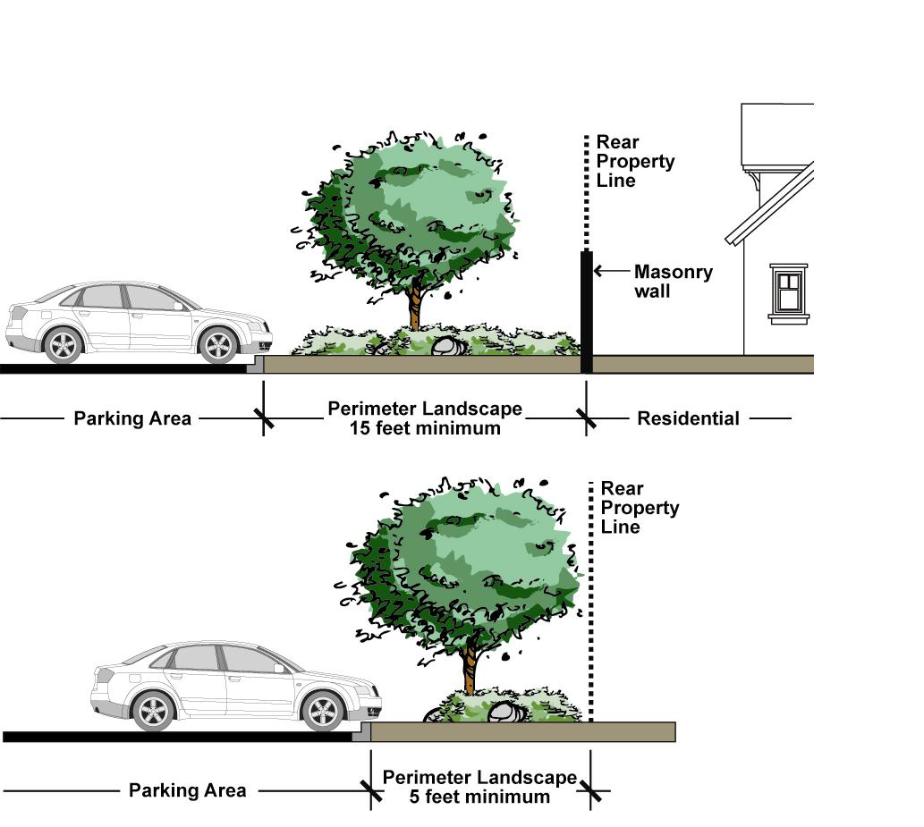
8.
Screening of drive-through aisles. To screen vehicles using a drive-through facility and minimize associated headlight impacts, a minimum, continuous, and immediate 42-inch-high landscape screen shall be established along the outer edge of drive-through aisles. Screening materials may include a combination of plant materials and raised planters as approved by the Director.
Figure 3-14. Screening of Drive-through Aisles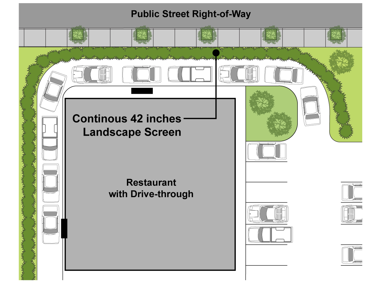
_____
9.
Parking lot shade.
a.
Trees in parking lots. Trees shall be planted and maintained in all parking lots at a minimum ratio of one tree for every six parking spaces.
b.
Tree shading requirement. Trees shall be planted and maintained throughout the parking facility to ensure that, within 15 years after establishment of the parking facility, at least 40 percent of the parking facility will be shaded.
c.
Shading calculation. Shading shall be calculated by using the expected diameter of the tree crown at 15 years. Each planting area shall be of adequate size for the landscaping approved and shall have adequate irrigation for that landscaping. The Director shall have discretion to modify tree shading requirements under power lines and other obstructions that prohibit strict compliance with shading requirements and to give shading credit for off-site trees, sidewalk canopies, and other structures, where appropriate.
d.
Installation. Upon completion of the installation of shade trees, the landscape designer shall certify that the shading complies with all requirements of this section.
D.
Parking lot storm water management.
1.
For new developments with 25 or more parking spaces, at least 50 percent of the required parking lot landscaping shall be provided as a vegetated swale, vegetated filter strip, rain gardens, or detention basins with bio-filtration within the parking lot.
2.
Parking lot drainage shall be designed such that all surface runoff (both piped and overland flow) is conveyed through a vegetated swale, vegetated filter strip, rain gardens, or detention basins with biofiltration. The parking lot shall provide appropriate curb cuts to allow water to freely enter and exit parking lot swales.
3.
All landscaped islands shall be situated below the grade of the parking spaces and driving aisles such that stormwater runoff flow is directed to and trapped by such islands.
4.
All development shall also comply with all applicable provisions of Chapter 6.15 (Stormwater and Urban Runoff Pollution Control) of the Municipal Code.
19.38.210 - Maintenance.
A.
All parking facilities, including curbs, directional markings, handicapped symbols, landscaping, irrigation, pavement, signs, striping, and wheel stops, shall be permanently maintained in good repair, free of litter and debris, potholes, obstructions, and stored material.
B.
It shall be the responsibility of the property owner to ensure that the surface is maintained free from conspicuous cracks or holes.
C.
Maintenance shall include, but shall not be limited to, necessary weeding, fertilizing and watering of the landscape areas and materials.
19.38.220 - Bicycle parking requirements.
A.
General provisions. These provisions implement the intent of Chapter 19.52 (Sustainable Development Practices). All developments except those located in the R-1 and R-2 zones shall be designed with the following:
1.
Bicycle parking shall be located on a paved surface, in proximity to a building entrance, not interfere with pedestrian access, and located in a visibly secure location adjacent to the building.
2.
Bicycle parking shall consist of at least one stationary parking device, where the bicyclist supplies a padlock and chain or cable to secure the bicycle to a stationary parking device.
3.
Where bicycle parking areas are not clearly visible to approaching cyclists, signs shall be provided to indicate the locations of the facilities.
B.
Bicycle parking requirements. Bicycle parking is required for multi-family, public and civic facilities, schools, retail commercial, industrial, hospital, and office uses in accordance with Table 3-11.
19.38.230 - Off-street loading requirements.
A.
General loading requirements. All developments zoned commercial and industrial shall be designed with the following:
1.
At least one driveway approach capable of accommodating a 48-foot wheel track turning radius.
2.
At least one on-site maneuvering area which provides a 48-foot turning radius wheel track through the parking area or a circulation pattern which does not require a truck to turn around on site.
B.
No use of public right-of-way. All industrial and commercially zoned developments shall be designed so as to prevent truck back-up maneuvering within public right-of-way.
C.
Loading docks.
1.
If an industrially or commercially zoned property is designed with dock high approaches and/or truck wells, each dock or well shall be provided with at least one back-up area to the dock or well in accordance with the following:
2.
The driveway aisle between parking stalls may be used for the approach, provided the 48-foot wheel track turning radius is maintained.
3.
The dock approach may not be encumbered by parking stalls or physical obstructions and shall be measured perpendicular to the dock or door. The minimum dock or door overhead clearance (excluding pipes, lights, etc.) is 12 feet.
4.
Loading docks located less than 100 feet to residential properties shall be housed in an enclosed structure that extends from the main building to minimize noise impacts.
D.
Minimum loading space requirements. The following off-street loading spaces shall be provided for all hospitals, institutions, hotels, commercial and industrial uses. The loading spaces shall be not less than 12 feet in width, 40 feet in length, and with 14 feet of vertical clearance.
_____
E.
Parking aisles. Parking aisles and access driveways adjacent to loading doors without dock high approaches or truck wells shall have a minimum width of eight feet plus the aisle width required in this chapter, except for 90 degree parking in which the parking aisle shall have a minimum 32-foot width.
F.
Fire lanes. Designated fire lanes shall provide fire ladder truck maneuvering in accordance with the requirements of the Fire Department.
G.
Loading doors not visible. No loading doors shall be visible from a public street.
19.38.240 - Transportation demand management.
A.
Purpose. The purpose of this Section is to provide significant public benefits by improving the general efficiency of the transportation system and improve air quality and reduce energy requirements. The requirements of this Section are intended to:
1.
Reduce the number of peak-period vehicle trips generated in association with the approval of development projects;
2.
Promote and encourage the use of alternative transportation modes, including ridesharing, carpools, vanpools, public bus and rail transit, bicycles and walking, as well as those facilities that support the use of these modes;
3.
Reduce vehicle trips, traffic congestion, and public expenditures for transportation system improvements and improve air quality through the utilization of existing local mechanisms and procedures for project review and permit processing;
4.
Promote coordinated implementation of strategies on a County-wide basis to reduce transportation demand; and
5.
Achieve the most efficient use of local resources through coordinated and consistent regional and/or local trip reduction programs.
B.
Applicability. The requirements of this Section shall apply to all new nonresidential projects, mixed use projects, and employment centers that are estimated to employ 250 or more persons (or as specified by the rules and regulations of the Southern California Air Quality Management District).
C.
Employment generation factors. The following generation factors are the basis for determining employment projections in the absence of more specific information.
Employment projections shall be developed by the project applicant, subject to approval by the City. The employment projection for a mixed-uses development shall be calculated on a case-by-case basis, based upon the proportion of development devoted to each type of land use.
D.
Facility standards. The site plan approved for all applicable development shall provide for each of the improvements specified below:
1.
Carpool parking.
a.
At least 15 percent of the employee parking spaces shall be reserved and designated for carpool vehicles by marking such spaces Carpool Only.
b.
Carpool spaces shall only be used by carpool vehicles in which at least 2 of the persons are employees or tenants of the development.
c.
Carpool spaces shall be located near the employee entrance or at other preferential locations.
2.
Bicycle parking. Bicycle parking and lockers facilities shall be provided for use by employees or tenants who commute to the site by bicycle per 19.38.220 (Bicycle Parking Requirements).
3.
Lockers and showers. A minimum of two showers and two lockers shall be provided.
4.
Information on transportation alternatives. A commuter information area shall be provided in one or more central areas that are accessible to all employees or tenants. Information shall include, but not be limited to, current maps, routes and schedules for public transit; ridesharing match lists; available commuter incentives and ridesharing promotional material supplied by commuter-oriented organizations.
5.
Rideshare vehicle loading area. A rideshare vehicle loading area shall be designated. The area shall accommodate a minimum of two passenger vehicles for the first 25,000 square feet of development, plus one for each 50,000 square feet of additional development or fraction thereof.
6.
Bus stop improvements. Bus stop improvements, including bus pullouts, bus pads, and right-of-way for bus benches and shelters shall be required for developments located along arterials where public transit exists or is anticipated to exist within five years. Improvements shall be determined according to a) frequency and relative impact of blocked traffic due to stopped buses; and b) level of transit ridership at the project location.
7.
Sidewalks. Sidewalks or other paved pathways connecting the external pedestrian circulation system to each building in the development shall be provided.
E.
Enforcement. The City may withhold the issuance of Building Permits, Certificates of Occupancy and/or issue stop work orders for a development project failing to comply with the provision of this Section. If any improvements or programs required by this Section are either rendered unusable or discontinued, the property owner, employer and/or tenant may be subject to enforcement procedures in compliance with Chapter 19.154 (Enforcement Provisions).
19.40.010 - Purpose, intent and applicability.
A.
Purpose. The City promotes the value and benefits of landscapes while recognizing the need to invest water and other resources as efficiently as possible. In compliance with applicable State standards and guidelines, and to promote the City's goals and standards regarding sustainable development set forth in Chapter 19.52 (Sustainable Development Practices), this Chapter establishes minimum landscape standards for all uses for the purpose of enhancing the appearance of developments, reducing heat and glare, controlling soil erosion, conserving water, establishing a buffer and/or screen between residential and nonresidential land uses, and ensuring the ongoing maintenance of landscape areas. Water conservation measures shall be addressed through landscape and irrigation design.
B.
Intent. The intent of the water-efficient landscape Chapter is:
1.
That this Chapter be at least as effective in conserving water as the State Model Water Efficient Landscape Ordinance and consistent with Governor Brown's April 1, 2015 Drought Executive Order B-19-25;
2.
Establish a structure for planning, designing, installing, and maintaining and managing water efficient landscapes in new construction and rehabilitated projects;
3.
Establish provisions for water management practices and water waste prevention for existing landscapes;
4.
To assure beneficial, efficient, and responsible use of water resources;
5.
To retain the land's natural hydrological role and promote the infiltration of surface water into the groundwater;
6.
To recognize that landscapes enhance the aesthetic appearance of developments and communities;
7.
To encourage the appropriate design, installation, maintenance, and management of landscapes so that water demand can be decreased, runoff can be retained, and flooding can be reduced without a decline in the quality or quantity of landscapes; and
8.
To reduce or eliminate water waste.
C.
Applicability. Beginning March 24, 2016, all landscaping projects subject to this Chapter shall obtain a permit from the Community Development Department prior to installation of any landscaping. All planting, irrigation, and landscape related improvements required by this Chapter shall apply to the following landscape projects:
1.
New landscape projects with an aggregate landscape area equal to or greater than 500 square feet requiring a building or landscape permit, plan check or design review;
2.
Rehabilitated landscape projects with an aggregate landscape area equal to or greater than 2,500 square feet requiring a building or landscape permit, plan check or design review;
3.
New or rehabilitated landscape projects between 500 and 2,500 square feet may comply with the performance requirements of this Chapter or conform to the prescriptive measures contained in Appendix A of the Guidelines;
4.
New or rehabilitated projects using treated or untreated graywater or rainwater capture on site, any lot or parcels within the project that has less than 2,500 square feet of landscape area and meets the lot or parcel's landscape water requirement (estimated total water use) entirely with the treated or untreated graywater or though stored rainwater capture on site is subject only to Appendix A of the Implementation Guidelines;
5.
Special Landscaped Areas with an area greater than 500 square feet, such as areas dedicated to edible plants, irrigated with recycled water, or dedicated to active play and/or a Recreational Area, shall prepare a water efficient landscape worksheet and landscape documentation package according to specifications for Special Landscaped Areas;
6.
Cemeteries. Recognizing the special landscape management needs of cemeteries, new and rehabilitated cemeteries are limited to Sections 2.2 and 2.9 of the Guidelines; and existing cemeteries are limited to Section 3 of the Guidelines.
D.
Other considerations. The requirements of the Guidelines may be partially or wholly waived, at the discretion of the Director of Community Development or his/her designee, for landscape rehabilitation projects that are limited to replacement plantings with equal or lower water needs and where the irrigation system is found to be designed, operable and programmed consistent with minimizing water waste in accordance with local water purveyor regulations.
E.
Exempt activities. The provisions of this Chapter do not apply to:
1.
Registered local, State, or federal historical sites.
2.
Ecological restoration projects that do not require a permanent irrigation system.
3.
Mined-land reclamation projects that do not require a permanent irrigation system.
4.
Existing plant collections as part of botanical gardens and arboretums open to the public.
F.
Project continuation. Any landscape project(s) conducted on the same parcel of land within a 12-month period from the first landscape project submittal shall be aggregated for the purposes of determining a project's applicability to the requirements of this Chapter.
G.
Relationship to private covenants. The architectural guidelines of a common interest development, which includes community apartment projects, condominiums, planned developments, and stock cooperatives, shall not prohibit or include conditions that have the effect of prohibiting the use of low-water use plants as a group.
(Ord. No. 862, § 1, 2-23-16)
19.40.020 - Definitions.
Aggregate. A concept that pertains to production home neighborhoods, common interest developments, or other situations where multiple parcels are undergoing landscape development as one project, but may eventually be individually owned or maintained.
Applied Water. The portion of water supplied by the irrigation system to the landscape.
Artificial Turf. A man-made material which simulates the appearance of live turf, organic turf, grass, sod, or lawn.
Automatic Irrigation Controller. See automatic controller under Chapter 19.160.030.
Backflow Prevention Device. A safety device used to prevent pollution or contamination of the water supply due to the reverse flow of water from the irrigation system.
Certification of Completion or Landscape Installation Certificate of Completion. The certification included as Exhibit E of the Implementation Guidelines that shall be provided to the City prior to Planning and Building Divisions final inspection pursuant to Section 2.7 of the Guidelines.
Certification of Design or Certificate of Landscape Design. The certification included as Exhibit B of the Implementation Guidelines that shall be included in the Landscape Documentation Package pursuant to Section 2.1 of the Guidelines.
Certified Landscape Irrigation Auditor. A person(s) certified to perform landscape irrigation audits by an accredited academic institution, a professional trade organization or other program such as the US Environmental Protection Agency's WaterSense irrigation auditor certification program and Irrigation Association's Certified Landscape Irrigation Auditor program.
Chapter. Refers to Chapter 19.40 of the Duarte Development Code.
Check valve or anti-drain valve. A valve or valves located under a sprinkler head, or other location in the irrigation system, to hold water in the system to prevent drainage from sprinkler heads when the sprinkler is off.
City. Refers to the City of Duarte.
Common Interest Developments. Refers to community apartment projects, condominium projects, planned developments, and stock cooperatives per Civil Code Section 1351.
Conversion Factor. The number that converts acre-inches per acre per year to gallons per square foot per year.
Drip Irrigation. See definition under Chapter 19.160.050.
Drought-Tolerant Landscaping. Landscaping that utilizes little or no irrigation through the use of water-conserving materials and techniques, including but not limited to, native drought-tolerant plants, mulch and efficient irrigation.
Drought-Tolerant Plants. See definition under Chapter 19.160.050.
Ecological Restoration Project. A project where the site is intentionally altered to establish a defined, indigenous, historic ecosystem.
Emitter. A drip irrigation emission device that delivers water slowly from the system to the soil.
Estimated Applied Water Use (EAWU). The annual total amount of water estimated to keep plants in a healthy state. It is based on factors such as reference evapotranspiration rate, the size of the landscaped area, plant water use factors, and the irrigation efficiency within each hydrozone.
Evapotranspiration. See definition under Chapter 19.160.060.
Evapotranspiration Adjustment Factor (ETAF). A factor of 0.55 for residential areas and 0.45 for non- residential areas, that, when applied to reference evapotranspiration, adjusts for plant factors and irrigation efficiency, two major influences upon the amount of water that needs to be applied to the landscape The ETAF for new and existing (non-rehabilitated) Special Landscape Areas shall not exceed 1.0. The ETAF for existing non-rehabilitated landscapes is 0.8.
Evapotranspiration Rate. The quantity of water evaporated from adjacent soil and other surfaces and transpired by plants during a specified time.
Flow Rate. The rate at which water flows through pipes, valves and emission devices, measured in gallons per minute, gallons per hour, or cubic feet per second.
Front Yard. For purposes of this Chapter and the Guidelines, shall mean the required front yard setback and any area between the street and the outline of the main building line. For other unique lot configurations, the Director of Community Development shall determine front yard.
Front Yard Landscaped Area. The Front Yard Area that is not occupied by driveways, hardscape or other pervious or non-pervious surfaces and that is required to be landscaped with live vegetation, artificial turf, drought tolerant landscaping or a combination of all three, as further described in this Chapter and the Implementation Guidelines.
Graywater. A system containing untreated wastewater that has not been contaminated by any toilet discharge, has not been affected by infectious, contaminated, or unhealthy bodily wastes, and does not present a threat from contamination by unhealthy processing, manufacturing, or operating wastes. Graywater includes, but is not limited to, wastewater from bathtubs, showers, bathroom washbasins, clothes washing machines, and laundry tubs, but does not include wastewater from kitchen sinks or dishwashers as per the Health and Safety Code (Section 17922.12). Graywater systems promote the efficient use of water and are encouraged to assist in on-site landscape irrigation. All graywater systems shall conform to the California Plumbing Code (Title 24, Part 5, Chapter 16) and any applicable local ordinance standards.
Hardscape. See definition under Chapter 19.160.090.
Hydrozone. See definition under Chapter 19.160.090.
Implementation Guidelines or Guidelines. Refers to the Water Efficient Landscape Ordinance Guidelines which shall be adopted by resolution of the Planning Commission. The purpose of the Guidelines is to provide procedural and design guidance for applicants proposing new landscape or landscape rehabilitation projects that are subject to Chapter 19.40 of the City of Duarte Development Code.
Infiltration Rate. See definition under Chapter 19.160.100.
Invasive and/or Noxious Plants Species. Species of plants not historically found in California that spread outside cultivated areas and can damage environmental or economic resources. Invasive plant species may be regulated by county agricultural agencies as noxious species.
Irrigation Audit. An in-depth evaluation of the performance of an irrigation system conducted by a Certified Landscape Irrigation Auditor. An irrigation audit includes, but is not limited to: inspection, system tune-up, system test with distribution uniformity or emission uniformity, reporting overspray or runoff that causes overland flow, and preparation of an irrigation schedule.
Irrigation Efficiency (IE). The measurement of the amount of water beneficially used divided by the amount of water applied to a landscaped area. Irrigation efficiency is derived from measurements and estimates of irrigation system characteristics and management practices. The minimum average irrigation efficiency for purposes of this Chapter and the Guidelines is 0.71. Greater irrigation efficiency can be expected from well designed and maintained systems. The following irrigation efficiency may be obtained for the listed irrigation heads with an IME of 90 percent:
*DU LH = .386 + (.614)(DU LQ
**IE (spray) = (DU LH )(IME)
***IE (drip) = Emission uniformity (EU)(IME)
Irrigation Management Efficiency (IME). The measurement used to calculate the irrigation efficiency of the irrigation system for a landscaped project. A 90 percent IME can be achieved by using evapotranspiration controllers, soil moisture sensors, and other methods that will adjust irrigation run times to meet plant water needs.
Landscape Coefficient (KL). The product of a plant factor multiplied by a density factor and a microclimate factor. The landscape coefficient is derived to estimate water loss from irrigated landscaped areas and Special Landscaped Areas.
Landscape Documentation Package. The package of documents that a project applicant is required to submit to the City pursuant to Section 2.1 of the Guidelines.
Landscape Professional. A licensed landscape architect, licensed landscape contractor, or any other person authorized to design a landscape pursuant to Sections 5500.1, 5615, 5641, 5641.1, 5641.2, 5641.3, 5641.4, 5641.5, 5641.6, 6701, 7027.5 of the California Business and Professions Code, Section 832.27 of Title 16 of the California Code of Regulations, and Section 6721 of the California Food and Agriculture Code.
Landscaped Area. Refers to all planting areas, turf areas, and water features in a landscape design plan subject to the Maximum Applied Water Allowance and Estimated Applied Water Use calculations. The landscaped area does not include footprints of buildings or structures, sidewalks, driveways, parking lots, decks, patios, gravel or stone walks, other pervious or non-pervious hardscapes, and other non-irrigated areas designated for non-development (e.g., open spaces and existing native vegetation).
Landscaping. See definition under Chapter 19.160.130.
Lateral Line. A water delivery pipeline that supplies water to the emitters or sprinklers from the valve.
Low Volume Irrigation. The application of irrigation water at low pressure through a system of tubing or lateral lines and low-volume emitters such as drip, drip lines, and bubblers. Low volume irrigation systems are specifically designed to apply small volumes of water slowly at or near the root zone of plants.
Low Volume Overhead Irrigation. Aboveground irrigation heads with an upper flow limit of 0.5 GPM.
Main Line. A pressurized pipeline that delivers water from the water source to the valve or outlet.
Manual Isolation Valve. A valve such as a gate valve, ball valve, or butterfly valve installed downstream of the point of connection of the water supply to shutdown water flow through mainline piping for routine maintenance and emergency repair.
Master Shut-Off Valve. An electronic valve such as a solenoid valve installed as close as possible to the point of connection and is used in conjunction with a flow sensor and flow monitoring controller technology to automatically shut down system wide water flow in the event of high flow conditions such as mainline pipe break.
Maximum Applied Water Allowance (MAWA). Refers to the upper limit of annual applied water for the established landscaped area, as specified in Section 2.2 of the Guidelines. It is based upon the area's reference evapotranspiration, the ETAF, and the size of the landscaped area. The Estimated Applied Water Use shall not exceed the Maximum Applied Water Allowance.
Microclimate. The climate of a small, specific area that may contrast with the climate of the overall landscaped area due to factors such as wind, sun exposure, plant density, or proximity to reflective surfaces.
Mined-Land Reclamation Projects. Any surface mining operation with a reclamation plan approved in accordance with the surface mining and Reclamation Act of 1975.
Mulch. Any organic material such as leaves, bark, straw or compost, or inorganic mineral materials such as rocks, gravel, or decomposed granite left loose and applied to the soil surface for the beneficial purposes of reducing evaporation, suppressing weeds, moderating soil temperature, and preventing soil erosion.
Non-Pervious or impervious. Any surface or material that does not allow for the passage of water through the material and into the underlying soil.
Operating Pressure. The pressure at which the parts of an irrigation system of sprinklers are designed to operate at by the manufacturer.
Overspray. The irrigation water which is delivered beyond the target area.
Parkway. See definition under Chapter 19.160.170.
Person. Any natural person, firm, joint venture, joint stock company, partnership, public or private association, club, company, corporation, business trust, organization, public or private agency, government agency or institution, school district, college, university, any other user of water provided by the City or the local water purveyor, or the manager, lessee, agent, servant, officer, or employee of any of them or any other entity which is recognized by law as the subject of rights or duties.
Pervious. Means any surface or material that allows the passage of water through the material and into the underlying soil.
Plant Factor or Plant Water Use Factor. A factor, when multiplied by ETo, that estimates the amount of water needed by plants. For purposes of this Water Efficient Landscape Ordinance, the plant factor range for very low water use plants is 0 to 0.1; the plant factor range for low water use plants is 0 to 0.3; the plant factor range for moderate water use plants is 0.4 to 0.6; and the plant factor range for high water use plants is 0.7 to 1.0. Plant factors cited in the Guidelines are derived from the Department of Water Resources 2000 publication "Water Use Classification of Landscape Species."
Precipitation Rate. The rate of application of water measured in inches per hour.
Project Applicant. The individual or entity submitting a Landscape Documentation Package required under Section 2.1 to request a permit, plan check, or design review from the City. A project applicant may be the property owner or his or her designee.
Property Owner. The record owner of real property as shown on the most recently issued equalized assessment roll.
Rain Sensor or Rain sensing shutoff device. A component which automatically suspends irrigation when it rains.
Recreational Area. An area(s), excluding private single family residential areas, designated for active play; recreation or public assembly in parks, sports fields, picnic grounds, amphitheaters; golf course tees, fairways, roughs, surrounds and greens; private recreational or assembly space as part of a comprehensive project that otherwise meets the intent of this Chapter, and other active or recreational play areas as determined by the Community Development Director.
Recycled Water or Reclaimed Water. Treated or recycled waste water of a quality suitable for non-potable uses such as landscape irrigation and water features. This water is not intended for human consumption.
Reference Evapotranspiration (ETo). A standard measurement of environmental parameters which affect the water use of plants. ETo is given expressed in inches per day, month, or year as represented in Appendix C of the Guidelines, and is an estimate of the evapotranspiration of a large field of four- to seven-inch tall, cool-season grass that is well watered. Reference evapotranspiration is used as the basis of determining the Maximum Applied Water Allowances.
Rehabilitated Landscape. Any re-landscaping project that requires a permit, plan check, or design review, meets the requirement of Section 1.2 of the Guidelines, and the modified landscape area is equal to or greater than 2,500 square feet.
Runoff. See definition under Chapter 19.160.190.
SMART Irrigation Controller or Soil Moisture Sensor. A weather-based or soil moisture-based irrigation controller that monitors and uses information about the environmental conditions at a specific location and landscape to automatically adjust watering schedules.
Soil Texture. The classification of soil based on its percentage of sand, silt, and clay.
Special Landscaped Areas (SLA). Area(s) of the landscape dedicated solely to edible plants such as orchards and vegetable gardens, areas irrigated with recycled water, water features using recycled water, and areas designated as a recreational area.
Sprinkler Head. A device which delivers water through a nozzle.
Static Water Pressure. See definition under Chapter 19.160.200.
Station. An irrigated area served by one valve or by a set of valves that operate simultaneously.
Swing Joint. An irrigation component that provides a leak-free connection between the emission device and lateral pipeline to allow movement in any direction and to prevent equipment damage.
Turf. See definition under Chapter 19.160.210.
Valve. A device used to control the flow of water in an irrigation system.
Visible Street Side Yard. For purposes of this Chapter and the Guidelines, means any street side yard that is visible from the public right-of-way, that shall be improved as further described in this Chapter and the Implementation Guidelines.
Water-Efficient Irrigation System. See definition under Chapter 19.160.240.
Water-Efficient Landscape. See definition under Chapter 19.160.240.
Water Efficient Landscape Ordinance. Refers to Chapter 19.40 of the City of Duarte Development Code.
Water Efficient Landscape Worksheet. The worksheet required to be completed pursuant to Section 2.2 of the Guidelines and which are included in Appendix C of the Guidelines.
Water Feature. A design element or elements where open water performs an aesthetic or recreational function. Water features include ponds, lakes, waterfalls, fountains, artificial streams, spas, and swimming pools (where water is artificially supplied). The surface area of water features is included in the high water use hydrozone of the landscaped area. Constructed wetlands used for on-site wastewater treatment, habitat protection, or storm water best management practices that are not irrigated and used solely for water treatment or storm water retention are not water features and, therefore, are not subject to the water budget calculation.
Watering Window. The time of day irrigation is allowed on landscaped surfaces.
WUCOLS. Refers to the Water Use Classification of Landscape published by the University of California Cooperative Extension, the Department of Water Resources, and the Bureau of Reclamation, 2000. www.owue.water.ca.gov/docs/wucols00
(Ord. No. 862, § 1, 2-23-16)
19.40.030 - Implementation guidelines.
Water Efficient Landscape Ordinance Guidelines shall be adopted by resolution of the Planning Commission.
(Ord. No. 862, § 1, 2-23-16)
19.40.040 - General landscape standards.
These standards shall apply to all parcels within the City.
A.
Water Efficient Landscape Ordinance Guidelines (Implementation Guidelines), adopted by resolution of the City of Duarte Planning Commission, shall establish criteria for the design and review of landscape and irrigation plans, and such criteria shall be adhered to in the design of landscape and irrigation plans as required by this Chapter.
B.
Trees may be planted in any required yard area. All required trees shall be of a minimum size of 15 gallons, unless a larger size is specified in project conditions of approval. In limited cases, smaller tree sizes may be approved if the Director determines that long-term tree growth potential is improved by smaller specimens.
C.
Landscaping shall be maintained in the area between the front property line and the dwelling, building, or structure. In all zones except the R-1 zones (inclusive), a permanent irrigation system shall also be maintained in the same front-yard area.
D.
Landscape planting shall emphasize drought-tolerant and native species, complement the architectural design of structures on the site, and be suitable for the soil and climatic conditions of the site, consistent with the requirement of this Chapter.
E.
Transformers shall be screened with dense landscaping or walls similar to those required for trash enclosures, and shall not be located within open space recreation areas. They shall be located away from public view wherever possible and shall not impede pedestrian or vehicular circulation. Where feasible, transformers should be placed underground.
F.
Use of artificial turf is regulated by both standards within this Chapter and in the Implementation Guidelines. The use of artificial turf requires Community Development Department approval before installation.
19.40.050 - Landscape of unused and undeveloped portions of a site.
All areas of a site not intended for a specific use or purpose in conjunction with a current application, including vacant or undeveloped pad sites in shopping centers held for future development, shall be fully landscaped and irrigated with an automatic irrigation system. Landscaping shall include a combination of trees, shrubs, ground cover, turf, and/or approved decorative landscape materials, as approved by the Director, and in compliance with this Chapter.
(Ord. No. 862, § 1, 2-23-16)
19.40.060 - Residential landscape standards.
The following standards shall apply to all parcels in all residential zones.
A.
A minimum of 20 percent of the entire parcel shall be fully landscaped with plant materials.
B.
At least 50 percent of the Front Yard Landscaped Area and 50 percent of the Visible Street Side Yard shall be landscaped with live vegetation, artificial turf, drought-tolerant landscaping or a combination of the three, as further described below:
1.
Live vegetation may include turf, trees, shrubs, groundcover, flowers, or other similar vegetation.
2.
Artificial turf is limited to no more than 40 percent coverage of the Front Yard Landscaped Area and shall include a minimum of 60 percent of live vegetation. Artificial turf is limited to no more than 40 percent coverage of the Visible Street Side Yard and shall include a minimum of 60 percent of live vegetation. (See Section 4.2 of the Guidelines)
3.
Drought tolerant landscaping shall include native water conserving plants. (See Section 4.3 of the Guidelines)
C.
Artificial turf is not permitted within the parkway.
D.
Bare dirt is not permitted within the front yard, visible street side yard or within the parkway. All bare dirt areas shall be finished with a minimum three inch thick layer of mulch, organic bark or earth-toned colored rubber bark.
E.
Parking lots for multi-family developments providing 10 or more parking spaces shall be landscaped per the requirements of Section 19.38.200 (Parking Lot Landscaping).
(Ord. No. 862, § 1, 2-23-16)
19.40.070 - Nonresidential landscape standards.
All new and rehabilitated landscaping plans undertaken in conjunction with any private development project on commercial, industrial, mixed-use, and other nonresidential properties, or those projects requiring a grading, building, use permit, or site plan and design review, as required by this Chapter, shall comply with the following standards.
A.
All unpaved areas, including those portions of required yard areas not utilized for vehicular and pedestrian access, shall be landscaped with plant material, including some combination of trees, shrubs, groundcover, and turf. Mulch, bark, and similar landscaping materials may be incorporated into the landscape design.
B.
A minimum of 15 percent of the parcel area shall be landscaped, exclusive of the parking lot area and any landscaping required within the parking lot.
C.
A minimum of 75 percent of the landscape area must be landscaped with live plants. The remaining area may utilize boulder, rocks, decomposed granite, water features or other hardscapes, subject to approval from the Community Development Department.
D.
All landscaped areas shall be provided with an automatic irrigation system, unless the Director finds that such an irrigation system, due to the size, location, or configuration of the landscaped area, cannot reasonably be installed and maintained.
E.
To achieve an immediate effect of a landscape installation and to allow sustained growth of planting materials, plant material sizes and plant spacing shall comply with the following standards, unless the Director finds that alternative sizes and planting will achieve the same or similar desired effects:
1.
The minimum plant size for trees shall be 15 gallons, unless otherwise specified by the provisions of this Chapter. Trees planted within 10 feet of a street, sidewalk, paved trail, or walkway shall be a deep-rooted species or shall be separated from paved surfaces by a root barrier to prevent physical damage to public improvements. A minimum distance of 15 feet is required between the center of trees to street light standards, water meters, back-flow prevention systems, sewer cleanouts, and fire hydrants.
2.
The minimum plant size for shrubs shall be five gallons.
3.
Groundcover, including turf, shall be planted in a manner to provide 100 percent coverage within one year of initial planting.
F.
Lots with freeway frontage shall provide and maintain freeway frontage landscaping.
G.
Parking lot landscaping shall be provided per the requirements of Section 19.38.180 (Parking Lot Landscaping).
H.
Artificial turf is not permitted within in the parkway.
I.
Artificial turf is discouraged on non-residential properties. Use of artificial turf is only allowed in special circumstances as approved by the Community Development Director.
J.
Bare dirt is not permitted within the front yard, visible street side yard or within the parkway. All bare dirt areas shall be finished with a minimum three inch thick layer of mulch, organic bark or earth-toned colored rubber bark.
19.40.080 - Hillside landscaping standards.
Landscaping standards for properties in hillside areas, as defined in Chapter 19.46 (Hillside Development Standards), in addition to the standards in this Chapter, shall comply with the standards set forth in 19.46.120 (Landscaping and Irrigation Standards).
(Ord. No. 862, § 1, 2-23-16)
19.40.090 - Landscape plan approval required.
A.
Required landscape plan. Except as otherwise specified in this Section, any application for any development that requires a grading permit, building permit, use permit, or site plan and design review shall include landscape and irrigation plans which provide for the utilization of low-water-usage irrigation systems and a landscape design consistent with the requirements of this Chapter. The plans shall be prepared by a licensed landscape architect, licensed landscape contractor or any other person authorized to design a landscape plan.
B.
Review required. The plan shall contain the information described in the Implementation Guidelines and shall be subject to review and approval by the Director for compliance with the landscape design criteria contained in this Chapter. The review process represents the basis for approval or denial of a landscape design proposal. No grading, building, use permit, or site plan and design approval can be issued until a project has received approval from the Director.
C.
Full construction drawings required. Following the granting of all required planning and subdivision approvals, full construction drawings shall be submitted to the Building Division for plan check approval. Drawings submitted for plan check shall include the entire Landscape Documentation Package described in the Implementation Guidelines, including the approved Preliminary Landscape Design Plan. The Landscape Design Plan shall be in substantial conformity with the approved Preliminary Landscape Design Plan prior to issuance of building permits.
(Ord. No. 862, § 1, 2-23-16)
19.40.100 - Landscape and irrigation maintenance.
A.
Landscape maintenance. Landscaping and vegetation shall be maintained as follows:
1.
All landscaped areas shall be kept and maintained in a manner that does not detract from the appearance of the immediate neighborhood, and that protects the health, safety, and welfare of the user, occupants, and general public.
2.
Landscaped areas shall be kept and maintained in a neat and clean condition, free of weeds, debris and dead, diseased, or dying vegetation, and broken or defective decorative elements.
3.
Vegetation in landscaped areas shall be mowed, groomed, trimmed, pruned, and watered to maintain a healthy, growing condition.
4.
Vegetative overgrowth shall not be permitted in a manner that is likely to harbor rodents, vermin, insects, or other nuisances; or impedes, obstructs, or denies pedestrian or other lawful travel on sidewalks, walkways, or other public rights-of-way.
5.
All property owners shall water, prune, weed, and otherwise maintain landscaping in the parkway portions of adjoining streets, including street trees.
B.
Irrigation systems. Irrigation systems shall be maintained as follows:
1.
Irrigation systems shall be kept in good working condition and repair to prevent leaks or public health hazards.
2.
Water waste resulting from inefficient landscape irrigation leading to excessive runoff, low-head drainage, overspray, and other similar conditions where water flows onto adjacent property, non-irrigated areas, walks, or structures, shall be minimized.
3.
Irrigation systems and their components shall be maintained in a fully functional manner consistent with the originally approved design and the provisions of this Chapter.
4.
Landscapes shall be maintained to ensure water efficiency. A regular maintenance schedule should include but not be limited to checking, adjusting and repairing irrigation equipment; resetting the automatic controller; aerating and dethatching turf areas; replenishing mulch; fertilizing; pruning; and weeding in all landscaped areas.
C.
Artificial turf. Artificial turf shall be maintained as follows:
1.
All artificial turf areas shall be kept and maintained in a manner that does not detract from the appearance of the immediate neighborhood, and that protects the health, safety, and welfare of the user, occupants, and general public.
2.
Artificial turf areas shall be kept free of animal waste, rubbish, leaves, sand, rocks, algae, mold, fungi, natural grass and/or weeds.
3.
Artificial turf seams, joints and edges shall be inconspicuous and not allowed to cause tripping or other hazards.
4.
Artificial turf that is discolored, deteriorated, matted, torn, stained, shows excess wear or is otherwise unsightly or neglected shall be repaired or replaced to the satisfaction of the City.
5.
Artificial turf infill material shall be maintained at adequate levels to allow proper use of the turf. Infill materials shall not be allowed to accumulate within the artificial turf area or otherwise be visible from the public right-of-way. Sweeping, raking or otherwise redistributing infill material on a regular basis is required.
(Ord. No. 862, § 1, 2-23-16)
19.40.110 - Cooperation with water purveyor(s).
A local agency may by mutual agreement, designate another agency, such as a water purveyor, to implement some or all of the requirements contained in this Chapter. Local agencies may collaborate with water purveyors to define each entity's specific responsibilities relating to this Chapter.
19.40.120 - Minor modifications to approved landscape and irrigation plans.
The Director may approve minor changes to approved landscape, irrigation, and related plans, subject to the provisions of Chapter 19.122 (Site Plan and Design Review) and the following criteria:
A.
Minor modifications to approved landscaping and irrigation, or grading plans which comply with the spirit and intent of this Chapter, including but not limited to, revising or substituting plant varieties, container sizes, plant locations, irrigation specifications, hardscape components, berm heights, berm locations, slope features, and the like.
B.
Modifications of planting, installation, and/or soil preparation details.
(Ord. No. 862, § 1, 2-23-16)
19.42.010 - Purpose.
This Chapter establishes regulations to:
A.
Implement the City's community design and safety standards set forth in the General Plan, and maintain and enhance the City's appearance by regulating the design, character, location, number, type, quality of materials, size, illumination, and maintenance of signs;
B.
Protect and improve pedestrian and vehicular traffic safety by balancing the need for signs which facilitate the safe and smooth flow of traffic (i.e., traffic directional signs) without an excess of signage which may distract motorists, overload their capacity to quickly receive information, visually obstruct traffic signs, or otherwise create congestion and safety hazards;
C.
Encourage signs that are well-designed, that attract and invite rather than demand the public's attention, and that protect the aesthetic environment from the visual clutter associated with the unrestricted proliferation of signs, all while providing reasonable channels of communication to the public;
D.
Encourage the design of signs that are complementary to the buildings and uses to which they relate and that are harmonious with their surroundings;
E.
Respect and protect the right of free speech by sign display, while reasonably regulating the structural, locational, and other non-communicative aspects of signs generally for the public health, safety, welfare, and specifically to serve the public interests in traffic and pedestrian safety and community aesthetics;
F.
Minimize the possible adverse effects of signs on nearby public and private property and the owners, occupants, and users, if any;
G.
Serve the City's interests in maintaining and enhancing its visual appeal for tourists and other visitors by preventing the degradation of visual quality which can result from excess signage; and
H.
Enable the fair, consistent, and efficient enforcement of the sign regulations of the City.
19.42.020 - Effect of chapter.
A.
Regulatory scope. This Chapter regulates signs, as defined in this Chapter, that are placed on private property or on property owned by public agencies other than the City and over which the City has zoning authority.
B.
Applicability.
1.
General. The regulations in this Chapter shall apply to all signs in all zones that come within the regulatory scope as defined this section, unless specifically exempted. In addition, the provisions of the Municipal Code relating to building codes, sign permits, fees, penalties, and methods of enforcement shall also apply.
2.
Exceptions. Notwithstanding the requirements of this Chapter, private schools, Places of Religious Assembly, theaters, and other unique uses, as defined by the Director, may have specific signage requirements that require minor deviations from the requirements of this Chapter. The responsible Approving Authority, upon referral by the Director, shall have the authority to recognize the signage requirements of such unique uses and modify the requirements through the comprehensive sign program process set forth in Section 19.42.200.C, provided that the Approving Authority makes findings that such deviations meet the intent of this Chapter and this Code, are consistent the General Plan, and will not adversely affect surrounding uses and properties.
C.
Signs approved in conjunction with another permit or approval.
1.
Where, prior to the effective date of this Chapter 19.42, approval of a Specific Plan, Conditional Use Permit, Minor Use Permit, or Planned Development Permit has been obtained and that approval includes specific conditions or regulations relating to on-site signs, that approval shall supersede the requirements of this Chapter. However, in the event of any significant remodel, change in use or tenant, or similar circumstance, as defined by Section 19.42.050.B, a comprehensive sign program must be prepared and all associated signage shall comply with the provisions of this Chapter, subject further to the allowances granted to legal nonconforming signs set forth in Section 19.42.250 (Nonconforming Signs).
2.
For any new Specific Plan, Conditional Use Permit, Minor Use Permit, or Planned Development Permit approved after the effective date of this Chapter 19.42, all signage will be subject to the sign permitting and review processes set forth in this Chapter. A sign permit or sign program may be reviewed in conjunction with the Specific Plan, Conditional Use Permit, Minor Use Permit, or Planned Development Permit application, but shall constitute a separate, independent permit subject to the requirements of this Chapter.
19.42.030 - Definitions.
A.
Purpose and applicability. This Chapter ensures precision in interpretation of this Code of regulations as they relate to signs. The meaning and construction of words and phrases defined in this Chapter shall apply throughout this Chapter, except where the context clearly indicates a different meaning or construction.
B.
Use of terms in this chapter. In addition to the general provisions of this Code, the following rules of construction shall apply:
1.
The specific shall supersede the general.
2.
Unless the context clearly indicates the contrary, the following conjunctions shall be interpreted as follows:
a.
"And" indicates that all connected words or provisions shall apply.
b.
"Or" indicates that the connected words or provisions may apply singularly or in any combination.
c.
"Either...or" indicates that the connected words or provisions shall apply singularly but not in combination.
d.
In case of conflict between the text and a diagram, the text shall control.
3.
All references to days are to calendar days unless otherwise indicated, if a deadline falls on a weekend or holiday it shall be extended to the next working day.
C.
Words and phrases. For the purposes of this Chapter, the following words and phrases shall have the meanings ascribed to them:
1.
Abandoned sign. Any sign where for a period of 90 days or more, there is no sign copy appearing on the sign, or where the establishment or building to which the sign refers or is attached has ceased operation and/or where it is clear that the sign has been forsaken or deserted. It shall also mean a sign which does not identify or advertise a current bona fide business, lessor, service, owner, or product available upon the site; or that identifies or advertises an event or activity that has already occurred.
2.
Accessory sign. Any sign which carries only informational, non-commercial, and strictly incidental and subordinate to a lawful use of the premise upon which it is located, including signs or sign devices indicating the business transacted, services rendered, or name of the person occupying the premises.
3.
Advertising area. That portion of a sign structure on which a commercial message is placed consistent with the standards of this Chapter.
4.
Advertising structure. A structure of any kind or character erected or maintained for outdoor advertising purposes, upon which any poster, bill, printing, painting, or other advertisement of any kind whatsoever, including statuary, may be placed, for advertising purposes. "Advertising structure" does not include:
a.
A structure for official notices issued by any court or public body or officer;
b.
A structure upon which notices are posted by any public officer in performance of a public duty or by any person in giving legal notices;
c.
A structure for directional, warning, or informational signs and/or notices, required or authorized by law or by federal, state, county, or City authority;
d.
A structure erected near the City which contains the name City of Duarte and the names of, or any other information regarding, civic, fraternal, or religious organizations located within the City.
5.
A-frame sign. A sign designed with an A-frame structure and intended to be placed directly on a sidewalk or similar ground surface.
6.
Animated sign. A sign that uses movement, lighting, or special materials to depict action or create a special effect or scene. This classification includes all electronic signs. However, electronic or mechanical indications of time and/or temperature shall not be included in this definition for animated signs.
7.
Approved combustible materials. Any materials defined by the Director, based on consultation with the Building Official, for the purposes of this Chapter.
8.
Approved plastics. Only those plastics which meet the flammability requirements set forth by the Building Official.
9.
Balloon sign. Any sign, figure, or object that is inflated with air or any gas and has a maximum inflated volume of eight cubic feet. See also Inflatable Sign.
10.
Banner. A temporary sign constructed of cloth, plastic, or similar non-durable material which is suspended between two fixed points and is intended for decoration, identification, or advertisement.
11.
Billboard. A sign that directs attention to a business, commodity, service, entertainment, product, or activity offered at a location other than the site or parcel on which the sign is located. This definition does not include real estate signs, temporary signs, or directional signs allowed and approved pursuant to this Chapter.
12.
Building code. The adopted various building codes of the City, together with amendments to those codes.
13.
Building frontage. For the purposes of this Chapter means all portions of a structure façade that face a public street or parking lot serving the structure served. The primary frontage means that wall face of the structure which faces the street. In cases where a structure has more than one street frontage or where a business has no frontage facing a street, that street frontage containing the main entrance(s) to the structure or tenant space faces shall be considered the primary frontage. Individual tenants of a multi-tenant structure have a single primary frontage equal to the horizontal length of their business frontage. Secondary frontage means any other wall portion that faces a public street or parking lot serving the use and which does not contain an entrance for the general public.
14.
Can sign. A sign that contains all text and logo symbols on a generally flat, monochrome background and that is contained within a solid cabinet that is not sculpted to the shape of its contents.
15.
Canopy or awning. Any overhanging shelter or shape, which may or may not be wholly supported by the building.
16.
Changeable copy sign. A sign or portion of a sign with characters, letters, or illustrations that can be changed or rearranged without altering the face or the surface of the sign. A sign on which the message changes more than once per minute shall be considered an animated sign and not a changeable copy sign for purposes of this Chapter.
17.
Combination sign. A sign that is a combination of any two or more types of signs.
18.
Commercial message. Any wording, logo, or other representation that directly or indirectly names or advertises or calls attention to a business, product, service, or other commercial activity, or which proposes a commercial transaction or relates primarily to commercial interests.
19.
Computed sign area. The combined area of all sign background as defined in this section. Where a sign is composed of cut-out elements, the aggregate surface shall be computed on the basis of a rectangle equivalent in dimensions to the larger extreme height and width dimensions of each element of the display. In computing area of sign background, only that face or those faces that can be seen from any one direction at one time shall be counted. This definition shall also apply to script, panel, and similar signs composed as separate elements.
_____
Figure 3-15. Measuring Surface of Individual
Letter/Non-Can Signs
_____
20.
Construction sign. A sign identifying individuals or companies involved in design, construction, demolition, financing, or development when placed upon the premises where work is under construction, but only for the duration of construction or demolition activity.
21.
Directory sign. A sign or set of similarly designed individual signs, placed or displayed in sequence, to list all or part of the businesses within a building or shopping center.
22.
Directional sign. An on-site sign designed to direct vehicular or pedestrian traffic.
23.
Display board sign. A permanently installed panel (bulletin board or display case) provided for the posting of temporary messages that are non-commercial in nature and/or menus, announcements or similar informational postings.
24.
Electronic or digital sign. Any sign that is internally illuminated and which changes light, color, and/or message automatically. Includes LED signs.
25.
Electronic reader message board. An electronic sign that displays a non-commercial message relating to the use located on the same site, such as a sign at a school or place of religious assembly providing announcements of events at that location or similar non-commercial information.
26.
Erect. To build, construct, attach, hang, place, suspend or affix, and also includes the painting of wall signs.
27.
Façade. The portion of any exterior elevation of a structure or building from grade to the top of the roofline and the entire width of the structure.
28.
Flag. See "Pennant."
29.
Freestanding sign. A sign supported permanently upon the ground by concealed poles, braces, or other structure and not attached to any building. Includes monument signs and signs on detached architectural elements.
30.
Freeway sign. A sign that is displayed on and completely supported by a single or multiple concealed support elements (poles) that is constructed into the ground, with no part of the sign attached to a building or similar structure.
31.
Governmental/civic sign. Any temporary or permanent sign erected and maintained by or required by the City, county, state, federal, or other government entity for traffic direction, entrance or directions to a government facility, or for designation to any school, hospital, historical site, or public service property or facility.
32.
Hanging sign. A sign that is affixed to the underside of an eave or the side of a structure and is suspended from supports therefrom. See also "Projecting sign."
33.
Iconic sign. A sign that contains no commercial message, is generally of a non-rectangular shape, and that uses images or forms to communicate. A barber poles is an example of an iconic sign.
34.
Identification sign and/or structure. A sign or architectural element (such as a tower) which serves to identify only the name, address, and lawful use of the premises upon which it is located and which sets forth no other advertisement.
35.
Illuminated sign. A sign with an artificial light source incorporated internally or externally for the purpose of illuminating the sign.
36.
Incidental sign. A sign, emblem, or decal informing the public of noncommercial facilities or services available on the premises. Examples of incidental signs include signs identifying restrooms, credit card acceptance, County health ratings, and hours of business operation. Incidental signs also include signs prohibiting trespassing and soliciting, as well as neighborhood watch/alarm signs. Incidental signs may also include signage required by local, state, or federal law, such as pricing signs at fuel service stations, hazardous materials alert signs, or licensing signs.
37.
Inflatable sign. A sign consisting of a flexible envelope of nonporous materials that gains its shape from inserted air or other gas, and that has an inflated volume of more than eight cubic feet. See "Balloon sign."
38.
Interior sign. Any sign located within an enclosed structure and that is not visible from outside of that structure.
39.
Location. A lot or premise, building, wall or place whatsoever upon which a sign is erected, constructed, or maintained.
40.
Logo. Lettering, picture, shape, color, or graphic that represents a particular trademark or business symbol for identification.
41.
Marquee. A fixed shelter used only as a roof extending over a building line and which is entirely supported by the structure to which it is attached.
42.
Marquee sign. A sign attached to or hanging from a marquee.
43.
Memorial sign. A commemorative sign or plaque indicating the historical significance of a site, building, or individual, or a building marker indicating same.
44.
Monument sign. A type of freestanding sign supported by a solid architectural element at its base.
Figure 3-16. Monument Sign
45.
Mural (commercial). The graphic artwork applied to and made an integral part of an exterior wall of a structure, public or private, and which directs or implies attention to a business, commodity, industry, or other commercial activity sold, offered, or conducted on the premises upon which such sign is located.
46.
Mural (non-commercial). The graphic artwork applied to and made an integral part of an exterior wall of a structure, public or private, and which contains no commercial message.
47.
Name plate. A panel attached to, suspended from, or projecting from a wall or any other building sign solely identifying the occupant of a dwelling unit.
48.
Neon or other gas tube illumination. The illumination caused by a light source consisting of neon or other gas contained within a tube which is bent to form letters, symbols, or other shapes.
49.
Non-commercial sign. Any sign that does not bear a commercial message, including but not limited to commentary on social, political, educational, religious, scientific, artistic, philosophical, or charitable subjects.
_____
Figure 3-17. Types of Signs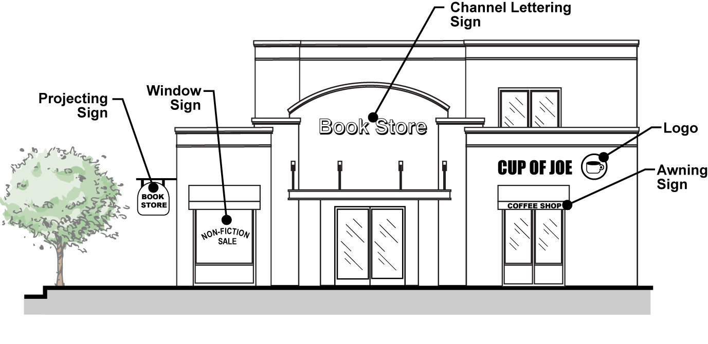
_____
50.
Off-site sign. A non-commercial sign located on private property that serves the limited purposes of either directing persons to a property or identifying political candidates or ballot measures. Examples of off-site signs include real estate signs, directional signs, and political campaign signs allowed and approved pursuant to this Chapter.
51.
On-site sign. A sign that directs attention to a business, commodity, service, entertainment, product, or activity that is conducted or offered on the same site or parcel on which the sign is located.
52.
Painted sign. A sign erected by means of painting the copy and all related material directly upon any portion of a building or other structure. This definition includes murals.
53.
Pennant. Any pennant, streamer, flag, picture, figure, or other object, regardless of the material of which it is made, that contains no commercial message, is suspended or tethered and is designed, and is intended to attract the attention of passersby.
54.
Permanent sign. A legally permitted and erected sign that is intended and authorized to remain at the location placed for more than 90 consecutive days.
55.
Pole sign. See "Freeway sign."
56.
Portable sign. A sign designed to be transported from place to place while supported or carried by one or more persons, or by a vehicle of some sort, and not affixed, anchored, or secured to the ground or a sign structure. Portable signs include signs attached to or painted on vehicles parked and visible from the public right-of-way, unless the vehicle is used in the day-to-day operations of the business. Portable signs does not include allowed A-frame and real estate signs.
57.
Projection. The distance by which a sign extends beyond the building or structure.
58.
Projecting sign. A sign other than a wall sign suspended from or supported by a building or structure and projecting out from that building or structure. See also "Hanging sign."
59.
Pylon sign. See "Freeway sign."
60.
Real estate sign. A temporary sign indicating that the premises on which the sign is located is for sale, lease, or rent, and which contains only the following information: a description of the property offered for sale, lease, rent, or future use; and the name, address and telephone number of the owner, broker, or other person offering the property for the intent indicated on the sign.
61.
Revolving sign. See "Animated sign."
62.
Roof sign. Any sign or portion thereof located on, or extending over, the roof, marquee, or canopy of a structure and either supported by the roof, marquee, or canopy or by an independent sign structure. As used in this subsection, a roof sign shall not mean any sign defined as a wall sign.
63.
Sandwich board sign. See "A-frame sign."
64.
Sign. Any device, structure, fixture, or placard displaying graphics, symbols, and/or written copy for the primary purpose of identifying, providing directions, or advertising any establishment, product, goods, or services to the public.
65.
Sign area. The measurable area of a sign face, pursuant to Section 19.42.120 (Number of Permitted Signs and Allowable Sign Area). For freestanding signs, the perimeter of the measurable sign area shall not include support and framing design embellishments exclusive of logo or written copy. Sign area for multi-faced signs shall be computed by adding together the area of all sign faces visible from any one point. See Figure 3-18.
_____
Figure 3-18. Sign Area Measurement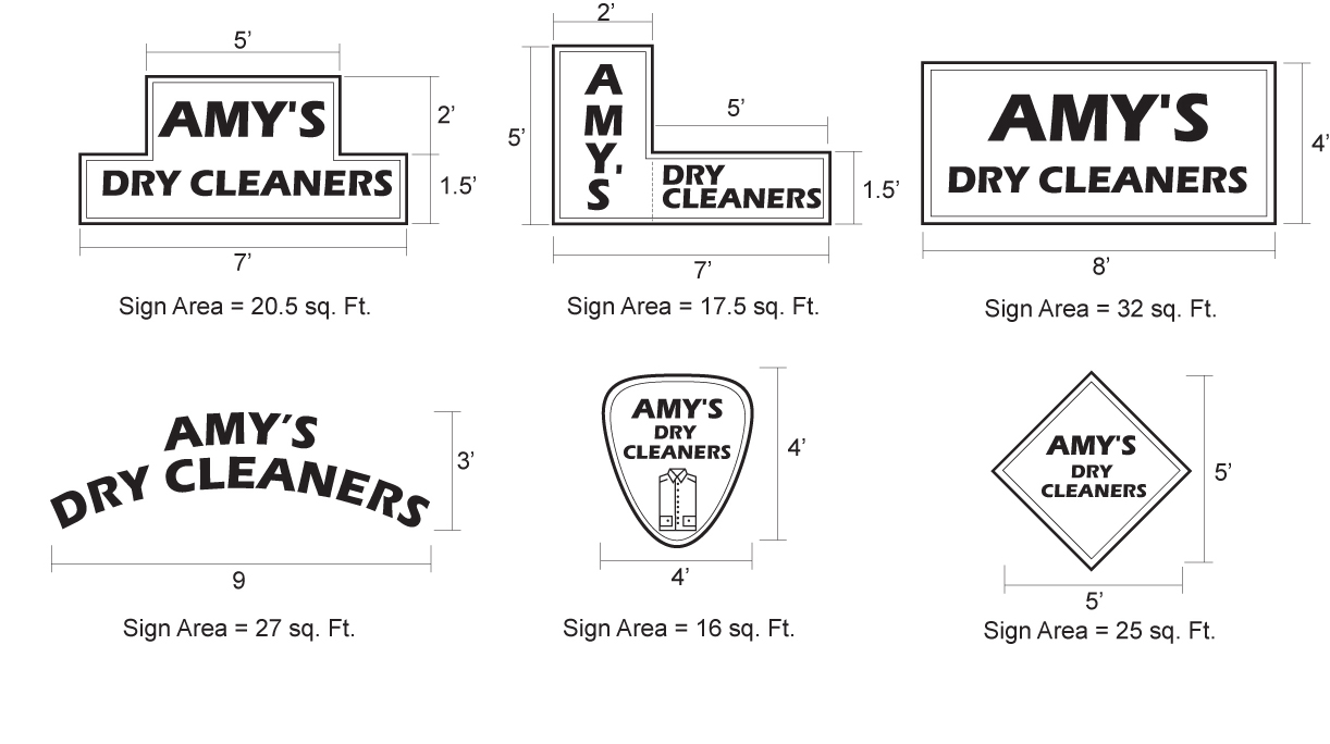
_____
66.
Special identification sign. Signs that identify a secondary tenant within a shared tenant space or a specific subordinate use within a primary tenant (e.g. a bank within a supermarket; coffee bar in a retail shop; or pharmacy in a supermarket).
67.
Structure. The supports, uprights, bracing and/or framework of a sign. The area of the structure shall not be included in computing the aggregate surface of the area of the sign which it supports.
68.
Temporary sign. Any nonpermanent sign erected, affixed, or maintained on a premises for a short, usually fixed, period of time.
69.
Tenant identification sign. A non-illuminated sign erected for the sole purpose of identifying tenants of an office building.
70.
Trim. Any molding, battens, lappings, matting strips, latticing, or platforms which may be attached to a sign structure.
71.
Wall sign. Any sign attached to, or erected against the wall, parapet, or mansard roof of a structure, with the exposed face of the sign in a line approximately parallel to the plane of the wall. This definition includes painted signs, including commercial murals, and individual letters or logos.
72.
Window sign. A sign installed or placed upon, inside, or behind a window pane or glass door with the purpose of having the sign visible from the outside of the building.
19.42.040 - Sign permit required.
A sign permit shall be required for all signs as set forth in this Chapter, including change of copy allowed under the provisions of this Chapter. All signs that require a sign permit shall be subject to approval by the responsible Approving Authority specified in Article 7 (Permit Processing Procedures). Only signs that comply with the provisions of this Chapter shall be approved.
19.42.050 - Comprehensive sign program—When required.
A.
New developments. Any new commercial, industrial, or institutional development project involving the establishment of leasable or saleable space for two or more tenants, any new single tenant development with more than 30,000 square feet of gross floor area, new development proposing a Specific Plan or Planned Development Permit, and any new development in the C-F zone shall be required to prepare a Comprehensive Sign Program pursuant to Section 19.42.190.
B.
Existing developments. For any existing commercial, industrial, or institutional development meeting the criteria of paragraph A, above, for which a comprehensive sign program was not previously required, a comprehensive sign program shall be prepared and subject to review pursuant to Section 19.42.190 whenever any remodel project or tenant improvements involving more than three tenants or 30,000 square feet is proposed, whichever is less.
19.42.060 - Application and review of sign permits.
A.
Sign permit application. An application for a sign permit shall be made on forms as prescribed by the Director and shall be filed with the Director. The application shall be accompanied by any fees or bonds as specified by Council resolution.
B.
Authority to review sign permits. Sign permit applications shall be reviewed as set forth in Chapter 19.122 (Site Plan and Design Review).
19.42.070 - Exempt signs.
The following signs are exempt from the requirements of this Chapter but are subject to compliance with all other provisions of this Code and any applicable requirements of Title 16 (Buildings and Construction) of the Duarte Municipal Code.
A.
Civic signs. City-sponsored civic signs for community entrance, identification, direction, and information, which are located on site or off premises in the public right-of-way with approval of an encroachment permit by the Public Works Department.
B.
Construction signs. One on-site construction sign, as defined in Section 19.42.030.C. On residential property, the maximum sign area is six square feet, with a maximum height of six feet. On nonresidential property, the maximum sign area is 50 square feet and the maximum height six feet. All such signs shall be non-illuminated and should set back a minimum of five feet from the public right-of-way or may be attached directly to the perimeter construction fencing within the setback. All such signs shall be removed prior to the issuance of an occupancy permit.
C.
Directional signs. The City has a compelling interest in ensuring traffic safety. To directly advance that interest, on-site directional signs which do not promote or advertise a business, property, or product shall be allowed for each one-way drive, drive aisle, and service or delivery entrance. Such signs shall be located so as not to impair vehicular or pedestrian traffic. The maximum area of each sign shall be four square feet and the maximum height four feet. Additional directional signs may be approved by the Director pursuant to the provisions of this Chapter. Also, the Director shall reserve the right to review any and all directional signs to ensure compliance with public safety objectives. When a comprehensive sign program is required, directional signs shall be included in the program.
D.
Directory signs. One or more directory signs internal to the building and/or integrated into the internal common area of a development (generally not visible from the public right-of-way). Such signs shall be limited to a maximum sign area of 24 square feet and a maximum height of six feet.
E.
Display board signs. One or more display board signs, attached to a wall near the entrance and not visible from the public right-of-way. Such signs shall be limited to a maximum sign area of six square feet.
F.
Flags. Flags representing a country, state, or other official government entity, and decorative flags with no commercial message. A maximum of three such flags shall be permitted on any one property. See Section 19.32.040 regarding maximum flag pole height.
G.
Governmental signs. Temporary or permanent signs erected and maintained by or required by the City, county, state, or federal government for traffic direction, entrance to a government or civic facility, or for designation or direction to any school, hospital, historical site, or public service, property, or facility.
H.
Government agency-required signs. Any informational sign required by any state or federal government agency for a licensed or regulated business, such as but not limited to signs identifying hazardous materials on a property, smog check only signs, and signs identifying sites for collection of recyclable materials.
I.
Garage/yard sale signs. One on-site garage/yard sale sign with a maximum sign area of six square feet and a maximum height of four feet. Such signs may only be displayed during the time of the sale and only in conjunction with an approved Garage Sale Permit.
J.
Holiday decorations. Holiday decorations that do not contain any commercial message. Such signs shall be removed within seven days following the holiday or event.
K.
Street address numbers. Street numbers identifying the address of a residence or building, with a maximum sign area of four square feet, including those painted on curbs in compliance with City codes or other regulations.
L.
Incidental signs. Signs that do not contain any commercial message, as described in Section 19.42.030 (Definitions).
M.
Interior signs. As defined in Section 19.42.030 (Definitions).
N.
Memorial wall signs. Such signs shall be limited to a maximum sign area of four square feet each. Signs shall be non-illuminated or externally illuminated. Noncommercial murals of a commemorative or historic recognition nature may exceed the four-square-foot limitation.
O.
Political campaign signs. Campaign signs pertaining to an election to any public office or ballot measure may be erected not earlier than 60 days prior to the election and shall be removed within 10 days following the same election. Political campaign signs shall not be erected within the public right-of-way or on any public property.
P.
Real estate signs. Real estate signs for sale or lease of property on private property, as set forth here. All such signs shall be set back a minimum of five feet from the public right-of-way and located in a manner that does not to impede or impair the view of a motorist from the right-of-way or other travel lanes. Signs shall be non-illuminated nor externally illuminated.
1.
For residential property, one on-site sign is allowed with a maximum sign area of six square feet. A maximum of three attached incidental signs are permitted on each real estate sign identifying the agent, special feature, and/or sales status.
2.
On weekends and holidays, open house signs for residential properties are allowed as needed to direct traffic from major collector and arterial streets to the subject property. One sign may be placed for each change in direction, to a maximum of five signs, each with a maximum sign area of six square feet. No such sign shall be located within any public right-of-way or on any public property.
3.
For nonresidential property, one on-site sign is allowed per street frontage, each with a maximum sign area of nine square feet and a maximum height of six feet.
Q.
Repair and maintenance of existing permitted signs. Sign repair and maintenance which does not alter the type, size, or location of any sign.
R.
Residential nameplates. One nameplate identifying the occupants of a dwelling unit, with a maximum sign area of two square feet.
S.
Tenant identification sign. One sign identifying the tenants of an office building, to be used for informational, non-commercial communication purposes only.
19.42.080 - Prohibited signs.
The following signs are prohibited:
A.
Abandoned signs.
B.
All non-exempt signs without necessary and/or valid permits/approvals.
C.
Animated signs, except authorized electronic reader message boards associated with civic, institutional, and not-for-profit uses and uses within the C-F zone, as provided for in this Chapter.
D.
Any sign established at a location or in any manner which impedes the vision or view of motorists, pedestrians, or cyclists.
E.
Banners, pennants, and balloon signs, except as a temporary sign as provided for in Section 19.42.100 or in association with a permitted A-frame sign as provided in this Chapter.
F.
Can or cabinet signs.
G.
Moving and flashing signs, including any hand-held commercial message sign, whether located on the site or off the site of the business which the sign advertises, except as expressly permitted by this Chapter or in conjunction with authorized road repair.
H.
Off-site identification signs, except government, civic, and real estate signs as provided in this Chapter.
I.
Pole and pylon signs, except as a permitted Freeway Sign within the Commercial-Freeway zone, as provided in this Chapter.
J.
Portable signs, including any hand-held temporary signs.
K.
Roof signs, except as permitted in the H zone per Table 3-18 (Signs in the C-P and H Zones).
L.
Signs within or projecting over any public right-of-way, with the exception of governmental or City-sponsored civic signs or signs with an approved encroachment permit.
M.
Signs which purport to be or are an imitation of or resemble official traffic warning devices or signs, that by color, location, or lighting may confuse or disorient vehicular or pedestrian traffic, excluding authorized on-site directional sites.
N.
Painted signs except non-commercial murals, as provided in this Chapter.
O.
Raceway-mounted signs.
P.
Signs with exposed neon tubing or neon tubing enclosed in a sign cabinet with a clear Plexiglas sign face. However, such signs may be considered subject to ARB review pursuant to Chapter 19.122 (Site Plan and Design Review).
Q.
Signs affixed to trees and/or other natural vegetation.
R.
Vehicle or mobile signs, signs, where the primary purpose or use of the vehicle or trailer is the display of advertising matter. This does not apply to signs maintained on vehicles when such advertising is incidental to the primary purpose for which the vehicle is being used, provided that the vehicle is not purposely parked in an obvious manner solely for the purposes of advertising.
S.
Vinyl letter signs.
19.42.090 - Temporary signs.
A.
General. Temporary signs shall only be permitted as set forth in this Section, and as allowed for specific purposes in residential zones, as set forth below.
B.
Temporary sign permit required. Temporary signs advertising a business grand opening or a special product, sale, event, or future tenant may be permitted on the site of the business or place of assembly to which the message pertains. Temporary directional signs for new residential developments are permitted as set forth in paragraph F. All such temporary signs shall require approval of a Temporary Sign Permit in compliance with the provisions of this Section.
C.
Temporary sign for special event.
1.
Each business or organization shall be permitted only one temporary sign at any point in time, with a maximum sign area of one square foot per linear foot of primary building frontage up to a maximum of 40 square feet per temporary sign (exclusive of allowed accessory embellishments).
2.
A temporary sign shall not be attached to any non-structure wall or fence, nor shall any temporary sign extend above the roofline of the structure on which it is located. Temporary signs which extend above a private vehicular or pedestrian right-of-way shall have a minimum clearance of 17 feet between the surface grade and the bottom of the sign.
3.
No temporary sign shall extend over or onto any street, alley, sidewalk, or other public right-of-way. No temporary sign shall be erected so as to prevent free ingress to or egress from any door, window, or fire escape, nor shall any temporary sign be attached to any standpipe or fire escape. The City shall have the right to remove, confiscate, destroy, or return to the owner the sign upon payment of any charges of removal for any sign located within the public right-of-way in violation of the terms of this Chapter.
4.
The advertisement contained on a temporary sign shall pertain only to the business, industry, or pursuit conducted on or within the premises on which such sign is erected or maintained.
5.
Each business shall be allowed a maximum of 105 days of temporary signage per calendar year. Except for temporary signs for a grand opening, no single temporary advertising period shall be longer than 30 consecutive days.
6.
Pennants, flags, and streamers may be displayed simultaneously with banners. However, pennants, balloons, etc. may be permitted in certain cases, subject to approval of the Director, and subject to the issuance of a Temporary Sign Permit. However, in no case shall such pennants, balloons, streamers, etc. be permitted on a property for more than 10 days at a time or for more than 20 days per year. Balloons permitted under these circumstances shall be no greater eight cubic feet in volume and shall be held to the same size/location limits as temporary signs.
D.
Temporary signs used for tenant identification. Temporary signs used to identify an imminent future tenant (e.g., Opening in October or Coming Soon) or a tenant for which a permanent sign has not yet been installed may be permitted in addition to a temporary sign as permitted in paragraph C, above. Such temporary tenant identification sign may be permitted for a total period of up to 90 consecutive days, but not more than 45 days prior to the opening date. Such sign shall be removed immediately upon installation of the permanent sign.
E.
Allowed materials. All temporary signs, including any embellishments such as pennants, flags, or balloons, must be approved by the Building Official as conforming to the safety requirements of the City's Building and Fire Codes. Any banner used as a temporary sign shall be made of cloth, vinyl, canvas, or similar non-paper materials. Temporary signs shall not be illuminated.
F.
Temporary new development directional signs.
1.
Temporary signs established for the purpose of directing persons to new residential, commercial, industrial, or office developments shall be subject to all requirements of this Section, except that such signs may be placed off site, and up to four such signs, each with a maximum size of six square feet may be permitted.
2.
The Director may require that a master sign program for such temporary signs be approved.
3.
Such signs shall require the permission of the property owner on whose property the sign is to be installed. The City may require that written authorization be provided.
G.
Temporary window signs.
1.
Temporary window signs shall cover no more than 25 percent of the window area in which they are located.
2.
No temporary window sign shall extend above a height of six feet measured from the ground surface on the exterior side of the window in which such window sign is located. This is to allow public safety personnel to have unobstructed views into a place of business.
3.
No individual temporary window sign may remain posted for a period longer than 30 days. Temporary window signs shall be stamped with the date posted and removed at least 30 days from that date.
19.42.100 - Standards for permanent signs requiring a sign permit.
A.
A-frame signs. A-Frame signs shall be permitted only in the commercial zones, any mixed-use development with a commercial component, and the H zone. The following standards shall apply to all A-frame signs.
1.
Dimensions. Signs shall be no greater than 12 square feet per side and limited to two sign faces per sign. Further, no A-frame sign may exceed three feet in width or four feet six inches in height.
2.
Number of signs. A maximum of one A-frame sign shall be permitted per each ground-floor business.
3.
Hours of sign display. Signs shall be displayed only during the posted hours for which the business is open, and shall be stored away from public view when the business is not open.
4.
Sign placement. A-Frame signs shall be located only on site, at grade, and adjacent to the business being advertised. For stand-alone single businesses, the sign shall be placed on the business property being advertised or adjacent to the business property's frontage. For businesses located in a commercial/office complex with multiple tenants and/or buildings, or in a business park, the sign may be placed within or at the perimeter of the complex or business park (when not placed on a private driveway). No A-frame sign shall be placed in a location that results in damage or modification to required landscaping. Where an A-frame sign is placed within a private walkway, the sign shall be placed within 10 feet of the front door of the business advertised and shall be placed or sized in such a manner that a minimum of 36 inches of pedestrian clearance remains.
5.
Prohibited on public sidewalk. A-Frame signs shall not be located within any public right-of-way; within any raised or painted median; across any street from the business being advertised; in parking aisles or stalls; in any driving lane or loading area; on any fence or wall; atop any other sign; on any vehicle; on any utility facility; or on any structure.
6.
Public safety considerations. No A-Frame sign shall be located at any place that causes a hazard to pedestrian traffic or vehicular traffic, and shall be located a minimum distance of 30 feet from an access drive or street intersection. The sign must meet ADA standards for pedestrian accommodation.
7.
Text/copy coverage. The maximum text/lettering area shall be limited to 50 percent coverage of the sign, and no more than 33 percent of the sign face shall be contain a visual or non-word design.
8.
Changeable message area. No more than 50 percent of each sign face may be reserved for changeable messages. The material for changeable messages may be chalk board or dry erase board, but may not be vinyl lettering. Handbills or similar paper attachments shall not be affixed to permitted A-frame signs. However, pennants shall be allowed.
9.
Pennants. The attachment of pennants directly to an A-frame sign is allowed when affixed and secured in a manner that does not increase the horizontal width of the sign nor exceed a maximum height from the ground of six feet. The requirements of this subsection for pedestrian and vehicular safety, access, and visibility shall apply. Handbill or similar paper attachments shall not be affixed to a permitted A-frame sign.
10.
Construction and materials. The finish of the A-frame sign shall be 100% painted in a color consistent with the associated business establishment, and shall be maintained in a professional manner free from chipping paint, cracks, gouges, loss of letters, etc. Materials used in the construction of A-frame signs must be durable, weather-resistant, exterior-quality wood or metal; non-exterior-quality plastic is not allowed, except for any materials for the changeable message portion. Changeable sign area must be screwed or bolted to the sign. A-frames signs shall be of sufficient weight and durability to withstand wind gusts, storms, etc. so as to avoid safety hazards to pedestrians and vehicles.
11.
Prohibited elements. The following shall be prohibited on A-frame signs: any form of illumination, including flashing, blinking, or rotating lights; animation; reflective materials; attachments, and materials creating excessive glare.
B.
Freeway signs.
1.
Freeway signs are allowed only in the C-F zone in conjunction with an approved development.
2.
Freeway signs shall be placed only at a location on a site that maximizes visual observation of the sign from the Interstate 210 freeway in Duarte.
3.
Freeway signs shall be designed in a manner that is architecturally compatible with structures located on the same site.
4.
For vehicle sales uses only, up to 50 percent of the sign area may consist of a programmable electronic message display element that displays messages only pertaining to the use on the site or non-commercial messages. Such electronic message displays shall be installed and operated in a manner that does not adversely affect driver safety. To achieve this standard, the Director may impose conditions on the operations of the electronic message display regulating such characteristics as, but not limited to, a limit on the number of lines of information, the frequency of message changes, and sign luminance.
C.
Hanging signs. Hanging signs shall provide a minimum eight foot clearance between the bottommost portion of the sign and the immediately adjacent finished ground surface.
D.
Projecting signs. Projecting signs may be permitted as part of a sign program for shopping centers or when approved by ARB for single users. The maximum size of a projecting sign shall be six square feet. The minimum clearance between the bottom of the sign and ground shall be eight feet.
E.
Monument signs. Monument signs may be located within landscaped areas, provided the Director determines that safe sight-distance is maintained. Except as provided for below, no changeable copy may be incorporated into a monument sign. Monument signs, including aspects of materials, color, style and placement, shall be designed to be compatible with the architectural style of the corresponding development.
F.
Special identification signs (secondary signs). Secondary signs, as defined in Section 19.42.030 (under "Special identification sign") may be allowed. For tenant spaces 10,000 square feet and greater, a maximum of two signs for each primary use, not to exceed 8 square feet and having maximum letter height of 12 inches.
G.
Wall signs.
1.
A wall sign may be placed on any wall, parapet, or mansard roof that faces a street, parking lot, or other interior structure.
2.
A wall sign shall not extend above the roofline.
3.
Wall signs shall not project more than 18 inches from the structure wall, and the sign length shall not exceed 75 percent of the structure frontage on which it is located.
4.
In addition to the standards in subsections 1—4 above, wall signs shall meet the definition of "wall sign" as provided in Section 19.42.030 and shall be located in accordance with the primary and/or secondary wall frontage as defined for "building frontage", also provided in Section 19.42.030.
H.
Window signs—Permanent. Permanent window signs shall be used for tenant or building identification purposes only.
19.42.110 - Number of permitted signs and allowable sign area.
A.
Number of signs permitted. Tables 3-15 through 3-19 indicate the number of permitted signs by sign type in each zone.
B.
Allowable sign area calculation.
1.
The allowable sign area is determined by either the maximum sign area allowed for a single or the as a ratio of the length of the primary building frontage for a particular use. Allowances for attached and freestanding sign areas are listed separately in Tables 3-15 to 3-19.
2.
Except where noted, the maximum allowable square footage for a single face sign or combination of allowable sign areas shall be calculated by the formula of one square foot of sign area per one lineal foot of primary building frontage.
C.
Measurement of sign height. Sign height shall be measured from the final finished graded surface level on which the sign is placed to the topmost element of the sign, except as otherwise may be provided for freeway signs in the C-F zone on monument signs incorporated into the landscape plan, as approved by the Director.
19.42.120 - Signs in residential zones.
A.
General. Table 3-15 summarizes the standards for allowed signs in residential zones.
B.
Additional conditions.
1.
Lighting shall not reflect on adjoining premises.
2.
Monument sign must be located within a landscape planter.
3.
Identification sign may include a removable vacancy for advertising sign of six square feet indicating units for rent.
19.42.130 - Signs in C-G zone.
A.
Standards. Table 3-16 identifies the development standards for signs in the C-G zone. These standards shall apply unless alternative standards have been adopted through an approved specific plan.
B.
Minimum frontage requirement for monument signs. A minimum street frontage of 100 feet shall be required for any site with a monument sign.
19.42.140 - Signs in the C-F zone.
A.
Standards. Table 3-17 identifies the development standards for signs in the C-F zone. These standards recognize the unique circumstances associated with businesses located within a freeway corridor relative to higher vehicle travel speeds and the regional draw generally associated with business having high freeway visibility, and thus the importance of having signage that can effectively communicate to freeway travelers. The following standards apply to developments within the C-F zone unless alternative standards have been adopted through an approved specific plan.
B.
Applicability relative to minimum lot size. These regulations shall apply only to parcels or development sites consisting of one or more acres. For lots that are less than one acre in size, the sign regulations for the C-G zone shall apply.
C.
Location. Freeway-oriented signs shall be located not less than 10 feet from the edge of the freeway right-of-way or more than 500 feet from the nearest point on the freeway centerline.
19.42.150 - Signs in C-P and H zones.
A.
Standards. Table 3-18 identifies the development standards for signs in the C-P and H zones. These standards shall apply unless alternative standards have been adopted through an approved specific plan.
B.
Special requirements for monument signs.
1.
A minimum street frontage of 50 feet shall be required for any site with a monument sign.
2.
A monument sign is allowed for single user or center identification only.
19.42.160 - Signs in M zone.
A.
Standards. Table 3-19 identifies the development standards for signs in the M zone. These standards shall apply unless alternative standards have been adopted through an approved specific plan.
B.
Special requirements for monument signs.
1.
A minimum street frontage of 50 feet shall be required for any site with a monument sign.
2.
A monument sign is allowed for single user or center identification only.
_____
19.42.170 - High-rise building identification signage.
A.
Applicability. In addition to the sign standards established for the C-F, C-P, and H zones, or as provided through a Specific Plan, Planned Development Permit, or comprehensive sign program, additional signage may be allowed for buildings higher than 50 feet in these zones, subject to the provisions of this Section and subject to ARB approval of such signage as part of a comprehensive sign program.
B.
Limitations on high-rise building signs.
1.
When and where used, high-rise building signs shall advertise the business name, registered logo, or building identification of primary tenant only.
2.
The use of a high-rise building identification sign shall reduce the maximum wall, mansard, or parapet sign by one-third of the allowable sign area
3.
For buildings that are part of a unified development, high-rise building signage can be applied to only one building per that development or as approved by the ARB.
C.
Location.
1.
A maximum of one sign is allowed per wall face. No building shall be determined to have more than four building walls.
2.
Any such high-rise building sign shall be placed above the uppermost row of windows, but not within two feet of the top of a parapet wall or bottom of a roof.
3.
The horizontal sign length shall not exceed 40 percent of horizontal building wall length and be no closer than five feet from vertical building edge.
D.
Sign area and composition.
1.
The maximum combined sign area allowed for high-rise building identification sign(s) shall not exceed 1.5 percent of the total aggregate building wall area. Building wall area excludes roof area, penthouses, and other structures above the parapet wall or building roof. Building wall area does not calculate horizontal walls or walls perpendicular to the primary building façade.
2.
Each building wall is considered separately for calculating the permitted sign area, as measured on the side of the building on which the sign is located.
3.
Sign and logo copy height shall not exceed a height of one foot for every 10 feet of building height, and shall not exceed 12 feet in height.
4.
Sign copy may contain up to two lines of text, subject to ARB approval. However, ARB cannot regulate content of sign copy.
5.
Logos under registered trademark are allowed, but may not exceed 25 percent of each permitted sign area.
E.
Construction requirements.
1.
If illuminated, the sign shall be internally illuminated.
2.
Sign text shall use channel letter or similar construction.
3.
Logos must use varying sign layers, such as push-through letters or flat cutout dimensional shapes.
4.
The sign shall project no more than 24 inches from a building wall.
5.
Signs shall not move, flash, contain changeable copy, or be audible.
6.
Exposed raceways, junction boxes, lamps, tubing or neon crossovers are not permitted.
19.42.180 - Architectural and design sign standards.
A.
Purpose and applicability. These design standards for signs are established to promote the establishment of signage that exhibits high design quality consistent with City objectives for overall community aesthetics. These standards apply to all signage for which a permit is required and to certain exempt signs specified in this Section.
B.
Sign design and materials.
1.
Signage shall be designed to complement the overall architectural style of the development with which it is associated, and shall be designed to be an integral part of the development.
2.
A single development with two or more tenants shall have a unifying sign theme that will be reviewed through a required Comprehensive Sign Program pursuant to Section 19.42.190 (Comprehensive Sign Program). Such signage shall included consistency with regard to:
a.
Type of construction materials.
b.
Sign supports.
c.
Shape of sign and related components.
d.
Letter size.
3.
Sign panels must be opaque, with lettering, logos, and any other sign face material consisting of routed-out characters.
4.
Logos shall use varying sign layers, such as push-through letters or flat cut-out dimensional shapes.
5.
Exposed raceways, junction boxes, lamps, tubing, or neon crossovers shall not be used.
6.
Signs that reflect the type of business through design, shape, or graphic form are encouraged.
7.
Flush-mounted signs should be positioned within the architectural features and should align with other signs on the building to reflect a consistent pattern.
C.
Design for exempt signs. Directional and directory signs shall be designed to complement the development in terms of color, sign design, use of fonts and logos, and materials.
19.42.190 - Comprehensive sign program.
A.
Purpose. The purpose of a Comprehensive Sign Program is to integrate all signs associated with a development, including a project identification sign, with overall site design and the design of structures into a unified architectural statement. A Comprehensive Sign Program provides a means for the flexible application of sign regulations for projects that require multiple signs in order to provide incentive and latitude in the design and display of multiple signs and to achieve, not circumvent, the purpose of this Chapter. It also provides the means to maintain consistent application of sign standards and sign appearance throughout a project.
B.
When required. A Comprehensive Sign Program shall be required as set forth in Section 19.42.050, above.
C.
Applicability to theaters. A Comprehensive Sign Program for a theater or cinema use may authorize signs that deviate from the standards of this Chapter. The Comprehensive Sign Program may allow marquee signs, brighter lights, and design features not otherwise authorized by this Chapter if the sign is generally consistent with the adopted sign design guidelines and the purposes of this chapter.
D.
Review authority. The ARB is the review authority for a Comprehensive Sign Program. The Director may approve revisions to a Comprehensive Sign Program if the intent of the original approval is not affected. Revisions that would substantially deviate from the original approval shall require the approval of a new/revised Comprehensive Sign Program by the ARB.
E.
Filing requirements. A Sign Permit application for a Comprehensive Sign Program shall include all information and materials required by the Director and the filing fee established by resolution of the Council.
F.
Standards of comprehensive sign program. A Comprehensive Sign Program shall comply with the following standards:
1.
The proposed sign program shall comply with the purpose and intent of this Chapter, any adopted sign design guidelines, and the overall purpose and intent of this Section.
2.
The proposed signs shall enhance the overall development, be in harmony with and relate visually to other signs included in the Comprehensive Sign Program, to the structures and/or developments they identify, and to surrounding development when applicable.
3.
The sign program shall address all signs, including permanent, temporary, and exempt signs.
4.
The sign program shall accommodate future revisions that may be required because of changes in use or tenants.
5.
The program shall comply with the standards of this Chapter, except that deviations are allowed with regard to sign area, total number, location, and/or height of signs to the extent that the Comprehensive Sign Program will enhance the overall development and will more fully accomplish the purposes and intent of this Chapter.
6.
Approval of a Comprehensive Sign Program shall not authorize the use of signs prohibited by this Chapter.
7.
Energy-efficient lighting, use of systems to monitor and limit signage lighting at night, and other monitoring of nuisance lighting shall be integrated into the sign program.
G.
Limitations. A Comprehensive Sign Program shall not be used to override the prohibition on new billboards set forth in Section 19.42.270, below.
19.42.200 - Sign construction and maintenance.
A.
Structural and electrical requirements. All signs shall comply with the appropriate detailed provisions of the State Building Code, as adopted by the City, relative to design and construction, structural integrity, connections and safety. Signs shall also comply with the provisions of the applicable electrical code and the additional construction standards set forth in this chapter.
B.
Sign maintenance. All signs shall be maintained in good, operable condition, including maintenance of colors and materials, replacement of defective parts, painted, cleaned, and kept free of graffiti. Any portions of a sign in need or repair shall be identified in writing by the Code Enforcement Officer, along with required action in accordance with enforcement procedures of Chapter 19.154 (Enforcement Provisions).
19.42.210 - Removal of unlawful, unsafe, and unauthorized signs on public property.
A.
Any sign, advertising device, or handbill found posted, installed, located, or otherwise affixed on any public property contrary to the provisions of this chapter may be removed by the City or its authorized agents. The person responsible for any such illegal posting shall be warned and/or held responsible for the costs incurred in the removal thereof, and the Director is authorized to effect the collection of said costs.
B.
If a sign is damaged or not properly maintained to a degree that causes it to pose a physical danger to persons or property, the following provisions shall apply:
C.
A hazardous sign is a sign that poses a danger to the public or that could create a potential hazard. Hazardous signs are declared to be a public nuisance in compliance with Municipal Code Section 9.32.010 (Maintenance of Property-Nuisances).
D.
Upon discovering a hazardous condition, the City may cause the immediate removal of a sign that is a danger to the public due to unsafe conditions. The determination that a sign has become hazardous or unsafe shall consider only the physical condition and characteristics of the sign, and shall not consider the message thereon. No hearing shall be required for removal of hazardous signs. The City is not required to give notice of intent to remove the sign prior to removal, but shall inform the owner that the hazardous sign has been removed within seven days of removal through the United States Postal Service by Certified Letter with a return receipt requested.
19.42.220 - Signs on city-owned property.
No sign shall be permitted on City-owned property unless erected by the City and/or approved by the City Manager.
19.42.230 - Signs utilizing non-roman alphabet.
A.
To facilitate emergency response by public safety personnel, every sign in connection with any business which utilizes any non-Roman alphabet letters, characters, and/or symbols shall also contain on the sign a general description of the business written in English. The English language portion of the sign shall be readable from the public right-of-way.
B.
In all cases where a sign or other zoning permit is required by this Title or other law, the applicant shall submit to the City a certification, issued under penalty of perjury under the laws of the state of California, containing an English language translation of all non-Roman alphabet letters, characters, and symbols proposed to be displayed on the sign. An application for such permit shall not be deemed complete until the applicant has provided such certification.
19.42.240 - Nonconforming signs.
A.
Any on-site sign becoming nonconforming as a result of this Chapter shall not be required to be removed, except as provided in the California Business and Professions Code sections 5492, 5493, 5495, and 5497.
B.
Any off-site sign or billboard becoming nonconforming as a result of this Chapter shall not be required to be removed, except as provided in the California Business and Professions Code sections 5412, 5412.1, 5412.2 and 5412.3.
C.
Any nonconforming pole sign that is not used continuously for any 90-day period shall be considered abandoned and shall lose its nonconforming status; such signs shall be subject to immediate abatement.
19.42.250 - Revocations.
A.
Unsafe signs. If the Director finds that any sign or other advertising structure regulated herein is unsafe or insecure, or is a menace to the public, or has been constructed or erected or is being maintained in violation of the provisions of this chapter, or any sign which has remained for a period of one hundred eighty days after the termination of the business for which it was originally intended, he shall give written notice to the permittee, business owner and/or property owner, as appropriate, thereof of the violation.
B.
Cost recovery. If the recipient of such notice fails to remove or alter the structure so as to comply with the standards herein set forth within ten days after such notice, the Director is authorized to revoke any existing permit and cause removal of such sign, and any expense incident thereto, including a reasonable charge for administrative expenses, shall be paid by the owner of the premises or structure to which the sign is attached.
C.
Immediate removal. The Building Official may cause any sign or other advertising structure which is an immediate peril to persons or property to be removed summarily and without notice.
19.42.260 - Illumination of signs.
Unless otherwise specified, signs may be non-illuminated, or may be internally illuminated. External illumination may be permitted only with the specific authorization of the Director. If illuminated, the illumination shall be fixed, steady, and directed or controlled in a manner to prevent glare on streets, walkways, and residential property.
19.42.270 - Billboards.
Billboards are prohibited in the City of Duarte.
19.44.010 - Residential architectural and design standards.
A.
Purpose. Site design and architectural standards are established consistent with General Plan policy to promote quality design of new residential structures and additions. The City recognizes that quality design promotes longer life of structures, improves the appearance and maintenance of neighborhoods, and increases value in the housing stock citywide.
B.
Applicability. The site design and architectural standards set forth in this Chapter shall apply to all new residential structures, additions to residential structures, and accessory structures (including garages). In addition, the City of Duarte Architectural Design Guidelines, and any such similar guidelines or policies that are adopted from time to time, shall be applied to the design, review, and implementation of all new residential structures and additions to residential structures.
C.
All residential zones.
1.
Architecture.
a.
For any new structure or addition, all façades visible from a public right-of-way shall incorporate features that eliminate blank, unarticulated walls; add visual interest; avoid clutter; and display a distinctive architectural style. Varied modulation for exterior façade surfaces is encouraged.
b.
Additions to residential structures and new accessory structures shall be designed and constructed to match the architectural style and building form of the structure to which they are added, including similar or complementary bulk, color, roof design, and other key architectural features.
c.
Rooflines and roofing materials shall be compatible with the architectural style of the residential structure. Use of varying, uncoordinated rooflines and roofing materials shall be avoided.
d.
Window and door design and placement shall be consistent with the overall architectural style of the structure and consistent with all windows/doors visible from the public right-of-way.
e.
Materials and finishes shall be of a consistent theme, shall match the style of the residential structure, and shall be consistently applied to all façades.
f.
Roof-mounted equipment, where permitted, shall be screened from view from public rights-of-way and adjacent properties by materials that are architecturally compatible with the structure they serve.
g.
Accessory structures and additions to residential structures shall be designed and constructed to match the architectural style and building form of the structure or structures to which they are added.
2.
Equipment screening.
a.
Mechanical equipment on the ground or on the roof should be screened from view from adjacent properties and the public right-of-way by an enclosure designed as part of the building or by appropriate landscaping (see Figure 3-19).
_____
Figure 3-19. Equipment Screening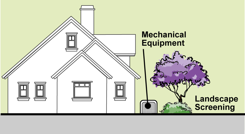
_____
b.
Water heaters, electrical boxes, gas meters, landscape irrigation equipment, and similar utility boxes should be painted to match the structure or be appropriately screened from view, or should be integrated into the floor plan of the structure.
c.
Where feasible, appurtenant equipment, plumbing, and related solar energy fixtures shall be installed in the attic, or if infeasible, flush mounted or ground mounted. Appurtenant equipment, plumbing, and related solar energy fixtures shall comply with the setback requirements of Section 19.32.020 (Permitted Projections into Required Setback Areas) and shall be screened from public view.
3.
Landscaping. Landscaping shall be provided consistent with the requirements of Chapter 19.40 (Landscaping).
4.
Scale and massing. A combination of second- and upper-story balconies, decks, window fenestrations, and similar features shall be used on front and street side façades to provide articulation and further reduce massing effects, and shall also be compatible with the overall architectural and mass/scale balance of the original structure, as well as the character of mass/scale in the immediate neighborhood.
5.
Site design and structure orientation.
a.
Front entries shall be clearly identifiable and generally oriented toward the street.
b.
Driveways shall be placed in a manner that avoids conflict with pedestrian access from the sidewalk and shall be of sufficient depth/width to reduce undue on-street curbside guest parking. See development standards for driveways in Section 19.38.100 (Parking Space and Drive Aisle Dimensions) and Section 19.38.180 (Design Standards for Parking Lots).
D.
Single-family and two-family structures.
1.
Architecture.
a.
Design of structures should be consistent with local and regional architectural styles.
b.
Exterior materials and finishes shall be appropriate to the architectural style of the structure.
c.
The overall style of single-family and two-family structures should be consistent on all sides of the building as well as among all portions of the roof. Particular attention should be taken that building elevations and roof elements visible from streets and other public or quasi-public spaces are stylistically consistent.
2.
Scale and mass.
a.
The bulk and mass of new single-family residential structures or additions should be compatible to the scale of existing structures in the immediate neighborhood.
b.
Garages shall be designed or located in a manner that minimizes the prominence of the garage within the front façade.
E.
Multi-family structures.
1.
Architecture.
a.
Design of structures should be consistent with local and regional architectural styles.
b.
The overall style of multi-family structures should be consistent on all sides of the building as well as among all portions of the roof. Particular attention should be taken that building elevations and roof elements visible from streets and other public or quasi-public spaces are stylistically consistent.
c.
Balconies, where provided, shall utilize railing or similar materials that are compatible with the overall architectural style of the development. Balconies shall be functional and built to the minimum dimensions set forth in Section 19.10.060.
2.
Service facilities and equipment screening.
a.
Architectural screening of trash and storage enclosures shall be constructed of materials and finishes compatible with the adjacent building, and shall be designed and placed to complement the style of development (see Figure 3-20).
b.
Accessory structures such as community rooms, pool houses, gazebos, maintenance equipment sheds should include architectural design that complements primary structures. See development standards for accessory structures in Chapter 19.34 (Accessory Structures).
c.
Storage areas shall be completely screened from ground level view using appropriate materials and shall be designed for maximum security. See development standards for storage areas in Section 19.10.060 (R-3 and R-4 Zones: Additional Standards).
d.
The storage areas shall be accessible to residents at all times. Storage areas within multi-family residential developments shall be conveniently located to the dwellings that they are intended to serve.
e.
Recyclable materials and green waste storage areas shall be conveniently located adjacent to solid waste disposal areas, or near one another, or combined. They may only be located inside a specially designated structure, on the outside of a structure in an approved fence or wall enclosure, a designated interior court or yard area with appropriate access, or in rear or interior side yards. Exterior storage areas shall not be located in a required front yard, street side yard, parking space, landscaped area, or open space areas.
f.
Driveways or aisles shall provide unobstructed access for collection vehicles and personnel with at least the minimum clearance required by the collection methods and vehicles utilized by the designated collector.
Figure 3-20. Trash and
Storage Enclosures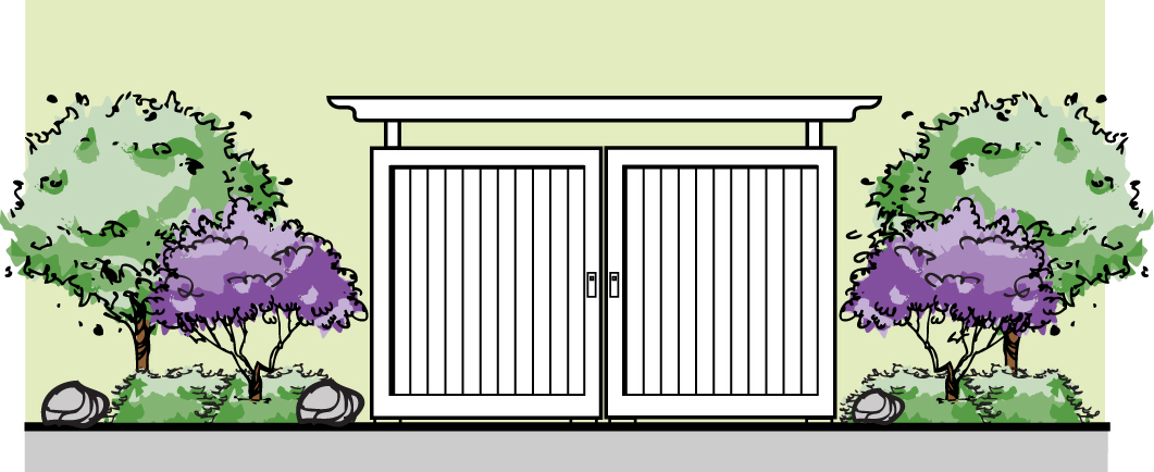
3.
Circulation and access.
a.
Common parking areas shall be located on the site to minimize their visibility from public rights-of-way and to be easily accessible to all residents of the development. See parking design standards in Chapter 19.38 (Off-Street Parking Regulations and Design).
b.
Interior pedestrian paths shall be provided to individual units and to link units to common open space areas and parking areas. See multi-family open space standards in Section 19.10.060 (R-3 and R-4 Zones: Additional Standards).
c.
Pedestrian and vehicular entrances shall be clearly identified and easily accessible to minimize pedestrian/vehicle conflict.
d.
The parking area shall be designed in a manner which links it to the building and street sidewalk system, as an extension of the pedestrian environment. This can be accomplished by using design features such as walkways with enhanced paving, trellis structures and/or landscaping treatment.
e.
Carports shall be architecturally compatible with the style of development.
f.
Non-motorized transportation shall be accommodated by providing bicycle storage, seating areas, and transit stop, if required. Vehicular traffic shall be adequately separated from bicycle and pedestrian circulation. See bicycle standards in Section 19.38.220 (Bicycle Parking Requirements).
4.
Landscaping.
a.
Landscaping shall be provided consistent with the requirements of Chapter 19.40 (Landscaping).
b.
Parking shall be screened from streets through combined use of berming, walls, and landscaping (see Figure 3-21).
_____
Figure 3-21. Parking Screening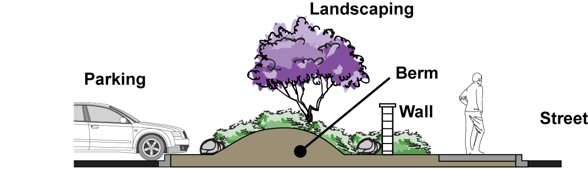
c.
Common open space areas shall be landscaped appropriate to their function. See common open space standards in Section 19.10.060 (R-3 and R-4 Zones: Additional Standards).
5.
Scale and mass.
a.
The bulk and mass of new multi-family structures and additions shall be sensitive to the scale of buildings in the immediate neighborhood.
b.
Clustering of residential units is encouraged to promote a sense of community within residential developments.
c.
Multi-family residential structures must incorporate architectural design details and elements which provide visual character and interest, avoiding flat planar walls and box-like appearances through the use of courtyards, balconies, offset planes and levels, deeply recessed or projecting windows, sloping roofs, and landscaped yards.
6.
Site design and structure orientation.
a.
See multi-family development standards in Section 19.10.030 (Development Standards).
b.
The main entry to the multi-family development shall be clearly delineated and identifiable, and shall be easily accessible for pedestrians from the public street.
c.
Entrances to individual residential units shall be accessible from the street or from common open space areas within the development.
d.
Windows, balconies, and similar openings shall be oriented to preserve privacy of individual units within the development.
e.
Loading and refuse/recycling collection areas shall be located so as to provide easy access to collection vehicles and to minimize noise impacts on residents. See multi-family trash and recycling facilities standards in Section 19.10.060 (R-3 and R-4 Zones: Additional Standards) and parking lot requirements in Section 19.38.050 (Off-Street Parking Space Requirements).
19.44.020 - Nonresidential site design and architectural standards.
A.
Purpose. Site design and architectural standards are established consistent with General Plan policy to promote quality design of new commercial, industrial, and hospital structures and additions. The City recognizes that quality design promotes longer life of structures, improves the appearance and maintenance of business districts, and increases value of properties citywide.
B.
Applicability. The following site design and architectural standards shall apply to all new commercial, industrial, hospital, and similar nonresidential structures, and additions to such structures. In addition, the City of Duarte Architectural Design Guidelines, and any such similar guidelines or policies that are adopted from time to time, shall be applied to the design, review, and implementation of all new commercial, industrial, hospital, and similar nonresidential structures and additions. Deviation from the standard design features may be evaluated on a case-by-case basis when appropriately integrated into an overall design theme that is of exceptional unique character, and approved through the Site Plan and Design Review process set forth in Chapter 19.122 (Site Plan and Design Review).
C.
All nonresidential zones (commercial, industrial, and hospital).
1.
Architecture.
a.
A unified architectural and design theme shall be applied to all structures within a development.
b.
Quality and definable treatment shall be applied to all façades exposed to public view. Blank end walls shall be avoided. Treatments shall include architectural features, landscaping, or art elements that tie into the overall design theme.
c.
Structures shall as designed to avoid long, monotonous, plain façades. Techniques such as staggered building planes, variation of façades, recessed entries, and use of relief features shall be used to create variety and interest (see Figure 3-22).
d.
Roof lines and materials shall be compatible with the architectural style of the structures. Particular consideration to color and material shall be given to the design and treatment of roofs because of their potential visual impact.
e.
Roof flashing, rain gutters, down spouts, vents, and other roof protrusions shall be screened from view or finished to match adjacent materials and/or colors of the parent structure.
f.
Additions to structures shall be designed to match the roofline, style, and colors of the original structure. Where the original structure has limited design quality, the addition shall work to enhance the overall appearance of the site.
_____
Figure 3-22. Structure Façade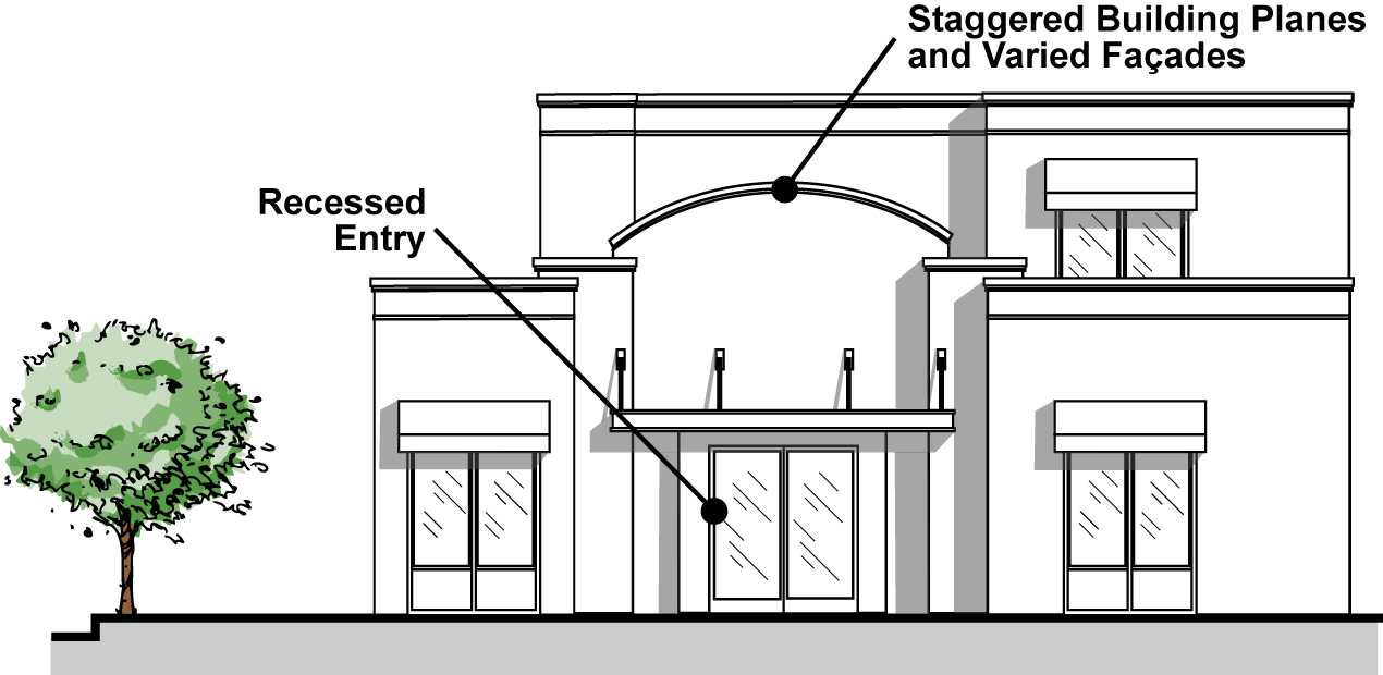
_____
g.
The use of wood shingles, simulated wood shingles, flat concrete tiles, metal or other roofs shall generally not be acceptable unless approved in a specific case by Architectural Review Board (ARB).
h.
All lighting and illumination fixtures should complement architectural style of project. See outdoor lighting standards in Section 19.50.070 (Outdoor Lighting).
2.
Buffers. See buffer standards in Section 19.36.070 (Buffer Wall Required).
3.
Circulation and access. Parking structures shall be designed and constructed according to the highest standards of quality to ensure consistency with the building architecture planned for the nonresidential project.
4.
Loading access.
a.
Loading and service areas shall not be visible from street frontages or along at-grade freeway corridors. Loading dock and service areas must be located on interior building side or rear yards and concealed from public view. See loading standards in Section 19.38.230 (Off-Street Loading Requirements).
b.
Loading areas shall be designed and located to avoid conflicts with interior pedestrian and vehicular circulation.
5.
Scale and massing.
a.
Nonresidential structures adjacent to residential uses shall incorporate sensitive transitions in scale and massing. For example, structure mass shall be broken down using height step-backs, articulated sub-volumes, and horizontal and vertical façade articulation.
b.
Long linear walls shall be staggered horizontally to provide interest and break long lines.
c.
Building forms shall be designed to create and define visually attractive exterior and functional spaces.
d.
Random or irregular building relationships shall be avoided.
e.
Building massing, height, and bulk shall be comparable to that of nearby surrounding development.
6.
Service facilities and equipment screening.
a.
All mechanical equipment shall be fully screened. Roof-mounted equipment shall be screened utilizing roof lines, parapets, or other similar methods. Equipment located on the ground must be fully screened with materials that are architecturally compatible with the structures they serve.
b.
Mechanical screens and penthouses shall be integrated with the building façade whenever possible and constructed of architecturally compatible materials. Screens should be continuous and solid.
c.
Utility connections, gas storage tanks, storage and maintenance equipment, and telephone junction boxes shall be screened from public view with the use of fencing or walls, berming, and/or landscaping.
d.
Trash and recyclable materials collection bins shall be located within a standard City trash enclosure. The enclosure shall be finished using materials compatible with the surrounding architecture, and shall be softened with landscaping. Gates shall be solid metal painted to match adjacent buildings.
e.
Utility rooms, switchgears, and other similar utility equipment should be within the building that it serves or in other decorative/architecturally designed structure approved by ARB.
f.
Roof access and/or ladders should be installed internal to the building or incorporated into the design that is hidden from the public right-of-way.
g.
Where feasible, appurtenant equipment, plumbing, and related solar energy fixtures shall be installed in the attic, or if infeasible, flush mounted or ground mounted. Appurtenant equipment, plumbing, and related solar energy fixtures shall comply with the setback requirements of Section 19.32.020 (Permitted Projections into Required Setback Areas) and shall be screened from public view.
7.
Walls and fences.
a.
See wall and fence standards and regulations in Chapter 19.36 (Fences, Walls, and Hedges).
b.
Wall and fencing materials and patterns should be compatible with the style and themes of the structures. See prohibited fencing materials in Section 19.36.050 (Prohibited Fencing Materials).
c.
Where walls are erected in locations visible from a public right-of-way, the use of full dimension caps, pilasters, and changes in wall surfaces (staggering) shall be applied (see Figure 3-23).
d.
In locations where walls might invite vandalism or graffiti, landscaping should be provided along the walls.
_____
Figure 3-23. Walls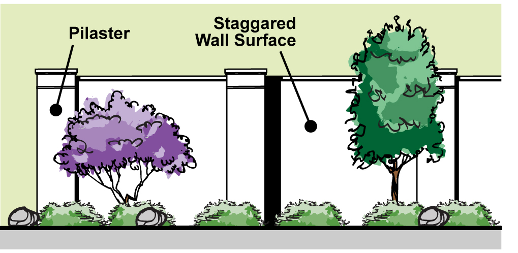
_____
D.
Commercial site design and architectural standards.
1.
Access and circulation.
a.
Any commercial structure located at a corner intersection shall incorporate architectural features that enhance pedestrian movement. These features may include building cut-offs, walk-through covered arcades, water features and trellis structures. The creation of pedestrian plazas at corners is particularly encouraged.
b.
Circulation shall be designed for both vehicle and pedestrian use. Pedestrian access from the street and the parking lot to the main door of the businesses they serve shall be designed to avoid conflict with vehicular traffic. Pedestrian paths shall be clearly delineated with pavement materials and/or markings and signage. See parking design standards in Chapter 19.38 (Off-Street Parking Regulations and Design).
2.
Architecture. A unified and/or complementary architectural theme shall be applied to all structures within a commercial center and associated signage. See Section 19.42.190 (Architectural and Design Sign Standards).
3.
Scale and massing.
a.
The scale and massing of commercial structures shall achieve a street-level environment accommodating to pedestrians.
b.
Height shall be determined as set forth in Section 19.32.040 (Height Measurement and Exceptions). However, the underlying theme of the massing should be to maintain a human scale and low profile.
c.
Structures shall be designed to avoid long, monotonous, plain façades. Techniques such as staggered building planes, variation of façades, recessed entries, and the use of arcades shall be used to create variety and interest.
4.
Site design.
a.
The entry area and pedestrian paths should be distinguished through the use of complementary and passive design features, such as changes in paving texture and color, lighting features, planters, etc.
b.
Storefronts should be oriented to the major street frontage, and/or interior parking lot, as appropriate. While side or rear entries may be desirable for secondary access, the predominant, major building entry shall be oriented toward the major street.
c.
Buildings should be oriented as close to the street as possible, with parking toward the rear of the site, to the greatest extent possible. Where parking must be oriented toward a public right-of-way, the parking shall be screened with berming, landscaping, or other effective methods. See perimeter parking landscaping standards in Section 19.38.200 (Parking Lot Landscaping).
E.
Industrial site design and architectural standards.
1.
Access and circulation.
a.
See loading standards and requirements in Section 19.38.230 (Off-Street Loading Requirements).
b.
Circulation shall be designed for both vehicle and pedestrian use. Pedestrian access from the parking lot to the main door of the business shall be designed to avoid conflict with vehicular traffic. See parking design standards in Chapter 19.38 (Off-Street Parking Regulations and Design).
2.
Service facilities and equipment screening. Buildings, walls, and landscaping should be arranged to screen less visually aesthetic components necessary for industrial development, including loading and service bays, storage areas, trash enclosures, mechanical equipment, and noise and odor producing functions. Service areas should be located at the sides and/or rear of main buildings, and screened with compatible architectural features and walls, and/or dense landscaping.
F.
Hospital site design and architectural standards.
1.
Access and circulation.
a.
Circulation shall be designed for both vehicle and pedestrian use. Pedestrian access from the street and the parking lot to the main door of a hospital or other medical facility shall be designed to avoid conflict with vehicular traffic and to easily accommodate access for the disabled and elderly. Pedestrian paths shall be clearly delineated with pavement materials and/or markings and signage, and shall be located to create the shortest possible, safe path between parking lots and passenger loading areas to the primary entrance.
b.
Passenger loading areas shall be provided at convenient and safe locations and shall be clearly identified.
c.
Wherever physically possible, reciprocal parking area access between adjacent related or similar medical uses shall be provided.
d.
Parking structures shall be designed and constructed according to the highest standards of quality to ensure consistency with the architecture of the hospital and medical buildings.
2.
Architecture. For hospital complexes, a unified and complementary architectural theme shall be applied to all structures within the complex and associated signage. See sign standards and regulation in Chapter 19.42 (Signs).
19.46.010 - Purpose.
A.
General. These Hillside Development Standards are established in recognition of the unique and sensitive environment and environmental hazards that exist in Duarte's hillside areas. This Chapter establishes regulations focused on protecting and maintaining landforms, sensitive and unique vegetative and wildlife communities, scenic qualities, and open spaces, and also minimizing risk to properties associated with wildfires, unstable slopes, rapid water movement, and other natural hazards inherent in hillside environments.
B.
Consistency with general plan. This Chapter contains regulations intended to implement General Plan policies aimed at:
1.
Ensuring that infill residential development in hillside areas is compatible in design, bulk, and height with existing residential development on surrounding properties;
2.
Providing hillside development that is sensitive to local views of the hills and the natural environment;
3.
Preserving the characteristics of the mountains, river beds, and canyons;
4.
Protecting valuable watershed;
5.
Maximizing the use of native and other drought-resistant plants to reduce the amount of water used for landscaping;
6.
Protecting public health, safety, and welfare from the dangers of flood, fire, seismic, and unstable geologic conditions; and
7.
Utilizing design approaches that require single-family homes to fit the landform rather than adjusting the landform to fit the house.
19.46.020 - Applicability.
A.
These regulations shall apply to the development of all new structures, additions to existing structures, and other property improvements within the City's hillside areas, defined as all properties within the R-1B, R-1D, and R-1F zones, as well as properties within the R-1 and R-1A zones that are located north of Sunnydale Drive and Brookridge Road. (as shown in Figure 3-24).
_____
Figure 3-24. Hillside Designation Boundary
_____
B.
In addition to the standards contained in this Chapter, all properties within the R-1D zone shall comply with the development regulations set forth in 19.10.050 (R-1D Zone: Additional Standards).
19.46.030 - Wildland-urban interface fire area requirements.
All new construction within the hillside areas defined in 19.46.020 (Applicability), above, shall comply with the California Building Code, Chapter 7A regarding construction requirements for structures within a Wildland-Urban Interface Fire Area, as defined in Chapter 7A, and the California Fire Code, Chapter 47.
19.46.040 - Application requirements.
In addition to any application requirements for a proposed improvement and/or subdivision of land otherwise set forth in this Code, all development applications for properties subject to the requirements of this Chapter shall require the following, unless waived by the Director:
A.
A topographical map, at a scale specified in development applications, which shall identify all existing slope banks, natural drainage courses, rock outcroppings, and existing vegetation. The vegetation map shall indicate whether the plant communities or habitat are native (e.g. southern mixed chaparral) or exotic (e.g. palm trees). Also depicted shall be known landslides and other existing geologic conditions.
B.
A conceptual grading plan for all proposed grading involving earth movement in excess of 50 cubic yards, which shall include the following items in addition to those required by the Municipal Code:
1.
Top of walls.
2.
Top of curbs.
3.
High point and low point elevations.
4.
Elevation of significant trees, which are defined to be trees with a greater than six-inch trunk diameter measured at four feet above grade.
5.
Spot elevations, where appropriate.
6.
Pad and/or finished floor elevations.
7.
Change in direction of drainage.
8.
Contours for existing and proposed topography.
9.
Lot and pad dimensions, along with a statistical summary.
10.
Design of driveways, including average grades indicated, as well as areas of the steepest grade.
11.
Lot drainage, including the gradient of the drainage and flow velocities.
C.
Map identifying proposed fill areas colored green and cut areas colored red, with depths of such areas clearly shown in five-foot topographic lines. Quantities of each cut and fill area shall also be clearly marked. Areas of cut and fill, calculated as a percentage of the total site area, shall be marked.
D.
In the event that no grading is proposed, a statement to that effect.
E.
The following technical reports, unless waived or conditionally waived by the Director:
1.
A geologic and soils report prepared by a registered geotechnical engineer and in sufficient detail to substantiate and support the design concepts presented in the application as submitted. A map shall be included that details geotechnical and soils conditions, including known faults and landslides.
2.
A biological resource survey report identifying all existing plant communities, with sensitive or protected species or communities clearly delineated, as well as known habitat area for protected animal species, including the location of sensitive biological resources. All sensitive species surveys shall be conducted in accordance with any applicable protocols established by the U.S. Fish and Wildlife Agency and the California Department of Fish and Game. The report shall be signed by the person preparing such report, with the signature intended to verify that the mandatory protocols were conformed to in the analysis. A map shall be included that shows all of the existing plant communities, with sensitive or protected species or communities clearly delineated, as well as known habitat area for protected animal species including the location of sensitive biological resources. The map should including identifying significant trees, which, for the purposes of this map, are defined to be trees with a caliper greater than six inches when measured four feet above grade.
F.
Visual simulation of the post-development condition, including use of photographic and/or computer-generated graphic renderings. The purpose of requiring a visual simulation is to provide decision makers with a pictorial representation of the future condition of a development project as close to reality as possible.
G.
The following property slope information:
1.
A detailed slope analysis map for the purposes of determining the amount and location of land as it exists in its natural state and for calculating the average slope. For the slope analysis map, the applicant shall use a base topographical map of the subject site, prepared and signed by a registered civil engineer or licensed land surveyor. The map which shall have a scale of not less than one inch to 100 feet and a contour interval of not more than 10 feet with two-foot intermediates. This interval may be adjusted with the approval of the Director and City Engineer on the basis of good engineering principles. This base topographical map shall include all adjoining properties within 150 linear feet of the site boundaries to portray the site's context. The slope map shall delineate slope bands, with contrasting colors, for the following slope ranges:
a.
Up to 10%
b.
10.1% to 20%
c.
20.1% to 25%
d.
25.1% to 30%
e.
Greater than 30%
2.
A calculation of the average slope of the entire parcel. Such calculation shall be performed by using the average percent slope formula, pursuant to Section 19.46.050 (Determination and Use of Average Property Slope).
3.
Calculations of average slope percent shall be based upon accurate topographic surveys using a contour interval no greater than 10 feet and a horizontal map scale of 1 inch: 200 feet or larger.
4.
The slope analysis shall be stamped and signed by a registered or licensed professional competent to provide such analysis and indicating the datum, source, and scale of topographic data used in the slope analysis, and attesting to the fact that the slope analysis has been accurately calculated.
H.
Sufficient number of slope sections to clearly illustrate the extent of the proposed grading. The slope profiles shall:
1.
All be drawn at the same scale and indexed, or keyed, to the existing topography, grading plan, and project site map. Both vertical and horizontal scales shall be indicated and not exaggerated. The slope section shall extend at least 150 feet outside the project site boundary to clearly show impact on adjacent property.
2.
At a minimum, be drawn along those locations of the project site where:
a.
The greatest alteration of existing topography is proposed;
b.
The most intense or massive development is proposed;
c.
The site is most visible from surrounding land uses;
d.
At all site boundaries illustrating maximum and minimum conditions; and
e.
Where grading will impact natural drainage conditions.
3.
Include at least two of the slope profiles roughly parallel to each other and roughly perpendicular to existing contour lines. At least one other slope profile shall be roughly at a 45° angle to the other slope profiles and existing contour lines.
4.
Be stamped and signed by a registered civil engineer or landscape architect registered in the State of California, indicate the datum, source, and scale of topographic data used in the slope profiles, and attest to the fact that the slope profiles have been accurately calculated and identified.
5.
Show existing and proposed topography, structures, and infrastructure facilities. Proposed topography, structures, and infrastructures shall be drawn with a dashed line. Existing topography and features shall be drawn with a thin, solid line.
19.46.050 - Determination and use of average property slope.
The average slope of any parcel shall be determined by the following formula:

Where: S is the average slope expressed as a percent;
I is the contour interval in feet;
L is the combined length of contour lines in scale feet; and
A is the gross area in acres of the parcel lot.
The contour map submitted for use in determining average slope shall have a maximum interval of 10 feet for slopes greater than 20 percent and a contour interval of five feet for slopes less than 20 percent.
19.46.060 - Development standards—New development projects and additions to existing development.
A.
General. The standards for the underlying zone shall apply, unless modified by this Section.
B.
Minimum distance between structures and slopes. In addition to the setback requirements that apply to the underlying zone, no building or structure shall be permitted to be erected closer to the toe or top of cut or fill slopes than the following distances. For the purposes of this Section, swimming pools, spas, and fish ponds constructed on the lot shall be considered as structures.
1.
Between a structure and the toe of slope where the slope is between the structure and front or side property line: five feet.
2.
Between a structure and the toe of slope where the slope is between the structure and rear property line: 15 feet
3.
Between a structure and the top of slope where the slope is between the structure and front, side or rear property line: 15 feet, unless a civil engineer, registered in the state of California, submits proof in writing that foundation conditions and slope stability are such that the distance may be safely reduced. Under no condition shall the distance be less than five feet.
19.46.070 - Grading standards—New development projects and additions to existing development.
A.
Supplemental to chapter 16.04. The requirements in this Section shall be supplemental to the requirements of Chapter 16.04 (Building Laws) of the Municipal Code. Where conflict between these provisions and those of Chapter 16.04 exist, the provisions of this Section shall govern.
B.
General grading standards.
1.
Landform grading techniques such as varying slope height, rounding tops and toes of slopes, and incorporating variable gradients shall be used to ensure that manufactured slopes mimic natural hill forms. Landform grading shall be used for all post-disturbance conditions unless determined by the Director and the City Engineer that landform grading is not feasible due to soil conditions, encroachment into sensitive biological resource areas, protection of watersheds or watercourses, or other similar considerations.
2.
Berming shall be used to screen utilitarian features such as, but not limited to, water tanks and detention basins.
3.
All slopes which are visible from any public right-of-way shall be landform graded.
4.
No excavation or other earth disturbance shall be permitted on any hillside area prior to the issuance of a grading permit, with the exception of drill holes and exploratory trenches for the collection of geologic and soil data. Such trenches shall be properly backfilled and erosion treatment shall be provided where such slopes exceed 20 percent.
5.
Graded or cut embankment adjacent to a publicly maintained right-of-way shall not exceed a slope ratio greater than two feet horizontal to one foot vertical.
6.
Graded slopes that are characterized by linear (in plan), planar slope surfaces with unvarying gradients and angular slope intersections are prohibited.
7.
No fill slope shall exceed two-feet horizontal to one-foot vertical, and no cut slope shall exceed a slope of one-and-one-half feet horizontal to one-foot vertical. Slopes steeper than specified may be approved if verified by a full soil investigation and report, including a deep soil test made by a geologist or soil engineer, and the report and recommendations are acceptable to the City Engineer.
8.
Whenever the depth of a cut and/or a fill exceeds 30 feet, eight-foot-wide benches paved in concrete shall be installed at not more than 30-foot vertical intervals. Approved drainage facilities shall be installed to drain benches. Concrete shall be three inches thick. Wire mesh shall be used when deemed advisable by a soil engineer's report. Modification shall be subject to proof by a geologist or a soil engineer's report acceptable to the City Engineer.
9.
No areas which are presently usable for firefighting shall be graded in relation to hillside development unless an access way is provided around the cut to the top of the ridge for firefighting equipment.
10.
Within six months, or such other period established by the Director, after the commencement of grading activities, all graded areas not covered by impervious surface shall be stabilized in such manner as shall be approved by the Director. In no case shall slope planting lag grading completion by more than six months.
11.
Landscaping coverage and stabilization of graded slopes shall be selected and designed to be compatible with surrounding natural vegetation or to replace removed natural vegetation and should recognize climatic, soil and ecologic characteristics of the region. Plant materials that require excessive water after becoming established should be avoided. Native grasses and other plants native to arid climates, consistent with guidelines adopted by the City, shall be selected wherever feasible.
12.
Trees which have a six-inch or greater trunk diameter at a point four and one-half feet above grade shall not be removed without specific approval. The location of all such trees shall be shown on all plans submitted for approval, including tentative tract maps, and tree removal shall be subject to approval of the map.
13.
The overall shape, height, grade of any cut or fill slopes shall be developed in concert with existing natural contours and scale of the natural terrain of a particular site.
14.
Where two cut or fill slopes intersect, the intersection shall be horizontally rounded and blended.
15.
Where any cut or fill slopes intersect the natural grade, the intersection of each slope shall be vertically and/or horizontally rounded and blended with the natural contours so as to present a natural slope appearance.
16.
Where any cut or fill slope exceeds 150 feet in horizontal length, the horizontal contours of the slope shall be developed in concert with existing natural contours.
C.
Grading for house sites—New construction.
1.
All graded slopes are to be contoured and blended to complement natural slopes.
2.
Housing is to be designed to fit the natural landform in a manner that does not require extensive grading through split-level house designs and other similar techniques.
3.
Significant landmark features, as determined by the responsible Review Authority, such as natural rock outcroppings, prominent trees, vegetation and wildlife communities, and other natural characteristics of significant geologic landform of special natural beauty, shall be preserved.
4.
Maximum vertical height of cuts, exposed or retained by walls, from toe to top, shall not exceed 12 feet, unless approved by the responsible Review Authority.
5.
Maximum vertical height of fills, exposed or retained by walls, from toe to top, shall not exceed 12 feet, unless approved by the responsible Review Authority.
6.
Building sites shall not be pre-graded until specific house site plans and elevations have been approved for the individual site.
D.
Retaining walls.
1.
Properly designed retaining walls, approved by the City Engineer, may be permitted to retain portions of front, side, and rear slopes, subject to the following:
a.
The height of any such wall shall not exceed ten feet.
b.
Such retaining walls may be permitted to be located on side and rear property lines when the vertical distance between adjacent properties does not exceed six feet. Such vertical distance shall be measured at the property line where such wall is to be located.
_____
Figure 3-25. Retaining Walls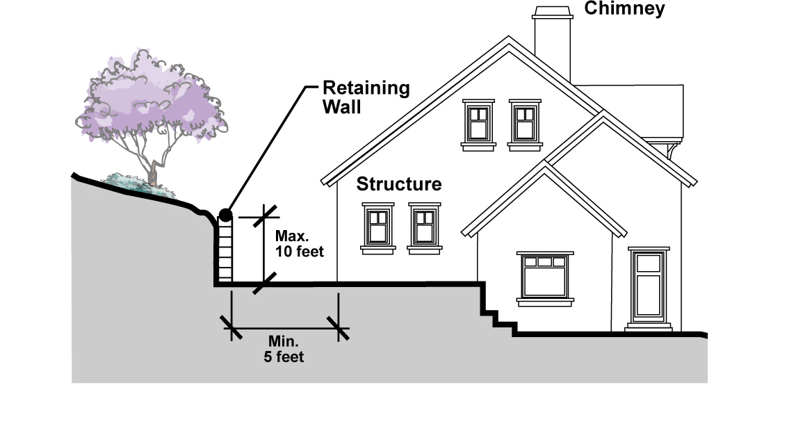
_____
2.
No building or structure shall be located closer than five feet from any retaining wall, with the exception of retaining walls that are an integral part of an approved dwelling, accessory structure, or any other approved structure.
3.
When a retaining wall is used to increase the usable area around structures, the minimum distance between such retaining wall and a structure shall be as set forth subsection 19.46.060(B).
E.
Erosion control planting.
1.
All cut and fill slopes shall be planted and irrigated with an approved automatic sprinkler system to promote growth of deep-rooted plants and groundcover that easily and quickly acclimate to their environment and prevent erosion.
2.
In developing a site, the developer shall plant and maintain all slopes where required by this Chapter until the property is occupied by reason of lease of purchase or until such time where the City accepts the landscaped area for maintenance per established city procedures. The developer shall provide suitable guarantees, planting, and maintenance required in this Chapter. The minimum requirements are as follows:
a.
All cut or fill slopes except slopes less than three feet in vertical height and all cut or fill slopes included within a slope maintenance district, shall be planted with adequate plant materials to protect the slope against erosion. Plant material shall be selected from a list of plant materials adopted by the City. The planting shall be in the ratio of at least one tree per 300 square feet of actual slope, at least one shrub per 150 square feet of actual slope area, and ground cover to completely cover the bank within two years from time of planting. An automatic sprinkler system shall be installed to irrigate the slopes, trees, and shrubs.
b.
Landscape plans and plans of the permanent automatic sprinkler system shall be prepared pursuant to the requirements of Chapter 19.40 (Landscaping). In no event shall the rate of precipitation or duration of sprinkling be permitted to create an oversaturated condition or cause an erosion problem.
3.
Grading bonds shall not be released until all conditions of the landscaping plans and specifications are met and acceptance by the Director and City Engineer is given.
19.46.080 - Required street improvements—New construction.
A.
Access. All lots or parcels shall have direct access from a public dedicated street.
B.
Curbs and gutters. Vertical curbs and gutters consistent with adopted City specifications for public streets shall be constructed on both sides of all streets.
C.
Parking lanes. Parking lanes, eight feet in width, shall be provided on at least one side of all public streets, except where existing topography renders development adjacent to the street impractical, or where off-street parking spaces are provided on each lot adjacent to the street or in parking bays. Roads without parking lanes shall be provided with emergency parking stalls adequate to contain two vehicles and spaces at an average distance of 500 feet. Such stalls are to be posted for Emergency Parking Only.
D.
Cut and fill slopes. All manufactured slopes adjacent to the roadway shall be a maximum of two horizontal to one vertical, unless limited by existing topography or constructed in rock. Manufactured slopes steeper than two to one may be permitted where adequate slope control measures are utilized. The slope shall in no case exceed the natural angle of repose of the material. Cut and fill slopes shall be constructed to eliminate sharp angles of intersection with the existing terrain and shall be rounded and contoured as necessary to blend with the natural topography to the maximum possible extent. Maximum vertical height of cut or fill slopes is to be 25 feet unless approved by the responsible Review Authority.
E.
Storm drainage. The design of storm drainage facilities shall ensure the acceptance and disposal of storm runoff without damage to the street or to adjacent properties impacted by storm water runoff. The use of special structures to accept design storm runoff shall be incorporated into the street design where appropriate.
F.
Sidewalks. Sidewalks of five feet minimum width shall be provided along or in the proximity of all public streets and along private streets, as determined by the Director to be necessary. Walkways shall be constructed consistent with standard City specifications.
G.
Street lighting. All hillside public streets shall be provided with a level of street lighting designed to protect the health, safety, and welfare of those living within the hillside areas, but to avoid excessive light and glare. Street lights shall be mounted on ornamental light standards as approved by the Director.
H.
Driveways and drives. Driveways and drives shall be designed to a grade and alignment that will provide the maximum of safety and convenience for vehicular, emergency, and pedestrian use and in a manner which will not interfere with drainage or public use of the sidewalk and/or street area.
I.
Grade. A street shall have a grade of not more than 12 degrees. Where topography makes it impractical to keep within such grades, the responsible Review Authority may approve a grade in excess of 12 degrees, provided in such cases the developer submits evidence satisfactory to the City Engineer that a lower grade is not feasible.
J.
Design. Streets shall be designed to City standards and subject to the approval of the City Engineer. No cul-de-sac street shall have a length exceeding 700 feet, unless approved by the responsible Review Authority.
K.
Secondary access. A second access shall be required when deemed necessary by the Fire Department or the Director.
L.
Drainage provisions required. No building permits shall be issued for construction on any site which does not have provisions for conducting water drainage from the site and from adjacent properties impacted by runoff to a natural drainage course, a drainage channel or a public street in a manner approved by the City Engineer. Perpetual maintenance by a public agency shall be required for storm drain facilities including debris basins.
19.46.090 - Private streets—New construction.
The use of private streets or lanes within hillside area developments shall not be allowed except where the Council determines that such streets will result in a more environmentally sensitive utilization of the hillside topography. Provisions shall be made for maintenance of private streets to the satisfaction of the Council. Private streets shall be built to City standards, and provisions for perpetual maintenance shall be established by the developer.
19.46.100 - Slope maintenance—New development projects and additions to existing development.
All slopes shall be maintained as follows:
A.
A declaration of covenants, conditions, and restrictions (CC&Rs) relating to the maintenance of slopes less than 30 feet in vertical height or located below a bench drain shall be required. A declaration of CC&Rs relating to the maintenance of slope areas, signed and acknowledged by those parties having any record title to the land to be developed, enforceable by the City, shall be recorded.
B.
All improvements located within the slope areas, such as landscaping and sprinklers, shall be maintained in a safe condition and a state of good repair. Any failure to maintain such improvements located on slope areas shall be deemed a public nuisance endangering the health, safety, and general welfare of the public and a detriment to the surrounding community. In addition to any remedy provided for by law for the abatement, removal and enjoinment of such public nuisance, the City, after giving proper notice, may cause the necessary work of maintenance or repair to be done, and the cost thereof shall be assessed against the owner.
C.
A landscape maintenance district must be established to maintain all manmade and natural slopes in excess of thirty feet or located above a bench drain.
19.46.110 - Fire prevention standards—New development projects and additions to existing development.
A.
In areas where, in the opinion of the Fire Chief, there will be a fire hazard to the watershed or any other properties, unobstructed fire protection equipment access easements, not less than 15 feet wide, shall be dedicated from the public highway to the subdivision boundary. The Fire Chief shall recommend to the responsible Review Authority where such easements are needed.
B.
Water mains and water systems shall be sized to provide sufficient water to meet the firefighting requirements of the area involved. The Fire Chief shall review proposed systems in relation to the National Board of Fire Underwriters' Standards for water systems, and shall make recommendations for the systems.
C.
The maximum distance between any residential structure and a fire hydrant shall be 250 feet, and hydrants shall be connected directly to water mains by not smaller than a six-inch pipe.
D.
All landscape planting and brush clearance shall comply with adopted fire regulations.
19.46.120 - Landscaping and irrigation standards—All development.
A.
All landscaping provided within 500 feet of the primary residential structure shall comply with the landscape materials and maintenance requirements for fuel modification zones.
B.
All portions of a site where existing vegetative cover is damaged or removed, or consists primarily of weeds (typically unwanted plants that grow aggressively and are damaging to native plants), and are not otherwise covered with new improvements, must be successfully re-vegetated with a substantial mix of native and/or drought tolerant grasses and ground covers. The density of the re-established vegetation must be adequate to prevent soil erosion and invasion of weeds after one growing season.
C.
Prior to planting, consideration of soil compaction shall be used to determine planting pit depths and drainage.
D.
The Director shall have the authority to require other improvements such as the removal of dead or diseased trees and the thinning of trees or other vegetation to encourage desirable growth.
E.
Landscaping and irrigation shall be maintained by the developer until the property is occupied. The developer shall provide guarantees, satisfactory to the reviewing body, for maintenance.
F.
The interface between new development and natural open space shall be designed to provide a gradual transition from manufactured areas into natural areas. Landscaping compatible with natural vegetation shall be designed so that it extends out from developed areas and forms a cohesive pattern with existing natural vegetation. The purpose is to blend the new landscape with the natural vegetation.
G.
Trees and shrubs shall be arranged in informal, randomly spaced masses, and shall be placed selectively to reduce the scale of and help to blend manufactured slopes into natural terrain.
H.
Landscape palettes shall be derived from the Los Angeles County Fire Department's fuel modification plan desirable plant list and landscaping guidelines adopted by the City.
I.
For fire prevention purposes, a fuel modification plan consistent with Los Angeles County Fire Department fuel modification plan requirements shall be submitted to the Director for review and approval prior to issuance of building permits.
J.
For each existing native tree or shrub removed or damaged with a combined caliper equal to or greater than four inches at four feet above finish grade, a 24-inch box minimum replacement tree or shrub of the same genus and species shall be planted on the site. For trees equal to or in excess of an eight-inch combined caliper, the replacement tree shall be a 48-inch box or larger of the same genus and species. Should a tree of the same genus and species not be available, the applicant shall submit reasonable proof of general unavailability in the region, and a list of no less than five substitutes, one of which shall be of the same genus, for approval by the Director. The Director may approve a substitute or may require provisions, including but not limited to bonds or similar security, to assure the installation and maintenance of the specific genus desired.
19.48.010 - Purpose and applicability.
A.
Purpose. This Chapter sets forth comprehensive minimum maintenance standards for structures, yards, land, landscaping, facilities, and equipment for the purpose of protecting the health, safety, and welfare of the public, and helping to preserve property values.
B.
Applicability. The provisions of this Chapter shall apply to all private and public property within the City of Duarte. Property maintenance standards shall apply to all development, whether constructed before or after the effective date of this Chapter.
19.48.020 - Relationship to other laws.
In the event of any inconsistency between this Chapter and any other provisions of this Development Code or other sections of the Municipal Code, including Chapter 9.32 (Property Maintenance-Nuisances) or in the event that this Chapter conflicts with laws of the State or other City ordinances, the higher standard - the standard that provides for a higher level of property maintenance - shall prevail, unless otherwise specified. This Chapter shall supplement and be an addition to the other relevant regulatory codes, statutes, and ordinances enacted by the City of Duarte, State of California, or any other legal entity or agency having jurisdiction.
19.48.030 - General maintenance provisions.
A.
General. All properties within the City shall be kept and maintained in a clean, neat, orderly, operable, and usable condition that is safe both to occupants and passersby. This requirement applies to structures, portions of structures, paving, fences, walls, landscaping, water, earth, and any other structure or natural feature.
B.
Prohibition on attractive nuisances. Any property which can be easily accessed by children must be kept clear of attractive nuisances that create a danger for children and other persons, including but not limited to abandoned, neglected, or broken equipment or vehicles, machinery, appliances, refrigerators or freezers; construction materials and construction equipment; and hazardous pools, ponds, and excavations.
C.
Structure maintenance. All structures and paved areas shall be kept and maintained in a manner so as to not detract from the appearance of surrounding properties, and that protects the health, safety and welfare of the user, occupant, and the general public. All such structures and paved areas shall be deemed substandard and in violation of this Chapter when such structures or paved areas display evidence of dilapidated conditions including, but not limited to, the following:
1.
Faulty, sagging, or leaking roof and roofs, missing roof tiles, or other visible roofing materials;
2.
Substantial areas of deteriorated structure siding materials including, but not limited to, dry rot, termite infestation, dented or rusting metal siding, broken or missing pieces of stucco, or other siding materials;
3.
Broken or missing windows;
4.
Inadequate site drainage and/or standing water adjacent to structure foundations;
5.
Broken or inoperable sanitary and plumbing facilities and/or fixtures;
6.
Broken or missing foundation;
7.
Broken, torn, or missing attic vent screens;
8.
Broken, ripped, or torn window screens;
9.
Structural defects such as warped, bowed or sagging structural members including, but not limited to, headers, sills, beams, eaves, doorways, door jambs, and similar structural or architectural elements;
10.
Holes in siding areas;
11.
Weathered or peeling paint.
D.
Fencing and walls. All fences and walls shall be kept and maintained in a manner that does not detract from the appearance of the immediate neighborhood or district, and that protects the health, safety, and welfare of the user, occupant, and general public. Fences and walls shall be deemed substandard and in violation of this Chapter when they display evidence of dilapidation or other conditions, such as any or all of the following:
1.
Sagging, broken, rotted, or defective support posts or other structural members;
2.
Missing or broken fence boards;
3.
Damaged or missing blocks from a block wall;
4.
Substantial areas of deterioration including dry rot, broken or missing pieces of stucco, holes, or warped or leaning fence or wall areas;
5.
Chain link fence material which is damaged or broken;
6.
Portions of the fence or wall which are substantially defaced with graffiti;
7.
Any condition of deterioration or any fault resulting in the fence or wall being structurally unsound or otherwise hazardous to property owners, occupants, or passersby;
8.
Height extensions of walls or fences in violation of this Development Code.
E.
Litter and refuse. All yards, landscaped areas, and other areas of private property surrounding structures shall be kept free of trash, old building materials, junk, unlicensed or inoperative vehicles, broken or discarded furniture, boxes, salvage materials, shopping carts, and other such material and equipment which, by its appearance, location or use, makes it incompatible with the principal use or other predominate principal uses in the immediate neighborhood.
F.
Private streets, sidewalks, and driveways.
1.
All parking, loading, storage, driveway, and vehicle maneuvering shall be kept and maintained so as to not detract from the appearance of surrounding properties, and to protect the health, safety and welfare of the user, occupant and general public. Such areas shall be kept in a neat and clean condition, free of inoperative vehicles, abandoned items, trash, debris or rubbish, furniture, equipment, play equipment, or similar materials, and free of potholes, sinkholes, standing water, cracks, and/or broken areas.
2.
Parking spaces delineation, pavement striping and related features, and signs shall be repainted, refurbished and/or replaced when the same become faded, damaged, or destroyed to such an extent as to no longer be effective. Further, such areas shall be periodically resurfaced or sealed in order to minimize seepage of water through such areas into the ground below such areas.
3.
When any paved area, which includes sidewalks, driveways, and private roadways, shows evidence of dilapidated or deteriorated conditions, it shall be deemed substandard and in violation of this Chapter.
G.
Landscaping and vegetation.
1.
All landscaped areas shall be kept and maintained in a manner that does not detract from the appearance of the surrounding properties, and that protects the health, safety, and welfare of the user, occupants, and general public.
2.
Landscaped areas shall be kept in a neat and clean condition, free of weeds, debris and dead, diseased or dying vegetation, and broken or defective decorative elements of the landscaped area.
3.
Vegetation in landscaped areas shall be mowed, groomed, trimmed, pruned, and watered as to keep the same in a healthy, growing condition. Irrigation systems shall be kept in good working condition and repair so as to prevent leaks or public health hazards.
4.
Vegetative overgrowth shall not be permitted in a manner that is likely to harbor rodents, vermin, insects, or other nuisances; or impede, obstruct, or deny pedestrian or other lawful travel on sidewalks, walkways or other public rights-of-way.
H.
Maintenance responsibility.
1.
It shall be the responsibility of any owner of any structure, residence, property, grounds or lots to ensure or compel compliance with the property maintenance standards set forth in this Chapter.
2.
It shall be the responsibility of any owner, tenant, lessee, or occupant of any structure, residence, property, grounds or lots to remove debris and remove any vegetation that is in violation of this Chapter that has accumulated on any streets within the City, if such person(s) placed the debris on such private property or streets, or otherwise owns, is occupying, or has custody or control over such private property or streets.
19.50.010 - Purpose.
This Chapter establishes performance standards to guard against the use of any property or structure in any zone in any manner which would create any dangerous, injurious, noxious, or otherwise objectionable fire, explosive, or other hazards; noise or vibration; smoke, dust, odor or other form of air pollution; heat, cold, dampness; electrical or other substance, condition or element in such a manner that adversely affects the health and safety of the public and the surrounding area or adjoining premises.
19.50.020 - Applicability.
A.
These performance standards shall apply to all uses in all zones, except for legal nonconforming uses which, based on a written opinion of the City Attorney, have an established right not to comply with the provisions of this Chapter.
B.
Compliance may be waived by the Council if a condition created under prior ordinances physically precludes the reasonable application of the standards. Additional categorical exemptions from compliance with the performance standards are as follows.
1.
Temporary activity. Festivals and other special events with approved temporary use permits or other required permits, where such activities otherwise comply with other applicable provisions of this Development Code.
2.
Emergency activities. Any emergency activity on the part of the City or a private party.
3.
Construction activity. Temporary construction activity is exempted except where such activity is explicitly regulated by other regulations of the Municipal Code.
19.50.030 - Hazardous materials.
A.
Purpose. The intent of this section is to protect local health, safety, and general welfare by ensuring that the design and operational characteristics of property does not adversely impact neighboring property owners, neighboring property users, or the general public through the accidental or intentional release or use of hazardous materials.
B.
Regulated by State of California and the U.S. EPA. The use, handling, storage, and transportation of hazardous and extremely hazardous materials shall comply with the provisions of the California Hazardous Materials Regulations (California Administrative Code, Title 22, Division 4). The U.S. Environmental Protection Agency and the California Department of Health Services identify hazardous materials and prescribe handling, use, and disposal practices. The use, storage, manufacture, and disposal of hazardous materials shall be regulated and monitored according to the standards established by these agencies and any delegated government agencies.
C.
Combustibles and explosives.
1.
The use, handling, storage, and transportation of combustibles and explosives shall comply with the provisions of Title 19 of the California Code of Regulations, Chapter 10 (Explosives).
2.
No gasoline or other inflammables or explosives shall be stored unless the location, plans, and construction conform to the laws and regulations of the State of California and have the approval of the City.
D.
Maintenance of equipment.
1.
Objects such as vehicle motor parts containing grease, oil or other hazardous substances, and unsealed receptacles containing hazardous materials, shall not be stored in areas susceptible to runoff.
2.
Any machine which is to be repaired or maintained in an uncovered outdoor area shall be placed on a pad of absorbent material to contain leaks, spills or small discharges.
3.
Machinery and equipment, including motor vehicles, which are leaking significant amounts of oil or fluid must be repaired.
19.50.040 - Radioactivity.
No use shall be permitted that emits radioactivity in dangerous amounts. The use, handling, storage, and transportation of radioactive materials shall comply with the provisions of the California Radiation Control Regulations (California Administrative Code, Title 17).
19.50.050 - Emission of smoke.
No use shall emit visible gray smoke of a shade or quality darker than No. 1 on the Ringlemann Chart, as specified in Information Circular 7718 of the U.S. Bureau of Mines, for more than five minutes in any one hour.
19.50.060 - Electric and electromagnetic disturbances and hazards.
No use shall be permitted where such use results in electric or electromagnetic interference that adversely affects the operation of any equipment other than that belonging to the creator of such interference, or that does not conform to the regulations of the Federal Communications Commission.
19.50.070 - Outdoor lighting.
A.
Purpose. This Section establishes outdoor lighting standards that are intended to be energy efficient and balance safety and security needs for lighting with efforts to ensure that light trespass (spill light), light pollution, and glare have a negligible impact on surrounding properties, particularly residential uses. Minimum requirements are presented here and that additional provisions that support sustainability are provided in Chapter 19.52 (Sustainable Development Practices).
B.
Exemptions. The following are exempt from the lighting provisions:
1.
Outdoor lights associated with a temporary event for which a Temporary Use Permit was granted.
2.
Outdoor lights used at public parks and school sites. Outdoor lights for recreational activities and special events shall be turned off between 11:00 p.m. and 6:00 a.m., unless otherwise approved by the Director.
3.
Temporary lights used for holiday decorations.
4.
Emergency lighting erected for official purposes by a local, State, or federal agency.
C.
General standards for outdoor lighting.
1.
All new outdoor lighting fixtures shall be energy efficient.
2.
Lighting shall be shielded or recessed so that direct glare and reflections are confined to the maximum extent feasible within the boundaries of the site, and shall be directed downward and away from adjoining properties and public rights-of-way.
3.
No lighting on private property shall produce an illumination level greater than one foot candle on any property within a residential zoning district except on the site of the light source.
4.
All lighting fixtures shall be appropriate in scale, intensity, and height to the use they are serving. Use the minimum amount of light necessary and only light areas that require it.
5.
No permanently installed lighting shall blink, flash, or be of unusually high intensity or brightness.
6.
Design and develop a control scheme, where acceptable, to minimize or turn lighting off during hours when they are not needed.
7.
Make use of full-cutoff fixtures to avoid glare and up-light. Note that these are different from cutoff fixtures or semi-cutoff, which still allow some up-light.
8.
Light standards within parking lots shall be the minimum height required to effectively illuminate the parking area and eliminate spillover of light and glare onto adjoining properties. To accomplish this, a greater number of shorter light standards may be required as opposed to a lesser number of taller standards.
9.
All late night and 24-hour uses, as defined in Article 9 (Definitions), shall comply with all lighting provisions of this Section.
D.
Outdoor lighting standards for multi-family residential property.
1.
Lighting shall represent the minimum level of illumination necessary to meet the aesthetic and security needs of the property. Light sources, intensity of light, and color of light shall be designed and located to achieve security or decorative lighting goals without causing an adverse impact on neighboring properties. Light sources shall be designed and located to minimize spillover of light or glare onto neighboring properties.
a.
Building-mounted lights shall be installed below the eave line. Pole or fence-mounted lights shall be located no more than eight feet above grade, except in residential parking lots.
b.
Lighting shall only be installed adjacent to buildings, walkways, driveways, or activity areas (decks, patios, spas and pools, and similar use areas) and focal landscape areas close to the residence or activity area.
c.
The lighting intensity within parking lots and adjacent areas shall be at least 1.0 foot candle at all points, but shall not exceed an average of 3.0 foot-candles over the entire parking lot. Overall height of light standards shall be no more than 22 feet above finish grade.
2.
Lighting plans may be required for common open space or recreation areas in multi-family developments to include a photo analysis demonstrating compliance with these lighting standards.
E.
Outdoor lighting standards for nonresidential property. Parking lots, driveways, pedestrian walkways, and building entrances/exits shall be illuminated for security and safety purposes during business hours of operation. Except as otherwise exempt, outdoor lighting shall be provided with shielding so that the light emitted from an outdoor light fixture is projected below an imaginary horizontal plane passing through the fixture. Where the light source from an outdoor light fixture is visible beyond the property line, shielding shall be required to reduce glare so that the light source is not visible from within any residential dwelling unit.
F.
Prohibited lighting. The following outdoor light fixtures shall be prohibited. Existing light fixtures legally permitted or authorized prior to the effective date of this ordinance may be maintained.
1.
Uplighted and back-lighted canopies or awnings.
2.
Searchlights, except as authorized for a special or temporary event authorized by a Temporary Use Permit.
3.
Flashing lights, except as used in conjunction with a security alarm system.
4.
Roof-mounted lights.
5.
Any light that imitates or causes visual interference with a traffic signal or other necessary safety or emergency light.
19.50.080 - Noise and vibration.
The regulations set forth in Chapter 9.68 (Noise Regulations) of the Municipal Code shall apply. For late night and 24-hour uses, as defined in Article 9 (Definitions), additional conditions may be applied through an associated discretionary permit.
19.50.090 - Odor.
No emission of odorous gases or other odorous matter in such quantities as to be readily detectable shall be permitted beyond the property lot lines of the source. Any process which may involve the creation or emission of any odors shall be provided with a secondary safeguard system so that control will be maintained if the primary safeguard system should fail.