
Dunwoody City Zoning Code
ARTICLE II
ZONING DISTRICTS
Sec. 27-56. - General.
(a)
The districts. The city's residential zoning districts are listed below. When this zoning ordinance refers to "residential" zoning districts, it is referring to these districts.
_____
_____
(b)
Purposes.
(1)
General. Dunwoody's residential zoning districts are primarily intended to create, maintain and promote a variety of housing and living opportunities for individual households and to help ensure consistency with the comprehensive plan. While the districts primarily accommodate residential use types, some nonresidential uses are also allowed, as indicated in the use table of section 27-57.
(2)
Single-dwelling (R) districts. When this zoning ordinance refers to "R" zoning districts, it is referring to the single-dwelling zoning districts: R-150, R-100, R-85, R-75, R-60, R-50, RA-5 and RA-8. The primary purposes of the R districts are as follows:
a.
To help protect the established character of existing neighborhoods;
b.
To accommodate infill development that is in keeping with character of existing neighborhoods; and
c.
To accommodate uses and structures designed to serve the housing, recreational, educational, religious and social needs of the neighborhood.
(3)
Multi-dwelling (RM) districts. When this zoning ordinance refers to "RM" zoning districts, it is referring to the multi-dwelling zoning districts: RM-150, RM-100, RM-85, RM-75 and RM-HD. The primary purposes of the RM, multi-dwelling zoning districts are as follows:
a.
To accommodate the development of multi-dwelling residential development in areas designated for such development by the comprehensive plan;
b.
To accommodate infill development that is in keeping with the physical character of existing neighborhoods; and
c.
To accommodate uses and structures designed to serve the housing, recreational, educational, religious and social needs of the neighborhood.
(Ord. No. 2013-10-15, § 1(Exh. A § 27-4.10), 10-14-2013)
_____
Sec. 27-57. - Uses allowed.
The following table identifies uses allowed in residential zoning districts. See subsection 27-111(4) for information about how to interpret the use table.
(Ord. No. 2013-10-15, § 1(Exh. A § 27-4.20), 10-14-2013; Ord. No. 2015-01-05, § 1, 1-26-2015; Ord. No. 2022-01-02, § I, 1-10-2022; Ord. No. 2024-07-05, § I, 7-22-2024)
_____
Sec. 27-58. - Lot and building regulations.
(a)
General. This section establishes basic lot and building regulations that apply in residential zoning districts. These regulations offer certainty for property owners, developers and neighbors about the limits of what is allowed; they are not to be construed as a guarantee that stated minimums and maximums can be achieved on every lot. Other factors, such as topography, the presence of protected resources, off-street parking and other factors may work to further limit actual building and development potential.
(b)
Single-dwelling districts. The lot and building regulations of the following table apply to all principal and accessory uses allowed in single-dwelling residential districts, unless otherwise expressly stated in this zoning ordinance. Article VII, division 1, identifies exceptions to these regulations and rules for measuring compliance (see also figure 4-1).
[1] Detached houses in RA-5 and RA-8 districts are subject to the lot and building regulations of the R-50 district.
[2] Minimum lot frontage on cul-de-sac lots is 35 feet. Minimum lot width at the required street setback must equal the required minimum frontage requirement for non-cul-de-sac lot (e.g., 100 feet in R-100).
[3] Minimum lot frontage applies to attached house projects, not individual dwelling units within the project.
[4] Corner lots are subject to street setbacks along all street frontages. The rear setback is measured from the property line parallel to the lot frontage (see section 27-572), and interior side setbacks are applicable along all other lot lines.
[5] Add five feet for minimum setbacks from arterial streets.
[6] Street-facing garage façades must be setback at least 20 feet from back of curb or back of sidewalk, whichever is greater.
[7] Interior side setback applies only to end units in attached house projects. No interior side setback required for units in attached projects with common or abutting walls. See also the attached house building separation requirements of section 27-132.
[8] Maximum lot coverage for institutional uses; including, but not limited to, educational services, places of worship, and neighborhood recreation club shall not exceed 60 percent.
[9] Maximum lot coverage in street yards shall not exceed 35 percent. This standard shall not apply to institutional uses.
Figure 4-1: Lot and Building Regulations Diagram, Single-Dwelling Residential Districts
(c)
Multi-dwelling districts. The lot and building regulations of the following table apply to all principal and accessory uses allowed in multi-dwelling residential districts, unless otherwise expressly stated in this zoning ordinance. Article VII, division 1, identifies exceptions to these regulations and rules for measuring compliance (see also figure 4-2).
[1] Applies only to attached house projects and multi-unit buildings with 4 or more dwelling units.
[2] Minimum lot frontage for detached houses on cul-de-sac lots is 35 feet. Minimum lot width at the required street setback must equal the required minimum frontage requirement for non-cul-de-sac lot (e.g., 60 feet in RM-150).
[3] Minimum lot frontage applies to attached house projects, not to individual dwelling units or lots within the project.
[4] See also the building spacing regulations of section 27-132 and section 27-142.
[5] In attached house projects, interior side setbacks apply only to end units. No interior side setback is required between units with common or abutting walls.
[6] Minimum interior side and rear setback is 50 feet for multi-unit residential buildings on lots abutting single-dwelling (R) residential zoning districts.
[7] Corner lots are subject to street setbacks along all street frontages and interior side setbacks along all other lot lines.
[8] Maximum lot coverage for institutional uses, including, but not limited to, educational services, places of worship, and neighborhood recreation club, and for permitted multi-unit buildings, including town homes and similar uses shall not exceed 70 percent.
Figure 4-2: Lot and Building Regulations Diagram, Multi-Dwelling Residential Districts
(Ord. No. 2013-10-15, § 1(Exh. A § 27-4.30), 10-14-2013; Ord. No. 2015-01-05, § 1, 1-26-2015; Ord. No. 2021-09-14, § II, 9-27-2021; Ord. No. 2022-08-13, § I, 8-22-2022)
Sec. 27-59. - Other regulations.
Uses and development in residential zoning districts may be subject to other regulations and standards, including the following.
(1)
Nonconformities. See article VI, division 4.
(2)
Accessory uses and structures. See article III, division 3.
(3)
Parking. See article IV, division 1.
(4)
Landscaping and screening. See article IV, division 2.
(5)
Signs. See chapter 20 of the Municipal Code.
(6)
Temporary uses. See article III, division 4.
(7)
Outdoor lighting. See article IV, division 3.
(Ord. No. 2013-10-15, § 1(Exh. A § 27-4.40), 10-14-2013)
Sec. 27-71. - General.
(a)
The districts. The city's nonresidential and mixed-use zoning districts are listed below.
_____
(b)
Purposes.
(1)
General. The nonresidential and mixed-use districts are generally intended to promote consistency with the comprehensive plan and provide opportunities for shopping, employment, entertainment and living.
(2)
Office-institution and office-institution-transitional. The primary purposes of the O-I and O-I-T districts are as follows:
a.
To provide convenient locations for office and institutional uses;
b.
To provide locations for the development of cultural, recreational, educational and health service facilities; and
c.
To limit building heights to two stories in O-I-T zoned areas adjacent to single-dwelling residential districts.
(3)
Office-distribution. The primary purpose of the O-D district is to provide convenient locations for office and distribution establishments.
(4)
Office-commercial-residential. The primary purposes of the OCR district are as follows:
a.
To provide for economic development within the city through redevelopment of parcels of land that have been used in the past for commercial and light industrial uses but that have become obsolete and now offer an opportunity for establishing new moderate-intensity mixed-use developments consisting of a combination of office, commercial and residential uses;
b.
To promote redevelopment and new development in an environment that is pedestrian-oriented and that provides employment, shopping, entertainment and living opportunities in close proximity thereby reduces auto dependency; and
c.
To encourage the conversion of vacant commercial and industrial buildings into mixed-use projects.
(5)
Neighborhood shopping. The primary purposes of the NS district are as follows:
a.
To provide convenient neighborhood retail shopping and service areas within the city;
b.
To provide for the development of new neighborhood shopping districts;
c.
To help ensure that the size and scale of neighborhood shopping centers and individual uses within shopping centers are compatible with the scale and character of surrounding neighborhoods; and
d.
To accommodate uses designed to serve the convenience shopping and service needs of the immediate neighborhood.
(6)
Local commercial. The primary purposes of the C-1 district are as follows:
a.
To provide convenient local retail shopping and service areas within the city;
b.
To provide for the development of new local commercial districts; and
c.
To accommodate uses designed to serve the convenience shopping and service needs of groups of neighborhoods.
(7)
Commercial-residential mixed-use. The primary purposes of the CR-1 district are as follows:
a.
To provide convenient local retail shopping and service areas within a mixed-use (commercial-residential) setting;
b.
To provide for the development of new commercial-residential mixed-use districts; and
c.
To promote development patterns that accommodate residential, employment and entertainment within a walkable, mixed-use environment.
(8)
General commercial. The primary purposes of the C-2 district are as follows:
a.
To provide convenient general business and commercial service areas within the city;
b.
To provide for the development of new general commercial districts; and
c.
To accommodate uses designed to serve the general business and commercial service needs of the city.
(9)
Industrial. The primary purposes of the M district are as follows:
a.
To provide areas for the establishment of businesses engaged in the manufacturing, processing, creating, repairing, renovating, painting, cleaning, or assembling of goods, merchandise, or equipment;
b.
To help ensure that establishments operate so as to not create adverse noise and other impacts on nearby residential, office, commercial and mixed-use districts; and
c.
To help ensure that M districts are located in areas with access to major arterials and freeways.
(Ord. No. 2013-10-15, § 1(Exh. A § 27-5.10), 10-14-2013)
_____
Sec. 27-72. - Uses allowed.
The following table identifies uses allowed in nonresidential and mixed-use zoning districts. See subsection 27-111(4) for information about how to interpret the use table.
[1] Within the O-I zoning district, other food and beverage sales and Other retail sales are limited as follows:
a. Not permitted in any residential buildings or buildings with a residential component.
b. Allowed only as an accessory use on the ground floor of a multi-story office or institutional building.
c. Maximum floor area of the tenant suite is limited to 2,000 square feet.
(Ord. No. 2013-10-15, § 1(Exh. A § 27-5.20), 10-14-2013; Ord. No. 2015-01-05, § 1, 1-26-2015; Ord. No. 2015-06-13, § 1, 6-22-2015; Ord. No. 2019-05-08, § 1, 5-6-2019; Ord. No. 2020-03-04, § I, 3-9-2020; Ord. No. 2021-09-14, § III, 9-27-2021; Ord. No. 2022-01-02, § II, 1-10-2022; Ord. No. 2023-08-09, § I, 8-14-2023; Ord. No. 2023-10-14, § I, 10-16-2023; Ord. No. 2024-07-05, § II, 7-22-2024)
Sec. 27-73. - Lot and building regulations.
(a)
This section establishes basic lot and building regulations that apply in nonresidential and mixed-use zoning districts. These regulations offer certainty for property owners, developers and neighbors about the limits of what is allowed; they are not to be construed as a guarantee that stated minimums and maximums can be achieved on every lot. Other factors, such as topography, the presence of protected resources, off-street parking and other factors may work to further limit actual building and development potential.
(b)
The lot and building standards of the following table apply to all principal and accessory uses allowed in nonresidential and mixed-use districts, unless otherwise expressly stated in this zoning ordinance. Article VII, division 1, identifies exceptions to these regulations and rules for measuring compliance (see also Figure 5-1).
[1] Attached house developments are subject to a minimum lot area requirement of 4,000 square feet per dwelling unit.
[2] No interior side setback required abutting C-1, CR-1 or C-2-zoned lots.
[3] Buildings may exceed three stories in height only if approved by fire and rescue services. Buildings in excess of five stories or 70 feet in height may be approved only through the special land use permit procedures of article V, division 3. Multi-unit residential and vertical mixed-use buildings that abut any attached single-dwelling residential district may not exceed 40 feet in height. Multi-unit residential buildings and vertical mixed-use buildings that abut any detached single-dwelling residential district may not exceed 35 feet in height.
[4] Buildings in excess stated height limits may be approved through the special land use permit procedures of article V, division 3. Buildings may exceed three stories in height only if approved by fire and rescue services.
[5] No individual building may exceed 50,000 sq. ft. (GSF). No multi-tenant center may exceed 100,000 sq. ft.
Figure 5-1: Lot and Building Regulations Diagram, Nonresidential and Mixed-use Districts
(Ord. No. 2013-10-15, § 1(Exh. A § 27-5.30), 10-14-2013; Ord. No. 2015-01-05, § 1, 1-26-2015)
_____
Sec. 27-74. - Other regulations.
Uses and development in nonresidential and mixed-use zoning districts may be subject to other regulations and standards, including the following.
(1)
Nonconformities. See article VI, division 4.
(2)
Accessory uses and structures. See article III, division 3.
(3)
Parking. See article IV, division 1.
(4)
Landscaping and screening. See article IV, division 2.
(5)
Signs. See chapter 20 of the Municipal Code.
(6)
Outdoor storage. See section 27-286.
(7)
Temporary uses. See article III, division 4.
(8)
Outdoor lighting. See article IV, division 3.
(Ord. No. 2013-10-15, § 1(Exh. A § 27-5.40), 10-14-2013)
Sec. 27-86. - Reserved.
Editor's note— Ord. No. 2017-04-07, § 1, adopted April 11, 2017, repealed § 27-86 which pertained to PC, Perimeter Center district, and derived from Ord. No. 2013-10-15, § 1(Exh. A, § 27-6.10), adopted Oct. 14, 2013. See div. 5, §§ 27-103—27-106.
Sec. 27-87. - PD, Planned Development district.
(a)
Purpose and administration of district. The PD, Planned Development district is intended to permit the planning and development of parcels of land that are suitable in location and character for the uses proposed as unified and integrated developments in accordance with detailed development plans. The PD district is intended to provide a means of accomplishing the following specific objectives:
(1)
To provide for development concepts not otherwise allowed within non-PD zoning districts;
(2)
To provide flexibility, unity and diversity in land planning and development, resulting in convenient and harmonious groupings of uses, structures and common facilities;
(3)
To accommodate varied type design and layout of housing and other buildings;
(4)
To allow appropriate relationships of open spaces to intended uses and structures;
(5)
To encourage innovations in residential, commercial, and industrial development and renewal so that the growing demands of the population may be met by greater variety in type, design, and layout of buildings and by the conservation and more efficient use of open space ancillary to those buildings;
(6)
To encourage a more efficient use of land and of public services, or private services in lieu thereof, and to reflect changes in the technology of land development so that resulting economies may benefit those who need homes;
(7)
To lessen the burden of traffic on streets and highways; and
(8)
To provide a procedure that can relate the type, design, and layout of residential, commercial, and industrial development to the particular site, thereby encouraging preservation of the site's natural characteristics.
(b)
Establishing a planned development.
(1)
No PD district may be established without the concurrent approval of an overall development plan (ODP) by the mayor and city council, in accordance with subsection (c).
(2)
PD districts must have a minimum contiguous land area of 4.5 acres if all or a part is located in the suburban neighborhood character area or in the institutional/campus character area as established in the comprehensive plan. In all other character areas, PD districts must have a minimum contiguous land area of 1.5 acres.
(3)
The boundaries of each PD, upon approval, must be shown on the zoning map, must be in conformance with the adopted comprehensive plan, any adopted master plan, and the approved overall development plan.
(4)
Once adopted, an ODP may be modified in the following ways:
a.
The community development director has sole authority to approve minor changes to conditions attached to an approved PD zoning designation. Minor changes are those that implement only slight alterations to the approved conditions, made necessary by actual field conditions at the time of development, that do not alter the impact of the development on nearby properties nor the intent or integrity of the conditions as originally imposed. Any request for minor change of conditions must be made in written form to the community development director. If an approved site plan exists, the request for minor change must be accompanied by a copy of the revised site plan.
b.
Any major change to conditions attached to an approved PD zoning designation requires approval of a zoning map amendment in accordance with the procedures of article V, division 2. Without limiting the meaning of the phrase, the following are deemed to constitute major changes for purposes of interpreting this section:
1.
The movement of any building or structure adjacent to an exterior boundary line, closer to the boundary line of the property to which it is adjacent;
2.
Any increase in the number of dwelling units or any increase in the total amount of floor space of any nonresidential building;
3.
Any decrease in the minimum size of residential units imposed in the original conditional zoning amendment;
4.
Any reduction in any buffer requirement imposed in the original conditional zoning amendment;
5.
Any increase in the height of any building or structure; or
6.
Any change in the proportion of floor space devoted to different authorized uses.
(c)
Application of regulations.
(1)
Overall development plan. Development of the PD is governed by overall development plan that designates the land uses of the PD. The ODP must be accompanied by a development standards text, which may be approved as a condition of zoning, providing development standards and uses for the project that can vary, augment or limit the requirements of this zoning ordinance and the development regulations. The ODP must be submitted as a part of the PD rezoning application.
(2)
At a minimum the ODP must include:
a.
Sketch plan;
b.
Type and location of all intended uses;
c.
Expected gross land areas of all intended uses including open space;
d.
Gross floor area or residential unit size and number for all buildings or structures, including a statement pertaining to the appropriateness of the density and intensity of the suggested uses relative to policies and standards contained within the comprehensive plan;
e.
Architectural elevations of all proposed building sides, a description of the types of exterior treatments of buildings, a site plan to scale, density calculations;
f.
Circulation plan;
g.
Street documentation;
h.
Parking analysis;
i.
A tree plan showing the existing trees on site that are six inches in diameter at breast height or greater for hardwoods and 16 inches in diameter at breast height for other trees;
j.
Existing site survey and a grading plan; and
k.
Any other information deemed necessary by the community development director for planning review.
(3)
To the extent that the approved ODP and development standards for a PD contradict the development regulations and this zoning ordinance, the approved ODP for the PD district governs.
(4)
No changes in land use or density may be allowed in any approved and incorporated overall development plan or development standards text, except as subsequently approved pursuant to a rezoning of the property.
(5)
Architectural compatibility must be determined based upon the context and guidance of the comprehensive plan and specific sub-area plan area in which the PD is located. As a part of the architectural design, a "four-sided" design philosophy must be used, materials used shall be enduring in their composition and include as the primary material, brick, stone or equivalent durable materials.
(6)
Land uses within a PD district may be multiple in nature. The location and relationship of these uses must be as established in and conform to the policies and standards contained within the comprehensive plan and other appropriate adopted and approved plans and established as part of the ODP.
(d)
Planning commission review. When reviewing a map amendment case that includes a lot to be zoned PD, the planning commission may move to table an item to the next regularly scheduled meeting up to three times. Should the planning commission fail to make a recommendation at the fourth meeting the item shall be forwarded to the council without a recommendation. All other considerations of section 2-88 apply unchanged.
(Ord. No. 2013-10-15, § 1(Exh. A § 27-6.20), 10-14-2013; Ord. No. 2015-01-05, § 1, 1-26-2015; Ord. No. 2017-04-07, § 1, 4-11-2017; Ord. No. 2021-05-08, 5-10-2021)
Sec. 27-96. - General.
(a)
Establishment. Overlay zoning district regulations and overlay zoning district boundaries may be established or amended only in accordance with the amendment procedures of article V, division 2.
(b)
Interpretation. Overlay zoning district regulations apply in combination with underlying (base) zoning district regulations and all other applicable regulations of this zoning ordinance. When overlay district standards conflict with standards that would otherwise apply under this zoning ordinance, the regulations of the overlay zoning district govern. Otherwise, all applicable regulations of this zoning ordinance apply in overlay districts.
(Ord. No. 2013-10-15, § 1(Exh. A § 27-7.10), 10-14-2013)
Sec. 27-97. - Reserved.
Editor's note— Ord. No. 2021-09-12, § 2, adopted Sep. 27, 2021, repealed § 27-97, which pertained to DVO, Dunwoody Village overlay and derived from Ord. No. 2013-10-15, § 1(Exh. A § 27-7.20), adopted Oct. 14, 2013; Ord. No. 2015-01-05, § 1, adopted Jan. 26, 2015; Ord. No. 2017-02-03, § 1, adopted Feb. 13, 2017; Ord. No. 2017-04-07, § 1, adopted April 11, 2017; Ord. No. 2018-12-20, § I, adopted Dec. 10, 2018; Ord. No. 2019-05-08, § 2, adopted May 6, 2019; Ord. No. 2020-08-15, adopted Aug. 24-2020.
Sec. 27-98. - Perimeter Center Overlay.
(a)
Overlay generally.
(1)
Intent. The regulations of the Perimeter Center Overlay are intended to recognize and foster the transformation of Perimeter Center into a pedestrian-friendly, livable center that ensures long term economic, social, and environmental sustainability.
(2)
Purpose. The Perimeter Center Overlay has been created to further the following public purposes.
a.
Plan compatibility. To guide new development and redevelopment as defined by the City of Dunwoody Comprehensive Plan (adopted 2015) and as amended.
b.
Perimeter Community Improvement districts (PCIDs). To provide implementation guidance for the general vision defined in Perimeter @ The Center - Future Focus, 2011 - A Ten Year LCI Update, dated November 2011, as amended (past, current, and future), and adopted by city council.
(3)
Applicability. The regulations within this section, 27-98 Perimeter Center Overlay, apply to all buildings, structures, land and uses within the Perimeter Center Overlay, as illustrated on the city's zoning map and in figure 27-98-1, Perimeter Center Overlay map.
(4)
Existing land development regulations. Refer to chapter 16, land development regulations, for additional requirements. When there is a conflict between the following regulations and chapter 16, the Perimeter Center Overlay regulations govern.
(5)
Review and approval procedures. Unless otherwise expressly stated, all uses and development in Perimeter Center Overlay are subject to the applicable review and approval procedures of article V, as well as any applicable procedures in chapter 16 of the Municipal Code (land development regulations).
(6)
Site plan review. All applications for development permits within the Perimeter Center Overlay must be accompanied by a site plan, which is subject to review and approval in accordance with article V, division 10.
(7)
Relief. In some instances, unique site conditions, existing building circumstances or other constraints related to the subject property may make strict compliance with the Perimeter Center Overlay regulations impossible or highly impractical. In such instances, an applicant may seek relief from applicable regulations. Any relief granted and conditions imposed run with the land and are binding on the subject property owner and all future property owners.
a.
Minor exception—Administrative relief. The community development director or public works director, as noted, is authorized to approve the following minor exceptions to strict compliance in accordance with the special administrative permit procedures of article V, division 7:
1.
A change to any street or frontage option component width or depth (requires approval by the public works director);
2.
A reduction in required landscape or yard depth by no more than ten percent;
3.
Establishment of a public access easement in lieu of right-of-way dedication for street type frontage options, per the public works director.
4.
Retaining walls in street type frontages up to five feet in height when extreme grades prevent the use of shorter walls and landscaping is used to mitigate the visual impacts of the taller retaining wall at the sidewalk edge; and
5.
Any other minor exception expressly authorized under the Perimeter Center Overlay regulations.
b.
Major exceptions—Variance. Major exceptions to strict compliance with the Perimeter Center Overlay regulations include any exception to strict compliance that is not expressly authorized as a minor exception under the provisions of subsection (a)(7)a. Major exceptions require review and approval in accordance with the variance procedures of article V, division 5.
(b)
Street types.
(1)
Intent. Street types are established for all of the existing and new streets in the Perimeter Center Overlay area. Frontage options are defined for the space between the building or parking and the curb per street type. Street types and frontage options are intended to address the comfort, convenience, and safety of pedestrians and bicyclists; to develop a network of streets with identifiable character; and to provide an aesthetically pleasing edge to all development.
(2)
Applicability. All new development and redevelopment within the Perimeter Center Overlay shall meet the street type frontage requirements under any one of the following circumstances:
a.
New structure. Development of a new principal structure on a lot or a portion of a lot.
b.
Redevelopment or renovation. Redevelopment or renovation of an existing structure or site that increases the gross building square footage by more than 50 percent.
c.
Parking lots. Redevelopment or revision to 50 percent or more of an existing parking lot or development of a new parking lot consisting of 15 or more spaces, not including resurfacing or repairing an existing layout.
(3)
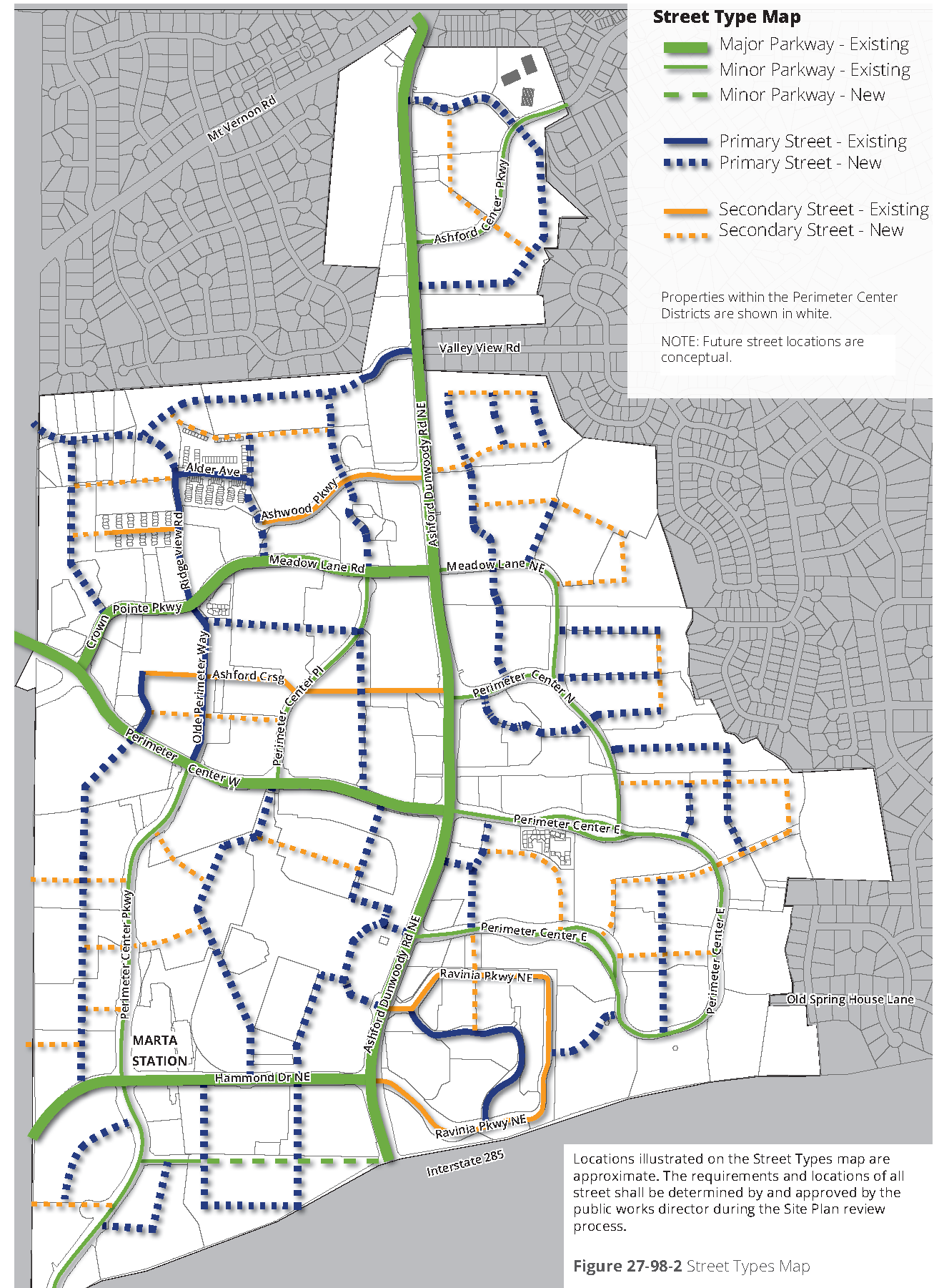
Street types map. Figure 27-98-2, street types map, defines street types in Perimeter Center for existing and new streets. Refer to [subsection] (c), streets and blocks, for more information about new streets and their designated locations.
Locations illustrated on the street types map are approximate. The requirements and locations of all streets shall be determined by and approved by the public works director during the site plan review process.
a.
Street types. The following street types are established for the existing streets and any new streets adjacent to and within the Perimeter Center Overlay. Refer to figure 27-98-2, street types map, for the typologies of existing streets and proposed new streets.
1.
Major parkway street. The major parkway street type is intended to create a parkway effect along the major transportation corridors within Perimeter Center through the use of wide landscape areas heavily planted with native or naturalized trees. Major parkways require designated bicycle facilities. Refer to [subsection] (b)(5), major parkway street type, for requirements.
2.
Minor parkway street. The minor parkway street type is intended to create a parkway effect along transportation corridors within Perimeter Center through the use of wide landscape areas heavily planted with trees. Minor parkways require designated bicycle facilities. Refer to [subsection] (b)(6), minor parkway street type, for requirements.
3.
Primary street. The primary street type is intended to establish a series of comfortably scaled streets with continuous building frontage and a limited number of drives interrupting the sidewalk. Primary streets require a balance between bicyclists and pedestrians and automobiles by providing designated bicycle facilities and a robust pedestrian realm, and by prioritizing bicyclists and pedestrians for a more balanced transportation route. Refer to [subsection] (b)(7), primary street type, for requirements.
4.
Secondary street. The secondary street type is meant to establish a designated street for parking lot and structure access, while still providing a safe and comfortable pedestrian realm. Refer to [subsection] (b)(8), secondary street type, for requirements.
b.
Street type graphics. The graphics provided in this section illustrate the preferred configuration of each street type. By applying the standards defined, other configurations are permitted.
c.
Redesignating street types. Existing street designations are set to match the existing character to the extent possible. New streets have been designated with the intent to provide an appropriate mix of primary and secondary streets, establishing comfortable pedestrian streets while providing for parking access. Redesignation of existing streets may occur per the following:
1.
Process. Parkways shall not be re-designated, except by a text amendment to this code. All other streets may be redesignated using the minor exception process.
2.
Entire blocks. When redesignating street types, the entire street between intersecting streets shall be redesignated.
3.
Primary streets. The intent is to maintain a similar amount of primary streets as established by the map. Primary streets may be re-designated as parkways or secondary streets only when a new or existing street, currently designated as secondary, within or abutting the same parcel is redesignated as a primary street.
4.
Secondary streets. Existing secondary streets may be redesignated as parkways or primary streets as long as vehicular access to parking for all surrounding sites has been addressed.
d.
Shared-use paths. Trail locations are required per the city's current comprehensive plan or other city-approved cycle/pedestrian plan and in coordination with public works director for locations for other trails.
(4)
Streetscape furnishings and hardscape design. In addition to the street type frontage requirements that include minimum tree plantings and walk/trails, a street furnishings and hardscape design is required along all new and existing street frontages per the following:
a.
Definition. The streetscape furnishings and hardscape design shall include the frontage area as defined by the street types plus any hardscaped building setback area less than 25 feet deep from the frontage edge.
b.
Design submittal. A consistent design shall be submitted for approval with site plan review for all streets within and adjacent to the development.
c.
Standard specifications. The design shall meet any standards defined by the city for sidewalk, curb, access, lighting, landscape, and other applicable construction details. Refer to chapter 16, land development regulations.
d.
Perimeter Community Improvements districts (PCID) public space standards. Refer to the current PCID public space standards document for recommended streetscape component and material specifications.
e.
Submittal requirements. At a minimum, the design submittal shall include the following:
1.
Trees. Trees meeting the minimum requirements of [subsection] (b), street types, shall be included in the design, with details related to tree pits, tree grates, and tree planting to meet the landscape installation requirements of [section] 27-364, landscape.
2.
Pavement design. Paving materials and pattern is required for each sidewalk and any other hardscape proposed. Pavement design shall address all walks or trails, including the minimum sidewalk or trail widths required by the frontage.
3.
Street furnishings. Benches and/or seatwalls, planters, planter fences, tree grates, and trash receptacles shall be specified and quantities and locations listed for each street. For each block face, a minimum of two benches or seatwalls, one trash receptacle, and one recycling receptacle are required.
4.
Bus stop facilities. Coordinate with the public works director for the location of bus stops and the required facilities. Facilities may include benches, pavement, shelters, signs, and other improvements.
5.
Landscape design. Ground plane vegetation shall be designated for any landscape bed areas, planter areas, and open tree wells, including shrubs, perennials, annuals, and grasses.
6.
Lighting. Pedestrian and vehicular lighting shall be specified with locations and quantities noted. All lighting shall meet any requirements of the public works director. Cut sheets and samples shall be submitted upon request.
7.
Stormwater facilities. Any stormwater facilities proposed for the right-of-way shall be included in the streetscape design. Facilities such as stormwater planters or parkway swales may be included. Maintenance responsibilities and processes shall be included.
8.
Identity elements. Any other elements designed to establish the identity of each street, such as banners mounted on light poles, pavement markers, artwork, or wayfinding signage, shall be included in the design submittal.
9.
Streetscape maintenance. Property owner is responsible for regular maintenance and emptying of trash and recycling receptacles, sweeping of sidewalks and seating areas, and tree maintenance. The city may request additional maintenance procedures.
10.
Streetscape design continuation. The approved streetscape design for each street may be utilized by the city for the extension of any street outside the development to provide continuity.
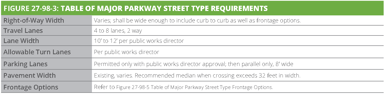
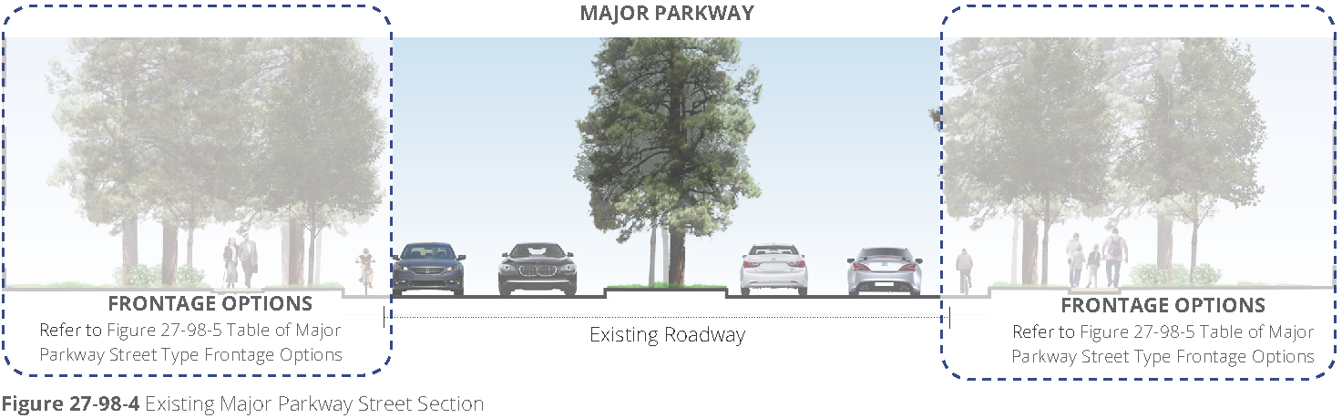
(5)
Major parkway street type. The major parkway street type applies to existing streets per figure 27-98-2, street types map. Refer to figure 27-98-3, table of major parkway street type requirements and figure 27-98-4, existing major parkway street section.
a.
New major parkway streets. New major parkway streets are not permitted, unless otherwise required by the public works director. This street type is applicable only to existing streets per figure 27-98-2, street types map.
b.
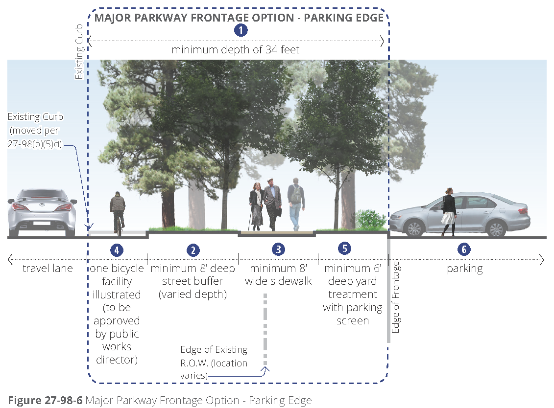
Frontage options. Frontages address the pedestrian and bicycle realm as well as street and parking buffers and public space options. Parcels that are adjacent to a major parkway as designated on the figure 27-98-2, street types map, shall apply one or more of the major parkway street frontage options along the entire length of the lot line abutting the major parkway. Refer to figure 27-98-5, table of major parkway street type frontage options.
c.
Dedication. When the sidewalk is fully or partially located on private property, right-of-way dedication is required, so that the sidewalk is fully located in the right-of-way. The public works director may approve an easement in lieu of right-of-way dedication based on the geometry of the site, topography, or other site-specific considerations.
d.
Curb movement. The existing street curb may be required to move, based on the selection of the appropriate context-sensitive bicycle facility, per public works director.

(6)
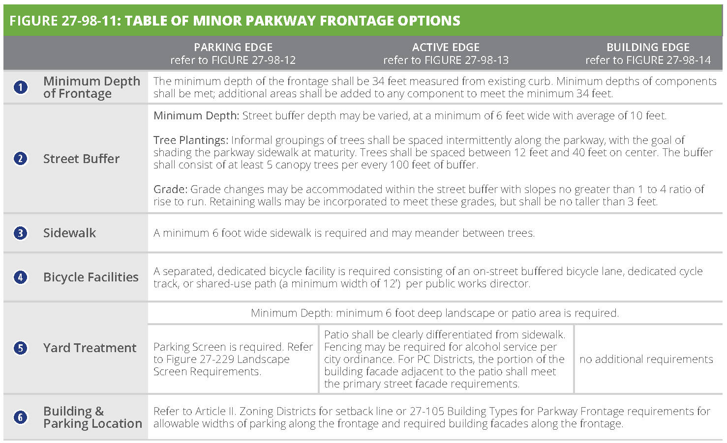
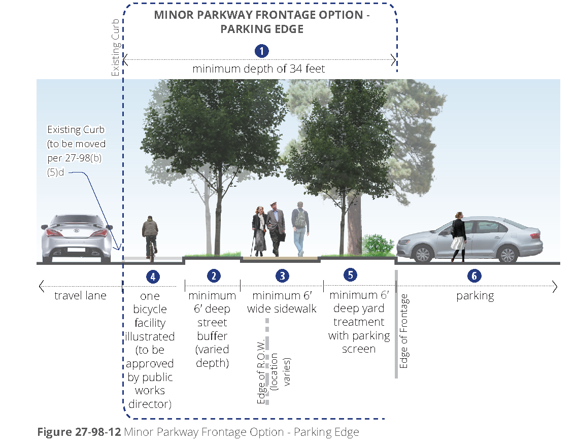
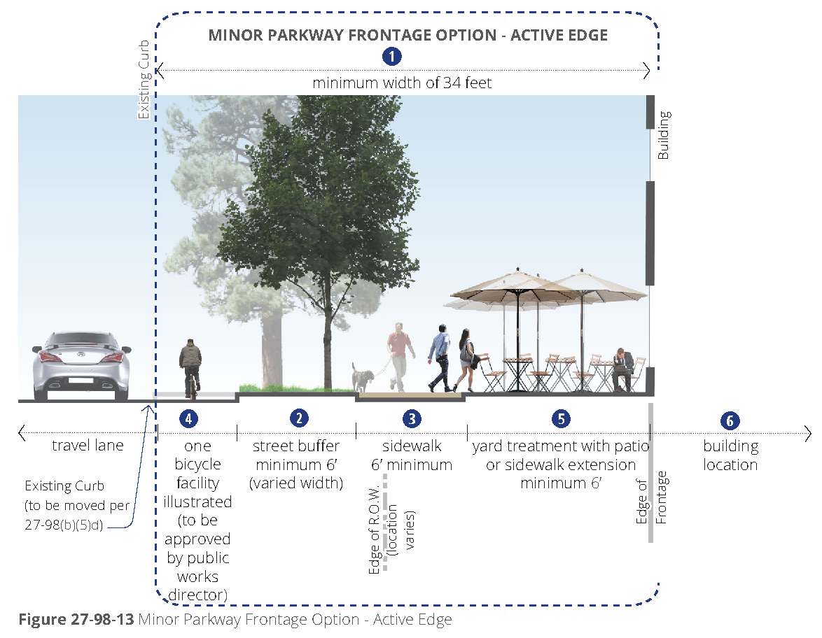
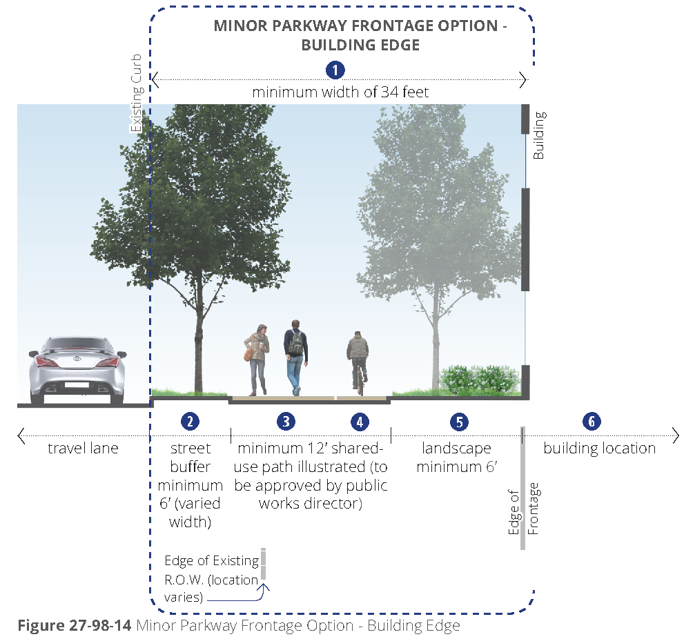
Minor parkway street type. The minor parkway street type applies to existing streets per figure 27-98-2 street types map and is available for new streets per public works director. Refer to figure 27-98-9. Table of minor parkway street type requirements and figure 27-98-10 minor parkway street section - existing and new.
a.
New minor parkway streets. New minor parkway streets are not permitted, unless a minor exception is approved by the public works director.
b.
Frontage options. Frontages address the pedestrian and bicycle realm as well as street and parking buffers and public space options. Parcels that are adjacent to a minor parkway as designated on figure 27-98-2, street types map, shall apply one or more of the minor parkway street frontage options along the entire length of the lot line abutting the minor parkway. Refer to figure 27-98-11, table of minor parkway street type frontage options.
c.
Dedication. When the sidewalk is fully or partially located on private property, right-of-way dedication is required, so that the sidewalk is fully located in the right-of-way. The public works director may approve an easement in lieu of right-of-way dedication based on the geometry of the site, topography, or other site-specific considerations.
d.
Curb movement. The existing street curb may be required to move, based on the selection of the appropriate, context sensitive bicycle facility, per the public works director.
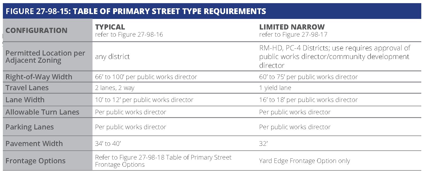
(7)
Primary street type. The primary street type applies to new and existing streets per figure 27-98-2, street types map.
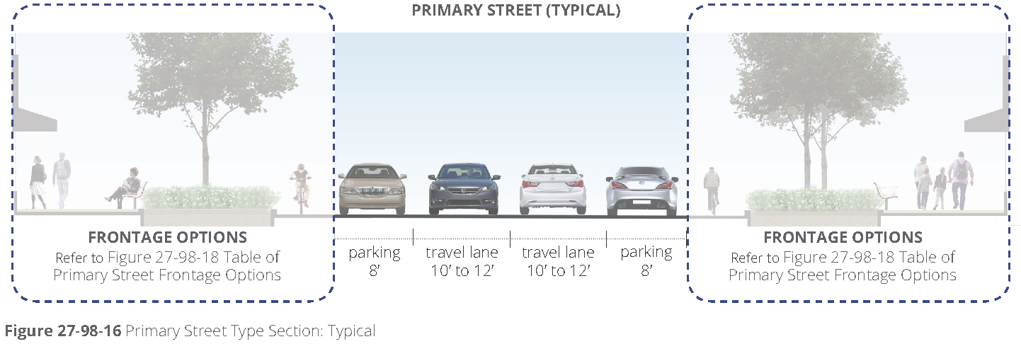
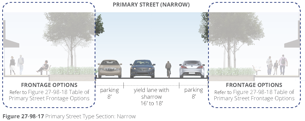
a.
New primary streets. Refer to figure 27-98-15, table of primary street type requirements, for primary street type requirements for new streets, figure 27-98-16, primary street type section: typical, illustrates the typical street section. A narrow version is available for limited application (refer to figure 27-98-17, primary street type section: narrow).
b.
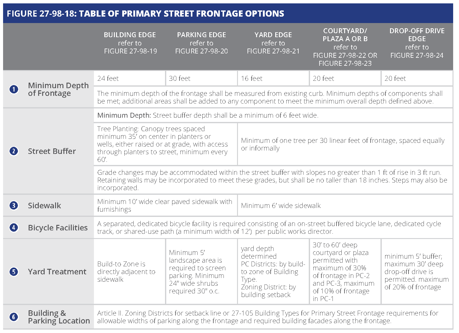
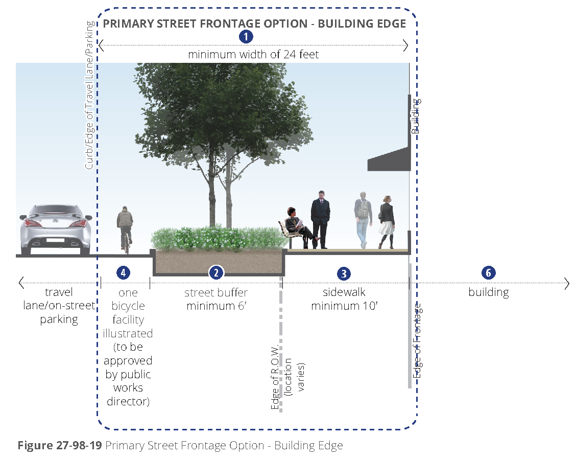
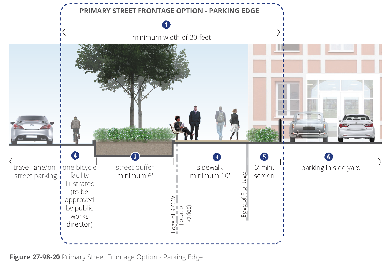
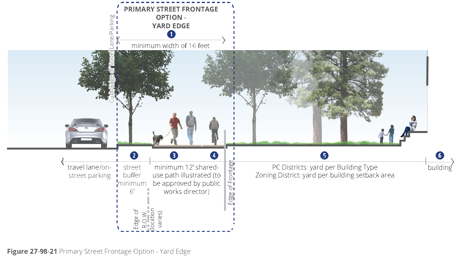
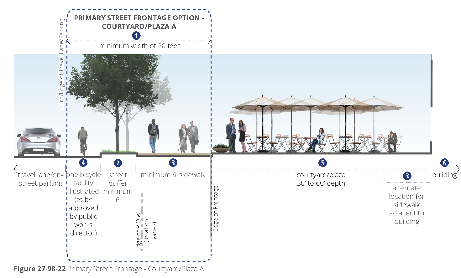
Frontage options. Frontages address the pedestrian and bicycle realm as well as street and parking buffers and public space options. Parcels that are adjacent to a primary street as designated on figure 27-98-2, street types map shall apply one or more of the primary street frontage options along the entire length of the lot line abutting the minor parkway. Refer to figure 27-98-18, table of primary street frontage options.
c.
Dedication. When the sidewalk is fully or partially located on private property, right-of-way dedication is required, so that the sidewalk is fully located in the right-of-way. The public works director may approve an easement in lieu of right-of-way dedication based on the geometry of the site, topography, or other site-specific considerations.
d.
Curb movement. The existing street curb may be required to move, based on the selection of the appropriate, context sensitive bicycle facility, per the public works director.
(8)
Secondary street type. The secondary street type applies to new and existing streets per figure 27-98-2, street types map.
a.
New secondary streets. Refer to figure 27-98-25, table of secondary street type requirements for secondary street type, requirements for new streets, figure 27-98-26, secondary street type section - typical, illustrates the typical street section. A narrow version is available for limited application (refer to figure 27-98-27, secondary street type section - narrow).
b.
Frontage options. Frontages address the pedestrian and bicycle realm as well as street and parking buffers and public space options. Parcels that are adjacent to a secondary street as designated on figure 27-98-2, street types map, shall apply one or more of the secondary street frontage options along the entire length of the lot line abutting the secondary street. Refer to figure 27-98-28, table of secondary street frontage options.
c.
Dedication. When the sidewalk is fully or partially located on private property, right-of-way dedication is required, so that the sidewalk is fully located in the right-of-way. The public works director may approve an easement in lieu of right-of-way dedication based on the geometry of the site, topography, or other site-specific considerations.
d.
Curb movement. The existing street curb may be required to move, based on the selection of the appropriate, context sensitive bicycle facility, per the public works director.
(c)
Streets and blocks.
(1)
Intent. The intent of the following requirements is to form an interconnected network of streets with multiple intersections and block sizes scaled to support multiple modes of transportation, including walking, biking, transit use, and driving, within the Perimeter Center Overlay area. Also refer to chapter 16 for additional regulations.
(2)
Applicability. All new development and redevelopment on site five acres or larger within the Perimeter Center Overlay shall meet the general block, lot, and street design requirements under any of the following circumstances:
a.
New structure. Development of a new principal structure on a lot or portion of a lot.
b.
Redevelopment or renovation. Redevelopment or renovation to an existing structure or site that increases the gross building square footage by more than 50 percent.
c.
Parking lots. Redevelopment or revision to 50 percent or more of an existing parking lot or development of a new parking lot consisting of 15 or more spaces, not including resurfacing or repairing an existing layout.
(3)
New street locations.
a.
Street types map. Proposed street locations are illustrated on figure 27-98-2, street types map, defined to establish a network that would fulfill the streets and blocks intent and regulations.
b.
Public works director. Locations illustrated on the street types map are approximate. The requirements and locations of all streets shall be determined by and approved by the public works director during the site plan review process.
(4)
Street connectivity. The following provides requirements and guidance for locating new streets and connecting to surrounding context.
a.
The arrangement of streets shall provide for the continuation of existing streets from adjoining areas into new developments.
b.
Cul-de-sac and dead end streets should be avoided and utilized only when topography and other existing barriers, such as highways, rail lines, or waterways, prevent street connectivity.
c.
Streets should follow natural features rather than interrupting or dead-ending at the feature.
d.
Streets should terminate at another street with either open space or a building façade across from the termination.
e.
When adjacent developments do not provide connectivity, coordinate with the community development director and public works director to determine the potential for future connections and provide for those connections.
(5)
Block configuration. Refer to figure 27-98-31 for an illustration of typical block elements and section 16-240 for blocks.
a.
Blocks should be deep enough to accommodate buildings facing streets with parking located in the interior. Refer to [subsection](b), street types, for minimum building frontages required for all streets.
b.
Blocks may be configured to include existing lots within an existing zoning district that is outside of the Perimeter Center Overlay.
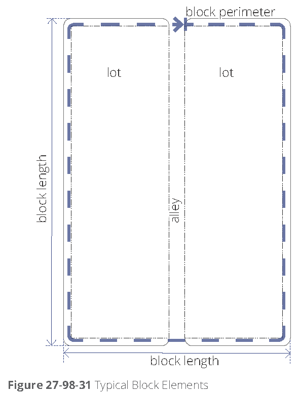
c.
A network of streets is required to meet the maximum block size requirement. Proposed new streets to meet these sizes are illustrated on figure 27-98-2, street types map.
d.
Block sizes for zoning districts. Block sizes for residential and commercial development and redevelopment are designated in section 16-240.
e.
Block sizes for Perimeter Center (PC) districts. Maximum block perimeter for all PC districts is 2,400 feet. Recommended block perimeter is a maximum of 1,800 feet.
f.
Exceptions. Exceptions to block sizes include locations adjacent to natural features, such as steep grades and drainage areas, and other existing barriers, such as an inability to connect to adjacent parcels.
(6)
Block driveway access configurations.
a.
Blocks may include alleys, drives, or driveway entrances for service, parking accessibility, and other routes internal to the development.
b.
Access to blocks should be aligned across the street from access to other blocks.
c.
In the Perimeter Center districts, driveway locations are defined in the general building type requirements. Refer to [section] 27-105(a)(10), driveways.
d.
Mid-block pedestrianways. Mid-block pedestrianways are required through blocks longer than 800 feet and at locations that connect public rights-of-way with other public facilities such as parks and transit.
1.
When combined with mid-block street crossings, these pathways should align to facilitate easy pedestrian movements.
2.
Mid-block pedestrianways should be located in the middle third of a block face.
3.
Minimum width for mid-block pedestrianways rights-of-way or easements is 20 feet.
4.
A minimum of one canopy tree per 600 square feet of area is required.
5.
Mid-block pedestrianways should be treated with the minimum design requirements per [subsection] (b)(4), streetscape furnishings and hardscape design.
6.
Shared-use paths through blocks per [subsection] (b)(3)d, may fulfill the requirements for mid-block pedestrianways.
(7)
Street types. Refer to [subsection] (b), street types, for requirements for streets.
a.
Street type. All new and existing streets shall utilize one of the permitted street types per figure 27-98-2 and the requirements of [subsection] (b), street types.
b.
Frontage options. For each side of a street adjacent to or within the development, one of the frontage options defined by street type shall be utilized.
c.
Other internal street. Other street types completely internal to the development may be approved by the public works director and the community development director through minor exception.
d.
Public use. All streets shall be available for public use at all times. Gated streets and streets posted as private are not permitted.
e.
Dimensions. The dimensions defined in each street type provide the acceptable ranges. The public works director shall determine the appropriate configuration and dimensions for each street. Minor exceptions may be approved by the public works director during the approval process.
f.
Additional director requirements. During the pre-submittal conference, the community development director and/or public works director may adjust requirements for right-of-way, pavement width, or street elements depending on unique site locations and characteristics.
g.
Street construction. All street construction, whether publicly dedicated or privately held, shall follow street type and frontage requirements and any other specifications defined by the city.
h.
Private streets. Private streets that prevent street connectivity or are inconsistent with adopted plans shall not be permitted.
(d)
General building design criteria.
(1)
Intent. These criteria are intended to address each building's appearance and cohesiveness within the overall Perimeter Center Overlay area. Further, the criteria are intended to elicit high quality buildings, enhance the pedestrian experience, maintain an appropriate scale, and implement the vision for the area as defined in current plans.
(2)
Applicability. The following outlines the general design criteria applicable to all buildings within the Perimeter Center Overlay.
a.
Applicable façades. These criteria apply to all façades visible from the street, facing streets, facing main parking lots, and adjacent to open spaces, unless otherwise noted.
b.
Applicable development sites. All new development and redevelopment within the Perimeter Center Overlay shall meet the general building design requirements under any of the following circumstances:
1.
New structures and additions. Development of a new principal structure or additions to a principal structure on a lot or a portion of a lot.
2.
Existing façade renovation. An alteration to an existing structure that includes renovation of more than 50 percent of an applicable façade.
(3)
Materials.
a.
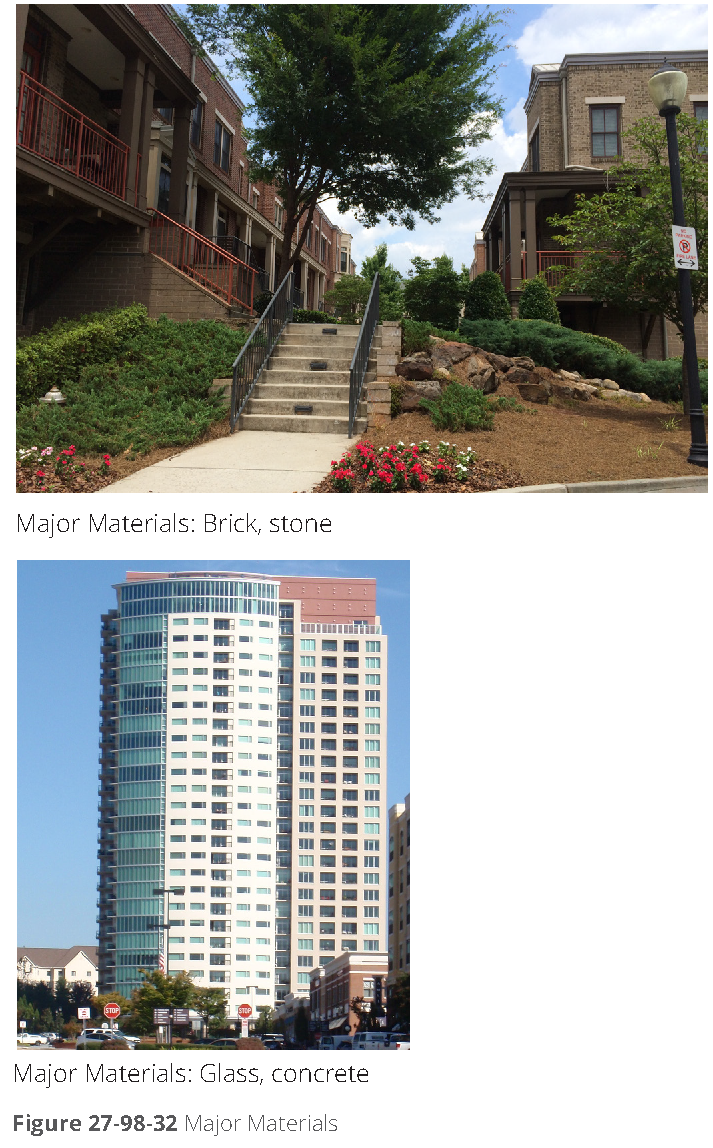
Major façade materials. Major façade materials include high quality, durable, finish materials, such as brick, stone, and glass. Other high quality materials may be approved by the director of community development during the site plan process. A minimum of 80 percent of each façade shall be constructed of major materials. Street façade materials shall continue around the corner of the building to non-street-facing façades a minimum depth of 20 feet. Refer to figure 27-98-32, major materials.
b.
Minor materials. Acceptable high quality minor façade materials include all major materials; cement-based stucco; wood lap siding and shingles;, architectural metal siding; architecturally finished concrete; fiber cement siding or shingles (such as Hardie Company products or similar); synthetic stucco/EIFS (see restrictions below); glass block; split-faced, burnished, glazed, or honed concrete masonry units (CMU), cast stone concrete elements. No more than 20 percent of each façade shall consist of minor materials.
c.
Accent materials. The following materials may be used for trim, details, soffits, eaves, and other accent areas: vinyl; aluminum and other durable metals; and metal for beams, lintels, trim, and ornamentation. Other materials may be approved by the director of community development during the site plan process.
d.
Restrictions.
1.
The use of plain CMU block and vinyl are prohibited as a façade material.
2.
Synthetic stucco (EIFS) used on the first or second floor of a building shall be a "high-impact" system. Conventional EIFS may be used above the second floor.
e.
Roof materials. Wherever asphalt shingles are used, they shall be a minimum three-dimensional architectural type.
(4)
Windows, awnings, and shutters.
a.
Quantity of windows. Window coverage is required for street facing façades and façades visible from the street that are fully or partially set back no more than 50 feet from the street.
1.
Measurement and Placement. Window requirements are measured as a percentage of the façade, or only the portion of the façade within 50 feet of a street, per floor. Windows shall be placed within the area they are measured.
2.
Blank walls. Windows shall be distributed so that no rectangular area greater than 30 percent of any story's façade, as measured from floor to floor, and no horizontal segment of a story's façade greater than 30 feet in width is windowless and violates the minimum percentage requirements.
3.
Visibility. One hundred percent of the required street-facing, street-level window pane surface area must allow viewing into the ground story for a minimum of eight feet in depth. Unless permitted by the sign ordinance, windows cannot be made opaque by non-operable window treatments. Acceptable operable window treatments include curtains, blinds, and shades.
b.
Transparent glass. All window glass shall be highly transparent with low reflectance. Light transmission should be approximately 60 percent for ground story windows and a minimum of 55 percent for upper story windows.
c.
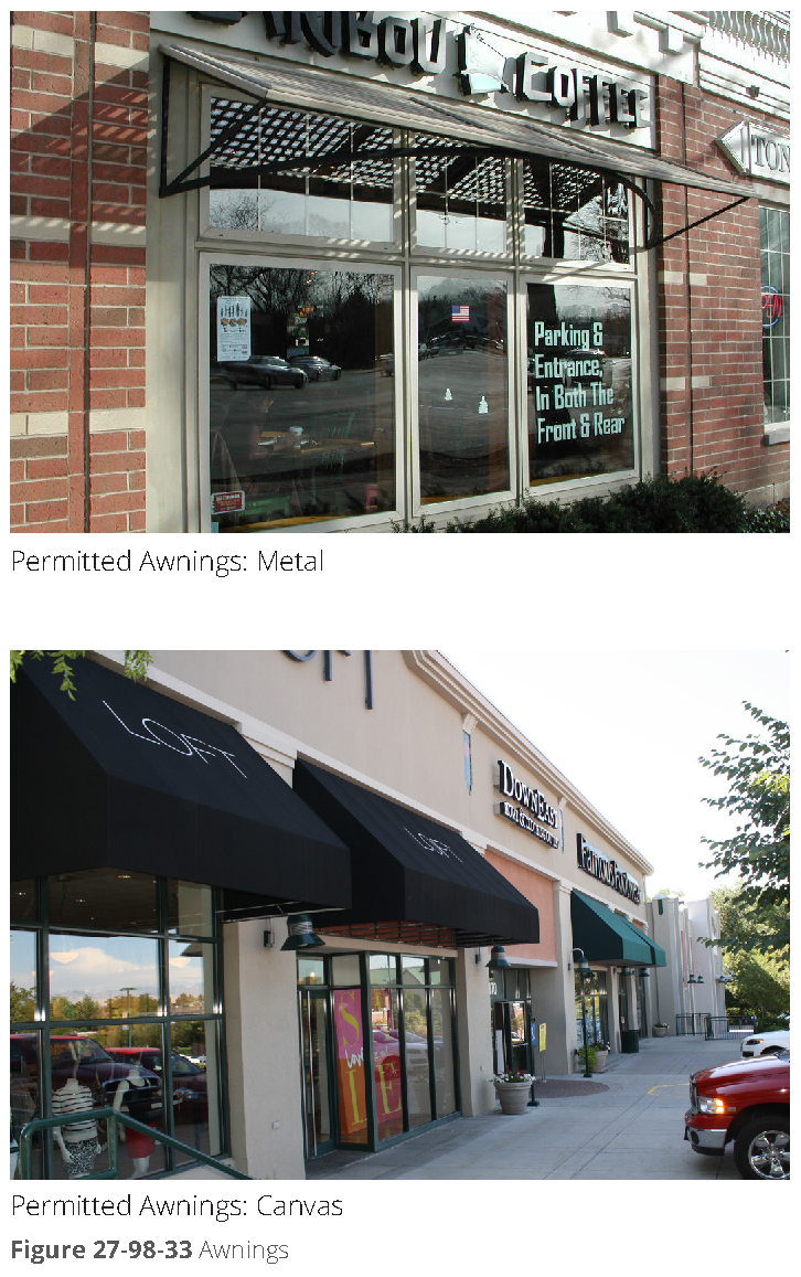
Awnings. All awnings shall be canvas or metal. Plastic awnings are prohibited. Awnings shall not be translucent. Refer to figure 27-98-33, awnings.
d.
Shutters. If installed, shutters, whether functional or not, may be designed to the following standards:
1.
All shutters should be sized for the windows, so that if the shutters were to be closed, they would not be too small for complete coverage of the window.
2.
Shutters should be wood, metal, or fiber cement. Other "engineered" woods may be approved during the site plan process with an approved sample and examples of successful, high quality local installations.
(5)
Garage doors. The following requirements apply to garage doors provided on any street façade:
a.
Location. Garage doors are not permitted on primary street façades unless not utilized for vehicular access (but for patio access, open air dining). Garage doors are permitted on secondary street façades with direct access to the street. The preferred location is on interior lot façades.
b.
Recessed from façades. Garage doors located on street facing façades shall be recessed a minimum of three feet from the dominant façade of the principal building facing the same street.
c.
Design. Garage doors facing a secondary street and intended to be closed during business hours shall be clad with materials consistent with the design of the building. Carriage-style doors are required on the townhouse and detached house building type.
(6)
Ground story at sloping façades.
a.
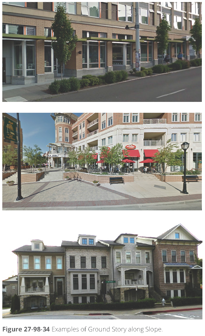
Intent. Given the slopes in many parts of the Perimeter Center area, building design must accommodate grade changes along the sidewalk without creating tall, out-of-scale blank walls. Large, unarticulated building façades signal to pedestrians that an area is not intended for walking, reducing activity in the area and creating dead zones. Refer to figure 27-98-34, examples of ground story along slope.
b.
Regulations for shopfronts.
1.
Grade transitions on the building along the sidewalk should be designed to maximize active pedestrian-scale frontages between waist and eye level while minimizing blank walls.
2.
Unless impracticable, the interior floor level should step to match the exterior grade.
3.
If it is necessary for the interior floor to remain constant along the grade, changes may be accommodated by a storefront window display space.
4.
Knee wall and retaining walls shall not exceed 30 inches in height except along a maximum 15-foot section of façade length.
5.
If grade change is more than 12 feet along a single block face, entrance requirements may be increased to one entrance per 80 feet of building frontage.
6.
Building entrances adjacent to the street should be within three feet of the elevation of the adjacent sidewalk, unless utilizing the PC district building types.
c.
Regulations for residential and other building frontages.
1.
Grade transitions at the building along the sidewalk should be designed to minimize blank walls.
2.
Unless impracticable, the interior floor level should step to match the exterior grade.
3.
Multiple front entrances along the street activate each segment of building section at each grade.
4.
Transition zones between the sidewalk and building façade of porches, terraces, and landscape areas may be used assist with grade changes.
5.
If it is necessary for the interior floor to remain constant along the grade, changes can be accommodated by terraced planters and retaining walls.
6.
Retaining walls shall not exceed 30 inches in height except along a maximum 15-foot section of frontage.
7.
When the elevation of the first floor is more than three feet above grade, windows should be provided into the basement or lower floor elevations.
(7)
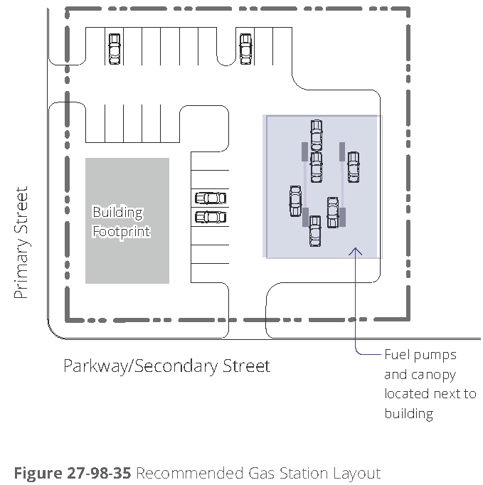
Fueling stations. Refer to figure 27-98-35, recommended gas station layout, for one illustration of the following criteria:
a.
Building location. A principal building should be built up to any corner with the longest façade along any primary street. If no primary street abuts the parcel, along the parkway façade.
b.
Side yard parking. One double loaded aisle of parking is permitted on the interior side along a primary street, perpendicular to the street.
c.
Pumps and canopy location. The pumps and canopy may be located on the interior of the parcel, but may have driveways to a street.
d.
Building build-to zone. A building should be built to within five feet to 15 feet of the edge of the street type frontage.
e.
Building façade design. The façade of all buildings shall meet all general design criteria within this section, [subsection] (d), general building design criteria.
f.
Canopy design. The canopy, columns, and structure shall be constructed substantially of the same materials utilized on the building.
g.
Pavement. Site paving shall consist of maximum 22-foot driveways and lanes along parking and along pumps. All other areas shall be landscaped.
h.
Frontage. A maximum of 50 percent of the frontage may be used for parking and fuel areas.
(8)
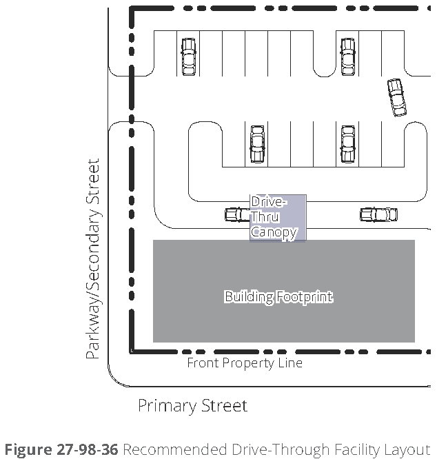
Accessory drive-through structures. Refer to figure 27-98-36, recommended drive-through facility layout, for one illustration of the following requirements:
a.
Structure/canopy. Drive-through structures or canopies shall be located on the rear or side façade of the building or in the rear of the lot behind the building, where permitted by use. The structure should not be visible from any primary street.
b.
Stacking lanes. Stacking lanes shall be located perpendicular to the primary street or behind the building.
c.
Canopy design. The canopy, columns, and structure shall be constructed substantially of the same materials utilized on the building.
(9)
Parking structures fronting a street. The following requirements are provided for parking structures fronting a secondary street or parkway.
a.
Primary streets. Parking structures, whether accessory or principal use, shall not front a primary street, unless otherwise approved with special land use permit per article V, division 3.
b.
Perimeter Center districts. In the Perimeter Center (PC) districts, parking structures as the principal use on the lot require a special land use permit (refer to article V, division 3, special land use permits).
c.
Parking structure design requirements.
1.
Blank wall limitations. On any street façade, no rectangular area greater than 30 percent of any story's façade, as measured from floor to floor, and no horizontal segment of a story's façade greater than 15 feet in width may be solid, blank wall.
2.
Pedestrian entry. A defined pedestrian entrance/exit is required separate from the vehicular entrance and directly accessing the sidewalk. If the entry is enclosed, windows are required to meet a transparency rate of 65 percent.
3.
Structures along highways. Structured parking located along highways shall incorporate architectural elements (e.g., trellises, planters, landscape, panels) that provide visual screening of vehicles and interior lighting.
(10)
Pedestrian entrances. A street-facing pedestrian entrance is required for each ground floor, commercial tenant suite. The entrance must be open during the respective business' hours of operation. A pedestrian entrance is defined as a main point of access for pedestrians into a building or suite within a building.
(Ord. No. 2017-05-14, § 1(Exh. A), 5-22-2017; Ord. No. 2022-06-12, § I, 6-13-2022)
Sec. 27-103. - General.
(a)
Intent and applicability.
(1)
Intent. The Perimeter Center (PC) district regulations are intended to promote the same purposes identified for the Perimeter Center Overlay, as stated in [section] 27-98(a)(2).
(2)
Applicability. The PC zoning district regulations apply to properties zoned to a PC district in accordance with the regulating map (figure 27-104-1) and the amendment procedures of article V, division 2.
(b)
Administration and procedures.
(1)
Establishment of Perimeter Center districts. Perimeter Center (PC) zoning district classifications may be applied to property and PC district boundaries may be amended only in accordance with the amendment procedures of article V, division 2 and the regulating map of figure 27-104-1.
(2)
Effect of establishment. Once property has been classified in a Perimeter Center district, that property is subject exclusively to the applicable Perimeter Center district regulations and any applicable overlay district regulations.
(3)
Review and approval procedures. Unless otherwise expressly stated, all uses and development in Perimeter Center districts are subject to the applicable review and approval procedures of article V, as well as any applicable procedures in chapter 16 of the municipal code (land development regulations).
(4)
Site plan review. All applications for development permits within a Perimeter Center district must be accompanied by a site plan, which is subject to review and approval in accordance with article V, division 10.
(5)
Relief. The Perimeter Center districts are intended to accommodate development as-of-right when such development occurs in strict conformance with applicable regulations. In some instances, however, unique site conditions, existing building circumstances or other constraints related to the subject property may make strict compliance impossible or highly impractical. In such instances, an applicant may seek relief from applicable regulations. Any relief granted and conditions imposed run with the land and are binding on the subject property owner and all future property owners.
a.
Minor exception—Administrative relief. The community development director is authorized to approve the following minor exceptions in accordance with the special administrative permit procedures of article v, division 7:
1.
The location of a building relative to any minimum setback requirement or build-to zone width/location, provided that location deviates from strict compliance by no more than five feet;
2.
An increase in total impervious coverage by no more than five percent, not to exceed the total amount of permitted impervious plus semi-pervious coverage;
3.
A decrease in build-to zone coverage by no more than ten percent;
4.
A reduction in the amount of required shopfront building frontage along primary streets, by no more than ten percent;
5.
Additional height of any building story by no more than two feet, provided that the overall building height does not exceed the maximum permitted height;
6.
An increase in the maximum permitted height of a retaining wall by up to five feet; and
7.
Any other minor exception expressly authorized under the Perimeter Center district regulations.
b.
Major exceptions—Special land use permit. Major exceptions to strict compliance with the Perimeter Center district regulations include any exception to strict compliance that is not expressly authorized as a minor exception under the provisions of section 27-103(b)(5)a. Major exceptions require review and approval in accordance with the special land use permit procedures of article V, division 3.
(c)
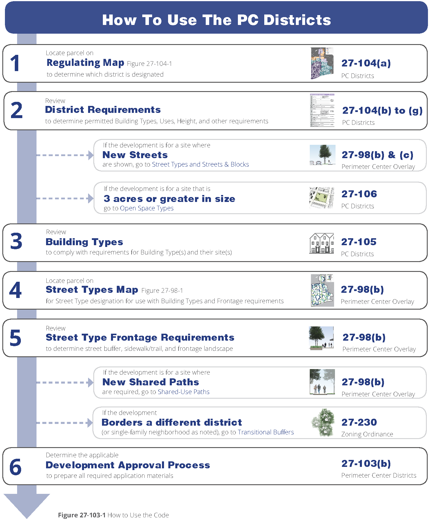
How to use this code. Refer to figure 27-103-1, how to use the code, for an overview of code use.
(Ord. No. 2017-05-14, § 2(Exh. B), 5-22-2017)
Sec. 27-104. - Districts.
(a)
Districts and regulating map.
(1)
District map. The permitted location for each Perimeter Center district is designated in figure 27-104-1, regulating map.
(2)
District requirements. The requirements in this subsection apply to the Perimeter Center districts as follows.
a.
Requirements specific to each district. Refer to [sections] 27-104(b) through 27-104(e) for specific descriptions and requirements for each district.
b.
Use requirements for all districts. Refer to [section] 27-104(f) uses for use requirements applicable to all districts.
c.
Sustainability measures for all districts. Refer to [section] 27-104(g), sustainability measures, for sustainable development practice requirements applicable to all districts.
(3)
Street types. Refer to section 27-98(b)(b) street types within the Perimeter Center Overlay for information on street types and street frontage requirements applicable to all Perimeter Center districts.
(4)
Transition yards. Refer to section 27-230, transition yards, for information on buffer and screen requirements between different districts and uses.
(5)
New streets and blocks. Refer to section 27-98(c), streets and blocks, within the Perimeter Center Overlay for information on new street design requirements and block configurations.
(6)
Other Perimeter Center Overlay requirements. Refer to section 27-98(d), general building design criteria within the Perimeter Center Overlay.
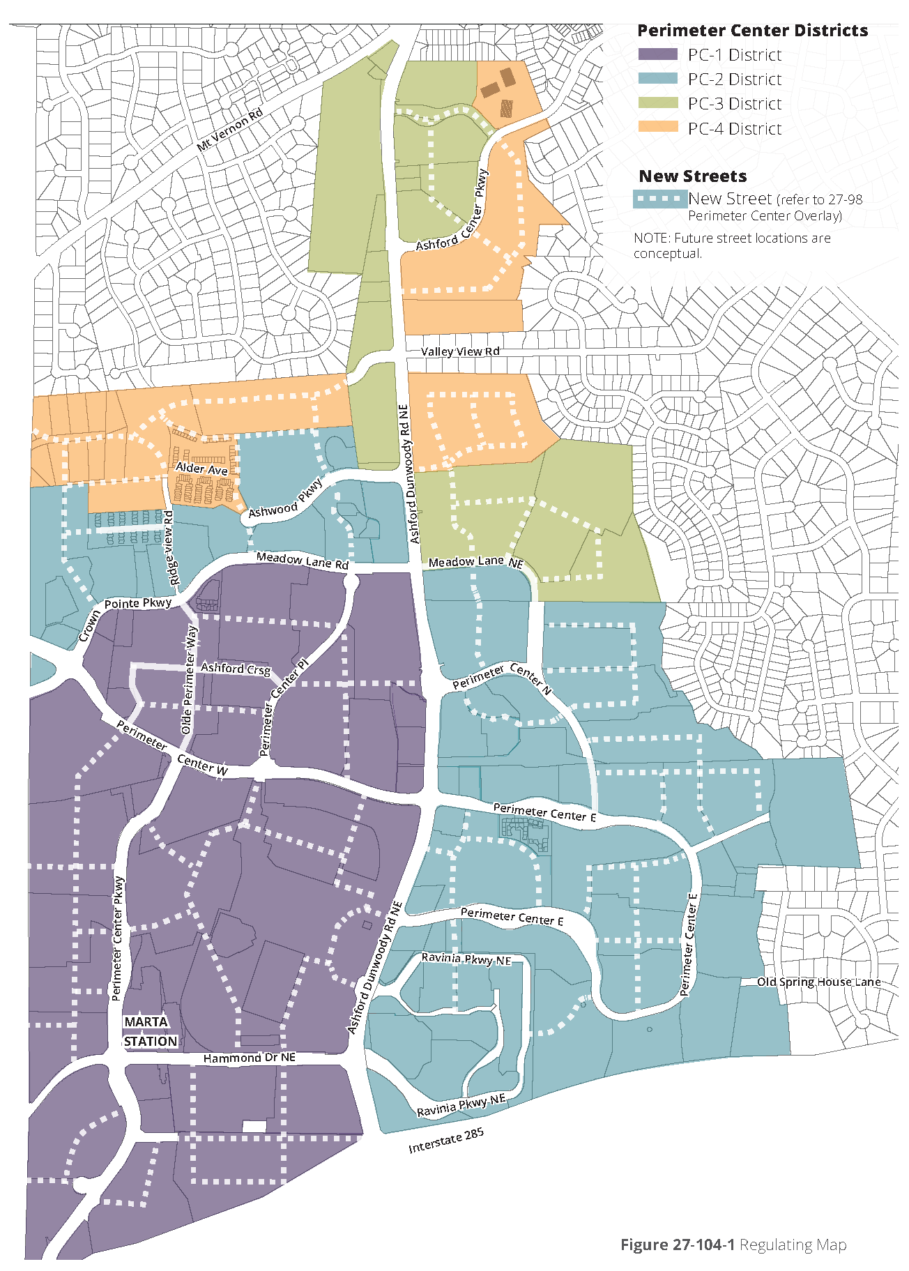
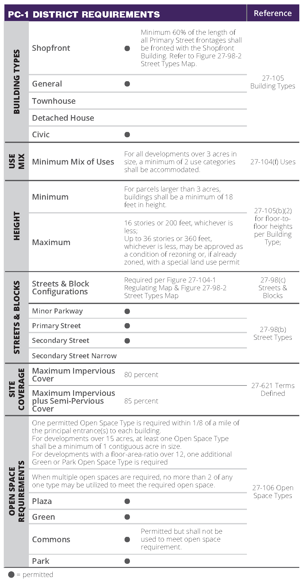
Figure 27-104-2. PC-1 District Requirements
(b)
PC-1 district. Requirements for this district are provided in figure 27-104-2, PC-1 district requirements.
(1)
Description and intent. The PC-1 district is intended to apply to the central core area of Perimeter Center, including the area directly surrounding the Dunwoody MARTA train station. This district allows for the highest intensity of buildings, a high level of employment uses, and active ground story uses and design that support pedestrian mobility.
(c)
PC-2 district. Requirements for this district are provided in figure 27-104-3, PC-2 district requirements.
(1)
Description and intent. The PC-2 district is meant primarily for employment uses, residential buildings, and limited shopfront retail and services.
Figure 27-104-3
(d)
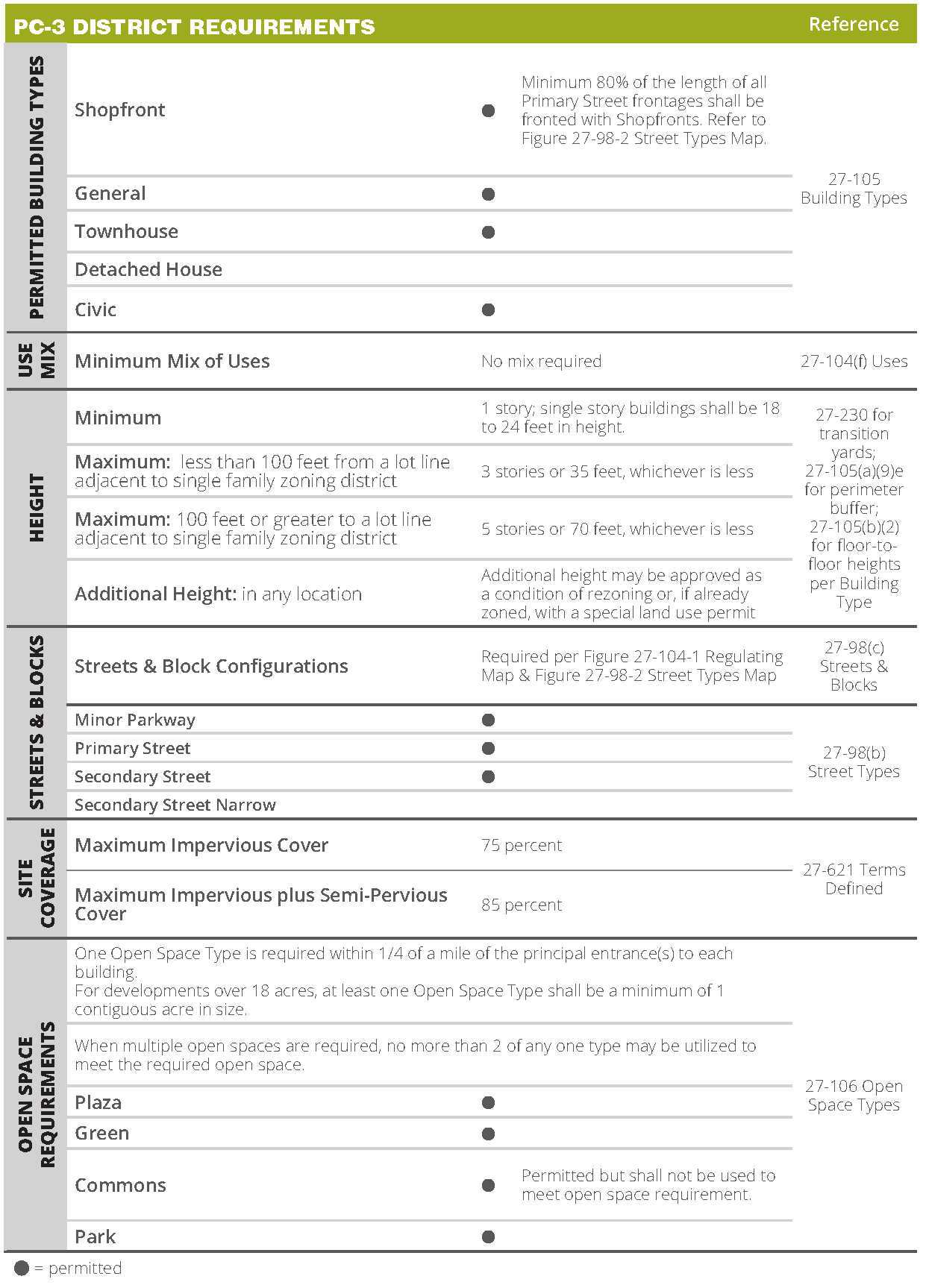
PC-3 district. Requirements for this district are provided in figure 27-104-4, PC-3 district requirements.
(1)
Description and intent. The PC-3 district is a smaller scale less intensive commercial district, permitting both shopfront buildings and office buildings.
Figure 27-104-4. PC-3 District Requirements
(e)
PC-4 district. Requirements for this district are provided in figure 27-104-5, PC-4 district requirements.
(1)
Description and intent. The PC-4 district is primarily meant for residential uses at a scale that provides a transition between the intensity of Perimeter Center and the surrounding single-family residential neighborhoods.
Figure 27-104-5. PC-4 District Requirements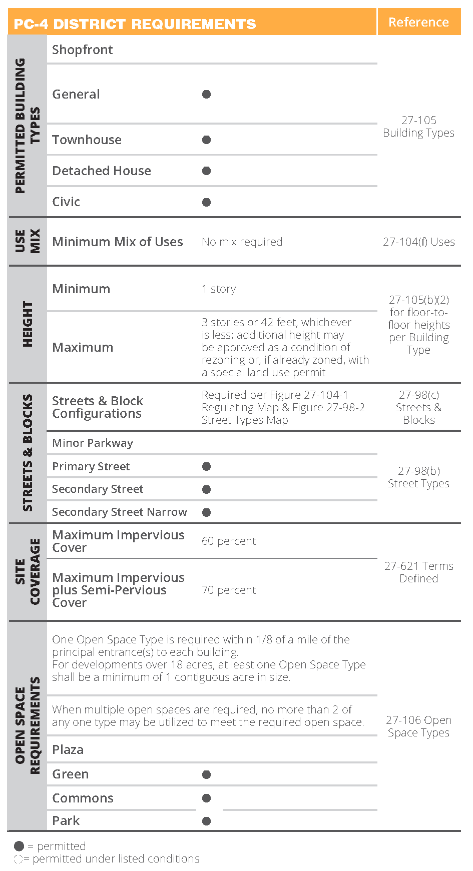
(f)
Uses. The following applies to all Perimeter Center districts.
(1)
Use table. The following apply to the uses outlined in this section. Refer to figure 27-104-6, table of permitted uses.
a.
Use categories. Refer to sections 27-111 through 27-116.
b.
Permitted and special uses. Each use may be permitted as-of-right, permitted with a special administrative permit, permitted as a special exception, or permitted with a special land use permit. Refer to section 27-111(4), use tables.
c.
Number of uses. A lot may contain more than one use.
d.
Principal and accessory uses. Each of the uses may function as either a principal use or accessory use on a lot, unless otherwise specified.
e.
Building type. Each use shall be located within a permitted building type (refer to section 27-105, building types), unless otherwise specified.
(2)
Use subcategories. For the purposes of fulfilling the use mix requirements defined in each district table (refer to section 27-104(b), PC-1 district through section 27-104(e), PC-4 district), utilize the following subcategories of uses, consisting of those uses listed in the table, right, that may contribute to the mix. Some permitted uses are not included.
a.
Lodging and residence subcategory.
Household living;
Group living;
Lodging.
b.
Civic subcategory.
Club or lodge, private;
Cultural exhibit;
Educational services;
Hospital;
Place of worship.
c.
Office subcategory.
Construction and building sales and service;
Medical service;
Office or consumer service;
Research and testing services.
d.
Retail sales subcategory.
Retail sales;
Food and beverage retail sales.
e.
Service use subcategory.
Animal services;
Day care;
Repair or laundry services, consumer;
Personal improvement services;
Eating and drinking establishments;
Financial services;
Entertainment and spectator sports;
Sports and recreation, participant.
Table of Permitted Uses
[1] Where more than ten percent of the units are rental, a special land use permit is required
(g)
Sustainability measures.
(1)
Intent. The following requirements are intended to further the sustainability goals of the city defined in the most current sustainability plan adopted by the city.
(2)
Applicability. The sustainable development measures in this section shall be addressed by all new developments in a Perimeter Center (PC) district that involve the complete replacement of an existing building or construction of a new building.
(3)
Calculation and evaluation.
a.
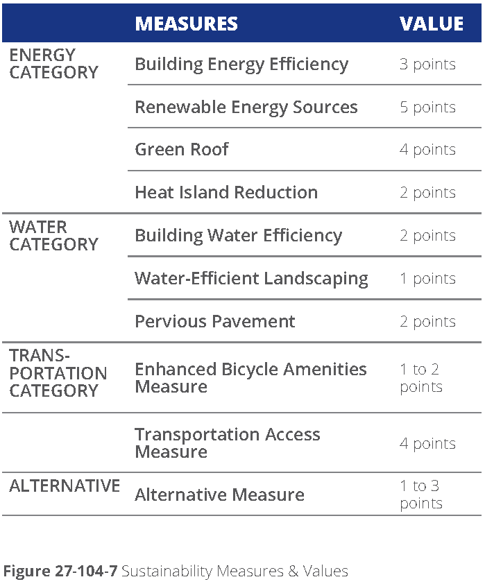
Minimum points required. The applicant shall achieve no fewer than seven points from any combination of the sustainable development measures as valued in figure 27-104-7, sustainability measures and values. No partial points will be accepted.
b.
Minimum requirements of the measure. All points shall be awarded based on meeting the minimum requirements of each sustainability measure, as indicated in this section.
c.
Newly constructed measures. Measures count only if they are part of the new development application; measures already in place at the time of application do not count, unless otherwise approved by the community development director.
d.
Required documentation. The following documentation is required:
1.
Documentation of which measures and total number of points the applicant will achieve shall be indicated on the development permit application submitted to the city (refer to article V, division 9).
2.
Documentation is required to clearly illustrate the extent to which the minimum requirements of each of the selected measures is to be met through permanent construction or policies.
(4)
Energy category measures.
a.
Energy efficiency. Newly constructed buildings must demonstrate an average ten-percent improvement over the energy code currently in effect in the city.
b.
Renewable energy. Incorporate renewable energy generation on-site with production capacity of at least five percent of the building's annual electric or thermal energy, established through an accepted building energy performance simulation tool. The following renewable energy generation sources are applicable: solar thermal or photovoltaics, ground-sourced heating or cooling, fuel cells and microturbines using non-fossil fuel, wind energy conversion. Other means of generating electricity without using a fuel, such as kinetic, heat exchange, approved by the community development director.
c.
Green roof. Install a vegetated roof for at least 50 percent of any building roof area or roof deck; a minimum of 2,500 square feet is required to receive credit.
d.
Heat island reduction. Use any combination of the following strategies for 35 percent of all on-site, non-roof hardscape areas, including sidewalks, plazas, courtyards, parking lots, parking structures, and driveway: coverage of the surface at canopy tree maturity in 15 years, and/or solar reflective paving and roofing with a SRI (solar reflectance index) of at least 29.
(5)
Water category measures.
a.
Building water efficiency. Indoor water use in new buildings and major renovations must be an average 20 percent less than in baseline buildings. Baseline water usage shall be determined based on fixtures per the Energy Policy Act of 1992 and subsequent rulings by the United States Department of Energy or a similar method approved by the community development director.
b.
Water-efficient landscaping. Reduce potable water used for landscape irrigation by 50 percent from a calculated midsummer baseline case by using either one of the following methods: utilizing all xeriscape plant materials and providing no permanent irrigation system, or using only captured rainwater with an irrigation system.
c.
Pervious pavement. Install an open grid or pervious pavement system that is at least 40 percent pervious on 65 percent of all hardscape surface areas, including sidewalks, plazas, courtyards, parking lots, and driveways. The water shall be directed into the groundwater or other acceptable storm accommodation per the public works director.
(6)
Transportation category measures.
a.
Enhanced bicycle amenities measure. Inclusion of two of the following earns one point. Inclusion of three of the following earns two points.
1.
Lockable enclosed bicycle storage. Provide one secure, enclosed bicycle storage space for ten percent of planned employee occupancy with no more than ten spaces required.
2.
Employee shower facilities. Provide a minimum of one shower facility per 150 employees, minimum of one total.
3.
Repair center. Provide a designated bicycle repair center open to the public and consisting of, at least one air pump, water, and basic tools for minor repairs.
b.
Transportation access measure. Site must be within one-fourth mile of existing or proposed transit stop with provision of enhanced access to transit and shall include one or more of the following.
1.
Construction of a bus turnout on development property or in adjacent street right-of-way.
2.
Construction of additional shared use paths other than those required per [section] 27-98(b)(3)d, shared use paths.
3.
Provision of direct platform connection to rail station.
4.
Additional easement for provision or enhancement of transit.
5.
Other items approved by the public works director.
(7)
Alternative measure. The applicant may submit an alternative sustainable development measure for approval by the community development director. The measure shall further a sustainability goal and shall not be considered standard practice for current developments. The measure shall be unrelated to any of the other measures defined in this section. Based upon their review, the community development director shall approve for the number of points to be awarded. Required documentation shall clearly illustrate that the measure furthers a sustainability goal.
(Ord. No. 2017-05-14, § 2(Exh. B), 5-22-2017; Ord. No. 2019-01-03, § I, 1-28-2019; Ord. No. 2020-03-04, § II, 3-9-2020; Ord. No. 2021-09-14, § VIII, 9-27-2021; Ord. No. 2022-01-02, § III, 1-10-2022; Ord. No. 2023-08-09, § II, 8-14-2023; Ord. No. 2023-10-14, § II, 10-16-2023; Ord. No. 2024-07-05, § III, 7-22-2024)
Sec. 27-105. - Building types.
(a)
Requirements for all building types. The building types detailed in this section outline the required building forms for new construction and renovated structures within the Perimeter Center districts defined in [section] 27-104, districts.
(1)
Applicability. The requirements of this section apply to all new development, or new structures or buildings, established in [section] 27-103(a)(2). All structures must meet the requirements of one of the building types permitted within the zoning district.
(2)
Districts, building types, and street types. For each lot, a designated Perimeter Center district is found on figure 27-104-1, regulating map.
a.
District. Each district, per [section] 27-104, districts, has a set of requirements related to streets, open space, uses, and permitted building types.
b.
Building types. Each building type, as established in this section 27-105, has a set of requirements, including requirements related to the façades facing different street types.
c.
Street types. Street types, per section 27-98(b), street types, of the Perimeter Center Overlay, include frontage requirements for the space between the build-to zone of the building type and the curb of the street.
(3)
Uses. Uses are permitted by district, per [section] 27-104(f), uses. Each building type can house a variety of uses depending on the district in which it is located. Some building types have additional limitations on permitted uses as located within the building.
(4)
General building design requirements. Refer to section 27-98(d), general building design criteria within the Perimeter Center Overlay, for information on building design requirements additional to and applicable to all building types.
(5)
Multiple principal structures. Multiple structures are permitted on all lots in the perimeter center districts. All structures shall meet the requirements of one of the permitted building types for the district.
(6)
Permanent structures. All buildings constructed shall be permanent construction, unless otherwise noted.
(7)
Other structures. Utility structures and towers permitted in the district are exempted from the building type standards.
(8)
Build to the corner. The corner of the lot is defined as the intersection of the two build-to zones of each street. Refer to figure 27-105-1, corner and build-to zones on different street types.
a.
Corners at primary street and parkways. Buildings shall be built up to the corner, occupying the intersection of the two build-to zones of any intersection of two primary streets, a primary street at any parkway, or two parkways. Courtyards shall not be located in this area.
b.
Corners involving secondary streets. Buildings should be built to the corner, occupying the intersection of the two build-to zones of any intersection involving a secondary street. Courtyards should not be located in this area.
(9)
Treatment of build-to zones, setbacks, and transition yards. Refer to [section] 27-621 terms defined for definition of build-to zones and setbacks.
a.
Landscape areas. All build-to zones and setbacks shall only contain courtyards (as permitted by street type frontage), plazas (as permitted by street type frontage), patios (as permitted by street type frontage), sidewalk or trail extensions, buffers, and/or landscape yards, unless otherwise specifically noted.
b.
Transition yards. Refer to [section] 27-230 for size and landscape requirements.
c.
Surface parking. Surface parking lot yard location is determined by building type and shall only be permitted in setbacks when the setback is labeled as a "building setback". Parking shall be set back from a lot line abutting another property a minimum of five feet. Refer to [section] 27-105(b), regulations specific to building types.
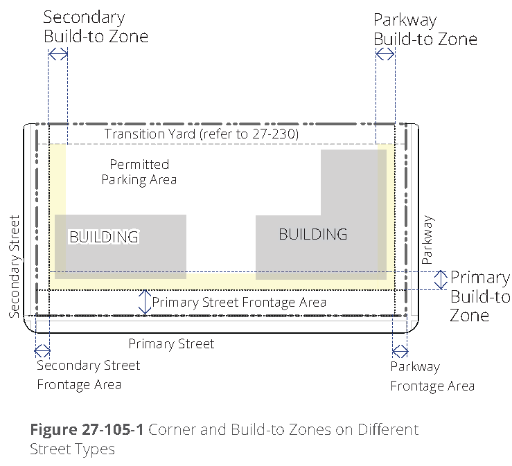
d.
Driveways. Driveways may cross perpendicularly through build-to zones and setbacks, when permitted per [section] 27-105(a)(10), driveways, below, or to connect to a parking lot on an abutting lots.
e.
Perimeter buffer. On all PC district lots, a required transition yard of 100 feet is established at the lot line of a PC district and any City of Dunwoody residential zoning district not within the PCID Overlay area. Within the perimeter buffer, building height is restricted to three stories or 42 feet, whichever is less. Refer to [section] 27-104, districts.
(10)
Driveway access. Location of vehicular driveway access is based on the major or minor parkway, primary street, and secondary street designations in figure 27-98-2, street types, map per the hierarchy as follows. Refer to figure 27-105-2, driveway locations by street type.
a.
Public works director. The public works director shall determine the quantity of driveways, need for closure of existing driveways, width of driveways, and proximity of driveways to other driveways or streets.
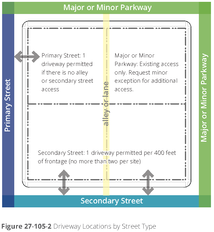
b.
Alleys/lanes. Access from an adjacent alley or lane is unlimited. Construction of new private or public alleys/lanes through blocks is encouraged. Typically, alleys or lanes cut through a block and provide vehicular access to multiple garages, parking lots, or service areas. Minimum pavement width for an alley or lane is 16 feet and maximum pavement width is 24 feet.
c.
Secondary street access. If no alley exists, one driveway access per 200 linear feet of street frontage or two total driveway access points, whichever is greater, are permitted from each secondary street per site.
d.
Primary street. If no alley or secondary street exists, one driveway access point is permitted off each primary street.
1.
Side parking off primary street. When side parking with the drive located perpendicular to the street centerline, is utilized as permitted by the building type, one driveway access is permitted off the primary street. This driveway counts towards entrances permitted by [section] 27-105(a)(10)d, above. The sidewalk paving shall extend across the driveway, signaling priority to the pedestrian.
e.
Parkways. If no alley, secondary street, or primary street exists, existing driveways may be utilized off parkways. New driveways off minor or major parkways are permitted only if no other option exists and a minor exception is granted by the public works director.
f.
Shared driveways. Shared driveways are encouraged for all other adjacent developments.
g.
Inter-lot drives. When two or more parking lots are located adjacent to each other and each lot contains the same building type, the parking lots shall be connected with a drive perpendicularly crossing the transition yard. Other parking lots should be connected wherever practical.
h.
Pedestrian facilities. At-grade, designated pedestrian routes, including sidewalks and crosswalks, shall be supplied connecting each parking area to either the primary sidewalk (and front entrance) or a rear public entrance.
1.
Crosswalks shall include pavers or colored concrete pavement across driveways.
2.
Vehicular areas, such as driveways, parking drive lanes, loading lanes, bike lanes/facilities, and parking areas, shall not be utilized as designated pedestrian routes.
3.
Pedestrian connections are desirable between all adjacent sites and land uses.
i.
Driveway width. Driveways shall be no greater than 22 feet in width at the right-of-way line. Driveways wider than 22 feet shall include landscaped, pedestrian refuge islands with a walk area to reduce the crossing to no more than 22 feet.
j.
Loading facilities. Loading facilities for all building types in all perimeter center districts shall be located as follows:
1.
Loading facilities shall not face primary streets.
2.
Loading facilities shall not be located in any required building setback area.
3.
Preferred location for loading facilities is on the interior of the lot, not visible from any streets.
4.
Loading facilities visible from a parkway or secondary street shall be screened from the sidewalk by a fence/wall or a combination of fence/wall and landscape screening.
i.
Fence/wall. Fences and walls shall be no taller than six feet and shall have a minimum overall opacity of 80 percent. Materials shall meet the requirements of [section] 27-98(d)(3)a, major façade materials, in the Perimeter Center Overlay.
ii.
Landscape. Tree canopies shall be used to screen above the six-foot wall or fence.
iii.
Shrubs and hedges. Shrubs and hedges may be utilized to fulfill no more than one third of the screening, as measured along the screen length. A double row of five-gallon shrubs, with mature height of a minimum six feet, is required.
k.
Accessory buildings. The following applies to all accessory buildings or structures in any PC district:
1.
Attached accessory structures are considered part of the principal structure and shall meet all requirements of the principal structure.
2.
Detached accessory structures shall comply with all building and district requirements unless otherwise modified in the following:
i.
Detached accessory structures are not permitted between the face of the building and any street right-of-way line.
ii.
Detached accessory structures shall be a maximum of ten feet lower in height than the overall building height or 15 feet in height, whichever is greater.
(b)
Regulations specific to building types.
(1)
Building type descriptions and intents.
a.
Shopfront building. The shopfront building is intended for use as a mixed use building located close to the sidewalk with parking typically in the rear or side of the lot.
The most distinctive element of this building type is the ground floor front façade with large amounts of storefront glass and regularly spaced entrances, typically for retail and service uses.
b.
General building. The general building is intended to be built close to the sidewalk, but may also allow for a landscape yard and drop off drives. This building can be structured to house offices or residential uses including multi-family, and may have limited amounts of accessory retail and service uses in the ground floor.
Parking is typically provided in structures at the rear of the lot, internally in the rear of the building, but may also have limited surface parking along the side of the building.
c.
Townhouse building. The townhouse building is a building typically comprised of several multi-story single-family units, located adjacent to each other, each with its own entrance to the street.
d.
Detached house building. The detached house building is a building surrounded by landscape yard, with an entrance facing the street, and typically housing single family uses.
Parking is required to be located in the rear, either incorporated into a detached garage or in an attached garaged accessed from the rear of the building.
e.
Civic building description. The civic building is the most flexible building type limited to civic and institutional types of uses.
These buildings are distinctive within the urban fabric created by the other building types and could be designed as iconic structures.
(2)
Building type regulations. The following defines and illustrates the regulations for each building type.
a.
Shopfront building regulations.
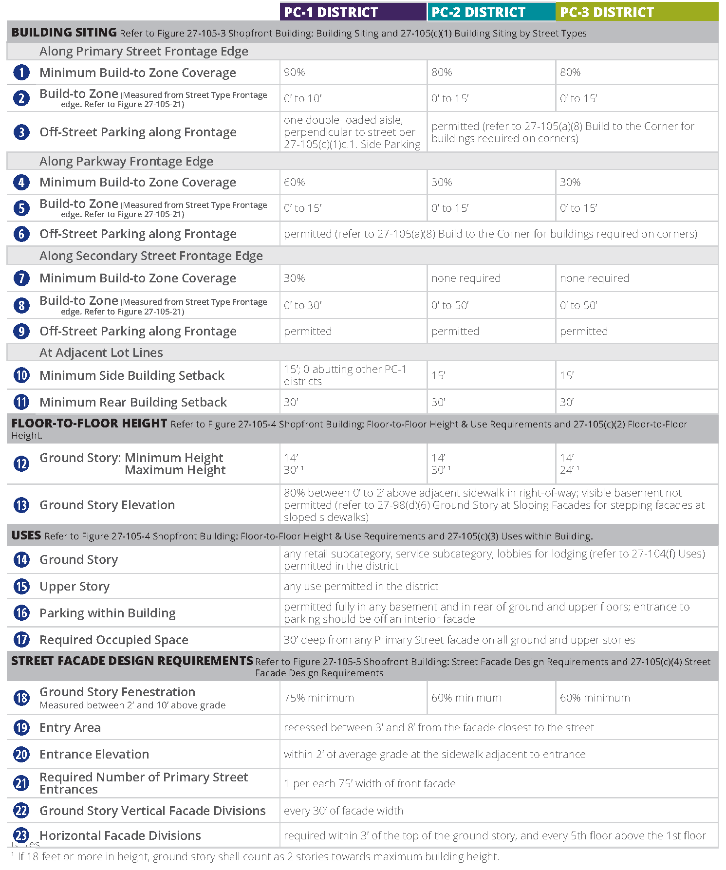
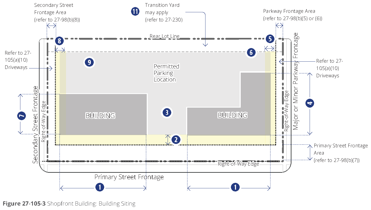
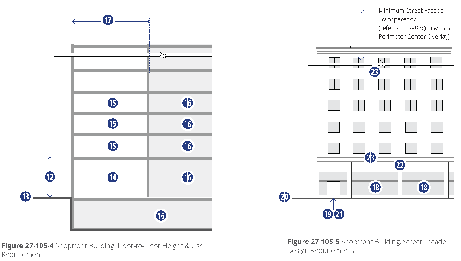
b.
General building regulations.
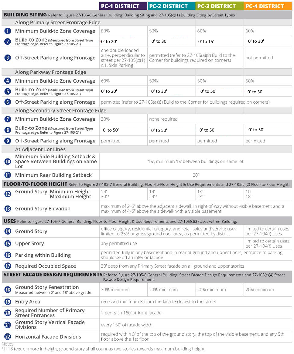
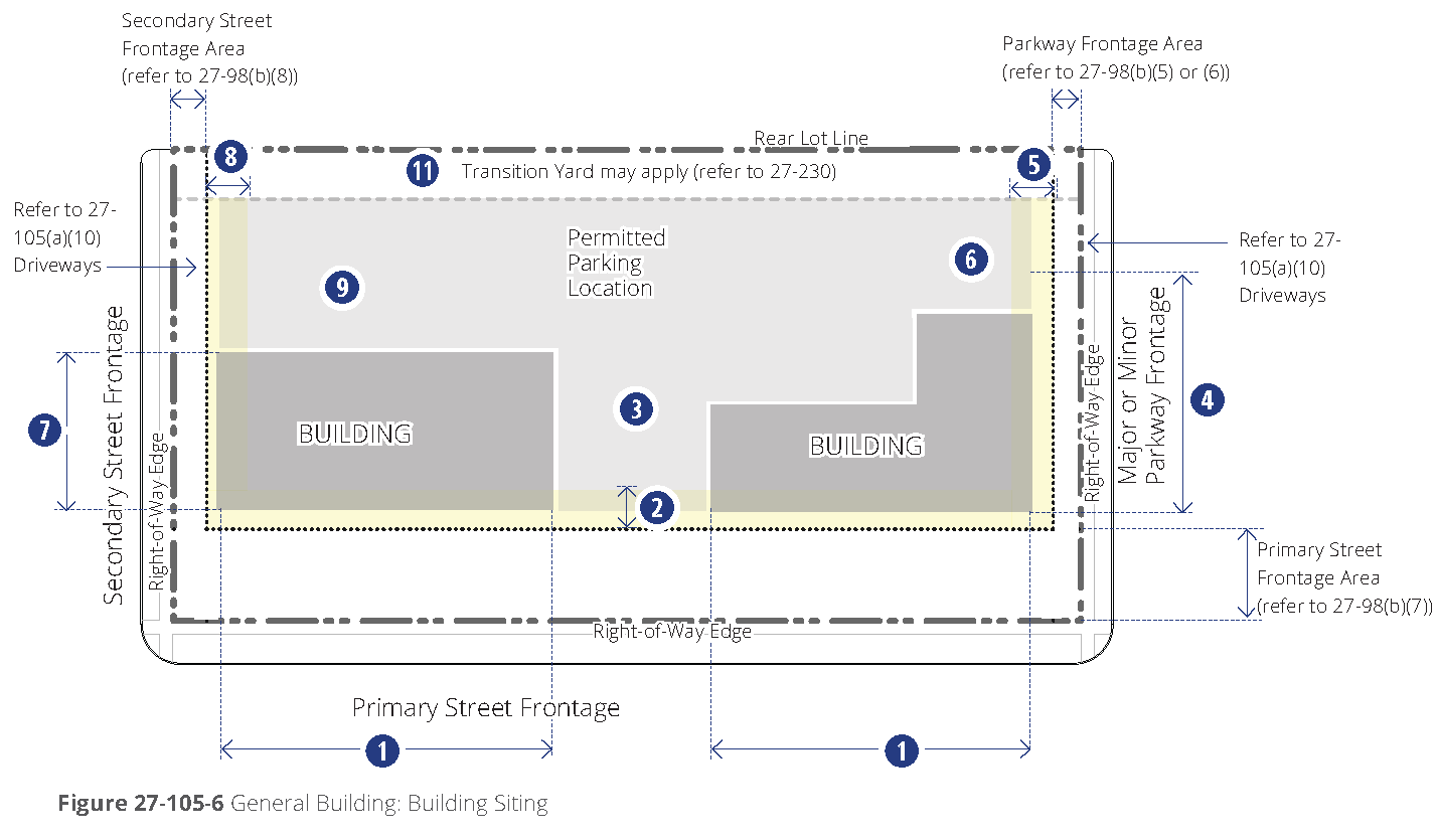
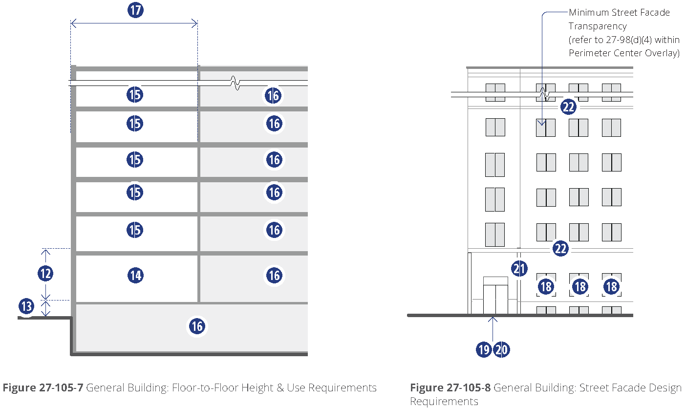
c.
Townhouse building regulations.
d.
Detached house building regulations.
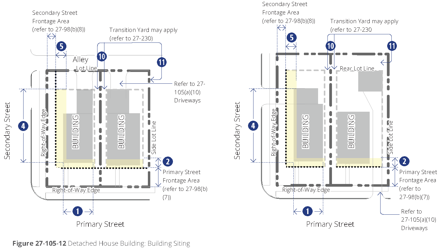
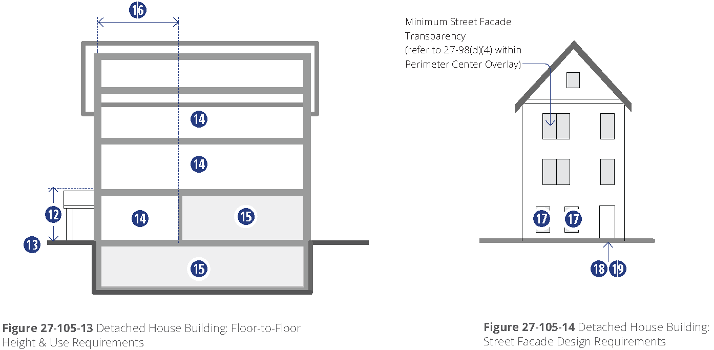
e.
Civic building regulations.
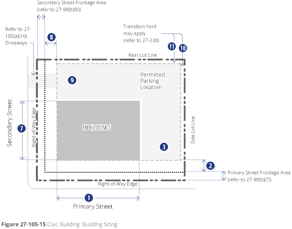
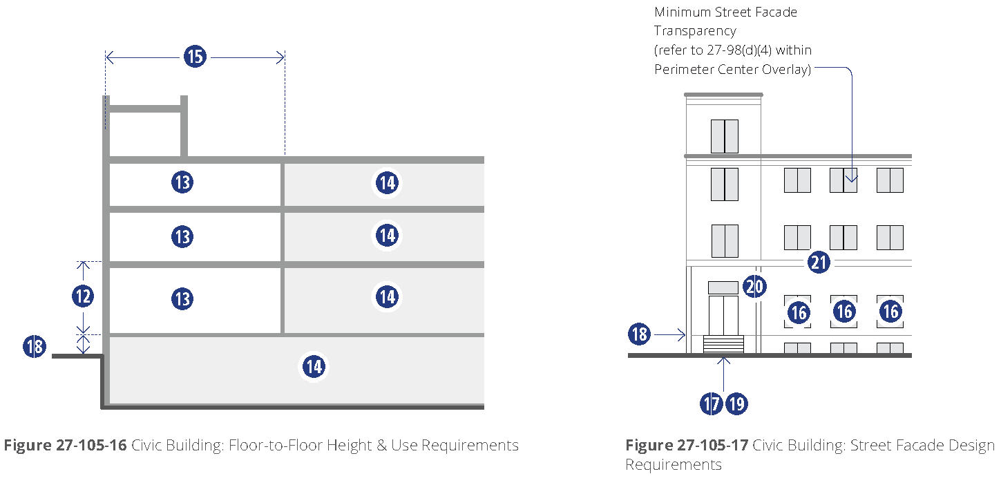
(c)
Explanation of specific building type requirements. The following explains and further defines the standards outlined on the tables on the previous pages, specific to each building type, refer to [subsections] (b)(2)a through (b)(2)e.
(1)
Building siting by street types. The following explains the line item requirements for each building type table within the section entitled "Building siting."
For each building type, requirements are defined for each street type frontage that may occur surrounding the site. Refer to figure 27-98-2, street types map, for the type defined for each street in the Perimeter Center area. Each street type is defined with frontage options in [section] 27-98(b), street types, including the major and minor parkway, primary street, and the secondary street.
a.
Build-to zone coverage. The minimum percentage of building wall or façade along the street for each street type (parkway, primary street, secondary street per figure 27-98-2, street types map) is designated on each building type table. Refer to [subsections] (b)(2)a through (b)(2)e.
1.
Measurement. The width of the principal structures (as measured within the build-to zone along the frontage edge) is divided by the length of the frontage parallel to the property line following the street. Refer to figure 27-105-18, minimum build-to zone coverage.
2.
Courtyards. Courtyards, per [section] 27-621, terms defined, located along the façade in the build-to zone count towards the minimum coverage. Refer to street types for limitations of courtyards along some frontages.
b.
Build-to zone. The build-to zone is designated separately for each street type frontage on each building type table. Refer to figure 27-105-1, corner and build-to zones, on different street types and figure 27-98-2, street types map.
1.
Measurement. The build-to zone for all districts and street type frontages is measured from the edge of the street type frontage area onto the site, along the frontage edge. Refer to figure 27-105-19, location of build-to zone in relation to frontage.
2.
Encroachments. Awnings and building mounted signage may extend beyond the build-to zone into the frontage area, but may not extend into the street right-of-way.
3.
Porches, arcades, galleries. Porches, arcades and galleries may be included on the building façade design, utilizing the range of depth permitted by the build-to zone. If located outside the building coverage requirement, the depth of the arcade or gallery may exceed the build-to zone.
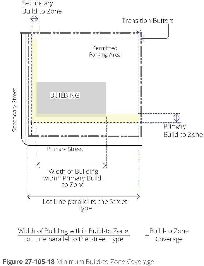
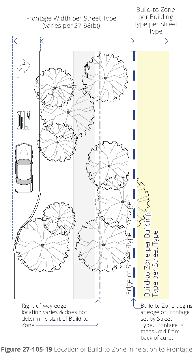
c.
Off-street parking along frontage. Off-street parking is permitted behind any buildings on the site, but is only permitted exposed along a frontage if designated on the table of requirements for each building type.
1.
Side parking. Where noted, side off-street parking along a primary street may be permitted with a maximum of one double loaded aisle of parking perpendicular to the street centerline and with a maximum width of 72 feet. Refer to the street type frontage parking edge for design requirements in front of the parking and figure 27-105-20, side off-street parking.
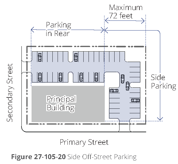
(2)
Floor-to-floor height. The following explains the line item requirements for each building type table within the section entitled "Floor-to-floor height."
Overall permitted building heights are designated by district in stories. Refer to [section] 27-104 districts.
a.
Ground story, minimum and maximum height. (Refer to figure 27-105-21, measuring story height). Each building type indicates a permitted range of height in feet for the ground story of the building.
1.
Taller spaces. Spaces exceeding the allowable floor-to-floor heights of the building type are not permitted on primary street façades. These spaces are unlimited on interior lot and secondary street façades, and limited to no more than 50 percent of major or minor parkway façades.
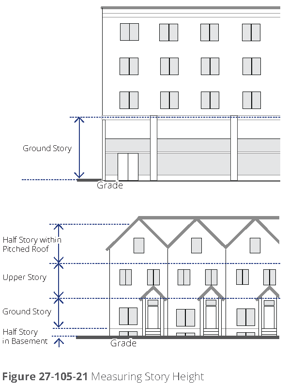
b.
Ground story elevation. The allowable ground story elevation for each building type is defined, establishing whether or not a visible basement is permitted.
1.
Visible basements. Visible basements, permitted by entrance type, are optional. The visible basement shall be a maximum of one-half the height of the tallest story.
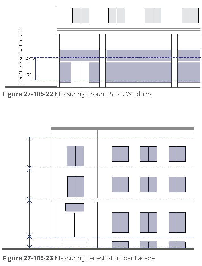
(3)
Uses within building. The following explains the line item requirements for each building type table within the section entitled "Uses within building." Refer to [section] 27-104(f), uses for uses permitted within each zoning district. The requirements in this section of the building type tables may limit those uses within a specific building type.
a.
Ground and upper story. The uses or category of uses which may occupy the ground and/or upper story of a building.
b.
Parking within building. The area(s) of a building in which parking is permitted within the structure.
c.
Required occupied space. The required depth of occupied space from the noted façade(s). Refer to [section] 27-621, terms defined, for the definition of occupied space.
(4)
Street façade design requirements. The following explains the line item requirements for each building type within the section entitled "street façade requirements".
These requirements apply only to façades facing public or private streets and façades facing main parking lots where visitors or customers park.
a.
Minimum fenestration. (refer to figure 27-105-23, measuring fenestration, per façade). The following articulates the minimum amount of ground story transparent glass required on façades facing street and parking façades.
1.
Measurement. Ground story windows, when defined separately from the overall minimum fenestration, shall be measured between two feet and eight feet from the average grade at the base of the front façade. Refer to figure 27-105-22, measuring ground story windows.
2.
Transparent. Transparent means any glass in windows and/or doors, including any mullions, that is highly transparent with low reflectance.
3.
Other stories. A general minimum fenestration requirement applies to all other stories visible from any street. Refer to [section] 27-98(d)(4),a quantity of windows.
4.
Arcades, galleries, courtyards. Ground story windows shall be located on the interior façade of any arcade or gallery. Ground story windows shall continue around a minimum of 60 percent of courtyard façades.
b.
Entry area. Size requirements and recommended types of entrance areas per building type.
c.
Required number of street entrances. The minimum number of and maximum spacing between entrances on the ground floor building façade with primary street frontage.
d.
Vertical façade divisions. The use of a vertically oriented expression line or form to divide the façade into vertical divisions at increments no greater than the dimension shown, as measured along the base of the façade. Elements may include a column, pilaster, or other continuous vertical ornamentation a minimum of 1.5 inch depth. Refer to [section] 27-621, terms defined, for the definition of expression line.
e.
Horizontal façade divisions. The use of a horizontally oriented expression line or form to divide portions of the façade into horizontal divisions at locations designated. Elements may include a cornice, belt course, molding, string courses, or other continuous horizontal ornamentation a minimum of 1.5 inch depth.
(Ord. No. 2017-05-14, § 2(Exh. B), 5-22-2017; Ord. No. 2019-01-03, § II, 1-28-2019)
Sec. 27-106. - Open space types.
(a)
Intent. To provide open space as an amenity that promotes physical and environmental health within the community and to provide access to a variety of active and passive open space types.
(b)
Applicability. The standards outlined apply to open space required per Perimeter Center district (refer to [section] 27-104(b) through [section] 27-104(e)).
(1)
Existing open space. At the discretion of the city, existing open space on the site may be used to meet the minimum requirement; however, the existing open space shall conform to one of the types defined.
(2)
Rooftop open space. Rooftop terraces or open space shall not count towards required open space.
(3)
Fee in-lieu. Open space requirements of this section must be met by open space provided on the development site, unless off-site open space or a fee in lieu of open space provision is approved in accordance with the special administrative permit process.
(c)
General requirements. All open space shall meet the following requirements.
(1)
Open space types. All open space provided within any perimeter center district shall comply with one of the open space types defined by [subsections] (e) through (h).
(2)
Access. All open space types shall provide public access from a pedestrian route associated with a vehicular right-of-way and/or adjacent building entrances/exits.
(3)
Dedicated. Open space types shall be designated by easement or, with permission of the city, may be either located within the right-of-way or dedicated by plat as a separate lot.
(4)
Fencing. Open space types may incorporate fencing provided that the following requirements are met.
a.
Height. Fencing shall be a maximum height of 48 inches, unless approved by the community development director for such circumstances as proximity to railroad right-of-way and use around athletic facilities.
b.
Level of opacity. Fence opacity shall be no greater than 60 percent.
c.
Type. Chain-link fencing is not permitted along any street frontage, with the exception of dedicated sports field or court fencing approved by the community development director.
d.
Spacing of openings. Openings or gates shall be provided on every street face at a minimum of one per every 200 feet.
(5)
Open water body. All open water bodies, such as lakes, ponds, pools, creeks, and streams, within an open space type shall be located at least 20 feet from a property line to allow for pedestrian and bicycle access as well as a landscape area surrounding the water body.
(6)
Parking requirements. Parking shall not be required for any open space type, unless otherwise determined by the community development director.
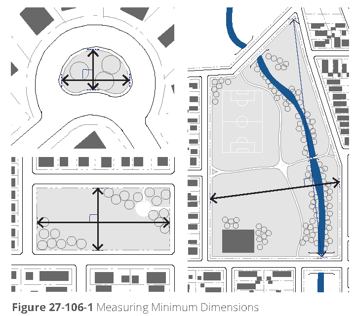
(7)
Continuity. New open space shall connect to abutting, or proximate existing or planned trail right-of-way.
(8)
Measuring size.
a.
Size. The size of the open space type is measured to include all landscape and paving areas associated directly with the open space type.
b.
Minimum dimension. The minimum length or width of the open space type, as measured along the longest two straight lines intersecting at a right angle defining the maximum length and width of the lot. Refer to figure 27-106-1, measuring minimum dimensions.
(9)
Minimum percentage of street frontage required. A minimum percentage of the open space perimeter, as measured along the outer edge of the space, shall be located directly adjacent to a parkway, primary street, or secondary street. This requirement provides access and visibility to the open space.
(10)
Improvements. As noted in the specific requirements for each open space type ([subsections] (e) through (h)), the following types of site improvements and structures may be permitted on an open space type.
a.
Fully enclosed structures permitted. Fully enclosed structures may include such uses as small cafes, kiosks, community centers, and restrooms.
(1)
Maximum area. For some civic open space types, fully enclosed structures are permitted, but limited to a maximum building coverage as a percentage of the open space area.
(2)
Semi-enclosed structures. Open-air structures, such as gazebos, are permitted in all open space types.
b.
Maximum impervious and semi-pervious surface permitted. The amounts of impervious and semi-pervious coverage are provided separately for each open space type ([subsections] (e) through (h)) to allow an additional amount of semi-pervious surface, such as permeable paving, above the impervious surfaces permitted, including, but not limited to, sidewalks, paths, and structures as permitted.
c.
Maximum percentage of open water body. The maximum amount of area within an open space type that may be covered by an open water body, including, but not limited to, ponds, lakes, and pools.
(d)
Stormwater in open space types. Stormwater management practices, such as normally dry storage and retention facilities or ponds maintaining water at all times, may be integrated into open space types and utilized to meet stormwater requirements for surrounding parcels.
(1)
Stormwater features. Stormwater features in open space may be designed as formal or natural amenities with additional uses other than stormwater management, such as an amphitheater, sports field, or a pond or pool as part of the landscape design. Stormwater features shall not be fenced and shall not impede public use of the land they occupy.
(2)
Walls. Retaining walls over 30 inches in height are not permitted in any open space accommodating stormwater.
(3)
Qualified professional. A qualified design professional shall be utilized to incorporate the stormwater features into the design of the open spaces.
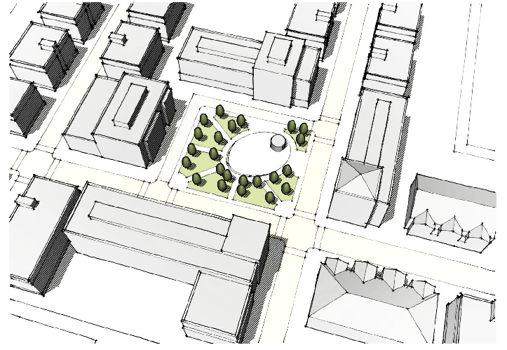 | |
| (e) Plaza. The intent of the plaza is to provide a formal open space type of medium scale to serve as a gathering place for civic, social, and commercial purposes. The plaza may contain a greater amount of impervious coverage than any other open space type. Special features, such as fountains and public art installations, are encouraged. | |
| Dimensions | |
| Minimum size | 0.10 acres |
| Minimum dimension | 60 feet |
| Minimum percentage of street frontage required | 25% |
| Improvements | |
| Fully enclosed structures | Permitted; may cover maximum 5% of plaza area |
| Maximum impervious surface + semi-pervious surface | 40% + 20% |
| Maximum percentage of open water and stormwater features | 30% |
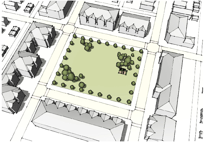 | |
| (f) Green. The intent of the green is to provide informal, medium scale active or passive recreation for building occupants and visitors within walking distance, mainly fronted by streets. | |
| Dimensions | |
| Minimum size | 0.10 acres |
| Minimum dimension | 45 feet |
| Minimum percentage of street frontage required | 25% |
| Improvements | |
| Fully enclosed structures | Not permitted |
| Maximum impervious surface + semi-pervious surface | 20% + 15% |
| Maximum percentage of open water and stormwater features | 30% |
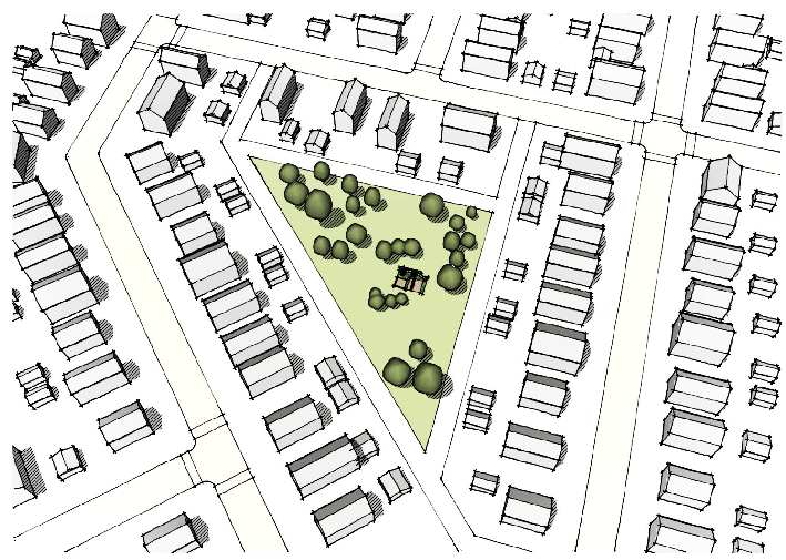 | |
| (g) Commons. The intent of the commons is to provide an informal, small to medium scale space for active or passive recreation for a limited area. Commons are typically internal to a block and tend to serve adjacent building occupants. | |
| Dimensions | |
| Minimum size | 0.25 acres |
| Minimum dimension | 45 feet |
| Minimum percentage of street frontage required | 0%; requires a minimum of two access points with a total depth of 100 feet maximum (minimum 30 feet wide) |
| Improvements | |
| Fully enclosed structures | Not permitted |
| Maximum impervious surface + semi-pervious surface | 30% + 10% |
| Maximum percentage of open water and stormwater features | 30% |
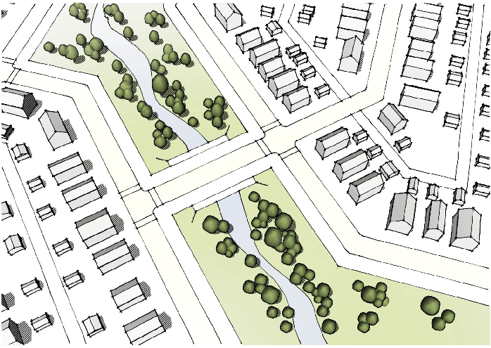 | |
| (h) Park. The intent of the park is to provide informal active and passive large-scale recreational amenities to local residents and the greater region. Parks have primarily natural plantings and are frequently created around an existing natural feature such as a water body or stands of trees. | |
| Dimensions | |
| Minimum size | 1 acre |
| Minimum dimension | 30 feet; minimum average width of 80 feet |
| Minimum percentage of street frontage required | 30% for parks less than 5 acres; 20% for parks 5 or more acres in size |
| Improvements | |
| Fully enclosed structures | Permitted in parks 2 acres or larger in size |
| Maximum impervious surface + semi-pervious surface | 20% + 10% |
| Maximum percentage of open water and stormwater features | 30% |
(Ord. No. 2017-05-14, § 2(Exh. B), 5-22-2017)
Sec. 27-107A. - Administration.
(a)
Intent and applicability.
(1)
Intent. The Dunwoody Village (DV) district regulations are intended to implement the policies and objectives of the comprehensive plan and the Dunwoody Village Master Plan. They are further intended to help:
a.
Maintain and enhance the identity and image of Dunwoody Village;
b.
Accommodate and promote walkable development patterns containing a complementary mix of land uses;
c.
Create opportunities for functional landscaped open and gathering spaces in the core of Dunwoody;
d.
Ensure that new development and substantial additions to existing buildings are designed to promote Dunwoody Village as an area of unique character, while requiring that all new construction makes use of design standards and materials that enhance the district, complement existing character, and allow for the introduction of new design elements while supporting the addition of walkability and open space;
e.
Support efforts to create a vibrant shopping and entertainment area in which merchants and businesses thrive and grow, thereby helping to maintain property values and keeping vacancy rates low; and
f.
Maintain and enhance the area's role as a place for civic activities and public gatherings within well-designed open spaces.
(2)
Applicability.
a.
DV district regulations apply to properties zoned to a DV district in accordance with the regulating map (figure 27-107B-1) and the amendment procedures of article V, division 2.
b.
The general applicability provisions of section 27-3 of this zoning ordinance apply to properties zoned a DV district, except where alternative applicability standards exist in DV district regulations.
(b)
Administration and procedures.
(1)
Establishment of Dunwoody Village districts. Dunwoody Village (DV) zoning district classifications may be applied to property and DV district boundaries may be amended only in accordance with the amendment procedures of article V, division 2 and the regulating map of figure 27-107B-1.
(2)
Effect of establishment. Once property has been classified in a DV district, that property is subject exclusively to the applicable DV district regulations.
(3)
Review and approval procedures. Unless otherwise expressly stated, all uses and development in DV districts are subject to the applicable review and approval procedures of article V, as well as any applicable procedures in chapter 16 of the municipal code (land development regulations).
(4)
Pre-application conference. Preapplication conferences with staff are required for development permit applications (see the pre-application provisions of section 27-305).
(5)
Site plan review. Development permits applications must be accompanied by a site plan, which is subject to review and approval in accordance with article V, division 10.
(6)
Relief. The DV districts are intended to accommodate development as-of-right when such development occurs in strict conformance with applicable regulations. In some instances, however, unique site conditions, existing building circumstances, or other constraints related to the subject property may make strict compliance impossible or highly impractical. In such instances, an applicant may seek relief from applicable regulations. Any relief granted and conditions imposed run with the land and are binding on the subject property owner and all future property owners.
a.
Minor exception—Administrative relief. The community development director is authorized to approve the following minor exceptions in accordance with the special administrative permit procedures of article v, division 7:
1.
The location of a building relative to any minimum setback requirement or build-to zone width/location, provided that the location deviates from strict compliance by no more than five feet, except when a greater deviation is necessary to minimize the impact on special or specimen trees;
2.
An increase in total impervious coverage by no more than five percent, not to exceed the total amount of permitted impervious plus semi-pervious coverage;
3.
A decrease in the percent of building façade in the build-to zone by no more than ten percent, except when a greater decrease is necessary to minimize the impact on special or specimen trees;
4.
A reduction in the amount of required shopfront building frontage along primary streets, by no more than ten percent, except when a greater reduction is necessary to minimize the impact on special or specimen trees;
5.
Additional height of any building story by no more than two feet, provided that the overall building height does not exceed the maximum permitted height;
6.
An increase in the maximum permitted height of a retaining wall by up to five feet;
7.
A modification to the required streetscape along existing streets with existing utilities, special trees, or specimen trees within or adjacent to the otherwise required streetscape; and
8.
Any other minor exception expressly authorized under the Dunwoody Village district regulations.
b.
Major exceptions—Special exceptions. Major exceptions to strict compliance with the DV district regulations include any exception to strict compliance that is not expressly authorized as a minor exception under the provisions of subsection 27-107A(b)(6)a. Major exceptions require review and approval in accordance with the special exception procedures of article V, division 6.
(c)
Text and graphics. Graphics are included in DV districts to illustrate the intent and requirement of the text. In the case of a conflict between the text and any graphics, the text governs.
(d)
Primary street designation. When used within a DV district, "primary street" means Chamblee Dunwoody Road, Mt. Vernon Road, and Dunwoody Village Parkway.
(Ord. No. 2020-11-23, Exh. A, 11-30-2020)
Sec. 27-107B. - Districts.
(a)
Districts and regulating map.
(1)
District map. The location for each DV district is designated in figure 27-107B-1, regulating map.
(2)
Official zoning map. The location for each DV district shown on the regulating map shall also be designated on the official zoning map.
(3)
District requirements. The requirements in this subsection apply to the DV districts as follows.
a.
Requirements specific to each district. Refer to sections 27- 107B(b) through 27-107B(e) for specific descriptions and requirements for each district.
b.
Use requirements for all districts. Refer to section 27- 107B(f), uses, for use requirements applicable to all districts.
(4)
General regulations. Refer to section 27-107C for general regulations that apply to all DV districts.
(5)
Building type regulations. Refer to section 27-107D for building type regulations that apply to all DV districts.
(6)
Open space regulations. Refer to section 27-107E for open space regulations that apply to all DV districts.
(7)
Buffers and transition yards.
a.
Refer to section 27-230, transition yards, for information on buffer and screen requirements between different districts and uses, except where b. below applies.
b.
Undisturbed buffers shall be required in the locations shown on the regulating map and with the width shown on the regulating map. Adjacent to these undisturbed buffers, an additional TY4 transition yard is also required in the locations shown on the regulating map and with the width shown on the regulating map.
Figure 27-107B-1 Regulating Map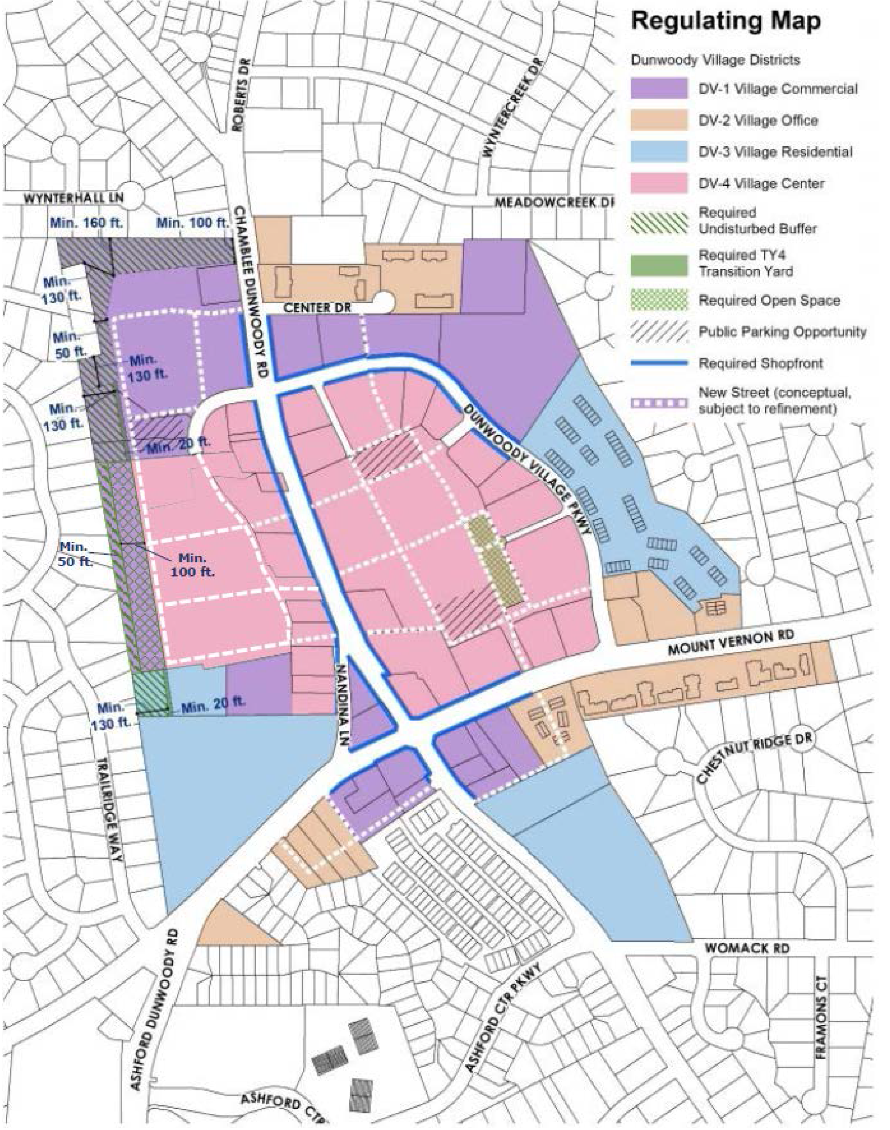
(b)
DV-1 Village Commercial District. Requirements for this district are provided in figure 27-107B-1. DV-1 District Requirements.
(1)
Description and intent. The DV-1 District is intended to provide areas for commercial uses that primarily serve the needs of nearby neighborhoods. The district also includes opportunities for residential uses when incorporated into mixed-use developments.
Figure 27-107B-2 DV-1 District Requirements
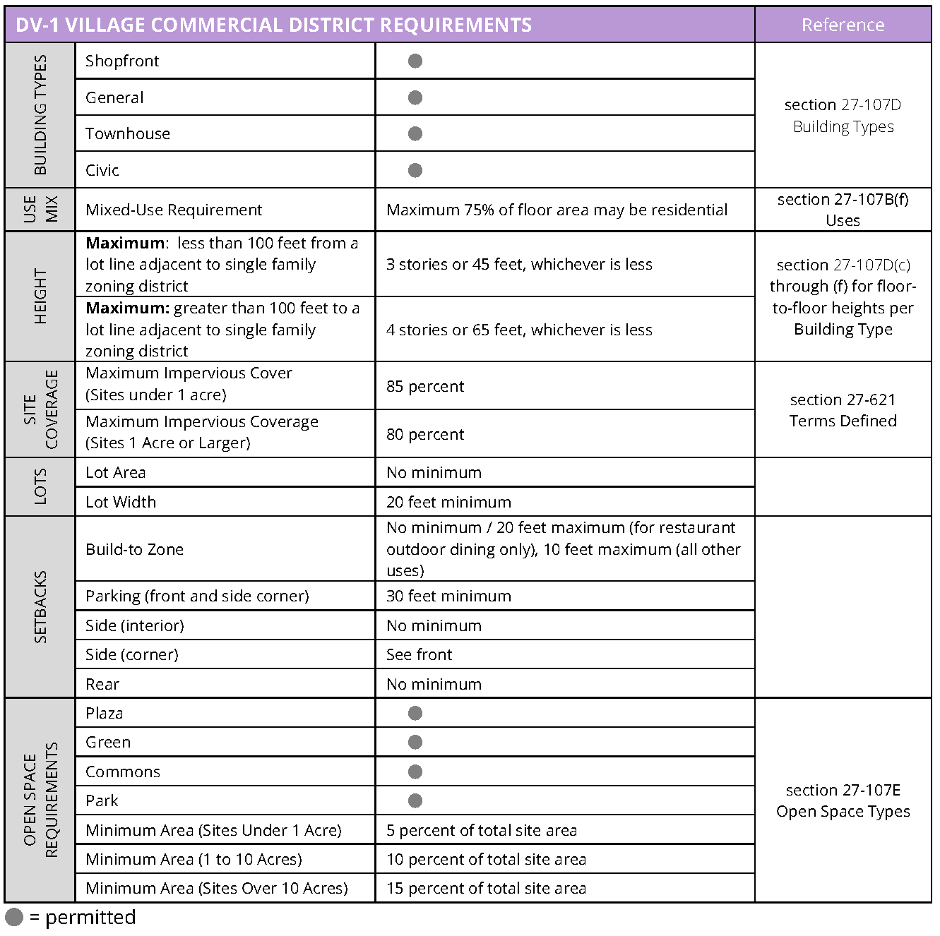
(c)
DV-2 Village Office District. Requirements for this district are provided in figure 27-107B-3. DV-2 District Requirements.
(1)
Description and intent. The DV-2 District is intended to provide areas for small-scale office uses to serve nearby neighborhoods.
Figure 27-107B-3 DV-2 District Requirements
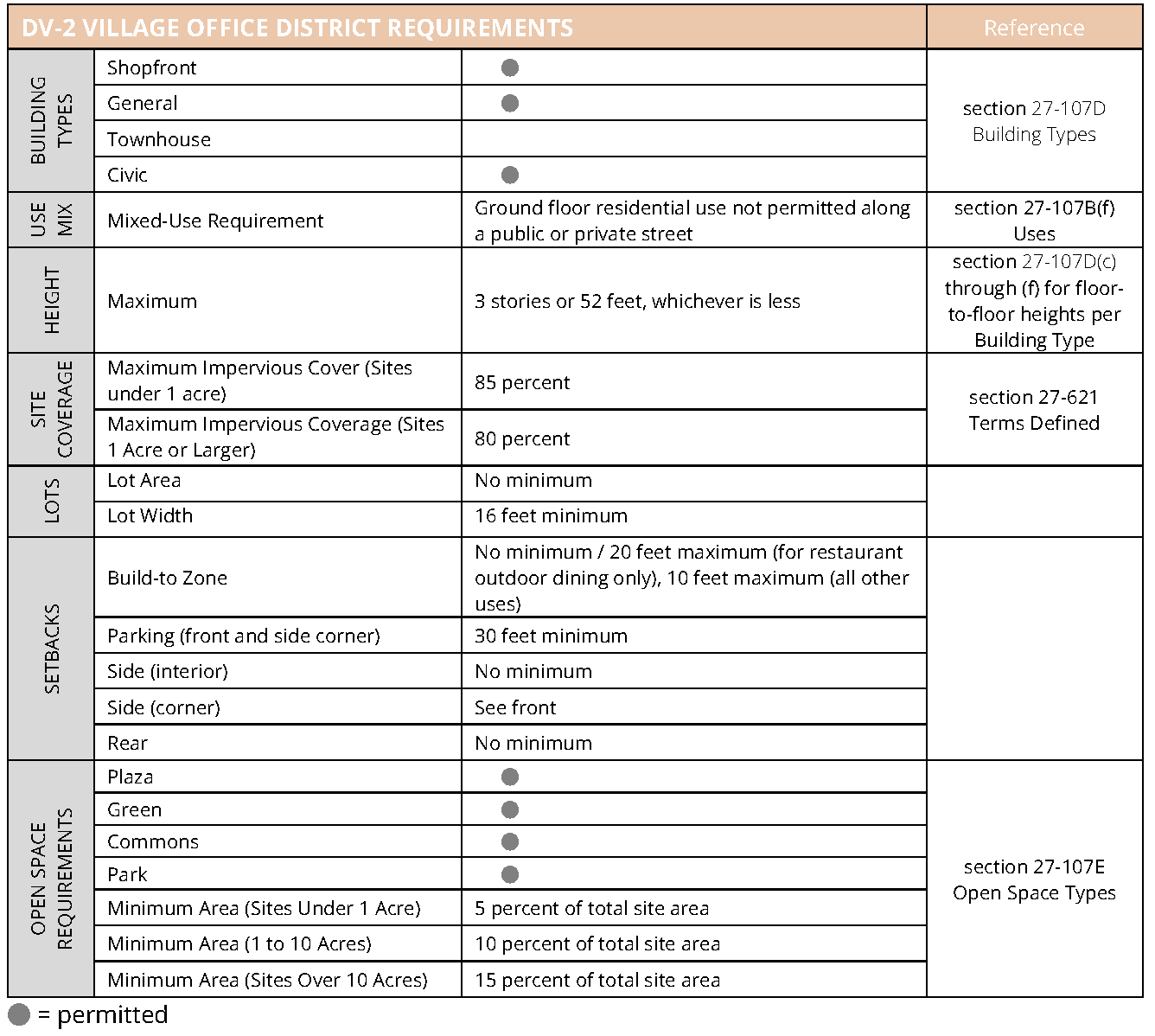
(d)
DV-3 Village Residential District. Requirements for this district are provided in figure 27-107B-4. DV-3 District Requirements.
(1)
Description and intent. The DV-3 District is intended to provide areas for residential uses that are within walking distance of retail and services. The district also supports existing quasipublic and institutional uses within Dunwoody Village.
Figure 27-107B-4 DV-3 District Requirements
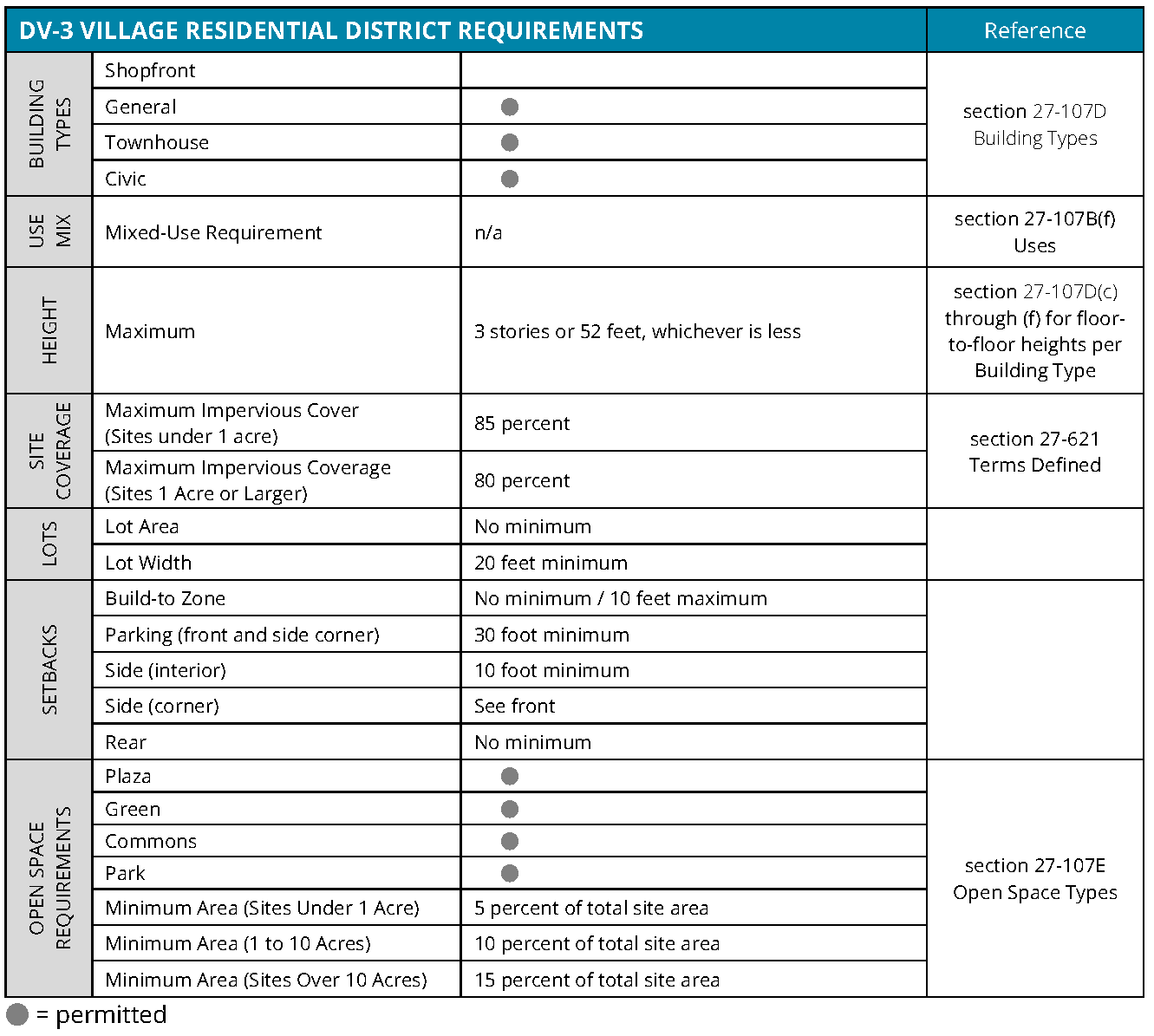
(e)
DV-4 Village Center District. Requirements for this district are provided in figure 27-107B-5. DV-4 District Requirements.
(1)
Description and intent. The DV-4 District is intended to serve as the core of Dunwoody Village and provide its most intense mix of uses, centralized landscaped open spaces, and highly walkable development patterns.
Figure 27-112-5 DV-4 District Requirements
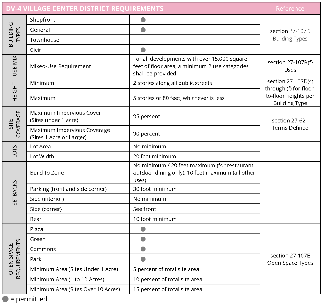
(f)
Uses. The following applies to all DV districts.
(1)
Use table. The following apply to the uses outlined in this section. Refer to figure 27-107B-6, use table.
a.
Use categories. Refer to sections 27-111 through 27-116.
b.
Permitted and special uses. Each use may be permitted as-of-right, permitted with a special administrative permit, permitted as a special exception, or permitted with a special land use permit. Refer to figure 27-107B-6, use tables.
c.
Number of uses. A lot may contain more than one use.
d.
Principal and accessory uses. Each of the uses may function as either a principal use or accessory use on a lot, unless otherwise specified.
e.
Building type. Each use shall be located within a permitted building type (refer to section 27-107D, building types), unless otherwise specified.
(2)
Use subcategories. For the purposes of fulfilling the use mix requirements defined in each district table (refer to section 27-107B(b) through section 27-107B(e)), utilize the following subcategories of uses, consisting of those uses listed in the table, that may contribute to the mix. Some permitted uses are not included.
a.
Lodging and residence subcategory.
1.
Household living.
2.
Group living.
3.
Lodging.
b.
Civic subcategory.
1.
Club or lodge, private.
2.
Cultural exhibit.
3.
Educational services.
4.
Hospital.
5.
Place of worship.
c.
Office subcategory.
1.
Construction and building sales and service.
2.
Medical service.
3.
Office or consumer service.
4.
Research and testing services.
d.
Retail sales subcategory.
1.
Retail sales.
2.
Food and beverage retail sales.
e.
Service use subcategory.
1.
Animal services.
2.
Day care.
3.
Repair or laundry services, consumer.
4.
Personal improvement services.
5.
Eating and drinking establishments.
6.
Financial services.
7.
Entertainment and spectator sports.
(3)
Live-work.
a.
Defined. Accessory nonresidential activity conducted wholly within a dwelling unit that allows employees, customers, or clients to visit.
b.
Use standards. All live-work is subject to the following:
1.
Live-work is only allowed when the dwelling unit to which it is accessory has been approved in accordance with figure 27-107B-6, use table.
2.
Live-work is only allowed on the ground story of a building.
3.
At least one person must occupy the dwelling containing the live-work use as their primary place of residence.
4.
The live-work use may employ no more than two persons not living on the premises at any one time.
5.
No business storage or warehousing of material, supplies, or equipment is permitted outside of the dwelling containing the live- work use.
6.
The nonresidential use of the live-work use is limited to a use allowed in the DV district.
7.
No equipment or process may be used that creates, without limitation, noise, dust, vibration, glare, fumes, odors, or electrical interference detectable to the normal senses, off the premises.
P = use permitted as of right
A = special administrative permit required
S = special land use permit required
[1] No more than 60 percent of dwelling units may have a floor area of less than 800 square feet.
[2] Individual establishments shall not exceed 50,000 square feet in gross floor area.
[3] Use shall not be located within 1,320 feet of the same use (as measured in a straight line from property line to property line), including any uses not within a DV district.
[4] Use shall not be located on the ground story along any public or private street. When the use is allowed on the ground story it must be set at least 30 feet behind the street-facing façade.
[5] No more than four vehicles for sale or rent may be displayed on site. All vehicles for sale or rent must be located in conditioned space.
[6] Detached houses shall be subject to the street façade design requirements of the townhouse building type. No other building type standards shall apply.
[7] A special land use permit is only required for accessory or non-accessory parking structures when any above-ground portion of such structure is located within 200 feet of a single-family residential zoning district. The use is permitted as of right in all other locations.
(Ord. No. 2020-11-23, Exh. A, 11-30-2020; Ord. No. 2021-09-12, § 1, 9-27-2021; Ord. No. 2022-01-02, § IV, 1-10-2022; Ord. No. 2023-08-09, § III, 8-14-2023; Ord. No. 2023-10-14, § III, 10-16-2023; Ord. No. 2024-07-05, § IV, 7-22-2024)
Sec. 27-107C. - General regulations.
(a)
Streets, blocks, and paths.
(1)
Intent. The intent of the following is to form an interconnected network of streets with multiple intersections and block sizes scaled to support multiple modes of transportation, including walking, biking, transit use, and driving, within Dunwoody Village. Refer to chapter 16 for additional regulations.
(2)
Applicability. New development and redevelopment must meet these street, block, and path requirements under any of the following circumstances:
a.
New structure. Development of a new principal structure on a lot or portion of a lot.
b.
Redevelopment or renovation. Redevelopment or renovation to an existing structure or site that increases the gross building square footage by more than ten percent over a 12-month period.
c.
Parking lots. Redevelopment or revision to ten percent or more of an existing parking lot or development of a new parking lot, not including resurfacing, restriping, or minor repairs to an existing lot.
(3)
New street locations.
a.
Regulating map streets. New streets must be installed in the approximate locations shown on figure 27-107B-1, regulating map, in order to establish a network that fulfills the streets, block, and path intent and regulations. Additional streets not shown on the regulating map are also allowed.
b.
Community development approval. The design and locations of all streets shall be approved by the community development director during the site plan review process.
(4)
Street connectivity. The following provides requirements and guidance for locating new streets and connecting to surrounding context.
a.
The arrangement of streets must provide for the continuation of existing streets from adjoining areas into new developments.
b.
Cul-de-sac and dead-end streets shall only be allowed where topography and other existing barriers, such as or waterways, prevent street connectivity.
c.
Streets must follow natural features rather than interrupting or dead-ending at the feature.
d.
Streets must terminate at another street with either landscaped open space or a building façade across from the termination.
e.
When adjacent developments do not provide street connectivity, applicants must coordinate with the community development director to determine the potential for future connections and provide for those connections.
(5)
Block configuration. Refer to figure 27-107C-1 for an illustration of typical block elements and section 16-240 for blocks.
a.
Blocks should be deep enough to accommodate buildings that face streets with parking located in the interior of the block.
Figure 27-107C-1 Typical Block Elements
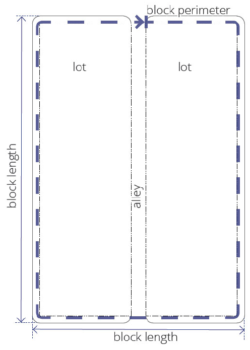
b.
Blocks may be configured to include existing lots within an existing zoning district that is not a DV district.
c.
A network of streets is required to meet the maximum block size requirement.
d.
Maximum block perimeter is 1,800 feet, except where the new streets required by the regulating map result in a smaller block perimeter, in which case such smaller block perimeter shall apply.
e.
Exceptions to block sizes may be granted by the community development director for new blocks that contain only open spaces or in locations adjacent to natural features such as steep grades and drainage areas, or other existing physical barriers.
(6)
Block driveway access.
a.
Blocks may include internal alleys, drives, or driveway entrances for service, parking accessibility, and other routes internal to the development.
b.
Alleys shall have a maximum paved surface width of:
1.
Twelve feet when only serving attached houses; otherwise
2.
Twenty-four feet.
c.
Alleys and driveways should be aligned with alleys, driveways, and similar access points in other blocks.
(7)
Mid-block pedestrian ways.
a.
Mid-block pedestrian ways are required through blocks longer than 800 feet and at locations that connect public rights-of-way with other public facilities such as parks and transit stops.
b.
When combined with mid-block street crossings, these pathways should align to facilitate easy pedestrian movements.
c.
Mid-block pedestrian ways should be located in the middle third of a block face.
d.
The minimum width for mid-block pedestrian ways rights-of-way or easements is 20 feet.
e.
A minimum of one canopy tree per 600 square feet of area is required.
f.
Mid-block pedestrian ways shall be treated with the same design requirements as existing streets per subsection (8), streetscapes.
g.
Required new pedestrian paths per figure 27-107B-1 may fulfill the requirements for mid-block pedestrian ways.
(8)
Streetscapes.
a.
Applicability. The following standards apply on existing and new public or private streets.
b.
Landscape area. All streets must incorporate the following landscape area abutting the back of the curb:
1.
New streets. Refer to section 27-107C(9), new streets.
2.
Existing streets. A minimum 6-foot wide landscaped area, except when an official city plan or project uses an alternate design. When an alternate design is used, existing streets must conform to said design.
c.
Sidewalk area. All streets must incorporate the following sidewalks immediately adjacent to the required landscape area:
1.
New streets. Refer to section 27-107C(9), new streets.
2.
Existing streets. A minimum 12-foot wide sidewalk, except when an official city plan or project uses an alternate design. When an alternate design is used, existing streets must conform to said design.
d.
Buildings. Buildings must be built to the back of the sidewalk as established by build-to zone regulations. If buildings are set back from the edge of the required sidewalk, the setback area must include features such as outdoor dining and seating areas or plazas and landscaped open spaces that provide a safe, comfortable, and active environment for pedestrians.
e.
Lighting. Lighting must conform to the following:
1.
Pedestrian and street lighting must be installed in the streetscape landscape zone at intervals of 50 to 70 feet on center and must be located an equal distance from required street trees.
2.
Pole height may not exceed 15 feet.
3.
Light poles and lamps must be selected from the city's approved streetscape list, which is available in the public works department. Alternative designs may be approved on a case-by-case basis with the approval of the community development director.
f.
Street furniture. Street furniture must be provided as follows:
1.
Benches and trash and recycling receptacles must be installed every 250 feet along the street and at each building entrance adjacent to a pedestrian walkway.
2.
Furniture must be selected from the city's approved streetscape list, which is available in the community development department; alternative designs may be approved on a case-by-case basis with the approval of the community development director.
g.
Maintenance. Maintenance of trash and recycling receptacles, including servicing, repair, and replacement, is the full responsibility of the nearest adjacent property owner.
h.
Recycling receptacles. Recycling receptacles must be clearly identified with symbols and/or text indicating its intended use.
(9)
New streets. The following apply to all new streets, including those not required by the regulating map.
a.
Street type. All new streets must be designed in accordance with new street type A, except where new street type B or new street type C are authorized by approval of both the community development director and the public works director, and except as provided for in "d" below.
b.
Public use. All streets shall be available for public use at all times. Gated streets and streets posted as private are not permitted.
c.
Public street standards. All new streets shall be public streets or private streets built to public standards.
Figure 27-107C-4 New Street Type A (not to scale)
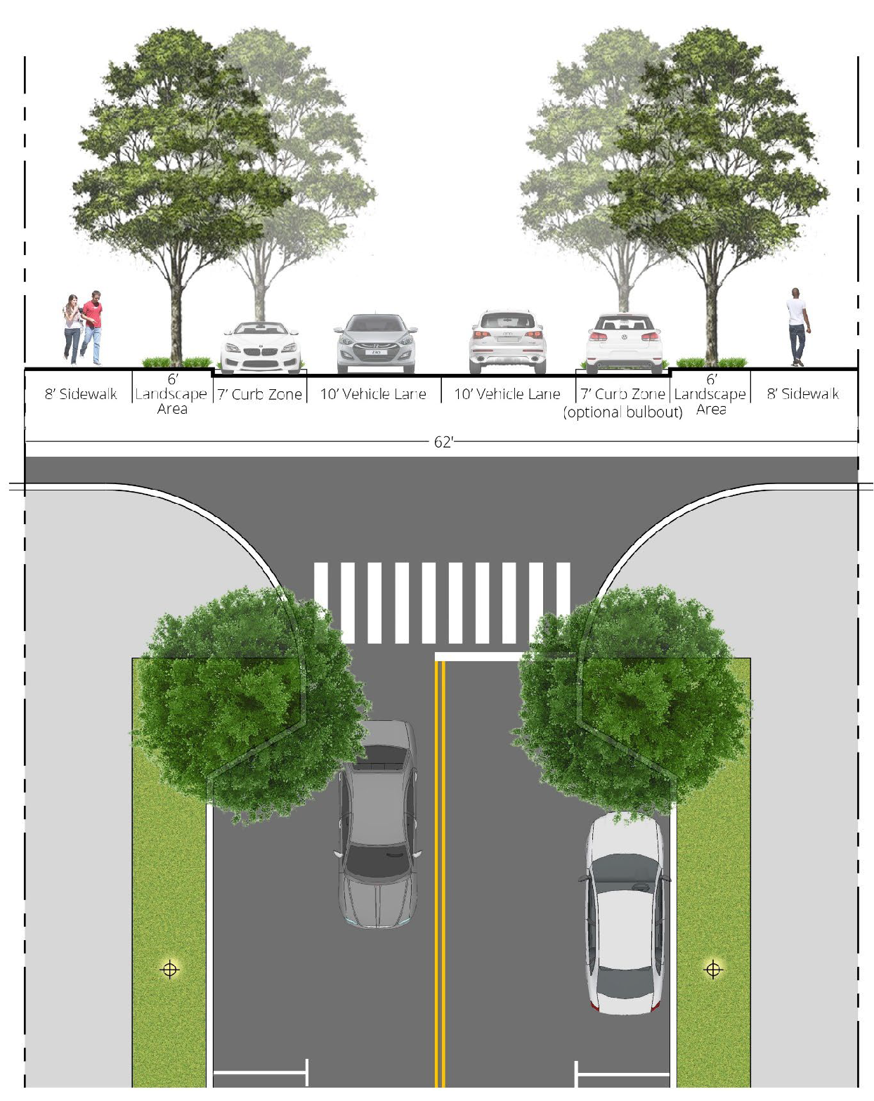
Figure 27-107C-3 New Street Type B (not to scale)
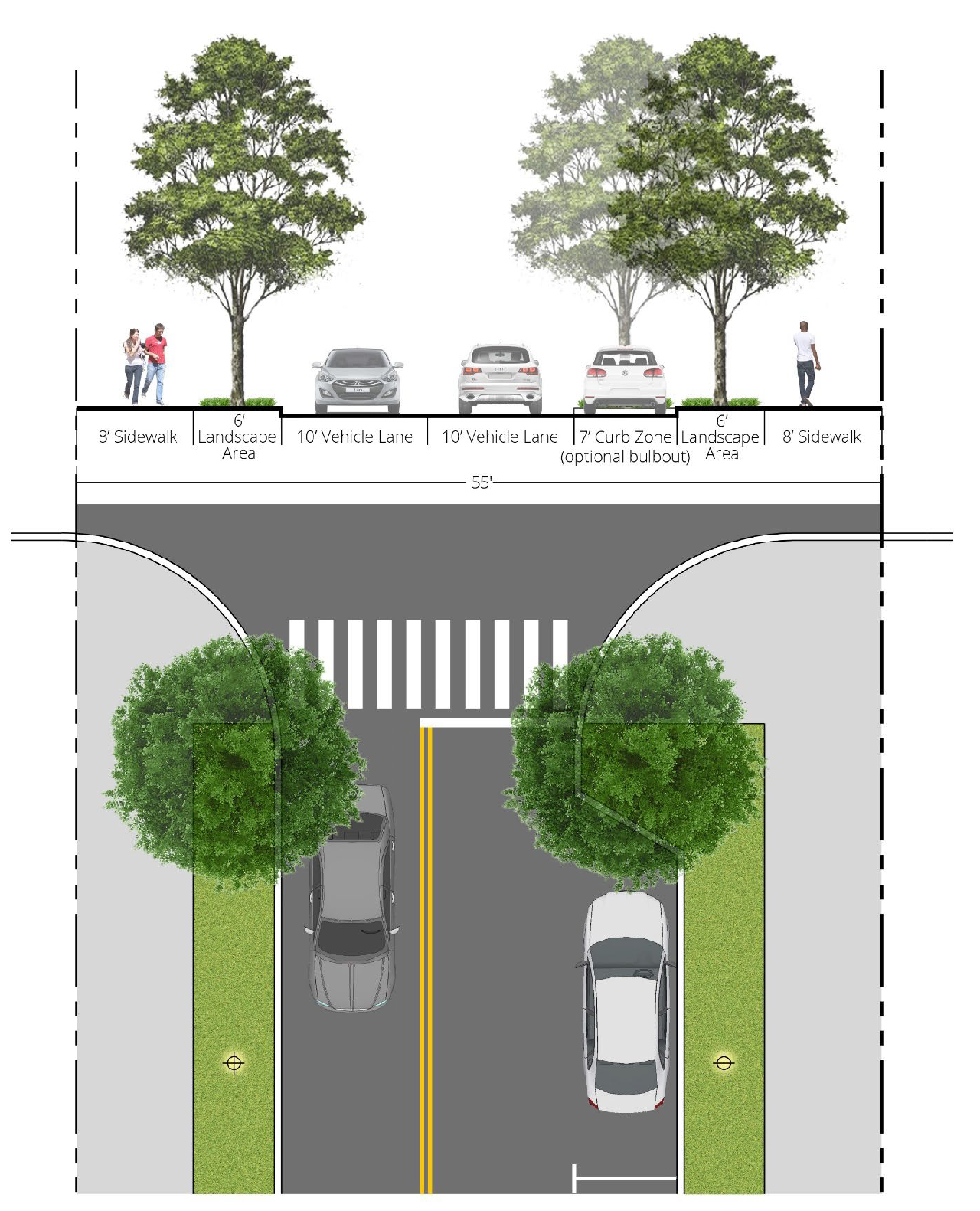
Figure 27-107C-2 New Street Type C (not to scale)
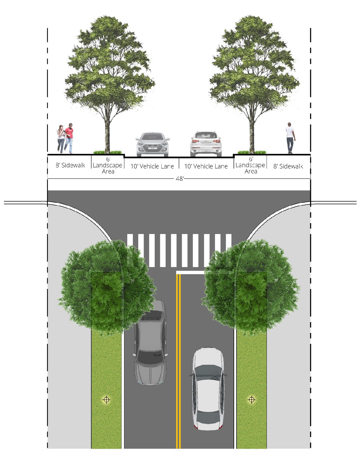
d.
Street design minor exceptions. Minor exceptions to the street types identified in "a" above may be authorized by approval of both the community development director and the public works director where both directors find that the minor exception is for one or more of the following public purposes:
1.
To provide on- or off-street bicycle facilities;
2.
To provide narrower sidewalks or landscaped zones in order to accommodate existing buildings, existing landscaping, existing topography, other existing features, lot size, or lot shape which restrict the ability to provide the required width;
3.
To provide a median, a left turn lane, or combination thereof;
4.
To add or eliminate bulb-outs;
5.
To provide hardscape surface in the landscaped zone in order to provide pedestrian access to adjacent on-street parking;
6.
To provide alternative curb zone or on-street parking configurations, such as angled parking, or to eliminate onstreet parking along one or both sides;
7.
To increase or decrease the travel lane width; or
8.
To provide traffic calming or pedestrian safety measures.
(10)
Pedestrian paths.
a.
Location. New pedestrian paths shall be required in the approximate location shown in the Dunwoody Village Master Plan or other plan that has been adopted by the city, in order to establish an off-street bicycle and pedestrian network. Additional pedestrian paths not shown in adopted plans are also allowed.
b.
Path type. All new paths shall be designed in accordance with figure 27-107C-5, new pedestrian path.
c.
Public use. All pedestrian paths shall be available for public use at all times. Gated pedestrian paths or paths posted as private are not permitted.
d.
Adjustments to requirements. During the pre-submittal conference, the community development director and/or public works director may adjust requirements for path location, right-of-way width and alignment, pavement width, or pedestrian path elements depending on unique site locations and characteristics.
Figure 27-107C-5 New Pedestrian Path (not to scale)
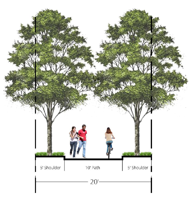
(b)
Required shopfronts. New shopfront buildings (refer to section 27-107D(e) must be constructed in areas shown on figure 27-107B-1, regulating map, in order to concentrate commercial activity in a pedestrian-friendly location.
(c)
Parking and circulation. The parking and circulation regulations of article IV, division 1 apply except as modified by the following regulations. (Refer also to the parking regulations of 27-107D(i)(5).)
(1)
Parking may be provided in excess of the citywide parking maximums by special exception (see article V, division 6) only when all of the following occur:
a.
The excess parking is located within a parking deck having at least two parking levels.
b.
The excess parking is located in a location identified as a public parking opportunity on the regulating map.
c.
The excess parking is available to the general public, either with or without paying a fee, on a daily basis.
d.
The excess parking may not be assigned to or otherwise deemed accessory to any on-site or off-site use.
(2)
Parking lots and parking structures must observe the parking setbacks established by district regulation and building type. Parking lot and parking structure setbacks are shown in figure 27-107C-6.
(3)
Parking lots must be set back from a lot line abutting another property a minimum of five feet.
(4)
Any parking deck which faces any public or private street must provide an intervening building having habitable space along the full length of the parking structure.
(5)
Wherever possible, parking lots must be confined to the rear of structures and parking decks must be placed underground.
Figure 27-107C-6 Parking setback for parking lots and parking structures
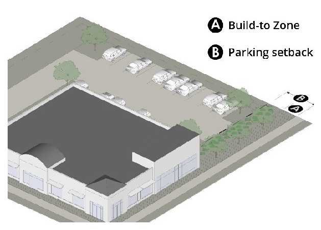
(d)
Landscaping.
(1)
The landscaping and screening regulations of article IV, division 2, apply.
(2)
Street tree regulations of chapter 16, section 16-238 apply.
(e)
Service areas, retaining walls, parking, and drive-throughs.
(1)
Dumpsters and other building service areas must be concealed from view of public rights-of-way, publicly accessible areas of the site, and residential zoning districts. All dumpsters must be concealed with secured gates screening in accordance with section 27-231.
(2)
Retaining walls must comply with the city building code. Visible areas of retaining wall must be faced with brick or stone compatible with the façade materials of the closest downhill building. Visible horizontal retaining wall expanses exceeding 20 feet must include offset pilasters faced with the same brick or stone as the wall, rising three courses above the top of the adjoining wall, and finished with a double course capital of the same brick or stone. As used here, "visible" means visible from a public street, private street, or adjacent parcels.
(3)
Parking must be concealed from view of public rights-of-way by buildings, evergreen hedges, or street walls. Evergreen hedges and street walls must be no less than 75 percent opaque and built along the build-to-line. Street walls must be a minimum of 3.5 feet in height. The street wall shall have other individual openings not exceeding four square feet in area at height of less than 3.5 feet.
(4)
Utilities must be placed underground unless otherwise approved by the director of community development.
(5)
New drive-throughs are prohibited and existing drive-throughs shall be deemed non-conforming uses subject to section 27-554.
(Ord. No. 2020-11-23, Exh. A, 11-30-2020)
Sec. 27-107D. - Building types.
(a)
General standards. The building types detailed in this section define the required building forms for new construction and renovated structures within the DV districts defined in section 27-107B, districts.
(b)
Applicability. The provisions of this section shall only apply to improvements which involve one or more of the following:
(1)
New structure. Development of a new principal structure on a lot or portion of a lot; or
(2)
Expansions of existing structures. Redevelopment or expansion that results in an increase in existing building gross floor area on the subject property by more than ten percent, based on the total floor area added over the previous 12-month period.
(c)
Districts, building types. For each lot, a designated DV district is found on figure 27-107B-1, regulating map.
(1)
District. Each district, per section 27-107B, districts, has a set of requirements related to permitted building types, building height, site coverage, lot dimensions, setbacks, uses, and open spaces.
(2)
Building types. Each building type, as established in this section has a set of requirements.
(3)
Uses. Uses are permitted by district, per 27-107B(f), uses. Each building type can house a variety of uses depending on the district in which it is located. Some building types have additional limitations on permitted uses as located within the building.
(4)
Multiple principal structures. Multiple structures are permitted on all lots. All structures shall meet the requirements of one of the permitted building types for the district.
(5)
Permanent structures. All buildings constructed shall be permanent construction, unless otherwise noted.
(6)
Other structures. Utility structures and towers permitted in the district are exempt from the building type standards.
(7)
Build to the corner.
a.
The corner of the lot is defined as the intersection of the two build-to zones of each street.
b.
Buildings shall be built up to the corner along both adjoining streets, occupying the intersection of the two build-to zones of any intersection streets. Courtyards shall not be located in this area.
(8)
Treatment of build-to zones, setbacks. See section 27-621 terms defined for definition of build-to zones and setbacks.
a.
Landscape areas. All build-to zones and setbacks not containing authorized buildings shall only contain courtyards (as permitted by street type frontage), plazas (as permitted by street type frontage), patios (as permitted by street type frontage), sidewalk or path extensions, buffers, and/or landscape yards, unless otherwise specifically noted.
(9)
Driveways.
a.
Public works director. The public works director shall determine the need to close existing driveways, width of driveways, and proximity of driveways to other driveways or streets.
b.
Alleys/lanes. Access from an adjacent alley or lane is unlimited. Construction of new private or public alleys/lanes through blocks is encouraged. Typically, alleys or lanes cut through a block and provide vehicular access to multiple garages, parking lots, or service areas.
c.
Secondary street access. If no alley exists, one driveway access per 200 linear feet of street frontage or two total driveway access points, whichever is greater, are permitted from each secondary street per site.
d.
Driveway access. If no alley or secondary street exists, one driveway access point is permitted off each primary street.
e.
Shared driveways. Shared driveways are required for all adjacent developments.
f.
Inter-lot drives. When two or more parking lots are located adjacent to each other and each lot is within the same DV district, the parking lots shall be connected with a drive perpendicularly crossing the transition yard. Other parking lots should be connected wherever practical.
g.
Pedestrian facilities. At-grade, designated pedestrian routes, including sidewalks and crosswalks, shall be provided to connect each parking area to either the primary sidewalk (and front entrance) or a rear public entrance.
1.
Vehicular areas, such as driveways, parking lot aisles, bike lanes/facilities, and parking areas, shall not be utilized as designated pedestrian routes.
2.
Pedestrian connections are required between all adjacent sites and land uses.
h.
Driveway location. Driveways may cross perpendicularly through build-to zones and setbacks, or to connect to a parking lot on an abutting lot.
(10)
Loading facilities.
a.
Loading facilities may not face a primary street.
b.
Loading facilities may not be located in any required building setback area or within the build-to zone.
c.
The preferred location for loading facilities is in the interior of the lot, not visible from any streets.
d.
Loading facilities visible from a street must be screened from the sidewalk by a fence/wall or a combination of fence/wall and landscape screening.
1.
Fence/wall. Fences and walls shall be no taller than six feet and shall have a minimum overall opacity of 80 percent. Materials must meet the requirements of section 27-107D(d)(3)a, predominant exterior materials.
2.
Landscape. Tree canopies shall be used to screen above the six-foot wall or fence.
3.
Shrubs and hedges. Shrubs and hedges may be utilized to fulfill no more than one third of the screening, as measured along the screen length. A double row of five-gallon shrubs, with mature height of a minimum six feet, is required.
(11)
Accessory buildings.
a.
Attached accessory structures are considered part of the principal structure and shall meet all requirements of the principal structure.
b.
Detached accessory structures are not permitted between the face of the building and any public or private street right-of-way line.
(d)
Architectural standards.
(1)
Applicable façades. These standards shall apply to all façades visible from the street, facing streets, facing main parking lots, and adjacent to open spaces, unless otherwise noted.
(2)
Applicability. In addition to the applicability requirements of 27-107D(b), the provisions of this section shall apply to any alteration to an existing structure that includes renovation of more than 25 percent of an applicable façade. Work that includes maintenance and repair of the existing doors, windows, paint, and roofs does not apply.
(3)
Exterior materials.
a.
Predominant exterior materials. Predominant exterior finish materials are limited to:
1.
Brick;
2.
Unpainted natural stone;
3.
Fiber cement siding;
4.
Hard-coat stucco; or
5.
Architectural ceramic panels.
b.
Secondary exterior materials. Secondary façade materials include all predominant materials. Other materials may be approved by the director of community development during the site plan review process.
c.
Accent materials. The following materials may be used for trim, details, soffits, eaves, and other accent areas: all predominant exterior materials, wood (including painted wood), synthetic materials, fiber cement, and aluminum or other durable metals. Other materials may be approved by the director of community development.
d.
Restrictions. The use of plain concrete block, aluminum siding, and vinyl siding are prohibited as façade materials.
e.
Roof materials. Acceptable roofing materials include asphalt shingles, wood shingles, reflective flat roofing systems, and other materials approved by the director of community development. Wherever asphalt shingles are used, they shall be a minimum three-dimensional architectural type. Standing seam metal roofs are permitted only as accents on porches or dormers.
(4)
Building façades.
a.
Façades shall provide front entrance(s) that are distinct and visible from the street, but should not exaggerate or double the height of the entrance.
b.
Simple massing is preferred and should be used with stoops, porches, galleries, arcades, roof eaves, and/or balconies to provide expressive character.
c.
Façades of all buildings with two or more stories shall provide a discernable base, middle, and cap that are clearly defined by horizontal elements along the bottom and top of the building. Expression of the elements should be handled through changes in material selection, color, or plane. Use of horizontal bands, cornices, and/or varied window patterns can assist in expression.
d.
Building wall materials may be combined on each façade only horizontally, with the lighter above more substantial materials.
e.
All glass shall be clear and free of color.
f.
Low pitch or flat roofs must be enclosed by a parapet that is a minimum of 42 inches in height, or a greater height as necessary to conceal mechanical equipment.
g.
Hardwood used for rafters, fascia boards, and all visible portions of roof decking shall be varnished, oiled, stained, or painted. Pressure treated wood shall be painted.
(5)
Awnings. All awnings must be canvas, glass, or metal. Plastic awnings are prohibited. Canvas and metal awnings may not be translucent.
(6)
Shutters. Where installed, shutters, whether functional or not, must be designed to the following standards:
a.
All shutters must be sized for the windows, so that if the shutters were to be closed, they would not be too small for complete coverage of the window.
b.
Shutters must be wood, metal, or fiber cement. Other "engineered" woods may be approved during the site plan review process with an approved sample and examples of successful, high quality local installations.
(7)
Garage doors. The following requirements apply to garage doors provided on any street façade:
a.
Location. Garage doors are not permitted on primary street façades unless not utilized for vehicular access (but may be used for patio access, open air dining, or similar purposes). Garage doors are permitted on secondary street façades with direct access to the street. The preferred location is on interior lot façades.
b.
Recessed from façades. Garage doors located on street facing façades shall be recessed a minimum of three feet from the dominant façade of the principal building facing the same street.
c.
Design. Garage doors facing a secondary street and intended to be closed during business hours shall be clad with materials consistent with the design of the building. Carriage-style doors are required on the townhouse building type.
(8)
Ground story at sloping façades.
a.
Intent. Given the topography in many parts of Dunwoody Village, building design must accommodate grade changes along the sidewalk without creating tall, out-of-scale blank walls. Large, unarticulated building façades signal to pedestrians that an area is not intended for walking, reducing activity in the area and creating dead zones.
b.
Regulations for shopfronts.
1.
Grade transitions on the building along the sidewalk should be designed to maximize active pedestrian-scale frontages between waist and eye level while minimizing blank walls.
2.
Unless impracticable, the interior floor level shall step to match the exterior grade.
3.
If it is necessary for the interior floor to remain constant along the grade, changes may be accommodated by a storefront window display space.
4.
Knee wall and retaining walls shall not exceed 30 inches in height except along a maximum 15-foot section of façade length.
5.
If grade change is more than 12 feet along a single block face, entrance requirements may be increased to one entrance per 80 feet of building frontage.
c.
Regulations for residential and other building frontages.
1.
Grade transitions at the building along the sidewalk should be designed to minimize blank walls.
2.
Unless impracticable, the interior floor level should step to match the exterior grade.
3.
Transition zones between the sidewalk and building façade of porches, terraces, and landscape areas may be used assist with grade changes.
4.
If it is necessary for the interior floor to remain constant along the grade, changes can be accommodated by terraced planters and retaining walls.
5.
Retaining walls shall not exceed 30 inches in height except along a maximum 15-foot section of frontage.
6.
When the elevation of the first floor is more than three feet above grade, windows should be provided into the basement or lower floor elevations.
(9)
Multi-unit building balconies. All multi-unit residential buildings, including those incorporating non-residential uses, shall incorporate balconies as follows:
a.
At least 50 percent of the dwelling units located on façades facing streets or façades adjacent to open spaces must provide private balconies.
b.
Required balconies must have a minimum depth of four feet and a minimum width of eight feet.
c.
Required balconies may be covered or uncovered.
(e)
Shopfront building regulations.
(1)
Intent. The shopfront building is intended for use as a mixed-use building located close to the sidewalk with parking in the rear or side of the lot. The most distinctive element of this building type is the ground floor front façade with large amounts of storefront glass and regularly spaced pedestrian entrances along the sidewalk, typically for retail and service uses.
(2)
Standards. The following are the regulations for shopfront buildings.
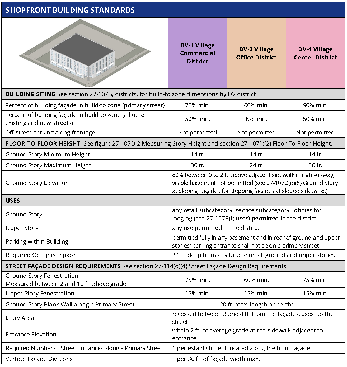
(f)
General building regulations.
(1)
Intent. The general building is intended to be built close to the sidewalk, but may also have a landscape yard. This building can be structured to house offices or residential uses including multi-family, and may have limited amounts of accessory retail and service uses in the ground floor. Parking is typically provided in structures at the rear of the lot, internally in the rear of the building, but may also have limited surface parking along the side of the building.
(2)
Standards. The following are the regulations for general buildings.
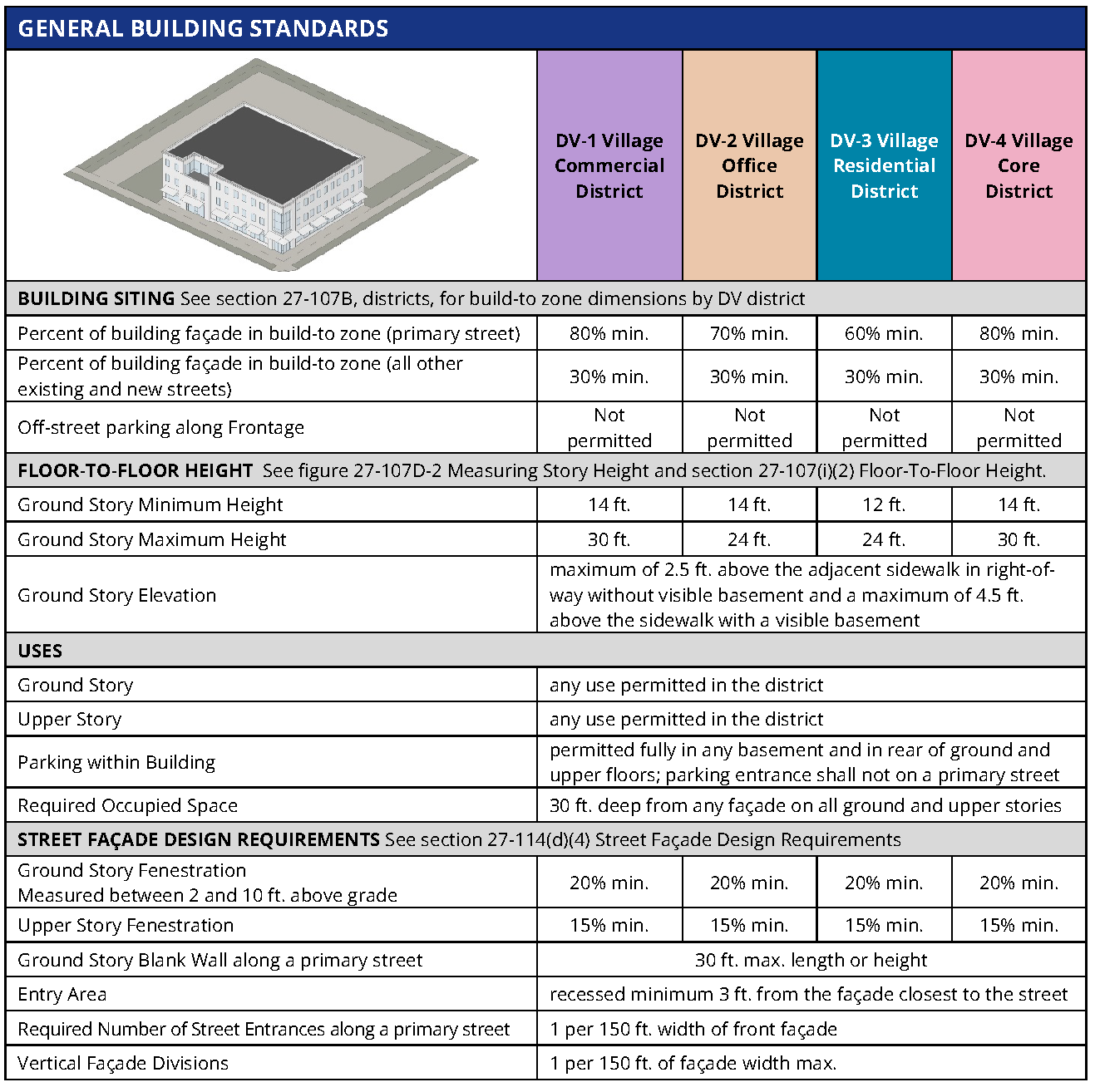
(g)
Townhouse building regulations.
(1)
Intent. The townhouse building is typically comprised of several multi-story attached house units, located adjacent to each other, each with its own pedestrian entrance to the street.
(2)
Standards. The following are the regulations for townhouse buildings.
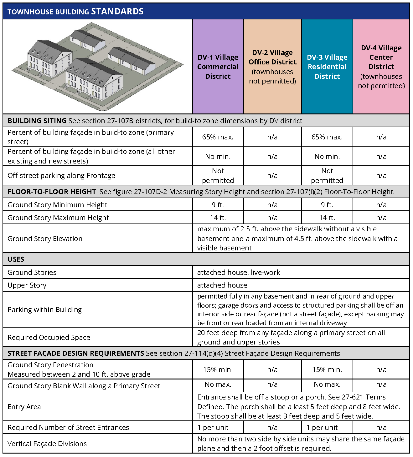
(h)
Civic building regulations.
(1)
Intent. The civic building is the most flexible building type and is limited to civic and institutional types of uses. These buildings are distinctive within the village fabric created by the other building types and could be designed as iconic structures.
(2)
Standards. The following are the regulations for civic buildings.
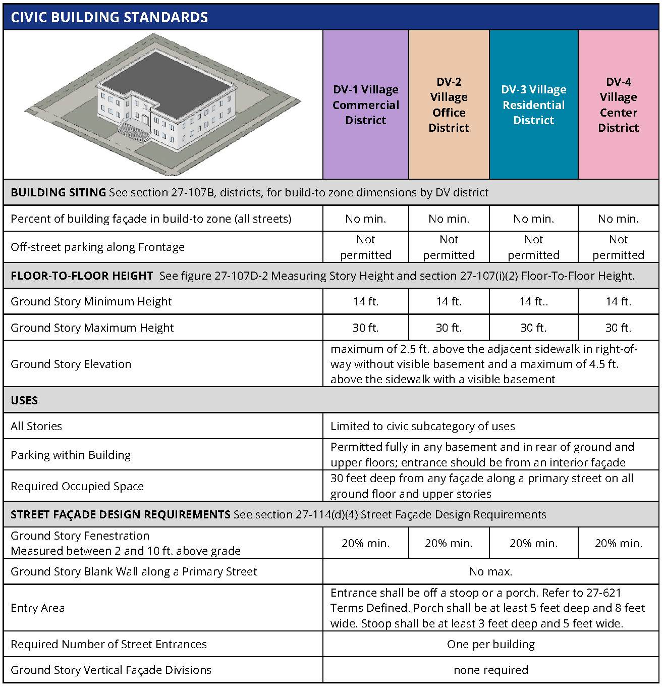
(i)
Explanation of specific building type requirements. The following explains and further defines the standards outlined on the tables on the previous pages, specific to each building type.
(1)
Building siting. The following explains the line item requirements for each building type table within the section entitled "Building siting."
a.
Build-to zone coverage. The minimum percentage of building wall or façade along the street for each street is designated on each building type table.
1.
Measurement. The width of the principal structures (as measured within the build-to zone along the frontage edge) is divided by the length of the frontage parallel to the property line following the street.
2.
Courtyards. Courtyards, per section 27-621, terms defined, located along the façade in the build-to zone count towards the minimum coverage. Refer to street types for limitations of courtyards along some frontages.
b.
Build-to zone.
1.
Defined. The build-to zone is the area on the lot where a certain percentage of the front building façade must be located, measured as a minimum and maximum yard (setback) range from the edge of the right-of-way.
2.
Measurement.
i.
The percent of building façade in build-to zone specifies the amount of the front building façade that must be located in the build-to zone, based on the width of the street-facing building façade divided by the width of the lot. The build-to zone is measured from the edge of the street frontage area onto the site. The lot width shall exclude any portions of the lot used for required transitions, provided new streets, or provided open space.
ii.
When a lot contains multiple buildings, the build-to zone requirements are measured as the sum of all buildings. There are no build-to zone requirements when a building is located behind another building that conforms to build-to zone requirements.
Figure 27-107D-1 Build-to zone with allowed plaza (left) and on corner lot (right)
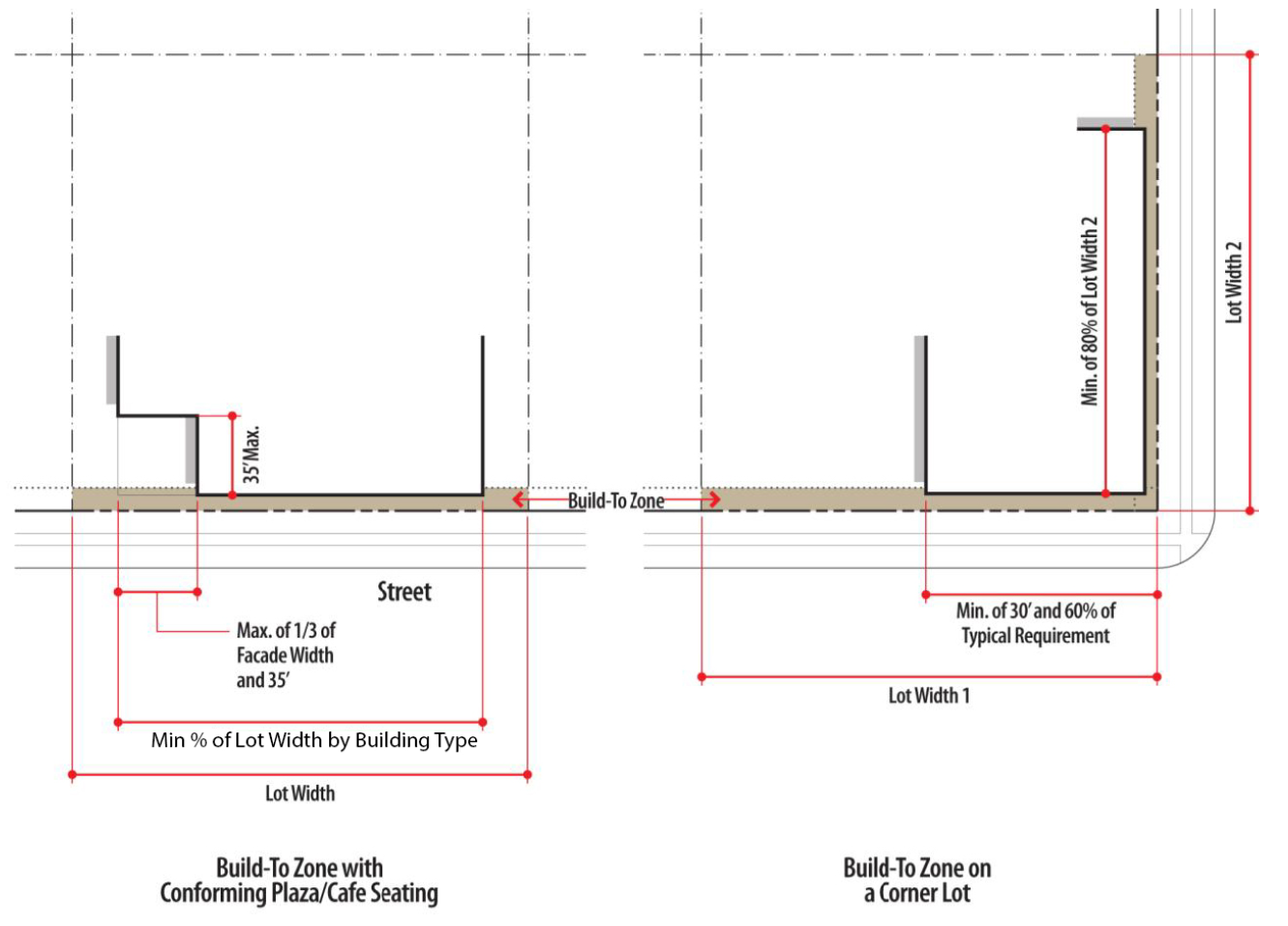
3.
Open spaces. Outdoor open space, plazas, and outdoor dining areas are counted as part of the building for the purpose of measuring compliance with build-to zone requirements, provided that:
i.
The area does not exceed one-third the length of the building face or 35 feet, whichever is less; and
ii.
The area is no more than 35 feet in depth (refer to figure 27-107D-1).
c.
Corner lots. On corner lots, minimum requirements governing the percent of building façade that must be located in the build-to zone may be reduced by 60 percent along one of the frontages, at the property owner's option, provided that a building façade must be placed in the build-to zone for the first 30 feet along each street extending from the corner (refer to figure 27-107D-1).
1.
Encroachments. Awnings and building mounted signage may extend beyond the build-to zone into the frontage area, but may not extend into the street right-of-way.
2.
Porches, arcades, galleries. Porches, arcades, and galleries may be included on the building façade design, utilizing the range of depth permitted by the build-to zone. If located outside the building coverage requirement, the depth of the arcade or gallery may exceed the build-to zone.
(2)
Floor-to-floor height. The following explains the line item requirements for each building type table within the section entitled "Floor-to-floor height."
a.
Overall permitted building heights are designated by district in stories. Refer to section 27-107B(b) through (e).
b.
Ground story, minimum and maximum height. (Refer to figure 27-107D-2, measuring story height). Each building type provides a permitted range of height in feet for the ground story of the building.
Figure 27-107D-2 Measuring Story Height
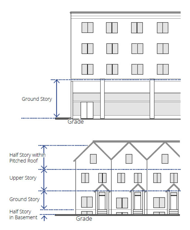
1.
Taller spaces. Spaces exceeding the allowable floor-to-floor heights of the building type are not permitted on primary street façades. These spaces are unlimited on interior lot and other street façades.
c.
Ground story elevation. The allowable ground story elevation for each building type is defined, establishing whether or not a visible basement is permitted.
1.
Visible basements. Visible basements, permitted by entrance type, are optional. The visible basement must not exceed one-half the height of the tallest story.
(3)
Uses within building. The following explains the line item requirements for each building type table within the section entitled "Uses within building." Refer to section 27-107B(f) uses for uses permitted within each DV district. The requirements in this section of the building type tables may limit those uses within a specific building type.
a.
Ground and upper story. The uses or category of uses which may occupy the ground and/or upper story of a building.
b.
Parking within building. The area(s) of a building in which parking is permitted within the structure.
c.
Required occupied space. The required depth of occupied space from the noted façade(s). Refer to section 27-621, terms defined, for the definition of occupied space.
(4)
Street façade design requirements. The following explains the line item requirements for each building type within the section entitled "street façade requirements". These requirements apply only to façades facing public or private streets and façades facing main parking lots where visitors or customers park.
a.
Minimum fenestration. (refer to figure 27-107D-4, measuring fenestration, per façade). Fenestration shall be measured as the percentage of the total façade area of each story dedicated to glazing. The following articulates the minimum amount of ground story transparent glass required on all façades facing streets.
1.
Measurement. Ground story fenestration, when defined separately from the overall minimum fenestration, shall be measured as the percentage of the total façade area dedicated to glazing between two feet and ten feet above average grade at the base of the front façade. Refer to figure 27-107D-3, measuring ground story fenestration.
2.
Transparent. Transparent means any glass in windows and/or doors, including any mullions, that is highly transparent with low reflectance. Glazed elements must be clear and non- reflective and not be painted or tinted, except that low-emission (Low-E) glass coatings are permitted.
Figure 27-107D-3 Measuring Ground Story Fenestration
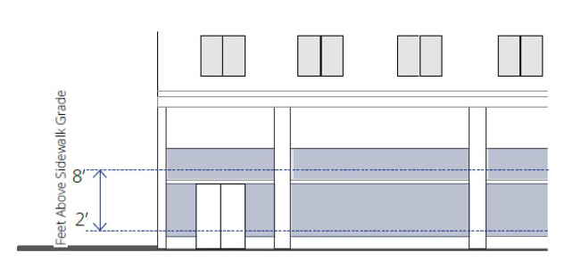
Figure 27-107D-4 Measuring Fenestration per Façade
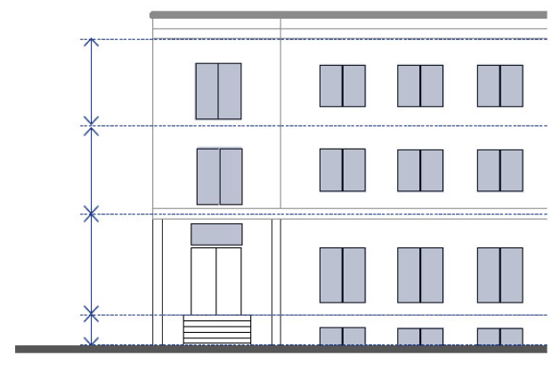
3.
Other stories. A general minimum fenestration requirement applies to all other stories visible from any street. The fenestration is measured from top of the finished floor to the top of the finished floor above. When there is no floor above, upperstory fenestration is measured from the top of the finished floor to the top of the wall plate.
4.
Arcades, galleries, courtyards. Ground story windows shall be located on the interior façade of any arcade or gallery. Ground story windows shall continue around a minimum of 60 percent of courtyard façades.
b.
Blank wall area.
1.
Blank walls are areas on the exterior façade of a building that do not include a substantial material change; windows or doors; columns, pilasters or other articulation greater than 12 inches in depth. Blank wall limits are established in 27-107D(e) through 27-107D(h).
2.
Blank wall area regulations apply in both a vertical and horizontal direction.
c.
Entry area. Size requirements and recommended types of entrance areas per building type.
d.
Required number of street entrances. The minimum number of and maximum spacing between entrances on the ground floor building façade with street frontage. Street entrances for all non-residential uses shall remain unlocked during business hours. Entrances located on corners may satisfy the requirement of both adjacent streets.
e.
Vertical façade divisions. The use of a vertically oriented expression line or form to divide the façade into vertical divisions at increments no greater than the dimension shown, as measured along the base of the façade. Elements may include a column, pilaster, or other continuous vertical ornamentation a minimum of 1.5 inch depth. Refer to section 27-621, terms defined, for the definition of expression line.
(5)
Parking structures fronting a street. The following applies to parking structures fronting a public street, in addition to the requirements of 27-107C(c).
a.
Primary streets. Parking structures, whether accessory or principal use, shall not front a primary street, unless otherwise approved with special land use permit per article V, division 3.
b.
Parking structure design requirements.
1.
Blank wall limitations. On any street façade, no rectangular area greater than 30 percent of any story's façade, as measured from floor to floor, and no horizontal segment of a story's façade greater than 15 feet in width may be solid, blank wall.
2.
Pedestrian entry. A defined pedestrian entrance/exit is required separate from the vehicular entrance and directly accessing the sidewalk. If the entry is enclosed, 65 percent of the entry must be transparent glass.
3.
Screening. All openings of any parking deck must be fully screened from view from any residential dwelling or adjacent public or private streets so that cars, sloped ramps, and interior deck lighting are not visible.
(Ord. No. 2020-11-23, Exh. A, 11-30-2020)
Sec. 27-107E. - Open space types.
(a)
Intent. To provide open space as an amenity that promotes physical and environmental health within the community and to provide access to a variety of active and passive open space types.
(b)
Applicability. These standards apply to open space required by 27-107B.
(1)
Existing open space. At the discretion of the city, existing open space on the site may be used to meet the minimum requirement; however, the existing open space shall conform to one of the types defined.
(2)
Historic preservation incentive. When buildings built before 1930 are incorporated into a development and when no changes are made to their exterior (other than paint color), an area equal to three times the building footprint is may be used to meet the minimum requirement.
(3)
Fee in-lieu. Open space requirements of this section must be met by open space provided on the development site, unless off-site open space or a fee in lieu of open space provision is approved in accordance with the special administrative permit process.
(c)
General requirements. All open space shall meet the following:
(1)
Open space types. All open space provided shall comply with one of the open space types defined by subsections (e) through (i).
(2)
Location. Open space must be provided in the approximate location required on figure 27-107B-1, regulating map, when applicable.
(3)
Access. All open space types shall provide public access from a pedestrian route associated with a vehicular right-of-way and/or adjacent building entrances/exits.
(4)
Fencing. Open space types may incorporate fencing, provided that the following requirements are met.
a.
Height. Fencing shall be a maximum height of 48 inches, unless approved by the community development director for such circumstances as use around athletic facilities.
b.
Level of opacity. Fence opacity shall be no greater than 60 percent.
c.
Type. Chain-link fencing is not permitted along any street frontage, with the exception of dedicated athletic facility fencing approved by the community development director.
d.
Spacing of openings. Openings or gates shall be provided on every street face at a minimum of one per every 200 feet.
(5)
Open water body. All open water bodies, such as lakes, ponds, pools, creeks, and streams within an open space type shall be located at least 20 feet from a property line to allow for pedestrian and bicycle access as well as a landscape area surrounding the water body.
(6)
Parking requirements. Parking shall not be required for any open space type, unless otherwise determined by the community development director.
(7)
Continuity. New open space shall connect to abutting or proximate existing or planned trail rights-of-way.
(8)
Measuring size.
a.
Size. The size of the open space shall be is measured to include all landscape and paving areas associated directly with the open space.
b.
Minimum dimension. The minimum dimension shall be the minimum length or width of the open space, as measured along the longest two straight lines intersecting at a right angle which define the maximum length and width of the lot. Refer to figure 27-107E-1, measuring minimum dimensions.
Figure 27-107E-1 Measuring Minimum Dimensions
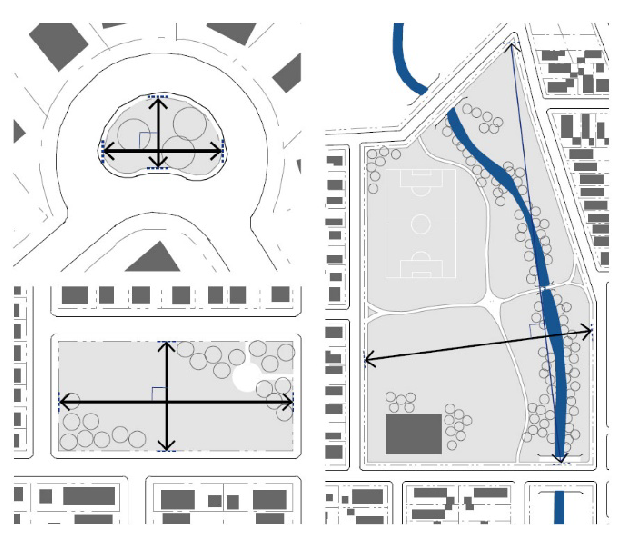
(9)
Minimum percentage of street frontage required. A minimum percentage of the open space perimeter, as measured along the outer edge of the space, shall be located directly adjacent to a primary or secondary street. This requirement provides access and visibility to the open space.
(10)
Improvements. As noted in the specific requirements for each open space type (subsections (e) through (i)), the following types of site improvements and structures may be permitted on an open space.
a.
Fully enclosed structures permitted. Fully enclosed structures may include such uses as small cafes, kiosks, community centers, and restrooms.
1.
Maximum area. For some civic open space types, fully enclosed structures are permitted, but limited to a maximum building coverage as a percentage of the open space area.
2.
Semi-enclosed structures. Open-air structures, such as gazebos, are permitted in all open space types.
b.
Maximum impervious and semi-pervious surface permitted. The amounts of impervious and semi-pervious coverage are provided separately for each open space type (subsections (e) through (i)) to allow an additional amount of semi-pervious surface, such as permeable paving, above the impervious surfaces permitted, including, but not limited to, sidewalks, paths, and structures as permitted.
c.
Maximum percentage of open water body. The maximum amount of area within an open space type that may be covered by an open water body, including, but not limited to, ponds, lakes, and pools.
(d)
Stormwater in open space types. Stormwater management practices, such as normally dry storage and retention facilities or ponds maintaining water at all times, may be integrated into open space types and utilized to meet stormwater requirements for surrounding parcels.
(1)
Stormwater features. Stormwater features in open space may be designed as formal or natural amenities with additional uses other than stormwater management, such as an amphitheater, sports field, or a pond or pool as part of the landscape design. Stormwater features shall not be fenced and shall not impede public use of the land they occupy.
(2)
Walls. Retaining walls over 30 inches in height are not permitted in any open space accommodating stormwater.
(3)
Qualified professional. A qualified design professional shall be utilized to incorporate the stormwater features into the design of the open spaces.
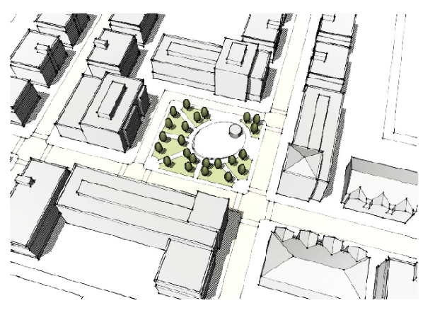
(e)
Plaza. The intent of the plaza is to provide a formal open space type of medium scale to serve as a gathering place for civic, social, and commercial purposes. The plaza may contain a greater amount of impervious coverage than any other open space type. Special features, such as fountains and public art installations, are encouraged.
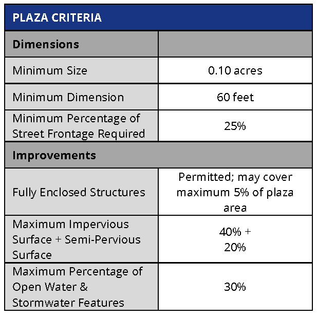
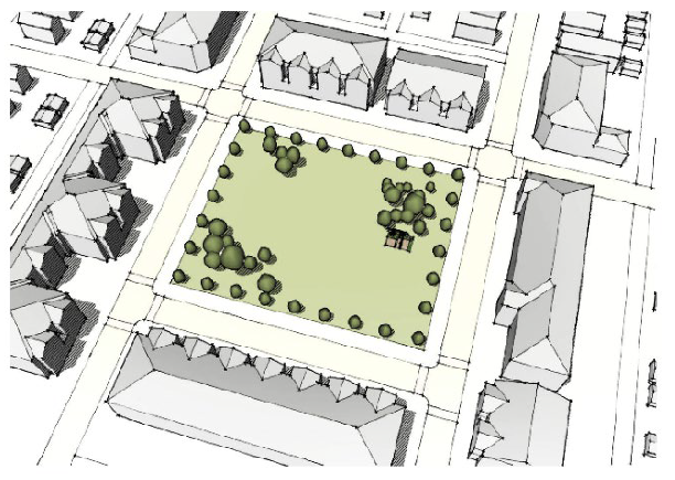
(f)
Green. The intent of the green is to provide informal, medium scale active or passive recreation for building occupants and visitors within walking distance, mainly fronted by streets.
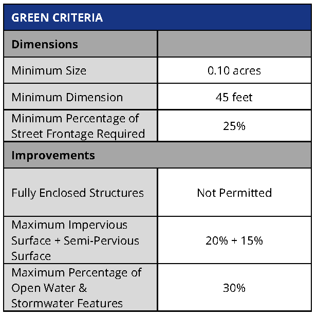
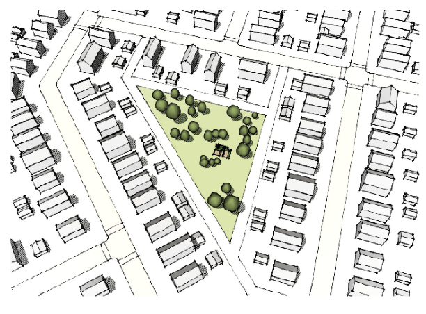
(g)
Commons. The intent of the commons is to provide an informal, small to medium scale space for active or passive recreation for a limited area. Commons are typically internal to a block and tend to serve adjacent building occupants.
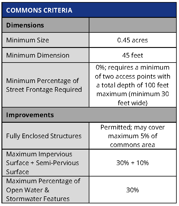
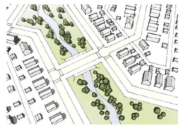
(h)
Park. The intent of the park is to provide informal active and passive large-scale recreational amenities to local residents and the greater region. Parks have primarily natural plantings and are frequently created around an existing natural feature such as a water body or stands of trees.
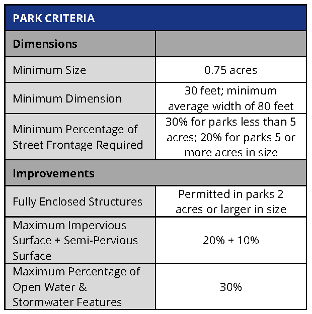
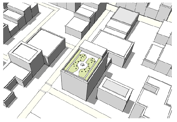
(i)
Rooftop terrace. The intent of the rooftop terrace is to provide a formal or informal, small to medium scale space for passive or active recreation or gatherings. Rooftop terraces tend to serve adjacent building occupants but must be open to the general public to count toward the open space requirement.
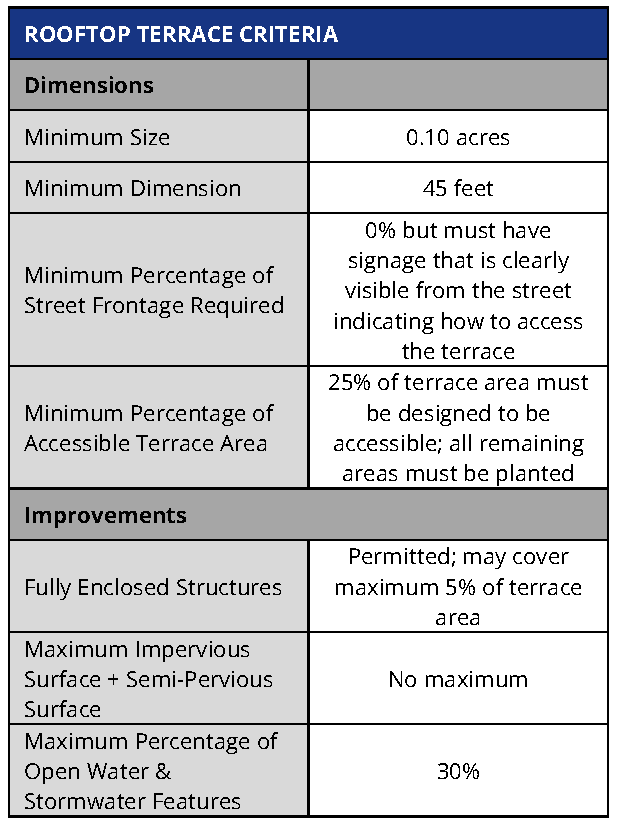
(Ord. No. 2020-11-23, Exh. A, 11-30-2020)