
El Centro City Zoning Code
ARTICLE I
- BASIC PROVISIONS
Sec. 29-1. - Purpose and scope.
The city zoning ordinance consisting of this chapter and the official zoning map is hereby established and adopted by the city council for the purpose of promoting and protecting the public health, safety and welfare of the people of the city, to implement the general plan of the city, and to provide for the social, physical and economic advantages resulting from comprehensive and orderly planned use of land resources.
(Ord. No. 24-03, § 2, 9-17-24)
Sec. 29-2. - Applicability of the chapter.
The chapter shall be applicable to all areas of the city. The use and employment of all land and any buildings or structures located upon the land and the construction, reconstruction, alteration, expansion, or relocation of any building or structure upon the land shall conform to all regulations applicable to the zone in which the land is located. No land, building, structure, or premises shall be used for any purpose or in any manner other than is permitted by this chapter and by the zone in which such land, building, structure, or premises is located.
(Ord. No. 24-03, § 2, 9-17-24)
Sec. 29-3. - Interpretation of the chapter.
If ambiguity arises concerning the content or application of the chapter, it shall be the duty of the community development director to ascertain all pertinent facts and set forth the community development director's finding and interpretation. Unless such finding and interpretation is appealed to the planning commission pursuant to article V, division 9, of this chapter, the community development director's interpretation shall thereafter govern.
(Ord. No. 24-03, § 2, 9-17-24)
Sec. 29-4. - Interpretation of conflicting provisions.
In interpreting and applying the provisions of these regulations, they shall be held to be the minimum requirement for the promotion of the public health, safety, comfort, convenience, and general welfare. The intent of these regulations is not to interfere with or abrogate or annul any easement, covenant, or other agreement between parties. When these regulations impose a greater restriction upon the use of buildings or land, or upon the height of buildings, or require larger open spaces than are imposed or required by other ordinances, rules, regulations, or by easements, covenants, or agreements, the provisions of these regulations shall control.
(Ord. No. 24-03, § 2, 9-17-24)
Sec. 29-5. - No relief from other provisions.
Except as otherwise specifically provided, no provision of this chapter shall be construed as relieving any party to whom a permit or variance is issued from any other provision of state or federal law or from any provision, ordinance, rule, or regulation of the city requiring a license, franchise, or permit to accomplish, engage in, carry on, or maintain a particular business, enterprise, occupation, transaction, or use.
(Ord. No. 24-03, § 2, 9-17-24)
Sec. 29-6. - Completion of existing projects.
Nothing contained herein shall require any change in the plans, construction or designated use of a building or structure for which a building permit has been issued prior to the effective date of any amendment of these regulations provided that actual construction of such building or structure is commenced within one hundred eighty (180) days after the date of issuance of the building permit and is completed within one (1) year from the effective date of such amendment, and provided further that such construction and proposed use of such building or structure is not on said effective date in violation of any other ordinance or law.
(Ord. No. 24-03, § 2, 9-17-24)
Sec. 29-7. - Severability of provisions.
If any section, subsection, sentence, clause, or phrase of this chapter is for any reason held to be invalid or unconstitutional, such invalidity or unconstitutionality shall not affect the validity or constitutionality of the remaining portions of these regulations, it being hereby expressly declared that this chapter and each section, subsection, sentence, clause, and phrase hereof would have been prepared, proposed, adopted, approved, and ratified irrespective of the fact that any one (1) or more other sections, subsections, sentences, clauses, or phrases be declared invalid or unconstitutional.
(Ord. No. 24-03, §2, 9-17-24)
Sec. 29-8. - Consistency with hazardous waste management plan.
Zone changes, conditional use permits, variances and other land use decisions shall be consistent with the portions of the county hazardous waste management plan (approved February 28, 1990) relating to siting and siting criteria for hazardous waste facilities. Nothing herein shall limit the ability of the city to attach appropriate conditions to the issuance of any such approval in order to protect the public health, safety or welfare nor to establish more stringent planning requirements or siting criteria than those specified in the county plan.
(Ord. No. 24-03, § 2, 9-17-24)
Sec. 29-14. - Purpose and applicability.
The purpose of this division is to promote consistency and precision in the interpretation of this chapter. The meaning and construction of words and phrases as set forth shall apply throughout this chapter, except where the context of such words or phrases clearly indicates a different meaning or construction. Definitions contained in the Uniform Building Code shall be applicable except when in conflict with definitions contained herein, in which case the chapter definition shall prevail.
(Ord. No. 24-03, § 2, 9-17-24)
Sec. 29-15. - General rules for construction and interpretation of language.
The following general rules of construction shall apply to the textual provisions of this chapter:
(1)
Headings. Section and subsection headings contained herein shall not be deemed to govern, limit, modify, or in any manner affect the scope, meaning, or intent of any provision of the chapter.
(2)
Illustration. In case of any difference of meaning or implication between the text of any provision and any illustration, the text shall control.
(3)
Shall and may. "Shall" is always mandatory and not discretionary. "May" is discretionary.
(4)
Tenses and numbers. Words used in the present tense include the future, and words used in the singular include the plural, and the plural the singular, unless the context clearly indicates the contrary.
(5)
Conjunctions. Unless the context clearly indicates the contrary, the following conjunctions shall be interpreted as follows:
a.
"And" indicates that all connected items or provisions apply;
b.
"Or" indicates that the connected items or provisions may apply singly or in any combination; and
c.
"Either... or" indicates that the connected items or provisions shall apply singly but not in combination.
(6)
Departments, bodies, etc. All public officials, bodies, and agencies to which reference is made are those of the city unless otherwise indicated.
(7)
Public officials and their designees. All references to public officials include designated representatives of such officials, unless otherwise indicated.
(8)
City Code. All references to City Code shall mean the Code of the City of El Centro.
(9)
State. All references to the "state" shall mean the State of California. Any reference to a specific State of California regulation or law shall also mean "as the regulation or law may be subsequently amended by the State of California."
(10)
Calendar days. All references to days are to calendar days unless otherwise indicated. If a deadline falls on a Saturday, Sunday or holiday, it shall be extended to the next full day in which the offices of the community development department are open for business.
(11)
Building/structure. The words "structure" and "building" shall have the same meaning.
(12)
Activities/facilities. The words "activities" and "facilities" include any part thereof.
(13)
Used. The word "used" shall include arranged, designed, constructed, altered, converted, rented, leased or intended to be used.
(14)
All terms shall be construed pursuant to division 2, definitions of this article I. Terms that are not defined shall be construed according to the context and approved usage of the language, and as ultimately determined by the community development director. If the definition of a term provided herein conflicts with a term defined by a state law or regulation, the definition provided by the state law or regulation shall prevail.
(Ord. No. 24-03, § 2, 9-17-24)
Sec. 29-16. - "A" definitions.
Abandonment: To cease the intended and designated use of a property or building for a period of one hundred eighty (180) days or more.
Abate: To end a nuisance, emergency, or non-conformance.
ABC license: A license issued by the state department of alcoholic beverage control.
Abutting: Two (2) adjoining parcels of property, with a common property line, are herein considered as one (1) parcel abutting the other, except where two (2) or more lots adjoin only at a corner or corners, they shall not be considered as abutting unless the common property line between the two (2) parcels measures not less than eight (8) feet in a single direction.
Access or access way: The place, means, or way by which pedestrians and vehicles shall have safe, adequate and usable ingress or egress to a property or use as required by this chapter.
Accessory building: A building, part of a building, or structure which is subordinate to, and the use of which is incidental to that of the main building, structure or use on the same lot.
Accessory dwelling unit: A dwelling on the same property as a primary dwelling that provides complete independent living facilities for one (1) or more people in compliance with Government Code section 66313. An accessory dwelling unit may be attached, detached, or internal to a primary dwelling. See also "junior accessory dwelling unit".
Accessory dwelling unit, attached: An accessory dwelling that shares at least one (1) common wall with the primary dwelling but is not entirely internal to the primary dwelling.
Accessory dwelling unit, detached: An accessory dwelling that does not share any common wall with the primary dwelling and is not internal to the primary dwelling. A detached accessory dwelling unit may share one (1) or more common walls with another detached accessory dwelling unit.
Accessory dwelling unit, internal: An accessory dwelling that is entirely internal to the primary dwelling.
Accessory use: A use which is customarily incidental, related, appropriate, and clearly subordinate to the main use of the lot or building, which accessory use does not alter the principal use of the subject lot or affect other properties in the zone.
Actual construction: The actual placing of construction materials in their permanent position, fastened in a permanent manner, except that where a basement is being excavated such excavating shall be deemed to be actual construction, or where demolition or removal of an existing structure has been begun preparatory to rebuilding, such demolition or removal shall be deemed to be actual construction.
Adjacent: Near, close, or abutting; for example, an industrial zone across a street or highway from a residential zone shall be considered "adjacent."
Adjoining: The same as "abutting."
Administrative decision: A decision in which an agency or official applies existing law or policy to a given set of facts.
Adult bookstore or adult video store: See section 29-245 for this definition.
Adult motion picture theater: See section 29-245 for this definition.
Advertising structure: An on- or off-site structure of any kind or character other than the main business identification sign, erected or maintained for outdoor advertising purposes, upon which any poster, bill, printing, painting, or other advertisement of any kind whatsoever may be placed, including statuary for advertising purposes. Includes billboards.
Agricultural uses: The use of land for small scale farming and animal keeping, including the growing of row crops, fruit, fiber, horticulture, and pasturage. Animal keeping shall abide by section 5-1, et seq. of the City Code and section 29-169, et seq., except that at no time shall the keeping of horses, bovine animals, sheep, goats and swine exceed a combined density of one (1) such animal per twenty-one thousand seven hundred eighty (21,780) square feet (one-half (½) acre) of gross area of the lot(s) upon which the same are kept and at no time shall any one (1) lot contain more than ten (10) such animals. The keeping of roosters is solely and expressly an agricultural use. Uses and structures incidental and accessory to said farming and animal keeping shall be permitted, including one (1) single-family residence per lot, barns, stables, pens, coops, greenhouses, apiaries, and small grain and produce storage buildings not exceeding ten thousand (10,000) square feet in gross floor area. Incidental farm employee housing shall constitute an agricultural use (see section 29-21 for definition of "farm employee housing").
Airport: Any area which is used or is intended to be used for the taking off and landing of aircraft, including helicopters, and any appurtenant areas which are used or are intended to be used for airport building or facilities, including open spaces, taxiways and tie-down areas, hangars, and other necessary buildings and open spaces.
Albedo: A measurement of solar reflectance on a surface. A "high albedo" means a high reflectance of sun and low absorption of heat on constructed surfaces of a building and development.
Alley: Any dedicated way, intended for vehicular service to the rear or side of property served by a street. Buildings facing only on an alley shall not be construed as satisfying the requirements of this chapter related to frontage on a dedicated street.
Altered: The same as "structural alteration."
Alternative tower structure: See section 29-256 for this definition.
Amendment: A change in the wording, context, or substance of this chapter, an addition or deletion, or a change in the zone boundaries or classifications upon the zoning map, which imposes any regulation not theretofore imposed or removes or modifies any such regulation theretofore imposed.
Amateur radio (HAM) facility: See section 29-256 for this definition.
Amateur radio (HAM) operator: See section 29-256 for this definition.
Amateur radio (HAM) service: See section 29-256 for this definition.
Anatomical areas: See "specified anatomical areas."
Animal hospital: A place where animals or pets are given medical or surgical treatment and are cared for during the time of such treatment. Use as a kennel shall be limited to short-time boarding and shall be only incidental to such hospital use.
Animal husbandry: Raising of animals or production of animal products, such as eggs or dairy products, on an agricultural or commercial basis. Typical uses include grazing, ranching, dairy farming and poultry farming.
Animal waste processing: The processing of animal waste and by-products, including but not limited to animal manure, animal bedding waste, or similar by-product of an animal-raising agricultural operation, for use as a commercial fertilizer or soil amendment and including composting operations.
Annexation: The incorporation of land area into the jurisdiction of the city with a resulting change in the boundaries of the city.
Antenna: See section 29-256 for this definition.
Apartment: A room or suite of two (2) or more rooms with a single kitchen in a multi-family dwelling, occupied or suitable for occupancy as a residence for one (1) family.
Appeal: A request by a project applicant or other qualified individual or agency for a city body to modify, or reverse a decision rendered by a subordinate city body or city staff.
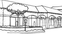
Arcade: A roofed passageway or lane, especially one with shops or enclosed living spaces on one (1) side and exterior open arches on the other side (figure 29-16.1).
Figure 29-16.1. Arcade
Area, gross: The area of a lot or parcel of land before public streets, easements or other areas to be dedicated or reserved for public use are deducted from such lot or parcel.
Area, net: The area within the property lines of a lot or parcel of land after all streets and other dedications have been complied with and to which development standards of this chapter shall apply.
Art gallery: An establishment engaged in the sale, loan, or display of art books, paintings, sculpture, or other works of art. This classification does not include libraries, museums, or non-commercial art galleries.
Artisan food and beverage production: The small-scale, small-batch (maximum three thousand and five hundred (3,500) gross square feet) production or preparation of hand-crafted, specialty food and beverage products made on site with limited to no automated processes involved. Typically operated by a single business entity. Includes small batch production of products such as ice cream, baked goods, chocolate and confectionery, coffee roasting, cheese making, condiments, olive oils, snacks, and other food or beverage products considered by the director to be similar. May include wholesale sales and direct sales to or onsite consumption by consumers. Does not include alcoholic beverages. See microbrewery, distillery, or winery for small-scale production of alcoholic beverages.
Artisan manufacturing and production: The small-scale manufacture and production of commercial and specialty goods using hand tools or small-scale, light mechanical equipment by a craftsperson, artist, or manual worker, such as jewelry, metal work, cabinetry and furniture, glassblowing, stained glass, textiles, ceramics/pottery, photograph and printing making, fine arts and crafts, clothing/apparel, and other uses determined by the director to be similar. This classification does not include any activity that causes externalities such as noise, odor, or vibration to be detectable on a neighboring property. May include incidental indoor storage associated with the permitted use. May include retail/gallery space for sale of the artisan products produced on-site; however, no more than ten (10) percent of sales may be from non-artisan products. See "small scale/artisan food and beverage production" for production of foods and beverages, not including alcoholic beverages.
Artisan loft: Combined commercial and residential space for artisan manufacturing and production activities. See definition of live/work. See related definition of "mixed-use development, artisan loft".
Assessor: The assessor of the county.
Assistant community development director: Assists the community development director in managing the community development department and assumes the duties and responsibilities of a city building official as referenced in the California Building Code.
Attic: The uninhabitable space between the upper surface of the top floor of a building and the roof above. An attic is not considered a story.
Automated teller machine (ATM): An unmanned machine that customers use to perform financial transactions including deposits and withdrawals of currency.
Automobile wrecking: The dismantling or wrecking of used motor vehicles or trailers, or the storage, sale, or dumping of dismantled or wrecked vehicles or their parts. The presence on any lot or parcel of land of five (5) or more motor vehicles which for a period exceeding thirty (30) days have not been capable of operating under their own power, and from which parts have been or are to be removed for reuse or sale shall constitute prima facie evidence of an automobile wrecking yard.
Automobile service station: A lot or portion of a lot primarily used for the retail sale of gasoline for use in motor vehicles, and incidental servicing of motor vehicles. Such servicing may include sale of motor oils, lubrication, car washing (with no steam equipment), waxing and polishing, sale and service of tires, tubes, batteries, and service of auto accessories. Such servicing shall not include tire recapping, sale of major auto accessories, parts, sale or rebuilding of engines, battery manufacturing or rebuilding, radiator repair or steam cleaning, body repair, painting or upholstery, installation of auto glass, or trailer rental, unless such use or uses are also permitted in the zone in which the automobile service station is located or proposed.
Automotive services: General maintenance, repair, rebuilding, or reconditioning of engines, motor vehicles or trailers, including, but not limited to, body and fender work, framework, welding, upholstering, and painting service.
Awning: A roof-like structure, attached to and supported entirely by the exterior wall of a building, often made of canvas or similar material that serves as a shelter over a storefront, window, door, or deck.
(Ord. No. 24-03, § 2, 9-17-24)
Sec. 29-17. - "B" definitions.
Backhaul network: See section 29-256 for this definition.
Bail: The pledge of cash or property to secure the release of a thing or person which would otherwise be held in custody.
Bail bond: A guarantee by a third-party that a defendant in a court action will appear to all of their criminal court proceedings. The bond is given in return for the release of the defendant from court custody.
Bakery, retail: A retail sales facility which offers bakery products only for direct sale to the public and which, as an accessory use, may include the preparation of products normally sold in bakeries, for sale off the premises.
Bakery, wholesale: A bakery or other food store that devotes over ninety (90) percent of its gross floor area to the preparation of bakery products for sale at other locations. Wholesale bakeries may offer bakery products for direct sale to the public.
Balcony: An unenclosed area either recessed or projected from the walls of a building.
Balconies are thirty (30) inches or more above grade, are attached to and supported primarily by the exterior wall of the building, are accessible from the building's interior, and are unenclosed on one (1) or more sides except for a railing or parapet, not less than forty-two (42) inches or greater than sixty (60) inches high. A balcony is not an accessory structure.
Bar: An alcohol sales establishment where the primary use is the sale and on-site consumption of alcoholic beverages and where secondary uses may include food service, in accordance with the regulations of the Alcohol Beverage Control (ABC) and other applicable state and federal laws, and which must possess a Type 40, 42, 48, or other applicable ABC liquor license. The premises may contain a counter upon and over which alcoholic beverages, such as beer, wine, and distilled spirits are served.
Barbed-wire: a type of steel fencing wire constructed with sharp edges or points arranged at intervals along the strands. Variations include razor wire which is fencing wire having a sharp edge or intermittent blades.
Basement: An area of a structure partially above ground and having no more than fifty (50) percent of its height, at any point, above finish grade on each and every side. A basement is not considered a story.
Bay window: a window or series of windows forming a bay in a room and projecting outward from the exterior wall.
Bedroom: Any habitable room other than a living room, family room, bathroom, dining room or kitchen shall be considered a bedroom if:
(1)
It has seventy (70) square feet or more of floor area;
(2)
The minimum horizontal dimension between interior walls is seven (7) feet and the ceiling height is seven (7) feet six (6) inches or more; and
(3)
It meets uniform building and housing requirements.
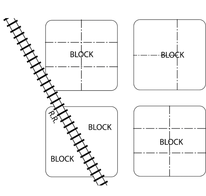
Block: A unit of land bounded by streets or by a combination of streets and public land, railroad rights-of-way, waterways, or any other barrier to the continuity of development (See figure 29-17.1).
Figure 29-17.1. Block
Block frontage: All property fronting on one (1) side of a street between a street and right-of-way, waterway, or between intersecting or intercepting streets, the end of a dead-end street, or city or county boundary measured along a street line. An intercepting street shall determine only the boundary of the frontage on the side of the street that it intercepts.
Boarding, lodging or rooming house: A building containing a single dwelling and not more than five (5) guest rooms, where lodging is provided with or without meals for compensation.
Bond: A contractual guarantee by a third-party that something will happen.
Breezeway: A roofed passageway, open on at least two (2) sides where the roof is structurally integrated with the structure of the main building.
Brewery, large: A large-scale brewery that produces fifteen thousand (15,000), or more, barrels of beers and/or similar beverages on-site per year as a primary use in accordance with the regulations of the Alcohol Beverage Control (ABC), other applicable state and federal laws, and which must possess either a Type 1 or Type 23 ABC License. The establishment may also include the retail sale to the general public of beverages for off-site consumption, but which may include on-site consumption only in accordance with the regulations for the zone on which the establishment is located and applicable ABC licenses and regulations. The establishment may include a restaurant on the premises also subject to City Code and ABC requirements.
Broadcast: See section 29-256 for this definition.
Broadband: See section 29-256 for this definition.
Brownfield site: An abandoned, idled, or underused industrial or commercial facility where expansion or redevelopment is complicated by real or perceived environmental contamination.
Buffer: An area of land separating two (2) distinct land uses that acts to soften, mitigate or protect the effects of one (1) land use on the other.
Building: Any structure that is completely roofed and enclosed on all sides which is built and maintained for the support, shelter or enclosure of persons, animals, chattels, or property of any kind, but shall not include temporary buildings as defined in "structure, temporary."
Building, main: A building within which is conducted the principal use permitted on the lot, as provided by this chapter.
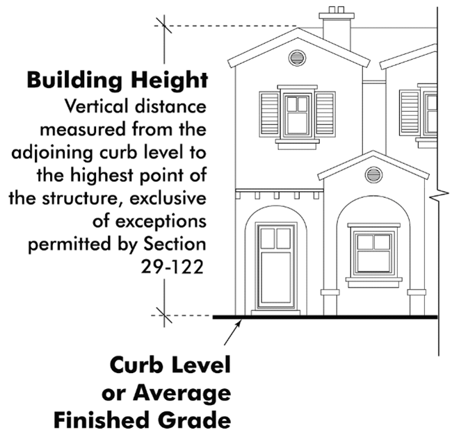
Building height: The vertical distance measured from the adjoining curb level to the highest point of the structure, exclusive of exceptions permitted by section 29-122; provided, however, that where buildings are set back from the street line, the height shall be measured from the average elevation of the finished grade at the front of the building (see figure 29-17.2).
Figure 29-17.2. Building Height
Building frontage: That portion of a building which abuts a legally accessible public or approved private street.
Building plane: A flat or level surface of a building that is contiguous without offsets or recesses.
Building site: The total ground area of a site including open space areas, easements, and rights-of-way. A building site may encompass more than one (1) lot.
(Ord. No. 24-03, § 2, 9-17-24)
Sec. 29-18. - "C" definitions.
Camouflaged tower: See section 29-256 for this definition.
Campers (truck-type): Automotive vehicles used for sleeping and/or with kitchen facilities.
Caretaker: A person residing in a dwelling unit (manufactured unit included) on a property, whose duties include, but are not limited to, direct care, supervision, or maintenance of the property or uses on the property.
Caretaker's residence (permanent): A dwelling unit containing living quarters and kitchen facilities located on a premises with a main non-residential use and occupied only by an owner, caretaker, superintendent, or security personnel for the main use, and his or her family.
Caretaker's residence (temporary): A temporary dwelling unit containing living quarters and kitchen facilities for housing persons responsible for administering, overseeing, or maintaining security for the main use on the site during the construction period.
Carport: A permanent roofed structure with not more than two (2) enclosed sides used or intended to be used for automobile storage for the occupants of the premises. Enclosed storage lockers may be provided within carports for said occupants.
Catering establishment: A business, social or home catering service providing food and incidental services for a social affair, event, or for a private dwelling, which does not engage in the sale of food or beverage to individually paying patrons.
Cell: See section 29-256 for this definition.
Cellular network: See section 29-256 for this definition.
CEQA: The California Environmental Quality Act, California Public Resources Code section 21000 et seq. and the California Environmental Quality Act Guidelines as may be subsequently amended by the state.
Child day care facilities:
(1) Small family day care home: A home which provides care, protection, and supervision of eight (8) or fewer children, for a period of less than twenty-four (24) hours per day, while the parents or guardians are away. The total number also includes children under the age of ten (10) years who reside in the caregiver's own home.
(2) Large family day care home: A home which provides care protection, and supervision of seven (7) to fourteen (14) children, inclusive, for a period of less than twenty-four (24) hours per day, while the parents or guardians are away. This total number would also include children under the age of ten (10) years who reside in the caregiver's own home.
(3) Child day care center: Any facility, of any capacity, other than a family day care home as defined herein in which less than twenty-four (24) hours per day non-medical care and supervision is provided for children in a group setting. Child day care centers include nursery schools, but do not include elementary schools.
(4) Child day care home provider: Any person who operates a child care facility and is licensed by the state department of social services.
Church: A permanently located building commonly used for religious worship, fully enclosed with walls (including windows and doors) and having a roof (canvas or fabric excluded) and conforming to applicable legal requirements affecting design and construction.
City: The City of El Centro.
Clinic: A place for group medical services not involving overnight housing of patients. Also see California Health and Safety Code section 1200.
Cleaning establishment: A commercial use wherein the cleaning of clothes is incidental to a laundry pickup establishment, launderette, or a coin-operated dry cleaning service, and where non-volatile materials are used in the process.
Club: An association of persons (whether or not incorporated) for a common purpose, but not including groups organized solely or primarily to render a service carried on as a business for profit.
Cluster units: A group of dwellings connected, or detached such as apartments, row housing and single-family homes which do not individually have direct access to a dedicated street or highway but which are served by a private or common street, driveway or alleyway. Commonly found in planned unit developments.
Collocation: See section 29-256 for this definition.
College: A college, junior college or university supported by public funds, or a private college, junior college or university which gives comparable academic instruction and degrees as a public institution.
Colonnade: A series of columns set at regular intervals and usually supporting the base of a roof structure under which one can walk.
Commercial recreation: Sports and recreation uses primarily conducted by and for participants for compensation. Any spectators would be incidental and on a nonrecurring basis.
Commercial private wireless communication facility: See section 29-256 for this definition.
Commercial public wireless communication facility: See section 29-256 for this definition.
Commercial vehicle or commercially-licensed vehicle: Any vehicle which is registered as commercial under the State Vehicle Code, rated over one (1) ton and having a wheel rim diameter of seventeen (17) inches or greater.
Commercial wireless communication facility: See section 29-256 for this definition.
Commissary: Rentable kitchen that adheres to local public health and safety regulations, where premises-less foodservice operators (such as food trucks, ghost kitchens, and caterers), and individuals who prepare and package foods for the direct and/or indirect sale to consumers, can rent and/or lease a portion or all of the commercial kitchen from its owner to prepare and store their food. May provide food trucks and mobile vendors with overnight parking and equipment storage. Also known as "commercial kitchen," "commissary kitchen," "shared commercial kitchen," and "kitchen as a service." A delivery-only kitchen may operate in a commissary. Up to ten (10) percent of the floor area may be devoted to retail sales and/or service of products produced onsite.
Commission: Unless otherwise stated, the use of the term "commission" in this chapter refers to the planning commission of the city.
Common areas: All elements of the project excepting units therein granted or reserved.
Community development department: The combination of the planning and zoning department, building and safety division, code enforcement and bureau of fire prevention.
Community development director: Shall be in charge of the planning and zoning department, building and safety division, code enforcement and bureau of fire prevention. The director shall supervise all employees in the community development department. The director shall administer, control, and supervise all assigned functions of the community development department subject to the approval of the city manager or his/her designee.
Compensation: Anything of value given or received in return for some item or service.
Condominium: An estate in real property consisting of an undivided interest in common in a portion of a parcel of real property together with a separate interest in space in a residential, industrial or commercial building on such real property, such as an apartment, office or store. A condominium may include in addition a separate interest in other portions of such real property. Also see California Civil Code section 1351(f).
Condominium conversion: The subdivision of any existing building and land to allow for condominium form of ownership.
Construction: The placement of construction materials in their permanent position fastened in a permanent manner. See also "actual construction."
Contiguous: The same as "abutting."
Convalescent home: A licensed facility used for the housing and ambulatory care of patients with post-operative convalescent and chronic illness who are unable to care for themselves. Care provided does not include a physician residing on the premises, surgery, or other similar activities that are customarily provided in sanitariums and hospitals.
Convenience store: A retail store of less than five thousand (5,000) square feet that sells convenience goods, such as pre-packaged food and beverage items, prepared food items for off-site consumption, tobacco, periodicals, and other limited groceries and household items. May include alcohol sales for off-site consumption subject to an alcoholic beverage control license and gasoline sales depending upon the use regulations of the applicable zone.
Corbel: An architectural member that projects from within a wall and supports a weight, especially one that is stepped upward and outward from a vertical surface.
Corner cutback: The provision for and maintenance of adequate and safe visibility for vehicular and pedestrian traffic at all intersections of streets, alleys, or private driveways.
Court: An open, unoccupied space, other than a yard, on the same lot with a building or buildings and bounded on two (2) or more sides by such building.
Court apartment: A group of dwellings arranged about two (2) or more sides of a court on a lot which opens onto a dedicated street.
Court, enclosed: A court enclosed on all sides by exterior walls of a building and lot lines on which fences, hedges or walls are permitted.
Court, inner: A court enclosed on all sides by the exterior walls of a building or buildings.
Court, outer: A court enclosed on all but one (1) side by exterior walls of a building or buildings or lot lines on which fences, hedges or walls are permitted.
County: The County of Imperial.
County recorder: The official recorder of the county.
Council: The city council of the city.
Coverage: The same as "lot coverage."
Co-work space: An establishment, building, or group of buildings on the same lot that provides a facilitated environment used by a recognized membership who share the site in order to interact and collaborate. Rules for membership and participation in the co-work space are explicit, transparent, and are available to the public. Contains including desks or other workspaces and facilities in a shared space. Equipment is limited to those that do not generate noise or pollutants in excess of what is customary within a typical office environment.
Crime prevention through environmental design (CPTED): A multi-disciplinary approach to crime prevention that uses urban and architectural design to make communities safer by employing key design techniques (such as windows and doors that face the street and provide natural surveillance or "eyes on the street").
Cul-de-sac lot: See "lot, cul-de-sac."
Curb level: The level of the established curb at the center of the front of the building. Where no curb level has been established, the director of public works shall establish each curb level or its equivalent for the purpose of this article.
Curve lot: See "lot, curve."
(Ord. No. 24-03, § 2, 9-17-24)
Sec. 29-19. - "D" definitions.
Delivery-only kitchen: Prepares, sells, and fulfills online food orders for catering, or for delivery using third-party apps (such as Grubhub, Uber Eats, DoorDash, and Postmates) or with their own delivery operation. As a result, they typically have no visible storefront—essentially a restaurant without the dining space. No on-site retail sales or consumption is permitted. Also known as "dark kitchen" and "ghost kitchen." A delivery-only kitchen may operate in a commercial kitchen.
Denial without prejudice: The approving authority may reconsider a revised application package when an application is denied without prejudice.
Density, gross: The total number of dwelling units divided by the total (gross) area of the property.
Density, net: The number of dwelling units per acre of developable land exclusive of public and private streets, greenways, land designated as open space on the general plan land use and circulation policy map, drainage, power-transmission line easements or other public and semipublic uses.
Density bonus: See article IV, division 4.
Density bonus program: See article IV, division 4.
Designated historic landmark: A building, structure, site, or collection of buildings or sites which is found by the city council to have historic, cultural, or architectural significance and is designated by the city council as a historic landmark.
Development plan: A plan created to describe a proposed development on a specific building site.
Development project: Any project undertaken for the purpose of development, as more specifically defined in article 2 of chapter 4.5 of the state planning and zoning law (California Government Code, section 65000 et seq.).
Development standard: A numerical maximum or minimum requirement set for each zone and regulating the development of building sites. Such standards include, but are not limited to, building setbacks, street frontage, and lot sizes.
Director: Community development director of the city or designee; provided, however, that in the event that there is no community development director another position designated by the city manager shall fulfill the duties set forth in this chapter for the community development director.
Distribution center: Large-scale regional and/or interstate facility typically having a gross floor area from three hundred thousand (300,000) to more than one million (1,000,000) square feet. Tends to ship from wholesale or manufacturer to businesses or fulfillment centers; does not deliver to end-users (i.e., retailers and external customers). Does not include a "fulfillment center."
Disability: A physical or mental impairment that substantially limits one (1) or more of the major life activities of individuals, and there is a record of such an impairment or the individual is regarded as having such an impairment. It is the intent of this definition to substantially comply with the term "disability" as defined by the Federal Americans with Disabilities Act of 1990, as may be amended periodically.
Discretionary project: A project which requires the exercise of judgment or deliberation when the city (council, commission or other administrative body) decides to approve or disapprove a particular activity, as distinguished from situations where the city merely ministerially determines conformity with applicable statutes, ordinances or regulations.
Dog: A canine that has reached the age of four (4) months.
Drive-through facility: An establishment that, by design of physical facilities or by service or packaging procedures, encourages or permits customers to receive a service or obtain a product while remaining in a motor vehicle. Also see California Government Code section 65091.
Duplex: A multi-family dwelling in which two (2) dwelling units are attached and located together on a lot or building site.
Dwelling: A building or portion thereof designed exclusively for residential occupancy, including single-family and multi-family dwellings, but not including hotels, boarding or lodging houses, or trailers (with or without wheels).
Dwelling, group: Apartment hotels, boarding, rooming or lodging houses consisting mainly of living units without individual kitchens which are rented on a weekly basis or longer. Also includes student dormitories.
Dwelling, multi-family: A building or buildings designed and used for occupancy by two (2) or more families, all living independently of each other and having separate kitchen and toilet facilities for each family.
Dwelling, primary: The main dwelling on a property with an accessory dwelling unit or junior accessory dwelling unit.
Dwelling, single-family: A detached building or manufactured home designed primarily for the use of a single-family.
Dwelling unit: One (1) or more rooms and a single kitchen designed as a unit for occupancy by one (1) family for living and sleeping purposes. Also see "rental unit."
(Ord. No. 24-03, § 2, 9-17-24)
Sec. 29-20. - "E" definitions.
Easement: A recorded right or interest in the land of another, which entitles the holder thereof to some use, privilege or benefit out of or over said land.
E-commerce (electronic commerce): The buying and selling of goods and services, or the transmitting of funds or data, over an electronic network, primarily the internet.
Emergency: A sudden, unexpected occurrence, involving a clear and imminent danger, demanding immediate action to prevent or mitigate loss of, or damage to life, health, property or essential public services.
Emergency shelter: A housing facility that provides temporary overnight shelter for persons with no permanent housing with minimal support services in which residency is limited to six (6) months or less and is not related to the person's ability to pay. Such facilities may offer services to meet basic needs such as food, clothing, and limited medical care. See California Health and Safety Code § 50801(e).
Enhanced specialized mobile radio service (ESMR): See section 29-256 for this definition.
Environmental review: A formal evaluation process to determine whether a proposed project will have a significant impact on the environment in conformance with CEQA.
Expressway: See "freeway."
(Ord. No. 24-03, § 2, 9-17-24)
Sec. 29-21. - "F" definitions
FAA: Federal Aviation Administration.
Facade: The exterior wall of a building exposed to public view or that wall viewed by persons not within the building.
Family: Two (2) or more individuals related by birth, marriage, adoption or convenience who occupy the same dwelling unit. A family also includes the residents of residential care facilities and group homes for people with disabilities. A family does not include larger institutional group living situations such as dormitories, fraternities, sororities, monasteries or nunneries, nor does it include such commercial group living arrangements as boardinghouses, lodging houses and farm labor camps.
Farm employee housing: Housing for agricultural employees that is incidental or accessory to a permitted agricultural use. Housing may include accommodations for six (6) or fewer employees within a single-family structure, up to thirty-six (36) beds in a group quarters, or up to twelve (12) units or spaces designed for use by a single-family or household. See section 17021.5 and 17021.6 of the California Health and Safety Code.
Farmworker housing: See "farm employee housing."
FCC: Federal Communications Commission.
Federal Communications Commission (FCC): See section 29-256 for this definition.
Federal: The government of the United States of America.
Feed lot or feed yard: A lot, or portion of a lot, used for the enclosing and fattening of livestock for market, and not operated in connection with a bona fide farm.
Fence: Any structural device forming a physical barrier which is so constructed that less than fifty (50) percent of the vertical surface is closed and prevents the transmission of light, air and vision through said surface in a horizontal plane. For board or other solid barriers, see "wall." The standards of section 29-143 shall apply.
Fenestration: The arrangement, proportioning, and design of windows and doors in a building.
Flag-lot: See "lot, flag."
Flea market: See "swap meet."
Flood: A general and temporary condition of partial or complete inundation of land areas from the overflow of inland and tidal waters, and the rapid accumulation of runoff of surface waters from any source and mudslides (i.e., mudflows) which are proximately caused or precipitated by accumulations of water on or under the ground.
Floor area: The term "floor area" is used in this chapter as a basis for requiring off-street parking for any structure. Unless otherwise stated, said floor area applies not only to the ground floor area but also to any additional stories or basement of said structure. All horizontal dimensions shall be taken from the exterior faces of walls including enclosed porches.
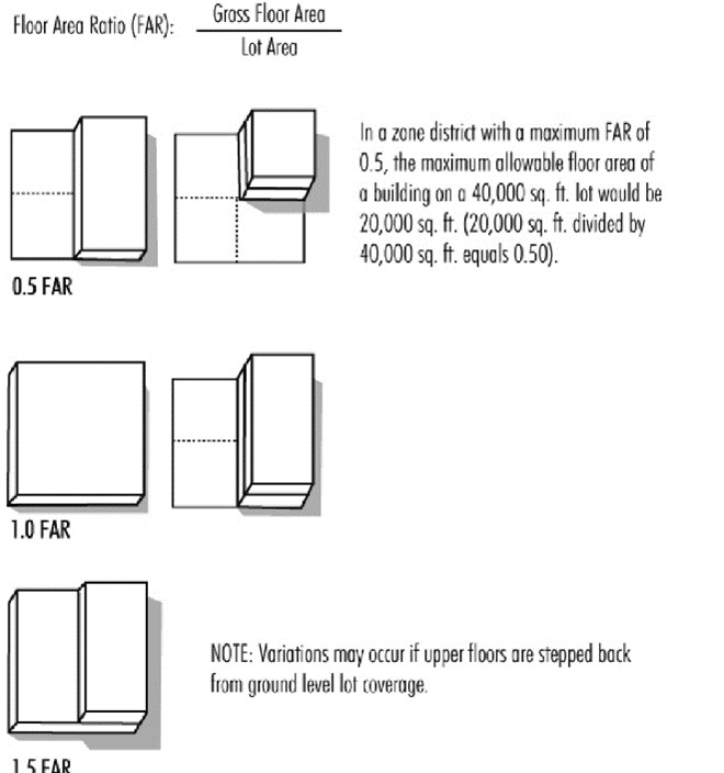
Floor area ratio (FAR): The ratio between the total gross floor area of all buildings on a lot and the total area of that lot (see figure 29-21.1).
Figure 29-21.1. Floor Area Ratio (FAR)
Freeway: A divided arterial highway for through traffic with full or partial control of access and generally with grade separations at intersections. For the purposes of this chapter, the word "freeway" shall include the word "expressway."
Freeway service facility: A comprehensively planned facility providing services for the traveler consisting, at a minimum, of gasoline and diesel sales, automotive and truck repair, and a restaurant. A motel and/or RV park may also be included, together with incidental sales of periodicals, sundries, maps, souvenirs and the like.
Frontage: That portion of a parcel of property which abuts a legally accessible public or approved private street or highway, measured along the future street line as indicated on the general plan land use policy map, on a final parcel map or subdivision map.
Fulfillment center: A type of distribution facility where goods or products are stored on-site temporarily, where incoming orders (typically via e-commerce) for goods or products are packaged and delivered or shipped to other fulfillment centers or directly to customers in order to "fulfill" individual online orders. Such facilities may include automated systems, office space, and a pick and pack area used by employees for sorting and packaging goods and products for delivery from available, on-site inventory. Does not have an on-site retail component.
(1) Large fulfillment center: A large format fulfillment facility that may serve regional or local markets. Has a typical gross floor area from one hundred and fifty thousand (150,000) to more than five hundred thousand (500,000) square feet. A large fulfillment center may package and deliver to a micro-fulfillment center or directly to the customer.
(2) Micro-fulfillment center: A small local or area fulfillment facility or station that primarily serves local markets, directly to the customer. Has a typical gross floor area from three thousand (3,000) to fifty thousand (50,000) square feet, up to one hundred and fifty thousand (150,000) square feet. Also known as "dark store" or "last-mile" fulfillment center.
Future street line: The future right-of-way line for a major or secondary highway or traffic collector street as located and dimensioned in the general plan or for a local street as indicated in the setback ordinance. A setback abutting such a highway or street shall be measured from the future street line.
(Ord. No. 24-03, § 2, 9-17-24)
Sec. 29-22. - "G" definitions.
Garage, private: A detached accessory building or a portion of a main building on the same lot for the parking or temporary storage of vehicles of the occupants of the premises.
Garage, public: Any garage other than a private garage.
Garage, repair: A building other than a private garage used for the care, repair, or equipment of automobiles.
Garage, storage: Any premises used exclusively for the storage of vehicles.
General bookstore: An establishment engaged in the buying, selling, and/or trading of new and/or used books, manuscripts, and periodicals of general interest. A general bookstore does not include an establishment that is encompassed by the definition of adult bookstore.
General motion picture theater: A building or part of a building intended to be used for the specific purposes of presenting entertainment as termed herein, or displaying motion pictures, slides, or closed-circuit television pictures before an individual or assemblage of persons, whether such assemblage be of a public, restricted or private nature, except a home or private dwelling where no fee, by way of an admission charge, is charged; provided, however, that any such presentations are not distinguished or characterized by an emphasis on the depiction' or description of specified sexual activities or specified anatomical areas in that any such depiction or description is only incidental to the plot or story line. A general motion picture theater does not include any establishment that is defined by adult motion picture theater, adult mini-motion picture theater, adult motion picture arcade, or adult drive-in theater.
General plan: The general plan for the city, consisting of the general plan map and text, adopted by the city council.
Gigahertz (GHz): See section 29-256 for this definition.
Glare: Any brightness within the field of vision of such a character as to cause annoyance, discomfort, interference with vision, or loss in visual performance and visibility.
Golf course: A lot or portion of a lot used for the playing of golf, including pitch-and-putt courses, but shall not include driving ranges, miniature golf courses or other similar commercial enterprises, unless expressly permitted in this chapter.
Grade: The average of the finished ground level at the center of all walls of a building. In case walls are parallel to and within five (5) feet of a sidewalk, the ground level shall be measured at the sidewalk.
Greyfield site: An abandoned or underutilized commercial site on which establishments such as shopping centers, big box retail buildings, strip malls or commercial buildings are built. They do not contain contaminated soil like brownfield sites.
Ground-mounted antenna: See section 29-256 for this definition.
Grouped facility: See section 29-256 for this definition.
Guest: Any transient person who occupies a room for sleeping purposes.
Guest ranch: A hotel, including all accessory buildings and commercial uses operated primarily for the convenience of the guests thereof.
Guest room: A room which is designed to be occupied by one (1) or more guests for sleeping purposes, and having no kitchen facilities, not including dormitories.
Guyed tower: See section 29-256 for this definition.
(Ord. No. 24-03, § 2, 9-17-24)
Sec. 29-23. - "H" definitions
Habitable room: Any room designed for sleeping or living purposes, excluding such spaces as closets, garages, bathrooms, hallways, unfinished attics, foyers, patios, storage spaces and utility rooms.
Health club: Health club means, but is not limited to, gymnasiums (except public), private clubs (athletic, health, or recreational), and weight control establishments.
Heliport: An area used or intended to be used for the landing and takeoff of helicopters, and may include any or all of the area of the building appropriate to accomplish these functions.
Highway: A street shown as a freeway, major or secondary highway on the general plan for the city.
Home occupation: Any use customarily conducted entirely within a dwelling or accessory building, and carried on by the inhabitants thereof, which use is clearly incidental and secondary to the use of the structure for dwelling purposes and which use does not change the character thereof. See section 29-162(2) for typical home occupations, and criteria for determining home occupation as defined herein.
Homeowners association: A private, nonprofit corporation of homeowners for the purpose of owning, operating, and maintaining various common properties.
Hospital: Any building or portion thereof used for the accommodation and medical care of sick, injured, or infirm persons and including sanitariums, alcoholic sanitariums, institutions for the cure of chronic drug addicts and mental patients.
Hotel: A structure or group of structures containing six (6) or more guest rooms or suites offering transient (twenty-eight (28) days or fewer) lodging accommodations to the general public, with most rooms gaining access through a common lobby and an interior hallway(s). Such a facility may include incidental services that customarily are provided by a hotel such as food service, recreational facilities, retail services provided for the convenience of hotel guests, and banquet, reception and meeting facilities. A hotel does not include any building in which human beings are housed or detained under legal restraint or which is used as a drug or other rehabilitation center.
(Ord. No. 24-03, § 2, 9-17-24)
Sec. 29-24. - "I" definitions.
Industrial park: An industrial subdivision developed according to a comprehensive site plan to provide serviced sites for manufacturing plants, distribution warehouses and similar uses, adequate control of the tract and buildings is provided, in order to maintain aesthetic values and to protect the investments of developers of the park, of the occupying industries, of neighboring developments, and of the community as a whole.
Industry: The manufacture, fabrication, processing, reduction or destruction of any article, substance or commodity, or any other treatment thereof in such a manner as to change the form, character, or appearance thereof, and including storage elevators, truck storage yards, warehouses, wholesale storage and other similar types of enterprise.
Institutional use: A nonprofit or quasi-public use such as a church, library, school, hospital, or municipally owned or operated building, structure or land.
(Ord. No. 24-03, § 2, 9-17-24)
Sec. 29-25. - "J" definitions.
Junior accessory dwelling unit: An accessory dwelling no more than five hundred (500) square feet and entirely internal to a primary dwelling that includes independent facilities for living, sleeping, cooking, and eating, and shared or independent sanitation facilities.
Junk: Any worn out, castoff, or discarded article or material which is ready for destruction or has been collected or stored for salvage or conversion to some use. Any article or material which, unaltered or unchanged and without further reconditioning can be used for its original purpose as readily as when new, shall not be considered junk.
Junkyard: Any lot, or the use of any portion of a lot, for the dismantling of machinery (not including motor vehicles) or for the storage or keeping for sale of parts and equipment resulting from such dismantling or wrecking, or for the storage or keeping of junk, including scrap metals or other scrap materials.
(Ord. No. 24-03, § 2, 9-17-24)
Sec. 29-26. - "K" definitions.
Kennel: Any lot or premises on which four (4) or more dogs or cats, or combination of dogs and cats, at least four (4) month of age, are kept, boarded or trained, whether in special buildings or runways or not.
Kilohertz (kHz): See section 29-256 for this definition.
Kiosk, permanent: A freestanding structure with a foundation located on private property not exceeding a maximum size of one hundred (100) square feet and compatible in design with other existing uses and buildings in the vicinity. Operated for the purpose of vending food, drink, or retail goods or services.
Kiosk, temporary or semi-permanent: A freestanding, temporary or semi-permanent structure having one (1) or more open air sides, operating on either private property or public rights-of-way and plazas, not exceeding a maximum of sixty (60) square feet and compatible in design with other existing uses and buildings in the vicinity. Operated for the purpose of vending food, drink, or retail goods.
Kitchen: Any room used or intended or designed to be used for cooking or the preparation of food, including any room having a sink and either a three-fourths(¾)-inch gas opening or provision for an electric stove.
(Ord. No. 24-03, § 2, 9-17-24)
Sec. 29-27. - "L" definitions.
Landfill: A place used for the disposal, abandonment, or discarding by burial, incineration, or by any other means, of any garbage, sewage, trash, refuse, rubble, waste material, offal, or dead animals. Such use shall not involve any industrial or commercial process.
Landscaping: The planting and continued maintenance of suitable plant materials or a combination of plant materials with minimum areas of paving, gravel, or otherwise dust-free materials. An adequate irrigation system is required.
Lattice tower: See section 29-256 for this definition.
Laundry: A premises where clothing and fabrics are washed.
Legislative: Legislative actions establish rules, policies, or standards of general applicability and are political in nature; they involve the exercise of discretion governed by considerations of public welfare.
Limited industrial: The further processing of products not manufactured on the site and in such a manner as to make a salable product normally sold in a general commercial zone.
Liquor store: A retail sales facility offering for sale an assortment of distilled, fermented, brewed or similarly prepared beverages that contain amounts of alcohol sufficient to cause the sale of the beverage to be regulated by the State of California and (i) where the sale of such beverages is the predominant product sold in such facility, whether such finding is determined by total annual retail sales or square footage of the facility dedicated to the storage and/or display of such merchandise; and (ii) the retail sales facility is not the direct, corporately owned marketing and/or sales facility of the producer of the alcoholic beverage and where the alcoholic beverage is primarily intended to be consumed off-site from the place of sale. Liquor stores commonly range in size from two thousand (2,000) to five thousand (5,000) square feet. A convenience market selling distilled spirits that meets criteria (i) and (ii) above shall also be considered as a liquor store for the purposes of this title.
Live theater: A theater, concert hall, auditorium, or similar establishment which, for any fee or consideration, regularly features live performances which are not distinguished or characterized by an emphasis on the depiction or description of specified sexual activities or specified anatomical areas in that any such depiction or description is only incidental to the primary purpose of the performance.
Live/work: A building or portion thereof intended to function predominately as workspace with secondary space for residential living with sleeping quarters, kitchen, and bathroom facilities. The live/work shall be the primary dwelling of the resident. Each portion must be occupied by the same tenant, and no portion of the live/workspace may be rented or sold separately. This classification differs from a home occupation, which is regulated under section 29-162(2). This classification does not include any activity that causes noise, odor, or vibration to be detectable on a neighboring property. May include incidental indoor storage associated with the workspace. See related definitions of "artisan loft" and "mixed-use development, artisan loft".
Loading space: An off-street space or berth on the same lot with a main building or contiguous to a group of building, for the temporary parking of commercial vehicles while loading or unloading, and which has access from a street, alley, or other permanent means of ingress and egress.
Lot:
(1)
A parcel of land with a separate and distinct number or other designation shown on a plat recorded in the office of the county recorder; or
(2)
A parcel of land delineated on an approved record of survey, lot split or sub-parceling map as filed in the office of the county recorder, and abutting at least one (1) public street or right-of-way, or easement determined by the commission to be adequate for the purpose of access; or
(3)
A parcel of land containing no less area than required by the zone in which it is located, abutting at least one (1) public street or right-of-way and held under separate ownership from adjacent property.
Lot, corner: A lot located at the intersection or interception of two (2) or more streets at an angle of not more than one hundred thirty-five (135) degrees. If the angle is greater than one hundred thirty-five (135) degrees, the lot shall be considered an "interior lot" (see figure 29-27.1).
Figure 29-27.1. Lot Types
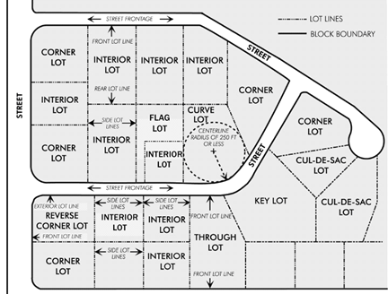
Lot, cul-de-sac: A lot fronting on, or with more than one-half (½) of its lot frontage on, the turnaround end of a cul-de-sac street.
Lot, curve: A lot fronting on the outside curve of the right-of-way of a curved street, which street has a centerline radius of two hundred fifty (250) feet or less (see figure 29-27.1).
Lot, flag: "Flag lot" or "panhandle lot" means a lot having access to a street by means of a private driveway access easement, or parcel of land not meeting the requirements of this chapter for lot width but having a dimension of at least twenty (20) feet at its narrowest point.
Lot, interior: A lot other than a corner or reversed corner lot (see figure 29-27.1).
Lot, key: Any lot where the side property line abuts the rear property line of one (1) or more lots and where said lots are not separated by an alley or any other public way (see figure 29-27.1).
Lot, reversed corner: A corner lot, the side line of which is substantially a continuation of the front lot lines of the lots to its rear, whether across an alley or not (see figure 29-27.1).
Lot, through: A lot having frontage on two (2) dedicated parallel or approximately parallel streets (see figure 29-27.1).
Lot area: The total horizontal area within the lot lines of a lot.
Lot coverage: The area of a site covered by buildings or roofed areas, excluding allowed projecting eaves, balconies, and similar features. This impervious area is expressed as a percentage of the total lot area.
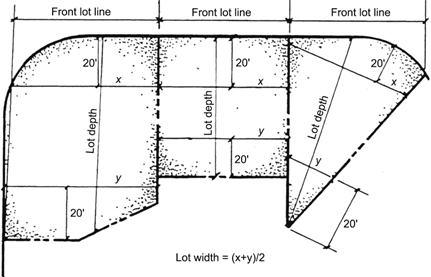
Lot depth: The horizontal distance between the front and rear lot lines measured in the mean direction of the side lot lines (see figure 29-27.2).
Figure 29-27.2. Lot Depth and Width
Lot line: Any line bounding a lot as herein defined.
Lot line, exterior: A side lot line abutting a street.
Lot line, front: The property line abutting a street (see figure 29-27.1).
Lot of record: A lot shown on an official subdivision map duly approved and recorded, or any lot for which a bona fide deed had been duly recorded subsequent to the effective date of this chapter.
Lot width: The average horizontal distance between the side lot lines, measured at right angles to the lot depth at a point midway between the front and rear lot lines. In the case of a flag lot, any portion of said lot which is less than thirty-five (35) feet wide for a distance of fifty (50) feet or more and which is designed to provide access to a building site shall be excluded when determining lot width.
Low barrier navigation center: A housing first, low-barrier, service-enriched shelter focused on moving people into permanent housing that provides temporary living facilities while case managers connect individuals experiencing homelessness to income, public benefits, health services, shelter, and housing. "Low barrier" means best practices to reduce barriers to entry, and may include, but is not limited to, the following:
(1)
The presence of partners if it is not a population-specific site, such as for survivors of domestic violence or sexual assault, women, or youth.
(2)
Pets.
(3)
The storage of possessions.
(4)
Privacy, such as partitions around beds in a dormitory setting or in larger rooms containing more than two (2) beds, or private rooms. Also see California Government Code section 65660.
(Ord. No. 24-03, § 2, 9-17-24)
Sec. 29-28. - "M" definitions.
Makerspace, general manufacturing: A co-work space in operation, but distinguished from it as to use, equipment, tools, and externalities. Space is shared for design, processing, fabrication, assembly, treatment, and packaging of products and prototypes associated with allowable uses in the general manufacturing (MG) zone. Includes associated equipment and tools, labs, workshops, studios, instructional/classroom space, office space, meeting rooms, and other shared spaces. Also may be known as a hacklab, innovation center, business incubator, techshop, fablab, inventors club, micro-factory, or similarly named business operation.
Makerspace, light manufacturing: A co-work space in operation, but distinguished from it as to use, equipment, tools, and externalities. Space is shared for design, processing, fabrication, assembly, treatment, and packaging of products and prototypes associated with allowable uses in the light manufacturing (ML) zone. Includes associated equipment and tools, labs, workshops, studios, instructional/classroom space, office space, meeting rooms, and other shared spaces. Also may be known as a hacklab, innovation center, business incubator, techshop, fablab, inventors club, micro-factory, or similarly named business operation.
Manufactured home: A structure designed as a permanent dwelling unit to be used with or without a permanent foundation, and which is in excess of eight (8) feet in width or in excess of forty (40) feet in length. "Manufactured home", also known as a mobile home, is defined in the State Health and Safety Code, section 18007.
Manufactured (mobile) home park: An area or tract of land where three (3) or more manufactured home lots are rented or leased or held out for rent or lease to accommodate manufactured homes for human habitation, provided that manufactured home park does not include:
(1)
Premises on which any manufactured home or trailer coaches are parked for inspection and sale; or
(2)
Premises on which there is one (1) manufactured home or trailer coach occupied by the owner thereof pursuant to a valid temporary occupancy permit issued in compliance with this chapter.
Master antenna television (MA TV) system: A facility as described in cable television (CATV) system, but differentiated from the definition of a (CATV) system by virtue of:
(1)
Serving fewer than fifty (50) subscribers;
(2)
Serving only the residents of an apartment dwelling under common ownership and consisting of not more than two (2) buildings; or
(3)
Providing service without charge.
Medical cannabis dispensing collective or dispensary: See chapter 13, section 13-112 of the City Code for this definition.
Megahertz (MHz): See section 29-256 for this definition.
Mezzanine: An intermediate floor just above the ground floor; it often has a low-ceiling and projects in the form of a balcony.
Microbrewery, craft distillery, or winery: A small-scale facility where beer, malt beverages, wine, hard cider, or spirits are made on-premises and then sold or distributed, and which produces fifteen thousand (15,000) barrels (or equivalent gallons) per year or less in accordance with the regulations of the Alcohol Beverage Control (ABC), other applicable state and federal laws, which must possess a Type 23 ABC License. Its products are primarily intended for local and/or regional consumption. The establishment may also include the retail sale of beverages for off-site consumption. May include on-site consumption only in accordance with the regulations for the zone on which the establishment is located and applicable ABC licenses and regulations. The establishment may include a tasting room or restaurant on the premises also subject to City Code and ABC requirements.
Ministerial decision: A government decision involving little or no subjective judgment or discretion as to the wisdom or manner of carrying out the project. A ministerial decision involves only the use of fixed standards or objective measurements.
Mixed-use building: A structure containing both residential and pedestrian-oriented commercial uses (including retail, restaurants, offices, services and similar uses deemed compatible with residential uses). The commercial use or uses are typically located on the ground floor of the structure with the residential dwellings predominantly located on the second or higher floors.
Mixed-use development, artisan loft: A street and/or upper-level space constructed as an expansive and open "shell" that allows individual owners flexibility for interior improvements. Establishes a gallery space to create, display, and sell artisan crafts with a strong connection to the living space. Within the "shell" are kitchen and sleeping areas that are secondary to the space designed for fabricating arts and/or crafts. Allows construction of artisan lofts on multiple stories.
Mixed-use development, general: A coordinated project with a functional integration of residential and non-residential uses located on single or multiple parcels and single or multiple structures with engaging street-level activity. Residential uses may be constructed above (vertical) non-residential uses or behind or next to (horizontal) non-residential uses and are provided separate access from the non-residential uses. With this type of development, there is no requirement that the residential and the non-residential uses be located in the same building. The allowable non-residential uses are those that are permitted within the respective zones.
Mobile food court: An area of land where two (2) or more mobile food businesses congregate to offer food or beverages for sale to the public. Any cluster of more than one (1) mobile food business located on the same area of land shall be considered a mobile food court.
Mobile food facility, limited: Any vehicle used in conjunction with a commissary or other permanent food facility upon which food is sold or distributed at retail, and where food preparation is limited, which includes hot dog carts, snow cones, coffee carts, fresh produce carts, kettle corn/popcorn. This is a temporary use subject to the requirements of article IV, division 5, temporary uses.
Mobile food facility, processing: Any vehicle used in conjunction with a commissary or other permanent food facility upon which food is sold or distributed at retail, and where food is processed by cooking, frying, or grilling. These types of food facilities are the typical food truck. This is a temporary use subject to the requirements of article IV, division 5, temporary uses.
Model home: A dwelling unit temporarily used for display purposes as an example of dwelling units available or to be available for sale or rental for the first time in a particular subdivision or other residential development which may be comprised of single-family or multi-family dwellings, or a combination thereof. "Model home" shall include examples of factory-built housing which may not necessarily be available in or related to a particular development.
Monopole: See section 29-256 for this definition.
Motel: A commercial land use providing transient occupancy for guests for twenty-eight (28) or fewer days, or longer than twenty-eight (28) days subject to payment of transient occupancy tax pursuant to City Code section 25-57 et seq., on one (1) or more buildings on the same lot. The buildings contain guest rooms or dwelling units or both, which are usually individually and independently accessible from outside the building. "Motel" includes motor lodge, tourist court, motor hotel or any other designation intended to identify the premises as providing for rental or overnight accommodation for guests.
(Ord. No. 24-03, § 2, 9-17-24)
Sec. 29-29. - "N" definitions.
Natural surveillance: Natural surveillance is a design concept directed primarily at keeping intruders under observation (also known as defensible space). The provision of natural surveillance helps to create environments where there is plenty of opportunity for the intended users of a project and people engaged in their normal behavior to observe the space around them.
Noncommercial wireless communication facility: See section 29-256 for this definition.
Non-conforming: See section 29-256 for this definition.
Nursery: The retail or wholesale handling of any article, substance or commodity related to the planting, maintenance, or harvesting of garden plants, shrubs, trees, packaged fertilizers, soils, chemicals, or other nursery goods and related products in small quantities to the consumer.
(Ord. No. 24-03, § 2, 9-17-24)
Sec. 29-30. - "O" definitions.
Office: "Office building" means a building whose primary function is to provide office space for professional, medical, and administrative purposes. Office buildings may include secondary and supporting retail uses that are generally located on the first floor.
Office park: An area in which a number of office buildings are constructed together, often on landscaped grounds with ancillary structures such as restaurants, recreational areas, health clubs and day-care centers.
Open space: Any part of a lot or project as defined herein unobstructed from the ground upward except as specified.
Operator: Any person or organization that controls the operation and maintenance of a facility, including wireless telecommunication facilities.
Outdoor advertising: Includes the definitions of "advertising structure" and "sign."
Outdoor living space: Any area designed for and to be used for relaxation, entertainment, recreation or landscaping located on, at, or above ground level.
(Ord. No. 24-03, § 2, 9-17-24)
Sec. 29-31. - "P" definitions.
Paging: See section 29-256 for this definition.
Parcel of land: A contiguous quantity of land in the possession of, or owned by, or recorded as the property of the same claimant or person.
Parking area, private: An open area, located on the same lot with a dwelling or apartment for the parking of automobiles of the occupants of such buildings.
Parking area, public: An open area, other than a street or a private parking area, used for the parking of more than four (4) automobiles.
Parking, bicycle: Any combination of facilities, including bicycle racks, bicycle lockers, and bins designated for the parking, security, and convenient use of bicycles. Bicycle parking facilities are usually conveniently located close to building entrances and locations that provide maximum visibility. At employee destination areas, bicycle parking may also include showers and changing areas for bicyclists.
Parking space, covered: A building or portion of a building, completely enclosed by walls or doors on two (2) or more sides, which is designed or used to shelter a parking space. Covered parking spaces include permanently constructed garages and carports.
Parking space for automobile: Space within a building or a private or public parking area, exclusive of driveways, ramps, columns, office and working area, which is permanently reserved for the parking of one (1) automobile.
Parking structure: A structure or portion thereof composed of one (1) or more levels or floors primarily used for the parking or storage of motor vehicles. A parking structure may be totally below grade (as in an underground parking garage) or either partially or totally above grade.
Parkway or park strip: A piece of land separating the pedestrian from vehicle traffic on a street, located between the rear of a curb and the front of a sidewalk. A parkway or park strip is usually used to enhance the walking environment by planting low ground cover and/or street trees and installing street furniture, lighting and other pedestrian amenities.
Paseo: An exterior linear area that is landscaped and open to the sky with shaded portions and with a minimum width of twenty (20) feet and pedestrian paths connecting one (1) side of a building or development to the other side.
Patio: A paved or decked area that may be attached or detached from a structure and be covered or uncovered. A patio shall not be used as a habitable room or as a parking space for vehicles.
Paving, pervious/permeable: Paving of a material and design that allows the infiltration of water through the soil.
Pawn: The pledge of a moveable thing or personal property to be given up as security for a loan.
Pawnbroker: Any natural person, partnership or corporation, either as principal or agent or employee thereof, who loans money on deposit or pledge of personal property or other valuable thing, or who deals in the purchasing of personal property or other valuable things on condition of selling the same back again at a stipulated price, or who loans money secured by chattel mortgage on personal property, taking possession of the property or any part thereof so mortgaged.
Pedestrian-oriented or pedestrian-friendly: Development that is designed with a primary emphasis on the street sidewalk and facilitating pedestrian access to the site and building rather than on auto access and parking areas. Buildings in such developments are generally placed close to the street and the main entrance is oriented to the street sidewalk. There are generally windows and display areas along the street facades of buildings and outdoor areas (such as plazas) that are oriented to pedestrians. Although parking areas may be provided, they are not emphasized by the design of buildings.
Perimeter line: The property line of the project as defined herein.
Personal communications services (PCS): See section 29-256 for this definition.
Person: Any individual, firm, co-partnership, joint venture, association, syndicate, this and any other city, city and county, county, municipality, district or other political subdivision, or any other group or combination acting as a unit.
Planned unit development: An integrated development located on a single building site, or on two (2) or more building sites which may be separated only by a street or other right-of-way. In such development, the land and structures shall be planned and developed as a whole in a single development operation or a series of operations in accordance with a detailed, comprehensive plan encompassing such elements as the location of structures, the circulation pattern, parking facilities, open space, and utilities, together with a program for provision, operation and maintenance of all areas, improvements, facilities and services provided for the common use of the persons occupying or utilizing the property. Also see California Civil Code section 1351(k).
Platform: See section 29-256 for this definition.
Pop-up shop: A store, restaurant, or other business that is a deliberately temporary use, subject to article IV, division 5, temporary uses. It is a shop that "pops-up" for a limited period of time to achieve a particular goal, such as boosting an on-line operation, testing or launching a new product, gauging whether to establish a permanent location for a new business, providing a temporary location for a seasonal business, and hosting events.
Preexisting towers and preexisting antennae: See section 29-256 for this definition.
Project: The entire parcel of real property planned and developed as a whole whether divided and conveyed as a condominium or retained in single ownership or in cooperative units.
Property line: The boundary line describing limits of a parcel of land as defined herein.
Provisions: All regulations and requirements referred to in the text.
Psychiatric facility: An institution in which care or treatment is given to persons suffering from mental illness, disease, disorder or ailment. Such facilities include, but are not limited to, psychiatric hospitals, day treatment hospitals, long term care facilities, resident treatment centers, family homes (mentally ill), alcoholism hospital, and facility for admission of drug addicts all as defined in the California Code of Regulations, Health and Safety Code, and Welfare and Institutions Code.
(Ord. No. 24-03, § 2, 9-17-24)
Sec. 29-32. - "Q" definitions.
Qualifying resident: See section 29-206 for this definition.
Quarry, sandpit or gravel pit: A lot or land or part thereof used for the purpose of excavating sand, gravel, limestone, marble or other such nonmetallic materials, but shall not include oil wells or shaft mine operations and shall be exclusive of a process of grading a lot preparatory to the construction of a building for which application for building has been made.
(Ord. No. 24-03, § 2, 9-17-24)
Sec. 29-33. - "R" definitions.
Radio: See section 29-256 for this definition.
Radio frequency (RF): See section 29-256 for this definition.
Radio frequency exposure professional: See section 29-256 for this definition.
Recreation, active: A structured individual or team activity that involves intensive activity requiring physical exertion and requires the use of special facilities, courses, fields, or equipment.
Recreation, passive: Low intensity activity performed for pleasure or relaxation that does not require facilities like sports fields or pavilions, such as walking, bird watching, picnicking, etc.
Recreational vehicle (RV) park: Campground facility providing transient habitation areas for travelers in recreational vehicles or tents.
Recreational vehicle: A motor home, travel trailer, truck camper or camping trailer, with or without motive power, designed for human habitation for recreational or emergency occupancy.
Recycling collection center: Establishments or places engaged in collecting recyclable household materials for the purpose of resource recovery, including metal or glass containers, paper or plastic. Such establishments shall include mobile recycling units and reverse vending machines.
Regeneration facility: See section 29-256 for this definition.
Residence: A building used, designed, or intended to be used as a home or dwelling place for one (1) or more families.
Residential care facility: Various types of licensed and unlicensed facilities that provide twenty-four(24)-hour non-medical supportive and custodial care for children, adults, and the elderly who need general assistance for everyday living. Residential care facilities may include: group homes, family care homes, foster family homes, small family homes, special needs housing, adult residential facilities, social rehabilitation facilities, residential board and care facilities, assisted living facilities, residential care facilities for the chronically ill, and residential care facilities for the elderly. See also California Health and Safety Code § 1502(a).
Residential care facility, small: A residential care facility, such as a small family care home or group home, that provides care for six (6) or fewer persons, including children under the age of eighteen (18) years, who reside at the home. A group home or small family care home, by definition, is a small residential care facility since care is provided for six (6) or fewer persons.
Residential care facility, large: A residential care facility, such as a large family care home, that provides care for seven (7) or more persons, including children under the age of eighteen (18) years, who reside at the home.
Resort hotel: A hotel or motel complex having accessory commercial uses operated primarily for the convenience of the guests thereof, provided that there is no street entrance directly to such commercial uses.
Retail store: A business selling goods, wares, or merchandise directly to the ultimate consumer. A maximum of twenty-five (25) percent of the gross floor area of the retail store may be devoted to on-site storage (e.g., "back of house" storage or "stock room") of goods, wares, or merchandise used to replenish the stock on the retail floor. May include curbside pickup or "buy online, pickup in-store" (BOPIS). Does not include delivery or fulfillment ("ship from store") activity, unless the activity is strictly accessory to the service of in-store/in-person customers (for example, a retail store with a pharmacy that also delivers medications to customers' homes).
Retirement home: A facility, licensed by the state to provide non-medical care and supervision to elderly residents, but not constituting a rest home or convalescent hospital. A retirement home shall provide "basic services" and "care and supervision" as defined and described in title 22, chapter 8, division 6 of the State Health and Safety Code.
Rezoning: The same as "zone, change of."
Right-of-way: An area or strip of land, either public or private on which a right of passage has been recorded. Thus, "right-of-way" shall include a public right-of-way, a common lot containing a private street, or other public or private right of passage consistent with this definition.
Roof-mounted: See section 29-256 for this definition.
Room: An un-subdivided portion of the interior of a dwelling unit, excluding bathroom, kitchen, closets, hallways and service porches.
Row house: See "townhouse."
(Ord. No. 24-03, § 2, 9-17-24)
Sec. 29-34. - "S" definitions.
Sanitarium: A health station or retreat or other place where patients are housed and where medical or surgical treatment is given. This does not include mental institutions or places for the treatment of narcotic addicts. Also see the Health and Safety Code.
Satellite dish or satellite antenna: See section 29-256 for this definition.
School, private: An institution conducting regular academic instruction at nursery school, kindergarten, elementary and secondary levels operated by a non-governmental organization.
School, public: A tuition-free school operated by publicly elected or appointed school officials in which the program and activities are under the control of these officials and which is supported primarily by public funds.
School, trade: Private schools offering instruction in the technical, commercial, or trade skills, such as real estate or secretarial schools, beauticians and barber colleges, electronics schools, automotive and aircraft technicians' schools, and similar commercial establishments operated for a profit. Also known as vocational school.
Screening: A continuous fence supplemented with landscape planting or a continuous wall, evergreen hedge or combination thereof, that effectively screens the property which it encloses, and is at least six (6) feet high and is broken only for access drives and walks (see also "landscaping.")
Secondary use: A purpose for which land or a building is or may be intended, occupied, maintained, arranged, or designed, which is less visible, prominent, or important than the principal use(s) on the same lot or parcel. A secondary use may, but need not be an accessory use to the principal use(s).
Secondhand merchandise: Used common household items including clothing, personal effects, household furnishings, appliances, antiques, and office equipment and furnishings.
Secondhand store: A retail location specializing in the sale of secondhand merchandise or accepting for sale on consignment. A secondhand store may dedicate up to twenty (20) percent of the retail area to prepackaged foods and produce.
Secondhand store with donation center: A secondhand store as defined in this section that includes acceptance/drop off of donation items in a manner that does not create a nuisance and is kept free of debris or litter.
Semi-nude model studio: See section 29-245 for this definition.
Service station: The same as "automobile service station."
Setback line, front yard: The line which defines the depth of the required front yard. Said setback line shall be parallel with the street line or the line established by the general plan or setback ordinance, and be removed therefrom by the perpendicular distance prescribed for the front yard in the zone (see figure 29-34.1)
Figure 29-34.1. Setbacks
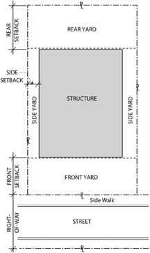
Setback line, rear yard or side yard: The line which defines the width or depth of the required rear or side yard. Said setback line shall be parallel with the property line, removed therefrom by the perpendicular distance prescribed for the yard in the zone. Where the side or rear yard abuts a street, the distance shall be measured as set forth in "setback line, front yard" (see figure 29-34.1).
Sexual device shop: See section 29-245 for this definition.
Sexually oriented business: See section 29-245 for this definition.
Shared parking: A tool through which adjacent property owners share their parking lots and reduce the number of parking spaces each would provide on their individual properties. If adjacent land uses have different peak hours of parking demand, then they can share the sum of the same parking spaces. In the CD zone, it may also allow for shared parking in a comparatively limited number of parking facilities because business can be conducted by parking once and walking to multiple destinations, but must be within five hundred (500) feet of the subject site.
Shopping center/mall: A grouping of retail business and service uses on a single site with common parking facilities.
Showroom: A retail use where samples and/or examples of available merchandise are displayed (showcased) for sale, while the inventory available for sale is located in an attached area devoted to on-site storage (e.g., warehouse), not on the showroom floor. The merchandise or products are typically, but not necessarily, large and often necessitate delivery to the customer and/or there may be a separate loading area for customer pick-up. A distinguishing feature from a "retail" use is that the warehouse area is greater than twenty-five (25) percent of the building floor area. Must have an on-site retail component. Excludes distribution centers and fulfillment centers.
Sidewalk cafe: An area adjacent to and directly in front of a street-level eating or drinking establishment located within the sidewalk area of the public right-of-way exclusively for dining, drinking, and pedestrian circulation. The encroachment area of a sidewalk cafe may be separated from the remainder of the sidewalk by railings, fencing, or landscaping planter boxes or a combination thereof.
Sign: See chapter 22.1, sign ordinance, section 22.1-30, for this definition.
Single room occupancy building: A building providing single-room units for one (1) or more persons with or without share kitchen and bath facilities, including efficiency units per Health and Safety Code section 17958.1.
Site plan: A plan, prepared to scale, showing accurately and with complete dimensions, all of the buildings, structures and uses and the exact manner of development proposed for a specific parcel of land.
Site plan review: The review by the city of a site plan and other studies to determine the manner in which an applicant intends to make use of his property and whether the proposed development complies with the use regulations, development and design standards, and other regulations of the chapter (see section 29-304 et seq., of this chapter).
Special event: A temporary public or private event that impacts or has potential to impact city streets, sidewalks, parking lots, public property, public buildings, airways, or traffic. This use is subject to the provisions of article IV, division 5, temporary uses.
Specialized mobile radio (SMR): See section 29-256 for this definition.
Specified anatomical areas: See section 29-245 for this definition.
Specified sexual activities: See section 29-245 for this definition.
Specialty food stores: Include delicatessen, meat, fish, poultry, candy stores, and health foods.
Sphere of influence: A plan for the probable ultimate physical boundary and service area of the city.
Stable, commercial: A stable for horses, mules or ponies which are let, hired, used or boarded on a commercial basis and for compensation.
Stable, private: A detached accessory building for the keeping of horses, mules or ponies owned by the occupants of the premises and not kept for remuneration, hire or sale.
Stealth mount: See section 29-256 for this definition.
Stepback: A required distance inward from and perpendicular to the building plane of the adjacent floor of a building at or behind which all structures must be located unless otherwise specified. Stepback is measured from the property line or setback, not the face of building.
Storage: Placing of materials at one (1) location for more than seventy-two (72) uninterrupted hours without use.
Storage of non-operating vehicles: The storage of non-operating motor vehicles shall not include automobile wrecking. The presence on any lot or parcel of land of five (5) or more motor vehicles which for a period exceeding thirty (30) days have not been capable of operating under their own power, and from which no parts have been or are to be removed for reuse or sale shall constitute prima facie evidence of the storage of non-operating motor vehicles.
Storefront: The front side of a store or commercial building facing a street and with transparent glazing that opens to the street.
Story: A space in a building between the surface of any floor and the surfaces of the floor next above, or if there is no floor above, then the space between such floor and the ceiling or roof above.
Street: A public thoroughfare or right-of-way dedicated, deeded or condemned for use as such, or approved private thoroughfare or right-of-way, other than an alley, which affords the principal means of access to abutting property including avenue, place, way, drive, lane, boulevard, highway, road and any other thoroughfare, except as excluded in this chapter. The word "street" shall include all major and secondary highways, traffic collector streets, and local streets.
Street, local: Any street, dedicated as such, serving as the principal means of access to property, which street is not shown as a freeway, major or secondary highway or traffic collector on the general plan.
Street, side: A street bounding a corner or reversed corner lot and extends in the same general direction as the line determining the depth of the lot.
Street, centerline: The centerline of a street right-of-way as established by official surveys.
Street line: The boundary line between street right-of-way and abutting property (see also "future street line").
Structural alteration: Any change in or alteration to the structure of a building involving a bearing wall, column, beam or girder, floor or ceiling joists, roof rafters, roof diaphragms, foundations, piles, retaining walls, or similar components.
Structure: Anything constructed or erected, any edifice or building of any kind, or any piece of work artificially built up or composed of parts jointed together in some definite manner, which requires location on or in the ground or is attached to something having a location on or in the ground, including swimming pools, wading pools and patios, excepting outdoor areas such as paved areas, walks, tennis courts, and similar recreation areas.
Structure-mounted: See section 29-256 for this definition.
Structure, temporary: A structure which is readily movable and used or intended to be used for the limited period shown in permit therefor. Such structure shall be subject to all applicable property development standards for the zone in which it is located.
Surface parking: Parking that is exterior, at grade level, and open to the sky.
Supportive housing: Housing with no limit on length of stay, that is occupied by the target population, and that is linked to onsite or offsite services that assist the supportive housing resident in retaining the housing, improving his or her health status, and maximizing his or her ability to live and, when possible, work in the community. "Target population" per this section means persons, including persons with disabilities, and families who are "homeless," as that term is defined by section 11302 of title 42 of the United States Code, or who are "homeless youth," as that term is defined by paragraph (2) of subdivision (e) of section 11139.3 of the Government Code. See also California Health and Safety Code § 50675.14(b).
Swap lot: A building, structure, enclosure, lot, or other area into which persons are admitted to display, exchange, barter, sell, or bargain for new or used merchandise.
Swap meet: The activity carried on in a swap lot.
Swimming pools, hot tubs and spas: Any constructed or prefabricated water-filled vessel that is not drained, cleaned or refilled for each individual, and is used for swimming, soaking, or recreation.
(Ord. No. 24-03, § 2, 9-17-24)
Sec. 29-35. - "T" definitions.
Telecommunication facility: See section 29-256 for this definition.
Telecommunication support facility: See section 29-256 for this definition.
Telecommunication tower: See section 29-256 for this definition.
Tobacco retail shops: Business whose main purpose is the sale of tobacco products.
Tobacco retail shops may include private smokers' lounges in accordance with California Labor Code section 6404.05.
Tower: See section 29-256 for this definition.
Tower-mounted: See section 29-256 for this definition.
Townhouse: Single-family dwellings with shared walls and no side yards between abutting dwellings. Also known as "row house."
Trailer: A vehicle without motive power, designed and constructed to travel on the public thoroughfares in accordance with the provisions of the California Vehicle Code, and to be used for human habitation or for carrying property, including a trailer coach.
Transient: A person who is receiving accommodations for a price with or without meals.
Transitional housing: Buildings configured as rental housing developments, but operated under program requirements that call for the termination of assistance and recirculation of the assisted unit to another eligible program recipient at some predetermined future point in time, which shall be no less than six (6) months. See California Health and Safety Code §§ 50675.2(h) and 50801(i).
Transitional housing development: See definition for "transitional housing".
Transparent, wall area: The use of open and clear or sheer materials, or the combination of, on building facades to allow the ability to see through or into and maximize visibility of street level uses. Typically consists of windows, doors with windows, porches, or patios.
Trellis: An open frame of latticework used as a screen or shade structure.
Truck and trailer sales lot: An open area where trucks or trailers are sold, leased, or rented, and where no repairs, repainting, or remodeling is done.
(Ord. No. 24-03, § 2, 9-17-24)
Sec. 29-36. - "U" definitions.
Unit: The elements of the project which are owned by individuals in fee.
Use: The purpose for which land or a building is arranged, designed, or intended, or for which either land or building is or may be occupied or maintained.
Use, temporary: A use established for a specified limited period of time. Any temporary use herein is subject to the provisions of article IV, division 5, temporary uses.
(Ord. No. 24-03, § 2, 9-17-24)
Sec. 29-37. - "V" definitions.
Visual enhancement area: Areas such as corridors, districts, gateways, and other activity nodes that would benefit from a coordinated design plan for streetscape improvements, amenities, and elements in the public rights-of-way. Existing and proposed developments are to be visually linked through enhanced landscaping, hardscape, signage, and streetscape amenities and furnishings in order to improve the visual environment of the city.
Vehicle towing service storage yard; impound lot: Any improved lot, structure, or the use of any portion of such lot or structure for the temporary outdoor storage of towed vehicles that are to be claimed by the titleholders or their agents. Any vehicle stored shall remain mechanically operable and licensed at all times.
Veneer: A thin sheet of material used to cover an exterior surface and to create the appearance of a stone or brick wall.
Veranda: A usually roofed open gallery or portico attached to the exterior of a building.
(Ord. No. 24-03, § 2, 9-17-24)
Sec. 29-38. - "W" definitions.
Wall: Any structure or device forming a physical barrier, which is so constructed that fifty (50) percent or more of the vertical surface is closed and prevents the passage of light, air, and vision through said surface in a horizontal plane. This shall include concrete, concrete block, wood, or other materials that are solids and are so assembled as to form a barrier. Where a solid wall is specified, one hundred (100) percent of the vertical surface shall be closed, except for approved gates or other access ways. Where a masonry wall is specified, said wall shall be concrete block, brick, stone, or other masonry material and one hundred (100) percent of the vertical surface shall be closed, except for approved gates or other access ways.
Warehouse: A building or buildings used for the storage of goods, wares, commodities, and merchandise of any type, whether for the owner thereof or for others, and when such building or buildings contains more than five hundred (500) square feet of storage space and where no retail operation is conducted. The purpose of a warehouse is to store inventory safely and efficiently for a lengthy period, usually several months to a year. Excludes distribution centers, self-storage facilities, and fulfillment centers. Also see "wholesaling".
Water dispensing facilities: A self-contained or connected appliance, machine, or mechanical device, which dispenses filtered water for retail sale, and is located outside or in a non-enclosed space, the operation of which depends upon the insertion of money, whether in coin or paper currency, or other things representative of value.
Wholesaling: The selling of any type of goods for purposes of resale.
Wireless communication: See section 29-256 for this definition.
Wireless communication facility: See section 29-256 for this definition.
Wire line communication: See section 29-256 for this definition.
(Ord. No. 24-03, § 2, 9-17-24)
Sec. 29-39. - "X" definitions.
Reserved.
Sec. 29-40. - "Y" definitions.
Yard: Any open space on the same lot with a building or dwelling group, which open space is unoccupied and unobstructed except for the projections permitted by this chapter.
Yard, front: A space between the front yard setback line and the front lot line or future street line, and extending the full width of the lot (see figure 29-40.1).
Figure 29-40.1. Yards
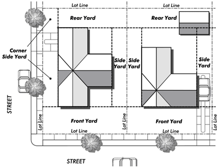
Yard, rear: A space between the rear yard setback line and the rear lot line, extending the full width of the lot (see figure 29-40.1).
Yard, side: A space extending from the front yard, or from the front lot line where no front yard is required by this chapter, to the rear yard, or rear lot line, between a side lot line and the side yard setback line (see figure 29-40.1).
(Ord. No. 24-03, § 2, 9-17-24)
Sec. 29-41. - "Z" definitions.
Zone: A mapped area to which a uniform set of regulations applies; or a uniform set of regulations including a list of permitted uses and standards for development.
Zone, change of: The legislative act of removing one (1) or more parcels of land from one (1) zone and placing them in another zone on the official zoning map of the city.
Zoning map: The official zoning map of the city, which is a part of this chapter of the City Code.
Zoning ordinance or ordinance: The comprehensive zoning ordinance, being this chapter of the City Code.
(Ord. No. 24-03, § 2, 9-17-24)