
El Cerrito City Zoning Code
PART I
- General Provisions
Chapter 19.01 - TITLE, COMPONENTS AND PURPOSES
Sections:
Chapter 19.02 - RULES FOR CONSTRUCTION OF LANGUAGE AND INTERPRETATION
Sections:
Chapter 19.03 - RULES OF MEASUREMENT
Sections:
19.01.010 - Title and authority.
This Title 19 of the City of El Cerrito Municipal Code shall be known and cited as the "El Cerrito Zoning Ordinance" or "Zoning Ordinance." This Zoning Ordinance is adopted by the City Council, pursuant to the laws of the State of California and is consistent with the City's General Plan. This Zoning Ordinance was originally adopted as Ordinance 13 N.S. on October 19, 1953.
(Ord. 2008-2 Div. II (part), 2008.)
19.01.020 - Purpose.
The purpose of this Zoning Ordinance is to implement the City's General Plan and to:
A.
Enhance and promote the public health, safety, peace, comfort, convenience and general welfare of the city.
B.
Provide a guide for the physical development of the city to promote the growth of the city in an orderly manner and achieve balanced residential, commercial and civic uses.
C.
Promote the safety and ease of movement of people and vehicles on public and private thoroughfares.
D.
Define duties and powers of administrative bodies and officers concerned with this Zoning Ordinance.
(Ord. 2008-2 Div. II (part), 2008.)
19.01.030 - Structure of regulations.
This Zoning Ordinance consists of six parts:
Part I. General Provisions.
Part II. Base District Regulations.
Part III. Overlay District Regulations.
Part IV. Regulations Applying in Some or All Districts.
Part V. Administrative Provisions.
Part VI. General Terms.
(Ord. 2008-2 Div. II (part), 2008.)
19.01.040 - General rules of applicability.
A.
Applicability to Property. This Zoning Ordinance shall apply to all uses and structures within the City of El Cerrito, including all uses, structures and land owned by any private person, firm, corporation or organization, the City of El Cerrito and other local state or federal agencies to the extent allowed by law.
B.
Compliance with Regulations. No land shall be used, and no structure shall be constructed, occupied, enlarged, altered, demolished or moved in any zoning district, except in accordance with the provisions of this Zoning Ordinance.
C.
Relation to Other Plans. Pursuant to the law of the State of California, this ordinance is consistent with the general plan of the City of El Cerrito.
D.
Relation to Other Regulations. Where conflict occurs between the provisions of this Zoning Ordinance and any other city code, chapter, resolution, guideline or regulation, the more restrictive provisions shall control, unless otherwise specified.
E.
Relation to Private Agreements. Where this Zoning Ordinance imposes greater restriction than imposed by an easement, covenant, or agreement, this Zoning Ordinance shall control. Where any easement, covenant, or other agreement now in effect is more restrictive, this Zoning Ordinance shall not interfere with or annul said agreements.
F.
Relation to Prior Ordinance. The provisions of this Zoning Ordinance supersede all prior zoning ordinances of the City of El Cerrito. No provision of this Zoning Ordinance shall validate any land use or structure established, constructed or maintained in violation of the prior zoning ordinance, unless such validation is specifically authorized by this Zoning Ordinance and is in conformance with all other regulations and codes.
G.
Application During Local Emergency. The City Council may authorize a deviation from a provision of this Zoning Ordinance during a local emergency declared and ratified under the El Cerrito Municipal Code. The City Council may authorize a deviation by resolution.
(Ord. 2008-2 Div. II (part), 2008.)
19.01.050 - Designation of base and special districts.
The city shall be classified into districts or zones, the designation and the regulations of which are set forth in this Zoning Ordinance and as follows:
A.
Base Zoning Districts. The following are the base zoning districts:
B.
Overlay Zoning Districts. The following are the special zoning districts:
(Ord. 2008-2 Div. II (part), 2008.)
19.01.060 - Official zoning map and district boundaries.
The boundaries of the zoning districts established by this Zoning Ordinance are shown on the official map entitled "Zoning Map of the City of El Cerrito, California," a copy of which is on file in the City Clerk's office. The official Zoning Map and all notations, references and other information shown thereon shall be incorporated by reference as if the matters and information set forth on such maps were fully described herein, including maps for the -CP Creek Protection overlay district and the -HZ Hazard overlay district. The -HZ Hazard Overlay district is also depicted by reference to the Hazard Special Study Map, commissioned by the City Building Official and the 1973 Tri-Cities Seismic Safety and Environmental Resources Study. PD Zones will appear on maps as approved.
(Ord. 2008-2 Div. II (part), 2008.)
19.02.010 - Purpose and applicability.
The purpose of this Chapter is to provide precision in the interpretation of the zoning regulations. The meaning and construction of words and phrases defined in the Chapter apply throughout this Zoning Ordinance, except where the context indicates a different meaning.
(Ord. 2008-2 Div. II (part), 2008.)
19.02.020 - Rules for construction of language.
A.
The specific controls the general. For example where there is a general provision that states "Quality materials shall be used to construct a fence" and a specific provision in the same section states "All fences shall be constructed of wood", the interpretation is that all fences governed by that section shall be constructed of wood, no other materials shall be allowed.
B.
If there is a conflict between a more specific statute and a general one, the specific one controls. Where there is no conflict, however, a general provision is still applicable.
C.
Unless the context clearly indicates the contrary, the following conjunctions shall be interpreted as follows:
1.
"And" indicates that all connected words or provisions shall apply.
2.
"Or" indicates that the connected words or provisions may apply singly or in any combination.
3.
"Either . . . or" indicates that the connected words or provisions shall apply singly but not in combination.
D.
In case of conflict between the text and a graphic or diagram, the text controls.
E.
References to departments, commissions, boards, or other offices are to those of the City of El Cerrito unless otherwise indicated.
F.
References to a public official in the City are to that person who performs the function referred to and includes a designated deputy of such official.
G.
All references to days are to calendar days unless otherwise indicated. In the event a date ends on a Saturday, Sunday, or a day when the City offices are closed, the date shall be considered to be the next consecutive business day. The end of a period shall be the close of business on the last day.
H.
Section titles and section headings contained herein shall not be deemed to govern, limit, modify, or in any manner affect the scope, meaning, or intent of any section.
I.
The words "activities" and "facilities" include any part thereof of the activity or facility.
(Ord. 2008-2 Div. II (part), 2008.)
19.02.030 - Rules for interpretation.
A.
Zoning Regulations. Where uncertainty exists regarding the interpretation of any provision of this Zoning Ordinance or its application to a specific site, the Zoning Administrator shall determine the intent of the provision pursuant to Section 19.33.040.
B.
Zoning Map. The following rules shall apply to zoning boundary determinations:
1.
Where the exact boundaries of a district cannot be readily or exactly ascertained by reference to the official Zoning Map, the boundary shall be deemed to be along the nearest street centerline, lot line, or geographic feature, such as a creek, as the case may be.
2.
Public streets, utility and other rights-of-way shall be in the same zoning district as contiguous property. Where contiguous property is classified in different zoning districts, the centerline of the street or right-of-way shall be the district boundary, unless otherwise depicted on the zoning map.
3.
District boundaries shown as lying at the edge of a body of water shall be construed to follow the adopted 100-year floodplain identified for the watercourse.
4.
If any uncertainty remains as to the location of a district boundary or other feature shown on the zoning map, the location shall be determined by the Zoning Administrator.
C.
Record of Interpretation. The Zoning Administrator shall keep a master record of interpretation made pursuant to this Section which shall be available to the public.
(Ord. 2008-2 Div. II (part), 2008.)
19.03.010 - Purpose.
The purpose of this Chapter is to explain how various measurements referenced in this Zoning Ordinance are to be calculated.
(Ord. 2008-2 Div. II (part), 2008.)
19.03.020 - General provisions.
For all calculations, the applicant shall be responsible for supplying drawings illustrating the measurements that apply to a project. These drawings shall be drawn to scale and of sufficient detail to allow easy verification upon inspection by the Zoning Administrator.
(Ord. 2008-2 Div. II (part), 2008.)
19.03.030 - Fractions.
When calculations result in fractions, the results will be rounded as follows:
A.
General Rounding. Fractions of one-half (0.5) or greater shall be rounded up to the nearest whole number and fractions of less than one-half (0.5) shall be rounded down to the nearest whole number, except as otherwise provided.
B.
Density Rounding. For purposes of computing the maximum number of residential units allowed on a lot, any fraction shall be rounded down to the nearest whole number.
C.
Rounding for State Affordable Housing Density Bonus. For projects eligible for bonus density pursuant to Government Code Section 65915 or any successor statute, and Chapter 19.22, Affordable Housing Bonus, any fractional number of permitted bonus density units shall be rounded up to the next whole number. See Section 19.22.030.
(Ord. 2008-2 Div. II (part), 2008.)
19.03.040 - Measuring distances.
A.
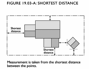
Measurements are Shortest Distance. When measuring a required distance, such as the minimum distance between a structure and a lot line, the measurement is made at the closest or shortest distance between the two objects. See Figure 19.03-A.
B.
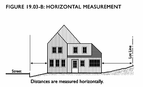
Distances are Measured Horizontally. When determining distances for setbacks and structure dimensions, all distances are measured along a horizontal plane from the appropriate line, edge of building, structure, storage area, parking area, or other object. These distances are not measured by following the topography or slope of the land. See Figure 19.03-B.
C.
Measurements Involving a Structure. Measurements involving a structure are made to the closest wall of the structure. Chimneys, eaves, cornices, and bay windows up to 12 feet in length are not included in the measurement. Other features, such as covered porches and entrances, are included in the measurement. Structures or portions of structures that are entirely underground are not included in measuring required distances.
(Ord. 2008-2 Div. II (part), 2008.)
19.03.050 - Measuring height.
A.
General. Height shall be considered the vertical distance from the highest point of any structure to the ground level directly below, except as otherwise provided in this Section.
B.
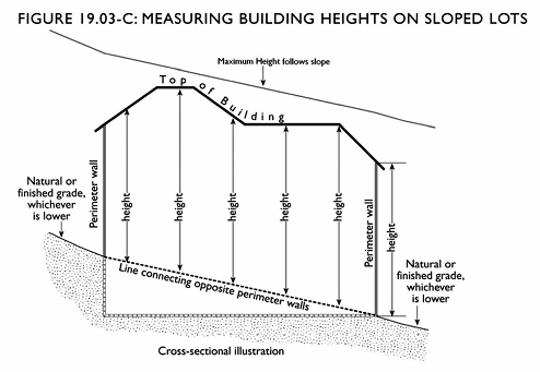
Measuring Building Height on Sloped Lots. Height shall be measured from any point on top of the building to a line directly below which connects to opposite perimeter walls, or other perimeter support systems, at the lower of natural or finished grade. All parts of a building, except for allowed projections specifically listed in this Zoning Ordinance, shall comply with maximum height limits. See Figure 19.03-C.
C.
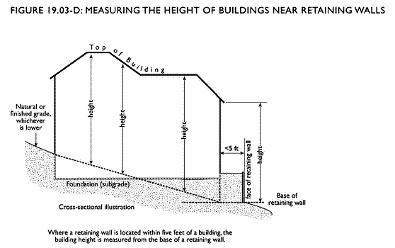
Measuring the Height of Buildings Located Near Retaining Walls. If any portion of a building lies within the setback area of a lot and the base of the retaining wall is at a lower elevation than the building, the height of the building shall be calculated from the base of the retaining wall (at the lower of natural or finished grade) rather than from the base of the building wall. See Figure 19.03-D.
D.
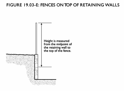
Measuring the Height of Combined Fences and Retaining Walls. When a fence is constructed on top of or within one foot of the face of an above-ground retaining wall, and located in a required yard, the height of the fence shall be measured from the top of the fence to the midpoint height of the retaining wall. See Figure 19.03-E.
E.
Measuring the Height of Decks. Deck height is measured from grade to the top of the floor of the deck if there is no rail or if the rail walls are more than 50 percent open, and from the ground to the top of the rails for all other situations.
(Ord. 2008-2 Div. II (part), 2008.)
19.03.060 - Measuring lot width and depth.
A.
Lot Width. Minimum lot width as required by this Title shall be measured at the front setback line as determined by the zoning of the parcel.
B.
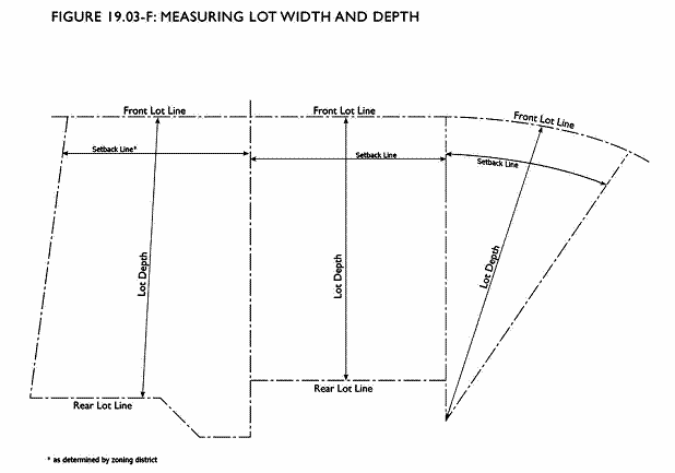
Lot Depth. Lot depth is measured along an imaginary straight line drawn from the midpoint of the front property line of the lot to the midpoint of the rear property line or to the most distant point on any other lot line where there is no rear lot line. See Figure 19.03-F.
(Ord. 2008-2 Div. II (part), 2008.)
19.03.070 - Determining lot slope.
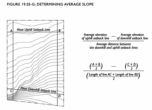
Lot slope is calculated as an average slope of the ground area within the required setback lines (buildable area) for primary structures on a site. Lot slope is based on existing grade. The elevations of the points where required setback lines intersect are used to determine the average elevation of each setback line. Specifically, the average elevation of each setback line is calculated by adding the elevations at the line's intersection points and dividing by two. The average lot slope is then calculated by subtracting the average elevation of the most uphill setback line and the average elevation of the most downhill setback line and dividing the sum by the average distance between these two setback lines, as illustrated in Figure 19.03-G. Where required setback lines do not intersect to form a four-sided polygon, average lot slope shall be calculated by dividing the difference between the elevations of the highest and lowest points within the buildable area by the horizontal distance between said points. See Figure 19.03-G.
(Ord. 2008-2 Div. II (part), 2008.)
19.03.080 - Measuring tree diameter.
A.
Existing Trees. Existing trees are measured at a height of four-and-one-half feet above the ground. Trees on slopes are measured from the ground level on the lower side of the tree. If a tree splits into multiple trunks below four and one-half feet, the trunk's diameter is measured at its most narrow point below the split.
B.
New Trees. New trees are measured in caliper inches, which is the diameter of the trunk six inches above the ground.
(Ord. 2008-2 Div. II (part), 2008.)
19.03.090 - Determining floor area.
Floor area is the horizontal area (expressed in square feet) of all floors included within a building or buildings, according to the following rules:
A.
Included in Floor Area. Floor area is deemed to include:
1.
The floor of atrium and lobby areas;
2.
Enclosed and roofed storage and equipment spaces;
3.
Enclosed and roofed halls, stairways, and elevator shafts;
4.
Enclosed and roofed porches and balconies;
5.
Portions of basements and attics that meet Building Code height requirements for living space;
6.
The actual floor space of mezzanines, interior balconies, and lofts.
B.
Excluded from Floor Area. Floor area does not include:
1.
Unenclosed balconies, decks, porches, and stairs;
2.
Substandard height portions of attics and basements (per Title 16, Buildings and Construction);
3.
The area within a building adjacent to, and in an imaginary horizontal plane with, interior balconies, mezzanines, or lofts.
(Ord. 2008-2 Div. II (part), 2008.)
19.03.100 - Determining floor area ratio.
Floor area ratio (FAR) is the ratio of the floor area of all principal and accessory buildings on a lot to the lot area. To calculate FAR, floor area is divided by lot area, and typically expressed as a decimal. For example, if the floor area of all buildings on a lot totals 20,000 square feet, and the lot area is 10,000 square feet, the FAR is expressed as 2.0.
(Ord. 2008-2 Div. II (part), 2008.)
19.03.110 - Determining lot coverage.
Lot coverage is the ratio of the footprint of all structures on a lot to the lot area, typically expressed as a percentage. The footprints of all principal and accessory structures, including garages, carports, and roofed porches, shall be summed in order to calculate lot coverage. The following structures shall be excluded from the calculation:
A.
The following unenclosed and unroofed structures: porches, landings, balconies, and stairways less than three feet in height;
B.
Unenclosed and unroofed decks less than eighteen inches in height;
C.
Eaves and roof overhangs projecting up to four feet from a wall;
D.
Trellises and similar structures that do not have solid roofs;
E.
Swimming pools and hot tubs that are not enclosed in roofed structures.
(Ord. 2008-2 Div. II (part), 2008.)
19.03.120 - Measuring garage width.
The width of a garage is not limited to the garage door, but is considered the width of that portion of a building facade that is backed by a garage space. It is measured from midpoint to midpoint of any enclosing walls that lie perpendicular to the garage door or entry.
(Ord. 2008-2 Div. II (part), 2008.)