
El Cerrito City Zoning Code
PART II
Base District Regulations
Chapter 19.06 - RESIDENTIAL DISTRICTS
Sections:
Chapter 19.07 - COMMERCIAL AND TRANSIT-ORIENTED MIXED-USE DISTRICTS
Sections:
Chapter 19.08 - PUBLIC AND SEMIPUBLIC DISTRICT
Sections:
Chapter 19.09 - OPEN SPACE AND PARKS DISTRICTS
Sections:
19.06.010 - Purpose.
The specific purposes of the residential districts are to:
A.
Preserve, protect, and enhance appropriately located areas for residential land use, consistent with the City's General Plan. Prohibit incompatible uses. Preserve and enhance the character of existing residential neighborhoods by limiting encroachment of new buildings and activities that are out of scale and character with the surrounding uses.
B.
Promote suitably located housing and services for all age groups within the city. Encourage diverse housing types, such as live-work units, studio spaces, townhouses, co-housing, congregate care, and garden apartments.
C.
Establish development standards that maintain and enhance neighborhood appearance, neighborhood character, and quality of life. Encourage higher-quality design through the use of well-crafted and maintained buildings and landscaping, use of higher-quality building materials, and attention to the design and execution of building details and amenities in both public and private projects.
D.
Protect sensitive environmental areas and features, including hillside areas, creeks, and biological resources; and protect against hazards related to earthquakes, unstable terrain, and wild fires.
E.
Ensure adequate provisions of appropriate public and semi-public land uses such as parks, playgrounds, churches, day-care centers, open spaces, and home occupations, needed to accommodate residential densities.
The additional purposes of each residential district are:
RS Single-family Residential. To promote and protect single-family neighborhoods at a base density of up to 10 dwelling units per net acre; and to minimize the out-of-scale appearance of large homes and development relative to their lot size and slope, and relative to adjacent homes in the neighborhood. Certain areas of the RS district areas are intended to: protect sensitive hillside areas from extensive development; protect against hazards related to earthquakes, unstable terrain, and wild fires; protect sensitive environmental areas and features; and provide sites for larger, distinctive residences. The RS District is split into four separate subsets guiding the minimum size of each lot and other development standards such as minimum lot depth and width and setbacks—RS-5 would be a minimum lot size of 5,000 square feet, RS-7.5 = 7,500 square feet, RS-10 = 10,000 square feet, and RS-20 = 20,000 square feet.
RD Duplex Residential. To accommodate more intensive forms of residential development, including duplexes, townhouse projects, apartments, and small-lot, single family residential uses, at a density of 11 to 20 dwelling units per net acre. The RD district is intended to provide greater housing choice in the city for different family sizes and incomes. The RD district is also intended to be located closer to community and retail services than RS zones, such as neighborhood shopping centers, and near minor and major collector streets where greater access can be provided. These areas should also be adequately served by parks and open space.
RM Multi-family Residential. To provide opportunities for multi-family residential development in a well-designed environment at a density of 21 to 35 dwelling units per net acre. Additional density can be achieved through the approval of density bonuses and other incentives. The RM district is intended to be located in areas where higher traffic volumes and buildings can be accommodated. These developments should be located outside of single-family residential communities, and where services and transportation systems are adequate to serve the increased densities. The RM district is further intended to achieve design compatibility between new multi-family development and surrounding less intensive residential neighborhoods by establishing physical development standards and performance standards.
(Ord. 2008-2 Div. II (part), 2008.)
19.06.020 - Land use regulations.
Table 19.06-A prescribes the land use regulations for residential districts. The regulations for each district are established by letter designations as follows:
"P" — Uses permitted as-of-right that require no discretionary review (i.e., use permit, variance) if in compliance with all standards. May be subject to zoning clearance review, See Chapter 19.33.
"L" — Uses permitted as-of-right subject to limitations restricting location, size or other characteristics to ensure compatibility with surrounding uses. Limitations are referenced by number designations listed at the end of Table 19.06-A.
"A" — Uses subject to Administrative Use Permit discretionary review by the Zoning Administrator.
"C" — Uses subject to a Conditional Use Permit discretionary review and public hearing by the Planning Commission.
"—" — Uses that are not permitted.
The "Additional Regulations" column includes specific regulations applicable to the use classification, located elsewhere in this Zoning Ordinance. Use classifications are defined in Chapter 19.46, Use Classifications. Use classifications not listed in the table below are prohibited. Definitions can be found in Chapter 19.47, Terms and Definitions.
TABLE 19.06-A
USE REGULATIONS - RESIDENTIAL DISTRICTS
L-1: Location limitations; see Additional Regulations.
Transitional and supportive housing are allowed in all zoning districts under the same standards as other types of permitted residential uses.
(Ord. 2008-2 Div. II (part), 2008.)
(Ord. No. 2015-01, § 2, 1-6-2015; Ord. No. 2017-04, § 3, 6-6-2017)
19.06.030 - Development standards.
Table 19.06-B prescribes the development regulations for residential districts, including lot dimensions, building form and location, pedestrian orientation, vehicle accommodation and other standards. The "Supplemental Regulations" column indicates more detailed explanations or regulations that follow the table (in paragraphs indicated by letter designation) or that are located elsewhere in this Zoning Ordinance.
TABLE 19.06-B
DEVELOPMENT STANDARDS FOR RESIDENTIAL DISTRICTS
A.
Maximum Density in the RM District. The following table sets forth the minimum lot area for a given number of units under 12 units. When a lot is irregular, the minimum lot area shall be as determined by the Zoning Administrator but at least 10 percent greater than the following table.
TABLE 19.06-C
MAXIMUM DENSITY IN RM DISTRICT
* 1,000 sq. ft. additional for corner lots
B.
Substandard Lot Standard. Any lot or parcel of land of less area or width than that required by the regulations for the district in which it is located may be used and/or developed as a building site subject to approval of a variance or certificate of compliance only if it was a lot of record on October 19, 1953 and the following standards are met:
1.
Required Improvements. All lots adjoining a public right-of-way shall install all required improvements in compliance with applicable development standards and use regulations, unless the Planning Commission approves a variance or waiver in accordance with the provisions of this Zoning Ordinance.
2.
RS District. No dwelling, other than a single family home, shall be constructed on any building site in the RS district containing less than 5,000 square feet of area.
3.
RD and RM Districts. Up to two units may be constructed on any building site in the RD and RM districts containing less than 5,000 square feet of area, or less than 45 feet average width, with the approval of a Conditional Use Permit.
C.
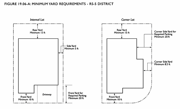
Minimum Setbacks. Minimum setbacks are as stated in Table 19.06-B. Illustrations are provided below for clarification. See Figure 19.06-A.
D.
Main Building Envelope — RS District. The envelope within which a main building on a site may be constructed is defined by minimum setback requirements, maximum height limits, and required daylight planes.
1.
RS District. In the RS district, both maximum building height and the height of the required daylight plane vary according to lot slope, in the slope ranges specified in Table 19.06-D. See Section 19.03.070 for calculating lot slope.
a.
Maximum Building Height. Table 19.06-D lists the building height allowed by-right, referred to as "Base Height." Additional building height, up to the maximum height stated in Table 19.06-D, may be allowed upon the granting of a Conditional Use Permit consistent with the provisions of Section 19.06.030(D)(3). See Section 19.03.050 for measuring building height.
b.
Required Daylight Planes. Required daylight planes extend from all required setback lines at a specified height above grade, then upward and inward toward the center of the site at a 45-degree angle from horizontal. Table 19.06-D states the maximum height at the setback line from which the daylight plane is defined. See Figure 19.06-B.
TABLE 19.06-D
HEIGHTS IN RS DISTRICT
2.
Projections Beyond Height Limits and Daylight Planes. Permitted projections beyond height limits and daylight planes are listed below. In any case where the dimensions of allowed projections specified below differ from those of Section 19.06.030(F), the more restrictive provision shall govern.
a.
Chimneys up to 20 square feet in horizontal area. Chimneys may project up to 10 feet beyond the maximum height limit.
b.
Dormers, provided that they are no more than 15 feet in width and do not occupy more than 20 percent of the total roof area.
c.
Bay windows, not exceeding eight feet in length, up to a maximum of two feet projection past the main envelope.
d.
Cornices, eaves, canopies, up to a maximum of two feet projection past the main envelope.
e.
Other minor projections up to two feet that collectively do not extend more than 50% of the length of one side of the building.
f.
Skylights, up to one and one half foot above the level of the roof.
Height increases beyond those stated above shall require a variance.
3.
Exceptions to Main Building Envelope. Exceptions to the main building envelope may be permitted with a Conditional Use Permit or an Administrative Use Permit as follows:
a.
Conditional Use Permit. The Planning Commission may consider the granting of exceptions to the standards set forth herein for single-family dwellings with respect to vertical and inclined setbacks and height limits, with a Conditional Use Permit pursuant to Chapter 19.34, Use Permits. In addition to the findings specified in that Chapter, the following findings must be met:

i.
The proposal when viewed in its entirety represents a superior design solution to that which would be possible if the project were built in full compliance with the required standards for the main building envelope, and will not cause a significant adverse impact on residences to the side, rear or directly across the street with respect to solar access, view blockage and privacy.
ii.
For Conditional Use Permits that allow height increases, the proposal causes the least practicable impact on neighbors in terms of views, privacy, and solar access; and provides detailing, articulation, and other design treatments that mitigate any bulk created by the additional height.
Height increases beyond the maximum height allowed in Table 19.06-B shall be subject to a variance.
b.
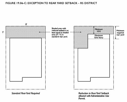
Administrative Use Permit for Reduced Rear Yard. The minimum rear yard dimension may be reduced to ten feet for single-story portions of single family dwellings in the RS District, subject to an Administrative Use Permit, provided that all of the following are met:
i.
A usable yard area (determined by multiplying the minimum rear setback requirement with the actual width of the lot) is maintained permanently in the rear half of the lot. See Figure 19.06-C.
ii.
The minimum rear yard dimension reduction will avoid or reduce an upper-story addition, and there will be no adverse impact on adjacent properties.
E.
Maximum Height of Downslope Skirt Walls. On a downslope lot, the skirt wall which covers the unfinished understory of the home shall not be greater than six feet in height if lot slope is 40 percent or less; and eight feet if lot slope exceeds 40 percent. The height of the skirt wall shall be measured from finished grade to the floor level of the lowest floor that is above ground. Greater height may be approved with an Administrative Design Review pursuant to Chapter 19.38, Design Review, provided that the wall has an architectural treatment that minimizes the unattractive blank wall surface. Acceptable treatments include but are not limited to: a different but compatible surface material than the rest of the building; a minimum five-foot projection from the floor above covered with a deck; a minimum two foot recess from the floor above; or covering the skirt wall with a trellis on which plant material grows and is maintained. See Figure 19.06-D.

F.
Projections. Projections are permitted in all residential districts except where specified subject to the following standards:
1.
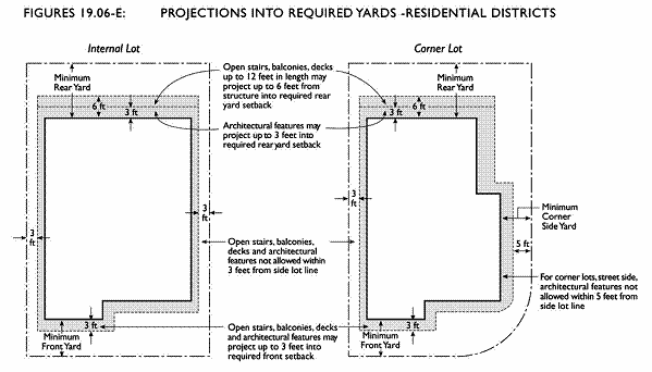
Projections Into Yards — Architectural Features. Architectural features, such as cornices, eaves, canopies, chimneys, and bay windows not exceeding 10 feet in length may not extend closer than three feet to the side lot line, nor more than three feet into any required front or rear setback. On corner lots, street side, such architectural features may not extend closer than five feet to the side lot line. Exceptions allowed with a conditional use permit.
2.
Projections Into Yards — Stairs, Decks and Balconies. Open, uncovered stair landings, decks and balconies 12 feet or less in length and less than six feet above grade may not extend closer than three feet to the side lot line, nor project more than three feet into the minimum front setback, or six feet into the rear setback in any residential area. On corner lots, street side, and beside public paths, such structures may not extend closer than five feet to the side lot line. Exceptions allowed with a conditional use permit.
3.
Projections above the Height Limit for RD and RM Districts. The following features may exceed the maximum height limit as specified:
a.
Elevator or stair towers, not exceeding 10 percent of the roof area, and no more than 10 feet above the level of the roof, in buildings with three or more residential units.
b.
Skylights, up to one foot above the level of the roof.
c.
Fire escapes, catwalks, and open railings required by law.
d.
Rooftop open space features in buildings with three or more residential units, such as seating, sunshade and windscreen devices, benches, open railings, and landscaping, up to 10 feet above the level of the roof.
G.
Minimum Distance Between Buildings and Minimum Size of Courts. In the RM district, courts within or between buildings that have parking, front doors to units, or primary living area windows (as designated by the developer) shall have a minimum dimension of twenty feet.
H.
Building Entrance. The principal entryway of each residential building shall incorporate a projection, recess, or combination of projection and recess of at least 20 square feet, with a minimum depth of four feet.
I.
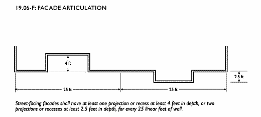
Facade Articulation. In the RM district, all street-facing facades shall have at least one horizontal or vertical projection or recess at least four feet in depth, or two projections or recesses at least two and one-half feet in depth, for every 25 linear feet of wall. The articulated elements shall occupy at least 50 percent of the height of the structure, and may be grouped rather than evenly spaced in 25 foot modules. Exceptions to this rule may be granted by either the Planning Commission via a use permit or through the review of the Design Review Board.
J.
Windows and Trim. All windows shall have articulation that creates architectural interest and shadow, achieved either with the window recess, trim, or an alternative design that meets this objective as determined by the Zoning Administrator.
K.
Design of Building Additions. Design elements used in additions to existing buildings, including but not limited to exterior materials, colors, windows, railings, porches, and decorative elements, shall be designed in a manner which is substantially and compatible with the design elements of the existing building. The Zoning Administrator shall make determinations of design compatibility. Exceptions may be granted through the design review process pursuant to Chapter 19.38, Design Review.
L.
Curb Cuts and Driveways. For lots less than one acre, a maximum of one curb cut for a driveway entrance to parking is permitted, except that for single-family homes on lots with at least 80 feet of street frontage, two curb-cuts for circular driveways are permitted. Exceptions may be approved with a Conditional Use Permit, pursuant to Chapter 19.34, Use Permits. See Figure 19.06-G.
M.
Maximum Driveway Width. In a street-facing yard, the maximum width of a driveway leading to parking facilities is 18 feet. See Figure 19.06-G. In the case of a three-car attached garage, the maximum width of a driveway is 27 feet. This does not apply to the size of the associated curb cut on public or private streets.
N.
Limitations on Parking and Garage Frontage. The following standards apply to parking and garage frontage.
1.
Detached Garages. Detached garages are subject to the following standards:
TABLE 19.06-E
DETACHED GARAGE STANDARDS
2.
Maximum Width of Garages and Carports. Detached garages and carports within 30 feet of a front or street-facing side lot line shall be no more than 20 feet in width. In addition, all attached garages and carports located within 30 feet of a front or street-facing side lot line shall not exceed 50 percent of the width of the residential facade. Exceptions may be allowed with design review. See Figure 19.06-H.
3.
Required Garage, Carport or Uncovered Parking Location to the Side or Rear of a Residence in Certain Cases. Garages, carports, or any uncovered parking spaces shall be located to the rear or side of any principal residential structure, and at least 30 feet from the front lot line, if at least 60 percent of the buildings in the immediate context have garages, carports and uncovered parking located at a depth of at least 30 feet from the front lot line. The immediate context shall consist of the five closest lots on each side of the project site plus the 10 closest lots on the opposite side of the street.
4.
Location of Parking for Single-family Dwellings. Parking shall only be allowed in designated covered or uncovered paved or otherwise hardscaped spaces or in a designated driveway.
5.
Location of Parking for Multi-family Dwellings. For projects with three or more residential units, no open parking or structured parking more than four feet above grade shall be located within 30 feet of a front or corner side property line. Exceptions may be approved with a Conditional Use Permit. See Figure 19.06-I.
O.
Maximum Paving in Street Facing Yards. No more than 50 percent of the required front or corner side yard may be covered with a paved surface. See Figure 19.06-G.
P.
Minimum Site Area Devoted to Landscaping. In the RM district, no less than 15 percent of any site shall be devoted to landscaping. With the exception of areas for entry and exit, all required front and street side setbacks shall be landscaped and such areas shall be credited to the required landscaping.
Q.
Required Planting on Downslope Lots. On all downslope lots with a ground slope greater than 10 percent, a minimum of three trees and three shrubs shall be planted in the downslope rear yard. Trees shall be of a species that is not highly flammable, and that does not have low branches close to the ground that could pose a fire hazard. Shrubs shall be located away from the base of the wall and tree trunks to minimize fire danger. See Figure 19.06-D.
R.
Open Space Requirements.
1.
Common Open Space. Common usable open space shall be provided in the ratio of 150 square feet for each dwelling unit on the lot. Common usable open space permanently maintained shall conform to the following standards:
a.
Usability. A surface shall be provided which inhibits dust and allows convenient use for outdoor activities. Such surface shall be any practicable combination of lawn, garden, flagstone, wood planking, concrete, asphalt or other serviceable surface. Slope shall not exceed ten percent. Areas devoted to off-street parking or loading facilities, including access ways and service areas, shall not be considered usable open space.
b.
Location. The space may be located anywhere on the lot, including the roof of the building, garage or carport, except within a required front setback, and provided the design review board shall have determined that such space is so designed and located as to be fully usable by the residents of the development. A maximum of 30% of the total common open space may be rooftop open space; greater amounts require approval of a Conditional Use Permit.
c.
Dimension. An open space area shall only be counted toward meeting the common open space requirements, if no side is less than 15 feet. Common open space provided in excess of the amount required shall not be limited by this dimension requirement. When space is located on a roof, the area occupied by vents or other structures not provided to enhance the usability of the space shall not be counted toward meeting requirements of dimension or minimum size.
d.
Accessibility. The open space shall be accessible to all of the dwelling units on the lot, and may be served by any access way, elevator, or other lawful access facility. Disabled access to the open space shall also be provided.
e.
Openness. There shall be no obstructions above the space except for devices to enhance the usability of the space.
2.
Private Open Space. A minimum of 80 percent of the dwelling units on a lot shall be provided with private usable open space permanently maintained and conforming to the following standards:
a.
Usability. A surface shall be provided which inhibits dust and allows convenient use for outdoor activities, and shall be any practicable combination of lawn, garden, flagstone, wood planking, concrete, or other serviceable surface. Areas devoted to off-street parking or loading, including driveways and service area, shall not be considered usable open space. Balconies may be considered private open space.
b.
Location. The space may be located anywhere on the lot except within the required front setback and shall be adjacent to the dwelling unit served.
c.
Size and Shape. A ground-level space shall be not less than 100 square feet in area, and it shall have no dimension less than eight feet. Above ground-level space shall not be less than fifty square feet in area, and said space shall have no dimension less than five feet.
d.
Accessibility. The space shall be accessible from only one dwelling unit, by a doorway to that unit.
e.
Openness. There shall be no obstructions over ground-level space except for devices to enhance the usability of the space. Above ground-level space shall have at least one exterior side open and unobstructed, except for incidental railings or balustrades for eight feet above floor level.
3.
Substitution of Private Open Space for Common Open Space. For every square foot of private open space provided over and above that required, the amount of common open space required may be reduced by one square foot.
S.
Pedestrian Walkways. Where more than four units are provided on a lot, a walkway which is distinct, separate, and physically protected from any adjacent driveway or parking area, shall be required to provide access from the public right-of-way to the dwelling units.
T.
Accessory Building Standards. One accessory building is allowed per parcel. This is in addition to a detached garage and/or accessory dwelling unit. Accessory structures, other than garages and accessory dwelling units, are subject to the following standards See Figure 19.06-J:
TABLE 19.06-F
ACCESSORY BUILDING STANDARDS
U.
Walls, Fences and Overhead Landscape Features.
1.
Walls, Fences and Overhead Landscape Features Height and Separation. The following standards in Table 19.06.G shall apply. All fences and decorative walls require a fence clearance application.
2.
Maximum Height — Walls and Fences in Street Facing Yards. Walls and fences in a front yard or street side yard may be a maximum of six feet in the following circumstances with a Conditional Use Permit, provided that at least 40 percent of the fence surface area is open and transparent and that no solid portion of the fence above three feet in height is within 10 feet of a driveway or alley.
a.
Lots that front on major arterials as identified in the General Plan.
b.
Lots that front on heavily used pedestrian routes and ways, including those on public streets.
c.
Lots where deer and other animals intrude into yards on a regular basis.
3.
Overhead Landscape Features — Allowable Height and Location.
a.
Overhead landscape features, such as, but not limited to, arbors, pergolas and trellises may locate in the front yard or street side setback provided that the overhead yard feature is:
i.
No higher than 8 feet measured from finished grade at any point.
ii.
At least 6 feet from any structures on the property.
iii.
Does not obstruct visibility to vehicular and pedestrian traffic.
iv.
Requires a fence and overhead yard feature clearance application through the Planning Division and a building permit through the Building Division.
v.
No more than two (2) overhead landscape features are located in the front yard. Exceptions may be granted with an administrative use permit.
b.
Overhead landscape features, such as, but not limited to, arbors, pergolas and trellises may locate elsewhere on the property, not in the front yard or street side setback, provided that the overhead yard feature is:
i.
No higher than 15 feet measured from finished grade at any point.
ii.
At least 6 feet from any structures on the property.
iii.
Requires a building permit through the Building Division.
TABLE 19.06-G
WALLS, FENCES AND OVERHEAD LANDSCAPE FEATURES — HEIGHT AND SEPARATION
Note: All fences and decorative walls require a fence and overhead landscape feature clearance application through the Planning Division. Overhead landscape features are not classified as accessory structures.
1 Fences constructed of masonry materials (bricks, concrete, stucco, etc.) and all retaining walls require a building permit.
2 See subsections (2) and (3) below.
3 All overhead landscape features require a building permit.
4.
Combined Fences and Retaining Walls. Where a fence is constructed on top of an above-ground retaining wall, and located on a side or rear property line separating two properties, the maximum height shall be measured from the midpoint height of the retaining wall. See Section 19.03.050(D).
5.
Fence Design and Materials.
a.
Fencing visible from a street, except fencing for single-family detached homes, shall be treated as an integral part of the architecture, with materials, colors and detailing drawn from the building they surround or adjoin.
b.
Fences for multifamily dwellings of 5 units or more shall be decorative masonry or stucco, subject to design review approval.
c.
Chain link fencing is not a permitted material for any fences fronting on a street.

(Ord. 2008-2 Div. II (part), 2008.)
(Ord. No. 2009-03, §§ I—VI, 4-20-2009; Ord. No. 2017-04, § 3, 6-6-2017)
19.06.040 - Review of plans.
All development is subject to development review under the City's administrative provisions, found in Part V, Administration of this Zoning Ordinance.
A.
Procedure for Public Notification of Certain Single-Family Dwelling Construction. See Section 19.32.050(F) for requirements for submittal of preliminary design plans for any construction of single family dwellings of more than one story, including additions to single family dwellings which would add an additional story, or expand any story in excess of a main story.
B.
Design Review Required. Design review may be required for certain types of projects, not including single family homes, that comply with all development standards and other requirements of this Title. See Chapter 19.38, Design Review.
(Ord. 2008-2 Div. II (part), 2008.)
19.07.010 - Purpose.
The specific purposes of the commercial and transit-oriented mixed-use districts are to:
A.
Provide appropriately located nodes and areas for commercial activity ranging from neighborhood convenience stores to community shopping centers and regionally oriented specialty stores and that reflect a full mixture of office, retail commercial, service commercial, and small-scale specialty manufacturing uses, consistent with the City's General Plan.
B.
Maintain a diversity of commercial land uses to ensure stability during economic cycles and enrich the lives of residents, specifically including the encouragement of small businesses. Strive to provide employment opportunities close to home for residents of the city and surrounding communities.
C.
Encourage a mix of uses that promotes such community values as convenience, economic vitality, fiscal stability, public safety, a healthy environment, and a pleasant quality of life. Encourage mixed-use development, especially offices or housing over ground-floor retail uses, where commercial uses are allowed.
D.
Ensure that projects incorporate high quality design, amenities for users of the developments (which may include community serving facilities), and planning and design features that promote crime prevention.
E.
Encourage a variety of commercial and mixed-use development that enhances the unique character and opportunities of specific areas: higher densities and mix of uses in the three development nodes identified in the General Plan; mixed use centers along San Pablo Avenue and side streets that provide the opportunity for people to walk among businesses, employment, and residences; and small commercial centers within residential neighborhoods.
F.
Encourage transit-oriented development along the San Pablo Avenue corridor.
The additional purposes of each commercial and transit-oriented mixed-use district are:
CN Neighborhood Commercial. To create, maintain, and enhance mixed-use, neighborhood-serving commercial areas that reflect smaller-scale, pedestrian-oriented development with continuous street frontage and a mix of uses. Retail, restaurant, and personal service uses that serve immediate day-to-day convenience shopping and services are encouraged. Ensure that land uses and buildings are compatible with the character and scale of the surrounding residential neighborhood. Residential and office uses are encouraged on upper floors.
TOM Transit-Oriented Mixed Use. To create, maintain, and enhance activity center nodes around BART stations and along transportation corridors and San Pablo Avenue that provide a mix of commercial, office and higher-density residential uses in a pedestrian-oriented setting. The TOM district is intended to encourage ground-floor, pedestrian-friendly retail sales and personal service uses with upper floors of office and residential uses. It also is intended for residential, office uses and live/work space, including administrative, professional, medical and dental offices, arts and crafts galleries and studios and "high-tech" research and development uses and laboratories, as well as limited, small scale specialty manufacturing uses compatible with surrounding neighborhoods. A focus in this zone is to create defined pedestrian and bicycle "paths" to transit facilities from surrounding neighborhoods.
CC Community Commercial. To create, maintain, and enhance areas of the city that are appropriate for a wide variety of commercial and institutional uses along the city's major transportation corridors, and in shopping districts or centers. These centers are intended to serve as centers of commercial activity and may include both pedestrian- and auto-oriented development. Residential uses are also allowed, particularly on upper floors.
(Ord. 2008-2 Div. II (part), 2008.)
19.07.020 - Land use regulations.
Table 19.07-A prescribes the land use regulations for commercial and mixed-use districts. The regulations for each district are established by letter designations as follows:
"P" — Uses permitted as-of-right that require no discretionary review if in compliance with all standards.
"L" — Uses permitted as-of-right subject to limitations restricting location, size or other characteristics to ensure compatibility with surrounding uses. Limitations are referenced by number designations listed at the end of Table 19.07-A.
"A" — Uses subject to an Administrative Use Permit following discretionary review by the Zoning Administrator.
"C" — Uses subject to a Conditional Use Permit following discretionary review and public hearing by the Planning Commission.
"—" — Uses that are not permitted.
The "Additional Regulations" column includes specific regulations applicable to the use classification, that are located elsewhere in this Zoning Ordinance. Use classifications are defined in Chapter 19.46, Use Classifications. Use classifications not listed in Table 19.07-A are prohibited. Definitions can be found in Chapter 19.47, Terms and Definitions.
TABLE 19.07-A
USE REGULATIONS — COMMERCIAL AND MIXED-USE DISTRICTS
L-1: Permitted if an existing use; new uses are prohibited. See Chapter 19.27: Nonconforming Uses and Structures.
L-2: Not allowed on the ground floor along San Pablo, Stockton and Fairmount Avenues without a conditional use permit.
L-3: Permitted if occupying less than 5,000 sq. ft.; conditional use permit required if larger.
L-4: Not permitted as a principal ground floor use on a street where retail storefronts occupy 50 percent or more of the blockface, without a conditional use permit.
L-5: Permitted on the ground floor if occupying less than 3,000 sq. ft.; conditional use permit required if larger.
L-6: Residential or mixed use projects with 25 residential units or more require a conditional use permit.
L-7: Location limitations; see Additional Regulations.
Transitional and supportive housing are allowed in all zoning districts under the same standards as other types of permitted residential uses.
(Ord. 2008-2 Div. II (part), 2008.)
(Ord. No. 2009-03, § VII, 4-20-2009; Ord. No. 2015-01, § 2, 1-6-2015; Ord. No. 2015-08, § 2.C., 10-6-2015; Ord. No. 2017-04, § 3, 6-6-2017)
19.07.030 - Development standards.
Table 19.07-B prescribes the development standards for the commercial and transit-oriented mixed use districts. The "Supplemental Regulations" column indicates more detailed explanations or regulations that follow the table (in paragraphs indicated by letter designation) or that are located elsewhere in this Zoning Ordinance. Exceptions to development standards in this section may be granted with a conditional use permit unless otherwise stated.
TABLE 19.07-B
DEVELOPMENT STANDARDS—COMMERCIAL AND MIXED USE DISTRICTS
A.
Maximum Residential Density.
1.
Calculation of Residential Density and FARs for Mixed Use Projects. Permitted residential densities for mixed-use projects shall be in addition to floor area ratios permitted for commercial uses in Table 19.07-B above, within the limits of all required yard, height and other developments standards.
2.
Density Bonuses. If a Conditional Use Permit is approved under the Incentive Program, an increased density of up to 45 units per acre may be granted by the Planning Commission. If a Conditional Use Permit is approved under the State Affordable Housing Density program, an increased density of up to 48 units per acre may be granted by the Planning Commission (or up to 70 units per acre for housing for elderly and disabled persons if services are provided).
B.
Building Height. Additional height may be allowed at specific nodes or other locations designated in the General Plan, design guidelines or specific plans adopted by the City Council. If not otherwise designated in the General Plan, design guidelines or specific plans, additional height may be allowed in the CC and TOM districts with the approval of a Conditional Use Permit. Additional findings for approval of a use permit for additional height in these districts are as follows:
1.
The building(s) provide an appropriate transition in scale to structures in adjacent residential districts.
2.
The building(s) attempt to minimize shadows or the "canyon effect" on public sidewalks and open spaces through stepbacks at upper levels or other design elements.
C.
Building Setback on Street Frontages. Buildings in the commercial districts shall be located between zero and 10 feet from property lines facing a street, for at least 80 percent of the linear street frontage of the property in the CN and TOM districts and for at least 70 percent of the linear street frontage of the property in the CC district. See Figure 19.07-A.
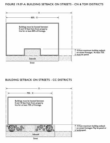
1.
CN and TOM Districts. Up to 25% of the area between the property line and the building in the CN and TOM districts may be landscaped, subject to the following standards; all other setback areas shall be paved for public use, and a public access easement for that area shall be granted. All landscaping shall be integrated into the building; the use of planter boxes at windows is encouraged.
2.
CC District. In the CC district, the area between the property line and the building may be landscaped.
D.
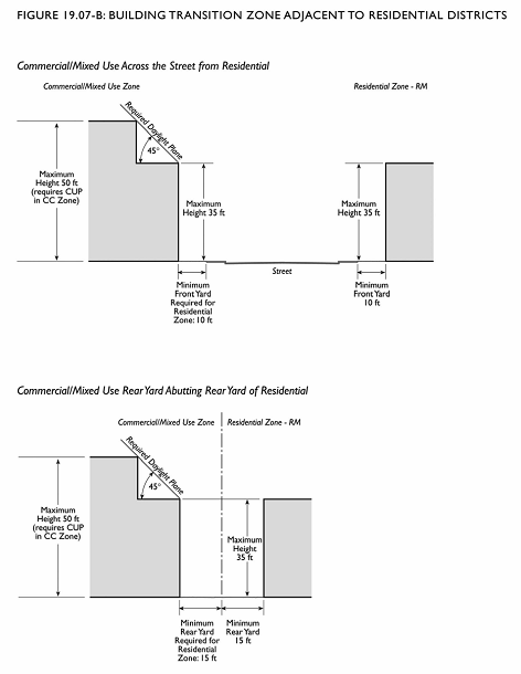
Minimum Yard Requirements—Building Transition Zone Adjacent to Residential Districts.
1.
For any portion of a structure adjacent to a residential district boundary (adjoining, opposite or across the street from a district boundary, including structures across from, but separated by, the Ohlone Greenway), the minimum required setbacks of the residential district shall apply.
2.
To protect privacy and minimize sunlight blockage, structures shall not intercept a 45-degree daylight plane inclined inward starting from a height of 35 feet above existing grade at the setback line. See Figure 19.07-B.
3.
Exceptions to the above requirements are permitted for a one-story parking or garage structure that does not exceed 10 feet in height in a side or rear yard that does not front on a street.
E.
Public Open Space. For buildings over 25,000 square feet, outdoor open space which is accessible to the public during daytime hours shall be provided at a ratio of 25 square feet per 1,000 square feet of building. Open space(s) shall be visible from a public street and shall be located within 40 feet of the street-facing property line. Exceptions may be granted with a conditional use permit.
F.
Limitations on Location of Parking.
1.
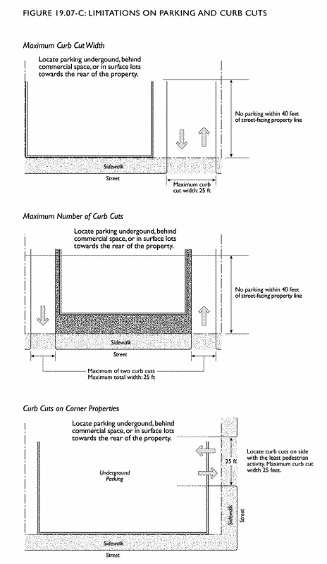
Commercial and mixed-use buildings shall be placed as close to the street as possible in accordance with Section 19.07.030.C (previous), with parking located either underground, behind habitable space, or on the interior side or rear of the site. See Figure 19.07-C.
2.
Above ground parking associated with a commercial or mixed-use project may not be located within 40 feet of a street facing property line — driveways excepted. Exceptions may be granted with the approval of a Conditional Use.
3.
Permit, for projects that do not meet this standard, including projects with parking on upper levels. Additional findings for approval of a Conditional Use Permit for exceptions to this regulation are as follows:
a.
The design incorporates habitable space built close to the public sidewalk to the maximum extent feasible; and any parking within 40 feet of the street facing property line is well screened with a wall, hedge, trellis, and/or landscaping.
b.
The site is small and constrained such that underground parking or surface parking located more than 40 feet from street frontages is not feasible; or the proposed use is a large-size commercial use where some surface parking is required and is not in the TOM district near the BART stations.
4.
Freestanding, single-purpose parking structures shall be allowed with a Conditional Use Permit and shall be subject to design review.
5.
See Chapter 19.24, Off-Street Parking and Loading for additional parking facility requirements.
G.
Limitations on Curb Cuts.
1.
Curb cuts are limited to a maximum of 25 feet of linear frontage per property, which may be achieved through a combination of one or two separate curb cuts. Additional area for curb cuts may be allowed with an Administrative Use Permit for properties over 25,000 square feet where it can be demonstrated that additional cuts are necessary to protect pedestrian safety or accommodate total vehicular traffic. See Figure 19.07-C.
2.
Curb cuts shall be located in the location least likely to impede pedestrian circulation.
3.
Shared curb cuts among abutting properties are encouraged whenever possible, to minimize curb cuts.
H.
Limitations on Location of Truck Docks; Loading and Service Areas. Truck docks, loading and service areas shall not be located within 50 feet of any residential district boundary or within 40 feet of a street-facing property line. These facilities shall be located at the interior side of buildings or on the rear of the site and be screened so as not to be visible from public streets. Exceptions may be granted with approval of a Conditional Use Permit if an alternative location for the truck dock, loading and/or service area better protects the pedestrian environment of the commercial district, better shields adjoining residential neighborhoods from noise and visual impacts, or the lot is sized or shaped preventing these regulations from being met.
I.
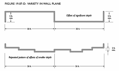
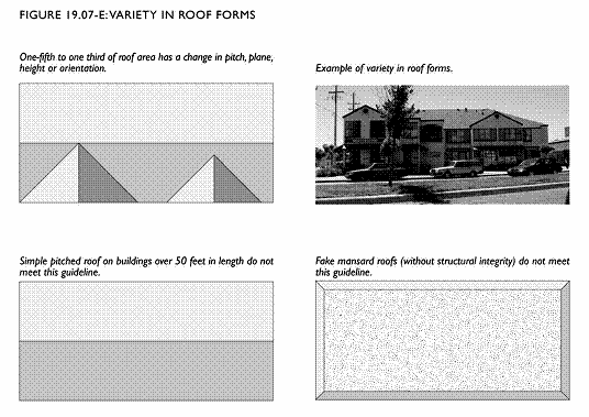
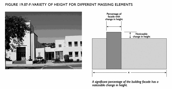
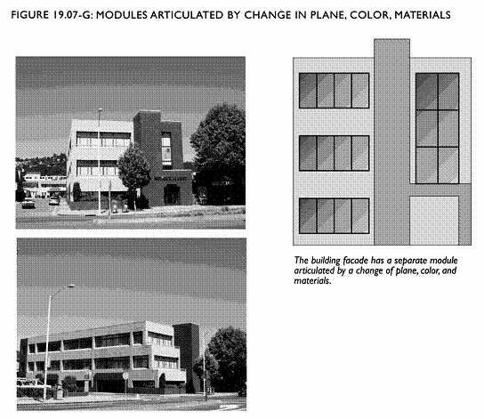
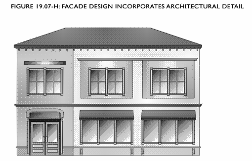
Building Design Features. The Planning Commission or Design Review Board in accordance with Chapter 19.38 shall make a finding that the commercial or mixed-use structure provides adequate design features to create architectural interest and avoid a large-scale, bulky and "box-like" appearance. Different ways that this finding may be met include but are not limited to those listed and illustrated below. See Figures 19.07-D and 19.07-H. The drawings and photos are intended to illustrate the concept, and do not represent an ideal design that applicants should attempt to replicate.
1.
Variety in Wall Plane. The planes of the exterior walls vary in depth and/or direction. Instead of having a continuous flat wall, the wall has either offsets with significant depth, or a repeated pattern of offsets of smaller depth. See Figure 19.07-D.
2.
Variety in Roof Forms. The roof forms or roof heights vary over different portions of the building. See Figure 19.07-E.
3.
Variety of Height for Different Massing Elements. The height of the building varies so that it appears to be divided into distinct massing elements. See Figure 19.07-F.
4.
Modules Articulated by Change in Plane, Color, or Materials. The different modules of a building's facade are articulated by use of a change in plane, color, arrangement of facade elements, or a change in materials. See Figure 19.07-G.
5.
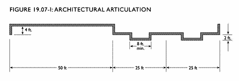
Facade Design Incorporates Architectural Detail. A flat building facade incorporates details such as window trim, window recesses, cornices, changes in material, color or other design elements in an integrated composition. Some of the architectural features of the main facade are incorporated into the rear and side elevations. See Figures 19.07-H and 19.07-I.
6.
Use of Balconies, Bay Windows, and other such Projections or Recesses. The building incorporates balconies, bay windows, entry porches or other projections and recesses in a pattern that creates architectural interest across the length of the facade. This is most typically found on buildings that include residential uses.
J.
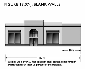
Blank Walls. No unadorned blank walls shall be permitted on the storefront side. Other building walls over 24 feet in height or 50 feet in length shall include an offset, recess, or projection at least one foot in depth, providing shadows or visual interest for at least 25 percent of the frontage. See Figure 19.07-J.
K.
Building Orientation.
1.
All buildings located along a public street shall be oriented toward, and have their primary entrances toward, the public street.
2.
On properties that border the Ohlone Greenway, buildings shall also have windows facing onto the greenway.
3.
All buildings and dwelling units located in the interior of a site shall have entrances from sidewalks that are designed as an extension of the public sidewalk and connect to a public sidewalk.
L.
Ground Floor Requirements. The following standards apply with respect to ground floor construction. Exceptions may be granted with approval of a Conditional Use Permit.
1.
Building materials used on the ground floor shall be high quality durable materials. The portions of the building two feet above grade that front the public sidewalk shall be constructed of concrete, stone, tile, masonry or other equivalent quality material, rather than wood or stucco. Exceptions may be granted by the Planning Commission or Design Review Board in accordance with Chapter 19.38.
2.
There shall be a same or greater level of detail and articulation of the ground floor than the upper floors of a building. See Figure 19.07-K.

M.
Building Transparency. A minimum of 60 percent of a building's frontage shall provide views into the building's interior through windows, window displays, or doors with a zone of transparency of between two and six feet above grade. See Figure 19.07-K.
N.
Open Space Requirements for Residential Uses. A minimum of 100 square feet of open space is required per residential unit and may be provided as common or private open space.
O.
Required Side and Rear Yards for Residential Uses in the Community Commercial (CC) Zones. In order to provide light and air for residential units, the following minimum setbacks apply for any side or rear yard not fronting a street. When the site is adjacent to a residential district, the standards of subsection (D) also apply, and the project must comply with whichever standard is stricter. Required depths of setbacks shall be as follows:
1.
Five feet for any wall with windows.
2.
10 feet for any wall with bedroom or kitchen windows.
3.
15 feet for any wall with living room or other primary windows.
4.
The building shall be set back one foot for every two feet of height above 35 feet. See Figure 19.07-L.
The length of the required setbacks must be at least the width of the window plus three feet on either side, and never less than 10 feet:

P.
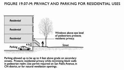
Privacy and Parking Location for Ground-Floor Residential Uses. In order to provide privacy for any permitted ground-floor residential units, the ground floor may be elevated up to four feet above the sidewalk level subject to the following:
1.
Along Secondary Streets. Structured parking that is no more than four feet above the grade of the public sidewalk and does not have ventilation openings fronting the sidewalk is permitted as-of-right for residential uses on secondary streets.
2.
Other Locations. Structured parking that is no more than four feet above the grade of the public sidewalk and which is located facing San Pablo Avenue, in the CN district, or which includes natural ventilation openings facing the street shall require approval of a Conditional Use Permit.
3.
Over Four Feet Above Grade. Structured parking more than four feet above the grade of the public sidewalk in any location shall require approval of a Conditional Use Permit. See Figure 19.07-M.
Q.
Street Trees for Residential Uses. Where residential uses face the street, street trees shall be planted along all street frontages in the one of the following manners:
1.
One row of trees directly abutting the street frontage with spacing to be determined by the Public Works Department.
2.
A double row of trees (depending on staggering and tree species as per the Public Works Department) along the street frontage.
R.
Consistency with Design Guidelines, General Plan, Specific Plans, or Area Plans Adopted by the City Council. All projects shall be consistent with any design guidelines, specific plans, area plans, or other similar documents that give specific guidance for development on private property and public improvements.
S.
Pedestrian Access to Buildings Set Back from the Street. If a Conditional Use Permit is approved for buildings set back farther than the minimum 10-foot setback requirement, the following standards for public access shall apply:
1.
To Neighbors. Direct and convenient access shall be provided from commercial and mixed-use projects to adjoining neighborhood residential and commercial areas. These connections shall remain accessible at all times, and not be gated.
2.
To Street Network. Pedestrian access from the public right-of-way to the primary uses on the site shall occur as often as necessary to connect the on-site walkways and the public sidewalk. Landscape strips shall be crossed for pedestrian access at regular intervals. When pedestrian access to a site is in the same location as automobile entries (i.e., at driveways), the auto and pedestrian paths shall be separated from each other by physical barrier (i.e., curb or bollards) with proper cuts and ramps to allow for ADA compliant disabled access. The pedestrian access shall be integrated with the parking lot landscaping so as to provide a shaded walkway.
3.
To Transit. Safe and convenient pedestrian connections shall be provided from transit stops to building entrances with public sidewalk and pedestrian walkways. Sidewalk "bulb-outs" or bus "pull-outs" may be required at potential bus stops.
4.
Pedestrian Walkway Design.
a.
Primary pedestrian routes and access points shall be specially treated and include trees at regular intervals, adequate lighting, and paving that distinguishes pedestrian from automobile areas. A minimum five-foot wide clear walkway is required to ensure pedestrian safety.
b.
All dedicated pedestrian routes, including those through parking areas, shall be separated from automobile routes by a curb.
T.
Fencing. Chain link fences visible from public view are not allowed. If fencing visible from public view is used for commercial uses, open work such as wrought iron and metal (tube) fences with design features are preferred, although masonry, stucco and plaster are permitted. Wood fences are not permitted. Commercial parcels abutting residential parcels shall use six (6) foot high masonry, stucco or plaster fences.
U.
Projections.
1.
Projections into Required Yards. Projections into required yards are permitted subject to the following standards:
a.
Architectural Features. Architectural features, such as bay windows not exceeding 10 feet in length, cornices, eaves, canopies, and chimneys may not extend closer than three feet to any side lot line, nor more than four feet into any required front or rear setback.
b.
Stairs, Decks, and Balconies. Open uncovered stair landings, decks and balconies 12 feet or less in length may not extend closer than three feet to any side lot line, nor more than four feet into any required front or rear setback.
2.
Allowed Projections above Height Limits. Projections, including elevator and stair towers, chimneys, silos, cupolas, flagpoles, monuments, water tanks, church steeples, roof furniture and roof equipment, building-mounted wireless telecommunications, and similar structures and necessary appurtenances, are permitted subject to the following standards:
a.
Projections are allowed up to 10 feet above the height of the roof, or they may be attached to existing projections if they do not increase the height of such projection.
b.
The total area of all projections may not cover more than 10 percent of the top floor roof area.
c.
Exceptions may be granted with a Conditional Use Permit.
d.
All roof mounted mechanical equipment shall be screened from public view.
(Ord. 2008-2 Div. II (part), 2008.)
(Ord. No. 2009-03, § VIII, 4-20-2009)
19.07.040 - Review of plans.
All development is subject to development review under the City's Administrative provisions, found in Part V of this Title. Certain development may also require design review, pursuant to Chapter 19.38, Design Review.
(Ord. 2008-2 Div. II (part), 2008.)
19.08.010 - Purpose.
The specific purposes of the PS Public and Semipublic district are to:
A.
Create, maintain, and enhance areas of the City that are appropriate for public or semipublic uses, including, private utilities (electrical, gas, water and telecommunications), schools (both private and public), other private uses of an institutional or community services nature and other city, county, state or federal facilities.
B.
Preserve and protect limited valuable resources, facilities and sites for possible future public use and to allow for careful consideration by the City Council of changes in land use when private institutional uses are no longer viable.
C.
Ensure that public and semipublic land uses protect and enhance the character and quality of life of the surrounding area.
(Ord. 2008-2 Div. II (part), 2008.)
19.08.020 - Land use regulations.
Table 19.08-A prescribes the land use regulations for the public and semipublic district. The regulations for each district are established by letter designations as follows:
"P" — Uses permitted as-of-right that require no discretionary review if in compliance with all standards.
"L" — Uses permitted as-of-right subject to limitations restricting location, size or other characteristics to ensure compatibility with surrounding uses. Limitations are referenced by number designations listed at the end of Table 19.08-A.
"A" — Uses subject to an Administrative Use Permit following discretionary review by the Zoning Administrator.
"C" — Uses subject to a Conditional Use Permit following discretionary review and public hearing by the Planning Commission.
"—" — Uses that are not permitted.
The "Additional Use Regulations" column includes specific regulations applicable to the use classification, and specifies regulations located elsewhere in this Zoning Ordinance. Use classifications are defined in Chapter 19.46, Use Classifications. Use classifications not listed in the table below are prohibited.
TABLE 19.08-A
USE REGULATIONS — PUBLIC AND SEMIPUBLIC DISTRICT
L-1: Permitted if in existence on June 30, 1977, excluding above-ground burials. Otherwise, requires a conditional use permit.
L-2: Limited to facilities related to, and in conjunction, with authorized public and semipublic facilities; otherwise requires a conditional use permit.
(Ord. 2008-2 Div. II (part), 2008.)
19.08.030 - Development standards.
A.
Conditional Uses. If a use permit is required, the use permit shall establish all final development standards.
B.
Other Applicable Development Regulations. The following regulations shall also apply:
(Ord. 2008-2 Div. II (part), 2008.)
19.08.040 - Review of plans.
All development is subject to development review under the City's administrative provisions, found in Part V of this Zoning Ordinance. Certain development may also require design review, pursuant to Chapter 19.38, Design Review.
(Ord. 2008-2 Div. II (part), 2008.)
19.09.010 - Purpose.
The specific purposes of the open space and parks districts are to:
A.
Create, preserve and enhance land for permanent open space, including environmentally sensitive lands and habitats, creeks, and city parks and recreation facilities that meet community needs for both active recreational use and passive visual enjoyment.
B.
Provide appropriately located areas for public and privately owned lands to be used for low-intensity, open space activities, such as hiking, walking or picnicking and to meet the active and passive recreational needs of the city's residents.
The additional purposes of each open space and parks district are:
OS-N Open Space Natural. To preserve publicly owned parklands, environmentally sensitive lands and habitats, and creeks in their natural state. Uses permitted shall be limited to those that maintain the property in its natural state such as passive recreation.
PR Parks and Recreation. To provide appropriately located areas for recreation and recreational uses. Uses permitted shall be limited to those that are devoted to public recreation, including parks, playgrounds, swimming centers, tennis and basketball courts, golf courses, community centers within the facilities, and accessory concession sales.
(Ord. 2008-2 Div. II (part), 2008.)
19.09.020 - Limits on calculation of parks.
No privately owned parks located in the PR district shall be counted towards parklands or other publicly accessible open space areas required by the General Plan.
(Ord. 2008-2 Div. II (part), 2008.)
19.09.030 - Land use regulations.
Table 19.09-A prescribes the land use regulations for open space and parks districts. The regulations for each district are established by letter designations as follows:
"P" — Uses permitted as-of-right that require no discretionary review if in compliance with all standards.
"L" — Uses permitted as-of-right subject to limitations restricting location, size or other characteristics to ensure compatibility with surrounding uses. Limitations are referenced by number designations listed at the end of Table 19.09-A.
"A" — Uses subject to an Administrative Use Permit following discretionary review by the Zoning Administrator.
"C" — Uses subject to a Conditional Use Permit following discretionary review and public hearing by the Planning Commission.
"—"— Uses that are not permitted.
The "Additional Use Regulations" column includes specific regulations applicable to the use classification, and specifies regulations located elsewhere in this Zoning Ordinance. Use classifications are defined in Chapter 19.46, Use Classifications. Use classifications not listed in the table below are prohibited.
TABLE 19.09-A
USE REGULATIONS — OPEN SPACE AND PARKS DISTRICTS
L-1: Permitted if in existence on June 30, 1977, excluding above-ground burials. Otherwise, requires a Conditional Use Permit.
L-2: Limited to facilities related to, and in conjunction with, park and public recreational facilities. Otherwise, requires a Conditional Use Permit.
L-3: Limited to trails, wildlife preserves and open space uses that maintain the property in its natural state. No building, structure or improvements shall be constructed in these areas, except for those required for public access, public restrooms, public signage, trash containers, parking facilities, and facilities needed for protecting environmental resources and general upkeep and maintenance of the property.
(Ord. 2008-2 Div. II (part), 2008.)
19.09.040 - Development standards.
A.
Conditional Uses. If a use permit is required, the Conditional Use Permit shall establish all final development standards.
B.
Other Applicable Development Regulations. The following regulations shall also apply:
(Ord. 2008-2 Div. II (part), 2008.)
19.09.050 - Review of plans.
All development is subject to development review under the City's Administrative provisions, found in Part V of this Zoning Ordinance. Certain development may also require design review, pursuant to Chapter 19.38, Design Review.
(Ord. 2008-2 Div. II (part), 2008.)