
Emporia City Zoning Code
ARTICLE IV
PRIMARY ZONING DISTRICTS
Sec. 90-231. - General.
(a)
Zoning districts established. Land within the city, as it exists at the time of this ordinance being enacted, is hereby divided into classes of primary zoning districts to:
(1)
Regulate and restrict the location and use of buildings and land for trade, industry, residence, and other purposes in accordance with the objectives of the comprehensive plan;
(2)
Regulate and restrict the location, height, and size of buildings hereafter erected or structurally altered; and
(3)
Ensure adequate setbacks, open spaces, and public facilities to support the city's population.
(b)
Primary zoning districts. The city is hereby divided into the following primary zoning districts:
Table 4.1 Primary Zoning Districts
(c)
Overlay districts. Overlay districts are established in article V, overlay zoning districts, of this ordinance.
Sec. 90-232. - References to district names.
For the purpose of reference throughout this ordinance, unless specifically provided to the contrary, the term "residential district" shall include R-1, R-2, and R-3 districts; "commercial district" shall include C-1, C-2, and DT districts; "industrial district" shall include I-1 and I-2 districts; and "planned development district" shall include the R-PRD district.
Sec. 90-233. - Purpose and intent of primary zoning districts.
(a)
Residential.
(1)
R-1, low density residential. The intent of this district is to protect existing low density residential areas, while promoting similar development as the city grows. Regulations for this district are designed to stabilize and protect the essential characteristics of the district, to promote and encourage a suitable environment for family life and to prohibit all activities of a commercial nature. To these ends, development shall be limited to low concentrations of homesites on more spacious lots. Uses are limited to single-family dwellings, plus certain additional public, civic, and recreational uses, such as schools, parks, and churches.
(2)
R-2, medium density residential. The intent of this district is to protect existing residential areas that provide single- and two-family dwellings, while promoting similar development as the city grows. Regulations for this district are designed to provide a suitable environment for a mix of housing types located in closer proximity to shopping and employment. To these ends, development shall be limited to relatively low to medium concentration, and uses are limited to single- and two-family dwellings, plus certain additional public, civic, and recreational uses, such as schools, parks, and churches.
(3)
R-3, high density residential. The intent of this district is to protect existing residential areas of medium to high concentrations that are located between or adjacent to other residential and commercial uses, while promoting complementary and similar uses as the city grows. Regulations for this district are designed to stabilize and protect the essential characteristics of the district, to provide a suitable environment for persons desiring the amenities of apartment living and the convenience of being close to shopping, employment centers, and other community facilities. This residential district allows for the most variation of dwelling types. Other permitted uses include those compatible with residential neighborhoods, such as public, civic, and recreational (schools, parks, churches) and limited commercial development unlikely to generate high traffic and crowds of customers. This district is predominately residential in character and, as such, commercial uses should be developed sensitively.
(4)
R-MH, manufactured home residential. The intent of this district is to increase opportunities for affordable housing alternatives, to recognize modern advances in manufactured housing technology, and to promote cost effective site development. This district provides opportunity for manufactured housing communities to develop in such a way that is harmonious with existing residential neighborhoods. Furthermore, this district provides for civic and recreational uses, and protects against the intrusion of incompatible commercial and industrial uses.
(b)
Commercial.
(1)
DT, downtown commercial. The intent of this district is to provide a traditional downtown with a mix of uses and services. This district should have infill development that fits the scale, design, and character of the area. Land uses should include a mix of retail, office, service, entertainment, and hotel uses, as well as introduce and expand residential uses that contribute to the activity and vitality of the area.
(2)
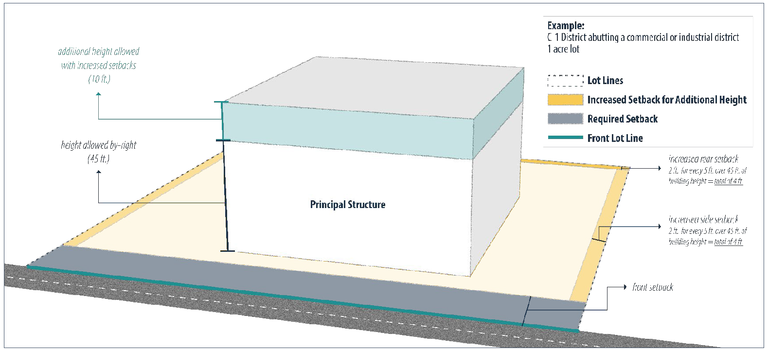
C-1, general commercial. The intent of this district is to recognize existing commercial uses and to provide an opportunity to expand these and other similar commercial uses and development. It is also intended to encompass the expanding commercial areas of C-2, and act as a transition between commercial and non-commercial districts. The district should accommodate a range of retail, personal service, and office uses and provide for the convenience and day-to-day needs of residents of nearby neighborhoods.
(3)
C-2, highway commercial. The intent of this district is to accommodate a wide range of retail, wholesale, service, and office uses that cater to the traveling public and serve the city and the surrounding region. The district is designed to provide highly attractive and accessible shopping along principal highways, while avoiding the routing of traffic onto minor streets or through residential areas.
(c)
Industrial.
(1)
I-1, light industrial. The intent of this district is to provide sufficient space in appropriate locations for less intense industrial uses, such as research facilities, wholesale, warehousing, light industrial, and heavy commercial uses. The uses in this district should be buffered from daily services and residences. Uses should occur mostly in enclosed buildings or be screened from view, and activities should not create a danger to health and safety in surrounding areas, nor create off-site noise, vibration, smoke, dust, lint, odor, heat, or glare.
(2)
I-2, heavy industrial. The intent of this district is to encourage and provide for larger scale manufacturing operations in appropriate areas separated from daily services and residences. The uses in this district may include outside storage, noise, smoke, or odor, which shall be mitigated with industry best practice for the compatibility of the surrounding area and the preservation of the environment.
(d)
Planned development.
(1)
R-PRD, residential planned development. The intent of this district it to promote residential planned developments that are designed and developed in accordance with a master plan. Within such communities, the location of all improvements shall be controlled in such a manner as to permit a variety of housing accommodations in an orderly relationship to one another, with the greatest amount of open area and the least disturbance to natural features. A planned residential development may include light commercial facilities to the extent necessary to serve the needs of the planned residential development.
Sec. 90-241. - General.
(a)
The requirements specified in this article shall be considered the minimum required to promote the public health, safety, and general welfare.
(b)
Except as provided elsewhere in this ordinance for nonconforming lots, every structure hereafter constructed shall be located on a lot meeting the minimum requirements for the district in which it is located.
(c)
Photographs, graphics, and/or diagrams in this article are included for illustrative purposes only. If there is any inconsistency between them and the text of this ordinance, including tables, the text will govern.
Sec. 90-242. - Additional standards.
In addition to the provided standards for each district, additional standards may apply, as listed below:
(1)
Use standards. Article VII, use standards, of this ordinance establishes additional standards pertaining to specific uses.
(2)
Community design standards. Article VIII, community design standards, of this ordinance establishes additional standards for:
a.
Landscaping and screening;
b.
Walls and fences;
c.
Parking and loading;
d.
Lighting;
e.
Signs; and
f.
Open space.
(3)
Drainage. Provisions shall be made for proper stormwater drainage from streets, parking, and loading areas, in accordance with chapter 78 of this Code. Water shall not be permitted to drain from such areas onto adjacent property except into a natural watercourse or a drainage easement. Provisions shall be made for protection against erosion and sedimentation in accordance with chapter 34 of this Code.
(4)
Streets and sidewalks. Provisions shall be made for the construction and maintenance of streets and sidewalks, in accordance with chapter 62 of this Code.
Sec. 90-251. - Height.
(a)
Measuring height.
(1)
Building height is measured, in feet, as the vertical distance from the level of the curb or the established curb grade that is opposite the front of the structure to the roofline, measured as follows (see figure 4.1):
a.
If a flat roof, measurement is to the top of the roof.
b.
If a mansard roof, measurement is to the deck line of the roof.
c.
If a gable, hip, or gambrel roof, measurement is to the mean height level between the eaves and ridge of the roof.
(b)
Floodplain height.
(1)
For structures that are in AE and A flood zones, as identified in article V, overlay zoning districts, division 2, floodplain overlay district, of this ordinance, the following applies:
a.
Height is measured from 24 inches above the base flood elevation to the roofline as required in subsection (a) above for the building site (see figure 4.2).
b.
In cases where there is a ground floor enclosure below the base flood elevation, height shall be measured as provided in subsection (a) above (see figure 4.1).
Figure 4.1 Height Measurement in Primary Districts
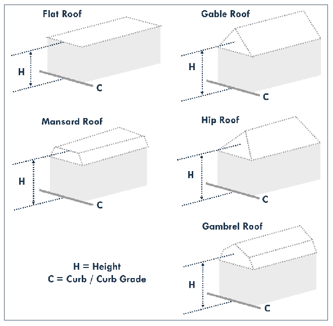
Figure 4.2 Height Measurement of Raised Structures in Floodplain Areas

(c)
Exemptions. The height limitations of this ordinance shall not apply to:
(1)
Spires;
(2)
Belfries;
(3)
Cupolas;
(4)
Domes;
(5)
Monuments;
(6)
Chimneys, flues, and smokestacks;
(7)
Flagpoles;
(8)
Silos;
(9)
Television antennas;
(10)
Radio aerials;
(11)
Parapet walls;
(12)
Roof-top mechanical equipment screened by parapet walls;
(13)
Water tanks or towers;
(14)
Broadcasting or communication towers; and
(15)
Utility service, major.
Sec. 90-252. - Lots and setbacks.
(a)
Lot standards.
(1)
Lot area shall be the total horizontal area included within the lot lines of a lot.
(2)
Lot width shall be the horizontal distance between the side lot lines of a lot, measured at the front setback.
(b)
Street frontage required. Except as otherwise provided in this article, every lot shall front a street; whether public or private.
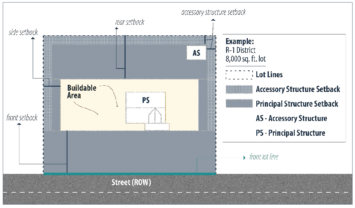
(c)
Required setbacks. See figures 4.3, 4.4, and 4.5.
(1)
Interior lots, corner lots, and stem lots shall have the following setbacks:
a.
One front, two side, and one rear.
(2)
Double frontage lots shall have the following setbacks:
b.
Two fronts, one side, and one rear.
Figure 4.3 Lot Standard Terms
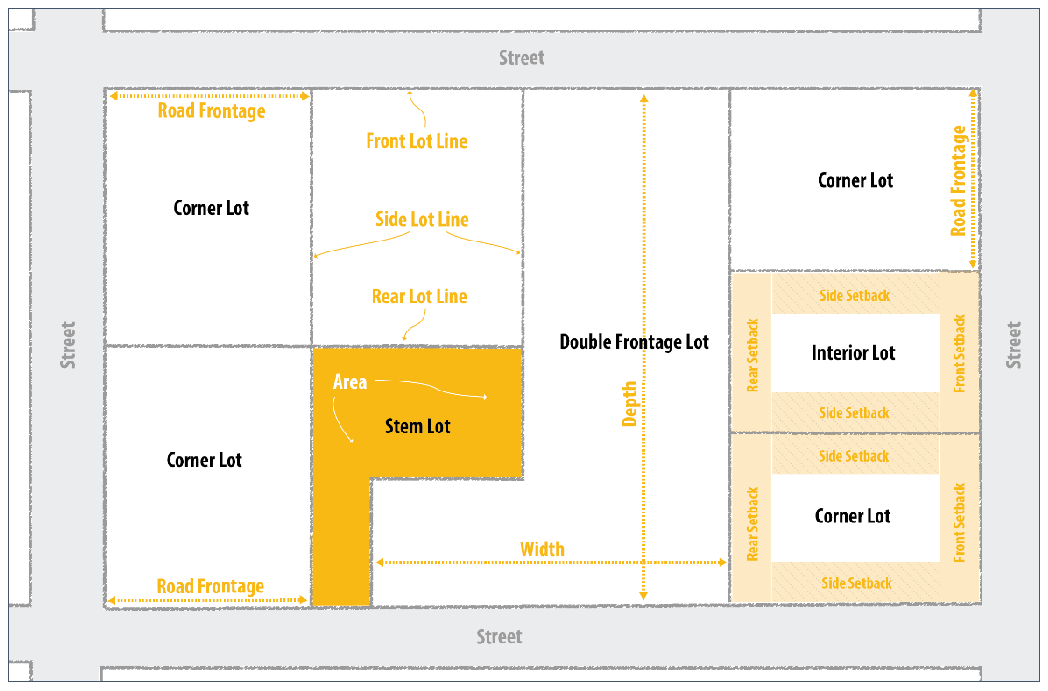
Figure 4.4 Required Setbacks
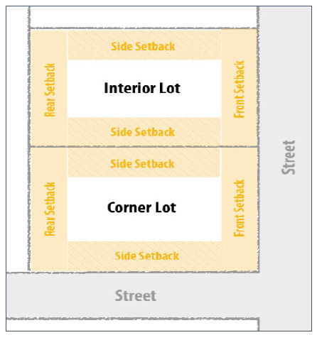
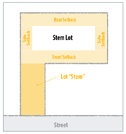
Figure 4.5 Stem Lot Front Setback
(d)
Measurement methods. See figure 4.6. The following methods shall be used for measuring setbacks:
(1)
All setback types. Setbacks shall be measured in such a manner that the lot line and the setback line are parallel to one another.
(2)
Front setback. Front setbacks are determined as follows:
a.
A front setback shall be included for the full width of the lot frontage, measured between the side lot lines.
b.
Depth of the front setback shall be measured from the front lot line, inward towards the lot, until the distance required in the district standards is met.
c.
Interior lots shall have one front setback that is the portion along the street.
d.
Double frontage lots shall have two front setbacks, one along each street.
e.
Corner lots shall have one front setback that is the shortest of the two street frontages.
f.
Stem lots shall have one front setback that is measured from the boundary delineating the end of the "stem" and then in towards the lot until the distance required in the district standards is met. See figure 4.5.
g.
Irregular lots shall have one front setback that shall be determined by the nearest existing buildings on each side of the lot. However, if the existing buildings are more than 125 feet away from the proposed structure, the administrator will determine the setback.
(3)
Side setback.
a.
Side setbacks shall be measured from the front setback to the rear setback.
b.
Depth of a side setback shall be measured from the lot line in towards the lot until the distance required in the district standards is met.
(4)
Rear setback.
a.
A rear setback shall be included for the full width of the rear of the lot, measured between the side lot lines.
b.
Depth of a rear setback shall be measured from the rear lot line in towards the lot until the distance required in the district standards is met.
Figure 4.6 Setback Example
(e)
Exemptions and encroachments. The following uses and structures are permitted in required setbacks, subject to the limitations provided:
(1)
Plantings, fences, or shrubbery.
a.
Plantings, fences, shrubbery, or other obstruction on any corner lot, shall be no taller than three feet higher than the curb or street level within the visibility triangle.
(2)
Unenclosed porches, steps, and decks, not exceeding 24 square feet in size, may project into any required setback, but shall not be closer than three feet to any lot line.
(3)
Architectural features, chimney, eaves, windowsills, and other like building features may project into any required setback but shall not be closer than three feet to any lot line.
(4)
Balconies and open, unenclosed fire escapes may project not more than four feet into any required side or rear setback but shall not be closer than three feet to any lot line.
a.
Accessory structures are subject to the requirements and regulations of article VII, use standards, of this ordinance.
Sec. 90-261. - Residential districts.
Table 4.2 Residential District Regulations
Sec. 90-262. - Commercial districts.
Table 4.3 Commercial District Regulations
Figure 4.7 C-1 Example of Additional Height with Increased Setbacks
Sec. 90-263. - Industrial districts.
Table 4.4 Industrial District Regulations
Sec. 90-271. - Purpose.
The purpose of planned development districts is to encourage innovative and efficient land use planning and physical design on large, unified sites. Planned development districts are intended to:
(1)
Achieve a high quality of development while protecting environmentally sensitive areas;
(2)
Provide a well-integrated mix of non-residential and recreation uses with various residential dwelling types to achieve a walkable, connected neighborhood;
(3)
Allow more efficient use of land through coordinated networks of streets, utilities, and pedestrian connections, both within the development and to adjacent development;
(4)
Encourage the provision of accessible and useable open space and recreational amenities within the development;
(5)
Promote development forms and patterns that respect the character of established surrounding neighborhoods and other land uses; and
(6)
Promote development patterns that complement a site's natural and man-made features, such as rivers, lakes, wetlands, floodplains, trees, and historic and cultural resources.
Sec. 90-272. - Application.
(a)
Planned development districts shall be established by amendment to the zoning map, in accordance with article III, permits and applications, of this ordinance.
(b)
No development within a planned development district, including but not limited to clearing, grading, excavating, road building, site preparation or structural improvements, may be permitted prior to site plan approval by the city council in accordance with article III, permits and applications, division 6, site plans, of this ordinance.
(c)
No transfer, sale, or conveyance of any individual lot or interest shall be permitted prior to final subdivision plat approval, in accordance with article X, subdivision, of this ordinance.
(d)
All development and subsequent operation within a planned development district shall be undertaken in accordance with the provisions of the approved site plan.
(e)
A proposed development may vary from the guidelines outlined in this division, except for uses subject to approval of a rezoning or conditional use permit in accordance with article III, permits and applications, of this ordinance or approval. Any waiver from the standards and guidelines shall be specifically acknowledged by means of a proffer or conditions. A request for waiver must:
(1)
Clearly outline the requested waiver(s); and
(2)
Justify the need or benefit to the public and community should the waiver be granted.
Sec. 90-273. - R-PRD, planned residential development district.
(a)
Character of development. Planned residential development districts should encourage unified, high-quality development combining a variety of lot sizes and housing types, recreation, and neighborhood commercial, in a compact, walkable neighborhood setting. Planned residential development districts typically include the following:
(1)
Pedestrian orientation;
(2)
Neighborhood friendly streets and paths;
(3)
Interconnected streets and transportation networks;
(4)
Parks and open space amenities;
(5)
Appropriate commercial uses in neighborhood centers;
(6)
Appropriately scaled buildings and spaces;
(7)
Mixture of housing types and affordability; and
(8)
Environmentally sensitive design.
(b)
Development requirements and standards. In addition to the standards provided in table 4.5 of this article, the following standards apply:
(1)
General.
a.
The R-PRD shall employ an overall cohesive character with design elements which may include, but are not limited to, materials, balconies, terraces, articulation of doors and windows, sculptural or textual relief of facades, architectural ornamentation, varied roof lines, or other appurtenances, such as lighting fixtures and landscaping. Compatibility may be achieved through the use of similar building massing, materials, scale, colors and other architectural features.
b.
Minimum setback ranges for residential dwellings and non-residential uses shall be specifically established during the review and approval of the concept plan, as part of the rezoning process, in accordance with article III, permits and application, of this ordinance.
c.
Areas between buildings used as service yards, storage of trash, or other utility purposes should be designed to be compatible with adjoining buildings;
d.
Building spacing and design shall incorporate privacy for outdoor activity areas (patios, decks, etc.) associated with individual dwelling units whenever feasible;
e.
Setbacks shall not interfere with public safety considerations such as intersection sight distance or utilities, including other public infrastructure such as sidewalks, open space, etc.
f.
All new utility lines, electric, telephone, cable television lines, etc., shall be placed underground.
(2)
Residential.
a.
Residential units should vary by dwelling type in a logical and attractive manner to best fit the site. A mixture of residential structures is critical for providing good housing opportunities in a healthy neighborhood setting; and
1.
Each R-PRD shall contain at least two types of residential uses.
2.
No more than 60 percent of the total number of residential units shall be of the same category (i.e. single-family, duplexes, townhouses).
b.
The gross and net residential densities shall be shown on the approved concept plan by area and for the development as a whole in dwelling units per acre (du/acre) and shall be binding upon its approval.
(3)
Commercial. The proposed commercial uses should be in proportion to the overall intent and functionality of predominately residential character of the planned development district concept.
(4)
Open space.
a.
Open space shall be provided in a logical relationship to the site; and
b.
Improvements shall be configured to accommodate any permitted, accessory, and conditional uses in an orderly relationship with one another, with the greatest amount of open area and with the least disturbance to natural features.
c.
Open space shall be in accordance with article VIII, community design standards, of this ordinance.
Table 4.5 R-PRD, Planned Residential District Regulations