
Estes Park City Zoning Code
CHAPTER 1
- GENERAL PROVISIONS
§ 1.1 - Title
The regulations of this Land Development Code shall be officially known and cited as the "Land Development Code of the Town of Estes Park, Colorado," although it may be referred to hereafter as the "Estes Valley Development Code," "EVDC" or "this Code."
(Ord. 03-20 §2, 2/11/20)
§ 1.2 - Authority
This Code is authorized by the Colorado Constitution and the applicable laws and statutes of the State of Colorado.
§ 1.3 - Purpose and Intent
The regulations of this Code are intended to implement the 1996 Estes Valley Comprehensive Plan, as amended, and more specifically are intended to:
A.
Provide for coordinated, harmonious development of the Estes Valley and the Town of Estes Park, which will, in accordance with present and future needs, best promote health, safety, order, convenience, prosperity and general welfare, as well as efficiency and economy in the process of development;
B.
Protect residents from fire, floodwaters, geologic hazards and other dangers;
C.
Preserve and protect existing trees and vegetation, agricultural lands, floodplains, riparian corridors, wildlife habitat and other sensitive environmental areas from adverse impacts of development;
D.
Facilitate the economic provision of adequate public facilities such as transportation, water supply, sewage disposal, drainage, electricity, public schools, parks and other public services and requirements;
E.
Coordinate transportation and land use planning to provide a safe and efficient transportation system in the Estes Valley;
F.
Work to improve the aesthetics and design of all primary gateways to the Town of Estes Park, including but not limited to Highways 7, 34 and 36;
G.
Encourage innovative residential development so that growing demand for housing may be met by greater variety in type, design and layout of dwellings, and by conservation and more efficient use of open areas ancillary to such dwellings;
H.
Encourage nonresidential development that preserves and protects the character of the community, including its natural and cultural landscape, and that minimizes objectionable noise, glare, odor, traffic and other impacts of such development, especially when adjacent to residential uses or to the historic downtown core;
I.
Preserve and protect the architecture, history and small-town character of Estes Park's historic downtown;
J.
Strengthen and improve the downtown Estes Park as the primary government, cultural, office, financial, tourist, specialty shopping and pedestrian district of the Estes Valley;
K.
Provide adequate building setbacks and height limitations;
L.
Encourage orderly and efficient distribution of the Estes Valley's population through land use regulations;
M.
Promote good civic design and arrangement; and
N.
Promote higher quality in site and land planning, conservation of open areas, and more efficient and attractive use of open areas.
§ 1.4 - Applicability
The provisions of this Code shall apply to:
A.
All land and development located within the incorporated areas of the Town of Estes Park and all unincorporated areas of Larimer County within the Estes Valley, as depicted in the Estes Valley Development Code Boundary Map, as may be amended from time to time. This map is set forth in Appendix A to this Code and hereby incorporated by reference; and
B.
Use of all structures and land within the incorporated areas of the Town of Estes Park and all unincorporated areas of Larimer County within the Estes Valley, as depicted on the Estes Valley Development Code Boundary Map (See Appendix A).
§ 1.5 - Minimum Standards and Compliance
A.
Minimum Standards. The provisions of this Code shall be considered the minimum requirements necessary for the promotion of the public health, safety, comfort, convenience, prosperity and general welfare.
B.
Compliance. No structure or premises shall hereafter be used or occupied, and no structure or portion thereof shall be erected, moved, constructed, reconstructed, extended, enlarged or altered contrary to the provisions of this Code. No portion of a lot area, open area, off-street parking space or yard required about or in connection with any building for the purposes of complying with this Code may be included as a portion of a lot area, an open area, off-street parking area or yard similarly required for any other building or its use except as provided under Chapter 9, "Planned Unit Developments."
C.
Nonconforming Uses, Structures and Lots. See Chapter 6 for regulations regarding nonconforming uses, structures and lots.
§ 1.6 - Rules of Construction and Interpretation
A.
Meaning and Intent. All provisions, terms, phrases and expressions contained in this Code shall be construed according to this Code's stated purpose and intent.
B.
Text Controls. In case of any difference of meaning or implication between the text of this Code and any heading, drawing, table or figure, the text shall control.
C.
Computation of Time. Unless the terms of a specific provision state otherwise (e.g., some provisions specify "working days"), periods of time defined by a number of days shall mean a number of consecutive calendar days, including all weekend days, holidays and other nonbusiness/working days; however, if the last day is a Saturday, Sunday or legal holiday, that day shall be excluded.
D.
Delegation of Authority. Whenever a provision appears requiring the head of a department or another officer or employee of the Town or County to perform an act or duty, that provision shall be construed as authorizing the department head or officer to delegate the responsibility to subordinates, unless the terms of the provision specify otherwise.
E.
Technical and Nontechnical Words. Words and phrases not otherwise defined in this Code shall be construed according to the common and approved usage of the language, but technical words and phrases not otherwise defined in this Code that may have acquired a peculiar and appropriate meaning in law shall be construed and understood according to such meaning.
F.
Mandatory and Discretionary Terms. The word "shall" is always mandatory, and the words "may" or "should" are always permissive.
G.
Conjunctions. Unless the context clearly suggests the contrary, conjunctions shall be interpreted as follows:
1.
"And" indicates that all connected items, conditions, provisions or events shall apply; and
2.
"Or" indicates that one (1) or more of the connected items, conditions, provisions or events shall apply.
H.
Tense and Usage. Words used in one (1) tense (past, present or future) include all other tenses, unless the context clearly indicates the contrary. The singular shall include the plural, and the plural shall include the singular.
I.
Gender. The masculine shall include the feminine, and vice versa.
§ 1.7 - Official Zoning Map
A.
Official Zoning Map. The location and boundaries of the zoning districts designated in Chapter 4 are hereby established as shown on the map entitled "Zoning District Map of the Estes Valley," and hereafter referred to as the Official Zoning Map, as may be amended.
B.
Incorporated by Reference. The Official Zoning Map and all the notations thereon are hereby incorporated by reference and made part of this Code. The signed copy of the Official Zoning Map containing the zoning districts designated at the time of the adoption of this Code, and all amendments thereto, shall be maintained on file in the office of the Town of Estes Park Director of Community Development. In case of any dispute regarding the zoning classification of property subject to this Code, this original map shall control. (See also Chapter 3.)
C.
Zoning District Boundaries. Unless otherwise specified, district boundaries are lot lines or the centerline of streets, rivers or such lines extended. For example, where a lot located at the boundary between two (2) zoning districts abuts a street or road, the zoning district boundary shall be the centerline of such abutting street or road.
D.
Changes to Map. Changes made in district boundaries or other matter portrayed on the Official Zoning Map shall be made in accordance with the provisions of this Code. Changes shall be entered on the Official Zoning Map promptly after the amendment has been approved by the Board of Trustees or Board of County Commissioners. No amendment to this Code that changes the Official Zoning Map shall become effective until after such change is entered on the map.
E.
Omitted Land. If any land subject to this Code has not been specifically included within any of the zoning districts shown on the official zoning map, such land shall automatically be classified in the RE Rural Estate zoning district.
§ 1.8 - Conflicting Provisions and Relationship to Other Regulations, Codes and Ordinances
A.
Conflicts and Relationship with Other Regulations.
1.
When the provisions of this Code are inconsistent with one another, or when the provisions of this Code conflict with provisions found in other ordinances, codes or regulations adopted by the Town of Estes Park or Larimer County, the more restrictive provision shall govern unless the terms of the provisions specify otherwise.
2.
It shall be the developer's or applicant's responsibility to determine and comply with all other applicable town, county, State or Federal codes or regulations governing land development and land use activities.
B.
Relationship with Private-Party Easements, Covenants or Agreements. This Code is not intended to interfere with or abrogate or annul any easements, covenants or agreements between parties, provided that wherever this Code proposes a greater restriction upon the use of buildings or land, upon the location or height of buildings or structures, or upon requirements for open areas than those that are imposed or required by such easements, covenants or agreements between parties, the provision of this Code shall govern.
In no case shall the Town or County be obligated to enforce the provisions of any easements, covenants or agreements between private parties.
§ 1.9 - Rules of Measurement
A.
Lot Area Measurement. Lot area refers to the total gross amount of horizontal land area within lot lines. Public and private rights-of-way and streets shall not be included in calculating lot area. No development plan, subdivision approval, building permit or other land use approval shall be issued for a lot that does not meet the minimum lot area requirements of this Code, except as may be otherwise allowed in this Code. See Figure 1-1.
B.
Lot Width Measurement. Lot width refers to the horizontal distance between the side lot lines as measured along a straight line parallel to the front lot line or the chord thereof. The minimum lot width shall be measured between the side lot lines along a line that is parallel to the front lot line and located the minimum front setback distance from the front lot line. Lot width standards shall apply to lots that do not have a front lot line, i.e., lots that do not abut a street. In these cases, the Decision-Making Body shall determine where to measure lot width. See Figure 1-1.
(Ord. 8-05 #1)

Figure 1-1
C.
Density Calculation.
1.
Net Land Area. Net land area shall be determined by subtracting from the gross land area, the following (as applicable):
a.
Eighty percent (80%) of lands located in the 100-year floodplain;
b.
Eighty percent (80%) of lands located above the elevation serviceable by the Town of Estes Park water system;
c.
All lands within private streets or dedicated public rights-of-way; and
d.
All lands subject to a ground lease that, because of the lease terms, would not be available for development of the proposed land use(s) on the subject property.
2.
Net Density. Net density shall be calculated by dividing the net land area by the minimum lot area or land area required for each unit.
3.
When applying a density standard to a parcel's net land area, any fraction of less than one-half (½) shall be rounded down to the next lower whole number and any fraction of one-half (½) or more shall be rounded up to the next higher whole number.
(Ord. 11-16 §1)
4.
The number of dwelling or accommodation units allowed on a site is based on the presumption that all other applicable standards shall be met. The maximum density established for a zoning district (see Chapter 4) is not a guarantee that such densities may be obtained, nor a valid justification for varying other dimensional or development standards.
D.
Setbacks—Building and Structure Setbacks.
1.
Building and Structure Setbacks from Lot Lines.
a.
Measurement: Setbacks shall be measured as the distance between the nearest lot line and the furthermost projection of a building or structure along a line at right angles to the setback line. Setbacks shall be unobstructed from the ground to the sky except as otherwise specifically allowed in this Section. See Figure 1-2.
b.
Features Allowed Within Building Setbacks:
(1)
Cornices, canopies, eaves or other similar architectural features, provided they extend no more than three (3) feet into a required setback or yard;
(2)
Driveways and sidewalks, provided that the edge of a driveway shall be set back at least three (3) feet from an adjacent property line unless owners of abutting properties agree in writing that the edge may be closer to or abut their common property line;
(3)
Fences or walls subject to height and other restrictions set forth in this Code;
(4)
Patios and decks, uncovered and at-grade, provided they do not extend more than thirty percent (30%) of the required setback distance to any required setback. See Figure 1-2;
(5)
Steps to the principal entrance and necessary landings, together with railings, that comply with the Uniform Building Code, provided they do not extend more than six (6) feet into the required setback;
(6)
Landscaping;
(7)
Trees, vegetation or other features of natural growth; and
(8)
Utility lines, wires and associated structures within a utility easement.
(9)
Signs that comply with applicable sign regulations.
(Ord. 8-05 #1)
(10)
The minimum amount of equipment necessary for the functional operation of roof-mounted photovoltaic systems; provided that such equipment shall be located as close to an adjacent building or structure as is reasonably practicable and does not extend more than three (3) feet into the required setback.
(Ord. 06-21, §1(Exh. A)
(11)
Postal boxes.
(Ord. 8-05 #1)
(12)
Parking lots that comply with landscaping standards set forth in §7.5.G, "Parking Lot Landscaping."
(Ord. 8-05 #1)
c.
Front Setbacks on Corner Lots and Double-Frontage Lots: For corner lots and double-frontage lots, all sides of the lot with street frontage shall be required to establish the applicable front yard setback. See Figure 1-2.
(Ord. 8-05 #1)
d.
Intersection and driveway sight visibility: Intersection and driveway sight visibility shall comply with the requirements of Appendix D, Section IV.C (Intersection and Driveway Visibility).
(Ord. 18-01 #1)
2.
Development Setbacks from River and Stream Corridors and Wetlands.
a.
Stream and River Corridors. Development setbacks shall be measured as the distance between the delineated stream or river corridor, as set forth in §7.6.D.2, and the furthermost projection of a building or structure along a line at right angles to the setback line. Setbacks shall be unobstructed from the ground to the sky except as otherwise specifically allowed in §7.6.D of this Code. See Figure 1-2.
b.
Wetlands. Development setbacks shall be measured as the distance between the delineated wetland edge, as set forth in §7.6.D.3, and the furthermost projection of a building or structure along a line at right angles to the setback line. Setbacks shall be unobstructed from the ground to the sky except as otherwise specifically allowed in §7.6.D of this Code. See Figure 1-2.
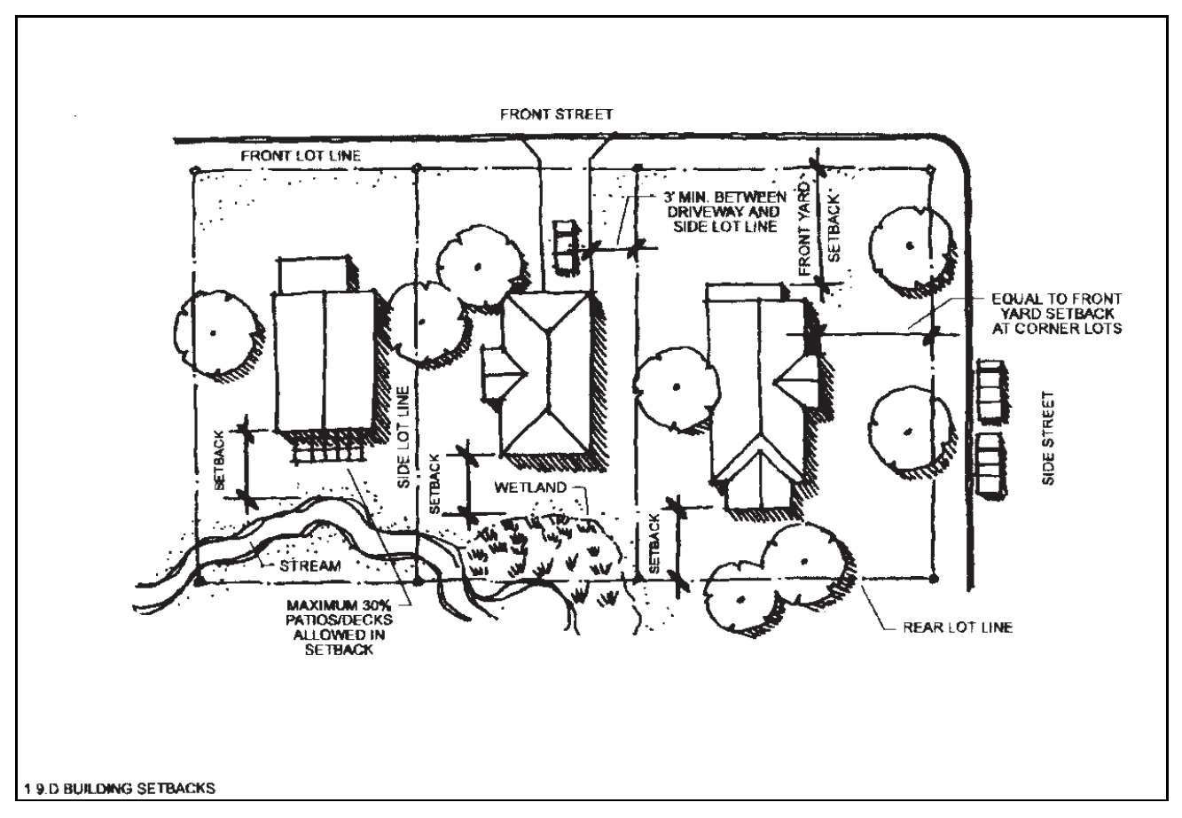
Figure 1-2
E.
Height.
1.
Measurement of Maximum Building Height. Height means the vertical distance measured from the mean average elevation of the finished grade ((lowest point elevation + highest point elevation)/2):
(1)
To the highest point of the roof surface, excluding parapet, if a flat roof;
(2)
To the deck line of a mansard roof;
(3)
To the mean height level between the lowest point of the topmost top plate and highest ridge for a gable, hip or gambrel roof; or
(4)
Exception: For any building with a steep sloped roof, the highest-point elevation shall be measured from average finished grade to the highest point on the highest ridge. For purposes of this subsection, the term "steep sloped" shall mean any roof with a pitch greater than or equal to a 12:12 ratio.
(Ord. 28-17 §1(Exh.))
2.
Line of Measurement. Height shall be measured along a vertical (plumb) line connecting the horizontal plane of roof height measurement to the horizontal plane of finished grade, as specified herein.
3.
Exemptions from Height Standards. The following features shall be exempt from maximum building height:
a.
Chimneys to the extent required by the applicable building code(s);
b.
Skylights, parapet walls, cornices without windows, communications antennas, Micro Wind Energy Conversion System (MWECS); and
c.
Wireless telecommunications facilities and structures, but only to the extent allowed by the specific provisions set forth in Use Tables 4-1 and 4-4 in Chapter 4 and in §5.1.T of this Code.
(Ord. 17-17 §1)
(Ord. 18-01 #1, 2, 10/23/01; Ord. 18-02 #3, 12/10/02; Ord. 8-05 #1, 6/14/05; Ord. 11-16 §1(Exh. A), 4/12/16; Ord. 17-17 §1(Exh. A), 6/13/17; Ord. 28-17 §1(Exh.), 10/24/17; Ord. 06-21, §1(Exh. A), 4/27/21)
§ 1.10 - Transitional Provisions
This Section addresses the applicability of new substantive standards enacted by this Code to activities, actions and other matters that are pending or occurring as of the effective date of this Code. (For definition of "effective date of this Code," see Chapter 13.)
A.
Violations Continue. Any violation of the previous zoning regulations of the Town or County shall continue to be a violation under this Code and shall be subject to the penalties and enforcement set forth herein, unless the use, development, construction or other activity is clearly consistent with the express terms of this Code.
B.
Completion of Development Plans Commenced or Approved Under Previous Codes.
1.
Buildings or Developments with Previously Issued Building Permits. Any building or development for which a building permit was granted prior to the effective date of this Code shall be permitted to proceed to construction even if such building or development does not conform to the provisions of this Code.
If construction is not completed and the intended use not established in accordance with the applicable permit terms within eighteen (18) months of building permit issuance, the Estes Valley Planning Commission may, for good cause shown, grant not more than one (1) extension of up to six (6) months. If the building or development is not completed within the 18-month period, or within any extension granted, then the building shall be constructed, completed, used or occupied only in compliance with the requirements of this Code.
2.
Developments with Preliminary or Final Approval. Any development for which preliminary or final approval was granted prior to the effective date of this Code may be completed in accordance with the approved plat or plan and any other permits and conditions, even if such development does not conform with the provisions of this Code.
3.
Developments with Applications for Approval Pending. Any development that has submitted a complete application that has been accepted by the Town or County prior to the effective date of this Code shall be exempt from complying with the provisions of this Code. Said application must be approved within six (6) months of the effective date of this Code. The EVPC may, for good cause shown, grant not more than one (1) extension of up to six (6) months.
§ 1.11 - Liability for Damages
This Code shall not be construed to hold the Town, County or their authorized representatives responsible for any damage to persons or property by reason of the inspection or reinspection authorized in this Code.
§ 1.12 - Severability
If a court of competent jurisdiction declares that any section, subsection or provision of this Code is invalid, that ruling shall not affect the validity of any other part of this Code, which shall remain in full force and effect.
§ 1.13 - TRANSITION TO ESTES PARK DEVELOPMENT CODE
All references in this Code to the Estes Valley Development Code or the EVDC shall be construed as references to this Code. Notwithstanding any statement in the Code to the contrary, this Code shall apply only to land and development located within the incorporated limits of the Town of Estes Park, or proposed to be annexed into the Town. Accordingly, no matters addressed by this Code shall require action by the Board of County Commissioners of Larimer County, or the staff, boards, or commissions of the County. All references to the Estes Valley Planning Commission or EVPC shall be construed as references to the Estes Park Planning Commission. All references to the Estes Valley Board of Adjustment or BOA shall be construed as references to the Estes Park Board of Adjustment. All references to both Town and County officials shall be construed as references solely to the Town counterpart. The Town Board intends that these references all be updated in a subsequent ordinance.
(Ord. 03-20 §2, 2/11/20)