
Estes Park City Zoning Code
CHAPTER 7
- GENERAL DEVELOPMENT STANDARDS
§ 7.1 - SLOPE PROTECTION STANDARDS
A.
Density Calculation for Residential and Accommodation Development on Steep Slopes in Excess of 12%.
1.
Applicability. These density calculation provisions shall apply to all new residential and accommodation development in the Estes Valley, except single-family residential development on a lot created and approved for such use prior to the effective date of this Code.
(Ord. 8-05 #1; Ord. 18-02 #1; Ord. 13-22, §1(Exh. A))
2.
General Rule. Notwithstanding the maximum densities permitted by the underlying zoning district, the minimum lot area for new residential and accommodation development on parcels containing slopes twelve percent (12%) or greater shall be determined by the following formulas:
a.
All Residential Zoning Districts (Except RM): For each percentage point by which average slope exceeds twelve percent (12%), the base zone minimum lot area requirement shall be increased by one thousand (1,000) square feet, as shown in Table 7-1 below.
Table 7-1
Density Calculation/Lot Area Adjustment for Steep Slopes by Zoning District
(Ord. 13-22, §1(Exh. A))
b.
RM Zone: For each percentage point by which average slope exceeds twelve percent (12%), the base zone minimum land area per unit requirement (five thousand four hundred [5,400] square feet per unit = maximum density of eight [8] dwelling units per acre) shall be increased by three hundred (300) square feet per dwelling unit.
(Ord. 24-16 §1)
c.
A Zone:
(1)
Accommodation development shall comply with the base zoning minimum lot area of forty thousand (40,000) square feet.
(2)
In addition, for each percentage point by which average slope exceeds twelve percent (12%), the base zoning minimum land area per unit requirement (one thousand eight hundred [1,800] or five thousand four hundred [5,400] square feet per unit) shall be increased by one hundred (100) or three hundred (300) square feet per unit, respectively.
(3)
Single-family or two-family uses in the A Zone shall comply with the base zoning minimum lot area of forty thousand (40,000) square feet. In addition, for each percentage point by which average slope exceeds twelve percent (12%), the base zone minimum land area per unit requirement (nine thousand [9,000] square feet for SF uses and six thousand seven hundred fifty [6,750] square feet for 2-F uses) shall be increased by three hundred (300) square feet per dwelling unit.
d.
A-1 Zone: Development shall comply with the base zoning minimum lot area of fifteen thousand (15,000) square feet. In addition, for each percentage point by which average slope exceeds twelve percent (12%), the base zone minimum land area requirement per dwelling unit or accommodation unit (ten thousand eight hundred ninety [10,890] square feet per unit) shall be increased by six hundred five (605) square feet per unit.
3.
Definition. For purposes of this Section, "average slope" shall be measured as set forth in Chapter 13 of this Code. See Figure 7-1.
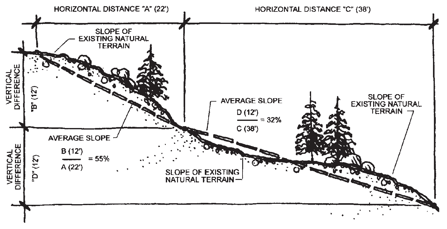
Figure 7-1
B.
Development Restrictions on Steep Slopes.
1.
Applicability. These development restrictions shall apply to all new development in the Estes Valley, except for development on lots that were approved for single-family residential use prior to the effective date of this Code.
(Ord. 18-02 #1)
2.
New Structures-Existing Slopes in Excess of Thirty Percent.
a.
New development proposed to be built on any portion of a site containing a slope of thirty percent (30%) or greater shall be subject to Staff review and approval of a development plan pursuant to §3.8 of this Code. This provision applies to development that would otherwise be exempt from the development plan review process (e.g., single-family developments containing less than three [3] units).
b.
Staff shall review all such development plans and evaluate them according to the following standards:
(1)
Site disturbance shall be minimized to the maximum extent practicable (see §7.2.D, "Limitations on Site Disturbance" below);
(2)
Cuts for utilities and access driveways shall be shared to the maximum extent feasible;
(3)
To the maximum extent feasible, new construction shall not take place on any portion of a parcel that shows evidence of slope instability, landslides, avalanche, flooding or other natural or manmade hazards (see §7.7, "Geologic and Wildfire Hazard Areas" below);
(4)
The Applicant shall demonstrate that the slope's ground surface and subsurface are not unstable, that the proposed development will not cause instability or increase the potential for slope failure, and that the development of the slope will not increase the degree of hazard both on-site and on adjacent properties.
c.
For purposes of this subsection, steepness of slope shall be measured from the points with highest and lowest elevation within five (5) feet of any portion of the proposed structure.
3.
Structure Clearance from Steep Slopes. Structure clearance from ascending or descending slopes greater than thirty percent (30%) shall comply with the requirements set forth in the applicable Building Code provisions.
4.
Grading, Clearing and Excavation-Slopes in Excess of Thirty Percent. Clearing, excavation and grading on slopes greater than thirty percent (30%) would not be allowed, unless expressly approved through a development plan.
5.
Roads/Driveways-Slopes in Excess of Thirty Percent. Shared driveways and access to sites or lots containing slopes in excess of thirty percent (30%) shall be utilized to the maximum extent feasible. See also "General Site Access" and "Intersection and Driveway Visibility" in Appendix D.
(Ord. 8-05 #1)
C.
Ridgeline Protection Standards.
1.
Applicability. This Section shall apply to all new development in the Estes Valley on land identified on the Estes Valley Ridgeline Protection Map as designated ridgeline protection areas. If the site contains an identified ridgeline, the Applicant may, by site specific analysis, demonstrate that the location of the proposed development is not on an identified ridgeline. Staff may then waive these standards.
2.
Building/Roof Design for Ridgeline Protection. Development subject to this subsection shall be designed and sited to minimize the visible intrusion of buildings and structures above the designated ridgelines or above existing ridge-top trees or vegetation, and thus preserve identified scenic views across or through the site. Techniques to meet this standard shall include, but are not limited to, careful consideration of architectural design, building massing, siting, building colors and roofing materials, and the use of native landscaping or other permitted screening materials. For example, compliance with this standard may require siting a building below a ridgeline so there is a solid, mountain backdrop behind the building. See Figure 7-2.
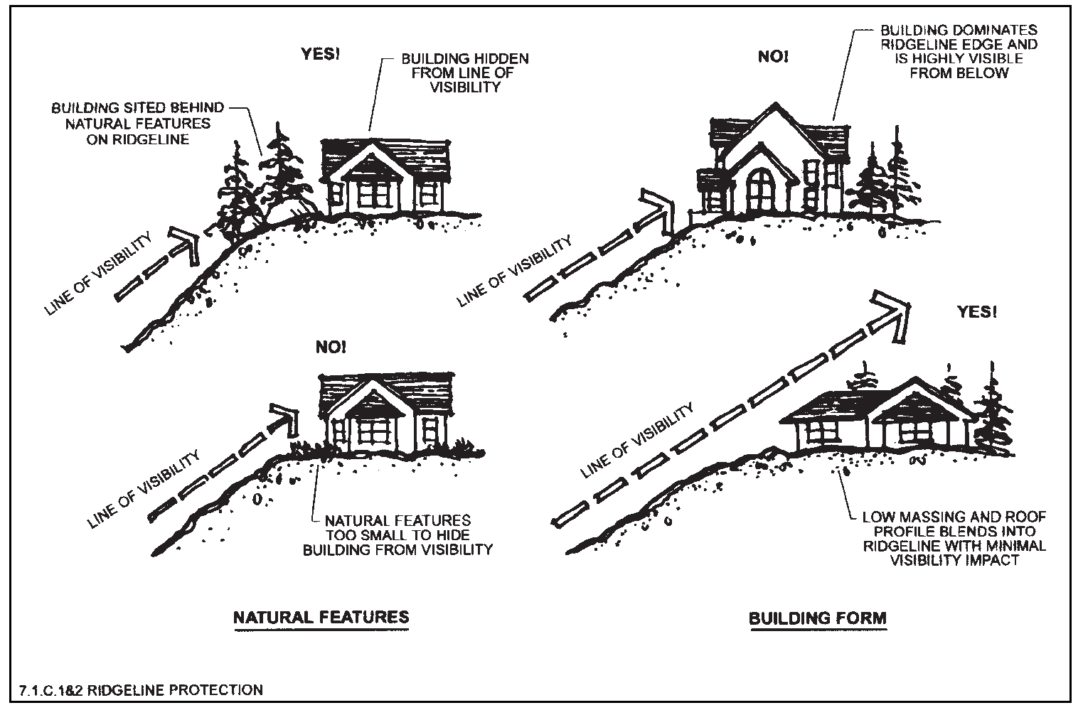
Figure 7-2
3.
Development Plan. All development subject to these ridgeline protection standards shall submit a development plan, including a visual analysis of the proposed development, for staff review and approval pursuant to §3.8 of this Code. This provision applies to development that would otherwise be exempt from the development plan review process (e.g., single-family developments containing less than three [3] units). The required visual analysis shall include a photographic simulation of the development, from viewpoints as determined by Staff.
D.
Staff Waiver of Ridgeline Protection Standards.
1.
Staff may grant such waivers or modifications to the ridgeline protection standards only if it finds, based on substantial evidence presented by the Applicant, that the following conditions are satisfied:
a.
Application of the ridgeline standards renders the site undevelopable; or
b.
Application of the ridgeline standards will result in a substantial economic hardship (as defined in Chapter 13), and the economic hardship is not created by the Applicant or otherwise self-imposed; and
c.
The development conforms with all other development, site design and environmental standards set forth in this Chapter and in all other applicable ordinances and codes.
2.
In granting a waiver from or modification of the ridgeline protection standards set forth in this Section, Staff may impose conditions if the effect of the conditions is to reduce the adverse impacts of the development, including but not limited to a reduction in maximum building height below what would otherwise be permitted in the applicable zoning district.
(Ord. 18-02 #1, 12/10/02; Ord. 8-05 #1, 6/14/05; Ord. 24-16, § 1(Exh. A), 11/22/16; Ord. 13-22, §1(Exh. A), 7/26/22)
§ 7.2 - GRADING AND SITE DISTURBANCE STANDARDS
A.
Applicability. These grading and site disturbance standards shall apply to all new development in the Estes Valley, except for single-family residential development on a lot created and approved for such use prior to the effective date of this Code.
(Ord. 18-02 #1; Ord. 8-05 #1)
B.
Grading Standards.
1.
Grading Prohibited Without Prior Approvals/Permits. No grading, excavation or tree/vegetation removal shall be permitted, whether to provide for a building site, for on-site utilities or services or for any roads or driveways, prior to final approval of a grading and excavation report/plan submitted in support of the project development plan or the issuance of a building permit.
2.
Limits on Changing Natural Grade. The original, natural grade of a lot shall not be raised or lowered more than ten (10) feet at any point for construction of any structure or improvement, except:
a.
For foundation walls incorporated into the principal structure to allow for walk-out basements; or
b.
The site's original grade may be raised or lowered a maximum of twelve (12) feet if a retaining wall or terracing is used to reduce the steepness of manmade slopes, provided that the retaining wall or terracing comply with the requirements set forth in this Section. See Figure 7-3.
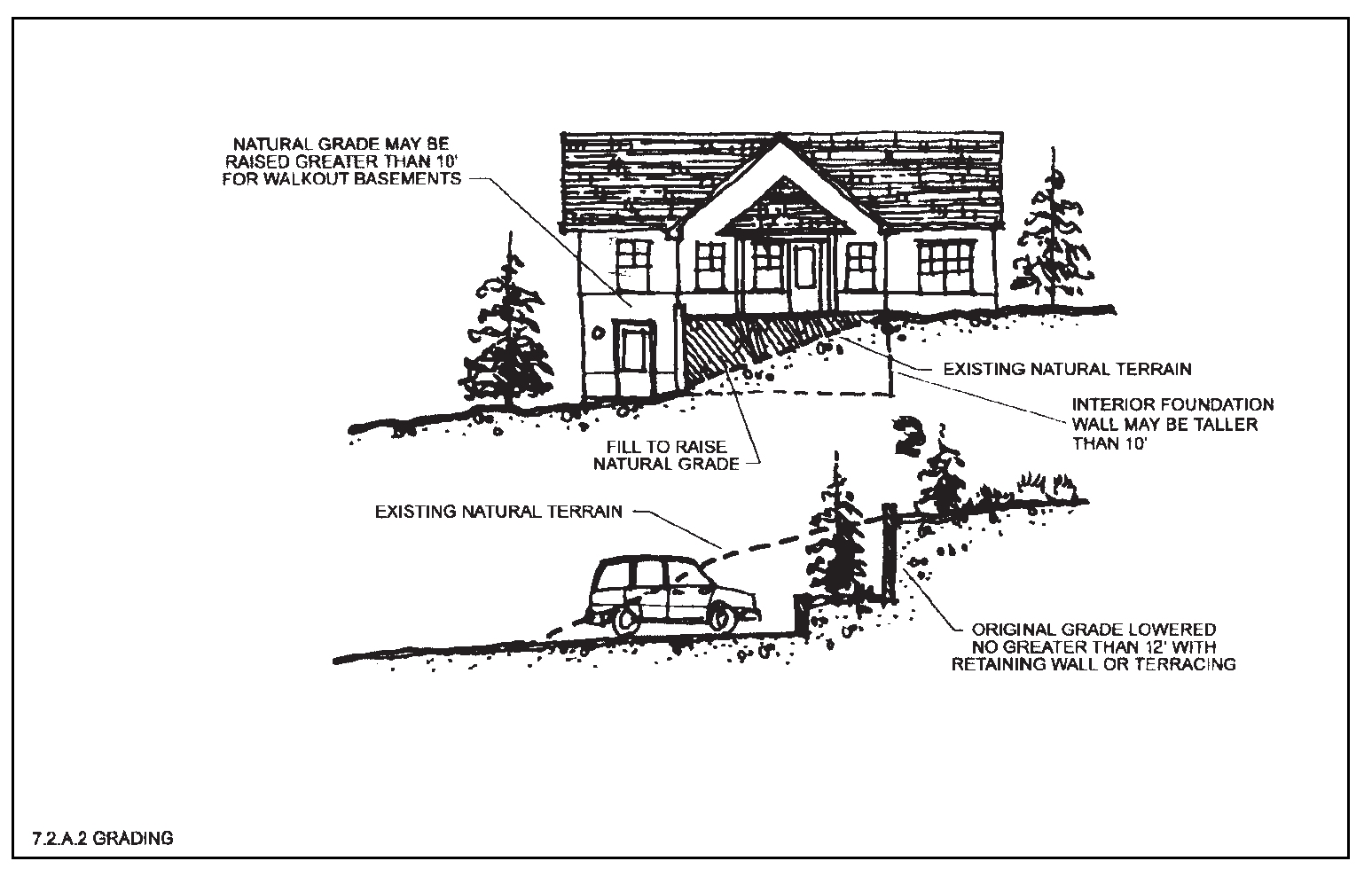
Figure 7-3
3.
Cutting to Create Benches. Cutting and grading to create benches or pads for additional or larger building sites or lawns shall be avoided to the maximum extent feasible. See Figure 7-4.
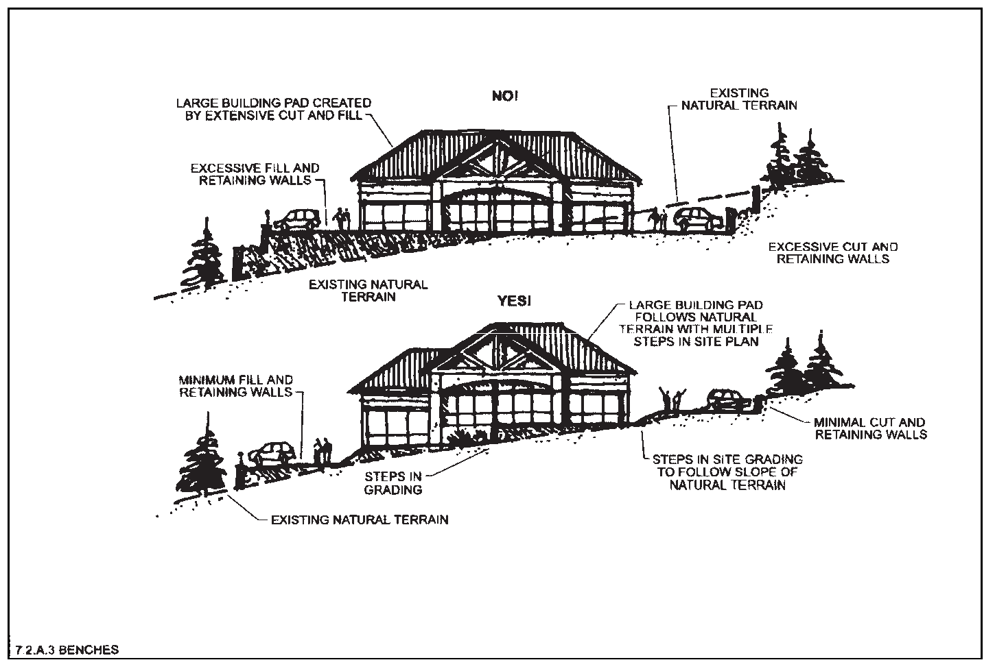
Figure 7-4
4.
Grading for Accessory Building Pads Discouraged. Separate pads for accessory buildings and structures other than garages, such as tennis courts, swimming pools, outbuildings and similar facilities, shall be discouraged except where the average natural slope is twenty percent (20%) or less, as measured from the points with highest and lowest elevation within five (5) feet of any portion of the proposed accessory structure or building.
5.
Limits on Graded or Filled Manmade Slopes.
a.
Slopes of twenty-five percent (25%) or less are strongly encouraged wherever feasible or practicable.
b.
Except as provided below, graded or filled manmade slopes shall not exceed a slope of fifty percent (50%) (a 2:1 slope) unless a soils engineering or a geotechnical report is furnished stating that the site has been investigated and that, in the opinion of the qualified professional, a cut at a steeper slope will be stable and not create a hazard to public or private property.
c.
If a steeper slope will result in less overall site disturbance, then graded or filled manmade slopes associated with road construction may exceed a slope of seventy-five percent (75%) (1.5:1 slope).
6.
Retaining Walls. Limited use of retaining walls is encouraged to reduce the steepness of manmade slopes and to provide planting pockets on steep slopes conducive to revegetation, subject to the following standards. See Figure 7-5:
a.
Retaining walls shall be used to provide breaks in manmade slopes exceeding thirty percent (30%) and to provide planting pockets.
b.
Retaining walls may be permitted to support steep slopes but shall not exceed six (6) feet in height from the finished grade, except for:
(1)
A structure's foundation wall, or
(2)
As necessary to construct a driveway from the street to a garage or parking area, or
(3)
As otherwise expressly allowed by this Section or Chapter.
c.
Retaining walls greater than four (4) feet in height shall be supported by appropriate engineering and reviewed and approved by Staff before construction.
d.
The width of the terrace between any two (2) four-foot vertical retaining walls shall be at least three (3) feet. Retaining walls higher than four (4) feet shall be separated from any other retaining wall by a minimum of five (5) horizontal feet. Terraces created between retaining walls shall be permanently landscaped or revegetated. See §7.5, "Landscaping" below.
e.
Retaining walls visible from an arterial street or highway, or from public open areas or parks, shall be screened by vegetation or faced with wood, stone or other earth-colored materials that blend with the surrounding natural landscape.
f.
All retaining walls shall comply with applicable Building Code provisions, except that when any provision of this Section conflicts with any provision set forth in the Building Code, the more restrictive provision shall apply.
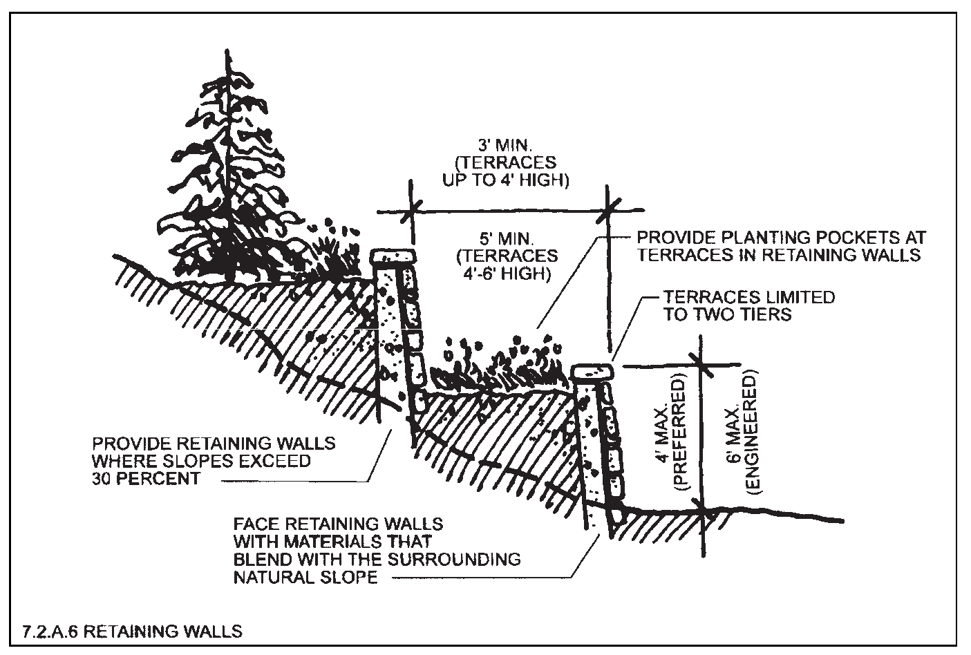
Figure 7-5
7.
Filling or Dredging of Waterways Prohibited. Filling, draining or dredging of water courses, wetlands, gullies, stream beds or stormwater runoff channels is prohibited, except as authorized with a floodplain development permit or with an approved development plan.
8.
Detention/Stormwater Facilities. Where detention basins and other storm and erosion control facilities may be required, any adverse visual and aesthetic impacts on the natural landscape and topography shall be minimized to the maximum extent feasible. See Figure 7-6.
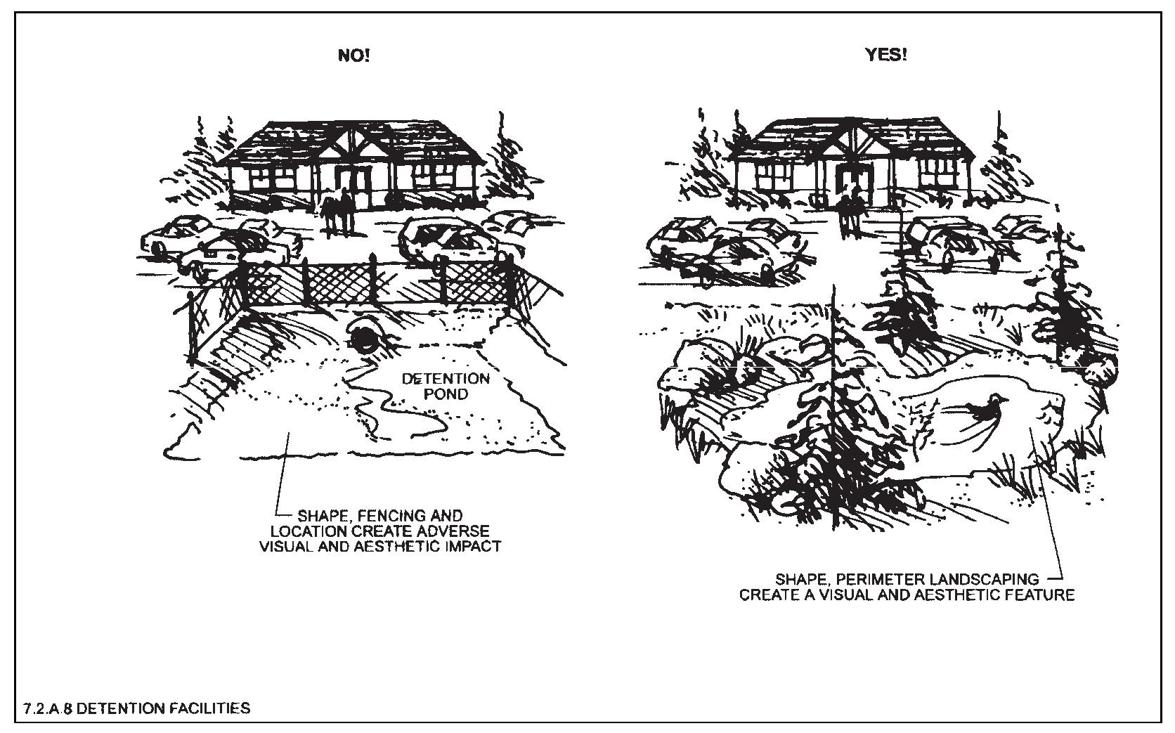
Figure 7-6
C.
Restoration of Disturbed Areas.
1.
Follow Natural Contours. All disturbed areas shall be restored as natural-appearing land forms, with curves that blend in with adjacent undisturbed slopes. Abrupt angular transitions and linear slopes shall be avoided.
2.
Revegetation Required. Areas disturbed by grading shall be contoured so they can be revegetated and shall be revegetated within one (1) growing season after construction, using native species similar to those growing on the site when such revegetation does not contribute to hazards. Revegetation shall be sufficient to provide erosion control and to prevent the invasion of weeds. (See also §7.3 and §7.5 regarding tree/vegetation preservation and landscaping requirements.) Plans for revegetation of cut-and-fill and graded slopes shall be included as part of the landscaping plan submitted as part of the project development plan approval process.
(Ord. 8-05 #1)
3.
Man-Made Slopes Greater than Twenty-five Percent. On man-made slopes of twenty-five percent (25%) or greater, plant materials with deep rooting characteristics shall be selected that will minimize erosion and reduce surface runoff.
4.
Man-Made Slopes Greater than Fifty Percent. On man-made slopes greater than fifty percent (50%), the Staff shall require additional stabilization measures such as erosion netting or hydro-mulching to ensure adequate stabilization and revegetation.
5.
Topsoil Stockpiled. To the maximum extent feasible, topsoil that is removed during construction shall be stockpiled and conserved for later use on areas requiring revegetation or landscaping, such as cut-and-fill slopes.
6.
Cut Rock Treatment. Disturbed areas resulting in rock cuts shall be treated with a rock-staining agent to the extent necessary to match the predominant colors of the surrounding soils or rocks.
D.
Limitations on Site Disturbance.
1.
Establishment of Limits of Disturbance. The Applicant shall propose, and the Decision-Making Body shall establish on each preliminary and final subdivision plat and on each project development plan, a "limits of disturbance" ("LOD") line(s) according to the criteria set forth below. The LOD shall indicate the specific area(s) of a lot, lots or site within which the developed project (including buildings, accessory structures and driveways) may be constructed and within which the development activity shall be contained. See the definition at §13.3, paragraph 134, and Figure 7-7.
2.
Criteria for Establishing LOD. In establishing the LOD, which may be multiple and noncontiguous on a site, the following criteria shall be taken into account:
a.
Avoidance of visual impacts, including but not limited to ridgeline protection areas, steep slopes and scenic views.
b.
Avoidance of steep slopes in excess of thirty percent (30%) and other erosion prevention and control measures, including but not limited to protection of natural drainage channels and compliance with an approved stormwater drainage management plan.
c.
Preservation of forests, significant native trees, rock outcroppings or formations, and other significant native site vegetation.
d.
Wildfire prevention and safety, including but not limited to location of trees and vegetation near structures.
e.
Mitigation of other geologic hazards, including potential adverse impacts on downslope and adjacent properties.
f.
Riparian habitat, stream corridors and wetland protection and buffering.
g.
Floodplains, floodways, flood fringes and flood hazards.
h.
Significant wildlife habitat areas.
i.
The practical needs of approved construction activity in terms of ingress and egress to the developed project and necessary staging and operational areas.
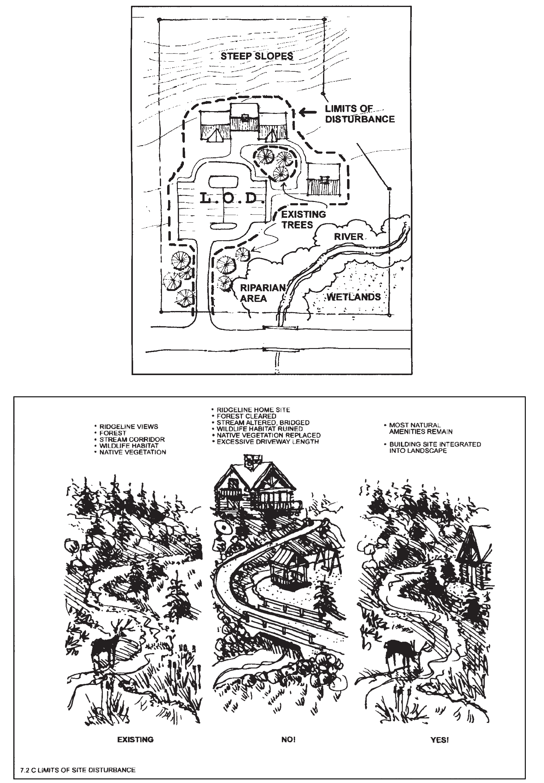
Figure 7-7
3.
Limits of Disturbance—Development Standards and Guidelines.
a.
No construction activity, including, without limitation, grading, excavation or stockpiling of fill material, shall be permitted within the limits of disturbance, whether to provide for a building site, on-site utilities or services or for any roads or driveways, prior to the approval of any required erosion and sedimentation control plan for the development.
b.
To the maximum extent feasible, no development, grading or vegetation removal or alteration shall occur as a part of the development project or associated construction activity outside the LOD except as provided in subsection 3.c below.
c.
Disturbance or construction activity may occur outside the LOD with approval of the Staff for the following limited purposes:
(1)
Mitigation of development activities;
(2)
Restoration of previously disturbed or degraded areas;
(3)
Utility installations and emergency public safety activities when such activities and installations cannot reasonably be contained within the LOD or other nearby developed areas;
(4)
Construction of a trail or pedestrian walkway that will provide public access for educational or recreational purposes when such trails or walkways cannot reasonably be contained within the LOD or other nearby developed areas; or
(5)
The enhancement of the habitat values and/or other natural resource values of an identified natural area.
4.
Designation on Final Plats and Plan s. Approved LODs shall be shown on the preliminary and final subdivision plats and/or on the development plan for each lot or development site.
5.
Standards For Protection During Construction. LODs shall be designated in the field prior to commencement of excavation, grading or construction with construction barrier fencing or other methods approved by Staff. For the protection of trees and clumps of trees to be preserved within a LOD, tree protection specifications as required in §7.3.E below shall be followed.
(Ord. 18-02 #1, 12/10/02; Ord. 8-05 #1, 6/14/05)
§ 7.3 - TREE AND VEGETATION PROTECTION
A.
Applicability. These tree and vegetation protection standards shall apply to all new development in the Estes Valley, except for single-family residential development on a lot created and approved for such use prior to the effective date of this Code.
(Ord. 18-02 #1; Ord. 8-05 #1)
B.
Purposes. Protection of existing tree and vegetation cover is intended to preserve the visual and aesthetic qualities of the Estes Valley; to encourage site design techniques that preserve the natural environment and enhance the developed environment; to control erosion, slippage and sediment run-off into streams and waterways; to increase slope stability; and to protect wildlife habitat and migration corridors.
C.
Exemptions for Specific Activities. The following activities shall be exempt from this Section:
1.
The removal of dead or naturally fallen trees or vegetation, or trees or vegetation that are found by the Town or County to be a threat to the public health, safety or welfare;
2.
The selective and limited removal of trees or vegetation necessary to obtain clear visibility at driveways or intersections (See Appendix D), or for the purpose of performing authorized field survey work;
3.
The removal of trees or vegetation on land zoned or lawfully used for:
a.
Agricultural and forestry activities, including tree farms and approved forestry management practices, except that if a site is substantially cleared of trees pursuant to legitimate forestry activities, no subdivision or development plan applications shall be accepted for thirty-six (36) months from the date the clearing is completed; or
b.
Commercial garden centers, greenhouses or nurseries.
D.
Tree/Vegetation Removal.
1.
Outside Approved Limits of Disturbance. No trees or vegetation shall be removed outside the approved limits of disturbance except as specifically exempted in this Section or Chapter. See §7.2.D above regarding limits on site disturbance.
2.
Within Approved Limits of Disturbance.
a.
To the maximum extent feasible, significant trees (deciduous trees four-inch DBH or larger, conifers eight-inch DBH or larger) and vegetation within the limits of disturbance shall be preserved. Significant trees removed from within the limits of disturbance shall be replaced as set forth in subsection 5 below. This standard shall not apply to tree/vegetation removal adjacent to structures in order to comply with wildfire hazard mitigation requirements (See §7.7 of this Code).
b.
Any existing trees or vegetation that are in appropriate locations, in sufficient quantities and of acceptable quality to be utilized to fulfill landscaping or buffering requirements of this Code shall be preserved to the maximum extent feasible.
3.
Wildfire Hazards and Tree/Vegetation Removal. See §7.7 below.
4.
Tree/Vegetation Removal for Views Prohibited. No trees or vegetation shall be removed for the sole purpose of providing open views to or from structures on a site.
5.
Replacement of Significant Trees. Except for significant trees removed for purposes of wildfire hazard mitigation (See paragraph 3 above), and except for trees removed through an expressly approved construction activity, when a significant tree or trees are removed from a site, the Applicant or developer shall replace such tree(s) on the lot, according to the following schedule and requirements:
a.
A significant deciduous tree that is removed shall be replaced by three (3) trees each with a minimum size of two-and-one-half-inch caliper.
b.
A significant coniferous tree that is removed shall be replaced by two (2) trees each with a minimum height of six (6) feet.
c.
Alternatively with Staff approval, acceptable replacement trees shall be determined by a person or firm qualified by training or experience to have expert knowledge of the subject. Alternatively, the valuation of trees removed may be established in accordance with the Valuation of Trees, Shrubs and Other Plants, prepared by the International Society of Arboriculture, and with Staff approval replaced with landscaping of equal dollar value.
d.
Replacement trees shall be maintained through an establishment period of at least three (3) years, except that single-family developments on a single lot shall have an applicable establishment period of only one (1) year. The Applicant shall post a bond or other surety acceptable to the Decision-Making Body guaranteeing the survival and health of all replacement trees during the establishment period and guaranteeing any associated replacement costs. If the replacement trees do not satisfactorily survive the establishment period, the bond or surety will be used to purchase and install new replacement trees.
E.
Tree/Vegetation Protection During Construction/Grading Activities. See Appendix D for tree/vegetation protection standards during construction or grading activities.
(Ord. 18-02 #1, 12/10/02; Ord. 8-05 #1, 6/14/05)
§ 7.4 - PUBLIC TRAILS AND PRIVATE OPEN AREAS
A.
Applicability.
1.
Trails. All new subdivisions shall provide for public trails pursuant to this Section and Chapter 4, "Zoning Districts." (Ord. 8-05 #1)
2.
Private Open Areas. New residential development and subdivisions shall provide for private open areas pursuant to this Section and the zoning district regulations set forth in Chapter 4 of this Code.
B.
Purposes. These regulations are intended to achieve the following purposes:
1.
To preserve open areas and sensitive natural lands or features;
2.
To provide passive and active recreation opportunities; or
3.
To provide trail and recreation facilities for the community.
C.
Locational Criteria.
1.
To the maximum extent feasible, where significant natural and scenic resource assets exist on a property, the Applicant shall give priority to their preservation through trail dedication or as private open areas. In reviewing the location of trails and private open areas, Staff and the Decision-Making Body shall use all applicable plans, maps and reports to determine whether significant resources exist on a proposed site that should be protected, with priority being given to the following areas (which are not listed in any particular priority order):
a.
Wetlands/
b.
Floodplains.
c.
Lakes, River, and Stream/Riparian Corridors.
d.
Wildlife Migration Corridors.
e.
Steep slope areas.
f.
Ridgelines.
g.
Geologic or Wildfire Hazard areas.
2.
The following shall not be counted towards trail dedication or private open area set-aside requirements:
a.
Private yards, except as allowed in "Conservancy Lots" pursuant to this Section;
b.
Public or private street rights-of-way;
c.
Open parking areas and driveways for dwellings;
d.
Land covered by structures; and
e.
Detention/retention ponds, except that detention or retention areas and storm water management structures or facilities may be included in calculating the amount of private open areas required, provided that such areas or facilities are accessible and usable as community amenities by the public or the residents of the development (e.g., picnic areas, passive recreation areas, playgrounds, ponds for fishing and/or boating, etc.). See Figure 7-6 above.
3.
Dedications for trails shall be at locations deemed appropriate by the Decision-Making Body and shall, to the maximum extent feasible, be in accord with the trails/bike path element contained in the Estes Valley Comprehensive Plan or any other subsequently adopted comprehensive hike/bike or open areas plan.
D.
Amount of Public Trail Dedication/In-Lieu Fee Requirements.
1.
Imposition of Trail Land Dedication/In-Lieu Fee. At the time of filing a preliminary plat for residential subdivision, the Decision-Making Body, at its sole discretion, may either (a) identify as part of the preliminary plat subdivision lands to be dedicated for trails, (b) allow payment of in-lieu fees for trails, or (c) require a combination of land dedication and in-lieu fee payment. Any such requirement shall provide sufficient lands or in-lieu fees to accommodate the growth and development proposed in the subdivision based on the standards set forth below.
2.
Dedication/In-Lieu Standards. For all developments and subdivisions, dedication of usable trail lands shall be made in an amount roughly proportional to the need or demand generated by the proposed development. The In-Lieu Fee/Unit shall be administratively determined by joint resolution of the Boards. The following minimum standards shall apply unless the Applicant demonstrates that the demand created is less than such requirements due to unique factors such as the age of the occupants of the development or the uses proposed:
3.
Trails Fee Fund. All fees paid in lieu of dedication of public trail land shall be paid to the Town of Estes Park, and upon receipt shall be deposited in a separate interest-bearing account kept specifically for public trail funding purposes.
E.
Use of Private Open Areas and Public Trails.
1.
Generally. Private open areas and dedicated public trail lands shall not be disturbed, developed or improved with any structures or buildings, except for the limited purposes allowed below.
2.
Private Open Areas.
a.
Private open areas may be used for any of the following:
(1)
Passive recreational and educational purposes approved by the EVPC, including but not limited to walking, biking, picnicking, fishing, preservation of natural areas and scenic resources, parks, environmental education and wildlife habitat protection.
(2)
Private open areas may also be used for the placement of any necessary utility services and to mitigate wildfire and geologic hazard areas.
(3)
Private open areas may be used for agricultural uses, including but not limited to grazing and crop production and necessary utility services.
b.
Private open areas shall not be used for excavation, fill or storage of equipment, materials or vehicles.
3.
Trails. Land dedicated for public trails shall be used for passive open areas purposes, including but not limited to walking, biking, picnicking, fishing, preservation of natural areas, environmental education and wildlife habitat protection.
4.
Sensitive Environmental Areas. Environmentally sensitive areas in private open areas or dedicated public trail lands, including but not limited to wetlands, riparian areas, wildlife habitat and steep slopes, shall not be used for active recreational purposes or incompatible agricultural purposes. No structures or improvements shall be constructed in such areas except for walkways, trails or educational interpretive facilities if such facilities can be constructed with minimal disturbance.
F.
Design Criteria.
1.
Generally. Land set aside for private open area or dedicated public trails shall meet the following design criteria, as relevant:
a.
The lands shall be compact and contiguous unless the land shall be used as a continuation of an existing trail or specific topographic features require a different configuration. An example of such topographic features would be the provision of a trail or private open area along a riparian corridor.
b.
When private open areas, trails, parks or other public spaces exist adjacent to the tract to be subdivided or developed, the trails and private open areas shall, to the maximum extent feasible, be located to adjoin, extend and enlarge the presently existing trail, park or other open area land.
2.
Trails. Dedicated public trails shall meet the following design standards:
a.
Dedication of land shall be a minimum width of twenty-five (25) feet; and
b.
The trail shall conform to design criteria set forth in any bike/trail plan or park and recreation plan adopted by the Town of Estes Park or Larimer County, if applicable.
G.
Provisions of Ownership. The Decision-Making Body shall review and approve the form of ownership being proposed for all dedicated or private open areas or trails. All open areas and trails shall be permanently reserved as open areas or trails in a manner satisfactory to the Decision-Making Body, and shall be either:
1.
Owned jointly or in common by the owners; or
2.
Owned by a nonprofit land trust or similar organization approved by the Decision-Making Body; or
3.
Subject to a conservation easement or similar deed restriction; or
4.
Dedicated to a public entity, subject to the entity's acceptance.
H.
Maintenance. The owner of the development property will be responsible for maintenance of all open areas and trails, unless dedicated to a public entity. A homeowner association may be established for the purpose of permanently maintaining all open areas and related facilities. Such homeowner association agreements, which shall at a minimum guarantee continuing maintenance, shall be submitted to the Decision-Making Body for approval prior to the issuance of any final subdivision plat approvals or other development approvals.
I.
Cluster Developments. See Chapter 11 for incentives and standards governing open areas and sensitive lands preservation through the voluntary technique of clustering residential lots.
J.
Rural Land Use Process. Parcels that are thirty-five (35) acres in area or larger and located in unincorporated Larimer County are eligible for development under the voluntary Rural Land Use Process established by the County to encourage alternative development patterns that can help to preserve existing rural and agricultural land uses and character. See §5.8, "Rural Land Use Process," of the Larimer County Land Use Code.
(Ord. 13-99 §E, 11/3/99; Ord. 8-05 #1, 6/14/05)
§ 7.5 - LANDSCAPING AND BUFFERS
A.
Purpose and Intent. The intent of this Section is to establish standards to protect and enhance the Estes Valley's appearance by the installation of appropriate landscaping and buffering materials; to encourage the preservation of native plant communities and ecosystems; to maintain and increase the value of land by providing for restoration of disturbed areas and by incorporating adequate landscaping into development; to restrict the spread of invasive plant species that disrupt and destroy native ecosystems; to encourage skilled installation and continued maintenance of all plant materials; and to establish procedures and standards for the administration and enforcement of this Section.
B.
Applicability. These landscape and buffer standards shall apply to residential subdivisions created after the adoption of this Code, and to all development where development plan review is required by §3.8 of this Code.
(Ord. 8-05 #1)
C.
Approval of Landscaping and Buffering Plan.
1.
No development plan required under this Code shall receive final approval unless a landscaping and buffering plan meeting the requirements of this Section has been submitted and approved. Landscaping plans may include provision for phasing. Refer to Appendix B for landscaping plan submittal requirements.
(Ord. 8-05 #1)
2.
Alternatives to the specifications concerning minimum plant sizes and quantities set forth in this Section may be authorized by the Decision-Making Body, provided that the Applicant submits a detailed landscaping plan and that the Decision-Making Body determines that the proposed landscaping satisfies the purpose and intent of this Section.
(Ord. 8-05 #1)
3.
No certificate of occupancy shall be issued unless the following criteria are fully satisfied with regard to the approved landscaping and buffering plan:
a.
Such plan has been fully implemented on the site and inspected by Staff.
b.
Such plan, which cannot or will not be implemented immediately because of seasonal conditions or phasing, has, however, been guaranteed by an improvement agreement (or included in an approved development agreement) in a form agreeable to the Town or County and secured by a letter of credit, cash escrow or other instrument acceptable to the Town or County, in an amount equal to one hundred fifteen percent (115%) of the cost of materials and labor for all elements of the landscape plan.
(Ord. 8-05 #1)
c.
A landscaping as-built plan, including sizes and quantities, details regarding revegetation, and irrigation, shall be submitted to Staff prior to inspection.
(Ord. 8-05 #1)
D.
General Landscaping Design Standards. The following minimum standards shall apply to all landscaped areas developed under the requirements of this Section. See Subsections E through I below for additional specific landscaping requirements for multi-family, accommodation and nonresidential developments.
1.
Aesthetic Enhancement Requirements. Landscaping shall be utilized in the design to enhance the aesthetic quality of the property by adding color, texture and visual interest while obscuring views of parking and unsightly areas and uses. In locations where new development alters visually attractive and distinctive natural landscapes, the selection and arrangement of new plantings shall be designed to complement and enhance the natural landscape character of the site.
(Ord. 8-05 #1)
2.
Plant Materials.
a.
(1)
Use of Native or Adaptive Plant Materials. Refer to the "ComDev Recommended Plant List" for lists of plant materials considered native or appropriate. The "ComDev Recommended Plant List" is an administrative advisory document, and shall not be construed as limiting landscape species choices to those listed, nor construed as excluding other landscape species choices; provided, however, that in identified important wildlife habitat areas in accordance with this Code, the provisions of Section 7.5.G.1.b shall apply. The "ComDev Recommended Plant List" is available by request from the Community Development Department, and is also available on the Town's website. In order to further water conservation and to assure adequate growth and survival of new plantings, all landscape plans shall be comprised entirely of native or adapted plants that reflect the surrounding plant materials and environment. All proposed plant materials shall be chosen from these lists unless Staff approves an equivalent alternative.
(2)
Fire Resistant and FireWise Guidelines. In addition to the "ComDev Recommended Plant List", the following two (2) documents (or their successors and updates) are also recommended: "Fire Resistant Landscaping" (Fact Sheet No. 6.303, CSU Extension); and "FireWise Plant Materials (Fact Sheet No. 6.305, CSU Extension). These documents (or their successors and updates) shall be available through the Community Development Department, and shall be distributed by staff upon request.
(Ord. 8-05 #1; Ord. 21-17, § 1(Exh.))
b.
Existing Plant Materials. Healthy, existing trees, grasses and shrubs shall be incorporated into the landscape to the maximum extent feasible. These existing plants shall be shown on the landscape plan and labeled as "existing." Similarly, existing and retained trees shall be listed on the plan's plant list with their current size shown.
(Ord. 8-05 #1)
(1)
Landscaping Credit. Existing trees and shrubs shall be credited against landscaping requirements, provided that they meet applicable standards such as size and location requirements.
(Ord. 8-05 #1)
(2)
Preservation of Existing Trees. If located within twenty-five (25) feet of a property line at the street, no existing tree of four (4) inches DBH or greater, or dense stand of trees or shrubs of four (4) or more feet in both depth and height shall be removed, unless dictated by plant health, access, safety or identification of the premises, all as determined by Staff. See §7.3, "Tree and Vegetation Preservation," above, for additional requirements regarding preservation of existing and significant trees and plant material.
(Ord. 8-05 #1)
(3)
Root zones. Design of the landscape shall take retained, existing trees into consideration with an adequate area provided around each tree that is free of impervious material to allow for infiltration of water and air. This pervious area shall be equal to one and one-half (1.5) times the drip line of the tree. The root zones of existing trees and shrubs to be preserved shall be protected from unnecessary disturbance due to cut or fill grade changes. The location of underground utility lines shall be carefully planned to avoid unnecessary disturbance of root zones that would threaten the survival of existing trees and shrubs to be preserved. (See also Appendix D for protection of trees/vegetation during construction activities.) (Ord. 8-05 #1)
c.
Species Mix. Species variation is required for all landscape plans because species uniformity can result in disease susceptibility and eventual demise of a large portion of a landscape at one (1) time. Landscape plans shall exhibit species variation, which shall increase based on the number of trees proposed in the landscaping plan.
(Ord. 8-05 #1)
d.
Plant Sizes. At the time of installation, plants shall be no smaller than the following:
(1)
Deciduous trees:
(a)
Fifty percent (50%) of amount on site: four-inch caliper.
(b)
Fifty percent (50%) of amount on site: two-inch caliper.
(2)
Evergreen trees:
(a)
Fifty percent (50%) of amount on site: eight (8) feet tall.
(b)
Fifty percent (50%) of amount on site: six (6) feet tall.
(3)
All shrubs: five-gallon.
(4)
It may be necessary for plant size to exceed these minimums in order to meet special buffering or screening needs. Individual species' growth rates and patterns shall be considered when choosing the installation size of plants.
(Ord. 8-05 #1)
e.
Plant Quality. All plant material shall meet the American Association of Nurserymen specifications for Number 1 grade, and shall comply with the quality standards of the Colorado Nursery Act, Title 35, Article 26, C.R.S., as amended.
f.
Plant Quantity. See Subsections E through I below for the quantity of landscaping required for each specific use category subject to this Section's requirements.
3.
Location and Arrangement of Required Landscaping.
a.
The selection and arrangement of new plantings shall be planned to create visual appeal, to provide effective screening, to define site circulation and to enhance the use of the site.
(Ord. 8-05 #1)
b.
All required landscaping elements shall be located on the property they serve. Landscaping located on adjacent properties or street rights-of-way shall not count toward the landscaping requirements of this Section.
(Ord. 8-05 #1)
c.
All required landscaping shall be located outside of any adjacent right-of-way unless a waiver is received from Estes Park or Larimer County Public Works.
(Ord. 8-05 #1)
d.
Trees shall be planted to allow for normal growth in height and shape without the need for excessive pruning. Refer to the "ComDev Recommended Plant List" for spread characteristics.
(Ord. 8-05 #1; Ord. 21-17, § 1(Exh.))
e.
Trees shall be planted no closer than seven (7) feet from any structure and shall be installed with at least fifty-five (55) square feet of nonpaved area around the trunk.
(Ord. 8-05 #1)
f.
No trees shall be planted within five (5) feet on either side of water or sewer main lines. All plantings shall be set back from overhead power lines or be of a type whose structure will not grow high enough to interfere with the power lines.
(Ord. 8-05 #1)
g.
Trees with a mature height of more than twenty-five (25) feet shall not be planted under utility lines. Refer to the "ComDev Recommended Plant List" for height characteristics.
(Ord. 8-05 #1; Ord. 21-17, § 1(Exh.))
h.
Plants that will exceed six (6) inches in height shall not be planted within three (3) feet of a fire hydrant. Refer to the "ComDev Recommended Plant List" for height characteristics.
(Ord. 8-05 #1; Ord. 21-17, § 1(Exh.))
i.
No trees shall be located within twenty-five (25) feet of street intersections or ten (10) feet from fire hydrants and utility poles.
(Ord. 8-05 #1)
4.
Restoration and Revegetation of Disturbed Areas. All portions of the site where existing vegetative cover is damaged or removed, that are not otherwise covered with new improvements, shall be successfully revegetated with a substantial mixed stand of native or adapted grasses and ground covers. The density of the reestablished grass vegetation after one (1) growing season shall be adequate to prevent soil erosion and invasion of weeds. See §7.2.C, "Restoration of Disturbed Areas." (Ord. 8-05 #1)
5.
Irrigation. All newly installed landscapes shall include a properly functioning automated sprinkler system with individual drip lines for nonturf areas. Other forms of irrigation may be approved on a case-by-case basis by Staff. A functional irrigation system is required for final approval of installed landscaping and release of associated collateral or assurances.
(Ord. 8-05 #1)
E.
Landscaping Requirements For Multi-family and Nonresidential Uses.
1.
All multi-family and nonresidential land uses, except in the CD Zoning District, shall install at least one (1) tree and three (3) shrubs for every one thousand (1,000) square feet of lot area covered by impervious surfaces, excluding parking lots, but including drives, sidewalks and other hard surfaces.
(Ord. 8-05 #1)
2.
Planting beds may contain a combination of living plant materials and mulch. Living materials shall comprise no less than fifty percent (50%) of the required planting beds.
3.
Plant materials shall be located to enhance views from public streets and sidewalks.
F.
Buffering and Screening.
1.
Purpose. Buffering is intended to help mitigate the physical, visual and environmental impacts created by development on adjacent properties. Buffering and screening creates a visual buffer between incompatible or differing land uses.
2.
Applicability. Buffering is required in the following circumstances:
a.
District Boundaries.
(1)
A landscaped buffer shall be planted on the boundary between the zoning districts set forth below, unless the abutting property is determined by Staff to be unbuildable or visually separated by topographic features. District buffers shall not be required for areas where street frontage buffer requirements are met.
(Ord. 8-05 #1)
(2)
The buffer shall be planted within twenty (20) feet of the district boundary.
(Ord. 8-05 #1)
(3)
A minimum buffer consisting of eight (8) evergreen trees and eleven (11) shrubs per one hundred (100) linear feet of district boundary shall be installed between the following zoning districts: (Ord. 8-05 #1)
(a)
An industrial district and any other zoning district;
(b)
A commercial or accommodations district and any residential district;
(c)
A multi-family residential district and any other residential district; or
(d)
A commercial district and any accommodations district.
b.
Street Frontage Buffers.
(1)
Purpose: Landscaping in areas located adjacent to streets is intended to create tree-lined streets, provide shade, improve air quality and enhance property values through improved views for the traveling public.
(Ord. 8-05 #1)
(2)
Exemption: The following shall be exempt from these street frontage buffer requirements:
(a)
Single-family developments and subdivisions, except in the RM Zoning District.
(b)
All development in the CD Zoning District.
(c)
Development in the CH and I-1 Zoning Districts shall be exempt from the nonarterial buffer requirements only.
(Ord. 8-05 #1)
(3)
Property Abutting Arterial Streets. All development on property abutting an arterial street shall provide a landscaped buffer with a minimum width of twenty-five (25) feet along the entire arterial street frontage. See Figure 7-8.
(4)
Property Abutting Nonarterial Streets. All development on property abutting a nonarterial street shall provide a landscaped buffer with a minimum width of fifteen (15) feet along the entire street frontage. See Figure 7-8.
(Ord. 8-05 #1)
(5)
Planting Requirements (See Figure 7-8).
(a)
Arterial Street Frontage:
(i)
One (1) tree shall be planted for each twenty-five (25) lineal feet of street frontage and one (1) shrub for each ten (10) lineal feet of street frontage, positioned to adequately buffer developed frontage as viewed from adjacent street or right-of-way as determined by the Decision-Making Body.
(Ord. 8-05 #1)
(ii)
Side Lot Line Planting Area: Side lot line planting is required for premises abutting an arterial street, but not in the CD or CH Zoning Districts. Required sideline planting shall be provided within five (5) feet of the side lot line between the front lot line and the building line.
(b)
Nonarterial Street Frontage: One (1) tree shall be planted for each forty (40) lineal feet of street frontage and one (1) shrub for each fifteen (15) lineal feet of street frontage, positioned to adequately buffer developed frontage as viewed from adjacent street or right-of-way as determined by the Decision-Making Body.
(Ord. 8-05 #1)
(6)
No Development in Street Frontage Buffer Area. Within the street frontage buffer, there shall be no development, parking or drives, except for access to the portion of the site not in the buffer, which is approximately perpendicular to the right-of-way, underground utility installation, pedestrian and bicycle paths, allowable signs and necessary lighting.
c.
Service Areas. All multi-family and nonresidential service areas, such as dumpsters, other trash receptacles and ground-mounted mechanical equipment, shall be screened from public view on three (3) sides by a solid wall or fence at least six (6) feet in height and on the fourth side by a solid gate at least five (5) feet high. The screening structure and gate shall be architecturally compatible with the principal building(s) on the site.
d.
Loading Areas. All commercial and industrial loading areas and docks shall be screened from view from public rights-of-way and residential zone districts.
e.
Berms. Berms may be utilized as part of street frontage landscaping, but shall vary in height over the length of the berm.
(Ord. 8-05 #1)
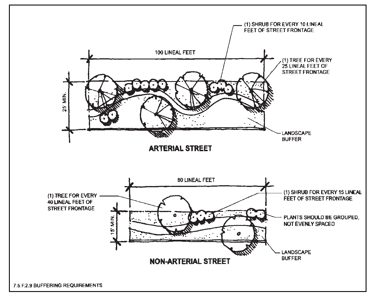
Figure 7-8
3.
Responsibility for Buffering. Buffering shall be the responsibility of new development. Existing land uses may be required to provide buffering if the use is changed, expanded, enlarged or in any other way increases the impacts on adjacent properties or rights-of-way over what is present at the time this regulation is adopted. It shall be the responsibility of the expanded or changed land use to evidence what the uses and impacts were at the time of adoption of this regulation.
4.
Method of Calculation. Graphic 7.1 shall serve as a guide for measuring distances for calculation of buffer requirements.
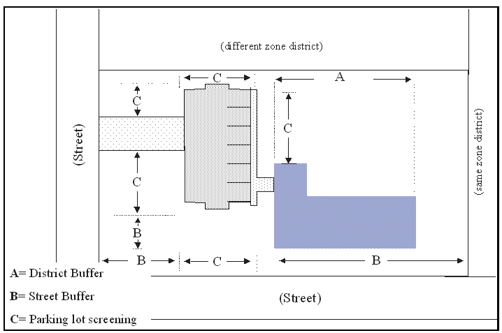
Graphic 7.1 (Ord. 8-05 #1)
G.
Parking Lot Landscaping.
1.
Purpose. Parking lot landscaping is intended to improve the views from adjacent properties and public use areas, alter the microclimate of parking areas by providing shade and reducing reflected heat, and break up large areas of impermeable surface, allowing areas for water infiltration.
2.
Perimeter Landscaping.
a.
Applicability. All parking lots containing six (6) or more spaces shall provide perimeter landscaping pursuant to the General Requirements below, except where abutting property is determined by Staff to be unbuildable or visually separated by topographic features. Parking lots in the I-1 and CH Zoning Districts shall be exempt. See Figure 7-9.
(Ord. 8-05 #1)
b.
General Requirements (See Figure 7-9).
(1)
All parking areas shall be separated from property lines at the street by a planting area at least twenty-five (25) feet wide on arterial streets and by a planting area at least fifteen (15) feet wide on other street property lines.
(2)
All parking areas shall be separated from side and rear property lines by a planting area at least eight (8) feet wide.
(Ord. 8-05 #1)
(3)
All parking lots or areas shall be separated from the high water mark of all river banks by a minimum setback of fifty (50) feet, except in the CD Zoning District where the setback shall be a minimum of twelve (12) feet. The required perimeter landscaping shall be provided within this setback area through retention of existing vegetation, or through additional new tree and shrub plantings as needed to meet the required minimum quantities of perimeter plantings. See §7.6.E below.
(4)
Perimeter landscaping shall provide a semi-opaque screen during the winter season.
(Ord. 8-05 #1)
c.
Berms. Berms may be utilized as part of perimeter landscaping, but shall vary in height over the length of the berm.
(Ord. 8-05 #1)
d.
Walls/Fences. Where walls or fences are used, a minimum of one (1) evergreen tree or three (3) shrubs is required for every forty (40) linear feet of wall or fence and shall be planted on the side of the fence or wall facing the surrounding streets, walks, parks, trails or other public use properties.
e.
Perimeter Planting Requirements:
(1)
A minimum of one (1) tree per twenty (20) lineal feet and one (1) shrub per five (5) lineal feet shall be planted along the perimeter of any parking lot area located adjacent to an arterial street. A minimum of one (1) tree per thirty (30) lineal feet and one (1) shrub per ten (10) lineal feet shall be planted along the perimeter of any parking lot area located adjacent to nonarterial streets. See Figure 7-9.
(Ord. 8-05 #1)
(2)
For parking lot areas that are adjacent to a side or rear lot line, one (1) tree per thirty (30) lineal feet and one (1) shrub per five (5) lineal feet shall be planted along the perimeter of any parking area located along the lot line.
(3)
Plants should be grouped, not evenly spaced.
3.
Parking Lot Interiors.
a.
Applicability. All parking lots with thirty (30) or more parking places shall comply with these interior parking lot landscaping requirements. Interior parking lot landscaping requirements shall be in addition to all other landscaping requirements; no other landscaping requirement may be used to fulfill interior parking lot landscaping requirements.
(Ord. 8-05 #1)
b.
Minimum Requirement: A minimum of six percent (6%) of the total interior parking lot area shall be landscaped with planted islands. A minimum of one (1) tree and two (2) shrubs must be planted in interior islands for every two thousand five hundred (2,500) square feet of parking lot, exclusive of perimeter plantings. See Figure 7-9.
c.
Landscaped Islands:
(1)
Individual landscaped islands shall include a minimum of one (1) tree, an automated sprinkler and raised concrete curbs.
(2)
Landscaped islands shall be at least one hundred (100) square feet in size, with the smallest dimension being six (6) feet to allow for adequate root aeration and expansion. See Figure 7-9.
(3)
Islands shall be arranged to maximize shading of parking spaces.
(4)
Plantings shall be arranged so as not to interfere with driver vision, vehicle circulation or pedestrian circulation.
(5)
To the maximum extent feasible, landscape islands shall be incorporated in the stormwater management plan and located to break up large areas of impermeable surface, allowing areas for water infiltration.
(Ord. 8-05 #1)
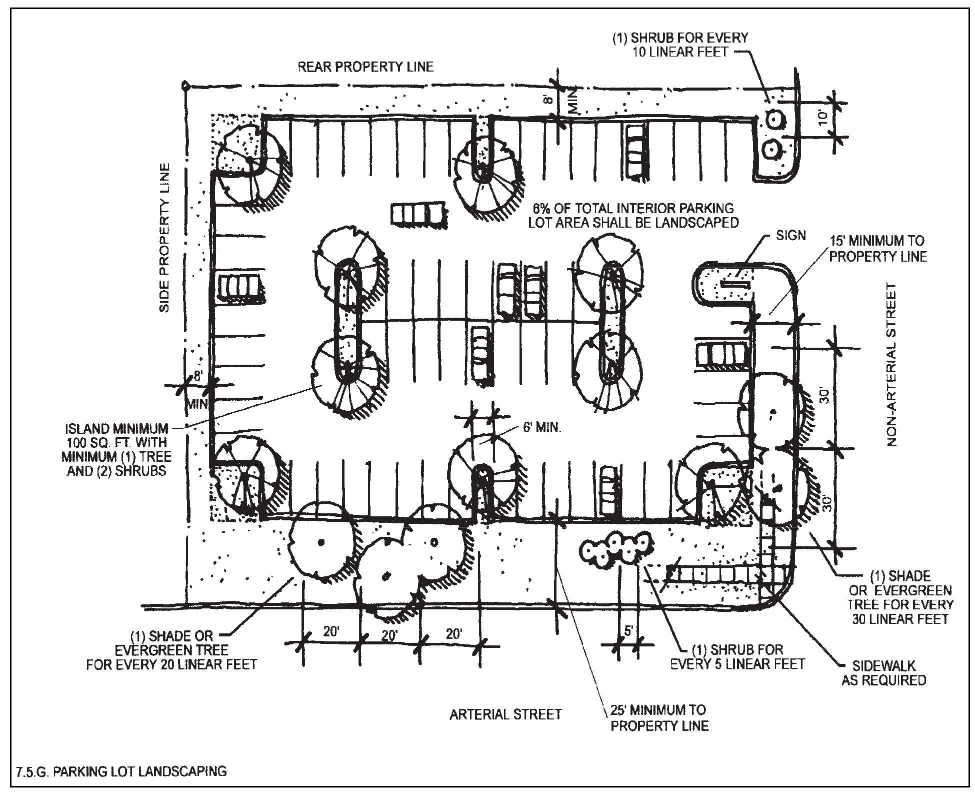
Figure 7-9
H.
Fences and Walls. Fences and walls are permitted as elements of a landscape plan and, in some locations, may be used to conceal storage or other unsightly or conflicting land uses. All fences or walls shall meet the following requirements:
1.
Materials.
a.
Fences or walls shall be constructed of wood, stone, brick, decorative concrete block, wrought iron (or products created to resemble these materials), a combination of any of these materials or other materials, as approved by the Decision-Making Body.
(Ord. 8-05 #1)
b.
All fencing shall be finished on both sides, except fencing accessory to a residential use or development, which shall be finished on all sides that are visible from off site.
(Ord. 8-05 #1)
c.
Plywood, particle board, sheet metal, concrete slabs, concrete barriers or similar materials shall not be used for fencing or walls intended to provide screening or buffering.
d.
Chain-link fencing shall not be used for screening or buffering purposes. Chain-link fencing may be allowed for security purposes as approved by the Decision-Making Body. No slats shall be allowed with chain-link fencing.
(Ord. 8-05 #1)
e.
Barbed-wire and similar fence materials may only be used in conjunction with a permitted agricultural use or in conjunction with the permitted keeping of horses or livestock.
2.
Fences/Walls Abutting Public Roads. Where opaque or solid fencing will abut a public road, it shall be screened from the road. Breaks in the screening shall be created and changes in fence setbacks, heights or materials shall also be utilized to provide visual diversity. Where more than two (2) consecutive rear lot lines will abut a public right-of-way, it shall be the developer's responsibility to install the wall or fence that will delineate the property line in order to assure diversity of setback, screening and streetscape views.
3.
Plantings in Conjunction with Fences/Walls. Where opaque or solid fencing continues for more than forty (40) feet along a buffer zone, the buffer requirements shall be located between the fence and the area to be buffered. Where opaque or solid fencing continues for more than forty (40) feet of street frontage, a minimum of one (1) evergreen tree and three (3) shrubs shall be planted on the outer or public side of the fence for each forty (40) linear feet of fence.
(Ord. 8-05 #1)
4.
Fences and Walls In Critical Wildlife Habitat. See §7.8.G.1.c below for standards.
I.
Technical Landscaping Requirements.
1.
Protection of Landscape from Vehicular Damage. Wheel stops, curbs or other elements intended to keep vehicles out of landscaped areas shall be set back from existing plant materials an adequate distance.
2.
Protection from Wildlife Damage. To protect landscaping from wildlife-related damage, transparent fences (including very low-voltage electrified fencing), walls or other architectural elements shall be included around landscaped areas in all landscape and buffering plans. Materials shall be compatible with materials used for structures on the site. No chain-link fencing shall be allowed to protect landscaping from wildlife damage.
(Ord. 8-05 #1)
J.
Maintenance Requirements.
1.
Maintenance Required. Required landscaping shall be maintained in a healthy, growing condition at all times. The property owner is responsible for regular irrigating, pruning, weeding, mowing, fertilizing, replacement of plants in poor condition and other maintenance of all plantings as needed.
2.
Maintenance of Landscape Structures. Where walls, fences or other structures are an integral part of the landscape plan, such structures shall be maintained in good repair. Fences that are leaning, broken, have missing pieces, peeling paint or are in any other way damaged shall be immediately repaired or replaced. Walls with missing bricks or blocks, crumbling mortar or other aesthetic or structural defects shall be immediately repaired.
3.
Replacement. The following plant material conditions require plant removal and replacement:
a.
Deciduous trees and shrubs that fail to produce leaves on more than fifty percent (50%) of the plant by July 1 st of the calendar year.
b.
Evergreen trees and shrubs with needle loss or browning over more than fifty percent (50%) of the tree.
c.
Damaged plant materials that have split trunks, loss of major branch structure, loss of leader shoot or other damage that a certified nurseryman confirms will ultimately cause the premature death of the plant.
d.
Diseased, insect-infested or parasite-infested plants that cannot be adequately treated to prevent premature death or to prevent contamination of other plant materials.
e.
Removal and replacement shall occur during the same growing season in which plant material exhibits at least one (1) of the above conditions. Where seasonal or adverse weather conditions make replanting or replacement within such a time period impractical, Staff may grant an extension and may require adequate fiscal assurance, if needed, from the Applicant or owner to assure replacement.
(Ord. 8-05 #1)
4.
Enforcement. All plantings shall be subject to periodic inspections to ensure compliance with this regulation and the approved landscape plan. Failure to comply with the Maintenance Plan shall be a violation of this Code, subject to the enforcement and penalties provisions set forth in Chapter 12.
(Ord. 8-05 #1, 6/14/05; Ord. 21-17, § 1(Exh.), 9/26/17)
§ 7.6 - WETLANDS AND STREAM CORRIDOR PROTECTION
A.
Purpose and Intent. The following requirements and standards are intended to promote, preserve and enhance the important hydrologic, biological, ecological, aesthetic, recreational and educational functions that stream and river corridors, associated riparian areas and wetlands provide.
B.
Applicability. This Section shall apply to all new development, except for the following development or activities:
1.
Agricultural activities such as soil preparation, irrigation, planting, harvesting, grazing and farm ponds;
2.
Maintenance and repair of existing public roads, utilities and other public facilities within an existing right-of-way or easement;
3.
Removal of noxious weeds;
4.
Maintenance and repair of flood control structures and activities in response to a flood emergency; and
5.
Wetland and wildlife habitat restoration, creation and/or enhancement that improves the wetland function provided that the proposed activity is approved by the appropriate agency such as the U.S. Army Corps of Engineers or the Colorado Division of Wildlife.
(Ord. 2-02 #5)
C.
Other Regulations.
1.
This Section does not repeal or supersede any existing federal, state or local laws, easements, covenants or deed restrictions. When this Section imposes a higher or more restrictive standard than found in another applicable ordinance, statute or regulation, this Section shall apply.
2.
No person shall engage in any activity that will disturb, remove, drain, fill, dredge, clear, destroy or alter any area, including vegetation, within a wetland that falls in the jurisdiction of the federal government and its agencies, except as may be expressly allowed under applicable federal laws or regulations.
(Ord. 8-05 #1)
D.
Boundary Delineation.
1.
Qualified Professional. Stream/river corridor and wetland area delineation shall be performed by a qualified professional that has demonstrated experience necessary to conduct site analysis. Delineations shall be subject to Staff's approval.
2.
Stream and River Corridor Boundaries. Stream and river corridors shall be delineated at the annual high-water mark, or if not readily discernible, the defined bank of the stream or river, as those terms are defined in Chapter 13 of this Code. Regulated stream and river corridors shall include only those streams and rivers as identified on the Stream and River Corridor Resource Map found in Appendix A. The rivers delineated on the Stream and River Corridor Resource Map are the Big Thompson and Fall River. Streams delineated on the Map include various named and unnamed streams and minor drainages, some of which are intermittent.
(Ord. 2-02 #5)
3.
Wetland Boundaries.
a.
Mapped Wetlands. Boundary delineation of wetlands shall be established by reference to one (1) of the following wetland maps and identification documents, which are available for reference in the Town of Estes Park Community Development Department and which are hereby adopted and incorporated by reference into this Code:
(1)
National Wetlands Inventory prepared by the U. S. Department of the Interior, Fish and Wildlife Service; and
(2)
Colorado Natural Heritage Program maps.
b.
Unmapped Wetlands. The review of a development proposal may discover a potential wetland that has not been mapped or for which the boundaries have not been clearly established. In such instances, the Applicant shall retain a qualified wetland expert to delineate the boundaries of the wetland according to accepted professional standards.
E.
Buffer/Setback Areas.
1.
Stream or River Corridors.
a.
Building/Structure Setbacks.
(1)
Stream Corridors (except in the CD zoning district). All buildings and accessory structures shall be set back at least thirty (30) feet horizontally (plan view) from the annual high-water mark of stream corridors, or if not readily discernible, from the defined bank of the stream. Where defined banks are not readily discernible, the setback shall be measured from the thread of the stream. See Figure 7-10.
(Ord. 2-02 #5)
Figure 7-10
(2)
River Corridors (except in the CD district).
(a)
General Rule. All buildings and accessory structures shall be set back at least fifty (50) feet horizontally (plan view) from the annual high-water mark of river corridors or, if not readily discernible, from the defined bank of the river.
(b)
Exception for Lots Developed Prior to the Adoption of this Code. All buildings and accessory structures shall be set back at least thirty (30) feet horizontally (plan view) from the annual high-water mark of river corridors or, if not readily discernible, from the defined bank of the river. See Figure 7-10.
(Ord. 2-02 #5)
(3)
Stream and River Corridors in the CD Zoning District. In the CD district, all buildings and accessory structures shall be set back at least twenty (20) feet horizontally (plan view) from the annual high-water mark of stream or river corridors or, if not readily discernible, from the defined bank of the stream or river. Where defined banks are not readily discernible, the setback shall be measured from the thread of the stream. Where a principal building in the CD district provides public access, including a primary entrance, on the side of the building facing a stream or river corridor, the setback may be reduced to ten (10) feet with the approval of the Decision-Making Body.
(Ord. 2-02 #5)
b.
Parking Lot Setbacks. Except in the CD zoning district, parking lots shall be set back at least fifty (50) feet horizontally (plan view) from the annual high-water mark of stream or river corridors, or if not readily discernible, from the defined bank of the stream or river. In the CD district, parking lots shall be set back at least twelve (12) feet from the delineated edge of the river or stream corridor.
2.
Wetlands.
a.
To the maximum extent feasible, wetlands shall not be included as part of a platted development lot.
b.
All buildings, accessory structures and parking lots shall be set back at least fifty (50) feet horizontally (plan view) from the delineated edge of a wetland. See Figure 7-10 above. Development on lots that were approved for single-family residential use prior to the adoption of this Code shall be exempt.
(Ord. 2-02 #5; Ord. 18-02 #1)
3.
Private Open Areas and Landscaping Credit. All stream corridor and wetland setback areas shall be credited toward any relevant private open areas requirements or landscaping and buffer requirements.
F.
Development Standards.
1.
Prohibited Activities. No person shall engage in any activity that will disturb, remove, fill, drain, dredge, clear, destroy or alter any area, including vegetation, within stream or river corridors, wetlands and their associated buffer/setback areas, except as may be expressly allowed in this Section or Code.
2.
Utilities. Utilities may be allowed in a buffer/setback area only if the Decision-Making Body determines that there is no practical alternative. Any disturbance of the buffer area shall be reclaimed by regrading and revegetation. Provisions for reclamation of the disturbed area shall be included in any development or improvements agreement for the project, with adequate collateral to guarantee that the reclamation will be completed. Utility corridors in buffer/setback areas shall be located at the outside edge of the area and access roads for maintenance of utilities shall be located outside the buffer/setback area. Access for maintenance of utilities in buffer/setback areas should be at specific points rather than parallel to the utility corridor.
3.
Recreation, Education or Scientific Activities. Structures and improvements for recreational, educational or scientific activities such as trails, fishing access and wildlife management and viewing may be permitted in a buffer/setback area provided that a management plan that establishes long-term protection of the buffer/setback area is submitted and approved.
G.
Preservation of Vegetation. All existing vegetation within the stream/river corridor or wetland buffer/setback area shall be preserved, and where necessary to provide adequate screening or to repair damaged riparian areas, supplemented with additional native planting and landscaping.
H.
Wetland Mitigation Requirements.
1.
Restoration shall be required according to an approved wetland mitigation plan when a wetland or its buffer is altered in violation of law or without specific permission or approval by the Decision-Making Body.
2.
All approved alterations of wetlands must be mitigated by replacement or enhancement on the site or within the same drainage basin on a one-to-one basis with equivalent or better biologic and hydrologic functions.
(Ord. 13-99 §§B, C, 11/3/99; Ord. 2-02 #5, 2/12/02; Ord. 18-02 #1, 12/10/02; Ord. 8-05 #1, 6/14/05)
§ 7.7 - GEOLOGIC AND WILDFIRE HAZARD AREAS
A.
Applicability. All new subdivisions and development, including residential development on lots of record approved prior to the effective date of this Code, shall comply with the procedures and standards set forth in this Section.
(Ord. 18-02 #1; Ord. 8-05 #1)
B.
Interpretation. The provisions of this Section shall be interpreted to apply in conjunction with all other applicable local, county and state land use requirements. Whenever a provision of any other land use regulation conflicts with the intent of this Section, the provisions of this Section shall apply.
C.
Description of Regulated Hazard Areas. Hazard areas regulated by this Section shall include all areas that are or that may become hazardous due to environmental conditions. The hazards include, but are not limited to, the following: wildfire, avalanche, landslide, rock fall, mud flow and debris fan, unstable or potentially unstable slopes, seismic effects, radioactivity, ground subsidence and expansive soil and rock.
D.
Professional Qualifications. All maps and reports required by this Section must be prepared by or under the responsible direction of a duly qualified professional.
(Ord. 8-05 #1)
1.
Wildfire hazard analysis required by this Section must be prepared by or under the direct supervision of a professional forester with at least two (2) years' experience with wildfire hazards in the Rocky Mountain region.
(Ord. 8-05 #1)
2.
Geologic hazard analyses required by this Section must be prepared by or under the direct supervision of a professional geologist with experience in engineering geology or geotechnical engineering.
(Ord. 8-05 #1)
3.
Engineering work required by this Section must be prepared by or under the direct supervision of a licensed professional engineer who is experienced in the engineering specialty (e.g., soils, slope stability) required to meet the objectives of this Section.
(Ord. 8-05 #1)
E.
Wildfire Hazards. (Ord. 8-05 #1)
1.
Wildfire Hazard Areas. (Ord. 8-05 #1)
a.
Mapped Wildfire Hazards. Wildfire hazard areas shall include all those areas shown as "high-tree" fire hazard areas on the Wildfire Hazards Resource Map in Appendix A.
(Ord. 8-05 #1)
b.
Unmapped Wildfire Hazards. Wildfire hazard areas shall also include areas located outside of the mapped wildfire hazard areas that are identified by the Colorado State Forest Service or the Larimer County Wildfire Safety Specialist, or designee, as hazardous areas.
(Ord. 8-05 #1)
c.
In the event an Applicant questions the existence of a wildfire hazard within the proposed development or subdivision, the Applicant may submit evidence with respect thereto from a professional forester. This evidence may be considered by the Decision-Making Body, together with all other applicable evidence, in determining whether or not said development or subdivision is within a wildfire hazard area.
(Ord. 8-05 #1)
2.
Wildfire Hazard Mitigation Plans. (Ord. 8-05 #1)
a.
Mitigation Plan Required. When new development or subdivision is proposed within a wildfire hazard area, the Applicant shall be required to submit a mitigation plan prepared by a professional forester, addressing how the development or subdivision will either avoid or mitigate the hazard, as more fully set forth below.
(Ord. 8-05 #1)
b.
Wildfire Mitigation Plan Requirements. Mitigation plans shall be prepared according to the "Colorado Landowner Forest Stewardship Plan Guidelines." (Ord. 8-05 #1)
3.
Review Criteria. (Ord. 8-05 #1)
a.
In reviewing new development or subdivisions subject to this Section, the Decision-Making Body may deny development within a hazard area or may approve it on the condition that the development is designed and built in such a manner to adequately mitigate the hazard.
(Ord. 8-05 #1)
b.
In reviewing new development and subdivisions, the Decision-Making Body shall take into consideration the following: (Ord. 8-05 #1)
(1)
The Applicant's mitigation plan; (Ord. 8-05 #1)
(2)
Vegetative, topographic, access and other technical information presented by the Applicant or other interested party, including the Town, County or other public agency; (Ord. 8-05 #1)
(3)
Recommendations of a reviewing state agency having expertise with respect to the hazard in question and recommendations of others with similar expertise; and (Ord. 8-05 #1)
(4)
Site specific vegetation and topographical characteristics.
(Ord. 8-05 #1)
c.
Mitigation methods required by the Decision-Making Body may include, but are not limited to: (Ord. 8-05 #1)
(1)
Compliance with "Guidelines and Criteria for Wildfire Hazard Areas," written by the Colorado State Forest Service, September 1974; "Wildfire Mitigation Plan Standards and Guidelines (Appendix D),'' written by the Colorado State Forest Service, April 1997; (Ord. 8-05 #1)
(2)
Specific requirements for construction, location and density of structures and/or lots; (Ord. 8-05 #1)
(3)
Provision of defensible space in compliance with current Colorado State Forest Service guidelines shall be required on all new construction in wildfire hazard areas. For additions to or changes in the type of the occupancy or use in existing structures, a defensible space shall be provided around the entire structure; and (Ord. 8-05 #1)
(4)
Specific requirements for alteration to the vegetative features of the land.
(Ord. 8-05 #1)
F.
Geologic Hazard Areas. (Ord. 8-05 #1)
1.
Geologic Hazard Areas. (Ord. 8-05 #1)
a.
Mapped Geologic Hazards. Geologic hazard areas shall include all areas shown on the Geologic Hazard Areas Resource map and all areas classified as 4, 5, 6 or 7 on the Official Geologic Hazard Maps, which have been reviewed by the Colorado Geological Survey and are incorporated by reference in this Code. The Official Geologic Hazard Maps shall be available for public review at the Community Development Department.
(Ord. 8-05 #1)
b.
Unmapped Geologic Hazards. Hazard areas shall further include any areas which have not been so classified, but where a hazard has been identified and confirmed by the Colorado Geological Survey. The Planning Director, or designee, shall have the authority to identify geologic hazard areas during field inspections. Such field identifications shall be based on identification procedures set forth in "Guidelines and Criteria for Identification and Land Use Controls of Geologic Hazard and Mineral Resource Areas," written by the Colorado Geological Survey, 1974.
(Ord. 8-05 #1)
c.
In the event an Applicant questions the existence of a geologic hazard area within the area proposed for development or subdivision, the Applicant may submit evidence with respect thereto from a professional geologist having requisite technical expertise. Such evidence may be considered by the Decision-Making Body, together will all other available evidence, in determining whether or not said development or subdivision is within a geologic hazard area.
(Ord. 8-05 #1)
2.
Geologic Hazard Mitigation Plans. (Ord. 8-05 #1)
a.
Mitigation Plan Required. When new development or subdivision is proposed within a geologic hazard area, the Applicant shall be required to submit a mitigation plan prepared by a professional geologist addressing how the development or subdivision will either avoid or mitigate the hazard, as more fully set forth below. Licensed professional engineers who are experienced in the engineering specialty (e.g., soils, slope stability) may submit mitigation plans for steep slope and alluvial soils hazards. Lots approved for single-family residential development prior to the adoption of this Code do not need to submit a mitigation plan for rock fall hazards.
(Ord. 8-05 #1)
b.
Colorado Geologic Survey Review. Except for single-family residential development on lots of record, new development and subdivisions within a geologic hazard area shall be referred to the Colorado Geological Survey for review and comment. At the time of application submittal, the Applicant shall submit the required fees for the Colorado Geological Survey review. Applicants seeking approval of single-family development on lots of record within an identified Geologic Hazard Area shall be exempt from Colorado Geological Survey review, but shall be subject to all other requirements in this Section.
(Ord. 18-02 #1; Ord. 8-05 #1)
c.
Geologic Mitigation Plan Requirements. Mitigation plans shall be prepared according to "Guidelines and Criteria for Identification and Land Use Controls of Geologic Hazard and Mineral Resource Areas," written by the Colorado Geological Survey, 1974 and include, at a minimum, the following: (Ord. 8-05 #1)
(1)
An evaluation and predication of the impact of the hazard or hazards affecting the proposed development or subdivision and recommended mitigation methods; (Ord. 8-05 #1)
(2)
Maps describing the extent and severity of the hazard at the particular site, and including a true north arrow, scale, ties to quarter-section corners and accurate dimensions for all lines, angles and curves used to describe property boundaries scale; (Ord. 8-05 #1)
(3)
Topography; (Ord. 8-05 #1)
(4)
A location map showing the general location of the development or subdivision and its relationship to surrounding topographic features; (Ord. 8-05 #1)
(5)
A map showing the location, type and density of the proposed development or subdivision; (Ord. 8-05 #1)
(6)
In the case of an alluvial soils hazard, an on-site subsurface soils investigation and report.
(Ord. 8-05 #1)
(7)
In the case of rock fall geologic hazards, the mitigation plan shall: (Ord. 8-05 #1)
(a)
Specifically address each possible method of mitigation, including: (Ord. 8-05 #1)
i.
building outside of the run-out zone, (Ord. 8-05 #1)
ii.
stabilization of rocks, (Ord. 8-05 #1)
iii.
slowing or diverting moving rocks, and (Ord. 8-05 #1)
iv.
physical barriers.
(Ord. 8-05 #1)
(b)
Include maps of the fallout zone, including the rock fall source area, the acceleration zone and the run-out zone. Computer modeling is the preferred method of determining hazard zones.
(Ord. 8-05 #1)
(c)
Include maps portraying the geologic conditions of a development area with particular attention given to the designated hazard condition or conditions and those geologic, hydrologic, soil and topographic features constituting the hazard.
(Ord. 8-05 #1)
(d)
If needed, geologic cross-sections can be utilized to portray the hazard conditions. These maps must show the topography with a contour interval of ten (10) feet or smaller if necessary. These maps must be on a scale sufficiently detailed to meet the purposes of this Section, but in no case can the scale be less than one (1) inch equals two hundred (200) feet.
(Ord. 8-05 #1)
3.
Review Criteria. (Ord. 8-05 §1)
a.
In reviewing a development subject to this Section, the Decision-Making Body may deny development within a hazard area or may approve it on the condition that the development is designed and built in such a manner as to adequately mitigate the hazard.
(Ord. 8-05 §1)
b.
In reviewing new development and subdivisions, the Decision-Making Body shall take into consideration the following: (Ord. 8-05 §1)
(1)
The Applicant's mitigation plan; (Ord. 8-05 §1)
(2)
Geologic, topographic and other technical information presented by the Applicant or other interested party, including the Town, County or other public agency; (Ord. 8-05 §1)
(3)
Recommendations of a reviewing state agency having expertise with respect to the hazard in question and recommendations of others with similar expertise; and (Ord. 8-05 §1)
(4)
The relationship between the development and the hazard area and the potential impact of the development within the area on lands outside the development.
(Ord. 8-05 §1)
c.
Mitigation methods required by the Decision-Making Body may include, but are not limited to: (Ord. 8-05 §1)
(1)
Compliance with "Guidelines and Criteria for Identification and Land Use Controls of Geologic Hazard and Mineral Resource Areas," written by the Colorado Geological Survey, 1974; (Ord. 8-05 §1)
(2)
To the maximum extent feasible, in rock fall hazard areas avoidance of the run-out zone shall be the method of mitigation; (Ord. 8-05 §1)
(3)
Location of building envelopes outside areas identified as Class II geologic hazard areas; (Ord. 8-05 §1)
(4)
Specific requirements for construction, location, density of structures and/or lots; (Ord. 8-05 §1)
(5)
Specific requirements for construction of roads upon the land; (Ord. 8-05 §1)
(6)
Specific requirements for alteration to the physical characteristics of the land.
(Ord. 8-05 §1)
(Ord. 18-02 §1, 12/10/02; Ord. 8-05 §1, 6/14/05)
§ 7.8 - WILDLIFE HABITAT PROTECTION
A.
Purpose. To maintain the diversity of wildlife species and habitat that occur in the Estes Valley, and to plan and design land uses to be harmonious with wildlife habitat and the species that depend on this habitat for the economic, recreational and environmental benefit of the residents of and visitors to the Estes Valley.
(Ord. 05-10 §1)
B.
Applicability. This Section shall apply to all applications for review of development plans, subdivision plats, planned unit developments, special review uses and rezonings. This Section shall not apply to development on lots that were approved for single-family residential use prior to the effective date of this Code.
(Ord. 18-02 §1)
C.
Exemptions. The procedures and regulations contained in this Section shall not apply to:
1.
Agricultural activities such as soil preparation, irrigation, planting, harvesting, grazing and farm ponds;
2.
Maintenance and repair of existing public roads, utilities and other public facilities within an existing right-of-way or easement;
3.
Maintenance and repair of flood control structures and activities in response to a flood emergency;
4.
Maintenance and repair of existing residential or nonresidential structures; or
5.
Activities undertaken pursuant to a wildlife conservation plan approved under this Section.
(Ord. 05-10 §1)
D.
Other Regulations. This Section of the Code does not repeal or supersede any existing federal, state or local laws, easements, covenants or deed restrictions pertaining to wildlife. When this Section imposes a higher or more restrictive standard, this Section shall apply.
(Ord. 05-10 §1)
E.
Wildlife Habitat Data Base. The following sources shall be used to identify important wildlife habitat areas for purposes of review under this Section:
1.
Wildlife Habitat map (dated December 1996), as set forth in the Estes Valley Comprehensive Plan, as amended from time to time.
2.
Colorado Division of Wildlife habitat maps for Larimer County, as amended from time to time.
3.
Colorado Natural Heritage Program Maps dated December 1996, or as amended from time to time.
4.
Other information and maps as Staff or the Estes Valley Planning Commission may from time to time identify in cooperation with the Colorado Division of Wildlife, such as wildlife maps produced specifically for the Estes Valley. Said maps shall be applicable only following adoption of an amendment to this Code.
5.
Wildlife habitat information required by this Section is intended for general planning purposes. Obvious errors or omissions may be corrected by the Staff.
(Ord. 05-10 §1)
F.
Review Procedures. The following procedures shall apply to all applications for development:
1.
Application. The Applicant shall submit a development plan, subdivision plat or sketch plan, as applicable, depicting the general location of the property, location of structures on the site, prominent natural areas such as streams and wetlands, and other features that Staff may require for review pursuant to this Section.
A Wildlife Conservation Plan shall be submitted for sites containing:
a.
An endangered or threatened species,
b.
Big Horn sheep or Big Horn sheep habitat, or
c.
Riparian areas adjacent to rivers and streams and wetlands identified on the maps set forth in Appendix A of this Code.
2.
Preliminary Review. Staff shall refer the submitted plan or plat to the Colorado Division of Wildlife for review. Applicants are also advised to consult with the Colorado Division of Wildlife and other agencies responsible for regulation of wildlife and habitat, such as the U.S. Fish and Wildlife Service, U.S. Department of the Interior-Rocky Mountain National Park, U.S. Forest Service and Colorado Natural Heritage Program. These agencies may maintain maps and databases that can aid in the site-specific confirmation of the presence or absence of wildlife and habitat on a specific site.
3.
Review Determination.
a.
The Review and Decision-Making Bodies shall issue a finding as to whether the application, including the wildlife conservation plan, complies with the requirements of this Section.
b.
Wildlife studies and mitigation plans found to be adequate by the Decision-Making Body shall become binding upon the Applicant.
c.
Applications that do not comply with Section 7.8 of this Code shall be denied.
4.
Waivers. Staff may waive or approve minor modifications of any development standard or review criteria contained in this Section upon a finding that such waiver or modification:
a.
Is consistent with the stated purposes of this Section;
b.
Will have no significant adverse impacts on wildlife species or habitat;
c.
Any potential adverse impacts will be mitigated or offset to the maximum extent practicable; and
d.
Application of the standard or criteria is not warranted based on the location of the development, the absence of a particular species on the site or other relevant factors.
(Ord. 05-10 §1)
G.
Review Standards. The following review standards shall apply to all development applications as specified, unless Staff determines that a specific standard may be waived pursuant to subsection F.5. above. It is the intent of this Section that these standards be applied in a flexible fashion to protect wildlife habitat and wildlife species in a cost-effective fashion.
1.
Review Standards.
a.
Buffers. All development subject to a wildlife conservation plan shall provide a setback from any identified important wildlife habitat area, in accordance with any recommendations in the wildlife conservation plan.
b.
Important Wildlife Habitat. Restricted to native species on Recommended Plant List. There shall be no introduction of plant species that are not on the approved landscaping list in the "ComDev Recommended Plant List" on any site containing any important wildlife habitat area. Plans approved under provisions of this Code shall show existing herbaceous and woody cover on the site maintained and removal of native vegetation minimized in connection with development.
(Ord. 21-17, § 1(Exh.))
c.
Fencing.
(1)
No fencing on a site containing important wildlife habitat shall exceed forty (40) inches in height, except to the extent that such fencing is approved by Staff to confine permitted domestic animals or to protect permitted ornamental landscaping or gardens.
(2)
Fences higher than forty (40) inches may be allowed if adequate openings are provided for the passage of deer, elk or other identified wildlife. These openings shall be at least six (6) feet wide and spaced a maximum of fifty (50) feet apart along continuous fence lines exceeding this length.
(3)
No fencing using barbed wire shall be allowed.
(4)
The type of fencing (materials, opacity, etc.) shall be determined by Staff or the Decision-Making Body as appropriate for the wildlife species on the site.
d.
Exterior Lighting. Use of exterior lighting shall be minimized in areas of important wildlife habitat, and lighting shall be designed so that it does not spill over or onto such critical habitat. See also §7.9 below.
e.
Refuse Disposal. Developments on sites containing important wildlife habitat, such as black bear, must use approved animal-proof refuse disposal containers. With Division of Wildlife approval, refuse disposal containers and enclosures may be electrified.
(Ord. 8-05 §1)
f.
Domestic Animals. Development applications for property that includes important wildlife habitat must include a plan with specified enforcement measures for the control of domestic animals and household pets. The plan must include provisions to prevent the harassment, disturbance and killing of wildlife and to prevent the destruction of important wildlife habitat.
(Ord. 05-10 §1)
H.
Wildlife Conservation Plans.
1.
Plan Preparation. A wildlife conservation plan required by this Section shall be prepared for the Applicant, at the Applicant's expense, under the responsible direction of a qualified person who has demonstrated expertise in the field.
2.
Plan Content. Any wildlife conservation plan required to be prepared pursuant to this Section shall include the following information at a minimum. Specific requirements may be waived by Staff due to the location of the development, the previous use of the site, the size and potential impact of the development, the absence of particular species on a site, the prohibition of a reasonable use of the site and other relevant factors.
a.
A description of the ownership, location, type, size and other attributes of the wildlife habitat on the site.
b.
A description of the populations of wildlife species that inhabit or use the site, including a qualitative description of their spatial distribution and abundance.
c.
An analysis of the potential adverse impacts of the proposed development on wildlife and wildlife habitat on or off site.
d.
A list of proposed mitigation measures and an analysis of the probability of success of such measures.
e.
A plan for implementation, maintenance and monitoring of mitigation measures.
f.
A plan for any relevant enhancement or restoration measures.
g.
A demonstration of fiscal, administrative and technical competence of the Applicant or other relevant entity to successfully execute the plan.
(Ord. 05-10 §1)
(Ord. 18-02 §1, 12/10/02; Ord. 8-05 §1, 6/14/05; Ord. 05-10 §1, 2/9/10; Ord. 21-17, § 1(Exh.), 9/26/17)
§ 7.9 - EXTERIOR LIGHTING
A.
Purpose. The intent of this Section is to focus on the actual physical effects of lighting, as well as the effect that lighting may have on the surrounding neighborhood. Exterior lighting shall be evaluated in the development review process to ensure that the functional and security needs of the project are met in a way that does not adversely affect the adjacent properties or neighborhood. The degree to which exterior night lighting affects a property owner or neighborhood will be examined considering the light source, level of illumination, hours of illumination and need for illumination in relation to the effects of the lighting on adjacent property owners and the neighborhood.
B.
Applicability. All new development shall comply with the standards set forth in this Section. Vacation homes as designated and regulated in §5.1.B of this Code shall comply with the standards set forth in this Section, whether new or existing.
(Ord. 29-16, § 1; Ord. 09-17, § 1)
C.
General Review Standard. If installed, all exterior lighting shall meet the functional security needs of the proposed land use without adversely affecting adjacent properties or the community.
D.
Design Standards. Exterior lighting is not required except for purposes of public safety. However, if installed, all exterior lighting shall meet the following design standards:
1.
Light sources shall be concealed or shielded with luminaires with cut-offs with an angle not exceeding ninety (90) degrees to minimize the potential for glare and unnecessary diffusion on adjacent property. In no case shall exterior lighting add more than one (1) foot-candle to illumination levels at any point off site. See Figure 7-11.

Figure 7-11 (Ord. 8-05 #1)
2.
All outdoor light not necessary for security purposes shall be reduced, activated by motion sensors devices or turned off during nonoperating hours.
3.
Light fixtures used to illuminate flags, statues or any other objects mounted on a pole, pedestal or platform shall use a narrow cone beam or light that will not extend beyond the illuminated object.
4.
For upward-directed architectural, landscape and decorative lighting, direct light emissions shall not be visible above the building line roof.
E.
Height Standards for Lighting. All exterior lighting luminaires shall be mounted no higher than fifteen (15) feet, except that lighting in parking lots containing more than one hundred (100) spaces shall have a maximum height of twenty-five (25) feet.
F.
Street Lighting. Lighting for public or private streets shall be shielded.
(Ord. 8-05 #1, 6/14/05; Ord. 29-16, § 1(Exh. A), 12/15/16; Ord. 09-17, § 1(Exh. A), 3/28/17)
§ 7.10 - OPERATIONAL PERFORMANCE STANDARDS
In addition to any standards required in the underlying zoning districts, all development shall meet the following performance standards:
A.
Noise. All land uses and new development subject to this Code shall comply with the noise standards found in Larimer County Ordinance 97-03 (adopted September 22, 1997, and as amended from time to time).
B.
Operational/Physical Compatibility. The following conditions may be imposed upon the approval of any development to ensure that it is compatible with existing uses, including but not limited to, restrictions on:
1.
Placement of trash receptacles;
2.
Location of loading and delivery areas;
3.
Location, intensity and hours of illumination; and
4.
Additional landscaping and buffering.
C.
Evidence of Compliance. The Decision-Making Body shall require such evidence of ability to comply with appropriate performance standards and mitigation measures as it deems necessary prior to issuance of project development plan approval or a building permit or a certificate of occupancy.
§ 7.11 - OFF-STREET PARKING AND LOADING
A.
Applicability.
1.
New Development/Exemption for New Development in the CD District. The off-street parking standards of this Section shall apply to all new buildings, structures and land uses subject to this Code, except that the off-street parking and off-street loading standards of this Section shall not apply to new development and land uses in the CD Downtown Commercial zoning district.
2.
Expansions and Alterations. The off-street parking standards of this Section shall apply when an existing structure or use is expanded or enlarged. Additional off-street parking spaces will be required only to serve the enlarged or expanded area, not the entire building or use, provided that in all cases the number of off-street parking spaces provided for the entire use (pre-existing + expansion) must equal at least seventy-five percent (75%) of the minimum requirements established in §7.11.D below.
B.
No Reduction Below Minimums. Existing parking spaces may not be reduced below the minimum requirements established in this Section. Any change in use or manner of operation that increases applicable off-street parking requirements will be deemed a violation of this Code unless parking spaces are provided in accordance with this Section.
C.
Rules for Computing Parking Requirements. The following rules apply when computing off-street parking requirements:
1.
Multiple Uses. Unless otherwise approved, off-street parking areas serving more than one (1) use must provide parking and loading in an amount equal to the combined total of the requirements for each use.
2.
Fractions. When measurement of the number of required spaces results in a fractional number, any fraction of one-half (½) or less shall be rounded down to the next lower whole number and any fraction of more than one-half (½) shall be rounded up to the next higher whole number.
3.
Area Measurements. Unless otherwise specifically noted, all square footage-based parking and loading standards must be computed on the basis of gross floor area.
4.
Occupancy- or Capacity-Based Standards. For the purpose of computing parking requirements based on employees, students, residents or occupants, calculations shall be based on the largest number of persons working on any single shift, the maximum enrollment or the maximum fire-rated capacity, whichever is applicable, and whichever results in the greater number of spaces.
5.
Unlisted Uses. Upon receiving a development application for a use not specifically listed in the off-street parking schedule below, Staff shall apply the off-street parking standard specified for the listed use that is deemed most similar to the proposed use, or shall establish minimum off-street parking requirements pursuant to §7.11.E below.
D.
Minimum Off-Street Parking Requirements. The following Off-Street Parking Schedule establishes the minimum number of off-street parking spaces to be provided for the use categories described in this Code.
(Ord. 13-14 § 1)
E.
Parking Studies.
1.
Several use classifications or specific uses listed in the off-street parking schedule above have widely varying parking and loading demand characteristics, making it impossible to specify a single off-street parking or loading standard. Upon receiving a development application for a use subject to this Section (as cross-referenced in the above off-street parking schedule), Staff shall apply the off-street parking and loading standard specified for the listed use that is deemed most similar to the proposed use or shall establish minimum off-street parking requirements on the basis of a parking and loading study prepared by the Applicant.
2.
The parking and loading study must include estimates of parking demand based on recommendations of the Institute of Traffic Engineers (ITE), or other acceptable estimates as approved by Staff, and should include other reliable data collected from uses or combinations of uses that are the same as or comparable with the proposed use. Comparability will be determined by density, scale, bulk, area, type of activity and location. The study must document the source of data used to develop the recommendations.
F.
Location.
1.
Except as otherwise expressly provided in this Section, required off-street parking spaces shall be located on the same lot or parcel as the principal use. (See Off-Street Parking Alternatives, §7.11.G below.)
2.
In all nonresidential zoning districts except the CH district, off-street parking shall not be located within the required front yard setback area. In the CD district, off-street parking shall also not be located between the lot line and the building line parallel to an arterial or collector street. See also §4.4.D.3, "Vehicular Access and Circulation Requirements."
3.
All off-street parking areas shall be separated from arterial street property lines by a landscaped buffer area at least twenty-five (25) feet wide, and from other street property lines by a landscaped buffer area at least fifteen (15) feet wide. See §7.5.F, "Buffering and Screening," and Figure 7-9 above.
4.
See §7.6.F for required parking areas setbacks from delineated river/stream corridors and wetlands.
5.
Parking for single-family and two-family dwellings may be located in residential driveways (excluding RVs and boats).
6.
Guest Parking. Shared driveways may not be counted toward the guest parking requirements unless it is demonstrated the design will not interfere with adjoining traffic movements. Guest parking shall be located to provide convenient access to all units and shall be dispersed throughout the site.
(Ord. 25-07 §1)
G.
Off-Street Parking Alternatives. Staff shall be authorized to approve alternatives to providing the number of off-street parking spaces required by the off-street parking schedule (See §7.11.D above) in accordance with the following standards:
1.
Off-Site Parking. Staff may approve off-site parking facilities if the off-site parking complies with the all of following standards:
a.
Ineligible Activities: Off-site parking may not be used to satisfy the off-street parking standards for residential uses (except for guest parking), restaurants, convenience stores or other convenience-oriented uses. Required parking spaces reserved for persons with disabilities may not be located off-site.
b.
Location: No off-site parking space may be located more than three hundred (300) feet from the primary entrance of the use served (measured along the shortest legal pedestrian route), unless remote parking shuttle bus service is provided. Off-site parking spaces may not be separated from the use served by a street right-of-way with a width of more than eighty (80) feet, unless a grade-separated pedestrian walkway is provided, or other traffic control or remote parking shuttle bus service is provided.
c.
Zoning Classification: Off-site parking areas must be located on a site with the same or a more intensive zoning classification than required for the primary use served.
d.
Agreement for Off-Site Parking:
(1)
In the event that an off-site parking area is not under the same ownership as the principal use served, a written agreement in a form approved by Staff between the record owners will be required. The agreement must guarantee the use of the off-site parking area for at least ten (10) years. An attested copy of the agreement between the owners of record must be submitted to Staff for recordation.
(2)
Recordation of the agreement must take place before issuance of a Building Permit or Certificate of Occupancy for any use to be served by the off-site parking area. An off-site parking agreement may be revoked only if all required off-street parking spaces will be provided, in accordance with the off-street parking schedule. (See subsection D above.) No use shall be continued if the off-site parking is removed unless Staff is notified at least sixty (60) days prior to the termination of a lease for the off-site parking and substitute parking facilities are provided.
2.
Shared Parking. Staff may approve shared parking facilities for developments or uses with different operating hours or different peak business periods if the shared parking complies with the all of following standards:
a.
Location. Shared parking spaces must be located within three hundred (300) feet of the primary entrance of all uses served, unless remote parking shuttle bus service is provided.
b.
Zoning Classification. Shared parking areas must be located on a site with the same or a more intensive zoning classification than required for the primary uses served.
c.
Shared Parking Study. Those wishing to use shared parking as a means of satisfying off-street parking requirements must submit a shared parking analysis to Staff that clearly demonstrates the feasibility of shared parking. The study must be provided in a form established by Staff and must be made available to the public. It must address, at a minimum, the size and type of the proposed development, the composition of tenants, the anticipated rate of parking turnover and the anticipated peak parking and traffic loads for all uses that will be sharing off-street parking spaces.
d.
Agreement for Shared Parking. A shared parking plan will be enforced through written agreement among all owners of record. An attested copy of the agreement between the owners of record must be submitted to Staff for recordation in a form established by the Town or County Attorney. Recordation of the agreement must take place before issuance of a building permit for any use to be served by the shared parking area. A shared parking agreement may be revoked only if all required off-street parking spaces will be provided in accordance with the off-street parking schedule. (See subsection D. above.)
3.
Other Eligible Alternatives. Staff may approve any other alternative to providing off-street parking spaces on the site of the subject development if the Applicant demonstrates to the satisfaction of Staff that the proposed plan will protect surrounding neighborhoods, maintain traffic circulation patterns and promote quality urban design to at least the same extent as would strict compliance with otherwise applicable off-street parking standards.
H.
Use of Off-Street Parking Areas. Required off-street parking areas are to be used solely for the parking of licensed, motor vehicles in operating condition. Required spaces may not be used for the display of goods for sale or lease or for long-term storage of vehicles, boats, motor homes, campers, mobile homes or building materials.
I.
Vehicle Stacking Areas. The vehicle stacking standards of this subsection shall apply unless otherwise expressly approved by Staff.
1.
Minimum Number of Spaces. Off-street stacking spaces shall be provided as follows:
Table 7-2
Required Off-Street Stacking Spaces
2.
Design and Layout. Required stacking spaces are subject to the following design and layout standards (See Figure 7-12):
a.
Size: Stacking spaces must be a minimum of eight (8) feet by twenty (20) feet in size.
b.
Location: Stacking spaces may not impede on- or off-site traffic movements or movements into or out of off-street parking spaces.
c.
Design: Stacking spaces shall be separated from other internal driveways by raised medians if deemed necessary by Staff for traffic movement and safety.
(Ord. 13-14 §1, 7/22/14)

Figure 7-12
J.
Accessible Parking for Disabled Persons. A portion of the total number of required off-street parking spaces in each off-street parking area shall be specifically designated, located and reserved for use by persons with physical disabilities.
1.
Number of Spaces. The minimum number of accessible spaces to be provided shall comply with applicable town, county, state and federal codes and/or regulations. Table 7-3 provides guidelines for provision of accessible parking spaces. Standards may vary depending on the proposed use. Parking spaces reserved for persons with disabilities shall be counted toward fulfilling off-street parking standards.
(Ord. 8-05 #1)
Table 7-3
Number of Accessible Parking Spaces Required (Ord. 8-05 #1)
2.
Minimum Dimensions. All parking spaces reserved for persons with disabilities shall comply with the parking space dimension standards of this Section, provided that access aisles shall be provided immediately abutting such spaces, as follows:
a.
Car-Accessible Spaces: Car-accessible spaces shall have at least a five-foot wide access aisle located abutting the designated parking space.
b.
Van-Accessible Spaces: Van-accessible spaces shall have at least an eight-foot wide access aisle located abutting the designated parking space.
3.
Location of Spaces. Required spaces for persons with disabilities shall be located in close proximity to building entrances and shall be designed to permit occupants of vehicles to reach the building entrance on an unobstructed path.
4.
Signs and Marking. Required spaces for persons with disabilities shall be identified with signs and pavement markings identifying them as reserved for persons with disabilities. Signs shall be posted directly in front of the parking space at a height of no less than forty-two (42) inches and no more than seventy-two (72) inches above pavement level.
K.
Access to Parking Areas.
1.
Backing Prohibited. All off-street parking spaces shall be accessible without backing into or otherwise reentering a public right-of-way, unless it is physically impossible to provide for such access.
2.
Driveways. Driveways shall have the following minimum widths at the gutter line, plus a minimum of one (1) foot additional clearance on each side of a vertical obstruction exceeding one-half (0.5) foot in height.
Note: Staff may require driveways in excess of these widths where unusual traffic, grade or site conditions prevail. Staff may require driveways to be constructed with full curb returns and handicapped ramps, as opposed to simple curb depression.
L.
Off-Street Parking Area Landscaping and Buffering. Off-street parking areas shall be landscaped and buffered in accordance with the standards of §7.5.G.
M.
Bicycle Racks. For premises requiring twenty (20) or more vehicular parking spaces, bicycle racks facilitating locking shall be provided to accommodate one (1) bicycle per twenty (20) parking spaces required or fraction thereof.
(Ord. 18-01 #21)
N.
Off-Street Loading Requirements.
1.
Off-Street Loading Schedule. Off-street loading spaces shall be provided in accordance with the off-street parking schedule (§7.11.D above) and the following schedule:
Notes:
Type A: 10-foot minimum width, 20-foot minimum length and 10-foot minimum vertical clearance
Type B: 12-foot minimum width, 35-foot minimum length and 14-foot minimum vertical clearance
2.
Location (See Figure 7-13):
a.
Required off-street loading spaces shall not be located within a building, but shall be on the site of the use served or on an adjoining site.
b.
A loading area shall not be located in a required setback. In addition, street side loading docks shall be set back at least seventy (70) feet from the street property line or one hundred ten (110) feet from the street center line, whichever is greater.
c.
No loading bay may intrude into any portion of a required parking aisle or access dimension. Loading areas visible from a street shall be screened on three (3) sides by a solid, decorative building extension, fence, wall or hedge at least six (6) feet in height.
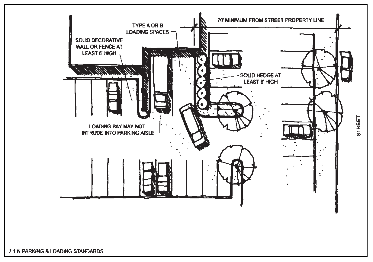
Figure 7-13
3.
Access.
a.
A required loading space shall be accessible without backing a truck across a street property line unless Staff determines that provision of turn-around space is infeasible and approves alternative access.
b.
An occupied loading space shall not prevent access to a required off-street parking space.
O.
Parking and Loading Area Design Standards.
1.
Markings.
a.
Each required off-street parking space and off-street loading facility shall be identified by surface markings and such markings shall be maintained in a manner so as to be readily visible and accessible at all times. Such markings shall be arranged to provide for orderly and safe loading, unloading, parking and storage of vehicles. Markings required to be maintained in a highly visible condition include but are not limited to striping, directional arrows and lettering on signs and in handicapped-designated areas.
b.
One-way and two-way accesses into required parking facilities shall be identified by directional arrows. Any two-way access located at any angle other than ninety (90) degrees to a street shall be marked with a traffic separation stripe the length of the access. This requirement does not apply to aisles.
c.
Parking lot striping shall be white.
(Ord. 8-05 #1)
2.
Surfacing and Maintenance. All off-street parking areas, loading areas and access drives servicing eight (8) or more parking spaces shall be surfaced with at least two (2) inches of bituminous paving material or four (4) inches of concrete.
(Ord. 8-05 #1)
3.
Parking Stall Dimensions. Standard parking spaces shall conform with the dimensions shown on the following table (See Figure 7-14):
Where:
A = Angle of Parking
B = Stall Width
C = Stall Length
D = Stall Depth
E = Curb Length per Stall
F = Aisle width for two-way traffic, with two-sided loading
G = Aisle width for one-way traffic, with one-sided or two-sided loading
Notes: [1] When a parking space abuts a landscape island or planter, the front 2 feet of the required parking space length may overhang the planter, provided that wheel stops or curbing is provided.

Figure 7-14
4.
Wheel Stops and Continuous Curbs.
a.
General. Wheel stops or continuous curbs shall be provided, located and designed to protect required screening devices, landscaping and pedestrian ways from damage or encroachment of vehicles and to provide necessary traffic control in the off-street parking or loading area.
b.
Wheel Stops. Each wheel stop shall be a single block of reinforced concrete, stone or other durable material six (6) inches in height, six (6) inches in width and eight (8) feet in length. The wheel side of a wheel stop shall be placed two and one-half (2½) feet from the end of the parking space and the wheel stop shall be centered across the width of the parking space, as illustrated below. All wheel stops shall be securely attached to the ground. No reduction in the paved area of the required parking stall length shall be reduced because of the use of wheel stops.
c.
Continuous Curbs.
(1)
Continuous curbs shall be made of asphalt, concrete or stone, and shall be a minimum of six (6) inches in height and six (6) inches in width. They shall form a noninterrupted edge around all landscaped areas adjacent to parking and turn-around areas that are not protected by wheel stops.
(2)
Where continuous curbs are used, the paved area of the parking stall length otherwise required by this Section may be reduced by two and one-half (2½) feet, provided that the vehicle overhang will not encroach on pedestrian circulation or the required setback for plant growth (see paragraph d. below).
d.
Placement. Wheel stops or continuous curbs shall be located a minimum of four (4) feet from any structures, buildings, walls or plant material, excluding groundcover, to prevent a vehicle from driving onto the landscape area or hitting any structure or plant material at the edge of the parking area. The mature size of any plant material shall be specified on the development or landscaping plan to determine compliance with this setback requirement.
5.
Basins and Drainage Facilities. All basin and drainage facilities shall comply with the Larimer County Stormwater Control Manual, as amended, and the standard drawings and specifications contained or referenced therein.
(Ord. 18-01 #21, 10/23/01; Ord. 8-05 #1, 6/14/05; Ord. 6-06 §1, 9/26/06; Ord. 25-07 §1, 11/27/07)
§ 7.12 - ADEQUATE PUBLIC FACILITIES
A.
Purpose. The purpose of these adequate public facilities regulations is to ensure that all utilities and other facilities and services needed to support development are available concurrently with the impacts of such development.
B.
Applicability. Adequate public facilities requirements apply to all new development and subdivisions subject to this Code, except that single-family residential development on a lot created and approved for such use prior to the effective date of this Code shall be exempt from the fire protection and transportation adequate facilities requirements of this Section.
(Ord. 18-02 #1; Ord. 8-05 #1)
C.
General Requirements.
1.
Approval Conditioned Upon Adequate Public Facilities. The approval of all development shall be conditioned upon the provision of adequate public facilities and services necessary to serve the new development. No building permit shall be issued unless such public facilities and services are in place or the commitments described in this Section have been made.
2.
Level of Service Standards.
a.
This Section establishes level of service standards for the following public facilities: sewage disposal, water, drainage, transportation, fire protection and electricity.
(Ord. 8-05 #1)
b.
No development plan or building permit shall be approved or issued in a manner that will result in a reduction in the levels of service below the adopted level of service standard for the affected facility.
3.
Vehicular Access to Public Streets and Private Driveways.
a.
No public right-of-way or public access easement shall be gated, have security-personnel stations or facilities, or have similar barriers installed, so as to restrict free vehicular access thereupon. This provision shall not apply to: (a) gates or barriers, temporary or permanent, installed under authority of public safety agencies; (b) temporary street closures under special event permits; (c) permits granted by the Town; or (d) temporary closures required to perform, infrastructure work or similar public-property maintenance duties.
b.
Gate-restricted access and similar physical access-control barriers and facilities shall be permitted across private driveways associated with non-residential developments; provided that: (a) no gates or other access-restriction measures shall be installed across public right-of-way or access easements.
c.
Gates capable of closure and similar barriers shall be specifically prohibited from installation or operation on the primary entrance of a private driveways accessing multi-family dwelling sites. Multi-family dwelling sites shall include private driveways accessing multiple single-family dwellings or driveways accessing apartment complexes. These driveways shall be maintained with unobstructed vehicular access between the dwelling entrance(s) and the public street access. However, additional accessways to a such developments may be created with emergency-access-only gates or barriers, provided the design, installation and operation shall be approved by appropriate public-safety review entities, including the Estes Valley Fire Protection District (EVFPD) Fire Marshal, for that purpose.
d.
Temporary closures of private right-of ways to prevent adverse possession claims for public use shall be allowed.
(Ord. 21-19, §1(Exh. A))
D.
Sewage Disposal.
1.
Level of Service. All development shall provide adequate and functional sewage service to each lot pursuant to this subsection. Public central sewer service is the preferred method of sewage collection and treatment in all zoning districts in the Estes Valley. To the maximum extent feasible, this preferred method of service shall be provided.
2.
Criteria for New Development. The development shall be served by either the Upper Thompson Sanitation District or the Estes Park Sanitation District, or the development will be served by on-site sewage treatment systems and all of the following criteria are met:
a.
The development site is located in a residential zoning district;
b.
All proposed lots are at least two (2) acres in area;
c.
An economic analysis of the cost to extend and connect to public central sewer, compared with the cost to design and construct on-site alternatives, shall be submitted for development sites within a current or proposed sewer service area. New development sites may utilize on-site sewer systems only when it can be demonstrated that it is clearly not economically feasible to connect to central public sewer; and
d.
An inventory and analysis of site conditions relevant to the use of on-site sewer systems shall be submitted to support their use. Relevant site conditions include but are not limited to: soils, percolation rates, location of bedrock and groundwater, surface water bodies, slopes, rock outcrops, irrigation ditches and wetlands; and
e.
Substantial evidence shall be submitted indicating that the design, layout and density of a development proposal incorporates the inventory and analysis of site conditions noted above. Proposals must demonstrate that site conditions are compatible with the use of on-site sewer systems and that the location of sewer systems will take advantage of favorable site conditions while avoiding significant constraints. Evidence of compatibility may include intrinsic suitability of soils and other site conditions, development design and density tailored to limits placed by site constraints, and the ability to meet future lot owners' expectations for operation and maintenance.
3.
Minimum Approval Requirements. Adequate sewage disposal facilities and services to support the proposed development shall be available concurrently with the impacts of such development. In this regard, the Decision-Making Body shall require that, at the time of issuance of any building permit, all necessary sewage disposal facilities and services, as described in §7.12.D.2 above, are in place and available to serve the new development in accordance with the approved utility plan for the development.
E.
Water.
1.
Level of Service. All development shall provide adequate and functional domestic water service to each lot pursuant to this subsection. Public water service is the preferred method of domestic water provision in all zoning districts in the Estes Valley. To the maximum extent feasible, this preferred method of service shall be provided.
2.
Criteria for New Development. New development shall meet one (1) of the following criteria:
a.
Public Water System. The development will be connected to the Town of Estes Park Water System, or
b.
Wells. The development will be served by individual or shared wells and all of the following conditions are met:
(1)
The development site cannot physically be served by the Town of Estes Park Water System or the development site is outside the Town's existing or planned water service area;
(2)
The development site is located in a residential zoning district; and
(3)
An augmentation plan has been approved and the Colorado Division of Water Resources confirms that well permits will be issued.
3.
Minimum Approval Requirements. Adequate domestic water facilities and services to support the proposed development shall be available concurrently with the impacts of such development. In this regard, the Decision-Making Body shall require that, at the time of issuance of any building permit, all necessary water facilities and services, as described in §7.12.E.2 above, are in place and available to serve the new development in accordance with the approved utility plan for the development.
F.
Drainage/Water Quality Management.
1.
Level of Service. All development shall provide adequate surface, subsurface and road storm drainage facilities and appurtenances as required by all current and applicable Town of Estes Park or Larimer County storm drainage master plans, and as required by the design criteria and construction standards set forth in the Larimer County Stormwater Management Manual, as amended. Either open or closed drainage systems may be required, depending upon terrain, development density and other considerations.
2.
Minimum Approval Requirements. Adequate stormwater drainage facilities and services to support the proposed development shall be available concurrently with the impacts of such development. Except as set forth below, at the time of building permit issuance, the Decision-Making Body shall require that all necessary drainage facilities and services are in place and available to serve the new development in accordance with the approved drainage and erosion control report and plan for the development. Where multiple building permits are to be issued for a project, twenty-five percent (25%) of the building permits and certificates of occupancy may be issued prior to the installation and acceptance of the drainage facilities.
G.
Fire Protection.
1.
Level of Service. All development shall provide sufficient fire suppression facilities and adequate accessibility to emergency fire protection services.
2.
Criteria for New Development. New development shall provide adequate fire flows and hydrant distribution as required by the latest Insurance Services Office (ISO) "Fire Suppression Rating Schedule" unless alternative service levels are approved by the Town's consulting engineer or Fire Department representative.
3.
Minimum Approval Requirements. Adequate fire protection facilities and services to support the proposed development shall be available concurrently with the impacts of such development. In this regard, the Decision-Making Body shall require that, at the time of issuance of any building permit, all such facilities and services, as described in §7.12.G.2 above, are in place and available to serve the new development.
H.
Transportation.
1.
Levels of Service.
a.
General Standard: All developments shall be required to demonstrate that there will be no significant adverse impact on existing transportation levels of service, access and vehicular movement on any arterial or collector street or intersection within one-quarter (¼) mile of the site or that any such adverse impact has been mitigated to the maximum extent feasible.
b.
Waiver: The Decision-Making Body may waive these requirements upon a showing by the Applicant that the impact of the proposed development on adjacent roads and intersections will be minimal and insignificant.
c.
Access to Development in All Districts: All development shall have safe and adequate access to the nearest paved road. "Safe and adequate access" shall mean that a paved access road is available to provide access to the nearest paved road on the Larimer County Major Road System or the Town Street System prior to the issuance of the first building permit for the development. Except as a more strict requirement in this Code may apply, access to county roads from development located in the County shall comply with the Larimer County Access Code.
d.
Right of Access: Applicants shall provide written evidence of recorded, legal access to a public street.
2.
Thresholds for Traffic Impact Analysis. Traffic Impact Analysis (TIA) may be required to be submitted with applications for development review and approval of:
a.
Any subdivision or multi-family residential development with twenty (20) or more dwellings units;
b.
Any nonresidential development that exceeds fifty (50) peak hour trips based on traffic generation estimates of the latest edition of the Institute of Transportation Engineers' Trip Generation Manual;
c.
Any application for a Zoning Map Amendment (rezoning); or
d.
Any development with frontage along a state or federal highway or numbered county road.
3.
TIA Contents. The TIA shall contain the following information:
a.
Traffic Impact Area. Identification of the precise boundaries of the Traffic Impact Area, which shall be approved in advance by Staff.
b.
Current LOS. The current projected average daily traffic volumes (level of service) on the segments and intersections of the road system in the Traffic Impact Area based upon existing conditions and factoring in already approved developments.
For purposes of these transportation facility standards, "approved development" shall mean developments that have received preliminary or final approvals from the EVPC or its predecessors and that have not been completed.
c.
LOS Including the Proposed Development. The projected average daily traffic volumes (level of service) of the segments and intersections on the road system in the Traffic Impact Area based upon existing conditions, the demands from approved development, and the proposed development.
d.
Study Findings. A summary outlining the study findings on the traffic impacts of the proposed development, including a detailed description of proposed improvements and mitigation measures necessary to maintain the adopted level of service standard.
e.
Other Information. Other information as may reasonably be required by the Decision-Making Body or Staff to determine compliance with the applicable level of service standards.
4.
Minimum Approval Requirements. At a minimum, the Decision-Making Body shall require that at the time of final plat or development plan approval all necessary transportation facilities and services to meet the applicable level of service standard are:
a.
Currently in place and available to serve the new development; or
b.
Guaranteed by an enforceable development or improvement agreement that ensures that the public facilities will be in place at the time that the impacts of the proposed development will occur.
I.
Electricity.
1.
Level of Service. All development shall provide adequate and functional electric service to each lot pursuant to this subsection.
(Ord. 8-05 #1)
2.
Criteria for New Development. The development shall be served by the Town and shall meet current standards established by the Town.
(Ord. 8-05 #1)
3.
Minimum Approval Requirements. Adequate electric services to support the proposed development shall be available concurrently with the impacts of such development. In this regard, the Decision-Making Body shall require that, prior to issuance of the first building permit, all necessary electric services are in place and available to serve the new development or subdivision in accordance with the approved utility plan for the development, i.e., all electric service shall be installed up to and including mains and distribution boxes such as transformers and secondary pedestals.
(Ord. 8-05 #1)
(Ord. 18-02 #1, 12/10/02; Ord. 8-05 #1, 6/14/05; Ord. 21-19, §1(Exh. A), 8/13/19)
§ 7.13 - OUTDOOR STORAGE AREAS, ACTIVITIES AND MECHANICAL EQUIPMENT
A.
Applicability. This Section shall apply to all new development subject to this Code.
B.
Standards.
1.
Areas for truck parking and loading shall be screened by a combination of structures and evergreen landscaping to minimize visibility from adjacent streets and property lines.
2.
Areas for outdoor storage, trash collection or compaction, loading or other such uses shall be located in the rear of the lot. If that is not feasible, then the side yard can be used, but in no case shall areas be located within twenty (20) feet of any public street, public sidewalk or internal pedestrian way.
3.
Outdoor storage, HVAC equipment, trash collection, trash compaction and other service functions shall be incorporated into the overall design of the building and the landscaping plan. Views of these areas shall be screened from visibility from all property lines and separated from pedestrian areas.
4.
Conduit, meters, vents and other equipment attached to the building or protruding from the roof shall be screened, covered or painted to minimize visual impacts.
5.
Nonenclosed areas for the storage and sale of seasonal inventory shall be permanently defined and screened with walls or fences. Materials, colors and design of screening walls or fences shall conform to those used as predominant materials and colors on the building. If such areas are to be covered, then the covering shall conform to those used as predominant materials and colors on the building. This subparagraph shall not apply to temporary seasonal sales uses that have valid temporary use permits as set forth in §5.3 of this Code.
6.
The following shall apply to outdoor sales:
a.
The sales and storage area shall be permanently defined and screened with walls or fences.
b.
The sales and storage area including all area within the defining walls or fences shall be limited to twenty-five percent (25%) of the gross area of the lot.
c.
Any covering over the sales area shall be of a permanent nature. Tents, canopies and tarps shall not be permitted.
d.
Setbacks for any sales and/or storage area shall be the same as required for buildings.
e.
Sanitation facilities shall be provided.
f.
Required parking shall be provided in accordance with §7.11 of this Code.
(Ord. 10-00 §3, 7/25/00)
§ 7.14 - MOBILE HOME PARKS
A.
Applicability. All mobile home park development shall be subject to the regulations in this Section.
B.
Dimensional Regulations.
1.
Maximum Density.
a.
RM District. The maximum number of mobile home lots shall equal the maximum number of dwelling units allowed under the requirements of the RM zoning district. See §4.3.B (Table 4-1).
b.
CO District. The maximum net density shall be eight (8) mobile home lots per acre in the CO zoning district.
2.
Minimum Park Size. A mobile home park development shall be a minimum of ten (10) acres in size.
3.
Minimum Mobile Home Site Size. Each individual mobile home shall have an assigned site of at least four thousand five hundred (4,500) square feet, not including street areas, and each site shall have a minimum of twenty-five (25) feet of street frontage.
4.
Setbacks.
C.
General Design Requirements.
1.
Site Characteristics Requirements. Condition of the soil, groundwater level, drainage and topography shall not create hazards to the property or the health or safety for the occupants. The site shall not be exposed to objectionable smoke, noise, odors or other adverse influences, and no portion subject to unpredictable and/or sudden flooding, subsidence or erosion shall be used for any purpose that would expose persons or property to hazards.
2.
Soil and Groundcover Requirements. Exposed ground surfaces in all parts of every mobile home park shall be paved, covered with stones or other solid material, or protected with a vegetative growth that is capable of preventing soil erosion and eliminating objectionable dust.
3.
Site Drainage Requirements. Mobile home parks shall comply with the requirements set forth in §7.12.F above.
4.
Nonresidential Uses. No part of any park shall be used for nonresidential purposes, except such accessory uses that are required for the direct servicing and well-being of park residents and for the management and maintenance of the park. However, nothing contained in this provision shall be deemed to prohibit the sale of a mobile home located on a mobile home stand and connected to the pertinent utilities.
5.
Required Recreation Areas
a.
Every mobile home park containing more than fifty (50) mobile home spaces shall provide outdoor recreation areas having a minimum total area of two thousand (2,000) square feet, or one hundred (100) square feet for each mobile home space in excess of fifty (50) mobile home spaces, whichever area is the greatest.
b.
In the event that more than one (1) outdoor recreation area is provided within a mobile home park containing more than fifty (50) mobile home spaces, the minimum area for each outdoor recreation area shall be two thousand (2,000) square feet, regardless that the minimum total area provided for in paragraph 5.a above may thereby be exceeded.
c.
Outdoor recreation areas may include, but are not limited to, adult recreation and child play areas and swimming pools, but shall not include areas devoted to parking, utilities or drying yards.
d.
Outdoor recreation areas shall be located in such a manner as to be free from traffic hazards and excessive topography, and shall be centrally located to provide easy access to all park residents, provided that the topography and traffic of the park permit.
D.
Circulation System.
1.
General Requirements. All mobile home parks shall be provided with safe and convenient vehicular access from abutting public streets or roads to each mobile home lot via private streets. Alignment and gradient shall be properly adapted to topography and shall provide good drainage. See Appendix D for applicable road standards.
2.
Access. Access to mobile home parks shall be designed to minimize congestion and hazards at the entrance or exit and allow free movement of traffic on adjacent streets. The entrance road connecting the mobile home park interior streets with a public street or road shall have a minimum road pavement width of thirty-four (34) feet where parking is permitted on both sides, or a minimum road pavement width of twenty-seven (27) feet where parking is limited to one (1) side.
3.
Internal Streets and Walkways.
a.
Street Width. Surfaced internal roadways shall be of adequate width to accommodate anticipated traffic, and in any case shall meet the following minimum requirements:
(1)
All streets, except minor streets: thirty-four (34) feet;
(2)
Minor streets:
(a)
Where parking is not allowed on either side of the street: twenty (20) feet;
(b)
Where parking is allowed on one (1) side of the street only: twenty-seven (27) feet, provided that the street is less than five hundred (500) feet long and serves fewer than twenty-five (25) mobile homes, or of any length if the street is one-way and provides access to abutting mobile home lots on one (1) side only.
b.
Dead-End Streets. Dead-end streets shall be limited in length to five hundred (500) feet and shall provide a turnaround at the closed end that has an outside paved roadway diameter of at least ninety (90) feet.
c.
Walkways. All mobile home parks shall be provided with safe, convenient, all-season pedestrian accesses of adequate width for intended use, durable and convenient to maintain, between individual mobile homes, the park streets and all community facilities provided for park residents.
d.
Illumination of Internal Streets and Walkways. All parks shall be furnished with lighting units so spaced and equipped with luminaries placed at such mounting heights as will provide illumination for the safe movement of pedestrians and vehicles, but in no case shall lighting be provided less than every four hundred (400) feet of street or walkway length.
4.
Street Construction and Design Standards.
a.
Pavement. All streets shall be provided with a smooth, hard and dense surface (asphaltic concrete or Portland cement concrete) which shall be durable and well-drained under normal use and weather conditions. Pavement edges shall be protected to prevent raveling of the wearing surface and shifting of the pavement base. Street surfaces shall be maintained free of cracks, holes and other hazards.
b.
Design Standards. Design standards for all streets shall meet the requirements set forth in Appendix D.
E.
Mobile Home Stands. The area of the mobile home stand shall be improved to provide an adequate foundation for the placement and tie-down of the mobile home, thereby securing the superstructure against uplift, sliding, rotation and overturning.
1.
The mobile home stand shall not heave, shift or settle unevenly under the weight of the mobile home due to frost action, inadequate drainage, vibration or other forces acting on the superstructure.
2.
The mobile home stand shall be provided with anchors and tie-downs such as cast-in-place concrete "dead men" eyelets imbedded in concrete foundations or runways, screw augers, arrowhead anchors or other devices securing the stability of the mobile home.
3.
Anchors and tie-downs shall be placed at least at each corner of the mobile home stand, and each shall be able to sustain a minimum tensile strength of two thousand eight hundred (2,800) pounds.
4.
All mobile home parks or mobile homes located in the area of special flood hazard shall meet the requirements of the floodplain regulations as set forth in this Code.
5.
All mobile home stands shall be visibly numbered.
F.
Other Development Requirements.
1.
Utilities. All utility lines shall be underground. Utility easements shall be provided for as required by this Code or other applicable regulations.
2.
Screening. All mobile home parks shall be screened from adjacent property with trees, shrubs, other planting arrangements and/or walls designed to provide noise and sight buffers. Such screening shall be at least six (6) feet in height; provided that such screening shall be less than three and one-half (3½) feet in height when located within one hundred (100) feet of the centerline intersection of two (2) streets or roads; and provided that trees and shrubs used may be of a type capable of attaining the minimum height requirement within five (5) years of planting.
3.
Required Community Sanitary Facilities. For each one hundred (100) mobile home stands or fractional part thereof, an emergency sanitary facility containing one (1) flush toilet and one (1) lavatory shall be provided for each sex. The building containing such emergency sanitary facilities shall be accessible to all mobile homes.
G.
Park Occupancy.
1.
Recreational Vehicles or Travel Trailers. No recreational vehicles or travel trailers shall be used as residences in a mobile home park.
2.
Restrictions on Occupancy. A mobile home shall not be occupied for dwelling purposes unless said home is properly placed on a mobile home stand and connected to water, sewage and electrical utilities.
3.
Single Unit. All mobile homes shall be occupied as only one (1) dwelling unit and shall meet the definition of "household living" as set forth in Chapter 13 of this Code.
4.
HUD Seal. All mobile homes in a mobile home park shall contain the United States Department of Housing and Urban Development seal or substantially conform to the requirements necessary to obtain said seal if said mobile home was constructed prior to the adoption of said seal.
5.
Commercial Uses Prohibited. No mobile home shall be used as a store, office or place for the carrying on of a business, trade or profession, except as a permitted home occupation.
6.
Tenting. Tents and tent trailers shall not be occupied in a mobile home park.
H.
Nonconforming Placement or Occupation. No mobile home shall be placed or occupied except within a mobile home park complying with the provisions of this Section or a temporary placement of a mobile home under the provisions of Section 14.08.020 of the Town of Estes Park Municipal Code or §5.3 of this Code. Any mobile home parks or mobile homes in existence at the time of the enactment of this Code that fail to conform to this Section's requirements shall be governed by the nonconforming use provisions of Chapter 6.
§ 7.15 - RECREATIONAL VEHICLE (RV) PARK/CAMPGROUND
A.
Applicability. All recreational vehicle (RV) parks and commercial campgrounds shall be subject to special review (§3.5) and this Section.
B.
Density Requirements.
1.
RV Parks: Notwithstanding the density limitations of the zoning district in which the RV park use is located, the maximum density within the RV park shall be twelve (12) RV sites per acre.
2.
Campground: Notwithstanding the density limitations of the zoning district in which the campground use is located, the maximum density within the campground shall be eight (8) camp sites per acre.
C.
Site Requirements.
1.
Size:
a.
RV parks shall have a minimum area of ten (10) acres and sites for no less than fifteen (15) recreational vehicles. Each site shall be a minimum of one thousand three hundred fifty (1,350) square feet in area, excluding roadways.
b.
Campgrounds shall have a minimum area of ten (10) acres and no less than fifteen (15) camp sites.
c.
Group sites may be established within a campground, provided that they have a minimum area of fifteen thousand (15,000) square feet (excluding roadways); and provided, further, that they shall provide a minimum of four hundred (400) square feet of parking area for vehicles other than recreational vehicles for every two (2) sites within the group site.
d.
Separate camping areas shall be maintained for independent units, dependent units and tents.
2.
Each RV site within a RV park or campground shall be equipped with an electrical hookup for a recreational vehicle.
3.
All land areas shall have an acceptable form of groundcover to prevent erosion and blowing dust.
4.
One (1) tree of a species suitable for the area and climate shall be provided to each two (2) RV sites or camping spaces, and shall be located in close proximity to those sites/spaces. Existing trees should be used to satisfy this requirement.
5.
Comfort stations with restrooms and other facilities shall be provided in accordance with Colorado Department of Health standards and the following requirements:
a.
Comfort stations shall occupy no more than ten percent (10%) of the gross park or campground area, shall be maintained primarily for the use of users, and the general public shall not be invited by advertisement, or otherwise, to use such service buildings.
b.
Comfort stations in RV parks and campgrounds shall have the following minimum facilities:
c.
For every thirty (30) additional sites in excess of one hundred (100) sites, one (1) additional male toilet, female toilet, male lavatory and female lavatory shall be provided. For every forty (40) additional sites in excess of one hundred (100) sites, one (1) additional male shower and female shower shall be provided. For every one hundred (100) additional sites in excess of one hundred (100) sites, one (1) additional urinal and one (1) additional female toilet shall be provided.
d.
Every site within an RV park or campground shall be located within a radius of at least 450 feet from a comfort station; provided, however, that in no event shall a comfort station be located closer than 75 feet to any site.
6.
Water Stations: Each RV park and nonprimitive campground shall contain at least one (1) water station for every one hundred (100) sites or fraction thereof. Water stations shall comply with the following standard:
a.
Every water station shall be equipped with two (2) or more hydrants, a water fountain, a sump, a vacuum breaker to prevent siphonage, a shut-off valve for controlling the rate of water flow, and a flexible hose to reach the inlet of recreational vehicle water storage tanks.
7.
Sanitary Stations: Each RV park and nonprimitive campground shall contain a minimum of one (1) sanitary station for every one hundred (100) sites, or fraction thereof. Sanitary stations shall comply with the following standards:
a.
The drainage basin of the sanitary station shall be constructed of an impervious material.
b.
Sewage facilities shall be connected to a public sewer collection and treatment system.
c.
The sanitary station shall be connected to the park or campground water supply and shall provide facilities for washing recreational vehicle waste holding tanks and for cleaning the general area of the sanitary station.
8.
Recreation Areas: Each campground and RV park shall provide and maintain an outdoor recreational area consisting of one hundred (100) square feet per site or campground space. Outdoor recreation areas include adult recreation and child play areas and comfort stations, but shall not include areas devoted to parking.
D.
Setback and Separation Requirements. Sites within a RV park or campground shall comply with the following minimum setback and separation requirements:
Notes to Table: [1] The minimum setback requirement shall not apply if the site or recreational vehicle is totally obscured from sight by natural barriers or artificial screening from a distance of 100 feet from such single-family residences or accommodation use, as measured from the portion of such buildings closest to the site or recreational vehicle.
E.
Screening Requirements.
1.
Residential areas adjoining the campground shall be screened by a fence or wall with a minimum height of six (6) feet.
2.
All trash collection areas shall be screened, and protective fencing shall be provided around hazardous areas.
F.
Road and Parking Requirements.
1.
Road systems shall be required to form a loop system only and shall be constructed in the same manner and to the same standards as an access road. If such road system is for one-way traffic only, directional signs shall be installed.
2.
Access roads shall be sixteen (16) feet in width if providing one-way traffic and twenty-four (24) feet in width if providing two-way traffic, and shall be surfaced with granular material of no greater than one-and-one-half-inch grade.
3.
Entrance ways into the use, or onto access roads, off of state or federal highways shall be rounded by at least a forty-foot radius arc in order to provide convenient and safe ingress and egress to such highways without traffic obstruction. Such intersections shall also be maintained free from obstruction to visibility for a distance of one hundred twenty-five (125) feet along the access road or entrance way from its intersection with such highway.
4.
Interior roadways must comply with Colorado Department of Health standards in addition to the requirements of this Code.
5.
Each camp site within a campground shall provide a parking space of at least two hundred (200) square feet for one (1) vehicle, other than a recreational vehicle, and such parking space shall be so constructed that no portion of such vehicle shall extend onto any roadway within the campground.
G.
Operational Requirements.
1.
Campgrounds and RV parks shall not be used as permanent residences except for the owner or manager and permanent maintenance personnel.
2.
All recreational vehicles in an RV park or campground shall be parked in an approved RV site.
3.
Each campground site shall be equipped with a numbered and color-coded sign indicator at least four (4) inches square in area and attached to a post or tree on or near the camp site, indicating the type of recreational vehicle, if any, which may be parked on the camp site.
4.
If provided, electric and gas service shall meet all state and local electric and gas regulations. All utilities shall be underground.
5.
Towed vehicles within the campground or RV park shall not exceed one hundred two (102) inches in width.
6.
At least one (1) public telephone shall be provided.
7.
Each campground or RV park shall provide at least one (1) full-time attendant. A permanent record of registrations shall be maintained.
8.
Walkways within the campground or park area shall be at least four (4) feet wide with an all-weather surface.
9.
Streets, walkways, buildings, comfort stations and other areas or facilities subject to nighttime use also shall be lighted for safe nighttime use, subject to lighting standards in §7.9.
H.
Application Requirements. In addition to the submittal and application requirements set forth in Appendix B for special review use approval, the following items shall be required in an application for special review approval of a RV park or campground use:
1.
The location and width of all roads within the site perimeters, together with the location and type of proposed accessory uses, the location of the entrance to the park or campground, the location of existing and proposed utility, water and sewer lines and the location of comfort stations and outside water outlets;
2.
The location and dimensions of proposed parking areas, and the location of the total number of proposed sites;
3.
The ownership of the proposed use and the ownership of immediately adjoining properties;
4.
A description of adjoining land uses and topography and an illustration of watercourses or bodies of water on adjoining properties within a distance of three hundred (300) feet from the boundaries of the proposed use; and
5.
A landscaping plan which conforms to the requirements of §7.5 of this Code.