
Fargo City Zoning Code
ARTICLE 20
05 - DIMENSIONAL STANDARDS
§20-0501 - Residential District Standards
The dimensional standards of Table 20-0501 apply to all development in MR-3 and more restrictive zoning districts.
Table 20-0501
Source: 2985 (1999), 3062 (1999), 4039 (2000), 4165 (2001), 4338(2003), 4695 (2009), 4818 (2012), 5091 (2017).
[1] Higher densities may be allowed in accordance with the Bonus Density provisions of Sec. 20-0505.
[2] SR-0 minimum district size is 20 acres. See Sec. 20-0203-A.
[3] Minimum lot width subject to limitation of access as provided in Sec. 20-0702.
[4] Minimum 100 feet from right-of-way on Arterial or section line road.
[5] Minimum 20-foot setback shall be provided between front-entry garages and nearest edge of sidewalk crossing plate.
[6] #/# = Percent of Lot Width/Feet (whichever is less).
[7] Minimum 75 feet from right-of-way on Arterial or section line road.
[8] Maximum of 37.5 percent of building coverage shall be allowed if site amenity is provided in accordance with Sec. 20-0403.B.7. If the amenity is contained within the footprint of one primary structure, the floor area of that amenity is counted as open space, but is not subtracted from the area of the building.
[9] The SR-5 zoning district is limited to a maximum size of 21,000 square feet, but may exceed 21,000 square feet, up to a maximum of two acres provided the district is within 600 feet of a private or public dedicated open space feature, such as a public park, private park, school yard or playground that is accessible to residents of the SR-5 district, any of which shall be a minimum of two acres or more in size. For purposes of identifying a single SR-5 zoning district, parcels adjacent to one another that are, or will be, the same zoning classification shall be deemed to be within the same zoning district and, therefore, shall be subject to the maximum size limitation.
[10] Watercourse setbacks for all residential, nonresidential and overlay/special zoning districts are as set forth in Section 20-0508.
§20-0502 - Nonresidential District Standards
The dimensional standards of Table 20-0502 apply to all development in nonresidential zoning districts.
Table 20-0502
Source: 4039 (2000), 4225 (2002), 4818 (2012), 5179 (2018).
___________
[1] No setback required when adjacent to DMU
[2] The 35-foot height restriction applies whenever residential protection standards apply, or when the Limited Commercial parcel is within 300 feet of SR zoning. Otherwise, the height limit shall be 60 feet in Limited Commercial zoning districts.
[3] Watercourse setbacks for all residential, nonresidential and overlay/special purpose zoning districts are as set forth in Section 20-0508.
§20-0503 - Overlay/Special Purpose Zoning District Standards
The dimensional standards that apply within overlay and special purpose zoning districts can be found in the following sections:
Source: 2985 (1999), 4039 (2000), 4818 (2012).
§20-0504 - Measurements and Exemptions
A.
Density
Density refers to the number of dwelling units for each acre of land. Density is calculated
by dividing the number of dwelling units on a lot by the area (in acres) of the lot
on which the dwelling unit is located. The number of dwelling units allowed on a site
is based on the presumption that all other applicable standards will be met. The maximum
density established for a district is not a guarantee that such densities may be obtained,
nor a justification for adjusting other dimensional or development standards.
B.
Lot Area
Lot area refers to the horizontal land area within lot lines. No building permit or
development approval may be issued for a lot that does not meet the minimum lot area
requirements of this Land Development Code except in the following cases.
1.
Reduction of Public Purpose
When an existing lot is reduced because of conveyance to a federal, state or local
government for a public purpose and the remaining area is at least 75 percent of the
required minimum lot size for the district in which it is located, then that remaining
lot will be deemed to comply with the minimum lot area standards of this Land Development
Code.
2.
Utilities
Utilities using land or an unoccupied building covering less than 1,000 square feet
of site area are exempt from the minimum lot area standards.
3.
Detached House Exemption
The minimum lot area standards of this Land Development Code shall not be interpreted
as prohibiting the construction of a detached house on a Legal Lot, provided that
the house is constructed in compliance with all applicable setback standards.
C.
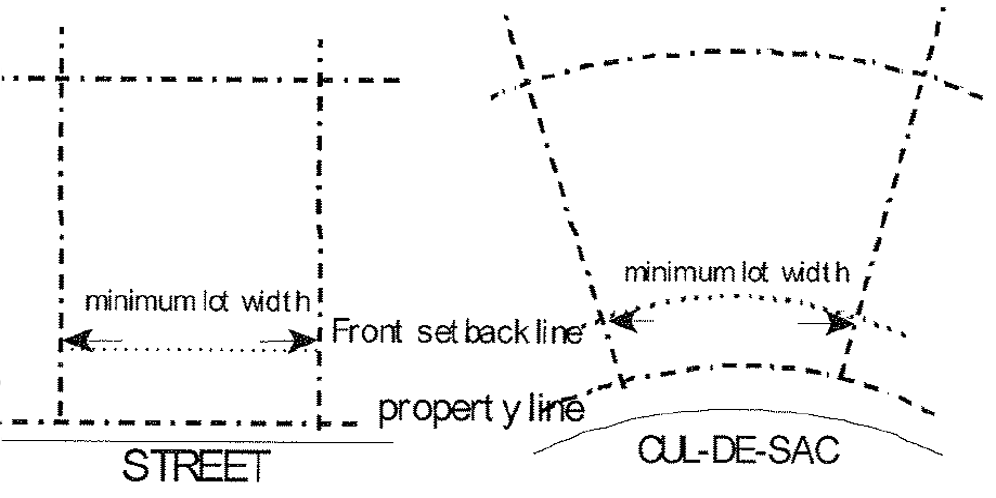
Lot Width
Lot width is measured between side lot lines along a line that is parallel to the
front lot line or its chord and located the minimum front setback distance from the
front lot line.
D.
Setbacks
Setbacks refer to the unobstructed, unoccupied open area between the furthermost projection
of a structure and the property line of the lot on which the structure is located,
except as modified by the standards of this section. Setbacks must be unobstructed
from the ground to the sky except as specified in this section.
1.
Exceptions to Setbacks
Every part of a required setback must be open and unobstructed from the ground to
the sky except as set out in this subsection:
a.
Trees, shrubbery or other landscape features may be located within any required setback;
b.
Fences and walls may be located within any required setback, subject to Sec. 20-0403-B.2;
c.
Driveways and sidewalks may be located within any required setback;
d.
Utility lines, wires and associated structures, such as power poles, may be located within any required setback;
e.
Signs, where permitted, may be located within any required setback;
f.
Uncovered porches, uncovered steps to building entrances, uncovered patio decks and uncovered balconies may extend up to 10 feet into any required front, rear or street side setback and up to 3 feet into any required interior side setback;
g.
Openwork fire balconies and fire escapes may extend up to 3 ½ feet into any required setback;
h.
Sills, belt courses, cornices, buttresses, eaves and other architectural features may extend up to 3 feet into any required setback;
i.
Off-street parking and loading areas, subject to Sec. 20-0704, may be located within any required setback;
j.
Chimneys and flues may extend up to 2 feet into any required setback;
k.
Accessory structures may be located within rear setbacks in accordance with Sec. 0403-B.3. (See also Sec. 0403-B.4);
l.
Solar panels and other apparatus needed for the operation of active and passive solar energy systems and all other forms of renewable passive energy, including but not limited to, overhangs, movable insulating walls and roofs, detached solar collectors, reflectors, and piping may project into a required rear setback by up to 10 feet and into a side setback by up to 3 feet. In all cases, however, they must be located at least 3 feet from all lot lines; and
m.
Satellite dish antennas may be placed in required rear setbacks and on roofs.
2.
Setback Averaging
In a block where the average front setback of existing buildings within 100 feet of
the subject lot is not more than 6 feet greater or 6 feet less than the front setback
requirement for the zoning district in which such block is located, the front setback
for the proposed building shall be set at such average depth. Where such average depth
is more than 6 feet greater or 6 feet less than the front setback required for such
district, this average setback requirement may be waived by the Board of Adjustment
and a different requirement established by the Board of Adjustment. When a block is
zoned in different zoning districts, the front setback requirements of the district
that requires the greater front setback shall apply along its entire length. Setback
averaging is not required in a UMU, University Mixed-Use District.
3.
Reverse Corner Lots
The minimum street side setback on a reverse corner lot shall equal at least 50 percent
of the required front setback of the lots located to the rear of the reverse corner
lot. No principal or accessory building on the reverse corner lot shall project beyond
this minimum street side setback line. This provision shall not be construed to reduce
the buildable lot width of a corner lot to less than 25 feet.
4.
Reduction for Public Purpose
When an existing setback is reduced because of conveyance to a federal, state or local
government for a public purpose and the remaining setback is at least 75 percent of
the required minimum setback for the district in which it is located, then that remaining
setback will be deemed to satisfy the minimum setback standards of this Land Development
Code.
E.
Building Coverage
Building coverage refers to the area of a lot covered by buildings (principal and
accessory) or roofed areas, as measured along the outside wall at ground level, and
including all projections, other than open porches, fire escapes, canopies and the
first three feet of a roof overhang.
F.
Open Space
Open Space refers to outdoor, unenclosed areas, located on the ground or on a roof,
balcony, deck, porch or terrace designed and accessible for outdoor living, recreation,
pedestrian access or landscaping, but not including roads, parking areas, driveways,
or other areas intended for vehicular travel. If approved by the Planning Commission,
the open space standards of this Article may be satisfied by funding or otherwise
providing an equivalent amount of off-site open space within a 1-mile radius of the
proposed development site.
G.
Height
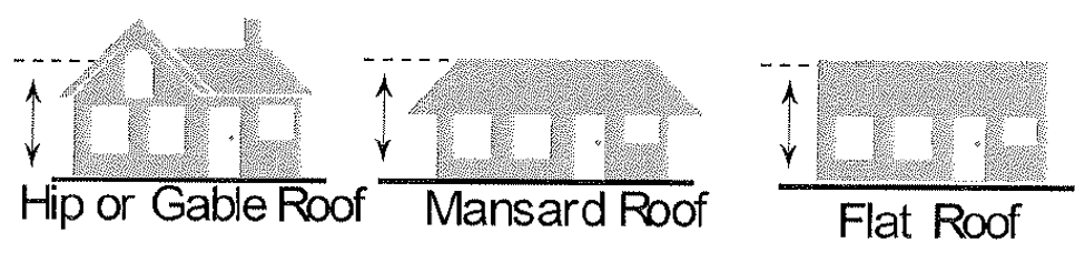
Building height refers to the vertical distance between the average finished grade
at the base of the building along the side of the building being measured and: 1)
the average height level between the eaves and ridge line of a gable, hip, gambrel
or mono-pitch roof; 2) the highest point of a mansard roof; or 3) the highest point
of the coping of a flat roof.
1.
Fences or Walls
In the case of fences or walls, height shall be measured from ground level on the
higher side of the fence or wall.
2.
Exceptions to Height Limits
Zoning district height limits do not apply to belfries, cupolas, spires, domes, monuments,
airway beacons, radio/communication towers, structures for essential services, windmills,
flagpoles, chimneys, radio/television receiving antennas or chimney flues. Height
limits also do not apply to any dormer, bulkhead, elevator, water tank, or to any
similar structure or necessary mechanical appurtenance extending above the roof of
any building if such structure does not occupy more than 33⅓ percent of the area of
the roof. No dormer may exceed the highest point or peak of the structure to which
the dormer is attached even when the structure is exempt from a height limitation.
Source: 2985 (1999), 4226 (2002), 4695 (2009), 5173 (2018).
§20-0505 - Bonus Density
A.
A maximum density of 30 dwelling units per acre shall be allowed for projects that comply with the following 3 standards, provided that:
1.
Parking area constructed within the building structure ( i.e. underground or "tuck under" parking) shall be provided, with an area equal to at least 70 percent of the principal building footprint;
2.
Minimum Open Space shall be 40 percent; and
3.
Building height shall comply with maximum height described in Sec. 20-0501.
B.
A maximum density of up to 30 dwelling units per acre in MR-3 district may be granted for projects located within 600 feet of the DMU zoning district if, after review under the Conditional Use review procedures of Sec. 20-0909, the Planning Commission determines that one or more of the following conditions have been met:
1.
The proposed project will allow for the development of underground parking and substantially more open space and landscaping than otherwise would be achieved;
2.
The proposed project is to be designed, constructed and managed for persons with special needs (e.g. physically disabled or older persons), with van service, on-site meals, care-givers and other services available to residents; or
3.
The proposal will ensure the preservation of a designated local, state or federally designated historic landmark.
Source: 2985 (1999), 4039 (2000), 4608 (2007).
§20-0506 - Alternative Residential Development Options
A.
General
1.
Purpose
The alternative development options of this section allow for variety in development
standards while maintaining the overall character of a single-dwelling neighborhood.
These options have several public benefits:
a.
They allow for development which is more sensitive to the environment, especially in hilly areas and areas with water features and natural drainageways;
b.
They allow for the preservation of open and natural areas;
c.
They promote better site layout and opportunities for private recreational areas;
d.
They promote opportunities for affordable housing; and
e.
They promote energy-efficient development.
2.
General
The alternative development options listed in this section are allowed by-right unless
otherwise expressly stated. The project must comply with all of the applicable development
standards of this section. The project must also comply with all other development
standards of the base zoning district unless those standards are superceded by the
standards in this section. The alternative development options listed in this section
are not applicable to SR-0 zoning districts.
B.
Attached Housing
1.
Lot Width, Lot Area, Building Coverage and Density
Attached housing is exempt from the lot width, lot area and building coverage standards
of the underlying zoning district, but shall not be exempt from the maximum density
standards.
2.
Setbacks
No interior side setback is required on the "attached" side of a lot containing an
attached house. The front, side, and rear setback standards shall apply around the
perimeter of an attached housing development.
3.
Number of Attached Units
In the SR-3 district, no single structure may contain more than 8 units.
C.
Zero Lot Line
1.
Description
A zero lot line development is where houses in a development on a common street frontage
are shifted to one side of their lot. This provides for greater usable yard space
on each lot. These developments require that planning for all of the house locations
be done at the same time. Because the exact location of each house is predetermined,
greater flexibility in site development standards are possible while assuring that
single-dwelling character is maintained.
2.
Applicability
Zero lot line developments are allowed for houses in the SR-1 through MR-3 zoning
districts.
3.
Procedure
Zero lot line developments are allowed by-right. Review for compliance with the standards
of this section shall occur during the subdivision platting process. Restrictions
that assure the minimum distance between houses and any required easements must be
recorded on the plats of the applicable lots. Proof of such recordation must be submitted
as part of the building permit application.
4.
Setbacks
The side building setback on one side of the house may be reduced to zero. This reduction
does not apply to the street side setback or to the interior side setback adjacent
to lots that are not part of the zero lot line project.
5.
Additional Standards
a.
Distance Between Houses
The minimum distance between all buildings in the development must be equal to twice
the required side setback required by the underlying zoning district. A deed restriction
must be recorded on the deed of each applicable lot to ensure continued compliance
with this setback.
b.
Eaves
The eaves on the side of a house with a reduced setback may project a maximum of 18
inches over the adjacent property line. In this case, an easement for the eave projection
must be recorded on the deed for the lot where the projection occurs.
c.
Maintenance Easement
An easement between the two property owners to allow for maintenance or repair of
the house is required when the eaves or side wall of the house are within 4 feet of
the adjacent property line. The easement on the adjacent property must provide at
least 5 feet of unobstructed space between the furthermost project of the structure
and the edge of the easement.
d.
Privacy
If the side wall of the house is on the property line, or within 3 feet of the property
line, windows or other openings that allow for visibility into the side yard of the
adjacent lot are not allowed. Windows that do not allow visibility into the side yard
of the adjacent lot, such as a clerestory window or a translucent window, are allowed.
D.
Cluster Development
A cluster development is a residential subdivision in which the lots are allowed to
be smaller (in area and width) than otherwise required for the underlying, base zoning
district, but in which the overall density cannot exceed the maximum density limit
for the underlying zoning district. Under the cluster development option, a subdivision
can contain no more lots than would otherwise be allowed for a conventional subdivision
in the same zoning district, but the individual lots within the development could
be smaller than required in a conventional subdivision. Smaller lot sizes within a
cluster development are required to be offset by a corresponding increase in open
space.
1.
Conflict with Other Regulations
If there is a conflict between the cluster development standards of this chapter and
any other requirement of this Land Development Code, the standards of this chapter
control. Otherwise, a cluster development is subject to all other applicable requirements
of this Land Development Code.
2.
Where Allowed
Cluster developments are allowed in all SR zoning districts.
3.
Approval Procedure
Cluster Developments are subject to the Subdivision procedures of Sec. 20-0907.
4.
Density
A cluster development is subject to the maximum density requirements of the base zoning
district.
5.
Lot Size
There is no set minimum lot size (area or width) requirement within a cluster development.
Individual lot sizes must be adequate to meet all required density and development
standards. Minimum lot sizes may be established by the Planning Commission or Board
of City Commissioners during the Subdivision process.
6.
Setbacks and Building Separations
The minimum setback standards of the base zoning district apply along the perimeter
of a cluster development. All detached structures within a cluster development must
be separated by a minimum distance of 10 feet.
7.
Open Space
a.
On-Site Open Space
Cluster developments shall be subject to the minimum on-site open space standards
of the base zoning district, if applicable.
b.
Common Open Space
(1)
Minimum Requirement
Common open space is required within a cluster development to ensure that the overall
density within the development does not exceed the maximum density allowed by the
underlying zoning district. Common open space must be provided in an amount at least
equal to the difference between (1) the actual, average lot area per dwelling unit
within the cluster development and (2) the required lot area per dwelling unit for
conventional development within the underlying base zoning district.
(2)
Use of Common Open Space
Common open space must be set aside and designated as an area where no development
will occur, other than project-related recreational amenities or passive open space
areas. The Planning Commission may require that up to 50 percent of required common
open space be useable open space, if deemed necessary by the Planning Commission or
Board of City Commissioners to ensure adequate recreational amenities for residents
of the development.
Source: 3062 (2000).
§20-0507 - Attached Development.
The alternative development options of this section allow for variety in development standards while maintaining the overall character of a commercial or industrial area. These options have several public benefits including the potential preservation of open land areas and more efficient use of commercial and industrial space.
a. In a PI (Public and Institutional), LC (Limited Commercial), GC (General Commercial), LI (Limited Industrial), GI (General Industrial), GO (General Office), NC (Neighborhood Commercial) and NO (Neighborhood Office) zoning district, attached structures and buildings shall be exempt from the interior side yard setback requirement of Section 20-0502; provided that owners of all property in the attached development shall have delivered to the zoning administrator written approval of the proposed attached structures or buildings and provided the zoning administrator consents to the proposed attached development. Written approval must be on a form acceptable for recording with the office of the recorder for the county.
(1)
Lot Width
In any attached structure, allowed under the foregoing sentence, must comply with
minimum building coverage requirements, parking requirements and landscaping requirements
as provided in the LDC.
(2)
Setbacks
No interior side setback is required on the (attached( side of a lot containing an
attached building. The front, side, and rear setback standards shall apply around
the perimeter of an attached development.
Source: 4531 (2006).
§20-0508 - Watercourse Setbacks - Restrictions and Exceptions.
A. No building or structure may be erected, constructed, enlarged or altered within the Minimal Disturbance Zone Setback or within the Limited Disturbance Zone Setback unless such building or structure conforms to the regulations in this section.
1.
a.
MDZS—Red River and Wild Rice Rivers.
The Minimal Disturbance Zone Setback ("MDZS") for properties near the Red River of
the North or the Wild Rice River shall be the greater distance of (a) 350 feet from
the center line of the river and (b) the floodway whichever distance creates the greater
amount of setback from the center line of the river.
b.
MDZS—Sheyenne River.
For parcels that are near the Sheyenne River, the Minimal Disturbance Zone Setback
("MDZS") shall be the greater distance of (a) 175 feet from the center line of the
river and (b) the floodway whichever distance creates the greater amount of setback
from the center line of the river.
2.
LDZS.
The Limited Disturbance Zone Setback ("LDZS") shall begin at the outer edge of the
Minimal Disturbance Zone Setback and extend an additional one hundred (100) feet on
the same line as for the MDZS.
For purposes of determining of the disturbance zone setbacks, distances shall be measured horizontally and perpendicular from the tangent of the center line of the applicable water course. For purposes of this ordinance, "floodway" means the channel of a river or other watercourse and the adjacent land areas that must be reserved in order to discharge the base flood without cumulatively increasing the water surface elevation more than a stated amount, as the same has been formally adopted either by the board of city commissioners, by the Federal Emergency Management Agency (FEMA) on a Flood Insurance Rate Map (FIRM), or by both the board of city commissioners and FEMA. To the extent the board of city commissioners and FEMA have adopted different floodways, the floodway most recently adopted shall be deemed to be the floodway for purposes of this ordinance.
B. Disturbing Land Prohibited.
No person, firm, corporation or other entity shall engage in any man-made change to
improved or unimproved real estate, including but not limited to, buildings or other
structures, mining, dredging, filling, grading, paving excavation or drilling operations
within the MDZS or the LDZS unless such development conforms to the regulations in
this section. Such man-made changes shall include, without limitation, any development
as the same is described in Fargo Municipal Code Article 21-06.
C. Minimal Disturbance Zone Setback.
All property within the MDZS calculated in accordance with this section shall conform
to the following regulations:
1.
No permanent structures shall be allowed except the following:
(a)
Stairways, Lifts and Landings - Stairways and lifts are the preferred alternative to major topographic alterations for achieving access up and down steep slopes to watercourses. Stairways and lifts must meet the following design requirements:
(i)
Stairways and lifts shall not exceed four (4) feet in width on residential lots and eight (8) feet in width for commercial properties or public open-space recreational properties. Residential lots are permitted one stairway or lift and one facility to provide watercourse access for the physically challenged. The number of accesses for commercial or public open-space shall be determined on a case-by-case basis by the board of city commissioners.
(ii)
Landings for stairways and lifts on residential lots shall not exceed thirty-six (36) square feet in area. Landings no larger than sixty-four (64) square feet shall be used for commercial properties, public open-space recreational properties.
(iii)
Canopies or roofs shall not be allowed on stairways, lifts, or landings.
(iv)
Where reasonably possible, stairways, lifts and landings shall be constructed above the ground on posts or pilings. Stairways, lifts and landing may be placed into the ground, provided they are designed and built in a manner that ensures control of soil erosion.
(v)
Facilities such as ramps, lifts or mobility paths for the physically challenged to achieve watercourse access shall not exceed four (4) feet in width for residential lots and eight (8) feet in width for commercial properties or public open-space recreational properties.
(vi)
Stairways, lifts and landings shall not prevent or limit the use of public paths or public or private non-motorized vehicle lanes or any other easements.
(b)
Roads, bridges, trails, storm drainage, stormwater management facilities and utilities are permitted within the minimal disturbance zone provided that an alternatives analysis has clearly demonstrated that no other feasible alternative exists and that minimal disturbance will take place. These structures shall be located, designed, constructed and maintained to provide maximum erosion protection, to have the least adverse effects on wildlife, aquatic life and their habitats and to maintain hydrologic processes and water quality. Following any disturbance, the impacted area shall be restored.
(c)
Bike paths, walking trails, or other multi-use paths.
(d)
A public rest room or a public facility that is open on all sides and functionally related to a designated open space or recreational use.
2.
No additional fill shall be allowed.
3.
No grading shall be allowed, except grading for bank restoration in areas experiencing bank slumping.
4.
No excavating shall be allowed.
5.
On-site septic systems and drain fields shall not be permitted.
6.
Irrigation systems shall not be permitted.
7.
Notwithstanding the foregoing restrictions or prohibitions, permanent flood protection levees or walls may be constructed within the MDZS or LDZS provided the soil is determined, in the opinion of the city engineer, to be sufficiently stable to support the proposed flood protection structure without slumping or shifting.
D. Limited Disturbance Zone Setback.
With respect to all property within the LDZS calculated in accordance with this section,
the regulations with respect to the said 100-foot setback of the LDZS shall be the
same as the regulations for the MDZS (Subsection C), except as follows:
1.
In the Limited Disturbance Zone Setback, one accessory building not to exceed One Hundred Twenty (120) square feet shall be allowed.
E. Transitional Provisions to Watercourse Setback Restrictions.
To the extent that land within either the MDZS or LDZS was platted prior to the effective
date of this ordinance, the following additional regulations shall apply:
1.
Exemptions—existing parks and golf courses; lots across street from river. Golf courses that exist as of the effective date of this ordinance and park land of the city or of the Park District of the City of Fargo shall be exempt from the provisions of this ordinance except with respect to permits that would otherwise be required by law other than this ordinance and that are related to buildings or structures within the MDZS or the LDZS. With respect to parcels that have been platted prior to the effective date of this ordinance that are within the MDZS or LDZS, to the extent that a permanent flood protection structure is able to be constructed on the side of the street nearest the river to the elevation established by city policy by motion, resolution or ordinance of the board of city commissioners said parcels shall be exempt from the provisions of this section and building permits may be issued for said parcels.
2.
Previously Platted Lands (and not built upon).
Building permits may not be issued for new buildings or structures within either the
MDZS or LDZS for parcels that have been platted prior to the effective date of this
ordinance and have not been previously built upon unless a waiver is obtained from
the board of city commissioners. A parcel shall be considered built upon if a valid
building permit has been issued prior to the effective date of this ordinance or if
a bona fide application for a building permit has been received by the Building Official
prior to the effective date of this ordinance. An applicant shall only be eligible
to receive such a waiver if the requested building permit is for a proposed building
or structure that will be located no nearer than 100 feet from the nearest floodway.
In reviewing an application for a waiver of this prohibition, the board of city commission
shall consider the following factors:
(a)
The extent to which the subject property is already protected from the risk of flooding.
(b)
The extent to which the soil is sufficiently stable to support the proposed building or structure without slumping or shifting of soil.
(c)
The extent to which the proposed building or structure may be elevated to such a level as to mitigate against the risk of flooding.
(d)
The adequacy of area available to install emergency flood protection if the proposed building or structure were in place.
(e)
If the proposed building or structure is accessory to a principal building or structure, the extent to which the accessory building or structure to either be constructed to an elevation to appropriately minimize risks of flooding or, in the alternative, or be designed and constructed so as to tolerate being flooded.
3.
Previously Platted Lands (and built upon). With respect to applications in which a permit is requested related to a parcel within either the MDZS or LDZS that has been platted prior to the effective date of this ordinance but has already been built upon, such building permit may be issued for a building or structure as follows:
(a)
Enlargement or alteration of existing principal buildings or structures shall be allowed so long as the proposed enlargement or alteration does not extend the building or structure closer to the river; and,
(b)
Interior remodeling of an existing building or structure is allowed.
(c)
To the extent said parcel contains one or more principal buildings or structures lying, in whole or in part, within the MDZS, the LDZS, or both, and in the event any of such buildings or structures is damaged or destroyed by any means, to the extent of more than 50 percent of its structural value prior to the damage, that building or structure may be restored, repaired or rebuilt in its entirety in accordance with the provisions in the Land Development Code regarding non-conforming structures (See generally LDC §20-1004).
F. Conflict with Other Regulations.
1.
Where the standards and management requirements of this setback are in conflict with other laws, regulations, ordinances or policies regarding streams, steep slopes, erodible soils, wetlands, floodplains, timber harvesting, land disturbance activities or other environmental protective measures, the more restrictive requirements shall apply.
2.
Nothing herein shall be interpreted to abrogate or limit the applicability of any other local, state or federal law, including without limitation the floodplain management regulations of the Federal Emergency Management Agency of the United States of America.
3.
Nothing herein shall be interpreted to abrogate or limit the applicability of any substantial improvement provisions of the floodplain management regulations as identified in article 21-06 of the Fargo Municipal Code, as the same may be amended from time to time.
Source: 4818 (2012).