
Fargo City Zoning Code
ARTICLE 20
06 - SUBDIVISION DESIGN AND IMPROVEMENTS
§20-0601 - General
Improvements within subdivisions must be installed and designed in accordance with the standards of this Article, all other applicable requirements of this Land Development Code and the following, as applicable:
A.
All applicable provisions of the North Dakota Century Code;
B.
The City's Building and Housing Codes;
C.
The intent of the Comprehensive Plan, Official Map, and Capital Improvements Program, including all streets, drainage systems, and parks shown on the Official Map or Comprehensive Plan, as adopted;
D.
Rules of the Health Department and other local and state agencies responsible for providing facilities and services;
E.
The rules of the North Dakota Department of Transportation;
F.
The standards and regulations adopted by the Planning Commission and all boards, commissions and agencies of the City;
G.
Requirements of the Flood Plain Management Ordinance of the City of Fargo including any necessary permits required from other governmental agencies.
§20-0602 - Land Unsuitable for Development
The Planning Commission shall not allow the subdivision of land that is unsuitable for development due to flooding, improper drainage, steep slopes, soil types, adverse earth formations or topography, utility easements or other features that will be harmful to the safety, health, and general welfare of the present or future inhabitants of the subdivision or its surrounding area. If adequate methods to overcome this unsuitability are formulated by the developer and approved by the Planning Commission, the Planning Commission may approve the development on the condition that these measures are carried out.
§20-0603 - Subdivision Names
Subdivision names may not duplicate or be phonetically similar to the names of other subdivisions or developments except in cases of additions to existing subdivisions. The Planning Commission shall have final authority over subdivision names.
§20-0604 - Street Names and Numbering
Street names may not duplicate names of any existing street in the City or in adjacent communities except where the street is a continuation of an existing street. Streets must be numbered in accordance with the City of Fargo street and property numbering system approved by the Board of City Commissioners.
§20-0605 - Monuments
A.
Location
Developers shall place permanent reference monuments at block corners, control points,
and lot corners.
B.
Material Specifications
1.
Corner and control point monuments must be iron pins set in concrete.
2.
Lot corner monuments must be iron pins set in the ground.
§20-0606 - Lots
A.
Arrangement
The lot arrangement must be such that there will be no foreseeable difficulties, for
reasons of topography or other conditions, in securing building permits to build on
all lots in compliance with this Land Development Code and all other applicable ordinances
and standards.
B.
Dimensions
Lots must comply with the minimum lot size, lot width and other dimensional standards
of this Land Development Code.
C.
Double-Frontage and Reverse Frontage Lots
Double frontage and reverse frontage lots shall be avoided except where necessary
to provide separation of residential development from arterials streets or to overcome
specific disadvantages of topography and orientation.
§20-0607 - Blocks
A.
Width
Blocks must have sufficient width to provide for two tiers of lots, except where single
tier lots are required to separate residential development from through vehicular
traffic, to separate the lots from another type of use, to allow for unusual topographic
conditions or when adjacent to the outer perimeter of the subdivision
B.
Length
Block lengths may not exceed 1,320 feet, and when blocks longer than 800 feet are
proposed, pedestrian crossings may be required to be provided near the center of the
block.
§20-0608 - Utilities
A.
General
Developers must provide utility improvements in each new subdivision in accordance
with the standards and requirements of the City Engineer.
B.
Underground Location Required
All utility facilities intended only for distribution within a subdivision including
electrical, telephone, and cable television facilities must be placed underground.
Area distribution facilities may be placed above ground if approved by the City Engineer.
C.
Connection to Public Sewer, Water and Stormwater Systems
Developers of subdivisions are required to connect subdivisions to the public sewer,
water and stormwater systems. Individual or other private facilities will be allowed
only if public facilities are not available and will not be available for over 15
years, as determined by the City Engineer. The owner of a parcel of land within 200
feet of a public sewer system shall be required to connect to the public sewer system,
in accordance with Section 11 or the City of Fargo Revised Ordinances of 1965. It
shall be unlawful for any owner or occupant of land within 200 feet of a public sewer
system to utilize an individual sewage disposal system on their property unless approved
by the City Engineer.
Source: 4166 (2001).
§20-0609 - Sidewalks
Sidewalks must be installed in accordance with this section and the standards of Article 18-02, unless an Alternative Sidewalk Plan is approved by the City Commission after recommendation of the Planning Commission, at the time of approval of a subdivision approval as provided in §20-0907. All sidewalks shall be located at least 6 feet from the street edge along which such sidewalk is parallel.
A.
Planning Commission Policy
The Planning Commission shall make its recommendation on a sidewalk waiver request
based on the guidelines of this subsection and the facts surrounding the waiver request.
Based on such factors, the Planning Commission may recommend denial of a sidewalk
waiver request even though the request may be technically eligible for such a waiver.
The Planning Commission has established the following statement of principles as a
foundation for reviewing requests for sidewalk waivers:
(1)
Sidewalks are a shared amenity and asset of the community. As such, the public interest in sidewalks transcend specific individuals, lots, subdivisions, or periods of time.
(2)
Sidewalks represent an important element of the transportation system, and as such, they provide an element of safety for both the automobile user and the pedestrian, including children on bikes.
(3)
Sidewalks are an important element in the inventory of recreational assets of the community.
(4)
To meet their potential as elements of the transportation and recreational components of the community, accessibility and convenience are factors of real importance.
(5)
Sidewalks, both as a transportation facility and as a recreational asset, must also consider and assume that vulnerable populations should be and will be found in most areas of the City. Availability and functionality are particularly important to children under 14, persons with disabilities and senior citizens.
(6)
Sidewalks that are not built can create an uneven or unfair burden of cost, maintenance, and use.
(7)
Sidewalk plans that offer creative solutions but that are substantially equal substitutes to the traditional sidewalk should be encouraged.
B.
Industrial
No maximum sidewalk waiver will apply to industrial subdivisions.
C.
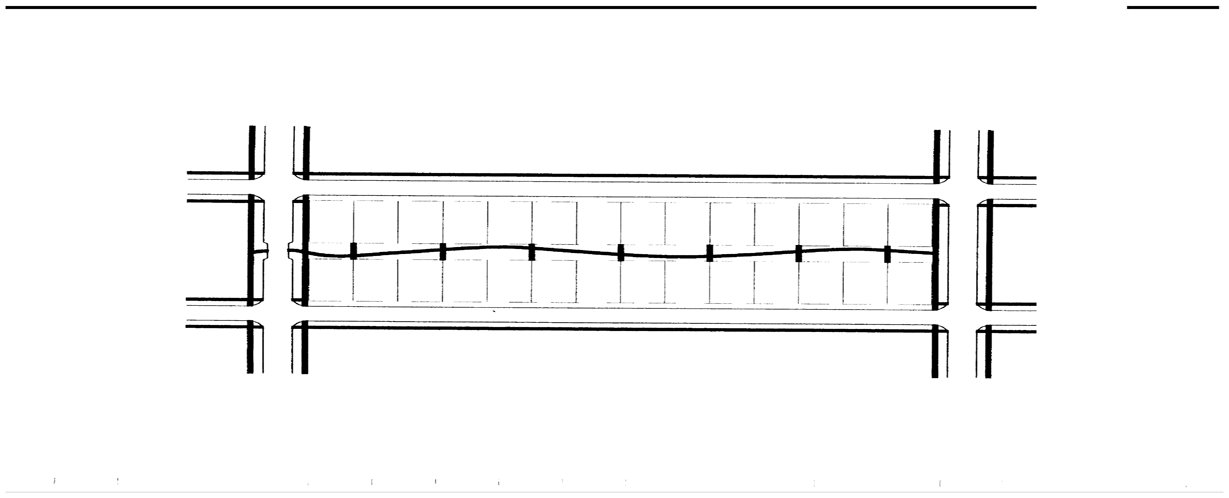
Alternative Sidewalk Plan
Sidewalk waivers may be granted at the time of approval of a subdivision if a substitute
pedestrian way or trail is incorporated that provides substantially equal service
to a sidewalk on a block face (even when there are more than 12 dwelling units per
block). An example would be a mid-block trail, pedestrian way or bike path. Pedestrian
ways or trails that tend to force mid-block pedestrian crossings should be avoided
or be given special design consideration.
Figure 20-0609-5
Sidewalk Alternative
D.
Rural Subdivisions and City Consolidations
If the City annexes a rural subdivision or consolidates with an incorporated community
a temporary waiver for the entire subdivision may be granted for up to 10 years, after
which the subdivision will be subject to the same regulations that apply in the rest
of the City. This guideline may be superceded by the applicable annexation or consolidation
agreement.
E.
Timing of Sidewalk Construction
Sidewalk installation will not be ordered in until street improvements such as paving,
curb and gutter are constructed.
F.
Missing or Conflicting Guidelines
When conditions arise that are not covered by the Sidewalk Waiver Guidelines of this
section, or where guidelines suggest contradictory solutions, the Planning Commission
will make a determination that best reflects the general intent of the guidelines.
Such determination will be kept on file and used in similar cases.
G.
Effect of Existing Sidewalks
The construction and existence of sidewalks that would have been eligible for consideration
for a waiver do not create by their existence the automatic requirement for a sidewalk
that would also be eligible for a waiver. The City may evaluate such requests as though
all the eligible sidewalks had been waived on the condition that reasonable continuity
and consistency of pedestrian service is provided.
Source: 4700 (2009).
§20-0610 - River Easements and Watercourse Setbacks
A. Maintenance easements shall be established on all land within 40 feet of the Mean High Water Line of all rivers and legal drains. Improvements shall be allowed within such maintenance easements, provided that the City shall be granted authority to temporarily occupy such easements when necessary to conduct maintenance work on the adjacent river or drain.
B. All Final Plats prepared for recording shall:
1.
Show the extent of any minimal or limited disturbance zone setbacks on the subject property by metes and bounds and be labeled as "Minimal Disturbance Zone Setback" or "Limited Disturbance Zone Setback"
2.
Provide a note to reference the minimal or limited disturbance zone setbacks stating, "There shall be no clearing, grading, construction or disturbance of soil and/or native vegetation except as permitted by the ordinances of the city of Fargo"
3.
Provide a note to reference any protective covenants governing all minimal or limited disturbance zone setbacks, "Any minimum or limited disturbance zone setbacks shown hereon are subject to protective covenants which may be recorded in the Office of the Recorder for Cass County and which restrict disturbance and use of these areas."
C. All minimal or limited disturbance zone setbacks must be protected during development activities. Prior to the initiation of development activities, the minimal and limited disturbance zone setbacks shall be surveyed and iron pins set in the ground on side lot lines and adequate visibility of the minimal or limited disturbance zone setbacks shall be provided by staking and flagging.
D. Minimal or limited disturbance zone setbacks shall be established and maintained through a declaration of protective or restrictive covenant, which must be submitted for approval by the board of city commissioners. The covenant shall be recorded in the Office of the Recorder for Cass County and shall run with the land and continue in perpetuity and may not be amended or terminated without approval of the city.
E. All lease agreements pertaining to parcels with MDZS areas, LDZS areas, or both areas, must contain a notation regarding the presence and location of protective covenants for minimal or limited disturbance zone setbacks, and must contain information on the management and maintenance requirements for the minimal or limited disturbance zone setbacks for the tenant.
F. No subdivision may be approved without a notation and delineation of an area One Hundred Seventy-Five (175) feet from the centerline of any legal drain and the applicant for subdivision approval will be required to dedicate such areas to the public for purposes of such drain.
Source: 4818 (2012).
§20-0611 - Streets
A.
General
Streets must be graded and improved in accordance with the standards of this section
and the design and construction standards of the City Engineer.
1.
All streets must be properly integrated with the existing and proposed system of thoroughfares and dedicated right-of-ways as established on the Official Map, Comprehensive Plan, or as determined by the Board of City Commissioners.
2
All thoroughfare capacity must be properly related to special traffic generators such as industries, business districts, schools, churches, shopping centers, population densities, and to the pattern of existing and proposed land uses.
3.
Local streets must be laid out to conform as much as possible to the topography, to discourage use by through traffic, to permit efficient drainage and utility systems, and to require the minimum number of streets necessary to provide convenient, safe access to property.
4.
Streets must be extended to the boundary lines of the subdivision, unless prevented by topography or other physical conditions.
5.
In business and industrial developments, the streets and other access ways must be planned in connection with the grouping of buildings, location of rail facilities, and the provision of alleys, truck loading and maneuvering areas, and walks and parking areas so as to minimize conflict of movement between the various types of traffic, including pedestrians.
B.
Rural and Urban Standards
The City Engineer will provide separate street standards for rural and urban subdivisions.
C.
Frontage on and Access to Streets
No subdivision may be approved unless the area to be subdivided has frontage on and
access to a street shown on the Official Map, or unless such street is:
1.
An existing state, county, or township highway; or
2.
A street designed and constructed in accordance with the standards of this Article and shown on a plat approved and recorded in accordance with the procedures of Sec. 20-0907.
D.
Access to Arterials
Where a subdivision borders on or contains an existing or proposed arterial, the Board
of City Commissioners may require that access to such streets be limited by one of
the following means (See also Sec. 20-0702):
1.
The subdivision of lots so as to back onto the arterial and front onto a parallel street of a lower functional classification. In such cases, direct access to the arterial may be prohibited, and screening must be provided in a strip of land along the real property line of such lots.
2.
A series of cul-de-sacs, U-shaped streets, or short loops entered from and designed generally at right angles to such a parallel street, with the rear lines of their terminal lots backing onto the arterial.
3.
A marginal access or service road that is separated from the arterial by a planting or grass strip and having access thereto at suitable points.
E.
Reserve Strips
Reserve strips are not permitted adjacent to a proposed street in such a manner as
to deny access from adjacent property to such street.
F.
Construction of Streets and Dead-End Streets
1.
Streets must be arranged to provide for the continuation of principal streets between adjacent properties. If the adjacent property is undeveloped and the street must be a dead-end street temporarily, the right-of-way shall be extended to the property line. A temporary circular turnabout must be provided on all temporary dead-end streets, with the notation on the subdivision plat that land outside the normal street right-of-way shall revert to abutting property owners whenever the street is continued. The Board of City Commissioners may limit the length of temporary dead-end streets in accordance with the design and construction standards of the City Engineer.
2.
Where a street does not extend to the boundary of the subdivision and its continuation is not required by the City Engineer for access to adjoining property, its terminus shall not be nearer to such boundary than 50 feet. However, the Board of City Commissioners may require the reservation of an appropriate easement to accommodate drainage facilities, pedestrian traffic, or utilities. A cul-de-sac turnaround shall be provided at the end of a permanent dead-end street in accordance with the City Engineer's construction standards. For greater convenience to traffic and more effective police and fire protection, permanent dead-end streets shall be limited in length in accordance with the design standards of the City Engineer.
G.
Geometric Standards
The geometric design standards of this section apply to all streets.
1.
Right-of-Way and Pavement Widths
The right-of-way and pavement width standards of Table 20-0611-1 apply to all streets.
Table 20-0611-1
2.
Backing onto Arterial Streets
Driveways must be designed and arranged so as to avoid requiring vehicles to back
on to arterial streets.
Source: 4331 (2003), 4367 (2003), 4695 (2009).
3.
Grades, Curve Radii and Other Standards
The street grade, curve radii and other standards of Table 20-0611-1 apply to all
streets.
Table 20-0611-2
___________
The Planning Commission may approve waivers from the cul-de-sac length standards with
it finds (1) that extraordinary hardships or practical difficulties will result from
strict compliance with the cul-de-sac length standards and (2) that the purposes of
these regulations will be served to a greater extent by an alternative proposal. Waiver
requests shall be considered during the Subdivision Plat review process.
H.
Surfacing.
Curbs, gutters and streets must be installed as prescribed by the regulations of this
Article. The surfacing shall be of such character as is suitable for the expected
traffic and in harmony with similar improvements in the surrounding areas. Types of
pavement shall be as determined by the City Engineer. Adequate provision shall be
made for culverts, drains, and bridges. The cost and benefit allocation to be determined
by Special Assessment Commission.
I.
Curbs
The curb standards of Table 20-0611-3 apply to all streets.
Table 20-0611-3
J.
Railroads and Limited Access Highways
Subdivisions adjacent to railroad rights-of-way or limited access highways shall be
treated as follows:
1.
Residential Districts
In UMU, MR-3 and more restrictive districts a buffer strip at least fifteen (15) feet
in depth in addition to the normal depth of the lot required in the district must
be provided adjacent to the railroad right-of-way or limited access highway. This
buffer must be included in the lot area owned and maintained by the owner.
2.
Nonresidential Districts
In NO and less restrictive districts, the nearest street extending parallel or approximately
parallel to the right-of-way shall be located a sufficient distance therefrom to ensure
suitable lot depth.
3.
Parallel Streets
Streets parallel to the right-of-way, when intersecting a street that crosses the
railroad or limited access highway, shall be located a sufficient distance from the
right-of-way to provide for adequate future grade separation from the right-of-way.
The minimum distance shall be established by the Traffic Engineer.
K.
Intersections
1.
Streets must be laid out so as to intersect as nearly as possible at right angles. A proposed intersection of two new streets at an angle of less than seventy-five (75) degrees is not acceptable. An oblique street should be curved approaching an intersection and should be approximately at right angles for at least 100 feet therefrom. No more than two (2) streets may intersect at any one point unless specifically approved by the City Engineer.
2.
Proposed new intersections along one side of an existing street must coincide with existing intersections on the opposite side of such street. Street jogs with center-line offsets of less than three hundred (300) feet will not be permitted, except where the intersected street has separated dual drives without median breaks at either intersection. Where streets intersect major streets, their alignment must be continuous. Intersections of major streets must be at least six hundred sixty (660) feet apart.
3.
The minimum curb radius at the intersection of two (2) local streets shall be at least twenty-five (25) feet and minimum curb radius at an intersection involving a collector street shall be at least thirty-five (35) feet. Alley intersections and abrupt changes in alignment within a block shall have the corners cut off in accordance with standard engineering practice to permit safe vehicular movement.
4.
Intersections must be designed with a flat grade consistent with good engineering practice. In hilly or rolling areas, at the approach to an intersection, a level area must be provided having not greater than a two percent (2%) grade at a distance of sixty (60) feet, measured from the nearest curb line of the intersecting street.
5.
Where any street intersection will involve earth banks or existing vegetation inside any lot corner that would create a traffic hazard by limiting visibility, the developer must cut such ground or vegetation (including trees) in connection with the grading of the public right-of-way to the extent deemed necessary by the City Engineer to provide an adequate sight distance.
6.
The cross-slopes on all streets, including intersections, shall be three percent (3%) or less.
7.
These standards shall not be construed so as to require a street design inconsistent with good engineering practice as determined by the City Engineer.
L.
Street Dedications and Reservations
1.
New Perimeter Streets
Street systems in new subdivisions must be laid out so as to eliminate or avoid new
perimeter half streets. Where an existing half-street is adjacent to a new subdivision,
the other half of the street must be dedicated by the subdivider. The Board of City
Commissioners may authorize a new perimeter street if the subdivider dedicates the
entire required street right-of-way within the subdivision boundaries.
2.
Widening and Realignment of Existing Streets
Where a subdivision borders an existing street of substandard width or when the Comprehensive
Plan, Official Map, or zoning setback regulations indicate plans for realignment or
widening a street that would require use of some of the land in the subdivision, the
applicant will be required to dedicate such areas for widening or realignment of such
streets. Land reserved for any street purposes may not be counted in satisfying zoning
district setback or lot area requirements.
Source: 4695 (2009).
§20-0612 - Waivers
The Planning Commission shall be authorized to recommend and the Board of City Commissioners shall be authorized to approve Modifications or Waivers of the Subdivision Design and Improvement Standards of this article in accordance with the Subdivision Waiver provisions of Sec. 20-0907.
Source: 2985 (1999), 5179 (2018).