
Flagler Beach City Zoning Code
SECTION 2
04.02.7.1. Downtown Design Guidelines Regulations.
Section 2.04.02.10. Use of wetlands in calculating density requirements.
In computing the density requirements for all zoning districts within the city, including planned unit development regulations and all subdivision regulations, all lands lying below the mean high water line of any tidal waters of the state lying within the city shall not be included in calculating density of any proposed planned development or construction. Single-family residential lots of record are exempted from the terms of this section.
Section 2.04.02.11. Temporary residential placement of mobile homes.
(a) Commission approval required. The city commission may, upon specific review, approve the temporary installation of mobile homes as living quarters for property owners only, for the purpose of temporarily residing on their lot during the construction of their homestead, for a period of not to exceed ninety (90) days. Water and sewer must be connected to the mobile home; the cost of such connection shall be paid by the property owner.
(b) Penalty for failure to remove. Failure to remove the mobile homes as a temporary living quarters at the expiration of the approval shall constitute a violation of City Code of Ordinances and be subject to the jurisdiction of the special magistrate or code enforcement board, which has the authority to impose fines on the violator of up to two hundred fifty dollars ($250.00) per day.
Overview
The City of Flagler Beach is located in southern Flagler County, approximately thirty-one (31) miles south of St. Augustine and twenty (20) miles north of Daytona Beach. The City covers approximately three and eight-tenths (3.8) square miles (two thousand four hundred twenty (2,420) acres) in area and has a population of approximately five thousand four hundred (5,400) permanent residents (2000 Census).
The RMPK Group was contracted by the City of Flagler Beach to conduct a Downtown Master Planning process, analyze the existing conditions within the Study Area, and prepare a comprehensive strategy to validate and implement the recommendations of the Charrette. The guidelines established in this report build on the recommendations presented in the Downtown Master Plan and visioning workshops during the earlier phases of the master planning process.
Objectives
The purpose of the City of Flagler Beach Downtown Design Guidelines is to provide a basis for evaluating development and redevelopment proposals and act as a guide for making decisions about public and private improvements within the boundaries of the Downtown Study Area. It is anticipated that through the use of the guidelines, both private and public projects will endeavor to preserve and enhance the form, scale, and visual character of its Downtown.
The design guidelines will provide the framework for redevelopment to gradually take place based on the community's vision for preserving its Old Florida character; and ensure that new buildings or public space will reinforce the City's unique identity. In particular, the guidelines are designed to support the following objectives in accordance with the Downtown Flagler Beach Master Plan and the Comprehensive Plan:
- Create a mixed-use environment that respects the traditional character of the Downtown.
- Provide improved visual and physical connectivity between the different land uses within the Downtown Study Area.
- Develop a distinctive and attractive visual character that is unique to the City of Flagler Beach.
- Conserve Downtown Flagler Beach's traditional residential neighborhoods.
- Establish an attractive, safe and efficient traffic circulation system that encourages pedestrian mobility in a compact urban form.
- Encourage retail oriented mixed-use development with enhanced streetscape elements within the Downtown Master Plan boundaries.
- Preservation, protection and conservation of natural resources.
- Allow design flexibility in development/redevelopment of properties in the Downtown Planning Area.
Methodology
The Downtown Master Plan designates the boundaries of the Downtown Planning area as follows: "The study area is bounded by the A1A corridor on the east, city owned properties along Flagler Avenue on the west, 9th Street North to the north and 9th Street South as the southern extent."
The Design Guidelines establish three (3) planning areas within the designated Downtown area (see Figure 1, Overlay Character Districts Map), based on existing land uses, zoning classifications, desired development characteristics and geographic locations. The three (3) areas represent distinct character districts of the Downtown that create a functional whole, each of which emulate the design guidelines, and the goals of the Community Redevelopment Agency. The character areas are as follows:
- Downtown Mixed-Use District—Provides general guidelines for commercial and mixed-use areas in the Downtown Core excluding the parcels located along the Oceanshore Boulevard.
- Downtown A1A Core Retail Corridor—Provides design guidelines for properties located along the A1A Corridor.
- Residential Neighborhoods—Includes general design guidelines for new developments/renovations of residential areas in the Downtown.
These guidelines define the physical character of each area through the establishment of site planning and architectural design standards based on the community's desired vision for its aesthetic character. These guidelines are intended to illustrate general principles that will assist the City to preserve and enhance the desired character for the Downtown. The proposed design guidelines should not be construed as prescriptive standards and it is through zoning regulations that appropriate minimum standards should be established.
The Design Guidelines also offer designers a flexible tool for quality and innovation. The guidelines are a descriptive template for maintaining and improving the urban character of downtown without dictating or prescribing a specific style or theme.
 |
| Downtown Core, Flagler Beach, Aerial View |
 |
| Downtown A1A Corridor, Aerial View |
 |
| Historic Photo, Downtown Flagler Beach |
Relationship to Other Documents
The viability of the Downtown Area has been a focus of planning initiatives reflected in the past and current city policy documents. The Downtown Design Guidelines build upon policies that are set forth in the CRA Plan for Downtown Flagler Beach. The Community Redevelopment Plan for the Downtown Area of the City of Flagler Beach identifies goals and objectives that serve as the foundation for the principles reflected in the Design Guidelines:
- Goal 1
Overall Redevelopment: Establish Downtown Flagler Beach as a focal point for the community and attract visitors from the entire region- Objective 1.1
Increase the visual attractiveness and unity of downtown Flagler Beach by identifying a common goal by 2006
- Objective 1.1
- Goal 3
Overall Land Use Goal: Foster a diversified economic base and the efficient use of land in the downtown.- Objective 3.1
Encourage the preservation and restoration of buildings of architectural significance through the review, adoption, and enforcement of a design, in accordance with the Downtown Master Plan - Policy 3.1.1
The CRA Agency shall encourage the renovation of buildings to promote commercial office and residential and or mixed use facilities within the designated CRA
- Objective 3.1
- Goal 4
Environmental Goal: Create an attractive, safe and comfortable environment that is conducive to activities during the day and evenings- Objective 4.1 Maintain city services for sidewalk maintenance and streetscapes. Continue to encourage building improvements by property owners
- Objective 4.4 Emphasize pedestrian orientation in the CRA through streetscape features, pedestrian-scale lighting and street furniture. Begin a phased program by 2006
The City of Flagler Beach Comprehensive Plan identifies the underlying general uses for land. The Comprehensive Plan's main feature for identifying uses is the Future Land Use Element. The Future Land Use Map depicts the location and extent of land uses in accordance with the categories, densities and intensities of land uses contained in this element.
The current Land Development Regulations for the City of Flagler Beach, as with older communities, encourages suburban oriented development. The current zoning specifies large front setbacks, low density, height limitations and separation of uses. The LDRs were originally established in 1981 and amended in 1987. The guidelines also build upon the City's Combined Use Ordinance to ensure consistency between the planning and regulation documents. Table 1.1 provides a brief description of the existing zoning categories found throughout the three (3) character districts.
The Design Guidelines are intended to be used as an overlay on the existing zoning categories. Overlay zoning is a technique that applies standards to a designated area that may cut across several different conventional or underlying zoning districts. While not superseding the "underlying" zoning entirely, the guidelines will provide the site design and building design standards for each of the current zoning sub-areas.
Organization of Guidelines
The Design Guidelines are organized based on the three (3) character districts identified within the Downtown Master Plan Study Area: (1) Downtown Mixed-Use District; (2) Downtown A1A Retail Corridor; (3) Residential Neighborhoods. The elements from the Land Development Regulations identified in these Design Guidelines are superseded by the proposed overlay districts. Elements not identified in the guidelines are, therefore, still the controlling regulation. The guidelines are organized around the following specific topic areas:
Streetscape Design
Streetscape Design is an integral component of the public realm improvements that will help achieve the desired character and vision for Downtown Flagler Beach. The sidewalks should be landscaped, where possible, to provide shade and aesthetic appeal and should also include streetscape elements such as brick or concrete pavers, for visual interest. At crosswalk locations, brick or concrete pavers should be used to emphasize the crosswalk area and to add to the visual appeal of downtown. Bulb-outs (see Figure 2, Intersection Design) should be integrated into the streetscape design when possible. Bulb-outs are extensions built into the sidewalk at key intersections that provide rest areas for pedestrians and also shorten the crossing distance. Because pedestrians remain on sidewalk as far as the outer edge of cars parked on the street, they have better visibility of the traffic before crossing the street and are also more visible to drivers. The expansion of sidewalks and public spaces will not only improve pedestrian connectivity, but will also provide public places for congregation. As the physical environment is improved, an increasing number of cafes and restaurants may use a portion of this space for exterior seating.
The intent of the Streetscape Design Guidelines is to provide direction for improvements to the public right-of-way that create a pedestrian friendly environment and enhance the identity of the area, complementing the recommendations of the Downtown Flagler Beach Master Plan. The principal objective of the guidelines is to promote a long-term, coordinated strategy that includes improvements to both the public and private realm to create a unified urban design theme that enhances the beach town character of Downtown Flagler Beach.
The design guidelines for the streetscape improvements employs a combination of Primary (Formal) and Secondary (Informal) streetscapes, based on a hierarchy of streets and design treatment. The Master Plan identifies the following primary streets in the Study Area that have the highest priority for implementation, and should incorporate formal design elements as discussed above:
- Moody Boulevard (Flagler Avenue to A1A)
- A1A (S. 3rd Street to N. 3rd Street)
- Central Avenue (S. 3rd Street to N. 3rd Street)
- S. 2nd Street (A1A to Daytona Avenue)
- S. 3rd Street (A1A to Daytona Avenue)
- N. 2nd Street (A1A to Flagler Avenue)
Primary (formal) Streetscape improvements in the Downtown Core should include:
- Sidewalks
- Street Trees
- Street Lights
- Signage
- Street Furniture
- Stormwater Drainage systems
- Enhanced pedestrian crosswalks
The goal of the secondary streetscape improvements incorporating "informal" design standards is to preserve the unique "beach-town" character of Flagler Beach building on the traditional landscape features. The secondary streetscape improvements will follow a phased approach based on availability of funds and includes the streets surrounding the Downtown Core. As new development occurs, opportunities to improve the pedestrian environment and aesthetics should be pursued in areas surrounding the Downtown Core with a gradual transition into the residential neighborhoods within the entire Study Area.
Objective
Maintain the traditional landscape character while incorporating formal streetscape elements to invigorate the Downtown Core as a pedestrian oriented retail environment.
I. Sidewalks
The pedestrian context of a street relies on the function and form of the sidewalks. In terms of form, a wide street with no median and/or traffic calming measures create a barrier for pedestrians while crossing the major roadways. Given Downtown Flagler Beach's civic, recreational and commercial anchors, the sidewalk network should be enhanced to create a walkable environment. Currently, four (4) to five (5) foot sidewalks are provided along sections of the arterial corridors (west side of Oceanshore Boulevard and both sides of Moody Boulevard) and along the periphery of Veteran's Park (South 2nd Street from A1A to Central Avenue and Central Avenue from South 2nd Street to Moody Boulevard). However, in most of the other areas including the residential neighborhoods, the sidewalks are not paved.
During the public workshops, the community expressed its desire to construct sidewalks within the Downtown Core to create a pedestrian environment that supports local retail businesses. In addition, the community emphasized its desire to maintain its "eclectic" beach town" character in the transitional and residential areas of Downtown.
Because of limited public rights-of-way widths available, sidewalks in Downtown Flagler Beach have been traditionally devoid of planting strips/amenity zones separating pedestrians from traffic. Physical separation from traffic is important to increase pedestrian comfort and also enhances the aesthetics of an area. Provision of sidewalks/public space should be required for mixed-use buildings within the Downtown Core as discussed in the Downtown Mixed-Use Overlay District guidelines. As defined in the Streetscape Design section, "formal design" elements should incorporate traditional materials in the overall design in order to create an environment that is sensitive to the traditional character of Downtown Flagler Beach.
Paving is an important unifying element in streetscape design. Using pervious paving materials such as crushed coquina stone and open paving blocks to minimize runoff and increase infiltration is preferred. While resurfacing existing sidewalks, porous concrete or concrete modular pavers with gapped joints that allow water to percolate should be used.
II. Street Trees
Street trees provide shade, buffer wind, and help reduce stormwater runoff in heavy pedestrian traffic areas. Trees also serve as buffers between automobile traffic and pedestrians, creating a more aesthetically pleasing walkable environment. Tree placement should respond to the local conditions and functional character of the uses on the street. Other factors that affect the tree planting include the volume of pedestrians, sidewalk design, visibility for drivers and pedestrians, and the volume of vehicles.
Considering the climatic conditions prevalent in the City of Flagler Beach, a palette of native species that are cold and salt tolerant, and wind resistant plants is recommended. (Refer to Appendix A, Landscape Palette)
III. Lighting
Pedestrian and street lighting play an important role in enhancing the pedestrian experience and greatly improves the quality and safety of streets and public spaces. Pedestrian scaled lighting design is pivotal in improving the visual character of retail oriented areas in Downtown. Pedestrian lighting consists of fixtures less than fourteen (14) feet high and should be based on the uses on a street. Street lighting is equally important in creating a safe environment. FDOT owns and maintains street lighting on Moody Boulevard and A1A. The intent of these guidelines is to encourage effective and innovative lighting to be incorporated as an integral component of each new public and private project. The use of lighting should be integrally designed as part of the built environment and should reflect a balance for the lighting needs with the contextual ambient light level and surrounding night time characteristics of Downtown Flagler Beach.
Lighting should be designed from an aesthetic and contextual perspective. Sea turtle friendly, low lights of a modest scale should be installed both in private development and public realm improvements. Lights should be located at the four (4) corners of an intersection and should relate to the desired overall character of the Downtown. (Refer to Section 4.04.04 Lighting standards for new development, Land Development Regulations for more information).
IV. Signage
The aesthetic quality of a streetscape design is affected by the visual harmony of the signs as they relate to the overall architecture and functional character of the Downtown. Signage guidelines include private business, public wayfinding and regulatory signage. All signs installed on buildings must conform to Article VII, Signs, of the City's Land Development Regulations.
V. Street Furniture
Street furniture is an important functional component of streetscape design to complete the pedestrian environment in a commercial setting. Street furnishings could include a combination of seating, trash receptacles, tree grates, bike racks, and newspaper stands. Maintenance, safety, cost, and comfort are primary considerations in the design and placement of street furniture. Street furniture may be provided when the public right-of-way allows for a clear pedestrian walking zone and separate seating areas. Furniture should also be incorporated in parking lots, public parks and plazas as part of mixed-use developments.
VI. Intersection Design
Signalized intersections and pedestrian crosswalks are currently painted along the primary corridors in the Downtown. Crosswalk materials and patterns could be a critical unifying element of the pedestrian environment in the Downtown. Crosswalk pavement should contrast with the adjacent street pavement at identified locations to reduce the speed of automobile traffic and guide the pedestrians to areas where they can cross the street safely. The City should work with FDOT to institute traffic calming measures along A1A and Moody Boulevard (SR 100) within the Downtown area.
The street sections illustrated show typical conditions that should be adjusted at the major roadways and secondary streets in the Downtown.
Parking
Parking is the most influential element in designing an efficient automobile and pedestrian traffic circulation system. During the Downtown Master Plan public workshops, the lack of convenient parking was among the primary concerns expressed by the residents and business owners. A combination of on-street parking, public parking surface lots and shared parking provisions should be incorporated to address the parking demand for Downtown Flagler Beach. Although the right-of-way widths in the Downtown are limited, on-street parking can be accommodated within most of the Downtown Mixed-Use District and A1A Commercial Retail Corridor without interrupting the sidewalk network. The parking lane also provides another layer of separation between the pedestrian and vehicular traffic.
The City of Flagler Beach Land Development Regulations address the parking and landscaping requirements for each zone district and use. All buildings and land uses, including a change, expansion or renovation of a building or change in land use, shall provide parking areas in accordance with the Schedule of Off-Street Parking Requirements, Section 2.06.02.1, Land Development Regulations and Section 5.04.00, Landscaping, Land Development Regulations.


Public Open Space
- Provide additional pedestrian area to the major public streetscape adjacent to the property. Sidewalks should be provided, abutting the property frontage extending the length of the property whether or not on-street parking is required.
- Sidewalks should be constructed per City approval and should be a minimum of six (6) feet in width.
- Provide a pedestrian environment that complements the major public streetscape design.
- When properties front on public streets, they shall be designed to provide a continuity of streetscape elements. The frontage yard between the building and the property line shall be designed to accommodate pedestrian traffic, seating or other use deemed suitable by approval of the Planning and Architectural Review Board.
- Provide visual and physical access to adjacent pedestrian areas
- Open Space such as urban plazas and internal walkways should be encouraged connecting the A1A Retail Corridor and the Downtown Mixed Use District.
|  |
| Public Open Space | Internal Pedestrian Walkway |

Architectural Styles
This section illustrates a conceptual approach to establish minimum architectural standards for future development projects. The primary goal of the Design Guidelines is to ensure that each individual site design, architectural and streetscape project contribute to the positive image of Downtown Flagler Beach.
The building elements outlined are inspired from a study of historic buildings in Downtown Flagler Beach and should be incorporated to enhance the area's unique and authentic character. The architect/developer is encouraged to provide innovative design solutions which may not meet the exact details of the guidelines. However, it is the responsibility of the architect to convince the City and the Planning and Architectural Review Board that the proposed design solutions are compatible with the traditional architectural character of the adjacent properties.
Downtown Mixed-Use District
The Downtown Mixed-Use Overlay Character District includes all lands situated between the area defined in the map on the Downtown Mixed-Use District Boundary Map. The area illustrated in the Map is defined by the CRA Boundary to the north, South 5th Street to the south, Flagler Avenue to the west, and properties east of Central Avenue, half a block west of A1A form the eastern extent. The Downtown Mixed-Use District is anticipated to support a mix of active uses at street level and low-rise medium density residential uses on the upper floors. New commercial only development in the Downtown Mixed-Use District should be consistent with the architectural and site design principles established for the Downtown Mixed-Use District.

Downtown Mixed Use District Boundary
Site Design
The intent of the site planning guidelines is to develop a system of planning criteria that would direct the future development of Downtown Flagler Beach in a more ordered environment. The guidelines aim to create an urban design framework and definition for the Downtown that provides a civic and cultural quality of life for the citizens. In addition, the guidelines reinforce and enhance the public realm improvements within the Downtown and encourage new development to provide a unified system of parking and vehicular connectivity.
Building Design
The built environment is vital in maintaining an area's visual integrity and unique character. Traditionally sized and smaller scaled buildings help to establish a pedestrian scale and also maintain the character of the Downtown. The guidelines discussed in this section are applicable primarily to properties located in the Downtown Mixed-Use Overlay District.
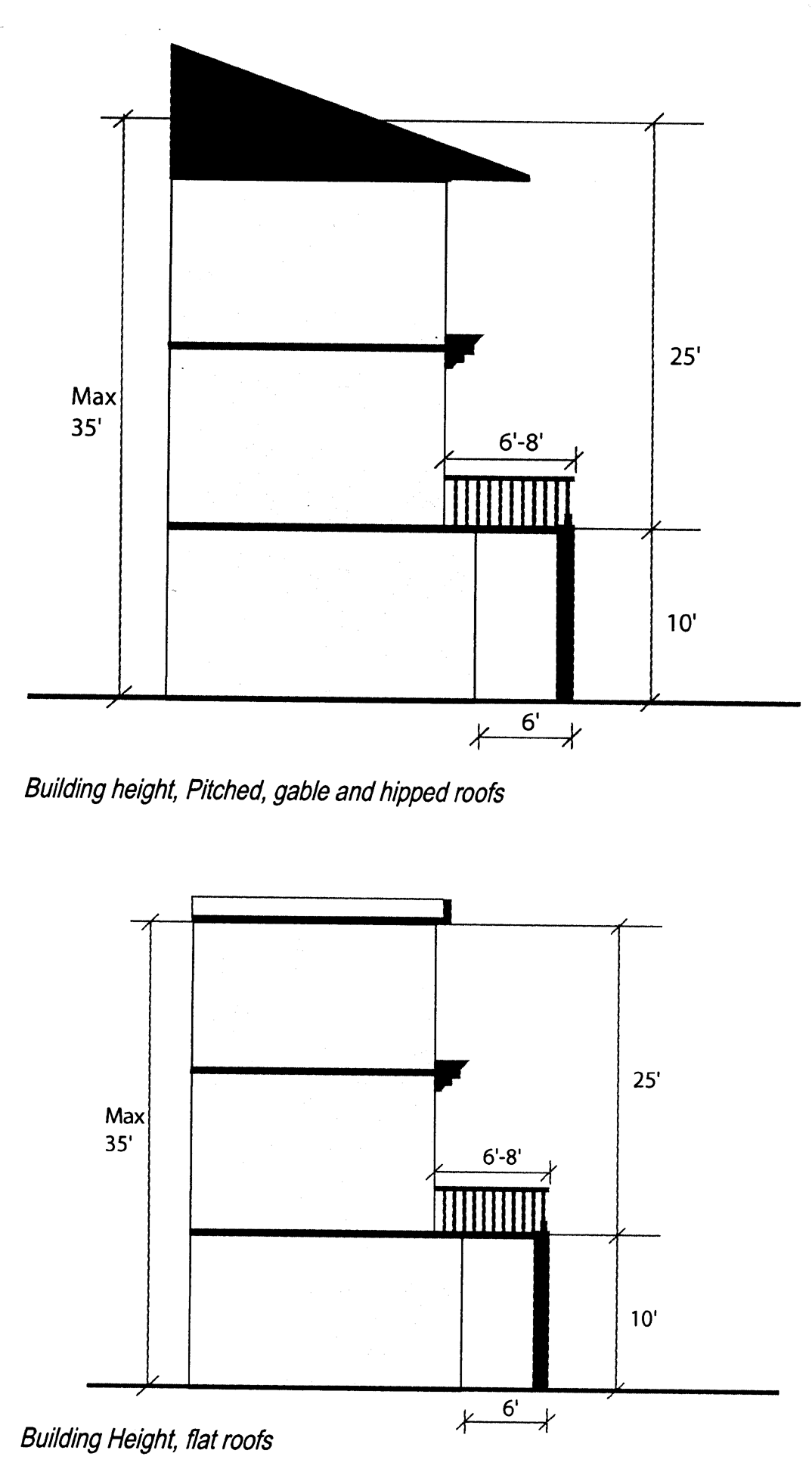
II. Building Height
Building heights are identified by the number of stories above grade and is measured as the vertical distance from the finished grade at the center of the front of the building to:
- The highest point of the roof surface for a flat roof
- To the deck line of a mansard roof
- To the mean height level between eaves and ridge for gable, hip and gambrel roofs
IV. Roofline Treatment
Roofs should be an integral part of the architectural design and form of the buildings in the Downtown.
Downtown A1A Retail Corridor
The Downtown A1A Retail Corridor includes all properties situated along Oceanshore Boulevard (A1A) between 9th Street North and 9th Street South, identified as commercial uses in the Future Land Use Map. The District is appropriate for low-rise mixed-use buildings that encourage street level uses. Several properties in this district are located seaward from the Coastal Construction Control Line (CCCL). This unique condition limits the development of mixed-use buildings in the Downtown A1A Retail District and the Master Plan anticipates the A1A as the primary retail street for Downtown Flagler Beach. Buildings have to be developed at the sidewalk edge and have transparent storefronts to enhance the pedestrian environment.
The following guidelines presents design principles and alternatives for physical improvements to new private development in the established retail corridor for Downtown Flagler Beach.
II. Building Height
Building heights are identified by the number of stories above grade and is measured as the vertical distance from the finished grade at the center of the front of the building to:
- The highest point of the roof surface for a flat roof
- To the deck line of a mansard roof
- To the mean height level between eaves and ridge for gable, hip and gambrel roofs
III. Facade Guidelines
Building facades play a basic role in the visual character of the primary retail district. Storefronts, signs, window displays and color are all integral elements of the design. Collectively improved, these elements create visual order. The facade should be intentionally designed to integrate storefront, sign and window display space into the overall fabric of the building exterior. As individual buildings stand side-by-side, visual harmony is created by the similar structural components of the buildings of various styles, age and appearance. Over the years isolated changes in facades, storefronts and signs have altered their visual relationships and have contributed to the eclectic character reflected in today's commercial business district. With proper design attention, a building's appearance from the street can be improved. Attractive individual commercial structures and signs, both old and new, are the basic building blocks of visual order.
Residential Neighborhood District
Surrounding Downtown Flagler Beach's commercial retail and mixed-use areas are traditional single-family neighborhoods. The neighborhoods reflect the traditional "eclectic" beach town character of Flagler Beach and should be preserved in all new residential development. These guidelines attempt to identify the design principles and provide guidance with respect to neighborhood context and basic design elements to develop new projects. Although the guidelines do not prescribe any architectural style, it is recommended that new development should be built upon the traditional architectural styles discussed in Chapter 2, Architectural Styles.
R - Reserved
| CATEGORY OF USE | USES PERMITTED | ||
| UNRESTRICTED USES | SPECIAL EXCEPTION USES | ||
| PRINCIPAL | ACCESSORY | ||
R - RESERVED The intent of the reserved district is to designate certain parcels into a limited use classification until such time as the owner requests a rezoning to proceed with development plans in accordance with the city's Future Land Use Plan.
Conversion from reserved to active status requires rezoning and must follow all procedures for rezoning described in this ordinance. Areas which are thus designated and which are rezoned must meet all standards and regulations of the district to which they are rezoned. |
| SEE SECTION 2.07.00 | |
P - Preservation
| CATEGORY OF USE | USES PERMITTED | ||
| UNRESTRICTED USES | SPECIAL EXCEPTION USES | ||
| PRINCIPAL | ACCESSORY | ||
P - PRESERVATION The provisions of this district are intended to protect areas of the city that, due to their special nature, are not suitable for development. The regulations in this district are intended to prevent the creation of conditions which would destroy the natural character and quality of this area. By definition, this designation will apply to those land areas which are under water as a normal condition and/or which evidence typical marshland vegetation, including, but not limited to, mangrove, spartina, batis maritima, marsh elder, glasswort and cordgrass. |
| Monopole communication towers and communication antennas which do not exceed the established height limitations. | SEE SECTION 2.07.00 |
C - Conservation
| CATEGORY OF USE | USES PERMITTED | ||
| UNRESTRICTED USES | SPECIAL EXCEPTION USES | ||
| PRINCIPAL | ACCESSORY | ||
C - CONSERVATION The provisions of this district are to allow only development that respects and safeguards the environmentally sensitive nature of the area. Development proposals in such designated areas must conform with all applicable federal and state laws and administrative regulations, including but not limited to, the Florida Department of Environmental Regulation requirements for coastal areas including saltwater marshes. No consideration of development will be given until a formal environmental impact statement is submitted to the planning and architectural review board and the city commission by all applicable state and federal agencies. |
| SEE SECTION 2.07.00 | |
SFR - Single-Family Residential
| CATEGORY OF USE | USES PERMITTED | ||
| UNRESTRICTED USES | SPECIAL EXCEPTION USES | ||
| PRINCIPAL | ACCESSORY | ||
SFR — SINGLE-FAMILY RESIDENTIAL The provisions of this district are intended to protect and preserve the single-family residential character of such areas in accordance with the principles of the Future Land Use Element of the city's Comprehensive Plan 2000.
The Mirror Lake Watershed Overlay District is created within the single-family residential zoning district in order to implement additional ordinances and restrictions to assist the district in stormwater management. [The boundaries of such district are not set out herein, but are on file and available for inspection in the office of the city clerk. For site plan requirements, see Section 2.04.02.7.] |
|
|
NOTE 1: All special exception uses are subject to Section 2.03.00, Section 2.06.01 and additional specific requirements as noted. NOTE 2: Notwithstanding Section 2.06.02(3), when a special exception has been granted for this use, all parking spaces on the residential zone property within two hundred (200) feet of the property on which the commercial use is located shall be included in the calculation of required parking spaces even though not located in the same zoning district as the commercial property. NOTE 3: The common boundary of the lot(s) shall extend the full width of the residential property to meet the requirement for such use. |
LDR - Low Density Residential
| CATEGORY OF USE | USES PERMITTED | ||
| UNRESTRICTED USES | SPECIAL EXCEPTION USES | ||
| PRINCIPAL | ACCESSORY | ||
LDR - LOW DENSITY RESIDENTIAL The purpose of this district is to delineate areas for low density residential development with densities of one (1) unit per 7,500 square feet for single-family residences and 3,750 square feet for two-family residences (see Schedule 2). This type of development is primarily intended for single-family development and other development compatible with such uses. |
|
|
NOTE: All special exception uses are subject to Section 2.03.00, Section 2.06.01 and additional specific requirements as noted. |
MDR - Medium Density Residential
| CATEGORY OF USE | USES PERMITTED | ||
| UNRESTRICTED USES | SPECIAL EXCEPTION USES | ||
| PRINCIPAL | ACCESSORY | ||
MDR - MEDIUM DENSITY RESIDENTIAL The provisions of this district are intended to apply to areas for medium density development which allows for a variety of housing types and certain other activities compatible with residential development. Density: one unit per 3,000 square feet, except where noted in Schedule 2. The regulations of this district are intended to protect and preserve the residential areas in accordance with the city's Future Land Use Map. |
|
|
(Ord. No. 2007-30, § 2, 9-27-07) |
MHP - Mobile Home Park
| CATEGORY OF USE | USES PERMITTED | ||
| UNRESTRICTED USES | SPECIAL EXCEPTION USES | ||
| PRINCIPAL | ACCESSORY | ||
MHP - MOBILE HOME PARK The provisions of this district are intended to apply to areas which consist exclusively of mobile/manufactured homes occupied as single-family dwelling units in an environment of residential character. |
| Accessory uses and structures are permitted if they are customarily accessory uses to permitted uses and structures; are located on the same lot or parcel as the mobile home park; are not likely to attract visitors in large numbers (greater than 10 percent of the park population); and involve operations or structures consistent with the character of a mobile home park, including:
|
|
TC - Tourist Commercial
| CATEGORY OF USE | USES PERMITTED | ||
| UNRESTRICTED USES | SPECIAL EXCEPTION USES | ||
| PRINCIPAL | ACCESSORY | ||
TC — TOURIST COMMERCIAL The provisions of this district are to provide for uses to serve tourist needs in the community. The primary uses are intended for commercial uses for lodging, dining establishment(s), and minor retail establishments which primarily serve tourist(s) and other visitors to the city. |
|
|
|
Note 1. Marinas allowing liveaboard vessels for nonresidential use are not allowed in any zoning district. Note 2. Once granted a special exception for residential liveaboard vessels, a marina shall not expand the number of liveaboard vessels granted unless application for a special exception for the expansion is granted by the city. Note 3. Pharmacies and medical marijuana treatment center facilities are not permitted uses within the tourist commercial zoning district. | |||
GC - General Commercial
| CATEGORY OF USE | USES PERMITTED | ||
| UNRESTRICTED USES | SPECIAL EXCEPTION USES | ||
| PRINCIPAL | ACCESSORY | ||
GC — GENERAL COMMERCIAL The provisions of this district are intended to serve the general commercial needs of the city, wherein a large variety of retail, commercial, governmental, financial, professional office services and other general commercial are permitted. The activities permitted are intended to be compatible with a pedestrian-oriented area, and uses not compatible with such an environment are discouraged. These include activities which require substantial parking requirements and generate traffic volumes which would be in conflict with the pedestrian character of the area. |
|
|
NOTE: All special exception uses are subject to Section 2.03.00, Section 2.06.01 and additional specific requirements as noted. |
LI - Light Industrial
| CATEGORY OF USE | USES PERMITTED | ||
| UNRESTRICTED USES | SPECIAL EXCEPTION USES | ||
| PRINCIPAL | ACCESSORY | ||
LI - LIGHT INDUSTRIAL The intent of this district is to provide areas which are suitable for light industrial and warehousing activities that meet such needs of the city and are in character with the residential nature of the community. This district is not intended to serve heavy industrial activities which may have objectionable or blighting influences. It is intended that all uses within this district house their activities within enclosed structures and that such uses should provide an adequate buffering treatment to adjacent residential areas. |
|
|
NOTE: All special exception uses are subject to Section 2.03.00, Section 2.06.01 and additional specific requirements as noted. |
REC - Recreation
| CATEGORY OF USE | USES PERMITTED | ||
| UNRESTRICTED USES | SPECIAL EXCEPTION USES | ||
| PRINCIPAL | ACCESSORY | ||
REC - RECREATION The purpose of this district is to provide for sites and facilities that offer leisure time opportunities to the residents of the city. It is intended that residential uses and structures will be excluded from these areas. Though a commercial use of these areas may pertain, commercial structures other than specified as accessory will be excluded. |
|
| None |
RECREATION/PUD
| CATEGORY OF USE | USES PERMITTED | ||
| UNRESTRICTED USES | SPECIAL EXCEPTION USES | ||
| PRINCIPAL | ACCESSORY | ||
RECREATION/PUD The purpose of this district is to provide for sites and facilities that offer recreational uses in conjunction with planned unit development residential projects. It is intended that this district shall apply to relatively large areas of land, generally thirty (30) acres or more, when the city finds that preserving much of the open space in the area of land while at the same time allowing reasonable residential development will best meet the recreational needs of the citizens of Flagler Beach as well as the associated residential development. | Uses: Uses permitted in the Recreation/PUD zoning district shall be those uses presently permitted in the recreation zoning district of the city, including the principal and accessory uses allowed. In addition thereto, planned unit development for residential purposes shall be permitted as a special exception use subject to the regulations applicable to special exception uses and planned unit developments generally in the zoning regulations except as modified specifically herein. The regulations concerning special exception uses and planned unit development requirements, including the procedures therein, shall apply to the Recreation/PUD zoning district; except, however, as set forth as follows: Development Standards |
| None |
| |||
(Ord. No. 97-12, 9-25-97; Ord. No. 2006-19, § 1, 6-8-06)
HC - Highway Commercial
| CATEGORY OF USE | USES PERMITTED | ||
| UNRESTRICTED USES | SPECIAL EXCEPTION USES | ||
| PRINCIPAL | ACCESSORY | ||
HC — HIGHWAY COMMERCIAL
NOTE: All commercial uses in existence at the time of the adoption date of Ordinance 2006-13, which are not in conformance with Schedule Two, Lot, Yard, and Bulk Regulations, shall hereby be deemed conforming uses |
|
|
NOTE: All Special Exception uses are subject to Section 2.03.00 Establishment of Districts, and Section 2.06.01, Special Exception uses. |
(Ord. No. 2006-13, § 2, 4-3-06; Ord. No. 2007-30, § 2, 9-27-07; Ord. No. 2007-33, § 2, 10-25-07; Ord. No. 2014-11, § 1, 5-22-14; Ord. No. 2014-12, § 1, 5-22-14; Ord. No. 2015-07, § 1, 8-27-15; Ord. No. 2017-09, § 1, 10-26-2017; Ord. No. 2020-02, § 1, 8-20-20)
(Ord. No. 2005-02, § 2, 3-24-05; Ord. No. 2005-24, § 2, 9-22-05; Ord. No. 2007-30, § 2, 9-27-07; Ord. No. 2008-08, § 2, 10-16-08; Ord. No. 2009-17, § 4, 10-8-09; Ord. No. 2014-11, § 1, 5-22-14; Ord. No. 2015-05, § 2, 6-11-15; Ord. No. 2015-07, § 1, 8-27-15; Ord. No. 2017-09, § 1, 10-26-17; Ord. No. 2022-09, § 3, 7-28-22)
(Ord. No. 2004-28, § 2, 9-23-04; Ord. No. 2005-02, § 2, 3-24-05; Ord. No. 2005-15, § 1, 7-14-05; Ord. No. 2007-30, § 2, 9-27-07; Ord. No. 2007-33, § 2, 10-25-07; Ord. No. 2008-08, § 3, 10-16-08; Ord. No. 2013-03, § 3, 2-23-12; Ord. No. 2014-11, § 1, 5-22-14; Ord. No. 2015-05, § 2, 6-11-15; Ord. No. 2015-07, § 1, 8-27-15; Ord. No. 2017-09, § 1, 10-26-2017; Ord. No. 2020-02, § 2, 8-20-20)
SCHEDULE TWO MAINLAND RESIDENTIAL AND NON-RESIDENTIAL DEVELOPMENT STANDARDS
| Zoning District | Min. Lot Size (Sq. Ft.) | Min. Lot Width at Building Setback Line (Feet) | Min. Lot Depth (Feet) | Density Sq. Ft. Per Dwelling Unit | Min. Front Yard (Feet) | Min. Side Yard (Feet) (See Note 1) | Min. Rear Yard (Feet) (See Note 2) | Max. Building Height (Feet) | Maximum Impervious Surface Coverage (% of Total Lot Area) (See Note 13) |
|---|---|---|---|---|---|---|---|---|---|
| Preservation (See Note 3) | |||||||||
| Conservation (See Note 4) | |||||||||
| SFR Single-family Residential (See Note 5) | 7500 | 75 (except for lots of record) | 100 | 7500 | 25 | 10% of lot width (See also Note 6) | 10 | 35 | 70 (See Note 7) |
| LDR Low Density Residential (See Note 5) | 7500 | 75 (except for lots of record) | 100 | 7500 for single-family 3750 for two family | 25 | 10% of lot width | 10 | 35 | 70 (See Note 14) |
| MDR Medium Density Residential (See Note 5) | Single-family Lot 7500 | 75 (except for lots of record) | 100 | 7500 | 25 | 10% of lot width | 10 | 35 | 65 |
| MDR | Two Family Lot 7500 | 75 | 100 | 3750 | 25 | 10% of lot width with 5' minimum | 10 | 35 | 65 |
| MDR (See Note 10) | Townhouse Project Lot Size 10,000 | 100 | 90 | 3000 | 25 | 10% of lot width with 10' minimum | 25 | 35 | 65 |
| MDR (See Note 10) | Multi-Family Project Lot Size 9000 | 100 | 75 | 3000 | 25 | 10% of lot width with 10' minimum | 25 | 35 | 65 |
| MDR (See Note 10) | Other Uses 7500 | 75 | 100 | 3000 | 25 | 10% of lot width with 10' minimum | 25 | 35 | 65 |
| TC Tourist Commercial | Single- or Two-Family Lot 7500 | 75 (except for lots of record) | 100 | 7500 for Single-Family 3750 for Two-Family | 25 | 10% of lot width | 10 | 35 | 70 |
| TC (See Note 11) | Townhouse Project Lot Size 10,000 | 100 | 90 | 3000 | 25 | 10% of lot width with 10' minimum | 25 | 35 | 65 |
| TC (See Note 11) | Multi-Family Project Lot Size 9000 | 100 | 75 | 3000 | 25 | 10% of lot width with 10' minimum | 25 | 35 | 65 |
| TC (See Note 11) | Non Residential Lot Size 4000 | 50 | 80 | 650 | 25 | Minimum of 7.5' | 10 | 35 | 70 |
| GC General Commercial (See Note 12) | 4000 | 50 | 80 | N/A, except when use is residential, then MDR Schedule 2 area/dwelling unit (sq. ft.) shall apply. | 25 if parking provided: 10 if not | None, except along A1A is 10% of lot width | 10 | 35 | 75 (CBD 85%) |
| HC Highway Commercial | 21,780 | 150 | N/A | N/A | 20 | 10 (See Note 8) | 15 (See Note 9) | 35 | 75 |
| LI Light Industrial | 10,000 | 100 | 100 | N/A | 30 | 35/15 | 30 | 35 | 70 |
Note 1. For corner lots minimum setback, see Section 2.05.03.1. Note 2. Twenty-five (25) feet if abutting street. Note 3. All development shall be consistent with the comprehensive plan's preservation overlay. Note 4. All development shall be consistent with the comprehensive plan's limited development overlay and Section 2.07.00. Note 5. In computing the setback requirements in all residential zoning districts, landowners may combine one (1) or more lots of record to construct a single residential unit on the lot. All setbacks shall be computed from the perimeter of the property. Note 6. On those single-family residential lots which are irregular in shape, said setback shall be determined by using the mid-point of the lot to determine width and then such side setback shall be determined as ten (10) percent of the lot width. Note 7. In the Mirror Lake Watershed Overlay District no more than fifty (50) percent of a property shall be deemed impervious including all but not limited to structures, driveways, pools, sidewalks, accessory uses, landscape enhancements or appurtenances. For those properties lying outside of the Mirror Lake Watershed Overlay District and situated within the floodplain; no more than fifty (50) percent of a property shall be deemed impervious including all but not limited to structures, driveways, pools, sidewalks, accessory uses, landscape enhancements or appurtenances. The city engineer may and can require additional testing or engineering, at the expense of the applicant. Note 8. Except where side yard is a corner lot wherein the minimum side yard shall be twenty (20) feet. Note 9. Except where rear yard adjoins a residential zoned district wherein a minimum setback of thirty (30) feet shall be required. Note 10. Mixed use district — All new multi-family residential development shall comply with the mixed use building site design and building design development standards as outlined in the downtown design guidelines; Chapter 3—Downtown Mixed-Use District. Note 11. Mixed use district — Mixed use building: See downtown design guidelines; Chapter 4—Downtown A1A Retail Corridor development standards. **Marina Area — See Chapter 3—Downtown Mixed Use District. Note 12. Mixed use district — Mixed use building: See downtown design guidelines; Chapter 3—Downtown Mixed-Use District development standards. **A1A Retail Corridor — See Chapter 4—Downtown A1A Retail Corridor. Note 13. Pavers are considered impervious and shall be included in the calculation of impervious surface coverage. Note 14. Two-family dwellings which may be permitted as a special exception use shall not exceed a maximum of sixty-five (65) percent lot coverage. | |||||||||
(Ord. No. 2007-29, § 1, 9-27-07; Ord. No. 2013-13, § 2, 10-24-13; Ord. No. 2015-05, § 3, 6-11-15; Ord. No. 2016-02, §§ 4, 5, 3-10-16; Ord. No. 2023-08, § 3, 1-11-24)
A. Residential dimensional standards.
| BARRIER ISLAND RESIDENTIAL DEVELOPMENT DIMENSIONAL STANDARDS | |||
| DEVELOPMENT STANDARD | ZONING DISTRICT | ||
| LOW DENSITY RESIDENTIAL1 | MEDIUM DENSITY RESIDENTIAL1 | HIGH DENSITY RESIDENTIAL | |
| Minimum Lot Area (sq. ft.)1, 2 | 5,000 | 5,000 | 10,000 |
| Minimum Density Per Dwelling Unit | 2 Dwelling Units Per Acre | 5 Dwelling Units Per Acre | 18 Dwelling Units Per Acre |
| Maximum Density (units/acre) | 5 | 18 | 20 |
| Minimum Lot Width at Building Setback (ft.) | 50 | 50 | 100 |
| Front Setback (ft.)3, 4, 5 | 20 | 20 | 25 |
| Side Setback (ft.)5, 8 | |||
| Interior side | 10% lot width | 10% | 15% |
| Street Side (ft.)8 | 10 | 15 | 15 |
| Rear Setback6 | 10 | 20 | 25 |
| Maximum Impervious Surface Ratio (%) (ISR)9 | 65 50 Flood Plain | 60 50 Flood Plain | 60 50 Flood Plain |
| Building Height (ft.)10 | 35 | 35 | 35 |
| Rounding Off: When calculating unit density is other than a whole number, the total number of units shall not be rounded to the nearest whole number (e.g. 5.65 u.p.a. = 5 u.p.a./5.35 = 5 u.p.a.). | |||
FOOTNOTES: Confirm location in Mixed Use District—See Downtown Design Guidelines Mixed Use Overlay District Character Area Develoment Standards
| |||
(Ord. No. 2026-03, 3-12-2026)
B. Non-residential and master planned development dimensional standards.
| BARRIER ISLAND NON-RESIDENTIAL AND MASTER PLANNED DEVELOPMENT DIMENSIONAL STANDARDS | |||||||
| DEVELOPMENT STANDARD | ZONING DISTRICT | ||||||
| GC1, 2 | TC1, 2 | PF | PRE | CON | REC | PUD | |
| Minimum Lot Area (sq. ft.) | 4,000 | 4,000 | N/A | N/A | N/A | 10,000 | |
| Density/sq. ft. Per Dwelling Unit | N/A | N/A | N/A | N/A | |||
| Maximum Density (units/acre) | N/A | N/A | N/A | 18 | |||
| Minimum Front Setback (ft.)3 | 10 | 10 | 20 | N/A | 15 | N/A | |
| Minimum Interior Side Setback (ft.) | 5 | 7.0 | 10 | N/A | 10 | N/A | |
| Minimum Street Side Setback (ft.) 4 | 10 | 10 | 20 | N/A | 15 | N/A | |
| Minimum Rear Setback (ft.) | 10 | 10 | 10 | N/A | 10 | N/A | |
| Maximum Impervious Surface Ratio (%) (ISR)5 | 70 CBD 75 | 70 | 65 | N/A | N/A | N/A | N/A |
| Building Height (ft.)6 | 35 | 35 | 35 | N/A | 35 | 35 | 35 |
FOOTNOTES:
| |||||||
A. Purpose and intent.
1. To establish an environment that emphasizes the pedestrian orientation of the area and to encourage diversity of compatible uses within the same building that may include a mix of residential uses in conjunction with compatible commercial uses.
2. To encourage development that exhibits the physical design characteristics of a storefront-style shopping, pedestrian oriented environment within downtown.
3. To permit, as opposed to mandate, mixed-use buildings with neighborhood-serving retail, service and other uses on the ground floor and residential units above the nonresidential space.
4. To provide site design and building design standards for:
a. Mixed use buildings, multi-family residential buildings and commercial buildings within the geographic boundary of the mixed use overlay district, and
b. The corresponding character areas as depicted on the official zoning map and mixed use district boundary map as provided in the downtown design guidelines.
B. General requirements.
a. Mixed use building authorization. The city shall permit, as a principal permitted use a mixed use building wherein the property of interest exhibits a general commercial or tourist commercial zoning designation, and lies within the mixed use district described as follows:
By the CRA boundary to the north, and having been further extended to North 11th Street for properties lying within the Tourist Commercial District adjacent to Oceanshore Blvd., Flagler Avenue to the west, South 5th Street to the south, and an eastern extent which begins at South 5th Street, extends to South 9th Street along Central Avenue to include all property lying one-half (½) block west of A1A, and having been further extended to South 13th Street for properties lying within the general commercial district and tourist commercial district adjacent to Oceanshore Blvd.
b. Mixed use building district development requirements.
1. All new buildings shall subscribe to the following adopted character area district development standards as established in the adopted Downtown Design Guidelines.
a. Downtown mixed use district.
b. Downtown A1A retail corridor.
c. Residential neighborhoods.
c. Development requirements. All requests for mixed use development shall be subject to the following:
i. Site plan review. Planning and architectural review board and city commission.
ii. Shall include a residential component together with those permitted commercial use listed in Section 2.04.02.12C., Permitted uses as provided in this chapter.
iii. The mix of commercial and residential uses for all new development shall be limited to the same building, with commercial uses limited to the first floor below the residential component use(s).
iv. The commercial floor area should not exceed fifty (50) percent of the gross floor area of the building.
v. The mix of residential and commercial uses shall be designed to minimize to the greatest extent practical the potential detrimental influence of commercial uses on the residential uses.
vi. Locate entranceways to minimize noise intervention between the residential and commercial use(s).
vii. Sound attenuation. The use of soundproofing materials to assure sound minimization between the commercial and residential use(s) shall be provided. Sound transmission classification technical data must be submitted at the time of site plan review application and incorporated with the building permit application. A minimum sound transmission classification (STC) rating of fifty (50) is required.
C. Permitted uses.
The following table contains a list of permitted uses in the general commercial district and tourist commercial district and further specifies whether each listed use is permitted as an unrestricted principal use (P), special exception (S) or not permitted (-) in accordance with Article II; Zoning of the Land Development Regulations.
| USE CATEGORY | General Commercial (GC) | Tourist Commercial (TC) |
| COMMERCIAL | ||
| -permitted use(s) located on the ground floor | P | P |
| -existing buildings | S | S |
| -storage (accessory to commercial use and within building enclosure) | P | P |
| RESIDENTIAL | ||
| -residential unit(s) located above the ground floor. | P | P |
| -existing buildings | S | S |
| EATERIES | ||
| -restaurants | P | P |
| -restaurants/ Open patio (See Note 1 below) | S | S |
| -cafes | P | P |
| -cafes/open patio (See Note 1 below) | S | S |
| -deli | P | P |
| -deli/open patio (See Note 1 below) | S | S |
| RETAIL SALES (ONLY) AND SERVICES | ||
| -antiques, arts, crafts | P | P |
| -computer, cell phone, electronics | P | P |
| -hardware | P | P |
| -household goods | P | P |
| -ice cream parlor | P | P |
| -pharmacy | P | P |
| -rentals (e.g. bicycles, beach chairs, surf boards, scooters) | P | P |
| -specialty store (See Note 2 definition below) | P | P |
| -thrift, consignment stores | P | S |
| PERSONAL AND BUSINESS SERVICES | ||
| -dry cleaning (drop-off and pick-up only) | P | P |
| -duplicating services | P | P |
| -eyewear | P | P |
| -fitness studio | P | P |
| -hair salon, spa, barber shop, reflexologist | P | P |
| -pet grooming (boarding not permitted) | P | - |
| -photographic studios | P | - |
| -postal services | P | P |
| -printing services | P | - |
| -shoe/watch repair | P | - |
| -travel services | P | P |
| OFFICE, PROFESSIONAL AND INSTITUTIONAL | ||
| -banks | P | - |
| -financial services | P | - |
| -educational services | P | - |
| -interior design studio | P | - |
| -professional offices | P | - |
Note 1. Outdoor serving of food and/or beverages shall be discontinued at 10:00 p.m.
Note 2. Specialty store — A small retail business offering specific and specialized types of items or focuses on selling a particular limited product range and associated items consistent with the uses permitted in the respective underlying tourist commercial district and general commercial district.
D. Prohibited uses.
a. Businesses or uses that emit intrusive odors or smoke or deemed not compatible with residential uses.
b. Drive-in type businesses that have a drive-in component as part of their operation.
c. Places of amusement such as game rooms, video arcades and similar uses.
d. Liquor stores.
E. Development standards.
| SITE DEVELOPMENT REQUIREMENTS | |
| Front | 5 feet or 10 feet |
| Side | Build to property line shall be required on one side of interior lot. |
| Side Opposite | Build-to maximum twenty (20) feet from property line. |
| Side (Corner Lot) (See Note 1) | Build to 5 feet or 10 feet on each street perimeter front. NOTE: Build to dimension shall be consistent on each street perimeter front. |
| Rear | Build to line determined by building location and arrangement of parking, but not less than 10 feet from property line. |
| Maximum Building Height | 35 feet as defined in Appendix A; Section 2.10; Definitions. |
| Maximum Lot Coverage | NA |
| Maximum Building Length | 150 feet |
| PARKING REQUIREMENTS | |
| Residential: 2 spaces per unit (on-site). | |
| Commercial: a. 1 space per 350 square feet (1.33 spaces per 800 square feet on-site). b. Off-site parking shall not exceed 40% of required on-site parking. c. Required parking calculation: Total number of spaces shall be rounded to the next higher number when a fraction thereof is greater than one-half (.50). | |
Note 1. Vehicular parking egress shall be limited to the rear of building(s).
F. Existing buildings.
A request to convert an existing structure to a mixed use building shall be evaluated as follows:
1. On a site specific basis and considered as a special exception.
2. Existing structures zoned general commercial or tourist commercial and lying within the downtown mixed use district and downtown A1A retail corridor boundary shall not be exempt from the site improvement regulations and commercial-residential use orientation specified herein unless deemed otherwise by the city based on such site considerations as the existing building(s) location, on-site parking availability and other factors affecting the reasonable application of the mixed use building site design and building design development regulations.
G. Supplemental site improvement regulations.
a. See downtown design guidelines.
i. Chapter 2 — Area-wide guidelines.
ii. Chapter 3 — Downtown mixed use district.
a. General requirements.
b. Frontage along Moody Boulevard.
iii. Chapter 4 — Downtown A1A retail corridor.
H. Parking requirements.
a. See downtown design guidelines.
i. Chapter 2 — Area-wide guidelines (on-street and off-street parking).
ii. Chapter 3 — Downtown mixed use district.
iii. Chapter 4 — Downtown A1A retail corridor.
b. Handicap parking — Shall be provided on-site the number of which shall be consistent with the requirements with the American Disabilities Act.
I. Landscaping.
Section 5.04.04, Mixed Use Building Off-Site Perimeter Landscaping Requirements:
Street trees — One (1) street tree shall be provided within the perimeter public sidewalk as provided for in the downtown design guidelines (area wide guidelines, Chapter 2). The minimum planter area shall be three (3) feet by three (3) feet to include a tree grate; the tree location, tree species, and tree grate specifications shall be standardized as approved by the city.
(Ord. No. 2005-02, §§ 2—4, 3-24-05; Ord. No. 2005-15, §1, 7-14-05; Ord. No. 2005-24, § 2, 9-22-05; Ord. No. 2007-12, § 1, 6-14-07; Ord. No. 2007-29, § 1, 9-27-07; Ord. No. 2007-30, § 2, 9-27-07; Ord. No. 2009-13, § 10, 8-6-09; Ord. No. 2009-14, § 2, 9-24-09; Ord. No. 2009-17, § 4, 10-8-09; Ord. No. 2010-16, § 1, 10-28-10; Ord. No. 2010-15, § 3, 11-18-10; Ord. No. 2015-01, § 1, 1-22-15; Ord. No. 2015-05, § 4, 6-11-15; Ord. No. 2018-02, § 3, 3-18-18; Ord. No. 2022-09, § 4, 7-28-22; Ord. No. 2023-08, § 2, 1-11-24)
Figure 1, Overlay Character Districts Map

A. Area-wide guidelines
There are some elements that should be consistent throughout the Downtown Commercial and Mixed-use districts. The following elements will provide continuity and consistency for all new development and redevelopment projects – both public and private. Notwithstanding the common elements, it is understood that some flexibility and case-by-case analysis will be required.
Common elements within the Downtown Mixed Use District and Downtown A1A Retail Corridor
- Streetscape Design
Sidewalks, Street Trees, Lighting, Signage, Street Furniture - Parking and Vehicular Circulation
- Public Open Space
- Service, Refuse, and Delivery Design
- Landscaping
- Architectural Styles
B. Building Design
The intent of the building design guidelines is to develop a system of architectural criteria to guide the future development of the established planning areas. The following elements are addressed in Downtown Mixed Use District and Downtown A1A Retail Corridor:
- Massing
- Building Height
- Facade Guidelines
- Roofline Treatment
- Architectural Elements
- Exterior Materials
C. Site Planning
The intent of the site planning guidelines is to develop a system of planning criteria to guide the future development of Downtown Flagler Beach. The guidelines provide development standards that will reinforce and enhance the relationship of each new building to the public street as well as the relationship of the new buildings to each other and to existing buildings. In addition, these site-planning standards will encourage development to provide adequate parking and vehicular connectivity.
The following elements are addressed in the Downtown Mixed-Use District and Downtown A1A Retail Corridor:
- Building Placement
- Build- To Zone
- Frontage Guidelines
- Barriers and Buffers
- Parking
TABLE 1.1, EXISTING ZONING REGULATIONS, DOWNTOWN FLAGLER BEACH
| General Commercial | Single-Family Residential | Low Density Residential | Medium Density Residential | Combined Use Ordinance | |
|---|---|---|---|---|---|
| Block and Lot Design | |||||
| Lot Area | 4000 sq.ft. minimum | 7,500 sq.ft. minimum | 7,500 sq.ft. minimum | 7,500 sq.ft. (SFR) | No minimum lot size |
| 7,500 sq.ft. (Two-family) | |||||
| 10,000 sq.ft. (Townhouse) | |||||
| 9,000 sq.ft. (Multi-family) | |||||
| 7,500 sq.ft. (Other uses) | |||||
| Width at Building Setback Line | 50 feet | 75 feet | 75 feet | 75 feet | NA |
| Depth | 80 feet | 100 feet | 100 feet | 100 feet | NA |
| Lot Coverage | 90% of total area | 40% of total area | 40% of total area | 40% of total area | NA |
| Building Setback | |||||
| Front | 25 feet minimum if parking is provided; 10 feet if not | 25 feet minimum | 25 feet minimum | Build to 5 feet or 10 feet from lot line | |
| Rear | 10 feet | 10 feet minimum | 10 feet minimum | Build to determined by building location and arrangement of parking but not less than 10 feet from lot line | |
| Side | None except along A1A. Along A1A-10% of lot width | 10% of lot width | 10% of lot width | Build-to property line shall be required on one side of an interior lot | |
| Corner | Build to 10 feet from lot line on each street perimeter frontage | ||||
| Density | 1 unit per 7,500 sq.ft. | 1 unit per 5,000 sq.ft (SFR) | 1 unit per 3,000 sq.ft. | 1 unit per 1,750 sq.ft | |
| 1 unit per 3,750 sq.ft (Two-family residences) | |||||
| % Building Frontage Required Principal Building | |||||
| 150 linear feet max. building length | |||||
| Parking Location | |||||
| Parking Requirements | |||||
| Residential | 2 spaces per unit | ||||
| Commercial | 1 space per 350 square feet | 1 space per 350 square feet (1.33 spaces per 800 square feet on-site and the remainder as per Ordinance) | |||
Illustrations
 |  |  |
| Existing Streetscape Treatment, Moody Boulevard | Pedestrian Crosswalk, A1A Corridor | Residential Streetscape Character, Downtown Flagler Beach |
 |  | |
| Existing Streetscape Treatment, Oceanshore Boulevard (A1A Corridor) | Lack of sidewalk and drainage network, Downtown Flagler Beach |
Illustrations
 |  |
| Existing Streetscape Treatment with planting Strip and sidewalk, A1A | Existing Streetscape Treatment with sidewalk and informal parking, S. 3rd Street |
 | |
| Existing Streetscape Treatment with minimal planting Strip and sidewalk, Moody Boulevard |
Design Guidelines
|  | |
 | ||
 | ||
Design Guidelines
- All selected trees should conform to the microclimate, soils, sun, budget and maintenance environment in which they are planted. Plant materials should conform to the standards for Florida No.1 or better as given in “Grades and Standards for Nursery Plants”, Part I, Current Edition, and Part II, State of Florida, Department of Agriculture, Tallahassee, or equal thereto. (Refer to Appendix A for a list of appropriate native species recommended by the TCRPC Downtown Charrette Plan)
- Consider mature tree size before planting to ensure ample room for trees to grow. Tree spread should take into consideration the available planting area.
- Use tree grates instead of planting strips/ tree lawns where pedestrian traffic is high to ensure wider sidewalks.
- Existing trees and plant material in healthy condition must be protected during construction.
- Require one (1) street tree per forty (40) linear feet or fraction thereof on the perimeter public sidewalk to include a tree grate and location approved by the City in the mixed use and commercial areas.
- Trees should not be placed closer than 25 feet from the curb at intersections and street corners within the corner triangle. Trees must not interfere with the visibility of traffic control devices especially at intersections.
Illustrations
|  |
| Cabbage Palm | Saw Palmetto |
 | |
| Cabbage Palms, Parking Lot, A1A Corridor |

Design Guidelines
- Retain the design of the existing lighting fixture.
- Metal poles and lighting fixtures should be avoided in outdoor lighting when replacing and/or installing new fixtures.
- Lighting should be designed to minimize the illumination cast on adjacent residential areas by directing the lights towards the interior of the property and/or by reducing the wattage or candle power of the lights.
- Minimize artificial lighting illuminating along the beach such that the source of light and any reflective surfaces of the fixture should not be directly visible to the beach users.
- Lights should not directly or indirectly illuminate the beach during the sea turtle nesting season.
- Single luminaries should be preferred over multiple luminaries, which should be considered only for gateway or entry points.
Illustrations
|
|
| Existing Lighting Fixture Downtown Flagler Beach | Existing Lighting Fixture Downtown Flagler Beach |
 | |
| Existing Lighting Fixture Downtown Flagler Beach |


Design Guidelines
- Signs should be visually interesting and informative. Lettering should be simple, legible and well proportioned.
- The number of signs should be limited to avoid visual clutter. Businesses should not be allowed more than two (2) signs, including wall and roof signs, but not signs painted in windows and doors.
- The illumination from signs should not overpower other signs on the street, pedestrians, and the architectural character of adjacent buildings.
- Signs should complement the architectural character of the buildings and provide a unifying element along the streetscape.
- Signs should be located so that they do not interfere with pedestrian movement or block the visibility of drivers at street corners and/ or intersections.
- Consider using symbols as signs that correlates to products or services rendered.
- Integrate signs with architectural elements.
- Design lighting and mounting hardware as an integral part of the sign.
- Sign materials should be durable and long lasting.
- Coordinate style, size and color on multiple occupancy buildings.
- Avoid pole mounted signs.
- Wayfinding signage, directional signage to parking lots, and signage identifying the Central Business District/ Downtown should be located near intersection entry points and should be designed in a consistent and easily identifiable manner.
Illustrations
 | |
 |
|

Design Guidelines
- Encourage the use of recyclable material, wind and corrosion resistant street furnishings. Wood, concrete or recycled materials are the preferred materials.
- Ensure that pedestrian seating areas are illuminated and does not interfere with plant materials or pedestrian circulation.
- Trash receptacles should be easily accessible for pedestrians and trash collection.
Illustrations
 |  |
 |  |
| |

Design Guidelines
- Clear space to handle pedestrian capacities.
- Incorporate intersection design elements including:
- Visibility to safely negotiate crossing
- Legibility of all directional information
- Accessibility and freedom from obstructions
- Separation from traffic
- Code based ramps and landings
- Traffic calming features should be utilized where traffic data and neighborhood consensus warrants.
- Consider raised brick crosswalk at identified intersections on A1A Corridor.
- Consider crosswalks with midblock pedestrian refuges along Moody Boulevard between Central Avenue and Daytona Avenue, if feasible

Illustrations
|
|
| Mid-Block Pedestrian Crosswalk, change of paving | Median landscaping |


The street sections illustrated show typical conditions that should be adjusted at the major roadways and secondary streets in the Downtown.
| Oceanshore Boulevard (A1A) | |
| Oceanshore Boulevard or A1A serves as the primary entrance to the City of Flagler Beach accommodating large volumes of traffic through the downtown. The A1A is a designated Florida Scenic Highway providing enhanced views and access to the Atlantic shoreline. Streetscape features should be designed to incorporate elements such as bulb-outs, speed tables to buffer pedestrians from traffic impacts, detached sidewalks with tree grates, improved beach access points, on-street parking and landscaping |  |
| Moody Boulevard (SR 100) | |
| Moody Boulevard connects the downtown with I-95 and the Bunnell and Palm Coast via the SR 100 Intracoastal Bridge. Currently, Moody Boulevard lacks pedestrian character and physically bisects the northern and southern parts of the Downtown. Streetscape treatment should emphasize well-designed pedestrian crosswalks linking the north and south sides of the roadway. This should also include landscaped medians, street lighting, tree planting, and where possible trees defined by grates in the sidewalk |  |
| Central Avenue | |
| Central Avenue is the local collector connecting the Downtown with the residential neighborhoods. The two-lane roadway provides the main pedestrian connections to a variety of uses including public uses (Flagler Beach Museum, Veteran’s Park, City Hall, Farmer’s Market). The existing streetscape exhibits a combination of formal and informal elements in certain sections including sidewalks, street furniture, and on-street parking. The use of similar materials, extension of sidewalks, landscaping and street trees will help unify the overall image of the Downtown. |  |
Design Guidelines - On-Street Parking
- Maximize on-street parking within the public right-of-way employing a combination of innovative strategies such as angled and parallel parking spaces, reducing the minimum stall dimensions and establishing a minimum percentage of total spaces to be designed for small cars.
- Use materials and textures to delineate parking spaces that reflect the traditional beach town character of the Downtown. Crushed coquina stone and recycled timbers are the preferred materials.
- Provide clear signage to direct traffic to on-street parking areas and public parking lots.
- When possible minimize curb cuts along street frontage by providing surface parking behind buildings to increase the on-street parking areas.
- Parking spaces should provide clear markings to indicate where drivers should park.
Design Guidelines - Off-Street Parking
Within the Downtown Mixed-Use District and Downtown A1A Mixed-Use District, a combination of off-street parking and on-street parking in accordance with the Schedule of Off-street parking requirements, the Combined Use Ordinance and the Downtown Master Plan Parking Plan is permitted to satisfy the parking requirements. On-street parking shall not exceed forty (40) percent of required off-street parking.
|  |
|
| Existing Public Parking Lot, South 5th Street | Off-street parking along street frontage | Conceptual parking placement Shaded areas indicate interconnected parking footprints |


Location
- On-street parking shall be provided along the perimeter of the development parcel, on the public right-of-way.
- Street or sidewalk areas may not be used for off-street parking purposes. Individual ingress and egress drives extending across the public sidewalks and curbs and connecting the off-street parking spaces to the public street areas shall not exceed a maximum of twelve (12) feet for a one-way drive and eighteen (18) feet for a two-way drive.
- Required off-street parking should be located on the same parcel as the uses served.
- Off-street parking shall be limited to the sides or rear of the building(s) and screened from street view with appropriate perimeter landscape material per Section 5.04.02, Criteria for parking lots and vehicular use, Land Development Regulations. No off-street parking shall be located between a building and the adjacent street frontage.
- Joint common access drives and shared parking provisions are encouraged for two or more contiguous interior lots owned exclusively or under separate ownership to enhance two-way access thereby decreasing access width from 15 feet to 12 feet for each lot.
Parking Design
- Maximum parking stall dimensions for off-street parking and on-street parking should include the following principles:
- Parallel parking space eight (8) by twenty-two (22) feet long constructed of a pervious material approved by the City.
- 60 degree or less (one-way) and 90 degree (one-way) parking space should have minimum parking dimensions of 8.6 feet wide by 20 feet long with an aisle width of 18 feet.
- 90 degree (two-way) parking should have a minimum width of 8.6 feet by 18 feet. The minimum aisle width in this case should be 22 feet.
- One (1) foot continuous concrete strip to separate the adjacent parking space from the traffic way and to maintain the integrity of the asphalt edge of street pavement extending the length of the designated parallel parking strip.
- Parking space strips separated by hard-surface material (e.g. concrete, pavers) extending the full width of the parking space per City approval.
- Shared parking requirements- The use of shared parking shall be encouraged when the development is under the control of a single owner/ developer and contains commercial, retail, office, institutional or public uses.
- Parking lot design and layout as per Section 5.04.00 Landscaping, Land Development Regulations.
- Parking should be located so that it does not break the continuity along the sidewalk.
 |  |
 |  |
| Parking configuration alternatives | |
Vehicular Circulation
- Curb cut access to property from front property line should be minimized and where possible shared parking should be encouraged.
- Vehicular access should be provided, where possible, from side streets, rear streets, alleys or adjacent properties only.
- Internal access drives should join together existing public streets and should line up with adjacent private drives.
- Internal parking lots should connect with adjacent parking lots where possible.
Location
- Service, refuse, and delivery areas should be located to the rear of the buildings with convenient vehicular access, unless facing a single-family residence or the front of another building; in which case service areas shall be shielded from view of adjacent buildings.
- Locate trash storage, loading, and truck parking so as to minimize visibility from the street/sidewalk and building entrances. Avoid locating service and loading areas along important view corridors and pedestrian traffic areas.
Screening
- All exterior trash receptacles should be screened from view.
- Screen loading docks and truck parking from public view using building mass, free-standing walls, and/or landscaping.
- Ensure that all utility equipment is located, sized, and designed to be as inconspicuous as possible. All utility runs should be located underground, wherever possible.
Applicability
The landscape standards discussed below apply to all projects and parking lots within the Downtown Mixed Use District and the Downtown A1A Mixed Use Corridor. These guidelines are not applicable to the Residential Neighborhoods. Landscaping features within the “overlay character districts” should be designed and installed in compliance with Section 5.04.00 Landscaping, Land Development Regulations (Appendix B, pg. 63). These guidelines are intended to supplement the City’s existing codes relating to the landscaping requirements.
Design Guidelines
- Landscaping improvements in the area between the building and the property line abutting the public sidewalk should utilize native vegetation and plantings approved by the Planning and Architectural Review Board.
- Street trees should be included in the planting strips in all new developments and public realm improvements. (Refer to street trees on pg. 16).
- Groundcovers in planting areas shall be consistent with adopted Streetscape Design Guidelines.
- Parking lots next to sidewalks visible from public right of way or adjacent residential areas should be dense enough to screen from headlight glare and the movement of traffic generated by vehicles using the parking area.
- Barriers and buffers should be designed such that they encourage internal pedestrian movement and vehicular movement between adjacent mixed use properties.
- Off-street parking shall have at least ten (10) percent of the total gross parking area devoted to living landscape, which includes grass, ground cover, plants, shrubs and trees. The gross parking area is to be measured from the edge of the parking and/ or driveway paving and sidewalks, extended five (5) feet in all directions, but is not to include any area enclosed by the building or covered by a building overhang.
- When an accessway intersects a public right-of-way or when the subject property abuts the intersection of two (2) or more public rights-of-way, all landscaping shall provide unobstructed cross-visibility, provided they are located so as not to create a traffic hazard. Landscaping, except required grass or ground cover, shall not be located closer than three (3) feet from the edge of any accessway pavement or sidewalk or walk path.
Appropriate Architectural Styles
While the architectural requirements do not recommend a specific design theme for buildings, it is encouraged that projects proposed in the Study Area must select one of the four main architectural styles in each Character District. In order to assure architectural diversity and to maintain the eclectic character of the community, it is recommended to incorporate a combination of architectural styles on any combination of buildings that exceed 150 linear feet of frontage on a single lot, or combination of lots, the enforcement of which, is subject to approval by the Planning Director and the City of Flagler Beach Planning and Architectural Board. The four architectural styles recommended for the Study Area include:
- Florida Frame Vernacular
- Key West Caribbean Style
- Bungalow Style
- Classic Revival
Florida Frame Vernacular
Florida Vernacular or "Cracker" style refers to the traditional style of wood construction commonly used in residential dwellings and plantation homes. The architectural characteristics common to this typology are the "wood-frame construction and the large attached front porch, the steep roof, revealed fireplace, horizontal wood siding, double hung vertical windows and the elevated first floor". This style is characterized by simple architectural elements with minimal ornamentation and detailing and promotes energy conservation and efficiency.
| Characteristics | |
The façade should contain a minimum of five of the following façade design elements for the Florida Vernacular Style (Refer to illustrations):
|
Front Elevation, Frame Vernacular |

| Examples | |
 |  |
Caribbean "Key West"
The Caribbean style is associated with symmetrical wooden or masonry facades and its characteristic elements include awnings and gable roof with overhanging eaves; wide porches with ornamental railings, balconies and metal seam roofing finish. This style often has multistory buildings (two (2) to three (3) stories) with architectural elements suited to the region's climate including roof hatches for ventilation and window louvers.
| Characteristics | |
The façade should contain a minimum of five of the following façade design elements for the Caribbean Style (Refer to illustrations): 1. Tile/ Seam Metal/ Slate Roofing |
Front Elevation, Caribbean Style |

| Examples | |
 |  |
Railing Detail: Scroll sawn gingerbread railing |
Window Detail: Shutters/ louvers over six by six |


Bungalow Style
The Bungalow Style generally has a rectangular ground plan, with the narrowest side oriented toward the street. The style has gently sloping gable roofs that face the street. A variety of exterior materials are employed including weatherboard, shingles, and stucco. There are often lattice roof vents in the gable ends. The porches are dominated by short, oversized, tapered or square columns which rest on heavy brick piers connected by a balustrade. Rafter ends are usually exposed and often carved in decorative patterns to combine structure and ornament.
| Characteristics | |
The façade should contain a minimum of three of the following façade design elements for the Bungalow Style (Refer to illustrations on the left and bottom):
|
Conceptual Sketch, Front Elevation, Bungalow Style |

| Examples | |
 |  |
Classic Revival
From 1890—1930, the Classic Revival style was associated with major public buildings and private residences designed by trained architects.
This style can be seen in a number of different building types within the State of Florida. Some were built as early as 1890's but this style did not gain wider popularity until the early 1900's. Over the following decades Classic Revival influenced the design of both commercial and public buildings such as courthouses and especially banks. This style can be seen in the Old Moody Hotel building. (Refer to illustration below.)
| Characteristics | |
The façade should contain a minimum of three of the following façade design elements for the Classic Revival Style:
|
Conceptual Sketch, Front Elevation, Classic Revival Style |

| Examples | |
 |  |
Goals
The urban design goals for this district are:
- Enhance the pedestrian scale environment while retaining the eclectic beach town character.
- Develop strong linkages between the residential neighborhoods and the Downtown.
- Create a harmonious character that incorporates the City's historical and cultural heritage.
- Provide flexible site development principles while maintaining a high level of aesthetic element.
- Maintain a sense of connection with the traditional single-family houses while accommodating a mix of residential and beach oriented commercial uses.

Existing Design Character, southwest corner of Central Avenue and S. 2nd St.
Scope
The Downtown Mixed-Use District contains varying types of lot sizes and configurations ranging from parcels fronting the arterial roads and secondary streets to interior lots and vacant lots covering the entire blocks. The development proposals should be evaluated on a site-specific level because of the variations in lot sizes and orientation and the unique conditions presented by each individual parcel. The following lot configurations have been taken into consideration in the development of design guidelines for the Downtown Mixed-Use District:
- Interior Lots—fifty (50) feet by one hundred (100) feet
- Corner Lots
- Frontage along major arterial roads (Moody Boulevard)
- Redevelopment opportunities at block level
Uses
Permitted Uses | Prohibited Uses |
Commercial Uses located on the ground floor. | Businesses or uses that emit intrusive odors or smoke or deemed not compatible with residential uses. |
Residences located above the ground floor. | Drive-in type businesses that have a drive-in component as part of their operation. |
Retail business involved in the sale of merchandise on the premises to be taken off the premises for use by the customer such as: | Places of amusement such as game rooms, video arcades and the like. |
Personal and business services, such as: | Liquor stores. |
All uses permitted shall be conducted wholly within a building except those uses permitted which are customarily conducted in the open such as: | |
Storage shall be limited to accessory storage of commodities sold at retail on the premises and storage shall be within a completely enclosed building. | |
Restaurants as defined. No outdoor serving of food, drink or the like after 10:00P.M. Open patio restaurants. |
Applicability
- All new development within this district should include residential uses in conjunction with permitted principal uses specified in Section 2.04.02.12 Combined Use Building Regulations, Land Development Regulations.
- The commercial floor area of the uses should not exceed fifty percent (50%) of the gross floor area of the buildings.
- The mix of uses should be limited to the same building, which includes business uses limited to the first floor below the residential uses
- The mixture of residential and commercial uses within the building should be designed so as to minimize to the greatest extent practical the potential detrimental influence of commercial uses on the residential uses, including the location of entranceways and the use of soundproofing materials to minimize noise intervention between uses.
1. Building Placement
Interior Lot
Location
- Locate buildings to the front of the property at the sidewalk’s edge.
- Maximize street frontage for the building.
Corner Lot
- Buildings on corner lots should be oriented to the street corner and the pedestrian street.
- Maximize the street frontage of the building.
- Building corner design at intersecting streets of corner lots shall be situated on a diagonal axis to establish architectural character and building frontage ingress/egress and to accommodate a line of vision for vehicular traffic from two streets.
2. Minimum Lot Size:
None
3. Build-To Line
Build-to lines are established for each property to ensure that building placements clearly define street edges and corners. The build-to line is the line parallel to the property line along which the facade of the building must be located. The maximum front build-to line requirements shall apply to the first story of the building, and higher portions of the building maybe stepped back further from the front property line.
Interior Lot
Front Line: Five (5) feet or ten (10) feet
Side Line: Build-to property line on one (1) side
Rear Line: Build-to determined by building location and arrangement of parking
Corner Lot
Front Line: Five (5) feet or ten (10) feet
Side Line facing street: Five (5) feet or ten (10) feet
Rear setback facing street: Build-to determined by building location and arrangement of parking
4. Frontage Guidelines
Front: Minimum of sixty (60) percent of the property line to be building; minimum of seventy-five (75) percent frontage if shared access
Side frontage (not facing street): Minimum of seventy (70) percent of the side property line to be building
Side frontage facing street: Minimum of sixty (60) percent of the side property line to be building
Rear frontage (not facing residential street): Maximum forty (40) percent of the rear property line may contain building
Barriers and Buffers: There should be no barriers between properties within the Downtown Mixed-Use Overlay District
5. Parking
Refer to Chapter 2, Area Wide Guidelines, VI Intersection Design Parking, for parking design guidelines.
Maximum amount of off-street parking permitted for all uses in the proposed Mixed-Use Districts shall be as follows:
Residential Uses: On-site two (2) spaces per unit as per Section 2.06.02.1 Schedule of Off-Street Parking Requirements.
Commercial Uses: 1.33 spaces per eight hundred (800) square feet to be provided on-site.
| Site Design: Interior Lot |
 |
| Front Line: 5’ or 10’ |
| Side Line: Build to property line on one side |
| Rear Line: Build-to determined by building location and arrangement of parking but not less than 10’ from property line |
| Ground Floor Commercial: 1000 sq. ft |
| Second Floor Residential: 1350 sq. ft. |
| Total Parking Spaces: Commercial: 2 Residential: 2 On-Street Parallel Parking: 1 |
| Site Design: Corner Lot |
 |
| Front Line: 5’ or 10’ |
| Side Line: 5’ or 10’ |
| Rear Line: Build- to determined by building location and arrangement of parking. |
| Ground Floor Commercial: 1,000 sq. ft |
| Second Floor Residential: 1,350 sq. ft. |
| Total Parking Spaces: Commercial: 2 Residential: 2 On-Street Parallel Parking: 1 |
| Site Design: Block |
 |
SITE DESIGN: FRONTAGE ALONG MOODY BOULEVARD
Interior Lot
Location
- Locate buildings to the front of the property.
- Maximize street frontage for the building.
Corner Lot
- Buildings on corner lots should be oriented to the street corner and the pedestrian street.
- Maximize the street frontage of the building.
- Building corner design at intersecting streets of corner lots shall be situated on a diagonal axis to establish architectural character and building frontage ingress/egress and to accommodate a line of vision for vehicular traffic from two (2) streets.
| Site Design: Frontage Along Moody Boulevard |
 |
Minimum Lot Size: None Front Line: Zero (0) feet or five (5) feet Side Line: Build to property line on one (1) side Rear Line: Build- to determined by building location and arrangement of parking but not less than 5’ from property line |
Guidelines
- All new development, additions and/or renovations should reflect the traditional development patterns and strive to encourage an efficient pedestrian oriented environment.
- New buildings should incorporate a clear division between street level and upper floors through a change of architectural elements, materials, and/or color.
Use architectural features to accentuate the eclectic character of Downtown Flagler Beach when possible. When possible relate entries, window lines, awnings and canopies, and sign locations to adjacent buildings.
Relate to adjoining residential neighborhoods with scale, detail and material at the edges of the Downtown Mixed Use District.
Intent
Buildings that appear similar in mass and scale to other buildings in the Downtown will help to maintain the unique beach town character. It is important to maintain a variety of heights to create visual interest. One, two and three story buildings should form the primary architectural character of the Downtown, with taller architectural elements located at corner buildings to emphasize the importance of intersections and create diversity in scale and character.
- In order to minimize the perceived size of a building, step down its height toward the street, neighboring structures and the rear of the lot.
- In order to break up the perceived mass of structure, divide it into modules that are similar in size to buildings seen traditionally.
Guideline: Vertical Setbacks
- Front:
There should be a minimum setback of six feet - (6’) between the 2nd and 3rd floor of the building, when possible. - Side facing a street:
There should be a minimum setback of six feet - (6’) between the 2nd and 3rd floor of the building, when possible. - Side facing a property line:
Between the 2nd and 3rd floor of the building, no minimum setback is required. - Rear:
Between the 2nd and 3rd floor of the building, no minimum setback is required.
Bands of Composition
- Buildings should be designed to establish the following three bands of vertical composition:
- Base (1 story),
- Mid-section (2nd and 3rd stories),
- Top (Roof)
Design Guidelines
- Building height shall not exceed thirty five (35) feet above the finished grade for flat roofs and mean height level between eaves and ridge for pitched, gable and hipped roofs.
- The ground floor shall not be less than ten (10) feet from the finished floor to finished ceiling. Above the ground floor, a story is defined as a habitable level no more than 12 feet in height, the additional height will count as an additional story.
- The proportional relationship of height and width should be consistent between adjacent structures
- The height of buildings should not drastically alter the scale of the Downtown.
Guideline: Facade Composition
There should be a side setback adjacent to the property line of five feet (5’) for buildings with a front facade longer than 100’.
Buildings on a single lot or combination of lots shall not exceed a continuous massing longer than 150 feet. In order to assure architectural diversity and to maintain the eclectic character of the community, no single architecture style shall be duplicated on any combination of buildings that exceed 150 linear feet of frontage on a single lot or a combination of lots.
On the ground floor of the primary facade, there shall be a minimum of two breaks for every 40’ of front elevation
Guideline: Relationship to Existing Building
If a new building is to be placed adjacent to an existing taller building, then the part of the new building that is closest to the existing building should be the tallest part of the new building’s elevation, unless the existing building is considered obsolete or non-conforming.
If a new building is to be placed adjacent to an existing shorter building, then the part of the new building that is closest to the existing building should be the shortest part of the new building’s elevation, unless the existing building is considered obsolete or non-conforming.
Guideline: Fenestrations
Blank Wall Guidelines
Walls or portions of walls where windows are not provided shall have architectural treatment wherever they face adjacent streets or adjacent residential areas. At least three of the following elements shall be incorporated into a design to achieve the mitigation of the visual impact of the blank wall areas.
- Horizontal architectural banding at story breaks
- Horizontal siding
- Vertical and diagonal clapboards
- Projecting canopies
- Projecting eaves
Guideline: Fenestration Ratio
Encourage largely transparent, open and inviting facades at the lower levels (ground floor) of the building to accentuate pedestrian environment.
Encourage a greater ratio of solid wall to window allowing for more variety of architectural material and elements at the upper floors. Approximately 25- 40% window to wall ratio is desirable in the facade area for each building facade area adjoining a street.
a. Guideline: Overall Roof Design
Variations in rooflines should be used to add interest to and reduce the massing of buildings. Roof features should be in scale with building mass and should complement the character of adjoining or adjacent buildings and neighborhoods. Roofing material should be constructed of durable high quality materials in order to enhance the appearance and attractiveness of the community.
b. Guideline: Roof Edge and Parapet Treatments
For buildings with a sloping roof: The roof edge or parapet should have a vertical change (minimum of 3 feet) from the dominant roof design at least once per 40 feet on the first floor. At least one such change should be located on a primary façade adjacent to a collector or arterial right of way.
c. Guideline: Roofline
For buildings adjacent to public streets, there should be a minimum of two roofline breaks per 40’ of frontage above the first floor.
Roof Eaves
The roof eaves may encroach a maximum of 5’ on all setback lines.
Balconies
Balconies may be built 6’ into the front and side vertical setbacks above 2nd floor
Awnings, Arcades and Canopies
Awnings and Canopies on the first floor may encroach 5’ into the setback if the bottom of the awning is 10’ above the sidewalk and they should be built within the Build-to Zone of the front and side setbacks
Columns, Arches, Piers, Railings and Balustrades
Columns and piers shall be spaced at intervals of no more than 20 feet.
Exterior Materials
The following materials are encouraged for exterior building construction:
- Stucco
- Brick
- Concrete masonry units, e.g. Hardiplank
- Stone
- Wood, Clapboard siding
The following materials are prohibited for exterior building construction:
- Plastic siding
- Corrugated or reflective metal panels
- Smooth or ribbed-faced concrete block
- Wood sheeting
| Illustrations |
Illustration: Roof Eaves
|
Illustration: Arcades
|
Illustration: Awnings and Canopies
|
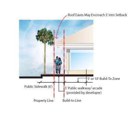
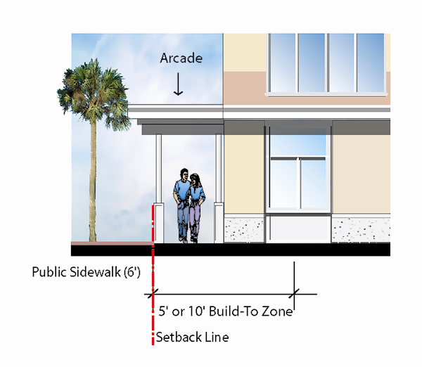
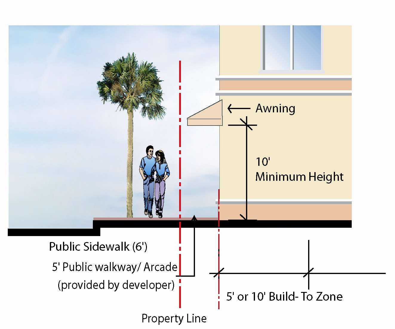
Goals
The urban design goals for this district are:
- Enhancing the pedestrian experience at the street level while retaining the existing beach town character with a variety of architectural styles.
- Locate on-site parking to minimize visibility from the sidewalk.
- Develop the ground floor level of a building to encourage pedestrian activity.
- Provide guidelines for new development and renovations that reflect the traditional historic character of the Downtown while establishing a more efficient land use and circulation pattern.
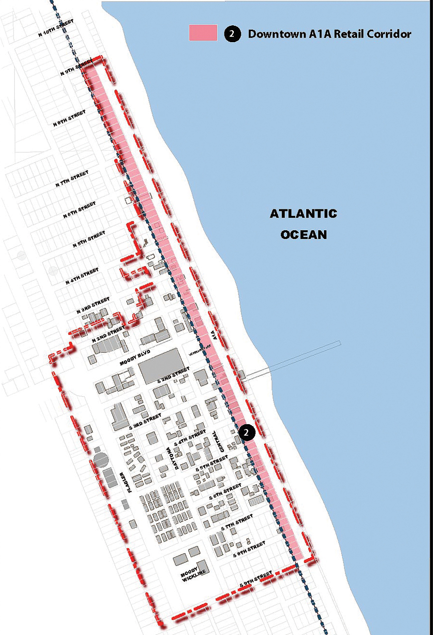
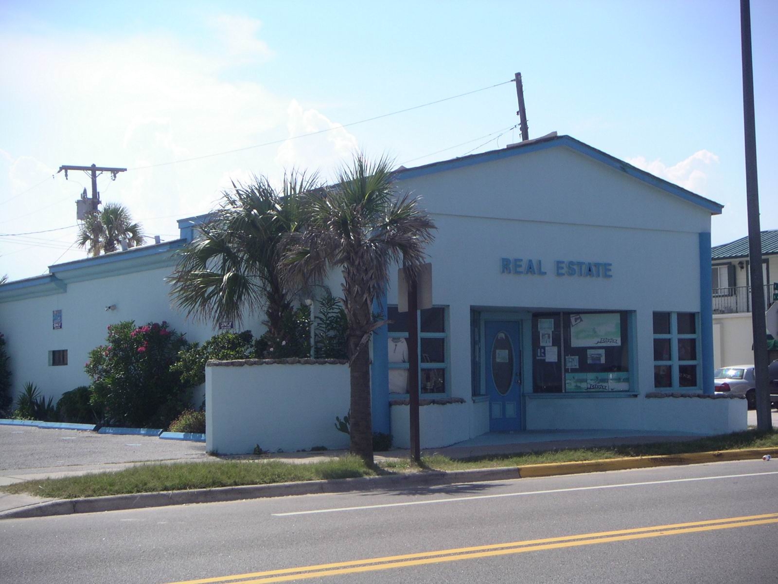 | 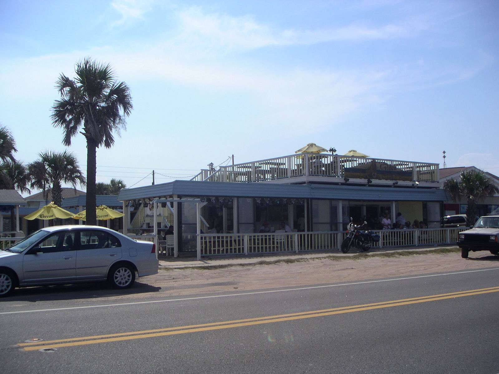 | 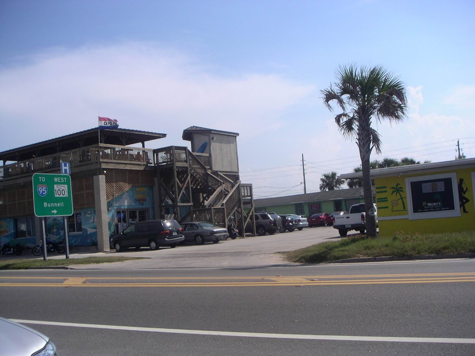 |
| Existing Character: A1A Corridor | ||
1. Building Placement
Interior Lot
Location
- Locate buildings to the front of the property at the sidewalk edge.
- Develop the ground floor level of a building level to encourage pedestrian activity.
- Maximize street frontage for the building.
Corner Lot
- Buildings on corner lots should be oriented to the street corner and the pedestrian street.
- Maximize the street frontage of the building.
- Building corner design at intersecting streets of corner lots shall be situated on a diagonal axis to establish architectural character and building frontage ingress/egress and to accommodate a line of vision for vehicular traffic from two (2) streets.
2. Minimum Lot Size:
None
3. Build-To Line
Build-to lines are established for each property to ensure that building placements clearly define street edges and corners. The build-to line is the line parallel to the property line along which the facade of the building must be located. The maximum front build-to line requirements shall apply to the first story of the building, and higher portions of the building maybe stepped back further from the front property line.
Front Line: Zero (0) feet
Side Line: Build to property line on one (1) side, twenty (20) feet on other side.
Rear Line: Build-to determined by building location and arrangement of parking.
| Site Design: Block |
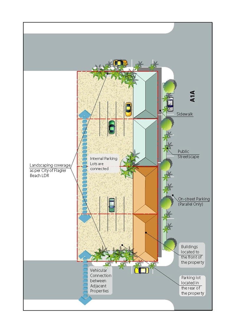 |
| Front Line: Zero (0) feet |
| Side Line: Build to property line on one (1) side, twenty (20) feet on other side. |
| Rear Line: Build-to determined by building location and arrangement of parking. |
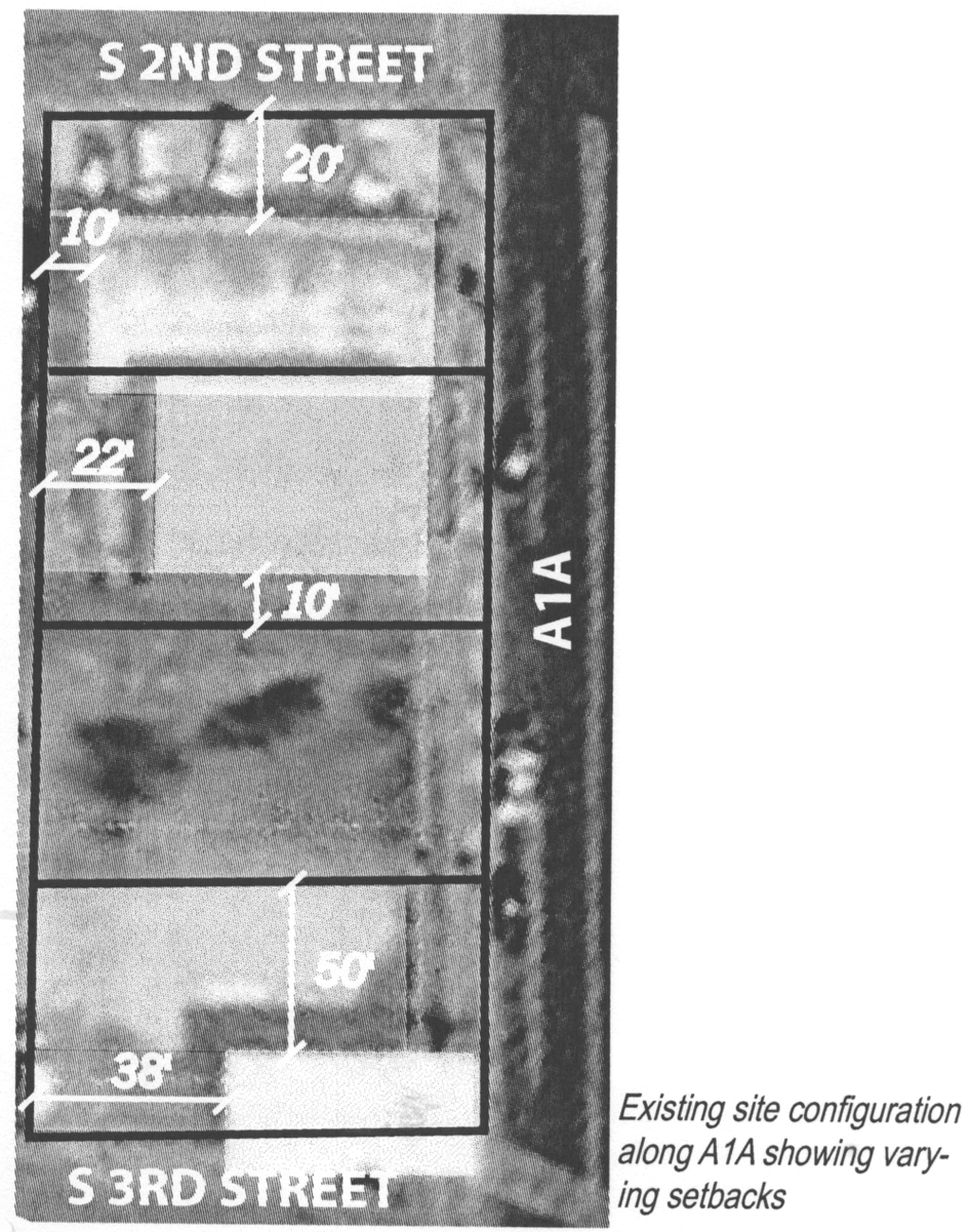 |
4. Building Frontage
- Buildings should be located at or within zero feet of the property line adjoining the street for no less than sixty-five (65) percent of street frontage. When the building is an addition to an existing structure, street frontage should be determined by the total building frontage including the original structure.
- Corner lots should apply the sixty-five (65) percent requirement to the entire perimeter frontage, provided that the build to requirement is met on the majority of any given street frontage.
5. Parking
- Parking should not be located such that it interrupts the storefront continuity along the sidewalk.
- On-site parking should be located behind buildings or to the side of the building, when possible.
- Encourage shared parking between adjacent uses, accessed from the rear of the property on corner lots.
- Driveways serving on-site parking should be avoided on A1A. When unavoidable, such driveways should have minimal width and should be clearly defined and visible to pedestrians from the sidewalk.
Maximum amount of off-street parking permitted for all uses in the Downtown A1A Retail District should conform to Section 2.06.02.1 Schedule of Off-Street Parking Requirements. [For off-site parking layout and design refer to Chapter 2 Area Wide Guidelines, VI Intersection Design, Parking Design Guidelines.]
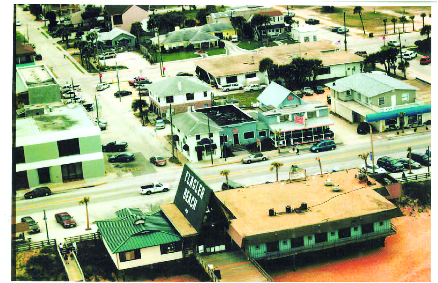
Intent
Buildings that appear similar in mass and scale to other buildings in the Downtown will help to maintain the human scale of the Downtown’s built environment. It is important to maintain a variety of heights to create visual interest. One and two storied buildings should form the primary architectural character of the Downtown, with taller architectural elements located at corner buildings to emphasize the importance of intersections and create diversity in scale and character.
A building’s scale is created by the size of the units of construction and architectural details in relationship to the human scale. The size of a building, or more precisely the building’s mass in relationship to open spaces, windows, doors, porches and balconies should be compatible with other buildings in a visually related field. The first and second floors should have more detail and frequency of pattern than the upper floors of a building due to the fact that these lower floors are directly adjacent to the viewer’s eye.
- In order to minimize the perceived size of a building, step down its height toward the street, neighboring structures and the rear of the lot.
- In order to break up the perceived mass of structure, divide it into modules that are similar in size to buildings seen traditionally.
| Examples | |
Existing A1A elevation | |
Block Elevation Source: Flagler Beach and Flagler County Charrette TCRPC |
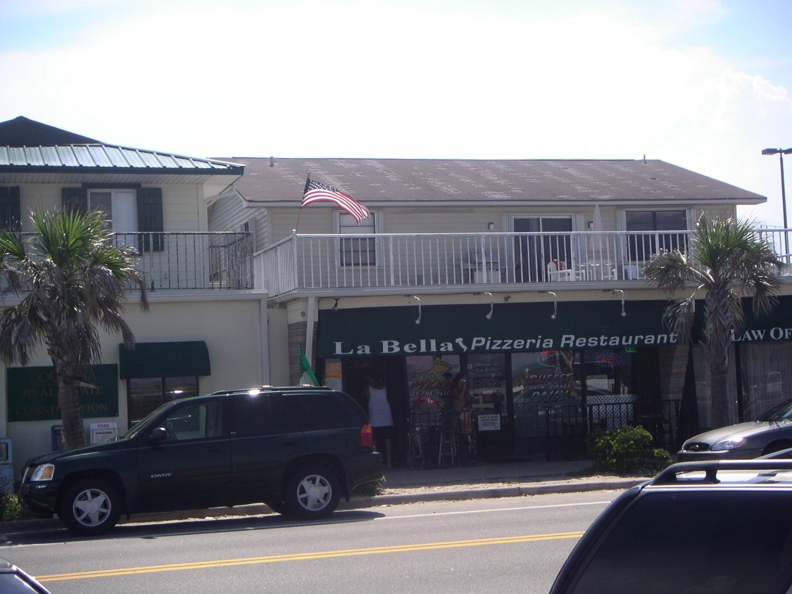
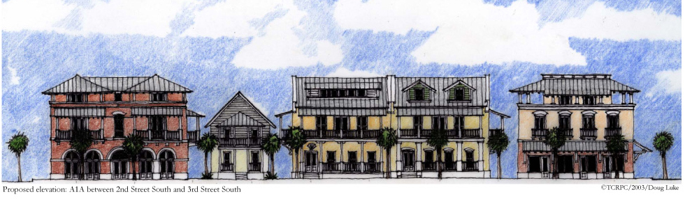
Design Guidelines
- Building height shall not exceed thirty five (35) feet above the finished grade for flat roofs and mean height level between eaves and ridge for pitched, gable and hipped roofs.
- The ground floor shall not be less than ten (10) feet from the finished floor to finished ceiling. Above the ground floor, a story is defined as a habitable level no more than 12 feet in height, the additional height will count as an additional story.
- The proportional relationship of height and width should be consistent between adjacent structures
- The height of buildings should not drastically alter the scale of the Downtown.
Guideline: Vertical Setbacks
| 1. Front: Between the 2nd and 3rd floor of the building, there should be a minimum setback of six feet - (6’), when possible. | 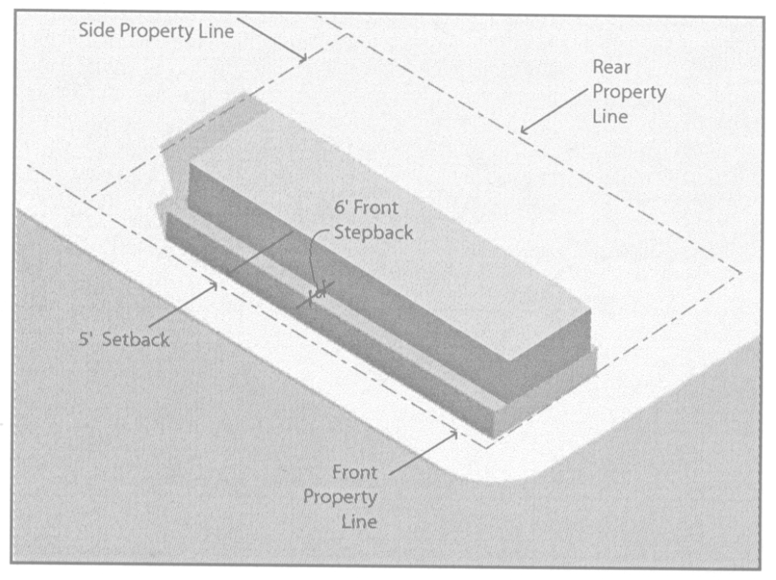 |
| 2. Side facing a street: Between the 2nd and 3rd floor of the building, there should be a minimum setback of six feet - (6’), when possible. | |
| 3. Side facing a property line: Between the 2nd and 3rd floor of the building, no minimum setback is required. | |
| 4. Rear: Between the 2nd and 3rd floor of the building, no minimum setback is required. | |
Bands of Composition
| 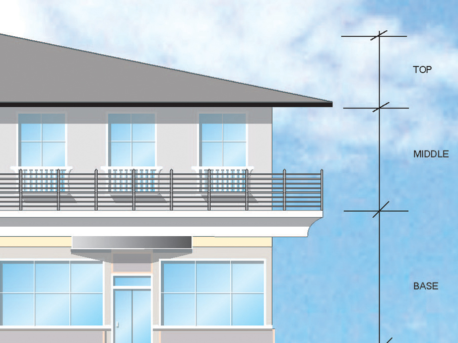 |
Guideline: Facade Composition
Buildings on a single lot or combination of lots shall not exceed a continuous massing longer than 50 feet. In order to assure architectural diversity and to maintain the eclectic character of the community, no single architecture style shall be duplicated on any combination of buildings that exceed 50 linear feet of frontage on a single lot or a combination of lots.
On the ground floor of the primary facade, there shall be a minimum of one break for every 50’ of front elevation.
The first floor or the primary facades of a building shall, at a minimum, utilize windows between the heights of three feet and eight feet above the walkway grade.
Guideline: Ground Floor Composition
The ground floor façade should contain a minimum of three of the following façade design elements (one of which must be awnings / canopy):
- Overhangs
- Arcade
- Raised cornice parapets over the doors
- Projected canopies
- Awnings/ Canopies
- Projecting Sill
Ground Floor Composition
| 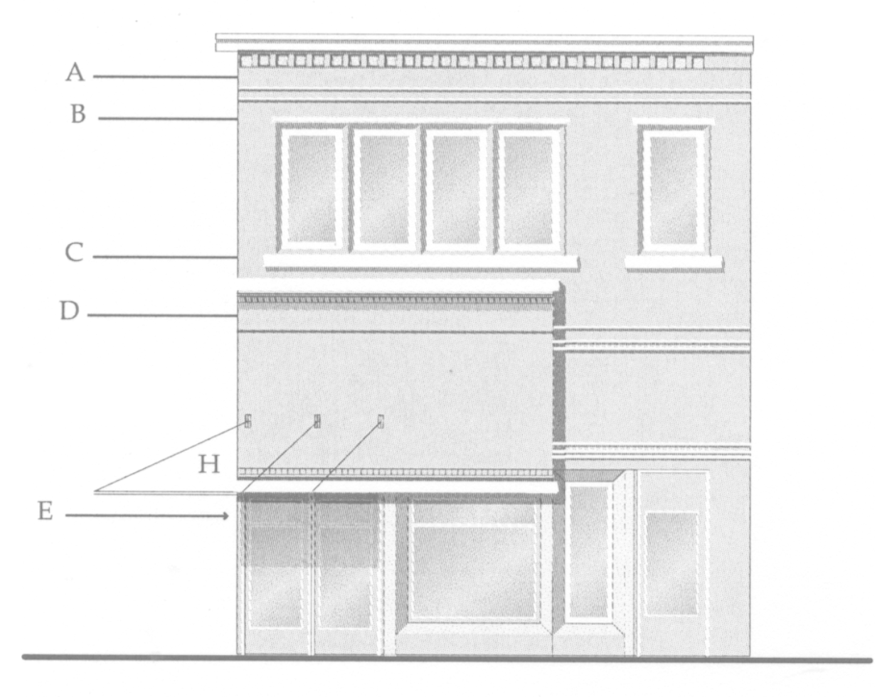 |
Guideline: Fenestration Ratio
Encourage largely transparent, open and inviting facades at the lower levels (ground floor) of the building to accentuate pedestrian environment.
Encourage a greater ratio of solid wall to window allowing for more variety of architectural material and elements at the upper floors. Approximately 25- 40% window to wall ratio is desirable in the facade area for each building facade area adjoining a street.
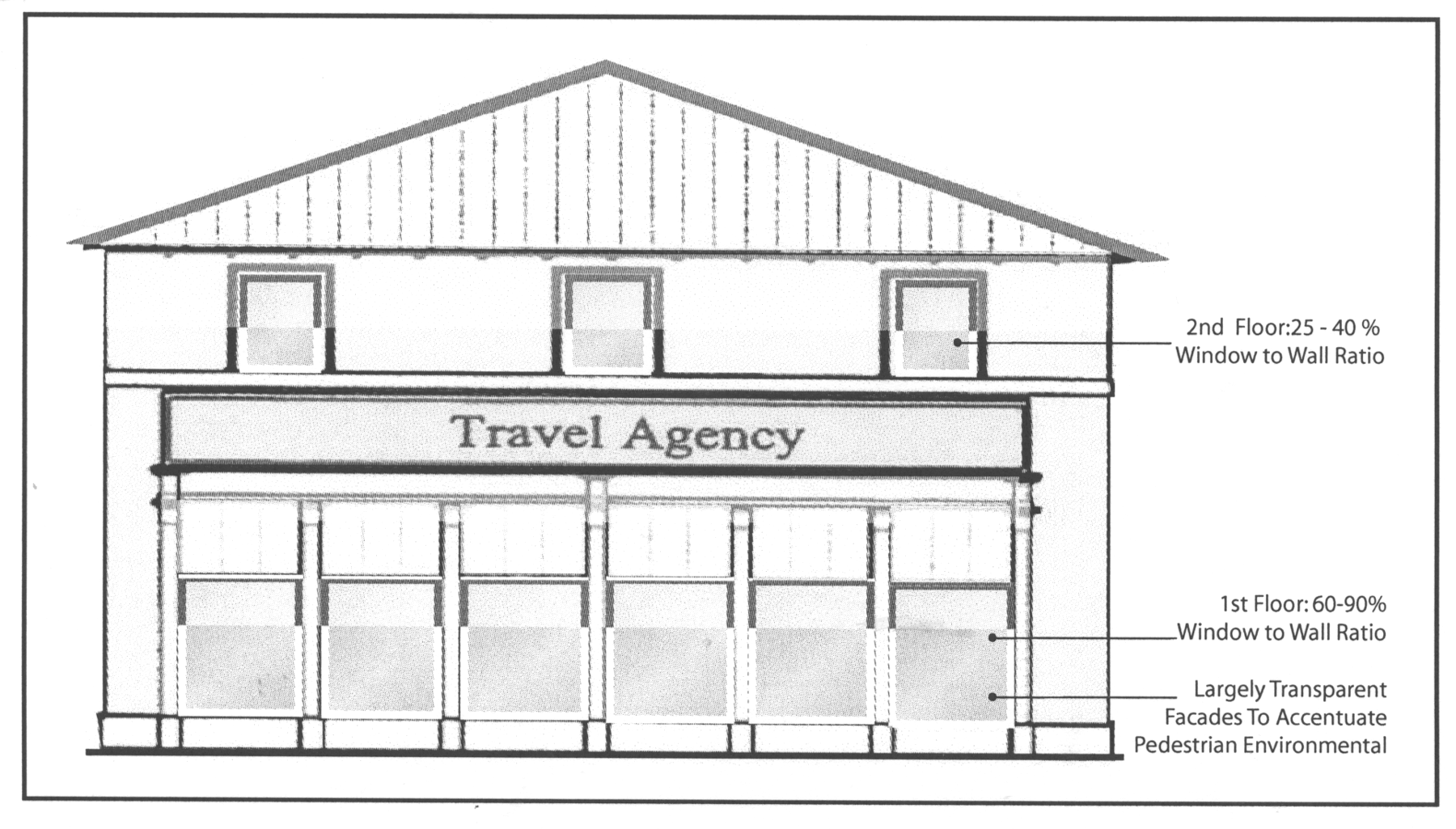
Awnings and Canopies
Awnings and canopies should be 10’ above the sidewalk and they should be built within the Build-to Zone of the front and side setbacks.
Storefront window openings should be designed to accommodate awnings above the windows.
Exterior Materials
The following materials are encouraged for exterior building construction:
- Stucco
- Brick
- Concrete masonry units, e.g. Hardiplank
- Stone
- Wood, Clapboard siding
- Tiles
The following materials are prohibited for exterior building construction:
- Plastic siding
- Corrugated or reflective metal panels
- Smooth or ribbed-faced concrete block
- Wood sheeting
 |
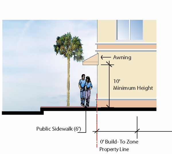 |
Goals
The urban design goals for this district are:
- Preserve the traditional character of the residential neighborhoods incorporating design elements that reinforce a historic connection.
- Enhance the sense of public and private open space through sensitive placement of building additions and new structure.
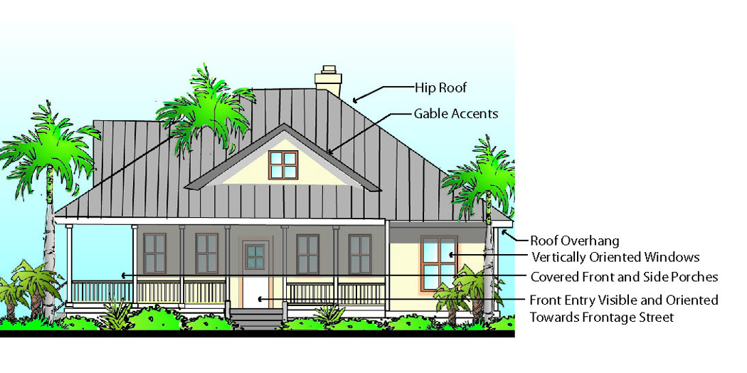
Design Guidelines
- Preserve a sense of open space in front, side and rear yards.
- Site the mass of the structure to the rear of the lot.
- Orient the primary entry of a primary building to the street.
- Clearly define the primary entrance by using a raised front porch as a functional space oriented to the street.
- Align the front and sides of new buildings with other structures in the neighborhood.
- For a lot on an alley, locate parking in a garage or detached carport near the alley edge and accessed from the alley.
- For a lot not accessible from an alley, locate parking to the rear of the lot with a driveway accessed from the street.
- Required parking spaces should be located in the rear half of the building.
- Parking for the primary residence should comply with existing code requirements.
- Minimize the visual impact of a driveway.
- Plan parking areas and driveways in a manner that minimizes the number of curb cuts on the block.
- The design of new development or addition should take into consideration existing trees. Property owners should comply with the City’s Tree Preservation Ordinance with regard to Landmark Trees.
- Maintain the traditional scale and width of alleys where existing.
- Screen parking from public view.
- Locate secondary structures to the rear of the lot, and along an alleyway when feasible.
| Examples | |
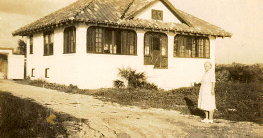 | 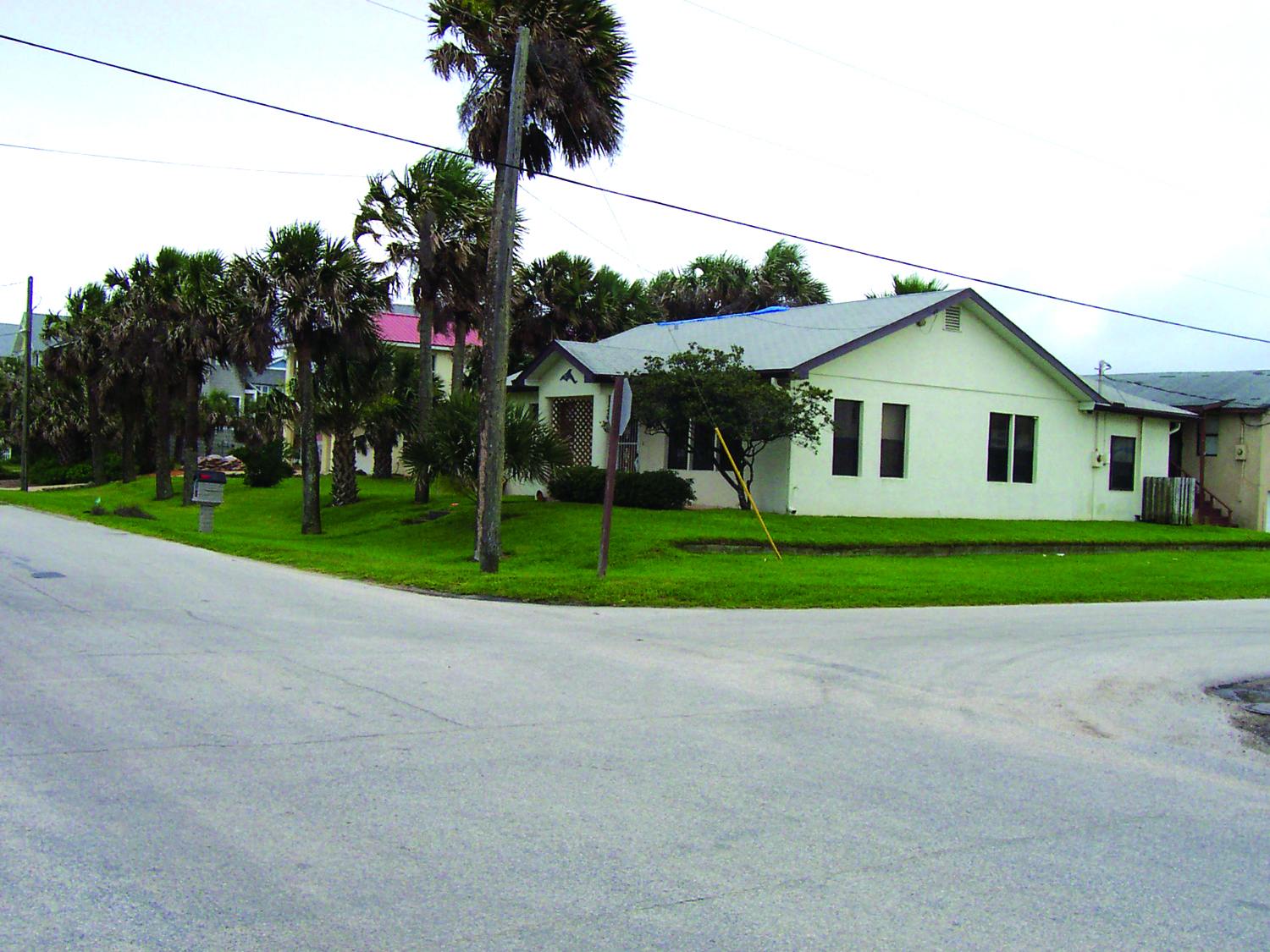 |
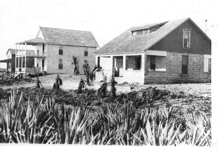 | 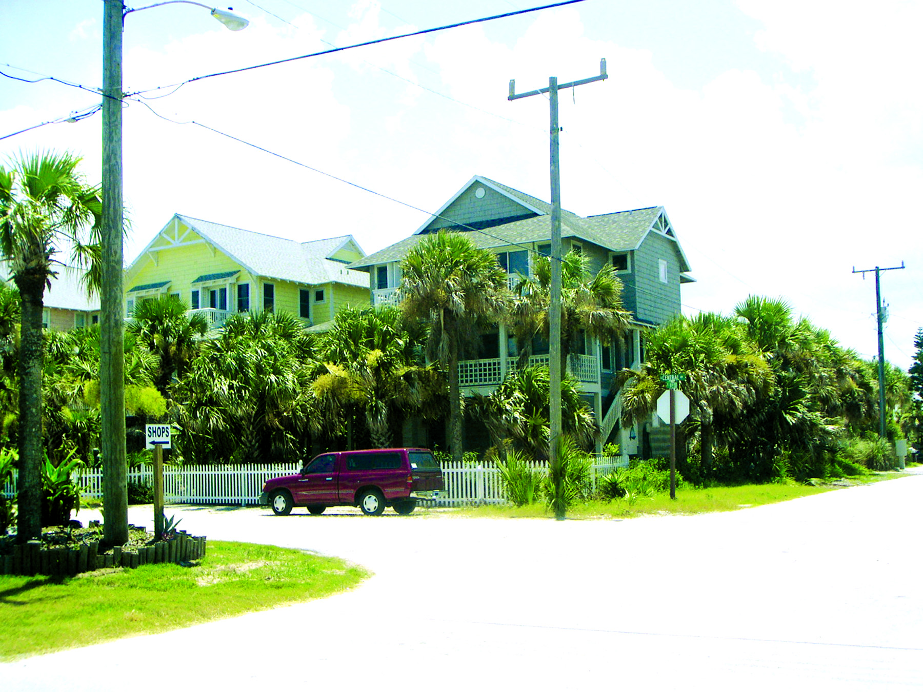 |
(Ord. No. 2006-26, § 1(Exh. A), 11-30-06)